1
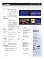
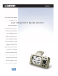
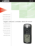
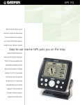
StreetPilot® 2820
With built-in Bluetooth® wireless
capability and preloaded MapSource®
Carefree navigation meets hands-free communication
street mapping, this Garmin GPS portable is
the ideal road companion for your car or
motorcycle. Simply enter a destination – via
touchscreen or remote – and your
StreetPilot® 2820 will route you there with
turn-by-turn directions and “spoken text”
voice prompts that call out streets by name.
A points-of-interest database helps locate
motels, restaurants, etc. And with a compatible cell phone, you can call ahead handsfree, using a plug-in mic and car audio – or
a Bluetooth-enabled headset or helmet.
MP3s, audio books, XM Satellite Radio® –
the 2820 plays them all. And in select U.S.
metro areas, you can even monitor traffic
tie-ups with the optional GTM™ 10/11 FM
or GXM 30™ XM receivers*.
*Traffic services available only in select U.S. cities. Subscriptions and
appropriate antenna required to activate XM Satellite-linked services.
StreetPilot® 2820
Moving map features
Storage:
Internal storage comes preloaded with
MapSource® City Navigator®, providing
street-level detail and addresses, plus
listings of nearby restaurants, hotels,
ATMs, etc., throughout the U.S., Canada
and Puerto Rico
Custom POIs:
Custom inputs let you add restaurants,
safety cameras and other points of
interest to the preloaded map. Proximity
alerting warns of upcoming custom POIs,
such as safety cameras or school zones.
Map scale:
Screen-width scale 900 feet to 6,100 miles
Map Orientation:
2D or 3D
Navigation features
Routes:
Automatically calculated with turn-by-turn
instructions; up to 50 stored routes; each
stored route can contain multiple VIA
points, which can be auto-arranged to
minimize trip distance; a detour function
enables routing around traffic problems
or road construction (using optional GTM
10/11 FM Traffic Receiver)*; custom road
preference allows user to prioritize choice
of back roads or major highways; auto
matic off-route recalc shows how to get
back on track if you miss a turn or exit it
Voice:
Text-to-speech capability offers more
specific voice guidance cues
Waypoints:
2000 with name and graphic symbol
Track log:
10,000 track log points
Trip computer:
Resettable odometer, timers, average
and maximum speeds
GPS performance
Receiver:
Acquisition times:
Warm:
Cold:
AutoLocate®:
Update rate:
GPS Accuracy:
Position:
Velocity:
GPS (WAAS) Accuracy:
Position:
Velocity:
Interfaces:
Antenna:
WAAS enabled;12 parallel channel GPS
receiver continuously tracks and uses up
to 12 satellites to compute and update
your position
Approximately 15 seconds
Approximately 45 seconds
Approximately 2 minutes
1/second, continuous
15 meters (49 feet), 95% typical1
0.05 meter/sec steady state
<3 meters, 95% typical
0.05 meter/sec steady state
USB 2.0 full speed device
Built-in patch; MCX-type connector for
optional external GPS antenna connection
Bluetooth® capabilities:
HFP (hands-free profile): enables the 2820 to act as the
speaker/mic for Bluetooth® enabled cell phones.
OPP (object push-pull profile): enables cell phone contact
lists/address books to be transferred to the 2820 for easy
dialing.
HSP (headset profile): enables the 2820 to transmit
navigation audio prompts wirelessly to a Bluetooth®
enabled headset/helmet.
Physical
Size:
type in an address
select from search results
follow the route
press “Go To!”
Map storage:
5.6”W x 3.0”H x 2.1”D
(14.2 x 7.5 x 5.4 cm)
.91 pounds (411 g)
3.8”W x 1.7”H (9.7 x 4.4 cm); 454 x 240
pixels; bright, automotive-grade 64K
color TFT w/automatic dimming back
light and touch screen
Remote control, IR port
Senses lighting conditions for automatic
backlight dimming
Rugged; fully gasketed
5°F to 158°F (-15°C to 70°C)
Indefinite; no memory battery required;
USB mass storage profile
Preloaded internal storage
Power
Input:
Usage:
12v DC
12w max. @ 13.8v DC
Weight:
Display:
Infrared:
Photo sensor:
Case:
Temp. range:
Data storage:
Accessories
Standard:
Optional:
Integrated dash mount
Portable non-skid mount
External speaker with vehicle power cable
A/C power adapter
PC/USB interface cable
Alphanumeric remote control
Owner’s manual
Quick reference guide
GTM™10 or 11 FM Traffic Receiver
GXM 30™ XM Smart Antenna
Remote GPS antenna (GA 27C)
Deluxe carrying case
Select MapSource® products
Garmin International, Inc.
1200 East 151st Street
Olathe, Kansas 66062, U.S.A.
913/397.8200 fax 913/397.8282
Garmin (Europe) Ltd.
Liberty House
Hounsdown Business Park
Southampton, Hampshire, SO40 9RB, U.K.
44/1794.519944 fax 44/1794.519222
Garmin (Asia) Corporation
No. 68, Jangshu 2nd Rd.
Shijr, Taipei County, Taiwan
886/2.2642.9199 fax 886/2.2642.9099
www.garmin.com
Clear Channel Broadcasting, Inc
Specifications are preliminary and subject to
change without notice.
*FM TMC Traffic services available only in select cities where
coverage exists. Requires GTM™ 10 FM traffic receiver and
subscription fee to enable traffic capability.
REV 0407
©2007 Garmin Ltd. or its subsidiaries.
M01-10222-00
1 Subject to accuracy degradation to 100m 2DRMS
under the U.S. Department of Defense imposed
Selective Availability Program
NAVTEQ ON BOARD is a trademark of NAVTEQ
©2006 NAVTEQ. All Rights Reserved.