1
GPS
# 82 5492 (11-02-14-MIWA)
Bedienungsanleitung
3 - 10
Operating Instructions
11 - 18
Notice d´utilisation
19 - 26
Istruzioni per l´uso
27 - 34
Manual de Instrucciones
35 - 42
MULTIPLEX Modellsport GmbH & Co. KG z Westliche Gewerbestraße 1 z D-75015 Bretten
© MULTIPLEX 2011, Printed in Germany
www.multiplex-rc.de
Bedienungsanleitung
GPS für M-LINK Empfänger
! Diese Bedienungsanleitung ist Bestandteil
des Produktes. Sie beinhaltet wichtige Informationen und Sicherheitshinweise. Sie ist
deshalb jederzeit griffbereit aufzubewahren
und beim Verkauf des Produktes an Dritte
weiterzugeben.
1.
TECHNISCHE DATEN
Best.-Nr.
# 8 5417
GPS Empfänger
Hochempfindlicher GPS
Empfänger mit 50 Kanälen
Antenne
Vieradrige zirkulär
polarisierende Helix Antenne
für nahezu omnidirektionalen
Empfang
Adresse / Displayzeile 9:
Geschwindigkeit im Raum
über Grund (3D) in km/h
Datenausgabe
(Grundfunktionen /
Werkseinstellung)
Adresse / Displayzeile 10:
Höhe über Fixpunkt in
Metern (m)
Anleitung GPS für M-LINK Empfänger # 82 5492 (11-02-14/MIWA) • Irrtum und Änderung vorbehalten! • ¤ MULTIPLEX
Adresse / Displayzeile 11:
Entfernung im Raum (3D)
zum Fixpunkt in Metern (m)
Dauer für den Kaltstart
bei normalen Empfangs- ca. 1 Minute
verhältnissen
Dauer für den Warmstart
bei normalen Empfangs- ca. 10 Sekunden
verhältnissen
Modellsportbereich entwickelt. Der Einsatz z.B. in personenbefördernden oder industriellen Einrichtungen ist nicht
erlaubt.
4.
GRUNDLAGEN UND MESSPRINZIP
Mit dem MULTIPLEX GPS für M-LINK Empfänger erhalten Sie interessante Informationen direkt aus Ihrem Modell.
Endlich werden Werte wie die aktuelle Fluggeschwindigkeit, die Höhe über der Startstelle und die Entfernung
des Modells visualisiert!
Darüber hinaus lassen sich weitere Werte, wie etwa die
insgesamt zurückgelegte Flugstrecke oder verschiedene
Winkelangaben individuell parametrieren. Zusätzlich lassen sich am GPS Warnschwellen einstellen, wie auch die
Anzeige verschiedener Minimal-, Maximal- oder Durchschnittswerte.
Das GPS basiert auf dem Messprinzip der Satellitennavigation. Es wird der zivile Service des US-amerikanischen Global Positioning System „GPS“ verwendet.
Die Positions- und Geschwindigkeitsmessung mittels GPS
basiert auf mehr als 24 Satelliten, die die Erde auf genau
festgelegten Bahnen jeweils innerhalb von 11 Stunden
und 58 Minuten einmal umkreisen. Diese Satelliten
enthalten mindestens eine hochgenaue Zeitbasis (Atomuhr), die mit Hilfe von erdfesten Basisstationen überwacht
und synchronisiert werden.
Auch der Empfänger im MULTIPLEX GPS enthält eine
Uhr, die auf die Atomuhren in den Satelliten synchronisiert
wird. Jeder Satellit sendet ein Signal in einem dem MULTIPLEX GPS Empfänger bekannten und festgelegten
Muster zur Erde.
Durch die Messung der Laufzeit der einzelnen Signale ist
es möglich, die Entfernung der einzelnen Satelliten zum
Empfänger und damit bei bekannter Position der Satelliten auch die Position des Empfängers auf der Erde zu
bestimmen.
Pufferbatterie
ja, integriert
Genauigkeit bei
optimalem Empfang
ca. 2,5 m (Position) bzw.
ca. 0,1 m/s (Geschwindigkeit)
Genauigkeit bei
normalen Empfangsverhältnissen
ca. 5 - 10 m bzw.
ca. 0,5 - 1 m/s
Abtastrate
2 Hz
Stromaufnahme
ca. 80 mA
Abmessungen
(L x B x H)
60,5 x 20,0 x 16,0 mm
Beim Einsatz folgender Sender kann das GPS mit seinen
Grundfunktionen (Werkseinstellung, Î 11.) ohne weitere
Konfiguration in Betrieb genommen werden:
Temperaturbereich
- 20 °C … + 55 °C
x Sender der Typen ROYALevo und ROYALpro,
jeweils mit M-LINK Technologie
Gewicht (inkl. Kabel)
16 g
2.
KOMPATIBLE AUSGABEGERÄTE
x Sender, die mit dem MULTIPLEX Telemetry Display
(# 4 5182) ausgestattet sind
SICHERHEITSHINWEISE
! Vor Inbetriebnahme Anleitung vollständig lesen.
! Nur für den vorgesehenen Einsatzbereich verwenden (Î 3.).
! Einbauhinweise beachten (Î 7.).
! GPS vor Vibrationen schützen.
3.
5.
EINSATZBEREICH
Das MULTIPLEX GPS für M-LINK Empfänger (nachstehend „GPS“) wurde ausschließlich für Anwendungen im
Nach einer individuellen Konfiguration kann das GPS darüber hinaus auch mit folgenden Sendern in Betrieb
genommen werden:
x Sendegeräte des Typs COCKPIT SX M-LINK
(ab Firmwareversion V3.06)
Zum Betrieb des GPS mit einer COCKPIT SX M-LINK
müssen am GPS vorab zwingend Adresswerte zwischen 0 und 7 eingestellt werden. Eine Konfiguration
des GPS ist in diesem Falle also obligatorisch.
Seite 3
Bedienungsanleitung
GPS für M-LINK Empfänger
Mit der MULTImate (# 8 2094) oder dem kostenlos auf der
MULTIPLEX Website zum Download bereitstehenden PCProgramm „MULTIPLEX Launcher“ (notwendiges Zubehör:
USB PC-Kabel, UNI (# 8 5149)) kann das GPS einfach
und komfortabel nach individuellen Vorstellungen konfiguriert werden (Î 13. + 14.).
Beim Einsatz mehrerer M-LINK Sensoren kann das GPS
alternativ auch an einen anderen M-LINK Sensor am
Steckplatz „S“ angeschlossen werden.
Beim Anschließen des UNI-Anschlusskabels (RX/S) auf
korrekte Steckrichtung und insbesondere bei Fremdprodukten auf kompatible Kontaktbelegung achten!
6.
! Hinweis:
Das GPS muss zur individuellen Konfiguration einzeln an
die MULTImate oder den PC angeschlossen werden.
Falls Sie also etwa Alarmschwellen am GPS setzen oder
weitere Messkanäle aktivieren möchten, so erledigen Sie
dies bitte vor dem Einbau in das Modell.
ANTENNENCHARAKTERISITIK
Die Empfangscharakteristik der Antenne (der schwarze
Zylinder gegenüber dem Kabelausgang) ist in der Art
gestaltet, dass der Empfang in nahezu alle Richtungen
möglich ist (omnidirektional). Lediglich nach „hinten“, also
in Richtung Auswerteelektronik und Anschlusskabel des
GPS, ist kein Empfang möglich.
7.
EINBAU DES GPS IM MODELL
Anleitung GPS für M-LINK Empfänger # 82 5492 (11-02-14/MIWA) • Irrtum und Änderung vorbehalten! • ¤ MULTIPLEX
1) Positionieren Sie das GPS an einer geeigneten Stelle
für optimale Empfangsbedingungen so im Modell, dass
die Antenne (Î 6.) in den meisten Fluglagen einen
unverstellten „Blick“ auf einen möglichst großen Bereich des Himmels hat:
x Bei (Thermik-)Segelflugmodellen
Hier wird ein im Rumpf stehender Einbau des MULTIPLEX GPS empfohlen, bei dem die Antenne nach
oben zeigt.
x Bei Kunstflugmodellen
Hier ist alternativ auch eine in Rumpfrichtung
liegende Einbausituation sinnvoll.
2) Achten Sie darauf, dass die Antenne des GPS möglichst wenig von leitenden Materialien abgeschirmt wird:
Elektrisch leitende Materialien wie z.B. Kohlefaser,
Metallfolien oder metallhaltige Lacke schatten das
Signal ab und beeinträchtigen so den Empfang (Abschirmung!). Ähnliches gilt für Hauswände oder
wasserhaltige Materialien wie z.B. Gras, Blätter und
®
Bäume. Materialien wie GfK oder ELAPOR stören bei
üblichen Materialstärken nicht.
Eine gute Position ist etwa unter einer Kabinenhaube
aus nichtleitendem Material.
3) Befestigen Sie das GPS z.B. mittels Klettband im
Modell. Schützen Sie Ihr GPS, besonders in Modellen
mit Verbrennungsmotoren, gegen Vibrationen (z.B. in
Schaumstoff locker einpacken).
! Hinweis:
Die von den GPS Satelliten mit einer Frequenz von ca.
1,58 GHz ausgesandten Signale sind in der Ausbreitung
mit den Signalen des M-LINK Systems bei 2,4 GHz vergleichbar. Sie sind jedoch aufgrund der Satellitenentfernung von ca. 20200 Kilometer um ein Vielfaches schwächer:
Lassen Sie daher beim Einbau des GPS dieselbe
Sorgfalt wie beim Einbau und der Ausrichtung der
Antenne(n) Ihrer M-LINK Empfänger walten!
8.
ANSCHLUSS
9.
INBETRIEBNAHME
Schalten Sie die RC-Anlage EIN und sorgen Sie dafür,
dass Empfang möglich ist:
x Möglichst freier Blick des GPS zum Himmel
x Modell nicht in hohem Gras, unter Bäumen oder im
Haus liegend
Î Nach einer bis hin zu wenigen Minuten werden erste
Werte auf Ihrem Senderdisplay bzw. auf dem Telemetry-Display angezeigt.
! Hinweise:
Sollten auch nach längerer Zeit keine oder nur unregelmäßig Daten übertragen werden, optimieren Sie den
Einbauort und / oder die Antennenausrichtung des GPS.
Zeigt das GPS in geschlossenen Räumen keine Werte
an, so ist dies normal und kein Fehler des GPS!
10. INTEGRIERTE PUFFERBATTERIE
Nach dem AUS schalten der RC-Anlage und somit auch
des GPS betreibt eine integrierte Pufferbatterie die Uhr
des GPS-Empfängers auch ohne Stromversorgung für
einige Minuten weiter. Darüber hinaus werden die Bahndaten der Satelliten gespeichert.
Dies bedeutet, dass Sie während eines Flugtages lediglich nach dem ersten EIN schalten eine gewisse Zeit warten müssen, bis Empfang vorhanden ist.
Bei den nächsten, zeitlich direkt darauf folgenden Flügen
wird der Empfang innerhalb weniger Sekunden nach dem
EIN schalten bzw. Anstecken des Akkus wiederhergestellt
sein!
11. WERKSEINSTELLUNG DES GPS
Folgende Daten werden ab Werk auf dem Senderdisplay
bzw. dem Telemetry-Display angezeigt:
x Adresse 9:
Geschwindigkeit im Raum über Grund (3D) in km/h
x Adresse 10:
Höhe über Fixpunkt in Metern (m)
x Adresse 11:
Entfernung im Raum (3D) zum Fixpunkt
in Metern (m) / Distanz
Stecken Sie das Anschlusskabel des GPS (RX/S) an den
Sensorsteckplatz Ihres telemetriefähigen M-LINK Empfängers an (mit „S“ oder „SENSOR“ bezeichnet).
Seite 4
Bedienungsanleitung
GPS für M-LINK Empfänger
Die „Adresse“ entspricht dabei der:
x Displayzeile am Sender ROYALevo/pro
x Displayzeile auf dem Telemetry-Display
x INFO-Anzeige der COCKPIT SX M-LINK
auf welcher der entsprechende Telemetriewert angezeigt
wird.
Als Modelltyp wird werksseitig die Einstellung „schnelles
Flugzeug“ (Î 15.4) verwendet.
13. KONFIGURATIONSMÖGLICHKEITEN
DES GPS MIT DER
MULTIPLEX MULTIMATE (# 8 2094)
12. MULTIMATE UND PC-PROGRAMM
MULTIPLEX LAUNCHER
Dieses Kapitel listet die Konfigurationsmöglichkeiten des
GPS mit der MULTImate sowohl bei englischer als auch
bei deutscher Menüführung auf:
Das GPS kann einfach und komfortabel nach individuellen
Vorstellungen konfiguriert werden mit:
11 MPX Sensors / MPX Sensoren
x MULTIPLEX MULTImate (# 8 2094)
Î Ab Firmwareversion V1.48
oder
x PC-Programm MULTIPLEX Launcher
Î Dieses PC-Programm steht auf www.multiplex-rc.de
zum kostenlosen Download bereit. Notwendiges
Zubehör: USB PC-Kabel, UNI (# 8 5149)
Anleitung GPS für M-LINK Empfänger # 82 5492 (11-02-14/MIWA) • Irrtum und Änderung vorbehalten! • ¤ MULTIPLEX
! Hinweis:
Um alle aktuellen Features des GPS bzw. generell der
angeschlossenen Komponenten nutzen zu können, bringen Sie Ihre MULTImate bzw. den Launcher in regelmäßigen Abständen „auf aktuellen Stand“.
Mit der MULTImate oder dem Launcher können die
Displayzeilen/-adressen der Mess- und Optionswerte
eingestellt, zusätzliche Messkanäle aktiviert oder die Einstellung von Warnschwellen vorgenommen werden.
Darüber bietet der Launcher folgende Möglichkeiten:
x Zurücksetzen des GPS auf Werkseinstellung
x Aufspielen von Firmwareupdates
Die Konfigurationsmöglichkeiten mit der MULTImate werden detailliert in Kapitel (Î 13.) beschrieben. Die Konfigurationsmöglichkeiten mittels Launcher finden Sie in
Kapitel (Î 14.).
Die Sensoren werden über den MULTIPLEX-Sensorbus
(MSB) mit dem Empfänger und untereinander verbunden.
Die Daten werden auf voreingestellten Displayzeilen/adressen am Senderdisplay bzw. dem Telemetry-Display
ausgegeben. Insgesamt können bis zu 16 Sensoren an
den MULTIPLEX-Sensorbus angeschlossen, bzw. bis zu
16 Adressen für Mess- und Optionswerten belegt werden:
x COCKPIT SX M-LINK
Î Ausgabe von max. 8 Telemetriewerten möglich
x ROYALevo/pro mit M-LINK Technologie
Î Ausgabe von max. 15 Telemetriewerten möglich
x Sender mit angeschlossener Telemetry-Display
Î Ausgabe von max. 16 Telemetriewerten möglich
Die gemessenen Werte werden auf dem Senderdisplay
bzw. dem Telemetry-Display angezeigt. Die Einstellung
von Warnschwellen ermöglicht die akustische und optische Anzeige von überschrittenen Grenzwerten (z.B.
Höhenmesser: Alarm oben = 500 m: Bei einer Flughöhe
von 500 m erfolgt ein Alarm). Dabei wechselt das Senderdisplay (bzw. das Telemetry-Display) zu der entsprechenden Adresse / Displayzeile und zeigt den überschrittenen Wert - im vorherigen Beispiel die Flughöhe - an.
11-3 Settings / Einstellung
Sp3D / G3D
(= Geschwindigkeit im Raum über Grund (3D) in km/h)
Konfigurationsoptionen:
Address / Adresse
(= Adresse)
Î off / aus (= aus), oder eine Adresse
im Bereich von 0 bis 15
Alarm low / Alarm unten
(= Alarm unten)
Î off / aus (= aus), oder eine Geschwindigkeit
im Bereich von 0,0 km/h bis 700,0 km/h
Alarm high / Alarm oben
(= Alarm oben)
Î off / aus (= aus), oder eine Geschwindigkeit
im Bereich von 0,0 km/h bis 700,0 km/h
Option / Option
(= Option)
Î Max value, Min value, Average /
Maximalwert, Minimalwert, Mittelwert
(= Maximalwert, Minimalwert oder Durchschnitt),
jeweils in km/h
Option ad. / Option Adr.
(= Option Adresse)
Î off / aus (= aus), oder eine Adresse
im Bereich von 0 bis 15
Sp2D / G2D
(= Geschwindigkeit horizontal über Grund (2D) in km/h)
Konfigurationsoptionen:
Address / Adresse
(= Adresse)
Î off / aus (= aus), oder eine Adresse
im Bereich von 0 bis 15
Alarm low / Alarm unten
(= Alarm unten)
Î off / aus (= aus), oder eine Geschwindigkeit
im Bereich von 0,0 km/h bis 700,0 km/h
Alarm high / Alarm oben
(= Alarm oben)
Î off / aus (= aus), oder eine Geschwindigkeit
im Bereich von 0,0 km/h bis 700,0 km/h
Seite 5
Bedienungsanleitung
GPS für M-LINK Empfänger
Anleitung GPS für M-LINK Empfänger # 82 5492 (11-02-14/MIWA) • Irrtum und Änderung vorbehalten! • ¤ MULTIPLEX
Option / Option
(= Option)
Î Max value, Min value, Average /
Maximalwert, Minimalwert, Mittelwert
(= Maximalwert, Minimalwert oder Durchschnitt),
jeweils in km/h
Option ad. / Option Adr.
(= Option Adresse)
Î off / aus (= aus), oder eine Adresse
im Bereich von 0 bis 15
H/H
(= Höhe über Fixpunkt in m)
Konfigurationsoptionen:
Address / Adresse
(= Adresse)
Î off / aus (= aus), oder eine Adresse
im Bereich von 0 bis 15
Alarm low / Alarm unten
(= Alarm unten)
Î off / aus (= aus), oder eine Höhe
im Bereich von - 500 m bis 2000 m
Alarm high / Alarm oben
(= Alarm oben)
Î off / aus (= aus), oder eine Höhe
im Bereich von - 500 m bis 2000 m
Option / Option
(= Option)
Î Max value, Min value, Average /
Maximalwert, Minimalwert, Mittelwert
(= Maximalwert, Minimalwert oder Durchschnitt),
jeweils in m
Option addr. / Option Adr.
(= Option Adresse)
Î off / aus (= aus), oder eine Adresse
im Bereich von 0 bis 15
Di3D / E3D
(= Entfernung im Raum (3D) zum Fixpunkt in m /
Distanz)
Konfigurationsoptionen:
Address / Adresse
(= Adresse)
Î off / aus (= aus), oder eine Adresse
im Bereich von 0 bis 15
Alarm low / Alarm unten
(= Alarm unten)
Î off / aus (= aus), oder eine Entfernung
im Bereich von 0 m bis 2000 m
Alarm high / Alarm oben
(= Alarm oben)
Î off / aus (= aus), oder eine Entfernung
im Bereich von 0 m bis 2000 m
Option / Option
(= Option)
Î Max value, Min value, Average /
Maximalwert, Minimalwert, Mittelwert
(= Maximalwert, Minimalwert oder Durchschnitt),
jeweils in m
Option ad. / Option Adr.
(= Option Adresse)
Î off / aus (= aus), oder eine Adresse
im Bereich von 0 bis 15
Di2D / E2D
(= Entfernung horizontal (2D) zum Fixpunkt
in m / Distanz)
Konfigurationsoptionen:
Address / Adresse
(= Adresse)
Î off / aus (= aus), oder eine Adresse
im Bereich von 0 bis 15
Alarm low / Alarm unten
(= Alarm unten)
Î off / aus (= aus), oder eine Entfernung
im Bereich von 0 m bis 2000 m
Alarm high / Alarm oben
(= Alarm oben)
Î off / aus (= aus), oder eine Entfernung
im Bereich von 0 m bis 2000 m
Option / Option
(= Option)
Î Max value, Min value, Average /
Maximalwert, Minimalwert, Mittelwert
(= Maximalwert, Minimalwert oder Durchschnitt),
jeweils in m
Option ad. / Option Adr.
(= Option Adresse)
Î off / aus (= aus), oder eine Adresse
im Bereich von 0 bis 15
Total dist. 3D / Wegstrecke 3D
(= Zurückgelegter Weg im Raum über Grund (3D)
in m bzw. km)
Î off / aus (= aus), oder eine Adresse
im Bereich von 0 bis 15
Anmerkung: Ab 10 km Wegstrecke erscheint die Anzeige
in km, darunter in m
Total dist. 2D / Wegstrecke 2D
(= Zurückgelegter Weg horizontal über Grund (2D)
in m bzw. km)
Î off / aus (= aus), oder eine Adresse
im Bereich von 0 bis 15
Anmerkung: Ab 10 km Wegstrecke erscheint die Anzeige
in km, darunter in m
Model type / Modelltyp
(= Einstellung des jeweiligen Modelltyps mit dem Ziel
der Optimierung der Ausgabedaten)
Î slow plane / car, Boat, fast plane/ jet /
langs.Flugz/Auto, Boot, schn.Flugz/Jet
(= Langsames Flugzeug / Auto, Boot, schnelles
Flugzeug / Jet)
Seite 6
Bedienungsanleitung
GPS für M-LINK Empfänger
Azimuth / Azimuth
(= Winkel vom Fixpunkt zum Objekt in Grad, bezogen
auf Nord)
Î off / aus (= aus), oder eine Adresse
im Bereich von 0 bis 15
Heading / Heading
(= Richtung des Flugzeugs in Grad bezogen auf Nord)
Î off / aus (= aus), oder eine Adresse
im Bereich von 0 bis 15
Elongation / Elongation
(= Richtung des Modells in Grad, bezogen auf den
Fixpunkt)
Î off / aus (= aus), oder eine Adresse
im Bereich von 0 bis 15
11-3 Send data / Daten send.
(= Daten senden)
Î Einstellrad lange drücken, um die Daten zu senden
14. KONFIGURATIONSMÖGLICHKEITEN
DES GPS MIT DEM
MULTIPLEX LAUNCHER
Anleitung GPS für M-LINK Empfänger # 82 5492 (11-02-14/MIWA) • Irrtum und Änderung vorbehalten! • ¤ MULTIPLEX
Dieses Kapitel listet die Konfigurationsmöglichkeiten des
GPS mit dem Launcher sowohl bei englischer als auch
bei deutscher Menüführung auf.
! Hinweis: Die Schaltfläche „Expert mode“ / „Expertenmodus“ (= Expertenmodus) im Launcher ist angeklickt.
Speed 3D / Geschwindigkeit 3D
(= Geschwindigkeit im Raum über Grund (3D) in km/h)
Konfigurationsoptionen:
Address / Adresse
(= Adresse)
Î off / aus (= aus), oder eine Adresse
im Bereich von 0 bis 15
Alarm high / Alarm oben
(= Alarm oben)
Î off / aus (= aus), oder eine Geschwindigkeit
im Bereich von 0,0 km/h bis 700,0 km/h
Alarm low / Alarm unten
(= Alarm unten)
Î off / aus (= aus), oder eine Geschwindigkeit
im Bereich von 0,0 km/h bis 700,0 km/h
Address / Adresse
(= Option Adresse)
Î off / aus (= aus), oder eine Adresse
im Bereich von 0 bis 15
Type / Typ
(= Typ)
Î Max value, Min value, Average /
Maximalwert, Minimalwert, Mittelwert
(= Maximalwert, Minimalwert oder Durchschnitt),
jeweils in km/h
Speed 2D / Geschwindigkeit 2D
(= Geschwindigkeit horizontal über Grund (2D) in km/h)
Konfigurationsoptionen:
Address / Adresse
(= Adresse)
Î off / aus (= aus), oder eine Adresse
im Bereich von 0 bis 15
Alarm high / Alarm oben
(= Alarm oben)
Î off / aus (= aus), oder eine Geschwindigkeit
im Bereich von 0,0 km/h bis 700,0 km/h
Alarm low / Alarm unten
(= Alarm unten)
Î off / aus (= aus), oder eine Geschwindigkeit
im Bereich von 0,0 km/h bis 700,0 km/h
Address / Adresse
(= Option Adresse)
Î off / aus (= aus), oder eine Adresse
im Bereich von 0 bis 15
Type / Typ
(= Option)
Î Max value, Min value, Average /
Maximalwert, Minimalwert, Mittelwert
(= Maximalwert, Minimalwert oder Durchschnitt),
jeweils in km/h
Height / Höhe
(= Höhe über Fixpunkt in m)
Konfigurationsoptionen:
Address / Adresse
(= Adresse)
Î off / aus (= aus), oder eine Adresse
im Bereich von 0 bis 15
Alarm high / Alarm oben
(= Alarm oben)
Î off / aus (= aus), oder eine Höhe
im Bereich von - 500 m bis 2000 m
Alarm low / Alarm unten
(= Alarm unten)
Î off / aus (= aus), oder eine Höhe
im Bereich von - 500 m bis 2000 m
Address / Adresse
(= Option Adresse)
Î off / aus (= aus), oder eine Adresse
im Bereich von 0 bis 15
Type / Typ
(= Option)
Î Max value, Min value, Average /
Maximalwert, Minimalwert, Mittelwert
(= Maximalwert, Minimalwert oder Durchschnitt),
jeweils in m
Seite 7
Bedienungsanleitung
GPS für M-LINK Empfänger
Anleitung GPS für M-LINK Empfänger # 82 5492 (11-02-14/MIWA) • Irrtum und Änderung vorbehalten! • ¤ MULTIPLEX
Distance 3D / Entfernung 3D
(= Entfernung im Raum (3D) zum Fixpunkt in m /
Distanz)
Konfigurationsoptionen:
Address / Adresse
(= Adresse)
Î off / aus (= aus), oder eine Adresse
im Bereich von 0 bis 15
Alarm high / Alarm oben
(= Alarm oben)
Î off / aus (= aus), oder eine Entfernung
im Bereich von 0 m bis 2000 m
Alarm low / Alarm unten
(= Alarm unten)
Î off / aus (= aus), oder eine Entfernung
im Bereich von 0 m bis 2000 m
Address / Adresse
(= Option Adresse)
Î off / aus (= aus), oder eine Adresse
im Bereich von 0 bis 15
Type / Typ
(= Option)
Î Max value, Min value, Average /
Maximalwert, Minimalwert, Mittelwert
(= Maximalwert, Minimalwert oder Durchschnitt),
jeweils in m
Distance 2D / Entfernung 2D
(= Entfernung horizontal (2D) zum Fixpunkt in m /
Distanz)
Konfigurationsoptionen:
Address / Adresse
(= Adresse)
Î off / aus (= aus), oder eine Adresse
im Bereich von 0 bis 15
Alarm high / Alarm oben
(= Alarm oben)
Î off / aus (= aus), oder eine Entfernung
im Bereich von 0 m bis 2000 m
Alarm low / Alarm unten
(= Alarm unten)
Î off / aus (= aus), oder eine Entfernung
im Bereich von 0 m bis 2000 m
Address / Adresse
(= Option Adresse)
Î off / aus (= aus), oder eine Adresse
im Bereich von 0 bis 15
Type / Typ
(= Option)
Î Max value, Min value, Average /
Maximalwert, Minimalwert, Mittelwert
(= Maximalwert, Minimalwert oder Durchschnitt),
jeweils in m
Total distance 3D / Wegstrecke 3D
(= Zurückgelegter Weg im Raum über Grund (3D)
in m bzw. km)
Î off / aus (= aus), oder eine Adresse
im Bereich von 0 bis 15
Anmerkung: Ab 10 km Wegstrecke erscheint die Anzeige
in km, darunter in m
Total distance 2D / Wegstrecke 2D
(= Zurückgelegter Weg horizontal über Grund (2D)
in m bzw. km)
Î off / aus (= aus), oder eine Adresse
im Bereich von 0 bis 15
Anmerkung: Ab 10 km Wegstrecke erscheint die Anzeige
in km, darunter in m
Azimuth / Azimuth
(= Winkel vom Fixpunkt zum Objekt in Grad, bezogen
auf Nord)
Î off / aus (= aus), oder eine Adresse
im Bereich von 0 bis 15
Heading / Heading
(= Richtung des Flugzeugs in Grad bezogen auf Nord)
Î off / aus (= aus), oder eine Adresse
im Bereich von 0 bis 15
Model type / Modelltyp
(= Einstellung des jeweiligen Modelltyps mit dem Ziel
der Optimierung der Ausgabedaten)
Î Slow plane, car ; Boat ; Fast plane, jet /
Langsames Flugzeug, Auto ; Boot ; schnelles
Flugzeug, Jet
(= Langsames Flugzeug, Auto ; Boot ; schnelles
Flugzeug, Jet)
Elongation / Elongation
(= Richtung des Modells in Grad, bezogen auf den
Fixpunkt)
Î off / aus (= aus), oder eine Adresse
im Bereich von 0 bis 15
Send / Senden
(= Daten senden)
Î Schaltfläche klicken, um die Daten zu senden
Factory Set. / Werkseinst.
(= Zurücksetzen auf Werkseinstellung)
Î Schaltfläche klicken, um die Werte auf die Werkseinstellung zurückzusetzen
Expert mode / Expertenmodus
(= Ansicht „Expertenmodus“)
Î Schaltfläche klicken, um die Ansicht „Expertenmodus“
ein- oder auszuschalten
Reset / Reset
(= Zurücksetzen der Optionswerte)
Î Schaltfläche klicken, um die Optionswerte zu löschen
Exit / Beenden
(= Beenden)
Î Schaltfläche klicken, um die Ansicht zu schließen
Seite 8
Bedienungsanleitung
GPS für M-LINK Empfänger
langsames Flugzeug kann auch keine schnellen Ha15. HINTERGRUNDINFORMATIONEN ZUM GPS Ein
ken in Form von extrem schnell wechselnden Positions1. Bezugsgröße der Geschwindigkeiten (2D und 3D)
Die ausgegebene Geschwindigkeit (2D und 3D) bezieht
sich immer auf die Erdoberfläche, ist also die Geschwindigkeit relativ zur sich drehenden Erdoberfläche.
2. Genauigkeit des GPS
Die Genauigkeit des GPS ist abhängig von diversen
Faktoren, wie etwa Einbausituation, Empfangsumfeld und
momentanem Stand der Satelliten.
Bei optimalen Empfangsbedingungen ist die Genauigkeit
hinsichtlich der Position in der Regel besser als 2,5 m
bzw. besser als 0,1 m/s bzgl. der Geschwindigkeit.
Bei schlechten Empfangsbedingungen kann die Genauigkeit geringer sein. In manchen ungünstigen Situationen
können z.B. Abweichungen von 15 m oder 1 m/s beobachtet werden.
Anleitung GPS für M-LINK Empfänger # 82 5492 (11-02-14/MIWA) • Irrtum und Änderung vorbehalten! • ¤ MULTIPLEX
3. Fixpunkt
Der Fixpunkt wird nach dem Einschalten des GPS ermittelt:
x Als aktuelle Position:
… wenn das GPS Signal eine hohe Genauigkeit
erreicht und sich das MULTIPLEX GPS nicht bewegt
oder:
x Als letzte ermittelte Position:
… wenn das GPS Signal eine hohe Genauigkeit
erreicht und sich das MULTIPLEX GPS bewegt.
4. Zur Einstellung „Modelltyp“
Modelltyp
Horizontale
Geschwindigkeit,
maximal
Vertikale
Geschwindigkeit,
maximal
Langsames
Flugzeug /
Auto
223 km/h
54 km/h
Boot
90 km/h
18 km/h
Schnelles
Flugzeug /
Jet
360 km/h
360 km/h
a) Einstellung „Slow plane“ / „Langsames Flugzeug“
(= Langsames Flugzeug)
Durch die „passende“ Einstellung kann eine Optimierung
der Datenausgabe am Senderdisplay bzw. TelemetryDisplay erfolgen:
Es ist einem langsamen Flugzeug (Einstellung „Slow
plane“ / „Langsames Flugzeug“) nicht möglich, beispielsweise 300 km/h schnell zu fliegen. Sollte ein solcher Wert
vom GPS gemessen werden, ist er für diese
Modellkategorie nicht plausibel und muss auf einer
„Fehlmessung“ beruhen. Daher wird ein solcher Wert
ausgeblendet.
Fehlmessungen können z.B. aufgrund ungünstiger Antennenverlegung, Schlechtwetter (ausgeprägte Bewölkung),
Kontakt zu nur wenigen Satelliten, Reflexionen, Abschirmungen, etc. entstehen.
werten schlagen. Werden allerdings solche „Haken“ durch
das GPS gemessen, so muss auch dies auf Fehlmessungen beruhen. Die entsprechenden Messwerte
werden in der Einstellung „Slow plane“ / „Langsames Flugzeug“ bei der Datenausgabe ebenfalls unterdrückt.
Daraus resultiert, dass die am Sender oder am TelemetryDisplay ausgegebenen Werte bei Wahl der Einstellung
„Slow plane“ / „Langsames Flugzeug“ weniger stark streuen.
b) Einstellung „Fast plane“ / „Schnelles Flugzeug“
(= Schnelles Flugzeug“)
Ein schnelles Flugzeug kann sich durchaus sehr schnell
auf einem Zickzack-Kurs bewegen, d.h. „schnelle Haken“
sind bei diesem Flugzeugtyp möglich. Daher werden
solche schnellen Positionsänderungen bei der Einstellung
„Fast plane“ / „Schnelles Flugzeug“ auch nicht ausgeblendet.
Daraus resultiert auch, dass die am Sender oder am
Telemetry-Display ausgegebenen Werte bei Wahl der
Einstellung „Fast plane“ / „Schnelles Flugzeug“ etwas
stärker streuen werden.
Aber Achtung: Es ist trotzdem denkbar, dass das Flugmodell diese (gemessenen) Haken überhaupt nicht geflogen hat. Es kann sich auch hierbei um Fehlmessungen
z.B. aufgrund ungünstiger Antennenverlegung, Schlechtwetter, Kontakt zu nur wenigen Satelliten, Reflexionen,
Abschirmungen, etc. handeln.
c) Fazit
Soweit die am Senderdisplay oder dem Telemetry-Display
ausgegebenen Werte plausibel erscheinen, sollten Sie bei
einem Flugmodell die Einstellung „Slow plane“ / „Langsames Flugzeug“ wählen: Bei der Einstellung „Fast plane“ /
„Schnelles Flugzeug“ wird eine tatsächliche Fehlmessung
eher für gültig gehalten, die bei der Einstellung „Slow
plane“ / „Langsames Flugzeug“ korrekt als Fehlmessung
erkannt worden wäre.
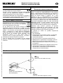
5. Zur Einstellung „Azimuth“
Bei dieser Winkelangabe handelt es sich um die Position
des Modells bezogen auf Nord (Î 19.). Diese Winkelangabe kann Ihnen ggfs. dabei helfen, das Modell bei
einer Außenlandung wieder zu finden.
6. Zur Einstellung „Heading“
Bei dieser Winkelangabe handelt es sich um „den Kompass im Modell“. Stellen Sie sich vor, Sie sitzen im Modell
und schauen auf einen Kompass. Mit dieser Winkelangabe können Sie „Kurs fliegen“ (Î 19.).
Beispiele:
x
0° Î Modell fliegt nach Norden
x
90° Î Modell fliegt nach Osten
x 180° Î Modell fliegt nach Süden
x 270° Î Modell fliegt nach Westen
7. Zur Einstellung „Elongation“
Bei dieser Winkelangabe handelt es sich um die
Flugrichtung bezogen auf den Piloten. Bei der Einstellung
„Elongation“ spielt der Nordpol also keine Rolle, es zählt
der Fixpunkt (Î 19.)!
Seite 9
Bedienungsanleitung
GPS für M-LINK Empfänger
Beispiele:
x
0° Î Modell fliegt vom Piloten weg
x
90° Î Modell fliegt nach rechts
x 180° Î Modell fliegt auf den Piloten zu
x 270° Î Modell fliegt nach links
16. CE-KONFORMITÄTSERKLÄRUNG
Die Bewertung des Gerätes erfolgte nach europäisch harmonisierten Richtlinien.
Sie besitzen daher ein Produkt, das hinsichtlich der
Konstruktion die Schutzziele der Europäischen Gemeinschaft zum sicheren Betrieb der Geräte erfüllt.
Die ausführliche CE-Konformitätserklärung finden Sie als
PDF-Datei im Internet bei www.multiplex-rc.de im Bereich
DOWNLOADS unter PRODUKT-INFOS.
Anleitung GPS für M-LINK Empfänger # 82 5492 (11-02-14/MIWA) • Irrtum und Änderung vorbehalten! • ¤ MULTIPLEX
17. ENTSORGUNG
Elektrogeräte, die mit der durchgestrichenen
Mülltonne gekennzeichnet sind, zur Entsorgung
nicht in den Hausmüll geben, sondern einem
geeigneten Entsorgungssystem zuführen.
In Ländern der EU (Europäische Union) dürfen
Elektrogeräte nicht durch den Haus- bzw. Restmüll
entsorgt werden (WEEE - Waste of Electrical and Electronic Equipment, Richtlinie 2002/96/EG). Sie können Ihr
Altgerät bei öffentlichen Sammelstellen Ihrer Gemeinde
bzw. ihres Wohnortes (z.B. Recyclinghöfen) kostenlos
abgeben. Das Gerät wird dort für Sie fachgerecht und
kostenlos entsorgt.
Mit der Rückgabe Ihres Altgerätes leisten Sie einen
wichtigen Beitrag zum Schutz der Umwelt!
18. GEWÄHRLEISTUNG /
HAFTUNGSAUSSCHLUSS
Die Firma MULTIPLEX Modellsport GmbH & Co.KG
übernimmt keinerlei Haftung für Verluste, Schäden oder
Kosten, die sich aus fehlerhafter Verwendung und Betrieb
ergeben oder in irgendeiner Weise damit zusammenhängen. Soweit gesetzlich zulässig, ist die Verpflichtung
der Firma MULTIPLEX Modellsport GmbH & Co.KG zur
Leistung von Schadenersatz, gleich aus welchem
Rechtsgrund, begrenzt auf den Rechnungswert der an
dem schadenstiftenden Ereignis unmittelbar beteiligten
Warenmenge der Firma MULTIPLEX Modellsport GmbH
& Co.KG. Dies gilt nicht, soweit die MULTIPLEX Modellsport GmbH & Co.KG nach zwingenden gesetzlichen
Vorschriften wegen Vorsatzes oder grober Fahrlässigkeit
unbeschränkt haftet.
Für unsere Produkte leisten wir entsprechend den derzeit
geltenden gesetzlichen Bestimmungen Gewähr. Wenden
Sie sich mit Gewährleistungsfällen an den Fachhändler,
bei dem Sie das Produkt erworben haben.
Von der Gewährleistung ausgeschlossen sind Fehlfunktionen, die verursacht wurden durch:
x Unsachgemäßen Betrieb
x Falsche, nicht oder verspätet, oder nicht von einer
autorisierten Stelle durchgeführte Wartung
x Falsche Anschlüsse
x Verwendung von nicht originalem MULTIPLEXZubehör
x Veränderungen / Reparaturen, die nicht von
MULTIPLEX oder einer MULTIPLEX Servicestelle
ausgeführt wurden
x Versehentliche oder absichtliche Beschädigungen
x Defekte, die sich aus der normalen Abnutzung
ergeben
x Betrieb außerhalb der technischen Spezifikationen
oder im Zusammenhang mit Komponenten anderer
Hersteller.
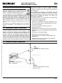
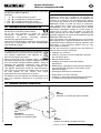
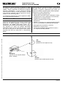
19. AZIMUTH, HEADING, ELONGATION
245°
Heading
(Flugrichtung bezogen auf Nord)
312°
Elongation
(Flugrichtung bezogen auf
die Achse Pilot – Modell)
Pilot
289°
Azimuth
(Position des Modells bezogen auf Nord)
Seite 10
Operating Instructions
GPS for M-LINK receivers
! These operating instructions are an integral
part of the product, and contain important information and safety notes. For this reason
please keep them readily accessible, and be
sure to pass them on to the new owner if you
ever dispose of the product.
1.
SPECIFICATION
Order No.
# 8 5417
GPS receiver
High-sensitivity GPS receiver
with fifty channels
Aerial
Four-core circular polarised
helical aerial for virtually
omni-directional reception
Address / screen line 9:
Spatial groundspeed (3D) in
km/hr
Data output
(base functions /
default settings)
Address / screen line 10:
Altitude above fixed point in
metres (m)
Instructions - GPS for M-LINK receivers # 82 5492 (11-02-14/MIWA) • Errors and omissions excepted! • ¤ MULTIPLEX
Address / screen line 11:
Spatial distance (3D) to fixed
point in metres (m)
Cold-start time
under normal reception
conditions
approx. 1 minute
Warm-start time
under normal reception
conditions
approx. 10 seconds
Buffer battery
yes, integral
Accuracy
under optimum
reception conditions
approx. 2.5 m (position) /
approx. 0.1 m/s (speed)
Accuracy
under normal
reception conditions
approx. 5 - 10 m /
approx. 0.5 - 1 m/s
Sampling rate
2 Hz
Current drain
approx. 80 mA
Dimensions (L x W x H)
60.5 x 20.0 x 16.0 mm
Temperature range
- 20°C … + 55°C
Weight (incl. leads)
16 g
2.
SAFETY NOTES
! Read right through these instructions before use.
! Use only for the intended purpose (Î 3.).
! Observe the installation notes (Î 7.).
! Protect the GPS unit from vibration.
3.
APPLICATION
The MULTIPLEX GPS for M-LINK receivers (hereinafter
“GPS”) has been developed exclusively for modelling
applications. It is prohibited to use the unit for industrial
applications or in man-carrying equipment or vehicles.
4.
BASICS, MEASURING PRINCIPLE
The MULTIPLEX GPS for M-LINK receivers provides a
means of obtaining interesting information direct from your
model.
At last you can actually see values such as the model’s
current airspeed, its altitude above the launch site, and its
distance!
It is also possible to obtain values for other individual
parameters such as the total distance covered by the
model, and various angular information. Warning thresholds can be set on the GPS, and a variety of minimum,
maximum and average values can be displayed.
The GPS is based on the same measuring principle as
satellite navigation. It exploits the civilian service of the
U.S. Global Positioning System “GPS”.
The measurement of position and speed by means of
GPS is based on more than 24 satellites which circle the
world on precisely determined paths, each orbit taking 11
hours and 58 minutes. Each satellite contains at least one
extremely accurate time-base (atomic clock), which is
monitored and synchronised by fixed stations on Earth.
The receiver in the MULTIPLEX GPS also contains a
clock which is synchronised to the atomic clocks in the
satellites. Each satellite transmits a signal to Earth using a
pre-determined pattern which is known to the MULTIPLEX
GPS receiver.
By measuring the timing of the individual signals it is
possible to determine the distance between the satellites
and the receiver; provided that the position of the satellites is known, this makes it possible to establish the
position of the receiver on the Earth’s surface.
5.
COMPATIBLE OUTPUT DEVICES
The basic functions of the GPS (default settings, Î 11.)
can be used without any configuration work provided that
one of the following transmitters is used:
x ROYALevo and ROYALpro transmitters,
fitted with M-LINK technology
x Transmitters equipped with the MULTIPLEX
Telemetry-Display (# 4 5182).
The GPS can also be operated in conjunction with the
following transmitters after completing an individual configuration process:
x COCKPIT SX M-LINK transmitters
(firmware version V3.06 and later)
Before using the GPS with a COCKPIT SX M-LINK it is
essential to set address values in the range 0 to 7 on
the GPS itself. It is also necessary to configure the
GPS for this application.
With the MULTImate (# 8 2094) or the “MULTIPLEX
Launcher” PC program (available as a free download from
the MULTIPLEX website (essential accessory: USB PClead, UNI (# 8 5149)) the GPS can be configured easily
and conveniently to suit personal requirements (Î 13. +
14.).
Page 11
Operating Instructions
GPS for M-LINK receivers
6.
AERIAL CHARACTERISTICS
The reception characteristics of the aerial (the black
cylinder at the opposite end to the cable output) are
designed to enable reception in virtually all directions
(omni-directional). The only direction in which reception is
impossible is “back”, i.e. facing the GPS analysis electronics and connecting leads.
Instructions - GPS for M-LINK receivers # 82 5492 (11-02-14/MIWA) • Errors and omissions excepted! • ¤ MULTIPLEX
7.
INSTALLING THE GPS IN THE MODEL
1) Position the GPS in the model in a suitable location
for optimum reception conditions, i.e. giving the aerial
(Î 6.) an unobstructed “view” over as large an area of
the sky as possible in most flight attitudes:
x Model gliders (thermal soarers)
In this case we recommend installing the MULTIPLEX GPS standing vertically in the fuselage, i.e.
with the aerial pointing up.
x Aerobatic models
An alternative location is horizontal, aligned with the
fuselage centreline.
2) To prevent signal shielding, ensure that the GPS aerial
is as far away as possible from conductive materials:
Electrically conductive materials such as carbon fibre,
metal foil or metallic paints shield the signal, and have
an adverse effect on reception. The same applies to
house walls and materials containing water, such as
grass, leaves and trees. Materials such as GRP and
®
ELAPOR foam have no adverse effect provided that
the material thickness is in the ‘normal’ range.
A good position is under a canopy made of non-conductive material.
3) Secure the GPS in the model using Velcro (hook-andloop) tape or similar. Protect your GPS from vibration,
especially in models with I.C. engines (e.g. pack it
loosely in shock-absorbing foam).
! Note:
The signals from the GPS satellites are transmitted on a
frequency of around 1.58 GHz, and are propagated in a
comparable manner to the signals of the M-LINK system
operating on 2.4 GHz. However, they are many times
weaker due to the distance of the satellites, which is about
20,200 kilometres:
This means that you should deploy the GPS with the
same care you would apply when installing and
deploying the aerial(s) of your M-LINK receiver!
8.
CONNECTIONS
Connect the GPS connecting lead (marked RX/S) to the
sensor socket of your telemetry-capable M-LINK receiver
(marked “S” or “SENSOR”).
Alternatively - if you are using multiple M-LINK sensors the GPS can be connected to another M-LINK sensor
using the socket marked “S”.
When connecting the UNI lead (RX/S) take care to insert
the connector the right way round, and maintain correct
polarity (pin assignment) if using non-MULTIPLEX equipment.
! Note:
If you have to configure the GPS, it must be connected to
the MULTImate or PC on its own. If you wish to set up
alarm thresholds on the GPS, or activate additional
measurement channels, this means that you should
always do so before installing the unit in the model.
9.
USING THE GPS FOR THE FIRST TIME
Switch the RC system ON, and ensure that reception is
possible:
x As clear a view of the sky as possible for the GPS
x Model not resting in tall grass, under trees or indoors
Î After a wait of one to a few minutes the first values will
be displayed on your transmitter screen, or on the
Telemetry-Display.
! Notes:
If no data, or irregular data, is transmitted even after a
long period, you will need to improve the installed location
and / or the aerial position of the GPS.
It is perfectly normal for the GPS to display no values at
all in an enclosed space. This is not a GPS error!
10. INTEGRAL BUFFER BATTERY
When you switch the RC system OFF - and with it the
GPS - an integral buffer battery continues to power the
GPS receiver’s clock for a few minutes, even without an
external power supply. During this period the unit also
stores the satellite trajectory data.
This simply means that, when you switch ON for the first
time in a flying session, you have to wait a short while
before reception is present.
If you fly the model again immediately after switching off,
reception will be restored within just a few seconds of
switching the system ON or connecting the battery.
11. DEFAULT GPS SETTINGS
The following default data are displayed on the transmitter
screen or the Telemetry-Display:
x Address 9:
Spatial groundspeed (3D) in km/hr
x Address 10:
Altitude above fixed point in metres (m)
x Address 11:
Spatial distance (3D) to fixed point in metres (m) /
distance
In this context the “address” means:
x The screen line on the ROYALevo / pro transmitter
x The screen line on the Telemetry-Display
x The INFO display on the COCKPIT SX M-LINK
at which the corresponding telemetry value is displayed.
The default model type is “fast plane” (= fast aircraft)
(Î 15.4.).
Page 12
Operating Instructions
GPS for M-LINK receivers
12. MULTIMATE AND THE MULTIPLEX
LAUNCHER PC PROGRAM
13. GPS CONFIGURATION FACILITIES WITH
MULTIPLEX MULTIMATE (# 8 2094)
The GPS can easily and conveniently be configured to
suit your personal preferences, using:
This Chapter lists the configuration facilities of the GPS
using the MULTImate, showing both the English and
German menu systems:
Instructions - GPS for M-LINK receivers # 82 5492 (11-02-14/MIWA) • Errors and omissions excepted! • ¤ MULTIPLEX
x MULTIPLEX MULTImate (# 8 2094)
Î With firmware version V1.48 or later,
or
x MULTIPLEX Launcher PC program
Î This PC program is available as a free download from
our website: www.multiplex-rc.de. Essential accessory: USB PC lead, UNI (# 8 5149)
The MULTImate or Launcher program can be used to
alter the screen lines / addresses for the measurements
and option values, to activate additional measurement
channels, and to set warning thresholds.
The Launcher also offers the following facilities:
x GPS reset to default settings
x Transfer of firmware updates
The configuration facilities available with the MULTImate
are described in detail in Chapter (Î 13.). The configuration facilities available with Launcher are covered in
Chapter (Î 14.).
The sensors are connected to the receiver and each other
using the MULTIPLEX Sensor Bus (MSB). The data are
displayed on the previously selected screen lines /
addresses on the transmitter screen or Telemetry-Display.
A maximum of sixteen sensors can be connected to the
MULTIPLEX Sensor Bus, i.e. up to sixteen addresses can
be used for measured values and options:
x COCKPIT SX M-LINK
Î Output of max. eight telemetry values possible
x ROYALevo/pro with M-LINK technology
Î Output of max. fifteen telemetry values possible
x Transmitter with Telemetry-Display connected
Î Output of max. sixteen telemetry values possible
The measured values are displayed on the transmitter
screen or the Telemetry-Display. It is possible to set
warning thresholds which trigger audible and visual
warnings when limit values are exceeded (e.g. altimeter:
top alarm = 500 m: an alarm is triggered when the model
exceeds a height of 500 m). When this occurs, the transmitter screen (or the Telemetry-Display) switches to the
corresponding address / screen line, and shows the
exceeded value - in our example the model’s altitude.
! Note:
To be able to exploit all the current features of the GPS,
and of the connected components generally, you should
update your MULTImate or Launcher at regular intervals.
11 MPX Sensors / MPX Sensoren
11-3 Settings / Einstellung
Sp3D / G3D
(= spatial groundspeed (3D) in km/hr)
Configuration options:
Address / Adresse
(= address)
Î off / aus (= off), or an address
in the range 0 to 15
Alarm low / Alarm unten
(= bottom alarm)
Î off / aus (= off), or a speed
in the range 0.0 km/hr to 700.0 km/hr
Alarm high / Alarm oben
(= top alarm)
Î off / aus (= off), or a speed
in the range 0.0 km/hr to 700.0 km/hr
Option / Option
(= option)
Î Max value, Min value, Average /
Maximalwert, Minimalwert, Mittelwert
(= maximum value, minimum value or average value),
in each case in km/hr
Option ad. / Option Adr.
(= option address)
Î off / aus (= off), or an address
in the range 0 to 15
Sp2D / G2D
(= level flight groundspeed (2D) in km/hr)
Configuration options:
Address / Adresse
(= address)
Î off / aus (= off), or an address
in the range 0 to 15
Alarm low / Alarm unten
(= bottom alarm)
Î off / aus (= off), or a speed
in the range 0.0 km/hr to 700.0 km/hr
Alarm high / Alarm oben
(= top alarm)
Î off / aus (= off), or a speed
in the range 0.0 km/hr to 700.0 km/hr
Option / Option
(= option)
Î Max value, Min value, Average /
Maximalwert, Minimalwert, Mittelwert
(= maximum value, minimum value or average value),
in each case in km/hr
Page 13
Operating Instructions
GPS for M-LINK receivers
Instructions - GPS for M-LINK receivers # 82 5492 (11-02-14/MIWA) • Errors and omissions excepted! • ¤ MULTIPLEX
Option ad. / Option Adr.
(= option address)
Î off / aus (= off), or an address
in the range 0 to 15
H/H
(= height above fixed point in m)
Configuration options:
Address / Adresse
(= address)
Î off / aus (= off), or an address
in the range 0 to 15
Alarm low / Alarm unten
(= bottom alarm)
Î off / aus (= off), or a height
in the range - 500 m to 2000 m
Alarm high / Alarm oben
(= top alarm)
Î off / aus (= off), or a height
in the range - 500 m to 2000 m
Option / Option
(= Option)
Î Max value, Min value, Average /
Maximalwert, Minimalwert, Mittelwert
(= Maximum value, minimum value or average value),
in each case in m
Option addr. / Option Adr.
(= option address)
Î off / aus (= off), or an address
in the range 0 to 15
Di3D / E3D
(= spatial distance (3D) to fixed point in m / distance)
Configuration options:
Address / Adresse
(= address)
Î off / aus (= off), or an address
in the range 0 to 15
Alarm low / Alarm unten
(= bottom alarm)
Î off / aus (= off), or a distance
in the range 0 m to 2000 m
Alarm high / Alarm oben
(= top alarm)
Î off / aus (= off), or a distance
in the range 0 m to 2000 m
Option / Option
(= option)
Î Max value, Min value, Average /
Maximalwert, Minimalwert, Mittelwert
(= maximum value, minimum value or average value),
in each case in m
Option ad. / Option Adr.
(= option address)
Î off / aus (= off), or an address
in the range 0 to 15
Di2D / E2D
(= horizontal distance (2D) to fixed point
in m / distance)
Configuration options:
Address / Adresse
(= address)
Î off / aus (= off), or an address
in the range 0 to 15
Alarm low / Alarm unten
(= bottom alarm)
Î off / aus (= off), or a distance
in the range 0 m to 2000 m
Alarm high / Alarm oben
(= top alarm)
Î off / aus (= off), or a distance
in the range 0 m to 2000 m
Option / Option
(= option)
Î Max value, Min value, Average /
Maximalwert, Minimalwert, Mittelwert
(= maximum value, minimum value or average value),
in each case in m
Option ad. / Option Adr.
(= option address)
Î off / aus (= off), or an address
in the range 0 to 15
Total dist. 3D / Wegstrecke 3D
(= distance covered over ground (3D)
in m or km)
Î off / aus (= off), or an address
in the range 0 to 15
Note: if the distance is over 10 km, the value is displayed
in km; below this figure it is displayed in m
Total dist. 2D / Wegstrecke 2D
(= horizontal distance covered over ground (2D)
in m or km)
Î off / aus (= off), or an address
in the range 0 to 15
Note: if the distance is over 10 km, the value is displayed
in km; below this figure it is displayed in m
Model type / Modelltyp
(= setting of appropriate model type, intended to
optimise the output data)
Î slow plane / car, Boat, fast plane/ jet /
langs.Flugz/Auto, Boot, schn.Flugz/Jet
(= slow aircraft / car, boat, fast aircraft / jet)
Azimuth / Azimuth
(= angle from fixed point to object in degrees, relative
to North)
Î off / aus (= off), or an address
in the range 0 to 15
Heading / Heading
(= direction of aircraft in degrees, relative to North)
Î off / aus (= off), or an address
in the range 0 to 15
Page 14
Operating Instructions
GPS for M-LINK receivers
Elongation / Elongation
(= direction of the model in degrees, relative to the
fixed point)
Î off / aus (= off), or an address
in the range 0 to 15
11-3 Send data / Daten send.
(= transmit data)
Î long press on the adjuster wheel to transmit data
14. GPS CONFIGURATION FACILITIES
USING MULTIPLEX LAUNCHER
This chapter lists the GPS configuration facilities using the
Launcher, showing both the English and German menu
systems.
! Note: the messages correspond to Expert mode,
i.e. the “Expert mode” / “Expertenmodus” button in
Launcher has been clicked.
Instructions - GPS for M-LINK receivers # 82 5492 (11-02-14/MIWA) • Errors and omissions excepted! • ¤ MULTIPLEX
Speed 3D / Geschwindigkeit 3D
(= spatial speed over ground (3D) in km/hr)
Configuration options:
Address / Adresse
(= address)
Î off / aus (= off), or an address
in the range 0 to 15
Alarm high / Alarm oben
(= top alarm)
Î off / aus (= off), or a speed
in the range 0.0 km/hr to 700.0 km/hr
Alarm low / Alarm unten
(= bottom alarm)
Î off / aus (= off), or a speed
in the range 0.0 km/hr to 700.0 km/hr
Address / Adresse
(= option address)
Î off / aus (= off), or an address
in the range 0 to 15
Type / Typ
(= type)
Î Max value, Min value, Average /
Maximalwert, Minimalwert, Mittelwert
(= maximum value, minimum value or average value),
in each case in km/hr
Speed 2D / Geschwindigkeit 2D
(= horizontal speed over ground (2D) in km/hr)
Configuration options:
Address / Adresse
(= address)
Î off / aus (= off), or an address
in the range 0 to 15
Alarm high / Alarm oben
(= top alarm)
Î off / aus (= off), or a speed
in the range 0.0 km/hr to 700.0 km/hr
Alarm low / Alarm unten
(= bottom alarm)
Î off / aus (= off), or a speed
in the range 0.0 km/hr to 700.0 km/hr
Address / Adresse
(= option address)
Î off / aus (= off), or an address
in the range 0 to 15
Type / Typ
(= option)
Î Max value, Min value, Average /
Maximalwert, Minimalwert, Mittelwert
(= maximum value, minimum value or average value),
in each case in km/hr
Height / Höhe
(= height above fixed point in m)
Configuration options:
Address / Adresse
(= address)
Î off / aus (= off), or an address
in the range 0 to 15
Alarm high / Alarm oben
(= top alarm)
Î off / aus (= off), or a height
in the range - 500 m to 2000 m
Alarm low / Alarm unten
(= bottom alarm)
Î off / aus (= off), or a height
in the range - 500 m to 2000 m
Address / Adresse
(= option address)
Î off / aus (= off), or an address
in the range 0 to 15
Type / Typ
(= option)
Î Max value, Min value, Average /
Maximalwert, Minimalwert, Mittelwert
(= maximum value, minimum value or average value),
in each case in m
Distance 3D / Entfernung3D
(= spatial distance (3D) to fixed point in m / distance)
Configuration options:
Address / Adresse
(= address)
Î off / aus (= off), or an address
in the range 0 to 15
Alarm high / Alarm oben
(= top alarm)
Î off / aus (= off), or a distance
in the range 0 m to 2000 m
Alarm low / Alarm unten
(= bottom alarm)
Î off / aus (= off), or a distance
in the range 0 m to 2000 m
Page 15
Operating Instructions
GPS for M-LINK receivers
Instructions - GPS for M-LINK receivers # 82 5492 (11-02-14/MIWA) • Errors and omissions excepted! • ¤ MULTIPLEX
Address / Adresse
(= option address)
Î off / aus (= off), or an address
in the range 0 to 15
Type / Typ
(= option)
Î Max value, Min value, Average /
Maximalwert, Minimalwert, Mittelwert
(= maximum value, minimum value or average value),
in each case in m
Distance 2D / Entfernung 2D
(= horizontal distance (2D) to fixed point in m /
distance)
Configuration options:
Address / Adresse
(= address)
Î off / aus (= off), or an address
in the range 0 to 15
Alarm high / Alarm oben
(= top alarm)
Î off / aus (= off), or a distance
in the range 0 m to 2000 m
Alarm low / Alarm unten
(= bottom alarm)
Î off / aus (= off), or a distance
in the range 0 m to 2000 m
Address / Adresse
(= option address)
Î off / aus (= off), or an address
in the range 0 to 15
Type / Typ
(= option)
Î Max value, Min value, Average /
Maximalwert, Minimalwert, Mittelwert
(= maximum value, minimum value or average value),
in each case in m
Total distance 3D / Wegstrecke 3D
(= spatial distance covered over ground (3D)
in m or km)
Î off / aus (= off), or an address
in the range 0 to 15
Note: if the distance is over 10 km, the value is displayed
in km; below this figure it is displayed in m
Total distance 2D / Wegstrecke 2D
(= horizontal distance covered over ground (2D)
in m or km)
Î off / aus (= off), or an address
in the range 0 to 15
Note: if the distance is over 10 km, the value is displayed
in km; below this figure it is displayed in m
Azimuth / Azimuth
(= angle from fixed point to object in degrees, relative
to North)
Î off / aus (= off), or an address
in the range 0 to 15
Heading / Heading
(= direction of aircraft in degrees, relative to North)
Î off / aus (= off), or an address
in the range 0 to 15
Model type / Modelltyp
(= setting of appropriate model type, intended to
optimise the output data)
Î Slow plane, car ; Boat ; Fast plane, jet /
Langsames Flugzeug, Auto ; Boot ; schnelles
Flugzeug, Jet
(= slow aircraft, car; boat; fast aircraft, jet)
Elongation / Elongation
(= direction of the model in degrees, relative to fixed
point)
Î off / aus (= off), or an address
in the range von 0 to 15
Send / Senden
(= transmit data)
Î click on button to transmit the data
Factory Set. / Werkseinst.
(= reset to default settings)
Î click on button to reset the values to the default
settings
Expert mode / Expertenmodus
(= “Expert mode” view)
Î click on button to switch “Expert mode” view on or off
Reset / Reset
(= reset option values)
Î click on button to erase the option values
Exit / Beenden
(= end)
Î click on button to close the view
15. BACKGROUND INFORMATION ON GPS
1. Reference value for speeds (2D and 3D)
The generated speed value (2D and 3D) always takes the
Earth’s surface as its reference point, i.e. the speed is
relative to the rotating surface of the Earth.
2. Accuracy of the GPS
The accuracy of the GPS unit varies according to a number of factors such as installed situation, reception
environment and momentary location of the satellites.
Under optimum reception conditions positional accuracy is
generally better than 2.5 m, and speed accuracy better
than 0.1 m/s.
Under poor reception conditions accuracy may be lower.
In some unfavourable situations deviations of 15 m or
1 m/s may be observed.
Page 16
Operating Instructions
GPS for M-LINK receivers
3. Fixed point
The fixed point is set when the GPS is switched on:
x As the current position:
… if the GPS signal is very accurate, and the
MULTIPLEX GPS is not moving,
or:
But please note: it is nevertheless possible that the model
aeroplane has not flown these (measured) changes of
direction at all, i.e. they may represent false measurements caused by unfavourable aerial deployment, poor
weather, contact with a small number of satellites,
reflections, shielding effects, etc.
x
c) Summary
In general terms it is advisable to select the “Slow plane“ /
“Langsames Flugzeug“ setting for a model aircraft, provided that the values shown on the transmitter screen or
the Telemetry-Display appear to be plausible; if you select
the “Fast plane“ / “Schnelles Flugzeug“ setting, the GPS
will tend to consider valid any erroneous measurements
which would have been correctly assessed as false at the
“Slow plane“ / “Langsames Flugzeug“ setting.
As the last established position:
… if the GPS signal is very accurate, and the MULTIPLEX GPS is moving.
4. Re. the “Model type” setting
Instructions - GPS for M-LINK receivers # 82 5492 (11-02-14/MIWA) • Errors and omissions excepted! • ¤ MULTIPLEX
Model type
Maximum
horizontal speed
Maximum
vertical speed
Slow aircraft /
car
223 km/hr
54 km/hr
Boat
90 km/hr
18 km/hr
Fast aircraft /
jet
360 km/hr
360 km/hr
a) “Slow plane“ / “Langsames Flugzeug“ setting
(= slow aircraft)
You can fine-tune the data output on the transmitter
screen or the Telemetry-Display by selecting the appropriate model type setting:
For example, it is not possible for a slow aircraft (“Slow
plane“ / “Langsames Flugzeug“ setting) to fly at a speed
of 300 km/hr. If the GPS measures such an implausible
value for this model category, it is clearly based on a
“false measurement”, so it suppresses the value.
False measurements may occur due to unfavourable
aerial deployment, poor weather (heavy cloud cover),
contact with only a small number of satellites, reflections,
shielding effects, etc.
Neither is it possible for a slow aeroplane to fly tight
changes of direction at high speed; this would manifest
itself as extremely fast alternating position values. If the
GPS detects such behaviour, then this also invariably
represents incorrect measurements. Once again, the GPS
suppresses the measured values in the data output when
the “Slow plane“ / “Langsames Flugzeug“ setting is selected.
The net result is that the values generated at the transmitter or the Telemetry-Display exhibit less pronounced
scatter if the GPS is set to the “Slow plane“ / “Langsames
Flugzeug“ setting.
b) “Fast plane“ / “Schnelles Flugzeug“ setting
(= fast aircraft)
High-speed aeroplanes are certainly capable of moving
very quickly in a zig-zag course, i.e. fast changes of
direction are possible with this aircraft type. For this
reason the GPS does not suppress rapid changes of position when the “Fast plane“ / “Schnelles Flugzeug“ setting
is selected.
One result of this is that the values generated at the transmitter or the Telemetry-Display exhibit more pronounced
scatter if the GPS is set to the “Fast plane“ / “Schnelles
Flugzeug“ setting.
5. Re. the “Azimuth“ setting
This angle value represents the model’s position relative
to North (Î 19.). This angular value may well help you to
find the model after an out-landing.
6. Re. the “Heading“ setting
This angle value represents the “compass in the model”:
imagine you are sitting in the model and looking at a
compass. This angular information enables you to “fly a
course” (Î 19.).
Examples:
x
0° Î model flying North
x
90° Î model flying East
x 180° Î model flying South
x 270° Î model flying West
7. Re. the “Elongation“ setting
This angle value represents the model’s direction of
flight relative to the pilot. The North Pole plays no role in
the “Elongation” setting; what matters is the fixed point
(Î 19.)!
Examples:
x
0° Î model flying away from the pilot
x
90° Î model flying to the right
x 180° Î model flying towards the pilot
x 270° Î model flying to the left
16. CE CONFORMITY DECLARATION
This device has been assessed and approved
in accordance with European harmonised directives.
This means that you possess a product whose design and
construction fulfil the protective aims of the European
Community designed to ensure the safe operation of
equipment.
The detailed CE conformity declaration can be downloaded in the form of a PDF file from the Internet under
www.multiplex-rc.de. It is located in the DOWNLOADS
area under PRODUKT-INFOS.
Page 17
Operating Instructions
GPS for M-LINK receivers
17. DISPOSAL NOTES
Electrical equipment marked with the cancelled
waste bin symbol must not be discarded in the
standard household waste; instead it should be
taken to a suitable specialist disposal system.
In the countries of the EU (European Union)
electrical equipment must not be discarded via the normal
domestic refuse system (WEEE - Waste of Electrical and
Electronic Equipment, Directive 2002/96/EG). You can
take unwanted equipment to your nearest local authority
waste collection point or recycling centre. There the
equipment will be disposed of correctly and at no cost to
you.
By returning your unwanted equipment you can make an
important contribution to the protection of the environment!
18. GUARANTEE / LIABILITY EXCLUSION
Instructions - GPS for M-LINK receivers # 82 5492 (11-02-14/MIWA) • Errors and omissions excepted! • ¤ MULTIPLEX
The company MULTIPLEX Modellsport GmbH & Co.KG
accepts no liability of any kind for loss, damage or costs
which are due to the incorrect use and operation of this
product, or which are connected with such operation in
any way. Unless the law expressly states otherwise, the
liability on the part of MULTIPLEX Modellsport GmbH &
Co.KG to pay damages, regardless of the legal argument
employed, is limited to the invoice value of those products
supplied by MULTIPLEX Modellsport GmbH & Co.KG which
were directly involved in the event in which the damage
occurred. This does not apply if liability is incurred
according to statutory law on account of intentional or
gross negligence.
We guarantee our products in accordance with the
currently valid statutory regulations. If you wish to make a
claim under guarantee, your initial course of action should
always be to contact the dealer from whom you
purchased the equipment.
The guarantee does not cover faults and malfunctions
which are caused by the following:
x Incorrect or incompetent use
x Maintenance carried out incorrectly, belatedly or not at
all, or not carried out by an authorised Service Centre
x Incorrect connections
x The use of accessories other than genuine
MULTIPLEX items
x Modifications or repairs which were not carried out by
MULTIPLEX or by an authorised MULTIPLEX Service
Centre
x Accidental or intentional damage
x Defects due to normal wear and tear
x Operation of the unit outside the limits stated in the
Specification
x Operation of the unit in conjunction with equipment
made by other manufacturers.
19. AZIMUTH, HEADING, ELONGATION
245°
Heading
(flight direction relative to North)
312°
Elongation
(flight direction relative to the
pilot – model axis)
Pilot
289°
Azimuth
(model´s position relative to North)
Page 18
Notice d’utilisation
GPS pour récepteurs M-LINK
! Cette notice fait partie intégrante du produit. Elle contient de précieuses informations
et d’importantes consignes de sécurité. Faites
en sorte de l’avoir toujours à portée de main,
et n’omettez pas de la transmettre, en cas de
revente, au nouvel acquéreur.
1.
CARACTÉRISTIQUES TECHNIQUES
Réf.Cde.
# 8 5417
Récepteur GPS
Récepteur GPS ultrasensible à 50 voies
Antenne
Antenne Helix 4 fils à
polarisation circulaire
pour une réception quasi
omnidirectionnelle
Adresse / Ligne écran 9:
Vitesse par rapport au sol en
km/h (dans un espace 3D)
Notice GPS pour récepteurs M-LINK # 82 5492 (11-02-14/MIWA) Ɣ Sous réserves d’erreurs et de modifications! Ɣ ¤ MULTIPLEX
Transmission des
données
(Fonctions de base /
Réglages usine)
Durée pour un
démarrage à froid dans
des conditions de
réception normales
Adresse / Ligne écran 10:
Altitude en mètres (m) par
rapport à un point fixe
Adresse / Ligne écran 11:
Eloignement en mètres (m)
dans l’espace (3D) par
rapport à un point fixe
env. 1 minute
Durée pour un
démarrage à chaud dans
env. 10 secondes
des conditions de
réception normales
Batterie tampon
oui, intégrée
Précision dans des
conditions de réception
optimales
env. 2,5 m (Position),
env. 0,1 m/s (Vitesse)
Précision dans des
conditions de réception
normales
env. 5 - 10 m,
env. 0,5 - 1 m/s
Intervalle
2 Hz
Consommation
env. 80 mA
Dimensions (L x l x h)
60,5 x 20,0 x 16,0 mm
Plage de température
- 20 °C … + 55 °C
Poids (avec cordons)
16 grs
2.
CONSIGNES DE SÉCURITÉ
! Avant utilisation, lire attentivement la notice, dans
son intégralité.
! A n’utiliser que dans dans les conditions d’utilisation recommandées (Î 3.).
! Respecter les instructions de montage (Î 7.).
! Protéger le GPS contre toutes vibrations.
3.
DOMAINE D’UTILISATION
Le GPS MULTIPLEX pour récepteurs M-LINK (désigné
ci-dessous par „GPS“) n’a été conçu que pour le modélisme. Son utilisation sur des appareils réels ou dans toutes
autres applications industrielles est formellement interdite.
4.
GÉNÉRALITÉS ET PRINCIPES DE BASE
Avec ce GPS MULTIPLEX pour récepteurs M-LINK, vous
avez accès à des données intéressantes émanant directement de votre modèle.
Des valeurs, telles que la vitesse actuelle du modèle, son
altitude par rapport au point de décollage et l’éloignement
du modèle peuvent enfin être visualisés!
Par ailleurs, d’autres données peuvent encore être
paramétrées, notamment la distance parcourue ou les
différents caps, paramétrables individuellement. De plus,
des seuils de déclenchement d’alarme peuvent être enregistrés au niveau du GPS, ainsi que l’affichage de valeurs
minimales, maximales ou de valeurs moyennes.
Ce GPS est basé sur le principe de la navigation par
satellites. C’est la version civile de l’US Global Positioning
System „GPS“ qui est utilisé.
Les relevés de la position et la mesure de la vitesse se
font avec grâce au GPS qui se base sur des données de
plus de 24 satellites qui ont des orbites bien précises et
qui font le tour de la terre en 11 heures et 58 minutes.
Ces satellites sont équipés d’une horloge extrêmement
précise (horloge atomique) qui, grâce aux stations de
base fixes sur la terre, peuvent être surveillés et
synchronisés en permanence.
Le récepteur GPS MULTIPLEX est également équipé
d’une telle horloge qui est synchronisée avec les horloges
atomiques des satellites. Chaque satellite envoie un
signal vers la terre dans un format reconnu et définit par
le récepteur MULTIPLEX GPS.
Grâce à la mesure du temps parcouru par chaque signal,
il est possible de déterminer la distance des différents
satellites par rapport au récepteur, et en fonction de la
position des satellites, on peut également déterminer la
position du récepteur par rapport à la terre.
5.
EMETTEURS COMPATIBLES
Si vous utilisez les émetteurs ci-dessous, le GPS, avec
ses fonctions de base (réglages d’origine, Î 11.) peut
être opérationnel, sans configuration particulière:
x Emetteurs de type ROYALevo et ROYALpro,
avec technologie M-LINK
x Emetteurs équipés de l’écran de télémétrie MULTIPLEX
(MULTIPLEX Telemetry Display (# 4 5182))
Après une configuration adéquate, le GPS peut également être utilisé avec les émetteurs suivants:
x Emetteurs de type COCKPIT SX M-LINK
(à partir de la version V3.06)
Pour utiliser le GPS avec une COCKPIT SX M-LINK il
faut auparavant enregistrer, au niveau du GPS, des
valeurs d’adresses entre 0 et 7. Dans ce cas, une
configuration du GPS est alors obligatoire.
Page 19
Notice d’utilisation
GPS pour récepteurs M-LINK
Avec le MULTImate (# 8 2094) ou avec le logiciel PC
„MULTIPLEX Launcher”, téléchargeable gratuitement sur
le site MULTIPLEX (accessoire nécessaire: cordon USBPC UNI (# 8 5149)), le GPS peut être configuré aisément
selon ses propres aspirations (Î 13. + 14.).
6.
CARACTÉRISTIQUES ANTENNE
L’antenne de réception (cylindre noir en face de la sortie
des fils) est conçue de telle sorte que la réception peut se
faire pratiquement à partir de n’importe quelle position
(omnidirectionnelle). Seulement, lorsqu’elle est dirigée
vers „l’arrière“, c’est-à-dire en direction de l’électronique et
du cordon de branchement du GPS, aucune réception
n’est possible.
Notice GPS pour récepteurs M-LINK # 82 5492 (11-02-14/MIWA) Ɣ Sous réserves d’erreurs et de modifications! Ɣ ¤ MULTIPLEX
7.
MONTAGE DU GPS DANS LE MODÈLE
1) Placez le GPS à un endroit adéquat dans le modèle,
de manière à ce que les conditions de réception soient
optimales et que l’antenne (Î 6.) quelquesoit la
position du modèle, soit toujours dirigée vers le haut:
x Dans des planeurs (vol thermique)
Il est conseillé de monter un support vertical GPS
MULTIPLEX dans le fuselage qui permet en sorte
que l’antenne soit toujours dirigée vers le haut.
x Sur des modèles de voltige
On peut également monter le GPS dans le sens
longitudinal du fuselage.
2) Veillez à ce que l’antenne GPS ne soit pas masquée
par des matériaux ou éléments conducteurs:
Des matériaux conducteurs, par exemple, carbone,
films métalliques ou vernis à particules métalliques
masquent le signal et atténuent la qualité de la
réception (blindage!). Il en est de même pour les murs
d’une maison, toutes les matières susceptibles de
retenir l’eau comme l’herbe, les feuilles ou les arbres.
®
Des matériaux comme le GfK ou l’ELAPOR , dans les
épaisseurs courantes n’ont aucune influence.
La bonne position est celle sous la verrière, si celle-ci
n’est pas dans une matière conductrice.
3) Fixez le GPS dans le modèle avec de la bande
crochetée. Si votre modèle est équipé d’une motorisation thermique, protégez-le contre les vibrations (par
ex. en l’enveloppant dans de la mousse).
! Remarque:
Les signaux émis par les satellites GPS, avec une
fréquence d’env. 1,58 GHz, sont comparables, au niveau
de la propagation, aux signaux du système M-LINK en
2,4 GHz. Ils sont néanmoins nettement plus faibles du fait
de l’altitude des satellites qui se situe à environ 20200
kilomètres:
C’est pourquoi, lors du montage du GPS, soyez aussi
minutieux que pour le montage et la pose de ou des
antennes de vos récepteurs M-LINK!
8.
BRANCHEMENT
Branchez le cordon du GPS (RX/S) sur une sortie
télémétrique de votre récepteur (sortie repérée par le
marquage „S“ ou „SENSOR“).
En cas d’utilisation de plusieurs capteurs M-LINK, le GPS
peut également être branché à la place d’un autre capteur
M-LINK sur la sortie „S“.
Lors du branchement du cordon UNI (RX/S) veillez à
respecter la polarité, notamment lorsque vous utilisez des
connexions de marques différentes!
! Remarque:
Pour une configuration individuelle, le GPS doit être
branché seul au MULTImate ou sur un PC. Si vous voulez enregistrer des seuils de déclenchement d’alarme sur
le GPS, ou activer d’autres voies de mesure, faites cela
avant de le monter dans le modèle.
9.
MISE EN ROUTE
Allumez votre ensemble RC et faites en sorte que la
réception soit possible:
x Accès libre du GPS vers le haut (ciel)
x Ne pas poser le modèle dans les herbes hautes, sous
les arbres ou dans la maison
Î Au bout d’une minute, voire plusieurs minutes, les
premières données seront affichées sur l’écran de
votre émetteur ou sur votre écran de télémétrie.
! Remarques:
Si au bout d’un certain temps aucune donnée ou des
données incohérentes sont retransmises, optimisez le
positionnement du GPS dans votre modèle et/ou
repositionnez l’antenne.
Si, dans un endroit fermé, le GPS n’affiche aucune valeur,
c’est normal, et ce n’est pas un dysfonctionnement de
votre GPS!
10. BATTERIE TAMPON INTÉGRÉE
Après avoir coupé l’ensemble radio, et ainsi le GPS, une
pile tampon intégrée alimente encore l’horloge du GPS,
sans alimentation extérieure, pendant quelques minutes.
Par ailleurs, les coordonnées des trajectoires des satellites
sont enregistrées.
Cela signifie, que pour faire un vol, et après avoir allumé
l’émetteur, il faudra attendre un certain temps, avant que
la réception ne se fasse.
Pour les vols qui suivent immédiatement après, et après
avoir allumé l’émetteur ou après avoir branché l’accu, la
réception se fait au bout de quelques secondes!
11. RÉGLAGES D’ORIGINE DU GPS
D’origine, les données ci-dessous sont affichées sur
l’émetteur ou sur l’écran de télémétrie:
x Adresse 9:
Vitesse par rapport au sol en km/h (dans un espace 3D)
x Adresse 10:
Altitude par rapport à un point fixe, en mètres (m)
x Adresse 11:
Eloignement / distance (dans l’espace 3D) en mètres
(m) par rapport au point fixe
Page 20
Notice d’utilisation
GPS pour récepteurs M-LINK
L’„Adresse“ correspond:
x à la ligne de l’écran de l’émetteur ROYALevo/pro
x à la ligne de l’écran de télémetrie
x à l’affichage INFO de la COCKPIT SX M-LINK
sur laquelle la valeur télémétrique correspondante est
affichée.
D’origine, c’est le réglage „Avion rapide“ qui est utilisé
pour le type de modèle (Î 15.4.).
12. MULTIMATE ET LOGICIEL PC
MULTIPLEX LAUNCHER
Le GPS peut être configuré aisément et simplement,
selon ses propres aspirations, avec:
x le MULTIPLEX MULTImate (# 8 2094)
Î A partir de la version V1.48
ou
Notice GPS pour récepteurs M-LINK # 82 5492 (11-02-14/MIWA) Ɣ Sous réserves d’erreurs et de modifications! Ɣ ¤ MULTIPLEX
x le logiciel PC MULTIPLEX Launcher
Î Ce logiciel est téléchargeable gratuitement sous
www.multiplex-rc.de. Accessoire nécessaire: cordon
interface USB PC, UNI (# 8 5149)
Avec le MULTImate ou le logiciel Launcher, vous pouvez
définir les lignes d’affichage/adresses des valeurs de
mesures et options, activer des voies de mesures
supplémentaires ou régler des seuils de déclenchement
d’alarme.
Par ailleurs, le logiciel Launcher offre encore les possibilités suivantes:
x Réinitialisation du GPS, retour aux réglages d’origine
x Affichage des mises à jour
Les différentes possibilités de configuration avec le
MULTImate sont détaillées au chapitre (Î 13.). Vous
trouverez les différentes possibilités de configuration avec
le logiciel Launcher au chapitre (Î 14.).
Les sondes et capteurs sont reliés entre eux et au
récepteur par un port Bus MULTIPLEX (MSB). Les
données sont affichées sur les lignes de l’écran
préenregistrées ou sur l’écran de télémétrie. Jusqu’à 16
capteurs/sondes peuvent être branchés sur le Bus
MULTIPLEX et jusqu’à 16 adresses peuvent être
attribuées pour les valeurs de mesures et options:
x COCKPIT SX M-LINK
Î Possibilité d’afficher un maximum de 8 données /
valeurs télémétriques
x ROYALevo/pro avec technologie M-LINK
Î Possibilité d’afficher un maximum de 15 données /
valeurs télémétriques
x Emetteur avec écran de télémétrie séparé
Î Possibilité d’afficher un maximum de 16 données /
valeurs télémétriques
Les valeurs releveés sont affichées à l’écran de l’émetteur
ou sur l’écran de télémétrie. L’enregistrement de seuils de
déclenchement d’alarme permet une signalisation
acoustique et visuelle du dépassement de valeurs limites
(par ex. Altimètre: seuil d’alarme supérieur = 500 m: dès
que vous avez atteint une altitude de 500 m, l’alarme se
déclenche). En même temps, l’adresse correspondante
s’affiche à l’écran de l’émetteur (ou sur l’écran de
télémétrie) et indique la valeur qui a été dépassée, dans
l’exemple ci-dessus, c’est l’altitude.
! Remarque:
Afin de pouvoir profiter de toutes les possibilités offertes
par le GPS et par les autres composants, nous vous
conseillons de faire régulièrement une mise à jour de
votre MULTImate ou de votre Launcher.
13. POSSIBILITÉS DE CONFIGURATION DU
GPS AVEC LE
MULTIPLEX MULTIMATE (# 8 2094)
Ce chapitre retrace toutes les configurations possibles du
GPS avec le MULTImate quelquesoit la langue du menu,
allemand ou anglais:
11 MPX Sensors / MPX Sensoren
11-3 Settings / Einstellung
Sp3D / G3D
(= Vitesse par rapport au sol en km/h (dans un
espace 3D)
Options de configuration:
Address / Adresse
(= Adresse)
Î off / aus (= off), ou une adresse
entre 0 et 15
Alarm low / Alarm unten
(= Seuil d’alarme inférieur)
Î off / aus (= off), ou une vitesse
entre 0,0 km/h et 700,0 km/h
Alarm high / Alarm oben
(= Seuil d’alarme supérieur)
Î off / aus (=off), ou une vitesse
entre 0,0 km/h et 700,0 km/h
Option / Option
(= Option)
Î Max value, Min value, Average /
Maximalwert, Minimalwert, Mittelwert
(= Valeur maxi, valeur mini ou valeur moyenne),
respectivement en km/h
Option ad. / Option Adr.
(= Option Adresse)
Î off / aus (= off), ou une adresse
entre 0 et 15
Sp2D / G2D
(= Vitesse horizontale en km/h par rapport au sol (2D))
Options de configuration:
Address / Adresse
(= Adresse)
Î off / aus (= off), ou une adresse
entre 0 et 15
Alarm low / Alarm unten
(= Seuil d’alarme inférieur)
Î off / aus (= off), ou une vitesse
entre 0,0 km/h et 700,0 km/h
Page 21
Notice d’utilisation
GPS pour récepteurs M-LINK
Notice GPS pour récepteurs M-LINK # 82 5492 (11-02-14/MIWA) Ɣ Sous réserves d’erreurs et de modifications! Ɣ ¤ MULTIPLEX
Alarm high / Alarm oben
(= Seuil d’alarme supérieur)
Î off / aus (= off), ou une vitesse
entre 0,0 km/h et 700,0 km/h
Option / Option
(= Option)
Î Max value, Min value, Average /
Maximalwert, Minimalwert, Mittelwert
(= Valeur maxi, valeur mini ou valeur moyenne),
respectivement en km/h
Option ad. / Option Adr.
(= Option Adresse)
Î off / aus (= off), ou une adresse
entre 0 et 15
H/H
(= Altitude en m par rapport à un point fixe)
Options de configuration:
Address / Adresse
(= Adresse)
Î off / aus (= off), ou une adresse
entre 0 et 15
Alarm low / Alarm unten
(= Seuil d’alarme inférieur)
Î off / aus (= off), ou une altitude
entre - 500 m et 2000 m
Alarm high / Alarm oben
(= Seuil d’alarme supérieur)
Î off / aus (= off), ou une altitude
entre - 500 m et 2000 m
Option / Option
(= Option)
Î Max value, Min value, Average /
Maximalwert, Minimalwert, Mittelwert
(= Valeur maxi, valeur mini ou valeur moyenne),
respectivement en m
Option addr. / Option Adr.
(= Option Adresse)
Î off / aus (= off), ou une adresse
entre 0 et 15
Di3D / E3D
(= Eloignement/distance en m par rapport
au point fixe (3D))
Options de configuration:
Address / Adresse
(= Adresse)
Î off / aus (= off), ou une adresse
entre 0 et 15
Alarm low / Alarm unten
(= Seuil d’alarme inférieur)
Î off / aus (= off), ou une distance/éloignement
entre 0 m et 2000 m
Alarm high / Alarm oben
(= Seuil d’alarme supérieur)
Î off / aus (= off), ou une distance/éloignement
entre 0 m et 2000 m
Option / Option
(= Option)
Î Max value, Min value, Average /
Maximalwert, Minimalwert, Mittelwert
(= Valeur maxi, valeur mini ou valeur moyenne),
respectivement en m
Option ad. / Option Adr.
(= Option Adresse)
Î off / aus (= off), ou une adresse
entre 0 et 15
Di2D / E2D
(= Eloignement/distance horizontal en m par rapport
au point fixe (2D))
Options de configuration:
Address / Adresse
(= Adresse)
Î off / aus (= off), ou une adresse
entre 0 et 15
Alarm low / Alarm unten
(= Seuil d’alarme inférieur)
Î off / aus (= off), ou une distance/éloignement
entre 0 m et 2000 m
Alarm high / Alarm oben
(= Seuil d’alarme supérieur)
Î off / aus (= off), ou une distance/éloignement
entre 0 m et 2000 m
Option / Option
(= Option)
Î Max value, Min value, Average /
Maximalwert, Minimalwert, Mittelwert
(= Valeur maxi, valeur mini ou valeur moyenne),
respectivement en m
Option ad. / Option Adr.
(= Option Adresse)
Î off / aus (= off), ou une adresse
entre 0 et 15
Total dist. 3D / Wegstrecke 3D
(= Distance parcourue en m, ou km par rapport
au sol (3D))
Î off / aus (= off), ou une adresse
entre 0 et 15
Remarque: A partir de 10 km, l’affichage se fait en km, en
dessous, c’est en mètres
Total dist. 2D / Wegstrecke 2D
(= Distance parcourue en m, ou km par rapport au sol,
horizontale (2D))
Î off / aus (= off), ou une adresse
entre 0 et 15
Remarque: A partir de 10 km, l’affichage se fait en km, en
dessous, c’est en mètres
Model type / Modelltyp
(= Réglage du type de modèle avec pour objectif
l’optimisation de l’affichage des données)
Î slow plane / car; Boat; fast plane/ jet /
langs.Flugz/Auto; Boot; schn.Flugz/Jet
(= avion lent / voiture; bateau; avion rapide /Jet)
Page 22
Notice d’utilisation
GPS pour récepteurs M-LINK
Azimuth / Azimuth
(= Angle en degrés du point fixe du modèle, par
rapport au Nord)
Î off / aus (= off), ou une adresse
entre 0 et 15
Heading / Heading
(= Cap, Direction du modèle, en degrés, par rapport
au Nord)
Î off / aus (= off), ou une adresse
entre 0 et 15
Elongation / Elongation
(= Cap, Direction du modèle, en degrés, par rapport
au point fixe)
Î off / aus (= off), ou une adresse
entre 0 et 15
Notice GPS pour récepteurs M-LINK # 82 5492 (11-02-14/MIWA) Ɣ Sous réserves d’erreurs et de modifications! Ɣ ¤ MULTIPLEX
11-3 Send data / Daten send.
(= Transmission des données)
Î Appuyer longuement sur le volant de réglage pour
transmettre les données
14. POSSIBILITÉS DE CONFIGURATION DU
GPS AVEC LE LOGICIEL
MULTIPLEX LAUNCHER
Ce chapitre retrace toutes les configurations possibles du
GPS avec le logiciel Launcher quelquesoit la langue du
menu, allemand ou anglais.
! Remarque: L’icône „Expert mode“ / „Expertenmodus“ (= mode expert) est cochée dans le Launcher.
Speed 3D / Geschwindigkeit 3D
(= Vitesse par rapport au sol en km/h (3D))
Options de configuration:
Address / Adresse
(= Adresse)
Î off / aus (= off), ou une adresse
entre 0 et 15
Alarm high / Alarm oben
(= Seuil d’alarme supérieur)
Î off / aus (= off), ou une vitesse
entre 0,0 km/h et 700,0 km/h
Alarm low / Alarm unten
(= Seuil d’alarme inférieur)
Î off / aus (= off), ou une vitesse entre
0,0 km/h et 700,0 km/h
Address / Adresse
(= Option Adresse)
Î off / aus (= off), ou une adresse
entre 0 et 15
Type / Typ
(= Type)
Î Max value, Min value, Average /
Maximalwert, Minimalwert, Mittelwert
(= Valeur maxi, valeur mini ou valeur moyenne),
respectivement en km/h
Speed 2D / Geschwindigkeit 2D
(= Vitesse horizontale en km/h par rapport au sol (2D))
Options de configuration:
Address / Adresse
(= Adresse)
Î off / aus (= off), ou une adresse
entre 0 et 15
Alarm high / Alarm oben
(= Seuil d’alarme supérieur)
Î off / aus (= off), ou une vitesse
entre 0,0 km/h et 700,0 km/h
Alarm low / Alarm unten
(= Seuil d’alarme inférieur)
Î off / aus (= off), ou une vitesse
entre 0,0 km/h et 700,0 km/h
Address / Adresse
(= Option Adresse)
Î off / aus (= off), ou une adresse
entre 0 et 15
Type / Typ
(= Option)
Î Max value, Min value, Average /
Maximalwert, Minimalwert, Mittelwert
(= Valeur maxi, valeur mini ou valeur moyenne),
respectivement en km/h
Height / Höhe
(= Altitude en m par rapport au point fixe)
Options de configuration:
Address / Adresse
(= Adresse)
Î off / aus (= off), ou une adresse
entre 0 et 15
Alarm high / Alarm oben
(= Seuil d’alarme supérieur)
Î off / aus (= off), ou une altitude
entre - 500 m et 2000 m
Alarm low / Alarm unten
(= Seuil d’alarme inférieur)
Î off / aus (= off ), ou une altitude
entre - 500 m et 2000 m
Address / Adresse
(= Option Adresse)
Î off / aus (= off), ou une adresse
entre 0 et 15
Type / Typ
(= Option)
Î Max value, Min value, Average /
Maximalwert, Minimalwert, Mittelwert
(= Valeur maxi, valeur mini ou valeur moyenne),
respectivement en m
Page 23
Notice GPS pour récepteurs M-LINK # 82 5492 (11-02-14/MIWA) Ɣ Sous réserves d’erreurs et de modifications! Ɣ ¤ MULTIPLEX
Notice d’utilisation
GPS pour récepteurs M-LINK
Distance 3D / Entfernung3D
(= Eloignement/distance en m par rapport
au point fixe (3D))
Options de configuration:
Address / Adresse
(= Adresse)
Î off / aus (= off), ou une adresse
entre 0 et 15
Alarm high / Alarm oben
(= Seuil d’alarme supérieur)
Î off / aus (= off), ou une distance/éloignement
entre 0 m et 2000 m
Alarm low / Alarm unten
(= Seuil d’alarme inférieur)
Î off / aus (= off), ou une distance/éloignement
entre 0 m et 2000 m
Address / Adresse
(= Option Adresse)
Î off / aus (= off), ou une adresse
entre 0 et 15
Type / Typ
(= Option)
Î Max value, Min value, Average /
Maximalwert, Minimalwert, Mittelwert
(= Valeur maxi, valeur mini ou valeur moyenne),
respectivement en m
Distance 2D / Entfernung 2D
(= Eloignement/distance horizontal en m par rapport
au point fixe (2D))
Options de configuration:
Address / Adresse
(= Adresse)
Î off / aus (= off), ou une adresse
entre 0 et 15
Alarm high / Alarm oben
(= Seuil d’alarme supérieur)
Î off / aus (= off), ou une distance/éloignement
entre 0 m et 2000 m
Alarm low / Alarm unten
(= Seuil d’alarme inférieur)
Î off / aus (= off), ou une distance/éloignement
entre 0 m et 2000 m
Address / Adresse
(= Option Adresse)
Î off / aus (= off), ou une adresse
entre 0 et 15
Type / Typ
(= Option)
Î Max value, Min value, Average /
Maximalwert, Minimalwert, Mittelwert
(= Valeur maxi, valeur mini ou valeur moyenne),
respectivement en m
Total distance 3D / Wegstrecke 3D
(= Distance parcourue en m, ou km par rapport
au sol (3D))
Î off / aus (= off), ou une adresse
entre 0 et 15
Remarque: A partir de 10 km, l’affichage se fait en km, en
dessous, c’est en m
Total distance 2D / Wegstrecke 2D
(= Distance horizontale parcourue en m, ou km par
rapport au sol (2D))
Î off / aus (= off), ou une adresse
entre 0 et 15
Remarque: A partir de 10 km, l’affichage se fait en km, en
dessous, c’est en m
Azimuth / Azimuth
(= Angle en degrés du point fixe au modèle,
par rapport au Nord)
Î off / aus (= off), ou une adresse
entre 0 et 15
Heading / Heading
(= Cap/direction du modèle par rapport au Nord)
Î off / aus (= off), ou une adresse
entre 0 et 15
Model type / Modelltyp
(= Réglage du type de modèle avec pour objectif
l’optimisation de l’affichage des données)
Î Slow plane, car; Boat; Fast plane, jet /
Langsames Flugzeug, Auto; Boot; schnelles Flugzeug,
Jet
(= avion lent, voiture; bateau; avion rapide /Jet)
Elongation / Elongation
(= Cap/direction du modèle par rapport au point fixe)
Î off / aus (= off), ou une adresse
entre 0 et 15
Send / Senden
(= Transmission des données)
Î Cliquez sur l’icône pour transmettre les données
Factory Set. / Werkseinst.
(= Retour aux réglages d’origine, réinitialisation)
Î Cliquer sur l’icône pour revenir aux réglages d’origine
Expert mode / Expertenmodus
(= Fenêtre „Mode Expert“)
Î Cliquer sur l’icône pour accéder à ou fermer la fenêtre,
„Mode expert“
Reset / Reset
(= Réinitialisation des valeurs optionnelles)
Î Cliquer sur l’icône pour effacer les valeurs optionnelles
Exit / Beenden
(= Terminer)
Î Cliquer sur l’icône pour fermer la fenêtre
Page 24
Notice d’utilisation
GPS pour récepteurs M-LINK
15. INFORMATIONS COMPLÉMENTAIRES
RELATIVES AU GPS
1. Références des vitesses (2D et 3D)
La vitesse affichée (2D et 3D) est toujours la vitesse par
rapport au sol, c’est donc une vitesse relative par rapport
à la surface terrestre en rotation.
Notice GPS pour récepteurs M-LINK # 82 5492 (11-02-14/MIWA) Ɣ Sous réserves d’erreurs et de modifications! Ɣ ¤ MULTIPLEX
2. Précision du GPS
La précision du GPS dépend de plusieurs facteurs,
notamment de son emplacement dans le modèle, des
conditions de réception et de la position actuelle des
satellites.
Dans des conditions de réception optimales, la précision
au niveau de la localisation est inférieure à 2,5 m et au
niveau de la vitesse, inférieure à 0,1 m/s.
Dans des conditions de réception défavorables, la précision est moins bonne. Lorsque les conditions sont
vraiment mauvaises, on peut constater des écarts de 15 m
au niveau de la localisation ou de 1 m/s au niveau de la
vitesse.
3. Point fixe
Après avoir allumé le GPS, le point fixe est déterminé en
tant que:
x Position actuelle:
… lorsque le signal GPS atteint une très grande
précision et lorsque le GPS MULTIPLEX ne bouge pas
ou:
x Dernière position reconnue:
… lorsque le signal GPS atteint une très grande
précision et lorsque le GPS MULTIPLEX bouge.
4. Pour le réglage du „Type de modèle“
Type de
modèle
Vitesse
maximale,
horizontale
Vitesse
maximale,
verticale
Avion lent /
voiture
223 km/h
54 km/h
Bateau
90 km/h
18 km/h
Avion rapide /
Jet
360 km/h
360 km/h
a) Réglage „Slow plane“ / „Langsames Flugzeug“
(= Avion lent)
Un réglage adéquat permet d’optimiser l’affichage des
données à l’écran de l’émetteur ou sur l’écran de télémétrie:
Il n’est pas possible à un avion lent (Réglage „Slow
plane“ / „Langsames Flugzeug“) de voler à une vitesse de
300 km/h, par exemple. Si une telle valeur devait être
relevée par le GPS, pour ce type de modèle, celle-ci n’est
pas plausible et ne peut donc être qu’une erreur d’interprétation. C’est pour cette raison que de telles valeurs
sont masquées.
Des erreurs au niveau des mesures peuvent être dues à
des antennes mal positionnées, à de mauvaises conditions météorologiques (temps couvert), à une liaison avec
trop peu de satellites, à des réfléchissements, etc.
Un modèle lent ne peut pas effectuer de rapides
changements de cap ou de direction. Si des tels
changements brusques sont relevés par le GPS, il ne
peut s’agir que d’une erreur d’interprétation. Les valeurs
correspondantes sont également minimisées dans les
réglages „Slow plane“ / „Langsames Flugzeug“ lors de la
transmission des données.
Il en résulte que la dispersion des valeurs affichées sur
l’écran de l’émetteur ou sur l’écran de télémétrie est
moins grande dans le cas d’un réglage „Slow plane“ /
„Langsames Flugzeug“.
b) Réglage „Fast plane“ / „Schnelles Flugzeug“
(= Avion rapide“)
Un modèle rapide peut très bien effectuer une trajectoire
rapide en zig-zag, ce qui veut dire que des changements
de direction rapides sont tout à fait possible avec ce type
de modèle. C’est pourquoi, avec le réglage „Fast plane“ /
„Schnelles Flugzeug“ de tels changements rapides de
trajectoire ne sont pas masqués.
Il en résulte que la dispersion des valeurs affichées sur
l’écran de l’émetteur ou sur l’écran de télémétrie est plus
grande dans le cas d’un réglage „Fast plane“ / „Schnelles
Flugzeug“.
Mais attention: Il est néanmoins possible de penser que le
modèle n’a pas pu effectuer tous ces changements de
cap brusques (relevés par le GPS). Il peut s’agir là
également d’erreurs de relevés, dues à un mauvais
positionnement des antennes, à de mauvaises conditions
météorologiques, à une liaison avec trop peu de satellites,
à des réfléchissements, ou autres phénomènes.
c) Conclusion
A partir du moment ou les données affichées à l’écran de
l’émetteur ou sur l’écran de télémétrie vous paraissent
plausibles, vous devriez sélectionner le réglage „Slow
plane“ / „Langsames Flugzeug“ pour un modèle: dans le
cas d’un réglage „Fast plane“ / „Schnelles Flugzeug“ une
véritable erreur de mesure sera plus difficilement
détectable qu’en réglage „Slow plane“ / „Langsames Flugzeug“.
5. Réglage „Azimuth“
Cet affichage en degrés indique la position du modèle par
rapport au Nord (Î 19.). Cette donnée peut par exemple,
vous permettre de retrouver plus facilement le modèle
lorsque vous vous êtes posé en dehors du terrain.
6. Réglage „Heading“
Cet affichage en degrés est un véritable compas dans le
modèle. Imaginez-vous dans le modèle en oberservant un
compas. Avec un tel affichage en degrés, vous pouvez
suivre un cap bien précis (Î 19.).
Exemples:
x
0° Î Cap au Nord
x
90° Î Cap à l’Est
x 180° Î Cap au Sud
x 270° Î Cap à l’Ouest
7. Réglage „Elongation“
Cet affichage en degrés indique la direction (sens de vol)
du modèle par rapport au pilote. Lors du réglage de
Page 25
Notice d’utilisation
GPS pour récepteurs M-LINK
„Elongation“ le pôle Nord ne joue aucun rôle, c’est le point
fixe qui est la référence (Î 19.)!
Exemples:
x
0° Î Le modèle s’éloigne du pilote
x
90° Î Le modèle fait un virage sur la droite
x 180° Î Le modèle se dirige vers le pilote
x 270° Î Le modèle fait un virage sur la gauche
16. DECLARATION DE CONFORMITE CE
L’homologation de ce produit ce fait en fonction
des directives européennes harmonisées.
De ce fait vous possédez un produit qui, par sa
construction, respecte la restriction de sécurités
européennes en vigueurs concernant l’utilisation
sécurisée des appareils électroniques.
Vous trouverez la déclaration complète en fichier PDF sur
internet sous www.multiplex-rc.de dans DOWNLOADS
sous PRODUKT-INFOS.
Notice GPS pour récepteurs M-LINK # 82 5492 (11-02-14/MIWA) Ɣ Sous réserves d’erreurs et de modifications! Ɣ ¤ MULTIPLEX
17. CONSIGNES DE RECYCLAGES
Les appareils électroniques portant le symbole de
la poubelle barrée ne doivent pas être jetés dans
une poubelle traditionnelle, mais apportés au
point de recyclage le plus proche.
Dans les pays de l’union européen (EU) il est
strictement interdit de jeter ce genre d’appareil électrique
avec les déchets ménagés habituels (WEEE - Waste of
Electrical and Electronic Equipment, ligne directrice
2002/96/EG). Néanmoins, vous pouvez déposer votre
vieil appareil électronique auprès de toute déchetterie,
centre de trie ou conteneur de collecte prévu à cet effet
de votre quartier ou ville. Celui-ci sera recyclé
gratuitement suivant les directives en vigueur.
En déposant votre vieil appareil aux endroits prévus à cet
effet, vous contribuez activement à la protection de la
nature!
18. GARANTIE / RESPONSABILITE
La société MULTIPLEX Modellsport GmbH & Co.KG ne
garantie en aucun cas ce produit en cas de perte, de
détérioration ou de coûts survenant à une utilisation non
conforme du matériel ou des conséquences de celle-ci.
En fonction des textes de lois, la société MULTIPLEX
Modellsport GmbH & Co.KG est tenue au remboursement, quelque soit la raison, pour une valeur maximum
correspondant à la valeur des pièces de la société
MULTIPLEX Modellsport GmbH & Co.KG mises en
causes lors de l’achat. Cela est valable, que dans les
limites prévues par les textes légaux concernant une
grossière négligence de la part de la société MULTIPLEX
Modellsport GmbH & Co.KG.
Pour nos produits, nous garantissons ceux-ci en fonctions
des textes de lois en vigueurs actuellement. Dans le cas
de problèmes dans la période de garantie, adressez-vous
directement à votre revendeur habituel chez qui vous
avez achetez ce matériel.
Ne sont pas couvert par la garantie sont des défauts ou
mauvais fonctionnement causés par:
x Utilisation non conforme
x Absence, mauvaise ou aucune réparation effectuée
par une station agrée
x Mauvais branchements
x Utilisation de matériel n’étant pas d’origine
MULTIPLEX
x Modifications / réparations n’ayant pas étés effectués
par la société MULTIPLEX ou d’une station service
MULTIPLEX agrée
x Dommages volontaires ou involontaires
x Défaut suite à une usure naturelle
x Utilisation en dehors des spécifications techniques ou
en relation avec des pièces d’autres fabricants.
19. AZIMUTH, HEADING, ELONGATION
245°
Heading
(Direction de vol (cap) par rapport au Nord)
312°
Elongation
(Direction de vol (cap) par
rapport à l’axe pilote-modèle)
Pilote
289°
Azimuth
(Position du modèle par rapport au Nord)
Page 26
Istruzioni per l'uso
GPS per riceventi M-LINK
! Queste istruzioni sono parte integrante del
prodotto. Contengono informazioni e avvertenze sulla sicurezza importanti. Per questo
motivo sono da conservarsi in modo che siano
sempre a portata di mano e sono da consegnarsi sempre nel caso il prodotto venga
venduto a terzi.
1.
DATI TECNICI:
N. d'ordine
# 8 5417
Ricevente GPS
Ricevente GPS ad alta
sensibilità con 50 canali
Antenna
Antenna ad elica quadrifilare
per una ricezione quasi
omnidirezionale
Indirizzo / riga display 9:
Velocità nello spazio sopra
il terreno (3D) in km/h
Output dati
(funzioni di base /
regolazione in fabbrica)
Indirizzo / riga display 10:
Quota sopra punto fisso in
metri (m)
Istruzioni per l'uso GPS per riceventi M-LINK # 82 5492 (11-02-14/MIWA) • Con riserva di errori e modifiche! • ¤ MULTIPLEX
Indirizzo / riga display 11:
Distanza nello spazio (3D)
sino al punto fisso in metri
(m)
p.es. in stabilimenti industriali o in impianti per il trasporto
di persone.
4.
BASI E PRINCIPIO DI MISURA
Con il GPS MULTIPLEX per riceventi M-LINK riceverete
informazioni interessanti direttamente dal Vostro modello.
Finalmente vengono visualizzati valori come l'attuale
velocità di volo, la quota sopra il punto di avvio e la
distanza del modello!
Inoltre si possono parametrizzare individualmente altri
valori, come la distanza percorsa in volo nel suo complesso o diverse indicazioni angolari. Inoltre al GPS si
possono regolare soglie di attenzione, come pure la
visualizzazione di diversi valori minimi, massimi o medi.
Il GPS si basa sul principio di misurazione della navigazione satellitare. Viene utilizzato il Global Positioning
System "GPS“ per uso civile americano.
La misura della posizione e della velocità tramite GPS si
basa su oltre 24 satelliti, ognuno dei quali ruota una volta
intorno alla terra entro 11 ore e 58 minuti in orbite ben
definite. Questi satelliti contengono almeno una base del
tempo precisissima (orologio atomico), che viene monitorata e sincronizzata con l'ausilio di stazioni di terra.
Anche la ricevente nel GPS MULTIPLEX contiene un
orologio che viene sincronizzato con gli orologi atomici a
bordo dei satelliti. Ogni satellite invia un segnale alla terra
sotto forma di un codice determinato e ben conosciuto
dalla ricevente GPS MULTIPLEX.
Misurando il tempo di propagazione dei singoli segnali è
possibile determinare la distanza dei singoli satelliti dalla
ricevente e quindi, conoscendo la posizione dei satelliti, si
può determinare anche la posizione della ricevente sulla
terra.
Durata per l'avvio a
freddo a condizioni di
ricezione normali
ca. 1 minuto
Durata per l'avvio a
caldo a condizioni di
ricezione normali
ca. 10 secondi
Batteria tampone
si, integrata
Precisione
a ricezione ottimale
ca. 2,5 m (posizione) e/o
ca. 0,1 m/s (velocità)
5.
Precisione a condizioni
di ricezione normali
ca. 5 - 10 m e/o
ca. 0,5 - 1 m/s
Frequenza di scansione
2 Hz
Se si utilizzano le seguenti radio il GPS può essere
messo in funzione con le sue funzioni basilari (regolazione in fabbrica, Î 11.) senza ulteriore configurazione:
Assorbimento
ca. 80 mA
Dimensioni (L x P x A)
60,5 x 20,0 x 16,0 mm
Intervallo di variazione
della temperatura
- 20 °C … + 55 °C
Peso (cavo incluso)
16 g
2.
AVVERTENZE SULLA SICUREZZA
! Prima della messa in funzione leggere completamente le istruzioni.
! Utilizzare solo per il campo d'impiego previsto (Î 3.).
! Osservare le istruzioni per il montaggio (Î 7.).
! Proteggere il GPS dalle vibrazioni.
3.
CAMPO D'IMPIEGO
Il GPS MULTIPLEX per riceventi M-LINK (in appresso
"GPS“) è stato sviluppato esclusivamente per le applicazioni nel settore dell'aeromodellismo. È proibito impiegarlo
APPARECCHI DI OUTPUT COMPATIBILI
x Radio dei tipi ROYALevo e ROYALpro,
ognuna delle quali con tecnologia M-LINK
x Radio dotate del display Telemetry MULTIPLEX
(# 4 5182)
Dopo una configurazione individuale il GPS può essere
messo in funzione anche con le seguenti radio:
x Radio del tipo COCKPIT SX M-LINK
(a partire dalla versione Firmware V3.06)
Per il funzionamento del GPS con una COCKPIT SX
M-LINK al GPS si devono prima regolare assolutamente i valori di indirizzo tra 0 e 7. In questo caso,
quindi, è obbligatorio effettuare una configurazione del
GPS.
Con il MULTImate (# 8 2094) o il programma per PC
“MULTIPLEX Launcher” da scaricare gratis al Sito MULTIPLEX (accessori necessari: cavo PC USB, UNI (# 8 5149))
il GPS può essere semplicemente e comodamente configurato secondo le esigenze individuali (Î 13. + 14.).
Pagina 27
Istruzioni per l'uso
GPS per riceventi M-LINK
6.
CARATTERISTICHE DELL'ANTENNA
La caratteristica di ricezione dell'antenna (il cilindro nero
di fronte all'uscita del cavo) è strutturata in modo che la
ricezione sia possibile in quasi tutte le direzioni
(omnidirezionale). Solo "indietro“, quindi in direzione
dell'elettronica di valutazione e il cavo di allacciamento del
GPS, non è possibile alcuna ricezione.
Istruzioni per l'uso GPS per riceventi M-LINK # 82 5492 (11-02-14/MIWA) • Con riserva di errori e modifiche! • ¤ MULTIPLEX
7.
MONTAGGIO DEL GPS NEL MODELLO
1) Posizionare il GPS in un luogo adatto per avere ottime
condizioni di ricezione nel modello, in modo che
l'antenna (Î 6.) abbia una "vista" non ostruita nella
maggior parte delle posizioni di volo su una zona
possibilmente grande del cielo:
x Per gli alianti (termici)
In questo caso si consiglia di montare il GPS
MULTIPLEX in posizione verticale nella fusoliera
con l'antenna rivolta verso l'alto.
x Per modelli acrobatici
Qui, come alternativa, è sensato anche un
montaggio orizzontale in direzione della fusoliera.
2) Fare attenzione che l'antenna del GPS venga
schermata il meno possibile da materiali conducenti:
I materiali che conducono elettricità come per esempio
i filamenti di carbone, i fogli metallici o le vernici a
contenuto di metalli oscurano il segnale limitando in
questo modo la ricezione (schermatura!). Lo stesso
vale per pareti di case o materiali a contenuto d'acqua
come p.e. erba, fogli e alberi. I materiali come la
®
vetroresina o ELAPOR non disturbano nel caso di
comuni spessori del materiale.
Una buona posizione è p.es. sotto una capottina
cabina in materiale non conducente.
3) Fissare il GPS tramite p.es. velcro al modello.
Proteggere il vostro GPS, soprattutto nei modelli con
motori a combustione, contro le vibrazioni (p.es.
avvolgerlo leggermente in espanso).
! Indicazione:
I segnali trasmessi dai satelliti GPS con una frequenza di
ca. 1,58 GHz sono comparabili per diffusione con i segnali
dei sistemi M-LINK da 2,4 GHz . Però sono parecchio più
deboli per via della distanza del satellite di ca. 20200
chilometri:
Per tal motivo quindi durante il montaggio del GPS
essere scrupolosi come per il montaggio e l'orientamento della(e) antenna(e) della vostra ricevente
M-LINK!
8.
COLLEGAMENTO
Inserire il cavo di collegamento del GPS (RX/S) nello slot
del sensore della vostra ricevente telemetrica M-LINK
(contrassegnato con "S“ o "SENSOR“).
Quando si utilizzano diversi sensori M-LINK il GPS in
alternativa può essere anche collegato ad un altro
sensore M-LINK, allo slot "S“.
Quando si collega il cavo di collegamento UNI (RX/S) fare
attenzione che la direzione sia corretta e soprattutto nel
caso di produttori terzi che i contatti siano compatibili!
! Indicazione:
Il GPS deve essere collegato separatamente al MULTImate o al PC per una configurazione individuale. Se
quindi impostate soglie di allarme al GPS o volete attivare
altri canali di misura, si prega di farlo prima del montarlo
nel modello.
9.
MESSA IN FUNZIONE
Accendere l'impianto RC e provvedere che sia possibile la
ricezione:
x Vista libera del GPS verso il cielo, se possibile
x Il modello non deve trovarsi in erba alta, sotto alberi o
a casa
Î Dopo un minuto o pochi minuti sul display della vostra
radio e/o sul display Temetry vengono visualizzati i
primi valori.
! Indicazioni:
Nel caso dopo un periodo lungo non venissero trasmessi
o trasmessi irregolarmente dati, ottimizzare il punto di
montaggio e / o la direzione dell'antenna al GPS.
Se il GPS non indica alcun valore in locali chiusi, si tratta
di una cosa normale e non di un errore del GPS!
10. BATTERIA TAMPONE INTEGRATA
Dopo aver spento l'impianto RC e quindi anche il GPS,
una batteria tampone integrata fa funzionare l'orologio
della ricevente GPS per ancora alcuni minuti anche senza
alimentazione di corrente. Inoltre vengono memorizzati i
dati dell'orbita dei satelliti.
Ciò significa che durante un giorno di volo prima che ci sia
ricezione bisogna aspettare un determinato lasso di tempo solo dopo la prima accensione.
Per i prossimi voli, direttamente successivi la ricezione
viene ristabilita entro pochi secondi dopo l'accensione e/o
l'inserimento del pacco batteria!
11. REGOLAZIONI IN FABBRICA DEL GPS
I seguenti dati vengono visualizzati sul display della radio
e/o sul display Telemetry in fabbrica:
x Indirizzo 9:
Velocità nello spazio sopra il terreno (3D) in km/h
x Indirizzo 10:
Quota sopra punto fisso in metri (m)
x Indirizzo 11:
Distanza nello spazio (3D) sino al punto fisso
in metri (m) / distanza
L'"indirizzo“ corrisponde:
x alla riga di display alla radio ROYALevo/pro
x alla riga di display sul display Telemetry
x alla visualizzazione INFO della COCKPIT SX M-LINK
sulla quale viene visualizzato il relativo valore telemetrico.
Come tipo di modello (Î 13.) in fabbrica viene utilizzata
l'impostazione "aereo veloce“ (Î 14.).
Pagina 28
Istruzioni per l'uso
GPS per riceventi M-LINK
12. MULTIMATE E PROGRAMMA PC
MULTIPLEX LAUNCHER
13. POSSIBILITÀ DI CONFIGURAZIONE
DEL GPS CON
MULTIPLEX MULTIMATE (# 8 2094)
Il GPS può essere configurato semplicemente e comodamente secondo le esigenze individuali con:
Istruzioni per l'uso GPS per riceventi M-LINK # 82 5492 (11-02-14/MIWA) • Con riserva di errori e modifiche! • ¤ MULTIPLEX
x MULTIPLEX MULTImate (# 8 2094)
Î A partire dalla versione Firmware V1.48
oppure
x Programma PC MULTIPLEX Launcher
Î Questo programma PC può essere scaricato gratis
dal Sito www.multiplex-rc.de. Accessori necessari:
Cavo PC USB , UNI (# 8 5149)
Con l'MULTImate o il Launcher si possono impostare le
righe/gli indirizzi display dei valori misurati e dei valori
opzionali, si possono attivare ulteriori canali di misura o
effettuare le regolazioni di soglie di attenzione.
Inoltre il Launcher offre anche le seguenti possibilità:
x Reimpostazione del GPS sulle impostazioni effettuate
in fabbrica
x Caricare update firmware
Le possibilità di configurazione di MULTImate vengono
descritte in modo dettagliato nel capitolo (Î 13.). Le
possibilità di configurazione tramite il Launcher si trovano
nel capitolo (Î 14.).
I sensori vengono collegati con la ricevente e tra di loro
tramite il bus sensore MULTIPLEX (MSB). I dati vengono
emessi sulle righe/sugli indirizzi display preimpostati sul
display della radio e/o display Telemetry. Al bus sensore
MULTIPLEX si possono collegare in tutto sino a 16
sensori, e/o si possono occupare sino a 16 indirizzi per
valori misurati e valori opzionali:
x COCKPIT SX M-LINK
Î Possibilità di output di al max. 8 valori telemetrici
x ROYALevo/pro con tecnologia M-LINK
Î Possibilità di output di al max. 15 valori telemetrici
x Radio con display Telemetry collegato
Î Possibilità di output di al max. 16 valori telemetrici
I valori misurati vengono visualizzati sul display della radio
e/o sul display Telemetry. L'impostazione di valori di
soglia rende possibile una visualizzazione acustica ed
ottica dei valori limite superati (p.es. altimetro: allarme val.
soglia superiore = 500 m: ad una quota di volo di 500 m
viene emesso un allarme). Il display della radio (e/o
display Telemetry) passa al relativo indirizzo / riga display
e visualizza il valore superato - nel precedente esempio la
quota di volo.
! Indicazione:
Per poter utilizzare le caratteristiche attuali del GPS e/o in
generale dei componenti collegati, portare regolarmente il
vostro MULTImate e/o Launcher "su stato attuale“.
Questo capitolo elenca le possibilità di configurazione del
GPS con MULTImate con guida a menu sia in inglese che
in tedesco:
11 MPX Sensors / MPX Sensoren
11-3 Settings / Einstellung
Sp3D / G3D
(= velocità nello spazio sopra il terreno (3D) in km/h)
Opzioni di configurazione:
Address / Adresse
(= indirizzo)
Î off / aus (= off), o un indirizzo
nella gamma da 0 a 15
Alarm low / Alarm unten
(= allarme valore soglia inferiore)
Î off / aus (= off), o una velocità
nella gamma da 0,0 km/h a 700,0 km/h
Alarm high / Alarm oben
(= allarme val. soglia superiore)
Î off / aus (= off), o una velocità
nella gamma da 0,0 km/h a 700,0 km/h
Option / Option
(= opzionale)
Î Max value, Min value, Average /
Maximalwert, Minimalwert, Mittelwert
(= valore massimo, valore minimo o medio),
ognuno in km/h
Option ad. / Option Adr.
(= opzione indirizzo)
Î off / aus (= off), o un indirizzo
nella gamma da 0 a 15
Sp2D / G2D
(= velocità orizzontale sopra il terreno (2D) in km/h)
Opzioni di configurazione:
Address / Adresse
(= indirizzo)
Î off / aus (= off), o un indirizzo
nella gamma da 0 a 15
Alarm low / Alarm unten
(= allarme valore soglia inferiore)
Î off / aus (= off), o una velocità
nella gamma da 0,0 km/h a 700,0 km/h
Alarm high / Alarm oben
(= allarme val. soglia superiore)
Î off / aus (= off), o una velocità
nella gamma da 0,0 km/h a 700,0 km/h
Option / Option
(= opzionale)
Î Max value, Min value, Average /
Maximalwert, Minimalwert, Mittelwert
(= valore massimo, valore minimo o medio),
ognuno in km/h
Pagina 29
Istruzioni per l'uso
GPS per riceventi M-LINK
Istruzioni per l'uso GPS per riceventi M-LINK # 82 5492 (11-02-14/MIWA) • Con riserva di errori e modifiche! • ¤ MULTIPLEX
Option ad. / Option Adr.
(= opzione indirizzo)
Î off / aus (= off), o un indirizzo
nella gamma da 0 a 15
H/H
(= quota sopra punto fisso in m)
Opzioni di configurazione:
Address / Adresse
(= indirizzo)
Î off / aus (= off), o un indirizzo
nella gamma da 0 a 15
Alarm low / Alarm unten
(= allarme val. soglia inferiore)
Î off / aus (= off), o una quota
nella gamma da 500 a 2000 m
Alarm high / Alarm oben
(= allarme val. soglia superiore)
Î off / aus (= off), o una quota
nella gamma da 500 a 2000 m
Option / Option
(= opzionale)
Î Max value, Min value, Average /
Maximalwert, Minimalwert, Mittelwert
(= valore massimo, valore minimo o medio),
ognuno in m
Option addr. / Option Adr.
(= opzione indirizzo)
Î off / aus (= off), o un indirizzo
nella gamma da 0 a 15
Di3D / E3D
(= distanza nello spazio (3D) dal punto fisso
in m / distanza)
Opzioni di configurazione:
Address / Adresse
(= indirizzo)
Î off / aus (= off), o un indirizzo
nella gamma da 0 a 15
Alarm low / Alarm unten
(= allarme val. soglia inferiore)
Î off / aus (= off), o una distanza
nella gamma da 0 a 2000 m
Alarm high / Alarm oben
(= allarme val. soglia superiore)
Î off / aus (= off), o una distanza
nella gamma da 0 a 2000 m
Option / Option
(= opzionale)
Î Max value, Min value, Average /
Maximalwert, Minimalwert, Mittelwert
(= valore massimo, valore minimo o medio),
ognuno in m
Option addr. / Option Adr.
(= opzione indirizzo)
Î off / aus (= off), o un indirizzo
nella gamma da 0 a 15
Di2D / E2D
(= distanza orizzontale (2D) dal punto fisso
in m / distanza)
Opzioni di configurazione:
Address / Adresse
(= indirizzo)
Î off / aus (= off), o un indirizzo
nella gamma da 0 a 15
Alarm low / Alarm unten
(= allarme val. soglia inferiore)
Î off / aus (= off), o una distanza
nella gamma da 0 a 2000 m
Alarm high / Alarm oben
(= allarme val. soglia superiore)
Î off / aus (= off), o una distanza
nella gamma da 0 a 2000 m
Option / Option
(= opzionale)
Î Max value, Min value, Average /
Maximalwert, Minimalwert, Mittelwert
(= valore massimo, valore minimo o medio),
ognuno in m
Option addr. / Option Adr.
(= opzione indirizzo)
Î off / aus (= off), o un indirizzo
nella gamma da 0 a 15
Total dist. 3D / Wegstrecke 3D
(= tragitto percorso nello spazio sopra il terreno (3D)
in m e/o km)
Î off / aus (= off), o un indirizzo
nella gamma da 0 a 15
Osservazione: a partire da un percorso di 10 km la
visualizzazione appare in km, al di sotto in m
Total dist. 2D / Wegstrecke 2D
(= tragitto percorso in orizzontale sopra il terreno (2D)
in m e/o km)
Î off / aus (= off), o un indirizzo
nella gamma da 0 a 15
Osservazione: a partire da un percorso di 10 km la
visualizzazione appare in km, al di sotto in m
Model type / Modelltyp
(= regolazione del relativo tipo di modello con
l'obiettivo di ottimizzare i dati di output)
Î slow plane / car, Boat, fast plane/ jet /
langs.Flugz/Auto, Boot, schn.Flugz/Jet
(= aereo lento / macchina, barca, aereo veloce / Jet)
Azimuth / Azimuth
(= angolo dal punto fisso sino all'oggetto in gradi,
rispetto al nord)
Î off / aus (= off), o un indirizzo
nella gamma da 0 a 15
Heading / Heading
(= direzione dell'aereo in gradi rispetto al nord)
Î off / aus (= off), o un indirizzo
nella gamma da 0 a 15
Pagina 30
Istruzioni per l'uso
GPS per riceventi M-LINK
Elongation / Elongation
(= direzione del modello in gradi, rispetto al punto
fisso)
Î off / aus (= off), o un indirizzo
nella gamma da 0 a 15
11-3 Send data / Daten send.
(= trasmettere dati)
Î Premere a lungo il volantino di regolazione, per
trasmettere i dati
14. POSSIBILITÀ DI CONFIGURAZIONE
DEL GPS CON MULTIPLEX LAUNCHER
Questo capitolo elenca le possibilità di configurazione del
GPS con il Launcher con guida a menu sia in inglese che
in tedesco:
! Indicazione: il pulsante "Expert mode“ / "Expertenmodus“ (= modalità esperti) nel Launcher è premuto.
Istruzioni per l'uso GPS per riceventi M-LINK # 82 5492 (11-02-14/MIWA) • Con riserva di errori e modifiche! • ¤ MULTIPLEX
Speed 3D / Geschwindigkeit 3D
(= velocità nello spazio su terreno (3D) in km/h)
Opzioni di configurazione:
Address / Adresse
(= indirizzo)
Î off / aus (= off), o un indirizzo
nella gamma da 0 a 15
Alarm high / Alarm oben
(= allarme val. soglia superiore)
Î off / aus (= off), o una velocità
nella gamma da 0,0 km/h a 700,0 km/h
Alarm low / Alarm unten
(= allarme valore soglia inferiore)
Î off / aus (= off), o una velocità
nella gamma da 0,0 km/h a 700,0 km/h
Address / Adresse
(= indirizzo)
Î off / aus (= off), o un indirizzo
nella gamma da 0 a 15
Type / Typ
(= tipo)
Î Max value, Min value, Average /
Maximalwert, Minimalwert, Mittelwert
(= valore massimo, valore minimo o medio),
ognuno in km/h
Speed 2D / Geschwindigkeit 2D
(= velocità orizzontale sopra il terreno (2D) in km/h)
Opzioni di configurazione:
Address / Adresse
(= indirizzo)
Î off / aus (= off), o un indirizzo
nella gamma da 0 a 15
Alarm high / Alarm oben
(= allarme val. soglia superiore)
Î off / aus (= off), o una velocità
nella gamma da 0,0 km/h a 700,0 km/h
Alarm low / Alarm unten
(= allarme valore soglia inferiore)
Î off / aus (= off), o una velocità
nella gamma da 0,0 km/h a 700,0 km/h
Address / Adresse
(= indirizzo)
Î off / aus (= off), o un indirizzo
nella gamma da 0 a 15
Type / Typ
(= opzionale)
Î Max value, Min value, Average /
Maximalwert, Minimalwert, Mittelwert
(= valore massimo, valore minimo o medio),
ognuno in km/h
Height / Höhe
(= quota sopra punto fisso in m)
Opzioni di configurazione:
Address / Adresse
(= indirizzo)
Î off / aus (= off), o un indirizzo
nella gamma da 0 a 15
Alarm high / Alarm oben
(= allarme val. soglia superiore)
Î off / aus (= off), o una quota
nella gamma da 500 a 2000 m
Alarm low / Alarm unten
(= allarme val. soglia inferiore)
Î off / aus (= off), o una quota
nella gamma da 500 a 2000 m
Address / Adresse
(= opzione indirizzo)
Î off / aus (= off), o un indirizzo
nella gamma da 0 a 15
Type / Typ
(= opzionale)
Î Max value, Min value, Average /
Maximalwert, Minimalwert, Mittelwert
(= valore massimo, valore minimo o medio),
ognuno in m
Distance 3D / Entfernung3D
(= distanza nello spazio (3D) dal punto fisso
in m / distanza)
Opzioni di configurazione:
Address / Adresse
(= indirizzo)
Î off / aus (= off), o un indirizzo
nella gamma da 0 a 15
Alarm high / Alarm oben
(= allarme val. soglia superiore)
Î off / aus (= off), o una distanza
nella gamma da 0 a 2000 m
Alarm low / Alarm unten
(= allarme val. soglia inferiore)
Î off / aus (= off), o una distanza
nella gamma da 0 a 2000 m
Pagina 31
Istruzioni per l'uso
GPS per riceventi M-LINK
Istruzioni per l'uso GPS per riceventi M-LINK # 82 5492 (11-02-14/MIWA) • Con riserva di errori e modifiche! • ¤ MULTIPLEX
Address / Adresse
(= opzione indirizzo)
Î off / aus (= off), o un indirizzo
nella gamma da 0 a 15
Type / Typ
(= opzionale)
Î Max value, Min value, Average /
Maximalwert, Minimalwert, Mittelwert
(= valore massimo, valore minimo o medio),
ognuno in m
Distance 2D / Entfernung 2D
(= distanza orizzontale (2D) dal punto fisso
in m / distanza)
Opzioni di configurazione:
Address / Adresse
(= indirizzo)
Î off / aus (= off), o un indirizzo
nella gamma da 0 a 15
Alarm high / Alarm oben
(= allarme val. soglia superiore)
Î off / aus (= off), o una distanza
nella gamma da 0 a 2000 m
Alarm low / Alarm unten
(= allarme val. soglia inferiore)
Î off / aus (= off), o una distanza
nella gamma da 0 a 2000 m
Address / Adresse
(= opzione indirizzo)
Î off / aus (= off), o un indirizzo
nella gamma da 0 a 15
Type / Typ
(= opzionale)
Î Max value, Min value, Average /
Maximalwert, Minimalwert, Mittelwert
(= valore massimo, valore minimo o medio),
ognuno in m
Total distance 3D / Wegstrecke 3D
(= tragitto percorso nello spazio sopra il terreno (3D)
in m e/o km)
Î off / aus (= off), o un indirizzo
nella gamma da 0 a 15
Osservazione: a partire da un percorso di 10 km la
visualizzazione appare in km, al di sotto in m
Total distance 2D / Wegstrecke 2D
(= tragitto percorso in orizzontale sopra il terreno (2D)
in m e/o km)
Î off / aus (= off), o un indirizzo
nella gamma da 0 a 15
Osservazione: a partire da un percorso di 10 km la
visualizzazione appare in km, al di sotto in m
Azimuth / Azimuth
(= angolo dal punto fisso sino all'oggetto in gradi,
rispetto al nord)
Î off / aus (= off), o un indirizzo
nella gamma da 0 a 15
Heading / Heading
(= direzione dell'aereo in gradi rispetto al nord)
Î off / aus (= off), o un indirizzo
nella gamma da 0 a 15
Model type / Modelltyp
(= regolazione del relativo tipo di modello con
l'obiettivo di ottimizzare i dati di output)
Î Slow plane, car ; Boat ; Fast plane, jet /
Langsames Flugzeug, Auto ; Boot ; schnelles
Flugzeug, Jet
(= aereo lento, macchina ; barca ; aereo veloce, Jet)
Elongation / Elongation
(= direzione del modello in gradi, rispetto al punto
fisso)
Î off / aus (= off), o un indirizzo
nella gamma da 0 a 15
Send / Senden
(= trasmettere dati)
Î Cliccare sul pulsante, per trasmettere i dati
Factory Set. / Werkseinst.
(= reimpostare le regolazioni di fabbrica)
Î Cliccare sul pulsante, per reimpostare i valori sulle
regolazioni di fabbrica
Expert mode / Expertenmodus
(= vista "modalità esperti“)
Î Cliccare sul pulsante per accendere o spegnere la
visualizzazione "modalità esperti“
Reset / Reset
(= reimpostare i valori opzionali)
Î Cliccare sul pulsante, per cancellare i valori opzionali
Exit / Beenden
(= esci)
Î Cliccare sul pulsante, per chiudere la visualizzazione
15. INFORMAZIONI SPECIFICHE SUL GPS
1. Grandezze di riferimento per le velocità (2D e 3D)
La velocità emessa (2D e 3D) si riferisce sempre alla
superficie della terra, ed è quindi la velocità relativa alla
superficie della terra che si gira.
2. Precisione del GPS
La precisione del GPS dipende da diversi fattori, come la
situazione di montaggio, le condizioni di ricezione e la
posizione momentanea dei satelliti.
Nel caso di condizioni di ricezione ottime la precisione per
quanto concerne la posizione è normalmente migliore di
2,5 m e/o migliore di 0,1 m/s per quanto riguarda la
velocità.
Nel caso di cattive condizioni di ricezione, la precisione
può essere inferiore. In alcune situazioni non favorevoli si
possono osservare degli scostamenti p.es. di 15 m o di
1 m/s.
Pagina 32
Istruzioni per l'uso
GPS per riceventi M-LINK
3. Punto fisso
Il punto fisso viene determinato dopo aver acceso il GPS:
x come posizione attuale:
… quando il segnale GPS ha raggiunto un'alta precisione e il GPS MULTIPLEX non si muove
oppure:
Ma importante: ciononostante è pensabile che il modello
non abbia affatto effettuato questi voli a zig zag (misurati).
Anche in questo caso si può trattare di misure sbagliate
p.es. in base ad una posa non felice dell'antenna, cattivo
tempo, contatto con solo pochi satelliti, riflessioni,
schermate, ecc.
x
c) Risultato
Per quanto i valori emessi sul display della radio o sul
display Telemetry appaiano plausibili, per un aereomodello si deve impostare la regolazione “Slow plane“ /
“Langsames Flugzeug“: per la regolazione “Fast plane“ /
“Schnelles Flugzeug“ viene piuttosto considerata valida
una vera misurazione sbagliata che sarebbe stata
riconosciuta con ragione come misurazione errata nella
regolazione “Slow plane“ / “Langsames Flugzeug“.
come ultima posizione determinata:
… quando il segnale GPS ha raggiunto un'alta precisione e il GPS MULTIPLEX si muove.
4. Per regolare "tipo modello“
Istruzioni per l'uso GPS per riceventi M-LINK # 82 5492 (11-02-14/MIWA) • Con riserva di errori e modifiche! • ¤ MULTIPLEX
Tipo modello
Velocità
orizzontale,
massima
Velocità
verticale,
massima
Aereo lento /
macchina
223 km/h
54 km/h
Barca
90 km/h
18 km/h
Aereo veloce /
Jet
360 km/h
360 km/h
a) Regolazione “Slow plane“ / “Langsames Flugzeug“
(= aereo lento)
Grazie alla regolazione "giusta" si può avere un'ottimizzazione dell'output di dati sul display della radio e/o display
Telemetry:
Per un aereo lento (regolazione “Slow plane“ / “Langsames Flugzeug“) non è possibile raggiungere per
esempio una velocità di 300 km/h. Se il GPS dovesse
misurare un tale valore, questo valore non è plausibile per
questa categoria di modello ed è da ricondurre ad una
"misurazione sbagliata". Quindi un tale valore viene
nascosto.
Misurazioni sbagliate possono venirsi a creare p.es. per
via di una posa sfavorevole dell'antenna, cattivo tempo
(molto nuvoloso), contatto solo con pochi satelliti,
riflessioni, schermature, ecc.
Un aereo lento non può neanche volare velocemente a
zig zag sotto forma di valori di posizione che cambiano
molto velocemente. Se però il GPS misura tali "voli a zig
zag", anche questo è da ricondursi a misurazioni
sbagliate. I relativi valori di misura vengono soppressi
nella regolazione “Slow plane“ / “Langsames Flugzeug“
durante l'output di dati.
Da ciò risulta che i valori emessi alla radio o al display
Telemetry nella selezione “Slow plane“ / “Langsames
Flugzeug“ scostano di meno.
b) Regolazione “Fast plane“ / “Schnelles Flugzeug“
(= aereo veloce“)
Un aereo veloce può muoversi molto velocemente anche
con una rotta a zig zag, cioé con questo tipo di aereo si
possono effettuare dei "voli a zig zag veloci". Quindi tale
modifiche veloci della posizione non vengono nascoste
nella regolazione “Fast plane“ / “Schnelles Flugzeug“.
Da ciò risulta che i valori emessi alla radio o al display
Telemetry nella selezione “Fast plane“ / “Schnelles Flugzeug“ scostano un po' di più.
5. In riguardo alla regolazione "Azimuth“
Questa indicazione angolare indica la posizione del
modello rispetto al nord (Î 19.). Questa indicazione
angolare può eventualmente aiutare a ritrovare il modello
nel caso di atterraggio fuori pista.
6. In riguardo alla regolazione "Heading“
Questa indicazione angolare indica "la bussola nel
modello“. Immaginatevi di essere nel modello e di
guardare su una bussola. Con questa indicazione
angolare potete "seguire la rotta“ (Î 19.).
Esempi:
x
0° Î il modello vola verso nord
x
90° Î il modello vola verso est
x 180° Î il modello vola verso sud
x 270° Î il modello vola verso occidente
7. In riguardo alla regolazione "Elongation“
Questa indicazione angolare indica la direzione di volo del
modello rispetto al pilota. Per la regolazione "Elongation“
il polo nord non è quindi importante, qui è decisivo il punto
fisso (Î 19.)!
Esempi:
x
0° Î il modello vola via dal pilota
x
90° Î il modello vola verso destra
x 180° Î il modello vola verso il pilota
x 270° Î il modello vola verso sinistra
16. DICHIARAZIONE DI CONFORMITÀ CE
La valutazione degli apparecchi avviene secondo
le normative europee.
Lei è quindi in possesso di un apparecchio che rispetta i
requisiti di costruzione e sicurezza stabiliti dall’Unione
Europea.
La dichiarazione di conformità dettagliata CE in file PDF e
può essere scaricata dal nostro sito www.multiplex-rc.de
cliccando su DOWNLOADS e poi PRODUKT-INFOS.
17. SMALTIMENTO
Apparecchi elettrici, contrassegnati con il bidone
della spazzatura depennato, non possono essere
smaltiti nella normale spazzatura di casa, ma
devono essere riciclati opportunamente.
Pagina 33
Istruzioni per l'uso
GPS per riceventi M-LINK
Nei paesi UE (Unione Europea) gli apparecchi elettrici
non possono essere smaltiti nella spazzatura domestica
(WEEE - Waste of Electrical and Electronic Equipment,
normativa 2002/96/EG). I vecchi apparecchi possono
essere portati ai centri di raccolta del comune o di zona
(p.es. centri di riciclaggio), dove gli apparecchi verranno
smaltiti in modo idoneo e gratuito.
Lo smaltimento adeguato dei vecchi apparecchi elettrici
aiuta a salvaguardare l’ambiente!
18. GARANZIA / RESPONSABILITÀ
La MULTIPLEX Modellsport GmbH & Co.KG declina
qualunque responsabilità per danni diretti o indiretti o costi
dovuti ad un utilizzo improprio o erroneo di questo
apparecchio. Se stabilito dalla legge vigente, noi ci
impegniamo solo al risarcimento del danno per un importo
non superiore al valore dei prodotti MULTIPLEX
Modellsport GmbH & Co.KG coinvolti nell’evento. Questo
non vale, se dal punto di vista giuridico siamo tenuti a
rispondere dei danni per colpa grave o comportamento
doloso.
I nostri prodotti sono coperti da garanzia, come stabilito
dalle leggi vigenti. Nel caso si renda necessaria una
riparazione in garanzia, l’apparecchio può essere consegnato al rivenditore, presso il quale è stato acquistato.
La garanzia non copre i difetti dovuti a:
x Utilizzo improprio dell’apparecchio
x Manutenzione mancante, errata o effettuata in ritardo,
o effettuata da un centro assistenza non autorizzato
x Collegamento con polarità invertita
x Utilizzo di accessori diversi da quelli originali
MULTIPLEX
x Modifiche / riparazioni non eseguite dalla MULTIPLEX
o da un centro assistenza autorizzato MULTIPLEX
x Danneggiamento involontario / volontario
x Difetti dovuti a normale usura
x Funzionamento aldifuori delle specifiche tecniche o
con componenti di altri produttori.
Istruzioni per l'uso GPS per riceventi M-LINK # 82 5492 (11-02-14/MIWA) • Con riserva di errori e modifiche! • ¤ MULTIPLEX
19. AZIMUTH, HEADING, ELONGATION
245°
Heading
(direzione di volo rispetto al nord)
312°
Elongation
(direzione di volo rispetto all'asse
pilota - modello)
Pilota
289°
Azimuth
(posizione del modello rispetto al nord)
Pagina 34
Manual de Instrucciones del
GPS para receptores M-LINK
! Este manual de instrucciones forma parte
del producto. Contiene información muy
importante y recomendaciones de seguridad.
Por tanto, téngalo siempre al alcance de la
mano y entréguelo con el producto si vende
éste a una tercera persona.
1.
CARACTERÍSTICAS TÉCNICAS
Referencia
# 8 5417
Receptor GPS
Receptor GPS de alta
sensibilidad con 50 canales
Antena
Antena helicoidal circular de
cuatro vías para una
recepción casi
omnidireccional
Dirección / Linea 9 del visor:
Velocidad en el aire sobre el
suelo (3D) en Km./h.
Instrucciones del GPS para receptores M-LINK # 82 5492 (11-02-14/MIWA) • ¡Salvo error o modificación técnica! • ¤ MULTIPLEX
Salida de datos
(Funciones básicas /
Ajustes de fábrica)
Dirección / Linea 10 del visor:
Altura sobre un punto fijo, en
metros (m.)
Dirección / Linea 11 del visor:
Distancia en el aire (3D) al
punto fijo en metros (m.)
3.
ÁMBITO DE UTILIZACIÓN
El GPS MULTIPLEX para receptores M-LINK (en adelante, “GPS”) ha sido concebido para su uso exclusivo en el
ámbito del modelismo. Su utilización, por ejemplo, en
entornos industriales o transporte de personas está totalmente prohibido.
4.
FUNDAMENTOS Y PRINCIPIO DE MEDIDA
Con el GPS MULTIPLEX para receptores M-LINK
obtendrá información interesante, directamente desde su
modelo.
¡Por fin, podrá visualizar los valores como la velocidad de
vuelo actual, la altura sobre el punto de partida y la
distancia del modelo!
Además, también podrá parametrizar otros valores
adicionales, como reducir aproximadamente la senda de
vuelo de retorno u otros datos sobre ángulos de giro.
Además podrá definir distintos umbrales de alarma en el
GPS, como también la visualización de distintos valores
mínimos, máximos y promedio.
El GPS se basa en el principio de medida de la navegación por satélite. Se utilizará el servicio civil del sistema
estadounidense de posicionamiento global ("GPS" por
sus siglas en inglés).
La medición de la velocidad y la posición por medio de
GPS se basa en más de 24 satélites que describen una
órbita exactamente calculada, dando una vuelta a la tierra
cada 11 horas y 58 minutos. Estos satélites contienen al
menos una medición de tiempo de alta precisión (reloj
atómico), que con la ayuda de las estaciones base
terrestres es monitorizada y sincronizada.
Los receptores GPS de MULTIPLEX también incluyen un
reloj que se sincronizan con los relojes atómicos de los
satélites. Cada satélite envía una señal a la tierra en un
patrón fijo reconocible por los receptores GPS MULTIPLEX.
Mediante la medida del tiempo transcurrido entre las
señales individuales se puede determinar la distancia de
cada uno de los satélites al receptor y con ello, la posición
del satélite y del receptor respecto a la tierra.
Duración del arranque
en frío en condiciones
normales de recepción
Aprox. 1 minuto
Duración del arranque
en caliente en
condiciones normales
de recepción
Aprox. 10 segundos
Buffer con batería
Si, integrado
Exactitud
con recepción óptima
Aprox. 2,5 m. (Posición) o
aprox. 0,1 m/seg. (Velocidad)
Exactitud en
condiciones normales
de recepción
Aprox. 5 - 10 m. o
aprox. 0,5 - 1 m./seg.
Tasa de muestreo
2 Hz.
Consumo
Aprox. 80 mA.
5.
Dimensiones (L x A x P)
60,5 x 20,0 x 16,0 mm.
Rango de temperaturas
- 20 °C … + 55 °C
Con la utilización de las siguientes emisoras puede
ponerse en marcha el GPS con sus funciones básicas
(Ajustes de fábrica,Î 11.) sin configuración adicional:
Peso (con cable)
16 gr.
2.
CONSEJOS DE SEGURIDAD
! Lea detenidamente las instrucciones antes de su
uso.
! De uso exclusivo en su ámbito de utilización (Î 3.)
! Respete los consejos de instalación (Î 7.)
! Proteja el GPS de las vibraciones.
DISPOSITIVOS DE SALIDA COMPATIBLES
x Emisoras de los modelos ROYALevo y ROYALpro
siempre que usen tecnología M-LINK
x Emisoras que estén equipadas con el visor de
telemetría MULTIPLEX (Telemetry-Display, # 4 5182)
Además, tras una configuración individualizada, el GPS
puede ponerse en funcionamiento con las siguientes
emisoras:
x Emisoras de los modelos COCKPIT SX M-LINK
(a partir de la versión de firmware V3.06).
Para utilizar el GPS con una COCKPIT SX M-LINK
deben configurarse previamente y de manera forzosa
Página 35
Manual de Instrucciones del
GPS para receptores M-LINK
en el GPS los valores de las direcciones entre 0 y 7.
En estos casos, también es obligatoria una configuración del GPS.
El GPS puede configurarse de manera cómoda y sencilla
según los requisitos individuales utilizando el MULTImate
(# 8 2094) o con el programa gratuito “MULTIPLEX Launcher” (accesorio necesario: Cable PC-USB UNI # 8 5149)
que puede descargar desde la página de MULTIPLEX
(Î 13 + 14.).
Instrucciones del GPS para receptores M-LINK # 82 5492 (11-02-14/MIWA) • ¡Salvo error o modificación técnica! • ¤ MULTIPLEX
6.
CARACTERÍSTICAS DE LA ANTENA
8.
CONEXIÓN
Conecte el cable de conexión del GPS (RX/S) al punto de
conexión de sensores de su receptor M-LINK compatible
con telemetría (indicado con "S" o "SENSOR").
Al utilizar múltiples sensores M-LINK, como alternativa
puede conectar también el GPS a otro sensor M-LINK en
el punto de conexión "S".
¡Al conectar el cable de conexión UNI (RX/S) compruebe
la correcta colocación del conector, especialmente si
utiliza productos de otros fabricantes y fíjese en la asignación de los pines!
La característica de recepción de la antena (el cilindro
negro opuesto a la salida del cable) está concebida de tal
modo que la recepción sea posible en casi todas las
direcciones (omnidireccional). Tan solo “hacia atrás”, por
la parte de la electrónica de evaluación y el cable del
GPS no se puede recibir.
! Nota:
El GPS, para una configuración personalizada, debe
conectarse una vez al MULTImate o al PC. En caso de
que quisiera configurar algún umbral de alarma en el GPS
o activar canales de medida adicionales, por favor, hágalo
antes de montarlo en el modelo.
7.
9.
MONTAJE DEL GPS EN EL MODELO
1) Ponga el GPS en un lugar apropiado del modelo para
unas condiciones de recepción óptimas de modo que
la antena (Î 6.), en la mayoría de las situaciones de
vuelo, sea capaz de "echar un vistazo" despejado a la
mayor superficie posible del cielo.
x En veleros (térmicas)
En estos modelos se recomienda un montaje
vertical en el fuselaje, para que la antena apunte
hacia arriba.
x En modelos acrobáticos
Aquí también se dispone de la alternativa de
instalarlo tumbado a lo largo del fuselaje.
2) Asegúrese de que la antena del GPS se vea lo menos
apantallada posible por materiales conductores.
Los materiales conductores de la electricidad, como
por ejemplo la fibra de carbono o pinturas con contenido metálico, bloquean la señal e influyen de este
modo en la recepción (¡Apantallamiento!). Lo mismo
se aplica para las paredes de las casas o materiales
que contienen agua, como por ejemplo césped, hojas
y árboles. Los materiales como la fibra de vidrio o el
®
ELAPOR , con grosores habituales, no molestan.
Una buena posición podría ser bajo la cabina siempre
que no haya material conductor.
3) Fije el GPS al modelo utilizando, por ejemplo, velcro.
Proteja su receptor GPS, especialmente si usa
motores de explosión, contra las vibraciones (P. Ej.,
envolviéndolo en espuma).
! Nota:
Las señales emitidas por los satélites GPS con una frecuencia aprox. de 1,58 GHz. son comparables, en cuanto
a la propagación de las señales, a los sistemas M-LINK
de 2,4 GHz. Sin embargo, debido a la distancia de unos
20.200 Km. de los satélites son varias veces más débiles:
¡Por tanto, durante el montaje del GPS proceda con el
mismo cuidado que pone para montar y alinear la(s)
antena(s) de su receptor M-LINK!
PUESTA EN FUNCIONAMIENTO
Encienda el equipo de radio y procure que para la recepción sea posible:
x Que el GPS tenga la mejor vista posible del cielo
x Que el modelo no esté sobre césped alto, bajo un
árbol o en una casa
Î Tras un minuto o algo más se mostrarán los primeros
valores en el visor de su emisora o en el visor de
telemetría.
! Notas:
Si incluso pasado un mayor tiempo no se recibiesen
datos o no fuesen regulares, optimice el punto de montaje
y/o la alineación de la antena del GPS.
¡El GPS no muestra ningún valor en espacios cerrados,
esto es normal y no es ningún error del GPS!
10.
BATERÍA DE BUFFER INTEGRADA
Tras el apagado del equipo RC y, con ello, también del
GPS entra en funcionamiento un buffer con batería que
mantiene el reloj del receptor GPS durante unos minutos
incluso sin alimentación. Además se memorizan los datos
de las órbitas de los satélites.
Esto implica que, durante un día de vuelo tan solo tras el
primer encendido tendrá que esperar un tiempo
determinado, hasta que la recepción se establezca.
¡En los subsiguientes vuelos, la recepción tendrá lugar
tan solo unos segundos después de activar o conectar la
batería!
11. AJUSTES DE FÁBRICA DEL GPS
Los siguientes valores vienen predefinidos para ser
visualizados en el visor de la emisora o el visor de telemetría:
x Dirección 9:
Velocidad en el aire sobre el suelo (3D) en Km./h.
x Dirección 10:
Altura sobre un punto fijo, en metros (m.)
Página 36
Manual de Instrucciones del
GPS para receptores M-LINK
x Dirección 11:
Distancia en el aire (3D) al punto fijo
en metros (m.) / Distancia
La “dirección” hace referencia a:
x Línea del visor de las emisoras ROYAlevo/pro
x Línea del visor de telemetría
x Pantalla INFO de las COCKPIT SX M-LINK
en las que se mostrará el valor de telemetría correspondiente.
Como tipo de modelo viene configurado de fábrica el
ajuste “avión rápido” (Î 15.4).
12. MULTIMATE Y EL PROGRAMA PARA PC
MULTIPLEX LAUNCHER
Instrucciones del GPS para receptores M-LINK # 82 5492 (11-02-14/MIWA) • ¡Salvo error o modificación técnica! • ¤ MULTIPLEX
El GPS puede configurarse cómoda y fácilmente según
las necesidades individuales con:
= 500 m.: A una altura de 500 m. sonará la alarma). Así,
el visor de la emisora (o el visor de telemetría) cambiará a
la dirección/línea del visor correspondiente y mostrará el
valor sobrepasado – en el ejemplo anterior, la altura.
! Nota:
Para poder utilizar todas las características actuales o en
general de los componentes conectados, actualiza regularmente su MULTImate o en Launcher para tenerlo a "la
última".
13. POSIBILIDADES DE CONFIGURACIÓN
DEL GPS CON EL
MULTIPLEX MULTIMATE (# 8 2094)
Este capítulo muestra las posibilidades de configuración
del GPS con el MULTImate tanto con la estructura de
menús en inglés como en alemán.
11 MPX Sensors / MPX Sensoren
x MULTIPLEX MULTImate (# 8 2094)
Î A partir de la versión de firmware V1.48
o
11-3 Settings / Einstellung
x Programa para PC MULTIPLEX Launcher
Î Este programa para PC está disponible para su
descarga gratuita en www.multiplex-rc.de. Accesorio
necesario: Cable USB-PC UNI (# 8 5149)
Opciones de configuración:
Address / Adresse
(= Dirección)
Î off / aus (= off), o una dirección
en el rango entre 0 y 15
Alarm low / Alarm unten
(= Alarma inferior)
Î off / aus (= off), o una velocidad
comprendida entre 0,0 Km./h. y 700,0 Km./h.
Alarm high / Alarm oben
(= Alarma superior)
Î off / aus (= off), o una velocidad
comprendida entre 0,0 Km./h. y 700 Km./h.
Option / Option
(= Opción)
Î Max value, Min value, Average /
Maximalwert, Minimalwert, Mittelwert
(= Valor máximo, mínimo o promedio),
todos en Km./h.
Option ad. / Option Adr.
(= Opción dirección)
Î off / aus (= off), o una dirección
entre 0 y 15
Con el MULTImate o con el Launcher se puede llevar a
cabo la configuración de las líneas/direcciones de los
valores de medida u opciones, activar canales de medida
adicionales o la configuración de umbrales de alarma.
Para ello, el Launcher ofrece las siguientes posibilidades:
x Resetear el GPS a su configuración de fábrica
x Realizar actualizaciones de firmware
Las posibilidades de configuración con el MULTImate se
describen con detalle en el capítulo (Î 13.). Las posibilidades de configuración con el Launcher las encontrará en
el capítulo (Î 14.).
Los sensores se conectan al receptor, y entre ellos
mismos, mediante el bus de sensores de MULTIPLEX
(MSB). Los datos se muestran en las direcciones/líneas
preconfiguradas del visor de la emisora o del visor de
telemetría. En total, pueden conectarse hasta 16 sensores al bus de sensores MULTIPLEX, es decir, se
pueden asignar hasta 16 direcciones para valores de
opciones y medidas.
x COCKPIT SX M-LINK
Î Capaz de visualizar un máx. de 8 valores de
telemetría
x ROYALevo/pro con tecnología M-LINK
Î Capaz de visualizar un máx. de 15 valores de
telemetría
x Emisoras con visor de telemetría conectado
Î Capaz de visualizar un máx. de 16 valores de
telemetría
Los valores medidos se muestran en el visor de la
emisora o el visor de telemetría: El ajuste de umbrales de
alarma posibilita la indicación acústica y óptica de los
umbrales sobrepasados (P. Ej., Altímetro: Alarma superior
Sp3D / G3D
(= Velocidad en el aire sobre el suelo (3D) en Km./h.)
Sp2D / G2D
(= Velocidad horizontal sobre el suelo (2D) in Km./h.)
Opciones de configuración:
Address / Adresse
(= Dirección)
Î off / aus (= off), o una dirección
entre 0 y 15
Alarm low / Alarm unten
(= Alarma inferior)
Î off / aus (= off), o una velocidad
comprendida entre 0,0 Km./h. y 700 Km./h.
Página 37
Manual de Instrucciones del
GPS para receptores M-LINK
Instrucciones del GPS para receptores M-LINK # 82 5492 (11-02-14/MIWA) • ¡Salvo error o modificación técnica! • ¤ MULTIPLEX
Alarm high / Alarm oben
(= Alarma superior)
Î off / aus (= off), o una velocidad
comprendida entre 0,0 Km./h. y 700 Km./h.
Option / Option
(= Opción)
Î Max value, Min value, Average /
Maximalwert, Minimalwert, Mittelwert
(= Valor máximo, mínimo o promedio),
todos en Km./h.
Option ad. / Option Adr.
(= Opción dirección)
Î off / aus (= off), o una dirección
entre 0 y 15
H/H
(= Altura sobre el punto fijo en m.)
Opciones de configuración:
Address / Adresse
(= Dirección)
Î off / aus (= off), o una dirección
entre 0 y 15
Alarm low / Alarm unten
(= Alarma inferior)
Î off / aus (= off), o una altura
comprendida entre - 500 m. y 2.000 m.
Alarm high / Alarm oben oben
(= Alarma superior)
Î off / aus (= off), o una altura
comprendida entre - 500 m. y 2.000 m.
Option / Option
(= Opción)
Î Max value, Min value, Average /
Maximalwert, Minimalwert, Mittelwert
(= Valor máximo, mínimo o promedio),
todos en m.
Option addr. / Option Adr.
(= Opción dirección)
Î off / aus (= off), o una dirección
entre 0 y 15
Di3D / E3D
(= Distancia desde el aire (3D) al punto fijo
en m. / Distancia)
Opciones de configuración:
Address / Adresse
(= Dirección)
Î off / aus (= off), o una dirección
entre 0 y 15
Alarm low / Alarm unten
(= Alarma inferior)
Î off / aus (= off), o una distancia
comprendida entre 0 m. y 2.000 m.
Alarm high / Alarm oben
(= Alarma superior)
Î off / aus (= off), o una distancia
comprendida entre 0 m. y 2.000 m.
Option / Option
(= Opción)
Î Max value, Min value, Average /
Maximalwert, Minimalwert, Mittelwert
(= Valor máximo, mínimo o promedio),
todos en m.
Option ad. / Option Adr.
(= Opción dirección)
Î off / aus (= off), o una dirección
entre 0 y 15
Di2D / E2D
(= Distancia horizontal (2D) al punto fijo
en metros / Distancia)
Opciones de configuración:
Address / Adresse
(= Dirección)
Î off / aus (= off), o una dirección
entre 0 y 15
Alarm low / Alarm unten
(= Alarma inferior)
Î off / aus (= off), o una distancia
comprendida entre 0 m. y 2.000 m.
Alarm high / Alarm oben
(= Alarma superior)
Î off / aus (= off), o una distancia
comprendida entre 0 m. y 2.000 m.
Option / Option
(= Opción)
Î Max value, Min value, Average /
Maximalwert, Minimalwert, Mittelwert
(= Valor máximo, mínimo o promedio),
todos en m.
Option ad. / Option Adr.
(= Opción dirección)
Î off / aus (= off), o una dirección
entre 0 y 15
Total dist. 3D / Wegstrecke 3D
(= Trayectoria recorrida en el aire sobre el suelo (3D)
en m. o Km.)
Î off / aus (= off), o una dirección
entre 0 y 15
Nota: A partir de 10 Km., la visualización se representa en
Km., en recorridos inferiores en m.
Total dist. 2D / Wegstrecke 2D
(= Trayectoria horizontal sobre el suelo (2D) en
m. o Km.)
Î off / aus (= off), o una dirección
entre 0 y 15
Nota: A partir de 10 Km., la visualización se representa en
Km., en recorridos inferiores en mModel type / Modelltyp
(= Ajuste del tipo de modelo actual con el objetivo de
optimizar los datos emitidos)
Î slow plane / car, Boat, fast plane/ jet /
langs.Flugz/Auto, Boot, schn.Flugz/Jet
(= Avión lento / coche; barcos; avión rápido / Jet)
Página 38
Manual de Instrucciones del
GPS para receptores M-LINK
Azimuth / Azimuth
(= Ángulo desde el punto fijo al objeto en grados,
referido al norte)
Î off / aus (= off), o una dirección
entre 0 y 15
Heading / Heading
(= Rumbo del avión en grados referido al norte)
Î off / aus (= off), o una dirección
entre 0 y 15
Elongation / Elongation
(= Rumbo del modelo en grados, referido al punto
fijo)
Î off / aus (= off), o una dirección
entre 0 y 15
11-3 Send data / Daten send.
(= Enviar datos)
Î Mantenga pulsada la rueda de ajuste para enviar los
datos
Instrucciones del GPS para receptores M-LINK # 82 5492 (11-02-14/MIWA) • ¡Salvo error o modificación técnica! • ¤ MULTIPLEX
14. POSIBILIDADES DE CONFIGURACIÓN
DEL GPS CON EL
MULTIPLEX LAUNCHER
Este capítulo muestra las posibilidades de configuración
del GPS con el Launcher tanto con la estructura de
menús en inglés como en alemán.
! Nota: La opción „Expert mode“ / „Expertenmodus“
(= modo experto) del Launcher está seleccionada.
Speed 3D / Geschwindigkeit 3D
(= Velocidad en el aire sobre el suelo (3D) en Km./h.)
Opciones de configuración:
Address / Adresse
(= Dirección)
Î off / aus (= off), o una dirección
entre 0 y 15
Alarm high / Alarm oben
(= Alarma superior)
Î off / aus (= off), o una velocidad
comprendida entre 0,0 Km./h. y 700,0 Km./h.
Alarm low / Alarm unten
(= Alarma inferior)
Î off / aus (= off), o una velocidad
comprendida entre 0,0 Km./h. y 700,0 Km./h.
Address / Adresse
(= Opción dirección)
Î off / aus (= off), o una dirección
entre 0 y 15
Type / Typ
(= Modelo)
Î Max value, Min value, Average /
Maximalwert, Minimalwert, Mittelwert
(= Valor máximo, mínimo o promedio),
todos en Km./h.
Speed 2D / Geschwindigkeit 2D
(= Velocidad horizontal sobre el suelo (2D) in Km./h.)
Opciones de configuración:
Address / Adresse
(= Dirección)
Î off / aus (= off), o una dirección
entre 0 y 15
Alarm high / Alarm oben
(= Alarma superior)
Î off / aus (= off), o una velocidad
comprendida entre 0,0 Km./h. y 700,0 Km./h.
Alarm low / Alarm unten
(= Alarma inferior)
Î off / aus (= off), o una velocidad
comprendida entre 0,0 Km./h. y 700,0 Km./h.
Address / Adresse
(= Opción dirección)
Î off / aus (= off), o una dirección
entre 0 y 15
Type / Typ
(= Modelo)
Î Max value, Min value, Average /
Maximalwert, Minimalwert, Mittelwert
(= Valor máximo, mínimo o promedio),
todos en Km./h.
Height / Höhe
(= Altura sobre el punto fijo en m.)
Opciones de configuración:
Address / Adresse
(= Dirección)
Î off / aus (= off), o una dirección
entre 0 y 15
Alarm high / Alarm oben
Î off / aus (= off), o una altura
comprendida entre - 500 m. y 2.000 m.
Alarm low / Alarm unten
(= Alarma inferior)
Î off / aus (= off), o una altura
comprendida entre - 500 m. y 2.000 m.
Address / Adresse
(= Opción dirección)
Î off / aus (= off), o una dirección
entre 0 y 15
Type / Typ
(= Opción)
Î Max value, Min value, Average /
Maximalwert, Minimalwert, Mittelwert
(= Valor máximo, mínimo o promedio),
todos en m.
Página 39
Instrucciones del GPS para receptores M-LINK # 82 5492 (11-02-14/MIWA) • ¡Salvo error o modificación técnica! • ¤ MULTIPLEX
Manual de Instrucciones del
GPS para receptores M-LINK
Distance 3D / Entfernung3D
(= Distancia desde el aire (3D) al punto fijo
en m. / Distancia)
Opciones de configuración:
Address / Adresse
(= Dirección)
Î off / aus (= off), o una dirección
entre 0 y 15
Alarm high / Alarm oben
(= Alarma superior)
Î off / aus (= off), o una distancia
comprendida entre 0 m. y 2.000 m.
Alarm low / Alarm unten
(= Alarma inferior)
Î off / aus (= off), o una distancia
comprendida entre 0 m. y 2.000 m.
Address / Adresse
(= Opción dirección)
Î off / aus (= off), o una dirección
entre 0 y 15
Type / Typ
(= Opción)
Î Max value, Min value, Average /
Maximalwert, Minimalwert, Mittelwert
(= Valor máximo, mínimo o promedio),
todos en m.
Distance 2D / Entfernung 2D
(= Distancia horizontal (2D) al punto fijo
en metros / Distancia)
Opciones de configuración:
Address / Adresse
(= Dirección)
Î off / aus (= off), o una dirección
entre 0 y 15
Alarm high / Alarm oben
(= Alarma superior)
Î off / aus (= off), o una distancia
comprendida entre 0 m. y 2.000 m.
Alarm low / Alarm unten
(= Alarma inferior)
Î off / aus (= off), o una distancia
comprendida entre 0 m. y 2.000 m.
Address / Adresse
(= Opción dirección)
Î off / aus (= off), o una dirección
entre 0 y 15
Type / Typ
(= Opción)
Î Max value, Min value, Average /
Maximalwert, Minimalwert, Mittelwert
(= Valor máximo, mínimo o promedio),
todos en m.
Total distance 3D / Wegstrecke 3D
(= Trayectoria recorrida en el aire sobre el suelo (3D)
en m. o Km.)
Î off / aus (= off), o una dirección
entre 0 y 15
Nota: A partir de 10 Km., la visualización se representa en
Km., en recorridos inferiores en m.
Total distance 2D / Wegstrecke 2D
(= Trayectoria horizontal sobre el suelo (2D)
en m. o Km.)
Î off / aus (= off), o una dirección
entre 0 y 15
Nota: A partir de 10 Km., la visualización se representa en
Km., en recorridos inferiores en m.
Azimuth / Azimuth
(= Ángulo desde el punto fijo al objeto en grados,
referido al norte)
Î off / aus (= off), o una dirección
entre 0 y 15
Heading / Heading
(= Rumbo del avión en grados referido al norte)
Î off / aus (= off), o una dirección
entre 0 y 15
Model type / Modelltyp
(= Ajuste del tipo de modelo actual con el objetivo de
optimizar los datos emitidos)
Î Slow plane, car; Boat; Fast plane, jet /
Langsames Flugzeug, Auto; Boot; schnelles Flugzeug,
Jet
(= Avión lento, coche; barcos; avión rápido, Jet)
Elongation / Elongation
(= Dirección del modelo en grados, referido al punto
fijo)
Î off / aus (= off), o una dirección
entre 0 y 15
Send / Senden
(= Enviar datos)
Î Hacer click sobre el botón para enviar los datos
Factory Set. / Werkseinst.
(= Volver a la configuración de fábrica)
Î Hacer click sobre el botón para resetear los valores
a la configuración de fábrica
Expert mode / Expertenmodus
(= Vista „modo experto“)
Î Hacer click sobre el botón para activar y desactivar
el “modo experto”
Reset / Reset
(= Reiniciar los valores de las opciones)
Î Hacer click sobre el botón para borrar los valores
de las opciones.
Exit / Beenden
(= Salir)
Î Hacer click sobre el botón para cerrar la vista.
Página 40
Manual de Instrucciones del
GPS para receptores M-LINK
15. INFORMACIÓN BÁSICA SOBRE EL GPS
1. Magnitud de referencia de las velocidades (2 y 3D)
Las velocidades indicadas se refieren siempre a la
superficie terrestre, también es la velocidad relativa la
superficie terrestre girando sobre su misma.
Instrucciones del GPS para receptores M-LINK # 82 5492 (11-02-14/MIWA) • ¡Salvo error o modificación técnica! • ¤ MULTIPLEX
2. Exactitud del GPS
La exactitud del GPS depende de diversos factores, como
por ejemplo el lugar de montaje, el entorno de la recepción y el estado momentáneo de los satélites.
En condiciones óptimas de recepción, la exactitud del
posicionamiento suele ser mejor de 2,5 m. o mejor de
0,1 m./s. si hablamos de velocidad.
En malas condiciones de recepción, la exactitud puede
ser inferior. En este tipo de situaciones desfavorables
pueden producirse desviaciones, por ejemplo, de 15 m. o
1 m./s.
3. Punto fijo
El punto fijo se determina tras el encendido del GPS:
x Como posición actual:
… cuando la señal GPS alcanza una alta precisión y el
GPS MULTIPLEX no se mueve.
o:
x Como última posición detectada:
… cuando la señal GPS alcanza una alta precisión y el
GPS MULTIPLEX se está moviendo.
4. Para ajustar “el tipo de modelo”
Tipo de
modelos
Velocidad
horizontal
máxima
Velocidad
vertical
máxima
Coche /
Avión lento
223 Km./h.
54 Km./h.
Barco
90 Km./h.
18 Km./h.
Avión rápido /
Jet
360 Km./h.
360 Km./h.
a) Configuración “Slow plane“ / “Langsames Flugzeug“
(= Avión lento)
Mediante la configuración “apropiada” puede obtenerse
una optimización de la entrega de datos al visor de la
emisora o al visor de telemetría.
Para un avión lento (Configuración “Slow plane“ / “Langsames Flugzeug“) no es posible el volar, por ejemplo, a
300 Km./h. Si el GPS tuviese que medir un valor de ese
calibre, para un modelo de esta categoría no sería
plausible y debería tratarlo como “error de medida”. Por
eso, se ha eliminado un valor de este tipo.
Por ejemplo, los errores de medida pueden ser causados
por un cableado de antena inapropiado, mal tiempo
(nubes densas), contacto con solo algunos satélites,
apantallamientos, etc.
Un avión lento tampoco puede realizar virajes en forma
de unos valores de posicionamiento que cambien
extremadamente rápidos. De todos modos, si esos
“virajes bruscos” fuesen medidos por el GPS, también se
debe sospechar de un error de medida. En la configura-
ción “Slow plane“ / “Langsames Flugzeug“, los valores de
medida correspondientes también serán eliminados de la
entrega de datos.
De ello resulta, que los valores mostrados en la emisora o
en el visor de telemetría al elegir la configuración “Slow
plane“ / “Langsames Flugzeug“ tengan una distribución
con poca dispersión.
b) Configuración “Fast plane“ / “Schnelles Flugzeug“
(= Avión rápido)
Un avión veloz es capaz de moverse en zig-zag realmente rápido, por tanto, los “virajes bruscos” son totalmente posibles con este tipo de aviones. Por ello, estos
cambios rápidos de posición no serán ocultados en la
configuración “Fast plane“ / “Schnelles Flugzeug“.
De ello también resulta, que los valores mostrados en la
emisora o en el visor de telemetría al elegir la configuración “Fast plane“ / “Schnelles Flugzeug“ tengan una
distribución mayor.
Pero cuidado: A pesar de ello debe pensar que puede
que el avión no haya realizado estos “virajes bruscos”
(medidos). Aquí también podríamos estar hablando de
errores de medida causados, por ejemplo, por un mal
cableado de la antena, mal tiempo, contacto con unos
pocos satélites, reflexiones, apantallamientos, etc.
c) Conclusión
Mientras que los valores mostrados en el visor de la
emisora o en el visor de telemetría le resulten plausibles,
debería escoger para su avión la configuración “Slow
plane“ / “Langsames Flugzeug“: Con la configuración “Fast
plane“ / “Schnelles Flugzeug“ puede que verdaderos
errores de medida se den por buenos, errores que con la
configuración “Slow plane“ / “Langsames Flugzeug“ serían
interpretados acertadamente como errores de medida.
5. Sobre la configuración “Azimuth“
Esta indicación de ángulo se refiere a la posición del
modelo respecto al norte (Î 19.). Este valor angular
podría serle útil, en caso necesario, para encontrar un
modelo que haya aterrizado fuera de pista.
6. Sobre la configuración “Heading“
Este valor angular se refiere a “la brújula” del modelo.
Imagínese que está sentado en el modelo y observa un
compás o brújula. Con este valor angular puede “volar
con rumbo” (Î 19.).
Ejemplos:
x
0° Î El modelo vuela hacia el norte
x
90° Î El modelo vuela hacia el este
x 180° Î El modelo vuela hacia el sur
x 270° Î El modelo vuela hacia el oeste
7. Sobre la configuración “Elongation“
Esta indicación de ángulo se refiere a la dirección de
vuelo respecto al piloto. Al trabajar con “Elongation” el
polo norte no juega papel alguno, ¡Lo que cuenta es el
punto fijo (Î 19.)!
Ejemplos:
x
0° Î El modelo se aleja del piloto
x
90° Î El modelo vuela hacia la derecha
x 180° Î El modelo vuela hacia el piloto
x 270° Î El modelo vuela hacia la izquierda
Página 41
Manual de Instrucciones del
GPS para receptores M-LINK
16. DECLARACIÓN DE CONFORMIDAD CE
El dispositivo ha sido probado según las directivas armonizadas de la Unión Europea.
Por tanto, posee un producto que ha sido diseñado para
cumplir con las regulaciones respecto la operatoria
segura de dispositivos de la Unión Europea.
Encontrará la declaración de conformidad CE completa en
formato PDF en nuestra página Web www.multiplex-rc.de
zona DOWNLOADS bajo PRODUKT-INFOS.
Instrucciones del GPS para receptores M-LINK # 82 5492 (11-02-14/MIWA) • ¡Salvo error o modificación técnica! • ¤ MULTIPLEX
17. NOTAS SOBRE EL RECICLADO
Los dispositivos electrónicos señalizados con una
papelera bajo una cruz, no deben ser arrojados a
la basura normal, sino que se han de depositar
en un contenedor para su reciclaje.
En los países de la UE (Unión Europea) los
dispositivos eléctricos-electrónicos no deben ser eliminados arrojándolos en el cubo de la basura doméstica.
(WEEE - es el acrónimo de Reciclado de equipos eléctricos y electrónicos en inglés. Directiva CE/96/2002).
Seguro que dispone en su comunidad, o en su población,
de un punto de reciclado donde depositar estos
dispositivos cuando no le sean útiles. Todos los
dispositivos serán recogidos gratuitamente y reciclados o
eliminados de manera acorde a la normativa.
¡Con la entrega para el reciclado de sus antiguos
aparatos, contribuirá enormemente al cuidado del medio
ambiente!
18. GARANTÍA /
EXENCIÓN DE RESPONSABILIDAD
La empresa MULTIPLEX Modellsport GmbH & Co.KG no
asume, ni puede ser responsabilizada de las perdidas,
daños o indemnizaciones derivadas de una utilización o
manejo erróneo durante el uso del producto, sean causados de manera directa o indirecta. Tal y como
establece la ley, la responsabilidad de la empresa
MULTIPLEX Modellsport GmbH & Co.KG queda limitada
al valor de compra del producto involucrado directamente
en el suceso y siempre que haya sido fabricado por
MULTIPLEX Modellsport GmbH & Co.KG. MULTIPLEX
Modellsport GmbH & Co.KG quedará exenta de esta
responsabilidad, tal y como dicta la ley, en los casos en
los que se denote falta de mantenimiento o negligencia.
Aplicamos para nuestros productos la garantía
legalmente establecida en cada momento. En caso
necesario, diríjase al distribuidor autorizado donde haya
comprado el producto para reclamar la garantía.
La garantía no cubrirá los posibles desperfectos
ocasionados por:
x Uso inapropiado
x Revisiones técnicas erróneas, tardías, no realizadas
o las llevadas a cabo en un centro no autorizado
x Conexiones erróneas
x Uso de accesorios no originales de MULTIPLEX
x Modificaciones / reparaciones no llevadas a cabo por
MULTIPLEX o un servicio técnico MULTIPLEX
x Daños ocasionados por el usuario con y sin intención
de causarlos
x Desperfectos causados por el desgaste natural o uso
x Funcionamiento fuera de los márgenes técnicos
especificados o relacionados con la utilización de
componentes de otros fabricantes
19. AZIMUTH, HEADING, ELONGATION
245°
Heading
(Rumbo de vuelo relativo al norte)
312°
Elongation
(Rumbo de vuelo referido al
eje modelo-piloto)
Piloto
289°
Azimuth
(Posición del modelo respecto al norte)
Página 42