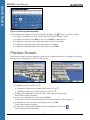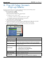
1
USER MANUAL iCN 530 with SmartS™ en English-New Zealand + UK © 2006 Brunswick New Technologies Asia Pte Limited. Navman is a registered trademark of Brunswick New Technologies Asia Pte Limited and is used under licence by Navman New Zealand. All rights reserved. The software contains proprietary information of Navman; it is provided under a licence agreement containing restrictions on use and disclosure and is also protected by copyright law. Reverse engineering of the software is prohibited. No part of this publication may be reproduced, stored in a retrieval system, or transmitted in any form or by any means, electronic, mechanical, photocopying, recording or otherwise, without the prior written permission of Navman. Back-On-Track, Drive-Away, Turn-by-Turn and Smart are either registered trademarks or trademarks of Brunswick New Technologies Asia Pte Limited and are used under licence by Navman New Zealand. All rights reserved. Microsoft Windows 98 SE, ME, 2000 and XP SP1, Microsoft Internet Explorer and ActiveSync are either registered trademarks or trademarks of Microsoft Corporation in the United States and/or other countries. Adobe and Adobe Reader are either registered trademarks or trademarks of Adobe Systems Incorporated in the United States and/or other countries. All rights reserved. All other trademarks and registrations are the property of their respective owners. Published in New Zealand. Disclaimer Due to continued product development this information may change without notice. Navman does not warrant that this document is error-free. The screenshots and other presentations shown in this User Manual may differ from the actual screens and presentations generated by the actual product. All such differences are minor and the actual product will deliver the described funcationaltiy as presented in this User Manual in all material respects. Compliance This device complies with part 15 of the FCC Rules. Operation is subject to the following two conditions: (1) This device may not cause harmful interference, and (2) this device must accept any interference received, including interference that may cause undesired operation. Disposal of Electrical and Electronic Equipment The crossed-out wheeled bin symbol printed on this product or its packaging indicates that this product must not be disposed of as unsorted municipal waste but should instead be collected separately. As user of this product, you are responsible for returning it to an authorised collection facility set up by your local council (which can provide you will information on your nearest collection facility). Alternatively, if you are replacing the old product with a new equivalent product, the shop where you buy the new product is required to take the old product back free of charge (or direct you to the nearest recycling point) as long as the new product is of equivalent type and fulfils the same functions as the old product. Waste electrical and electronic equipment must be treated separately in order to ensure that hazardous materials contained inside the equipment are not buried thereby providing potential future problems for the environment and human health. Moreover, parts of the waste equipment can be reused and recycled, thereby reducing the quantities of waste being disposed of and preventing the depletion of natural resources. Your role in participating in the separate collection of waste electrical equipment is essential in ensuring that environmental protection and human health objectives are achieved through responsible treatment and recycling. Applicable accessories: In-vehicle power adaptor. The above information is provided in compliance with the [Waste Electrical and Electronic Equipment (Produced Responsibility) Regulations 2006] which requires the separate collection, treatment, recycling and environmentally sound final disposal of waste of electrical and electronic equipment (WEEE). iCN 530 | User Manual Contents Box Contents ............................................................................ 5 1. Introduction ........................................................................... 7 2. iCN Features ........................................................................ 8 3. Starting your iCN................................................................. 12 4. Setting your Destination ...................................................... 15 By Address ...................................................................... 18 By POI ............................................................................. 21 5. Using the 2D Map Screen to Plan a Route ......................... 23 6. Multi-stop Trips ................................................................... 24 7. Viewing your Route ............................................................. 29 8. The 2D Map Screen Pop-up Menu..................................... 33 9. Avoiding an Area ................................................................. 34 10. Route Demonstrator............................................................ 35 11. Favourites and My Home .................................................... 37 12. Preferences ......................................................................... 42 13. Smart Desktop ................................................................ 55 14. Updating your iCN .............................................................. 57 15. Installing Maps Using Smart Desktop ............................. 58 16. Smart Desktop Advanced Features ................................ 60 Appendix: Street Types ............................................................. 65 Support Information .................................................................. 68 Important Safety Information...................................................... 69 3 iCN 530 | User Manual Important Safety Information Please Read Carefully Before Installing Product in Vehicle This is the safety alert symbol. It is used to alert you to potential personal injury hazards. Obey all safety messages that follow this symbol to avoid possible injury or death. WARNING WARNING indicates a potentially hazardous situation which, if not avoided, could result in death or serious injury. CAUTION CAUTION indicates a potentially hazardous situation which, if not avoided, may result in minor or moderate injury. CAUTION CAUTION used without the safety alert symbol indicates a potentially hazardous situation which, if not avoided, may result in property damage. WARNING Removing original equipment, adding accessories or modifying your vehicle could affect the vehicle’s safety or make it illegal to operate in some jurisdictions. Follow all product instructions and all instructions in your vehicle owner’s manual regarding accessories or modifications. Consult your country’s and/or state’s laws regarding operation of a vehicle with any accessories or modifications. WARNING It is your sole responsibility to place, secure and use the iCN in a manner that will not cause accidents, personal injury or property damage. Always observe safe driving practices. Mount the iCN in a position that is secure and does not obstruct the driver’s view. Do not mount the iCN in a way that may interfere with the safe operation of the vehicle, the deployment of air bags or other safety equipment. Do not operate the iCN while driving. Before you use your iCN for the first time, make yourself familiar with your device and its operation. On main roads, the distance to an exit calculated by the iCN may be further than the distance shown on road signs. Road signs show the distance to the start of an exit while your iCN shows the distance to the next intersection, i.e., the end of the exit ramp or road. To prepare to exit a road, always follow distance information on road signs. CAUTION Do not handle the iCN while it is hot. Let the product cool, out of direct sunlight.Do not expose the iCN CAUTION to direct sunlight in an unattended vehicle for prolonged periods. Overheating may damage the unit. To discourage theft, do not leave the iCN, mounting bracket or any cables in plain view in an unattended vehicle. Failure to adhere to these instructions may lead to death, serious injury, or property damage. Navman disclaims all liability for use of the iCN that causes or contributes to death, injury, or property damage or that violates any law. Navman is not responsible for the accuracy of any traffic-related information supplied by other parties and disclaims all liability for any accident, injury or property damage resulting from reliance on such information. 4 iCN 530 | User Manual This user manual will help you Drive-Away™ with your iCN, straight out of the box. Navman welcomes your feedback. To contact us or visit our website, see Support Information on page 68. Box Contents . USB Cable Mounting Bracket Protective Carry-Case iCN with GPS Antenna 12V In-Vehicle Power Adaptor with Power Cable Remote Control CD-ROMs, including: • Smart™ for iCN 530 software including Smart Desktop • Map data • User Manual (PDF format) and Adobe® Reader® Note: the number of disks varies with country of purchase. Documentation, including: • User Manual • In-Car Installation Guide • Software Product Licence/ Limited Warranty Agreement • Registration Card • GPS FAQ Guide 5 Getting started Thank you for purchasing your Navman iCN 530. We hope you enjoy your new GPS transferable navigation system. Getting started iCN 530 | User Manual 6 iCN 530 | User Manual Whether you travel in your own country or elsewhere, your iCN will direct you to your destination without the need for map-books and second-hand instructions. The Global Positioning System (GPS) is available free of charge, at any time, and is accurate to within 5 m (15 ft). The maps on your iCN provide street-level detail for door-to-door navigation, including Points of Interest (POIs) such as accommodation, petrol stations, railway stations and airports. Use this manual to learn how to operate your iCN efficiently and safely; discover all the different features available to you. GPS and GPS Signals The Global Positioning System is a network of satellites that transmit accurate time and position information worldwide. GPS receivers receive signals from these satellites and use the information to determine an exact location. GPS satellites orbit the earth at around 20,200 kilometres (12,000 miles). While a GPS receiver can detect signals from up to 12 satellites at any time, only three signals are needed to provide a position or “GPS fix” (latitude and longitude) for vehicle navigation systems. The iCN GPS antenna receives GPS signals. To receive GPS signals, ensure that the iCN is outdoors, or in a vehicle outdoors, and the GPS antenna has an unobstructed view of the sky. The iCN can operate in all types of weather except snowfall. GPS signals may also be blocked by heat-reflective or heated windscreens. If your vehicle is fittted with such a windscreen, you may need to purchase an external antenna so that your iCN can receive GPS signals. 7 Getting started 1. Introduction Getting started iCN 530 | User Manual 2. iCN Features We recommend that you familiarise yourself with the iCN’s basic operations, such as using the stylus and Volume control. Front Components 1 4 5 2 6 7 3 8 Component Description Displays maps and menu options. 1 Touch Screen 2 Charge Indicator 3 Infrared Receiver Receives signals from the remote control. 4 Fuel Displays the Select POI screen, listing the nearest petrol stations to your current position. 5 Park Displays the Select POI screen, listing the nearest public car parks to your current position. 6 Menu 7 Page Cycles through the 2D Map, 3D Map, Next Turn and Next 5 turns screens; displays additional preferences or search-result screens, when available. 8 ESC Cancels an action, returns to the previous screen or deletes the last text character on the Keyboard screen; hold down for longer to delete a whole line at once. Tap with the stylus to select menu options or enter information. Amber indicates that the battery is charging; Green indicates that the battery is fully charged. Displays the Main Menu screen. Press and hold to reset the iCN. 8 iCN 530 | User Manual 1 2 3 Component Description 1 Reset Resets the iCN; press using the stylus. 2 Hot Shoe Plate Connection plate for the P1 or T1 mount. 3 Battery Switch Must be set to ON ( | )for normal use. Switching to OFF (O) will turn the battery off, saving battery power. Side Components 1 4 2 3 Component Description 1 Headphone Socket Connection socket for headphones or earphones (not included). 2 SD/MMC Slot Slot for memory card. Memory card must be inserted with label facing forward. 3 USB Socket Connection for the in-vehicle power adaptor and connection socket for USB cable to your computer. 4 Volume Control Rotate up or down briefly to hear a sound test; rotate and hold to adjust volume. 9 Getting started Bottom Components Getting started iCN 530 | User Manual Back Components 1 2 Component Description 1 External Antenna Socket Connection socket for GPS mMCX External Antenna (not included). Protected by rubber cover. 2 Speaker Outputs voice commands and warnings. Use the Volume control to adjust. Top Components 1 2 Component Description 1 Power Turns the iCN on or off. When off, the iCN enters a suspended state. 2 Stylus Used to tap the screen to make selections and enter information; Pull out of the slot to use; store in the slot when not using your iCN. 10 iCN 530 | User Manual The stylus is your input device. Pull the stylus out of the slot and extend it for ease of use. Store it in the slot when not in use. • Tap the screen with the stylus to select. • Tap and drag the screen with the stylus to navigate the 2D Map and 3D Map screens. Internal Battery The iCN has an internal battery that when fully charged should power the iCN for 4 hours. You can monitor battery power at the Power Status screen: Main Menu Preferences More Preferences Hardware Power Status Charging the Battery When the battery is charging, the Charge Indicator is amber; when the battery is fully charged, the Charge Indicator is green. • To charge the iCN in a vehicle, plug the vehicle power adaptor into the USB Socket on the side of the iCN and the other end into the vehicle power socket. • To charge the iCN via a computer, ensure the computer is switched on. Plug the USB cable into the USB Socket on the side of the iCN and the other end into the USB socket on the computer. 11 Getting started Stylus Getting started iCN 530 | User Manual 3. Starting your iCN Before you begin, check if your vehicle is fitted with a heat-reflective or heated windscreen. If so, you will need to purchase an external antenna for your iCN to receive GPS signals. Step One: Position the iCN in your Vehicle Follow the safety notice on page 7 to ensure that the iCN does not obstruct the driver’s view, or interfere with the operation of vehicle airbags and safety devices. Position the iCN in your vehicle according to the instructions in your In-Car Installation Guide. The Main Menu screen provides access to all of the iCN’s functions, including navigating to a destination. Step Two: Turn iCN On 1. If the Battery Switch is off (O), remove and use the stylus to switch it on ( | ). 2. Press . The iCN will turn on. Step Three: Language Screen When you switch your iCN on for the first time, the Language screen will display. 1. Tap your language choice. • To prevent the Language screen from displaying on each startup, select the Do not show on startup check box. 2. Tap to go to the next screen. The Warning screen will display. 12 iCN 530 | User Manual 1. Read the warning message. 2. To confirm that you have read and understood the message, tap Accept The first Tutorial screen will display. Step Five: Tutorial Screens 1. Read the Tutorial screen. • To prevent the Tutorial from displaying on startup, select the Do not show Tutorial on startup check box. • You can view the Tutorial again while using your iCN. See page 54 for details. 2. Tap to move through each Tutorial screen. The 2D Map screen will display. Main Menu Screen • Access the Main Menu acreen at any time by pressing . • Use the stylus to select a Main Menu option. • The Route Information option is only available when a route has been calculated. See page 32 for more information. 13 Getting started Step Four: Warning Screen Getting started iCN 530 | User Manual To Turn your iCN Off When your iCN is off, it enters a suspended state and the system stops operating. When you turn your iCN on, it returns to the screen you were last viewing. 1. Remove the iCN from the suction-mount bracket, if necessary. 2. Press . The iCN will enter a suspended state and the screen will turn off. Power-Saving Suspended State To save battery power, your iCN will automatically enter a suspended state after a set period of time. You can change the default suspended-state settings at the Power Options screen. Main Menu Preferences More Preferences Hardware Power Options Note: if you are not going to be using the iCN for an extended period of time, switch the Battery Switch to Off (O) to save battery power. To Reset your iCN Normally you do not need to reset your iCN; however, should your iCN not turn on or not respond, you can reset it to solve the problem. To reset your iCN, either: a. Press and hold . The message Reset Device? will display. Tap Yes. b. Use the stylus to press the Reset button on the bottom of the iCN. 14 iCN 530 | User Manual For your safety, enter destination information before you start a journey. Do not operate the iCN while driving. Select a destination using the Destination, Keyboard and Preview screens, which used together form a destination wizard. This section describes how to use each of these screens and provides two case studies to help guide you through setting your destination. Destination Screen The Destination screen is used to select your destination by area, street, postal code/ZIP code, Point of Interest (POI), intersection, city, town, country or state. As you specify each part of the address, it will display in the You are going to field at the top of the screen. The available options will change to reflect the parts of the address still to be completed. Keyboard Screen The Keyboard screen will display when you are required to enter text, such as when searching for a street name. As you select each character, the first two results will display. Tap to see more search results. Search results will be listed in matching order, with the closest matches appearing at the top of the list. If your destination appears in the list at the top of the screen, tap on it to select it. The Keyboard screen can display in three modes: alphabet, alternate and number/symbol. Figure 1. Alphabet Keyboard Figure 2. Alternate Keyboard 15 Getting started 4. Setting your Destination Getting started iCN 530 | User Manual Figure 3. Number/Symbol Keyboard As you select each character, the first two results will display. Tap to see more search results. • To select a character or a search result, tap the character or search result. • To delete a character, press ESC or tap <<; hold ESC to delete the line. • To display the number/symbol Keyboard screen (Figure 3), tap 123. • To display the alternate Keyboard screen (Figure 2), tap Alt. • To display the alphabet Keyboard screen (Figure 1), tap ABC. Preview Screen The Preview screen is used to display a preview of your destination before navigating to it, saving it as a Favourite or displaying it on the 2D Map screen. • To display the zoom options, tap . • To display a smaller area in greater detail (zoom in), tap . • To display a larger area in less detail (zoom out), tap . • To display your destination on the 2D Map screen, tap the preview map. The 2D Map screen will display. • To save your destination as a Favourite, tap Save. The New Favourite screen will display. See Favourites and My Home on page 37. • To calculate the route and open the 3D Map screen, tap Go. The 3D Map screen will display. • To view Point of Interest (POI) details when your destination is a POI, tap The POI Detail screen will display. 16 . iCN 530 | User Manual The following rules apply when searching for a destination in Europe: Street names with dates or numbers If a street name contains a date or a number, search by the first number: Example 1: If searching for “Faubourg du 13 Juillet 1920”, search by “13”. Example 2: If searching for “Avenue du 14 Avril 1914”, search by “14”. Example 3: If searching for “Rue de la 1 ere Armée”, search by “1”. If a highway or motorway designation contains a number, search by the first character of the designation: Example 1: If searching for “A-6”, search by “A”. Example 2: If searching for “E55”, search by “E”. Example 3: If searching for “Strada Provinciale 168”, search by “168”. Streets named after people If a street name is a person’s name (including at least a first and last name), search by the first name: Example 1: If searching for “Rue Albert Mathieu”, search by “Albert”. Example 2: If searching for “Fred Archer Way”, search by “Fred”. Example 3: If searching for “Franz Grillparzer-Strasse”, search by “Franz”. Postcodes in the Netherlands When searching by postcode in the Netherlands, type the postcode without the last two letters. Example: If searching for “3514 BN”, search by “3514”. For exact European street type abbreviations, see Appendix: Street Types on page 65. 17 Getting started Address Search Rules Getting started iCN 530 | User Manual Setting your Destination by Address Step One: Open the Destination screen a. From the Main Menu, tap Go To. b. From the Go To screen, tap Address or POI. The Destination screen will display. Important Note: The first time you are setting your destination, the Select country screen will display instead of the Destination screen. Go to Step Two: Select the Country of Destination, step b. The next time you perform this procedure, the Destination screen will open as expected. Step Two: Select the Country of Destination a. From the Destination screen, tap Change country. The Select country screen will display. b. Select a country from the list. The Destination screen will display. Step Three: Find the Area of Destination a. From the Destination screen, tap Find area. The Keyboard screen will display. 18 iCN 530 | User Manual The Destination screen will display. Step Four: Find the Street of Destination a. From the Destination screen, tap Find street. The Keyboard screen will display. b. Use the Keyboard screen to find the street of your destination. For information on using the Keyboard screen, see pages 15-16. The Destination screen will display. 19 Getting started b. Use the Keyboard screen to find the area of your destination. For information on using the Keyboard screen, see pages 15-16. Getting started iCN 530 | User Manual Step Five: Find the House Number of Destination a. From the Destination screen, tap Enter house number. The Keyboard screen will display. Note: If the Enter house number option is not displayed, house numbers are not available for your selected street. Tap Go to centre of street to display the Preview screen. Go to step c. b. Use the Keyboard screen to find the house number of your destination. For information on using the Keyboard screen, see pages 15-16. The Preview screen will display. c. Complete one of the following: • To calculate the route and open the 3D Map screen, tap Go. The 3D Map screen will display. • To display the destination on the 2D Map screen, tap the preview map. The 2D Map screen will display. • To save the destination as a Favourite, tap Save. The New Favourite screen will display. See Favourites and My Home on page 37. • To change your destination, tap ESC. The Destination screen will display. To return to the Main Menu, press . 20 iCN 530 | User Manual A POI is a named site, feature, landmark or public venue which can be displayed as an icon on the map. POIs are grouped by type, such as parks and museums. Step One: Open the Destination screen a. From the Main Menu, tap Go To. b. From the Go To screen, tap Address or POI. The Destination screen will display. Important Note: The first time you are setting your destination, the Select country screen will display instead of the Destination screen. Go to Step Two: Select the Country of Destination, step b. The next time you perform this procedure, the Destination screen will open as expected. Step Two: Select the Country of Destination a. From the Destination screen, tap Change country. The Select country screen will display. b. Select a country from the list. The Destination screen will display. Step Three: Select the Type of POI Note: To narrow the search for a type of POI, you can first search by Area. a. From the Destination screen, tap Find Point of Interest. The Select POI screen will display. b. Select a POI type from the list. The Keyboard screen will display. 21 Getting started Setting your Destination by POI Getting started iCN 530 | User Manual c. Use the Keyboard screen to find the POI. For information on using the Keyboard screen, see pages 15-16. The Preview screen will display. d. Complete one of the following: • To calculate the route and open the 3D Map screen, tap Go. The 3D Map screen will display. • To display the destination on the 2D Map screen, tap the preview map. The 2D Map screen will display. • To save the destination as a Favourite, tap Save. The New Favourite screen will display. See Favourites and My Home on page 37. • To change your destination, tap ESC. The Destination screen will display. • To view Point of Interest (POI) details when your destination is a POI, tap The POI Detail screen will display. To return to the Main Menu, press . 22 . iCN 530 | User Manual You can plan a route directly from the 2D Map screen using the Pop-up menu. 1. From the Main Menu, tap Map. The 2D Map screen will display. • Move around the 2D Map screen using the stylus. • To display the zoom options, tap . • To display a smaller area in greater detail (zoom in), tap . • To display a larger area in less detail (zoom out), tap . 2. Tap the Map screen to display the cross-hairs. • To remove the cross-hairs press ESC. 3. Drag the intersection of the cross-hairs to a destination. Where the cross-hairs intersect on a street, the street will highlight and the street name will display. 4. Tap the intersection of the cross-hairs to select the street as your destination. The Pop-up menu will display. 5. Select Navigate to. The route is calculated and displayed on the 3D Map screen. 23 Getting started 5. Using the 2D Map screen to Plan a Route iCN 530 | User Manual 6. Multi-stop Trips You can use the Multi-stop Trip screen to set multiple destination points for your trip. Your route will be calculated to go via each of these points in the specified order. Destination points can be added via the Multi-stop Trip screen or by selecting Show Details from the pop-up menu on the 2D Map screen, then Add to Trip. You can save up to 200 multi-stop trips, each with up to 14 destination points. . Step One: Start your Multi-stop Trip a. From the Main Menu, tap Multi-stop Trip. The Multi-stop Trip screen will display. b. Tap Add. The Add to Trip screen will display. c. Tap Address or POI. The Destination screen will open. Note: You can also add destination points using Favourites, recent destinations and nearest Points of Interest. 24 iCN 530 | User Manual Step Two: Select the Country of your Destination Point a. If the destination point is in a different country to the previous destination point, tap Change country. The Select country screen will display. b. Select a country from the list. The Destination screen will display. Step Three: Find the Area of your Destination Point a. From the Destination screen, tap Find area. The Keyboard screen will display. b. Use the Keyboard screen to find the area of your destination point. For information on using the Keyboard screen, see pages 15-16. The Destination screen will display. 25 iCN 530 | User Manual Step Four: Find the Street of your Destination Point a. From the Destination screen, tap Find street. The Keyboard screen will display. b. Use the Keyboard screen to find the street of your destination point. For information on using the Keyboard screen, see pages 15-16. The Destination screen will display. 26 iCN 530 | User Manual Step Five: Find the House Number of your Destination Point a. From the Destination screen, tap Enter house number. The Keyboard screen will display. Note: If the Enter house number option is not displayed, house numbers are not available for your selected street. Select Go to centre of street to display the Preview screen. Go to step c. b. Use the Keyboard screen to find the house number of your destination point. For information on using the Keyboard screen, see pages 15-16. The Preview screen will display. c. Tap Add to Trip. The Multi-stop Trip screen will display, listing your destination point. 27 iCN 530 | User Manual d. Complete one of the following: Note: Destination points added, updated or deleted after a multi-stop trip has commenced will not affect the current route. If you want to ... Then ... add another destination point Note: Destination points added after a multi-stop trip has commenced will not be included in the current route. i tap Add. The Add to Trip screen will display. change the order of your destination points i select a destination point to move from the list. The Preview screen will display. ii select Move. The Multi-stop Trip screen will display. iii use the Up and Down arrows to move the selected destination point to the correct position, then tap OK. calculate the route select Go. The 3D Map screen will display the calculated route. delete all destination points tap Clear. delete one destination point i select a destination point to delete from the list. The Preview screen will display. ii tap Delete From Trip. The Multi-stop Trip screen will display. save the multi-stop trip as a Favourite i tap Save. The New Favourite screen will display. ii tap Save. The Favourite will save and the Multistop Trip screen will display. To return to the Main Menu screen, press ii tap Address. The Destination screen will display. iii go to Step Three: Find the Area of your Destination Point. . Skipping a Destination Point You can modify a multi-stop trip at any time from the Multi-stop Trip screen; however, if you have already commenced a trip, changes will not affect the current route: Main Menu Multi-stop Trip To skip a destination point during a multi-stop trip, complete the following: 1. Press to return to the Main Menu screen. The Main Menu screen will display. 2. Tap Route Information. The Route Information screen will display. 3. Tap Skip Next Dest. The next destination point will be skipped and the route recalculated to the following destination point. 28 iCN 530 | User Manual 7. Viewing your Route Once a route has been calculated, you can view it in several ways. Press to cycle through the screens. 2D Map Screen The 2D Map screen is always oriented North and shows your current position (if a GPS fix is active) and surrounding street names. If a route has been calculated, the route and turns are highlighted. You can plan a route from the 2D Map screen. See page 23 for further details. To view the 2D Map screen, either tap Map on the Main Menu screen or press the screens when a route has been calculated. • To display the zoom options, tap to cycle through . • To display a smaller area in greater detail (zoom in), tap . • To display a larger area in less detail (zoom out), tap . • To display the cross-hairs, tap the map. Tap the intersection of the cross-hairs to display the Pop-up menu. Name of the next location. North-oriented compass. Tap to display the Satellite Signal Strengths screen. Direction of the next turn. Tap to hear next instruction. Additional information can display here. Tap to scroll the options. You must have a route calculated to view these options: Your next turn is highlighted in a different colour from future turns. The colour will depend on the theme you are using. Your current position is marked with . Displays either a description of the information in the bottom right hand corner of the screen or your current location. Tap to display the Main Menu screen. 29 • Speed • Time • Heading • Distance to Turn • Distance to Go • ETA (Estimated Time of Arrival) • Time to Go iCN 530 | User Manual 3D Map Screen The 3D Map screen displays when a route is calculated, oriented to the travelling direction with an adjustable horizon. It is not possible to plan a route directly from this screen. To view the 3D Map screen when a route has been calculated, press • • to cycle through the screens. To adjust the viewing angle, slide the stylus over the 3D Map. To display the zoom options, tap . • To display a smaller area in greater detail (zoom in), tap . • To display a larger area in less detail (zoom out), tap . • To display the Go To Pop-up summary, use the stylus to tap and hold on the 3D Map. Name of the next location. North-oriented compass. Tap to display the Satellite Signal Strengths screen. Direction of the next turn. Tap to hear next instruction. Additional information can display here. Tap to scroll the options. You must have a route calculated to view these options: Your next turn is highlighted in a different colour from future turns. The colour will depend on the theme you are using. Your current position is marked with . Displays either a description of the information displaying in the bottom right hand corner of the screen or your current location. Tap to display the Main Menu screen. 30 • Speed • Time • Heading • Distance to Turn • Distance to Go • ETA (Estimated Time of Arrival) • Time to Go iCN 530 | User Manual Next Turn Screen The Next Turn screen displays information that you need for the next turn, the direction of the turn and the distance to the turn. A route must have been calculated for this screen to be able to display. Access to this screen is controlled by the Display preferences screen. See page 44. To view the Next Turn screen when a route has been calculated, press to cycle through the screens. Map of the next turn. The next instruction. Additional information can display here. Tap to scroll the options: • Speed • Time • Heading • Distance to Turn • Distance to Go • ETA (Estimated Time of Arrival) • Time to Go Direction of next turn. Tap to hear next instruction. Distance to the next turn. Displays either a description of the information in the bottom right hand corner of the screen or your current location. Tap to display the Main Menu screen. Next 5 Turns Screen The Next 5 Turns screen displays the next five turns of your route, the turn direction, the street name and the distance to the turn. A route must have been calculated for this screen to be able to display. Access to this screen is controlled by the Display preferences screen. See page 44. To view the Next 5 Turns screen when a route has been calculated, press to cycle through the screens. Distance to the next turn The next turn is highlighted at the top of the list. Additional information can display here. Tap to scroll the options: • Speed • Time • Heading • Distance to Turn • Distance to Go • ETA (Estimated Time of Arrival) • Time to Go Displays either a description of the information in the bottom right hand corner of the screen or your current location. Tap to display the Main Menu screen. Back-On-Track™ Automatic Rerouting Your route is re-directed if you make a wrong turn. The ? symbol will display in the upper left corner of the 3D Map and Next Turn screens while the route recalculates. 31 iCN 530 | User Manual Route Information Screen The Route Information screen provides information about your current route and lets you skip a trip destination point or cancel a route. The screen is only available from the Main Menu when you are navigating a route: Main Menu Route Information Show Route Tap Show Route to display your entire route on the 2D Map screen. Instruction List Tap Instruction list to display the Instruction List screen. The Instruction List screen is similar to the Next 5 Turns screen (see page 31) except that it displays your entire route. • Press to cycle through the instruction list. Summary Tap Summary to display the Route Summary screen containing your From and To addresses, Estimated Time to arrival and the Distance remaining to your destination. If you are navigating a multi-stop trip, the information displayed will relate to your next destination point. Skip Next Destination Tap Skip Next Dest. to skip the next destination point of your trip. Only available when navigating a multi-stop trip. Cancel Route Tap Cancel Route to cancel the route. 32 iCN 530 | User Manual 8. The 2D Map Screen Pop-up Menu The Pop-up menu allows you to access navigational functions from the 2D Map screen. To display the Pop-up menu, complete the following: 1. From the Main Menu, tap Map. The 2D Map screen will display. • Move around the 2D Map screen using the stylus. • To display the zoom options, tap . • To display a smaller area in greater detail (zoom in), tap . • To display a larger area in less detail (zoom out), tap . 2. Tap the Map screen to display the cross-hairs. • To remove the cross-hairs press ESC. 3. Position the intersection of the cross-hairs on a destination point. Where the cross-hairs intersect on a street, the street will highlight and the street name will display. 4. Tap the intersection of the cross-hairs to select the street as your destination. The Pop-up menu will display. 5. You can choose one of the following options: Menu Option Description Navigate To Calculates a route from your current location. Set as Start Location Add to Favourites Sets the selected point as your departure point. Smart will calculate and display the route to your destination. Displays the New Favourite screen for you to add the selected point as a Favourite. Displays the Address Details screen from which you can: Show Details • View details of the selected point; • Add the point to your multi-stop trip; • Set the point as your destination point; • Save the point as a Favourite. Add Avoid Area Adds an Avoid Area for you to size. Delete Avoid Area Deletes the selected Avoid Area. Nearest POI Displays the Select POI screen; select the POI type, then the specific POI to navigate to. 33 iCN 530 | User Manual 9. Avoiding an Area You can calculate a route that avoids a specified area on the map. For example, you may want to avoid an area that frequently experiences traffic problems. Up to ten Avoid Areas can be added. Avoid Areas are displayed as shaded areas. If no alternative route around an Avoid Area exists, you will be routed through the Avoid Area. Adding an Avoid Area 1. From the Main Menu screen, tap Map. The 2D Map screen will display. 2. Tap the Map screen to display the cross-hairs. 3. Use the stylus to position the intersection of the cross-hairs to the area that you want to avoid. 4. Tap the intersection of the cross-hairs to display the Pop-up menu. 5. Select Add Avoid Area. An Avoid Area is displayed. 6. Set the Avoid Area to the correct size and position using the stylus 7. Tap the Avoid Area to enable the Avoid Area. Deleting an Avoid Area 1. From the Main Menu screen, select Map. The 2D Map screen will display. 2. Tap the Map screen and move the cross-hairs over the Avoid Area that you want to delete. 3. Tap the intersection of the cross-hairs to display the Pop-up menu. 4. Select Delete Avoid Area. The Avoid Area is deleted. Deleting all Avoid Areas 1. From the Main Menu screen, tap Preferences. 2. From the Preferences screen, tap My Data. The My Data screen will display. 3. From the My Data screen, tap Clear Data. The Clear Data screen will display. 4. Select Clear Avoid Areas. When the warning dialog-box opens, select Yes. 5. To return to the Main Menu, press . 34 iCN 530 | User Manual 10. Route Demonstrator The Route Demonstrator allows you to: • Preview a route. • Plan and view a route without a GPS fix, such as when you are inside a building. Step One: Activate Route Demonstrator 1. From the Main Menu screen, tap Preferences. 2. From the Preferences screen, tap Routing. The Routing screen will display. 3. Press twice. 4. Select the Demonstrate Route check box. 5. Tap Save. The Main Menu screen will display. Step Two: Select Departure Point If you have a GPS fix, you do not need to select a departure point unless you want the demonstrated route to start elsewhere. 1. From the Main Menu screen, tap Map. The 2D Map screen will display. 2. Tap the Map screen to display the cross-hairs. 3. Position the intersection of the cross-hairs on your departure point. Where the crosshairs intersects on a street, the street will highlight and the street name will display. 4. Tap the intersection of the cross-hairs. The Pop-up menu will display. 5. Select Set as Start Location. The Pop-up menu will close. Step Three: Select Destination Point Set a destination either by using the Destination screen (see pages 15-22) or by using the 2D Map screen Pop-up menu and completing the following: 1. Tap the Map screen to display the cross-hairs. 2. Position the intersection of the cross-hairs on your destination point. Where the crosshairs intersects on a street, the street will highlight and the street name will display. 3. Tap the intersection of the cross-hairs. The Pop-up menu will display. 4. Select Navigate To. The Pop-up menu will close. The 3D Map screen will display the calculated route in Route Demonstrator mode. • If you have selected the Repeat check box on the Routing preferences screen, the Route Demonstrator will continue to repeat the route. 35 iCN 530 | User Manual To Disable Route Demonstrator 1. Press to display the Main Menu screen. 2. From the Main Menu screen, tap Preferences. 3. From the Preferences screen, tap Routing. The Routing screen will display. 4. Press twice. 5. Clear the Demonstrate Route check box. 6. Tap Save. The Route Demonstrator will be disabled. The Main Menu screen will display. 36 iCN 530 | User Manual 11. Favourites and My Home You can save up to 200 destinations as Favourites, one of which can be saved as My Home. My Home can be any designated Favourite, but we recommend that it is your home or other common destination. You can save a Favourite from the Preview screen after searching for an address, or from the Pop-up Menu on the 2D Map screen. Saving a Favourite 1. Either search for an address using the Destination and Keyboard screens as described in Setting your Destination, pages 15-22, or create a multi-stop trip as described in Multi-stop Trips, pages 24-28, until the Preview screen is displayed. 2. Tap Save. The New Favourite screen will display. 3. To change the name of the Favourite, tap the Name box. The Enter text screen will display. • To select a character, tap the character. • To delete a character, press ESC or tap <<; hold ESC to delete the line. • To display the number/symbol Enter text screen, tap 123. • To display the alternate Enter text screen, tap Alt. • To display the alphabet Enter text screen, tap ABC • After you have entered a name for the Favourite, tap Enter. The New Favourite screen will display. 37 iCN 530 | User Manual 4. Complete one of the following: • To save as My Home, tap Save as My Home. The Favourite is saved as My Home. The Go To screen will display. • To save as a favourite, tap Save as Favourite. The Favourite is saved. The Go To screen will display. Saving a Favourite from the 2D Map Screen 1. From the Main Menu, select Map. The 2D Map screen will display. 2. Tap the Map screen to display the cross-hairs. 3. Position the intersection of the cross-hairs. Where the cross-hairs intersect on a street, the street will highlight and the street name will display. 4. Tap the intersection of the cross-hairs. The Pop-up menu will display. 5. Select Add to Favourites. The New Favourite screen will display. 38 iCN 530 | User Manual 6. To change the name of the Favourite, select the Name box. The Enter text screen will display. • To select a character, tap the character. • To delete a character, press ESC or tap <<; hold ESC to delete the line. • To display the number/symbol Enter text screen, tap 123. • To display the alternate Enter text screen, tap Alt. • To display the alphabet Enter text screen, tap ABC • After you have entered a name for the Favourite, tap Enter. The New Favourite screen will display. 7. Complete one of the following: • To save as a favourite, tap Save as Favourite. The Favourite is saved. The Go To screen will display. • To save as My Home, tap Save as My Home. The Favourite is saved as My Home. The Go To screen will display. Editing the Name of the Favourite 1. From the Main Menu, tap Go To. 2. From the Go To screen, tap Favourites. The Favourite screen will display. 3. Select a Favourite to edit. The Preview Favourite screen will display. 39 iCN 530 | User Manual 4. Tap the Name box. The Enter text screen will display. • To select a character, tap the character. • To delete a character, press ESC or tap <<; hold ESC to delete the line. • To display the number/symbol Enter text screen, tap 123. • To display the alternate Enter text screen, tap Alt. • To display the alphabet Enter text screen, tap ABC • After you have entered a name for the Favourite, tap Save. The New Favourite screen will display. 5. Complete one of the following: • To save as My Home, tap Save as My Home. The Favourite is saved as My Home. The Go To screen will display. • To save as a favourite, tap Save as Favourite. The Favourite is saved. The Go To screen will display. Deleting a Favourite 1. From the Main Menu, tap Go To. 2. From the Go To screen, tap Favourites. The Favourite screen will display. 3. Select a Favourite to delete. The Preview Favourite screen will display. 4. Tap Delete. A Warning dialogue box will display asking for confirmation to delete the Favourite. 5. Tap Yes. The Favourite is deleted. The Favourite screen will display. 40 iCN 530 | User Manual Navigating to a Favourite 1. From the Main Menu, tap Go To. 2. From the Go To screen, tap Favourites. The Favourite screen will display. 3. Select a Favourite. The Preview Favourite screen will display. 4. Tap Go. The route is calculated and displayed on the 3D Map screen. Navigating to My Home 1. From the Main Menu, tap Go To. 2. From the Go To screen, tap My Home. The route is calculated and displayed on the 3D Map screen. 41 iCN 530 | User Manual 12. Preferences You can modify the following preferences to suit your needs. Volume 1. Rotate the Volume Control up or down to hear a sound test. 2. Rotate the Volume Control up or down and hold to display the volume bar. • Rotate the Volume Control up or down to adjust the volume. You can also adjust volume from the Volume preference screen. See page 52. Routing Preferences 1. From the Main Menu, tap Preferences. 2. From the Preferences screen, tap Routing. The first of three Routing screens will display. Press to move through the Routing screens. 3. Complete one of the folllowing If you want to... Then... change the Route Type move the Route Type slider towards Quickest to give more weighting to the fastest time when calculating a route. move the Route Type slider towards Shortest distance to give more weighting to the shortest distance when calculating a route. change the Preference for motorways move the Preference for motorways slider towards Less often to use roads other than motorways where possible when calculating a route. move the slider towards More often to use motorways where possible when calculating a route. 42 iCN 530 | User Manual If you want to... Then... change the Preference for urban roads move the Preference for urban roads slider towards Less often to use roads other than urban roads where possible when calculating a route. move the Preference for urban roads slider towards More often to use urban roads where possible when calculating a route. revert to default settings select Set default on the first Routing screen. This will restore the default settings for Route Type, Preference for motorways and Preference for urban roads. avoid toll roads select the Avoid toll roads check box. avoid unsurfaced roads select the Avoid unsurfaced roads check box. avoid ferries select the Avoid ferries check box. receive a warning if your route includes toll roads select the Toll roads check box to display a warning message at the start of your trip if your route includes toll roads. receive a warning if your route includes unsurfaced roads select the Unsurfaced roads check box to display a warning message at the start of your trip if your route includes unsurfaced roads. receive a warning if your route includes ferries select the Ferries check box to display a warning message at the start of your trip if your route includes ferries. enable the Route Demonstrator select the Demonstrate Route check box. This allows you to plan and view a route without a GPS fix. See page 35 for more information. enable the Route Demonstrator to play repeatedly select the Repeat check box. enable Smart Demonstration to be played select the Smart Demonstration check box. The demonstration willl navigate between the first and second Favourites after a 10-second delay. enable Track Recording (only to be used if required by Navman Customer Support) contact Navman Customer Support, as we recommend this feature be used only under the supervision of a Navman technician. 4. Tap Save. The Main Menu screen will display. 43 iCN 530 | User Manual Map Preferences — Display Settings 1. From the Main Menu, tap Preferences. 2. From the Preferences screen, tap Maps. 3. From the Maps screen, tap Display. The first of two Display screens will display. Press to move through the Display screens. 4. Complete the following: If you want to... Then... enable Auto Zoom during navigation select the Auto Zoom check box. If selected, the 2D Map and 3D Map screen will automatically zoom in or out, depending on your speed, to allow optimal route-viewing. enable access to the Next Turn screen select the Display Next Turn screen check box. enable access to the Next 5 Turns screen select the Display Next 5 Turns screen check box. change the colour scheme select your preferred scheme from the Map colour scheme box by tapping the left or right arrows. improve screen contrast in light or dark conditions under Map colours, select either Day or Night. If Night is selected, the Night Keypad Lighting checkbox will be enabled. automatically select screen contrast to suit daytime or night-time under Map colours, select Auto. turn on the keypad backlight when the iCN is using external power select the Night Keypad Lighting check box. Note: This option is only available when Map colours is set to Night. 44 iCN 530 | User Manual If you want to... Then... display topographical information on the 2D Map and 3D Map screens select the Topographic display check box. display grid lines on the 2D Map and 3D Map screens select the Display Map Grid check box. display a north-pointing compass on the 2D Map and 3D Map screens select the Display Compass on Map check box. display “no entry” icons on “no entry” roads on the 2D Map and 3D Map screens select the Display no entry roads check box. 5. Tap Save. The Main Menu screen will display. Map Preferences — Points of Interest (POIs) Points of Interest in a region are grouped into types. This function allows you to select the types you need. For example, you may be only interested in entertainment venues and want to disable other POI types such as schools. 1. From the Main Menu, tap Preferences. 2. From the Preferences screen, tap Maps. 3. From the Maps screen, tap Points of Interest. The Points of Interest screen will display. 4. You may either choose to display (or hide) icons of all POI types on the 2D Map and 3D Map screens, or to selectively display desired icons chosen from the list of POI types. • To display all POI icons (i.e., icons of all POI types) on the 2D Map and 3D Map screens, select Turn all on. To hide all POI icons, select Turn all off. • To select a specific POI type icon for display, select the POI type check box. Repeat until all desired POI types are selected. • To view additional pages of POI types, press 5. Tap Save. The Main Menu screen will display. 45 . iCN 530 | User Manual Alerts Preferences — Active POIs The Active POI settings allow you to set warning chimes and visual warnings for custom POIs that will activate within a chosen radius of your location. For example, a warning chime will sound or a visual warning will display when an active POI is within 150 ft of, but not necessarily on, your route. Note: Custom POIs must first be installed on your iCN using Smart Desktop before they can be set as active POIs. See Points of Interest (POI) Editor on pages 61-63. 1. From the Preferences menu, tap Safety Alerts. The Safety Alerts screen will display. 2. On the Safety Alerts screen, tap Active POI. The Select Active POI screen will display. 3. Select a custom POI type. The POI Activation Settings screen will display. 4. Select the Active check box to activate the POI. 5. Modify the settings as required: • To enable a warning chime when the POI is in close proximity, select the Audio Warning check box. • To enable a visual warning when the POI is in close proximity, select the Visual Warning check box. • Move the Distance to POI slider to select the distance at which the warnings will activate. 6. Tap Save. The Main Menu screen will display. 46 iCN 530 | User Manual Alerts Preferences - Speed and GPS Signals The Safety settings allow you to set safety-related warnings. 1. From the Preferences menu, tap Safety Alerts. The Safety Alerts screen will display. 2. On the Safety Alerts screen, tap Safety. The Safety screen will display. 3. Complete the following: If you want to... Then... enable a warning chime when traveling at or above a designated speed select the speed in the Speed box by tapping the left or right arrows. Tap Save. The Safety alerts screen will display. Note: The GPS signal alert will be activated when a Speed alert is selected. enable a visual warning if the Main Menu screen is accessed in a moving vehicle select the Warn driver when operating check box. enable a warning chime and visual warning when the GPS signal has been lost select the Warn when GPS lost check box. Note: The GPS signal alert will be activated when a Speed alert is selected. 4. Tap Save. The Main Menu screen will display. 47 iCN 530 | User Manual My Data Preferences - My Points of Interest (My POI) Custom Points of Interest (POIs) are installed from the Smart Desktop POI Editor (see pages 6163), and listed on the My POIs screen. 1. From the Main Menu, tap Preferences. 2. From the Preferences screen, tap My Data. 3. From the My Data screen, tap My POI. The My POI screen will display. 4. To select a POI file, select the POI check box. Note: there may be more than one page of POI types. To view additional pages of POI types, press . 5. Tap Save. The Main Menu screen will display. My Data Preferences - Clear Data 1. From the Main Menu screen, tap Preferences. The Preferences screen will display. 2. From the Preferences screen, tap My Data. The My Data screen will display. 3. From the My Data screen, tap Clear Data. The Clear Data screen will display. 4. Complete the following: If you want to... Then... clear recent destinations select Clear Recent. When the warning dialog-box opens, tap Yes. clear favourites select Clear Favourites. When the warning dialog-box opens, tap Yes. Note: This option will not clear My Home. clear avoid areas 5. Press select Clear Avoid Areas. When the warning dialog-box opens, tap Yes. to return to the Main Menu screen. 48 iCN 530 | User Manual GPS Status Signals are transmitted by Global Positioning System (GPS) satellites orbiting the Earth. The Satellite Signal Strengths screen provides a visual representation of the information being received. Latitude and longitude are displayed, along with a north-pointing compass, the heading in degrees and ground speed. The strength of each satellite is displayed on a bar chart. From the Main Menu screen, select Preferences More Preferences GPS status. The Satellite Signal Strengths screen will display. You can also access this screen from the 2D Map and 3D Map screens by tapping the Northoriented compass. The circle on the right side of the screen displays green when there is a valid fix (2D or 3D) and red when no fix is available. A fix will be obtained more quickly if the vehicle is stationary than if it is moving. The satellites available from your current position are shown as grey, red and green coloured bars: Bar Colour Description Grey No signal at all. Red A valid signal, but not being used to fix your position. Green A valid signal being used to fix your position. 49 iCN 530 | User Manual Measurement Preferences 1. From the Main Menu screen, tap Preferences. The Preferences screen will display. 2. From the Preferences screen, tap More Preferences. The second Preferences screen will display. 3. On the second Preferences screen, select Measurements. The Measurements screen will display. 4. Complete the following: If you want to... Then... change the Position format select either the Decimal degrees or the Degrees, minutes, seconds option. change the local time offset select the offset from the Coordinated Universal Time (UTC) for your location from the Local time offset box by tapping the left or right arrows. Next, select either the 12 Hour or 24 Hour option for timeformat. choose distance units* select either the kilometres or miles option. 5. Tap Save. The Main Menu screen will display. * Only available when UK English or US English language is selected. Language Preferences 1. From the Main Menu, tap Preferences. 2. From the Preferences screen, tap More Preferences. The second Preferences screen will display. 3. On the second Preferences screen, tap Language. The Language screen will display. 4. To change your language, including the voice scheme used for voice guidance during navigation, select your preferred voice scheme from the Language box by tapping the left or right arrows. 5. To enable Voice guidance instructions during navigation, select the Enable check box. 6. Tap Save. The Main Menu screen will display. 50 iCN 530 | User Manual Hardware Preferences - Screen 1. From the Main Menu screen, tap Preferences. The Preferences screen will display. 2. From the Preferences screen, tap More Preferences. The second Preferences screen will display. 3. On the second Preferences screen, tap Hardware. The Hardware screen will display 4. From the Hardware screen, tap Screen. The Screen screen will display. 5. Complete the following: If you want to... Then... align the touch screen tap Align and follow the prompts. Note: The prompts are available in English only. adjust screen brightness move the Brightness slider towards High to increase screen brightness. move the Brightness slider towards Low to decrease screen brightness. 6. Tap Save. The Main Menu screen will display. 51 iCN 530 | User Manual Hardware Preferences - Volume 1. From the Main Menu screen, tap Preferences. The Preferences screen will display. 2. From the Preferences screen, tap More Preferences. The second Preferences screen will display. 3. On the second Preferences screen, tap Hardware. The Hardware screen will display. 4. From the Hardware screen, tap Volume. The Volume screen will display. 5. To increase volume, move the Volume Level slider towards High; to decrease volume, move the Volume Level slider towards Low. • Tap Test to test the volume. 6. Tap Save. The Main Menu screen will display. 52 iCN 530 | User Manual Hardware Preferences - Power Status 1. From the Main Menu screen, tap Preferences. The Preferences screen will display. 2. From the Preferences screen, tap More Preferences. The second Preferences screen will display. 3. On the second Preferences screen, tap Hardware. The Hardware screen will display. 4. From the Hardware screen, tap Power Status. The Power Status screen will display. 5. Press to return to the Main Menu screen. Hardware Preferences - Power Options 1. From the Main Menu screen, tap Preferences. The Preferences screen will display. 2. From the Preferences screen, tap More Preferences. The second Preferences screen will display. 3. On the second Preferences screen, tap Hardware. The Hardware screen will display. 4. From the Hardware screen, tap Power Options. The Power Options screen will display. 53 iCN 530 | User Manual 5. Complete the following: If you want to... Then... change the time to elapse before entering suspended state when connected to an external power source i select the Go to Power Saving Mode if not used for check box under External Power. change the time to elapse before entering suspended state when using battery power i select the Go to Power Saving Mode if not used for check box under Internal Backup Battery. ii select the time to elapse when connected to an external power source before entering suspended state by tapping the left or right arrows. ii select the time to elapse when connected to a battery before entering suspended state by tapping the left or right arrows. 6. Tap Save. The Main Menu screen will display. Startup Preferences 1. From the Main Menu screen, tap Preferences. The Preferences screen will display. 2. From the Preferences screen, tap More Preferences. The second Preferences screen will display. 3. On the second Preferences screen, tap Startup. The Startup screen will display. 4. Complete the following: If you want to... Then... display the Tutorial on startup select the Tutorial screen check box. display the Language screen on startup select the Language selection screen check box. view the Tutorial select Show Tutorial. The first Tutorial screen will display. Press repeatedly to cycle through the Tutorial screens. 5. Tap Save. The Main Menu screen will display. 54 iCN 530 | User Manual 13. Smart Desktop Smart Desktop is used to install maps to your iCN, obtain software updates, manage Custom Points of Interest (POIs) and install Basemaps. Microsoft® ActiveSync® Microsoft ActiveSync is used to establish a connection between your iCN and your computer. ActiveSync 3.7.1 will be installed on your computer (if it is not already installed) as part of the installation of Smart Desktop. Installing Smart Desktop on your Computer Important Notes: • Ensure that Internet Explorer 6 or higher is installed on your computer before you install Smart Desktop, even if it is not your default browser. • Windows® XP users, ensure that Windows XP Service Pack 1 has been applied before you install Smart Desktop. 1. Close all open programs on your computer. 2. Insert the Smart Application Installer CD into your computer CD drive. The Smart Desktop installer will start. • If your computer does not automatically launch the CD, start the installation manually: Start Run. Type D:\Setup Smart for iCN530.exe where “D” is the letter assigned to your CD drive. Click OK. 3. Follow the screen prompts to install Smart Desktop, including: • Select your preferred language for Smart Desktop when prompted. • Review and accept the Licence Agreement for Smart Desktop and Microsoft ActiveSync (if not already installed on your computer) when prompted. • Install Microsoft ActiveSync (if not already installed on your computer) when prompted. • Select a destination folder for Smart Desktop when prompted. 4. When the installation has finished, click Finish. Smart Desktop will open. Desktop and iCN tabs Selected maps Map Display screen Download selected maps to the memory card or memory card reader (not supplied) Map information Map Colour Key 55 iCN 530 | User Manual 5. If prompted to connect your iCN to your computer, complete the following: • Plug the large end of the USB cable directly into a USB port on your computer (not a USB hub); plug the small end into the USB Socket on the side of your iCN. Tip: Where possible, plug the USB cable into a USB port at the back of your computer. • Plug the small end of the AC Power Pack cable into the Power Socket on the side of your iCN; plug the other end into the mains. • Press . The iCN will turn on. • When the following screen displays on your iCN, click Next. • Microsoft ActiveSync will synchronise with your iCN. You are now ready to install maps to your iCN. To Open Smart Desktop Once Smart Desktop has been installed, you can access it from the Start menu: Start Programs Navman Smart for iCN530 Uninstalling Smart Desktop from your Computer We recommend that you use the Add or Remove Programs feature in your Windows Control Panel: 1. Open Add or Remove Programs: Start Control Panel Add or Remove Programs 2. Uninstall: Smart for iCN530. Note: The name of the program may vary from the above. Smart Desktop has now been uninstalled from your computer. 56 iCN 530 | User Manual 14. Updating your iCN Updating your Version of Smart We recommended that you regularly use Smart Desktop to check the Navman website for Smart software updates: 1. If you connect to the Internet via a dial-up connection, connect to the Internet now. 2. Open Smart Desktop: Start Programs Navman Smart for iCN530 3. On the Setup menu, select Update software, then Check for updates on the web. Your computer will connect to the Internet and display the Navman website. 4. If an update for your region is available, download it to your computer. 5. On the Setup menu, select Update software, then Update software on iCN. Follow the prompts to update your iCN software. Upgrading from a Previous Version of Smart See the Installation Guide that came with your software upgrade. 57 iCN 530 | User Manual 15. Installing Maps Using Smart Desktop NOTE: Your iCN comes with preinstalled maps. If you have purchased a software or map upgrade, follow the instructions in your Upgrade Guide to install and activate your new software or maps. Installing and Activating Maps on your iCN 1. Open Smart Desktop, if it is not already open: Start Programs Navman Smart for iCN530 2. Insert a Smart Map CD into your computer CD drive, the available maps will display (the default colour for available maps is cross-hatch blue). Note: If your computer opens Windows Explorer, close the Windows Explorer window. 3. Click the map you want to install to your iCN. Note: You may need to install multiple maps to cover the desired geographical area. Maps available on the Map CD in your CD drive are displayed in cross-hatch blue. 4. You will be prompted to enter or update your contact details so Navman can advise you when updates are released. • If you are activating a map from a continental region that was not previously installed on your iCN, follow the prompts to activate the new region. The four continental regions are Europe, North America, Australia and New Zealand. • When activation has completed, the map will change colour (the default colour for activated maps is light green). The activated map is displayed in light green. 58 iCN 530 | User Manual 5. Click the map to install to your iCN. The map will change colour to indicate it has been selected (the default colour for selected maps is dark green). The map is now listed in the Selected section of the Desktop Selected Maps tab. The selected map is displayed in dark green. 6. Click the Add to button to install all maps listed in the Selected section of the Desktop Selected Maps tab to your iCN. Smart Desktop will install the selected map or maps to your iCN or iCN memory card. When they have been installed, the map or maps will change colour (the default colour for installed maps is yellow). 7. To use your iCN, disconnect the USB cable from your iCN. WARNING: Do not disconnect the USB cable from the iCN USB Socket until the Map Display screen has refreshed and the installed map or maps have changed colour (the default colour for installed maps is yellow). Removing Maps from your iCN 1. Open Smart Desktop: Start Programs Navman Smart for iCN530 2. Open the Maps on iCN section: iCN tab Maps on iCN. 3. Click the map to be removed and select Remove from iCN from the pop-up menu. The map will be removed from your iCN. 59 iCN 530 | User Manual 16. Smart Desktop Advanced Features This section details advanced features of Smart Desktop. If you have not installed Smart Desktop, see pages 55-56. To Find a City or Town 1. From the Map menu, click Find City. The Find City window will open. 2. Type the name of the city or town in the City Name field. The list of available cities will reduce to match your search. 3. Double-click the name of the city or town. The Map Display will rotate to centre on the selected city or town and or town location. will mark the city Map Colours and Textures To access the Desktop Colours section: Desktop tab Settings Colours. Adjust the settings to change the look of the map type. Colour Settings Description Controls map colours. Displays the: • map border colour; • map colour; • map border width. Adjusts the map border width. Controls the map display: • solid colour; • no colour; • crosshatch texture. Controls geographic features displayed on the map. Features are only visible if the map has no colour or crosshatch texture. 60 iCN 530 | User Manual Map Layers To conserve space on your iCN and memory card, you can choose map layers to install. The layers you can choose from are: • Points of Interest (POIs) • Bodies of water and parks • Land contours (topography). To access the Map Layers section: Desktop tab Settings Layers. Select or clear each checkbox to indicate the layers to install for each map. Points of Interest (POI) Editor You can create custom Points of Interest (POIs) using the POI Editor in two ways: • by creating your own POI files, or • by using compatible POI files downloaded from the Internet. A maximum of 25 Custom POI files can be saved on your iCN. The Custom POI files are listed on the My POI screen. Custom POIs can be set to enable a warning chime or visual warning when in close proximity at the Select Active POI screen. Creating a Custom POI File 1. Create a new POI File using the POI Editor. • On the Smart Desktop Map menu, click Points of Interest. The POI Editor window will open. • On the POI Editor window File menu, click New Text File. The POI File Name window will open. • Type a name for the file in the File Name box, then click OK. The file name can be up to eight characters with no spaces. 61 iCN 530 | User Manual 2. Add a POI to the POI File. • On the POI Editor window Edit menu, click New. The POI Details window will open. • Type a description for the POI in the Description box. • On the Degrees, Minutes, Seconds tab, type or select the degree, minute and second of the POI latitude in the Latitude boxes. • On the Degrees, Minutes, Seconds tab, type or select the degree, minute and second of the POI longitude in the Longitude boxes. • To save the POI, click OK. 3. Repeat step 2 until all POIs have been added to the POI file. 4. On the File menu, click Save. The POI file is saved. 5. Complete Saving a Custom POI File to your iCN below. Importing a Custom POI File 1. Download a POI file from the Internet and save it on your computer. 2. Open the POI file using the POI Editor. • On the Smart Desktop Map menu, click Points of Interest. The POI Editor window will open. • On the POI Editor window File menu, click Open Text File. The Open dialogue box will open. • Select the POI file from your local or network drive, then click Open. 3. Complete Saving a Custom POI File to your iCN below. Saving a Custom POI File to your iCN 1. On the Smart Desktop Map menu, click Points of Interest. The POI Editor window will open. 2. On the POI Editor window File menu, click Save to Device. The POI Options window will open. 62 iCN 530 | User Manual 3. Modify the POI settings as required: If you want to... Then... activate the POI select the Active check box. Note: If you do not activate the POI, you will be able to configure only the POI Visibility Level and Icon File settings. enable a visual warning when the POI is in close proximity select the Visual Alert check box. enable a warning chime when the POI is in close proximity select the Audio Alert check box. change the units used to measure distance for this POI select the Metric or Imperial option. select the distance from the POI at which the visual warning should display or the warning chime should sound select the distance from the Distance box. indicate the priority of this POI when one or more additional POIs are in the same locale move the POI Visibility Level slider left or right. select a custom POI type icon to display on the map (if you do not select a custom icon, a default icon will display) Type the path to the icon file to be used to represent the POI type in the Icon File box or select the icon file from your local or network drive by clicking , locating the file and clicking Open. The file must be a bitmap (.bmp) graphic with a minimum of 6x6 pixels and a maximum of 32x32 pixels. 4. Click OK and follow the prompts. The POI file is saved to the iCN as a Custom POI type. • If you want to change the file name, edit the file name in the POI File Name window File Name box, then click OK. The file name can be up to eight characters and cannot contain spaces. Deleting a Custom POI File from your iCN 1. On the Map menu, click Points of Interest. The POI Editor window will open. 2. On the File menu, click Manage POI Files. The Manage POI Files window will open, displaying a list of custom POI files installed on your iCN. 3. Click the File Name or Size of the POI file to delete. 4. Click Delete. The file is removed from the list, but is not yet deleted. 5. To select another file to delete, go back to step 2; otherwise, proceed to step 6. 6. Click OK and accept the changes. The selected file or files are deleted. 63 iCN 530 | User Manual Backups You can save backups of all iCN Preferences and Favourites to your computer. To Back up your Preferences, Favourites and My Home 1. On the Smart Desktop File menu, click Backup. The Backup window will display. 2. Click New Backup. The New Backup window will display. 3. Click OK. The New Backup window will close. The backup will be listed on the Backup window. 4. Close the Backup window. To Delete a Backup 1. On the Smart Desktop File menu, click Backup. The Backup window will display. 2. Select from the list the backup to delete. 3. Click Delete, then click OK. The backup is deleted. 4. Close the Backup window. To Restore a Backup 1. On the Smart Desktop File menu, click Restore. The Restore window will display. 2. Select the backup from the list, then click Restore. The Restore File Selection window will display. 3. Select or clear the check boxes to indicate which part of the backup to restore. 4. Click OK. The Restore File Selection window will close and the backup will be restored. 5. Close the Restore window. 64 iCN 530 | User Manual Appendix: Street Types Note: Belgium and Switzerland each list street types and their abbreviations in three languages. Country Street Type Abbreviation Austria BOULEVARD CHAUSSEE PLATZ STRASSE BVD CH PL STR Belgium (Dutch) BAAN BERG DREEF LAAN MARKT PARK PLEIN SQUARE STEENWEG STRAAT BN BG DR LN MKT PK PL SQ STWG STR Belgium (French) AVENUE BOULEVARD CHAUSSÉE IMPASSE MONT MONTAGNE PLACE ROUTE ROUTE NATIONAL RUE SQUARE AVE BVD CH IMP MT MT PL RTE RN R. SQ Belgium (German) CHAUSSEE PLATZ STRASSE CH PL STR Finland GATAN GATE GATA VÄGEN VÄG GT GT GT V. V. France ALLEE AVENUE BOULEVARD CHAUSSÉE DOMAINE FAUBOURG IMPASSE MONT MONTAGNE PASSAGE PLACE QUARTIER ROND-POINT ROUTE ROUTE NATIONALE RUE SQUARE TRAVERSE ALL AVE BVD CH DOM FG IMP MT MT PAS PL QU RPT RTE RN R. SQ TRA 65 iCN 530 | User Manual Country Street Type Abbreviation Germany BOULEVARD CHAUSSEE PLATZ STRASSE BVD CH PL STR Ireland AVENUE BOULEVARD CENTRE CRESCENT PLACE ROAD ROUTE SQUARE STREET YARD AVE BVD CTR CR PL RD RTE SQ ST YD Italy CONTRADA CORSO FRAZIONE LARGO PIAZZA PIAZZALE STRADA STATALE SUPERSTRADA VIA VIALE C.DA C.SO FR LGO P.ZA P.LE SS SS V. VL Luxembourg ALLÉE AVENUE BOULEVARD CHAUSSÉE DOMAINE FAUBOURG IMPASSE MONT MONTAGNE PASSAGE PLACE QUARTIER ROND-POINT ROUTE ROUTE NATIONALE RUE SQUARE TRAVERSE ALL AVE BVD CH DOM FG IMP MT MT PAS PL QU RPT RTE RN R. SQ TRA Netherlands BOULEVARD DIJK DWARSSTRAAT DWARSWEG GRACHT KADE KANAAL LAAN LEANE LOANE PARK PLANTSOEN PLEIN SINGEL STRAAT STRJITTE STRAATWEG WEG BVD DK DWSTR DWWG GR KD KAN LN LN LN PK PLNTS PLN SNGL STR STR STRWG WG 66 iCN 530 | User Manual Country Street Type Abbreviation Norway GATA GATE PLASSEN VEGEN VEI GT GT PL V. V. Portugal AVENIDA BAIRRO CALÇADA CAMINHO ESTRADA LARGO LARGUINHO PRAÇA QUARTO QUARTA QUINTA RUA SÃO SANTA SANTO AVE BA CC CAM EST LGO LARG PR QT QT QU R. S. S. S. Spain AVENIDA CALLE CALLEJÓN CAMINO CARRETERA GLORIETA PASEO PLAZA RAMBLA RONDA AVE C/ CJ CM CR G P.O P. RBLA RD Switzerland (German) BOULEVARD CHAUSSEE PLATZ STRASSE BVD CH PL STR Switzerland (French) AVENUE CHAUSSÉE IMPASSE MONT MONTAGNE PLACE QUARTIER ROUTE ROUTE NATIONAL RUE SQUARE AVE CH IMP MT MT PL QU RTE RN R. SQ Switzerland (Italian) CONTRADA CORSO FRAZIONE LARGO PIAZZA PIAZZALE VIA VIALE C.DA C.SO FR LGO P.ZA P.LE V. VL United Kingdom AVENUE BOULEVARD CENTRE CRESCENT AVE BVD CTR CR 67 iCN 530 | User Manual Support Information Support for Australia: Support for Europe: Navman Australia Pty. Ltd PO Box 479 Gladesville, NSW 2111 Australia Navman Europe Limited 4G Gatwick House Peeks Brook Lane Horley, Surrey RH6 9ST United Kingdom Support: http://support.navman.com Website: http://www.navman.com Support: http://support.navman.com Website: http://www.navman.com Support for New Zealand: Support for US and Canada: Navman New Zealand PO Box. 68-155 Newton Auckland New Zealand Navman USA, Inc. 5275 Capital Boulevard Raleigh, NC 27616-2925 United States of America Phone: 866-9-NAVMAN Support: http://support.navman.com Website: http://www.navman.com Support: http://support.navman.com Website: http://www.navman.com NAVMAN DISCLAIM ALL LIABILITY FOR ANY USE OF THIS PRODUCT IN A WAY THAT MAY CAUSE ACCIDENTS, DAMAGE OR VIOLATE THE LAW. 68 iCN 530 | User Manual Important Safety Information Please Read Carefully Before Installing Product in Vehicle AC Adapter WARNING To charge your iCN from the mains power, use the AC adapter/AC power pack (PHIHONG, PSC05R050 PH(MU-R)) supplied by Navman as an accessory (sold separately). Using other AC adapters with your iCN could result in serious injury or property damage. WARNING Never use the adapter if the plug or cord are damaged. Do not expose the adapter to moisture or water. Do not use the adapter in a high moisture environment. Exposure to water may cause electrical sparks or fires. Never touch the adapter when your hands or feet are wet. Allow adequate ventilation around the adapter when using it to operate your iCN or charge the iCN internal battery. Do not cover the adapter with paper or other objects that will reduce ventilation. Do not use the adapter while it is inside a carrying case or other container. Ensure that the adapter is connected to a power source with the correct fitting and voltage requirements. The voltage requirements can be found on the AC adapter casing and/or packaging. Do not attempt to service the adapter as this could result in personal injury. Replace the adapter if it is damaged or exposed to excess moisture. Internal Battery WARNING The iCN contains a non-replaceable internal lithium ion battery. The battery may burst or explode if mishandled, releasing hazardous chemicals. To reduce the risk of fire or burns, do not diassemble, crush or puncture the battery. Recycle or dispose of the battery safely and properly according to local laws and regulations. Do not dispose of the battery in fire or water. CAUTION Only use the correct AC adapter (sold separately) or in-vehicle adapter supplied by Navman to charge the iCN internal battery. Only use the iCN internal battery with the Navman iCN unit. Failure to adhere to these instructions may lead to death, serious injury, or property damage. Navman disclaims all liability for use of the iCN that causes or contributes to death, injury, or property damage or that violates any law. 69 iCN 530 | User Manual 70 MN000550B-G