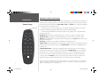
1
2610_2650 Cover.indd 1
8/1/2003, 4:17:59 PM
© Copyright 2003 Garmin Ltd. or its subsidiaries
Garmin International, Inc.
1200 East 151st Street, Olathe, Kansas 66062, U.S.A.
Tel. 913/397.8200 or 800/800.1020
Fax 913/397.8282
Garmin (Europe) Ltd.
Unit 5, The Quadrangle, Abbey Park Industrial Estate, Romsey, SO51 9DL, U.K.
Tel. 44/1794.519944
Fax 44/1794.519222
Garmin Corporation
No. 68, Jangshu 2nd Road, Shijr, Taipei County, Taiwan
Tel. 886/2.2642.9199
Fax 886/2.2642.9099
All rights reserved. Except as expressly provided herein, no part of this manual may be reproduced, copied, transmitted, disseminated, downloaded or stored in any
storage medium, for any purpose without the express prior written consent of Garmin. Garmin hereby grants permission to download a single copy of this manual
and of any revision to this manual onto a hard drive or other electronic storage medium to be viewed and to print one copy of this manual or of any revision hereto,
provided that such electronic or printed copy of this manual must contain the complete text of this copyright notice and provided further that any unauthorized
commercial distribution of this manual or any revision hereto is strictly prohibited.
Information in this document is subject to change without notice. Garmin reserves the right to change or improve its products and to make changes in the content
without obligation to notify any person or organization of such changes or improvements.
Visit the Garmin web site (www.Garmin.com) for current updates and supplemental information concerning the use and operation of this and other Garmin products.
Garmin®, AutoLocate®, MapSource®, StreetPilot®, and MetroGuide® are registered trademarks of Garmin Ltd. or its subsidiaries and may not be used without the
™ trademarks.
express permission of Garmin. Garmin Corporation is an authorized licensee of the CompactFlash®and
July 2003
2610_2650 Cover.indd 2
Part Number 190-00257-00 Rev. A
Printed in Taiwan
8/1/2003, 4:18:09 PM
Preface
Congratulations on choosing one of the most advanced GPS navigation systems available! The Garmin
StreetPilot 2610/2650 utilizes the proven performance of Garmin GPS and full featured mapping to create
an unsurpassed mobile navigation system.
This manual covers instructions for the StreetPilot 2610 and Street Pilot 2650. Unit operation and
specifications are the same on both models, unless otherwise specified. To get the most out of your
new navigation system, take the time to go through this owner’s manual and learn the operating procedures
for your unit. This manual is broken down into three parts for your convenience.
Part One introduces you to your StreetPilot 2610/2650. This includes warnings and cautions,
maintenance for your StreetPilot 2610/2650, and the configuration of the buttons.
Part Two is divided into sections that provide detailed references to the advanced features and
operations of the StreetPilot 2610/2650.
Part Three gives additional information such as a glossary of terms and installation instructions. Use the
Table of Contents on the next page for a quick reference to the desired appendix.
Introduction
Product Registration
Serial Number
Use this area to record the serial number (8-digit number
located on the bottom of the unit) in case it is lost, stolen,
or needs service. Be sure to keep your original sales
receipt in a safe place or attach a photocopy inside the
manual.
Serial Number:
Customer Service Product Registration
Help us better support you by completing our on-line registration today! Have the serial number
of your StreetPilot 2610/2650 handy and connect to our web site (www.garmin.com). Look for the Product
Registration link on the Home page. Also, be sure to record your serial number in the right-hand column
for a quick reference.
)
NOTE: If you have previously registered a Garmin product purchase, we invite you to reregister using our on-line system. Many services provided by our new product registration
system are now being automated and re-registering your purchase ensures you the best
possible support from Garmin.
,
The Garmin StreetPilot 2610/2650 has no user-serviceable parts. Should you ever encounter a problem with
your unit, please take it to an authorized Garmin dealer
for repairs.
The StreetPilot 2610/2650 is fastened shut with screws.
Any attempt to open the case to change or modify the
unit in any way voids your warranty and may result in
permanent damage to the equipment.
i
2610_2650 OM.indd i
8/1/2003, 4:15:24 PM
Introduction
Table of Contents
PREFACE.....................................................................i
Product Registration ............................................... i
TABLE OF CONTENTS ................................................ii
INTRODUCTION........................................................iii
FCC Compliance.................................................. iii
Warnings and Cautions ..................................... iv-v
Software License Agreement ................................. vi
Warranty ............................................................. vii
Maintenance....................................................... viii
Packing List.......................................................... ix
Unit Desription ..................................................... x
Keypad Usage........................................................1
Remote Usage........................................................2
Power/Display Adjustments...................................3
Touch Screen/Data Entry .......................................4
Data Entry/Selecting ..............................................5
Unit Pages .............................................................6
REFERENCE ...............................................................7
ii
2610_2650 OM.indd ii
Map Page...............................................................7
Map Page Options ...............................................11
Next Turn Page....................................................16
Current Route .....................................................17
Trip Information..................................................18
Marking Waypoints .............................................20
Using the Find Menu...........................................21
Using the Routes Menu .......................................27
Main Menu..........................................................31
System Setup.......................................................32
General Tab.....................................................32
Guidance Tab ..................................................33
Routing Tab.....................................................33
Time Tab .........................................................36
Safety Tab........................................................36
Track Log Tab..................................................37
Language Tab ..................................................37
Interface Tab (2650 Only) ...............................38
Info Pages............................................................39
GPS Info..........................................................39
Map Info .........................................................43
System Info .....................................................43
APPENDICES ...........................................................44
Appendix A: Installation......................................44
Appendix A: Time Offsets....................................49
Appendix A: Using Diacritical Marks...................50
Appendix A: CompactFlash® Data Cards.............51
Appendix A: Messages.........................................54
Appendix B: Specifications ..................................56
Appendix C: Index ..............................................58
8/1/2003, 4:15:30 PM
FCC Compliance
The StreetPilot 2610/2650 complies with Part 15 of the FCC interference limits for Class B digital
devices FOR HOME OR OFFICE USE. These limits are designed to provide more reasonable protection
against harmful interference in a residential installation, and are more stringent than “outdoor” requirements.
Operation of this device is subject to the following conditions: (1) This device may not cause harmful
interference, and (2) this device must accept any interference received, including interference that may
cause undesired operation.
This equipment generates, uses and can radiate radio frequency energy and, if not installed and used in
accordance with the instructions, may cause harmful interference to radio communications. However, there
is no guarantee that interference will not occur in a particular installation. If this equipment does cause
harmful interference to radio or television reception, which can be determined by turning the equipment
off and on, the user is encouraged to try to correct the interference by one of the following measures:
• Reorient or relocate the receiving antenna.
• Increase the separation between the equipment and the receiver.
• Connect the equipment into an outlet on a circuit different from that to which the receiver is connected.
• Consult the dealer or and experienced radio/TV technician for help.
The StreetPilot 2610/2650 does not contain any user-serviceable parts. Repairs should only be made
by an authorized Garmin service center. Unauthorized repairs or modifications could result in permanent
damage to the equipment, and void your warranty and your authority to operated this device under Part 15
regulations.
Introduction
FCC Compliance Statement
iii
2610_2650 OM.indd iii
8/1/2003, 4:15:31 PM
Introduction
Warnings and Cautions
CAUTION: Use the StreetPilot 2610/2650 at your own risk. To reduce the risk of unsafe operation,
carefully review and understand all aspects of this Owner’s Manual—and thoroughly practice operation
using the simulator mode prior to actual use. When in actual use, carefully compare indications from the
StreetPilot 2610/2650 to all available navigation sources, including the information from other NAVAIDs,
visual sightings, charts, etc. For safety, always resolve any discrepancies before continuing navigation.
CAUTION: IT IS THE USER’S RESPONSIBILITY TO USE THIS PRODUCT PRUDENTLY. THIS
PRODUCT IS INTENDED TO BE USED ONLY AS A NAVIGATIONAL AID AND MUST NOT BE USED
FOR ANY PURPOSE REQUIRING PRECISE MEASUREMENT OF DIRECTION, DISTANCE, LOCATION
OR TOPOGRAPHY. THIS PRODUCT SHOULD NOT BE USED AS AN AID TO DETERMINE GROUND
PROXIMITY FOR AIRCRAFT NAVIGATION.
,
CAUTION: The electronic chart is an aid to navigation and is designed to facilitate the use of authorized government charts, not replace them. Only official government charts and notices to mariners contain
all information needed for safe navigation – and, as always, the user is responsible for their prudent use.
MAP DATA INFORMATION: One of the goals of Garmin is to provide customers with the most
complete and accurate cartography that is available to us at a reasonable cost. We use a combination of
governmental and private data sources, which we identify as required in product literature and copyright
messages displayed to the consumer. Virtually all data sources contain inaccurate or incomplete data to
some degree. This is particularly true outside the United States, where complete and accurate digital data is
either not available or prohibitively expensive. Because the map data may not be perfect, it helps at times
to cross-check the unit’s map with your actual surroundings to confirm that you are arriving at the exact
destination.
iv
2610_2650 OM.indd iv
8/1/2003, 4:15:33 PM
WARNING: The Global Positioning System (GPS) is operated by the United States government, which
is solely responsible for its accuracy and maintenance. The system is subject to changes which could affect
the accuracy and performance of all GPS equipment. Although the Garmin StreetPilot 2610/2650 is a precision electronic NAVigation AID (NAVAID), any NAVAID can be misused or misinterpreted and, therefore,
become unsafe.
WARNING: For use in vehicles, it is the sole responsibility of the owner/operator of the StreetPilot
2610/2650 to secure the unit so that it will not interfere with the vehicle’s operating controls, obstruct
the driver’s view of driving conditions, or cause damage or personal injury in the event of an accident. Do
not mount the StreetPilot 2610/2650 over air bag panels or in the field of air bag deployment. Air bags
expand with a rapid force that can propel objects in their path toward the driver or passengers causing
possible injury. Refer to air bag safety precautions contained in the vehicle’s owner manual. Do not mount
the StreetPilot 2610/2650 in a place where the driver or passengers are likely to impact it in an accident
or collision. The mounting hardware provided by Garmin is not warranted against collision damage or the
consequences thereof.
WARNING: For use in vehicles, it the sole responsibility of the driver of the vehicle to operate the
vehicle in a safe manner, maintain full surveillance of all driving conditions at all times, and not become
distracted by the StreetPilot 2610/2650 to the exclusion of safe driving practices. It is unsafe to operate
the controls of the StreetPilot 2610/2650 while you are driving. Failure by the driver of a vehicle equipped
with a StreetPilot 2610/2650 to pay full attention to operation of the vehicle and road conditions while the
vehicle is in motion could result in an accident or collision with property damage and personal injury.
WARNING: This product, its packaging, and its components contain chemicals known to the State of
California to cause cancer, birth defects, or reproductive harm. This Notice is being provided in accordance
with California’s Proposition 65. If you have any questions or would like additional information, please
refer to our web site at http://www.garmin.com/prop65.
2610_2650 OM.indd v
Introduction
Warnings and Cautions
Your StreetPilot is equipped with a ‘Safe Mode’ feature to
improve driver safety. By default, this feature is enabled,
but can be turned off to allow a passenger to operate
the unit. When your vehicle is moving, Safe Mode
disables certain StreetPilot functions which require
significant operator attention and may become a distraction to use while driving. See page 36 for details.
For instructions on vehicle installation, see
Appendix A (pages 44).
v
8/1/2003, 4:15:34 PM
Introduction
Software License Agreement
Software License Agreement
BY USING THE STREETPILOT 2610/2650, YOU AGREE TO BE BOUND BY THE TERMS AND
CONDITIONS OF THE FOLLOWING SOFTWARE LICENSE AGREEMENT. PLEASE READ THIS AGREEMENT CAREFULLY.
Garmin grants you a limited license to use the software embedded in this device (the “Software) in
binary executable form in the normal operation of the product. Title, ownership rights and intellectual
property rights in and to the Software remain in Garmin.
You acknowledge that the Software is the property of Garmin and is protected under the United States
of America copyright laws and international copyright treaties. You further acknowledge that the structure,
organization and code of the Software are valuable trade secrets of Garmin and that the Software in source
code form remains a valuable trade secret of Garmin. You agree not to decompile, disassemble, modify,
reverse assemble, reverse engineer or reduce to human readable form the Software of any part thereof or
create any derivative works based on the Software. You agree not to export or re-export the Software to any
country in violation of the export control laws of the United States of America.
vi
2610_2650 OM.indd vi
8/1/2003, 4:15:35 PM
LIMITED WARRANTY
This Garmin product is warranted to be free from defects in materials or workmanship for one year
from the date of purchase. Within this period, Garmin will at its sole option, repair or replace any components that fail in normal use. Such repairs or replacement will be made at no charge to the customer for
parts or labor, provided that the customer shall be responsible for any transportation cost. This warranty
does not cover failures due to abuse, misuse, accident or unauthorized alteration or repairs.
THE WARRANTIES AND REMEDIES CONTAINED HEREIN ARE EXCLUSIVE AND IN LIEU OF ALL
OTHER WARRANTIES EXPRESS OR IMPLIED OR STATUTORY, INCLUDING ANY LIABILITY
ARISING UNDER ANY WARRANTY OF MERCHANTABILITY OR FITNESS FOR A PARTICULAR
PURPOSE, STATUTORY OR OTHERWISE. THIS WARRANTY GIVES YOU SPECIFIC LEGAL RIGHTS,
WHICH MAY VARY FROM STATE TO STATE.
IN NO EVENT SHALL GARMIN BE LIABLE FOR ANY INCIDENTAL, SPECIAL, INDIRECT OR
CONSEQUENTIAL DAMAGES, WHETHER RESULTING FROM THE USE, MISUSE, OR INABILITY TO
USE THIS PRODUCT OR FROM DEFECTS IN THE PRODUCT. Some states do not allow the exclusion of
incidental or consequential damages, so the above limitations may not apply to you.
Garmin retains the exclusive right to repair or replace the unit or software or offer a full refund of the
purchase price at its sole discretion. SUCH REMEDY SHALL BE YOUR SOLE AND EXCLUSIVE REMEDY
FOR ANY BREACH OF WARRANTY.
To obtain warranty service, call your local Garmin authorized dealer. Or call Garmin Customer Service
at one of the numbers listed on the right for shipping instructions and an RMA tracking number. The unit
should be securely packed with the tracking number clearly written on the outside of the package. The unit
should be sent, freight charges prepaid, to any Garmin warranty service station. A copy of the original sales
receipt is required as the proof of purchase for warranty repairs.
Products sold through online auctions are not eligible for rebates or other special offers from Garmin.
Online auction confirmations are not accepted for warranty verification. To obtain warranty service, an
original or copy of the sales receipt from the original retailer is required. Garmin will not replace missing
components from any package purchased through an online auction.
Introduction
Warranty
Garmin Addresses
Garmin International, Inc.
1200 E. 151st Street
Olathe, KS 66062, U.S.A.
Phone: 800/800.1020
FAX: 913/397.0836
Garmin (Europe) Ltd.
Unit 5, The Quadrangle,
Abbey Park Industrial Estate
Romsey, SO51 9DL, U.K.
Phone: 44/1794.519944
FAX: 44/1794.519222
www.garmin.com
vii
2610_2650 OM.indd vii
8/1/2003, 4:15:35 PM
Introduction
Maintenance
GPS Cleaning
The StreetPilot 2610/2650 case and remote are constructed of high quality materials and do not require
user maintenance other than cleaning. Clean the unit using a cloth dampened with a mild detergent solution and then wipe dry. Avoid chemical cleaners and solvents that may damage plastic components.
Touchscreen Cleaning
The StreetPilot 2610/2650 touchscreen is intended primarily for finger operation. Although a PDA
stylus may also be used to operate touchscreen, never attempt this while operating a vehicle. Never use a
hard or sharp object to operate the touchscreen or damage may result. The touchscreen should be cleaned
using a soft, clean, lint-free cloth. Water, isopropyl alcohol, or eyeglass cleaner may be used if needed. If
these are used, apply liquid to cloth and then gently wipe touchscreen with moistened cloth.
Storage
Do not store the StreetPilot 2610/2650 where prolonged exposure to temperature extremes may occur
(such as in the trunk of a car) as permanent damage may result. User information, such as waypoints,
routes, etc. are retained in the unit’s memory without the need for external power. It is always a good
practice to back up important user data by manually recording it or downloading it to a PC (transferring it
to MapSource).
Storing alkaline batteries in the remote control for extended periods is not recommended. In order to
reduce the chance for battery leakage in the battery compartment, remove the batteries when storing the
unit for more than six months.
viii
2610_2650 OM.indd viii
8/1/2003, 4:15:35 PM
Before installing and getting started with your unit, please check to see that your package includes the
following items. If any parts are missing, please contact your Garmin dealer immediately.
Standard Package:
• StreetPilot 2610 or 2650
• MapSource City Navigator CD-ROM with Unlock Certificate
• CompactFlash® Memory Card
• Dash Mount
• Portable Bean Bag Mount (Friction Mount)
• External Speaker with 12/24-volt Adapter Cable
• A/C Power Adapter
• PC/USB Interface Cable
• DR (Dead Reckoning) Installation Cable (2650 Only)
• Alphanumeric Remote Control (Requires two alkaline AA batteries. Not included)
• Owner’s Manual
• Quick Reference Guide
• Setup Guide
Introduction
Packing List
Optional Accessories:
• Remote GPS Antenna (GA 27C)
• Deluxe Carrying Case
• 128 and 256 MB CompactFlash® Memory Cards
ix
2610_2650 OM.indd ix
8/1/2003, 4:15:36 PM
Introduction
Unit Description
Internal Patch
Antenna
Infrared Window
Power Switch
Toggle DOWN to turn
unit ON and UP to
turn OFF.
Receives signals from GPS
satellites to determine
position. Do not block.
Receives signals from
remote control. Do
not block.
External Antenna
Connector
Light Sensor
Connection for optional
external antenna.
Automatically adjusts
backlight level
PAGE
MARK
MENU
ROUTE
FIND
RECENT
SPEAK
StreetPilot
VOLUME
2650
Front View
8-Bit Color LCD Touch
Screen Display
x
On-screen information is
referred to as a “page”.
Press PAGE/MARK key to
select a different screen.
2610_2650 OM.indd x
Back View
Keypad
USB Connector
Controls unit
operation.
Interface unit with a PC
to program the CF card,
Power/Speaker
Connector
Connector for power,
speaker, and Dead
Reckoning cable (2650
only)
Adjustable Mount
Allows the unit to connect to the mounting
base and tilt forward/
backward.
CompactFlash® Card
Door
Insert programmed CF card
for increased map detail
and information lookup
capability. Keep door shut
to prevent water entry.
8/1/2003, 4:15:36 PM
Keypad Usage
The StreetPilot 2610/2650 keypad allows you to perform more than one function using a single key.
The key’s primary function appears in larger text above the secondary function. Always press and release a
key to perform its primary function. Pressing and holding a key activates its secondary function (if available). For example, quickly pressing and releasing the PAGE/MARK key cycles through the available main
pages. If you press and hold the PAGE/MARK key for more than 2 seconds (then release), the unit marks
the current position as a waypoint (See page 20).
Introduction
Keypad Usage
PAGE/MARK Key — PAGE switches between main pages and returns display from an option window
back to a main page. MARK captures your present position and saves it as a waypoint.
MENU/ROUTE Key — MENU displays a menu of options for the current page. Press twice to display
various Info options. ROUTE displays a pop-up window of available route navigation features.
FIND/RECENT Key — FIND displays search options for Cities, Exits, Waypoints, and Recently found
places. If MapSource City Navigator or MetroGuide map data is loaded in an installed CompactFlash®
card, it also searches for various Points of Interest, Addresses, and Intersections. RECENT allows you to
view a sortable list of recent finds.
SPEAK/VOLUME Key — SPEAK triggers the voice to repeat the next turn or current destination when
navigating and current GPS status when not navigating. VOLUME displays an adjustment slide on the
screen to change the speaker volume. To hear the volume count (i.e., 1, 2, 3, 4, 5, 6, 7, 8, 9, 10) touch up
or down on the slider. Each press activates the audio number.
1
2610_2650 OM.indd 1
8/1/2003, 4:15:37 PM
Alphanumeric Remote Control Usage
Introduction
Remote Usage
IR Window
IN
OUT
ZOOM
QUIT
PAGE
FIND
MENU
ROUTE
SPEAK
1
ABC
2
DEF
3
GHI
4
JKL
5
MNO
6
PQRS
TUV
8
WXYZ
7
0
2
2610_2650 OM.indd 2
9
The StreetPilot 2610/2650’s alphanumeric remote control allows you to perform functions similar to the
unit’s touch screen and keypad controls. The key’s primary function appears on the key and the secondary
functions (same as keys on unit) for the PAGE, MENU, FIND, and SPEAK can be activated by holding the
key for more than 2 seconds (then release).
In order for the remote to operate properly, be sure to point the IR (infrared) window on the remote
towards the unobstructed IR window on the left front of the StreetPilot 2610/2650.
The remote also has additional function keys that allow you to quickly enter data and perform other
operations on the unit:
(ZOOM) IN Key — Zooms in to adjust the Map page scale to show a smaller area with more detail.
(ZOOM) OUT Key — Zooms out to adjust the Map page scale to show a larger area with less detail.
QUIT Key — Returns display to previous page. When entering data, pressing QUIT restores the previous
value (cancels data entry.)
ROUTE Key— Displays a pop-up window of available route navigation features.
THUMB STICK — Selects menu options, changes settings, and enters data. Also controls movement if the
panning cursor on the Map page. Press IN on the THUMB STICK to select/activate a highlighted item or
begin data entry.
ALPHANUMERIC KEYS — Used when entering alphanumeric data in the unit, such as an address or
waypoint name. These keys can be used in conjunction with the THUMB STICK. To select the first letter
press the key once, to select the second letter press the key twice, to select the third letter press the key
three times, or to select the number press the key four times (five times for 7 and 9). (The 1 key only
accepts one press and SPACE/0 key only accepts two key presses.) When you have the correct letter or
number selected, pause and the unit advances the cursor to the next character automatically.
The remote requires two AA alkaline batteries. To install the batteries, press UP on the battery door clip, then pull the
battery door away from the remote. Install batteries observing the correct polarity (see inside battery compartment).
Replace cover, making sure the it is closed all the way.
8/1/2003, 4:15:38 PM
Turning the StreetPilot 2610/2650 On and Off
Toggle the power switch on the right side DOWN to turn the unit On and UP to turn Off. The Welcome screen appears briefly, followed by the Card Information/MapSource copyright page, Press IN on the
THUMB STICK or TOUCH ‘OK’ to acknowledge, or wait briefly until the Safe Driving Warning Message
appears. Once again, press IN on the THUMB STICK or TOUCH ‘OK’ or wait until the Map Page appears.
Introduction
Power/Display Adjustments
Adjusting the Backlight, Contrast, and Speaker Volume
The StreetPilot 2610/2650 display and keys can be illuminated for operation at night or in bright sunlight. Backlight intensity and screen contrast are adjustable. When operating the StreetPilot 2610/2650 at
extreme temperatures, you may find that minor adjustments are needed to obtain the clearest screen.
To adjust screen backlighting and contrast:
1. Press the remote or unit MENU key. Select ‘Display’ (see pages 4-5).
2. Adjust the backlight and the contrast to the desired level (see pages 4-5). To have the unit automatically
adjust the brightness, place a check in the ‘Automatic Brightness’ box. For optimum Automatic Brightness
results, set the brightness to a middle level. If Automatic Brightness is checked, the lower the brightness
slide level is set to, the sooner the unit reaches a minimum brightness level. The unit automatically adjusts
the level depending on ambient light conditions.
Brightness
Slider.
Contrast
Slider.
To adjust the external speaker volume:
1. Press and hold the SPEAK/VOLUME key. A slider adjustment window appears.
2. Adjust the speaker volume (see pages 4-5). The loudest setting is ten, the softest is one. (Alternatively,
volume can be cycled between three settings by repeatedly pressing SPEAK/VOLUME button from this
screen.) Each press activates the audio number.
To calibrate the touch screen:
1. Press the remote or unit MENU key. Select ‘Display’ (see pages 4-5).
2. Press the remote or unit MENU key again to begin calibration. Follow the on-screen instructions.
Speaker Volume
Slider.
3
2610_2650 OM.indd 3
8/1/2003, 4:15:40 PM
Introduction
Touch Screen/Data Entry
,
The StreetPilot 2610/2650 touchscreen is intended
primarily for finger operation. Although a PDA stylus
may also be used to operate touchscreen, never
attempt this while operating a vehicle. Never use
a hard or sharp object to operate the touchscreen or damage may result. The touchscreen
should be cleaned using a soft, clean, lint-free cloth.
Water, isopropyl alcohol, or eyeglass cleaner may
be used if needed. If these are used, apply liquid
to cloth and then gently wipe touchscreen with
moistened cloth.
Touch Screen Control
The StreetPilot 2610/2650’s Touch Screen allows you to make menu selections, position the pointer/
cursor, scroll through menu selections, and enter data with the touch of a finger.
To use the touch screen control, TOUCH the desired object on the screen, applying just enough pressure to active the function. It is not necessary to apply excessive pressure to the touch screen. If the
‘Touchscreen Tone’ setting is ‘On’, you hear a click from the speaker with every finger press. If the touch
screen is not responding properly, it may need to be calibrated (see page 3).
To perform actions such as panning on the map or scrolling through menus, TOUCH and hold on the
screen while sliding your finger to the desired map or menu point.
Features and Data Entry
The following features and data entry procedures are referred to throughout this manual.
Cursor — A yellow highlighted area on the screen that can be moved up/down/left/right with the
remote control THUMB STICK or by TOUCH to select individual fields on the display. Moving the cursor
to a given location allows you to begin data entry, change settings, or scroll through a list.
Field — The location on a page where a group of characters or an option is entered and displayed. The
cursor is placed on a field (using the THUMB STICK or by TOUCH) to begin data entry or selection of
options.
To enter data in a data field:
1. Use the THUMB STICK by moving it UP, DOWN, LEFT, or RIGHT to highlight the desired data field and
press IN or TOUCH the desired field to begin data entry.
Entering Data
2. For the touch screen, TOUCH the desired letters or numbers. To switch between entering letters and
numbers, TOUCH the ‘A-Z’ tab for letters and the ‘0-9’ tab for numbers. The unit automatically advances
the cursor to the next position. TOUCH ‘<’ to back up the cursor or ‘>’ to advance. TOUCH ‘Space’ to
enter a space. TOUCH ‘Delete’ to delete the highlight character. The unit automatically shows greyed out
predictive text for Find fields. TOUCH ‘>’ or press the THUMB STICK RIGHT to use the letters.
For the remote, use the THUMB STICK to highlight the desired letter/number or option and press IN or
for entering letters/numbers, use the ALPHANUMERIC keys by pressing the desired key once for the first
letter, twice to select the second letter, three times to select the third letter, or to select the number press
the key four times. (The 1 key only accepts one press and SPACE/0 key only accepts two key presses,
4
2610_2650 OM.indd 4
8/1/2003, 4:15:41 PM
press fives times for the number on the 7 and 9 keys.) When you have the correct letter or number
selected, pause and the unit advances the cursor to the next character automatically. Move the cursor all
the way to the left position, then once more to clear the entire data field.
3. Once the desired data has been entered, TOUCH or highlight and press IN on the THUMB STICK on
‘OK’ to confirm.
Introduction
Data Entry/Selecting
To select and change a setting:
1. Highlight the field with the THUMB STICK by pressing UP, DOWN, LEFT or RIGHT, and press IN or
TOUCH the desired field.
2. Highlight the desired setting with the THUMB STICK and press IN or TOUCH the desired setting.
Icons — Similar to “Field” and “On-Screen Buttons”. Icons are graphical pictures of menu items or map
options. Place the cursor on a button and press IN on the THUMB STICK or TOUCH the button select.
As you highlight menu icons with the THUMB STICK, the title text enlarges for easier viewing.
On-Screen Button — Similar to “Field”. Place the cursor on a button and press IN on the THUMB
STICK or TOUCH the button select the action corresponding to that button. An example of an on-screen
button is the ‘Go To’ button appearing at the bottom of the New Waypoint page.
Scroll Bar — When viewing a list of items too long to display on a single page, a scroll bar appears
along the right-hand side of the list. The position of the scroll bar indicates which portion of the list is currently being displayed. The height of the scroll bar indicates the number of items in the list.
An example of an on-screen “button”—the ‘Go To’
button on the Waypoint Marked page.
To scroll through a list of items:
1. Move UP or Down on the THUMB STICK. You may also TOUCH the blue up or down arrows to scroll
through the list one item at a time; TOUCH and hold the scroll bar, then slide UP or DOWN to scroll; or
TOUCH the area above or below the scroll bar to scroll a page at a time.
Default — A system-selected format built into the operating software or the unit’s memory that is
followed unless the user chooses a different setting. For example, the default setting for speed readings
is ‘Statute’ or but can be changed to ‘Metric’. Once a setting is changed, the new setting is retained until
another change is made or the ‘Restore Settings’ menu option is selected.
2610_2650 OM.indd 5
When viewing a list of items too long to display on a
single page, a scroll bar appears along the right-hand
side of the list. Also, using the LEFT/RIGHT portion of the
THUMB STICK scrolls information one full screen at a
5
time.
8/1/2003, 4:15:42 PM
Unit Pages at a Glance
Introduction
All of the information needed to operate the StreetPilot 2610/2650 is found on ‘pages’—display screens.
There are three main pages, the Map, Trip Information, and Current Route. A fourth page is available
during navigation, the Next Turn page. Press the remote PAGE or QUIT key to switch back and forth
between pages or press the PAGE key on the GPS to cycle forward. The Reference Section describes in
detail what each page does and how they are configured.
Unit Pages
UNIT OR
REMOTE
PAGE
KEY
Map Page
Trip Information Page
SPEAK
KEY
6
2610_2650 OM.indd 6
REMOTE
QUIT
KEY
Current Route Page—Available
only during navigation
(Or can be set
to automatically
appear for 10
seconds)
Next Turn Page—Available
only during navigation
8/1/2003, 4:15:42 PM
Map Page
Reference
Route Line
Data Fields
Map Page
Next Turn
Your Current
Position
Map Scale
Driving Instructions
The Map page is the main operating page of the StreetPilot 2610/2650. It graphically shows you map
details, your current location, and marks your route to a destination with a magenta colored route line. It
tells you what direction to go or the direction you are traveling. Customizable data tabs on the right side
allow you to display information such as your speed, the distance you have traveled, the distance to the
next turn, the time remaining before reaching the next turn, and more. If the StreetPilot 2610/2650 has
yet to calculate your location, there is a flashing question mark over the vehicle pointer and the status text
displays ‘Acquiring Satellites’, ‘Searching for Satellites’, or ‘Locating Satellites’. A ‘Ready to Navigate’ voice
prompt and tab text (if a tab is set to ‘NextTurn’) appears.
The map display shows your present position and direction of movement as a triangular ‘Position Icon’
in the center of the map. The map display also shows the map scale, north reference, and geographic details
such as lakes, rivers, highways, and towns. When you are driving on roads that are not present in the
maps, you may see a circle drawn around the position pointer. This is the ‘accuracy circle’. The StreetPilot
2610/2650 uses both map resolution and GPS accuracy in defining your location to a point within this
“accuracy circle”. The smaller the circle, the more accurate your location. More detailed map features as
well as information about those features can be displayed using a CF data card containing map data transferred from a Garmin MapSource CD-ROM. When you zoom into smaller map scales, “MapSource” appears
directly below the map scale indicating that MapSource data is being used to draw a more detailed map.
The map may be also be toggled between a North Up or Track Up orientation. (see page 12)
For maximum map display, you can select ‘Hide
Tabs’. This section of the manual discusses how to
select between the displays. You may also TOUCH
the tabs to hide/show them.
The ‘Hide Tabs’ configuration showing no Navigation Information. TOUCH the placeholder to show
the tab again.
7
2610_2650 OM.indd 7
8/1/2003, 4:15:43 PM
Reference
Map Page
Zooming, Panning and Pointing
There are three main actions you can perform on the Map page: zooming, panning, and pointing. The
map display has 24 map scales (from 120 feet to 800 miles) that are selected by pressing the remote IN
and OUT zoom keys or TOUCH the current map scale in the lower left corner of the map display. You can
change the map scale to show more map area with less detail, or less map area with more detail.
To change the map scale:
1. TOUCH the map scale on the lower left corner. A zoom/pan toolbar appears on the left side of the display and the data tabs on the right are hidden. TOUCH the ‘+’ magnifying glass icon to zoom IN to see
a smaller area with more detail. You may also use the remote IN zoom key (The toolbar does not appear
when using the remote.) Press and hold this remote key to zoom the map scale rapidly.
2. TOUCH the ‘-’ icon to zoom OUT to see a larger area with less detail. You may also us the remote OUT
zoom key. Press and hold this remote key to zoom the map scale rapidly.
Select ‘+’ to zoom in and ‘-’ to zoom out.
3. To return back to the normal Map page, TOUCH the ‘Back’ (Left) arrow in the upper left or press QUIT
on the remote.
You may also define a particular area to enlarge on the map by drawing a “box” on the touch screen,
then lifting your finger from the screen. The zoom/pan toolbar shows both the View Area and Pan icons in
the lower left. The larger of the two icons is the one that is active, with the inactive option appearing as a
smaller icon in the lower right on the zoon/pan toolbar. The View Area option can only be used with the
touch screen.
To zoom in on particular map area:
1. TOUCH the map to display the zoom/pan toolbar.
2. If the Pan (hand) icon is the larger of the two, TOUCH the icon. The icons change places and the View
Area icon is the larger.
Drag to create a box around the zoom area.
8
2610_2650 OM.indd 8
3. TOUCH and hold a point adjacent to the area you want to enlarge and then drag to create a box around
the area. Lift your finger to complete, allowing the map to redraw. The unit zooms in on the drawn area
and adjust the zoom scale as needed. The unit zooms in greater scale increments if a smaller box is
drawn. Note that when the View Area Selector is active, the Pan Map feature is not usable.
8/1/2003, 4:15:44 PM
When zoomed in to smaller map areas, ‘overzoom’ appears directly below the map scale. This indicates
the current scale exceeds the optimum resolution of available map detail. Extra caution should be used in
‘overzoom’ since some detail, such as roads, are drawn using widely spaced points and the actual layout of
these details may differ from the map presentation.
Panning allows you to move the map in order to view areas beyond the current map area. This provides
a ‘look ahead’ capability, which is particularly useful with smaller map areas. While in panning mode, the
data tabs on the right are hidden.
Reference
Map Page
To pan the Map page:
1. Use the remote THUMB STICK or TOUCH, hold, and drag your finger to move the map in any direction,
including diagonally.
2. Once you are finished panning, you can quickly remove the panning arrow and re-center the map on
your present position by pressing the remote QUIT key or TOUCH the back arrow in the upper left.
As you begin to pan the map with the remote, a pointer appears. This map pointer serves as a target
marker for the map. If you change the scale, the map is redrawn with the pointer at the center. When
the pointer is placed on a map object, the name of that object is highlighted and an ‘I’ (Information) icon
appears in the upper right corner. If the pointer is on a blank area of the map, a Create Waypoint ‘Flag’
appears. This feature applies to everything displayed on the map except route lines and track log data.
When a map item or waypoint name is highlighted, you can review information, show it on the map, or
execute a ‘Go To’ directly from the Map page. Waypoints have an additional ‘Delete’ option and all other
map items have a ‘Flag’ icon to create a waypoint at that item’s location.
The Map page showing the panning arrow and a
highlighted map feature or point of interest.
To select an on-screen location with the panning pointer:
1. Use the remote THUMB STICK or TOUCH to highlight the desired map item.
2. To view information for the selected item, press IN on the THUMB STICK or TOUCH the Information ‘I’
in the upper right corner.
The Information page for the historical
landmark highlighted in the screen above.
3. To exit the information pages, press QUIT on the remote or TOUCH the ‘X’ in the upper right corner.
9
2610_2650 OM.indd 9
8/1/2003, 4:15:45 PM
Reference
Map Page
To create a new waypoint from the Map Page (blank map area):
1. Use the remote THUMB STICK or TOUCH to point to the desired location on the map. Press IN on the
THUMB STICK or TOUCH the ‘Flag’ icon. A ‘New Map Waypoint’ page appears, with an auto-assigned
name (3-digit number) for the waypoint. To change the name or coordinates, see Data Entry on page 4.
2. To save the waypoint, TOUCH ‘OK’ or select with the THUMB STICK.
To create a new waypoint using a map item:
1. Use the remote THUMB STICK or TOUCH to point to the desired map item. Select the ‘Information’
icon.
2. Select the Create Waypoint ‘Flag’ icon. A ‘New Waypoint’ page appears, with an abbreviated autoassigned name. To change the name or coordinates, see Data Entry on page 4.
3. To save the waypoint, select ‘OK’.
When the ‘New Waypoint’ page appears, the
waypoint is stored in memory once you select ‘OK’.
Once you are finished with panning, you can quickly remove the panning arrow and re-center the map
on your present position by pressing the remote QUIT key or TOUCH the ‘Back’ arrow in the upper left.
See page 20 for more on creating and editing waypoints.
The ‘Go To’ function can be used anywhere on the map. If nothing currently exists at the map pointer
position, a new waypoint is created at the pointer’s location before the ‘Go To’ is started. You can also create
a waypoint on the Map page without selecting it as a ‘Go To’ destination.
Routing to a Map Feature or Location
1. Use the remote THUMB STICK or TOUCH to point to the desired map item or location on the map.
2. Select the ‘Information’ or ‘Flag’ icon in the upper right.
2. Select ‘Go To’.
The ‘Waypoint Created’ page appears with a default
three-digit number for its name which can be
changed to something a little more descriptive (up
to 10 characters in length).
3. The ‘Route Preference’ window appears. Select ‘Faster Time’, ‘Shorter Distance’, or ‘Off Road’. The
StreetPilot 2610/2650 routes you to the selected destination using turn-by-turn navigation and voice
prompting. See pages 27-30 for more on Routes.
10
2610_2650 OM.indd 10
8/1/2003, 4:15:45 PM
Map Page Options
Like each of the main pages, the Map page is menu driven. With the Map page displayed, pressing
the remote or unit MENU key displays an options menu, allowing you to customize the page to your
preferences and/or select special features that specifically relate to the Map page. (See page 5 for how to
select menu icons.) The following options are available : ‘Use Indoors’, ‘Measure Distance’, ‘Map Setup’,‘Tab
Setup’ or ‘Hide/Show Tabs’, ‘Route’, ‘Options’, ‘Info’, and ‘Display’.
Reference
Map Page Options
Use Indoors (or) Use Outdoors — The ‘Use Indoors’ option stops satellite reception, conserves
power usage, speeds Map page drawing, and is used for practicing with the unit. The ‘Use Outdoors’ option
receives satellites for real-time navigation.
Measure Distance — Allows you to measure the distance between any two points you choose on the
Map page. Also displays the latitude and longitude of the pointer.
To measure the distance between two points:
1. From the Map page, press either the unit or remote MENU key.
Once you have marked a waypoint, you can route
to it, show it on the map, or delete it.
2. Select ‘Measure Distance’. An on-screen pointer appears on the map display at your current location. The
top of the screen displays
3. Move the panning arrow with the THUMB STICK to or TOUCH the desired reference point (the point
you want to measure from) and select the check mark in the upper right corner. A data window appears
at the top with the distance, bearing and coordinates.
4. Move the panning arrow to the second point, to which you want to measure. The direction and distance
from the reference point is shown on the top of the Map page.
5. Press the QUIT key, TOUCH the ‘Back’ arrow or select ‘Stop Measuring’ on the menu to return to the
regular Map page display.
Map Setup — Allows you to configure the map display to your preferences, including map detail, map
orientation, automatic zooming, and color mode. The map setup options are organized under a series of
‘file tabs’, making individual selections easier to locate and change. The following pages describe the file
tabs and settings available under each tab:
2610_2650 OM.indd 11
You can route to a map item by selecting ‘Go To’.
11
8/1/2003, 4:15:46 PM
Reference
Map Page Options
Common Settings
Text Size — Specifies the text size that a map item display. Selecting ‘None’ turns off the text display for
that item.
Max Zoom — Specifies the maximum map scale at which a map item displays. If ‘Auto’ is selected, the
maximum map scale is determined by the ‘Detail’ setting to prevent map clutter. If ‘Off’ is selected, the item
won’t be shown.
Map Options
The Options menu on the Map page allows you to
customize the Map page.
Map Detail— Adjusts the amount of map information, such as roads, that is displayed. ‘Most’ shows
maximum detail and ‘Least’ shows minimum detail. The higher level of detail, the slower the map redrawing time.
Orientation — Selecting ‘North Up’ displays the map with North at the top. Selecting ‘Track Up’ automatically rotates the map to keep your current direction of travel at the top of the screen. A white ‘North’
indicator is displayed on the map when in the ‘Track Up’ mode. The indicator always points to North. An
‘N’ with a black arrow pointing up displays while in ‘North Up’ To quickly change the map orientation,
TOUCH the ‘Orientation’ icon in the upper left to toggle between ‘North Up’ and ‘Track Up’.
Color Mode — Select between Day, Night, or Automatic for best viewing conditions. ‘Day’ shows mostly
a yellow background, ‘Night’ shows a black background for less intensity in a dark environment, for easier
viewing while driving at night. ‘Automatic’ switches between day and night automatically.
AutoZoom — When ‘On’, this option automatically adjusts the map scale to show both your current location and the next item to which you are navigating.
Line Options
Track Log — Controls the display of the Track Log on the map.
Railroad — Controls the display of railroads on the map.
Street Label — Controls the display of street names on the map.
Other Options
12
2610_2650 OM.indd 12
Point Tab — Controls the display of waypoints, exits, and POIs (points of interest) on the map.
8/1/2003, 4:15:47 PM
City Tab — Controls the display of different size cities on the map.
Area Tab — Controls the display of rivers, lakes, parks, and other areas (airports, shopping malls, hospitals, etc.).
Some map data is only visible at certain zoom scale ranges. For example, you may set ‘Street Label’ Max
Zoom to 200 miles, but they would not show above a 0.8 mile zoom scale. Setting the Max Zoom to ‘Auto’
generally gives the best display performance.
Reference
Map Page Options
Resetting Map Setup Defaults
You may reset (restore) map settings for each individual setup tab or for all tabs.
To reset map setup defaults:
1. From the Map Page, press the unit or remote MENU key.
2. Select ‘Map Setup’.
3. To restore defaults for an individual map setup tab, highlight the tab and press the unit or remote MENU
key.
A series of “file tabs” allow you to change the Map
page setup options.
4. Select either ‘Reset Settings’ or ‘Reset All Settings’.
Tab Setup — Data tabs on the Map page display a variety of information and may be customized. You
can change the size, type of data displayed, shading of the data fields, and which tabs are shown/hidden.
There are two different sets of tabs that display, depending your navigation mode. When not navigating a
route, the ‘Mapping’ tabs are used and ‘Routing’ tabs are used while navigating a route.
To show/hide individual or groups of data tabs (Touch screen only):
1. From the Map page, TOUCH the individual tab to hide it. The tab is replaced by a blue placeholder on
the right side of the display. TOUCH the placeholder to show the tab again. A tab turns red when it is
selected.
2. To show/hide more multiple tabs, TOUCH and hold on the left side of the topmost group of tabs you
wish to hide, hold and slide your finger in a ‘L’ shape down and right to the side of the display. Repeat
the process in reverse to redisplay the tabs.
2610_2650 OM.indd 13
You can adjust the map colors for day or night
operation for maximum clarity.
13
8/1/2003, 4:15:47 PM
Reference
Map Page Options
To show/hide all data tabs:
1. From the Map page, press MENU on the unit or remote. Select ‘Hide Tabs’ or ‘Show Tabs’ (depending on
the current setting).
To setup data tab sizes:
1. Select ‘Tab Setup’ from the Map menu.
2. Select either the ‘Mapping’ or ‘Routing’ tab.
3. Select ‘Tab Style’. Choose ‘Wide Tabs’, ‘Narrow Tabs’, or ‘Compact Tabs’. A preview of the layout shows
on the right side along with the type of data that is to be displayed. You may select different layout for
both the ‘Mapping’ and ‘Routing’ tabs.
To change the data tab shading:
1. Select ‘Tab Setup’ from the Map menu.
Tab Setup Menu
2. Select the Shading Slider at the bottom.
3. TOUCH or move Left/Right on the THUMB STICK to select one a shade setting.
To customize the data tabs:
1. Select ‘Tab Setup’ from the Map menu.
2. Select either the ‘Mapping’ or ‘Routing’ tab.
3. Press MENU on the unit or remote then select ‘Custom Setup’.
4. Select the button for the tab you wish to customize. You may also choose to add tabs by selecting the tab
number. If a tab is not available due to size, it is grayed out.
5. Select the primary type of data you wish to display. The number of custom tabs with that type of data
appears.
6. Select ‘Prev’ (Previous ) or ‘Next’ to cycle through the available selections.
Customizing the Tabs
7. When the desired tab appears, select ‘OK’. When done, press QUIT on the remote or TOUCH the ‘X’ in
the upper right corner.
14
2610_2650 OM.indd 14
8/1/2003, 4:15:48 PM
Map Page Navigation Information
The following types of navigational data can be displayed on the ‘Mapping’ data tabs:
Reference
Address – Destination address when navigating to a route.
Heading – Current direction of travel.
Map Page Options
Next Turn – Shows GPS status when stationary, the next intersection when driving, and driving
instructions for the next turn when navigating a route.
Speed – Your rate of travel, which can be displayed in miles or kilometers per hour.
Time of Day – Current time.
The ‘Routing’ data tabs can use the same type of navigational data as ‘Mapping’ in addition to:
Arrival Distance – Distance to final destination.
Arrival Time – Estimated time of arrival at final destination.
Distance To Turn – When navigating a Route, the distance remaining to reach the next turn is displayed. When not navigating a Route, this field is not displayed.
Time to Turn – The estimated time to go before reaching the next turn.
Available Data Types (Routing Tab Shown)
15
2610_2650 OM.indd 15
8/1/2003, 4:15:49 PM
Reference
Next Turn Page
Map Orientation
Route Line
Next Turn Page
Driving Instructions
Map Scale
Time to Go
Distance to Go
You can select when the Next Turn page appears, or
you can turn it off completely (see page 33).
The Next Turn page displays in detailed format the features of the next turn in the route. When a route
is being navigated, it shows for ten seconds. The top-view map is oriented to the inbound direction for the
turn. Map scale is adjustable using the remote IN/OUT zoom keys or TOUCH the zoom scale. The page
shows the distance and time to the next turn, and driving directions in text format. To clear the Next Turn
page and return to the previous page at any time, press either the remote QUIT or TOUCH the ‘Back’ key.
The Next Turn page can be turned off completely, set to automatically appear when navigating a route,
set to appear only when the SPEAK key is pressed, or both. See the System Setup on page 33 for instructions on configuring the Next Turn page. When not navigating a route, the Next Turn page is no longer
available.
When navigating a route, the Map page displays the next turn distance and a turn direction arrow in
blue on the left side of the display.
This page appears automatically when you are
navigating a route.
16
2610_2650 OM.indd 16
8/1/2003, 4:15:49 PM
Current Route Page
Driving Instructions
Time to Go/ Time of
Arrival at Turn
Reference
Current Route Page
Direction of Turn
Scroll Bar
Distance to Go
Final Destination
Distance and Time to
Go, Time of Arrival
When the StreetPilot 2610/2650 is navigating a Route, the Current Route page is displayed between
the Map page and the Trip Information page (the Current Route page is only available during
navigation). The page shows a pointer that indicates the direction of travel from your current location to
the destination, a list of the next three turns and the destination (turn direction arrow, turn description,
distance and time for each).It is often desirable to view the Next Turn page from the Current Route page.
Use the Scroll Bar to view past or future turns
and directions on the Current Route page.
To view the Next Turn Page from the Current Route Page:
1. With the Current Route page displayed, select the turn you want to see.
2. Press the remote QUIT or TOUCH the ‘X’ when done looking at the next turn.
You can scroll through the entire list and highlight any of the turns in the list and view the Next Turn
page for that turn.
To scroll through the list:
1. Use the THUMB STICK or TOUCH the UP/DOWN arrows or to scroll through the list, stopping at the
desired turn. Select to view the Next Turn page for that turn. Press the remote QUIT or TOUCH the ‘X’ to
get back to the Current Route page.
The Next Turn page can be viewed from the Current
Route page by selecting the desired turn.
17
2610_2650 OM.indd 17
8/1/2003, 4:15:50 PM
Reference
Trip Information Page
Trip Information Page
The third main page is the Trip Information page. If you are making a long trip, you may find the Trip
Information page very useful. It indicates your current speed and many helpful statistics about your trip.
The following are useful suggestions to aid in maximizing the use of the Trip Information page:
Be certain to reset the Trip Computer before beginning a trip (see next page). If you make frequent
stops, leave the StreetPilot 2610/2650 powered on and receiving satellites. This allows the unit to accurately measure elapsed time during the trip. However, some vehicles disconnect power to the cigarette
lighter when the ignition is turned off.
The following trip information is displayed on the Trip Information page:
Time of Day – Current time.
Compass Ribbon – Shows your current compass heading while moving with a red indicator arrow.
The Trip Information page
Speed – This is the current vehicle speed, displayed in miles or kilometers an hour.
Odometer – A running total of distance traveled, based upon the distance between second-by-second location readings, since the Trip Computer was last reset.
Mileage Log – Allows you to use up to four different mileage odometers for recording trip distances. You
may also rename each mileage log (see next page).
Driving Avg – Your average speed of travel during the time the vehicle has been in motion, since the Trip
Computer was last reset.
Overall Avg – Your average speed of travel (including time stopped) during the time the StreetPilot 2610/
2650 has been tracking your location since the Trip Computer was last reset.
Select from different Mileage Logs.
Max Speed – The maximum speed recorded since the Trip Computer was last reset. Max Speed may also
be reset individually without resetting other Trip Computer information.
Driving Time – The length of time that the vehicle has been in motion since the Trip Computer was last
reset.
18
2610_2650 OM.indd 18
8/1/2003, 4:15:51 PM
Stopped Time – The length of time that the vehicle has been stopped (stationary) during the time the
StreetPilot has been tracking your location since the Trip Computer was last reset.
Total Time – The total length of time that the StreetPilot 2610/2650 has been tracking your location since
the Trip Computer was last reset. This is always equal to Driving Time plus Stopped Time.
Reference
Trip Information Page
To reset the Trip Computer or the Maximum Speed:
1. Press the unit or remote MENU key to display the Options window. You may also select the round buttons to the right of the main odometer or Max Speed. (Skip to step 4 if using the buttons.)
2. Select ‘Reset Trip Computer’.
3. To reset the Maximum Speed only, select ‘Reset Max Speed Only’.
4. Select ‘Yes’ or ‘No’.
To select a Mileage Log:
1. Select the ‘Job 1’ field.
2. Select the desired Mileage Log name.
You can reset Max Speed or the Trip Computer from
the Trip Information menu.
To rename a Mileage Log:
1. With the desired Mileage Log displayed, press the unit or remote MENU key to display the Options
window.
2. Select ‘Rename Log’ .
3. Enter the new name (see pages 4-5) and select ‘OK’ when done.
To reset a Mileage Log:
1. With the desired Mileage Log displayed, press the unit or remote MENU key to display the Options
window. You may also select the round button to the right of the Mileage log. (Skip to step 3 if using the
button.)
2. Select ‘Reset Log’.
Renaming a Mileage Log
3. Select ‘Yes’ or ‘No’.
19
2610_2650 OM.indd 19
8/1/2003, 4:15:51 PM
Reference
Marking Waypoints
Marking Your Location as a Waypoint
It is useful to mark a location, so that you can drive to it again later. These locations are called
‘Waypoints’. The StreetPilot 2610/2650 can hold up to 500 Waypoints.
To mark your location as a Waypoint:
1. Hold down either the remote or unit PAGE key for 2 seconds and release. The ‘New Waypoint’ page
appears, with a default three-digit name for the new Waypoint in the upper-left portion of the page. The
StreetPilot 2610/2650 captures the location from the instant you release PAGE, so you do not need to
be concerned about moving around or losing satellite reception, your Waypoint is safely stored.
To rename the Waypoint, manually change the Coordinates or Elevation:
1. Select the Name, Coordinates, or Elevation field.
2. Enter the new waypoint name, waypoint coordinates, or elevation (pgs 4-5) and select ‘OK’ when done.
A waypoint is stored in memory as soon as the ‘New
Waypoint’ page appears.
Each waypoint may also be assigned a custom waypoint symbol for easy recognition on the Map page.
To change the Waypoint symbol:
1. Select the Waypoint symbol field (immediately to the left of the waypoint name).
2. Select the most appropriate symbol and select ‘OK. The new Waypoint is now stored in memory.
When stationary, you may also average a waypoint’s position to increase it’s accuracy. If you are moving
or average the waypoint the from another location, it changes the coordinates to the updated position.
To average a waypoint location:
1. From the New Waypoint screen, press the unit or remote MENU key and select ‘Average Location’.
2. The unit shows a Measurement Count and Estimated Accuracy. Select ‘Update <waypoint> Location’.
There are approximately 50 waypoint symbols to
choose from. These symbols are used to mark the
waypoint’s position on the Map page.
20
2610_2650 OM.indd 20
At the bottom of the Waypoint Marked and Waypoint Review page there are three option buttons that
may be selected:
Delete – deletes the waypoint.
Show On Map – Shows the waypoint on the Map page.
Go To – Tells the unit that you want to navigate to that waypoint.
8/1/2003, 4:15:52 PM
Using the Find Menu
You can use the unit or remote FIND key to search for Waypoints, Cities, or Exits that are included in
the StreetPilot 2610/2650 basemap. In addition, if you are using City Navigator map data, you can search
for Points of Interest, Addresses, or Intersections (you must have the CF data card with map data loaded
inserted in the unit to use these functions). Your current location is normally used as the reference point
for the ‘Nearest’, ‘Distance’, and ‘Direction’ features. However, if you are using the panning arrow (Map
Pointer), it is used as the reference point.
Reference
Using the Find Menu
Finding Items ‘By Name’, ‘Near Here’, ‘Near <map item>’, or ‘Near Other’
Personal Waypoints, Cities, and Points of Interest on the Find menu can be viewed in four formats, ‘By
Name’ (a list of every item available for a category), ‘Near Here’ (a list of only those items for a category
that are nearby), ‘Near <map item>’ (position of the Map Pointer or final destination if navigating a route),
or ‘Near Other’ (a list of items near a certain point on the map or set of coordinates). The Find Nearest
lists (nearest businesses, cities, waypoints and exits) update continuously. Highlighting an item with the
THUMB STICK allows you to scroll through and select any of the nearest items listed and it also freezes
the list in its current order. To remove the highlight and resume continuous searching for nearest items,
press the remote QUIT key. You may also filter search items using letters or numbers.
To switch between ‘By Name’, ‘Near Here’, ‘Near <map item>’, or ‘Near Other’:
The Find menu uses the built-in basemap and
optional City Navigator CD Map Data.
‘Find Near’ Button
1. Select the Find Near button (located between title and ‘Filter’ button.
2. Select ‘By Name’, ‘Near Here’, ‘Near <map item>’, or ‘Near Other’.
To find an item by name:
1. If ‘By Name’ has previously been chosen, select the ‘Spell’ button. The first character in the name field
at the top of the page is selected. Begin entering the name of the item you want, using the method for
entering each letter or number described on page 4. Letters entered inthe top field appear in white, while
possible find result suggestions appear in grey. If you see the remaining letters in grey you wish to use,
select the ‘>’ arrow until the name is spelled out in white or the search results are less than 5.
2. The number of matches appears in the corner as you enter letters and numbers and turns green when
there are 5 or less matches found. Select ‘OK’ to see the results list.
3. Select the item you want from the list to display the information page for the item.
2610_2650 OM.indd 21
You can find items by name or search for nearby
items by category.
21
8/1/2003, 4:15:53 PM
Reference
To find a ‘Near Here’ or ‘Near <map item>’ item:
1. Select the item you want from the either list to display the information page for the item.
To find an item ‘Near Other’ nearest item:
Using the Find Menu
1. Select ‘Near Other’ from the Find Near button. Pan and zoom the map pointer on the map to find the
desired location then press IN on the THUMB STICK or TOUCH the checkmark in the upper right. A
‘Near Map Pointer’ list appears. To manually enter coordinates, press the unit or remote MENU key and
select ‘Enter As Text’. Select the coordinates, enter the desired data and select ‘OK’ when done.
2. Select the item you want from list to display the information page for the item.
To filter items with letters or numbers:
1. From the find screen, select ‘Filter’.
2. Enter in the letters or numbers (pages 4-5) of the item you wish to search for and select ‘OK’. For
example, entering ‘KAN’ searchs for anything with those letters anywhere in the name.
Nearest cities are listed in order according to their
respective mileage from your present position.
3. Select the item you want from list to display the information page for the item.
Finding a Waypoint
Waypoints that you have created and stored in the StreetPilot 2610/2650 can be found by selecting the
‘Waypoints’ option of the Find menu. You can find a waypoint from a list of waypoints using the Finding
items procedure explained on the previous page.
The Waypoint Information page displays the waypoint name, a map symbol, the location in lat/lon,
elevation and three on-screen buttons (Delete, Show On Map, or Go To the Waypoint).
Finding a City
You can search for cities using the built-in basemap
data or using data loaded from MapSource CDs
(such as City Navigator Europe).
22
2610_2650 OM.indd 22
Cities can be found by selecting the ‘Cities’ option of the Find menu. The City Information page for the
selected city displays the city name, the size by population (the larger the icon, the higher the population)
and the distance from your location. You can save it as a waypoint (‘Flag’ icon), view it on the map (‘Show
On Map’) or ‘Go To’ it from your current location. Cities can be found in the built-in “basemap” or in data
downloaded from a MapSource CD.
8/1/2003, 4:15:54 PM
To find a city in MapSource data or built-in basemap data:
1. Follow the steps on pages 21-22 to find an item.
2. While viewing a list of cities, press the remote or unit MENU key to view an options window. Select
‘Select Map’.
3. The ‘Select Map’ window appears. Select the desired map.
Reference
Using the Find Menu
Finding an Exit
You can use the Find Exit option to locate a nearby exit on an interstate highway. Exits are listed only
by ‘Nearest’. You can also search for exits on interstates other than the nearest one by choosing ‘Change
Highway’ from the options menu.
To find an Exit:
1. Press the unit or remote FIND key to display the Find menu.
2. Select ‘Exits’. A list of the nearest exits ahead of you is displayed. The interstate that the exits are on is
displayed in the upper right. Direction and distance is shown on the right side of the list from your location to the selected exit.
Once you locate the item of your choice, select it to
display an information page for that item.
3. To change the highway, press the remote or unit MENU key, then select ‘Change Highway’. Enter the
name of the highway (see pages 4-5) and select OK. Select the desired highway.
4. Select the on screen button in the upper left if you wish to search for ‘All Exits’, ‘Exits With Services’, Rest
Areas’, or ‘Other Exits’.
5. Use the THUMB STICK or TOUCH to scroll through the list and select the desired exit.
6. Once you select an exit, the Exit page for that exit is displayed. This page contains the exit description
at the top of the page and a list of services near that exit at the bottom. You can save it as a waypoint
(‘Flag’ icon), show the exit on the map (‘Show on Map’), or navigate to the exit (‘Go To’).
7. Selecting an item from the list shows the type of services, its direction from the exit and a list of services
available, each marked by a check.
8. Press the remote QUIT key or TOUCH the ‘X’ to move back a screen.
To view all of the exit information on the list, use
the UP/DOWN portion of the THUMB STICK or
TOUCH the scroll bar UP/DOWN arrows.
23
2610_2650 OM.indd 23
8/1/2003, 4:15:54 PM
Reference
Using the Find Menu
Finding a Point of Interest
You must have a data card in the StreetPilot 2610/2650 with MapSource City Navigator or other
MapSource POI (Points of Interest) map data to search for points of interest, otherwise this option is
unavailable. POI icons include All Points of Interest, Addresses, Intersections, Food & Drink, Lodging,
Services, Entertainment, Attractions, Shopping, Transportation, and Emergency & Government. For finding
Addresses or Intersections, see the following page.
To locate a point of interest:
1. Press the FIND key to display the Find menu. Select ‘All Points of Interest’ or any of the individual POI
icons.
2. Select the type category of your choice from the upper left button to display the list of types.
3. Select a sub-category type to display a list of the points of interest first for that type.
Scroll through the Points of Interest list to see all of
the points of interest that are available, including
‘Emergency & Government’.
Type Button
4. If desired, follow instructions on pages 21-22 to find a point of interest by name or nearest or to filter by
letters or numbers.
5. Select the desired point of interest on the list and select it to display the information page. The information page includes the full name, type, address, and phone number. You can choose to save the selection
as a waypoint (‘Flag’ icon), show it on the map (‘Show On Map’), or ‘Go To’. Make your selection or press
QUIT or TOUCH the ‘X’ to search for another item.
When searching for points of interest using the ‘By Name’ list, multiple items with the same name
appear only once on the list (for example “McDonald’s”). When you select it, a list of ‘Nearest’ for that name
appears.
POI Search Options
24
2610_2650 OM.indd 24
8/1/2003, 4:15:55 PM
Finding an Address or an Intersection
You must be using MapSource City Navigator (included) or other optional MapSource data which
provides this type of map information, otherwise these options are not selectable.
To locate an address:
Reference
Using the Find Menu
1. Press the unit or remote FIND key to display the Find Feature menu. Select the ‘Addresses’ option to
display the ‘Find Address’ page.
2. Select the ‘Number’ field and use the method for entering numbers as explained on pages 4-5.
3. Select the ‘Street’ field and use the method for entering numbers as explained on pages 4-5. Find
the street you want following the instructions for finding an item by name on pages 21-22. Tip: Enter
“Main” instead of “E Main St” to display a list of “Main” streets.
5. Select the desired street selected to place the street name on the find page.
6. To limit the search to a particular City, State/Province or Postal Code, select the ‘Limit to’ field, then
select either ‘<No Limit>’, ‘Enter a City’, ‘Enter a State/Province’ or ‘Enter a Postal Code’. Enter the data
as explained on pages 4-5 and select ‘OK’. Note: If you enter this data before ‘Number’ and ‘Street’, it
narrows the search and speeds up data entry by only showing data from that particular area.
7. You may also refine the Street search by pressing MENU from the Find Address window and selecting
‘Refine Street’. Choose the appropriate street prefix and/or suffix and select ‘OK’.
8. Select the ‘Find’ key to view the ‘Select Address’ page with a list of possible address matches. A window
at the bottom of the list displays the quality of each address match.
9. Select an address to display the ‘Address’ page, from which you can save the address as a waypoint
(‘Flag’ icon), view the address on the map (‘Show On Map’), or ‘Go To’.
10.If there are multiple matches, use the optional city and postal code fields to place the best matches near
the top of the list.
To locate an intersection:
1. The ‘Find Intersection’ feature operates like the ‘Find Address’ feature, with the exception that you enter
first and second street names instead of an address number and a street name.
2610_2650 OM.indd 25
25
8/1/2003, 4:15:56 PM
Reference
Using the Find Menu
Recently Found Places
Each recent list holds up to 30 items. The last 30 businesses are listed in the POI list, the last 15 cities
are in the cities list, etc. The most recently reviewed item is at the top of each list and the list is in reversechronological order. You can use the ‘Recent Finds’ option to locate points of interest, addresses and
intersections, cities, and other locations. The ‘Recently Found Places’ page is denoted by a file tab at the top
that identifies the function of that page.
To locate a Recently Find:
1. Press the FIND key to display the Find Feature menu. Select ‘Recent Finds’ to display a list of places (you
can also display the ‘Recent Finds’ page by pressing on and holding down the unit or remote FIND key).
Select the file tab category to the right to display the list of types and select of your choice .
The most recently reviewed item is at the top of the
recently found list and they are listed in reverse
chronological order.
2. Select the desired item on the list to display the information page. The information page includes the full
name, type, address, and phone number (only for points of interest). You can choose to save the selection
as a waypoint (‘Flag’ icon), show it on the map (‘Show On Map’), or route to it (‘Go To’).
To clear points from the Recent Finds list
1. To clear a point from a list, highlight the point or to clear an entire list, select the list category type. From
the Recent Finds list press the unit or remote MENU key.
2. Select from ‘Delete Point’, ‘Delete List’, or ‘Delete All Finds’. Note that this only clears the list and does
not delete the actual point.
The ‘Routes’ menu
26
2610_2650 OM.indd 26
8/1/2003, 4:15:56 PM
Using the Routes Menu
The Routes menu gives you nine options to manage the StreetPilot 2610/2650 Routes feature. To
access the Routes menu, press and hold the unit or remote MENU (ROUTE) key for two seconds or press
MENU, then select ROUTE. The nine options are as follows:
Recalculate – Recalculates the active route for faster time or shorter distance.
Stop or Resume Route – Stops the route being navigated (or simulated) or resumes a stopped route.
Via Point – Adds or removes an intermediate point to be reached on the way to the final destination.
Detour – Calculates a new route to destination avoiding part of the current route.
Return to Start – Reverses the route and returns you to the point from which you initiated the route.
Routing Setup – Allows you to control routing preference settings.
New – Starts an entirely new route.
Route List – Selects a Route to start from a list of saved routes.
Save – Saves the active route.
To start a new Route:
Reference
Using the Routes Menu
You can change the routing preferences directly
from the Routes menu. Once the new preferences
are set, you can recalculate the route with the
‘Recalculate’ option.
1. Press and hold the unit or remote MENU (ROUTE) key for two seconds to view the Routes menu. Select
‘New’. The Find Destination window appears.
2. Follow the instructions given on pages 21-22 to select a Find Destination item. Once the Information
page is displayed for the item you found, select ‘Go To’.
3. The Route Preference window appears (unless disabled by the ‘Ask Me My Preference’ setting under the
System Setup Routing tab).
4. From the Route Preference window, select ‘Faster Time’, ‘Shorter Distance’, or ‘Off Road’ (or ‘Don’t Ask
Again’). See pages 33-34 for a description of these options.
5. The Thumbnail Route Map appears in the lower left-hand corner of the Map page as the unit calculates
the route. A voice prompt sounds and the magenta route line appears. The unit is now ready to navigate
the new route.
To save a route, select ‘Save’ from the Routes menu
and select the ‘OK’ button on the Route Saved
window.
27
2610_2650 OM.indd 27
8/1/2003, 4:15:57 PM
Reference
Using the Routes Menu
To save a Route:
1. Press and hold the unit or remote MENU (ROUTE) key for two seconds to view the Routes menu. Select
‘Save’. The Route Saved window appears, showing the active route that is automatically named with the
start and end points (the route name can be edited here by selecting it to change the name).
2. Select ‘OK’ to confirm the name and save the route. The unit can hold up to 50 saved routes.
To select a Route to follow from a list of Saved Routes:
1. Press and hold the unit or remote MENU (ROUTE) key for two seconds to view the Routes menu. Select
‘List’. The Route List window appears.
2. Select a saved route from the list. The unit is now ready to navigate the route.
To recalculate a Route:
1. Press and hold the unit or remote MENU (ROUTE) key for two seconds to view the Routes menu. Select
‘Recalculate’.
The StreetPilot 2610/2650 lets you select a specific
detour distance and calculates a new route based
on this information.
2. The Route Preference Window appears (unless disabled). From the Route Preference window select
‘Faster Time’, ‘Shorter Distance’, or ‘Off Road’ (or ‘Don’t Ask Again’). See pages 33-34 for a description of
these options.
3. Press ENTER. The Thumbnail Route Map appears in the lower left-hand corner of the Map page. The unit
is now ready to navigate the route.
To stop a Route:
1. Press and hold the unit or remote MENU (ROUTE) key for two seconds to view the Routes menu.
2. Select ‘Stop’. The current route becomes inactive.
To resume a Route:
1. Press and hold the unit or remote MENU (ROUTE) key for two seconds to view the Routes menu.
Via points are intermediary points that can be added
to your route using the ‘Add Via Point’ option under
the ‘Via Point’ feature of the Routes menu.
2. Select ‘Resume’. The current route becomes active again.
28
2610_2650 OM.indd 28
8/1/2003, 4:15:58 PM
To add a Detour:
1. Press and hold the unit or remote MENU (ROUTE) key for two seconds to view the Routes menu. Select
‘Detour’. The Detour Distance window appears.
2. Select the appropriate detour distance (1/2, 1, 2, 5, or 15 miles, or 1, 2, 5, 10, 30 kilometers). The unit
avoids the original route from your current location for the specified detour distance. The Route Preference window appears (unless disabled by the ‘Ask Me My Preference’ setting under the System Setup
Routing tab).
Reference
Using the Routes Menu
3. From the Route Preference window, select ‘Faster Time’, ‘Shorter Distance’, or ‘Off Road’ (or ‘Don’t Ask
Again’). See pages 33-34 for a description of these options.
5. The unit is now ready to navigate the newly altered route. Note that the StreetPilot 2610/2650 remembers the detour each time the route is recalculated (whether manually or automatically); the list of roads
to be avoided are only cleared from memory once you stop navigation or turn off the unit.
To add a Via Point:
1. Press and hold the unit or remote MENU (ROUTE) key for two seconds to view the Routes menu. Select
‘Via Point’, then select ‘Add Via Point’ (note that if the active route does not contain any via points, the
‘Add Via Point’ option is the only allowable option). A window appears with two selectable options (‘Use
Map’ and ‘Find’).
You can add a via point using either the map (‘Use
Map’) or the ‘Find’ option in order to add an intermediary location to your route.
2. To choose a via point using the map, select ‘Use Map‘, point to a location on the map. The route is recalculated to include the newly entered via point.
3. To choose an already stored location or POI to become a via point, select ‘Find’ and follow the directions
on page 21-22 to select a location, then select ‘Add As Via’. The route is automatically recalculated to
include the newly added via point.
)
NOTE: A via point is always placed after all of the via points already entered. Thus, the newly
entered via point becomes the last point on the route before destination.
You can also remove the last via point entered,
using the ‘Remove Via Point’ option under the ‘Via
Point’ feature of the Routes menu.
29
2610_2650 OM.indd 29
8/1/2003, 4:15:58 PM
Reference
Using the Routes Menu
To remove a Via Point:
1. Press and hold the unit or remote MENU (ROUTE) key for two seconds to view the Routes menu. Select
‘Via Point’ then select ‘Remove Via Point’ (note that if the active route does not contain any via points,
the ‘Remove Via Point’ option is automatically disabled).
2. A window appears, asking you to confirm your intention to remove the via point from the current route.
Selecting ‘Yes’ automatically removes the last via point entered and allow the route to be recalculated to
reflect the change.
Deleting and Renaming Routes
You can delete a single route or all of the routes that exist in the StreetPilot 2610/2650. You can also
rename a route.
To delete a single Route:
The StreetPilot 2610/2650 allows you to delete
either a specific route or all of the routes saved
under the ‘List’ option of the Routes menu. Routes
can also be renamed.
1. Press and hold the unit or remote MENU (ROUTE) key for two seconds to view the Routes menu. Select
‘Route List’. The Route List appears with all routes. Highlight the single route to delete and press the
MENU key. Select ‘Delete’. Select ‘Yes’ in the verification window.
To delete all Routes:
1. Press and hold the unit or remote MENU (ROUTE) key for two seconds to view the Routes menu. Select
‘Route List’. A list of all routes appears. Press the MENU key. Select ‘Delete All’. Select ‘Yes’ in the confirmation window.
To rename a Route:
1. Press and hold the unit or remote MENU (ROUTE) key for two seconds to view the Routes menu. Select
‘Route List’. A list of all routes appears. Select the single route to be renamed and press the MENU key.
Select ‘Rename’. Enter the new route name using the instructions on page 4-5.
Route Rename and Delete Options
30
2610_2650 OM.indd 30
8/1/2003, 4:15:59 PM
Main Menu
Pressing the unit or remote MENU key accesses the Main menu options (Route, Options, Info, and
Display) which appear from any page. Pressing MENU twice displays the Info menu items (GPS Info, Map
Info, and System Info). From the Main Menu window, you may select the following:
Reference
Main Menu
Route - Displays Route menu options (see page 27).
Options - Display various system setup options.
Info - Displays the GPS Info, Map Info, and System Info options (see page 42).
Display - Shows options to adjust brightness, contrast, auto brightness, and screen calibration (see page 3).
Options - System Setup Pages
This group of pages is used to perform various System Setup functions. Each selectable page is denoted
by a ‘file tab’ at the top that identifies the function of that page.
To select a System Setup option:
Main Menu Icons.
1. With the System Setup on the screen, select the file tab for the desired function. The associated information and options are automatically displayed when the file tab is selected.
2. Once the desired file tab has been selected, select the desired option to view or modify.
3. Select an item to change to a different option. In most cases, a list of available options is shown.
4. Select the desired choice and accept the change.
5. Highlight the file tab area and select another file tab, if desired.
At some point in time, you may desire to restore the default settings for each tab on the Options menu
of the StreetPilot 2610/2650 . This can be done by selecting the option called ‘Reset Settings’.
To restore the original settings:
Selecting a System Setup Option
1. With the desired tab highlighted, press the unit or remote MENU key and choose ‘Reset Settings’.
2. If desired, repeat steps 1 for other file tabs.
31
2610_2650 OM.indd 31
8/1/2003, 4:16:00 PM
Reference
The file tab headings and System Setup functions are:
General – Color Scheme, Units, Voice, Touchscreen Tone, Attention Tone, and Keypress Tone.
Guidance – Off-Route Recalculation and Next Turn Pop-Up.
System Setup
Routing – Route Preference, Ask Me My Preference, Calculation Method, Calculate Routes for, and
Avoid (U-Turns, Toll Roads, Highways, and Unpaved Roads).
Time – Time Format, Time Zone, Daylight Savings, Time, Date, Sunrise, and Sunset.
Safety – Switches ‘Safe Mode’ On and Off.
Track Log – Recording, Percentage Full and Clear Track.
Language – Selects desired operating language for on-screen text and voice prompts.
Interface (2650 Only) – Odometer Wave Type, Reverse Light Polarity, USB Format, and Serial Format.
The System Setup pages allow you to customize the
features of the StreetPilot 2610/2650.
The following describes, in more detail, the available settings for each System Setup file tab item.
‘General’ Tab
Color Scheme – Allows you to choose between three operating modes:
• Dark: Displays a black background with white letters.
• Bright: Displays a white background with black letters.
• Auto: Automatically adjust switches to ‘Dark’ at sunset and ‘Bright’ at sunrise.
Units – Allows you to select the desired units of measure for distance in miles (‘Statute’) or kilometers
(‘Metric’). If you select ‘Statute’, the speed is shown in miles per hour and the elevation is shown in feet.
‘Metric’ shows speed in kilometers per hour and elevation in meters.
You can completely reset the System Setup features
on each file tab to their original settings.
32
2610_2650 OM.indd 32
Voice – This setting determines when the voice (and chime, if enabled) sounds. The StreetPilot 2610/2650
“speaks” status messages (if enabled), such as “external power lost”, and route navigation messages, such as
“drive point eight miles west and turn right”. If enabled, a single chime precedes all automatic voice navigation messages (see ‘Attention Tone’). There are three possible voice messages per route leg. The first
8/1/2003, 4:16:00 PM
message comes right after you have completed a turn and are starting a new leg: the voice message is
preceded by a lower pitched tone. The second message comes toward the end of the leg depending on how
fast you are progressing: this message is also preceded by a lower pitched tone. The last message on the
route leg comes right before a turn and is preceded by a higher pitched tone.
• Guidance and Status: the unit speaks guidance messages during route navigation, as well as status
messages such as “battery power low” and “lost satellite reception.”
Reference
System Setup
• Route Guidance: the unit speaks guidance messages during route navigation.
• SPEAK Key Only: the unit only speaks when the SPEAK key is pressed (it will not talk otherwise).
Touchscreen Tone – Allows you to turn the touchscreen click sounds On or Off.
Attention Tone – Determines whether the voice prompts are preceded by a chime.
Keypress Tone – Allows you to turn the keypress beeper sounds On or Off. A beep confirms that a key on
the unit or remote has been pressed.
‘Guidance’ Tab
By selecting “SPEAK Key Only” on the ‘General’ tab
under the ‘Voice’ function, the unit only talks when
the SPEAK key is pressed.
Off-Route Recalculation – Controls how the StreetPilot 2610/2650 recalculates the route when you
depart from the route (‘Prompted’, ‘Automatic - Announced’, ‘Automatic - Silent’, and ‘Off’).
Next Turn Pop-Up – Controls when the Next Turn page is displayed (‘Off’, ‘SPEAK Key Only’,
‘Automatic Only’, ‘Both’).
‘Routing’ Tab
The Routing Tab allows you to customize the routing features of the StreetPilot 2610/2650.
Route Preference – Determines which criteria are used for finding the route to your destination. The following options are available:
• Faster Time: this setting causes time to be used as the criteria for calculating your route. The routes
calculated with this setting is faster to drive but may be longer in distance.
The ‘Attention Tone’ field determines whether voice
prompts are preceded by a chime.
33
2610_2650 OM.indd 33
8/1/2003, 4:16:01 PM
Reference
System Setup
• Shorter Distance: this setting causes distance to be used as the criteria for calculating your route. The
routes calculated with this setting is shorter in distance but may take more time to drive.
• Off Road: this setting causes your route to be a direct line from you to your destination. This may be
useful outside of detailed map coverage areas.
Ask Me My Preference – Determines whether you are prompted to change your current Route Preference
(‘Faster Time’, ‘Shorter Distance’, or ‘Off Road’) before route calculations. This setting can also be changed
from Yes to No from the Route Preference page. The following options are available:
• Yes: this setting results in the Route Preference page being displayed before route calculations. This
setting is recommended if you frequently have a different preference for your routes.
The ‘Off Road’ option is useful if you stop somewhere on your trip where there are no roads (scenic
area, etc.) and you still want to navigate (via a
straight line) using the StreetPilot 2610/2650.
• No: this setting skips the Route Preference page before route calculations. The StreetPilot 2610/2650
uses your current Route Preference for all route calculations. This setting is recommended if you usually have the same preference for your routes.
Calculation Method – Allows you to control how thoroughly the StreetPilot 2610/2650 searches for the
perfect route. There is a trade-off here between the length of time it takes to find a route and the quality
of that route (i.e., given the calculation criterion selected under ‘Route Preference’ settings). The following
options are available:
• Quickest Calculation: this gives you the fastest results, but the least optimal route.
• Quick Calculation: takes a bit more time to calculate than the ‘Quickest Calculation’ method, but
produces a better quality route.
• Better Route: even better quality route, but longer calculation time than the ‘Quick Calculation’
method.
The ‘Ask Me My Preference’ setting can also be
changed from the Routing File tab.
• Best Route: this gives the most optimal route, but takes the longest time to calculate.
34
2610_2650 OM.indd 34
8/1/2003, 4:16:02 PM
Calculate Routes for – Lets you take full advantage of the routing information built into the City Navigator maps. Some roads have vehicle-based restrictions. For example, a street or gate may be accessible by
emergency vehicles only, or a residential street may not allow commercial trucking traffic. By specifying
which vehicle type you are driving, you can avoid being routed through an area that is prohibited for your
type of vehicle. Likewise, the StreetPilot 2610/2650 may give you access to roads or turns that wouldn’t be
available to normal traffic. The following options are available:
• Car/Motorcycle
• Truck (large semi-tractor/trailer/lorry)
• Bus
• Emergency (ambulance, fire department, police, etc.)
• Taxi
• Delivery (delivery vehicles)
• Bicycle (avoids routing through interstates and major highways)
• Pedestrian
Reference
System Setup
Using the ‘Calculate Routes for’ option allows you
to take full advantage of the routing information
contained in the City Navigator maps for planning
the most efficient route for your type of vehicle.
Avoid – Lets you avoid certain things that may be undesirable on your route.
• U-Turns: if checked, the StreetPilot 2610/2650 does not direct you to make a U-turn unless absolutely necessary.
• Toll Roads: if checked, the StreetPilot 2610/2650 avoids entering toll roads, but still does so if the
other alternatives take you too far out of your way.
• Highways: if checked, the StreetPilot 2610/2650 avoids routing you through interstates and major
highways, but still does so if the other alternatives take you too far out of your way.
• Unpaved Roads: if checked, the StreetPilot 2610/2650 avoids unpaved surfaces, but still does so if the
other alternatives take you too far out of your way.
You may also choose to avoid U-Turns.
35
2610_2650 OM.indd 35
8/1/2003, 4:16:02 PM
Reference
System Setup
‘Time’ Tab
Time Format – Allows you to choose from a 12 or 24 hour time format. When you select the 12 hour time
format, the clock reads like a standard clock with 12 hour AM and PM cycles. The 24 hour option sets the
clock to display a 24 hour cycle (military time).
Time Zone – Can be set to either one of the U.S. time zones, or to any other time zone (by selecting ‘Other’
and entering a specific UTC time offset). Refer to the instructions for setting UTC Time Offset on page 49.
Daylight Savings – Can be turned On, Off, or set to Automatic.
Time, Date, Sunrise and Sunset – Determined by the satellite information being received; cannot be
changed.
‘Safety’ Tab
Remember that current date and time are determined by the satellites and cannot be changed.
The StreetPilot 2610/2650 is equipped with a ‘Safe Mode’ feature to improve driver safety. By default,
this feature is enabled, but can be turned off to allow a passenger to operate the unit. When your vehicle is
moving, ‘Safe Mode’ disables the StreetPilot 2610/2650 functions which require significant operator attention and may become a distraction while driving.
Disabled functions include:
• Map Panning
• All FIND key functions (except Recent List)
• All MENU key functions
• Creating new routes
When you come to a complete stop, these features are automatically re-enabled.
The ‘Safe Mode’ can be turned off to allow a passenger to operate the unit.
36
2610_2650 OM.indd 36
8/1/2003, 4:16:03 PM
‘Track Log’ Tab
The StreetPilot 2610/2650 automatically records a history of your locations in the ‘Track Log’, creating
an electronic ‘bread crumb’ trail of the path you have traveled. Once the log is full, new track points replace
the oldest track points. The beginning of the track contains the earliest point while the end contains the
most recent ones. The display of the track log on the map can be turned on and off in Map Setup (the
default is Off).
Reference
System Setup
Recording – Select On or Off; On to record tracks, Off to stop tracks from being recorded.
Percentage Full – Shows the percentage of track memory used.
Clear Track – Clears all of the points of the track log from memory. To clear the track, select ‘Clear Track’
and then select ‘Yes’.
‘Language’ Tab
The StreetPilot 2610/2650 Language Setup feature allows you to change the languages used for onscreen text and for voice prompting.
Press the ‘Clear Track’ button on the Track Log page
to clear all of the stored track points.
Text Language – This changes all on-screen text on all pages and menus to the selected language. The
StreetPilot 2610/2650 offers text language in the following 14 languages: English, German, French, Italian,
Spanish, Swedish, Danish, Portuguese, Dutch, Norwegian, Finnish, Polish, Czech and Hungarian. Changing the Text Language setting does not affect the display of map data or user-entered data. Map data such
as city, street, and point of interest names is always displayed in the language in which they are stored in
the map. See pages 50-51 for information on using diacritical marks commonly used in many European
languages.
Voice Language – This changes the language used for all voice commands and messages. ‘Text Language’
changes the on-screen text to the selected language. ‘Voice Language’ changes the language for all voice
prompts and messages to the selected language.
You may change the language for on-screen text
and voice prompts separately.
37
2610_2650 OM.indd 37
8/1/2003, 4:16:04 PM
Reference
System Setup
‘Interface’ Tab
The Interface tab only appears on the StreetPilot 2650 with Dead Reckoning (DR) sensors. The
StreetPilot 2650 must be installed by an qualified Garmin dealer (see page 48). It is recommended that you
record these settings down in case the unit needs service or the tab is reset to defaults. The ‘Interface’ file
tab provides the following input/output format settings:
Odometer (Vehicle Speed Sensor) Wave Type – The type (Sine or Square Wave) needs to be determined either by contacting the vehicle manufacturer or by using an oscilloscope. ‘Square Wave’ is the most
common type. Do not connect the DR Cable into the vehicle speed sensor signal from the ABS
control.
Reverse Light Polarity – Used to determine if there is a high or Low (No) volatage signal when the vehicle’s reverse light is activated. Contact the vehicle manufacturer for polarity or check with a voltmeter. Set to
‘High’ (most common) if a positive, high voltage is detected. Set to ‘Low’ if no or a low voltage is detected.
USB Format – This option allows you to turn the USB On (‘Garmin’) or Off (‘None’). If ‘Serial Format is
set to ‘Garmin’, then ‘USB Format’ is automatically set to ‘None’. Set this to ‘Garmin’ when connecting your
StreetPilot 2650 to a USB port to use with MapSource.
The StreetPilot 2650 DR and Interface Settings page.
Serial Format – This option allows you to choose from one of the available settings below. If ‘USB Format
is set to ‘Garmin’, then ‘Serial Format is automatically set to ‘None’.
• Garmin: the proprietary format used to exchange waypoint, route, track log data with a PC via serial
connection. The format used for database updates and to save optional MapSource CD-ROM data to
an installed data cartridge (also optional).
• NMEA: supports the input/output of standard NMEA 0183 version 3.01 data.
• Text Out: supports a standardized, fixed-column ASCII output with data for position, track, speed,
etc.
• None: provides no interfacing capabilities.
38
2610_2650 OM.indd 38
See page 48 for information on wiring the DR cable.
8/1/2003, 4:16:04 PM
Info Pages
Pressing MENU twice displays the Info menu items (GPS Info, Map Info, and System Info). From the
Main Menu window, you may select the following:
GPS Info page - Visual reference of GPS receiver functions
Map Info page - Displays version and map name(s) for any MapSource CD-ROM data stored on an
installed CF data card.
System Info page - Displays the unit software version and unit ID number.
Reference
Info Pages/GPS Info Page
GPS Information Page
The GPS Information page provides a visual reference of GPS receiver functions, including current
satellite coverage, receiver status, and position accuracy. As the StreetPilot 2610/2650 locks onto satellites,
a signal strength bar appears for each satellite in view, with the appropriate satellite number (from 01-32)
underneath each bar. The progress of satellite acquisition is shown in three stages:
• No signal strength bar: the receiver is looking for the satellite(s) indicated. The corresponding
number(s) on the sky view is not highlighted.
A hollow bar indicates the receiver has found the
satellite and is collecting data.
• Hollow signal strength bar: the receiver has found the satellite and is collecting data.
• Solid green signal strength bar: the receiver has collected the necessary data and the satellite(s) is
ready for use. The corresponding number(s) on the sky view is highlighted.
Each satellite has a 30-second data transmission that must be collected (hollow signal strength bar, as
described above) before that satellite may be used for navigation (solid green signal strength bar). Once a
fix has been calculated, the StreetPilot 2610/2650 then updates your position, ground track, and ground
speed by selecting and using the best satellites in view.
Solid green bars indicate the receiver has collected
the necessary information and the satellite is ready
for use.
39
2610_2650 OM.indd 39
8/1/2003, 4:16:05 PM
Reference
GPS Info Page
Sky View and Signal Strength Bars
The sky view and signal strength bars give you an indication of which satellites are currently visible, which satellites are being used to calculate a position fix, and the signal quality. The sky view shows
a “bird’s eye” view of each satellite position relative to the unit’s last known position. The outer circle
represents the horizon in all directions (with cardinal heading references). The inner circle represents an
elevation of 45° above the horizon. Any satellite depicted near the center is directly overhead. You can use
the sky view to help determine whether any satellites are being blocked and whether you have a current
position fix (indicated by ‘2D Navigation’ or ‘3D Navigation’ in the status field). You can also set the sky
view to a ‘Track Up’ instead of ‘North Up’ configuration (under the ‘Orientation’ field of the ‘Map’ tab page
under ‘Map Setup’), causing the top of the sky view to align to your current track heading. (See page 42)
Receiver Status
‘Acquiring Sats’ means the receiver is collecting
data from available satellites but has not collected
enough data to calculate a position fix.
As soon as the StreetPilot 2610/2650 has collected the necessary data to calculate a fix, the status field
indicates a 2D or 3D status (for ‘2D’, you may need to enter your elevation). Receiver status is indicated at
the top left corner of the page. The status is shown as one of the following conditions:
Searching Sky – The StreetPilot 2610/2650 is looking for any available satellites in view.
AutoLocate – The StreetPilot 2610/2650 is initializing and collecting new almanac data. This process can
take up to five minutes, depending on the satellites currently in view.
Acquiring Sats – The receiver is collecting data from available satellites, but has not collected enough data
to calculate a position fix.
2D Navigation – At least three satellites with good geometry have been locked onto and a two-dimensional position fix (latitude and longitude) is being calculated.
‘GPS is Off’ tells you the unit is being used indoors
and cannot be used for navigation.
40
2610_2650 OM.indd 40
3D Navigation – At least four satellites with good geometry have been locked onto and your position is
now being calculated in latitude, longitude and elevation.
Poor GPS Coverage – The receiver isn’t tracking enough satellites for a 2D or 3D fix due to bad satellite
geometry or due to a shaded antenna (driving between buildings, etc.)
8/1/2003, 4:16:06 PM
Not Usable – The receiver is unusable, possibly due to incorrect initialization or abnormal satellite conditions. Turn the unit off and back on to reset and re-initialize the receiver if necessary.
GPS is Off – The unit is being used indoors and cannot be used for navigation. When the unit is being
used indoors, battery life is saved since the GPS receiver is turned off.
Reference
GPS Info Page
Dead Reckoning (2650 only) – The unit isn’t tracking enough satellites for a 2D or 3D fix due to bad satellite geometry or due to a shaded antenna (driving between buildings, etc.) and is using Dead Reckoning.
‘Poor Satellite Reception’ Menu
If no satellites are received for several minutes (or an insufficient number of satellites are received to
determine a position fix), a message appears, prompting you to either turn off the GPS for using the unit
indoors for practice, update your approximate location (quicker) or have the unit automatically search for
the satellites (takes longer). Updating your approximate location ensures that the StreetPilot 2610/2650 is
searching for the correct satellites and is useful if you have traveled over 500 miles with the unit turned off.
If the unit has been stored for a few months and the displayed date is incorrect, the StreetPilot 2610/2650
does not know the current positions of the GPS satellites.
The ‘Poor Satellite Reception’ menu gives you
several options when an insufficient number of
satellites is received to determine a position fix.
The ‘Poor Satellite Reception’ prompt may appear when you first use your StreetPilot 2610/2650. The
prompt may also appear during normal use if the antenna is shaded or when the unit is used indoors.
Accuracy
The GPS Information page indicates the accuracy of the position fix. See Appendix I (pages 56-57) for
the StreetPilot 2610/2650 performance specifications which include accuracy.
The sun and moon icons on the satellite skyview are for
reference (notice that the icons are grayed if the sun/
moon is below the horizon). You can see the sunrise
and sunset times for your current location and date on
the Time Setup page under System Setup.
41
2610_2650 OM.indd 41
8/1/2003, 4:16:06 PM
Reference
GPS Info Page
GPS Information Page Options
To display the GPS Information page options, press MENU (with the GPS Information page displayed).
The following options are available: Track Up/North Up, New Elevation, and New Location.
Track Up/North Up – Changes the sky view display from ‘North Up’ orientation to align to current direction of travel (ground track). If ‘Track Up’ is selected, ‘North Up’ appears as an option instead. You may also
TOUCH the sky view to toggle between Track Up and North Up.
New Location – Forces the StreetPilot 2610/2650 to search for any available satellite to determine its
position. This option is useful if you’ve relocated a long distance (greater than 500 miles) away from the last
location where the StreetPilot 2610/2650 was used. In such instances, without initialization, the StreetPilot
2610/2650 may be looking for the wrong group of satellites.
To select a new location:
Selecting ‘North Up’ displays the sky view with
North at the top.
1. Select ‘New Location’. A window appears with two options (‘Automatic’ and ‘Use Map’).
2. Select either ‘Automatic’ or ‘Use Map’.
3. Selecting ‘Automatic’ puts the unit in Autolocate mode and begins searching the sky for satellites. ‘For
‘Use Map’, a New Location map page appears. Pan and zoom the map pointer on the map to find your
approximate location then press IN on the THUMB STICK or TOUCH the checkmark in the upper right.
New Elevation – Allows you to designate your approximate elevation when the StreetPilot 2610/2650 is
acquiring satellites or navigating within a two-dimensional position. By default, 2D navigation attempts
to use the last known elevation. If the elevation shown is off by several hundred feet (or more), manually
entering your approximate elevation enables the receiver to more accurately determine a position fix. Once
the unit has a 3D position, it is not possible to enter an elevation.
To enter an elevation:
1. Select ‘New Elevation’.
2. Enter your approximate elevation using the steps on page 4 and select ‘OK”.
42
2610_2650 OM.indd 42
8/1/2003, 4:16:07 PM
Map Info Page
The Map Info page displays version and map name(s) for any MapSource CD-ROM data stored on an
installed CF data card. A box appears to the immediate left of each map name (directly under ‘Enabled’).
When the box is checked, the designated map data appears on the map — at the appropriate map scales
and when within the boundaries of that map area.
Reference
Map Info Page
To turn individual MapSource maps on or off:
1. MapSource data must first be uploaded to a CF data card and installed in your StreetPilot 2610/2650.
2. Select the ‘MapSource Info’ option from the Info menu, then scroll through the list of available maps.
3. If a check mark appears in the box to the left of a map name, that map is turned on and appears on the
map display (maps that are disabled cannot be used for routing). If necessary, select the name of any
listed map to add or remove the check mark.
4. You may also press the unit or remote MENU key and select options to ‘Enable All Maps’ or ‘Disable All
Maps’.
Check the box for the MapSource data that you want
displayed on the map.
For more information on MapSource and CF data cards, see page 53.
System InfoPage
The System Info window shows the unit software version and unit ID number.
The System Information page
43
2610_2650 OM.indd 43
8/1/2003, 4:16:07 PM
Appendix A
Vehicle Installation
WARNING: For use in vehicles, it is the sole responsibility of the owner/operator to place and secure the GPS
unit so that is does not interfere with the vehicle operating controls and safety devices, obstruct the driver’s view
of driving conditions, or cause damage or personal injury
in the event of an accident. Do not place the mounting
bracket over airbag panels or in the field of airbag
deployment. Airbags expand with a rapid fire force
that can propel objects in their path towards the vehicle
driver or passengers causing possible injury. Refer to
airbag safety precautions contained in the vehicle owner’s
manual. Do not place the mounting bracket where the
driver or passengers are likely to impact it in an accident
or collision. The mounting hardware provided by
Garmin is not warranted against collision damage or the
consequences thereof.
Vehicle Installation
The StreetPilot 2610/2650 is portable, allowing you to easily carry the unit from vehicle to vehicle or
take it with you once you reach your destination. A Dash Mount consisting of a mounting base, required
hardware, and adhesive pads is included with the StreetPilot 2610/2650. You may choose to use the nonskid friction mount, which is designed for convenient temporary mounting for your StreetPilot 2610/2650.
Installation should be performed with consideration for the following safety warnings:
Do not mount where
driver’s field of vision is
blocked
Do not mount over
airbag panels
Do not place unsecured on the vehicle
dash
Do not mount in front of an
airbag field of deployment
Select a suitable location for installation that allows routing of an external power cord and/or antenna
cable (if needed) to the GPS unit. If you are NOT using a remote antenna, be certain to select a location
where the GPS unit’s antenna has a relatively unobstructed view of the sky.
The StreepPilot 2650, with DR (Dead Reckoning), continues to work as a GPS navigation unit (the
same as the StreetPilot 2610) without the DR cable attached. It is possible to use the StreetPilot 2650 as a
portable, non-DR unit in multiple vehicles, without the DR cable installed in those vehicles.
NOTE: An optional external remote antenna (Garmin
GA 27C) may be needed when operating the unit in a
vehicle with a coated windshield or an in-screen heating
system which can block the GPS signals.
44
2610_2650 OM.indd 44
8/1/2003, 4:16:08 PM
Installing the Mounting Base with Disk Adhesive (for the non-skid friction mount, skip this)
1. To secure the mounting base to the dash of the vehicle you may choose either the permanent (hole in
disk) or repositionable adhesive options (no hole in disk).
2. Carefully clean the area where the base is to be placed using an alcohol dampened cloth. Wipe the area
dry with a clean, dry cloth. Remove one side of the protective backing from the adhesive, and place on
the bottom of the base.
Appendix A
Vehicle Installation
3. Remove the remaining backing from adhesive and position the base on the cleaned area. Be certain the
locking lever on the base faces forward for easy access.
mounting base
adhesive disk
(permanent shown)
Secure Mounting Base with Disk Adhesive
NOTE: Allow the permanent adhesive to set 24 hours
before using the dash mount. If permanent adhesive is
later removed, use rubbing alcohol to clean any adhesive
residue. Repositionable adhesive should only be used on
clean, dust-free surfaces.
mounting
surface
45
2610_2650 OM.indd 45
8/1/2003, 4:16:09 PM
Appendix A
Vehicle Installation
Attaching the External Speaker System with 12/24v DC Adapter to the StreetPilot
2610/2650
1. Locate the power connector on the rear of the StreetPilot 2610/2650. The connector is “keyed” with a
notch located towards the bottom of the plug.
2. Mate the power plug on the External Speaker System with 12/24v DC Adapter to this connector by aligning
the notches and sliding the plug into the connector until fully seated. (see figures to the left)
3. Plug the cigarette lighter portion of the External Speaker System with 12/24v DC Adapter into an available
cigarette lighter receptacle in your vehicle. Use care when routing the adapter cable being certain that it
does not interfere with vehicle operation in any way.
Attaching the DR (Dead Reckoning) Cable to the External Speaker System with 12/24v
DC Adapter for the StreetPilot 2650 only
1. Locate the DR connector on the side of the External Speaker System with 12/24v DC Adapter. The connector is “keyed” with a large and small receptacle.
2. Mate the DR plug to the connector on the External Speaker System with 12/24v DC Adapter and push the
plug into the connector until fully seated.
Non-Skid Friction Mount Base
The non-skid friction mount base is designed to fit an uneven surface. Each of the four weighted tabs
can be bent to fit the shape of your vehicle’s dash. By fitting the base to your vehicle’s dash, you maximize
the contact area and minimize the likelihood that the StreetPilot would slide when making sharp turns.
locking lever
mounting base
release tab
weighted tabs
46
2610_2650 OM.indd 46
8/1/2003, 4:16:09 PM
Attaching the StreetPilot to the Base
Appendix A
These steps apply to both the non-skid friction
mount base and the adhesive mounting base.
1. Slide the locking lever on the mounting base, to the
left (unlocked position).
Vehicle Installation
2. Attach the StreetPilot to the mounting base by sliding
the disk on the bottom of the StreetPilot into the
base until it clicks into place.
3. Rotate the StreetPilot left or right until the desired
angle is achieved. Slide the locking lever to the right
(lock) to secure the StreetPilot to the base.
Adjusting the StreetPilot’s Viewing Angle
1. Tilt the StreetPilot 2610/2650 forwards or backwards as needed.
The mounting bracket clicks as you adjust the tilt.
2. Rotate the entire StreetPilot by sliding the locking lever to the
left (unlocked position). Adjust the angle as desired and move
the lever back (right) to the locked position.
Unlock to adjust
left/right
Removing the StreetPilot from the Base
1. Slide the locking lever, on the mounting base, to the left (unlocked position).
2. Press the release tab downward and slide the StreetPilot to the right.
47
2610_2650 OM.indd 47
8/1/2003, 4:16:15 PM
Appendix A
DR Cable Wiring (2650 Only)
DR Cable Wiring - For Dealer Installation
The StreetPilot 2650 must be installed by a licensed dealer due to the DR (Dead Reckoning) cable connections. The DR connection consists of a 2-wire harness that connects to the VSS (Vehicle Speed Sensor)
and Reverse Light Switch on the bare wire end and the External Speaker System with 12/24v DC Adapter
on the 2-prong molded connector end. See pages 44-47 for additional installtion instructions for the
StreetPilot 2650.
The Orange DR 1 cable wire attaches to the VSS. The unit software option ‘Odometer Wave Type’ needs to
be set to either ‘Square Wave’ or ’Sine Wave’ (see page 38). This may be determined either by contacting the
vehicle manufacturer or by using an oscilloscope. ‘Square Wave’ is the most common type. Do not connect the DR Cable into the vehicle speed sensor signal from the ABS control.
The Green DR 2 cable wire attaches to the Reverse Light Switch. The unit software options ‘Reverse Light
Polarity’ needs to be set to either ‘High’ or ’Low’ (see page 38). Contact the vehicle manufacturer for polarity or check with a voltmeter. Set to ‘High’ (most common) if a positive, high voltage is detected. Set to
‘Low’ if no or a low voltage is detected.
,
Interface Tab (2650 Only)
WARNING: the terms of the Garmin Warranty require that the DR (Dead Reckoning) Cable
with bare wire leads be installed by experienced installers at a qualified installation facility
(i.e., auto electrical accessory installation center). The user should not attempt installation
without proper knowledge of automotive electrical systems and skill in the use of special
tools or hardware required for installation.
DR 2 - GREEN
OK to cut or splice
past limiter.
DR 1 - ORANGE
48
2610_2650 OM.indd 48
Do NOT cut or splice the cablebeween the limiter and plug.
DR 1
DR 2
8/1/2003, 4:16:17 PM
Time Zones and UTC Time Offset
The StreetPilot 2610/2650 has many time zones built into memory. To display the correct local time,
simply choose the corresponding time zone. Internally, the StreetPilot 2610/2650 does the necessary
“offset” calculations to convert from UTC (Coordinated Universal Time) to selected local time zone.
To select a time zone:
Appendix B
Time Offsets
1. Press unit or remote MENU to select the Main Menu, then select ‘Options’.
2. Select the ‘Time’ file tab, then select the ‘Time Zone’ field to display a list of available time zones.
3. Select the desired time zone and press ENTER.
If the desired time zone is not pre-programmed into the StreetPilot 2610/2650, you’ll need to enter the
time offset manually. To do this, select ‘Other’ as the time zone. Once selected, a ‘UTC Offset’ field appears
directly adjacent to ‘Other’, allowing you to manually enter the difference between UTC and the local time
zone.
To manually enter a time zone offset:
1. Follow the steps above and select ‘Other’ in the ‘Time Zone’ field.
Many time zones are pre-programmed into your
StreetPilot 2610/2650 making display of local time
simple.
2. Select the ‘UTC Offset’ field, then use the enter the desired offset amount.
3. Select ‘OK’ when finished.
If you are not certain what the offset is between UTC and the local time zone, experiment. Simply enter
incremental offset values until the correct local time appears. To aid this endeavor, keep in mind that as
you move West of the Prime Meridian (0° longitude) the offset is negative (-), and as you move East of the
Prime Meridian the offset is positive (+). In other words, it is earlier in the day when you move West and
later in the day when you move East.
If the desired time zone is not pre-programmed, select
‘Other’ and enter the offset from UTC to the local time.
49
2610_2650 OM.indd 49
8/1/2003, 4:16:18 PM
Appendix C
Using Diacritical Marks
Using Diacritical Marks
The European version of the StreetPilot 2610/2650 supports diacritical marks commonly used in
many European languages. Diacritical marks are added to letters to indicate a special phonetic value that
distinguishes it from an otherwise identical letter. The following letter/diacritic combinations, and special
characters, are supported in your StreetPilot 2610/2650:
À
É
Ñ
Ú
When finding cities, enter each character using the
base letter (or whatever corresponding letter with
diacritical marks appears), then proceed to the next
character.
Á
Ê
Ò
Û
Â
Ë
Ó
Ü
Ã
Ì
Ô
Ý
Ä
Í
Õ
Ÿ
Å
Î
Ö
Þ
Ç
Ï
Ø
ß
È
Ð
Ù
Ligatures are not displayed, but are instead converted to separate characters. For example, “Æ” or “æ”
appears on the StreetPilot 2610/2650 as “AE”. Similarly, “Œ” or “œ” appears on the StreetPilot 2610/2650
as “OE”. The “ß” character is displayed as “SS” on the StreetPilot 2610/2650.
Letters with diacritical marks are sorted together with those without diacritics. For example, the “Ç”
is sorted in the StreetPilot 2610/2650’s alphabet as a “C”, and the “Д is sorted as a “D”. This means that
sorted lists may contain a mix of diacritic marks for a given letter. Also note that the “Þ” character appears
at the end of the alphabet on the StreetPilot 2610/2650.
When searching for a city or point of interest (POI) that includes these special characters in its name,
your search proceeds as if the base letter and the same letter with diacritical marks are identical. In other
words, when searching for a city/POI that includes E, È, É, Ê or Ë in the name, simply enter “E” or whichever diacritic version appears and proceed to the next character in the name. As you continue to enter
additional characters, the appropriate character appears when the correct city/POI name is selected. You
can observe this by using the FIND key to select the following cities:
50
As you continue entering each character, previously
entered characters may change to appear with or
without diacritical marks. Once the desired name is
displayed select ‘OK’, then select the desired name to
display an information page.
2610_2650 OM.indd 50
To FIND Västerås, Sweden:
1. Press the unit or remote FIND key then select ‘Cities’.
8/1/2003, 4:16:19 PM
2. Using the instructions on page 4 select ‘V’ as the first character. The next field is automatically highlighted
Appendix C
3. Select the ‘A’ as the second character.
4. Select the ‘S’ as the third character. As you enter letters, notice how the ‘A’ character in the preceding
step changes from ‘A’ to an ‘A’ with diacritical marks.
Using Diacritical Marks
5. Continue entering the next three characters ‘T’, ‘E’ and ‘R’ in the same manner.
6. Select ‘Å’ as the seventh character. Notice that the diacritic letter appears first, not ‘A’, because
‘VÄSTERÅS’ is the only matching entry remaining in the city database.
7. Try this same exercise with København, Denmark; Logroño, Spain; or Genève, Switzerland.
For other special characters, try searching for the following cities: Bragança, Portugal (appears as
shown here); or Meißen, Germany (appears as “MEISSEN” in your StreetPilot 2610/2650).
If you wish to save a city/POI as a waypoint, the StreetPilot 2610/2650 assigns a waypoint name to
this location. Keep in mind that, although diacritical marks appear when using the FIND key, they are
not supported in most other StreetPilot 2610/2650 functions. Therefore, Västerås, Sweden appears as
“VASTERAS” when saved as a waypoint.
Other special characters appear on your
StreetPilot 2610/2650.
To save a city or point of interest as a waypoint:
1. Follow steps 1 through 6 above to select the desired city or point of interest (POI).
2. With the desired city or POI displayed, select the desired city or POI to display a waypoint information screen.
3. Select the on-screen Save as Waypoint ‘Flag’icon.
To save a city or point of interest as a waypoint,
select the on-screen Save as Waypoint ‘Flag’ button.
51
2610_2650 OM.indd 51
8/1/2003, 4:16:20 PM
Installing and Removing the CompactFlash® (CF) Data Card
Appendix D
CompactFlash® Data Cards
The StreetPilot 2610/2650 supports Type I and II CompactFlash® (CF) data cards. The top of the card
should always face towards the FRONT of the unit when inserting. Type I cards have a slight ridge on the
bottom of the card that aids with removal. When removing Type II cards, avoid pinching the card in the
middle, rather grab the card by the inserted top and bottom edges.
To install a CF data card:
1. Slide UP on the top portion of the CF card door, then open the door away from the unit.
Top
Ridge
Type I CF Card
Top
2. Insert the CompactFlash card into the slot with the top facing toward the front of the StreetPilot 2610/
2650. Gently push the card in until the eject button extends out to about the end of the CF card. Do not
apply excessive force as this may damage the CF card and/or result in internal damage to
the unit! When properly inserted, the CF card protrudes slightly from the slot (not flush).
3. Close the card door by pushing the top of the card door towards the unit until it clicks and locks. Always
close the door completely to prevent water entry.
4. To remove the card, repeat step one, then push the eject button until it is flush with the casing. Gently
slide the CF card out of the unit.
1
Type II CF Card
Opening CF
Card Door
2
,
CompactFlash® cards are widely available over the
counter, and you may purchase additional cards
at many different retailers. Because Garmin does
not manufacture these cards, it is possible that
CompactFlash cards by certain manufacturers may
generate radio frequency signals that interfere with the
operation of your StreetPilot. These circumstances are
beyond Garmin’s control. If this occurs, please use a CF
card from a different manufacturer.
Installing CF Card
Removing CF Card
Eject Button
52
2610_2650 OM.indd 52
8/1/2003, 4:16:21 PM
MapSource City Navigator
A CD-ROM containing MapSource City Navigator mapping software is included with your
StreetPilot 2610/2650. City Navigator is designed specifically for the StreetPilot 2610/2650 and
contains detailed street maps and points of interest for major cities. This mapping software allows for
automatic routing; the map data also contains turn restrictions and other routing information. With
City Navigator data in your StreetPilot 2610/2650, simply enter an address or intersection, or search
for a point of interest using the unit or remote FIND key and the StreetPilot 2610/2650 automatically
plans a route and provides turn-by-turn directions to that location. You may also view the address,
phone number and map location of services or points of interest. Be aware that, depending on the City
Navigator version, not all areas are covered in detail by the City Navigator CD. To get detailed, streetlevel routing for major cities, you need to download maps from the City Navigator CD.
Transferring City Navigator CD Data to a CF Data Card
Included with your purchase of the StreetPilot 2610/2650 is a CompactFlash® Data Card, which
allows you to quickly download maps from your PC. Follow the directions with MapSource to install
the software, then connect the unit to your PC’s USB port. Once you’ve inserted the City Navigator CD
and started the MapSource program on your PC, move the cursor to the pull-down menu at the top of
the screen and select “City Navigator.”
Now, select the detailed coverage areas you want to download. You can continue to add map areas
until the total map size reaches the limit of your data card. With the CF data card inserted in your
StreetPilot, click on the download button at the top of the screen, and the information quickly downloads to the CF data card. As you load different map areas, MapSource overwrites previously stored
data.
For more information, please refer to the MapSource User’s Manual and Reference Guide under
“Creating and Using Map Sets” and “Transferring Data.”
Appendix D
Using MapSource
The MapSource City Navigator CD is designed
specifically for use with the StreetPilot 2610/2650, and
contains detailed street maps for major cities within a
regional area (for example, North America or Europe).
53
2610_2650 OM.indd 53
8/1/2003, 4:16:36 PM
Appendix E
Messages
54
2610_2650 OM.indd 54
Messages
The StreetPilot 2610/2650 uses an on-screen message system to alert you to unit operating characteristics. Press the remote IN key or TOUCH the message to acknowledge.
Antenna Shorted To Ground – Check antenna wiring or antenna placement.
Basemap Failed – The unit’s basemap has failed. Return the unit to Garmin for service.
CF Temperature Out of Range – Type II CF card is too hot/cold to run reliably. Check operating temperature.
The card should start to function normally when the temperature has returned to normal range.
Data Card Error – Error with data on card. Try reloading or replacing card.
Data Card Error: Bad Format – Unrecognized data format. Use preformatted CF card.
Data Card Error: File not Found – No map data on card. Load map data to CF card.
Data Transfer Complete – Transfer of data to the unit from PC software has been completed.
Database Error – A waypoint or route failed to store in memory. If the problem persists, return the unit to
Garmin for service.
Detail Maps Don’t Support Routing – The maps that are loaded on the data card do not support automatic
route calculation.
GPS Turned Off for Indoor Use – GPS satellite reception has been disabled for indoor use.
Lost Position Confidence – (2650 Only) Unit has been running on DR (Dead Reckoning) too long without
GPS position. Make sure the antenna has a clear view of the sky.
Lost Satellite Reception - The unit has lost satellite signals. Check antenna connections or try moving it to a
location with a clear view of the sky.
Memory is Full – The unit’s memory is full. To reduce the amount of memory used, delete unused routes,
waypoints, or track log data.
Memory (RAM) Failed – The unit has detected a failure in its internal memory. If this message persists, the unit
is unusable: return it to Garmin for service.
Memory (ROM) Failed – The unit has detected a failure in its permanent memory. If this message persists, the
unit is unusable: return it to Garmin for service.
8/1/2003, 4:16:41 PM
None Found – A search through MapSource data, using the selected criteria, has produced no matching results.
Processor Failed – The unit has detected a fault in its internal processor. If this message persists, the unit is
unusable: return it to Garmin for service.
Route Data Transfer Complete – Route data has successfully been transferred to the unit.
Route Memory is Full – Route memory is full and no more routes can be saved or added (from another GPS
unit or a PC).
Route Truncated – The route has been truncated because it was too long. There are turns missing prior to the
destination.
Route Waypoint Memory is Full – There is no more space for map-based route waypoints (used for turns).
Safe Mode is Turned On – The action attempted is disabled while moving to prevent distractions from driving.
Sunrise, Switching to Day Mode – The map is switching to the Day Mode display.
Sunset, Switching to Night Mode – The map is switching to the Night Mode display.
That Route Name is Already Used – The route name you have entered is already being used by another route.
Too Many Maps on Data Card – The data card contains more maps than the unit software can process.
Track Data Transfer Complete – Track data has successfully been transferred to the unit.
Track Name Already Exists: <name> – The track you have entered is already used by another track. Choose a
different name.
Track Memory is Full – Track log memory is full. No additional track log data can be stored without deleting
old data to create memory space.
Track Truncated – A complete uploaded track will not fit in memory. The oldest track log points were deleted
to make space for the most recent data.
Waypoint Data Transfer Complete – Waypoint data has successfully been transferred to the unit.
Waypoint Memory is Full – You have used all 500 waypoints available. Delete unwanted waypoints to make
space for new entries.
Waypoint Name Already Used – The waypoint name you have entered is already used by another waypoint.
Choose a different name.
2610_2650 OM.indd 55
Appendix E
Messages
55
8/1/2003, 4:16:41 PM
Appendix F
Specifications
Physical Specifications
Size:
5.6”W x 3.2”H x 2.0”D (14.3 x 8.0 x 5.0 cm)
Weight:
.93 pounds (420 g)
Display:
3.3”W x 1.7”H (8.4 x 4.4 cm), (305 x 160 pixels), automotive-grade 8-bit, 256-color LCD
w/automatic dimming backlight and touch screen; compatible with polarized sunglasses
Case:
Rugged; fully gasketed; IPX-7 waterproof (only with CF card slot cover closed. Waterproof
rating for StreetPilot unit only, does not include remote control)
Antenna:
Built-in patch; MCX-type connector for optional GPS antenna connection.
Temp. Range: 5° to 158°F (-15° to 70°C)
Infrared:
Remote control, IR port
Photo Sensor: Senses lighting conditions for automatic backlight dimming
Data Storage:
Indefinite; no memory battery required
Map Storage:
CompactFlash® (CF) memory cards; type I and II compatible*
Performance
Receiver:
12 parallel channel receiver
Acquisition Times**
Warm:
Approximately 15 seconds
Cold:
Approximately 45 seconds
AutoLocate: Approximately 2 minutes
Update Rate:
Once per second, continuous
GPS Accuracy
Position***: <15 meters (49 feet), 95% typical
Velocity:
0.05 meter/sec steady state
Dynamics:
Performs to specifications to 6 g’s
Interface:
USB 1.1 device
56
2610_2650 OM.indd 56
8/1/2003, 4:16:42 PM
Power
Source:
Usage:
12/24v DC
6 watts maximum
@ 13.8v DC
AGC/3AG - 1.0 Amp
Fuse:
Remote Control: Two AA alkaline batteries. (Not included)
Appendix F
Specifications
Features
Waypoints:
500 with name and graphic symbol
Routes:
Up to 50 stored
Track Log:
2000 track log points
Dead Reckoning: (StreetPilot 2650 only) Internal angular rate sensor, external speed sensor input, and
external reverse light sensor input (Installed by dealer)
*
CompactFlash® data cards are widely available over the counter, and you may purchase additional cards at many different
retailers. Because Garmin does not manufacture these cards, it is possible that CompactFlash cards by certain manufacturers
may generate radio frequency signals that interfere with the operation of your StreetPilot. These circumstances are beyond
Garmin’s control. If this occurs, please use a CF card from a different manufacturer.
** Warm = all data known; Cold = position, time and almanac known; AutoLocate = almanac known, position and time
unknown; Skysearch = no data known.
*** Subject to accuracy degradation to 100m 2DRMS under the U.S. DOD-imposed Selective Availability Program.
57
2610_2650 OM.indd 57
8/1/2003, 4:16:42 PM
Appendix G
Index
Color Scheme 32
CompactFlash® Data Cards 52, 53, 57
Compass Ribbon 18
Contrast 3, 31
Current Route Page 17
A
D
Accuracy 41
Accuracy circle 7
Address 15, 25
ALPHANUMERIC KEYS 2
Antenna 44, x
Area Tab 13
Arrival Distance 15
Arrival Time 15
Ask Me My Preference 34
Attention Tone 33
Auto-brightness 31
AutoZoom 12
Avoid 35
Data Entry 4
Date 36
Daylight Savings 36
Dead Reckoning 44, 46, 48
Defaults 13, 31
Deleting a Waypoint 20
Deleting Routes 30
Detour 27, 29
Diacritical Marks 50, 51
Display 11, 31
Distance To Turn 15
Driving Avg 18
Driving Time 18
DR Cable 48
B
Backlight 3
Brightness 31
E
Elevation 20, 42
C
F
Calculate Routes for 35
Calculation Method 34
City Tab 13
Color Mode 12
FCC Compliance iii
Filter 21, 22
FIND/RECENT Key 1
Finding an Address 25
58
2610_2650 OM.indd 58
Finding an an Intersection 25
Finding an Exit 23
Finding a City 22
Finding a Point of Interest 24
Finding a Waypoint 22
Find Menu 21, 22, 23, 24, 25, 26
G
General Tab 32
Go To 20, 23, 24, 25, 26
GPS Cleaning viii
GPS Info 31
GPS Info Page 40, 41, 42
GPS Info page 39
Guidance Tab 33
H
Heading 15
Hide/Show Tabs 11
I
Icons 5
Info 11, 31
Info Pages 39
Infrared Window 2, x
Installation 44, 45, 46, 47, 48
Interface Tab 38
Intersection 25
IN Key 2
8/1/2003, 4:16:43 PM
K
Keypad Usage 1
Keypress Tone 33
L
Language Tab 37
M
Maintenance viii
Main Menu 31
MapSource City Navigator 53
Map Detail 12
Map Info 31
Map Info Page 39, 43
Map Page 7, 8, 9, 10, 16
Map Page Options 11, 12, 13, 14, 15
Map Scale 8
Map Setup 11
Marking Waypoints 20
Max Speed 18
Max Zoom 12
Measure Distance 11
MENU/ROUTE Key 1
Messages 54, 55
Mileage Log 18, 19
N
Navigation Information 15
New Elevation 42
New Location 42
2610_2650 OM.indd 59
Next Turn 15
Next Turn Page 16, 17
Next Turn Pop-Up 33
North Up 42
O
Odometer 18
Off-Route Recalculation 33
On-Screen Button 5
Options 11, 31
Orientation 12
OUT Key 2
Overall Avg 18
P
Packing List ix
PAGE/MARK Key 1
Panning 8, 9
Pan Toolbar 8
Pointing 8
Points of Interest 24
Point Tab 12
Poor Satellite Reception’ 41
Power On/Off 3
Preface i
Product Registration i
R
Railroad 12
Recalculate a Route 27, 28
Appendix G
Index
Receiver Status 40
Recently Found Places 26
Remote Batteries 2
Remote Control 2, viii
Remote Usage 2
Return to Start 27
Routes, Deleting 30
Routes, New 27
Routes, Renaming 30
Routes, Resuming 27, 28
Routes, Saving 27, 28
Routes, Stopping 28
Routes Menu 27, 28, 29
ROUTE Key 2
Route List 27
Route menu 31
Route Preference 10, 33
Routing 10, 11
Routing Setup 27
Routing Tab 33
S
Safety Tab 36
Safe Mode 36, v
59
8/1/2003, 4:16:43 PM
Appendix G
Index
Scroll Bar 5
Selecting 5
Serial Number i
Show On Map 20, 23, 24, 25, 26
Sky View 40
Software License Agreement vi
Software Version 43
SPEAK/VOLUME Key 1
Speaker Volume 3
Specifications 56, 57
Speed 15, 18
Stopped Time 19
Stop Route 27
Storage viii
Street Label 12
Sunrise 36
Sunset 36
System Info 31
System Info Page 39, 43
System Setup Pages 31, 32, 33, 34, 35, 36, 37
T
Tabs, Customizing 14
Tab Setup 11, 13
60
2610_2650 OM.indd 60
Text Size 12
Time 36, 49
Time Format 36
Time Offsets 49
Time of Day 15, 18
Time Tab 36
Time to Turn 15
Time Zone 36
Time Zones 49
Total Time 19
Touchscreen 4
Touchscreen Cleaning viii
Touchscreen Tone 33
Touch screen, Calibrating 3
Touch Screen Calibration 31
Touch Screen Control 4
Track 37
Track, Clearing 37
Track Log 12
Track Log Tab 37
Track Percentage Full 37
Track Recording 37
Track Up 42
Transferring City Navigator CD Data 53
Transferring Data 53
Trip Information Page 18
Type Button 24
Unit ID Number 43
Unit Pages 6
Use Indoors 11
Use Outdoors 11
V
Via Point 27, 29, 30
Voice 32
W
Warnings and Cautions 44, iv, v
Warranty vii
Waypoint, Averaging 20
Waypoint, Creating 9, 10, 20, 23, 24, 25, 26, 51
Waypoint, Deleting 20
Waypoint, Manually Entering 20
Waypoint Symbol 20
Z
Zooming 8, 16
Zoom Toolbar 8
U
Units 32
Unit Description x
8/1/2003, 4:16:43 PM
2610_2650 Cover.indd 3
8/1/2003, 4:18:10 PM
For the latest free software updates (excluding map data) throughout the
life of your Garmin products, visit the Garmin web site at www.garmin.com.
Copyright 2003 Garmin Ltd. or its subsidiaries
Garmin International, Inc.
1200 East 151st Street, Olathe, Kansas 66062, U.S.A.
Garmin (Europe) Ltd.
Unit 5, The Quadrangle, Abbey Park Industrial Estate, Romsey, SO51 9DL, U.K.
Garmin Corporation
No. 68, Jangshu 2nd Road, Shijr, Taipei County, Taiwan
www.garmin.com
Part Number 190-00257-00 Rev. A
2610_2650 Cover.indd 4
8/1/2003, 4:18:10 PM