1
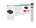
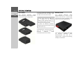
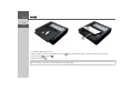
Becker® TRAFFIC STAR NAVIGATION
Operating guide
EN_CN_V1_A
Contents
>>>
CONTENTS
Contents
Safety instructions
The Becker® TRAFFIC STAR
NAVIGATION
Usage
Unpacking the Becker® TRAFFIC
STAR NAVIGATION
> ZH
> EN
Checking the delivery
Delivery contents
Complaints
Dealing with the packaging
Description of unit
Battery
USB connecting cable
Map update/Additional functions
Registration
Repairs
Emissions and disposal
General operation
Maintenance and care
Battery quality declaration
Commissioning
Power supply
Unit holder
Memory card
Basic operation
Calling up navigation mode
Selecting/highlighting elements
Back function
Menu basics
2
2
4
5
5
5
5
5
6
6
6
6
6
6
7
7
7
8
8
9
9
9
10
10
11
11
11
11
12
Main menu
Using the input menu
Entering characters
Selecting from a list
Malfunctions
Content Manager Becker®
TRAFFIC STAR NAVIGATION
12
12
13
13
13
14
Installing the Content Manager Becker®
TRAFFIC STAR NAVIGATION
14
Starting the Content Manager
15
Navigation mode
What is navigation?
Last destinations
Using last destinations
Starting with existing destination
Displaying or editing a destination
Home address
Destination input
Structure of the destination input menu
Entering an address
Selecting a province
Selecting an address and starting
route guidance
Points of interest
POI nearby/POI near destination
POI near address
Entering a POI directly
Entering a POI by phone number
search
16
16
17
17
17
17
18
19
19
19
20
20
24
24
25
25
25
Selecting a destination from the map
Route planning
Creating a new route
Editing a route
Traffic announcements
using TMC
Displaying TMC messages
Reading a message
Displaying the relevant road in
the map
Taking announcements into
consideration when calculating routes
Automatic recalculation
Manual recalculation
The map display
Calling up the map display
Structure of the map display
Map display without route guidance
Map display with route guidance
Split screen with route guidance
Route guidance with arrow display
Using the map display
Map zooming
26
27
28
28
29
29
30
30
30
30
31
31
32
32
32
32
33
34
34
34
CONTENTS
Map toolbox
Route
Entering/deleting a stopover
TMC on the route
Point of interest on the route
Setting route options
Displaying the entire route
Blocking a route
Skipping a destination
Display destination list
Cancelling route guidance
Map display
Position display
Adjust position
Repeating an announcement
Muting announcements
35
35
35
35
36
37
37
38
39
39
40
40
41
42
42
42
Settings
Route guidance settings
43
43
Route options
Reality view
Signposts
Lane recommendations
Announcements
43
44
44
44
44
Map settings
Autozoom
POIs on the map
Speed limits
Driver alerts
TMC settings
45
45
45
46
46
47
System settings
Language
Design variants
Map update reminder
Information
Factory reset
>>>
47
47
48
48
48
48
> ZH
> EN
Glossary
49
Index
50
NOTICE
52
China Restriction of certain Hazardous
Substances (China RoHS)
52
CE declaration of conformity
53
Disposal
54
Disposal of the battery
55
Duty to supply information according
to battery legislation (BattV)
Removing the battery
55
55
The information and data contained in
this document is subject to change without notice.
No part of this document may be reproduced or transmitted for any purpose
without the prior written permission of
HARMAN/BECKER
Automotive
Systems GmbH. All technical data, drawings etc. are protected by copyright law.
© Copyright 2013, HARMAN/BECKER
Automotive Systems GmbH
All rights reserved.
3
>>>
SAFETY INSTRUCTIONS
Safety instructions
> ZH
!Safety instructions
> EN
• Operation of the unit is permitted only if traffic conditions are suitable and you are absolutely sure that you, your
passengers or other motorists are not endangered, obstructed or inconvenienced.
In all cases, all applicable road traffic regulations must be obeyed. Destinations may only be entered when the vehicle is
stationary.
• The navigation system is only an aid. Errors may occur in individual data items/entries. At all times, the driver must decide
whether or not to heed the information provided. We do not accept liability for erroneous data provided by the navigation
system. Due to continual changes in traffic routing or deviations in the data, it may occur that imprecise or erroneous
information is given. Therefore, actual road signs and traffic regulations must always be observed. In particular, the
navigation system cannot be used as an orientation aid at times of poor visibility.
• The unit must only be used for its intended purpose. The volume of the navigation unit should be adjusted so that external
noise is still clearly audible.
• Remove the unit immediately if a fault occurs (e.g. emission of smoke or odours).
• In the interest of safety, the unit must only be opened by a specialist. Please refer to your dealer for repair.
• Never open the unit (with the exception of the battery compartment) or the rechargeable battery. Any modification to the
unit is also impermissible and renders the type approval invalid.
• Use only genuine Harman original accessories. This will ensure that all the relevant regulations are complied with and
damage to health and property is avoided. Dispose of defective units and the rechargeable battery according to the
applicable legal requirements.
• No warranty is granted in the case of improper use. These safety instructions also apply to genuine Harman original
accessories.
4
THE BECKER® TRAFFIC STAR NAVIGATION
Usage
The Becker® TRAFFIC STAR NAVIGATION
The
Becker®
TRAFFIC
STAR
NAVIGATION is a high-performance
navigation module for use in BMW
MINI vehicles.
The unit and the accessories are to be protected against moisture and dirt.
Unpacking the Becker®
TRAFFIC STAR NAVIGATION
Note:
Your Becker® TRAFFIC STAR
NAVIGATION is delivered in stable
packaging. If the packaging or its contents exhibit serious damage, the unit
must not be unpacked further. In this
case, please contact your dealer.
Checking the delivery
With GPS = Global Positioning System
you no longer have to waste time looking
up road maps.
Your Becker® TRAFFIC STAR
NAVIGATION is equipped with TMC.
TMC gives you the option of receiving
traffic announcements. You will then be
informed of any traffic problems. The system plans an alternative route automatically or on request to avoid traffic problems, depending on the setting.
Before starting up the Becker® TRAFFIC
STAR NAVIGATION, the delivery contents must be checked to ensure they are
complete and in good order.
> Carefully unpack the packaging contents and check them.
>>>
Delivery contents
> ZH
> EN
1
2
3
1 Becker®
TRAFFIC
STAR
NAVIGATION including battery
2 Leaflet with installation instructions
3 USB cable
5
>>>
THE BECKER® TRAFFIC STAR NAVIGATION
Complaints
Please check first on
www.beckertrafficstar.com (FAQs, software updates) for possible solutions. If
this should not lead to success, please contact your dealer.
> ZH
> EN
Dealing with the packaging
The original packaging must be kept in a
dry place at least for the warranty period.
Note:
It must be disposed of correctly in line
with the national regulations. The packaging must not be burnt. The packaging
can be handed over to the dealer, depending on the country where delivered.
Description of unit
The
Becker®
TRAFFIC
STAR
NAVIGATION consists of the basic
Becker®
TRAFFIC
STAR
NAVIGATION unit and the supplied accessories in the delivery contents.
Note:
The basic unit and the accessories must
not be opened or modified in any way.
Battery
The integrated rechargeable battery is
charged when the Becker® TRAFFIC
STAR NAVIGATION is placed in the
holder and the vehicle ignition is switched
on.
Note:
When the Becker® TRAFFIC STAR
NAVIGATION is connected to a PC, it
is supplied with power via the PC and
does not consume battery power.
6
USB connecting cable
You can connect the Becker® TRAFFIC
STAR NAVIGATION to a standard personal computer having a USB interface
using the USB connecting cable provided.
The 8 GB flash memory of the Becker®
TRAFFIC STAR NAVIGATION and
any SD card can then be addressed via the
PC like a removable storage medium.
Map update/Additional functions
The road network is constantly changing,
but having a fresh map ensures you have
the wealth of information you need to
find your destination with ease.
It is also possible that in the course of further development of your device new
functions will be available.
With the program described under “Content Manager Becker® TRAFFIC STAR
NAVIGATION” on page 14 you can easily keep your Becker® TRAFFIC STAR
NAVIGATION up to date.
THE BECKER® TRAFFIC STAR NAVIGATION
>>>
Registration
> ZH
You can register your product using our
software service. We will then inform you
of any new updates and other news.
> EN
You can register online on the Becker
homepage www.beckertrafficstar.com.
Repairs
The unit must not be opened in the event
of damage. Please contact your dealer.
Emissions and disposal
Information on emissions, electromagnetic compatibility and disposal can be found
in “” on page 52.
7
>>>
GENERAL OPERATION
Maintenance and care
General operation
> ZH
The unit is maintenance-free.
For proper care, a commercially available
cleansing fluid for electrical devices may
be applied using a soft damp cloth.
> EN
!Danger!
Danger to life by electrocution.
Always switch off the unit and disconnect the mains power supply unit before
cleaning the unit, supplied components
or accessories.
Note:
Do not use any aggressive or abrasive
substances or cloths which may damage
the surface.
The unit must not be exposed to water.
8
Your unit was designed and manufactured
with great care and should be treated with
equal care. You will enjoy your unit for a
long time to come if you observe the recommendations listed below:
• Protect your unit and the accessories
from water and moisture. If your unit
has been exposed to moisture, switch it
off immediately and disconnect the
power supply. Allow to dry at room
temperature.
• Do not store and operate your unit in a
dusty or dirty environment.
• Do not store your unit in hot environments. High temperatures can shorten
the service life of electronic components
in your unit, damage the rechargeable
batteries and cause certain plastics to
warp or melt.
• Do not store your unit in cold environments. During operation, when the
unit warms up to operating temperature, moisture may form internally,
causing damage to electronic components.
• Do not drop your unit, protect it from
shocks and do not shake it. Improper
handling can damage components
within the unit.
• Never use corrosive or aggressive chemicals, cleaning solutions or aggressive
detergents for cleaning.
All the above information applies equally
to the unit, the rechargeable battery and
all accessories. Should one of these parts
not work properly, please contact your authorised dealer.
GENERAL OPERATION
Battery quality declaration
Commissioning
Power supply
The capacity of the rechargeable battery in
your Becker® TRAFFIC STAR
NAVIGATION decreases with every
charging/discharging cycle. Improper
storage at excessively high or low temperatures may also cause a gradual deterioration of capacity. Consequently, the operating time may be substantially reduced
even in the case of a fully charged battery.
The rechargeable battery is designed such
that it should certainly still be possible for
it to be charged and discharged after
6 months of operation of your unit.
Once the Becker® TRAFFIC STAR
NAVIGATION has been unpacked and
checked to ensure it is free of damage, the
unit can be started up.
The battery is already deployed.
Your Becker® TRAFFIC STAR
NAVIGATION has an integrated rechargeable battery. The battery is charged
as soon as the Becker® TRAFFIC STAR
NAVIGATION is placed in the holder
and the vehicle ignition is switched on.
Insert the Becker® TRAFFIC STAR
NAVIGATION in the vehicle’s glove
compartment as described under “Unit
holder” on page 10.
>>>
> ZH
> EN
Note:
Note that if the battery is completely discharged, it may take up to a minute before the Becker® TRAFFIC STAR
NAVIGATION can be activated again.
9
>>>
GENERAL OPERATION
Unit holder
> ZH
The
Becker®
TRAFFIC
STAR
NAVIGATION is inserted in the holder
in the vehicle’s glove compartment.
> EN
To remove the Becker® TRAFFIC STAR
NAVIGATION from the holder, push
the slide at the front of the holder.
Note:
The slide can be pulled out. When the
slide is pulled out, the Becker®
TRAFFIC STAR NAVIGATION cannot be unlocked. This can serve as an additional protection against theft.
To unlock the Becker® TRAFFIC
STAR NAVIGATION the slide can only
be inserted one way.
The
Becker®
TRAFFIC
STAR
NAVIGATION is released and ejected a
little way. You can now remove the
Becker®
TRAFFIC
STAR
NAVIGATION from the holder.
10
Memory card
Your Becker® TRAFFIC STAR
NAVIGATION has a slot for an SD
memory card. This slot is used for additional maps that can be purchased via the
Becker Content Manager/Webshop
The card slot is located on the right side of
the
Becker®
TRAFFIC
STAR
NAVIGATION. The card slot is
equipped with a spring-actuated locking
and ejector mechanism.
GENERAL OPERATION
Basic operation
The
Becker®
TRAFFIC
STAR
NAVIGATION is operated using a
number of the controls of the installed audio system.
Calling up navigation mode
> Press the
button near the MINI
joystick.
Navigation mode is called up.
Selecting/highlighting elements
To operate the Becker® TRAFFIC STAR
NAVIGATION you must select or highlight menu items.
This is done using the MINI joystick of
the installed audio system. Turn the
MINI joystick to toggle between the various menu items. This operating manual
describes the process of highlighting.
To select a menu item, you must first turn
the MINI joystick to highlight the item
and then press the MINI joystick.
>>>
Back function
At all menu levels you can return to the
previous menu level by pressing the
button.
> ZH
> EN
Note:
The
is located to the left of the MINI
joystick.
During route guidance (route guidance is
active), pressing the
button brings
you back to the main menu.
Note:
The MINI joystick can also be moved in
4 different directions. This is dealt separately in the operating manual.
Note:
To exit the Navigation mode, press again
the
button near the MINI joystick.
11
>>>
GENERAL OPERATION
Menu basics
> ZH
During operation you are assisted by various menus and input windows.
> EN
Main menu
The top menu level is the main menu.
You can start the various functions of your
Becker®
TRAFFIC
STAR
NAVIGATION from the main menu.
Information on the individual functions
can be found in the following sections.
In addition to the individual functions,
the main menu also contains further information and operating options.
By selecting
you can switch the menu
language and the language for the navigation announcement from English to Chinese or from Chinese to English.
12
The navigation satellites currently available are shown in the bottom right corner.
If no valid location can be determined in
spite of received satellites, the icon
is
displayed.
Using the input menu
Some applications require input using the
input menu.
If route guidance is already active, the current destination address is displayed in the
bottom line.
To cancel route guidance, push the MINI
joystick downwards and then press MINI
joystick.
The characters input using the input
menu are displayed in the top line of text.
The middle section is used for character
entry. The bottom section can display a
list of all cities corresponding to the letters
entered so far when entering a city, for example.
Note:
The input menus that are not used for
destination input are locked when your
vehicle is travelling at a speed in excess of
5 km/h. If you are currently in such an
input menu, a message indicating that
the menu has been locked will be displayed. The menus are enabled again
when the speed falls below 3 km/h.
GENERAL OPERATION
Entering characters
Characters are input by selecting them
with the MINI joystick.
When a navigation destination is entered,
the
Becker®
TRAFFIC
STAR
NAVIGATION compares the data with
the stored data.
Only those letters that are still possible are
available for selection.
If you have selected enough letters, a list
automatically appears. Select the desired
entry from the list using the MINI joystick.
Note:
Selecting the
symbol deletes the last
character entered.
A space is entered when the underscore
character (_) is selected in the input
menu.
Selecting from a list
Once a few letters of the desired selection
have been entered, you can select your
destination from the selection list.
> In the input menu, push the MINI joystick downwards.
> Select the desired entry from the list using the MINI joystick.
The entry is accepted and the selection list
is closed.
>>>
Malfunctions
> ZH
Should there be a malfunction in the operating system or in the unit, they will be
displayed accordingly.
You can even try to correct the malfunction:
> Remove, as described under “Unit
holder” on page 10, the Becker®
TRAFFIC STAR NAVIGATION
from the holder.
> Wait a while and insert the Becker®
TRAFFIC STAR NAVIGATION
again.
or
> Press (e.g. with a ballpoint pen) the reset button on the front of the inserted
Becker®
TRAFFIC
STAR
NAVIGATION.
The
Becker®
TRAFFIC
STAR
NAVIGATION then restarts.
> EN
If the messages recur or the unit does not
work properly for other reasons, please
contact your dealer.
13
>>>
GENERAL OPERATION
> ZH
Content Manager Becker®
TRAFFIC STAR NAVIGATION
> EN
The Content Manager Becker®
TRAFFIC STAR NAVIGATION is a PC
based application containing a number of
important functions to help you manage
the content on your Becker® TRAFFIC
STAR NAVIGATION.
With the Content Manager Becker®
TRAFFIC STAR NAVIGATION you
can:
• back up the content saved on the
Becker® TRAFFIC STAR
NAVIGATION to your PC and restore
it later to your Becker® TRAFFIC
STAR NAVIGATION,
• download current content from the Internet and install it on the Becker®
TRAFFIC STAR NAVIGATION.
To use the Content Manager Becker®
TRAFFIC STAR NAVIGATION, you
will need the USB cable provided as well
as a computer that meets the following
minimum requirements:
14
• Operating system Microsoft Windows
XP (SP2), Vista or Windows 7
• Microsoft Internet Explorer 7 or higher
• PC with USB 2.0
• fast internet connection with more than
2 Mbit/s
• at least 10 GB free storage space.
Installing the Content Manager
Becker® TRAFFIC STAR
NAVIGATION
You can install the Content Manager
Becker®
TRAFFIC
STAR
NAVIGATION on your computer with
the following steps:
> Connect the USB interface of the
Becker®
TRAFFIC
STAR
NAVIGATION directly to the USB
port of the computer using the USB cable provided.
Note:
When you connect the Becker®
TRAFFIC STAR NAVIGATION to the
PC for the first time, the PC installs all
the necessary drivers and then displays
the message "Your unit is now ready to
use".
After a short time, the Becker®
TRAFFIC STAR NAVIGATION is displayed as a removable storage medium on
the computer.
The installation should start automatically.
GENERAL OPERATION
Note:
If the installation does not start automatically, start in the folder „Content Manager“ on the removable storage medium
the file „Setup.exe“
> Follow the instructions of the software.
The Content Manager Becker®
TRAFFIC STAR NAVIGATION can be
started immediately after installation.
This completes the installation procedure.
>>>
Starting the Content Manager
> Connect the USB interface of the
Becker®
TRAFFIC
STAR
NAVIGATION directly to the USB
port of the computer using the USB cable provided.
After a short time, the Becker®
TRAFFIC STAR NAVIGATION is displayed as a removable storage medium on
the computer.
> Click on Start > All Programs on the
computer.
> Select Content Manager.
> Click on Content Manager.
> ZH
> EN
The Content Manager Becker®
TRAFFIC STAR NAVIGATION is
started.
15
>>>
NAVIGATION MODE
What is navigation?
Navigation mode
> ZH
The term “navigation” (lat. navigare = to
travel by sea) is generally understood to
mean the location of a vehicle, the determination of the direction and distance
from the desired destination and the required route. Stars, prominent landmarks,
compass and satellites etc. are used as navigation aids.
With the Becker® TRAFFIC STAR
NAVIGATION, the location is determined by the GPS receiver. The Global
Positioning System (GPS) was developed
during the 1970s by the US military as a
weapons guiding system.
GPS is based on a total of 24 satellites orbiting the Earth and emitting signals. A
GPS receiver receives these signals and
uses the signal times to calculate the distance to an individual satellite, and then
determines your current geographical position.
> EN
16
Signals from at least three satellites are required to determine your position; your
height above sea level can be calculated if
signals are received from four or more satellites.
The
Becker®
TRAFFIC
STAR
NAVIGATION determines the direction
and distance from the destination using a
navigation computer and a digital street
map held in its internal memory.
For safety reasons, route guidance is given
predominantly in spoken form. This is
supported by a direction indicator and a
map display.
!Safety instructions
• Road traffic regulations always take
priority. The navigation system is only
an aid. Errors may occur in individual
data items/entries. At all times, the
driver must decide whether or not to
heed the information provided.
We do not accept liability for erroneous data provided by the navigation
system.
• When first put into use it can take up
to 30 minutes to fix the position.
• Observation of traffic signs and local
traffic regulations must always take priority.
• Traffic guidance is restricted to passenger vehicles. Special driving recommendations and regulations for other
vehicles (e.g. commercial vehicles) are
not included.
• Destinations may only be entered
when the vehicle is stationary.
NAVIGATION MODE
Last destinations
In the last destinations, the most recent
destinations and stored destinations are
displayed and can be selected directly.
> Select Last destinations from the main
menu.
If you have already entered your home address, you can start route guidance to your
home address in the last destinations
(Home).
The destination list containing the destinations most recently travelled to as well
as stored destinations is displayed in the
lines below this.
Note:
Up to 200 of the most recent destinations
are automatically stored in the destination list. If the storage capacity is reached,
the oldest destination is automatically deleted to make room for a new destination. However, important destinations
can be protected.
Protected entries are identified by the
symbol.
If you select your home address and it has
not yet been defined, you will be requested to enter the address.
>>>
Using last destinations
> ZH
Starting with existing destination
The destinations available in the last destinations are included in the destination
list.
> Select the desired entry from the list using the MINI joystick to start route calculation.
The calculation begins.
When the calculation is complete, the
map appears and the route guidance begins.
> EN
Displaying or editing a destination
Any destination stored in the last destinations can be displayed and edited.
> Highlight the desired entry using the
MINI joystick.
> Push the MINI joystick to the right.
17
>>>
NAVIGATION MODE
Option
Meaning
Show details The data for the destination is displayed. From
this screen you can display the destination on
the map, display the
route or start the route
guidance.
Name entry
The destination can be
renamed. If the destination is given a name it is
automatically protected.
Protect entry The destination is protected against automatic
deletion. This function is
only available in the case
of unprotected destinations.
Remove
Protection of the destinaprotection
tion is disabled. This
function is only available
for protected destinations.
Move up /
The destination is moved
forward/back by one poMove down
sition. If the destination
is moved it is automatically protected.
> ZH
> EN
18
Option
Delete entry
Delete all
Meaning
The destination is deleted from the last destinations.
All destinations and your
home address are deleted
from the list.
Home address
When you select Home with the MINI
joystick you will be asked to enter an address if no home address has yet been entered.
> Select Yes to enter the address.
You can then enter a destination as described under “Destination input” on
page 19.
Note:
The menu items Set current position
and Select from last destinations can
also be used to select a destination.
NAVIGATION MODE
Destination input
You can enter a destination in a number of
ways.
> Select Enter destination from the main
menu.
The destination input menu will appear.
Structure of the destination input menu
• Enter address
The various steps from selecting an address to starting route guidance can be
carried out using Enter address.
See “Entering an address” on page 19.
• Enter point of interest
Points of interest such as airports and
ferry ports, restaurants, hotels, petrol
stations or public buildings can be selected and route guidance started using
Enter point of interest.
See “Points of interest” on page 24.
• Select on map
With Select on map, you can select a
destination directly on the map and
start route guidance.
See “Selecting a destination from the
map” on page 26.
• Route planning
A route with several stopovers can be
planned using Route planning.
See “Route planning” on page 27.
>>>
Entering an address
> Select Enter address from the destination input menu.
The menu for entering addresses appears.
The last address entered is already entered
automatically.
> ZH
> EN
19
>>>
NAVIGATION MODE
Selecting a province
> ZH
Note:
If a province of destination has already
been entered it will remain until you select a different province.
> EN
> Select the entry containing the province
of destination.
> Select the first letters of the destination
province.
The selection list will appear.
> Select the desired province.
20
Selecting an address and starting route
guidance
The following settings can be made in the
address input menu:
• City
• District
• Postal code
• Street and house number
• Intersections as an orientation aid
It is also possible to:
• start the route guidance straight away.
• search for a point of interest near to the
address entered (POI search). This can
be entered as described under “POI
near address” on page 25.
• save the destination with name in the
last destinations.
• show the route on the map.
Selecting a city
The destination city can be specified by
entering the name or postal code.
When you select the letters of a city, the
Becker® TRAFFIC STAR NAVIGATION
displays suggestions. If you do not wish to accept the suggestion simply select the subsequent letters of the desired city.
The
Becker®
TRAFFIC
STAR
NAVIGATION excludes all impossible
letter combinations and postal codes and
activates only those letters and numbers
that could give the name of an existing
city or postal code.
> Select the letters of the destination city
or the numbers of the postal code consecutively.
When sufficient letters have been entered
it will automatically switch to a list from
which you can select the city. However,
you can switch to the list before this by
pushing the MINI joystick backwards.
You can then select the city from the list.
NAVIGATION MODE
Selecting the street
In the Street menu field the street and
house number can be entered separately.
The
Becker®
TRAFFIC
STAR
NAVIGATION excludes all impossible
letter combinations and activates only
those letters that could give an existing
street name.
A house number can only be chosen once
the street has been selected and if house
numbers are included in the data.
> Select the letters of the destination
street consecutively.
When sufficient letters have been selected
it will automatically switch to a list from
which you can select the street. However,
you can switch to the list before this by
pushing the MINI joystick backwards.
You can then select the street from the list.
Selecting the intersection
After entering the destination city and
street, you can enter an intersection so as
to further limit the choice.
Selecting a house number
After entering the destination city and
street, you can enter a house number so as
to further limit the choice.
Note:
Instead of entering an intersection, you
can also enter a house number. However,
it is not possible to enter both at the same
time.
Note:
Instead of entering the house number,
you can also enter an intersection. However, it is not possible to enter both at the
same time.
> Select Intersection.
The input menu for the name of the intersection will appear.
> Select the letters of the intersection consecutively.
Once a few letters of the desired street
have been entered a list will automatically
be displayed.
However, you can switch to the list before
this by pushing the MINI joystick backwards. You can then select the intersection
from the list.
> Select No.
The input menu for the house number
will appear.
> Enter the house number.
> Select from the automatically displayed
list the desired house number.
>>>
> ZH
> EN
21
>>>
NAVIGATION MODE
Displaying the route
Once the address has been entered, the address input menu allows the route to the
destination to be displayed on the map.
> Push the MINI joystick to the right.
> Select Show route to display the route
on the map.
The route is calculated.
> ZH
> EN
You can start the route guidance directly
from this screen by selecting Start.
The other options on this screen are described under “Displaying the entire
route” on page 37.
In addition to these described functions,
you can also display alternative routes.
> Select Options und then select
Alternative routes.
22
After a short time, the alternative routes
will be displayed.
The area on the right-hand side shows the
colour key for the individual routes, the
mileage for each route and the estimated
driving time.
> Select the desired route.
The desired route is calculated and the
route guidance will begin.
Showing the destination on the map
> In the address input menu, push the
MINI joystick to the right.
> Select On map.
The map display is opened and the destination is displayed.
Storing a destination
> In the address input menu, push the
MINI joystick to the right.
> Select Save.
> Enter the desired name.
The destination is transferred to the last
destinations and protected.
NAVIGATION MODE
> Select Add as stopover or Replace old
destination.
Starting route guidance
> In the address input menu, select Start
guidance to start route guidance.
All data entered thus far is processed when
calculating the route.
Note:
The symbols above the address refer to
restrictions that you may have activated
(e.g. unpaved roads, toll roads).
Is so far no active route guidance and the
function for automatic alternative route
selection is enabled (See “Route options”
on page 43.), you have in the following
menu the option to calculate alternative
routes.
>>>
> Select Calculate alternative routes for
the alternative route calculation. Then
select one of the displayed routes.
or
> Select Use route: to apply the displayed
route.
The map will then be displayed and the
route guidance will begin.
If the route guidance is already running,
you have no option to select alternative
routes. You will be asked whether the new
destination should replace the old destination or if the new destination should be regarded as a stopover.
> ZH
If the route guidance is already running
and a stopover has already been entered
you will be asked whether the new destination should replace the old destination
or the stopover.
> EN
> Select Replace stopover or Replace
old destination.
23
>>>
NAVIGATION MODE
Points of interest
Points of interest (POI for short) include
airports and ferry ports, restaurants, hotels, petrol stations, public buildings. You
can use points of interests as navigation
destinations.
> Select Enter point of interest from the
destination input menu.
> ZH
> EN
POI nearby/POI near destination
> In the POI menu, select POI nearby for
a POI nearby.
or
> In the POI menu, select POI near
destination for a POI near the destination.
If you have selected the category, any
points of interest belonging to relevant
category and available within the area in
question will now be displayed.
The name, distance as the crow flies and
the address is displayed for each entry.
> Select the desired point of interest.
> Select one of the available categories.
The POI menu appears.
You can choose between
• a point of interest nearby,
• a point of interest near an address,
• a point of interest near a destination, or
• entering a point of interest directly,
• searching a point of interest by a phone
number.
24
Note:
You can
also select Search all
categories: An input menu will then
open and you can enter the name of a
point of interest directly and confirm it.
For some categories, e.g. petrol stations, a
further selection menu is displayed in
which you can narrow down the choice
further, e.g. by brand.
You will now receive additional information about your chosen destination.
NAVIGATION MODE
Note:
Push the MINI joystick to the right for
further control options.
Note:
If you have already entered an address,
this address will appear by default.
> Select Start guidance to begin route
guidance to the point of interest straight
away.
> Press the Select category button.
POI near address
> In the POI menu, select POI near
address.
Note:
You can also select Select POI. An input
menu will then open and you can enter
the name of a point of interest directly
and confirm it.
The points of interest categories available
for the entered city are displayed.
> Select the desired point of interest as described under “POI nearby/POI near
destination” on page 24.
> Select the desired province.
> Enter the city and, if necessary, the
street in which you wish to search for a
point of interest.
Entering a POI directly
> In the POI menu, select POI search by
name.
>>>
> To confirm the previous input, select
or press and hold the MINI joystick.
> ZH
> EN
The
Becker®
TRAFFIC
STAR
NAVIGATION displays in a list all the
points of interest corresponding to the
name entered.
Note:
The search radius is limited to 45 kilometres around your current position.
A maximum of 50 points of interest are
displayed.
> Select the desired destination from the
list.
> Select Start guidance to begin route
guidance to the point of interest straight
away.
Entering a POI by phone number search
> In the POI menu, select POI search by
phone number.
> Enter the desired point of interest or
part of the name.
25
>>>
NAVIGATION MODE
> Enter the phone number (or a part of
the number) of the desired point of interest.
> To confirm the previous input, select
or press and hold the MINI joystick.
> ZH
> EN
Selecting a destination from the
map
You can select a destination straight from
the map.
> Select Select on map from the destination input menu.
The map display appears.
> The Becker® TRAFFIC STAR
NAVIGATION displays in a list all the
points of interest corresponding to the
number entered.
Note:
The search radius is limited to 45 kilometres around your current position.
A maximum of 50 points of interest are
displayed.
> Select the desired destination from the
list.
> Select Start guidance to begin route
guidance to the point of interest straight
away.
26
Depending on the position of the crosshair pointer, a list of potential destinations, an address or geocoordinates is displayed. When TMC message symbol
appears in the cross-hair pointer, it is also
displayed in the list. By selecting it in the
list, you can pull up the message details.
> Select the desired entry from the list.
> Search for the desired position.
Note:
Turn the MINI joystick to change the
scale of the map display.
Push the MINI joystick to move the displayed cursor to the desired position.
> Press the MINI joystick.
Note:
Push the MINI joystick to the right for
further control options.
> Select Start guidance to begin route
guidance to the destination straight
away.
NAVIGATION MODE
Route planning
The route planning menu allows you to
create and select individual routes. To do
this, enter the individual destination
points for the desired route. It is then possible to travel to these points consecutively
without having to enter any further information. You can also optimise the destination points entered and in so doing
change their order.
> Select Route planning from the destination input menu.
This displays the route menu.
In the route menu you can create a new
route by selecting Create new route. Previously stored routes are shown in a list
below this.
Note:
If no routes have yet been stored, the
route menu is empty.
Note:
You can also select a stage in the route
here. The route is then started from this
stage.
Editing stored routes
You can change the name of a stored route
or delete it.
> Highlight the route you wish to edit.
> Push the MINI joystick to the right.
By selecting Rename route you can give
the route a new name.
By selecting Delete route you can delete
the route from the stored routes.
> Select the start point or your current
position as the start point for route
guidance.
Selecting and starting a route
> Select the required route from the route
menu.
The route is loaded and displayed in the
stage menu.
> Select Calculate.
>>>
> ZH
> EN
Note:
When a start point is selected, this is only
used for the purposes of displaying a
route.
The individual stages are calculated.
A map of the stages will then be displayed.
The total distance and estimated total
journey time are displayed on the lefthand side.
> Select Start to start route guidance or
select one of the functions described below.
27
>>>
NAVIGATION MODE
• Route list
Displays a list of the individual stages.
• Options
Calls up further options. You can then
simulate the route, optimise the route
(order of the destinations to be travelled
to) and call up the route options.
•
and
Scrolls through the individual stages in
the route.
> ZH
> EN
Creating a new route
> Select Create new route from the route
menu.
Option
You can now enter a stage destination as
described under “Destination input” on
page 19. You also have the option of selecting a destination in the last destinations using Select from last destinations.
> Select Add stage to enter further stage
destinations as described above.
> When you have entered all stage destinations, select Save route. Assign the
route a name.
28
Editing a route
> Select the route you wish to edit.
> Highlight the stage that you wish to edit.
> Push the MINI joystick to the right.
The edit menu will be displayed. The following options are available:
Meaning
Start
Start route guidance
guidance
from the selected stage.
Show details The data relating to the
stage destination is displayed.
Move up /
The stage is moved forwards/backwards by one
Move down
position.
Replace
You can replace the sestage
lected stage with another
stage destination.
Delete stage The stage is deleted from
the route.
NAVIGATION MODE
Traffic announcements
using TMC
Note:
To use the TMC functionality of the
Becker®
TRAFFIC
STAR
NAVIGATION you have to buy with
the Becker Content Manager a licence in
the webshop.
Your Becker® TRAFFIC STAR
NAVIGATION can receive traffic announcements (TMC messages) from radio stations.
Traffic announcements are transmitted by
radio stations via the TMC (Traffic Message Channel) in addition to the radio
programme and are received and analysed
by the navigation system. Receiving traffic
announcements is free of charge.
Note:
As the traffic announcements are transmitted by radio stations, we cannot assume responsibility for the completeness
or accuracy of the announcements.
The
Becker®
TRAFFIC
STAR
NAVIGATION
constantly
checks
whether there are any relevant announcements for the route that has been set.
If the continuous checks determine that a
traffic announcement is relevant to route
guidance, the unit can automatically recalculate a new route to the destination
(See “TMC settings” on page 47.).
>>>
Displaying TMC messages
Once you have connected the Becker®
TRAFFIC STAR NAVIGATION to the
unit holder, your Becker® TRAFFIC
STAR NAVIGATION will receive up-todate traffic announcements and dynamic
route calculation will be enabled (traffic
jam diversion). You can also view traffic
announcements directly.
Settings for TMC can be made as described under “TMC settings” on
page 47.
> Select TMC from the main menu.
> ZH
> EN
The message list appears.
29
>>>
NAVIGATION MODE
> ZH
Reading a message
> Select the desired message in the message list.
> EN
1
1
The message display appears.
Note:
If the entire message does not fit in the
display area, you can select More... to display the rest of the message.
> Select 1 to scroll through the received
messages.
By selecting Detour you can specify
whether or not a message is to be taken
into account in the route calculation.
30
Displaying the relevant road in the map
> Select On map in the message display.
1
The relevant road can be seen in the map.
Note:
In the map display, sections of your route
with obstacles in the trip direction are
displayed in purple. Sections not on your
route with obstacles are displayed in light
blue.
By selecting Text view you can return to
the message display.
By selecting 1 you can scroll through all
the messages in the message list and show
them on the map.
By selecting Detour you can specify
whether or not a message is to be taken
into account in the route calculation.
You can zoom the map view. Push the
MINI joystick down. You can now zoom
the map by turning the MINI joystick.
Pressing the
button will leave the
zoomed map.
Taking announcements into consideration when calculating
routes
Your Becker® TRAFFIC STAR
NAVIGATION can take traffic announcements into consideration when
calculating a route. You have the option of
setting this function to automatic, manual
or never under “TMC settings” on
page 47.
Automatic recalculation
If your route is affected by a traffic problem, the Becker® TRAFFIC STAR
NAVIGATION checks whether a diversion to bypass the problem is feasible. If a
diversion is feasible, a detour is calculated
and you are guided via the detour.
NAVIGATION MODE
Manual recalculation
If a traffic announcement affects your
route, a window with detailed information on the traffic announcement appears.
By selecting Detour you can specify
whether or not the message is to be taken
into account in the route calculation.
Note:
A detour is not generally calculated when
you select Detour. This is only done
when it is feasible in terms of time savings
and the route to be driven.
You can change your chosen setting at any
time in the message list.
If after the selection of Detour the
Becker®
TRAFFIC
STAR
NAVIGATION determines that an expedient alternative route is possible, the following display appears.
>>>
The map display
The display provides you with an overview of the alternative route calculated.
The red route or route marked purple for
an obstruction shows the previous route.
The route marked green displays the alternative route calculated.
In the upper section of the display, you
can see for the previous route and the alternative route the distance to be travelled
and the estimated journey time.
> Select the desired route.
> ZH
The map display is used primarily for
route guidance. However, you can also use
the map display without route guidance to
show your current position and, for example, to receive warnings about exceeding
the speed limit.
> EN
Note:
The map display can show signs (e.g.
speed limits). Please note that this is additional information in the map data.
The reality may differ from those signs.
The traffic situation and the local road
signs take precedence over the navigation
system information.
31
>>>
> ZH
> EN
NAVIGATION MODE
Calling up the map display
Structure of the map display
Map display with route guidance
The map display is called up automatically when you start route guidance.
Without route guidance, you can call up
the map display from the main menu or
by a longpress on the
button in several base menus.
The structure depends on the settings
made in “Map display” on page 40 and
whether route guidance is active or not.
Note:
The information in the left area is only
displayed when action must be taken.
Otherwise the destination arrival time and stopover arrival time, if applicable - is
displayed in the lower left area.
Map display without route guidance
1
1
10
2
3
2
4
> Select Map from the main menu.
The map display will then appear and, if
GPS reception is available, will show your
current position.
If route guidance is already active, the
map will be displayed with route guidance.
32
If the navigation is not active, almost the
whole area of the display will be taken up
by the map.
1 Speed limit on the road currently being driven on (display not available
for all roads), signs for the driver
alerts will also be displayed
2 Number of satellites currently being
received
3 Vehicle position
4 Current road
9
8
3
6
4
7
5
1 Road signs, which you should follow
2 Speed limit on the road currently be-
3
4
5
6
ing driven on (display not available
for all roads)
Driver alerts
Number of satellites currently being
received
Display of TMC status
Vehicle position
NAVIGATION MODE
Split screen with route guidance
7 Current road
or
Traffic lane recommendation (only
appears on some multi-lane roads;
green arrows = recommended lanes)
Note:
Following the traffic lane recommendations allows you to perform the next driving manoeuvre without changing lanes.
8 Distance to next driving manoeuvre
9 Next driving manoeuvre
10 Estimated time of arrival, remaining
journey time and remaining distance
to destination
Your current position is displayed on the
map via the position icon.
11
10
The next manoeuvre is displayed as an arrow, with the distance to the next manoeuvre point indicated underneath it. If
two driving manoeuvres are to be performed in succession within a short time,
another smaller arrow indicating the second driving manoeuvre is displayed above
the first arrow.
Information on the TMC status is displayed in the bottom line. There are three
possible TMC statuses:
9
If the first icon is displayed, TMC is operating correctly.
If the second icon is displayed, there is a
hold-up on the route.
If the third icon is displayed, TMC reception is disrupted and no TMC messages
can be received.
1
> ZH
2
> EN
3
6
4
8
7
5
1 Road signs, which you should follow
2 Speed limit on the road currently be-
3
4
5
6
7
Information is also displayed on the left in
the preview area.
>>>
ing driven on (display not available
for all roads)
Driver alerts
Number of satellites currently being
received
Display of TMC status
Vehicle position
Current road
or
Traffic lane recommendation (only
appears on some multi-lane roads;
green arrows = recommended lanes)
33
>>>
NAVIGATION MODE
Note:
Following the traffic lane recommendations allows you to perform the next driving manoeuvre without changing lanes.
> ZH
> EN
8 Distance to next driving manoeuvre
9 Progress bar to illustrate the distance
to the next driving manoeuvre
10 Next driving manoeuvre
11 Estimated time of arrival, remaining
journey time and remaining distance
to destination
Route guidance with arrow display
11
1
5
10
9
2
7
4
3
1 Estimated time of arrival, remaining
journey time and remaining distance
to destination
2 Number of satellites currently being
received
3 Display of TMC status
4 Driver alerts
34
ing driven on (display not available
for all roads)
6 Next driving manoeuvre but one
7 Current road
or
Traffic lane recommendation (only
appears on some multi-lane roads;
green arrows = recommended lanes)
Note:
Following the traffic lane recommendations allows you to perform the next driving manoeuvre without changing lanes.
8 Distance to next driving manoeuvre
9 Progress bar to illustrate the distance
to the next driving manoeuvre
10 Next driving manoeuvre
11 Road signs, which you should follow
6
8
5 Speed limit on the road currently be-
Using the map display
Map zooming
If the Autozoom function is enabled as described under “Map display” on page 40
or “Autozoom” on page 45, the map is enlarged or reduced according to these settings.
However, you can also enlarge or reduce
the map at any time during route guidance by turning the MINI joystick. The
Autozoom function is then disabled until
the next maneuver is reached or for the
duration of 60 seconds.
In the bottom right corner of the map, the
current map scale is displayed.
NAVIGATION MODE
Map toolbox
Route
Using the map toolbox you can change
the settings for route guidance, for the
map display mode and for the route.
> In the map display, press the MINI joystick.
With an active route guidance, the following version of the toolbox is displayed.
Note:
The following functions are only available when route guidance is active.
> Select Route in the map toolbox.
>>>
The entered stopover is marked on the
map as a green flag.
> ZH
> EN
Deleting a stopover
> In the route menu, select Delete
stopover.
The stopover is deleted. The system performs a route recalculation.
TMC on the route
You can view and edit TMC messages located on your route.
The route menu appears.
If there is no active route guidance, the
following version of the toolbox is displayed.
With Enter destination you can select the
destination input. With no active route
guidance, the entries Route and Repeat
are not available.
Entering/deleting a stopover
With this function, you can enter a stopover or delete an entered stopover.
> In the route menu, select Add
stopover.
You can now enter a destination as a stopover as described in “Destination input”
on page 19. You also have the option of
selecting a destination in the last destinations using Select from last destinations.
Once you have entered the desired stopover, the route is recalculated.
Note:
The TMC messages that have led to a
change in the route are also displayed.
> In the Route menu, select TMC on
route.
35
>>>
NAVIGATION MODE
> ZH
> EN
The TMC messages located on your route
are displayed.
Once you have selected a message you can
decide e.g. whether or not to divert
around the hold-up. Please also refer to
the description in “Traffic announcements using TMC” on page 29.
Note:
Did you set the automatic consideration
under “TMC settings” on page 47, you
can not influence whether you will be directed around the the hold-up.
36
Point of interest on the route
During route guidance, you can display
the points of interest located on the route.
You can specify which categories of points
of interest should be displayed, and you
can also choose whether to display only
the nearest POIs, all the POIs on the entire route, or only POIs near the destination.
> In the Route menu, select POI on route.
The nearest points of interest for the three
selected categories are displayed.
The distance indicated shows the distance
to the point of interest. The points of interest are displayed on the map on the lefthand side.
After selecting one of the points of interests you can start route guidance to it.
Setting categories
> Select More....
> Select Select POI categories.
> Then select the desired categories.
NAVIGATION MODE
Point of interest near destination/on
complete route
> Select More....
> Select Search POI on route.
or
> Select Search POI near destination.
> Select the desired category.
> Then select the desired point of interest.
> Start navigation to the selected point of
interest.
Setting route options
You can modify the route options (route
selection etc.) during route guidance.
> In the route guidance menu, select
Route options.
> Set the route options as described under
“Route options” on page 43.
After a change, the route is recalculated.
>>>
Displaying the entire route
You can display the entire route to the
destination on the map. You also have the
option of displaying the complete directions and blocking particular sections/
roads of the route permanently. As a further option you can display the various
routes that you can set in the route options and also select them if you wish.
> In the My Route menu, select Show
route.
> ZH
> EN
The entire route is displayed.
On the left-hand side you can see the distance to be travelled and estimated journey time. The destination address appears
at the bottom of the display.
Select Resume to continue route guidance.
37
>>>
NAVIGATION MODE
> ZH
Displaying the route list
You can display the route in a list.
> With the entire route displayed, select
Route list.
> EN
The route list is displayed.
Setting route options
You can set the route options.
> With the entire route displayed, select
Options.
> Select Route options.
> Set the route options as described under
“Route options” on page 43.
After a change, the route is recalculated.
38
Simulating a route
You can also start a simulation of the
route.
> With the entire route displayed, select
Options.
> Select Simulation.
The route is simulated at four times the
normal speed.
Blocking a route
You can block a stretch of road ahead.
This determines a certain stretch of road
that should not be used. The Becker®
TRAFFIC STAR NAVIGATION then
attempts to calculate a diversion.
Note:
• Destination navigation is stopped
during section selection.
• The maximum length of a section is 31
mi. (50 km)
• During the section selection, you can
go back to the current point by pressing the
button.
> In the route menu, select Block ahead.
NAVIGATION MODE
> By turning the MINI joystick you can
select the starting point of the block.
> Press the MINI joystick to confirm the
starting point.
> By turning the MINI joystick you can
now select the end point of the block.
> Press the MINI joystick to confirm the
end point.
> Select Yes to activate the block.
The block is activated and the new route
is calculated.
Delete section block
You can remove a previously entered
block.
> In the route menu, select Clear
blockings.
The block is deleted and the new route is
calculated. The system performs a route
recalculation.
Skipping a destination
If a planned route with a number of destinations is active, you can delete the current destination of the route. Route guidance to the next destination will then be
initiated.
This might be necessary if, for example, a
destination was not driven to directly.
Otherwise the Becker® TRAFFIC STAR
NAVIGATION will attempt to guide
you to the current destination.
> In the route guidance menu, select Next
destination.
Route guidance to the next destination
will be initiated.
>>>
Display destination list
If a planned route with several
destinations is active, you can view and
modify the planned route.
> In the route menu, select Itinerary.
A map with the stages of the route is
displayed.
> ZH
> EN
In the left area, the total number of miles/
kilometres and the expected trip time is
displayed.
> Select Resume to continue with the
destination navigation or select one of
the following described functions. You
will see a detailed description of individual functions under “Route planning” on page 27.
39
>>>
NAVIGATION MODE
• Route list
Displays a list of the individual stages.
• Options
Displays additional options. You can
simulate and optimise (order of
destinations) the route as well as pull up
additional route options.
•
and
pages through the individual route
stages.
> ZH
> EN
Cancelling route guidance
Map display
You can cancel active route guidance.
> In the route guidance menu, select Stop
guidance.
This cancels route guidance to all destinations.
You can select whether the map is to be
displayed in 3D or 2D mode, in a split
screen with 3D or 2D display or in arrow
mode.
In addition, you can adjust in 3D mode
the viewing angle of the map and specify
whether or not 3D models of buildings
and 3D landmarks should be displayed.
Note:
You can also cancel route guidance as described in „Main menu“ on page 12.
> Select Map in the map toolbox.
> Select with Full map, Map with TurnBy-Turn, Split screen or Turn-By-Turn
the basic display.
> Select with 2D or 3D the mode of the
map display.
40
NAVIGATION MODE
> For 3D mode, select whether or not 3D
places of interest available should be displayed (yes
or no
) with 3DLandmarks. The display of the models
of buildings is switched on and off simultaneously.
> For 2D mode, select whether the map
should always be orientated to the direction of travel ( ) or to the north
( ) with Heading up.
> Switch Autozoom on
or off
with Autozoom.
> For 3D mode, select Map tilt angle to
set the viewing angle of the map.
> Select between the viewing angles
Higher, Normal and Lower.
> Save and close your settings by pressing
the
button.
Position display
You can display your current position and
store this position. You can also display
information concerning the current GPS
reception and the current country.
>>>
By selecting Save you can store your current position in the last destinations.
> ZH
> EN
By selecting GPS-Info you can view information regarding the GPS reception.
> Select Information in the map toolbox.
The current position is displayed. If possible, an address is displayed.
If route guidance is active, the destination
address and any stopover addresses are
also displayed.
You can see how many satellites are being
received, and whether the satellite reception is good enough for navigation. The
current time is also displayed.
Push the MINI joystick to the right for
further control options.
41
>>>
> ZH
> EN
NAVIGATION MODE
Adjust position
Repeating an announcement
In case of the use of an elevated road you
can select the elvated or the surface road.
Elevated and surface road are displayed on
the map in parallel. If the actual position
is not appropriate, e.g. while the position
icon is positioned on a surface road and
actually an elevated road is used you can
select the correct position.
When route guidance is active, you can request a current announcement or repeat
the last announcement.
> Select Repeat in the map toolbox.
> Select Adjust position in the map toolbox to set the correct position.
The position icon is adjusted and the
route is recalculated, if necessary.
42
Muting announcements
You can mute the navigation system
announcements.
> In the map toolbox, select the
icon.
The navigation system announcements
have now been muted. In the lower area of
the map display, the corresponding icon is
displayed, indicating that announcements
have been muted.
> In the map toolbox, select the
icon to unmute the announcements.
SETTINGS
To call up the settings, select Settings
from the main menu.
Settings
The Settings menu appears.
You can now select from the following settings:
• Guidance settings
Settings relating to the route guidance
• Map settings
Settings relating to the map display
• TMC settings
Settings relating to the receiving of
TMC messages
• System settings
Basic settings relating to the Becker®
TRAFFIC STAR NAVIGATION
Route guidance settings
The route guidance settings contain the
settings that are relevant to route guidance.
> In the settings menu, select Guidance
settings.
>>>
1
> ZH
2
3
> EN
4
> With 1 select your mode of travel
(Unhurried, Normal and Sporting).
This setting influences the calculation of
your estimated time of arrival.
The route guidance settings are displayed.
Route options
You can set your driving profile. The settings made here have an effect on the
route selection and on the calculation of
the estimated journey times.
> Select Route options in the route guidance settings.
> With 2 select one of the following options.
Option
Economical
Fast
Meaning
With this option, the
most economical route in
terms of travel time and
mileage is calculated taking into consideration
further parameters such
as gradients, for example.
With this option, the
fastest route in terms of
travel time is calculated.
43
>>>
SETTINGS
Option
> ZH
Short
> EN
Meaning
With this option, the
shortest route in terms of
mileage is calculated.
> Select 3 to exclude various types of
road (e.g. motorways, ferries and toll
roads) from the route calculation.
Reality view
Announcements
When this function is enabled, you will
see realistic views (if available) of the current lane situation, at many motorway intersections and motorway exits.
> Select Reality view in the route guidance settings.
> Switch the function on
or off
.
You can select whether street names are
announced, short or detailed turn-off
information is provided, or whether
updated arrival times are announced.
Signposts
You can now select either Allow und
Avoid for each type of road.
Note:
For motorways the selection Prefer is also
available.
> Select 4 whether you would like to be
offered alternative route calculations
when the route is calculated (On).
> Save and close your settings by pressing
the
button.
44
When this function is enabled, you will
receive information (if available) at motorway intersections and other roads regarding the road signs which you should
follow.
> Select Signposts in the route guidance
settings.
> Switch the function on
or off
.
Lane recommendations
When this function is enabled, you are instructed as to which lane you should move
into in the case of multi-lane roads.
> Select Lane recommendations in the
route guidance settings.
> Switch the function on
or off
.
Note:
This function is not available for all
languages/announcers. If the function is
not available, it cannot be selected.
> In the destination navigation settings,
select Announcements.
> Select Arrival to turn the updated
arrival time announcement on
or
off
.
> Select Advanced to set more
preferences.
SETTINGS
>>>
Map settings
> ZH
The map settings contain the settings that
are relevant to the map display.
> In the settings menu, select Map
settings.
> Select Street names to turn street name
announcements on
or off
.
> Select between All manoeuvre
information and Short manoeuvre
information in order to set the level of
detail for turn-off information.
> EN
> Switch Autozoom on
or off
with Autozoom.
After selecting Advanced you can specify
how strong the Autozoom action is to be.
The map settings are displayed.
Autozoom
You can select how the map changes when
approaching an action point or at different speed.
> Select Autozoom in the map settings.
POIs on the map
You can select which POI symbols are to
be displayed on the map.
> Select POIs on map in the map settings.
> Switch display of the POIs on
with Show POIs.
or off
45
>>>
SETTINGS
> ZH
After selecting Advanced you can specify
whether all POI symbols or only a set of
POI symbols selected by you are to be displayed on the map.
> EN
Driver alerts
You can have signs displayed, e.g. for dangerous curves or steep gradients, provided
if this information is stored in the map data.
Speed limits
You can select whether speed limits are
displayed in parallel to the navigation.
You can also receive an audible warning
about exceeding the speed limit.
> Select Speed limits in the map settings.
!Danger!
Risk of accident.
The speed limit information in the map
data may be incorrect as a result of
short-term changes (road works, for example).
The traffic situation and the local road
signs take precedence over the navigation system information.
46
> Switch the speed limits on
or off
with Speed limits.
After selecting Advanced you can specify
whether speed limits are only to be displayed if the limit is exceeded or always
displayed. You can also set the minimum
speed at which you would like to receive a
warning if the limit is exceeded.
> Select Driver alerts in the map settings.
> Switch the warnings on
or off
with Driver alerts.
After selecting Advanced you can specify
which categories of warnings should be
displayed.
SETTINGS
TMC settings
System settings
You can make settings for the reception
and processing of TMC traffic announcements.
> In the settings menu, select TMC
settings.
You can change various basic settings for
the
Becker®
TRAFFIC
STAR
NAVIGATION.
> In the settings menu, select System
settings.
1
> With 1 select whether traffic announcements are to be taken into account Automatically, Manually or TMC
off.
> Select Advanced to make additional
settings.
1
2
2
> With 1 specify whether new TMC
messages are to be read out automatically (on
or off
).
> With 2 tune to the desired TMC station.
>>>
> ZH
> EN
The system settings are displayed.
Language
You can set the menu language and the
language for the navigation announcements.
> Select Language in the system settings.
> Select the desired language.
47
>>>
> ZH
> EN
SETTINGS
Design variants
Information
You can select between two different design variants for the display of the day
skin.
> Select Design variants in the system
settings.
> Select the desired variant.
The following selection displays information regarding the Becker® TRAFFIC
STAR NAVIGATION.
> Select Information in the system settings.
The information display appears.
Always quote these details in enquiries to
the service.
Map data versions displays information
relating to the installed map data.
Map update reminder
You can turn off the automatic reminder
for a map update.
> Select Map update reminder in the system settings.
> Switch the automatic reminder on
or off
.
48
Factory reset
You can reset your Becker® TRAFFIC
STAR NAVIGATION to the factory settings.
All settings apart from the language are reset to their factory settings. The last destinations and your home address are also
deleted.
> Select Factory reset in the system settings.
> Select Yes.
The
Becker®
TRAFFIC
STAR
NAVIGATION is reset to the factory settings.
GLOSSARY
GMT
(Greenwich Mean Time)
Central European time
Standard time at degree of longitude 0
(the degree of longitude through Greenwich, Great Britain). This time is used all
over the world as the standard time for
synchronising data acquisition.
Glossary
GPS
(Global Positioning System)
GPS uses satellites to calculate your current geographical position. It is based on a
total of 24 satellites orbiting the Earth and
emitting signals. A GPS receiver receives
these signals and uses the signal time differences to calculate the distance to an individual satellite and thus the current geographical position (longitude and
latitude). Signals from at least three satellites are required for positioning. The current height can also be calculated if signals
are received from four or more satellites.
>>>
SD card
(Secure Digital)
The SD card was developed in 2001 by
SanDisk and is based on the older MMC
standard. An SD card is a rewriteable removable memory card.
> ZH
> EN
TMC
(Traffic Message Channel)
Traffic announcements transmitted by
most FM stations via RDS. Basis for dynamic navigation.
USB
(Universal Serial Bus)
The Universal Serial Bus (USB) is a bus
system for connecting a computer to external USB peripherals for exchanging data.
There are two different standards with
various transmission speeds. USB 1.1
transfers at a speed of 12 Mbit/s and USB
2.0 transfers at 480 Mbit/s.
For a transfer of large amounts of data devices that use the USB 2.0 standard
should be used.
49
Index
>>>
> ZH
> EN
INDEX
Numerics
E
M
3D display . . . . . . . . . . . . . . . . . . . . 40
Economical route . . . . . . . . . . . . . . . 43
Entering a city . . . . . . . . . . . . . . . . . 20
Entering an address . . . . . . . . . . . . . 20
Main menu . . . . . . . . . . . . . . . . . . .
Map
Displaying . . . . . . . . . . . . . . . . .
Zooming in . . . . . . . . . . . . . . . .
Zooming out . . . . . . . . . . . . . . .
Map display . . . . . . . . . . . . . . . . . . .
Map settings . . . . . . . . . . . . . . . . . . .
Memory card . . . . . . . . . . . . . . . . . .
Motorways . . . . . . . . . . . . . . . . . . . .
A
Alternative routes . . . . . . . . . . . . . . . 22
Blocking . . . . . . . . . . . . . . . . . . . . . . 38
Blocking a route . . . . . . . . . . . . . . . . 38
Fast access mode . . . . . . . . . . . . . . . . 17
Fast route . . . . . . . . . . . . . . . . . . . . . 43
Ferries . . . . . . . . . . . . . . . . . . . . . . . 44
C
G
B
Content Manager Becker®
TRAFFIC STAR NAVIGATION . .
Installing . . . . . . . . . . . . . . . . . .
Starting . . . . . . . . . . . . . . . . . . .
Current position . . . . . . . . . . . . . . . .
14
14
15
41
Destination from map . . . . . . . . . . .
Destination input . . . . . . . . . . . . . . .
Destination input menu . . . . . . . . . .
Destination list . . . . . . . . . . . . . . . . .
Destinations
Entering . . . . . . . . . . . . . . . . . .
Storing . . . . . . . . . . . . . . . . . . .
Displaying the route . . . . . . . . . . 22,
GMT . . . . . . . . . . . . . . . . . . . . . . . . 49
GPS . . . . . . . . . . . . . . . . . . . . . . . . . 49
GPS reception . . . . . . . . . . . . . . . . . 41
H
Home address . . . . . . . . . . . . . . . . . . 18
House number . . . . . . . . . . . . . . . . . 21
D
50
F
26
19
19
17
19
22
37
I
Input lock . . . . . . . . . . . . . . . . . . . . 12
Intended purpose . . . . . . . . . . . . . . . . 4
Intersection . . . . . . . . . . . . . . . . . . . 21
L
Last destinations . . . . . . . . . . . . . . . . 17
12
31
34
34
31
45
10
44
N
Navigation . . . . . . . . . . . . . . . . . . . .
Cancelling . . . . . . . . . . . . . . . . .
Starting . . . . . . . . . . . . . . . . . . .
New destination . . . . . . . . . . . . . . . .
16
40
23
19
P
Points of interest
Entered directly . . . . . . . . . . . . .
Near address . . . . . . . . . . . . . . .
Near destination . . . . . . . . . . . .
Nearby . . . . . . . . . . . . . . . . . . .
On the route . . . . . . . . . . . . . . .
25
25
24
24
36
INDEX
R
Restrictions
Ferries . . . . . . . . . . . . . . . . . . . . 44
Motorways . . . . . . . . . . . . . . . . . 44
Toll roads . . . . . . . . . . . . . . . . . . 44
Route guidance
Cancelling . . . . . . . . . . . . . . . . . 40
Starting . . . . . . . . . . . . . . . . . . . 23
Route guidance settings . . . . . . . . . . . 43
Route options . . . . . . . . . . . . . . .37, 43
Route planning . . . . . . . . . . . . . .19, 27
S
Safety instructions . . . . . . . . . . . . .4, 16
Satellites . . . . . . . . . . . . . . . . . . . . . . 41
SD card . . . . . . . . . . . . . . . . . . . . . . . 10
Selecting a city . . . . . . . . . . . . . . . . . . 20
Selecting a destination
Entering an address . . . . . . . . . . 20
Selecting a province . . . . . . . . . . . . . . 20
Selecting the street . . . . . . . . . . . . . . . 21
Setting the map display . . . . . . . . . . . 40
Settings
Map . . . . . . . . . . . . . . . . . . . . . . 45
Route guidance . . . . . . . . . . . . . . 43
System . . . . . . . . . . . . . . . . . . . . 47
TMC . . . . . . . . . . . . . . . . . . . . . 47
Short route . . . . . . . . . . . . . . . . . . . . 44
>>>
Stopover
Deleting . . . . . . . . . . . . . . . . . . . 35
Entering . . . . . . . . . . . . . . . . . . . 35
System settings . . . . . . . . . . . . . . . . . 47
> ZH
> EN
T
TMC . . . . . . . . . . . . . . . . . . . . . . . . . 29
On the route . . . . . . . . . . . . . . . . 35
Recalculating routes . . . . . . . . . . 30
TMC settings . . . . . . . . . . . . . . . . . . 47
Toll roads . . . . . . . . . . . . . . . . . . . . . 44
U
USB . . . . . . . . . . . . . . . . . . . . . . . . . . 49
51
>>>
China Restriction of certain Hazardous Substances (China RoHS)
NOTICE
> ZH
Material declaration
> EN
Marking styles for names and contents of toxic or hazardous substances or elements
Name of the parts
Lead
(Pb)
Mercury
(Hg)
Cadmium
(Cd)
Hexavalent
Chromium
(CrVI)
Polybrominated
biphenyls (PBB)
Polybrominated
diphenyls ethers
(PBDE)
Housing
O
O
O
O
O
O
PCB Main
X
O
O
O
O
O
O: Indicates that this toxic or hazardous substance contained in all of the homogeneous materials for this part is below the
limit requirement in SJ/T11363-2006
X: Indicates that this toxic or hazardous substance contained in at least one of the homogeneous materials used for this
part is above the limit requirement in SJ/T11363-2006
Pollution control label
52
NOTICE
>>>
Dear customer,
In conformance with current EC guidelines, any person may operate this unit. This unit conforms to the current valid European or harmonised national standards. This designation is
your guarantee that the unit conforms to the applicable specifications regarding electromagnetic compatibility. This means that interference with other electrical/electronic devices
caused by the unit, or interference with this unit caused by other electrical/electronic devices
is largely prevented.
> ZH
> EN
The EC type approval mark (E13) issued by the Luxembourg's vehicle licensing authority in accordance with European Directive ECE-R10 governing the EMC of motor vehicles in its current version authorises installation and operation of the unit in
motor vehicles (classes L, M, N and O).
CE declaration of conformity
Harman/Becker Automotive Systems GmbH declares herewith that the Becker® TRAFFIC
STAR NAVIGATION conforms to the basic requirements of applicable EC regulations and
especially to the basic requirements and other relevant regulations of the R&TTE directive
1999/5/EC.
A detailed CE declaration of conformity for the product is available on our Internet site
http://www.beckertrafficstar.com under “Downloads”.
53
>>>
NOTICE
Disposal
> ZH
Customer information on the disposal of electrical and electronic devices
(private households)
In accordance with the self-imposed principles of Harman/Becker Automotive Systems GmbH, its product was developed and made from high-quality, recyclable materials and components.
This symbol on the product and/or accompanying documents means that at the end of their
life electrical and electronic products must be disposed of separately from domestic waste.
Please take these products to communal collecting points or recycling centres for processing
and salvage of materials. The units will be accepted there free of charge.
The proper disposal of this product helps protect the environment and prevents harmful effects on humans and the environment, which could result from improper handling.
More detailed information on the nearest collecting point or the nearest recycling centre can
be obtained from your local council.
> EN
For commercial customers in the European Union
Please contact your dealer or supplier if you would like to dispose of this electrical/electronic
equipment.
Information on disposal in countries outside of the European Union
This symbol is only valid within the European Union.
54
NOTICE
>>>
Disposal of the battery
> ZH
Duty to supply information according to battery legislation (BattV)
> EN
Batteries must not be disposed of in household waste. It is the duty of the user to return used batteries. Please only dispose of batteries
via specialised dealers or at battery collection points. In this way, you make a positive contribution to environmental protection.
Since 1998, German battery legislation obligates all citizens to dispose of used batteries exclusively via retail outlets or at collection
points specially equipped for this purpose (statutory obligation to return). It is the duty of retail outlets and manufacturers to take
back these batteries free of charge and to correctly recycle them or to dispose of them as hazardous waste (statutory obligation to take
back). If you wish to return your batteries to us, please send them, with adequate postage, to the following address:
Harman/Becker Automotive Systems GmbH
- Battery recycling Becker-Göring-Str. 16
D- 76307 Karlsbad- Ittersbach
The lithium ion battery in the Becker® TRAFFIC STAR NAVIGATION is marked with
the adjacent symbol, consisting of a crossed-out waste bin, and the type of battery used.
Removing the battery
Before you hand in your old unit for disposal, the battery must first be removed.
Lithium ion
Note:
You should only remove the battery if your unit is obsolete and is to be handed in for disposal.
55
>>>
NOTICE
> ZH
> EN
2
1
3
> Completely discharge the battery.
> Press the battery cover on the underside of the unit 1 lightly and push the battery cover in the direction of the arrow.
> Lift the battery 2 by the tab 3 .
> Remove the battery 2 .
Note:
Do not reconnect a unit that you have opened to the power supply.
56