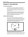
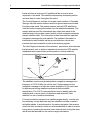
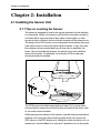
1
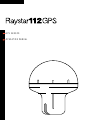
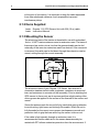
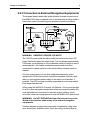
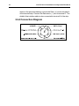
Distributed by
Any reference to Raytheon or
RTN in this manual should be
interpreted as Raymarine.
The names Raytheon and RTN
are owned by the
Raytheon Company.
GPS SENSOR
OPERATION MANUAL
RAYSTAR 112 Installation and Operation Handbook
RAYSTAR 112 GPS SENSOR
Owner/Installation Manual
PURPOSE
This manual contains very important information on the installation,
operation, and maintenance of your new equipment. In order to get the
best results in operation and performance, please take the time to read
this manual thoroughly.
IMPORTANT NOTICE
This device is only an aid to navigation. Its accuracy can be
affected by many factors, including equipment failure or defects,
environmental conditions and improper handling or use.
It is the user’s responsibility to exercise common prudence and
navigational judgement, and this device should not be relied upon
as a substitute for such prudence and judgement.
RAYTHEON ELECTRONICS products are supported by a network of
Authorized Service Representatives. For information on Raytheon
products and services, contact any of the following:
UNITED STATES
Raytheon Marine Company
676 Island Pond Road
Manchester, N.H. 03109 – 5420
Telephone: (603) 647 – 7530
Facsimillie: (603) 634 – 4756
EUROPE
Raytheon Marine Europe Limited
Anchorage Park
Portsmouth
Hampshire PO3 5TD
United Kingdom.
Telephone: 44 – 1705 693611
Facsimillie: 44 – 1705 694642
ã Copyright Raytheon Electronics 1997
The technical and graphical information contained in this handbook, to the best of our
knowledge, was correct as it went to press. However, the Raytheon policy of continuous
improvement and updating may change product specifications without prior notice. Therefore,
unavoidable differences between the product and handbook may occur from time to time, for
which liability cannot be accepted by Raytheon.
RAYSTAR 112 Installation and Operation Handbook
RAYSTAR 112 Installation and Operation Handbook
EMC Installation
& Service Guidelines
IMPORTANT NOTE
All Raytheon equipment and accessories are designed to the best
industry standards for use in the leisure marine environment.
Their design and manufacture conforms to the Electromagnetic
Compatibility (EMC) Regulations, but good installation is required to
ensure that performance is not compromised. Although every effort has
been taken to ensure that they will perform under all conditions, it is
important to understand what factors could affect the operation of the
product.
Installation
To avoid the risk of operating problems, all Raytheon equipment and
cables connected to it should be;
• At least 1m (3 ft) from any equipment transmitting or cables carrying
radio signals e.g. VHF radios, cables and antennas. In the case of
SSB radios, the distance should be increased to 2m (7ft).
• More than 2m (7ft) from the path of a radar beam. A radar beam can
normally be assumed to spread 20 degrees above and below the
radiating element.
• The equipment should be supplied from a different battery than the
one used for engine start. Voltage drops below 10v in the power
supply to our products can cause the equipment to reset. This will not
damage the equipment, but will cause the loss of some information
and can change the operating mode.
• Genuine Raytheon cables should be used at all times. Cutting and
rejoining these cables can compromise EMC performance and so
should be avoided unless doing so is detailed in the installation
manual.
RAYSTAR 112 Installation and Operation Handbook
Check Before Going to Sea
• Always check the installation before going to sea to make sure that it
is not affected by radio transmissions, engine starting etc..
• In some installations, it may not be possible to prevent the equipment
from being affected by external influences. In general this will not
damage the equipment but can lead to it resetting, or momentarily
may result in faulty operation.
Servicing and Safety
• Raytheon equipment should be serviced only by authorised
Raytheon service engineers. They will ensure that service
procedures and replacement parts used will not affect performance.
There are no user serviceable parts in any Raytheon product.
• Some products generate high voltages, and so never handle the
cables/connectors when power is being supplied to the equipment.
• Always report any EMC related problem to your nearest Raytheon
dealer. We will use any such information to improve our quality
standards.
Please keep these notes for future reference.
Contents
Contents
Chapter1: Introduction ......................................................... 1
1.1 General Information .......................................................... 1
1.2 Basic GPS Information ...................................................... 1
Chapter 2: Installation ........................................................... 5
2.1 Installing the Sensor Unit ................................................... 5
2.1.1 Tips on Locating the Sensor ...................................... 5
2.1.2 Items Supplied .......................................................... 6
2.1.3 Mounting the Sensor ................................................. 6
2.2 Sensor Connections ......................................................... 7
DC Power ..................................................................... 7
NMEA 0183 Data Output ............................................... 7
Data Input to Sensor ..................................................... 8
2.2.1 Connection to Raytheon Units ................................... 8
2.2.2 Connections to DGPS Receiver ................................ 8
2.2.3 Connection to External Navigation Equipments .......... 9
2.2.4 Connection Diagram ............................................... 10
Chapter 3: Operation .......................................................... 11
3.1 COLD Start (Initial Start-up) ............................................. 11
3.2 Geodetic Datum ............................................................. 11
Chapter 4: Maintenance ...................................................... 13
4.1 General .......................................................................... 13
4.2 Replacing the Battery ...................................................... 13
4.3 Trouble Shooting ............................................................ 14
4.4 Electrical Specifications: .................................................. 15
General: .......................................................................... 15
Mechanical Specifications: ............................................... 15
RAYSTAR 112 Installation and Operation Handbook
Appendix A ......................................................................... 17
Additional Local Geodetic Systems .................................. 17
Chapter 1: Introduction
1
Chapter1: Introduction
1.1 General Information
Congratulations on your purchase of Raytheon’s Raystar 112 GPS
sensor unit. We think you will appreciate the accuracy of GPS, the
quality, long-term reliability, and additional space saving convenience of
having GPS navigation data available at your navigation console from
your new Raystar 112.
Built into the environmentally rugged, compact housing is our newest
12 channel GPS receiver/processor combined with the ADP antenna.
The position output data from the Raystar 112 can be displayed on
radars, plotters, fishfinders, lorans, and other navigation equipment
capable of accepting NMEA 0183 formatted data.
1.2 Basic GPS Information
GPS is a satellite-based radionavigation system developed and
operated by the U.S. Department of Defense (DOD). GPS permits land,
sea and airborne users to determine their three-dimensional position,
velocity, and time 24 hours a day, in all weather, anywhere in the world
with a precision and accuracy far better than other radionavigation
systems available today or in the forseeable future.
GPS consists of three segments: space, control and user.
The Space Segment, consists of 24 operational satellites in six circular
orbits 20,200 km (10,900 nm) above the earth at an inclination angle of
55 degrees with a 12 hour period. The satellites are spaced in orbit so
2
RAYSTAR 112 Installation and Operation Handbook
that at any time a minimum of 6 satellites will be in view to users
anywhere in the world. The satellites continuously broadcast position
and time data to users throughout the world.
The Control Segment, consists of a master control station in Colorado
Springs, with five monitor stations and three ground antennas located
throughout the world. The monitor stations track all GPS satellites in
view and collect ranging information from the satellite broadcasts. The
monitor stations send the information they collect from each of the
satellites back to the master control station, which computes extremely
precise satellite orbits. The information is then formatted into updated
navigation messages for each satellite. The updated information is
transmitted to each satellite via the ground antennas, which also
transmit and receive satellite control and monitoring signals.
The User Segment consists of the receivers, processors, and antennas
that allow land, sea, or airborne operators to receive the GPS satellite
broadcasts and compute their precise position, velocity and time.
The satellites continuously broadcast their navigation messages at a
frequency of 1575.42 Mhz (for civilian use). Superimposed on the
navigation message is a high rate coarse acquisition (C/A) code used
for precise positioning measurements and positive satellite
identification. The C/A ID code permits the user to identify particular
satellites and, in some cases, to determine and select the “best
satellites” to use in position calculations.
If it were possible to measure true satellite ranges directly, it would only
be necessary to track data from any two satellites to obtain a vessel’s
latitude/longitude. In actual practice, for marine navigation, the receiver
must lock onto and track a minimum of three satellites in order to resolve
timing errors, including the receiver’s own internal clock timing bias error
which must be factored into the various range calculations.
Chapter 1: Introduction
3
Normally the Raystar 112 tracks up to 12 satellites (if visible) and uses
all tracked satellites for calculating position fixes. By using these
satellites, the processor can determine the amount of clock errors in
each range calculation. The receiver subtracts the error bias equally
from each range solution until the lines of position (LOP’s) intersect.
Theoretically, this process can produce highly accurate latitutde/
longitude (L/L) position fixes for navigation within +/- 15m (rms).
Continuous tracking of each satellite allows the receiver to perform this
timing adjustment process and to calculate accurate measurements to
the satellites. The Raystar 112 uses a 12 channel receiver. This sensor
design method provides fast efficient acquisition and accurate position
updating, even when satellites are obstructed from view.
The US Department of Defense, for security reasons, has included a
special mode in the GPS satellite system design which introduces
variable timing errors into the satellite signals. This mode is known as
“Selective Availability” (SA), and when it is enabled, is designed to
provide less accurate fixes for all users (except military users). Accuracy
in the order of +/- 100 Meters (rms) 95% of the time is obtained when
SA is ON. This means that 95% of the time the actual ship’s GPS Lat/
Long position will be within a radius of 100 meters (+/- one football field)
and 5% of the time the actual position will be out of this 100 meter circle.
Selective Availability has been enabled almost continuously since early
1991.
The use of Differential GPS technology can remove most of these
intentionally induced errors in the GPS satellite signals due to the
“Selective Availiblity” mode including errors that can result due to
environmental conditions as the satellite signals travel to earth.When
you attach Raytheon’s Differential Beacon Receiver to the Raystar 112
GPS sensor, the GPS differential corrections can improve the L/L
4
RAYSTAR 112 Installation and Operation Handbook
position output accuracy of the Raystar 112 from +/- 100 meters down
to 5 to 8 meters in most cases.
The Raystar 112 provides NMEA 0183 formatted data at its output as
follows:
RMC
Combines position, course, and speed
GLL
Vessel’s Latitude/Longitude position
VTG
Course over the ground, Speed over ground
GGA
Ships L/L position & satellite status information
GSA
Active satellites and DOP
GSV
Satellites in view
This data can be supplied to plotters, fishfinders, radars, integrated
systems, etc., which are set up to use these sentences from the
NMEA 0183 format.
Please read through this manual thoroughly before proceeding with the
installation and operation of the sensor. There are some important
recommendations regarding successful installation practices to follow
for getting the best GPS sensor performance.
In the back of this manual you will also find a warranty registration card
for your Raystar 112. To ensure that your unit is registered for full
warranty coverage, please take a few moments to fill in the necessary
information, and return the card to Raytheon. No postage is required if
the card is mailed in the USA.
Chapter 2: Installation
5
Chapter 2: Installation
2.1 Installing the Sensor Unit
2.1.1 Tips on Locating the Sensor
The sensor is designed to receive the signals emitted from the satellites
in a direct path. Ideally, the antenna unit should be mounted vertically in
a location that is open and clear of any masts, search lights, or other
structures that could block the line-of-sight reception of the antenna unit.
The height of the GPS sensor is not as important as the sensor having a
clear view horizon to horizon for ideal signal reception. In fact, the lower
the antenna can be mounted and have a clear view to satellites, the
better. The more stable the antenna, the easier it is to track satellites
lower to the horizon. On sailboats, mounting the GPS to mast tops
should generally be avoided.
The GPS sensor should be separated by at least 3 ft (1m) from other
communication antennas and should not be mounted in the direct path
of the radar’s antenna beam.
While planning the location for the sensor, consider finding a convenient
pathway for running the interconnecting cable which will connect the
GPS sensor to the GPS display unit. Ideally the cable should be run in a
manner so it can be hidden from view and, if possible, be in a direct path
6
RAYSTAR 112 Installation and Operation Handbook
to the point of connection. It is important to keep the cable separated
from other shipboard cables as much as possible to prevent
interference pickup.
2.1.2 Items Supplied
1 each Raystar 112 GPS Sensor Unit, with 33ft (10 m) cable
1 each Instruction Manual
2.1.3 Mounting the Sensor
The aluminum base of the sensor is threaded for use with a standard
1inch x 14 NPT marine antenna mount or extension mast. The base of
the sensor has a slot cut into it so that the prewired cable can be fed
externally of the mount or extension mast if so desired. If the connector
is removed, the cable can be fed down through the extension mast or
mount, exiting through the mount assembly.
The aluminium base of your Raystar 112 Sensor has received a
chromation treatment which adds toughness, resistance to wear and
tear, and resistance to corrosion of the assembly. Prior to attaching the
GPS sensor to the mount, we do recommend that a light coating of the
silicon grease be applied th the surface of the threads of the sensor and
mount.
Screw the antenna onto the mount fully by hand while paying attention
to avoid curling, tight loops, and kinking of the cable. When the unit is
fully threaded on the mount use a proper sized spanner wrench and
protective cloth to grip the base and snug the sensor to the mount.
If the cable is fed internally through an extension mast, it is
recommended that the cable slot in the sensor base assembly be
sealed with RTV silicon sealant as protection from the environment. If
Chapter 2: Installation
7
the cable is fed externally through the slot, the cable should be tyrapped
or clamped at the base. Then the slot in the base should be sealed with
RTV silicon sealant.
The cable assembly supplied is 33 ft (10 m) in length with a 6 pin
connector installed at the receiver end. The cable should be run as
directly as possible to the navigation console or to the external
navigation device. The cable may either be cut as necessary to the
desired length or coiled and stored out of the way.
If the cable is cut to length, the cable may be rejoined by following the
connection diagram in section 2.2.4.
2.2 Sensor Connections
The Raystar 112 sensor has the following input/output requirements:
DC Power
The 12 VDC power input to the sensor should be in the range of 11 to
16 VDC. It is important to verify that these voltage limits will not be
exceeded to protect the GPS sensor unit. The negative leg of the 12V is
grounded at the sensor base. If the vessel has a floating 12VDC
system, an insulator must be used between the sensor base and mount
to isolate the sensor from the ships ground.
NMEA 0183 Data Output
The NMEA 0183 Data contains RMC, GLL, VTG, GGA, GSA and GSV
sentences. Please note that the sensor output is guaranteed to drive
only 2 (two) devices directly. When using modern low current NMEA
0183 listener devices, up to 5 units can be driven in parallel. Contact
your dealer if there are any questions regarding interfacing capabilities.
8
RAYSTAR 112 Installation and Operation Handbook
Data Input to Sensor
The sensor data input line is used to provide initialization data to the
sensor unit as well as other set-up information, such as geodetic datum
selection. This data is ordinarily provided via Raytheon’s GPS display
units (RayNav 298, RayNav 398, etc.).
2.2.1 Connection to Raytheon Units
When the Raystar 112 sensor is connected directly to one of
Raytheon’s GPS display units, it normally obtains its 12VDC operating
power input from the unit. In this typical installation, the 6 pin sensor
connector is plugged directly into the connector labeled “GPS” on the
rear of the display unit cabinet. The DC power is then supplied via pins 1
and 2 of the GPS connector to the sensor.
Other external equipment requiring GPS data input should obtain their
required NMEA 0183 data via connection to the data output wires
located in the NAV display unit power cable assembly.
2.2.2 Connections to DGPS Receiver
The Raystar 112 is designed to accept differential corrections in the
RTCM Version 2.1 format from the Raytheon DGPS Beacon Receiver.
The corrections from the Beacon receiver pass directly to the GPS
sensor. A convenient “Y” cable assembly is packaged with the Beacon
receiver to permit this interconnection. The diagram below shows the
configuration.
Chapter 2: Installation
9
2.2.3 Connection to External Navigation Equipments
The diagram shown below should be followed to make connections of
the NMEA 0183 data to external units. A terminal strip would provide a
convenient means for attaching the necessary inputs and outputs.
WARNING: OBSERVE PROPER POLARITY!
The 12VDC power leads should normally be routed to the ship’s DC
power distribution panel on larger boats. The unit draws approximately
0.25 amps, so connection to a circuit breaker rated at 5 amps or less is
recommended. On smaller vessels the power leads should be
connected to a panel switch or to the main battery isolation switch or
breaker.
For best noise immunity from other shipboard electronics, avoid
grouping the GPS sensor power connections together with the radar,
radio, or echo sounder power leads on the same circuit breaker, if
possible. The GPS’s wiring should be separated as much as possible
from these other devices.
When using the NMEA 0183 format, the Raystar 112 can provide data
for at 2 or more navigation equipments when connected in parallel. Be
sure that all devices connected to the data output ( plotters, video
sounders, radars) are programmed to use the NMEA 0183 data format.
WARNING: Do NOT GROUND the Data, Data return lines, or the
Shield of the interface cable at any of the external navigation
equipments.
Interface between equipments is normally completed by using a two
wire, twisted pair, shielded, cable. If you are using a terminal strip as
10
RAYSTAR 112 Installation and Operation Handbook
shown in the previous drawing, connect the Data ( + ) wire to terminal 4
of the terminal strip. Connect the Data return ( - ) wire to terminal 3. The
shield of the interface cable is also connected to terminal 3 of the strip.
2.2.4 Connection Diagram
Chapter3:Operation
11
Chapter 3: Operation
3.1 COLD Start (Initial Start-up)
Your GPS is set up for fully Automatic operation when it leaves the
factory. All you need to do is turn the unit ON.
When power is applied to the Raystar 112 for the very first time, the GPS
sensor has to locate and identify three or more satellites before
determining the vessel’s actual L/L position. The sensor’s memories
contain pre-programmed profiles of each satellite’s signal coding. So it
becomes a matter of sampling the incoming GPS signals and
comparing the profiles until the signal coding matches. Unfortunately,
this process (similiar to matching fingerprints) is both time consuming
and complex. It can take up to 10 minutes before the unit completes
satellite identification and calculates the first position.
If you are using one of Raytheon’s GPS display units, the operator can
aid the GPS sensor in its satellite search by entering specific initialization
information concerning ship’s position, date, and time. The time required
for obtaining the initial position fix can be reduced to approximately 1 to 3
minutes once the sensor has received this initialization data.
After the sensor has completed this initial search and determined its
location, the sensor will remember the L/L position in memory. The next
time you use the unit, the only thing you’ll have to do is turn the unit ON.
In a few minutes your position will be displayed.
This will occur as long as the ship remains within approximately 100
NMof the L/L position where the unit was turned OFF. If the vessel has
been moved a substantial distance from the last saved position and the
GPS sensor is then powered up, the unit may again go through the Cold
Start routine. The time to acquire the satellites and get your position can
be reduced by re-entering your new L/L position, date, and time
information.
3.2 Geodetic Datum
The normal Geodetic datum used by the Raystar 112 sensor is
WGS-84.
Mariners can/may find considerable errors (up to 200 m) in plotting own
ship’s position if their charts were created using one type of geodetic
12
RAYSTAR 112 Installation and Operation Handbook
data system while the GPS sensor is busy calculating positions using
another data system. When using the Raytheon’s GPS display unit, the
sensor can be programmed to use different geodetic datums for making
position calculations. The datums that may be selected via the display
unit are as follows:
No.
Datum Area
Service Area
0
WGS-84
Default GPS datum
1
WGS-72
Loran C
2
BESSEL
Japan
3
NAD-27
USA (older NOAA charts)
4
NAD-27 CAN
Canada/Alaska
5
EUROPEAN 50
Europe
6
AUSTRAL 66
Australia
7
OSGB 36
UK (British Admiralty)
8
NAD 83
USA
9
Other Datums
see Appendix A
When a sensor is programmed for a different datum, the datum will be
saved in the sensors internal memory, which is backed-up by internal
battery.
If operating this unit with other navigation equipment, refer to the
equipment users manual for instructions on set-ups or programming to
select and receive external data inputs into those equipments.
Chapter 4: Maintenance
13
Chapter 4: Maintenance
4.1 General
Maintaining satisfactory operation of your Raystar 112 can depend on
how well you care for the equipment. The simple maintenance tips that
follow can save you time and money, as well as prevent unnecessary
premature failures when the unit is most needed.
Note:
Periodically check system hardware. Inspect the sensor, mount, and
cables, making sure all components are free of corrosion and are
securely mounted. Examine the cable for evidence of chafing or
abrasions. Clean and/or repair as necessary. Make sure connections to
the ship’s DC power are clean and tight. A light coating of a high
insulation silicon grease (such as Dow Corning DC-4) can be used on
connector pins to protect the plug contacts from corrosion when used.
4.2 Replacing the Battery
The Raystar 112 contains internal memories to store your position, and
other set-up information. A Lithium battery back-up keeps this memory
information intact even when the unit is disconnected from the ship’s
battery.
The estimated life span of the battery is five years. If the battery should
fail, the memory contents will be lost. While the Raystar 112 will still
operate without the battery, the unit will take longer to acquire a fix each
time you use the unit. To insure trouble free operation, it is suggested
that the battery be replaced every five years with an exact replacement
lithium battery. Your authorized Raytheon distributor or Raytheon
Factory Service Center can fit a replacement battery for you.
14
RAYSTAR 112 Installation and Operation Handbook
4.3 Trouble Shooting
All Raytheon products undergo comprehensive testing prior to
packaging and shipment from the factory. However, in the unlikely event
that a problem arises, the following checks should help to locate the
possible cause.
Fault
Cause
Action
No data output after
30 min. operation.
No DC power
1. Check power is switched on.
2. Check fuse/breaker
No satellites
No fix
Path blocked
3. Verify antenna is not obstructed
and is vertically mounted.
No Data output
4. Check data connections
for broken wires.
Chapter 4: Maintenance
15
4.4 Electrical Specifications:
General:
Receiver type:
12 Channel, parallel, highspeed
Frequency:
1575.42 MHz +/- 1MHz (C/A code), L1
Sensitivity:
-130 dBm
Signal Acquisition:
Automatic and computer controlled
Time to first fix:
10 minutes maximum;
Less than 3 minutes after first fix.
Maximum No. of
tracked satellites:
12
Almanac update:
Automatic
Accuracy (Typical):
Position:
Speed:
SA= Off SA= On
+/- 15M +/- 100M
0.1 kts
DGPS=On
+/-5 to 8M
Differential Correction:
Accepts RTCM SC-104
Geodetic Datum:
WGS-84 is default; 190 others programmable
Data Output:
Single output port. NMEA 0183 includes
RMC, GLL, VTG, GGA, GSA and GSV
sentences.
Data Type:
TTL level asynchronous serial data,
4800 baud.
Memory Backup:
Via internal lithium battery, 3-5 years life
Power Requirements:
13.6 VDC, 0.25A nominal (11-16 VDC)
Mechanical Specifications:
Antenna:
ADP
Antenna Construction:
Waterproof to USCG standard CFR 46
Cable Type:
6 conductor, White PVC jacket
Cable Length:
10 meters (33 ft)
Dimensions:
110 x 130 mm (4.3" H x 5.1" W)
Weight:
0.6 kg (1.3 lbs) approximately
Temperature:
-20° to +70°C
Storage Temperature:
-40°C to +85° C
16
RAYSTAR 112 Installation and Operation Handbook
Appendix
17
Appendix A
Additional Local Geodetic Systems
11
Adindan (Mean for Ethiopia and Sudan)
12
ARC 1950 (Mean for Botswana, Lesotho, Malawi, Swaziland,
Zaire, Zambia, Zimbabwe)
13
Australian Geodetic 1984 (Australia)
14
Bermuda 1957 (Bermuda Islands)
15
Bogota Observatory (Columbia)
16
Campo Inchauspe (Argentina)
17
Chatham 1971 (Chatham Island)
18
Chua Astro (Paraquay)
19
Corrego Alegre (Brazil)
20
Djakarta (Vatavia) (Sumatra)
21
European 1979 (Europe)
22
Geodetic Datum 1949 (New Zealand)
23
Guam 1963 (Guam)
24
Hayford 1910 (Finland)
25
Hjorsey 1955 (Iceland)
26
Indian (India and Nepal)
27
Ireland 1965 (Ireland)
28
Kertau 1948 (West Malaysia and Singapore)
29
L.C.5. Astro (Cayman Brac Island)
30
Liberia 1964 (Liberia)
31
Luzon (Philippines (excluding Mindanao))
32
Merchich (Morocco)
33
Minna (Cameroon)
34
Nahrwan (Oman)
35
Naparima, BWI (Trinidad and Tobago)
36
Old Egyptian (Egypt)
37
Old Hawaiian (Hawaiian Islands)
38
Pico De Las Nieves (Canary Islands)
39
Provisional South American 1956 (Mean for Bolivia, Chile,
Columbia, Ecuador, Guyana, Peru, Venezuela)
40
Provisional South Chilean 1963 (Southern Chile)
41
Puerto Rico (Puerto Rico and Virgin Islands)
18
RAYSTAR 112 Installation and Operation Handbook
42
Qornoq (Southern Greenland)
43
RT90 (Sweden)
44
Santa Braz (Sao Maguel and Santa Maria Islands)
45
South American 1969 (Mean for Argentina, Bolivea, Brazil, Chile,
Columbia, Ecuador, Guyana, Paraguay, Peru, Trinidad & Tobago,
Venezuela)
46
Southwest Base (Graciosa Base) (Faial, Graciosa, Pico,
Sao Jorge and Terceira Island)
47
Timbalai 1948 (Brunei and East Malaysia)
50
Adindan (Burkina Faso)
51
Adindan (Cameroon)
52
Adindan (Ethiopia)
53
Adindan (Mali)
54
Adindan (Senegal)
55
Adindan (Sudan)
56
Afgooye (Somalia)
57
Ain el Abd 1970 (Bahrain)
58
Ain el Abd 1970 (Saudi Arabia)
59
Ain el Abd 1970 (Cocos Islands)
60
Antigua Island Astro 1943 (Antigua and Leeward Islands)
61
Arc 1950 (Botswana)
62
Arc 1950 (Burundi)
63
Arc 1950 (Lesotho)
64
Arc 1950 (Malawi)
65
Arc 1950 (Swaziland)
66
Arc 1950 (Zaire)
67
Arc 1950 (Zambia)
68
Arc 1950 (Zimbabwe)
69
Arc 1950 (Mean for Kenya and Tanzania)
70
Ascension Island 1958 (Ascension Island)
71
Astro Beacon E 1945 (Iwo Jima)
72
Astro DOS 71/4 (St Helena Island)
73
Astro Tern Island 1961 (Tern Island)
74
Astronomical Station 1952 (Marcus Island)
75
Ayabelle Lighthouse (Djibouti)
76
Bellevue (IGN) (Efate and Erromango Islands)
Appendix
19
77
Bissau (Guinea, Bissau)
78
Bukit Rimpah (Indonesia (Bangka and Belitung Islands))
79
Camp Area Astro (Antarctica (McMurdo Camp))
80
Canton Astro 1966 (Phoenix Islands)
81
Cape (South Africa)
82
Cape Canaveral (Bahamas and Florida)
83
Carthage (Tunisia)
84
Dabola (Guinea)
85
DOS 1968 (New Georgia Islands)
86
Easter Island 1967 (Easter Island)
87
European 1950 (Mean for Austria, Denmark, Germany,
Netherlands, Switzerland)
88
European 1950 (Mean for Iraq, Israel, Jordon, Lebanon,
Kuwait, Saudi Arabia, Syria)
89
European 1950 (Cyprus)
90
European 1950 (Egypt)
91
European 1950 (England, Channel Islands, Scotland, Shetland
Islands)
92
European 1950 (Finland, Norway)
93
European 1950 (Greece)
94
European 1950 (Iran)
95
European 1950 (Italy (Sardinia))
96
European 1950 (Italy (Sicily))
97
European 1950 (Malta)
98
European 1950 (Portugal ,Spain)
99
European 1979 (Mean for Austria, Finland, Netherlands,
Norway, Spain, Sweden, Switzerland)
100
Fort Thomas 1955 (Nevis, St Kitts (Leeward Islands))
101
Gan 1970 (Maldives)
102
Guam 1963 (Guam)
103
Gunung Segara (Indonesia (Kalimantan))
104
GUX 1 Astro (Guadalcanal Island)
105
Herat North (Afghanistan)
106
Hong Kong 1963 (Hong Kong)
107
Hu-Tzu-Shan (Taiwan)
108
Indian (Bangladesh)
20
RAYSTAR 112 Installation and Operation Handbook
109
Indian 1954, (Thailand, Vietnam)
110
Indian 1975 (Thailand)
111
ISTS 061 Astro 1968 (South Georgia Islands)
112
ISTS 073 Astro 1969 (Diego Garcia)
113
Johnston Island 1961 (Johnston Island)
114
Kandawala (Sri Lanka)
115
Kerguelen Island 1949 (Kerguelen Island)
116
Kusaie Astro 1951 (Caroline Islands)
117
Legion Ghana
118
Luzon Philippines (Philippines Mindanoa)
119
Mahe 1971 (Mahe Island)
120
Massawa (Ethiopia (Eritrea ))
121
Midway Astro 1961 (Midway Island)
122
Minna (Nigeria)
123
Montserrat Island Astro 1958 (Montserrat (Leeward Islands))
124
M’Poraloko (Gabon)
125
Nahrwan (Saudi Arabia)
126
Nahrwan (United Arab Emirates)
127
North American 1927 ( NAD27 ) (Mean for Antigua, Barbados,
Barbuda, Caicos Islands, Cuba, Dominican Republic,
Grand Cayman, Jamaica, Turks Islands)
128
North American 1927 ( NAD27 ) (Mean for Belize, Costa Rica,
El Salvador, Guatemala, Honduras, Nicaragua)
129
North American 1927 ( NAD27 ) (Mean for CONUS ( East of
Mississippi River))
130
North American 1927 ( NAD27 ) (MEAN for CONUS ( West of
Mississippi River))
131
North American 1927 ( NAD27 ) (Alaska)
132
North American 1927 ( NAD27 ) (Bahamas ( Except San
Salvador Island))
133
North American 1927 ( NAD27 ) (Canada (Alberta, British
Columbia))
134
North American 1927 ( NAD27 ) (Canada ( Manitoba, Ontario))
135
North American 1927 ( NAD27 ) (Canada (New Brunswick,
Newfoundland, Nova Scotia, Quebec)
136
North American 1927 ( NAD27 ) (Canada ( Northwest Territories,
Saskatchewan))
Appendix
21
137
North American 1927 ( NAD27 ) (Canada (Yukon))
138
North American 1927 ( NAD27 ) (Canal Zone)
139
North American 1927 ( NAD27 ) (Cuba)
140
North American 1927 ( NAD27 ) (Greenland (Hayes Peninsula))
141
North American 1927 ( NAD27 ) (Mexico)
142
North American 1983 (Alaska, Canada, CONUS)
143
North American 1983 (Central America, Mexico)
144
Obersvatorio Metereo 1939 (Azores)
145
Old Hawaiian (Mean for Hawaii, Kauai, Maui, Oahu)
146
Old Hawaiian (Kauai)
147
Old Hawaiian (Maui)
148
Old Hawaiian (Oahu)
149
Oman (Oman)
150
Ordnance Survey of Great Britain 1936 (Mean for England,
Isle of Man, Scotland, Shetland Islands , Wales)
151
Ordnance Survey of Great Britain 1936 (England , Isle of Man,
Wales)
152
Ordnance Survey of Great Britain 1936 (Scotland, Shetland
Islands)
153
Ordnance Survey of Great Britain 1936 (Wales)
154
Pitcairn Astro 1967 (Pitcairn Island)
155
Point 58 (Mean for Burkina Faso and Niger)
156
Pointe Noire 1948 (Congo)
157
Porto Santo 1936 (Porto Santo, Madeira Islands)
158
Provisional South American 1956 (Bolivia)
159
Provisional South American 1956 (Chile (Northern Near 19°S ))
160
Provisional South American 1956 (Chile ( Southern Near 43°S )
161
Provisional South American 1956 (Columbia)
162
Provisional South American 1956 (Ecuador)
163
Provisional South American 1956 (Guyana)
164
Provisional South American 1956 (Peru)
165
Provisional South American 1956 (Venezuela)
166
Qatar National (Qatar)
167
Reunion (Mascarene Islands)
168
Rome 1940 (Italy, Sardinia)
169
Santa(DOS) 1965 (Espirito Santo Island)
22
RAYSTAR 112 Installation and Operation Handbook
170
Sapper hill 1943 (East Falkland Island)
171
Schwarzeck (Namibia)
172
Selvagem Grande (Salvage Islands)
173
SGS 85 Soviet Geodetic System 1985 (Russia)
174
South American 1969 (Argentina)
175
South American 1969 (Bolivia)
176
South American 1969 (Brazil)
177
South American 1969 (Chile)
178
South American 1969 (Columbia)
179
South American 1969 (Ecuador)
180
South American 1969 (Ecuador (Baltra, Galapagos))
181
South American 1969 (Guyana)
182
South American 1969 (Paraguay)
183
South American 1969 (Peru)
184
South American 1969 (Trinidad & Tobago)
185
South American 1969 (Venezuela)
186
South Asia (Singapore)
187
Tananarive Observatory 1925 (Madagasar)
188
Tokyo (Japan)
189
Tokyo (Korea)
190
Tokyo (Okinawa)
191
Tristan Astro 1968 (Tristan de Cunha)
192
Viti Levu 1916 (Fiji (Viti Levu Island))
193
Wake-Eniwetok 1960 (Marshall Islands)
194
Wake Island Astro 1952 (Wake Atoll)
195
Yacare (Uruguay)
196
Zanderij (Suriname)
197
Reserved
198
Reserved
199
Reserved
200
User Defined
81126-1
Printed in England
Raytheon Marine Company
676 Island Pond Road
Manchester, NH 03109-5420
TEL (603) 647-7530
FAX (603) 634-4756
Raytheon Marine Europe Ltd.
Anchorage Park, Portsmouth,
Hampshire, PO3 5TD, England
TEL (01705) 693611
FAX (01705) 694642
Document No. G623819-5