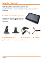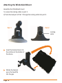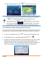
1
IGO500
IGO430
In-Car Navigation
For more exciting new products please visit our website:
Australia: www.uniden.com.au
New Zealand: www.uniden.co.nz
Thank you for purchasing this Uniden product. Read the Quick Start Guide first
and start using your device right away. This document is the detailed description of
the navigation software. You can easily discover your device while you are using
it; however, we still recommend that you read this manual to fully understand the
screens and the features of your software.
3 Year Map Updates Subscription* via Redemption
Go to the GPS Navigation web page on www.uniden.com.au for Australia or
www.uniden.co.nz for New Zealand and download the redemption form to claim
your updates subscription.
*Map updates are for Australia and New Zealand and are provided through
www.naviextras.com
Page 2
Table of Contents
What Do I Do First?
Make Sure These Items Arrived in the Box
Plug it in
Hardware Keys
How Do I Put It in My Car?
Safety considerations
Attaching the Windshield Mount
Adjusting the Windshield Mount
Mount to the Windshield
Removing the Windshield Mount
1 Warnings and Safety information
2 Getting started
2.1 Startup screen: the Map and Navigation menu
2.2 Buttons and other controls on the screen
2.2.1 Using keyboards
2.2.2 Beyond single screen tap
2.3 Map screen
2.3.1 Navigating on the map
2.3.2 Position markers
2.3.2.1 Vehimarker and Lock-on-Road
2.3.2.2 Selected Map location (Cursor) and selected map object
2.3.3 Objects on the map
2.3.3.1 Streets and roads
2.3.3.2 Turn preview and Next street
2.3.3.3 Lane information and Signposts
2.3.3.4 Junction View
2.3.3.5 Motorway exit services
2.3.3.6 3D object types
2.3.3.7 Elements of the active route
2.3.4 Manipulating the map
2.3.5 Quick menu
2.3.6 Checking the details of the current position (Where Am I?)
6
6
7
8
9
9
10
11
11
11
12
13
15
16
18
19
20
20
22
22
23
23
23
24
25
26
26
27
28
28
30
34
Page 3
3 Navigating
3.1 Selecting the destination of a route
3.1.1 Entering an address or part of an address
3.1.1.1 Entering an address
3.1.1.2 Entering an address starting with the street name
3.1.1.3 Entering the midpoint of a street as the destination
3.1.1.4 Selecting an intersection as the destination
3.1.1.5 Selecting a town/suburb centre as the destination
3.1.1.6 Entering an address with a postal code
3.1.1.7 Tips on entering addresses quickly
3.1.2 Selecting the destination from the Places of Interest
3.1.2.1 Quick search for a Place of Interest
3.1.2.2 Searching for a Place of Interest using preset categories
3.1.2.3 Searching for a Place of Interest by category
3.1.2.4 Searching for a Place of Interest by name
3.1.2.5 Selecting nearby assistance from ‘Where Am I?’
3.1.3 Selecting a map location as the destination
3.1.4 Selecting the destination from your Favourites
3.1.5 Selecting the most likely destination (Smart History)
3.1.6 Selecting the destination from the History
3.1.7 Entering the coordinate of the destination
3.1.8 Navigate to a location stored in a photo
3.1.9 Building the route from the list of destinations (Create Route)
3.2 Viewing the entire route on the map
3.3 Checking route parameters and accessing route related functions
3.4 Modifying the route
3.4.1 Selecting a new destination when already having a route:
New Route, Waypoint of Final Destination
3.4.2 Setting a new starting position for the route
3.4.3 Editing the list of destinations (Edit Route)
3.4.4 Pausing the active route
3.4.5 Cancelling the active route
3.4.6 Checking route alternatives when planning the route
3.4.7 Changing the route planning method (route alternatives)
3.4.8 Changing the vehicle used in route planning
Page 4
36
36
37
37
40
42
44
46
48
50
51
52
53
56
60
63
65
66
68
69
70
71
72
74
74
75
75
76
78
79
79
79
81
82
3.4.9 Changing the road types used in route planning
3.5 Saving a location as a Favourite destination
3.6 Saving a location as an alert point
3.7 Editing an alert point
3.8 Watching the simulation of the route
4 Off-road navigation
4.1 Selecting the destination of the route
4.2 Navigating in off-road mode
5 Reference Guide
5.1 Concepts
5.1.1 Smart Zoom 5.1.2 Daytime and night colour themes
5.1.3 Tunnel View
5.1.4 Route calculation and recalculation
5.1.5 Green routing
5.1.6 Road Safety Cameras and Other Proximity Alerts Points
5.1.7 Speed limit warning
5.1.8 Battery and GPS position quality indicators
5.1.9 Traffic information in route planning
5.1.9.1 Historical traffic
5.2 ‘More’ menu
5.3 Settings menu
5.3.1 Sound and Warnings
5.3.2 Customise Quick menu
5.3.3 Route Settings
5.3.4 User profiles
5.3.5 Map Settings
5.3.6 Visual guidance settings
5.3.7 Display settings
5.3.8 Regional settings
5.3.9 Trip monitor settings
5.3.10 Log Collection settings
6 Glossary
7 End User Licence Agreement
8 Limited One Year Warranty
83
84
85
86
87
89
89
89
91
91
91
91
91
92
95
96
97
98
99
99
100
102
103
107
107
113
114
116
118
118
119
119
121
123
129
Page 5
What Do I Do First?
Make Sure These Items Arrived in the Box
If anything listed here is missing or damaged, contact your place of purchase
immediately.
IGO500 or IGO430 GPS navigation device
Press and hold the power button at the TOP
of the device to start or resume the navigation
programme.
Part 1
Part 2
Windshield Mount (2 part)
Owners Manual
Page 6
DC (car) adapter
Quick Start Guide sheet
USB cable
Plug it in
Connect the power adapter to the power connector on the lower left side of
the device.
Plug the other end into your car’s cigarette lighter (or any standard 12VDC 24VDC outlet).
Only use the power adapter that comes with your device. Any other adapter
might damage the device.
Press and hold the power
button at the top of the device to turn it on/off.
Whenever it senses power coming in the LCD screen turns on and the device resumes from it’s last status. You can turn the LCD screen on/off anytime you
want: just momentarily push the power button.
Page 7
Hardware Keys
IGO500 / IGO430 model
1
2
3
4
5
6
7
Ref
1
Component
Power Key
Power on/off/sleep
2
Touch-pen*
Touch-pen
3
Speaker
Speaker
4
micro SD card slot
micro SD card slot
5
micro USB power/
charge port
Reset
6
7
Description
Charge the GPS device by connecting the DC
Adaptor (car charger) or USB cable.
If the device fails to operate properly, try resetting the
device. Press the reset button by using the touch pen
or a similar tool.
LCD Display Screen LCD Display Screen
*IGO500 touch-pen location is shown. IGO430 touch-pen is fitted on the
windshield mount.
Page 8
How Do I Put It in My Car?
Safety Considerations
Don’t install any device where it will block your view (including your mirrors!)
while you’re driving.
Keep your attention on the road! Don’t try to operate or focus on any device
while you’re driving. If you have to concentrate on a device, pull off the road
for a few minutes.
It’s a good idea to take valuable items with you when you leave you car—that
includes GPS devices. If you can’t take the device with you, lock it in the glove
compartment or hide it somewhere. And don’t forget to take down the
windshield mount: you don’t want to remind any potential thieves that you
might have some valuable mobile electronics in the car.
Don’t leave the device in direct sunlight for a long period of time or where the
temperature could go above 60º C (140º F).
Page 9
Attaching the Windshield Mount
Assemble the Windshield mount.
1) Loosen the locking collar on part 2.
2) Push the ball joint of Part 1 through the locking collar into part 2.
Part 1
Part 2
Locking
collar
Insert the bracket hook into
the notches at the bottom of
the device.
Rotate the bracket
up so the head fits into the gap.
Page 10
Adjusting the Windshield Mount
Locking
collar
Turn the windshield mount arm to a suitable angle for mounting.
Suction lock
Mount on the Windshield
Make sure the device does not block your view of the road or your mirrors.
Once you decide where you want the device, hold the suction cup in that position,
then adjust the mount so you have the best view of the device.
1) Press the suction cup flat against the windshield.
2) Push the suction lock up (clockwise) until it snaps into place.
3) Adjust the unit & bracket to a final position. Tighten the locking collar to secure.
4) Gently pull on the mount to make sure it is secure.
If you have trouble getting the suction cup to stick:
Clean the spot with an ammonia-free cleanser.
Dry the spot completely (use a lint-free cloth, if possible).
Make sure the spot is smooth and flat (suction cups won’t stick well on a
curved or textured surface).
Removing the Windshield Mount
When you release the suction latch, make sure you’re holding or somehow
supporting the device.
Lift the suction lock and use the plastic pull tab to pull the suction cup off of the glass.
Page 11
1 Warnings and Safety information
The navigation system helps you find your way to your destination with the built-in
GPS receiver. The software does not transmit your GPS position; others cannot
track you.
If you accept this when first using the application, it collects usage information
and GPS logs that may be used for improving the application and the quality and
coverage of maps. The data is processed anonymously; no one will be able to
track any personal information. If you change your mind later, you can enable or
disable the log collection in Log Collection settings (page 119).
It is important that you look at the display only when it is safe to do so. If you are
the driver of the vehicle, we recommend that you operate your software before
you start your journey. Plan the route before your departure and stop if you need
to change the route.
You must obey the traffic signs and follow the road geometry. If you deviate from
the recommended route, your software changes the instructions accordingly.
Never place your device where it obstructs the driver’s view, where it is in the
deployment zone of an airbag or where it might cause injuries in an accident.
For more information, consult the End User Licence Agreement (page 123).
Page 12
2 Getting started
The software is optimised for in-car or pedestrian use. There is no need to use a
stylus. You can use it easily by tapping the screen buttons and the map with your
fingertips.
When using the navigation software for the first time, an initial setup process starts
automatically. Do as follows:
1. Read the End User Licence Agreement. Tap
to continue.
2. You are now asked whether you allow the software to collect usage
information and GPS logs that may be used for improving the application
and the quality and coverage of maps. Tap
anonymous statistics or
to disable this function. Later you can
turn them on or off individually in Log Collection settings (page 119)
to allow the
3. Please take a moment to initially set up your new device to your preferences. Later on you can run this configuration wizard, or change these (and some
more) settings under the More / settings menu. Tap
to continue.
Page 13
4. Select the language and speaker used for voice guidance messages. Later
you can change it in Regional settings (page 118).
5. If needed, modify the time format and unit settings. Later you can
change them in Regional settings (page 118).
6. If needed, modify the default route planning options. Later you can change
them in Route settings (page 106).
7. The initial setup is now complete. Tap
to continue. The Configuration wizard can be restarted later from the Settings menu (page 102).
Page 14
After the initial setup, the Map screen appears and the device looks for GPS
signal. A view of the sky is required to lock onto GPS. For the initial start this may
take a few minutes. you can start using the software. This is the screen you see
every time navigation starts.
2.1 Startup screen: the Map and Navigation menu
The software starts with the map screen. For first time users touch
open the Navigation menu.
to
From the Navigation menu you can reach all parts of the software.
You have the following options:
•
Tap
to select your destination by entering an address or selecting a
place of interest, a location on the map or one of your Favourite destinations. You can also look up your recent destinations from the Smart History, enter a
coordinate or use the location saved in a photo.
•
Tap
to display the route parameters and the route in its full length on
the map. You can also perform route-related actions such as cancelling your
route, picking route alternatives, simulating navigation or adding the
destination to your Favourites.
•
Tap
to customise the way the navigation software works, watch the
Tutorial, simuate demo routes, or to run some additional applications.
Page 15
•
Tap
to start navigating on the map. The button itself is a miniature
live map that shows your current position, the recommended route and the
surrounding map area. Tap the button to enlarge the map to the full screen.
•
Tap
to stop navigation and exit the software.
2.2 Buttons and other controls on the screen
When you are using the software, you usually tap buttons on the touch screen.
You only need to confirm selections or changes if the application needs to restart,
it needs to perform a major reconfiguration, or you are about to lose some of your
data or settings. Otherwise, the software saves your selections and applies the
new settings without confirmation as soon as you use the controls.
Type
Example
Description
How to use it
Button
Tap it to initiate a
function, to open a
new screen, or to set
a parameter.
Tap it once.
Button
with
value
Some buttons display
the current value of
a field or setting. Tap
the button to change
the value. After the
change, the new
value is shown on
the button.
Tap it once.
Icon
Shows status
information.
Some icons also
function as a
button. Tap them
once.
Page 16
List
When you need to
select from several
options, they appear
in a list.
Grab the list
anywhere and slide
your finger up or
down. Depending
on the speed of the
sliding, the list will
scroll fast or slow,
only a bit or till the
end. Alternatively,
move between
pages with the
and
buttons and tap the
value that you want.
Slider
When a feature can
be set to different
values in a range,
the software shows
an indicator on a
gauge that displays
and sets the value.
• Drag the handle to
move the slider to
its new position.
• Tap the slider
where you want the
handle to appear;
the thumb jumps
there.
Radio
Button
When there are only
a few choices, radio
buttons may be used
instead of lists. Only
one value can be
selected.
Tap one of the
buttons to select a
new value.
Switch
When there are
only two choices, a
checkmark shows
whether the feature
is enabled.
Tap it to turn the
switch on or off.
Page 17
Virtual
keyboard
Alphabetic and
alphanumeric
keyboards to enter
text and numbers.
Each key is a touch
screen button.
2.2.1 Using keyboards
You only need to enter letters or numbers when you cannot avoid it. You can type
with your fingertips on the full-screen keyboards and you can switch between
various keyboard layouts, for example English, Greek or numerical.
Task
Switching to another keyboard
layout, for example from an English
keyboard to a Greek keyboard
Correcting your entry on the
keyboard
Entering a space, for example
between a first name and a family
name or in multi-word street
names
Entering upper and lower
case letters
Details
Tep the
button and select the
new keyboard layout from the list.
to remove the unneeded
Tap
character(s).
Tap and hold the button to delete several
characters or the entire input string.
button at the bottom centre
Tap the
of the screen.
When entering a text, the first character
appears in upper case while the rest of
to enter
the text is in lower case. Tap
an upper case letter or tap twice to turn
on Caps Lock. Tap again and lower case
letters return.
Page 18
Entering numbers and symbols
to switch to a keyboard offering
Tap
numeric and symbol characters.
Finalising the keyboard entry
(accepting the suggested search
result)
Tap
.
Finalising the keyboard entry
(opening the list of search results) Tap
.
Finalising the keyboard entry
(saving your input)
Tap
.
Cancelling the keyboard entry
(returning to the previous screen)
Tap
.
2.2.2 Beyond single screen tap
You usually need to tap the screen only once. However, some useful features can
be accessed with combined touch screen tapping. Those are the following:
Action
Details
Tapping and
holding the
screen
Tap and keep pressing the following buttons to reach extra functions:
• Tap and hold
screen appears.
on list and menu screens: the Map
,
,
,
,
and
• Tap and hold any of the
buttons on the Map screen: you can rotate, tilt or scale the map
continuously.
on keyboard screens: you can delete
• Tap and hold
several characters quickly.
• Tap and hold
continuously.
or
in long lists: you can scroll pages
Page 19
Gestures
(drag&drop)
You need to drag and drop the screen only in cases like:
• Moving the handle on a slider.
• Scrolling the list: grab the list anywhere and slide your finger up
or down. Depending on the speed of the sliding, the list will scroll
fast or slow, only a bit or till the end.
• Moving the map in map browsing mode: grab the map, and
move it in the desired direction.
2.3 Map screen
2.3.1 Navigating on the map
The Map screen is the most frequently used screen of the software.
A small live map is displayed on the Navigation menu, as a part of the
button.
To enlarge this small map and open the Map screen, tap
.
The map is displayed in black and white when there is no GPS position:
This map shows the current position (the Vehimarker, a blue arrow by default), the
recommended route (an orange line), and the surrounding map area.
When there is no GPS position, the Vehimarker is transparent. It shows your last
known position.
You see coloured dots circling around a satellite symbol in the top left corner. The
more green dots you see, the closer you are to get the valid GPS position.
Page 20
When GPS position is available, the Vehimarker is displayed in full colour, now
showing your current position.
There are screen buttons and data fields on the screen to help you navigate.
During navigation, the screen shows route information.
By default, only one data field is displayed in the bottom right corner. Tap this field
to see all route data fields.
Tap any of the data fields to suppress others and display only the selected one.
The data fields are different when you are navigating an active route and when
you have no specified destination (the orange line is not displayed).
Default data fields when cruising without a destination (tap and hold any of the
fields to change its value):
Page 21
Field
Description
Shows your current speed given by the GPS receiver.
Shows the speed limit of the current road if the map contains it.
Shows the current time corrected with time zone offset. The
accurate time comes from the GPS satellites, and the time zone
information comes from the map or it can be set manually in
Regional settings.
(The current time is always displayed in the top left corner of the
high level menu screens.)
Default data fields when navigating a route (tap and hold any of the fields to
change its value):
Field
Description
Shows the distance you need to travel on the route before
reaching your final destination.
Shows the time needed to reach the final destination of the route
based on information available for the remaining segments of the
route. Historical traffic data or traffic patterns are also taken into
account whenever such information exists.
Shows the estimated arrival time at the final destination of the
route based on information available for the remaining segments
of the route. Historical traffic data or traffic patterns are also
taken into account whenever such information exists.
2.3.2 Position markers
2.3.2.1 Vehimarker and Lock-on-Road
When your GPS position is available, the software marks your current position
with the Vehimarker. By default, this marker is a blue arrow, but you can change
this icon in Settings.
Page 22
The exact location of the Vehimarker depends on the vehicle type used for route
calculation. The vehicle type can be selected in Route settings (page 107).
•
If you choose pedestrian: The Vehimarker is at your exact GPS position. The
direction of the icon shows your current heading.
•
In all other cases: The Vehimarker may not show your exact GPS position
and heading. If roads are near, it is aligned to the nearest road to suppress
GPS position errors, and the direction of the icon is aligned to the direction of
the road.
2.3.2.2 Selected map location (Cursor) and selected map object
You can mark a map location in the following ways:
• Tap the map when navigating,
• Tap the map when you are asked to confirm the destination at the end of a
search, or
• Tap the map in Find on Map (page 65)
When a map location is selected, the Cursor appears at the selected point on the
map. The Cursor is displayed with a radiating red dot (
all zoom levels.
) to make it visible at
The location of the Cursor can be used as the destination of the route, you can
search for Places around it, or you can save this location as one of your Favourite
destinations.
You can also select some of the objects on the map. If you tap the map at the icon
of a Place of Interest or an alert point, the object will be selected (you see a red
circling border around the object), and you can get information about this object or
use it as a route point.
2.3.3 Objects on the map
2.3.3.1 Streets and roads
The software shows the streets in a way that is similar to how the paper road
maps show them. Their width and colours correspond to their importance: you can
easily tell a motorway from a small street.
Page 23
2.3.3.2 Turn preview and Next street
When navigating a route, the top section of the Map screen shows information
about the next route event (manoeuvre) and the next street or the next city/town.
There is a field in the top left corner that displays the next manoeuvre. Both the
type of the event (turn, roundabout, exiting motorway, etc.) and its distance from
the current position is displayed.
A smaller icon shows the type of the second next manoeuvre if it is near the first
one. Otherwise, only the next manoeuvre is displayed.
Most of these icons are very intuitive. The following table lists some of the
frequently shown route events. The same symbols are used in both fields:
Icon
Description
Turn left.
Turn right.
Turn back.
Bear right.
Page 24
Turn sharp left.
Keep left.
Continue straight in the intersection.
Go left on the roundabout, 3rd exit (next manoeuvre).
Enter roundabout (second next manouvre).
Enter motorway.
Exit motorway.
Board ferry.
Leave ferry.
Approaching a waypoint.
Approaching the destination.
2.3.3.3 Lane information and Signposts
When navigating on multilane roads, it is important to take the appropriate lane in
order to follow the recommended route. If lane information is available in the map
data, the software displays the lanes and their directions using small arrows at the
bottom of the map. Highlighted arrows represent the lanes you need to take.
Where there is additional information available, signposts substitute arrows.
Signposts are displayed at the top of the map. The colour and style of the signposts
are similar to the real ones you can see above road or by the roadside. They show
the available destinations and the number of the road the lane leads to.
All signposts look similar when cruising (when there is no recommended route).
When navigating a route, only that signpost is displayed in vivid colours that points
Page 25
to the lane(s) to be taken; all others are darker.
2.3.3.4 Junction view
If you are approaching a motorway exit or a complex intersection and the needed
information exists, the map is replaced with a 3D view of the junction. The lanes
you need to take are displayed with arrows. Signposts can also be present if
information is available.
2.3.3.5 Motorway exit services
You may need a petrol station or a restaurant during your journey. This feature
displays a new button on the map when you are driving on motorways.
Tap this button to open a panel with the details of the next few exits or service stations.
Page 26
2.3.3.6 3D object types
Your software supports the following 3D object types:
Type
Description
3D terrain
3D terrain map data shows changes in terrain, elevations or
depressions in the land when you view the map in 2D, and use it to
plot the route map in 3D when you navigate. Hills and mountains
are shown in the background of the 3D map, and illustrated by
colour and shading on the 2D map.
Elevated
roads
Complex intersections and vertically isolated roads (such as
overpasses or bridges) are displayed in 3D.
3D
landmarks
Landmarks are 3D artistic or block representations of prominent or
well-known objects.
3D
buildings
(optional
data)
3D block representation of full city building data containing actual
building size and position on the map.
Page 27
2.3.3.7 Elements of the active route
Your software shows the route in the following way:
Symbol
Name
Description
Current GPS
position and
Start point
Your current position displayed on the map.
• In pedestrian mode it is the exact GPS position.
• If a vehicle is selected for route calculation and
roads are near, the symbol is snapped onto the
nearest road.
Normally if GPS position is available, the route starts from
the current position. If there is no valid GPS position, your
software uses the last known position as the start point.
Waypoint
(intermediate
destination)
An intermediate destination of the route before
reaching the final destination.
Destination
(end point)
The last point of the route.
Route colour
The route always stands out with its colour on the
map, both in daytime and in night colour mode.
Streets and
roads that
are excluded
from the
navigation
You can choose whether you want to use or avoid
certain road types (page 107). However, when your
software cannot avoid such roads, the route will
include them and it will show them in a colour that is
different from the route colour.
2.3.4 Manipulating the map
Tap the map anywhere to browse it during navigation. The map stops following
the current position (the Vehimarker, a blue arrow by default, is not locked in a fix
position on the screen any more) and control buttons appear to help you modify
the map view.
Page 28
Action
Moving the
map with
drag&drop
Zooming in
and out
Button(s)
No buttons
,
Description
You can move the map in any direction: tap and
hold the map, and move your finger towards the
direction you want to move the map.
Changes how much of the map is displayed on the
screen.
Your software uses high-quality vector maps that
let you examine the map at various zoom levels,
always with optimised content. It always displays
street names and other text with the same font
size, never upside-down, and you only see the
streets and objects that you need.
Map scaling has a limit in 3D map view mode. If
you zoom out further, the map switches to 2D view
mode.
Tap the button once to modify the view in large
steps, or tap and hold the button to modify it
continuously and smoothly.
Tilting up and
down
,
Changes the vertical view angle of the map in 3D
mode.
Tap the button once to modify the view in large
steps, or tap and hold the button to modify it
continuously and smoothly.
Page 29
Rotating left
and right
,
2D or 3D
view
,
Changes the horizontal view angle of the map.
Tap the button once to modify the view in large
steps, or tap and hold the button to modify it
continuously and smoothly.
Tap this button to switch between the 3D
perspective and 2D top-down map view modes.
Compass in
2D map view
mode
,
The direction of the compass shows North. Tap the
button to switch to North-up view, then tap again to
rotate the map in the previous direction.
Compass in
3D map view
mode
,
The direction of the compass shows North. Tap the
button to switch to North-up view, then tap again to
rotate the map in the previous direction.
Location
information
Tap this button to open a new screen with
information about the selected map point, the
Cursor.
Return to
normal
navigation
Tap this button to move the map back to follow the
current GPS position. Automatic map rotation is
also re-enabled.
The map manipulation buttons disappear and
navigation continues.
Additional
options
Tap this button to open a list of additional features
like saving the Cursor as a Favourite destination,
or searching for Places around the Cursor.
Select
destination
Tap this button to select the Cursor as a new
destination. The route is automatically calculated.
2.3.5 Quick menu
The Quick menu is a selection of controls that are frequently needed during
navigation. It can be opened directly from the Map screen by tapping
Page 30
.
The menu will close after a few seconds of inactivity or if you tap
.
The menu will also close if you initiate simple controls like muting the device. In
other cases tapping a button will open a new screen with options.
Most of these functions are shortcuts. They are accessible from the menu system.
There are more functions available than the number of buttons in the menu. In
Settings, you can choose the function of each button (page 105). The following
options are available:
Button
Master
Volume
slider
Description
Adjusts the sound volume of the
device. All sounds of the application
are affected.
The loudness of your software is
independent of your device settings.
When you exit navigation, the device
default settings return.
,
Shortcut for
More / Settings /
Sound and Warnings /
Volume / Master slider
(page 103)
Use the switch to mute all sounds
of the device and then to re-enable
them again.
More / Settings /
Sound and Warnings /
Volume / Master switch
(page 103)
Tap this button to search for a Place
along your route or around your
current location if there is no route
calculated.
Find / Find Places /
Quick Search (page
52)
Page 31
Page 32
Tap this button to select one of your
Favourite destinations.
Find / Favourite (page
66)
Tap this button to select one of your
previous destinations in the History
list.
Find / History (page
69)
Tap this button to edit the route.
My Route / Edit Route
Tap this button to change route
related settings.
More / Settings / Route
Settings (page 102)
Tap this button to change map related
settings.
More / Settings / Map
Settings (page 114)
This button opens a special screen
with information about the current
position and a button to search
for nearby emergency or roadside
assistance. For details, see the next
chapter.
n/a
Tap this button to cancel the route
and stop navigating. This button is
available when only one destination
is given.
My Route / Cancel
Route (page 79)
Tap this button to skip the next
waypoint from the route. This button
replaces the previous one if more
destinations are given.
n/a
This function opens a 2D map scaled
and positioned to show the entire
route.
My Route / Overview
(page 74)
This function opens the Visual
Guidance settings screen.
More / Settings / Visual
Guidance (page 115)
This function lets you bypass parts of
the recommended route.
My Route / Avoidances
This function opens the Trip Monitor
screen where you can manage your
previously saved trip logs and track
logs.
More / Trip Monitor
(page 101)
This function opens the list of
manoeuvres (the itinerary).
Tap the top of the
Map screen during
navigation.
With this function you can save the
active route for later use.
My Route / More /
Save Route
With this function you can replace the
active route with a previously saved
route.
My Route / More /
Load Route
With this function you can search for
Places of Interest in various different
ways.
Find / Find Places
(page 51)
This function opens the Map screen
and starts simulating the active route.
My Route / More /
Simulate Navigation
(page 87)
This function opens the GPS
Information screen with satellite position
and signal strength information.
Tap the top of the Map
screen when there is
no GPS reception
This button opens the parameters of
the selected Vehicle profile.
More / Settings / Route
(page 107)
Page 33
2.3.6 Checking the details of the current position (Where Am I?)
This screen contains information about the current position (or about the last
known position if GPS reception is not available) and a button to search for useful
Places nearby.
You can access this screen from the map in one of the following ways:
• If the current street is displayed below the Vehimarker (the current position on the map), tap it to open the Where Am I? screen.
• Open the Quick menu and tap the
button.
Information on this screen:
•
,
: Latitude and Longitude (coordinates of the current position in
WGS84 format).
: Altitude (elevation information coming from the GPS receiver - often
•
inaccurate).
: House number on the left.
•
•
•
: House number on the right.
In the middle of the screen you can see whether the position is current, or the time
left since it was last updated.
•
Address details (when available) of the current position are also displayed at
the bottom.
Page 34
You can also perform some actions on this screen:
Tap
to save the current position as a Favourite destination.
You can search for assistance near your current position. Tap
a new screen for the Quick search:
to open
The following services can be searched around the current position or the last
known position:
•
: Car repair and roadside assistance services
•
: Medical and emergency services
•
: Police stations
•
: Petrol Stations
Tap any of the buttons, select a Place from the list, and navigate to it.
Page 35
3 Navigating
When first started, the software calculates routes using the road network of the
high quality vector maps provided with the product.
You can set up your route in different ways:
•
If you need a route for immediate navigation, you can select the destination
and start navigating to it right away (normal navigation).
•
You can also plan a route independently of your current GPS position or even
without GPS reception (to achieve this, you need to turn off the GPS receiver
and set a new starting point in My Route / Edit Route by tapping the flag icon
at the current position).
You can plan routes with multiple destinations. Select the first destination. Then
select a second destination ad add it to your route to create a multi-point route.
You can add as many destinations to your route as you like.
You can also use the software for off-road navigation. For details, see page 68.
3.1 Selecting the destination of a route
The software offers you several ways of choosing your destination:
•
Enter a full address or a part of an address, for example a street name without
a house number or the names of two intersecting streets (page 44).
•
Enter an address with postal code (page 48). This way you do not need to
select the name of the settlement and the search for street names might be
faster as well.
•
Use a built-in Place of Interest as your destination (page 52).
•
Select a location on the map with the Find on Map feature (page 65).
•
Use a previously saved Favourite destination (page 66).
•
Select a location from the History of previously used destinations (page 69).
•
Enter the coordinate of the destination.
•
Use the location where a photo was taken.
Page 36
3.1.1 Entering an address or part of an address
If you know at least a part of the address, it is the quickest way to select the
destination of the route.
Using the same screen, you can find an address by entering:
•
the exact address, including house number
•
the centre of a city/town
•
an intersection
•
the midpoint of a street
•
any of the above, starting the search with the postal code (page 46)
3.1.1.1 Entering an address
To enter an address as the destination, do as follows:
1. If you are on the Map screen, tap
menu.
to return to the Navigation
2. In the Navigation menu, tap the following buttons:
,
.
3. By default, the software proposes the country and settlement where you
are. If needed, tap
, enter the first few letters of the country name
on the keyboard, and select a different one from the list of results. For quickest
results choose the country with state if you know which state to search from.
4. If needed, select a new town/suburb (if you do not know the town/suburb then you can skip this selection and go to the street selection - this feature is only
available when country with state is selected):
Page 37
a.Tap
. The town/suburb of your current location to accept it, otherwise is offered by default. For a local search, tap
continue with entering the destination town/suburb name.
b. Start entering the name of the town/suburb on the keyboard.
c. Find the town/suburb you need:
•
The most likely town/suburb name is always shown in the input field. .
To accept it, tap
•
If the desired name does not show up, the names that match the string
appear in a list after entering a couple of characters (to open the list of
results before it appears automatically, tap
town/suburb from the list.
). Select the
5. Enter the street name:
a.Tap
.
b. Start entering the street name on the keyboard.
c. Find the street you need:
•
The most likely street name is always shown in the input field. To
accept it, tap
•
Page 38
.
If the desired name does not show up, the names that match the string
appear in a list after entering a couple of characters (to open the list of
results before it appears automatically, tap
from the list.
). Select the street
6. Enter the house number:
a.Tap
.
).
b. Enter the house number on the keyboard. (To enter letters, tap
c.Tap
to finish entering the address. (If the entered house
number cannot be found, the midpoint of the street is selected as the
destination.)
7. A full screen map appears with the selected point in the middle. If necessary,
tap the map somewhere else to modify the destination. The Cursor (
appears at the new location. Tap
)
to confirm the destination, or tap
to select a different destination.
8. After a short summary of the route parameters, the map appears showing the
entire route. The route is automatically calculated. Tap
Page 39
to modify route parameters, or tap
and start your journey.
If you know that you will use this destination frequently, before tapping
to confirm the destination, put it on the list of your
TIP
Favourites first: tap
then
, give a name for the
new Favourite, and tap
to save the location. The map with
the destination returns automatically. Now you can start your journey.
3.1.1.2 Entering an address starting with the street name
You can leave the town/suburb/town/suburb name empty and start the search with
the street name. This way you can search in all streets of a state. Do as follows:
1. If you are on the Map screen, tap
to return to the Navigation menu.
2. In the Navigation menu, tap the following buttons:
3.
,
.
By default, the software proposes the country and state where you are. If needed, tap the button with the name of the country, enter the first few letters of the destination country or state on the keyboard, and select a country and state from the list. If you select the country without a state, this function cannot work.
Page 40
4. Enter the street name:
a.Tap
.
b. Start entering the street name on the keyboard.
c. Find the street you need:
•
The most likely street name is always shown in the input field. To accept it, tap
.
•
If the desired name does not show up, the names that match the string appear in a list after entering a couple of characters (to open the
list of results before it appears automatically, tap
the street from the list.
). Select 5. Enter the house number:
a.Tap
.
b. Enter the house number on the keyboard. (To enter letters, tap
).
c.Tap
to finish entering the address. (If the entered house number cannot be found, the midpoint of the street is selected as the destination.)
Page 41
6. A full screen map appears with the selected point in the middle. If necessary,
tap the map somewhere else to modify the destination. The Cursor (
appears at the new location. Tap
)
to confirm the destination, or tap
to select a different destination.
7. After a short summary of the route parameters, the map appears showing the
entire route. The route is automatically calculated. Tap
to modify route parameters, or tap
and start your journey.
3.1.1.3 Entering the midpoint of a street as the destination
You can navigate to the midpoint of a street if the house number is not available:
1. If you are on the Map screen, tap
to return to the Navigation menu.
2. In the Navigation menu, tap the following buttons:
,
.
3. If necessary, modify the country and settlement as described earlier (page 37).
4. Enter the street name:
Page 42
a.Tap
.
b. Start entering the street name on the keyboard.
c. Find the street you need:
•
The most likely street name is always shown in the input field. To accept it, tap
.
•
If the desired name does not show up, the names that match the string appear in a list after entering a couple of characters (to open the
list of results before it appears automatically, tap
the street from the list.
5. Instead of entering the house number, tap
street is selected as the destination.
). Select . The midpoint of the
6. A full screen map appears with the selected point in the middle. If necessary,
tap the map somewhere else to modify the destination. The Cursor (
appears at the new location. Tap
)
to confirm the destination, or tap
Page 43
to select a different destination.
7. After a short summary of the route parameters, the map appears showing the
entire route. The route is automatically calculated. Tap
to modify route parameters, or tap
and start your journey.
3.1.1.4 Selecting an intersection as the destination
To enter an address as the destination, do as follows:
1. If you are on the Map screen, tap
to return to the Navigation menu.
2. In the Navigation menu, tap the following buttons:
,
.
3. If necessary, modify the country, state and town/suburb as described earlier (page 37).
4. Enter the street name:
a.Tap
.
b. Start entering the street name on the keyboard.
c. Find the street you need:
•
The most likely street name is always shown in the input field. To
accept it, tap
•
Page 44
.
If the desired name does not show up, the names that match the
string appear in a list after entering a couple of characters (to open the
list of results before it appears automatically, tap
the street from the list.
). Select
5. Enter the intersecting street name:
a.Tap
.
•
If only a few intersecting streets exist, their list appears immediately.
•
In case of a longer street, a keyboard screen appears. Start entering
the name of the intersecting street on the keyboard. As soon as the street names that match the entered string can be shown on one
screen, their list appears automatically. Select from the list.
6. A full screen map appears with the selected point in the middle. If necessary,
tap the map somewhere else to modify the destination. The Cursor (
appears at the new location. Tap
)
to confirm the destination, or tap
to select a different destination.
7. After a short summary of the route parameters, the map appears showing the
Page 45
entire route. The route is automatically calculated. Tap
to modify route parameters, or tap
and start your journey.
3.1.1.5 Selecting a town/suburb centre as the destination
The town/suburb centre is not the geometric centre of the settlement but an arbitrary
point the map creators have chosen. In towns and villages, it is usually the most
important intersection; in larger cities, it is one of the important intersections.
1. If you are on the Map screen, tap
to return to the Navigation menu.
2. In the Navigation menu, tap the following buttons:
,
.
3. If necessary, modify the country as described earlier (page 37).
4. Select the destination town/suburb:
a.Tap
.
b. Start entering the name of the town/suburb on the keyboard.
c. Find the town/suburb you need:
•
The most likely town/suburb is always shown in the input field. To accept it, tap
.
•
If the desired name does not show up, the names that match the
string appear in a list after entering a couple of characters (to open the
list of results before it appears automatically, tap
the town/suburb from the list.
Page 46
). Select 5. Instead of entering the street name, tap
. This way the centre of
the displayed town/suburb becomes the destination of the route.
6. A full screen map appears with the selected point in the middle. If necessary,
tap the map somewhere else to modify the destination. The Cursor (
appears at the new location. Tap
)
to confirm the destination, or tap
to select a different destination.
7. After a short summary of the route parameters, the map appears showing the
entire route. The route is automatically calculated. Tap
to modify route parameters, or tap
and start your journey.
Page 47
3.1.1.6 Entering an address with a postal code
All of the above address searching possibilities can be performed with entering
the postal code instead of the settlement name. Find below an example with a full
address:
1. If you are on the Map screen, tap
to return to the Navigation menu.
2. In the Navigation menu, tap the following buttons:
,
.
3. If necessary, select the country as described earlier (page 37).
4. Select the destination town/suburb:
a.Tap
b.Tap
.
to open the numeric keypad.
c. Start entering the postal code.
d. Find the town/suburb you need:
•
The most likely postal code is always shown in the input field. To accept it, tap
•
If the desired number does not show up, open the list of results by
tapping
Page 48
.
. Select the postal code from the list.
5. Enter the street name:
a.Tap
.
b. Start entering the street name on the keyboard.
c. Find the street you need:
•
The most likely street name is always shown in the input field. To accept it, tap
.
•
If the desired name does not show up, the names that match the
string appear in a list after entering a couple of characters (to open the
list of results before it appears automatically, tap
the street from the list.
). Select
6. Enter the house number:
a.Tap
.
b. Enter the house number on the keyboard. (To enter letters, tap
).
c.Tap
to finish entering the address. (If the entered house
number cannot be found, the midpoint of the street is selected as the
destination.)
Page 49
7. A full screen map appears with the selected point in the middle. If necessary,
tap the map somewhere else to modify the destination. The Cursor (
appears at the new location. Tap
)
to confirm the destination, or tap
to select a different destination.
8. After a short summary of the route parameters, the map appears showing the
entire route. The route is automatically calculated. Tap
to modify route parameters, or tap
and start your journey.
3.1.1.7 Tips on entering addresses quickly
•
When you are entering the name of a town/suburb or a street:
•
Only those letters are offered on the keyboard that appear in possible
search results. All other characters are greyed out.
As you are typing, the most likely result is always displayed in the input
•
field. If the guess is correct, tap
Page 50
to select it.
•
•
After entering a couple of letters, tap
contain the specified letters.
to list the items that
You can speed up finding an intersection:
•
Search first for the street with a less common or less usual name; fewer
letters are enough to find it.
•
If one of the streets is shorter, search for that one first. You can then find
the second one faster.
•
You can search for both the type and the name of a road. If the same word
appears in several names, for example in the name of streets, roads and
avenues, you can obtain the result faster if you enter the first letter of the
street type: For example, enter ‘PI A’ to obtain Pine Avenue and skip all Pine
Streetsand Pickwick Roads.
•
You can also search in postal codes. As postal codes consist of only a few
characters, this is usually faster than entering the name of the town/suburb.
3.1.2 Selecting the destination from the Places of Interest
You can select your destination from the Places of Interest included with your
software.
Using the same screen, you can find a Place in different ways:
•
with the Quick search feature, you can quickly find a nearby Place by its name
•
with the Preset search feature, you can find frequently searched types of Places with only a few screen taps
•
you can search for a Place by its category
•
you can search for a Place by its name
In addition, you can search for special services from the ‘Where Am I?’ screen.
Page 51
3.1.2.1 Quick search for a Place of Interest
The Quick search feature lets you quickly find a Place by its name. The search is
always carried out
•
along the recommended route if it exists or
•
around your current location if there is no destination given.
1. Start the Quick search function:
•
If you are on the Map screen, tap
•
If you are in the Navigation menu, tap
and then tap
,
.
and then tap
.
2. Using the keyboard, start entering the name of the Place.
3. After entering a few letters, tap
to open the list of Places with
names containing the entered character sequence.
Page 52
4. (optional) The Places in the list are ordered by the length of the necessary
detour (when navigating a route) or by their distance from the current position
(when no destination is given). If you need to reorder the list, tap
.
5. Browse the list if necessary and tap one of the list items. A full screen map
appears with the selected point in the middle. The name and address of the
Place is displayed at the top of the screen.
to see the details of the selected Place. Tap
6. (optional) Tap
return to the map.
to
7. If necessary, tap the map somewhere else to modify the destination. The
) appears at the new location. Tap
Cursor (
destination,or tap
to confirm the
to select a different destination.
8. After a short summary of the route parameters, the map appears showing
the entire route. The route is automatically calculated. Tap
modify route parameters, or tap
to
and start your journey.
3.1.2.2 Searching for a Place of Interest using preset categories
The Preset search feature lets you quickly find the most frequently selected types
of Places.
Page 53
1. If you are on the Map screen, tap
to return to the Navigation menu.
2. In the Navigation menu, tap the following buttons:
,
.
3. The preset search categories appear:
•
:
•
If an active route exists, petrol stations are searched along the route.
•
If there is no active route (destination is not selected), they are searched
around the current position.
•
If the current position is not available either (no GPS signal), they are
searched around the last known position.
•
:
•
If an active route exists, parking lots are searched around the destination
of the route.
•
If there is no active route (destination is not selected), they are searched
around the current position.
•
If the current position is not available either (no GPS signal), they are
searched around the last known position.
•
:
•
If an active route exists, restaurants are searched along the route.
Page 54
•
If there is no active route (destination is not selected), they are searched
around the current position.
•
If the current position is not available either (no GPS signal), they are
searched around the last known position.
•
:
•
If an active route exists, accommodation is searched around the destination of the route.
•
If there is no active route (destination is not selected), they are searched
around the current position.
•
If the current position is not available either (no GPS signal), they are
searched around the last known position.
4. Tap any of the quick search buttons to get an instant list of Places.
5. (optional) The Places in the list are ordered by their distance from the current
or last known position, from the destination or by the length of the necessary
detour. If you need to reorder the list, tap
.
6. Browse the list if necessary and tap one of the list items. A full screen map
appears with the selected point in the middle. The name and address of the
Place is displayed at the top of the screen.
to see the details of the selected Place. Tap
7. (optional) Tap
return to the map.
to
Page 55
8. If necessary, tap the map somewhere else to modify the destination. The
) appears at the new location. Tap
Cursor (
destination,or tap
to confirm the
to select a different destination.
9. After a short summary of the route parameters, the map appears showing
the entire route. The route is automatically calculated. Tap
modify route parameters, or tap
to
and start your journey.
3.1.2.3 Searching for a Place of Interest by category
You can search for Places of Interest by their categories and subcategories.
1. If you are on the Map screen, tap
to return to the Navigation menu.
2. In the Navigation menu, tap the following buttons:
,
.
.
3.Tap
4. Select the area around which the Place should be searched for:
•
Tap
to search around the current position or if it is not
available, around the last know position. (The result list will be ordered by
the distance from this position.)
Page 56
• Tap
to search for a place within a selected city or town. (The
result list will be ordered by the distance from the centre of the selected city/town.)
•
Tap
to search for a place around the destination of the active
route. (The result list will be ordered by the distance from the destination.)
• Tap
to search along the active route, and not around a given
point. This is useful when you search for a later stopover that results in a
minimal detour only, such as searching for upcoming petrol stations or restaurants. (The result list will be ordered by the length of the necessary
detour.)
5. (optional) If you have selected
, select the town/suburb to search in.
6. Select one of the main Place categories (e.g. Accommodation) or tap
to list all Places around the selected location or along the route.
Page 57
7. Select one of the Place subcategories (e.g. Hotel or Motel) or tap
to list all Places in the selected main category around the selected location or
along the route.
8. Sometimes the list of brands in the selected Place subcategory appears.
Select one brand or tap
to list all Places in the selected
subcategory around the selected location or along the route.
9. Finally, the results appear in a list.
Page 58
10. (optional) The Places in the list are ordered by their distance from the current
or last known position, from the selected town/suburb, from the destination or by
the length of the necessary detour. If you need to reorder the list, tap .
11. Browse the list if necessary and tap one of the list items. A full screen map
appears with the selected point in the middle. The name and address of the
Place is displayed at the top of the screen.
to see the details of the selected Place. Tap
12. (optional) Tap
to return to the map.
13. If necessary, tap the map somewhere else to modify the destination. The
) appears at the new location. Tap
Cursor (
destination, or tap
to confirm the
to select a different destination.
14. After a short summary of the route parameters, the map appears showing
the entire route. The route is automatically calculated. Tap
modify route parameters, or tap
to
and start your journey.
Page 59
3.1.2.4 Searching for a Place of Interest by name
You can search for Places of Interest by their names. You can search around
different locations or along your route in the whole Place database or in one Place
category or subcategory only.
1. If you are on the Map screen, tap
to return to the Navigation menu.
2. In the Navigation menu, tap the following buttons:
,
.
.
3.Tap
4. Select the area around which the Place should be searched for:
•
Tap
to search around the current position or if it is not
available, around the last know position. (The result list will be ordered by
the distance from this position.)
• Tap
to search for a place within a selected city/town. (The
result list will be ordered by the distance from the centre of the selected
city/town.)
•
Tap
to search for a place around the destination of the active
route. (The result list will be ordered by the distance from the destination.)
• Tap
to search along the active route, and not around a given
point. This is useful when you search for a later stopover that results in a
minimal detour only, such as searching for upcoming petrol stations or
restaurants. (The result list will be ordered by the length of the necessary
detour.)
Page 60
5. (optional) If you have selected
, select the city/town to search in.
6.Tap
to search in all Places, or select one of the main Place
categories (e.g. Accommodation) to search in.
7.Tap
to search in the selected Place category or select one of the
Place subcategories (e.g. Hotel or Motel) to search in.
Page 61
8.Tap
if you have not done it before.
9. Using the keyboard, start entering the name of the Place.
10. After entering a few letters, tap
to open the list of Places with
names containing the entered character sequence.
11. (optional) The Places in the list are ordered by their distance from the current
or last known position, from the selected city/town, from the destination or by
the length of the necessary detour. If you need to reorder the list, tap
.
12. Browse the list if necessary and tap one of the list items. A full screen map
appears with the selected point in the middle. The name and address of the
Place is displayed at the top of the screen.
Page 62
13. (optional) Tap
to see the details of the selected Place. Tap
return to the map.
to
14. If necessary, tap the map somewhere else to modify the destination. The
) appears at the new location. Tap
Cursor (
destination, or tap
to confirm the
to select a different destination.
15. After a short summary of the route parameters, the map appears showing
the entire route. The route is automatically calculated. Tap
modify route parameters, or tap
to
and start your journey.
3.1.2.5 Selecting nearby assistance from ‘Where Am I?’
You can quickly search for nearby assistance from the ‘Where Am I?’ screen.
1. On the Map screen, tap
to open the Quick men.
Page 63
2.Tap
, and then
.
3. The Quick search categories appear, all for searching around the current position (or around the last known position if the current position is not available):
•
: Car repair and roadside assistance services
•
: Medical and emergency services
•
: Police stations
•
: Petrol stations
4. Tap any of the quick search buttons to get an instant list of that type of Places.
5. (optional) The Places in the list are ordered by their distance from the current
or last known position, from the selected city/town, from the destination or by
the length of the necessary detour. If you need to reorder the list, tap
Page 64
.
6. Browse the list if necessary and tap one of the list items. A full screen map
appears with the selected point in the middle. The name and address of the
Place is displayed at the top of the screen.
to see the details of the selected Place. Tap
7. (optional) Tap
return to the map.
to
8. If necessary, tap the map somewhere else to modify the destination. The
) appears at the new location. Tap
Cursor (
destination, or tap
to confirm the
to select a different destination.
9. After a short summary of the route parameters, the map appears showing
the entire route. The route is automatically calculated. Tap
modify route parameters, or tap
to
and start your journey.
3.1.3 Selecting a map location as the destination
1. If you are on the Map screen, tap
to return to the Navigation menu.
2. In the Navigation menu, tap the following buttons:
,
.
3. Locate your destination on the map: move and scale the map as needed.
Page 65
4. Tap the location that you want to select as your destination. The Cursor (
appears.
5.Tap
to select the Cursor as the destination.
6. After a short summary of the route parameters, the map appears showing
the entire route. The route is automatically calculated. Tap
modify route parameters, or tap
to
and start your journey.
3.1.4 Selecting the destination from your Favourites
You can select a location that you have already saved as a Favourite to be your
destination. Adding a location to the list of Favourite destinations is described on
page 64.
1. Access the list of Favourites:
• If you are on the Map screen, tap
Page 66
and then tap
.
)
•
If you are in the Navigation menu, tap
and then tap
.
2. The list of Favourite destinations is displayed.
3. Tap the Favourite that you want to set as your destination. If necessary,
browse down to see more of the list or tap
from the name of the Favourite destination.
and enter a few letters
4. A full screen map appears with the selected point in the middle. If necessary,
tap the map somewhere else to modify the destination. The Cursor (
appears at the new location. Tap
)
to confirm the destination, or tap
to select a different destination.
5. After a short summary of the route parameters, the map appears showing
the entire route. The route is automatically calculated. Tap
modify route parameters, or tap
to
and start your journey.
Page 67
3.1.5 Selecting the most likely destination (Smart History)
The destinations that you have set earlier appear in the History list. Two of those
recent destinations are shown in the Destination menu for easy access. Smart
History offers these locations based on your navigation habits, using parameters
like the current time of day, the day of week, and the current location. The more
you use the navigation software, the better it can guess your desired destination.
1. If you are on the Map screen, tap
2. In the Navigation menu, tap
3. Tap the
or the
to return to the Navigation menu.
.
destination in the History field.
4. A full screen map appears with the selected point in the middle. If necessary,
tap the map somewhere else to modify the destination. The Cursor (
appears at the new location. Tap
)
to confirm the destination, or tap
to select a different destination.
5. After a short summary of the route parameters, the map appears showing
the entire route. The route is automatically calculated. Tap
modify route parameters, or tap
Page 68
and start your journey.
to
3.1.6 Selecting the destination from the History
The destinations that you have set earlier appear in the History.
1. Access the History:
and then tap
.
•
If you are on the Map screen, tap
•
If you are in the Navigation menu, tap
2.
The list of recent destinations appear. Smart History promotes three
destinations to the first page based on your previous routes (most likely
destinations). The rest of the destinations are ordered by time they were last
selected. If necessary, scroll the list to see earlier destinations.
and then tap
.
3. Select a destination from the list.
4. A full screen map appears with the selected point in the middle. If necessary,
tap the map somewhere else to modify the destination. The Cursor (
appears at the new location. Tap
)
to confirm the destination, or tap
Page 69
to select a different destination.
5. After a short summary of the route parameters, the map appears showing
the entire route. The route is automatically calculated. Tap
modify route parameters, or tap
to
and start your journey.
3.1.7 Entering the coordinate of the destination
You can also select a destination by entering its coordinate.
To enter an address as the destination, do as follows:
1. If you are on the Map screen, tap
2. In the Navigation menu, tap
3. Open the
to return to the Navigation menu.
.
tab and tap
.
4. You can enter the latitude and longitude values in any of the following formats:
decimal degrees; degrees and decimal minutes; or degrees, minutes and
decimal seconds.
5. (optional) If necessary, tap
Page 70
then
and enter the
coordinate in UTM format.
6. When finished, tap
.
7. A full screen map appears with the selected point in the middle. If necessary,
tap the map somewhere else to modify the destination. The Cursor (
appears at the new location. Tap
)
to confirm the destination, or tap
to select a different destination.
8. After a short summary of the route parameters, the map appears showing
the entire route. The route is automatically calculated. Tap
modify route parameters, or tap
to
and start your journey.
3.1.8 Navigate to a location stored in a photo
You can also set the location stored in a photo as your destination. Do as follows:
1. If you are on the Map screen, tap
2. In the Navigation menu, tap
to return to the Navigation menu.
.
Page 71
3. Open the
tab and tap
.
4. The list of photos stored in the device appears. Select one photo from the list.
5. A full screen map appears with the selected point in the middle. If necessary,
tap the map somewhere else to modify the destination. The Cursor (
appears at the new location. Tap
)
to confirm the destination, or tap
to select a different destination.
6. After a short summary of the route parameters, the map appears showing
the entire route. The route is automatically calculated. Tap
modify route parameters, or tap
NOTE
to
and start your journey.
Only geotagged JPG files contain location information. That is why
these kind of files can only be used in navigation. Other picture files
do not appear in the list. Files must be located on an inserted SD card,
either in the root folder or in a “pictures” folder.
3.1.9 Building a route from the list of destinations (Create Route)
You can also build your route destination by destination from the My Route menu.
1. If you are on the Map screen, tap
2. In the Navigation menu, tap
3.Tap
Page 72
.
to return to the Navigation menu.
.
4. There is only one line in the list of route points, the start point of the route,
normally the current GPS position.
5.Tap
to select the destination.
6. The Destination menu appears and you can select the destination of the route
the same way as described in the previous sections.
7. When the new destination is selected, the list returns.
8. To add more destinations, tap
where you want to insert the new route
point in the list, and repeat the above procedure.
Page 73
3.2 Viewing the entire route on the map
It is easy to get a map overview of the active route. Do as follows:
1. If you are on the Map screen, tap
2. In the Navigation menu, tap
to return to the Navigation menu.
.
3.Tap
The active route is displayed it in its full length on the map
together with additional information and controls.
3.3 Checking route parameters and accessing route related
functions
You can check different parameters of the route recommended by the software.
1. If you are on the Map screen, tap
2. In the Navigation menu, tap
to return to the Navigation menu.
.
3. The following pieces of information are displayed:
•
The name and/or address of the destination.
•
Warning icons (if any). They provide extra information about your route
(e.g. unpaved roads or toll roads to be taken).
•
The total time of the route.
•
The total length of the route.
•
The symbol of the vehicle type used in route calculation.
Page 74
•
The route planning method (e.g. Fast).
4. You have the following options on this screen (for detailed instructions on how
to use them, see the next chapter):
•
Tap
to edit the route: to add or remove destinations or change
their sequence. You can also set a route start point other than your current
location. This can be useful to plan and save a future trip.
•
Tap
to display the entire route on the map.
•
Tap
to bypass a part of the route.
•
Tap
to delete the active route.
•
Tap
to open a list with more options like selecting from route
alternatives, changing route parameters, simulating the route, saving the
active route or loading a previously saved route.
•
Tap
to return to the Navigation menu.
3.4 Modifying the route
When navigation is already started, there are several ways to modify the active
route. The following sections show some of those options.
3.4.1 Selecting a new destination when already having a route: New Route,
Waypoint or Final Destination
If you already have a recommended route and you select a new destination as
described in the above sections, the application will ask you whether to start a
new route, add a new waypoint (intermediate destination) to the route or append
the newly selected destination at the end of the current route.
Page 75
•
Tap
to plan a new route to the newly selected location. The previous
destination and waypoint(s) are deleted.
•
to add the newly selected location as an intermediate destination
Tap
to your route. The other destinations of the route remain intact. Note: the new
waypoint is placed among destinations to keep the route optimal. To decide
where a waypoint to appear, use the Edit Route feature.
•
to append the newly selected destination at the end of the route. The
Tap
other destinations of the route remain intact. The previous final destination is
now the last waypoint.
3.4.2 Setting a new starting position for the route
For normal navigation, all routes are planned from the current position. In order to
check future routes, simulate them or see their length in time and distance, you
can turn off the GPS receiver. Then you can set the starting point of the route to a
different location than the current GPS position.
1. If you are on the Map screen, tap
2. In the Navigation menu, tap
3. If you already have a route, tap
tap
Page 76
.
to return to the Navigation menu.
.
. If you are starting a new route,
4. The first line is the start of the route, normally the current GPS position.
Tap
and confirm your action at the warning message.
5. The Destination menu appears and you can select the start point of the route
the same way you select a destination.
6. When the new start point is set, tap
.
Page 77
7. The map returns with a transparent Vehimarker (showing that there is no GPS
reception). If an active route already existed, it is now recalculated starting
from the selected location.
8. To return to normal navigation, tap
.
3.4.3 Editing the list of destinations (Edit Route)
You can edit the route by modifying the list of destinations. You can add or remove
destinations, modify the start position or reorder the list.
1. If you are on the Map screen, tap
2. In the Navigation menu, tap
3.Tap
.
4. You have the following options:
•
Tap
to add a new destination.
•
Tap
to delete a destination.
Page 78
to return to the Navigation menu.
.
•
•
Tap
to modify the start point of the route.
Tap
to reorder the list. You can do it manually or you can let
the application optimise the route for you.
3.4.4 Pausing the active route
You do not need to pause the active route: when you start driving again, the
software restarts the voice instructions from your position.
3.4.5 Cancelling the active route
To cancel the navigated route, do one of the following:
•
If you are on the Map screen, tap
with waypoints, you need to tap
•
In the Navigation menu, tap
route is deleted with all its waypoints.
and then tap
. (If you have a route
until all waypoints are deleted.)
and then tap
. The active
3.4.6 Checking route alternatives when planning the route
You can select from different route alternatives or change the route planning
method after you have selected a new destination. Do as follows:
1. Select a destination as explained earlier, and get to the route confirmation screen.
2.Tap
.
Page 79
3.Tap
.
4. You see the basic details of three route alternatives with the selected route
planning method. Tap any of them to see it on the map.
5. Or if you cannot find a good alternative, tap
routes with different routing methods.
and scroll down for
6. Select one of the route alternatives and tap
to return to the
previous screen. The software recalculates the route. The orange line now
shows the new recommended route.
Page 80
3.4.7 Changing the route planning method (route alternatives)
To recalculate the active route with a different route planning method, you can
modify the Route settings (page 106). Another way for this is to compare these
alternatives. Do as follows:
1. If you are on the Map screen, tap
2. In the Navigation menu, tap
3.Tap
.
4.Tap
.
to return to the Navigation menu.
.
5. You see the basic details of three route alternatives with the selected route planning method. Tap any of them to see it on the map.
Page 81
6. Or if you cannot find a good alternative, tap
routes with different routing methods.
and scroll down for 7. Select one of the route alternatives then tap and hold
for a few seconds to return to the Map screen. The software recalculates the route. The orange line now shows the new recommended route.
3.4.8 Changing the vehicle used in route planning
To recalculate the active route for a different vehicle, do as follows. These
changes can also be made in Settings (page 101).
1. On the Map screen, tap
Page 82
and then tap
.
2.Tap
•
•
•
•
•
•
, and then tap one of the following:
3. The software recalculates the route optimised for the new vehicle type. The
orange line now shows the new recommended route.
NOTE
If you select
and you forget to change it back to a vehicle
later, the software warns you when you travel with a speed that is
too high for a pedestrian. You are allowed to switch back instantly to
.
3.4.9 Changing the road types used in route planning
To recalculate the active route with different road type preferences, do as follows.
These changes can also be made in Settings (page 102).
1. On the Map screen, tap
and then tap
.
Page 83
2. Tap any of the listed road types to modify the route. If needed, scroll the list for
all road types. You have the following options (their order depends on the
selected vehicle type):
•
- You might need to avoid motorways when you are driving a
slow car or you are towing another vehicle.
•
- Charge roads are pay roads where you can purchase a
pass or vignette to use the road for a longer period of time. They can be
enabled or disabled separately from toll roads.
•
- The software includes toll roads (pay roads where there is
a per-use charge) in the routes by default. If you disable toll roads, your
software plans the best toll-free route.
•
- The software includes ferries in a planned route by default.
However, a map does not necessarily contain information about the
accessibility of temporary ferries. You might also need to pay a fare on ferries.
•
- The software excludes unsealed roads by default: unsealed
roads can be in a bad condition and usually you cannot reach the speed limit
on them.
3.Tap
to confirm the changes. The software recalculates the route.
The orange line now shows the new recommended route.
3.5 Saving a location as a Favourite destination
You can add any location to Favourites, the list of frequently used destinations.
Planning a route to one of the Favourite destinations is described on page 64.
1. Select a destination as described before. It can be an address, a Place, any
location on the map, a previously used destination from History, a coordinate
or a location where a photo was taken.
2. When the full screen map appears with the selected location in the middle,
tap
Page 84
.
3.Tap
.
4. (optional) Using the keyboard, you can change the name offered for the
to enter numbers or symbols.
Favourite. Tap
5.Tap
to save the location as a new Favourite destination.
3.6 Saving a location as an alert point
You can save any map location as an alert point (for example a speed camera or a
railway crossing).
1. Browse the map and select a location. The red Cursor appears there.
2.Tap
.
Page 85
3. Scroll down the list and tap
.
4. On the newly opened screen, select the type of the alert point, the direction from
which you expect the alert, and (if applicable) the speed limit for this alert point.
5.Tap
to save the location as a new alert point.
3.7 Editing an alert point
You can edit a previously saved or uploaded alert point (for example a speed
camera or a railway crossing).
1. Browse the map and select the alert point to edit. The red circle appears
around the alert point.
2.Tap
Page 86
.
3. Scroll down the list and tap
.
4. On the newly opened screen, modify the type of the alert point, the direction
from which you expect the alert, or (if applicable) the speed limit for this alert
point.
5.Tap
to save the changes to the alert point.
3.8 Watching the simulation of the route
You can run a simulated navigation that demonstrates the active route. Do as
follows:
1. If you are on the Map screen, tap
2. In the Navigation menu, tap
3.Tap
to return to the Navigation menu.
.
.
Page 87
4. Scroll down the list and tap
. The simulation starts from the
starting point of the route, and using a realistic speed, it leads you through the
whole recommended route.
5. (optional) You have the following controls during the simulation (the control
buttons disappear after a few seconds but you can open them again if you tap
the map):
•
: Jump to the next route event (manoeuvre).
•
: Pause the simulation.
•
: Jump to the previous route event (manoeuvre).
•
: Tap to increase the speed of the simulation to 4, 8 or 16 times faster.
Now tap again to return to the normal speed.
6.Tap
Page 88
to stop the simulation.
4 Off-road navigation
When first started, the software calculates routes using the road network of the
high quality vector maps provided with the product. You can switch the application
to off-road mode in Navigation settings in one of the following ways:
•
,
From the Main menu, tap
,
and then •
From the Map screen, tap
,
and then
.
Most of the procedures described for on-road navigation also apply to off-road
navigation. However, there are some that are not available in this navigation mode
(for example you cannot open the itinerary as you have no manoeuvres just route
points and straight lines between them).
NOTE
Off-road navigation is a separate feature from and should not be
confused with the optional (if content is available) 4WD tracks setting in
Route settings.
4.1 Selecting the destination of the route
Selecting the start point or a destination (waypoint or final destination) is the same
as described at onroad navigation. The only difference is that route points are
linked to form a route with straight lines regardless of the road network and traffic
regulations.
4.2 Navigating in off-road mode
The real difference between the on-road and off-road modes is the navigation
itself. When you are on the Map screen with an off-road route:
•
your position and heading is not aligned with the nearest road and
•
there is no turn by turn navigation just a recommended direction.
Page 89
You see a orange line drawn between your current position and the next
destination to reach. The Turn Preview field in the top left corner shows a
compass with your bearing and the distance of the next destination.
When you reach a waypoint, the orange line will show the direction to the next
destination. (Future legs of the route are shown with orange lines.)
When you reach the final destination, navigation ends.
Page 90
5 Reference Guide
On the following pages you will find the description of the different concepts and
menu screens of the software.
5.1 Concepts
5.1.1 Smart Zoom
Smart Zoom provides much more than just a usual automatic zoom feature:
•
While following a route: when approaching a turn, it will zoom in and raise the view angle to let you easily recognise your manoeuvre at the next junction. If the next turn is at a distance, it will zoom out and lower the view angle to be flat so you can see the road in front of you.
•
While driving without an active route: Smart Zoom will zoom in if you drive
slowly and zoom out when you drive at high speed.
5.1.2 Daytime and night colour themes
The software uses different colour themes during the day and during the night for
both the map and the menu screens.
•
Daytime colours are similar to paper road maps, and the menus are bright.
•
The night colour themes use dark colours for large objects to keep the
average brightness of the screen low.
The software offers different daytime and night colour profiles. It can also switch
automatically between the daytime and the night schemes based on the current
time and GPS position a few minutes before sunrise, when the sky has already
turned bright, and a few minutes after sunset, before it becomes dark.
5.1.3 Tunnel View
When entering a tunnel, the map is replaced with a generic tunnel image so that
surface roads and buildings cannot distract you.
Page 91
The top-down overview of the tunnel helps you orientate yourself. The remaining
distance in the tunnel is also displayed. After leaving the tunnel, the original map
view returns. This feature can be turned off in Settings (page 85).
5.1.4 Route calculation and recalculation
Your software calculates the route based on your preferences:
•
Route planning methods:
•
: Gives a quick route if you can travel at or near the speed
limit on all roads. Usually the best selection for fast and normal cars.
•
: Gives a route that has the smallest total distance of all possible routes. It can be practical for slow vehicles.
•
: Gives a quick but fuel efficient route based on the fuel
consumption data given in Routing settings (page 107). Travel cost
and CO2 emission calculations are estimations only. They cannot take
elevations, curves and traffic conditions into account.
•
: For vehicle types where Green routing is not available,
this method combines the benefits of Fast and Short: The software calculates as if it were calculating the Fast route, but it takes other roads as well to save fuel.
•
: Results in a route with fewer turns and no difficult
manoeuvres. With this option, you can make your software to take, for
example, the motorway instead of a series of smaller roads or streets.
Page 92
•
Vehicle types:
•
:
•
•
Manoeuvre restrictions and directional constraints are taken into
account when planning a route.
Roads are used only if access for cars is allowed.
•
Private roads and resident-only roads are used only if they are inevitable to reach the destination.
Walkways are excluded from routes.
•
•
:
•
Neither manoeuvre restrictions nor directional constraints are taken
into account when planning a route.
•
Roads are used only if access for pedestrians is allowed.
•
Controlled-access roads are excluded from routes.
•
A private road is used only if the destination is there.
•
•
Speed limits are not used in route calculation and an average walking
speed is used when calculating the estimated time of arrival.
:
• Manoeuvre restrictions and directional constraints (if they are applied
to bicycles in the map data) are taken into account when planning a
route.
•
Roads are used only if access for bicycles or pedestrians is allowed.
•
Controlled-access roads are excluded from routes.
•
A private road is used only if the destination is there.
•
Speed limits are not used in route calculation and an average cycling
speed is used when calculating the estimated time of arrival.
Page 93
•
:
•
All manoeuvres are available in intersections.
•
•
Directional constraints are taken into account the way that opposite
direction is allowed with a low speed.
A private road is used only if the destination is there.
Walkways are excluded from routes.
•
•
:
•
Manoeuvre restrictions and directional constraints are taken into account when planning a route.
Roads are used only if access for buses is allowed.
•
• Private roads, resident-only roads and walkways are excluded from
routes.
•
:
•
Manoeuvre restrictions and directional constraints are taken into
account when planning a route.
Roads are used only if access for taxis is allowed.
•
• Private roads, resident-only roads and walkways are excluded from
routes.
•
Road types used or avoided in route calculation:
•
•
•
Page 94
•
•
Whenever data exists, route calculation takes into account statistical traffic data
for the given day of week and time of day.
Your software automatically recalculates the route if you deviate from the
proposed itinerary.
For further information about Route settings, see page 106.
5.1.5 Green routing
Route calculation is not only about finding the quickest or shortest route. For some
of the vehicle types, you can also check the fuel consumption and CO2 emission
when planning a route, and you can create cost effective routes with less effect on
the environment.
In Route settings, you can edit the parameters of the selected vehicle. Enter the
fuel consumption values and the price of the fuel. You can also select whether
you want to see the difference between your route and the green route even if the
selected routing method is not Green.
After the above parameters are set, select
as route planning method
to get a fast but also fuel efficient route. Note that travel cost and CO2 emission
calculations are estimations only. They cannot take elevations, turns, curves
and traffic conditions into account. Also, this routing is not meant to give you the
“greenest” route of all. It is still important to travel quickly so the result is a fast
route with low fuel consumption and CO2 emission.
With a vehicle type where green routing is selectable, whichever route planning
method is selected, the Green details are also shown when you confirm the route:
Page 95
If the selected route planning method is not Green, and you have allowed the
application to show the green alternative, the price, fuel consumption and CO2
emission differences between your selected route and the Green route are also
shown on this screen:
Tap the field with these details to switch the route to Green immediately.
5.1.6 Road Safety Cameras and Other Proximity Alert Points
There is a special proximity warning for road safety cameras (like speed or red
light cameras) and other proximity alert points (like schools or railroad crossings).
These alert points are preloaded in the software.
The application can warn you when you approach road safety cameras like speed
cameras or dangerous areas like school zones or railroad crossings. You can set
up the different alert types individually in Sound and Warning settings (page 69).
The following alert types are available:
• Audio warning: beeps or the name of the alert type can be played while you
are approaching the camera, or extra alert sounds if you exceed the speed
limit while approaching one of these cameras.
Page 96
• Visual warning: the type of the alert point, its distance and the related speed
limit appear on the Map screen while you are approaching one of these
cameras. The distance from the camera is also displayed.
For some of the alert points, the enforced or expected speed limit is available. For
these points, the audio alert can be different if you are below or above the given
speed limit.
• Only when speeding: The audio alert is only played when you exceed the
given speed limit.
• When approaching: The audio alert is always played. In order to draw your
attention, the alert can be different if you exceed the speed limit.
NOTE
The warning for road safety cameras is disabled when GPS position is
not available or if you are in certain countries where road safety camera
warning is prohibited.
5.1.7 Speed limit warning
Maps may contain information about the speed limits of the road segments. The
software is able to warn you if you exceed the current limit. This information may
not be available for your region (ask your local dealer), or may not be fully correct
for all roads in the map. Speed warning can be fine-tuned in Sound and Warning
settings (page 105).
You can set the relative speed above which the application initiates the warning.
The following alert types are available:
• Audio warning: you receive a verbal warning when you exceed the speed limit
with the given percentage.
• Visual warning: the current speed limit is shown on the map when you exceed it
(for example:
).
You can also choose to see the speed limit sign on the map all the time.
Page 97
5.1.8 Battery and GPS position quality indicators
You can find useful information in the top corners of menu screens.
The battery symbol in the top left corner, next to the current time shows
information about the rechargeable battery of the device.
Icon
Description
The battery is charging. The device runs on external power.
The battery is not charging but it is full.
The battery is not full but it still has enough capacity.
You need to recharge the battery.
In the top right corner, the GPS reception quality icon shows the current accuracy
of the position information.
Icon
Description
The software has no connection to the GPS receiver: GPS
navigation is not possible.
Devices with a built-in GPS receiver are permanently connected. On
such devices, the icon does not appear in normal circumstances.
The software is connected to the GPS receiver, but the signal is too
weak and the receiver cannot determine the GPS position.
GPS navigation is not possible.
Only a few satellites are received. Position information is available,
but elevation (altitude) cannot be calculated.
GPS navigation is possible, but the position error may be significant.
Page 98
Altitude information is available, the position is a 3D position.
GPS navigation is possible.
5.1.9 Traffic information in route planning
The function is subject to data availability. The recommended route is not always
the same between two points. Offline statistical traffic information (historical speed
information or traffic patterns) can be taken into account in the route calculation
based on the time of day and the day of week whenever suitable data exists.
You can display the historical traffic information on the map if you browse the
map and select this option from the More menu. A 2D map is displayed with road
segments coloured by the density of the traffic in the given period. The current
information is shown when you open the screen. Modify the day of week and the
time of day to see the desired period.
5.1.9.1 Historical traffic
The function is subject to data availability. If statistical traffic information is stored
with the map data, the software can take them into account when planning a route.
In normal cases, these statistics help you avoid usual traffic jams on the given
day of week in the given hour but in some cases like on public holidays that fall on
normal weekdays, they can be misleading.
You can display statistical traffic information on the map if you browse the map
and select this option from the More menu.
Page 99
5.2 ‘More’ menu
The ‘More’ menu provides you with various options and additional applications.
Tap the following buttons:
Button
,
.
Description
You can configure the program settings, and modify the
behaviour of the software. Fine-tune route planning options,
change the look of the Map screen, turn on or off warnings, or
restart the Configuration wizard, etc.
See the next chapter for details.
Visit www.naviextras.com to get additional content, such as
new maps or 3D landmarks and useful applications.
Access the Picture Viewer application. View the pictures stored
on your device. If coordinates are stored in your photos, you can
start navigating to the place where the selected photo was taken.
Access travel applications: the unit converter helps you
convert between various different international units for
temperature, speed, area or pressure, etc.
Access travel applications: the clothing size converter helps
you convert between various different international size units
for men’s or women’s cloth types and shoes.
Page 100
The scientific calculator helps you in all your calculation
needs. Tap the Mode button for additional functions and use
the memory to save your results.
The Fuel consumption monitor helps you keep track of the
consumption of your car even if you do not use navigation
for all your journeys. Set the initial odometer value and
then record the distance taken and fuel filled in whenever
you fill your car. You can also set reminders for regular car
maintenance.
Tap this button to see the sunlit and dark areas of the world.
Your current location and route points are marked on the
map. Tap the Details button to see the exact sunrise and
sunset times for all your route points (your current location, all
waypoints and the final destination).
If you save your trip logs when you arrive at some of your
destinations or let the application automatically save the trip logs
for you, those logs are all listed here. Tap one of the trips to see
the trip statistics, speed and altitude profile. If track log has also
been saved, you can display it on the map with the selected
colour. Track logs can be exported to GPX files for later use.
Select a country from the list and see useful driving
information about the selected country. Information may
include speed limits on different road types, the maximum
blood alcohol level and any compulsory equipment you need
to show when stopped by the police.
The About section provides you with product information. Read
the Software and Database End User License Agreement,
look up content licenses or check the unique identifier of the
software. You can also access program usage statistics.
Page 101
5.3 Settings menu
You can configure the program settings, and modify the behaviour of the software.
Tap the following buttons:
,
,
The Settings menu has several options. Tap
the full list.
Button
.
or scroll with your finger to see
Description
Adjust the sound volume, mute your device or change the
voice guidance language. In addition, you can enable and set
up different warnings and alerts.
The content of the Quick menu (page 30) is fully customisable.
Tap the button you want to change, and select its new function
from the list.
These settings determine how routes will be calculated. Select
the type of vehicle you are driving, the road types used in route
planning, and the route planning method.
If more drivers use the softwarefor navigating, their settings
can be remembered by using one of the user profiles.
You can fine-tune the appearance of the Map screen. Adjust
the map view to your needs, choose suitable colour themes
from the list for both daytime and night use, change the blue
arrow to a 3D car model, show or suppress optional data of
3D buildings, turn track logging on or off, and manage you
Place visibility sets (which Places to show on the map).
Page 102
Settings related to guidance on the map screen can be
adjusted here.
Display related settings include menu animations, separate skins
for daytime and night use and the brightness of the display.
These settings allow you to customise the application for your
local language, measurement units, time and date settings
and formats, as well as to choose the time zone.
Trip logs and track logs contain useful information about your
trips. Trip logs can be saved manually when you reach your
destination or you can turn on the automatic saving here.
The application collects usage information and GPS logs that may
be used for improving the application and the quality and coverage
of maps. Here you can enable or disable collecting these logs.
Modify the basic software parameters set during the initial
setup process. For details, see page 13.
Delete all saved data and reset all settings to their factory
defaults.
5.3.1 Sound and Warnings
Adjust the sound volume, mute your device or change the voice guidance
language. In addition, you can enable and set up different warnings and alerts.
Button
Description
Tap this button to adjust the volume of the different sounds in
the application. A new screen shows the different sound types
and their controls. See below for details.
The loudness of your software is independent of your device
settings. When you exit the program, the device default
settings return.
Page 103
This button shows the current voice guidance profile. By
tapping the button, you can select a new profile from the list of
available languages and speakers. Tap any of these to hear
a sample voice prompt. Just tap
selected the new spoken language.
when you have
Different voice profiles are capable of different levels of service:
• Natural Voice: These prerecorded sounds can only tell you
basic information about turns and distances.
• TTS Voice: These computed voices can tell you complex
instructions, they can tell you the street names or read out the
system messages for you.
Tap this button to adjust the enhanced TTS features. The
following settings are available:
•
You can set the feature to read out traffic messages.
• Whenever a route is calculated, the software can read out
the quick summary of the route.
• When you cross country borders, the application can read
out the information about the country you have just entered.
Street names sound correctly only if you use a native voice
profile for the country. You can decide whether the application
•
tries to read the street names in a foreign country,
•
use road numbers in your language or
•
announces the manoeuvre only.
You can also decide whether you want an announcement for
distance manoeuvres or it is enough to receive the information
when the turn is near.
Tap this button to set the verbosity of the voice instructions:
how much they tell and how often they speak.
Page 104
Maps may contain information about the speed limits of
the road segments. The software is able to warn you if you
exceed the current limit. This information may not be available
for your region (ask your local dealer), or may not be fully
correct for all roads in the map. The maximum speed set in
the vehicle profile is also used for this warning. The software
alerts you if you exceed the preset value even if the legal
speed limit is higher. This setting lets you decide whether you
wish to receive visible and/or audible warnings.
Adjust the slider to set the relative speed above which the
application initiates the warning.
The following alert types are available:
• Audio warning: you receive a verbal warning when you
exceed the speed limit with the given percentage.
• Visual warning: the current speed limit is shown on the
map when you exceed it.
If you prefer to see the speed limit sign on the map all the
time (normally it is shown only if your speed exceeds it), you
can set it here.
This feature allows you to receive a warning when approaching
a Road Safety Camera or other alert points like school zones or
railroad crossings. You must ensure on your own liability that using
this feature is legal in the country where you intend to use it.
You can choose what alert point sources you want to use.
• Provider alert points come with the application or can be
updated dynamically like the community alert points. These point
are refreshed less frequently but they are usually more accurate
and reliable.
Page 105
You can set the alert for the different alert point categories
individually. The following alert types are available:
• Audio warning: beeps can be played (natural voice) or
the type of the alert can be announced (TTS) while you are
approaching one of these points, and an extra alert can warn
you if you exceed the given speed limit while approaching.
• Visual warning: the type of the alert point, its distance and
the related speed limit appear on the Map screen while you
are approaching one of these cameras.
For some of the alert points, the enforced or expected speed
limit is available. For these points, the audio alert can be
different if you are below or above the given speed limit.
• Only when speeding: The audio alert is only played when
you exceed the given speed limit.
• When approaching: The audio alert is always played
when approaching one of these alert points. In order to draw
your attention, the alert is different when you exceed the
speed limit.
Maps may contain driver alert information. Tap this button
to turn on or off these warnings and to set the distance
from the hazard to receive the warning at. These can be set
individually for the different warning types.
You can control the volume of the following sound types:
Button
Description
This is the main volume control. These controls affect all below
sounds. They can also be accessed from the Quick menu.
These controls affect the volume of the guidance sounds
(verbal instructions).
Page 106
Turn off the attention tone preceding verbal instructions or
adjust its volume.
These controls affect the volume of the alert sounds (beeps).
Key sounds provide audible confirmation of either pressing
hardware buttons or tapping the touch screen. These controls
affect key sounds.
Controls for each sound type:
Button
Volume slider
Description
Adjusts the volume of the related sound.
Use the switch to mute the related sound. The slider becomes
inactive. Tap again to re-enable.
5.3.2 Customise Quick menu
The content of the Quick menu (page 30) is fully customisable. Tap the button you
want to change, and select its new function from the list.
The list of available functions and their descriptions are on page 31.
5.3.3 Route settings
These settings determine how routes will be calculated.
Button
Description
You can set the type of vehicle you will use to navigate the
route. Based upon this setting, some of the road types can
be excluded from the route, or some of the restrictions may
not be taken into account in route calculation.
Page 107
On-road navigation creates a turn by turn itinerary using the
road network on the map. Switch to off-road navigation to
navigate between destinations in a straight line.
The route calculation can be optimised for different situations
and vehicle types by changing the planning method. See
below for details.
If the selected routing method is not Green, you can have
your route compared to the best green alternative on the
screen when confirming the route. If this alternative is much
better than the selected method, you can quickly switch to
Green mode.
To let the route fit your needs, you can also set which road types are to be
considered for or to be excluded from the route if possible.
Excluding a road type is a preference. It does not necessarily mean total
prohibition. If your destination can only be accessed using some of the excluded
road types, they will be used but only as much as necessary. In this case a
warning icon will be shown on the My Route screen, and the part of the route not
matching your preference will be displayed in a different colour on the map.
In the list of road types you can see in how many segments and what total length
of the road type is used in the current route.
Button
Description
You might need to avoid motorways when you are driving a
slow car or you are towing another vehicle.
Charge roads are pay roads where you can purchase a pass
or vignette to use the road for a longer period of time. They
can be enabled or disabled separately from toll roads.
The software includes toll roads (pay roads where there is
a per-use charge) in the routes by default. If you disable toll
roads, your software plans the best toll-free route.
Page 108
The software includes ferries in a planned route by default.
However, a map does not necessarily contain information
about the accessibility of temporary ferries. You might also
need to pay a fare on ferries.
The software excludes unsealed roads by default: unsealed
roads can be in a bad condition and usually you cannot reach
the speed limit on them.
Vehicle profiles:
When you first tap
have the following options:
Button
, you see the list of default vehicle profiles. You
Description
You can edit the parameters of the vehicle profile.
Tap this button to reveal the below options.
Tap this button to create your own vehicle profile.
Tap this button to reset all vehicle profiles to their default
settings.
When creating a new vehicle profile, first you need to select the vehicle type.
Then you need to set the following parameters (some of them may not exist for
the selected vehicle type). You can modify the same parameters when you edit an
existing profile:
Page 109
Button
Description
Tap this button to rename the profile for something
meaningful.
Enter the average consumption of your vehicle when used
in built-up areas. The unit for consumption can be set in
Regional Settings.
Enter the average consumption of your vehicle when used on
highways. The unit for consumption can be set in Regional
Settings.
Select the engine and fuel type of your vehicle. This helps in
estimating the CO2 emission.
Enter the average fuel price for travel cost calculation. The
currency can be set in Regional Settings.
Set the maximum speed you travel with the vehicle.
Check this box to enable more settings for the below
parameters.
Set the total length of the vehicle.
Set the width of the vehicle.
Set the height of the vehicle.
Set if there is a trailer attached to the vehicle.
Set the maximum allowed weight of the vehicle.
Set the actual weight of the vehicle.
Page 110
Select one or more hazard types if the vehicle carries
dangerous material.
Freight
Vehicle types:
•
:
• Manoeuvre restrictions and directional constraints are taken into account
when planning a route.
• Roads are used only if access for cars is allowed.
• Private roads and resident-only roads are used only they are inevitable to
reach the destination.
• Walkways are excluded from routes.
•
:
• Neither manoeuvre restrictions nor directional constraints are taken into account when planning a route.
• Roads are used only if access for pedestrians is allowed.
• Controlled-access roads are excluded from routes.
• A private road is used only if the destination is there.
• Speed limits are not used in route calculation and an average walking speed
is used when calculating the estimated time of arrival.
•
:
• Manoeuvre restrictions and directional constraints (if they are applied to
bicycles in the map data) are taken into account when planning a route.
• Roads are used only if access for bicycles or pedestrians is allowed.
• Controlled-access roads are excluded from routes.
• A private road is used only if the destination is there.
Page 111
• Speed limits are not used in route calculation and an average cycling speed
is used when calculating the estimated time of arrival.
•
:
• All manoeuvres are available in intersections.
• Directional constraints are taken into account the way that opposite direction
is allowed with a low speed.
• A private road is used only if the destination is there.
• Walkways are excluded from routes.
•
:
• Manoeuvre restrictions and directional constraints are taken into account
when planning a route.
• Roads are used only if access for buses is allowed.
• Private roads, resident-only roads and walkways are excluded from routes.
•
:
• Manoeuvre restrictions and directional constraints are taken into account
when planning a route.
• Roads are used only if access for taxis is allowed.
• Private roads, resident-only roads and walkways are excluded from routes.
Route Planning Method types:
Option
Description
Gives a quick route if you can travel at or near the speed limit on
all roads. Usually the best selection for fast and normal cars.
Gives a short route to minimise the distance to travel. Usually
practical for pedestrians, cyclists or slow vehicles. Searching for
a short route regardless of the speed, this route type is rarely
practical for normal vehicles.
Page 112
Gives a quick but fuel efficient route based on the fuel consumption
data given in Green Routing settings (page 95). Travel cost and
CO2 emission calculations are estimations only. They cannot take
elevations, curves and traffic conditions into account.
For vehicle types where Green routing is not available, this method
combines the benefits of Fast and Short: The software calculates
as if it were calculating the Fast route, but it takes other roads as
well to save fuel.
Results in a route with fewer turns and no difficult manoeuvres.
With this option, you can make your software to take, for example,
the motorway instead of a series of smaller roads or streets.
5.3.4 User profiles
If more drivers use the softwarefor navigating, their settings can be remembered
by using one of the user profiles. Rename the profiles after tapping the edit button
on the right so that all users know which profile to use and switch between profiles
by tapping its name. If you select a new profile, the application restarts so that the
new settings can take effect.
Page 113
5.3.5 Map settings
You can fine-tune the appearance of the Map screen. Adjust the map view to your
needs, choose suitable colour themes from the list for both daytime and night use,
change the blue arrow to a 3D car model, show or hide 3D buildings, turn track
logging on or off, and manage you Place visibility sets (which Places to show on
the map).
The map is always shown on the screen so that you can see the effect when you
change a setting.
Button
Description
Switch the map view between a 3D perspective view and a
2D top-down view.
Adjust the basic zoom and tilt levels to your needs. Three
levels are available.
When selected, the map zooms out to show an overview of
the surrounding area if the next route event (manoeuvre) is far.
When you get close to the event, the normal map view returns.
Switch between daytime and night colour modes or let the
software switch between the two modes automatically a few
minutes before sunrise and a few minutes after sunset.
Select the colour scheme used in daytime mode.
Select the colour scheme used in night mode.
Page 114
Replace the default position marker to one of the 3D vehicle
models. You can select separate icons for different vehicle
types selected for route planning. Separate icons can be
used for car, pedestrian and the other vehicles.
Show or suppress 3D landmarks, 3D artistic or block
representations of prominent or well-known objects.
Show or suppress optional data of 3D city models, 3D artistic
or block representation of full city building data containing
actual building size and position on the map.
3D Terrain
Show or suppress the 3D elevation of the surrounding
terrain.
Turn on or off track log saving, that is, saving the sequence
of the locations your journeys go through.
Select which Places to show on the map while navigating.
Too many Places make the map crowded so it is a good idea
too keep as few of them on the map as possible. For this,
you have the possibility to save different Place visibility sets.
You have the following possibilities:
•
Tap the checkbox to show or hide the Place category.
• Tap the name of the Place category to open the list of its
subcategories.
• Tap
to save the current Place visibility set or
to load a previously saved one. Here you can also revert to
the default visibility settings.
Page 115
5.3.6 Visual guidance settings
Settings related to guidance on the map screen can be adjusted here.
The data fields in the corner of the Map screen can be
customised. Tap this button and select the values you want to
see. The values can be different when you navigate a route
from when you are just cruising without a given destination.
You can select general trip data like your current speed or the
altitude, or route data related to your final destination or the
next waypoint on your route.
If you are approaching a motorway exit or a complex
intersection and the needed information exists, the map is
replaced with a 3D view of the junction. You can turn this
feature on or let the map be displayed for the whole route.
Select the service types displayed for the motorway exists.
Choose from the POI categories.
Whenever adequate information is available, lane information
similar to the real ones on road signs above the road is displayed
at the top of the map. You can turn this feature on or off.
If you are approaching a motorway exit or a complex
intersection and the needed information exists, the map is
replaced with a 3D view of the junction. You can turn this
feature on or let the map be displayed for the whole route.
When entering tunnels, the surface roads and buildings
can be disturbing. This feature shows a generic picture of a
tunnel instead of the map. A top-down overview of the tunnel
and remaining distance are also displayed.
Turn on the route progress bar to see your route as a straight
line on the left side of the map. The blue arrow represents
your current position and moves up as you travel. Waypoints
are also displayed on the line.
Page 116
When you slow down while driving on a motorway, there
is a chance that you are in a traffic jam so the software
offers you a detour using the next exit. The message shows
you distance of the exit and the difference in distance and
estimated time compared to the original route. You can
choose from one of the following options:
• Tap Dismiss or just ignore the message if you want to
keep the original route.
• Tap Preview to see the overview of the original route and
the detour to make the decision. You can accept the detour
as offered or increase the bypassed motorway segment
before accepting.
• Turn to the suggested new direction and the route will be
automatically recalculated.
Similar to the above possibility, alternative routes can be
suggested when driving on normal roads. The software will
select a different turn in the upcoming intersection and offers
you a different route for the next section of the route.
Your options are the similar as above but you cannot modify
the offered detour.
Parking at the destination may not be easy in city areas.
As you approach the destination, the software can offer
parking category Places near your destination (if POI data is
available). Tap the “P” button to open a top-down map with
the destination and the offered parking Places. Select one
and modify the route accordingly.
Page 117
If you leave the recommended route and suddenly exit the
motorway, the application offers different alternatives near
the exit like petrol stations or restaurants. Also, if there are
avoidable parts of the original route ahead (like a tunnel, a
toll road or a ferry), you will find them in the list in case you
want to bypass them with the help of the software.
5.3.7 Display settings
Display related settings include menu animations, separate skins for daytime and
night use and the brightness of the display.
When animation is turned on, buttons on menus and
keyboard screens appear in an animated way. Screen
transitions are also animated.
Select the style and colours of the application used in
daytime mode.
Select the style and colours of the application used in night
mode.
Adjust the display backlight.
5.3.8 Regional settings
These settings allow you to customise the application for your local language,
measurement units, time and date settings and formats, as well as to choose the
time zone.
Button
Description
This button displays the current written language of the
user interface. By tapping the button, you can select a new
language from the list of available languages. The application
will restart if you change this setting; you are asked to
confirm this.
Page 118
You can set the distance units to be used by the program.
Your software may not support all the listed units in some
voice guidance languages.
Select between 12 and 24 hours time display and the various
international date display formats.
By default, time zone is taken from the map information and
adjusted by your current location. Here you can set time zone
and daylight saving manually.
5.3.9 Trip monitor settings
Trip logs and track logs contain useful information about your trips. Trip logs
can be saved manually when you reach your destination or you can turn on the
automatic saving here. You can access these logs in the Trip monitor. Trip monitor
is available from the More menu.
Trip monitor can record statistical data of your trips. If you
need these logs later, you can let the application save them
automatically for you.
This is not a button. This line shows the current size of the
trip database, the sum of all trip and track logs saved.
Track logs, the sequence of the positions given by the GPS
receiver, can be saved together with trip logs. They can later
be displayed on the map. You can let the application save the
track log whenever it saves a trip.
Page 119
5.3.10 Log Collection settings
If you accept this when first using the application, it collects usage information
and GPS logs that may be used for improving the application and the quality and
coverage of maps. The data is processed anonymously; no one will be able to
track any personal information.
Here you can enable or disable collecting these logs.
Anonymous statistical information on using the navigation
software is collected for later development purposes.
Understanding how different people use the application can
help us improve the user interface and the program workflow.
Anonymous track logs are collected for later development
purposes. Your trips can help us improve the quality and
coverage of maps.
Page 120
6 Glossary
2D/3D GPS reception
The GPS receiver uses satellite signals to calculate its (your) position and needs
at least four signals to give a three-dimensional position, including elevation.
Because the satellites are moving and because objects can block the signals, your
GPS device might not receive four signals. If three satellites are available, the
receiver can calculate the horizontal GPS position but the accuracy is lower and
the GPS device does not give you elevation data: only 2D reception is possible.
Active route
The currently navigated route. Whenever the destination is set, the route is active
until you delete it, reach your destination or you quit the software. See also: Route.
Colour theme
Your software comes with different colour themes for daytime or night use of the
map and menu screens. Themes are custom graphic settings and they can have
different colours for streets, blocks or surface waters in 2D and 3D modes, and
they display shades or shadows in different ways in 3D mode.
One daytime scheme and one night scheme is always selected for the map and for
the menus. The software uses them when it switches from day to night and back.
GPS accuracy
Several factors have impact on the deviation between your real position and the
one given by the GPS device. For example, signal delay in the ionosphere or
reflecting objects near the GPS device have a different and varying impact on how
accurately the GPS device can calculate your position.
Map
The software works with digital maps which are not simply the computerised
versions of traditional paper maps. Similarly to the paper road maps, the 2D mode
of digital maps show you streets, roads, and elevation is also shown by colours.
In 3D mode, you can see the altitude differences, for example valleys and mountains,
elevated roads, and in selected cities 3D landmarks and 3D buildings are also displayed.
Page 121
You can use digital maps interactively: you can zoom in and out (increase or
decrease the scale), you can tilt them up and down, and rotate them left and right.
In GPS-supported navigation, digital maps facilitate route planning.
North-up map orientation
In North-up mode the map is rotated so its top always faces North. This is the
orientation for example in Find on Map. See also: Track-up map orientation.
Road Safety Camera
Special alert points for speed, red light or bus lane cameras. Different data
sources are available. You can configure the software to warn you when you
approach one of these cameras.
Detecting the location of Road Safety Cameras is prohibited in certain countries.
It is the sole responsibility of the driver to check whether this feature can be used
during the trip.
Route
A sequence of route events, i.e. manoeuvres (for example, turns and roundabouts)
to reach the destination. The route contains one start point and one or more
destinations. The start point is the current (or last known) position by default. If you
need to see a future route, the start point can be replaced with any other given point.
Town/Suburb Centre
The Town/Suburb centre is not the geometric centre of the settlement but an
arbitrary point the map creators have chosen. In towns and villages, it is usually the
most important intersection; in larger cities, it is one of the important intersections.
Track-up map orientation
In Track-up mode the map is rotated so its top always points in the current driving
direction. This is the default orientation in 3D map view mode.
Vehimarker
The current position is shown with a blue arrow on the map by default. The direction of
the blue arrow shows the current heading. This position marker can be replaced with
different vehicle and pedestrian symbols. You can even specify different Vehimarkers for
different route types (depending on which vehicle type is selected for route calculation).
Page 122
7 End User Licence Agreement
1 The contracting parties
1.1 This Agreement has been entered into by and between Nav N Go Kft.
(registered seat: 23 Bérc utca, H-1016 Budapest, Hungary; Company reg.no.: 0109-891838) as Licensor (hereinafter: Licensor) and You as the User (hereinafter:
User; the User and the Licensor jointly referred to as: Parties) in subject of the use
of the software product specified in this Agreement.
2 Conclusion of the Agreement
2.1 The Parties hereby acknowledge that this Agreement shall be concluded by
implicit conduct of the Parties without signing the Agreement.
2.2 The User hereby acknowledges that following the lawful acquisition of the
software product constituting the object of this Agreement (Section 4), any
degree of use, installation into a computer or other hardware, installation of such
hardware into a vehicle, pressing of the “Accept” button displayed by the software
during installation or use (hereinafter referred to as Use) shall mean that the User
has accepted the terms and conditions of this Agreement as legally binding.
2.3 This Agreement shall by no means authorise use of the software product
by those persons having unlawfully acquired the software product or having
unlawfully installed it on a computer or in a vehicle.
3 Relevant laws and regulations
3.1 To all issues not regulated by this Agreement, the laws of the Republic of
Hungary, with specific reference to Act IV of 1959 on the Civil Code and to Act
LXXVI of 1999 on Copyrights shall apply.
3.2 The original language version of this Agreement is the Hungarian version.
This Agreement has versions in other languages as well. In case of dispute the
Hungarian version shall prevail.
4 Object of the Agreement
4.1 The object of this Agreement shall be the navigation guidance software
product of Licensor (hereinafter referred to as the Software Product).
Page 123
4.2 The Software Product shall include the operating computer program, its
complete documentation, the map database pertaining thereto and any thirdparty content and services accessible through the Software Product (hereinafter:
Database).
4.3 Any form of display, storage, coding, including printed, electronic or graphic
display, storage, source or object code, or any other as yet undefined form of
display, storage, or coding, or any medium thereof shall be deemed parts of the
Software Product.
4.4 Error corrections, additions, updates used by the User following the conclusion
of this Agreement shall also be deemed parts of the Software Product.
5 Rights under copyright
5.1 Unless otherwise provided by law or contractual provisions, the Licensor is the
sole and exclusive owner of all material copyrights vested in the Software Product.
5.2 Copyrights extend to the whole Software Product and to its parts separately as
well.
5.3 The owner(s) of the copyrights of the Database forming part of the Software
Product is (are) the natural person(s) or corporate entity(ies) listed in the
Appendix to this Agreement or in the “About” menu item of the operating computer
programme (hereinafter referred to as Database Owner). The user’s manual of
the Software Product includes the name of the menu option where all the owners
of the Database items are listed. The Licensor hereby states that it has obtained
sufficient usage and representation rights from the Database owners in order to
utilise the Database, to offer it for utilisation and to transfer it for utilisation as set
forth in this Agreement.
5.4 Pursuant to this Agreement, all rights vested in the Software Product shall
remain in the ownership of the Licensor, except for those to which the User is
entitled under law or by virtue of this Agreement.
6 Rights of the User
6.1 The User is entitled to install the Software Product into one hardware device
(desktop, handheld, portable computer, navigation device), and to run and use
one copy of the Software Product or a preinstalled copy of the Software Product
Page 124
thereon.
6.2 The User undertakes and accepts that the Software Product and/or its certain
elements and/or contents provided by third parties may require separate action
(registration/activation) within the time period specified in the Software product to
achieve its partial or full functionality.
6.3 The User is entitled to make one backup copy of the Software Product.
However, if the Software Product operates after installation without the use of
the original media copy, then the original media copy shall be deemed to be a
backup copy. In all other cases, the User is only entitled to use the backup copy
if the original media copy of the Software Product has been ascertainably and
unequivocally rendered unsuitable for its lawful and intended use.
7 Limitations of use
7.1 The User is not entitled
7.1.1 to duplicate the Software Product (to make a copy thereof);
7.1.2 to lease, rent or lend it or to transfer it to a third person for any reason;
7.1.3 to translate the Software Product (including translation (compilation) to other
programming languages);
7.1.4 to decompile the Software Product;
7.1.5 to evade the protection of the Software Product or to modify, circumvent or
obviate such protection through technological or by any other means;
7.1.6 to modify, extend, transform the Software Product (in whole or in part), to
separate it into parts, combine it with other products, install it in other products,
utilise it in other products, not even for the purpose of achieving interoperability
with other devices;
7.1.7 apart from using the computer program, to obtain information from the
Database as a part of the Software Product, to decompile the Database, to use,
copy, modify, extend, transform the Database in whole or in part or the group of
data stored therein, or to install it in other products or otherwise, utilise it in other
products or to transfer it, not even with the aim of achieving interoperability with
other products.
Page 125
7.2 The User acknowledges that the Software Product may prohibit or block partly
or completely the use of the Software Product and/or its parts and/or third party
contents if the separate action (activation/registration) as specified in Section 6 is
not met within the time defined in the Software Product.
7.3 The User may only use the contents available through the Software Product
and provided by third parties for his/her own personal benefit and at his/her
own risk. It is strictly prohibited to store, to transfer or to distribute these data
or contents or to disclose them in full or in part to the public in any format or to
download them from the product.
8 No warranty or limitation of responsibility
8.1 The Licensor hereby informs the User that although the greatest care was
taken in producing the Software Product, given the nature of the Software Product
and its technical limitations, the Licensor does not provide a warranty for the
Software Product being completely error-free, and the Licensor is not bound by
any contractual obligation whereby the Software Product obtained by the User
should be completely error-free.
8.2 The Licensor does not warrant that the Software Product is suitable for any
purpose defined either by the Licensor or the User, and does not warrant that the
Software Product is capable of interoperating with any other system, device or
product (e.g. software or hardware).
8.3 The Licensor does not assume any responsibility for damages incurred due
to an error in the Software Product (including errors of the computer program, the
documentation and the Database).
8.4 The Licensor does not assume any responsibility for damages incurred due to
the Software Product not being applicable for any defined purpose, or due to the
error or incompatibility of the Software Product with any other system, device or
product (e.g. software or hardware).
8.5 The Licensor also draws the attention of the User to the fact that, when using
the Software Product in any form of vehicle, observing the traffic regulations and
rules (e.g. use of obligatory and/or reasonable and suitable security measures,
proper and generally expected care and attention in the given situation, and
special care and attention required due to the use of the Software Product)
is the exclusive responsibility of the User. The Licensor shall not assume any
Page 126
responsibility for any damages occurred in relation to use of the Software Product
in a motor vehicle.
8.6 By concluding the Agreement, the User shall, in particular, acknowledge the
information stated in Section 8 above.
9 Sanctions
9.1 The Licensor hereby informs the User that, if the Licensor finds its rights under
the Copyright Act to be breached, the Licensor may
9.1.1 seek judicial recognition of this breach;
9.1.2 demand that the breach cease and order the person in breach to refrain from
continuing such actions;
9.1.3 demand that the person under breach give proper compensation (even by
way of publicity at the expense of the person in breach);
9.1.4 claim the return of the increase of assets due to the breach;
9.1.5 demand the cease of the wrongful action and, demand restitution to its state
before the breach was committed at the expense of the person in breach, and may
demand the destruction of instruments and materials used to commit the breach
as well as of the products created by the breach;
9.1.6 claim for damages.
9.2 The Licensor hereby also informs the User that the breach of copyrights and
related rights is a crime under Act IV of 1978 on the Hungarian Criminal Code,
which may be sentenced of two years in prison in basic cases and up to eight
years in prison in aggravated cases.
9.3 Contents and services provided by third parties
The Licensor hereby excludes any liability of its own for the Database in the
Software Product and for any content or service provided by a third party by using
the Database. The Licensor does not warrant the quality, suitability, accuracy,
fitness for a specific purpose or territorial coverage of the product or service
or the availability of the service, and it specifically excludes any liability for the
suspension of the service, and any damage arising in relation to the service or for
complete cancellation of the service.
Page 127
The relevant information and data in connection with the contents and services
provided by third parties are available at www.navngo.com. The User hereby
acknowledges that the contents and services provided by third parties may only
be used at the risk of the User and for the personal benefit of the User.
9.4 Contents and services provided by the Licensor or an agent of the Licensor
The Licensor or a contractual partner may offer various products and services
to the User through www.naviextras.com. The User may only use these
services when the User has read and understood the relevant end user licence
agreement(s) at www.naviextras.com and the User is obliged to use the services
in line with the terms and conditions thereof.
9.5 The parties hereby agree that - depending on the nature of the dispute either the Pest Central District Court (Pesti Központi Kerületi Bíróság) or the
Metropolitan Court of Budapest (Fővárosi Bíróság) will have exclusive jurisdiction
to rule on any disputes arising in connection with this Agreement.
10. Anonymous data collection
10.1 The User hereby acknowledges that the Software Product may collect and
store data connected to the usage of the Software Product by the User (e.g.
movement/route data, user interaction data). Such data collection functions may
be disabled or enabled by User any time from within the corresponding menu. The
collected data is connected to the device type identifier of the device running the
Software Product and not associated in any way with any personal information of
the User or with the User itself.
10.2 The collected data may be uploaded to Licensor’s database and used
exclusively for the purpose of enhancing and improving the features and services
of the Software Product and the Databases.
Uploading is executed through Licensor’s special software or by the User
navigation device, and the upload may be enabled or disabled by User. After
successful data upload, the collected data is deleted from the Software Product
storage media.
10.3 Collected data is transmitted, stored and handled anonymously and no
connection of the data with the User shall be established by Licensor or any third
party.
Page 128
One-year Limited Warranty
UNIDEN IGO500 and IGO430 IN CAR NAVIGATION
IMPORTANT Satisfactory evidence of the original purchase is required for warranty
service
Please refer to our Uniden website for any details or warranty durations offered in addition to
those contained below.
Warrantor:The warrantor is either Uniden Australia Pty Limited ABN 58 001 865 498
(“Uniden Aust”) or Uniden New Zealand Limited (“Uniden NZ”) as the case may be.
Terms of Warranty: Uniden Aust/NZ warrants to the original retail purchaser only that the
IGO500 and IGO430 (“the Product”), will be free from defects in materials and craftsmanship
for the duration of the warranty period, subject to the limitations and exclusions set out below.
Warranty period: This warranty to the original retail purchaser is only valid in the original
country of purchase for a Product first purchased either in Australia or New Zealand and will
expire one (1) year from the date of the original retail sale.
If a warranty claim is made, this warranty will not apply if the Product is found by Uniden to be:
(A)
(B)
(C)
(D)
(E)
Damaged or not maintained in a reasonable manner or as recommended in the relevant
Uniden Owner’s Manual;
Modified, altered or used as part of any conversion kits, subassemblies or any configurations not sold by Uniden Aust or Uniden NZ;
Improperly installed contrary to instructions contained in the relevant Owner’s Manual
Repaired by someone other than an authorized Uniden Repair Agent in relation to a defect or malfunction covered by this warranty; or
Used in conjunction with any equipment, parts or a system not manufactured by Uniden.
Parts Covered: This warranty covers the Product and included accessories.
User-generated Data: This warranty does not cover any claimed loss of or damage to usergenerated data (including but without limitation phone numbers, addresses and images) that
may be stored on your Product.
Page 129
Statement of Remedy: If the Product is found not to conform to this warranty as stated
above, the Warrantor, at its discretion, will either repair the defect or replace the Product
without any charge for parts or service. This warranty does not include any reimbursement or
payment of any consequential damages claimed to arise from a Product’s failure to comply
with the warranty.
Our goods come with guarantees that cannot be excluded under the Australian Consumer
Law. You are entitled to a replacement or refund for a major failure and for compensation for
any other reasonably foreseeable loss or damage. You are also entitled to have the goods
repaired or replaced if the goods fail to be of acceptable quality and the failure does not
amount to a major failure.
This warranty is in addition to and sits alongside your rights under either the COMPETITION
AND CONSUMER ACT 2010 (Australia) or the CONSUMER GUARANTEES ACT (New
Zealand) as the case may be, none of which can be excluded.
Procedure for obtaining warranty service: Depending on the country in which the Product
was first purchased, if you believe that your Product does not conform with this warranty,
you should deliver the Product, together with satisfactory evidence of your original purchase
(such as a legible copy of the sales docket) to Uniden at the addresses shown below. You
should contact Uniden regarding any compensation that may be payable for your expenses
incurred in making a warranty claim. Prior to delivery, we recommend that you make a backup
copy of any phone numbers, images or other data stored on your Product, in case it is lost or
damaged during warranty service.
UNIDEN AUSTRALIA PTY LTD
Service Division
345 Princes Highway,
Rockdale, NSW 2216
Phone number: 1300 366 895
Email: [email protected]
Page 130
UNIDEN NEW ZEALAND LTD
Service Division
150 Harris Road, East Tamaki
Auckland 2013
Phone number: (09) 273 8377
Email: [email protected]
Notes
Page 131
Thank you for buying a Uniden product.
© 2012 Uniden Australia Pty Limited. Uniden New Zealand Ltd. Printed in PRC.