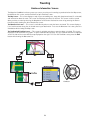
1
Magellan® RoadMate™
Reference Manual
Instructions for Operating the
Magellan RoadMate 360
*** IMPORTANT SAFETY WARNINGS ***
The Magellan RoadMate 360 is a vehicle-navigation aid designed to assist you in arriving at your
selected destinations. When using the Magellan RoadMate, these safety rules must be followed
to prevent accidents that can result in injury or death to yourself or others:
•
When driving, the need to view the display is minimal. Voice prompts will guide you to
your destination. The driver should enter data or program the unit only when the vehicle is
stopped. Only a vehicle passenger should enter data or program the unit while the vehicle
is moving.
•
It is your responsibility to comply with all traffic laws.
•
While every attempt is made to ensure that the database is accurate, roadways, points of
interest, and business and service locations may change over time. The database does not
include, analyze, process, consider, or reflect any of the following: legal restrictions (such
as vehicular type, weight, height, width, load and speed restrictions); road slope or grade;
bridge height, width, weight, or other limits; population density; neighborhood quality or
safety; availability or proximity of law enforcement, emergency rescue, medical, or other
assistance; construction work zones or hazards; road or lane closures; road, traffic, or
traffic facilities’ safety or condition; weather conditions; pavement characteristics or
conditions; special events; traffic congestion. It is your responsibility to disregard any
unsafe, hazardous, or illegal route suggestions.
•
Keep the Magellan RoadMate safe from extreme temperature conditions. For example, do
not leave it exposed to direct sunlight for an extended period of time.
•
Laws in some states prohibit wearing stereo headphones while operating a motor vehicle.
Please contact your state’s Department of Motor Vehicles for information.
•
Take care when mounting the unit in your vehicle, whether using the windshield mount or
other mount or accessories, that it does not obstruct the driver's view of the road, interfere
with the operation of the vehicle's safety devices such as air bags, or present a hazard to
occupants of the vehicle should the unit be dislodged while driving. You assume the risks
associated with damage to your vehicle or vehicle occupants as the result of your choices
in mounting the unit.
•
Please refer to the Read Me First document supplied with your Magellan RoadMate for
installation instructions.
© 2005 Thales Navigation, Inc. All rights reserved. The Magellan Logo, Magellan, RoadMate,
Turn it on and go, TrueView, TrueFix, and QuickSpell are trademarks of Thales Navigation. No
part of this user manual may be reproduced or transmitted in any form or by any means,
electronic or mechanical, including photocopying and recording, for any purpose other than the
purchaser’s personal use, without the prior written permission of Thales Navigation.
631264-01 A
Contact Information
If you need support for your Magellan RoadMate and you wish to contact Thales, please use the
following information to direct your questions/comments to the proper person.
Technical Support
If you need technical assistance or “how-to” help, or if you have a technical question about the
functionality of your Magellan product, please contact us on the Internet at www.magellangps.com or
reach us by fax or by phone.
Our Technical Support phone representatives are available Monday through Friday, 6:00 a.m. to 5:00
p.m. PST/PDT. After hours, you may leave a detailed voice mail message that will be returned within the
next business day.
Telephone: (866) 868-2259 or (909) 394-5000 (Outside North America)
You may also reach Technical Support by Fax: (909) 394-7050 [Attn: Tech. Support]; or E-Mail:
[email protected]
Warranty Service
To obtain warranty service on your unit, you must contact us for a return authorization before you ship
the product. Packages arriving at our dock without an RA will be refused.
To obtain an RMA, simply contact our Technical Support group at: Telephone: (866) 868-2259 or (909)
394-5000; Fax: (909) 394-7050 [Attn: Tech. Support]; or E-Mail: [email protected]
Customer Service
If you need to order accessories, you can call our Customer Service Department Monday through Friday,
6:00 a.m. to 5:00 p.m. PST/PDT, or visit our Web site at www.magellangps.com.
Telephone: (866) 339-0488 or (909) 394-5000 (Outside North America); Fax: (909) 394-7078.
2
Table of Contents
Information ....................................................................................................................... 1
Technical Support .....................................................................................................................2
Warranty Service .......................................................................................................................2
Customer Service .......................................................................................................................2
About Satellite Navigation ..............................................................................................................1
How Satellite Navigation Works ......................................................................................................1
Line of Sight ..............................................................................................................................1
Precision ...................................................................................................................................1
Placement of Your GPS Receiver for Optimal Satellite Reception .......................................................2
A Word on the Safe Usage of GPS Maps ..........................................................................................2
From Source to Destination .........................................................................................................2
GPS Maps and Your Safety ..........................................................................................................3
Care and Use of the Pre-Installed Secure Digital (SD) Card ...............................................................3
To Insert the SD Card: ................................................................................................................4
To remove the SD card: ..............................................................................................................4
Magellan RoadMate .......................................................................................................... 5
Front View .................................................................................................................................5
Rear View ..................................................................................................................................5
Left- and Right-Side Views .........................................................................................................6
Bottom View .............................................................................................................................6
Installation ....................................................................................................................... 7
Installing the Windshield Mount .....................................................................................................7
Installing the External Antenna .......................................................................................................8
Basic Operation ............................................................................................................... 10
Turning the Magellan RoadMate On ...........................................................................................10
Inputting Text Characters ..........................................................................................................11
Additional Characters (More) .....................................................................................................12
Numerical Characters (123) ......................................................................................................12
Using QuickSpell® and AutoFill™ .............................................................................................12
Help with Street Names ............................................................................................................13
Selecting Destinations ..................................................................................................... 14
Choosing the Route Method .........................................................................................................15
Changing the Route Method .........................................................................................................16
Cancelling a Planned Route .........................................................................................................17
Detouring from the Planned Route ................................................................................................18
Excluding a Maneuver in a Planned Route .....................................................................................18
Accessing Regions ......................................................................................................................19
Selecting a Destination Using “Select Address” .............................................................................21
Selecting a Destination Using “Address Book” ...............................................................................23
Previous Destinations ...............................................................................................................23
Routing to A Previous Destination ............................................................................................23
Saving a Previous Destination to your Address Book ...................................................................24
List Addresses .........................................................................................................................25
List All ..................................................................................................................................25
Route ................................................................................................................................26
Edit ..................................................................................................................................26
Delete ...............................................................................................................................27
List Favorites .........................................................................................................................27
Route ................................................................................................................................28
Edit ..................................................................................................................................28
Delete ...............................................................................................................................29
i
Table of Contents
Search Address Book ..............................................................................................................29
Route ................................................................................................................................30
Edit ..................................................................................................................................31
Delete ...............................................................................................................................31
Create New Entry .....................................................................................................................31
Select on Map ........................................................................................................................31
Select Address .......................................................................................................................33
Dining, ATM, Gas... ................................................................................................................35
Search POI by Name ..........................................................................................................35
Search Nearest POI ............................................................................................................38
Intersection ...........................................................................................................................41
Trip Planner ............................................................................................................................43
New ......................................................................................................................................43
Edit ......................................................................................................................................45
Delete, Rename .....................................................................................................................46
Delete ...............................................................................................................................47
Rename ............................................................................................................................47
Selecting a Destination Using “Dining, ATM, Gas...” ......................................................................49
Search POI by Name ................................................................................................................49
Nearby Current Position ..........................................................................................................49
Nearby City Center .................................................................................................................50
Search Nearest POI ..................................................................................................................51
Current Position .....................................................................................................................52
By City Center ........................................................................................................................53
By Airport ..............................................................................................................................54
Selecting a POI on the Map .......................................................................................................55
Selecting a Destination Using “Intersection” .................................................................................57
Traveling ........................................................................................................................ 59
Guidance Information Screens ......................................................................................................59
Map Screen .............................................................................................................................60
Changing the Map Zoom Levels .................................................................................................60
Maneuver List Screen ...............................................................................................................61
TrueView Screen ......................................................................................................................61
Current Location .........................................................................................................................62
Displaying Information About Your Current Location ....................................................................62
Save Location ..........................................................................................................................62
User Options ................................................................................................................... 63
User Option Menu .......................................................................................................................63
Trip Computer ............................................................................................................................64
Stopping or Starting the Trip Computer ......................................................................................64
Saving the Current Trip Report ..................................................................................................64
Resetting the Trip Computer .....................................................................................................65
Viewing a Saved Trip Report ......................................................................................................65
Deleting a Trip Report ..............................................................................................................66
Track Recorder ...........................................................................................................................67
Start Track Recorder ................................................................................................................67
Stop Track Recorder .................................................................................................................67
Save Track Record ...................................................................................................................68
View Track ...............................................................................................................................69
Delete, Rename Track ..............................................................................................................70
Configuration ..............................................................................................................................72
Brightness ...............................................................................................................................72
Volume ...................................................................................................................................72
ii
Table of Contents
Auto Power Off ........................................................................................................................73
Language ................................................................................................................................73
User Settings ..............................................................................................................................74
POI Selection ..........................................................................................................................74
Map Options ............................................................................................................................75
Map Orientation .................................................................................................................75
Units of Measure ................................................................................................................75
Map Guidance Option .........................................................................................................75
Select Map Color ......................................................................................................................75
Route Preferences ....................................................................................................................76
Split TrueView .........................................................................................................................76
Menu Colors ............................................................................................................................77
Tone Options ...........................................................................................................................77
Diagnostics ..............................................................................................................................78
Video Test .............................................................................................................................78
Touch Screen Test ..................................................................................................................78
Keypad Test ...........................................................................................................................78
Audio Test .............................................................................................................................78
Headphone Test .....................................................................................................................79
Product Information ................................................................................................................81
Simulator Mode ......................................................................................................................81
System Messages ...................................................................................................................82
User - Edit Name .....................................................................................................................82
Password Settings ....................................................................................................................83
Appendix ........................................................................................................................ 84
GPS Status Screen ...................................................................................................................84
GPS STATUS Screen Structure-first page .................................................................................84
Bad fix code ..........................................................................................................................84
GPS STATUS Screen Structure - second page ...........................................................................85
Typical GPS STATUS Screen Display ........................................................................................86
POI Categories .........................................................................................................................87
Specifications ..........................................................................................................................89
iii
Information
Information
About Satellite Navigation
Global satellite navigation is an exciting technology, providing enhanced productivity and accuracy in a vast number
of industries. It adds a new level of enjoyment and safety to a wide range of navigation, sports, and recreational
activities.
A Global Navigation Satellite System (GNSS) is a network of satellites that transmit high-frequency radio signals
containing time and distance data that can be picked up by a receiver, allowing users to pinpoint their precise
locations anywhere around the globe.
There are two Global Navigation Satellite Systems in operation: the U.S. Global Positioning System (GPS) and the
Russian GLObal NAvigation Satellite System (GLONASS). These systems are constantly being upgraded to meet
higher standards of reliability. A third GNSS named GALILEO, after the Italian astronomer of the early 1600s, is
being developed in Europe specifically to provide a higher standard of integrity and reliability, required to ensure the
safety of lives during transport by air, land and sea, without the use of additional augmentation systems.
While the GPS and GLONASS satellite networks are being developed to achieve maximum performance, SatelliteBased Augmentation Systems (SBAS) have been established to provide improved accuracy. SBAS provides
differential signal corrections for GPS and GLONASS transmissions with the use of ground stations and
geostationary satellites in specific regions. This is GNSS-1, the first phase in establishing the required integrity for
high-precision satellite navigation.
GNSS-2 requires the launching of new satellites into orbit and a complete upgrade of the existing satellite systems.
This second phase is already well underway. GALILEO, scheduled to begin service in 2008, is being developed to
meet the standards of GNSS-2 for rapid and reliable, certified precision positioning.
How Satellite Navigation Works
Global navigation satellites continuously transmit time and distance information as they orbit the earth in a precise
formation. Navigation satellite receivers use this information to calculate an exact location through triangulation.
Every point on Earth is identified by two sets of numbers called coordinates. These coordinates represent the exact
point where a horizontal line, known as latitude, crosses a vertical line, known as longitude. The receiver locks on to
at least three satellites and uses the information received to determine the coordinates of the receiving device.
By comparing the time the signals were transmitted from the satellites and the time they were recorded, the receiver
calculates how far away each satellite is. The distance of the receiver from three or more satellites reveals its
position on the surface of the planet. With these distance measurements, the receiver might also calculate speed,
bearing, trip time, distance to destination, altitude, and more.
The satellite-navigation device may display its position as longitude/latitude, Universal Transverse Mercator (UTM),
Military Grid (MG), or simply as a point on an electronic map. Many Thales Navigation receivers provide
comprehensive mapping data, making satellite navigation an easy tool to enhance your recreational and industrial
activities.
Line of Sight
Satellite-navigation receivers operate by line of sight with global-positioning satellites. This means that at least three
satellites must be in “view” of a receiver in order to calculate longitude and latitude. A fourth satellite must also be
within line of sight to calculate altitude. On average, eight satellites are continuously within line of sight of every
position on Earth; the more satellites in view, the more accurate the positioning.
Though the radio signals of navigation satellites will pass through clouds, glass, plastic, and other lightweight
materials, satellite-navigation receivers will not work underground or in other enclosed spaces.
Precision
On average, a satellite-navigation receiver is accurate to within 15 meters. Thales Navigation employs several
technologies to increase the accuracy of their professional and Magellan®-branded receivers. An accuracy of 3
meters or better is achieved using correction signals from satellite navigation-augmentation systems. In the U.S., an
accuracy of 3 meters is achieved using signal corrections from a network of ground stations and fixed-position
satellites known as WAAS (Wide-Area Augmentation System). Throughout Europe a similar system, EGNOS
(European Geostationary Navigation Overlay System), provides the same accuracy. In Asia, satellite navigation-signal
correction is provided by MSAS (Multifunctional Transport Satellite-based Augmentation System). Other ways to
1
Information
increase the accuracy of satellite navigation include the use of DGPS (Differential Global-Positioning System);
ground relay stations, set at known positions, transmit corrected satellite-navigation signals. Various methods and
applications of DGPS can increase satellite navigation accuracy from a few meters to within a few millimeters. Using
DGPS requires a differential-beacon receiver and antennae in addition to a satellite-navigation device. Accuracy can
also be increased using an RTK (Real-Time Kinematic) satellite-navigation system. This is a receiver capable of
transmitting a phase-corrected signal from a known position to one or more rover receivers.
A number of positioning errors can occur, limiting accuracy to within 15 to 25 meters. These errors are monitored
and compensated for in a number of ways:
Orbiting errors -- Occasionally a satellite's reported position does not match its actual trajectory. In the U.S., the
Department of Defense continuously monitors each satellite, making orbital corrections with onboard booster
rockets.
Poor geometry -- If all of the satellites within line of sight of a receiver are clustered closely together, or lined up
relative to the position of the receiver, the geometric calculations necessary for triangulating a position become
difficult and less reliable. The use of differential-correction signals from satellite-based augmentation systems or
DGPS can compensate for both orbital errors and poor geometry.
Multipath signals -- Signals may be reflected off tall buildings or other obstructions before reaching the receiver,
increasing the distance a signal travels and reducing accuracy.
Thales Navigation receivers make a number of complex mathematical calculations to effectively compensate for
other potential errors in positioning:
Atmospheric delay -- Satellite-navigation signals slow as they pass through the Earth's atmosphere. Thales
Navigation receivers calculate the average delay in nanoseconds to compensate.
Clock errors -- The clock built into a receiver is not as accurate as the atomic clock on a navigation satellite, which
is accurate to one second every million years. Each Thales Navigation receiver compensates for time differentials by
comparing the time signals of several satellites and adjusting its calculations and its clock to match.
Placement of Your GPS Receiver for Optimal Satellite Reception
FIrstly, before considering signal reception, it is important to understand that your GPS receiver is a sensitive piece
of equipment. You should never place it in an area of your vehicle where it may be struck by other items, or where
vibration may cause it to strike other items or parts of the vehicle. The windshield mount included in the box allows
you to place the receiver in such a way that the antenna can receive the satellite signal through the windshield
without being obstructed by other parts of the vehicle. However, tinted windows or other reflective coatings may
interfere with reception. In this case, it may be required to attach an external antenna (optional). The external
antenna mounts to the outside of your vehicle and is therefore not hampered by tinted windows. Other mounting
solutions are available but may require and external antenna.
External conditions also affect GPS signal reception. Although weather conditions do not affect the signal, tall
buildings and trees, driving through canyons, wooded areas, or tunnels, and sitting in a garage or covered parking
area will affect the GPS signal. The GPS receiver constantly monitors and updated the GPS signal status and will
reacquire the signal once it is clear of any obstructions.
A Word on the Safe Usage of GPS Maps
Just like paper maps, maps on GPS devices vary greatly in terms of information included and visual presentation.
Whether topographical maps, roadmaps or marine charts, each map and the data it presents is designed for a
specific purpose. For example, marine charts will often present only a minimal representation of roadways and are
not a substitute for street maps. Topographic maps usually provide minimal detail about bodies of water, and do not
contain marine navigational markers.
Maps also vary widely in scale: the smaller the scale, the more detailed the map. Therefore, when using GPS maps
(just as with paper maps) it is important to consider what type of map you are using in your explorations and to use
common sense.
From Source to Destination
Thales Navigation, maker of Magellan GPS products, is not a cartography company. We do not create the maps that
are used on our GPS devices. We seek to acquire map data from the best public and private sources available at the
2
Information
time of publication. Thales Navigation licenses* topographical maps, roadmaps, marine charts and points of interest
data from commercial and governmental cartographic sources that provide raw map data. Thales Navigation
processes and compresses the raw data into a format that makes it presentable and manageable to work on our GPS
devices. And to ensure that our map data is as robust as possible, data from multiple sources are often combined to
provide a better user experience for our customers. This processing does not alter the landforms, coordinates or
other spatial data that comes in the raw data. The accuracy of the maps is fundamentally dependent on the source
data used to create them. Map data changes frequently due to both natural and man-made causes. As a result,
governmental and commercial cartography companies must continuously review correct and improve upon their map
data. We release new versions of our maps on a regular basis to reflect these changes.
After processing the data, we test the compatibility of the map with our GPS devices to ensure that the products we
release work properly on our GPS devices. We also beta test our products to get customer feedback prior to release.
GPS Maps and Your Safety
Remember, your GPS device is an aid to navigation. It must be used with common sense and it is important that
users interpret GPS map data with a critical eye. Landscapes and roads change or may be impassable, trees and tall
buildings can obscure GPS signals and your GPS device may not always reflect the complete picture. When using
GPS, you must combine the information provided by your GPS map with your relevant local knowledge, road
signage, buoys, depth soundings and changing local conditions to generate a complete understanding of your
situation.
It is your responsibility to ensure compliance to all traffic laws, including pedestrian observance of crosswalks, and
to use good judgment while operating the Magellan GPS receiver. Safety must be your primary concern. The
Magellan GPS receiver must not be used while engaged in any activity requiring the user's full attention to the
environment. For instance, the Magellan GPS receiver should be operated only by vehicle passengers or by the driver
when the vehicle has come to a complete stop. The driver must not attempt to view the display while driving. A
climber must not attempt to view the display while negotiating treacherous terrain. Disregard any unsafe, hazardous
or illegal route suggestions.
Magellan maps do not include, analyze, process, consider or reflect any of the following: legal restrictions (such as
weight, height, width, load and speed restrictions); road slope or grade; bridge height, width, weight or other limits;
population density; neighborhood quality or safety; availability or proximity of law enforcement, emergency rescue,
medical or other assistance; construction work zones or hazards; road, sidewalk or waterway closures or conditions;
weather conditions; pavement characteristics or conditions; special events; traffic congestion; time of day.
*Thales Navigation licenses map data from governmental sources such as, but not limited to, US Geological Survey
(USGS), the National Oceanic and Atmospheric Administration (NOAA-NOS) and the Canadian Hydrographic
Service (CHS). Thales Navigation licenses map data from commercial cartography companies such as Navigation
Technologies, Navionics, DMTI and C-Map.
Care and Use of the Pre-Installed Secure Digital (SD) Card
The Magellan RoadMate 360 comes with an SD card that is pre-installed in the unit. The SD card is a small,
lightweight flash memory device that allows increased data storage for your Magellan RoadMate. The compact size is
ideal for storing large amounts of data and not taking a lot of physical space. This card contains map data that
covers the entire United States and Canada and should never need to be removed. However, in the event that the SD
Card should be removed from the unit, reinstalling it is simple and fast.
The SD card slot on your Magellan RoadMate employs what is called a “push-push” method of locking and
releasing. In other words, when you insert the card you must push it to lock it in, and to release it you must push it
also. It is important to remember to never remove or insert the SD card when the unit is on. Always make sure to
turn the power off when removing or inserting the SD card. Failure to do so may cause the unit or the data on the SD
card to become corrupt or unusable.
3
Information
To Insert the SD Card:
Peel back the rubber gasket to expose the SD card slot. Do not
completely remove the rubber gasket.
The SD card can only be inserted in one direction. Do not force
the card into the slot.
Insert the SD card into the slot with the metal contacts going in
first and the beveled edge to the left.
Push the SD card until you hear a click.
Metal Contacts
Close the rubber gasket.
Beveled Edge
To remove the SD card:
Peel back the rubber gasket to expose the SD card slot. Do not
completely remove the rubber gasket.
Push the SD card until you hear a click. Do not attempt to pull
the card out of the slot
Remove the SD card from the slot.
Close the rubber gasket.
4
Magellan RoadMate
Magellan RoadMate
Front View
1
2
3
4
5
6
7
Power
Zoom In
Zoom Out
View
Locate
Option
Cancel
8
Enter
9
Navigation Key
Press to turn the Magellan RoadMate on or off.
While viewing the map, press to enlarge the map view
While viewing the map, press to shrink the map view
Switch between Map, Maneuver List, and TrueView
Show details of your current location and save it to your address book
Access customizable features
Cancel changes and selections
Confirm menu selections and text input, repeats last voice prompt
during routing while on the Map Screen
Select menu options, characters, and pan map
Rear View
1
Antenna
Rotate up when in use to receive signals from the GPS satellite network
5
Magellan RoadMate
Left- and Right-Side Views
1
2
3
USB Connection
Power Connection
Headset Connection
Connect to your PC to upload map data or software updates
Plug into your vehicle or at home
Plug in an earpiece for noisy areas
Bottom View
1
SD Card Slot
Secured Digital (SD) Card slot
6
Installation
Installation
Installation
Take care when mounting the Magellan RoadMate in your vehicle, whether using the windshield mount or another
mount, that it does not obstruct the driver’s view of the road. Make sure that the placement of the Magellan
RoadMate and cable does not interfere with the operation of vehicle safety devices, such as air bags. You assume
the risks associated with damage to your vehicle or your vehicle’s occupants as a result of how you choose to mount
the Magellan RoadMate.
Installing the Windshield Mount
Slide the mount assembly onto the windshield mount bracket attached to the
back of the unit.
Press the windshield mount to the glass and rotate the locking lever toward the
glass until it locks into place.
Plug the power cable into the unit.
Plug the cigarette lighter connector into an appropriate 12V receptacle in your
car.
7
Installation
Rotate the antenna upward.
Installation is complete. You are ready to turn the Magellan RoadMate on and
go.
Installing the External Antenna
The external antenna (not included) provides faster satellite fix times and greater signal strength. Because it is
mounted outside of the vehicle, it is not affected by reflective coatings on windows and has an unobstructed line of
sight to the satellites.
Remove the standard antenna by rotating it completely upward.
Hold the antenna at the pivot point and pull straight off the back of the unit.
Attach the antenna to a flat, horizontal portion of the roof of your vehicle. The
antenna is magnetic. Do not use any adhesives to attach the antenna to your
vehicle.
8
Installation
Route the antenna cable along the weatherstripping of the door and through the
vehicle interior so it such a way that it does not interfere with the operation of
the vehicle.
Plug the end of the external antenna into the socket on the back of the unit.
Replace the unit onto the mount in your vehicle. There is no special settings to
make to the unit in order to use the external antenna. Turn the unit on and
operate normally.
9
Basic Operation
Basic Operation
Turning the Magellan RoadMate On
Press the Power button. The Power button is located on the left side of the unit.
See “Front View” on page 5 for button locations.
If power is properly connected, a logo screen is displayed.
Next, you will need to select the language you wish to use for your Magellan
RoadMate. The language selection will be used for menu text and audible voice
prompts.
The Warning screen will appear. At the bottom of the screen, select your preferred
user. The Magellan RoadMate can be personalized for three different users.
The Magellan RoadMate will display a series of help screens to guide you through
the selection of map regions. Select OK to proceed to the next screen or, Select
Don’t Show Again to proceed to the next screen and not show the Help sequence at
start-up next time.
Next you will need to decide on which regions you travel within most often. Select
OK to proceed to the next screen or, select Back to view the previous screen.
10
Basic Operation
Selecting only one region will greatly speed up the time it takes to search for
addresses and POIs. Select OK to proceed to the next screen or, select Back to
view the previous screen. If you do not wish to view this screen each time you
select a map region, select Don’t Show Again.
Select the geographical area you most often travel within.
Next, to narrow down further, select the regions you most often travel within. If you
often travel between states that are not contained within one region, you may want
to select both regions. Select Mark All to choose all available regions, select Clear
All to deselect all regions. When you have selected at least one region, select Save.
The region is active and the Select Destination screen will appear.
Inputting Text Characters
Whenever you need to input names, street addresses,
etc., the Magellan RoadMate will display a key pad.
Touch the screen or use the navigation key to input
text.
Cancel
Space Bar
Backspace
Alphabetic Characters
Numerical Character Menu
Accept Entry
Additional Characters Menu
11
Basic Operation
Additional Characters (More)
When you are entering information, you may need to add punctuation or other special
characters. When available, select More to bring up the additional characters.
Numerical Characters (123)
You may also need to add numbers to your text. When available, select 123 to bring
up the numeric keypad.
Using QuickSpell® and AutoFill™
The Magellan RoadMate uses QuickSpell technology to provide you with the fastest method possible to enter
characters. QuickSpell eliminates the possibility of a misspelled word or looking for a city or street that is not in the
database. As you begin entering characters, the QuickSpell feature of the Magellan RoadMate dims out those
characters that are not available, thereby speeding up the process of entering data.
With AutoFill, as you enter characters the next name in the database matching the characters entered is displayed in
the speller.
Suppose that you need to input the name of a city, in this case, San Francisco.
Select “S”. Also as you enter characters, the next city in the database matching the
characters inputted will show in the speller.
Continue to enter characters. When you have entered enough characters to match
the desired city, it will show in the speller. OK.
12
Basic Operation
However, because the city search lists all cities in the database matching the
characters inputted, it is possible to select a city that does not contain the street
selected previously.
In this case, you can either select Street to re-enter the street name; select City to
choose only form cities that contain the desired street; or choose Back to continue
spelling the city name. For this example select City.
Enter the name of the desired city. Notice this time you enter fewer characters to
match the desired city in the speller.
Help with Street Names
When entering names of streets, it is important to follow a few simple guidelines.
Press the Help button on the Spell Street screen.
First, only enter the street name, do not enter any prefixes or suffixes such as
“North” or “N”, “South” or “S”. Do not enter the street type such as “St” or “Ave”.
For example, if the street you are looking for is “N. Foothill Blvd.”, you would
simply enter “Foothill”.
Second, when entering numbered streets, use the numeric keypad to enter the
street followed by entering the identifier using the alpha keypad. Do not spell the
street name. For example, if the street you are looking for is “4th Street”, use the
numeric keypad to enter the number “4”, then, switch back to the alpha keypad to
enter “th”. Do not spell “Fourth” unless the name of the street starts with the word “Fourth” such as “Fourth Army
Rd.”
13
Selecting Destinations
Selecting Destinations
Selecting Destinations
Select Region†
Select Address
Previous Destinations
List Addresses
Address Book
Create New Entry
Trip Planner
Search POI by Name
Select Region†
Dining, ATM, Gas...
Search Nearest POI
Intersection
† If more than one region is active, you will be asked
to select the region from which to search.
14
Select Region†
Selecting Destinations
Choosing the Route Method
Every route is calculated based on the Route Method criteria selected. Every time a new destination is selected, the
Magellan RoadMate prompts you for the method that will be used to calculate the route.
Shortest Time: This selection calculates a route that should take the least amount
of time using known speed limits, streets, and other information in the database.
Other factors such as traffic conditions, road closures, and emergency activity are
not factors in the calculation of shortest time.
Avoid Toll Roads: This option calculates the route by excluding known toll roads
from the calculation whenever possible. This option may not reflect the shortest
time.
Least Use of Freeways: This selection calculates the route by avoiding freeways
whenever possible.
Most Use of Freeways: This selection calculates the route by using freeways as
much as possible.
15
Selecting Destinations
Changing the Route Method
While viewing the Map screen, the Maneuver List screen, or the
TrueView 3D screen, press the Cancel button.
Select Route.
Select the new Route Method.
The route will be re-calculated using the new Route Method chosen and the Map
screen will be displayed. Press the View button to see the Maneuver List with the new
route.
16
Selecting Destinations
Cancelling a Planned Route
While viewing the Map screen, the Maneuver List screen, or the
TrueView 3D screen, press the Cancel button.
Select Yes to cancel the route and display the Select Destination
screen.
Select No returns the display to the last viewed screen.
17
Selecting Destinations
Detouring from the Planned Route
If you detour from the calculated route, the Magellan RoadMate will get you back on course in one of two ways:
1. If you detour from the calculated route to stop at a gas station or a convenience store, and the unit shuts off
as you turn off the car, or you turn off the unit manually, when you return to your vehicle and the unit is
turned back on, you are presented with a screen asking if you want to resume your route. Selecting
“Resume” causes the Magellan RoadMate to recalculate the route using the same destination as before,
selecting “Cancel” clears the route and displays the Select Destination screen.
2. If you detoured from the calculated route due to a traffic jam or construction, the Magellan RoadMate will
automatically recalculate the route to your destination based on your new location.
By default, the Magellan RoadMate will continue to recalculate the route as long as you choose to keep it active.
Excluding a Maneuver in a Planned Route
While traveling or setting up your destination, you may find it necessary to exclude one of the maneuvers in the
Maneuver List. This could be due to an accident or street maintenance you want to avoid. The Magellan RoadMate
provides you with tools to select a specific maneuver, exclude it from the planned route, and recalculate the route
when possible.
Within an active planned route and while viewing the Guidance screen, press View.
Select the maneuver instruction to be excluded.
The details for the maneuver are displayed. Select Exclude.
The trip will be re-calculated, excluding the maneuver selected. This calculation is
done using the same Route Method that was chosen when the destination was
selected. After the route is recalculated, the Map screen is displayed.
18
Selecting Destinations
Accessing Regions
When you first start-up your Magellan RoadMate, you were asked to select a default region. This region is one you
travel within most often. By having only one region active, the time it takes to search for an address is greatly
decreased. If you have selected more than one active region, when you search for an address, you will be asked to
narrow down the search by selecting which active region the address is in. If the address you are searching for is not
within any active region, you can select the Globe button to activate the region you wish to search from.
Select the Globe.
A dialog box will appear with the active region status. Select Yes.
Next you will need to decide on which regions you travel within most often. Select
OK to proceed to the next screen.
Selecting only one region will greatly speed up the time it takes to search for
addresses and POIs. Select OK to proceed to the next screen or, select Back to
view the previous screen. If you do not wish to view this screen each time you
select a map region, select Don’t Show Again.
Select the geographical area.
19
Selecting Destinations
Select the region you wish to activate. Select Mark All to choose all available
regions, select Clear All to deselect all regions. When you have selected at least
one region, select Save.
If you select more than one region to activate, you will be prompted to select the
region when searching for an address. Select OK.
Select OK.
If you select only one region to make active, all address and POI searches will be
from this region.
Select OK.
The region is active and the Select Destination screen will appear.
20
Selecting Destinations
Selecting a Destination Using “Select Address”
A destination can be created by entering the street address that you want to go to. This address is not automatically
added to your Address Book but is saved to your Previous Destination list (which is part of the address book menu)
if you have routed to it.
From the Select Destination screen, select Select Address.
If more than one region is active, you will be asked to select the region from which
to search.
Enter the base name for the street. For example, if you are searching for “Overland
Court” you would enter “OVERLAND”. As you type, the AutoFill will show the next
possible match from the database. Select OK. For additional help with entering
street names, see “Help with Street Names” on page 13.
Next, if the street you are looking for is within two to five cities, select the desired city
from the list. If the desired street is within more than six cities, you will need to narrow
down your search further by entering the city name. Again, as you type, AutoFill will
display the next possible match. Select OK.
Enter the street address. The acceptable range of numbers is displayed at the top of
the screen. If you do not know the exact address, just select Done and the Magellan
RoadMate will route you to the lowest number in the range. When an acceptable street
address has been entered, select Done to continue
21
Selecting Destinations
Select the desired Route Method.
The Magellan RoadMate will calculate the route. When the calculations are
complete, the Map screen will be displayed
22
Selecting Destinations
Selecting a Destination Using “Address Book”
The Address Book can store up to 200 addresses for each of the three users. When you select “Address Book” you
are given four options. Selecting “Previous Destinations” lets you select from a list of the last 50 destinations you
have routed to with the option of saving them to your address book. “List Addresses” displays a list of all the
addresses you have stored in your Address Book. “Create New Entry” lets you create a new address and store it in
your address book. “Trip Planner” lets you select two or more addresses from your Address Book to route to in
sequence.
Previous Destinations
Routing to A Previous Destination
From the Select Destination screen, select Address Book.
Select Previous Destinations.
Select from the list of previous destinations.
Select Route to be routed to the selected city.
Select the desired Route Method.
23
Selecting Destinations
The Magellan RoadMate will calculate the route. When the calculations are
complete, the Map screen will be displayed
Saving a Previous Destination to your Address Book
From the Select Destination screen, select Address Book.
Select Previous Destinations.
Select the address that you wish to save.
To save this destination to the Address Book, select Edit.
The top line (Name) and the bottom line (Information) can be edited. The address
cannot be changed. Select the line you want to modify.
24
Selecting Destinations
Enter the desired text. Select OK.
You can also add this address to your Favorites list. Select Favorites.
When you are satisfied with the information, select Save.
The address is saved to the Address Book. Press Cancel to return to the Previous
Destinations screen.
List Addresses
List All
From the Select Destination screen, select Address Book.
Select List Addresses.
Select List All.
25
Selecting Destinations
Select the destination from the list of addresses in the Address Book and press
Enter. You will then have the option of routing to, editing, or deleting this address.
Route - Select Route.
Select the desired Route Method.
The Magellan RoadMate will calculate the route. When the calculations are
complete, the Map screen will be displayed.
Edit - Select Edit.
Click on either the top line (name) or the bottom line (information) and enter the
desired text.
26
Selecting Destinations
Select Save to save the changes and return to the Address Book screen.
Delete - Select Delete.
A dialog box will appear prompting you to confirm the deletion. Select Yes.
The address has been deleted from your address book and you are returned to the
Select Destination screen.
List Favorites
From the Select Destination screen, select Address Book.
Select List Addresses.
27
Selecting Destinations
Select List Favorites.
All of the addresses marked as favorites will be displayed.
Route - Select Route.
Select the desired Route Method.
The Magellan RoadMate will calculate the route. When the calculations are
complete, the Map screen will be displayed.
Edit - Select Edit.
Click on either the top line (name) or the bottom line (information) and the desired
text.
28
Selecting Destinations
Select Save to save the changes and return to the address screen.
Delete - Select Delete.
A dialog box will appear prompting you to confirm the deletion. Select Yes.
The address has been deleted from your address book and you are returned to the
Select Destination screen.
Search Address Book
From the Select Destination screen, select Address Book.
Select List Addresses.
29
Selecting Destinations
Select Search Address Book.
Enter the characters that may be part of the name you are searching for in your
address book. When you have finished, select OK
A list of addresses matching your criteria is shown. Select the address you wish to
use. You will then have the option of routing to, editing, or deleting this address.
Route - Select Route.
Select the desired Route Method.
The Magellan RoadMate will calculate the route. When the calculations are
complete, the Map screen will be displayed.
30
Selecting Destinations
Edit - Select Edit.
Click on either the top line (name) or the bottom line (information) and the desired
text.
Select Save to save the changes and return to the address screen.
Delete - Select Delete.
A dialog box will appear prompting you to confirm the deletion. Select Yes. The
address has been deleted and you are returned to the Address Book screen.
Create New Entry
Select on Map
From the Select Destination screen, select Address Book.
31
Selecting Destinations
Select Create New Entry.
Select Select on Map.
Touch the screen and drag the map to a point near to the desired address. Press
the Enter key.
A dialog box will appear prompting you to edit the information. Select Edit Name.
Enter a name for the address. When you are finished, select OK.
Select Save.
32
Selecting Destinations
The location is saved to your address book and you are returned to the map screen.
Press Cancel to resume normal routing.
Select Address
From the Select Destination screen, select Address Book.
Select Create New Entry
Select Select Address.
If more than one region is active, you will be asked to select the region from which
to search.
33
Selecting Destinations
Enter the base name for the street. For example, if you are searching for “Overland
Court” you would enter “OVERLAND”. As you type, the AutoFill will show the next
possible match from the database. Select OK. For additional help with entering street
names, see “Help with Street Names” on page 13.
Next, if the street you are looking for is within two to five cities, select the desired city
from the list. If the desired street is within more than six cities, you will need to narrow
down your search further by entering the city name. Again, as you type, AutoFill will
display the next possible match. Select OK.
Enter the street address. The acceptable range of numbers is displayed at the top of
the screen. If you do not know the exact address, just select Done and the Magellan
RoadMate will route you to the lowest number in the range. When an acceptable street
address has been entered, select Done to continue
A dialog box will appear prompting you to edit the information. Select Edit Name.
Enter a name for the address. When you are finished, select OK.
If you wish, you can select Favorite to add this address to your Favorites list. Select
Save.
34
Selecting Destinations
You are returned to the Address Book screen.
Dining, ATM, Gas...
From the Select Destination screen, select Address Book.
Select Create New Entry
Select Dining, ATM, Gas....
Search POI by Name - This function allows you to search for a specific point of
interest and save it to your address book. Select Search POI by Name.
If more than one region is active, you will be asked to select the region from which
to search.
35
Selecting Destinations
Nearby Current Position. This function allows you to search for the named POI
nearest to your present position starting with the closest. Select Nearby Current
Position.
Select the POI category.
Enter the first few characters for the POI name. After you have selected the
characters, select OK.
Use the navigation key to scroll the list up or down and select the desired POI.
A dialog box will appear prompting you to edit the information. You can choose to
keep the default name. If you wish, you can select Favorite to add this address to
your Favorites list. Select Save.
You are returned to the Address Book screen.
36
Selecting Destinations
Nearby City Center. This function allows you to search for the named POI closest to
the geographical center of a city. Select Nearby City Center.
Enter the first few characters for the city name. After you have selected the
characters, select OK.
Select the POI category.
Enter the first few characters for the POI name. After you have selected the
characters, select OK.
Use the navigation key to scroll the list up or down and select the desired POI.
A dialog box will appear prompting you to edit the information. You can choose to
keep the default name. If you wish, you can select Favorite to add this address to
your Favorites list. Select Save.
37
Selecting Destinations
You are returned to the Address Book screen.
Search Nearest POI - This function lets you search for a point of interest from three
criteria and save it to your address book: Current Position, By City Center, and By
Airport. Select Search Nearest POI.
If more than one region is active, you will be asked to select the region from which
to search.
Current Position. This option lets you find a specific point of interest based on
where you are at the time. Select Current Position.
Select the POI category (if available, select the sub-category).
Use the navigation key to scroll the list up or down and select the desired POI.
38
Selecting Destinations
A dialog box will appear prompting you to edit the information. You can choose to
keep the default name. If you wish, you can select Favorite to add this address to
your Favorites list. Select Save.
You are returned to the Address Book screen.
By City Center. This option lets you find a specific point of interest closest to a
chosen city center. Select By City Center.
Enter the first few characters for the city name. After you have selected the
characters, select OK.
Use the navigation key to scroll the list up or down and select the desired city.
Select the POI category (if available, select the sub-category).
39
Selecting Destinations
Use the navigation key to scroll the list up or down and select the desired POI.
A dialog box will appear prompting you to edit the information. You can choose to
keep the default name. If you wish, you can select Favorite to add this address to
your Favorites list. Select Save.
You are returned to the Address Book screen.
By Airport. This option lets you find a specific point of interest closest to a chosen
airport. Select By Airport.
Enter the first few characters for the Airport name. After you have selected the
characters, select OK.
Use the navigation key to scroll the list up or down and select the desired Airport.
40
Selecting Destinations
Select the POI category (if available, select the sub-category).
A list of available POIs that match your criteria is shown. Use the navigation key to
scroll the list up or down and select the desired POI.
A dialog box will appear prompting you to edit the information. You can choose to
keep the default name. If you wish, you can select Favorite to add this address to
your Favorites list. Select Save.
You are returned to the Address Book screen.
Intersection
From the Select Destination screen, select Address Book.
Select Create New Entry
41
Selecting Destinations
Select Intersection.
If more than one region is active, you will be asked to select the region from which
to search.
Enter the first few characters for the first street. After you have selected the
characters, select OK.
Use the navigation key to scroll the list up or down and select the desired street.
Select the city that the street is in. If the selected street is located in only one city,
this screen will not appear.
Enter the first few characters for the second street. After you have selected the
characters, select OK.
42
Selecting Destinations
Use the navigation key to scroll the list up or down and select the desired street. It
is possible to select a non-intersecting street. In that case, a warning screen will
appear. Press Cancel to go back and re-enter the street name.
Click on either the top line (name) or the bottom line (information) and enter the
desired text.
Select Save to save the changes and return to the Address Book screen.
Trip Planner
The Trip Planner enables you to plot multiple destinations and save them as a trip. This feature is useful when
planning a vacation, making deliveries, or running errands. Each user can define up to 20 trips with 20 destinations
each. Each different destination will be saved in the address book. Note however, that only 200 addresses can be
saved per user.
New
You can create trips from addresses stored in your address book.
From the Select Destination screen, select Address Book.
Select Trip Planner
43
Selecting Destinations
Select New.
Enter a name for the trip and select OK
Your trip name will be displayed, followed by your address list.
Select the addresses you wish to use in your trip in the order you wish them to be
listed. When you have finished, select Done: [trip name].
You will be taken back to the Trip Planner screen. At this point you can choose to
route to your new trip.
Press Guide Me.
44
Selecting Destinations
Select the trip you created.
Select the first point of the trip you wish to route to.
Select the desired Route Method.
The Magellan RoadMate will calculate the route. When the calculations are
complete, the Map screen will be displayed. When you arrive at your first point the
Magellan RoadMate will notify you. Selecting Cancel or, if you turn off your car and
turn it back on, the Magellan RoadMate will ask you to resume trip guidance.
Select Resume to be routed to the next address in your trip. Select Cancel to stop
trip guidance.
Edit
Editing your trip allows you to add, delete, or change the order of the points in your
trip.
From the Select Destination screen, select Address Book.
Select Trip Planner
45
Selecting Destinations
Select Edit.
Select the Trip you wish to edit.
Select any of the points of the trip. A submenu will appear giving you the option of
adding another point to your trip, moving the selected point up or down, or deleting
the selected point.
When you are finished making changes, press the Cancel button to return to the
Trip Planner screen.
Delete, Rename
From the Select Destination screen, select Address Book.
Select Trip Planner.
46
Selecting Destinations
Select Delete, Rename.
Delete - Select Delete.
Select the trip you wish to delete.
A dialog box will appear prompting you to confirm your selection. Select Yes.
The trip has been deleted.
Rename - Select Rename.
47
Selecting Destinations
Select the trip you wish to rename.
Use the backspace key to erase the name, then enter the new name. When you are
finished, select OK.
The trip has been renamed.
48
Selecting Destinations
Selecting a Destination Using “Dining, ATM, Gas...”
Points of Interest (commonly referred to as POIs), include businesses, recreation areas, landmarks, or other services.
These range from restaurants, parks, and gas stations, to hotels and city centers. The purpose of the POI database
(accessed through the “Dining, ATM, Gas...” menu option) is to provide you a list of popular destinations that you
might be interested in going to, without having to add them to your address book manually. These POIs are very
useful while traveling in an unfamiliar city.
Search POI by Name
From the Select Destination screen, select Dining, ATM, Gas....
Select Search POI by Name.
If more than one region is active, you will be asked to select the region from which
to search.
Nearby Current Position
This function allows you to search for the named POI nearest to your present
position starting with the closest. Select Nearby Current Position.
Select the POI category.
49
Selecting Destinations
Enter the first few characters for the POI name. After you have selected the
characters, select OK.
Use the navigation key to scroll the list up or down and select the desired POI.
Select the desired Route Method.
The Magellan RoadMate will calculate the route. When the calculations are
complete, the Map screen will be displayed
Nearby City Center
This function allows you to search for the named POI closest to the geographical
center of a city. Select Nearby City Center.
Enter the first few characters for the city name. After you have selected the
characters, select OK.
50
Selecting Destinations
Select the POI category.
Enter the first few characters for the POI name. After you have selected the
characters, select OK.
Use the navigation key to scroll the list up or down and select the desired POI.
Select the desired Route Method.
The Magellan RoadMate will calculate the route. When the calculations are
complete, the Map screen will be displayed
Search Nearest POI
Select Dining, ATM, Gas....
51
Selecting Destinations
Select Search Nearest POI.
If more than one region is active, you will be asked to select the region from which
to search.
Current Position
This option lets you route to a specific point of interest based on where you are at
the time. From the Select Current Position.
Select the POI category (if available, select the sub-category).
Use the navigation key to scroll the list up or down and select the desired POI.
Select the desired Route Method.
52
Selecting Destinations
The Magellan RoadMate will calculate the route. When the calculations are
complete, the Map screen will be displayed
By City Center
This option lets you route to a specific point of interest closest to a chosen city
center. Select By City Center.
Enter the first few characters for the city name. After you have selected the
characters, select OK. If you wish, you may enter the entire city name.
Use the navigation key to scroll the list up or down and select the desired city.
Select the POI category (if available, select the sub-category).
Use the navigation key to scroll the list up or down and select the desired POI.
53
Selecting Destinations
Select the desired Route Method.
The Magellan RoadMate will calculate the route. When the calculations are
complete, the Map screen will be displayed
By Airport
This option lets you route to a specific point of interest closest to a chosen airport.
From the Select By Airport.
Enter the first few characters for the Airport name. After you have selected the
characters, select OK. If you wish, you may enter the entire Airport name.
Use the navigation key to scroll the list up or down and select the desired Airport.
Select the POI category (if available, select the sub-category).
54
Selecting Destinations
A list of available POIs that match your criteria is shown. Use the navigation key to
scroll the list up or down and select the desired POI.
Select the desired Route Method.
The Magellan RoadMate will calculate the route. When the calculations are
complete, the Map screen will be displayed
Selecting a POI on the Map
While viewing the Map screen, you can select a POI icon and be routed to it, or save it to you address book.
Touch the POI on the screen.
A dialog box will appear giving you information on the POI. Select Route.
Select the desired Route Method.
55
Selecting Destinations
The Magellan RoadMate will calculate the route. When the calculations are
complete, the Map screen will be displayed
56
Selecting Destinations
Selecting a Destination Using “Intersection”
Intersections are very common markers for routing when you don’t know the actual address. The Magellan RoadMate
can route you to an intersection of two streets contained within the active detailed map.
From the Select Destination screen, select Intersection.
If more than one region is active, you will be asked to select the region from which
to search.
Enter the first few characters for the first street. After you have selected the
characters, select OK.
Use the navigation key to scroll the list up or down and select the desired street.
Select the city that the street is in. If the street is in only one city, this screen will
not appear.
Enter the first few characters for the second street. After you have selected the
characters, select OK. It is possible to enter an non-intersecting street. In that
case, a warning screen will appear. Press the Cancel key to go back and re-enter
the street name.
57
Selecting Destinations
Use the navigation key to scroll the list up or down and select the desired street.
Select the desired Route Method.
The Magellan RoadMate will calculate the route. When the calculations are
complete, the Map screen will be displayed
58
Traveling
Traveling
Guidance Information Screens
The Magellan RoadMate has three screens you can use to assist you in traveling to your destination: the Map screen,
the Maneuver List screen, and the TrueView (or Split TrueView) screen.
The Map Screen — This screen displays a map of your surrounding area, along with the planned route (if calculated)
and information about the route. This screen also displays your direction of travel. This screen can be accessed
when you have no route by selecting the Map button on the Select Destination screen or by pressing the View or
Cancel key while viewing the Select Destination screen.
The Maneuver List Screen — This screen is available only when a route has been calculated. This screen displays a
list of each maneuver along the calculated route to your destination. To access the Maneuver List screen, press the
View button while viewing the Map screen.
The TrueView/Split TrueView Screen — This screen is available only when a route has been calculated. This screen
displays the next maneuver as a graphic. In Split TrueView mode (see page 76), the TrueView maneuver is displayed
on the left side of the screen with the map displayed on the right. To access the TrueView screen, press the View
button while viewing the Maneuver List.
View Button
View
59
Traveling
Map Screen
The Map screen is the most commonly used screen in the Magellan RoadMate. It provides you with detailed
information about where you are and where you are going.
Current Road
Planned Route (pink)
POI Icon
Position Cursor
Next Road
Next Maneuver
Direction of Travel and
GPS Signal Strength
Distance to Next Maneuver
Estimated Time to Destination
Direction of Destination
Distance to Destination
As you travel, the Map screen constantly updates your location. It provides you with not only a map but also a visual
indication of where you are on the map.
If the Magellan RoadMate loses the satellite signal for more than 15 seconds and is unable to compute your
location, the display will automatically switch to the Maneuver List screen. This will give you the information needed
for your next maneuver. While viewing the map screen, touching a POI icon will give you the option of routing to that
point. See “Selecting a POI on the Map” on page 55.
Changing the Map Zoom Levels
While in the Map screen, you can zoom in on (enlarge) the
map or zoom out from (shrink) the map. The zoom levels
range from 130 ft. to 1665 mi.
Zoom In Button
Zoom Out Button
60
Traveling
Maneuver List Screen
Next Maneuver
Direction of Travel and
GPS Signal Strength
Distance to Next Maneuver
1/10 Mile Countdown
Distance to Destination
Estimated Time to Destination
Direction of Destination
TrueView Screen
Direction of Travel and
GPS Signal Strength
Distance to Next Maneuver
1/10 Mile Countdown
Distance to Destination
Estimated Time to Destination
Direction of Destination
61
Traveling
Current Location
Displaying Information About Your Current Location
Whenever you want to view information about your present location you can press the Locate
button.
This screen displays the name of the street you are currently traveling on, the city and
state, your current heading, speed and latitude and longitude coordinates. It also
displays the distance to and name of the next street, and the distance from and name
of the previous street.
Save Location
If you are traveling and you wish to save a location that is not in the database, say a photo spot
or a fishing spot, you can save it to your address book. Press the Locate button.
Select Save Location.
Select Edit Name.
Edit the name of the location. Select OK.
Select Save. The address is saved to your address book and you are returned to the
last viewed screen.
62
User Options
User Options
User Option Menu
User Options enable you to customize the Magellan RoadMate and take advantage of
its data recording capabilities. User Options can be accessed from any screen by
pressing the Option button.
The User Options section of Magellan RoadMate provides you with four options:
Trip Computer – Displays useful information about your trip such as mileage, that can be saved for future reference. Ideal for the business traveler who needs to record mileage and time spent on the road.
Track Recorder – Records a graphical representation of where you’ve been that you can save and view on the
Magellan RoadMate screen.
Configuration – Lets you change the audio, video, language, and power option settings of the Magellan RoadMate.
User Settings – Lets you further customize the Magellan RoadMate.
63
User Options
Trip Computer
The Trip Computer is a valuable tool for recording the mileage and time spent driving while on vacation or on a
business trip. The information for the trip can be saved to the Magellan RoadMate as a report and viewed at any
time, giving you easy access to previous and current trip information.
When you begin a new trip and you need to record the information, access the Trip Computer. There, you can save
the information displayed for the current trip (if needed) and reset the Trip Computer to zero in preparation for your
new trip.
Press the Option button and select Trip Computer.
Select Current.
The data for the current trip is displayed. By default, the trip will be running and
recording data from the first time it is turned on. From this screen, the Trip
Computer can be restarted, stopped, reset or saved.
Stopping or Starting the Trip Computer
Select Stop to stop the current trip.
Select Start to resume the current trip.
The top of the display will show “Running...” or “Stopped,” depending on the
current status of the Trip Computer.
Saving the Current Trip Report
Select Save.
64
User Options
Use the keypad to enter a name for the saved Trip Report and select OK.
Your trip is saved and you are returned to the current trip screen.
Resetting the Trip Computer
Select Reset. The values for the Trip Computer will be set to zero. Resetting the Trip
Computer will also set the status of the computer to “Running...” if it had been
stopped previously.
Viewing a Saved Trip Report
From any screen, press the Option button. Select Trip Computer.
Select the Trip Report to be viewed.
The saved Trip Report is displayed. When you are done viewing the saved Trip
Report, you can press Cancel twice to be returned to the User Options screen.
65
User Options
Deleting a Trip Report
From any screen, press the Option button. Select Trip Computer.
Select the Trip Report to be deleted.
The details of the Trip Report are displayed. Select Delete.
Select Yes to confirm.
The Trip Report is deleted, and you are returned to the Trip Computer screen.
66
User Options
Track Recorder
The Track Recorder is useful if you wish to keep a record of a route you have taken to a particular place. You can
record up to 30 tracks on your unit with 2,000 track points each.
Start Track Recorder
From any screen, press the Option button and select Track Recorder.
Select Start to begin recording a new track.
The Magellan RoadMate will begin recording. At this point you can return to the
Map screen by pressing the Cancel button and continue driving normally.
Stop Track Recorder
From any screen press the Option button and select Track Recorder.
Select Stop.
67
User Options
A dialog box will appear asking you if you wish to stop the track and save it, stop
the track and not save it, or resume recording the track. Select No.
The track recorder is stopped and you are returned to the Track Recorder screen.
Save Track Record
From any screen press the Option button and select Track Recorder.
Select Stop.
A dialog box will appear asking you if you wish to stop the track and save it, stop
the track and not save it, or resume recording the track. Select Yes.
You will be prompted to enter a name for your track. When you are finished, select
OK.
68
User Options
You are returned to the Track Recorder screen.
View Track
From any screen press the Option button and select Track Recorder.
Select View.
Select the track you wish to view from the list.
The track will be displayed. When you are finished viewing the track, press the
Cancel button.
You are returned to the Track Recorder screen.
69
User Options
Delete, Rename Track
From any screen press the Option button and select Track Recorder.
Select Delete, Rename.
Delete
Select Delete.
Select the track you wish to delete.
A dialog box swill appear asking you to confirm your request. Select Yes.
The track is deleted.
70
User Options
Rename
Select Rename.
Select the name of the track you wish to rename.
Use the backspace key to erase the old name and enter the new name. Select OK.
The track has been renamed.
71
User Options
Configuration
The Configuration menu lets you adjust the visual and audio settings of the Magellan RoadMate.
From any screen, press the Option button. Select Configuration.
Brightness
Select “Brightness”.
Press right arrow to increase the brightness, press the left arrow to decrease the
brightness. When you are finished, select Save.
Volume
Select Volume.
Press the right arrow to increase the volume, press the left arrow to decrease the
volume. When you are finished, select Save.
72
User Options
Auto Power Off
The Magellan RoadMate can be set to automatically shut itself off after 20 minutes
of inactivity. Select Auto power off.
Select Auto Power Off. The box is checked indicating that the feature is active.
Select Save.
If after 20 minutes it has not received any input or changed location, an audible
alert will sound and a screen will appear notifying you that the unit will shut down
in 60 seconds. Pressing any key will disable this warning.
Language
The first time you use your Magellan RoadMate you will be asked to select a
language. This language will be used for menu text and voice prompts. If you wish
to change the language, press the Option button and select Configuration,
Select Language.
Select your preferred language. A dialog box will appear asking you to confirm your
selection. Select Yes and the new language will be applied to menu selections and
voice prompts.
73
User Options
User Settings
The Magellan RoadMate can be further configured to each user’s preferences.
From any screen, press the Option button. Select User Settings.
POI Selection
You can customize the Map screen to display all, none, or individual POIs. Select
POI Selection.
Select Mark All to show all available POI icons on the Map screen. Because of the
size of the POI database, selecting to view all POIs on the screen can clutter the
screen and make selecting individual POIs difficult.
Select Clear All to remove all POI icons from the Map screen.
Or, you can individually select which icons to remove or show on the map screen.
When you have finished selecting which icons you want to display, select Save.
74
User Options
Map Options
You can customize how the data is displayed on the Map screen. Select Map
Options.
Select the options you wish to change. When you are finished, select Save.
Map Orientation. Heading Up sets the map display so that the direction of travel is
always at the top of the screen. North Up sets the map so that the top of the screen
always displays North.
Units of Measure. Select miles or kilometers as the unit of measure for distance.
Map Guidance Option. Map Smart automatically changes the display from the Map
screen to the TrueView screen before the maneuver. Map Always shows only the
Map screen and the highlighted route. Map Manual allows the TrueView screen to
be displayed only when the View button is pressed.
Select Map Color
You can change the color scheme of the map. Select Select Map Color.
Select the desired color scheme. When you are finished, select Save.
75
User Options
Route Preferences
Route references is where you activate or deactivate Automatic Re-Route.
Automatic Re-Route enables the Magellan RoadMate to automatically re-calculate
the route to the destination when it has detected that the vehicle is not on the
previously calculated route. Select Route Preferences.
Select Automatic Re-Route. The box is checked indicating that the feature is active.
Select Save.
Split TrueView
With Split TrueView active, the normal TrueView screen is shown simultaneously
with the map screen. Select Split TrueView.
Select Split TrueView. The box is checked indicating that the feature is active.
Select Save.
The TrueView screen is now split with one half showing TrueView, and the other half
showing the map.
76
User Options
Menu Colors
Select Menu Colors.
Select the preferred color scheme and select Save.
Default
Pastel
Forest
Desert
Tone Options
You can have the Magellan RoadMate alert you by one of three tones. Select Tone
Options.
77
User Options
Select the desired sound you want the Magellan RoadMate to alert you with. When
you are finished, select Save.
Diagnostics
The Magellan RoadMate has a number of diagnostic features that enable you to
check the condition of the unit. Select Diagnostics.
Video Test
Displays random colors to ensure that your display is working properly.
Touch Screen Test
Checks that the touch screen is calibrated and accurate.
Keypad Test
Verifies proper operation of the keypad.
Audio Test
Checks that the speaker is working correctly.
78
User Options
Headphone Test
Checks that sound is transmitted to the headphone jack correctly.
GPS Status
Monitors the satellite signal.
Initialize GPS
Resets the unit and reacquires the satellite signal. Note: Previously saved satellite
data will be reset and reacquiring the satellite signal may take 15 minutes or more.
Set GPS Position
Enables you to manually set the location of the current position icon. If you have
traveled a long distance with the unit off, it may take some time for the unit to
reacquire a satellite signal. By manually setting the position of the unit you are
telling the unit where you are and will speed up the satellite signal acquisition.
There are two options for setting the GPS position:
Search by Street enables you enter a specific address by which to set the GPS
position. Select Search by Street.
Select the detailed region the street is located in.
79
User Options
Enter the base name for the street. For example, if you are searching for
“Overland Court” you would enter “OVERLAND”. As you type, the AutoFill will
show the next possible match from the database. Select OK. For additional help
with entering street names, see “Help with Street Names” on page 13.
Next, if the street you are looking for is within two to five cities, select the
desired city from the list. If the desired street is within more than six cities,
you will need to narrow down your search further by entering the city name.
Again, as you type, AutoFill will display the next possible match. Select OK.
Enter the street address. The acceptable range of numbers is displayed at the
top of the screen. If you do not know the exact address, just select Done and
the Magellan RoadMate will route you to the lowest number in the range.
Select Done to continue. You will be returned to the Diagnostics Screen.
Go to the Map Screen. Your current position is now set to the address you
entered.
Search BaseMap City enables you enter a city center by which to set the GPS
position if you don’t know the exact address for your location. Select Search
BaseMap City.
Enter the first few characters for the city. After you have selected the
characters, select OK.
80
User Options
Use the navigation key to scroll the list up or down and select the desired city.
You are returned to the Diagnostics Screen.
Product Information
Gives you detail about the hardware and software that is currently being used by
the Magellan RoadMate. This feature is useful when receiving software updates.
.
Simulator Mode
In Simulator Mode, you can demonstrate the capabilities of the Magellan
RoadMate without actually driving. In order for the simulation to work, you must
set a route first. Select Simulator Mode.
The Propose simulator when calculating route option will ask you if you want to
activate the simulator after you select a location to route to.
After you select your destination and select Route, a dialog box will appear asking
you if you would like to simulate driving the route. Select Yes. The simulation will
begin.
81
User Options
You can control the playback of the simulation by selecting Restart to start the
simulation again, Step Back to go back along the route a distance of one mile, Step
Forward to advance along the route a distance of one mile, or Stop to stop the
simulation.
You can also control the speed coefficient at which the simulator runs. Where 1X is
typical speed for the current road, 1.5X is one and one half times typical speed,
and 2X is twice the typical speed.
Press Cancel to return to the map screen to view your route in progress.
System Messages
Gives you information on errors that you can relay to Technical Support.
.
User - Edit Name
You can change the default user name. Select User - Edit Name.
Use the backspace key to erase the default name and enter the name you wish to
use for that user. When you have finished, select OK.
82
User Options
The user name is enabled.
.
Password Settings
You can set a password for your user profile to protect your settings and to prevent
unauthorized usage. Select Password Settings.
Select Set Password.
Enter the password you wish to use for your profile and select OK.
Select Activate. The box is checked indicating that the feature is active. Select
Save.
Confirm password protection activation by selecting Yes.
Password protection is now active. When you select your User profile at startup,
you will be asked for your password in order to continue.
83
Appendix A
Appendix
GPS Status Screen
GPS STATUS Screen Structure-first page
CH
01
02
03
04
05
06
07
08
09
10
11
12
13
14
PRN
d1
d1
d1
d1
d1
d1
d1
d1
d1
d1
d1
d1
d1
d1
AZ
d2
d2
d2
d2
d2
d2
d2
d2
d2
d2
d2
d2
d2
d2
EL
d3
d3
d3
d3
d3
d3
d3
d3
d3
d3
d3
d3
d3
d3
SNR
d4
d4
d4
d4
d4
d4
d4
d4
d4
d4
d4
d4
d4
d4
FRQ
d5
d5
d5
d5
d5
d5
d5
d5
d5
d5
d5
d5
d5
d5
U/N
c1
c1
c1
c1
c1
c1
c1
c1
c1
c1
c1
c1
c1
c1
c2
c2
c2
c2
c2
c2
c2
c2
c2
c2
c2
c2
c2
c2
d6
d7
It is ordered by the channel number from 1 to 12.
Where:
d1:
Satellite PRN number, with “e” or “E” to the right means got ephemeris data, “v” or “V” to the right means got verified
ephemeris data (double check). “E” or “V” also means got satellite time for this channel.
d2:
Azimuth, in degrees
d3:
Elevation angle, in degrees
d4:
SNR (signal to noise ratio), it is ratio-Hz, not dB unit
d5:
Searching Frequency Offset (Hz)
c1:
U – Used for position fix, U – Not used for position fix
c2:
Mode of the channel: I- Idle, S-searching, B – Bit sync, R- Reacquisition, T- Tracking, D-tracking and collecting data
d6:
Last Bad fix code. 0 means getting fixes. A non-zero value is either waiting for a fix or has a bad fix
d7:
Clock Offset (Hz).
Bad fix code
0 PVT_OK
:good fix
2 ILLEGAL_ALT: illegal altitude
< -10km or > 17.5km
4 POSITION_JUMP: too big position jump between two epoch (300 miles)
5 ILLEGAL_VELOCITY_OR_ALT: max velocity 951mile
7 TOO_BIG_ACCELERATION
8 TOO_SMALL_ALTITUDE
9 TOO_BIG_ALTITUDE
10 TOO_BIG_PDOP
max 15m around 1.5g
-10000 m
17,500 m
max PDOP 50
11 SATS_BELOW_MASK_ANGLE satellite elevation angle is below mask angle
16 ILL_DEFINED_3D_MATRIX 3X3 matrix can not be inverted in 3D fix
84
Appendix A
17 ILL_DEFINED_2D_MATRIX 2X2 matrix can not be inverted in 2D fix
20 NO_SAT_TIME
no satellite time
23 NOT_ENOUGH_SATS
no enough satellite for 2D or 3D fix
24 CANNOT_SELECT_FIX_TYPE
30 VELOCITY_2D_ONLY
2 satellite fix only for velocity, no position fix
31 BAD_VELOCITY_PDOP
50 too big pdop for velocity
32 TOO_MANY_SATS_FOR_2D_VEL there are 4 or more satellites, but 2D fix provided
51 WRONG_NUMSAT
number of satellite for fix > 12 or less 2
56 LOOP_3D_NOT_CONVERGING 3D initial fix is not convergent
57 MILLISECOND_ERROR
millisecond jump happened
58 LOOP_2D_NOT_CONVERGING 2Dinitial fix is not convergent
59 BAD_RANGE_CHITEST; range post-fix residuals chi-test failed
60 BAD_DOPPLER_CHITEST
doppler post-fix residuals chi-test failed
61 OSC_DRIFT_ERR
too much clock drift 60HZ for XO, 7.5HZ for TCXO
62 BAD_DOPPLER_ERR
too big Doppler errors 4m/s
63 BIG_RANGE_RESID
110m/40m depend on virtual ttagl/ DGPS factors
64 BIG_DOPPLER_RESID 0.7m/s
65 HUGE_RANGE_RESID
10km normal for postfit residuals for range
66 HUGE_DOPPLER_RESID
100m/s normal for postfit residuals for doppler
Usually, Bad code is 20 and 23. If fix is good, it would be 0.
GPS STATUS Screen Structure - second page
Heading XXX
(degree)
Current Lat: DDD.DDDDD W/E
Current Long: DDD.DDDDD N/S
Speeding
XX.X (meter per second)
(current latitude, degree)
(current longitude, degree)
Current altitude XXXX (altitude in mean sea level meter)
TTFF XXXXs (Time-To-First-Fix in second)
#Satellite (U/T) XX/XX (the number of satellite used and tracked)
PDOP
XX.X
(Position Dilution Of Precision)
VDOP
XX.X
(Vertical Dilution of Precision)
TDOP
XX.X
(Time Dilution of Precision)
HDOP
XX.X
(Horizontal Dilution of Precision)
FOMS
P/V/H
(Figures Of Merits for position, velocity and heading in map matching)
UTC TIME MM/DD/YY HH:MM:SS(UTC time without local zone)
85
Appendix A
Typical GPS STATUS Screen Display
First Page
CH
01
02
03
04
05
06
07
08
09
10
11
12
13
14
PRN
27V
03E
13e
20e
31v
01V
28V
08V
02V
84
10
72
134
122
AZ
311
078
079
175
119
120
220
282
046
255
325
105
255
105
EL
54
29
81
06
34
53
13
29
27
12
06
13
12
13
SNR
334
135
204
90
179
316
152
182
173
0
47
34
50
63
Second Page
Heading 0Speeding
0.0 m/s
Current Lat: 34.10939 N
Current Long:117.82599 W
Current altitude 255
TTFF 116s
#Satellite (U/T) 11/12
PDOP
2.3
VDOP
1.7
TDOP
0.0
HDOP 1.3
FOMS
P/V/H
2
UTC TIME 08/16/2004 22:56:53
86
FRQ
1712
-702
-704
-1952
1525
-1954
3677
2848
2120
934
2257
934
171
169
U/N
U
U
U
N
U
U
U
U
N
N
N
N
N
N
D
D
D
S
D
D
D
D
D
S
S
S
S
S
0
941
Appendix B
POI Categories
The Magellan RoadMate POI database has 41 different categories. The icons will appear on the Map screen (if enabled):
Airport
International and Municipal airports
Restaurant
Fast food, diners, and food marts
Bank/ATM
Most financial services
Gas Station
Most fuel services
Hotel or Motel
Most overnight stay locations
Car Rental
Car rental companies
City Center
The geographical center of a selected city
Vehicle Services
Repair shops, tire stores, and oil changes
Amusement Park
Family fun spots
Border Crossing
Border patrol stations along the US/Canada
border
Businesses
Business office locations
Bus Station
Bus station locations
Commuter Rail Station
Light Rail stations
Court House
City, County, and State courts
Entertainment
Movie theaters, live performance venues
Exhibition Center
Major Convention Centers
Ferry Terminal
River and lake crossings
Golf Course
Private and public courses
Grocery Store
Major chains and local markets
Higher Education
Schools, Colleges, and other learning
institutions
Historical Monument
Places of public interest
Hospital/Polyclinic
Most medical services
Library
Local libraries
87
Appendix B
Marina
Docks and harbors
Museum
Local and county museums
Parking Garage
Covered parking structures
Parking Lot
Open parking areas
Parks
County, regional, and local parks
Park and Ride
Commuter carpool and buspool locations
Performing Arts
Theaters and stages
Police Station
Local, county and state law enforcement
Rest Area
Rest stops along major highways
School
Elementary and High School locations
Shopping
Malls and other retail stores
Ski Resorts
Most major ski resorts
Sports
Stadiums, parks, lakes
Tourist Attraction
Places most visited by tourists
Train Station
Long distance rail stations
Winery
Vinyards and tasting locations
When selecting restaurants, you can further narrow the search by cuisine type such as French, Italian, Greek, Mexican, etc.
88
Appendix C
Specifications
DImensions:
3.1” x 6.2” x 1.2”
7.9cm x 15.7cm x 3.0cm
Weight:
9 oz.
255g
Display:
3.5" TFT color touch screen display, 2.2" x 2.9"
Screen Resolution:
320x240 QVGA, 32,000 colors
Audio:
Integrated Speaker
GPS Antenna:
Integrated, detachable for optional external antenna connection
89