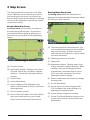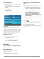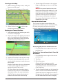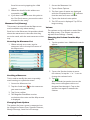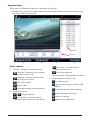
1
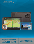
®
FREE
Record
HD
Video
Lifetime
Map
Updates
Magellan RoadMate
®
6220-LM
6230-LMX
6235-LM
®
User Manual
IMPORTANT SAFETY WARNINGS
The Magellan RoadMate receiver is a vehicle-navigation aid designed to assist you in arriving at
your selected destinations. When using the Magellan RoadMate receiver, these safety rules must be
followed to prevent accidents that can result in injury or death to yourself or others:
Please check the applicable regulations in your state regarding windshield mounting. Certain
states prohibit the mounting of any items on your windshield. Go to www.magellanGPS.com for
alternative mounting solutions.
When driving, the need to view the display is minimal. Voice prompts will guide you to your
destination. The driver should enter data or program the Magellan RoadMate receiver only when
the vehicle is stationary. Only a vehicle passenger should enter data or program the Magellan
RoadMate receiver while the vehicle is moving. Do not become distracted by the receiver while
driving, and always be fully aware of all driving conditions.
It is your responsibility to comply with all traffic laws and to use the Magellan RoadMate and
mounting options in such a manner that the user is in compliance with applicable laws.
Roads, points of interest (POIs), business and service locations may change over time. As a result
the database may contain inaccuracy. Also, the database does not include, analyze, process,
consider, or reflect any of the following: legal restrictions (such as vehicle type, weight, height,
width, load and speed restrictions); road slope or gradient;
bridge height, width, weight or other limits; population
Magellan RoadMate
6220T-LM
density; neighborhood quality or safety; availability or
proximity of police, emergency rescue, medical or other
Tested To Comply
assistance; construction work zones or hazards; road
With FCC Standards
or lane closures; road, traffic or traffic facilities’ safety or
condition; weather conditions; pavement characteristics
or conditions; special events; traffic congestion. It is your
FOR HOME OR OFFICE USE
responsibility to disregard any unsafe, hazardous or illegal
route suggestions.
Keep the Magellan RoadMate receiver safe from extreme temperature conditions. For example, do
not leave it exposed to direct sunlight for an extended period of time.
Take care when mounting the Magellan RoadMate receiver in your vehicle, whether using the
windshield mount or other mounts, that it does not obstruct the driver’s view of the road, interfere
with the operation of the vehicle’s safety devices such as air bags, or present a hazard to occupants
of the vehicle should the receiver be dislodged while driving. It is your responsibility to assess the
risks associated with damage to your vehicle or vehicle occupants as the result of your choices in
mounting the Magellan RoadMate receiver.
Temperature
The maximum operating temperature is 140°F (60°C).
Battery
The battery in the Magellan RoadMate receiver is rechargeable and should not be removed. In the
event that it should need to be replaced, please contact Magellan Technical Support.
Charging the Magellan RoadMate
An optional AC adapter is available as an accessory for your Magellan RoadMate. Use of
RoadMate User Manual
Page ii
another type of AC adapter can result in malfunction and/or possible fire hazard due to battery
overheating.
Use only the car charger approved for/supplied with your Magellan RoadMate receiver. Use of
another type of car charger will result in fire or electric shock.
For safety reasons, the battery in your Magellan RoadMate receiver will stop charging when the
ambient temperature is less than 32°F (0°C) or more than 113°F (45°C).
It will take approximately 4 hours of charging the Magellan RoadMate receiver through the vehicle
power adapter or optional AC adapter to obtain a full battery charge. It is recommended that you
charge the battery initially for at least 2 hours.
Use only the charger approved for your Magellan RoadMate receiver.
Estimated usage of the Magellan RoadMate on battery power is approximately 1 hour.
Federal Communication Commission Interference Statement
This equipment has been tested and found to comply with the limits for class B digital devices,
in accordance with part 15 of the FCC Rules. These limits are designed to provide reasonable
protection against harmful interference in a residential installation. This equipment generates,
uses and can radiate radio frequency energy and, if not installed and used in accordance with
the instructions, may cause harmful interference to radio communications. However, there is
no guarantee that interference will not occur in a particular installation. If this equipment does
cause harmful interference to radio or television reception, which can be determined by turning
the equipment off and on, the user is encouraged to try to correct the interference by one of the
following measures:
Reorient or relocate the receiving antenna.
Increase the separation between the equipment and receiver.
Connect the equipment into an outlet on a circuit different from that to which the receiver is
connected.
Consult the dealer or an experienced radio/TV technician for help.
This device complies with Part 15 of the FCC Rules. Operation is subject to the following two
conditions: (1) This device may not cause harmful interference, and (2) this device must accept any
interference received, including interference that may cause undesired operation.
FCC Caution: Any changes or modifications not expressly approved by the party responsible for
compliance could void the user’s authority to operate this equipment.
IMPORTANT NOTE:
FCC Radiation Exposure Statement:
This equipment complies with FCC radiation exposure limits set forth for an uncontrolled
environment. End users must follow the specific operating instructions for satisfying RF exposure
compliance.
This transmitter must not be co-located or operating in conjunction with any other antenna or
transmitter.
In order to maintain compliance with FCC regulations, shielded cables must be used with this
equipment. Operation with non-approved equipment or unshielded cables is likely to result in
interference to radio and TV reception. The user is cautioned that changes and modifications
RoadMate User Manual
Page iii
made to the equipment without the approval of manufacturer could void the user’s authority to
operate this equipment.
The Magellan RoadMate receiver must be installed and operated at a distance no closer than 8
inches (20 cm) from the user.
This Class B digital apparatus meets all requirements of the Canadian Interference-Causing
Equipment Regulations.
IC statement
Operation is subject to the following two conditions:
1. This device may not cause interference and
2. This device must accept any interference, including interference that may cause undesired
operation of the device.
IMPORTANT NOTE:
IC Radiation Exposure Statement:
This equipment complies with IC radiation exposure limits established for an uncontrolled
environment. End users must follow the specific operating instructions for satisfying RF exposure
compliance.
This transmitter must not be co-located or operated in conjunction with any other antenna or
transmitter.
One or more claims of the following patents may cover this product: U.S. patent No. 5,544,060,
U.S. patent No. 5,654,892, U.S. patent No. 5,832,408 and U.S. patent No. 5,987,375
The information provided in this document is subject to change without notice. Improvements
and enhancements to the product may occur without any formal notification. Check the
Magellan website (www.magellanGPS.com/support) for product updates and additional
information.
© 2014 MiTAC International Corporation. The Magellan logo, Magellan, RoadMate and
Quickspell are registered trademarks of MiTAC International Corporation. SmartDetour and
OneTouch are trademarks of MiTAC International Corporation and are used under license by
MiTAC International Corporation. All rights reserved.
All other products and brand names are trademarks of their respective holders.
No part of this user manual may be reproduced or transmitted in any form or by any means,
electronic or mechanical, including photocopying and recording, for any purpose other than
the purchaser’s personal use, without the prior written permission of MiTAC International
Corporation.
The information provided in this document is correct at the time that it is created. MiTAC
International Corporation assumes no responsibility or liability for any errors or inaccuracies that
may appear in the contents of this User Manual.
112-0079-001
RoadMate User Manual
Page iv
Contents
IMPORTANT SAFETY WARNINGS..............................................................ii
1 Magellan RoadMate GPS Receiver with DVR.........................................1
Magellan RoadMate controls and features................................................................ 2
Reset...............................................................................................................................................2
2 Fundamentals...........................................................................................3
Battery Levels................................................................................................................... 3
Viewing the Battery Level Indicator....................................................................................3
Speaker Volume.............................................................................................................. 3
Changing the Volume from the Map Screen...................................................................3
Changing the Volume from Settings...................................................................................3
Setting Button Sounds On or Off.........................................................................................3
Setting Smart Volume On or Off...........................................................................................3
Brightness......................................................................................................................... 4
Accessing the Brightness Control.........................................................................................4
Main Menu....................................................................................................................... 4
Accessing the Main Menu.....................................................................................................4
Keypad.............................................................................................................................. 5
Selecting From List.....................................................................................................................5
Selecting QWERTY or ABC keyboard..................................................................................5
Notes on entering data.................................................................................................. 5
QuickSpell......................................................................................................................... 5
Smart City Search............................................................................................................ 6
3 Map Screen...............................................................................................7
Normal Mode Map Screen......................................................................................................7
Routing Mode Map Screen.....................................................................................................7
Setting Map Options.................................................................................................................8
Selecting Map Mode and Default Zoom Level ................................................................8
Panning on the Map.................................................................................................................9
Routing to a Panned Position................................................................................................9
Current Location Screen................................................................................................ 9
Accessing the Current Location Screen..............................................................................9
Saving Your Current Location to Your Address Book....................................................9
Maneuver List (Itinerary).............................................................................................10
Accessing the Maneuver List............................................................................................... 10
Avoiding a Maneuver............................................................................................................ 10
RoadMate User Manual
Page v
Changing Route Options..................................................................................................... 10
Volume............................................................................................................................10
Changing the Volume from the Map Screen................................................................ 10
4 OneTouch Menu.................................................................................... 11
Accessing the OneTouch Menu........................................................................................ 11
The Home Button..........................................................................................................11
Saving an Address to a OneTouch Icon.......................................................................... 11
Changing the Address or Search of a OneTouch Icon.............................................. 11
Saving a POI Search Criteria to a OneTouch Icon........................................................ 12
Setting a Route to a OneTouch Icon................................................................................ 12
5 Selecting a Destination......................................................................... 13
Creating a Destination to an Address.............................................................................. 13
Tips on Entering Addresses Quickly..........................................................................14
Intersections...................................................................................................................14
Creating a Destination to an Intersection....................................................................... 14
City Centers....................................................................................................................15
Creating a Destination to a City Center........................................................................... 15
Previous Destinations...................................................................................................15
Routing to a Previous Destination..................................................................................... 15
Clearing the list of Previous Destinations........................................................................ 15
Address Book.................................................................................................................15
Saving a Destination to Your Address Book................................................................... 15
Accessing an Address in Your Address Book................................................................ 16
Routing to an Address in Your Address Book............................................................... 16
6 Traveling on a Route............................................................................ 17
Map Screen.....................................................................................................................17
Maneuver List................................................................................................................17
Accessing the Maneuver List............................................................................................... 17
Viewing a Maneuver............................................................................................................. 17
Excluding a Maneuver.......................................................................................................... 17
Types of Routes.............................................................................................................17
Changing the Routing Method.......................................................................................... 18
Compare Routing Methods................................................................................................. 18
To Change the Default Routing Method ....................................................................... 18
Special Routing Functions...........................................................................................18
Cancelling a Route................................................................................................................. 18
RoadMate User Manual
Page vi
Detouring off a Route........................................................................................................... 18
7 Points of Interest (POI)......................................................................... 20
Creating a Route to a POI by Category........................................................................... 20
Creating a Route to a POI by Name................................................................................. 21
Creating a Route to a Highway Exit POI......................................................................... 21
8 Using the DVR....................................................................................... 22
DVR Screen and Controls............................................................................................22
Storage and locked Recordings..................................................................................22
DVR Settings..................................................................................................................22
Automatic Recording...................................................................................................23
Viewing Recordings on the Device...........................................................................23
Viewing Recordings on a Computer.........................................................................23
Using your receiver as a card reader................................................................................ 23
Using your computer’s card reader ................................................................................. 23
Locate and run the player program................................................................................. 23
Magellan Player.............................................................................................................24
Player controls......................................................................................................................... 24
Playing recordings.................................................................................................................. 25
Locked Recordings................................................................................................................. 25
Damaged Recordings............................................................................................................ 25
Language Selection.............................................................................................................. 25
Saving recorded video.......................................................................................................... 26
Managing memory cards..................................................................................................... 26
9 Settings.................................................................................................. 27
Accessing System Settings................................................................................................... 27
Map Options..................................................................................................................27
Setting Auto Night Map Display........................................................................................ 27
Setting Heading Up or North Up in 2D Mode.............................................................. 27
Assigning Visible POIs........................................................................................................... 27
Setting Auto Zoom on Turns.............................................................................................. 27
Setting Highway Lane Assist............................................................................................... 27
Sound..............................................................................................................................28
Setting Volume from Settings............................................................................................. 28
Turning Button Sounds On/Off......................................................................................... 28
Turning Smart Volume On/Off.......................................................................................... 28
Navigation......................................................................................................................28
RoadMate User Manual
Page vii
Setting The Default Route Method................................................................................... 28
Setting The Turn Warning Alert Sounds......................................................................... 28
Enabling Landmark Guidance............................................................................................ 28
Enabling Spoken Street Names.......................................................................................... 28
Enabling U Turn Guidance.................................................................................................. 28
Avoiding Toll Roads............................................................................................................... 28
Avoiding Unpaved Roads.................................................................................................... 29
Brightness.......................................................................................................................29
Setting Brightness................................................................................................................... 29
Languages......................................................................................................................29
Setting Languages.................................................................................................................. 29
Speed Warnings............................................................................................................29
Setting Speed Warning Options........................................................................................ 29
Phantom Alerts........................................................................................................................ 29
Time Zone.......................................................................................................................29
Selecting the Time Zone....................................................................................................... 29
Time Format...................................................................................................................29
Setting the Time Format....................................................................................................... 29
Keyboard........................................................................................................................30
Setting the Keyboard Layout.............................................................................................. 30
Units of Measure...........................................................................................................30
Selecting Units of Measure.................................................................................................. 30
Regions...........................................................................................................................30
GPS...................................................................................................................................30
Setting the GPS Position....................................................................................................... 30
Viewing the GPS Status........................................................................................................ 30
Default System Settings...............................................................................................30
Restoring All Default System Settings............................................................................... 30
Product Information.....................................................................................................30
Viewing Product Information............................................................................................. 30
RoadMate User Manual
Page viii
1 Magellan RoadMate GPS Receiver with DVR
The Magellan® RoadMate® receiver is a
vehicle navigation product with Digital Video
Recorder (DVR) functionality.
It uses GPS signals from satellites to
calculate your precise location and compute
navigational information.
The DVR records continuous video, audio,
location, and other information. The video
provides an impartial witness in case of need.
The RoadMate uses its position and
movement to overlay this information
on detailed maps to provide a visual
representation of your location.
With the Magellan RoadMate receiver you
can:
•Save searches and addresses under the
OneTouch™ menu for fast, convenient
access to favorite destinations and
searches.
•Store your home address and quickly get
routing details to your home.
•Save location information to create a map
later of the places you went.
•Save all or part of the video for later
viewing.
•Customize your Magellan RoadMate
receiver to meet your needs using the
Settings menu.
The user interface for the Magellan RoadMate
receiver is intended to be easy and simple to
follow.
The Magellan RoadMate receiver has a builtin battery so, in most cases, you will be able
to follow these instructions while reading
them on your computer screen without
plugging the Magellan RoadMate receiver to
an external power source. Note that a fully
charged Magellan RoadMate only has about
60 minutes of battery life. If you need or wish
to use external power, you can use an optional
AC power adapter.
•Route to an address that you enter using
the QuickSpell™ and Smart City search for
easy, errorless address entry.
While the Magellan RoadMate has a powerful
GPS chipset, you may not get strong enough
satellite signals to compute your location when
indoors or in a parking garage. If you find
you are not getting strong enough satellite
signals while in a garage or other structure,
move to a location where there is a clear view
of the sky and you should immediately see an
improvement in signal strength.
•Route to any point of interest (POI) that
has been preloaded into your Magellan
RoadMate receiver.
The Magellan RoadMate receiver includes
Voice Alerts (both prerecorded and Text-toSpeech) for driving instructions.
•Create a route with multiple destinations.
Handy for business people who need
routing information to many destinations.
We hope that you find this manual useful and
the instructions easy to follow.
•Enter and save addresses in your address
book that can be accessed at any time
and get routing information to that
address.
•View POIs that are near exits ahead of
you on the highway. The Highway Exit
POIs function provides you with a list
of gas stations, restaurants, hotels and
auto repair shops located near exits you
are approaching while travelling on the
interstate.
RoadMate User Manual
Page 1
Magellan RoadMate controls and features
C
A
B
D
E
F
Magellan RoadMate 6220-LM, 6230-LMX, 6235-LM
A
Power button
Press and hold to turn the device on or to completely shut down.
Press momentarily to suspend or resume the device.
B
C
D
E
DVR Lock button
Locks current video segment to prevent overwriting.
MicroSD Card for DVR
Required for DVR function: MicroSD card provided with unit***
Audio Out
Connect external headphones.
MicroSD Card slot
Available for use as external card reader for DVR playback on a PC.
F
USB Connector
Connect to power source* or personal computer**
Reset
The reset button is located on the back of the receiver in the upper right corner. If you have
problems with your receiver or in the unlikely event that it locks up, use a paperclip and gently
insert it into the reset hole to press the reset button with the receiver turned on. The receiver
should restart with the factory defaults loaded.
* Power input from vehicle power adapter cable or optional AC
power adapter.
** Connect your receiver to a personal computer to playback or
save DVR videos, and to update maps and software using the
Magellan Content Manager application.
*** Size may vary by model for 6220-LM, 6230-LMX and 6235-LM.
RoadMate User Manual
Page 2
2 Fundamentals
Battery Levels
The Magellan RoadMate receiver has an
internal battery that is charging whenever the
receiver is connected to external power.
3. Tap
.
Changing the Volume from Settings
1. Access the Main Menu.
2. Tap the Settings icon.
3. Tap Sound.
Note: The battery can only be serviced by
authorized Magellan repair facilities.
Viewing the Battery Level Indicator
1. While viewing the Map screen, tap on
the Menu button in the right corner.
2. The battery level indicator is located in
the upper right corner of the Main Menu,
just below the satellite signal indicator.
Green bars indicate battery level.
Speaker Volume
Changing the Volume from the Map
Screen
1. Tap the speaker icon . Additional
controls appear.
4. Tap the top or bottom of the Master
volume adjust bar or drag the slider
button to change the volume level of the
Magellan RoadMate receiver.
5. Tap
to save and return to the
Settings screen.
Setting Button Sounds On or Off
1. Access the Main Menu.
2. Tap the Settings icon.
3. Tap Sound.
4. Tap the check box for Button Sounds.
Check to have button sounds played,
unchecked to turn them off.
Setting Smart Volume On or Off
Smart Volume is a feature of the receiver that
changes the volume automatically as your
speed changes, compensating for road noise.
1. Access the Main Menu.
2. Tap the Settings icon.
3. Tap Sound.
4. Tap the check box for Smart Volume.
When checked, Smart Volume is on.
2. Tap the speaker button to mute the
volume, or tap the ‘+’ or ‘-’ buttons to
raise or lower the volume.
RoadMate User Manual
Page 3
Brightness
Accessing the Brightness Control
1. Access the Main Menu.
2. Tap the Settings icon .
3. Tap Brightness.
4. Tap the ends of the brightness adjust
bar or drag the slider to set the desired
brightness.
Note: On the Brightness Setting screen there
is a “Dim on Battery Power” option. When
checked, the Magellan RoadMate receiver
will reduce the brightness when operating
exclusively on battery power and you have
not used the touch screen for a few seconds.
This prolongs the battery life between
charges.
Accessing the Main Menu
1. From the Map screen tap Menu.
Functions Available from the Main Menu
Address
Enter an address as a destination for you route.
Points of Interest
Select a Point of Interest (POI) from the list of
preloaded locations as a
destination.
Previous
List of the most recent
destinations that you have
gone to before allowing
you to quickly select one
to route to again.
Intersection
Create a route to the intersection of two streets.
City Center
Create a route to the geographical center of a city.
Current Location
Displays information
about your position
including the street name,
names of streets forward
and behind you as well as
the Lat/Long information
for your position.
Coordinates
Allows direct input of
Latitude and Longitude to
create a route.
Back
Access the Map screen.
Address Book
Access the Address Book
where you can save addresses and destinations
to have available when
needed.
DVR
Displays the DVR screen.
Settings
Displays the Settings
menu. Lets you customize
the Magellan RoadMate
receiver to your personal
needs.
Satellite Status
Graphic display of the
strength of satellite signals
being received.
Battery Level
Graphic display of the
current battery level.
Main Menu
The Main Menu screen is the center for all
available functions of the Magellan RoadMate
receiver. The Main Menu contains large, easy
to access icons for all the major functions.
RoadMate User Manual
Page 4
Keypad
Accept
The keypad is the most common method for
entering data into the Magellan RoadMate
receiver. Understanding the keypad while
entering an address is an important part of
using your Magellan RoadMate receiver.
(Entering City) Accepts
the suggested city that is
displayed in the data field.
(Entering street) Brings up a
list of streets beginning with
the characters entered.
Selecting From List
When a list of items found in the database
are displayed, use the arrows on the right to
move the list up and down and tap on the
desired item in the list to continue.
Selecting QWERTY or ABC keyboard
1. Access the Main Menu.
2. Tap the Settings icon .
3. Tap Keyboard.
4. Select QWERTY or ABC.
Keypad overview
Backspace
Moves the cursor one position
backwards, deletes the preceding character.
Shift
Shifts between uppercase and
lowercase characters.
Space
Inserts a space at the cursor
position.
Numeric
Displays a numeric keypad.
Symbols
Displays available symbols.
Previous
Zip Code
List
Previous destination list
(Enter City only) When
entering a city, the previous
destinations list displays
a list of cities previously
entered. Tap on a city from
the displayed list to accept
that city.
(Enter City only) Displays a
numeric keypad to quickly
enter a city when the zip
code is known.
(Enter City only) While
entering a city, press the
List button to bring up a
list of cities beginning with
the characters you have
entered.
RoadMate User Manual
Notes on entering data
If you are having trouble getting the results
you expected, here are a few useful tips.
•Check for apostrophes and hyphens. If
you do not see the POI or street name you
are looking for in the list, check to see if
the name has an apostrophe or hyphen.
•The more characters you enter, the
smaller the list of possible options is from
which to choose.
•When entering a street or city name it is
not necessary to use accented letters. You
can enter city and streets names using
only standard characters.
QuickSpell
Another feature the Magellan RoadMate
receiver uses to make entering cities
and streets easier, is a feature known as
QuickSpell. As letters are entered for a city
or street the Quickspell feature checks the
database for cities or streets that begin with
the letters entered. Any letters that could
not be used to spell a city or street name are
greyed out. This provides quick and error-free
city and street name entry.
Page 5
Smart City Search
The Magellan RoadMate receiver utilizes a
feature known as “Smart City Search”. Smart
City Search attempts to predict the city you
are looking for. This prediction is based upon
two factors; your position and cities you have
gone to before.
Whenever entering or searching on an
address the first screen displayed is the Enter
City Name keyboard.
Quickspell and Smart City Search makes
entering an address quick and easy with little
chance for errors.
As letters are entered, Quickspell checks
the database for cities beginning with the
letters entered. Keys that don’t spell a city in
the database are greyed out and Smart City
Search displays a suggested city in the text
field.
If the city is correct, tap the
continue.
button to
button can be tapped to display
The
the list of cities that begin with the letters
entered.
RoadMate User Manual
Page 6
3 Map Screen
The most commonly used screen is the Map
screen. Whether you are following a route or
just traveling around a city, the chances are
that the Map screen will be displayed. The Map
screen can be displayed in two unique modes:
normal and routing.
Normal Mode Map Screen
F
E
D
C
(A) Current location.
(B) Information display. Displays your choice
of speed, time of day, elevation, compass
direction. Tap on the information field to
change.
(C) Zoom Out/In.
(D) Access Main Menu.
(E) Access Highway POIs (Displayed only
while on an Interstate, freeway, and some)
state highways.)
(F) Access volume controls.
(G) Access OneTouch Menu. OneTouch Menu
gives you instant access to your saved
search criteria and favorite destinations.
RoadMate User Manual
I
A
C
G
B
In routing mode additional information is
displayed providing detailed information about
the route you have selected.
B
In normal mode, your position is shown on
the map along with the time. As you travel,
your position will be updated, giving you a
clear view of your position and surrounding
streets.
A
Routing Mode Map Screen
D
H
G
F
E
(A) Turn instructions for next maneuver. Tap
icon to display the maneuver list (available
only when routing). Distance and road
name for the next maneuver. Tap to repeat
last voice instruction.
(B) Following maneuver indicator.
(C) Speed limit.
(D) Information display. Displays speed, time
of day, elevation, compass direction. While
routing it also can also display distance
to destination, estimated time of arrival
(ETA), and time remaining. Tap on the
information field to change.
(E) Zoom in and zoom out controls to change
the map scale.
(F) Access Main Menu.
(G) Access the list of nearest Highway Exit
POIs (available only when driving on a
highway/freeway/interstate).
(H) Access volume, brightness controls.
(I) Access OneTouch Menu for instant access
to your saved search criteria and favorite
destinations.
Page 7
Setting Map Options
The map display can be customized in Settings
to your preferences.
1. From the Map screen, tap the MENU
button.
2. Tap the Settings Icon.
3. Tap Map button.
4. Use the Map Options screen to customize
what is shown on the map and how the
map is displayed.
Selecting Map Mode and Default Zoom
Level
When driving, the map displays at a zoom level
you set here.
1. From the Map screen, tap anywhere on
the map. A button appears in the lower
left corner; it displays the mode it will
select when tapped.
2. Tap the button to switch between 2D
and 3D. The 2D mode (North Up or
Heading Up) is from the settings screen as
described above.
3. Tap the ‘+’ or ‘-’ zoom level buttons at the
bottom of the Map screen to zoom to
your preferred level,
4. Tap
.
Note that zoom levels are limited in 3D mode.
As you zoom out in 3D, the display will switch
to 2D at higher zoom levels.
Night Mode
For additional details on Settings, see “Settings”
on page 27
Night Mode determines when (or if) the
display switches from daytime mode to night
mode. The button displays the active setting tap to see the options and select the one you
like. There may be a brief delay before the
selected mode becomes active.
Map Mode (2D or 3D)
Sets how the map is normally displayed:
3D - Perspective view
2D - Top down view, Heading Up
2DN - Top down view, North Up
Tap the button to switch between modes. The
selected mode is shown on the button.
POI Visibility
You can set which POIs are displayed on the
map as you drive. Set checkmarks for each item
you want displayed.
Auto Zoom on Turns
Check to enable, uncheck to disable.
Highway Lane Assist
Check to enable, uncheck to disable.
RoadMate User Manual
Page 8
Panning on the Map
1. While viewing the Map screen, slide your
finger across the map.
2. The map screen changes to Pan mode.
5. Tap the large GO button on the right to
begin navigating and return to the Map
screen.
Note: If the panned position does not
match an existing street address (i.e. the
destination is not along a road or street
that is stored in the map database), the
guidance will stop on the road that is
closest to your destination. A dashed
line to your final destination will then be
displayed on the map.
Current Location Screen
3. When finished, tap
and the map
returns to your current position.
The Current Location screen displays the
approximate address of your current position,
the next and previous intersections, your
latitude, longitude, heading and elevation.
Routing to a Panned Position
1. Pan the map until the location you wish
to route to is displayed.
2. Tap on the map at the point you want to
go to. A red push pin will be displayed
along with information about the point
chosen at the top of the screen.
Accessing the Current Location Screen
1. From the Map screen tap on the current
position icon.
Saving Your Current Location to Your Address Book
3. Tap the GO button in the top left corner.
4. If an active route already exists, you will
need to define what to do with this new
route point:
Replace Destination: the next destination
is cleared and replaced with the one
selected from the Pan screen.
Go There Now: the selected location is
inserted in the route as an intermediate
destination before the next destination.
Add To Trip: the selected destination is
added to the end of the current trip.
RoadMate User Manual
1. From the Map screen tap on the current
position icon .
2. Tap Save.
3. Edit information:
(Optional) If you want to save this
location to the OneTouch menu as well
as the address book, check the Add to
OneTouch box.
4. Tap the Name field and use the keypad to
enter a name for the Address Book entry.
(Optional) Tap List Categories to select a
category for this address. New categories
can be added from the Select Category
Page 9
from List screen by tapping the +Add
button.
5. When the details for this address are
.
acceptable, tap
6. If you have selected to save this point to
the OneTouch menu, you need to select
a button for the entry.
Maneuver List (Itinerary)
This screen is accessed from the Map screen
and is available only when routing.
Each line in the Maneuver List provides details
about the maneuvers in the order that they
are to be made, with the next maneuver at the
top.
Accessing the Maneuver List
1. When actively on a route, tap the
maneuver icon in the top left corner of
the Map screen.
2. Tap on Route Options.
3. The four types of routes are displayed
with the computed time. A
indicates
that the route will use a toll road.
4. Tap on the desired route option.
5. The GO screen is displayed. Tap GO to
begin routing.
Volume
The volume can be adjusted or muted from
the Map screen. (The volume can also be
adjusted from Settings > Sound.)
Changing the Volume from the Map
Screen
1. Tap the speaker icon. Additional controls
appear.
2. Tap on the Speaker button to mute
the volume, or tap the ‘+’ or ‘-’ icons to
change the volume levels.
Avoiding a Maneuver
This is used to modify the route to possibly
avoid routing on a particular street.
1. Access the Maneuver List.
2. Tap the Avoid icon
you want to avoid.
1. Access the Maneuver List.
for the maneuver
3. Tap Yes to confirm.
3. Tap
.
When muted the speaker icon on the
Map screen will appear with a red
diagonal line through it. Tap on the
speaker icon again to unmute the
volume.
4. The Magellan RoadMate receiver
recalculates the route and the Map screen
is displayed.
Changing Route Options
The options for how a route is computed can
be changed to Fastest Time, Shortest Distance,
Mostly Freeways, Least Use of Freeways.
RoadMate User Manual
Page 10
4 OneTouch Menu
The OneTouch™ menu provides quick access
to your home address, emergency services, gas
stations and addresses or searches you have
stored to the OneTouch menu.
Note: If you need to edit or delete the Home
address you selected here you can do this by
going to the Address Book (found in the Main
menu) and edit the entry labeled “Home”.
Accessing the OneTouch Menu
Saving an Address to a OneTouch Icon
1. From the Map screen, tap the OneTouch
icon in the upper right corner.
1. Tap the Edit button in the top right
corner of the Map screen. The OneTouch
menu appears.
2. Tap one of the Assign icons.
3. Tap Location.
4. Using the keypad, enter the address (city,
street and number) for the OneTouch
icon.
5. When the address is complete you are
prompted to enter a name for the button.
6. Using the keypad, enter a name for the
button and tap
.
The Home Button
Tap the Home icon.
If you have a Home Address saved, the
receiver will begin giving you navigation
information to arrive at your home.
If you do not have a Home Address saved, you
will be prompted to enter one.
7. Verify that the address has been
added by going to the Map screen and
accessing the OneTouch menu.
Changing the Address or Search of a
OneTouch Icon
1. Tap the Edit button in the top right
corner of the Map screen. The OneTouch
menu appears.
2. Tap the Edit button.
3. Tap on the OneTouch button you want
to edit.
4. Tap on the Re-assign button.
5. Tap Yes to confirm.
6. Follow the instructions for assigning a
OneTouch button.
If you select Yes, you will need to enter
your home address using the Enter Address
keyboard.
To use your current location for Home, just
press the Use My Current Location button.
RoadMate User Manual
Page 11
Saving a POI Search Criteria to a OneTouch Icon
Besides frequently visited destinations, you can
also save POI search criteria to a OneTouch
button. For example you may frequently
search for coffee shops near your location or
gas stations along your route. You can save
these searches for later use.
1. Tap the OneTouch button in the top right
corner of the Map screen.
2. Tap one of the Assign buttons.
3. Tap Search.
4. Tap one of the POI categories in the list.
Setting a Route to a OneTouch Icon
With the OneTouch menu set up you can now
go to a saved address or search.
1. Tap the OneTouch button in the top right
corner of the Map screen.
2. Tap one of the assigned OneTouch
buttons.
3. If the assigned button is for a search,
the list of POIs is displayed. Tap on the
desired POI.
The “Preview” icon at the bottom of
the display allows you to step through
the available POIs while viewing their
location on the map.
4. The “Near...” button allows you to select
how the list is sorted (nearest your
current position, nearest a city you define
or near an address you enter).
5. Whether the destination was chosen
from a list of POIs or by an address, the
GO screen is displayed Tap on the Go
button to begin the route.
5. If the next screen contains a list of
subcategories, tap one of the POI
subcategories in the list to further narrow
the search, or tap “All Subcategories” to
select all the subcategories or continue
defining your search criteria.
6. Using the keypad, enter a name for the
button and tap
.
RoadMate User Manual
Page 12
5 Selecting a Destination
Creating a Destination to an Address
2. Enter Street name:
When creating an address, the first step is to
enter the city.
The city can be specified by entering the name
of the city, entering the ZIP code for the city or
by selecting a previously used city.
1. From the Main Menu tap the Address
icon. Enter City:
With the city selected, the keyboard will
be displayed, prompting you for the street
name.
You have three ways to do this:
To select the city from the list of previous
cities, tap the Previous button.
To enter a new city: use the keyboard
to enter the first few characters of any
significant word in the city name. If the
city you are entering appears in the top
field you can tap on the city name or
.
Use the keyboard to enter the street
name. It is not necessary to enter
accented characters. Enter the first few
characters of any significant word in the
street name and tap
or continue
entering characters until the list of streets
is displayed.
3. Tap on the street name from the list.
4. Enter Street number:
At any time, you can tap on the List
button to bring up a list of cities that
begin with the characters you entered.
Tap to select the city from the list.
To enter a ZIP code: if needed, tap the
Zip Code button to switch to the numeric
keyboard. Enter the ZIP code. Tap to
bring up a list of cities with the zip code
entered.
RoadMate User Manual
Use the keyboard to enter the street
number for the address. The range of
acceptable street numbers is displayed
before you start typing. Tap
when
the street number is complete.
Page 13
5. The GO screen appears with the address
of the selected location, the estimated
time of arrival (ETA), the distance to
travel, and the routing method (e.g.
Fastest Time).
Intersections
Creating a Destination to an Intersection
When the street number is not known, an
intersecting street can pinpoint the location.
1. From the Main Menu, tap the Intersection
icon.
2. Enter City:
You have three ways to do this:
To select the city from the list of previous
cities, tap the Previous button.
To enter a new city: use the keyboard
to enter the first few characters of any
significant word in the city name. If the
city you are entering appears in the top
.
field you can tap on the city name or
(Optional) Tap Options if you want to
change the routing method.
(Optional) Tap on
route.
At any time, you can tap on the List
button to bring up a list of cities that
begin with the characters you entered.
Tap to select the city from the list.
to preview the
6. Tap the large GO button on the right
to return to the Map screen and begin
routing.
To enter a ZIP code: if needed, tap the
Zip Code button to switch to the numeric
keyboard. Enter the ZIP code. Tap to
bring up a list of cities with the zip code
entered.
Tip: If you know that you will use a
destination later, before tapping the
orange button you can tap Save to save it
in your Address Book or in the OneTouch
menu.
3. Enter Street name:
With the city selected, the keyboard will
be displayed prompting you for the street
name.
Tips on Entering Addresses Quickly
•When you are entering the name of a city
or a street, Magellan software only displays
those characters that appear in possible
search results. The other characters are
grayed out.
•When entering city names or street names,
tap the List button after a couple of letters;
Magellan software lists the items that
contain the specified characters.
•You can also search by ZIP codes. This
narrows the number of matching cities to
normally less then four.
Use the keyboard to enter the street
name. It is not necessary to enter
accented characters. Enter the first few
characters of any significant word in the
street name and tap
or continue
entering characters until the list of streets
is displayed.
Tap on the street name from the list.
4. Enter the second street:
Enter the name of the second street as
you did the first street.
5. A screen appears with the address of the
selected location, the estimated time of
arrival (ETA), the distance to travel, and
the routing method (e.g. Fastest Time).
RoadMate User Manual
Page 14
(Optional) Tap Options if you want to
change the routing method.
6. Tap the large GO button on the right
to return to the Map screen and begin
routing.
City Centers
Creating a Destination to a City Center
City Center allows you to select any city on
the map as your destination. This option is
particularly useful when you want to go to
a city without having any specific address
to select. (A route to a city center uses
the geographical center of the city as the
destination point.)
1. From the Main Menu, tap the City Center
icon.
2. Enter City:
To select the city from the list of previous
cities, tap the Previous button.
To enter a new city: use the keyboard
to enter the first few characters of any
significant word in the city name. If the
city you are entering appears in the top
.
field you can tap on the city name or
At any time, you can tap on the List
button to bring up a list of cities that
begin with the characters you entered.
Tap to select the city from the list.
To enter a ZIP code: if needed, tap the
Zip Code button to switch to the numeric
to
keyboard. Enter the ZIP code. Tap
bring up a list of cities with the zip code
entered.
Previous Destinations
Routing to a Previous Destination
1. From the Main Menu, tap the Previous
icon.
2. Select the destination from the list of
previous destinations.
3. A screen appears with the address of the
selected location, the estimated time of
arrival (ETA), the distance to travel, and
the routing method (e.g. Fastest).
(Optional) Tap Options if you want to
change the routing method.
4. Tap the large GO button on the right
to return to the Map screen and start
navigating.
Clearing the list of Previous Destinations
1. Access the list of Previous Destinations as
described above.
2. Tap Delete All to clear the list.
3. To confirm the deletion, tap Yes.
Address Book
Saving a Destination to Your Address
Book
Whenever you create a destination you can
save the destination to your address book
before beginning the route.
1. On the Go screen, tap Save.
2. The Edit Information screen is displayed.
If you want to save this location to
the OneTouch menu, select Add to
OneTouch.
3. A screen appears with the address of the
selected location, the estimated time of
arrival (ETA), the distance to travel, and
the routing method (e.g. Fastest Time).
(Optional) Tap Options if you want to
change the routing method.
4. Tap the large GO button on the right
to return to the Map screen and start
navigating.
RoadMate User Manual
Page 15
Edit information:
Tap the Name field and use the keyboard
to enter a name for the address book
entry.
(Optional) Tap <Work, Cell or Home
phone> to specify a phone number for
the address book entry.
(Optional) Tap List Categories to bring up
a list of categories you have created for
your address book. If the category you
want isn’t there, you can create one by
tapping the “+ Add” button at the bottom
of the screen.
3. When the details for this address are
.
acceptable, tap
4. If you have selected to save this to the
OneTouch menu, you will be asked to
select the OneTouch button that you
want it assigned to.
Accessing an Address in Your Address
Book
1. From the Main Menu, tap the Address
Book icon.
2. To easily find the desired address, you can
tap the top left corner of the screen and
narrow the list by the first letter of the
address book entries.
Routing to an Address in Your Address
Book
1. Access the address record from your
address book as described above.
2. Tap the GO icon of the desired address
book entry. A screen appears with
the address of the selected location,
the estimated time of arrival (ETA),
the distance to travel, and the routing
method (e.g. Fast).
3. (Optional) Tap Options if you want to
change the routing method.
4. Tap the large GO button on the right
to return to the Map screen and start
navigating.
RoadMate User Manual
Page 16
6 Traveling on a Route
Map Screen
When a route has been calculated, the
first maneuver and turn instructions will be
displayed at the top of the screen. If sounds
are enabled, the instruction will be spoken.
The turn instructions include the name of the
street that comes next in your Turn List and its
distance. If you are not in the city in which the
next street is, the name of the city is displayed
instead.
As the route progresses, voice alerts will be
used to prompt you of upcoming maneuvers.
3. Tap the Avoid icon
you want to avoid.
for the maneuver
4. Tap Yes to confirm.
5. The Magellan RoadMate receiver
recalculates the route and the Map screen
returns.
Types of Routes
There are a wide variety of methods you can
use to create a route. Each method is discussed
in the chapter which is associated with it.
Routing Method
Maneuver List
The Maneuver List displays all of the
maneuvers to be made to complete the route
and arrive at the destination. To view the
Maneuver List, tap on the maneuver icon in
the top left corner of the Map screen.
Just as you can use different methods to select
a destination, the Magellan RoadMate can
calculate the route several different ways.
Routes can be calculated by the following
methods:
Accessing the Maneuver List
When actively following a route, tap the
maneuver icon in the top left corner of the
Map screen.
Viewing a Maneuver
While the maneuver list is displayed, tap on
any maneuver instruction to see a map view of
the maneuver.
Excluding a Maneuver
1. This is used to modify the route to
possibly avoid routing on a particular
street.
Fastest Time (Fast): the fastest possible route
provided the vehicle is able to travel at or near
the speed limit.
Shortest Distance (Short): the shortest
possible route.
Most Use of Freeway: creates a route that
uses freeways whenever possible.
Least Use of Freeway: creates a route that
avoids use of freeways.
When a destination is selected, the Magellan
RoadMate offers the route with the default
selected routing method first.
2. Access the Maneuver List.
RoadMate User Manual
Page 17
Changing the Routing Method
You can view and compare routing options at
any point of a trip: while you’re creating it, or
along the way.
To change the routing method as you’re
establishing a trip, tap Options when the ‘Go’
screen is displayed. The Magellan RoadMate
calculates the route and displays the travel
time of each method.
Special Routing Functions
Cancelling a Route
1. From the Map screen, tap Menu.
2. On the Main Menu, tap the Cancel Trip
icon.
Compare Routing Methods
You can visually compare options by tapping
at the lower right of the
the map icon
screen. A map is shown with the various route
options color-coded on the map and
corresponding buttons at the bottom of the
screen.
3. Tap Yes to confirm that you want to
cancel the route.
OR
4. Tap the OneTouch icon from the Map
screen to display the OneTouch menu.
5. Tap the cancel route icon.
6. Tap Yes to confirm that you want to
cancel the route.
Detouring off a Route
Tap the method you prefer and the trip will be
routed by that method.
1. From the Map screen, tap Menu.
2. Tap the Detour icon.
Once the trip has been routed, you can access
routing options from the Maneuver List.
Tap the Maneuver icon to view the maneuver
list, then tap the Options button to show
Route Options.
Tap the desired routing method in the list,
and the previous screen returns with the new
calculation.
To Change the Default Routing Method
1. From the Main Menu, tap the Settings
icon.
2. Tap Navigation.
3. Use the Route Method drop-down menu
to select the default routing method.
3. Different detours are calculated using
the same routing method that was used
to create the route. The list of alternate
routes is displayed along with Estimated
Time of Arrival for each. (ETA)
(Optional) You can check the Maneuver
List of an alternate route if you tap the
RoadMate User Manual
Page 18
button on the right.
4. Tap the desired alternate route.
You can also tap Route Options to change the
routing method.
RoadMate User Manual
Page 19
7 Points of Interest (POI)
The Magellan RoadMate receiver has
preloaded POIs that can be used as a
destination for a route. Selecting a restaurant
or finding a gas station nearby is at your
fingertips.
4. POIs near your current position are
displayed. You can tap “Near...” for
different search criteria (Near Current
Position, Near City, or Near Address).
Creating a Route to a POI by Category
POIs are categorized into unique categories
from gas stations to tourist attractions. Most,
but not all categories are further organized
into subcategories. Restaurants have, for
example, several subcategories that provide a
way to search for restaurants serving Chinese
food, fast food, or other favorites.
1. From the Main Menu, tap the Points of
Interest icon.
2. Tap one of the POI categories in the list.
If you select Near City or Near Address
you will need to enter the city or address
information.
5. Select the POI desired from the list of
POIs.
6. The ‘Go’ screen appears with the address
of the selected location, the estimated
time of arrival (ETA), the distance to
travel, and the routing method (e.g.
Fastest Time).
3. If the next screen contains a list of
subcategories, tap one of the POI
subcategories in the list to further narrow
the search.
RoadMate User Manual
(optional) Tap Options if you want
to change the routing method. You
can select from Fastest Time, Shortest
Distance, Mostly Freeways or Least Use of
Freeways.
7. Tap the large Go button on the right
to return to the Map screen and begin
navigating to the POI selected.
Page 20
Creating a Route to a POI by Name
1. From the Main Menu, tap the Points of
Interest icon.
2. Tap the Search By Name button.
3. Spell the name of the POI to be used as
the destination. You don’t need to enter
the full name, but the more characters
you enter, the easier it will be to find the
.
exact POI you are searching for. Tap
4. POIs near your current position are
displayed. You can tap “Near” for
different search criteria (Near Current
Position, Near City, or Near Address).
If you select Near City or Near Address
you will need to enter the city or address
information.
5. Select the POI desired from the list of
POIs.
6. The ‘Go’ screen appears with the address
of the selected location, the estimated
time of arrival (ETA), the distance to
travel, and the routing method (e.g. Fast).
(optional) Tap Options if you want to
change the routing method.
7. Tap the large Go button on the right
to return to the Map screen and start
navigating.
Creating a Route to a Highway Exit POI
The Highway Exit POIs function provides a
way of accessing commonly used POIs that
are near an exit you are approaching while
travelling on a highway. Highway Exit POIs
include restaurants, gas stations, car repair
facilities and hotels. Highway Exit POIs can be
accessed while on a route or just driving, as
long as you are on a highway1.
3. Small symbols represent the following
service POIs near the exits:
Restaurants
Gas Stations
Car Repair
Accommodations
4. Tap any of the symbols to get a list of
related POIs near the exit.
5. Select one POI from the list, and tap
6. The ‘Go’ screen appears with the address
of the selected POI, the estimated time of
arrival (ETA), the distance to travel, and
the routing method.
(optional) Tap Options if you want to
change the routing method.
7. Tap the Go button on the right to return
to the Map screen and begin routing to
the POI selected.
1. From the Map screen, tap the Highway
Exit POIs button when it appears.
2. The list of the next highway exits and
their distance from your current position
appear.
1
Highway Exit POIs are available on Interstates, freeways,
and many state highways.
RoadMate User Manual
.
Page 21
8 Using the DVR
The DVR records sound and video from the
Receiver’s camera to a micro-SD card. It also
records G-forces experienced by the receiver.
Recordings can be viewed on the device itself,
or on a computer.
The Receiver is provided with a micro-SD card
in the DVR slot. You can purchase and format
additional micro-SD cards if you wish. This
would permit you to set a SD-card aside with
important recordings on it, while continuing to
use your DVR.
The playback software is placed on the SDcard when you format it, so you can play it
back anywhere you have a Windows PC and a
reader for the card.
•Warning: The DVR cannot record without
a properly formatted micro-SD card in the
DVR card slot.
DVR Screen and Controls
From the Menu screen, tap
DVR screen.
Storage and locked Recordings
The DVR records in short segments (up to
a few minutes long), and will use the entire
capacity of the card. When the card is full, it
continues by writing over the oldest segments
in sequence.
To prevent a segment from being overwritten,
it must be locked. If the device experiences a
shock of greater than 2Gs, it locks the active
segment.
Note: Minor accidents may not cause
recording to lock. If in doubt, tap the Lock
button on top of the device.
Each locked segment will be preserved until
you take action to unlock or delete it.
DVR Settings
To access the DVR settings screen, tap the DVR
Settings icon at the bottom of the DVR screen.
to show the
A
G
B
C
D
E
A Recording indicator, lock indicator.
B Record/Stop recording button
C Show playback controls
D Lock current video segment
E DVR Settings
F Exit DVR
F
Auto Run: When selected, the DVR will start
recording when the unit is turned on, and
record until it is turned off.
Auto Light: When selected, the unit adjusts to
improve video quality in low light conditions.
Format Card: Erase all data from a micro-SD
card and prepare it for use in the DVR.
• Note - formatting removes any existing data
from the card.
Tap
to return to the DVR screen.
G Date and time display 1
1
Date and time is in Greenwich Mean Time
RoadMate User Manual
Page 22
Automatic Recording
recording.
If Auto Run is enabled (factory setting), the
DVR runs whenever the device is powered on.
To check recording status, select the DVR
screen and look for Rec flashing on the screen.
To start or stop recording, select the DVR
screen and tap
.
When recording, the DVR screen flashes Rec
and shows the recording time. There is no
indication of recording outside of the DVR
screens.
The DVR will record until it is powered off
or until it is stopped with the Record/Stop
recording button.
A Windows application must be used to save
one or more video segments (recordings). This
application is placed on the card when it is
used for DVR recording.
• You can’t just copy files from the card - you
must use the included application.
You can use a card reader connected to your
computer, or you can connect the receiver to
your computer and use it as a card reader.
Using your receiver as a card reader
1: Power off the Magellan receiver (device)
and remove the card.
Viewing Recordings on the Device
Recordings can be viewed on the device or on
a computer. To view recordings on the device,
.
select the DVR screen and tap
A
Viewing Recordings on a Computer
G
2: Transfer the card from the DVR slot (on the
top edge of the device) to the expansion
slot on the end of the device above the
USB connector.
3: Turn on your device. Connect the miniUSB end of the USB cable to the back of
your device and the other end to a USB
port on your computer.
Using your computer’s card reader
If your card reader connects to your computer
with a cable, make sure it is connected.
B
C
D
E
F
A Recording segment number, position
within the segment
B
Return to DVR screen
C Select previous segment
D Play/Stop playback
E
Select next segment
F
Lock/unlock current segment
G Date, time the current segment was
recorded
When you select the playback screen, the
starting frame of the most recent recording is
displayed. To select another recording, use
and
to select the segment you want, and
to confirm.
tap
1. Insert the card in the reader slot.
2. Make sure that your computer recognizes
the card and that you can view files on it.
Locate and run the player program
1. Run the file “Magellan Player.exe”. (Details
can vary according to the settings on
your computer.)
2. Depending on your computer
configuration, you may need to click the
folder icon at the lower left and use the
provided tools to locate your card for the
player.
3. In the player, you can review recording
segments and export any or all of them to
.avi files.
You can skip back or forward while playing a
RoadMate User Manual
Page 23
Magellan Player
When you run “Magellan Player.exe”, the player will start up.
•Multiple screens note: On some computers with multiple monitors, video performance may
not be the same on all screens.
Full list
Short list
A
B
Player controls
A File tools, settings, and snapshot tool:
Open file - if needed, use to identify
drive /folder of the card
Snapshot - saves the current video
image to disk as a picture
Save video to disk
Delete video
Language settings and card utilities
B
Playback controls:
Play/pause video
Play slower - use while video is
playing to slow it down and see details
RoadMate User Manual
C
D
Play faster - use while video is
playing to speed it up
Stop video playback
C Volume control - adjust playback volume
D Player display and video tools
Set repeat on/off
Flip the video playback (rotate it 180
degrees)
Enable/disable the G-force display
Repair damaged recordings
Unlock recordings
Adjust screen brightness
Page 24
Playing recordings
Click any video to see a preview of the first frame. The short list shows major segments. The full
list shows each video segment.
Click
to begin playback.
You can speed up (
) or slow down (
) the playback speed.
To view a trace of the recorded G-forces, click
.
Locked Recordings
The unlock button ( ) lets you unlock one or several segments. The player does not provide a
way to lock segments.
Damaged Recordings
If a recording is damaged for any reason, it will have a “broken” icon, as below
Use the
tool to repair damaged recordings. Click the
“broken” icon to see a list of damaged recordings within
that group.
Select the segments to repair, or click Repair all. Click Repair.
Language Selection
To change the Player’s language
selection, click
.
The setting is displayed. Select a
language from the drop-down,
and click the Apply button.
RoadMate User Manual
Page 25
Saving recorded video
Select the segments you want to save and click
.
A folder browser is shown. Select the file location to save and click OK.
If you used the checkboxes on the short list,
conversion will start immediately. If you selected
from the full list, a list of segments within that
group is shown. Select the checkboxes or click
SaveAll, then click SaveFile.
The selected segments are merged and output to
a single .avi file in the selected directory. Naming
is automatic.
Managing memory cards
A formatted memory card is provided with
the RM-6220. If you wish to use an additional
memory card or a larger one, it must be prepared
(formatted) first. See DVR Settings on page 22
for the suggested procedure.
A card formatted by the
DVR will appear to be
about 120MB in size to
Windows. The rest of the
card’s capacity is reserved
for DVR recording.
•Remember - you
must have a properly
formatted card in the
DVR card slot for the
DVR to record video.
RoadMate User Manual
Page 26
9 Settings
With user Settings you can customize the
Magellan RoadMate receiver to better suit your
personal needs and preferences.
Note: Tapping the Back arrow from any of the
Setting screens will save your changes.
Accessing System Settings
From the Main Menu screen, tap the Settings
icon.
Setting Heading Up or North Up in 2D
Mode
Sets how the map is normally displayed; in 3D
mode (perspective view), or 2D (top down
view) in either 2D-Heading Up or 2D-North Up
(2DN).
1. From the Main Menu screen, tap the
Settings icon.
2. Tap Map.
3. Tap 3D, 2D Heading Up or 2D North Up
to toggle between settings.
The selected mode is shown on the button.
Assigning Visible POIs
To avoid cluttering of the map, the POI icons
that are displayed on the map can be turned
on or off.
1. From the Main Menu screen, tap Settings.
Map Options
2. Tap Map.
3. Tap POI Visibility.
4. Use the POI Selection screen to check
those POIs you want shown and uncheck
those you want hidden.
Setting Auto Zoom on Turns
You can set the map to automatically zoom in
to the lowest level when coming up to a turn.
1. From the Main Menu screen, tap the
Settings icon.
2. Tap Map.
Setting Auto Night Map Display
Normally the map is displayed in vivid colors
for daytime use and with dark tints for night
use. You can select whether to always use
daytime colors, night color, or let the Magellan
RoadMate receiver switch between them
automatically a few minutes before sunrise
and a few minutes after sunset.
1. From the Settings screen, tap Map.
2. Tap Night Mode to select Automatic for
the timed adjustment, on always or off
always.
RoadMate User Manual
3. Checking Auto Zoom on Turns enables
this function.
Setting Highway Lane Assist
When Highway Lane Assist is checked,
the map will display highway signs as you
approach a highway interchange, giving you
visual indication of which lane you want to be
in.
1. From the Main Menu screen, tap the
Settings icon.
2. Tap Map.
3. Checking Highway Lane Assist enables
this function.
Page 27
Sound
Setting Volume from Settings
1. From the Main Menu screen, tap the
Settings icon.
2. Tap Sound.
3. Tap inside the volume slider bar to set the
desired volume level.
Turning Button Sounds On/Off
1. From the Main Menu screen, tap the
Settings icon.
2. Tap Sound.
3. Unchecking Button Sounds will turn off
the audible indication that a button is
tapped.
Turning Smart Volume On/Off
Smart Volume adjusts the sound levels based
on vehicle speed which normally increases
road noise making the speaker harder to hear.
1. From the Main Menu screen, tap the
Settings icon.
2. Tap Sound.
3. Unchecking Smart Volume turns Smart
Volume off.
Navigation
Setting The Turn Warning Alert Sounds
1. From the Main Menu screen, tap the
Settings icon.
2. Tap Navigation Preferences.
3. Use the drop-down menu to select the
default sound you want played when
alerting you to a turn.
Enabling Landmark Guidance
Landmark Guidance uses common landmarks
when available to help you identify streets
requiring a maneuver.
1. From the Main Menu screen, tap the
Settings icon.
2. Tap Navigation Preferences.
3. Checking Enable Landmark Guidance
turns Landmark Guidance on.
Enabling Spoken Street Names
1. From the Main Menu screen, tap the
Settings icon.
2. Tap Navigation Preferences.
3. Checking Enable Spoken Street Names
allows street names to be spoken while
giving guidance.
Enabling U Turn Guidance
1. From the Main Menu screen, tap the
Settings icon.
2. Tap Navigation Preferences.
3. Checking Enable U Turns will allow the
receiver to use U turns when necessary to
compute your route.
Avoiding Toll Roads
1. From the Main Menu screen, tap the
Settings icon.
2. Tap Navigation Preferences.
Setting The Default Route Method
1. From the Main Menu screen, tap the
Settings icon.
3. Checking Avoid Toll Roads tells the
receiver to avoid toll roads whenever
possible.
2. Tap Navigation Preferences.
3. Use the drop-down menu to select the
default routing method.
RoadMate User Manual
Page 28
Avoiding Unpaved Roads
1. From the Main Menu screen, tap the
Settings icon.
2. Tap Navigation Preferences.
3. Checking Avoid Unpaved Roads tells
the receiver to avoid unpaved roads
whenever possible.
Brightness
Setting Brightness
1. Access the System Settings menu (above).
2. Tap Brightness.
3. Tap in the brightness slider to set the
brightness of the display for either day or
night use.
4. Tap the back arrow .
5. The Dim on Battery Power option will
prolong battery life by dimming the
display while using internal battery
power. Check to turn this option on.
Languages
Setting Languages
Phantom Alerts
PhantomALERTS provide warnings about
road safety, speed traps, and more. Basic
phantomALERTS include red light cameras and
speed cameras.
1. From the Main Menu screen, tap the
Settings icon.
2. Tap Phantom Alerts.
3. Tap each enabled button Red Light
Cameras, etc).
4. Each type of alert can be set to enable
or disable Audio Alert, Visual Alert, and
Show on Map.
5. Tap the back arrow to return to the
Phantom Alerts screen.
Premium phantomALERTS may be purchased
from www.magellangps.com/shop.
6. Tap the back arrow to return to the
Settings screen.
Time Zone
Selecting the Time Zone
1. Access the System Settings menu (above).
1. Access the System Settings menu (above).
2. Tap Time Zone.
2. Tap Languages.
3. Tap on the desired language.
3. Check Auto Time Zone or select your time
zone from one of the cities in the list.
4. Confirm the change.
4. Tap the back arrow.
5. Tap the back arrow.
Speed Warnings
Setting Speed Warning Options
1. From the Main Menu screen, tap the
Settings icon.
Time Format
Setting the Time Format
1. Access the System Settings menu (above).
2. Tap Time Format.
2. Tap Speed Warning.
3. Tap on 24 Hours or 12 hours with
am/pm.
3. Set Audible Warning on or off.
4. Tap the back arrow.
4. Set Visible Warning on or off.
5. The Visible checkbox determines if the
speed limit icon is displayed on the
screen.
6. Set the number of miles above the speed
limit you want the warnings to be alerted
on highways and other roads.
RoadMate User Manual
Page 29
Keyboard
Setting the Keyboard Layout.
1. From the Main Menu screen, tap the
Settings icon.
2. Tap Keyboard.
3. Select QWERTY (default) or ABC keyboard
layouts.
Units of Measure
Selecting Units of Measure
1. Access the System Settings menu (above).
2. Tap Units.
3. Tap on the desired unit of measure.
4. Tap the back arrow.
Regions
1. From the Main Menu screen, tap the
Settings icon.
2. Tap Region.
3. Select an available map that is installed in
your receiver.
Viewing the GPS Status
1. Tap the satellite signal indicator in the
upper right corner of the Main Menu
screen to access the GPS Status screen
2. You can also access the GPS Status screen
from Settings > GPS > Status.
Default System Settings
Restoring All Default System Settings
1. Access the System Settings menu (above).
2. Tap Restore Default.
3. Confirm that you want to proceed in
restoring all the system defaults.
Product Information
Viewing Product Information
1. From the Main Menu screen, tap the
Settings icon.
2. Tap Product Information.
3. (Note: Scroll down the page to view the
Serial Number and Software Version.)
GPS
Setting the GPS Position
If the Magellan RoadMate receiver is
transported over 800 km/500 mi while turned
off, it may take a long time to find satellites and
establish its location. Setting the GPS position
will allow the Magellan RoadMate receiver
to compute which satellites are available and
calculate the position more quickly.
1. From the Main Menu screen, tap the
Settings icon.
2. Tap GPS.
3. Tap Set GPS Position.
4. Enter an address as if you were selecting
a destination.
RoadMate User Manual
Page 30