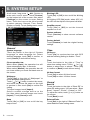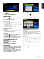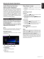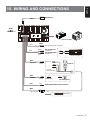
1
Owner´s manual
NX302E
MULTIMEDIA STATION WITH BUILT-IN NAVIGATION & 6.2” TOUCH
PANEL CONTROL
English
Contents
Thank you for purchasing this Clarion product.
• Please fully read this owner’s manual before operating this equipment.
• Check the contents of the enclosed warranty card and store it in a safe place with this manual.
1. FEATURES......................................................................................................................... 3
Expanding Systems............................................................................................................ 3
2. PRECAUTIONS.................................................................................................................. 4
3. CAUTIONS ON HANDLING............................................................................................... 5
4. CONTROLS........................................................................................................................ 6
Operational Panel............................................................................................................... 6
Names of Buttons............................................................................................................... 6
5. MAIN MENU OPERATION................................................................................................. 7
6. SYSTEM SETUP................................................................................................................. 8
7. USB OPERATION............................................................................................................. 11
Accessing an USB............................................................................................................ 11
USB Audio Operation....................................................................................................... 11
USB Video Operation....................................................................................................... 14
8. BLUETOOTH OPERATION.............................................................................................. 15
Bluetooth Telephone Operation....................................................................................... 15
Bluetooth Audio Operation............................................................................................... 17
9. RADIO OPERATION......................................................................................................... 18
Radio Data System Operation.......................................................................................... 20
10. iPod & iPhone Operation.......................................................................................... 21
11. Navigation Operation............................................................................................ 23
12. AUX Operation.......................................................................................................... 23
13. TROUBLE SHOOTING................................................................................................... 24
14. SPECIFICATIONS.......................................................................................................... 26
15. Wiring and Connections....................................................................................... 27
2
NX302E
• 6.2” Wide-VGA Color LCD Touch Panel
• Front-Panel Auxiliary Input and 2ch RCA Output with Subwoofer Control
• BEAT-EQ with 3 Band Parametric Equalizer and MAGNA BASS EX Dynamic
Bass Enhancement
• Latest Map Guarantee
English
1. FEATURES
Expanding Systems
Expanding audio features
Expanding visual features
Rear
Monitor
Rear vision
Camera
2 Channel Amplifier
iPod® / iPhone®
(Connect via CCA-750)
Portable Player
(Connect via AUX IN Jack)
USB Memory
Bluetooth®
cellular phone
Notes:
• The items listed outside of the frames are the commercial products generally sold.
• CCA-750: Sold by separately.
NX302E
3
English
2. PRECAUTIONS
WARNING
For your safety, the driver should not operate the controls while driving.
Also, while driving, keep the volume to a level at which external sounds can be heard.
1.This unit uses precision parts and components for its operation. In the event that trouble
arises, never open the case, disassemble the unit, or lubricate the rotating parts. Contact your
Clarion dealer or service center.
2.“ Made for iPod,” and “Made for iPhone” mean that an electronic accessory has been
designed to connect specifically to iPod, or iPhone, respectively, and has been certified by
the developer to meet Apple performance standards.
Apple is not responsible for the operation of this device or its compliance with safety and
regulatory standards. Please note that the use of this accessory with iPod or iPhone may
affect wireless performance.
iPhone and iPod are trademarks of Apple Inc., registered in the U.S. and other countries.
3.The Bluetooth® word mark and logos are registered trademarks owned by Bluetooth SIG, Inc.
and any use of such marks by Clarion Co.,Ltd, is under license.
NX302E
AM
FM
531-1602kHz
87.5-108MHz
03 2234
This product includes technology owned by Microsoft Corporation and
cannot be used or distributed without a license from MSLGP.
TX-1092E-A
4
NX302E
CHINA
PN:127070009973
English
3. CAUTIONS ON HANDLING
Front Panel / Generalities
For a longer service life, be sure to read the following cautions.
•Do not allow any liquids on the unit from drinks, umbrellas, etc. Doing so may damage the
internal circuitry.
• Do not disassemble or modify the unit in any way. Doing so may result in damage.
• Do not let cigarettes burn the display. Doing so may damage or deform the body.
• If a problem should occur, have the unit inspected at your store of purchase.
•The remote control unit may not work if the remote control sensor is exposed to direct
sunlight.
Cleaning the body
• Use a soft, dry cloth and gently wipe off any dirt and/or dust.
•For tough dirt, apply some neutral detergent diluted in water to a soft cloth, wipe off the dirt
gently, then wipe again with a dry cloth.
•Do not use benzene, thinner, car cleaner, etc., as these substances may damage the body
or cause the paint to peel. Also, leaving rubber or plastic products in contact with the body for
long periods of time may cause stains.
USB Port
•The USB memory sticks must be recognized as “USB mass storage class“ to work properly.
Some models may not operate correctly.
When the memorized data is lost or damaged by any chance, Clarion shall not be liable
for any damage.
When using an USB memory stick, we recommend that you backup your data stored on it
before using a personal computer etc.
•Data files may be broken when using USB memory sticks in the following situation: When
disconnecting the USB memory stick or turning the power off during reading data.
When affected static electricity or electric noise.
Connect/disconnect the USB memory stick when it is not accessed.
•Connecting with the computer is not covered.
NX302E
5
English
4. CONTROLS
Operational Panel
[
[
ALL ] ALL MENU
RESET
[MIC]
] NAVI/AV
[POWER/VOL]
Micro SD card slot
Only navigation map
card is available and
don't remove it when
unit is power on.
AUX Jack
Names of Buttons
[POWER/VOL] Knob
•Press to power on the system when ignition on.
• When power on, short press to mute the volume.
•Rotate the knob to increase or decrease the volume.
•Press and hold this key more than 1 second to turn off the system.
[ ALL ] ALL MENU Button
• Short press to show/exit shortcut menu.
• Long press to show/exit main source menu.
[
] NAVI/AV Button
•Press to enter navigation mode;
•Press again to return current source.
[ MIC ] Hole
• Internal microphone
[RESET] Button
• Press to load original settings.
Note: When the [RESET] button is pressed, frequencies of radio stations, titles, etc. stored
in memory are cleared.
6
NX302E
Long press [ ALL ] button on the PANEL to
show main source menu.
Short press [
cut menu.
ALL ] button to show Short
Playing Source
Touch [ - ] on the bottom of screen to show
front zone sources.
[Settings]: Touch the icon to enter system
setting menu. (see “System Setup”)
English
5. MAIN MENU OPERATION
[Beat EQ]: Touch the icon to enter equalizer
setting menu. (see “System Setup”)
[Short Cut]: Touch the icon to enter Shortcut
setting menu. Hold the desired icon for more
than 2 seconds until it’s activated, then drag
it to the bottom. The name will appear on the
bottom.
•Hold the center of the screen and drag left
or right to show more icons.
•You can make total 5 shortcuts.
•You can access the shortcut list by
pressing the [ ALL ] button.
[Wallpaper]: Touch the icon to enter
Wallpaper setting menu. (see “System
Setup”)
Change page by dragging left or right or
touching other two [ - ] buttons.
[Monitor Off]: Touch the icon to turn off the
monitor.
To turn on the monitor, touch the monitor
again.
Touch the icons on the screen to enter
corresponding work mode, such as USB
mode, Tuner mode, Telephone mode, etc.
Touch [Audio Off] to mute the volume.
Custom Setting
Touch [Custom] on the bottom of screen to
show custom setting menu.
NX302E
7
English
6. SYSTEM SETUP
At all mode, long press [ ALL ] button to
enter main source menu. Touch [Custom]
on the bottom left of the screen, then select
[Settings] on the screen to enter Setting
menu. Touch the icons on the left of screen
to select category: General, Time, Sound,
Display or Setup. To exit Setting menu, touch
[ ] on the bottom left of the screen.
Blinking LED
Touch [On] or [Off] to turn on/off the blinking
LED.
At blinking LED [On] mode, when ACC off,
the LED on the top left of the panel will blink.
Amplifier cancel
Touch [On] or [Off] to set the internal
amplifier on or off.
System software
Touch [Version] to show current software
version.
Factory default
Touch [Restore] to load the original factory
settings.
General
System language
Touch the button to the right of “System
language” to show language list. Select
desired language, touch [OK] to confirm, or
touch [Cancel] to exit without saving.
Close operation bar
When select [Auto], the operation bar will
close automatically after 10 seconds.
When select [Manual], the operation bar will
not close unless you touch the blank area on
the screen.
Wallpaper
Touch [Set] to the right of “Wallpaper” to
show Wallpaper setting menu.
Touch [ ] or [ ] button to select the scene,
and touch the picture file name on the right
to preview it, then touch [Set] to confirm the
setting.
To import images, touch [Import].
Select a mobile storage device on the
list, then select desired images and touch
[Import]. Touch [Cancel] to exit.
Beep
Touch [On] or [Off] to turn on/off the key
beep sound.
8
NX302E
Time
GPS sync
Touch [On] to synchronize time with GPS
and the following setting is disable: “Time”.
Time
Touch the button to the right of “Time” to
show time setting menu. Touch [ ] or [ ]
button to select hour or minute. Touch [Set]
to confirm or [Back] to exit without saving.
24-Hour format
Touch [On] to select 24-Hour format.
Touch [Off] to select 12-Hour format.
Sound
Beat EQ
Touch the button to the right of “Beat EQ” to
show EQ setting menu. You can select : “Bass
Boost”, “Impact”, “Excite”, “Custom” or “Off”.
To adjust the value, touch [-] or [+] button on
the screen.
Touch [Back] to exit.
Balance/Fader
Touch [Set] to the right of “Balance/Fader” to
show Balance/Fader setting menu.
AUX
Sub woofer control
Touch [-] or [+] button on the right of “Sub
woofer control” to adjust sub woofer level.
Bluetooth
Sub woofer phase
Touch to select sub woofer phase Normal or
Reverse.
High pass filter
Touch the button to the right of “High pass
filter” to show the sub-menu, then select the
filter: “Through”, “55Hz”, “85Hz” or “120Hz”.
Touch [Cancel] to exit.
Low pass filter
Touch the button to the right of “Low pass
Filter” to show the sub-menu, then select the
filter: “Through”, “62Hz”, “95Hz” or “135Hz”.
Touch [Cancel] to exit.
Line out
Touch [SW] to choose Subwoofer.
Touch [Rear] to choose Rear Line out.
Magna Bass Ex
Touch [On] to turn on the loudness.
Display
Dimmer Mode
Touch [Auto], [Day] or [Night] to choose
dimmer mode.
Auto: The dimmer is controlled by your car
light.
Dimmer
Touch [-] or [+] button to the right of “Dimmer”
to adjust dimmer.
The setting is only for Day or Night.
• Input Aux Level (AUX1)
Choose “Low”, “Middle“ or “High” input
level of auxiliary device.
English
Touch [
] or [
] button to adjust Fader,
and touch [
] or [
] button to adjust
Balance.
Touch [Center] to reset the value.
Touch [Back] to exit.
• Bluetooth
Choose Bluetooth function on or off.
• Telephone Speaker
Choose Front Left or Front Right speaker
at telephone mode.
• Tone Select
Touch [Auto] to use ringtones of your
mobile phone.
Touch [Internal] to use preset ringtone of
the unit.
• Software Update
Update the software.
Camera
• Camera Interrupt
Choose [On], the screen will switch to rear
camera menu automatically when backing.
Navigation
• Navigation Interrupt
Select navigation interrupt On, Pop-Up or
Off.
• Voice Guidance
ON: Interrupt function of voice guidance
is on. While interrupting no attenuate
function of AV sound.
MUTE: Interrupt function of voice guidance
is on. While interrupting attenuate function
of AV sound is on.
OFF: Interrupt function of voice guidance
is off. While interrupting no attenuate
function of AV sound.
Setup
Touch [Setup] on the right of screen to
spread the setting list. then touch the button
to the right of desired option to adjust or
show the sub-menu. Touch [Close] to close
the list.
NX302E
9
Anti Theft
English
• Anti Theft code
You can set an Anti-theft code. After set
successfully, when Battery wire reconnect,
you need to input the Anti-theft code.
1.L ong press the [General] button until a
dialog box popped up. Touch [Yes] to set
a personal code of Anti-Theft.
2.Input a 4-digit code. Touch [OK] to confirm.
Then input it again for confirmation.
3.T o remove the code, long press the
[General] button and input the old
password.
Note:
Please make a note of the Anti theft code not
to forget. if the right code is not inputted, it
becomes impossible to operate this unit.
10
NX302E
English
7. USB OPERATION
Accessing an USB
1. Insert an USB device into the USB cable.
When connecting an USB device, the unit
will read the files automatically.
2.To remove the USB device, you should
first select another source or turn off
the power, in order to avoid damaging
the USB device. Then take off the USB
device.
3.T o a c c e s s a n U S B d e v i c e a l r e a d y
connected to the unit, long press [ ALL ]
button to enter main source menu, then
select [USB] to enter USB mode.
If [USB] is not on the current source menu,
touch [ - ] buttons on the bottom of the
screen, or hold the center of screen and
drag left/right to show more icons.
USB Audio Operation
This system can play audio files (MP3/WMA)
stored in an USB memory. You can use it as
an audio device by simply copying desired
audio files into it.
Notes:
• T
his system will not operate or may
operate improperly with some USB.
• Files protected with any DRM cannot be
played.
Select USB Audio mode
Touch top left corner of the screen until USB
Audio appears.
MP3/WMA Playback
This unit is an ID3 Tag compatible model.
This unit supports the ID3 TAGs of the
Version 2.4, 2.3, 1.1 and 1.0.
In displaying, this unit gives priority to the
Version 2.3 and 2.4 TAGs.
What is MP3/WMA
MP3 is an audio compression method
and classified into audio layer 3 of MPEG
standards.
WMA is an audio compression method
developed by Microsoft Corporation.
These audio compression methods have
penetrated into PC users and become a
standard format.
Displaying MP3/WMA TAG titles
Tag information such as title, artist and album
title can be displayed for MP3/WMA file
containing Tag information.
Precautions when creating MP3/
WMA file
Usable sampling rates and bit rates
1.MP3: Sampling rate 8 kHz-48 kHz, Bit rate
8 kbps-320 kbps / VBR
2. WMA: Bit rate 8 kbps-320 kbps
NX302E
11
English
File extensions
1.A lways add a file extension “.MP3”,
“.WMA” to MP3, WMA file by using single
byte letters. If you add a file extension
other than specified or forget to add the
file extension, the file cannot be played.
2.Files without MP3/WMA data will not play.
The files will be played soundlessly if you
attempt to play files without MP3/WMA
data.
*When VBR files are played, the play time
display may differ the play location.
*When MP3/WMA files are played, a little
no sound part is caused between tunes.
Folder structure
A storage with a folder having more than 8
hierarchical levels will be impossible.
Number of files or folders
1.U p to 999 files can be recognized per
folder.
Up to 6000 files can be played.
2.Tracks are played in the order that they
were stored. (Tracks may not always be
played in the order displayed on the PC.)
3.S ome noise may occur depending on
the type of encoder software used while
recording.
Playing MP3 folders
When selected for play, files and folders
(Folder Search, File Search or Folder Select)
are accessing in the order in which they were
written to the media.
As a result, the order in which they are
expected to be played may not match the
order in which they are actually played.
You may be able to set the order in which
MP3/WMA files are to be played by assigning
file names beginning with play sequence
numbers such as “01” to “99”.
For example, a medium with the following
folder/file hierarchy is subject to Folder
Search, File Search or Folder Select.
See the diagram below.
12
NX302E
0
()
1
2
3
5
6
7
♪①
♪②
♪③
♪④
♪⑤
4
♪⑥
♪⑦
♪⑧
♪⑨
○
Root Folder
Folder
♪
File
Layer1 Layer 2 Layer 3 Layer 4 Layer5
The player will only recognize three folder
levels and does not display folders containing
other folders. In the example above, the unit
will display folders 2, 3, 5 and 7, but 1 and 6
since they do not contain others.
Playback menu
Touch the bottom half of screen to show
operation bar.
1. Show folder/file list(Browse)
2. Folder/Title/Artist/Album information
3. Play/Pause
4. Repeat play
5. Previous track
Fast reverse (long press)
6. Progress bar
7. Next track
Fast forward (long press)
8. Random play
9. Show other options
English
10. Scan play
11. Back to main operation bar
Browse mode
Touch the [
] button to show track list.
Drag up/down to browse the tracks, and
touch desired track to select it.
Search Function
1.Touch the [
] button to show folder/
file list. Touch [
] button to enter search
menu.
2Input numbers by touching digit buttons,
then touch [Search] to begin searching.
To delete numbers, touch [
] button.
Pausing play
1.Touch the [ ] button on the bottom left of the
screen to pause play.
“PAUSE” appears in the display, and [ ]
button becomes [ ] .
2.Touch [ ] button to resume play.
Selecting a track
Track-up
] button to move to the
1.T ouch the [
beginning of the next track.
Track-down
1.Touch the [
] button to move back to
the beginning of the current track.
2.Touch the [
] button twice to move back
to the beginning of the previous track.
Fast forward/Fast reverse
Fast forward
Touch and hold the [
Fast reverse
Touch and hold the [
] button .
] button .
Folder Select
This function allows you to select a folder
containing MP3/WMA files and start playing
from the first track in the folder.
Touch the [
] button on the upper left of
the screen to show folder/file list. You can
select a folder or file by touching it.
Other various play functions
Scan play
This function allows you to locate and play
the first 10 seconds of all the tracks.
] button, then touch [Scan] to
Touch the [
scan play.
Repeat play
This function allows you to play the current
track repeatedly or play a track currently
being played in the MP3/WMA folder
repeatedly.
] button to select Track
Touch the [
Repeat, Folder Repeat or All Repeat.
Random play
This function allows you to play all tracks in a
random order.
Touch the [
] button to perform random
play.
NX302E
13
English
USB Video Operation
This system can play video files (MP4, etc)
stored in an USB memory. You can use it as
an video device by simply copying desired
video files into it.
Notes:
• T
his system will not operate or may
operate improperly with some USB.
• Files protected with any DRM cannot be
played.
• W hile voice guidance is in, USB video
playback is interrupted.
Select USB Video mode
Touch top left corner of the screen until USB
Video appears.
Touch [
] button to show folder/file list.
Select a desired file to play.
Playback menu
When playing, touch the bottom half of
screen to show operation bar.
8. Show playback information
9. Back to main operation bar
Browse mode
Touch the [ ] button to show folder/file list.
Drag up/down to browse, and touch desired
option to select it.
Pausing play
1.Touch the [ ] button on the screen to pause
play.
“ PAUSE” appears in the display.
2.Touch [ ] button to resume play.
Selecting a file
File-up
T ouch the [
] button to move to the
beginning of the next file.
File-down
Touch the [
] button to move back to the
beginning of the current or previous file.
Fast forward/Fast reverse
Fast forward
] button .
Hold the [
Fast reverse
] button .
Hold the [
Repeat play
1. Play/Pause
2. Repeat playback
3. Previous file
Fast reverse (long press)
4. Progress bar
5. Next file
Fast forward (long press)
6. Stop and show list menu (Browse)
7. Show other options
14
NX302E
This function allows you to play the current
file repeatedly or play files currently being
played in the folder repeatedly.
Touch the [
] button to select File Repeat,
Folder Repeat, All Repeat or Repeat Off.
Search function
1.At video main menu, touch the [ ] button
to show folder/file list.
2.Touch [ ] button to enter search menu.
3Input numbers by touching digit buttons,
then touch [Search] to begin searching.
To delete numbers, touch [
] button.
The Bluetooth allows you to utilize your car’s built-in audio system for wireless mobile phone or
music handsfree communication. Some Bluetooth mobile phones have the audio features, and
some portable audio players support Bluetooth feature. This system can play audio data stored
in a Bluetooth audio device. The car stereo with Bluetooth will be able to retrieve phonebook
contacts, received call, dialled call, missed call, incoming calls, outgoing call and listen to music.
English
8. BLUETOOTH OPERATION
Notes:
• D
o not set the microphone of Bluetooth handsfree in the places with wind passing such as air
outlet of the air conditioner, etc. This may cause a malfunction.
• I f set it in the places subjected to direct sun, high temperature can cause distortion,
discoloration which may result in a malfunction.
• This system will not operate or may operate improperly with some Bluetooth audio players.
• Clarion cannot guarantee the compatibility of all mobile phones together with the unit.
• Audio playback will be set to the same volume level as set during telephone call. This might
cause problems, if extreme volume level is set during telephone call.
Bluetooth Telephone Operation
Pairing
1.Turn on the Bluetooth function of the unit.
(see <System Setup>, <Bluetooth>)
2.Turn on Bluetooth function of your mobile
phone.
3.E nter mobile phone’s Bluetooth setup
menu.
4. Search for new Bluetooth devices.
5.Select NX302E from the pairing list on the
mobile phone.
6. Enter “0000” as the password.
7.After pairing successfully,
indicator on
the bottom right of the screen turns blue.
Search from the unit
You can search Bluetooth device from the
unit.
1.Touch [Add] on the right of the screen, the
unit will search the Bluetooth devices and
list on the screen.
2.I f your desired device isn’t on the list,
touch the button on the bottom left of the
screen to refresh.
To stop searching, touch [Cancel].
3.Touch the device name on the screen to
select it, then input PIN code on the submenu.
4.A fter paired successfully, select device
image, touch [OK] to confirm.
5.If connect unsuccessfully, select [Retry] to
reconnect or select [Cancel] to return to
list menu.
Choose paired device
After paired, the mobile device information
appears on the right of screen, such as
model number, Signal, Battery.
1.T o select other paired device, hold the
middle right of the screen, and drag it left
or right, touch it to show control buttons.
2.Touch [Connect] to connect the Bluetooth
device. Touch [Cut] to disconnect.
] to delete the paired device
3.T ouch [
from pairing list.
Telephone menu
Long press [ ALL ] button to enter main
source menu, then select [Telephone] to
enter telephone mode.
If [Telephone] is not on the current source
menu, touch [ - ] buttons on the bottom of the
screen, or hold the center of screen and drag
left/right to show more icons.
NX302E
15
English
• Dialed/Received/Missed Call History
You can search any Dialled/Missed/Received
Call History.
1. Show history categories
2. Backspace
3. Paired device information
4. Number pad
5. Call/Hang up
6. Turn on/off Auto Connect function
7. Turn on/off Auto Answer function
8. Set PIN code
9. Select internal or external microphone
10. Show next page
11. Back to main operation bar
1.Touch [ ] button to show following history
categories: Dialed, Received, Missed and
Contacts.
Touch [Dialer] to dial number manually.
2.Touch to select a category, the numbers of
the category are displayed.
] button to
3.Select a number, touch [
dial.
Touch [ ] to return previous menu.
• Call from Phonebook
You can search the contact name in the
phonebook and make call.
1.Touch [ ] button and select [Contacts].
It may take a few minutes to synchronize
the phone book at first time.
] button to
2.Select a number, touch [
dial.
Touch [ ] to return previous menu.
Note:
Some cellular phones may not be able to
transfer the Phone Book data.
• Answering a call
You can answer an incoming call by pressing
the [
] button.
*T o u c h [
] button to reject an
incoming call.
12. Show previous page
13. Adjust microphone gain
14. Show Bluetooth information
15. Bluetooth indicator
Making a call
• Dial Number
1.Input numbers by digit-keys on the screen.
] button to dial.
2. Touch [
Touch [
] button to delete characters.
3. Touch [
] button to terminate call.
16
NX302E
Audio Streaming Operation
What is audio streaming?
Audio streaming is a technique for transferring
audio data such that it can be processed as
a steady and continuous stream. Users can
stream music from their external audio player
to their car stereo wirelessly and listen to the
tracks through the car’s speakers. Please
consult your nearest Clarion dealer for more
information on the product of wireless audio
streaming transmitter offered.
CAUTION
Please avoid operating your connected
mobile phone while audio streaming as
this may cause noise or sound choppy on
the song playback.
Audio streaming may or may not resume
after telephone interrupt as this is
dependent on mobile phone.
Note:
Be sure to read the chapter “Pairing” and
“Choose paired device” before proceeding.
Playback menu
Touch the bottom half of screen to show
operation bar.
Play / Pause a track
1.T ouch the [ ] button to pause audio
playback.
2.To resume audio playback, touch the [ ]
button.
English
Bluetooth Audio Operation
Selecting a track
Track-up
] button to move to the
1.T ouch the [
beginning of the next track.
2.Each time you touch the [
] button, the
track advances to the beginning of the
next track.
Track-down
1.Touch the [
] button to move back to
the beginning of the current track.
2.Touch the [
] button twice to move back
to the beginning of the previous track.
Stop playback
Touch [
] button to stop playback.
Note:
Playing order will depend on Bluetooth audio
player. When [
] button is pressed, some
A2DP devices will restart the current track
depends on the duration of playback.
Some Bluetooth audio players may not
have play/pause synchronized with this unit.
Please make sure both device and main
unit are in the same play/pause status in
Bluetooth Audio mode.
1. Title/Artist/Album information
2. Play/Pause
3. Previous track
Fast reverse (long press)
4. Stop
5. Next track
Fast forward (long press)
NX302E
17
English
9. RADIO OPERATION
Select tuner for listening to the radio
Long press [ ALL ] button to enter main
source menu, then select [Tuner] to enter
Tuner mode.
If Tuner is not on the current source menu,
touch [ - ] buttons on the bottom of the
screen, or hold the center of screen and drag
left/right to show more icons.
Menu of listening to the radio
Touch the bottom half of screen to show
operation bar.
17. Show previous page
18. Select Programme Type
19. Auto store preset stations
Select one radio band
Touch the top left corner of the screen to
select one radio band among FM1, FM2,
FM3 and AM.
Manual tuning
1. Band switch
2. Information area
3. Preset station number
4. Current station frequency
5. Show preset stations list
6. Scan preset stations
7. Manual tune backward
Auto tune backward (long press)
8. Frequency bar
9. Manual tune forward
Auto tune forward (long press)
10. Show other options
During manual tuning, the frequency will be
changed in steps.
Touch the [
] or [
] button on the
operation bar to tune in a higher / lower
station.
Auto tuning
Hold the [
] or [
] button on the
operation bar for more than 2 seconds to
seek a higher / lower station.
To stop searching, repeat the operation
above or press other buttons having radio
functions.
Note:
When a station is received, searching stops
and the station is played.
Preset scan
18
11. Choose local or distant seeking mode
12.Turn on/off Traffic Announcement
13. Turn on/off Alternative Frequency
14. Turn on/off Regional
15. Show next page
16. Back to main operation bar
NX302E
Preset scan receives the stations stored
in preset memory in order. This function is
useful when searching for a desired station
in memory.
1.Touch the [
] button on the operation
bar.
2.When a desired station is tuned in, press
the [
] button to continue receiving that
station.
Auto store
English
Only stations with sufficient signal strength
will be detected and stored in the memory.
To star automatic station search, touch
following buttons on the operation bar in
sequence: [
] -> [
] -> [OK]
To stop auto store, press other buttons
having radio functions.
Notes:
1. A fter auto store, the previous stored
stations will be overwritten.
2. The unit has 4 bands, such as FM1, FM2,
FM3 and AM. FM3 and AM can store
by AS function. Each bands can store 6
stations, NX302E can store 24 stations in
total.
Manual store
When one expected radio station has been
detected, touch [
] button on the right
edge of the screen to show the preset
station list, hold one of the six preset stations
for more than 2 seconds to store it in the
memory. Touch [
] button near the center
of screen to hide the preset station list.
Recall the stored stations
Touch [
] button on the right edge of the
screen to show the preset station list, touch
to select a preset station.
Touch [
] button near the center of screen
to hide the preset station list.
Local seeking
When LOCAL seeking is on, only those radio
stations with strong radio signal could be
received.
To open LOCAL function, touch [
] button
on the operation bar, then touch the [Mode]
button to select “Local” or “DX”.
Note:
The number of radio stations that can be
received will decrease after the local seeking
mode is on.
NX302E
19
Radio Data System Operation
English
Radio Data System
This unit has a built-in “Radio Data System”
decoder system that supports broadcast
stations transmitting “Radio Data System”
data.
When using the “Radio Data System”
function, always set the radio to FM mode.
AF function
The AF function switches to a different
frequency on the same network in order to
maintain optimum reception.
]
To turn on or off AF function, touch [
button on the operation bar, then touch the
[AF] button to select “On” or “Off”
• AF ON:
“AF” indicator lights up and AF function
turns on.
• AF OFF:
“AF” indicator turns gray and AF function
turns off.
REG (Regional programme)
function
When the REG function is ON, the optimum
regional station can be received. When this
function is OFF, if the regional station area
switches as you drive, a regional station for
that region is received.
To turn on or off REG function, touch [
]
button on the operation bar, then touch the
[REG] button to select “On” or “Off”
• REG ON:
“REG” indicator lights/blinks up and REG
function turns on.
• REG OFF:
“REG” indicator turns gray and REG
function turns off.
Notes:
• T
his function is disabled when a national
station such as BBC R2 is being received.
• The REG function ON/OFF setting is valid
when the AF function is ON.
20
NX302E
TA (Traffic Announcement)
In the TA standby mode, when a traffic
announcement broadcast starts, the traffic
announcement broadcast is received as top
priority regardless of the function mode so
you can listen to it. Traffic programme (TP)
automatic tuning is also available.
*This function can only be used when
“TP” appears in the display. When “TP”
appears, this means that the “Radio Data
System” broadcast station being received
has traffic announcement programmes.
To turn on or off TA function, touch [
]
button on the operation bar, then touch the
[TA] button to select “On” or “Off”
• TA ON:
“TA” indicator lights up and the unit is set
into the TA standby mode until a traffic
announcement is broadcast.
• TA OFF:
“TA” indicator turns gray and the TA
standby mode is cancelled.
PTY (Programme Type)
This function enables you to listen to a
broadcast of the selected programme type.
Selecting PTY
To select PTY type, touch following buttons
on the operation bar in sequence:
] -> [ ] -> [PTY Select]
[
Then select desired type on the dialog box,
touch [Seek] to begin searching.
English
10. iPod & iPhone Operation
Connect an iPod or iPhone to the USB
connector via CCA-750 cable.
When connecting a device, the unit will read
the files automatically. The track information
display on the screen once playback start.
CCA-750
11. Turn on / off Simple Control
12. Select Audiobook play speed
13. Back to main operation bar
Browse mode
Accessing iPod mode
Long press [ ALL ] button to enter main
source menu, then select [iPod] to enter
iPod mode.
If [iPod] is not on the current source menu,
touch [ - ] buttons on the bottom of the
screen, or hold the center of screen and drag
left/right to show more icons.
At iPod Audio mode, touch the bottom half of
screen to show operation bar.
1.Touch the [
] button to show file list.
Drag up/down to browse. Touch a item of
list on the screen to select it.
2.Touch [ ], [ ] and [ ] buttons to show
the following categories: Playlists, Songs,
Artists, Albums, Genres, Composers,
Audiobooks, Podcasts.
3.Touch to select a category, the contents of
the category are displayed. Drag up/down
to browse.
4. Touch an option to select it.
Pausing play
1.Touch the [ ] button on the bottom left of the
screen to pause play.
“PAUSE” appears in the display, and [ ]
button becomes [ ] .
2.Touch [ ] button to resume play.
Selecting a track
1. Show file list (Browse)
2. Switch between iPod Audio and Video
3. Song/Artist/Album information
4. Play/Pause
5. Repeat play
6. Previous track
Fast reverse (long press)
7. Progress bar
8. Next track
Fast forward (long press)
9. Random play
10. Show other options
Track-up
1.T ouch the [
] button to move to the
beginning of the next track.
2.Each time you touch the [
] button, the
track advances to the beginning of the
next track.
Track-down
1.Touch the [
] button to move back to
the beginning of the current track.
2.Touch the [
] button twice to move back
to the beginning of the previous track.
NX302E
21
Fast forward/Fast reverse
English
Fast forward
Touch and hold the [
Fast reverse
Touch and hold the [
] button .
] button .
Repeat play
This function allows you to play the track
repeatedly.
Touch the [
] button to select Repeat one
or Repeat all.
Random play
This function allows you to play all tracks in a
random order.
Touch the [
] button to perform random
play.
iPod menu alphabet search
This function searches the subfolders for
desired alphabetical letters.
1.Touch the [
] button to show file list.
Touch [ ] button to enter search menu.
2.Input characters by touching buttons on
the screen, then touch [Search] to begin
searching.
Touch [123] to show digit keypad, touch
[ABC] to show letter keypad.
Touch [Space] to input a blank space.
Touch [
] button to delete characters.
Setting iPod simple control mode
Use this function if you wish to operate
through your iPod connected to this unit via
the USB cable.
] button, then touch [Simple
Touch the [
Control] to set it to [On].
iPod video playback
To playback video from iPod, touch top left
corner of the screen, then select a video file
to play.
During playback, touch the bottom half of
screen to show operation bar.
22
NX302E
1. Play/Pause
2. Repeat play
3. Previous file
Fast reverse (long press)
4. Progress bar
5. Next file
Fast forward (long press)
6. Show iPod list menu
7. Show other options
8. Turn on / off Simple Control
9. Back to main operation bar
Return to video list menu
Touch [
] button on the operation bar to
return to video list menu.
English
11. Navigation Operation
Using a Micro SD card
1.Slide the cover of the card slot located on
the bottom left of the panel to the right.
Insert a Micro SD card into the card slot.
2.To remove the card, you should first select
another source or turn off the power, in
order to avoid damaging the card. Press to
pop it out, then take off the card. Close the
cover to the left.
Control buttons
Access navigation mode
1.Slide the cover of the card slot located on
the bottom left of the panel to the right.
Insert a Micro SD card into the mini card
slot.
2.To remove the card, you should first select
another source or turn off the power, in
order to avoid damaging the card. Press to
pop it out, then take off the card. Close the
cover to the left.
3.P ress [
] button on panel to visit
Navigation mode.
*The navigation operations depend on your
map, it may be different from the following
content.
1.Touch top left corner of the screen to show
GPS informations. Touch [Back] to return.
2.T ouch bottom left corner of the screen
to enter Navigation menu. Touch [Show
Map] to return.
3.Touch middle left of the screen to show
shortcuts of general functions. Touch [ ]
button to hide.
4.Touch bottom right corner of the screen
to show Distance/Time Left/Arrival Time.
Touch it again to hide.
5.T ouch the blank area to show control
buttons.
Top left corner: Plane/three-dimensional
Top right corner: Cursor location.
[ ]/[ ]: Move left/right
[ ]/[ ]: Move up/down
[ ]/[ ]: Enlarge/reduce the map
[Back]: Hide the buttons.
[More]: Show more informations.
[Select]: Select the route.
12. AUX Operation
Long press [ ALL ] button to enter main
source menu, then select [AUX] to visit front
auxiliary device.
If [AUX] is not on the current source menu,
touch [ - ] on the bottom of the screen, then
hold the center of screen and drag left/right
to show more icons.
NX302E
23
English
13. TROUBLE SHOOTING
GENERAL
Problem
Unit can not
power on.
Cause
Replace with new fuse of correct rating.
Car battery fuse blown.
Replace with new fuse of correct rating.
Turn off the power and press the [RESET]
button with a thin rod.
Unit can not
power on.
Nothing happens
The microprocessor has
when buttons are
malfunctioned due to noise, etc.
pressed.
Display is not
accurate.
Remote control
does not work.
Measure
Unit fuse blown.
Note:
When the [RESET] button is pressed, turn off
the power.*
* When the [RESET] button is pressed,
frequencies of radio stations, titles, etc. stored
in memory are cleared.
Battery depleted.
Change the battery.
Battery installed incorrectly.
Install the battery correctly.
Improper audio output connection. Check wiring and correct.
No/low audio
output
Volume set too low.
Increase volume level.
Speakers damaged.
Replace speakers.
Heavily biased volume balance.
Adjust the channel balance to center position.
Speaker wiring is in contact with
metal part of car.
Insulate all speaker wiring connections.
Speaker power rating does not
match unit.
Poor sound quality
or distortion
Wrong connections.
Speaker is shorted.
Unit resets itself
Incorrect connection between
when engine is off. ACC and Battery.
Replace speakers.
Check wiring and correct.
Check wiring and correct.
Check wiring and correct.
The brightness control is too low. Adjust the brightness properly.
The display is
dark.
There are red,
green, and blue
points in display
24
NX302E
The temperature inside the vehicle may be 0°C
or lower. Set to an appropriate temperature
(25°C or so) and check it again.
The display is made dark at night to prevent
The headlight of the vehicle is lit. the glare (When the headlight of the vehicle is
lit in the daytime, the display gets dark.)
This is not a faiure, but a phenomenon peculiar
to a liquid crystal panel (The liquid crystal
panel is produced according to technology
____________________
with very high precision. Note that, though
there are effective pixels of 99.99% or more,
pixel missing or normally lit pixels account for
0.01%).
The operating condition is not
good.
USB Devices
USB device cannot
be inserted.
USB device is not
recognized.
Sound skips or is
noisy.
Cause
Measure
The USB device has been
inserted with wrong direction.
Reversing the connection direction of the USB
device, try it again.
The USB connector is broken.
Replace with a new USB device.
The USB device is damaged.
Disconnect the USB device and reconnect. If
the device is still not recognized, try replacing
with a different USB device.
Connectors are loose.
English
Problem
MP3/WMA files are not encoded
Use MP3/WMA files encoded properly.
properly.
No sound heard
No MP3/WMA file is stored in
with the display “NO
Store these files properly in the USB device.
the USB device.
FILE” shown.
The video image
of iPod/iPhone is
disturbed.
The TV Signal setting of the Set the TV Signal setting (NTSC/PAL) of the
iPod/iPhone is not set correctly. iPod/iPhone correctly.
Bluetooth
Problem
Cannot pair the
Bluetooth enabled
device with the car
audio system.
The audio quality
is poor after
connection with a
Bluetooth-enabled
device.
Cause
Measure
The device does not support the
Use another device to connect.
profiles required for the system.
The Bluetooth function of the Refer to the user manual of the device for how
device is not enabled.
to enable the function.
The internal microphone gain is Adjust the gain of the internal microphone in
not set correctly.
System Setup.
Adjust the gain and position of the external
The external microphone is microphone.
not set correctly nor properly
For example, stick the microphone onto the
positioned.
dashboard so it is close to the driver.
NX302E
25
FM Tuner
Input
Frequency range: 87.5-108.0MHz
Usable sensitivity: 13dBf
Frequency response: 30Hz-15kHz
Stereo separation: 30dB(1kHz)
Signal/noise ratio: >55dB
Audio input sensitivity:
High: 320mV (at 1V output)
Mid: 650mV (at 1V output)
Low: 1.3V (at 1V output)
(input impedance 10 k or greater)
AUX-in Audio level : ≤2V
Video level : NTSC/PAL 1Vp-p@75Ω
Frequency range: 531-1602kHz
Usable sensitivity (S/N=20dB): 30dBμ
MP3/WMA mode
MP3 sampling rate: 8 kHz to 48 kHz
MP3 bit rate: 8 kbps to 320 kbps / VBR
WMA bit rate: 8 kbps to 320 kbps
USB
Specification: USB 1.0/2.0
Playable audio format:
MP3(.mp3): MPEG 1/2/Audio Layer-3
WMA(.wma): Ver 7/8/9.1/9.2
Playable video format:
M4V(.m4v), MP4(.mp4):
MPEG4part2(Simple),MPEG4 AVC/
H.264([email protected])
3GP(.3gp): MPEG4part2(Simple)
Resolution : 480x272
Audio format :AAC,AMR,MP3,WMA,WAV
Bluetooth
Specification: Bluetooth Ver. 2.0+EDR
Profile: HFP (Hands-free Profile)
A2DP (Advanced Audio Distribution Profile)
AVRCP (AV Remote Control Profile)
PBAP (Phone Book Access Profile)
Send/Receive Sensitivity: Class 2
Audio Amplifier
Maximum power output:
180W (45W x 4)
Speaker impedance: 4 (4 to 8
allowable)
6.2 Inch TFT LCD
Display resolution (dot): 800RGB (H) x 480(V)
Active area (mm): 137.52(H) x 77.232 (V)
Screen size (inch): 6.2 (Diagonal)
Dot pitch (mm): 0.1719(H) x 0.1609(V)
26
NX302E
General
Power supply voltage:
14.4VDC (10.8 to 15.6V allowable),
negative ground
Fuse: 15A
Dimensions of the Main Unit:
178mm Width × 100mm Height × 163mm Depth
Weight of the Main Unit: 1.45kg
Dimensions of the Remote Control unit:
49mm Width × 12mm Height × 139mm Depth
Weight of the Remote Control Unit:
55g (including battery)
163mm
AM Tuner
13mm
English
14. SPECIFICATIONS
Note:
178mm
100mm
• Specifications
and design are subject
to change without notice for fur ther
improvement.
NX302E
English
15. Wiring and Connections
GPS
GPS Antenna
Antenna
(Black)
(Black)
(Black)
(Black)
Radio Antenna
Radio
Antenna
C
B
1
2
3
4
5
6
7
8
Referto
to next
next page.
Refer
page.
Black
Black
Black
Black
Black
Black
A
1
2
3
4
5
6
7
8
External
External Microphone
MicrophoneConnection
Connection
White
White
Red
Red
Black
Black
VISUAL
VISUAL IN
IN
Line
Line Out
OutRear
RearLeft
Left
Subwoofer
Subwoofer11
Line Out
OutRear
RearRight
Right
Line
Subwoofer22
Subwoofer
2-Channel Amplifier
Amplifier
2-Channel
Video
Video Out
Out
Yellow
Yellow
®
iPod/iPhone
iPod/iPhone
CCA-750
CCA-750
(sold separately)
separately)
(sold
Black
Black
CAMERA
CAMERA
Gray
Gray
Yellow
Yellow
Video
VideoOut
Out
Rear
Camera
RearVision
Vision Camera
Gray
Gray
Steering
Terminal
SteeringWheel
WheelRemote
RemoteControl
Control
Terminal
Black
Black
USB
USB connector
connector
or
or
USB Memory
Memory
USB
NX302E
27
English
B
18
16
14
12
10
8
6
4
2
1
3
5
7
Rear left Rear left +
Front left Front left +
Front right +
2
4
6
8
Front right Rear right +
Rear right Fuse 15A
Battery +
C
A
17
15
13
11
9
7
5
3
1
Location
1
3
5
7
Reverse
Parking
ACC +
AUTO ANT
AMP Remote
2
4
6
8
Illumination
Phone Mute
Groundd
Function
Connector A
Connector B
Rear right (+) / Purple
Rear right (-) / Purple with black stripe
Front right (+) / Gray
Battery 12V(+) / Yellow
Auto Antenna / Blue
Front left (+) / White
Illumination / Orange with white stripe
Front left (-) / White with black stripe
ACC+ / Red
Rear left (+) / Green
Ground / Black
Rear left (-) / Green with black stripe
Yellow
Yellow
Red
Red
VW, Audi
28
NX302E
Front right (-) / Gray with black stripe
Clarion Co., Ltd.
All Rights Reserved. Copyright © 2014: Clarion Co., Ltd.
Printed in China
Owner's manual
NX302E
Navigation
Thank you for choosing the Clarion NX302E as your navigator. Start using Clarion NX302E
right away. This document is the detailed description of the navigation software. You can
easily discover Clarion Mobile Map while you are using it; however, we still recommend that
you read this manual to fully understand the features and functions.
Easy navigation map updates
It is easy to keep the navigation system up to date. Simply download new map data from
Clarion’s portal site, store them on a microSD card and insert it into the Clarion NX302E via
the front card slot.
Latest Map Guarantee
When you start using the product, you have 30 days to download the latest available map free
of charge.
2 NX302E English
Table of contents
1 Warnings and Safety information .........................................................................6 2 Getting started .........................................................................................................7 2.1 Buttons and other controls on the screen....................................................................... 8 2.1.1 Using keyboards .................................................................................................................. 9 2.1.2 Beyond single screen tap ................................................................................................... 10 2.2 Map screen ................................................................................................................... 11 2.2.1 Navigating on the map ....................................................................................................... 11 2.2.2 Position markers ................................................................................................................ 13 2.2.2.1 Vehimarker and Lock-on-Road .................................................................................................. 13 2.2.2.2 Selected map location (Cursor) and selected map object .......................................................... 13 2.2.3 Objects on the map ............................................................................................................ 13 2.2.3.1 Streets and roads ....................................................................................................................... 13 2.2.3.2 Turn preview and Next street ..................................................................................................... 14 2.2.3.3 Lane information and Signposts................................................................................................. 15 2.2.3.4 Junction view ............................................................................................................................. 16 2.2.3.5 Motorway exit services .............................................................................................................. 16 2.2.3.6 3D object types........................................................................................................................... 17 2.2.3.7 Elements of the active route ....................................................................................................... 17 2.2.3.8 Traffic events ............................................................................................................................. 18 2.2.4 Manipulating the map ........................................................................................................ 19 2.2.5 Quick menu ........................................................................................................................ 20 2.2.6 Checking the details of the current position (Where Am I?) ............................................. 23 2.3 Navigation Menu .......................................................................................................... 24 3 On-road navigation ...............................................................................................26 3.1 Selecting the destination of a route .............................................................................. 26 3.1.1 Entering an address or a part of the address....................................................................... 26 3.1.1.1 Entering an address ................................................................................................................... 27 3.1.1.2 Entering the midpoint of a street as the destination ................................................................... 29 3.1.1.3 Selecting an intersection as the destination ............................................................................... 31 3.1.1.4 Selecting a city/town centre as the destination........................................................................... 32 3.1.1.5 Entering an address with a postal code ..................................................................................... 34 3.1.1.6 Tips on entering addresses quickly ............................................................................................ 36 3.1.2 Selecting the destination from the Places of Interest ......................................................... 36 3.1.2.1 Quick search for a Place of Interest........................................................................................... 37 3.1.2.2 Searching for a Place of Interest using preset categories .......................................................... 38 3.1.2.3 Searching for a Place of Interest by category ............................................................................ 40 3.1.2.4 Searching for a Place of Interest by name ................................................................................. 43 3.1.2.5 Searching for a Place of Interest by its Phone Number ............................................................. 45 3.1.2.6 Selecting nearby assistance from 'Where Am I?' ....................................................................... 47 3.1.3 Selecting a map location as the destination ....................................................................... 48 3.1.4 Selecting the destination from your Favourites ................................................................. 49 NX302E English 3
3.1.5 Selecting your Home location ............................................................................................ 50 3.1.6 Selecting a recent destination from the History ................................................................. 51 3.1.7 Entering the Coordinate of the destination ........................................................................ 52 3.1.8 Navigate to a location stored in a photo ............................................................................. 53 3.1.9 Building a route from the list of destinations (Create Route) ............................................ 54 3.2 Viewing the entire route on the map ............................................................................ 55 3.3 Checking route parameters and accessing route related functions ............................. 55 3.4 Modifying the route ...................................................................................................... 56 3.4.1 Selecting a new destination when already having a route: New Route, Waypoint or Final
Destination.................................................................................................................................... 57 3.4.2 Setting a new starting position for the route ...................................................................... 57 3.4.3 Editing the list of destinations (Edit Route) ....................................................................... 59 3.4.4 Pausing the active route ..................................................................................................... 59 3.4.5 Cancelling the active route ................................................................................................ 60 3.4.6 Checking route alternatives when planning the route ........................................................ 60 3.4.7 Checking route alternatives for an existing route .............................................................. 61 3.4.8 Changing the vehicle used in route planning ..................................................................... 62 3.4.9 Changing the road types used in route planning ................................................................ 63 3.5 Saving a location as a Favourite destination ............................................................... 64 3.6 Saving a location as an alert point .............................................................................. 65 3.7 Editing an alert point ................................................................................................... 66 3.8 Watching the simulation of the route ........................................................................... 67 4 Off-road navigation...............................................................................................69 4.1 Selecting the destination of the route ........................................................................... 69 4.2 Navigating in off-road mode ........................................................................................ 69 5 Reference Guide ....................................................................................................70 5.1 Concepts ....................................................................................................................... 70 5.1.1 Smart Zoom ....................................................................................................................... 70 5.1.2 Daytime and night colour themes ...................................................................................... 70 5.1.3 Tunnel view ....................................................................................................................... 70 5.1.4 Route calculation and recalculation ................................................................................... 71 5.1.5 Green routing ..................................................................................................................... 73 5.1.6 Road safety cameras and other proximity alert points ....................................................... 74 5.1.7 Speed limit warning ........................................................................................................... 75 5.1.8 Traffic information in route planning ................................................................................ 75 5.1.8.1 Real-time traffic information (TMC) .......................................................................................... 75 5.2 'More' menu.................................................................................................................. 77 5.3 Settings menu ............................................................................................................... 78 5.3.1 Sound and Warnings .......................................................................................................... 79 5.3.2 Customise Quick menu ...................................................................................................... 81 5.3.3 Traffic settings ................................................................................................................... 81 4 NX302E English
5.3.4 Route settings..................................................................................................................... 81 5.3.5 User profiles....................................................................................................................... 85 5.3.6 Map settings ....................................................................................................................... 85 5.3.7 Visual guidance settings .................................................................................................... 87 5.3.8 Display settings .................................................................................................................. 88 5.3.9 Regional settings ................................................................................................................ 88 5.3.10 Trip monitor settings........................................................................................................ 89 6 Glossary ..................................................................................................................90 7 End User Licence Agreement ...............................................................................92 8 Copyright note .......................................................................................................92 NX302E English 5
1. Warnings and Safety information
The navigation system helps you find your way to your destination with a connected GPS
receiver. Clarion Mobile Map does not transmit your GPS position; others cannot track you.
It is important that you look at the display only when it is safe to do so. If you are the driver of
the vehicle, we recommend that you operate Clarion Mobile Map before you start your
journey. Plan the route before your departure and stop if you need to change the route.
You must obey the traffic signs and follow the road geometry. If you deviate from the
recommended route, Clarion Mobile Map changes the instructions accordingly.
Never place where it obstructs the driver's view, where it is in the deployment zone of an
airbag or where it might cause injuries in an accident.
For more information, consult the End User Licence Agreement (page 92).
6 NX302E English
2. Getting started
Clarion Mobile Map is optimised for in-car use. You can use it easily by tapping the screen
buttons and the map with your fingertips.
When using the navigation software for the first time, an initial setup process starts
automatically. Do as follows:
1.
Select the written language of the application interface. Later you can change it in
Regional settings (page 88).
2.
Read the End User Licence Agreement. Tap
3.
The Configuration wizard starts. Tap
4.
Select the language and speaker used for voice guidance messages. Later you can
change it in Sound and Warnings settings (page 88).
5.
If needed, modify the time format and unit settings. Later you can change them in
Regional settings (page 88).
to continue.
to continue.
NX302E English 7
6.
If needed, modify the default route planning options. Later you can change them in
Route settings (page 81).
7.
The initial setup is now complete. The Configuration wizard can be restarted later from
the Settings menu (page 78).
After the initial setup, the Map screen appears and you can start using Clarion Mobile Map.
2.1 Buttons and other controls on the screen
When you are using Clarion Mobile Map, you usually tap buttons on the touch screen.
Type
Example
Description
How to use it
Button
Tap it to initiate a function, Tap it once.
to open a new screen, or
to set a parameter.
Button
with
value
Some buttons display the Tap it once.
current value of a field or
setting. Tap the button to
change the value. After the
change, the new value is
shown on the button.
Icon
List
Shows status information.
When you need to select
from several options, they
appear in a list.
Some icons also function
as a button. Tap them
once.
Grab the list anywhere
and slide your finger up
or down. Depending on
the speed of the sliding,
the list will scroll fast or
slow, only a bit or till the
end.
Alternatively, move
between pages with the
and
buttons
and tap the value that
you want.
8 NX302E English
Radio
button
When there are only a few Tap one of the buttons to
choices, radio buttons may select a new value.
be used instead of lists.
Only one value can be
selected.
Switch
When there are only two
Tap it to turn the switch
choices, a checkmark
on or off.
shows whether the feature
is enabled.
Slider
When a feature can be set
to different values in a
range, Clarion Mobile Map
shows an indicator on a
gauge that displays and
sets the value.
•
Drag the handle to
move the slider to
its new position.
•
Tap the slider
where you want
the handle to
appear; the thumb
jumps there.
Each key is a touch
Alphabetic and
screen button.
alphanumeric keyboards to
enter text and numbers.
Virtual
keyboard
2.1.1 Using keyboards
You only need to enter letters or numbers when needed. You can type with your fingertips on
the full-screen keyboards and you can switch between various keyboard layouts, for example
English, Greek or numerical.
Task
Switching to another
keyboard layout, for
example from an English
keyboard to a Greek
keyboard
Instruction
Tap the
keyboard layout from the list.
button and select the new
Correcting your entry on the
keyboard
Tap
to remove the unneeded character(s).
Tap and hold the button to delete several characters or the
entire input string.
Entering a space, for
example between a first
name and a family name or Tap the
in multi-word street names
button at the bottom centre of the screen.
NX302E English 9
Entering upper and lower
case letters
When entering a text, the first character appears in upper case
while the rest of the text is in lower case. Tap
to enter an
upper case letter or tap twice to turn on Caps Lock. Tap again
and lower case letters return.
Entering numbers and
symbols
to switch to a keyboard offering numeric and symbol
Tap
characters.
Finalising the keyboard
entry (accepting the
suggested search result)
Tap
Finalising the keyboard
entry (opening the list of
search results)
.
Tap
.
Tap
.
Tap
.
Finalising the keyboard
entry (saving your input)
Cancelling the keyboard
entry (returning to the
previous screen)
2.1.2 Beyond single screen tap
You usually need to tap the screen only once. However, some useful features can be
accessed with combined touch screen tapping. Those are the following:
Action
Tapping and holding
the screen
Details
Tap and keep pressing the following buttons to reach extra functions:
•
Tap and hold
the Map screen appears.
•
Tap and hold any of the
on list and menu screens:
,
,
,
,
,
and
buttons on the Map screen: you can rotate, tilt or
scale the map continuously.
10 NX302E English
•
on keyboard screens: you can delete
Tap and hold
several characters quickly.
•
Tap and hold
continuously.
or
in long lists: you can scroll pages
Gestures
(drag&drop)
You need to drag and drop the screen only in cases like:
•
Moving the handle on a slider.
•
Scrolling the list: grab the list anywhere and slide your finger up
or down. Depending on the speed of the sliding, the list will
scroll fast or slow, only a bit or till the end.
•
Moving the map in map browsing mode: grab the map, and
move it in the desired direction.
2.2 Map screen
2.2.1 Navigating on the map
A small live map is displayed on the Navigation Menu, as a part of the
button.
To enlarge this small map and open the Map screen, tap
.
This map shows the current position (the Vehimarker, a red arrow by default), the
recommended route (an orange line), and the surrounding map area.
When there is no GPS position, the Vehimarker is transparent. It shows your last known
position.
You see coloured dots circling around a satellite symbol in the top left corner. The more green
dots you see, the closer you are to get the valid GPS position.
NX302E English 11
When GPS position is available, the Vehimarker is displayed in full colour, now showing your
current position.
There are screen buttons and data fields on the screen to help you navigate. During
navigation, the screen shows route information.
By default, only one data field is displayed in the bottom right corner. Tap this field to see all
route data fields. Tap any of the data fields to suppress others and display only the selected
one.
The data fields are different when you are navigating an active route and when you have no
specified destination (the orange line is not displayed).
Default data fields when cruising without a destination (tap and hold any of the fields to
change its value):
Field
Description
Shows your current speed given by the GPS receiver.
Shows the speed limit of the current road if the map contains it.
Shows the current time corrected with time zone offset. The accurate
time comes from the GPS satellites, and the time zone information
comes from the map or it can be set manually in Regional settings.
Default data fields when navigating a route (tap and hold any of the fields to change its value):
Field
Description
Shows the distance you need to travel on the route before reaching
your final destination.
Shows the time needed to reach the final destination of the route
based on information available for the remaining segments of the
route.
If Clarion NX302E is capable of receiving live traffic information, the
calculation takes into account traffic delays affecting your route if they
are received. However, this calculation is rarely accurate.
12 NX302E English
Shows the estimated arrival time at the final destination of the route
based on information available for the remaining segments of the
route.
If Clarion NX302E is capable of receiving live traffic information, the
calculation takes into account traffic delays affecting your route if they
are received. However, this calculation is rarely accurate.
2.2.2 Position markers
2.2.2.1 Vehimarker and Lock-on-Road
When your GPS position is available, Clarion Mobile Map marks your current position with the
Vehimarker. By default, this marker is a red arrow, but you can change this icon in Settings.
When on-road navigation is selected, the Vehimarker may not show your exact GPS position
and heading. If roads are near, it is aligned to the nearest road to suppress GPS position
errors, and the direction of the icon is aligned to the direction of the road.
If you select off-road navigation: The Vehimarker is at your exact GPS position. The direction
of the icon shows your current heading.
2.2.2.2 Selected map location (Cursor) and selected map object
You can mark a map location in the following ways:
•
Tap the map when navigating
•
Tap the map when you are asked to confirm the destination at the end of a search
•
Tap the map in Find on Map (page 48)
When a map location is selected, the Cursor appears at the selected point on the map. The
Cursor is displayed with a radiating red dot (
) to make it visible at all zoom levels.
The location of the Cursor can be used as the destination of the route, a new alert point, you
can search for Places around it, or you can save this location as one of your Favourite
destinations.
You can also select some of the objects on the map. If you tap the map at the icon of a Place
of Interest or an alert point, the object will be selected (you see a red circling border around
the object), and you can get information about this object or use it as a route point.
2.2.3 Objects on the map
2.2.3.1 Streets and roads
Clarion Mobile Map shows the streets in a way that is similar to how the paper road maps
show them. Their width and colours correspond to their importance: you can easily tell a
motorway from a small street.
NX302E English 13
2.2.3.2 Turn preview and Next street
When navigating a route, the top section of the Map screen shows information about the next
route event (manoeuvre) and the next street or the next city/town.
There is a field in the top left corner that displays the next manoeuvre. Both the type of the
event (turn, roundabout, exiting motorway, etc.) and its distance from the current position are
displayed.
A smaller icon shows the type of the second next manoeuvre if it is near the first one.
Otherwise, only the next manoeuvre is displayed.
Most of these icons are very intuitive. The following table lists some of the frequently shown
route events. The same symbols are used in both fields:
Icon
Description
Turn left.
Turn right.
Turn back.
Bear right.
Turn sharp left.
Keep left.
Continue straight in the intersection.
Go left on the roundabout, 3rd exit (next
manoeuvre).
Enter roundabout (second next manoeuvre).
14 NX302E English
Enter motorway.
Exit motorway.
Board ferry.
Leave ferry.
Approaching a waypoint.
Approaching the destination.
2.2.3.3 Lane information and Signposts
When navigating on multi-lane roads, it is important to take the appropriate lane in order to
follow the recommended route. If lane information is available in the map data, Clarion Mobile
Map displays the lanes and their directions using small arrows at the bottom of the map.
Highlighted arrows represent the lanes you need to take.
Where additional information is available, signposts substitute arrows. Signposts are
displayed at the top of the map. The colour and style of the signposts are similar to the real
ones you can see above road or by the roadside. They show the available destinations and
the number of the road the lane leads to.
All signposts look similar when cruising (when there is no recommended route). When
navigating a route, only the signpost that points to the lane(s) to be taken is displayed in vivid
colours; all others are darker.
If you want to hide the currently displayed signposts, tap any of them and the normal Map
screen returns until new signpost information is received.
NX302E English 15
2.2.3.4 Junction view
If you are approaching a motorway exit or a complex intersection and the needed information
exists, the map is replaced with a 3D view of the junction. The lanes you need to take are
displayed with arrows. Signposts can also be present if information is available.
If you want to hide the currently displayed junction, tap the picture and the Map screen returns.
2.2.3.5 Motorway exit services
You may need a petrol station or a restaurant during your journey. This feature displays a
new button on the map when you are driving on motorways.
Tap this button to open a panel with the details of the next few exits or service stations.
Tap any of them to display it on the map and add it as a waypoint to your route if needed.
If you want to display other types of Places for the exits, you can change the icons in Visual
Guidance settings (page 87).
16 NX302E English
2.2.3.6 3D object types
Clarion Mobile Map supports the following 3D object types:
Type
Description
3D terrain
3D terrain map data shows changes in terrain, elevations or depressions in
the land when you view the map in 2D, and use it to plot the route map in
3D when you navigate. Hills and mountains are shown in the background of
the 3D map, and illustrated by colour and shading on the 2D map.
Elevated roads
Complex intersections and vertically isolated roads (such as overpasses or
bridges) are displayed in 3D.
3D landmarks
Landmarks are 3D artistic or block representations of prominent or wellknown objects.
3D buildings
3D block representation of full city building data containing actual building
size and position on the map.
2.2.3.7 Elements of the active route
Clarion Mobile Map shows the route in the following way:
Symbol
Name
Current GPS position and
Start point
Description
Your current position displayed on the map. If
roads are near, it is aligned to the nearest road.
Normally if GPS position is available, the route
starts from the current position. If there is no valid
GPS position, Clarion Mobile Map uses the last
known position as the start point.
Waypoint (intermediate
destination)
An intermediate destination of the route before
reaching the final destination.
Destination (end point)
The final destination of the route.
Route colour
The route always stands out with its colour on the
map, both in daytime and in night colour mode.
Streets and roads that are
You can choose whether you want to use or
excluded from the navigation avoid certain road types (page 81). However,
when Clarion Mobile Map cannot avoid such
roads, the route will include them and it will show
them in a colour that is different from the route
colour.
Streets and roads that are
affected by traffic events
Road segments may be affected by traffic events
received. These streets and roads are displayed
in an alternate colour, and small symbols
displayed along the route show the type of the
traffic event.
NX302E English 17
2.2.3.8 Traffic events
Road segments affected by traffic events are displayed with an alternate colour on the map,
and small symbols above the road show the nature of the event:
Tap
to open the Traffic Summary screen.
to open the list of traffic events:
Tap
Now tap any of the list items to see its details, and to display the affected road segment in its
full length on the map:
If there are traffic events on the recommended route that the application has not
Note!
bypassed, the
icon will open the list of significant traffic events to let you
quickly check them.
18 NX302E English
2.2.4 Manipulating the map
Tap the map anywhere to browse it during navigation. The map stops following the current
position (the Vehimarker, a red arrow by default, is not locked in a fix position on the screen
any more) and control buttons appear to help you modify the map view.
Action
Moving the map
with drag&drop
Button(s)
No buttons
Zooming in and out
,
Description
You can move the map in any direction: tap
and hold the map, and move your finger
towards the direction you want to move the
map.
Changes how much of the map is displayed on
the screen.
Clarion Mobile Map uses high-quality vector
maps that let you examine the map at various
zoom levels, always with optimised content. It
always displays street names and other text
with the same font size, never upside-down,
and you only see the streets and objects that
you need.
Map scaling has a limit in 3D map view mode.
If you zoom out further, the map switches to
2D view mode.
Tap the button once to modify the view in large
steps, or tap and hold the button to modify it
continuously and smoothly.
Tilting up and down
,
Changes the vertical view angle of the map in
3D mode.
Tap the button once to modify the view in large
steps, or tap and hold the button to modify it
continuously and smoothly.
Rotating left and
right
Changes the horizontal view angle of the map.
,
2D or 3D view
,
Tap the button once to modify the view in large
steps, or tap and hold the button to modify it
continuously and smoothly.
Tap this button to switch between the 3D
perspective and 2D top-down map view
modes.
NX302E English 19
Compass in 2D
map view mode
,
The direction of the compass shows North.
Tap the button to switch to North-up view, and
then tap again to rotate the map in the
previous direction.
,
The direction of the compass shows North.
Tap the button to switch to North-up view, and
then tap again to rotate the map in the
previous direction.
Compass in 3D
map view mode
Location
information
Tap this button to open a new screen with
information about the selected map point, the
Cursor.
Return to normal
navigation
Tap this button to move the map back to follow
the current GPS position. Automatic map
rotation is also re-enabled.
The map manipulation buttons disappear and
navigation continues.
Additional options
Tap this button to open a list of additional
features like saving the Cursor as a Favourite
destination, or searching for Places around the
Cursor.
Select destination
Tap this button to select the Cursor as a new
destination. The route is automatically
calculated.
2.2.5 Quick menu
The Quick menu is a selection of controls and functions that are frequently needed during
navigation. It can be opened directly from the Map screen by tapping
The menu will close after a few seconds of inactivity or if you tap
.
.
Most of these functions are shortcuts. They are accessible from the menu system.
20 NX302E English
There are more functions available than the number of buttons in the menu. In Settings, you
can choose the function of each button (page 81). The following options are available:
Button
Description
Shortcut for
This function lets you search for a Place along your route Find / Find Places /
Quick Search (page
or around your current location if there is no route
37)
calculated.
This button opens the list of your Favourite destinations.
Find / Favourite (page
49)
This button opens the History list. You can select one of Find / History (page
51)
your previous destinations.
This button opens the route editing function.
This button opens the route related settings.
This button opens the map related settings.
My Route / Edit Route
More / Settings /
Route Settings (page
81)
More / Settings / Map
Settings (page 85)
This button opens a special screen with information Tap the Current
Street field on the
about the current position and a button to search for
nearby emergency or roadside assistance. For details, Map screen
see the next chapter.
This button cancels the route and stops navigation. The My Route / Cancel
button is replaced with the next one if waypoints are Route (page 60)
given.
This button skips the next waypoint from the route.
This button opens a 2D map scaled and positioned to My Route / Overview
(page 55)
show the entire route.
This button opens the Visual Guidance settings screen.
More / Settings /
Visual Guidance
(page 87)
NX302E English 21
This button opens the Traffic Summary screen.
Tap the Traffic icon in
the Navigation Menu
or on the Map screen
This button lets you bypass parts of the recommended My Route /
Avoidances
route.
This button opens the Trip Monitor screen where you can More / Trip Monitor
(page 77)
manage your previously saved trip logs and track logs.
This button opens the list of manoeuvres (the itinerary).
Tap the top of the
Map screen during
navigation.
With this function you can save the active route for later My Route / More /
Save Route
use.
With this function you can replace the active route with a My Route / More /
Load Route
previously saved route.
With this function you can search for Places of Interest in Find / Find Places
(page 36)
various different ways.
This button opens the Map screen and starts simulating My Route / More /
Simulate Navigation
the active route.
(page 67)
This button opens the GPS Information screen with Tap the top of the
Map screen when
satellite position and signal strength information.
there is no GPS
reception
This button offers your Home location as a destination.
This button opens the parameters of the selected Vehicle More / Settings /
Route (page 81)
profile.
22 NX302E English
2.2.6 Checking the details of the current position (Where Am I?)
This screen contains information about the current position (or about the last known position if
GPS reception is not available) and a button to search for useful Places nearby.
.
You can access this screen from the map in one of the following ways:
•
If the current street is displayed below the Vehimarker (the current position on the
map), tap it to open the Where Am I? screen.
•
Open the Quick menu and tap the
button.
Information on this screen:
•
,
format).
: Latitude and Longitude (coordinate of the current position in WGS84
•
: Altitude (elevation information coming from the GPS receiver - often inaccurate).
•
: House number on the left.
•
: House number on the right.
•
In the middle of the screen you can see whether the position is current, or the time left
since it was last updated.
•
Address details (when available) of the current position are also displayed at the
bottom.
You can also perform some actions on this screen:
Tap
to save the current position as a Favourite destination.
NX302E English 23
You can also search for assistance near your current position. Tap
open a new screen for the Quick search:
to
The following services can be searched around the current position or the last known position:
•
: Car repair and roadside assistance services
•
: Police stations
•
: Medical and emergency services
•
: Petrol stations
Tap any of the buttons, select a Place from the list, and navigate to it.
2.3 Navigation Menu
You can reach all parts of Clarion Mobile Map from the Navigation Menu.
You have the following options:
•
Tap
to select your destination by entering an address or selecting
a place of interest, a location on the map or one of your Favourite destinations. You
can also look up your recent destinations from the Smart History or enter a coordinate.
•
to display the route parameters and the route in its full length
Tap
on the map. You can also perform route-related actions such as editing or cancelling
your route, setting a start point for the route, picking route alternatives, avoiding parts
of the route, simulating navigation or adding the destination to your Favourites.
24 NX302E English
•
to customise the way the navigation software works, to
Tap
simulate demo routes or to run some additional applications.
•
to start navigating on the map. The button itself is a miniature
Tap
live map that shows your current position, the recommended route and the surrounding
map area. Tap the button to enlarge the map to the full screen.
•
Tap
to open the Traffic Summary screen.
NX302E English 25
3 On-road navigation
When first started, Clarion Mobile Map calculates routes using the road network of the high
quality vector maps provided with the product.
You can set up your route in different ways:
•
If you need a route for immediate navigation, you can select the destination and start
navigating to it right away (normal navigation).
•
You can also plan a route independently of your current GPS position or even without
GPS reception (to achieve this, you need to turn off the GPS receiver and set a new
starting point in My Route / Edit Route by tapping the flag icon at the current position).
You can plan routes with multiple destinations. Select the first destination. Then select a
second destination and add it to your route to create a multi-point route. You can add as
many destinations to your route as you like.
You can also use Clarion Mobile Map for off-road navigation. For details, see page 69.
3.1 Selecting the destination of a route
Clarion Mobile Map offers you several ways of choosing your destination:
•
Enter a full address or a part of an address, for example a street name without a house
number or the names of two intersecting streets (page 26).
•
Enter an address with postal code (page 34). This way you do not need to select the
name of the city/town and the search for street names might be faster as well.
•
Use a built-in Place of Interest as your destination (page 36).
•
Select a location on the map with the Find on Map feature (page 48).
•
Use a previously saved Favourite destination (page 49).
•
Select a location from the History of previously used destinations (page 51).
•
Enter the coordinate of the destination (page 52).
•
Use the location where a photo was taken (page 53).
3.1.1 Entering an address or a part of the address
If you know at least a part of the address, it is the quickest way to select the destination of the
route.
Using the same screen, you can find an address by entering:
•
the exact address, including house number
•
the centre of a city/town
•
an intersection
•
the midpoint of a street
•
any of the above, starting the search with the postal code (page 34)
26 NX302E English
3.1.1.1 Entering an address
To enter an address as the destination, do as follows:
1.
If you are on the Map screen, tap
2.
In the Navigation Menu, tap the following buttons:
3.
By default, Clarion Mobile Map proposes the country and city/town where you are. If
to return to the Navigation Menu.
,
.
, enter the first few letters of the country name on the
needed, tap
keyboard, and select one country from the list of results.
4.
If needed, select a new city/town:
.
a.
Tap
b.
Start entering the name of the city/town on the keyboard.
c.
Find the city/town you need:
•
The most likely city/town name is always shown in the input field. To
accept it, tap
•
.
If the desired name does not show up, the names that match the string
appear in a list after entering a couple of characters (to open the list of
results before it appears automatically, tap
the city/town from the list.
). Select
NX302E English 27
5.
Enter the street name:
.
a.
Tap
b.
Start entering the street name on the keyboard.
c.
Find the street you need:
•
The most likely street name is always shown in the input field. To accept
.
it, tap
•
If the desired name does not show up, the names that match the string
appear in a list after entering a couple of characters (to open the list of
results before it appears automatically, tap
the street from the list.
6.
7.
). Select
Enter the house number:
.
a.
Tap
b.
Enter the house number on the keyboard. (To enter letters, tap
c.
Tap
to finish entering the address. (If the entered house
number cannot be found, the midpoint of the street is selected as the
destination.)
).
A full screen map appears with the selected point in the middle. If necessary, tap the
map somewhere else to modify the destination. The Cursor (
new location. Tap
to confirm the destination, or tap
to select a different destination.
28 NX302E English
) appears at the
8.
After a short summary of the route parameters, the map appears showing the entire
route. The route is automatically calculated. Tap
parameters, or tap
to modify route
and start your journey.
If you know that you will use this destination frequently, before tapping
to confirm the destination, put it on the list of your
Tip!
Favourites first: tap
then
, give a
name for the new Favourite, and tap
to save the location.
The map with the destination returns automatically. Now you can start your
journey.
3.1.1.2 Entering the midpoint of a street as the destination
You can navigate to the midpoint of a street if the house number is not available:
1.
If you are on the Map screen, tap
2.
In the Navigation Menu, tap the following buttons:
3.
If necessary, modify the country and city/town as described earlier (page 27).
4.
Enter the street name:
,
.
.
a.
Tap
b.
Start entering the street name on the keyboard.
c.
Find the street you need:
•
to return to the Navigation Menu.
The most likely street name is always shown in the input field. To accept
it, tap
.
NX302E English 29
•
If the desired name does not show up, the names that match the string
appear in a list after entering a couple of characters (to open the list of
results before it appears automatically, tap
the street from the list.
). Select
5.
Instead of entering the house number, tap
street is selected as the destination.
6.
A full screen map appears with the selected point in the middle. If necessary, tap the
map somewhere else to modify the destination. The Cursor (
new location. Tap
. The midpoint of the
) appears at the
to confirm the destination, or tap
to select a different destination.
7.
After a short summary of the route parameters, the map appears showing the entire
route. The route is automatically calculated. Tap
parameters, or tap
30 NX302E English
and start your journey.
to modify route
3.1.1.3 Selecting an intersection as the destination
To enter an address as the destination, do as follows:
1.
If you are on the Map screen, tap
2.
In the Navigation Menu, tap the following buttons:
3.
If necessary, modify the country and city/town as described earlier (page 27).
4.
Enter the street name:
Tap
b.
Start entering the street name on the keyboard.
c.
Find the street you need:
.
If the desired name does not show up, the names that match the string
appear in a list after entering a couple of characters (to open the list of
results before it appears automatically, tap
the street from the list.
5.
.
The most likely street name is always shown in the input field. To accept
it, tap
•
,
.
a.
•
to return to the Navigation Menu.
). Select
Enter the intersecting street name:
1.
Tap
.
•
If only a few intersecting streets exist, their list appears immediately.
•
In case of a longer street, the keyboard screen appears. Start entering
the name of the intersecting street on the keyboard. As soon as the street
names that match the entered string can be shown on one screen, their
list appears automatically. Select from the list.
NX302E English 31
6.
A full screen map appears with the selected point in the middle. If necessary, tap the
map somewhere else to modify the destination. The Cursor (
new location. Tap
) appears at the
to confirm the destination, or tap
to select a different destination.
7.
After a short summary of the route parameters, the map appears showing the entire
to modify route
route. The route is automatically calculated. Tap
parameters, or tap
and start your journey.
3.1.1.4 Selecting a city/town centre as the destination
The city/town centre is not the geometric centre of the city/town but an arbitrary point the map
creators have chosen. In towns and villages, it is usually the most important intersection; in
larger cities, it is one of the important intersections.
to return to the Navigation Menu.
1.
If you are on the Map screen, tap
2.
In the Navigation Menu, tap the following buttons:
3.
If necessary, modify the country as described earlier (page 27).
4.
Select the destination city/town:
Tap
b.
Start entering the name of the city/town on the keyboard.
c.
Find the city/town you need:
The most likely city/town name is always shown in the input field. To
accept it, tap
32 NX302E English
.
.
a.
•
,
.
•
If the desired name does not show up, the names that match the string
appear in a list after entering a couple of characters (to open the list of
results before it appears automatically, tap
the city/town from the list.
). Select
5.
Instead of entering the street name, tap
. This way the centre of
the displayed city/town becomes the destination of the route.
6.
A full screen map appears with the selected point in the middle. If necessary, tap the
map somewhere else to modify the destination. The Cursor (
new location. Tap
) appears at the
to confirm the destination, or tap
to select a different destination.
7.
After a short summary of the route parameters, the map appears showing the entire
route. The route is automatically calculated. Tap
parameters, or tap
to modify route
and start your journey.
NX302E English 33
3.1.1.5 Entering an address with a postal code
All of the above address searching possibilities can be performed with entering the postal
code instead of the city/town name. Find below an example with a full address:
to return to the Navigation Menu.
1.
If you are on the Map screen, tap
2.
In the Navigation Menu, tap the following buttons:
3.
If necessary, modify the country as described earlier (page 27).
4.
Enter a new city/town using its postal code:
a.
Tap
.
b.
Tap
to open the numeric keypad.
c.
Start entering the postal code.
d.
Find the city/town you need:
•
.
If the desired number does not show up, open the list of results by
tapping
5.
.
The most likely postal code is always shown in the input field. To accept
it, tap
•
,
. Select the postal code from the list.
Enter the street name:
.
a.
Tap
b.
Start entering the street name on the keyboard.
c.
Find the street you need:
•
The most likely street name is always shown in the input field. To accept
it, tap
34 NX302E English
.
•
If the desired name does not show up, the names that match the string
appear in a list after entering a couple of characters (to open the list of
results before it appears automatically, tap
the street from the list.
6.
7.
). Select
Enter the house number:
.
a.
Tap
b.
Enter the house number on the keyboard. (To enter letters, tap
c.
Tap
to finish entering the address. (If the entered house
number cannot be found, the midpoint of the street is selected as the
destination.)
).
A full screen map appears with the selected point in the middle. If necessary, tap the
map somewhere else to modify the destination. The Cursor (
new location. Tap
) appears at the
to confirm the destination, or tap
to select a different destination.
NX302E English 35
8.
After a short summary of the route parameters, the map appears showing the entire
route. The route is automatically calculated. Tap
parameters, or tap
to modify route
and start your journey.
3.1.1.6 Tips on entering addresses quickly
•
When you are entering the name of a city/town or a street:
•
Only those letters are offered on the keyboard that appear in possible search
results. All other characters are greyed out.
•
As you are typing, the most likely result is always displayed in the input field. If
the guess is correct, tap
•
•
to select it.
After entering a couple of letters, tap
contain the specified letters.
to list the items that
You can speed up finding an intersection:
•
Search first for the street with a less common or less usual name; fewer letters
are enough to find it.
•
If one of the streets is shorter, search for that one first. You can then find the
second one faster.
•
You can search for both the type and the name of a road. If the same word appears in
several names, for example in the name of streets, roads and avenues, you can obtain
the result faster if you enter the first letter of the street type: For example, enter 'PI A' to
obtain Pine Avenue and skip all Pine Streets and Pickwick Roads.
•
You can also search in postal codes. As postal codes consist of only a few characters,
this is usually faster than entering the name of the city/town.
3.1.2 Selecting the destination from the Places of Interest
You can select your destination from the Places of Interest included with Clarion Mobile Map.
Using the same screen, you can find a Place in different ways:
•
with the Quick search feature, you can quickly find a nearby Place by its name
•
with the Preset search feature, you can find frequently searched types of Places with
only a few screen taps
•
you can search for a Place by its category
36 NX302E English
•
you can search for a Place by its name
In addition, you can search for special services from the 'Where Am I?' screen.
3.1.2.1 Quick search for a Place of Interest
The Quick search feature lets you quickly find a Place by its name. The search is always
carried out
•
along the recommended route if it exists or
•
around your current location if there is no destination given.
1.
Start the Quick search function:
•
If you are on the Map screen, tap
•
If you are in the Navigation Menu, tap
tap
and then tap
.
,
and then
.
2.
Using the keyboard, start entering the name of the Place.
3.
After entering a few letters, tap
to open the list of Places with
names containing the entered character sequence.
4.
(optional) The Places in the list are ordered by the length of the necessary detour
(when navigating a route) or by their distance from the current position (when no
destination is given). If you need to reorder the list, tap
.
5.
Browse the list if necessary and tap one of the list items. A full screen map appears
with the selected point in the middle. The name and address of the Place is displayed
at the top of the screen.
6.
to see the details of the selected Place. Tap
(optional) Tap
to return to the map.
NX302E English 37
7.
If necessary, tap the map somewhere else to modify the destination. The Cursor
(
) appears at the new location. Tap
destination, or tap
8.
to confirm the
to select a different destination.
After a short summary of the route parameters, the map appears showing the entire
to modify route
route. The route is automatically calculated. Tap
parameters, or tap
and start your journey.
3.1.2.2 Searching for a Place of Interest using preset categories
The Preset search feature lets you quickly find the most frequently selected types of Places.
1.
If you are on the Map screen, tap
2.
In the Navigation Menu, tap the following buttons:
3.
The preset search categories appear:
•
to return to the Navigation Menu.
,
.
:
•
If an active route exists, petrol stations are searched along the route.
•
If there is no active route (destination is not selected), they are searched
around the current position.
•
If the current position is not available either (no GPS signal), they are
searched around the last known position.
•
:
•
38 NX302E English
If an active route exists, parking lots are searched around the destination
of the route.
•
If there is no active route (destination is not selected), they are searched
around the current position.
•
If the current position is not available either (no GPS signal), they are
searched around the last known position.
•
:
•
If an active route exists, restaurants are searched along the route.
•
If there is no active route (destination is not selected), they are searched
around the current position.
•
If the current position is not available either (no GPS signal), they are
searched around the last known position.
•
:
•
If an active route exists, accommodation is searched around the
destination of the route.
•
If there is no active route (destination is not selected), they are searched
around the current position.
•
If the current position is not available either (no GPS signal), they are
searched around the last known position.
4.
Tap any of the quick search buttons to get an instant list of Places.
5.
(optional) The Places in the list are ordered by their distance from the current or last
known position, from the destination or by the length of the necessary detour. If you
.
need to reorder the list, tap
6.
Browse the list if necessary and tap one of the list items. A full screen map appears
with the selected point in the middle. The name and address of the Place is displayed
at the top of the screen.
7.
to see the details of the selected Place. Tap
(optional) Tap
to return to the map.
8.
If necessary, tap the map somewhere else to modify the destination. The Cursor
(
) appears at the new location. Tap
destination, or tap
to confirm the
to select a different destination.
NX302E English 39
9.
After a short summary of the route parameters, the map appears showing the entire
route. The route is automatically calculated. Tap
parameters, or tap
to modify route
and start your journey.
3.1.2.3 Searching for a Place of Interest by category
You can search for Places of Interest by their categories and subcategories.
1.
If you are on the Map screen, tap
2.
In the Navigation Menu, tap the following buttons:
3.
Tap
4.
Select the area around which the Place should be searched for:
to return to the Navigation Menu.
,
.
.
•
to search around the current position or if it is not
Tap
available, around the last know position. (The result list will be ordered by the
distance from this position.)
•
to search for a place within a selected city/town. (The
Tap
result list will be ordered by the distance from the centre of the selected
city/town.)
•
to search for a place around the destination of the
Tap
active route. (The result list will be ordered by the distance from the destination.)
40 NX302E English
•
to search along the active route, and not around a
Tap
given point. This is useful when you search for a later stopover that results in a
minimal detour only, such as searching for upcoming petrol stations or
restaurants. (The result list will be ordered by the length of the necessary
detour.)
5.
(optional) If you have selected
6.
Select one of the main Place categories (e.g. Accommodation) or tap
, select the city/town to search in.
to list all Places around the selected location or along the route.
7.
Select one of the Place subcategories (e.g. Hotel or Motel) or tap
to list all Places in the selected main category around the selected location or along the
route.
NX302E English 41
8.
Sometimes the list of brands in the selected Place subcategory appears. Select one
to list all Places in the selected subcategory around
brand or tap
the selected location or along the route.
9.
Finally, the results appear in a list.
10. (optional) The Places in the list are ordered by their distance from the current or last
known position, from the selected city/town, from the destination or by the length of the
.
necessary detour. If you need to reorder the list, tap
11. Browse the list if necessary and tap one of the list items. A full screen map appears
with the selected point in the middle. The name and address of the Place is displayed
at the top of the screen.
to see the details of the selected Place. Tap
12. (optional) Tap
to return to the map.
13. If necessary, tap the map somewhere else to modify the destination. The Cursor
(
) appears at the new location. Tap
destination, or tap
to confirm the
to select a different destination.
14. After a short summary of the route parameters, the map appears showing the entire
route. The route is automatically calculated. Tap
parameters, or tap
42 NX302E English
and start your journey.
to modify route
3.1.2.4 Searching for a Place of Interest by name
You can search for Places of Interest by their names. You can search around different
locations or along your route in the whole Place database or in one Place category or
subcategory only.
to return to the Navigation Menu.
1.
If you are on the Map screen, tap
2.
In the Navigation Menu, tap the following buttons:
3.
Tap
4.
Select the area around which the Place should be searched for:
5.
,
.
.
•
to search around the current position or if it is not
Tap
available, around the last know position. (The result list will be ordered by the
distance from this position.)
•
to search for a place within a selected city/town. (The
Tap
result list will be ordered by the distance from the centre of the selected
city/town.)
•
to search for a place around the destination of the
Tap
active route. (The result list will be ordered by the distance from the destination.)
•
to search along the active route, and not around a
Tap
given point. This is useful when you search for a later stopover that results in a
minimal detour only, such as searching for upcoming petrol stations or
restaurants. (The result list will be ordered by the length of the necessary
detour.)
(optional) If you have selected
, select the city/town to search in.
NX302E English 43
6.
Select one of the main Place categories (e.g. Accommodation) to search in or tap
to search among all Places.
7.
Select one of the Place subcategories (e.g. Hotel or Motel) to search in or tap
to search in the selected Place category.
8.
Tap
9.
Using the keyboard, start entering the name of the Place.
if you have not done it before.
10. After entering a few letters, tap
to open the list of Places with
names containing the entered character sequence.
44 NX302E English
11. (optional) The Places in the list are ordered by their distance from the current or last
known position, from the selected city/town, from the destination or by the length of the
.
necessary detour. If you need to reorder the list, tap
12. Browse the list if necessary and tap one of the list items. A full screen map appears
with the selected point in the middle. The name and address of the Place is displayed
at the top of the screen.
to see the details of the selected Place. Tap
13. (optional) Tap
to return to the map.
14. If necessary, tap the map somewhere else to modify the destination. The Cursor
(
) appears at the new location. Tap
destination, or tap
to confirm the
to select a different destination.
15. After a short summary of the route parameters, the map appears showing the entire
to modify route
route. The route is automatically calculated. Tap
parameters, or tap
and start your journey.
3.1.2.5 Searching for a Place of Interest by its Phone Number
You can search for Places of Interest by their Phone Number:
1.
If you are on the Map screen, tap
2.
In the Navigation Menu, tap the following buttons:
3.
The numeric keyboard appears. Enter the phone number you are looking for or a part
of it.
4.
Tap
to return to the Navigation Menu.
,
.
.
NX302E English 45
5.
The list of Places with the entered sequence in their phone number appears.
6.
(optional) The Places in the list are ordered by their distance from the current or last
known position, from the selected city/town, from the destination or by the length of the
.
necessary detour. If you need to reorder the list, tap
7.
Browse the list if necessary and tap one of the list items. A full screen map appears
with the selected point in the middle. The name and address of the Place is displayed
at the top of the screen.
8.
to see the details of the selected Place. Tap
(optional) Tap
to return to the map.
9.
If necessary, tap the map somewhere else to modify the destination. The Cursor
(
) appears at the new location. Tap
destination, or tap
to confirm the
to select a different destination.
10. After a short summary of the route parameters, the map appears showing the entire
route. The route is automatically calculated. Tap
parameters, or tap
46 NX302E English
and start your journey.
to modify route
3.1.2.6 Selecting nearby assistance from 'Where Am I?'
You can quickly search for nearby assistance from the 'Where Am I?' screen.
1.
On the Map screen, tap
2.
Tap
3.
Preset search categories appear, all for searching around the current position (or
around the last known position if the current position is not available):
, and then
to open the Quick menu.
.
•
: Car repair and roadside assistance services
•
: Medical and emergency services
•
: Police stations
•
: Petrol stations
4.
Tap any of the quick search buttons to get an instant list of that type of Places.
5.
(optional) The Places in the list are ordered by their distance from the current or last
known position, from the selected city/town, from the destination or by the length of the
necessary detour. If you need to reorder the list, tap
.
NX302E English 47
6.
Browse the list if necessary and tap one of the list items. A full screen map appears
with the selected point in the middle. The name and address of the Place is displayed
at the top of the screen.
7.
to see the details of the selected Place. Tap
(optional) Tap
to return to the map.
8.
If necessary, tap the map somewhere else to modify the destination. The Cursor
(
) appears at the new location. Tap
destination, or tap
9.
to confirm the
to select a different destination.
After a short summary of the route parameters, the map appears showing the entire
to modify route
route. The route is automatically calculated. Tap
parameters, or tap
and start your journey.
3.1.3 Selecting a map location as the destination
1.
If you are on the Map screen, tap
2.
In the Navigation Menu, tap the following buttons:
3.
Locate your destination on the map: move and scale the map as needed.
4.
Tap the location that you want to select as your destination. The Cursor (
appears.
5.
Tap
48 NX302E English
to return to the Navigation Menu.
to select the Cursor as the destination.
,
.
)
6.
After a short summary of the route parameters, the map appears showing the entire
route. The route is automatically calculated. Tap
parameters, or tap
to modify route
and start your journey.
3.1.4 Selecting the destination from your Favourites
You can select a location that you have already saved as a Favourite to be your destination.
Adding a location to the list of Favourite destinations is described on page 64.
1.
Access the list of Favourites:
•
If you are on the Map screen, tap
•
If you are in the Navigation Menu, tap
to open the Quick menu.
.
. The list of Favourite destinations is displayed.
2.
Tap
3.
Tap the Favourite that you want to set as your destination. If necessary, browse down
to see more of the list or tap
name of the Favourite destination.
4.
and enter a few letters from the
A full screen map appears with the selected point in the middle. If necessary, tap the
map somewhere else to modify the destination. The Cursor (
new location. Tap
) appears at the
to confirm the destination, or tap
to select a different destination.
NX302E English 49
5.
After a short summary of the route parameters, the map appears showing the entire
route. The route is automatically calculated. Tap
parameters, or tap
to modify route
and start your journey.
3.1.5 Selecting your Home location
To navigate to your Home location, first you need to save it. Seach for your address or
browse the map and when the Cursor is at the desired location, tap
select
and
.
Now that the Home location is set, you can quickly navigate to it:
1.
To select the Home location, do one of the following:
•
and then tap
If you are on the Map screen, tap
be added to the Quick menu in Settings - page 81).
•
If you are in the Navigation Menu, tap
(this button can
and then tap
.
2.
A full screen map appears with the selected point in the middle. If necessary, tap the
map somewhere else to modify the destination. The Cursor (
new location. Tap
to confirm the destination, or tap
to select a different destination.
50 NX302E English
) appears at the
3.
After a short summary of the route parameters, the map appears showing the entire
route. The route is automatically calculated. Tap
parameters, or tap
to modify route
and start your journey.
3.1.6 Selecting a recent destination from the History
The destinations that you have set earlier appear in the History.
1.
Access the History:
•
If you are on the Map screen, tap
•
If you are in the Navigation Menu, tap
and then tap
.
and then tap
.
2.
The list of recent destinations appears. Smart History promotes three destinations to
the first page based on your previous routes (most likely destinations). The rest of the
destinations are ordered by time they were last selected. If necessary, scroll the list to
see earlier destinations.
3.
Select a destination from the list.
4.
A full screen map appears with the selected point in the middle. If necessary, tap the
map somewhere else to modify the destination. The Cursor (
new location. Tap
) appears at the
to confirm the destination, or tap
to select a different destination.
NX302E English 51
5.
After a short summary of the route parameters, the map appears showing the entire
route. The route is automatically calculated. Tap
parameters, or tap
to modify route
and start your journey.
3.1.7 Entering the Coordinate of the destination
You can also select a destination by entering its coordinate. Do as follows:
1.
If you are on the Map screen, tap
2.
In the Navigation Menu, tap
3.
Tap
4.
You can enter the latitude and longitude values in any of the following formats: decimal
degrees; degrees and decimal minutes; or degrees, minutes and decimal seconds.
5.
(optional) If necessary, tap
the coordinate in UTM format.
6.
When finished, tap
52 NX302E English
to return to the Navigation Menu.
.
.
then
.
and enter
7.
A full screen map appears with the selected point in the middle. If necessary, tap the
map somewhere else to modify the destination. The Cursor (
new location. Tap
) appears at the
to confirm the destination, or tap
to select a different destination.
8.
After a short summary of the route parameters, the map appears showing the entire
to modify route
route. The route is automatically calculated. Tap
parameters, or tap
and start your journey.
3.1.8 Navigate to a location stored in a photo
You can also set the location stored in a photo as your destination. Do as follows:
1.
If you are on the Map screen, tap
2.
In the Navigation Menu, tap
3.
Open the
4.
The list of photos stored in the device appears. Select one photo from the list.
5.
A full screen map appears with the selected point in the middle. If necessary, tap the
to return to the Navigation Menu.
.
menu and tap
map somewhere else to modify the destination. The Cursor (
new location. Tap
.
) appears at the
to confirm the destination, or tap
to select a different destination.
NX302E English 53
6.
After a short summary of the route parameters, the map appears showing the entire
to modify route
route. The route is automatically calculated. Tap
parameters, or tap
Note!
and start your journey.
Only geotagged JPG files contain location information. That is why these kind of
files can only be used in navigation. Other picture files do not appear in the list.
Files must be located on an inserted SD card or USB pendrive, either in the root
folder or in a "pictures" folder.
3.1.9 Building a route from the list of destinations (Create Route)
You can also build your route destination by destination from the My Route menu.
1.
If you are on the Map screen, tap
2.
In the Navigation Menu, tap
3.
Tap
4.
There is only one line in the list of route points, the start point of the route, normally the
current GPS position.
5.
Tap
to return to the Navigation Menu.
.
.
to select the destination.
54 NX302E English
6.
The Destination menu appears and you can select the destination of the route the
same way as described in the previous sections.
7.
When the new destination is selected, the list returns.
8.
To add more destinations, tap
where you want to insert the new route point in
the list, and repeat the above procedure.
3.2 Viewing the entire route on the map
It is easy to get a map overview of the active route. Do as follows:
1.
If you are on the Map screen, tap
2.
In the Navigation Menu, tap
3.
Tap
. The active route is displayed in its full length on the map
together with additional information and controls.
to return to the Navigation Menu.
.
3.3 Checking route parameters and accessing route related functions
You can check different parameters of the route recommended by Clarion Mobile Map.
NX302E English 55
to return to the Navigation Menu.
1.
If you are on the Map screen, tap
2.
In the Navigation Menu, tap
3.
The following pieces of information are displayed:
4.
.
•
The name and/or address of the destination.
•
Warning icons (if any). They provide extra information about your route (e.g.
unpaved roads or toll roads to be taken).
•
The total time of the route.
•
The total length of the route.
•
Estimated delay calculated from traffic events on your route.
•
The symbol of the vehicle type used in route calculation.
•
The route planning method (e.g. Fast).
You have the following options on this screen (for detailed instructions on how to use
them, see the next chapter):
•
to edit the route: to add or remove destinations or
Tap
change their sequence. You can also set a route start point other than your
current location. This can be useful to plan and save a future trip.
•
Tap
to display the entire route on the map.
•
Tap
to bypass a part of the route.
•
Tap
to delete the active route.
•
Tap
to open a list with more options like selecting from
route alternatives, changing route parameters, simulating the route, saving the
active route or loading a previously saved route.
•
Tap
to return to the Navigation Menu.
3.4 Modifying the route
When navigation is already started, there are several ways to modify the active route. The
following sections show some of those options.
56 NX302E English
3.4.1 Selecting a new destination when already having a route: New Route,
Waypoint or Final Destination
If you already have a recommended route and you select a new destination as described in
the above sections, the application will ask you whether to start a new route, add a new
waypoint (intermediate destination) to the route or append the newly selected destination at
the end of the current route.
•
to plan a new route to the newly selected location. The previous
Tap
destination and waypoint(s) are deleted.
•
to add the newly selected location as an intermediate destination to your
Tap
route. The other destinations of the route remain intact. Note: the new waypoint is
placed among destinations to keep the route optimal. To decide where a waypoint to
appear, use the Edit Route feature.
•
to append the newly selected destination at the end of the route. The
Tap
other destinations of the route remain intact. The previous final destination is now the
last waypoint.
3.4.2 Setting a new starting position for the route
For normal navigation, all routes are planned from the current position. In order to check
future routes, simulate them or see their length in time and distance, you can turn off the GPS
receiver. Then you can set the starting point of the route to a different location than the
current GPS position.
1.
If you are on the Map screen, tap
2.
In the Navigation Menu, tap
3.
If you already have a route, tap
tap
to return to the Navigation Menu.
.
. If you are starting a new route,
.
NX302E English 57
4.
The first line is the start of the route, normally the current GPS position. Tap
confirm your action at the warning message.
5.
The Destination menu appears and you can select the start point of the route the same
way you select a destination.
6.
When the new start point is set, tap
7.
The map returns with a transparent Vehimarker (showing that there is no GPS
reception). If an active route already existed, it is now recalculated starting from the
selected location.
8.
To return to normal navigation, tap
58 NX302E English
and
.
.
3.4.3 Editing the list of destinations (Edit Route)
You can edit the route by modifying the list of destinations. You can add or remove
destinations, modify the start position or reorder the list.
1.
If you are on the Map screen, tap
2.
In the Navigation Menu, tap
3.
Tap
4.
You have the following options:
to return to the Navigation Menu.
.
.
•
Tap
to add a new destination.
•
Tap
to delete a destination.
•
Tap
•
Tap
to reorder the list. You can do it manually or you can
let the application optimise the route for you.
to modify the start point of the route.
3.4.4 Pausing the active route
You do not need to pause the active route: when you start driving again, Clarion Mobile Map
restarts the voice instructions from your position.
NX302E English 59
3.4.5 Cancelling the active route
To cancel the navigated route, do one of the following:
•
If you are on the Map screen, tap
with waypoints, you need to tap
•
and then tap
. (If you have a route
until all waypoints are deleted.)
In the Navigation Menu, tap
and then tap
The active route is deleted with all its waypoints.
..
3.4.6 Checking route alternatives when planning the route
You can select from different route alternatives or change the route planning method after you
have selected a new destination. Do as follows:
1.
Select a destination as explained earlier, and get to the route confirmation screen.
2.
Tap
.
3.
Tap
.
4.
You see the basic details of three route alternatives with the selected route planning
method. Tap any of them to see it on the map.
60 NX302E English
and scroll down for
5.
Or if you cannot find a good alternative, tap
routes with different routing methods.
6.
to return to the
Select one of the route alternatives and tap
previous screen. Clarion Mobile Map recalculates the route. The orange line now
shows the new recommended route.
3.4.7 Checking route alternatives for an existing route
To recalculate the active route with a different route planning method, you can modify the
Route settings (page 81). There is another way to do this and to compare different route
alternatives with the same route planning method. Do as follows:
1.
If you are on the Map screen, tap
2.
In the Navigation Menu, tap
3.
Tap
.
4.
Tap
.
to return to the Navigation Menu.
.
NX302E English 61
5.
You see the basic details of three route alternatives with the selected route planning
method. Tap any of them to see it on the map.
6.
Or if you cannot find a good alternative, tap
routes with different routing methods.
7.
Select one of the route alternatives then tap and hold
for a few
seconds to return to the Map screen. Clarion Mobile Map recalculates the route. The
orange line now shows the new recommended route.
and scroll down for
3.4.8 Changing the vehicle used in route planning
To recalculate the active route for a different vehicle, do as follows. These changes can also
be made in Settings (page 81).
1.
On the Map screen, tap
2.
Tap
•
•
62 NX302E English
and then tap
.
and then tap one of the following:
•
•
•
3.
Clarion Mobile Map recalculates the route optimised for the new vehicle type. The
orange line now shows the new recommended route.
3.4.9 Changing the road types used in route planning
To recalculate the active route with different road type preferences, do as follows. These
changes can also be made in Settings (page 81).
and then tap
.
1.
On the Map screen, tap
2.
Tap any of the listed road types to modify the route. If needed, scroll the list for all road
types. You have the following options (their order depends on the selected vehicle
type):
•
- You might need to avoid motorways when you are driving
a slow car or you are towing another vehicle.
•
- Charge roads are pay roads where you can purchase a
pass or vignette to use the road for a longer period of time. They can be
enabled or disabled separately from toll roads.
•
- Clarion Mobile Map includes toll roads (pay roads where
there is a per-use charge) in the routes by default. If you disable toll roads,
Clarion Mobile Map plans the best toll-free route.
•
- Clarion Mobile Map includes ferries in a planned route by
default. However, a map does not necessarily contain information about the
accessibility of temporary ferries. You might also need to pay a fare on ferries.
•
- Clarion Mobile Map excludes unpaved roads by default:
unpaved roads can be in a bad condition and usually you cannot reach the
speed limit on them.
NX302E English 63
•
3.
- If the selected routing method is not Green, you can have
your route compared to the best green alternative on the screen when
confirming the route. If this alternative is much better than the selected method,
you can quickly switch to Green mode
to confirm the changes. Clarion Mobile Map recalculates the
Tap
route. The orange line now shows the new recommended route.
3.5 Saving a location as a Favourite destination
You can add any location to Favourites, the list of frequently used destinations. Planning a
route to one of the Favourite destinations is described on page 49.
1.
Select a destination as described before. It can be an address, a Place, any location
on the map, a previously used destination from History, etc.
2.
When the full screen map appears with the selected location in the middle, tap
.
3.
Tap
4.
(optional) Using the keyboard, you can change the name offered for the Favourite. Tap
.
to enter numbers or symbols.
5.
Tap
64 NX302E English
to save the location as a new Favourite destination.
3.6 Saving a location as an alert point
You can save any map location as an alert point (for example a speed camera or a railway
crossing).
1.
Browse the map and select a location. The red Cursor appears there.
2.
Tap
3.
Scroll down the list and tap
4.
On the newly opened screen, select the type of the alert point, the direction from which
you expect the alert, and (if applicable) the speed limit for this alert point.
5.
Tap
.
.
to save the location as a new alert point.
NX302E English 65
3.7 Editing an alert point
You can edit a previously saved or uploaded alert point (for example a speed camera or a
railway crossing).
1.
Browse the map and select the alert point to edit. The red circle appears around the
alert point.
2.
Tap
3.
Scroll down the list and tap
4.
On the newly opened screen, modify the type of the alert point, the direction from
which you expect the alert, or (if applicable) the speed limit for this alert point.
5.
Tap
66 NX302E English
.
.
to save the changes to the alert point.
3.8 Watching the simulation of the route
You can run a simulated navigation that demonstrates the active route. Do as follows:
to return to the Navigation Menu.
1.
If you are on the Map screen, tap
2.
In the Navigation Menu, tap
3.
Tap
4.
Scroll down the list and tap
. The simulation starts from the starting
point of the route, and using a realistic speed, it leads you through the whole
recommended route.
1.
(optional) You have the following controls during the simulation (the control buttons
disappear after a few seconds but you can open them again if you tap the map):
.
.
•
: Jump to the next route event (manoeuvre).
•
: Pause the simulation.
•
: Jump to the previous route event (manoeuvre).
NX302E English 67
•
2.
: Tap to increase the speed of the simulation to 4, 8 or 16 times faster.
Now tap again to return to the normal speed.
Tap
68 NX302E English
to stop the simulation.
4 Off-road navigation
When first started, Clarion Mobile Map calculates routes using the road network of the high
quality vector maps provided with the product. You can switch the application to off-road
mode in Navigation settings in one of the following ways:
•
,
From the Main menu, tap
,
and then
.
•
From the Map screen, tap
,
and then
.
Most of the procedures described for on-road navigation also apply to off-road navigation.
However, there are some that are not available in this navigation mode (for example you
cannot open the itinerary as you have no manoeuvres just route points and straight lines
between them).
4.1 Selecting the destination of the route
Selecting the start point or a destination (waypoint or final destination) is the same as
described at on-road navigation. The only difference is that route points are linked to form a
route with straight lines regardless of the road network and traffic regulations.
4.2 Navigating in off-road mode
The real difference between the on-road and off-road modes is the navigation itself. When
you are on the Map screen with an off-road route:
•
your position and heading is not aligned with the nearest road and
•
there is no turn by turn navigation just a recommended direction.
You see a orange line drawn between your current position and the next destination to reach.
The Turn Preview field in the top left corner shows a compass with your bearing and the
distance of the next destination.
When you reach a waypoint, the orange line will show the direction to the next destination.
(Future legs of the route are shown with orange lines.)
When you reach the final destination, navigation ends.
NX302E English 69
5 Reference Guide
On the following pages you will find the description of the different concepts and menu
screens of Clarion Mobile Map.
5.1 Concepts
5.1.1 Smart Zoom
Smart Zoom provides much more than just a usual automatic zoom feature:
•
While following a route: when approaching a turn, it will zoom in and raise the view
angle to let you easily recognise your manoeuvre at the next junction. If the next turn is
at a distance, it will zoom out and lower the view angle to be flat so you can see the
road in front of you.
•
While driving without an active route: Smart Zoom will zoom in if you drive slowly
and zoom out when you drive at high speed.
5.1.2 Daytime and night colour themes
Clarion Mobile Map uses different colour themes during the day and during the night for both
the map and the menu screens.
•
Daytime colours are similar to paper road maps, and the menus are bright.
•
The night colour themes use dark colours for large objects to keep the average
brightness of the screen low.
Clarion Mobile Map offers different daytime and night colour profiles. It can also switch
automatically between the daytime and the night schemes based on the current time and
GPS position a few minutes before sunrise, when the sky has already turned bright, and a few
minutes after sunset, before it becomes dark.
5.1.3 Tunnel view
When entering a tunnel, the map is replaced with a generic tunnel image so that surface
roads and buildings cannot distract you.
The top-down overview of the tunnel helps you orientate yourself. The remaining distance in
the tunnel is also displayed.
After leaving the tunnel, the original map view returns.
70 NX302E English
This feature can be turned off in Settings (page 87).
5.1.4 Route calculation and recalculation
Clarion Mobile Map calculates the route based on your preferences:
•
Route planning methods:
•
: Gives a quick route if you can travel at or near the speed
limit on all roads. Usually the best selection for fast and normal cars.
•
: Gives a route that has the smallest total distance of all
possible routes. It can be practical for slow vehicles.
•
: Gives a quick but fuel efficient route based on the fuel
consumption data given in Route settings (page 81). Travel cost and CO2
emission calculations are estimations only. They cannot take elevations, curves
and traffic conditions into account.
•
: Results in a route with fewer turns and no difficult
manoeuvres. With this option, you can make Clarion Mobile Map to take, for
example, the motorway instead of a series of smaller roads or streets.
•
:
a)
: Enter the average consumption of your vehicle when
used in built-up areas. The unit for consumption can be set in Regional
Settings.
b)
: Enter the average consumption of your vehicle when
used on highways. The unit for consumption can be set in Regional
Settings.
c)
: Select the engine and fuel type of your vehicle. This
helps in estimating the CO2 emission.
d)
: Enter the average fuel price for travel cost
calculation. The currency can be set in Regional Settings.
NX302E English 71
•
Vehicle types:
When creating a new vehicle profile, select one of the below vehicle types. Besides
the below mentioned conditions, dimension, weight and freight hazard restrictions
can also be taken into account when planning a route.
•
:
•
Manoeuvre restrictions and directional constraints are taken into account
when planning a route.
•
Roads are used only if access for cars is allowed.
•
Private roads and resident-only roads are used only if they are inevitable
to reach the destination.
•
Walkways are excluded from routes.
•
:
•
All manoeuvres are available in intersections.
•
Directional constraints are taken into account the way that opposite
direction is allowed with a low speed.
•
A private road is used only if the destination is there.
•
Walkways are excluded from routes.
•
:
•
Manoeuvre restrictions and directional constraints are taken into account
when planning a route.
•
Roads are used only if access for buses is allowed.
•
Private roads, resident-only roads and walkways are excluded from
routes.
•
:
•
Manoeuvre restrictions and directional constraints are taken into account
when planning a route.
•
Roads are used only if access for taxis is allowed.
•
Private roads, resident-only roads and walkways are excluded from
routes.
•
:
•
Manoeuvre restrictions and directional constraints are taken into account
when planning a route.
•
Roads are used only if access for lorries is allowed.
•
Private roads, resident-only roads and walkways are excluded from
routes.
•
U-turns are excluded from routes (turning back on a divided road is not
considered as a U-turn).
72 NX302E English
•
Road types used or avoided in route calculation:
•
•
•
•
•
•
Real-time Traffic events are also taken into account and sometimes greatly modify the route.
Clarion Mobile Map automatically recalculates the route if you deviate from the proposed
itinerary or if a newly received Traffic event concerns a part of the recommended route.
For further information about Route settings, see page 81.
5.1.5 Green routing
Route calculation is not only about finding the quickest or shortest route. For some of the
vehicle types, you can also check the fuel consumption and CO2 emission when planning a
route, and you can create cost effective routes with less effect on the environment.
In Route settings, you can edit the parameters of the selected vehicle. Enter the fuel
consumption values and the price of the fuel. You can also select whether you want to see
the difference between your route and the green route even if the selected routing method is
not Green.
as route planning method to
After the above parameters are set, select
get a fast but also fuel efficient route. Note that travel cost and CO2 emission calculations are
estimations only. They cannot take elevations, turns, curves and traffic conditions into
account. Also, this routing is not meant to give you the "greenest" route of all. It is still
important to travel quickly so the result is a fast route with low fuel consumption and CO2
emission.
With a vehicle type where green routing is selectable, whichever route planning method is
selected, the Green details are also shown when you confirm the route:
NX302E English 73
If the selected route planning method is not Green, and you have allowed the application to
show the green alternative, the price, fuel consumption and CO2 emission differences
between your selected route and the Green route are also shown on this screen:
Tap the field with these details to switch the route to Green immediately.
5.1.6 Road safety cameras and other proximity alert points
There is a special proximity warning for road safety cameras (like speed or red light cameras)
and other proximity alert points (like schools or railroad crossings). These alert points are
preloaded in Clarion Mobile Map. You can download more from www.clarion.naviextras.com
or you can upload points in a specific text file if needed.
You can also add your own alert points or edit the preloaded or uploaded points. See page 65
for details.
The application can warn you when you approach road safety cameras like speed cameras or
dangerous areas like school zones or railroad crossings. You can set up the different alert
types individually in Sound and Warning settings (page 79).
The following alert types are available:
•
Audio warning: beeps can be played (natural voice) or the type of the alert can be
announced (TTS) while you are approaching one of these points, and an extra alert
can warn you if you exceed the given speed limit while approaching.
•
Visual warning: the type of the alert point, its distance and the related speed limit
appear on the Map screen while you are approaching one of these cameras.
For some of the alert points, the enforced or expected speed limit is available. For these
points, the audio alert can be different if you are below or above the given speed limit.
•
Only when speeding: The audio alert is only played when you exceed the given speed
limit.
•
When approaching: The audio alert is always played when approaching one of these
alert points. In order to draw your attention, the alert can is different when you exceed
the speed limit.
Note!
The warning for road safety cameras is disabled when you are in a country
where road safety camera warning is prohibited. However, you must ensure on
your own liability that using this feature is legal in the country where you intend
to use it.
74 NX302E English
5.1.7 Speed limit warning
Maps may contain information about the speed limits of the road segments. Clarion Mobile
Map is able to warn you if you exceed the current limit. This information may not be available
for your region (ask your local dealer), or may not be fully correct for all roads in the map.
The maximum speed set in the vehicle profile is also used for this warning. Clarion Mobile
Map alerts you if you exceed the preset value even if the legal speed limit is higher.
Speed warning can be fine-tuned in Sound and Warning settings (page 79).
You can set the relative speed above which the application initiates the warning.
The following alert types are available:
•
Audio warning: you receive a verbal warning when you exceed the speed limit with the
given percentage.
•
Visual warning: the current speed limit is shown on the map when you exceed it (for
example:
).
You can also choose to see the speed limit sign on the map all the time.
5.1.8 Traffic information in route planning
The recommended route is not always the same between two points. Real-time traffic
information can help you avoid current traffic events like temporary road closures or a traffic
jam caused by an accident. The function is subject to data availability.
You can display the live traffic information on the map if you browse the map and select this
option from the More menu. A 2D map is displayed with road segments coloured by the
severity of traffic events. Tap the event type icon at the road segment and then tap the
button to get information about the traffic event.
5.1.8.1 Real-time traffic information (TMC)
TMC (Traffic Message Channel) can provide you with the real-time status of the traffic. Route
calculation can avoid road blocks or unexpected traffic jams caused by an accident.
TMC is a specific application of the FM Radio Data System (RDS) used for broadcasting realtime traffic and weather information.
Using traffic information is enabled by default in Clarion Mobile Map.
Note!
TMC is not a global service. It may not be available in your country or region.
Ask your local dealer for coverage details.
NX302E English 75
Clarion NX302E contains the TMC receiver that is needed to receive Traffic events.
If public Traffic data is broadcast at your location, Clarion Mobile Map automatically takes into
account the traffic events received. You do not need to set anything in the program. The
receiver will automatically search the FM radio stations for TMC data, and the decoded
information will immediately be used in route planning. When Clarion Mobile Map receives
traffic information that may affect your route, the program will warn you that it is recalculating
the route, and navigation will continue with a new route that is optimal considering the most
up-to-date traffic conditions.
To fine-tune this recalculation, you can set the minimum delay that can trigger a route
recalculation, or you can instruct Clarion Mobile Map to have you confirm the new
recommended route before it takes effect. You can do these in Traffic settings (page 81).
) is displayed on the Map screen to show you whether traffic events are
A special icon (
received. The icon shows the status of the traffic receiver when there are no traffic events on
your route, otherwise it shows the type of the next traffic event on your route.
Road segments affected by traffic events are displayed with an alternate colour on the map,
and small symbols above the road show the nature of the event:
Tap
to open the Traffic Summary screen:
Tap
to open the list of traffic events:
Now tap any of the list items to see its details, and to display the affected road segment in its
full length on the map:
76 NX302E English
If there are traffic events on the recommended route that the application has not
Note!
bypassed, the
icon will open the list of significant traffic events to let you
quickly check them.
5.2 'More' menu
The 'More' menu provides you with various options and additional applications. Tap the
following buttons:
,
Button
.
Description
You can configure the program settings, and modify the behaviour of Clarion
Mobile Map. Fine-tune route planning options, change the look of the Map
screen, turn on or off warnings, or restart the Configuration wizard, etc.
See the next chapter for details.
Visit www.clarion.naviextras.com to get additional content, such as new maps
or 3D landmarks and useful applications.
The scientific calculator helps you in all your calculation needs. Tap the Mode
button for additional functions and use the memory to save your results.
The Fuel consumption monitor helps you keep track of the consumption of
your car even if you do not use navigation for all your journeys. Set the initial
odometer value and then record the distance taken and fuel filled in whenever
you fill your car. You can also set reminders for regular car maintenance.
Tap this button to see the sunlit and dark areas of the world. Your current
location and route points are marked on the map. Tap the Details button to see
the exact sunrise and sunset times for all your route points (your current
location, all waypoints and the final destination).
If you save your trip logs when you arrive at some of your destinations or let
the application automatically save the trip logs for you, those logs are all listed
here. Tap one of the trips to see the trip statistics, speed and altitude profile. If
track log has also been saved, you can display it on the map with the selected
colour. Track logs can be exported to GPX files for later use.
Select a country from the list and see useful driving information about the
selected country. Information may include speed limits on different road types,
the maximum blood alcohol level and any compulsory equipment you need to
show when stopped by the police.
NX302E English 77
Run the Demo to watch sample route simulations to see how navigation
works.
The About section provides you with product information. Read the Software
and Database End User License Agreement, or check the map and other
contents of the application. You can also access program usage statistics.
5.3 Settings menu
You can configure the program settings, and modify the behaviour of Clarion Mobile Map. Tap
the following buttons:
,
The Settings menu has several options. Tap
Button
,
.
or scroll with your finger to see the full list.
Description
Adjust the sound volume, mute your device or change the voice
guidance language. In addition, you can enable and set up different
warnings and alerts.
The content of the Quick menu (page 20) is fully customisable. Tap
the button you want to change, and select its new function from the
list.
The recommended route is not always the same between two points.
Whenever suitable data exists, traffic information can be taken into
account in the route calculation.
These settings determine how routes will be calculated. Select the
type of vehicle you are driving, the road types used in route planning,
and the route planning method.
If more drivers use Clarion Mobile Map for navigating, their settings
can be remembered by using one of the user profiles.
You can fine-tune the appearance of the Map screen. Adjust the map
view to your needs, choose suitable colour themes from the list for
both daytime and night use, change the red arrow to a 3D car model,
show or suppress 3D buildings, turn track logging on or off, and
manage you Place visibility sets (which Places to show on the map).
Adjust how the software helps you navigate with different kinds of
route related information on the Map screen.
78 NX302E English
Display related settings.
These settings allow you to customise the application for your local
language, measurement units, time and date settings and formats, as
well as to choose the time zone.
Trip logs and track logs contain useful information about your trips.
Trip logs can be saved manually when you reach your destination or
you can turn on the automatic saving here.
Modify the basic software parameters set during the initial setup
process. For details, see page 7.
Delete all saved data and reset all settings to their factory defaults.
5.3.1 Sound and Warnings
Adjust the different sounds of the application or change the voice guidance language. In
addition, you can enable and set up different warnings and alerts.
Button
Description
Tap this button to adjust the volume of the different sounds in the
application. A new screen shows the different sound types and their
controls. See below for details.
This button shows the current voice guidance profile. By tapping the
button, you can select a new profile from the list of available languages
and speakers. Tap any of these to hear a sample voice prompt. Just
tap
language.
when you have selected the new spoken
Different voice profiles are capable of different levels of service:
•
Natural Voice: These prerecorded sounds can only tell you
basic information about turns and distances.
•
TTS Voice: These computed voices can tell you complex
instructions, they can tell you the street names or read out the
system messages for you.
Street names sound correctly only if you use a native voice profile for
the country. You can decide whether the application
•
tries to read the street names in a foreign country,
•
use road numbers in your language or
•
announces the manoeuvre only.
You can also decide whether you want an announcement for distance
manoeuvres or it is enough to receive the information when the turn is
near.
NX302E English 79
Tap this button to set the verbosity of the voice instructions: how much
they tell and how often they speak.
Maps may contain information about the speed limits of the road
segments. Clarion Mobile Map is able to warn you if you exceed the
current limit. This information may not be available for your region (ask
your local dealer), or may not be fully correct for all roads in the map.
The maximum speed set in the vehicle profile is also used for this
warning. Clarion Mobile Map alerts you if you exceed the preset value
even if the legal speed limit is higher.
This setting lets you decide whether you wish to receive visible and/or
audible warnings.
Adjust the slider to set the relative speed above which the application
initiates the warning.
The following alert types are available:
•
Audio warning: you receive a verbal warning when you exceed
the speed limit with the given percentage.
•
Visual warning: the current speed limit is shown on the map
when you exceed it.
If you prefer to see the speed limit sign on the map all the time
(normally it is shown only if your speed exceeds it), you can set it here.
This feature allows you to receive a warning when approaching a
Road Safety Camera or other alert points like school zones or railroad
crossings. You must ensure on your own liability that using this feature
is legal in the country where you intend to use it.
You can set the alert for the different alert point categories individually.
The following alert types are available:
•
Audio warning: beeps can be played (natural voice) or the type
of the alert can be announced (TTS) while you are approaching
one of these points, and an extra alert can warn you if you
exceed the given speed limit while approaching.
•
Visual warning: the type of the alert point, its distance and the
related speed limit appear on the Map screen while you are
approaching one of these cameras.
For some of the alert points, the enforced or expected speed limit is
available. For these points, the audio alert can be different if you are
below or above the given speed limit.
•
Only when speeding: The audio alert is only played when you
exceed the given speed limit.
•
When approaching: The audio alert is always played when
approaching one of these alert points. In order to draw your
attention, the alert is different when you exceed the speed limit.
Maps may contain driver alert information. Tap this button to turn on or
off these warnings and to set the distance from the hazard to receive
the warning at. These can be set individually for the different warning
types.
80 NX302E English
5.3.2 Customise Quick menu
The content of the Quick menu (page 20) is fully customisable. Tap the button you want to
change, and select its new function from the list.
The list of available functions and their descriptions are on page 20.
5.3.3 Traffic settings
The recommended route is not always the same between two points. Whenever suitable data
exists, traffic information can be taken into account in the route calculation.
Button
Description
Use this switch to enable or disable the TMC receiver that can receive
real-time traffic information. The rest of the buttons below are all
related to the TMC function and are available only if the receiver is
enabled.
This setting determines how Clarion Mobile Map uses the received
real-time traffic information in route calculation. When calculating a
new route, or when recalculation becomes necessary based on the
received Traffic events, Clarion Mobile Map avoids traffic events if it
makes sense.
You can also set the minimum delay that triggers route recalculation,
and you can instruct the application if you want to confirm every
recalculation.
Tap this button to open the list of traffic event types, and select which
events to take into account in route calculation.
5.3.4 Route settings
These settings determine how routes will be calculated.
Button
Description
You can set the type of vehicle you will use to navigate the route.
Based upon this setting, some of the road types can be excluded from
the route, or some of the restrictions may not be taken into account in
route calculation.
You can edit the parameters of the selected vehicle profile, or you can
even create new vehicle profiles if you tap More.
On-road navigation creates a turn by turn itinerary using the road
network on the map. Switch to off-road navigation to navigate between
destinations in a straight line.
The route calculation can be optimised for different situations and
vehicle types by changing the planning method. See below for details.
NX302E English 81
If the selected routing method is not Green, you can have your route
compared to the best green alternative on the screen when confirming
the route. If this alternative is much better than the selected method,
you can quickly switch to Green mode.
To let the route fit your needs, you can also set which road types are to be considered for or
to be excluded from the route if possible.
Excluding a road type is a preference. It does not necessarily mean total prohibition. If your
destination can only be accessed using some of the excluded road types, they will be used
but only as much as necessary. In this case a warning icon will be shown on the My Route
screen, and the part of the route not matching your preference will be displayed in a different
colour on the map.
In the list of road types you can see in how many segments and what total length of the road
type is used in the current route.
Button
Description
You might need to avoid motorways when you are driving a slow car
or you are towing another vehicle.
Charge roads are pay roads where you can purchase a pass or
vignette to use the road for a longer period of time. They can be
enabled or disabled separately from toll roads.
Clarion Mobile Map includes toll roads (pay roads where there is a
per-use charge) in the routes by default. If you disable toll roads,
Clarion Mobile Map plans the best toll-free route.
Clarion Mobile Map includes ferries in a planned route by default.
However, a map does not necessarily contain information about the
accessibility of temporary ferries. You might also need to pay a fare on
ferries.
Clarion Mobile Map excludes unpaved roads by default: unpaved
roads can be in a bad condition and usually you cannot reach the
speed limit on them.
Vehicle profiles:
When you first tap
the following options:
Button
, you see the list of default vehicle profiles. You have
Description
You can edit the parameters of the vehicle profile.
Tap this button to reveal the below options.
Tap this button to create your own vehicle profile.
82 NX302E English
Tap this button to reset all vehicle profiles to their default settings.
When creating a new vehicle profile, first you need to select the vehicle type. Then you need
to set the following parameters (some of them may not exist for the selected vehicle type).
You can modify the same parameters when you edit an existing profile:
Button
Description
Tap this button to rename the profile for something meaningful.
Enter the average consumption of your vehicle when used in built-up
areas. The unit for consumption can be set in Regional Settings.
Enter the average consumption of your vehicle when used on
highways. The unit for consumption can be set in Regional Settings.
Select the engine and fuel type of your vehicle. This helps in
estimating the CO2 emission.
Enter the average fuel price for travel cost calculation. The currency
can be set in Regional Settings.
Set the maximum speed you travel with the vehicle.
Vehicle types:
When creating a new vehicle profile, select one of the below vehicle types. Besides the below
mentioned conditions, dimension, weight and freight hazard restrictions can also be taken into
account when planning a route.
•
:
•
Manoeuvre restrictions and directional constraints are taken into account when
planning a route.
•
Roads are used only if access for cars is allowed.
•
Private roads and resident-only roads are used only they are inevitable to reach
the destination.
•
Walkways are excluded from routes.
•
:
•
All manoeuvres are available in intersections.
•
Directional constraints are taken into account the way that opposite direction is
allowed with a low speed.
•
A private road is used only if the destination is there.
•
Walkways are excluded from routes.
NX302E English 83
•
:
•
Manoeuvre restrictions and directional constraints are taken into account when
planning a route.
•
Roads are used only if access for buses is allowed.
•
Private roads, resident-only roads and walkways are excluded from routes.
•
:
•
Manoeuvre restrictions and directional constraints are taken into account when
planning a route.
•
Roads are used only if access for taxis is allowed.
•
Private roads, resident-only roads and walkways are excluded from routes.
•
:
•
Manoeuvre restrictions and directional constraints are taken into account when
planning a route.
•
Roads are used only if access for lorries is allowed.
•
Private roads, resident-only roads and walkways are excluded from routes.
•
U-turns are excluded from routes (turning back on a divided road is not
considered as a U-turn).
Route Planning Method types:
Button
Description
Gives a quick route if you can travel at or near the speed limit on all
roads. Usually the best selection for fast and normal cars.
Gives a short route to minimise the distance to travel. It can be
practical for slow vehicles. Searching for a short route regardless of
the speed, this route type is rarely practical for normal vehicles.
Gives a quick but fuel efficient route based on the fuel consumption
data given in Route settings (page 81). Travel cost and CO2 emission
calculations are estimations only. They cannot take elevations, curves
and traffic conditions into account.
Results in a route with fewer turns and no difficult manoeuvres. With
this option, you can make Clarion Mobile Map to take, for example, the
motorway instead of a series of smaller roads or streets.
84 NX302E English
:
a)
: Enter the average consumption of your vehicle when used in
built-up areas. The unit for consumption can be set in Regional Settings.
b)
: Enter the average consumption of your vehicle when used on
highways. The unit for consumption can be set in Regional Settings.
c)
: Select the engine and fuel type of your vehicle. This helps in
estimating the CO2 emission.
d)
: Enter the average fuel price for travel cost calculation. The
currency can be set in Regional Settings.
5.3.5 User profiles
If more drivers use Clarion Mobile Map for navigating, their settings can be remembered by
using one of the user profiles. Rename the profiles after tapping the edit button on the right so
that all users know which profile to use and switch between profiles by tapping its name. If
you select a new profile, the application restarts so that the new settings can take effect.
5.3.6 Map settings
You can fine-tune the appearance of the Map screen. Adjust the map view to your needs,
choose suitable colour themes from the list for both daytime and night use, change the red
arrow to a 3D car model, show or hide 3D buildings, turn track logging on or off, and manage
you Place visibility sets (which Places to show on the map).
The map is always shown on the screen so that you can see the effect when you change a
setting.
NX302E English 85
Button
Description
Switch the map view between a 3D perspective view and a 2D topdown view.
Adjust the basic zoom and tilt levels to your needs. Three levels are
available.
When selected, the map zooms out to show an overview of the
surrounding area if the next route event (manoeuvre) is far. When you
get close to the event, the normal map view returns.
Switch between daytime and night colour modes or let the software
switch between the two modes automatically a few minutes before
sunrise and a few minutes after sunset.
Select the colour scheme used in daytime mode.
Select the colour scheme used in night mode.
Replace the default position marker to one of the 3D vehicle models.
You can select separate icons for different vehicle types selected for
route planning. Separate icons can be used for car, pedestrian and the
other vehicles.
Show or suppress 3D landmarks, 3D artistic or block representations
of prominent or well-known objects.
Show or suppress 3D city models, 3D artistic or block representation
of full city building data containing actual building size and position on
the map.
Show or suppress the 3D elevation of the surrounding terrain.
Turn on or off track log saving, that is, saving the sequence of the
locations your journeys go through.
Select which Places to show on the map while navigating. Too many
Places make the map crowded so it is a good idea to keep as few of
them on the map as possible. For this, you have the possibility to save
different Place visibility sets. You have the following possibilities:
86 NX302E English
•
Tap the checkbox to show or hide the Place category.
•
Tap the name of the Place category to open the list of its
subcategories.
•
to save the current Place visibility set
Tap
or to load a previously saved one. Here you can also revert to
the default visibility settings.
5.3.7 Visual guidance settings
Adjust how the software helps you navigate with different kinds of route related information on
the Map screen.
The data fields in the corner of the Map screen can be customised.
Tap this button and select the values you want to see. The values can
be different when you navigate a route from when you are just cruising
without a given destination. You can select general trip data like your
current speed or the altitude, or route data related to your final
destination or the next waypoint on your route.
You may need a petrol station or a restaurant during your journey.
This feature displays a new button on the map when you are driving
on motorways. Tap this button to open a panel with the details of the
next few exits or service stations. Tap any of them to display it on the
map and add it as a waypoint to your route if needed.
Select the service types displayed for the motorway exists. Choose
from the POI categories.
Whenever adequate information is available, lane information similar
to the real ones on road signs above the road is displayed at the top of
the map. You can turn this feature on or off.
If you are approaching a motorway exit or a complex intersection and
the needed information exists, the map is replaced with a 3D view of
the junction. You can turn this feature on or let the map be displayed
for the whole route.
When entering tunnels, the surface roads and buildings can be
disturbing. This feature shows a generic picture of a tunnel instead of
the map. A top-down overview of the tunnel and remaining distance
are also displayed.
Turn on the route progress bar to see your route as a straight line on
the left side of the map. The red arrow represents your current position
and moves up as you travel. Waypoints and Traffic events are also
displayed on the line.
When you slow down while driving on a motorway, there is a chance
that you are in a traffic jam so Clarion Mobile Map offers you a detour
using the next exit. The message shows you distance of the exit and
the difference in distance and estimated time compared to the original
route. You can choose from one of the following options:
•
Tap Dismiss or just ignore the message if you want to keep the
original route.
•
Tap Preview to see the overview of the original route and the
detour to make the decision. You can accept the detour as
offered or increase the bypassed motorway segment before
accepting.
•
Turn to the suggested new direction and the route will be
automatically recalculated.
NX302E English 87
Similar to the above possibility, alternative routes can be suggested
when driving on normal roads. Clarion Mobile Map will select a
different turn in the upcoming intersection and offers you a different
route for the next section of the route.
Your options are the similar as above but you cannot modify the
offered detour.
Parking at the destination may not be easy in city areas. As you
approach the destination, Clarion Mobile Map can offer parking
category Places near your destination. Tap the "P" button to open a
top-down map with the destination and the offered parking Places.
Select one and modify the route accordingly.
If you leave the recommended route and suddenly exit the motorway,
the application offers different alternatives near the exit like petrol
stations or restaurants. Also, if there are avoidable parts of the original
route ahead (like a tunnel, a toll road or a ferry), you will find them in
the list in case you want to bypass them with the help of Clarion
Mobile Map.
5.3.8 Display settings
Display related settings include menu animations, separate skins for daytime and night use
and the brightness of the display.
When animation is turned on, buttons on menus and keyboard
screens appear in an animated way. Screen transitions are also
animated.
5.3.9 Regional settings
These settings allow you to customise the application for your local language, measurement
units, time and date settings and formats, as well as to choose the time zone.
Button
Description
This button displays the current written language of the user interface.
By tapping the button, you can select a new language from the list of
available languages. The application will restart if you change this
setting; you are asked to confirm this.
You can set the distance units to be used by the program. Clarion
Mobile Map may not support all the listed units in some voice guidance
languages.
Select between 12 and 24 hours time display and the various
international date display formats.
You can also set other country specific units used to display different
values in the application.
88 NX302E English
By default, time zone is taken from the map information and adjusted
by your current location. Here you can set time zone and daylight
saving manually.
5.3.10 Trip monitor settings
Trip logs contain useful information about your trips. Trip logs can be saved manually when
you reach your destination or you can turn on the automatic saving here. You can access
these logs in the Trip monitor. Trip monitor is available from the More menu.
Trip monitor can record statistical data of your trips. If you need these
logs later, you can let the application save them automatically for you.
This is not a button. This line shows the current size of the trip
database, the sum of all trip and track logs saved.
Track logs, the sequence of the positions given by the GPS receiver,
can be saved together with trip logs. They can later be displayed on
the map. You can let the application save the track log whenever it
saves a trip.
NX302E English 89
6 Glossary
2D/3D GPS reception
The GPS receiver uses satellite signals to calculate its (your) position and needs at least four
signals to give a three-dimensional position, including elevation. Because the satellites are
moving and because objects can block the signals, your GPS device might not receive four
signals. If three satellites are available, the receiver can calculate the horizontal GPS position
but the accuracy is lower and the GPS device does not give you elevation data: only 2D
reception is possible.
Active route
The currently navigated route. Whenever the destination is set, the route is active until you
delete it, reach your destination or you quit Clarion Mobile Map. See also: Route.
City Centre
The city/town centre is not the geometric centre of the city/town but an arbitrary point the map
creators have chosen. In towns and villages, it is usually the most important intersection; in
larger cities, it is one of the important intersections.
Colour theme
Clarion Mobile Map comes with different colour themes for daytime or night use of the map
and menu screens. Themes are custom graphic settings and they can have different colours
for streets, blocks or surface waters in 2D and 3D modes, and they display shades or
shadows in different ways in 3D mode.
One daytime scheme and one night scheme is always selected for the map and for the
menus. Clarion Mobile Map uses them when it switches from day to night and back.
GPS accuracy
Several factors have impact on the deviation between your real position and the one given by
the GPS device. For example, signal delay in the ionosphere or reflecting objects near the
GPS device have a different and varying impact on how accurately the GPS device can
calculate your position.
Map
Clarion Mobile Map works with digital maps which are not simply the computerised versions
of traditional paper maps. Similarly to the paper road maps, the 2D mode of digital maps
show you streets, roads, and elevation is also shown by colours.
In 3D mode, you can see the altitude differences, for example valleys and mountains,
elevated roads, and in selected cities 3D landmarks and 3D buildings are also displayed.
You can use digital maps interactively: you can zoom in and out (increase or decrease the
scale), you can tilt them up and down, and rotate them left and right. In GPS-supported
navigation, digital maps facilitate route planning.
90 NX302E English
North-up map orientation
In North-up mode the map is rotated so its top always faces North. This is the orientation for
example in Find on Map.
Road Safety Camera
Special alert points for speed, red light or bus lane cameras. Different data sources are
available. You can configure Clarion Mobile Map to warn you when you approach one of
these cameras.
Detecting the location of Road Safety Cameras is prohibited in certain countries. It is the sole
responsibility of the driver to check whether this feature can be used during the trip.
The software is capable of showing and warning for more than just cameras. Various other
types of proximity alert points like school zones and railway crossings are also available.
Route
A sequence of route events, i.e. manoeuvres (for example, turns and roundabouts) to reach
the destination. The route contains one start point and one or more destinations. The start
point is the current (or last known) position by default. If you need to see a future route, the
start point can be replaced with any other given point.
Track-up map orientation
In Track-up mode the map is rotated so its top always points in the current driving direction.
This is the default orientation in 3D map view mode.
Vehimarker
The current position is shown with a red arrow on the map by default. The direction of the red
arrow shows the current heading. This position marker can be replaced with different 3D
vehicle symbols. You can even specify different Vehimarkers for different route types
(depending on which vehicle type is selected for route calculation).
NX302E English 91
7 End User Licence Agreement
1 The contracting parties
1.1 This Agreement has been entered into by and between NNG Software Developing and
Commercial Ltd. (registered seat: 23 Bérc utca, H-1016 Budapest, Hungary; company reg.no.:
01-09-891838) as Licensor (hereinafter: Licensor) and You as the end user (hereinafter: User;
the User and the Licensor jointly referred to as: Parties) in subject of the use of the products
specified in this Agreement, including software products, databases and content .
2 Conclusion of the Agreement
2.1 The Parties hereby acknowledge that this Agreement shall be concluded by implicit
conduct of the Parties without signing the Agreement.
2.2 The User hereby acknowledges that following the lawful acquisition (online purchase from
authorized vendor or preinstalled on purchased Device) of the software product constituting
the object of this Agreement (Section 4), any degree of use, installation into a computer or
other hardware equipment (mobile phone, multi-function device, personal navigation device,
in-car navigation or multi function head unit, etc.) (hereinafter referred to as: “Device”),
installation of such Device into a vehicle, pressing of the “Accept” button displayed by the
software during installation or use (hereinafter referred to as: “Use”) shall mean that the User
has accepted the terms and conditions of this Agreement as legally binding. The time of
conclusion of the present Agreement is the time of executing the first action of use
(commencement of use).
2.3 This Agreement shall by no means authorize Use of the software product by those
persons having unlawfully acquired the software product or having unlawfully installed it on a
Device or in a vehicle.
2.4 U.S. Government Users. If you acquire the Software Product by or on behalf of the United
States Government or any other entity seeking or applying rights similar to those customarily
claimed by the United States Government, you are on notice that the Software Product and
the Databases, content and services are commercial items as that term is defined at 48 C.F.R
(“FAR”) 2.101 and that all use of the Software Product is subject to this Agreement.
3 Applicable laws and regulations
3.1 Any action related to this Agreement will be governed by the laws of the Republic of
Hungary, with specific reference to Act IV of 1959 on the Civil Code and to Act LXXVI of 1999
on Copyrights (the “Copyright Act”) shall apply. The United Nations Convention on Contracts
for the International Sales of Goods is hereby excluded from application to this EULA.
3.2 The parties hereby agree that the courts of the Republic of Hungary will have exclusive
jurisdiction to rule on any disputes arising in connection with this Agreement.
3.3 The original language version of this Agreement is the Hungarian version. This
Agreement has versions in other languages as well. In case of dispute the Hungarian version
shall prevail.
4 Object of the Agreement and Termination
4.1 The object of this Agreement shall be the navigation guidance software product of
Licensor (hereinafter referred to as: the “Software Product”).
4.2 The Software Product shall include the operating computer program, its complete
documentation, the map database pertaining thereto and any third-party contents and
services accessible through the Software Product (hereinafter together referred to as: the
“Database”).
4.3 Any form of display, storage, coding, including printed, electronic or graphic display,
storage, source or object code, or any other as yet undefined form of display, storage, or
coding, or any medium thereof shall be deemed parts of the Software Product.
4.4 Error corrections, additions, updates or upgrades to the Software Product or the
Databases used by the User following the conclusion of this Agreement shall also be deemed
parts of the Software Product and Used in accordance with this Agreement.
92 NX302E English
4.5. Your rights under this Agreement will terminate immediately without notice from Licensor
if you materially breach it or take any action in derogation of Licensor's and/or its licensors'
rights to the Software Product. Licensor may terminate this Agreement if any Software
Product becomes, or in Licensor's reasonable opinion likely to become, the subject of a claim
of intellectual property infringement or trade secret misappropriation. Upon termination, you
will cease use of, and destroy Software Product and all parts of it and confirm compliance in
writing to Licensor, if requested.
5 Rights under copyright
5.1 Unless otherwise provided by law or contractual provisions, the Licensor is the sole and
exclusive owner of all material copyrights vested in the Software Product.
5.2 Copyrights extend to the whole Software Product and to its parts separately as well.
5.3 The owner(s) of the copyrights of the Database or certain works protected by intellectual
property rights, that are forming part of the Software Product is (are) the Licensor, or natural
person(s) or corporate entity(ies) owners of certain Databases (hereinafter referred to as:
“Database Owner”). Some Database Owners are listed in the “About” or similar menu item of
the Software Product. The Licensor hereby states that it has obtained sufficient usage and
representation rights from the Database Owners in order to utilize the Database, to offer it for
utilization and to transfer it for utilization as set forth in this Agreement.
5.4 Pursuant to this Agreement, all rights vested in the Software Product shall remain in the
ownership of the Licensor, except for those to which the User is entitled under law or by virtue
of this Agreement.
6 Rights of the User
6.1 By default the User is entitled to install the Software Product on one Device having a
single GPS sensor built in, and to run and use one copy of the Software Product or a
preinstalled copy of the Software Product thereon. The Software Product and Database is for
the User’s personal or internal business use only.
6.2 The User is entitled to make one backup copy of the Software Product. However, if the
Software Product operates after installation without the use of the original media copy, then
the original media copy shall be deemed to be a backup copy. In all other cases, the User is
only entitled to use the backup copy if the original media copy of the Software Product has
been ascertainably and unequivocally rendered unsuitable for its lawful and intended use.
6.3 In the event that the Software Product comes preinstalled on- or otherwise licensed
together with the Device or purchased online for and installed by the User for a specific
Device, the Software Product shall be tied to the Device and may not be separated-,
transferred to-, or used with another Device or sold to another User without selling the Device
itself.
6.4 The Database, content or services provided to User may only be used together with
User’s copy of the Software Product and may not be used separately or with another copy of
the Software Product.
7 Limitations of use
7.1 The User is not entitled
7.1.1 to duplicate the Software Product (to make a copy thereof) except to the extent
allowed by this Agreement or Applicable law;
7.1.2 to resell, sublicense or use it for commercial purposes, use to lease, rent or lend it, or
to transfer it to a third person for any reason without transferring the Device on which it was
first legally installed on (see section 6.3);
7.1.3 to translate the Software Product (including translation (compilation) to other
programming languages);
7.1.4
to decompile, disassemble, or reverse engineer the Software Product;
7.1.5 to evade the protection of the Software Product or to modify, circumvent or obviate
such protection through technological or by any other means;
NX302E English 93
7.1.6 to modify, extend, transform the Software Product (in whole or in part), to separate it
into parts, combine it with other products, install it in other products, utilize it in other products,
not even for the purpose of achieving interoperability with other devices;
7.1.7 apart from using the computer program, to obtain information from the Database as a
part of the Software Product, to decompile the Database, to use, copy, modify, extend,
transform the Database in whole or in part or the group of data stored therein, or to install it in
other products or otherwise, utilize it in other products or to transfer it, not even with the aim
of achieving interoperability with other products.
7.2 The User may only use the Databases, content and services available through the
Software Product and provided by third parties and the data received through the services
provided by third parties (including but not limited to the traffic data received from the RDS
TMC or on-line TMC traffic information service) for his/her own personal benefit and at his/her
own risk. It is strictly prohibited to store, to transfer or to distribute these data or contents or to
disclose them in full or in part to the public in any format or to download them from the
product.
7.3 The User is not entitled to remove, modify or obscure of any copyright, trademark notice,
or restrictive legend included in the Software Product, the Database, content or services.
8 No warranty, limitation of liability
8.1 The Licensor hereby informs the User that although the greatest care was taken in
producing the Software Product, given the nature of the Software Product and its technical
limitations, the Licensor does not provide a warranty for the Software Product being
completely error-free, and the Licensor is not bound by any contractual obligation whereby
the Software Product obtained by the User should be completely error-free.
8.2 THE LICENSED SOFTWARE PRODUCTS, DATABASES, CONTENT AND SERVICES
ARE PROVIDED ON AN “AS IS” AND “WITH ALL FAULTS BASIS” (INCLUDING NO
WARRANTY FOR THE CORRECTION OF FAULTS) AND LICENSOR, THE DATABASE
OWNERS AND THIRD PARTY SUPPLIERS EXPRESSLY DISCLAIM ALL WARRANTIES,
EXPRESS OR IMPLIED, INCLUDING BUT NOT LIMITED TO, THE IMPLIED WARRANTIES
OF NON-INFRINGEMENT, MERCHANTABILITY, SATISFACTORY QUALITY, ACCURACY,
TITLE AND FITNESS FOR A PARTICULAR PURPOSE. NO ORAL OR WRITTEN ADVICE
OR INFORMATION PROVIDED BY LICENSOR OR ANY OF ITS AGENTS, DATABASE
OWNERS, EMPLOYEES OR THIRD PARTY PROVIDERS SHALL CREATE A WARRANTY,
AND USER IS NOT ENTITLED TO RELY ON ANY SUCH ADVICE OR INFORMATION.
THIS DISCLAIMER OF WARRANTIES IS AN ESSENTIAL CONDITION OF THE
AGREEMENT.
Licensor does not warrant that the Software Product, Database, content or service are
capable of interoperating with any other system, Device or product (e.g. software or
hardware).
8.3 The Licensor does not assume any responsibility for damages incurred due to an error in
the Software Product (including errors of the computer program, the documentation and the
Database).
8.4 The Licensor does not assume any responsibility for damages incurred due to the
Software Product not being applicable for any defined purpose, or due to the error or
incompatibility of the Software Product with any other system, device or product (e.g. software
or hardware).
8.5 NEITHER LICENSOR NOR ITS SUPPLIERS SHALL BE LIABLE TO USER FOR ANY
INCIDENTAL, CONSEQUENTIAL, SPECIAL, INDIRECT OR EXEMPLARY DAMAGES
ARISING OUT OF THIS AGREEMENT, INCLUDING LOST PROFITS OR COSTS OF
COVER, LOSS OF USE OR BUSINESS INTERRUPTION OR THE LIKE, REGARDLESS OF
WHETHER THE PARTY WAS ADVISED OF THE POSSIBILITY OF SUCH DAMAGES.
NOTWITHSTANDING ANYTHING TO THE CONTRARY CONTAINED HEREIN, THIRD
PARTY SUPPLIERS (E.G. DATABASE OWNERS, MAP PROVIDERS) OR AGENTS OF
LICENSOR SHALL HAVE NO MONETARY LIABILITY TO THE USER FOR ANY CAUSE
(REGARDLESS OF THE FORM OF ACTION) UNDER OR RELATING TO THIS
AGREEMENT.
94 NX302E English
8.6 The Licensor also draws the attention of the User to the fact that, when using the
Software Product in any form of vehicle, observing the traffic regulations and rules (e.g. use of
obligatory and/or reasonable and suitable security measures, proper and generally expected
care and attention in the given situation, and special care and attention required due to the
use of the Software Product) is the exclusive responsibility of the User. The Licensor shall not
assume any responsibility for any damages occurred in relation to use of the Software
Product in a motor vehicle.
8.7 By concluding the Agreement, the User shall, in particular, acknowledge the information
stated in Section 8 above.
9 Sanctions
9.1 The Licensor hereby informs the User that, if the Licensor finds its rights under the
Copyright Act to be breached, the Licensor may
9.1.1
seek judicial recognition of this breach;
9.1.2 demand that the breach cease and order the person in breach to refrain from
continuing such actions;
9.1.3 demand that the person under breach give proper compensation (even by way of
publicity at the expense of the person in breach);
9.1.4
claim the return of the increase of assets due to the breach;
9.1.5 demand the cease of the wrongful action and, demand restitution to its state before
the breach was committed at the expense of the person in breach, and may demand the
destruction of instruments and materials used to commit the breach as well as of the products
created by the breach;
9.1.6 claim for damages.
9.2 The Licensor hereby also informs the User that the breach of copyrights and related rights
is a crime under Act IV of 1978 on the Hungarian Criminal Code, which may be sentenced of
two years in prison in basic cases and up to eight years in prison in aggravated cases.
9.3 Content and services provided by third parties. The Licensor hereby excludes any liability
of its own for the Database in the Software Product and for any content or service provided by
a third party by using the Database. The Licensor does not warrant the quality, suitability,
accuracy, fitness for a specific purpose or territorial coverage of the Database, content,
product or service or the availability of the Database, content, product or service, and it
specifically excludes any liability for the suspension or cancellation of the service, and any
damage arising in relation to the service or for complete cancellation of the service. User
acknowledges that the mapping data in Databases contains geographical data and other data.
The User hereby acknowledges that (i) inaccurate or incomplete information due to the
passage of time, changing circumstances, sources used and the nature of collecting
comprehensive geographic data, may each lead to incorrect results; and (ii) that the
Database, contents and services provided by third parties may only be used at the risk of the
User and for the personal or internal business benefit of the User. User acknowledges that
the Databases, content and services are the confidential information of Database Owners and
disclosure of the Databases to third parties is prohibited.
USE OF THE SOFTWARE PRODUCT’S REAL TIME ROUTE GUIDANCE FUNCTION IS AT
USER’S SOLE RISK AS LOCATION DATA MAY NOT BE ACCURATE.
9.4 Content and services provided by the Licensor or an agent of the Licensor. For certain
Software Products the Licensor or a contractual partner may offer various products and
services to the User through www.naviextras.com. The User may only use these services
when the User has read and understood the relevant end user license agreement(s) at
www.naviextras.com and the User is obliged to use the services in line with the terms and
conditions thereof.
9.5 Purchase and acquisition of activation license for the use of certain functions, Databases,
content or services may require Internet connection with no alternative way of acquisition
offered by Licensor.
10 Anonymous data collection
NX302E English 95
10.1 The User hereby acknowledges that the Software Product may collect, transmit to
Licensor or third parties, and in some cases store data connected to the usage of the
Software Product by the User (e.g. movement/route data, user interaction data). Such data
collection functions may be disabled or enabled by User any time from within the
corresponding menu. The collected data is always anonymous, not associated in any way
with any personal information of the User or with the User itself.
10.2 The collected data may be uploaded to Licensor’s database or transmitted periodically or
in real time to a third party partner and used exclusively for the purpose of enhancing and
improving the precision and reliability of features and services of the Software Product and
the Databases. Uploading is executed through Licensor’s special software or by the User
navigation device, and the upload may be enabled or disabled by User. After successful data
upload, the collected data is deleted from the Software Product storage media.
10.3 Collected data is transmitted, stored and handled anonymously and no connection of the
data with the User shall be established by Licensor or any third party.
10.4 Licensor hereby informs the User, that if it accesses the Internet through mobile data
service while abroad or otherwise roaming another mobile network the transmission of such
data may result in special roaming charges. To avoid such charges it is the responsibility of
the User to disable mobile data services while roaming or to turn off the data collection
functions of the Software Product.
11 Online Content Service Auxiliary Terms
11.1 For online content services the following auxiliary terms shall also apply. Database
content (e.g. weather-, traffic info, location based info) may be supplied by Licensor to the
User’s Device through an Internet connection (hereinafter: "Online Content Services"). Such
Content may be granted for a fee or free of charge subject to Licensor’s decision. Ensuring
access to the Internet is the responsibility of the User.
11.2 Online Content Services in general are not available in all countries, furthermore
different conditions and Service characteristics may apply in different countries. Use of certain
Online Services may be prohibited in various countries. It is the User's responsibility to
comply with country specific regulation. Licensor excludes its liability for the consequences of
illegal use of such functions and User shall indemnify and hold Licensor harmless from all
claims against Licensor from authorities or third parties due to the illegal use.
11.3 Online Content is downloaded by the Software Product from Service Provider's Online
content servers. The Licensor hereby excludes any liability of its own for the Online content.
The Licensor does not warrant the quality, suitability, accuracy, fitness for a specific purpose
or territorial coverage of the Online content, furthermore no warranty is offered regarding the
availability (e.g. uptime) of Online content servers. User acknowledges that in any territory or
time, slow- or non-connectivity may be experienced due to capacity limitations of Licensor's
servers. The Software Product may allow the User to access and communicate third party
servers directly. In such cases use of such servers is for User's own risk entirely. Licensor
shall not undertake any liability whatsoever for such servers and services accessed and
received directly form third parties.
11.4 User acknowledges that the data or information provided through Online Content
Services is not updated in real-time and may not accurately reflect the real life situation or
events.
11.5 The User hereby acknowledges that the Online Content Services may only be used at
the risk of the User and for the personal benefit of the User. It is the sole responsibility of the
User to provide and maintain a connection to the public Internet network. User accepts that
the usage of the Online Content Services generates data traffic (up- and downstream) and
may result in increased data service fees payable by User.
11.6 Online Content Services may provide data, information or materials supplied and/or
licensed by third parties to Licensor. For such materials different terms and conditions
imposed by such third parties may apply. Applicable third party terms shall be referred in the
"About" section of the Software Product or as part of this Agreement. When first using /
enabling Online Content, User accepts compliance with those third party terms and conditions.
96 NX302E English
11.7 Discontinuation. Licensor reserves the right to discontinue provision or access to any
Online Content Service with or without prior notice to the User. Such discontinuation shall not
entail any consequences other than here stated. In case of discontinued Online Content
Services that were (i) provided for a pre-paid fee, AND (ii) such fee covers the use of the
Online Content Service for a definite term (i.e. pre-paid subscription service), User shall be
entitled to a refund proportionate to the term remaining from such definite term from the time
of the discontinuation.
11.8. Community Services. Some Online Content Services may be based on data and
information uploaded by participating individuals (Users or other persons) or a Database
created and maintained by a group of such individuals. Such data may not come from a
trusted source and may also be intentionally false or misleading, as Licensor does not have
any means to control or verify the credibility or accuracy of such data or the individuals
providing the data. Therefore User accepts that community type Online Content Services
must be used with extreme care.
By participating in the community by providing data or any information via the Software
Product or other means offered by Licensor (e.g. through a website or other software), User
shall accept the following:
(a) Licensor is granted a royalty free right to use the data uploaded, in particular, to modify,
display, make available to the public, distribute, copy the data for any purpose;
(b) User warrants that not third party has any rights that would hinder or render impossible the
use of the data as set out in (a) above, and that no third party rights are infringed by
uploading the data on those conditions;
(c) User indemnifies and holds harmless Licensor from any claim from a third party against
Licensor due to violation of its rights regarding the uploaded data.
12 Third Party Terms
12.1 Google Local Search. User acknowledges that Google Local Search (GLS) functionality
is provided by the usage of Google, Inc.'s service to the User. User hereby accepts all
conditions of Google's Terms of Service provided at http://www.google.com/accounts/TOS .
User accepts that the Google Local Search is declared "deprecated" and is not commercially
supported by Google, Inc. and also it may be made unavailable without notice by Google in
accordance with the relevant terms of service at http://code.google.com/intl/huHU/apis/websearch/terms.html .
NX302E English 97
8 Copyright note
The product and the information contained herein are subject to change without prior
notification.
This manual may not, in whole or in part, be reproduced or transmitted in any form either
electronically or mechanically, including photocopying and recording, without the express
written consent of Clarion.
© 2014 - Clarion
Data Source © 2006-2014 Tele Atlas. All rights reserved. This material is proprietary and the
subject of copyright protection, database right protection and other intellectual property rights
owned by Tele Atlas or its suppliers. The use of this material is subject to the terms of a
license agreement. Any unauthorised copying or disclosure of this material will lead to
criminal and civil liabilities.
All rights reserved.
98 NX302E English