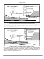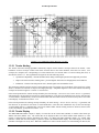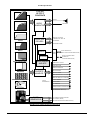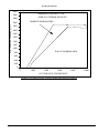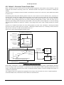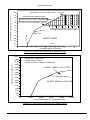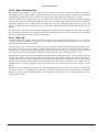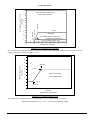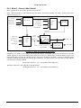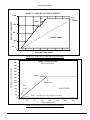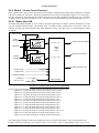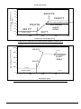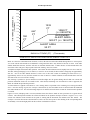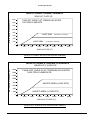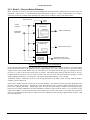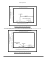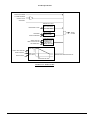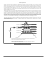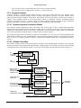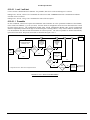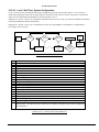
1
DASH NO.
-601
APPLICATION
NEXT ASSY
USED ON
965-1176
965-1186
965-1206
965-1216
TITLE SHEET
INDEX
SHEET NO.
TITLE SHEET
——————————— 1
REVISION STATUS OF SHEETS INDEX
—— 2
REVISIONS
———————————— 3
DOCUMENT
———————————— 4
This document is an unpublished work. Copyright 1999, 2000, 2002 Honeywell International Inc. All rights reserved.
This document and all information and expression contained herein are the property of Honeywell International Inc., and is provided to
the recipient in confidence on a “need to know” basis. Your use of this document is strictly limited to a legitimate business purpose
requiring the information contained therein. Your use of this document constitutes acceptance of these terms.
Typed signatures constitute approval. Actual
signatures on file at Honeywell in Redmond WA.
CONTRACT NO.
-----------------DRAWN
Peter Bateman
PRECIOUS METAL
INDICATOR CODE:
N/A
Honeywell International Inc.
REDMOND, WA 98073-9701
Product Specification
29-NOV-99
for the MK VI and MK VIII
CHECK
ENGR
Peter Bateman
Enhanced Ground Proximity Warning System
29-NOV-99
(EGPWS)
MFG
QA
APVD
Lyle Kendall
APVD
HIF-2121/R5 9651176601.DOC
29-NOV-99
SIZE
CAGE CODE
A
97896
SCALE: NONE
DWG NO.
965-1176-601
SHEET 1 OF 147
REV.
D
Product Specification
REVISION STATUS OF SHEETS INDEX
ADDED SHEETS
SHEET
NUMBER
REV
LTR
ALL
D
HIF-2121/R5
SHEET
NUMBER
REV
LTR
CAGE CODE: 97896
SHEET
NUMBER
ADDED SHEETS
REV
LTR
SCALE: NONE
SHEET
NUMBER
SIZE: A
REV
LTR
SHEET
NUMBER
DWG NO: 965-1176-601
REV
LTR
SHEET
NUMBER
REV: D
REV
LTR
SHEET 2
Product Specification
SH
ALL
REV
A
ALL
B
ALL
ALL
C
D
REVISIONS
DESCRIPTION
Details of each section’s updates are listed in the Revision History
at the beginning of each section. Changes made after the date of
the previous revision were made as part of this revision.
DATE
S. Wright
J. Kistler
APPROVED
07-JUN-00
Reason: 01
Severity: 10
Details of each section’s updates are listed in the Revision History
at the beginning of each section. Changes made after the date of
the previous revision were made as part of this revision.
S. Wright
L. Kendall
07-DEC-00
Reason: 01
Severity: 10
Details of each section’s updates are listed in the Revision History
at the beginning of each section. Changes made after the date of
the previous revision were made as part of this revision.
G. Ostrom
P. Hermann
05-JUL-01
Reason: 01
Severity: 10
Details of each section’s updates are listed in the Revision History
at the beginning of each section. Changes made after the date of
the previous revision were made as part of this revision.
N Paterson
P. Hermann
31-JAN-02
Reason: 01
HIF-2121/R5
Severity: 10
CAGE CODE: 97896
SCALE: NONE
SIZE: A
DWG NO: 965-1176-601
REV: D
SHEET 3
Product Specification
TABLE OF CONTENTS
1
INTRODUCTION..........................................................................................................................................................6
1.0
1.1
1.2
1.3
1.3.1
1.3.2
1.3.3
1.3.4
1.3.5
1.3.6
1.3.7
2
REFERENCE DOCUMENTS ........................................................................................................................................32
2.0
2.1
2.2
2.3
3
DOCUMENT OVERVIEW.................................................................................................................................................7
PART NUMBER ..............................................................................................................................................................7
PURPOSE .......................................................................................................................................................................8
SYSTEM OVERVIEW ......................................................................................................................................................8
Ground Proximity Warning................................................................................................................................10
Terrain and Obstacle Awareness .......................................................................................................................22
Reserved .............................................................................................................................................................26
Maintenance/Test Interfaces ..............................................................................................................................26
System Elements.................................................................................................................................................27
System Limitations .............................................................................................................................................31
Installation Procedures and Limitations............................................................................................................31
INTRODUCTION ...........................................................................................................................................................32
HONEYWELL DOCUMENTS AND DRAWINGS ................................................................................................................32
INDUSTRY AND GOVERNMENT DOCUMENTS ...............................................................................................................32
TERRAIN DATA REFERENCES ............................................................................................................................... .......33
COMPUTER DESIGN CRITERIA ........................................................................................................ .......................34
3.0
3.1
3.2
3.2.1
3.3
3.3.1
3.3.2
3.4
3.5
3.5.1
3.5.2
3.6
3.6.1
3.6.2
3.6.3
3.6.4
3.6.5
3.7
INTRODUCTION ...........................................................................................................................................................34
FUNCTIONAL PARTITIONING .......................................................................................................................................34
ENVIRONMENTAL .......................................................................................................................................................34
Environmental, 965-1176-xxx, 965-1186-xxx, 965-1206-xxx, 965-1216-xxx.....................................................34
RELIABILITY/MAINTAINABILITY.................................................................................................................................36
Scheduled Maintenance .....................................................................................................................................36
Reliability...........................................................................................................................................................36
PERFORMANCE ...........................................................................................................................................................36
POWER ........................................................................................................................................................................36
EGPWC Power Requirements............................................................................................................................36
System Response to Power Interrupts ................................................................................................................37
MECHANICAL..............................................................................................................................................................37
Packaging ..........................................................................................................................................................37
Connectors .........................................................................................................................................................38
Mounting ............................................................................................................................................................39
Cooling...............................................................................................................................................................39
Weight ................................................................................................................................................................39
SOFTWARE DESIGN REQUIREMENTS ...........................................................................................................................40
4
EXTERNAL INTERFACE............................................................................................................. ................................41
5
FUNCTIONAL INPUTS .............................................................................................................. ...................................42
6
SYSTEM FUNCTIONS............................................................................................................... ....................................43
6.0
6.0.1
6.0.2
6.0.3
6.0.4
6.0.5
6.0.6
6.1
6.1.1
6.1.2
MODE CONTROL .........................................................................................................................................................43
Air/Ground Mode...............................................................................................................................................43
GPWS Takeoff/Approach Mode .........................................................................................................................43
MKVIII EGPWS Windshear Takeoff/Approach Mode .......................................................................................44
Mode 2 Takeoff ..................................................................................................................................................44
Simulator Reposition..........................................................................................................................................44
Terrain Awareness Alerting Guard....................................................................................................................44
CONFIGURATION MODULE ..........................................................................................................................................45
MKVI EGPWS Feature Selection.......................................................................................................................45
MKVIII EGPWS Feature Selection ....................................................................................................................45
PROPRIETARY NOTICE ON TITLE PAGE APPLIES
ASAF-2121/R2
CAGE CODE: 97896
SCALE: NONE
SIZE: A
DWG NO: 965-1176-601
REV: D
SHEET 4
Product Specification
6.2
GPWS FUNCTIONS .....................................................................................................................................................46
6.2.1
Mode 1 -- Excessive Descent Rate .....................................................................................................................47
6.2.2
Mode 2 -- Excessive Terrain Closure Rate ........................................................................................................53
6.2.3
Mode 3 -- Descent After Takeoff ........................................................................................................................58
6.2.4
Mode 4 -- Unsafe Terrain Clearance.................................................................................................................61
6.2.5
Mode 5 -- Descent Below Glideslope.................................................................................................................71
6.3
TERRAIN CLEARANCE FLOOR .....................................................................................................................................75
6.3.1
TCF System Requirements .................................................................................................................................75
6.4
ADVISORY ALERTS .....................................................................................................................................................79
6.4.1
Minimums Type Callouts....................................................................................................................................79
6.4.2
Altitude Callouts ................................................................................................................................................80
6.4.3
Smart Altitude Callouts ......................................................................................................................................80
6.4.4
Excessive Bank Angle Callout............................................................................................................................80
6.4.5
Above Field Callout ...........................................................................................................................................82
6.5
MKVIII WINDSHEAR DETECTION ALERTS .................................................................................................................83
6.5.1
Honeywell Windshear Detection........................................................................................................................83
6.6
RESERVED ..................................................................................................................................................................86
6.7
TERRAIN AWARENESS FUNCTIONS .............................................................................................................................87
6.7.1
EGPWS Input Processing and Signal Selection.................................................................................................87
6.7.2
Local Terrain Processing...................................................................................................................................89
6.7.3
Terrain Threat Detection ...................................................................................................................................89
6.7.4
Terrain/Obstacle Displays and Alerts................................................................................................................91
6.7.5
Terrain Database ...............................................................................................................................................96
6.7.6
Obstacle Database .............................................................................................................................................96
6.7.7
Internal Magnetic Variation Database ..............................................................................................................96
6.7.8
Geometric Altitude .............................................................................................................................................97
6.7.9
WGS-84 Correction............................................................................................................................................99
6.7.10
Horizontal Position Source Selection ................................................................................................................99
6.8
ENVELOPE MODULATION..........................................................................................................................................100
6.9
SYSTEM OUTPUTS .....................................................................................................................................................103
6.9.1
Serial Output....................................................................................................................................................103
6.9.2
Audio Output....................................................................................................................................................103
6.9.3
Discrete Outputs ..............................................................................................................................................104
6.9.4
Display Output and Control.............................................................................................................................105
6.10
MAINTENANCE FUNCTIONS ......................................................................................................................................108
6.10.1
Maintenance Philosophy..................................................................................................................................108
6.10.2
Windshear Monitor ..........................................................................................................................................108
6.10.3
LRU Flight history Recording..........................................................................................................................110
6.10.4
Front Panel ......................................................................................................................................................113
6.10.5
Smart Cable (PCMCIA Interface)....................................................................................................................115
6.10.6
Self-Test............................................................................................................................................................117
6.10.7
ATP ..................................................................................................................................................................126
6.10.8
BIT Tests ..........................................................................................................................................................126
6.10.9
RS-232 Test Interface.......................................................................................................................................127
6.10.10
Data Loading Interface ................................................................................................................................129
6.10.11
Configuration Management and Version Identification...............................................................................131
6.10.12
Present Status Output Format......................................................................................................................133
6.10.13
Flight History Output Formats ....................................................................................................................135
6.10.14
Internal GPS Status Format.........................................................................................................................141
6.10.15
Configuration Module Programming via RS-232 ........................................................................................142
APPENDICES........................................................................................................................................................................145
APPENDIX A: DEFINITIONS .....................................................................................................................................................145
PROPRIETARY NOTICE ON TITLE PAGE APPLIES
ASAF-2121/R2
CAGE CODE: 97896
SCALE: NONE
SIZE: A
DWG NO: 965-1176-601
REV: D
SHEET 5
Product Specification
1 Introduction
Revision History
Date - Modified By
29-NOV-99 Peter Bateman
24-MAY-00 Susie Wright
06-JUN-00 – Susie Wright
01-DEC-00 – Susie Wright
11-JUN-01 – P. Bateman
11-JUN-01 – P. Bateman
02-JUL-01 – S. Wright
02-JUL-01 – S. Wright
Description of the Updates
Initial Release and Entry into PVCS
SCR 4795: Added Envelope Modulation to EM6/8. Added commercial
Modes 1, 3, 4 and 6 curves. General Document Cleanup.
Document only change – Deleted proprietary note from footer.
Doc only change - Lamp Format 2 plus general document cleanup for –006
release.
SCR 5991: Added Bizjet bank angle autopilot warning area.
SCR 5919: Added above field callout.
SCR 4734: Added Honeywell windshear for BD-100 to 1.3.1.9
Added review comments.
Effectivity
App.
Cfg.
-001
-001
-003
-003
-003
-006
-003
-006
-008
-008
-008
-008
-008
-008
-008
-008
ENHANCED GROUND PROXIMITY WARNING COMPUTER
HIF-2121/R5
CAGE CODE: 97896
SCALE: NONE
SIZE: A
DWG NO: 965-1176-601
REV: D
SHEET 6
Product Specification
1.0
Document Overview
This document is organized as follows.
Section 1
Introduction, identifies this product specification, gives an overview of the EGPWS, and describes the
content and organization of this document.
Section 2
Referenced Documents, listed by document number, title, and source, all documents that are referenced in
this specification.
Section 3
Computer Design Criteria, identifies the design, environmental, and regulatory standards that will be used
to measure the performance of the EGPWS.
Section 4
External Interface, refer to the Installation Design Guide.
Section 5
Functional Inputs, describes each of the functions external system inputs used in the EGPWS.
Section 6
System Functions, describes each of the system functions included in the EGPWS.
Appendix A
Definitions and Symbols, contains lists of acronyms used in this document.
1.1
Part Number
This document is the Product Specification for the Enhanced Ground Proximity Warning System (EGPWS), Honeywell part
numbers:
965-1176-xxx: MKVI EGPWC
965-1186-xxx: MKVI EGPWC with Internal GPS
965-1206-xxx: MKVIII EGPWC
965-1216-xxx: MKVIII EGPWC with Internal GPS
Differences, where they exist, between the different part numbers, are highlighted within this document.
The 965-1176-xxx series part number MKVI EGPWCs are intended for turboprop aircraft that provide a mixture of limited
analog and digital interfaces. Display support includes several weather radar indicators and limited EFIS support. The terrain
database included with the EGPWC is regional. See Figures 1.3.2-2, -3 and -4 for regions.
The 965-1186-xxx series part number MKVI EGPWCs include an internal GPS-PXPRESS card and are otherwise as 9651176-xxx.
The 965-1206-xxx series part number MKVIII EGPWCs are intended for regional turboprop and turbofan aircraft that
provide a mixture of limited analog and digital signal interfaces. Display support includes several weather radar indicators
and limited EFIS support. The terrain database included with the EGPWC is global.
The 965-1216-xxx series part number MKVIII EGPWCs include an internal GPS-PXPRESS card and are otherwise as 9651206-xxx.
In order to minimize complexity, the EGPWC utilizes a 10 digit part number. This 10 digit part number will identify the
configuration of the EGPWC, which affects form, fit, or function as seen by the pilot. This part number is defined as follows:
•
•
•
•
•
•
•
965-1ABC-DDD (example 965-1176-001)
A = 1 (EMVI) or 2 (EMVIII)
B = 7 (EMVI without internal GPS) or 8 (EMVI with internal GPS) or 0 (EMVIII without internal GPS) or 1 (EMVIII
with internal GPS
C = MK VI or MK VIII EGPWC Hardware (including boot code). C = 6, 7, 8, 9 as hardware part numbers roll.
DDD = Application software (including configuration software)
Terrain Database(including the Envelope Modulation Database)- Version not identified in 10-digit part number but with
a separate identifier.
Modifications - All modifications will be identified via “mod dots”. No mod dots will be skipped.
The digits identifying the application software will match the respective version number of the application software.
See section 6.10.11 for details on configuration management.
HIF-2121/R5
CAGE CODE: 97896
SCALE: NONE
SIZE: A
DWG NO: 965-1176-601
REV: D
SHEET 7
Product Specification
1.2
Purpose
The Product Specification describes all of the system functions and design criteria for the MKVI and MKVIII Enhanced
Ground Proximity Warning System (EGPWS). This document serves two major purposes. First, it describes the system
functions for EGPWS customers. Secondly, it provides a system description for regulatory authorities.
1.3
System Overview
The purpose of the Enhanced Ground Proximity Warning System is to help prevent accidents caused by Controlled Flight into
Terrain (CFIT). The system achieves this objective by accepting a variety of aircraft parameters as inputs, applying alerting
algorithms, and providing the flight crew with aural alert messages and visual annunciations and displays in the event that the
boundaries of any alerting envelope are exceeded. Figure 1.3-1 provides an overall system block diagram.
AUDIO ALERT
MESSAGES
GPWS
ALGORITHMS
FLIGHT DECK
SPEAKERS AND
INTERPHONE
AURAL
CALLOUTS
AIRCRAFT
SENSORS
AND
SYSTEMS
AIRCRAFT
PARAMETERS
I
N
P
U
T
P
R
O
C
E
S
S
I
N
G
TERRAIN
AWARENESS &
OBSTACLE
ALERTING AND
DISPLAY
ALGORITHMS
TERRAIN
CLEARANCE
FLOOR
ALGORITHMS
O
U
T
P
U
T
VISUAL ALERT
MESSAGES
P
R
O
C
E
S
S
I
N
G
WINDSHEAR
DETECTION
AND ALERTING
ALGORITHMS
TERRAIN DISPLAY
DATA
ALERT LAMPS
AND EFIS
DISPLAY
EFIS NAV.
DISPLAY OR Wx
RADAR
INDICATOR
EGPWC
FIGURE 1.3-1: ENHANCED GROUND PROXIMITY WARNING SYSTEM
The system comprises the following groups of components:
• Aircraft sensors and other systems providing input signals
• The Enhanced Ground Proximity Warning Computer (EGPWC)
• Flight deck audio systems (speakers and interphone)
• Alert (caution and warning) lamps and/or digital outputs to EFIS displays (for alert and system status messages)
• Weather radar indicator for display of terrain and limited EFIS display support.
• Switching relay(s) or Display Switching Unit (DSU) when required for switching display inputs from
weather display to terrain display.
The system is designed to be fully compatible with normal operations of commercial aircraft: unwanted alerts will be very
rare if the flight crew maintains situational awareness with respect to the terrain and if the crew follows correct avoidance
procedures for any significant windshear activity.
Several main alerting functional areas are integrated into the EGPWC, which is a single Line Replaceable Unit (LRU). Each
function is configuration module selectable.
HIF-2121/R5
CAGE CODE: 97896
SCALE: NONE
SIZE: A
DWG NO: 965-1176-601
REV: D
SHEET 8
Product Specification
The functional areas are:
• Basic Ground Proximity Warning
• Altitude Awareness Callouts
• Excessive Bank Angle Alert
• Enhanced features, Terrain and Obstacle Awareness alerts and warnings as well as optional display
of this information, “Peaks” mode, and Terrain Clearance Floor.
• WS Detection and Alerting (limited application).
The basic Ground Proximity Warning (GPW) function is the backbone of the system, and the primary design objective has
been to maintain the integrity of this function independent of the other functions. For example, loss of the Terrain Awareness
display function will not affect the operation of the GPW functions (provided that the input signals necessary for GPW
operation are still available).
In addition to the main alerting functions, the computer also performs the following auxiliary functions:
• Input signal processing (including filtering and signal monitoring).
• Alert output processing (including alert prioritization, voice message synthesis, audio output and display
and caution or warning lamp drivers)
• Built In Test and monitoring including cockpit-activated self test.
• PCMCIA interface for uploading software and databases (using a Smart Cable).
• Front panel maintenance test connector for system checkout and troubleshooting.
• System status LED’s located on the LRU front panel to indicate external fault, computer O.K. and computer
fail conditions.
HIF-2121/R5
CAGE CODE: 97896
SCALE: NONE
SIZE: A
DWG NO: 965-1176-601
REV: D
SHEET 9
Product Specification
1.3.1 Ground Proximity Warning
As shown in Figure 1.3.1-1, the EGPWS provides the basic Ground Proximity Warning System (GPWS) alerting in six
modes.
MODE 2
MODE 1
EXCESSIVE DESCENT RATE
"SINKRATE"
"PULL UP!"
EXCESSIVE TERRAIN
CLOSURE RATE
"TERRAIN..TERRAIN"
"PULL UP!"
MODE 6
MODE 3
EXCESSIVE BANK ANGLE
"BANK ANGLE!"
SINK AFTER TAKEOFF
"DON'T SINK!"
ALTITUDE CALL-OUTS
"...FIVE HUNDRED..."
MODE 4
MODE 5
TOO CLOSE TO TERRAIN
"TOO LOW - TERRAIN"
"TOO LOW - GEAR"
"TOO LOW - FLAPS"
EXCESSIVE DEVIATION
BELOW GLIDESLOPE
"GLIDESLOPE"
FIGURE 1.3.1-1: GROUND PROXIMITY WARNING MODES
Modes 1 through 5 are in accordance with the requirements of TSO-C92c, TSO-C151a, DO-161A, C117a, CAA Spec 14 and
ICAO Annex 6. Mode 6 provides additional protection in the form of a selectable menu of radio altitude callouts during
landing approach, and an optional alert for excessive bank angle. (It should be noted that the numbering of the modes is
derived from the history of the development of GPWS, and does not imply any special hierarchy).
The basic GPW modes are tailored for the application by selection of various options, which are configuration module
selectable during installation of the EGPWC. An overview of the functioning of each of the GPW modes is given in the
following paragraphs. Full details of the operation of the modes are given in section 6.2.
An audio declutter feature is standard which activates the voice alert once, then not again unless the situation has degraded by
20%. This feature applies to modes 1, 3, 4, and 5.
HIF-2121/R5
CAGE CODE: 97896
SCALE: NONE
SIZE: A
DWG NO: 965-1176-601
REV: D
SHEET 10
Product Specification
1.3.1.1 Mode 1 - Excessive Descent Rate
Mode 1 provides alerts when the aircraft has excessive descent rate close to the terrain (see Figure 1.3.1.1-1 and 1.3.1.1-2).
Figure 1.3.1.1-1 shows the turboprop curves, available on MKVI and MKVIII EGPWS. Figure 1.3.1.1-2 shows the turbofan
curves, available on MKVIII EGPWS only and selectable at the time of installation.
"SINKRATE"
RADIO ALTITUDE (FEET)
2500
TE
A
R
K
N
I
"S
2000
1500
1000
"
"PULL UP!"
"PULL UP!"
500
0
0
2000
4000
6000
8000
DESCENT RATE (FEET/MINUTE)
FIGURE 1.3.1.1-1: MODE 1 - EXCESSIVE DESCENT RATE (TURBOPROP)
"SINKRATE"
RADIO ALTITUDE (FEET)
2500
"
2000
1500
"
NK
I
S
1000
R
E
AT
"PULL UP!"
"PULL UP!"
500
0
0
2000
4000
6000
8000
DESCENT RATE (FEET/MINUTE)
FIGURE 1.3.1.1-2: MODE 1 - EXCESSIVE DESCENT RATE (TURBOFAN)
If the aircraft penetrates the “outer” alert boundary, the aural message “Sinkrate” is generated, and alert discretes are output
by the computer for driving visual annunciators. If the aircraft penetrates the “inner” alert boundary, the aural message “Pull
Up!” is generated and visual alert discretes are also output. The alert boundaries are defined in terms of aircraft vertical
speed (barometric altitude rate) and radio altitude.
HIF-2121/R5
CAGE CODE: 97896
SCALE: NONE
SIZE: A
DWG NO: 965-1176-601
REV: D
SHEET 11
Product Specification
Improvements to the Mode 1 alert boundaries are as follows:
• Envelope Modulation - (see paragraph 1.3.1.7)
• Glideslope Deviation Bias - The “outer” alert boundary (“Sinkrate”) is desensitized when the aircraft is
above the glideslope beam. This prevents unwanted alerts when the aircraft is safely capturing the
glideslope (or repositioning to the centerline) from above the beam.
• Steep Approach Bias - If steep approach is enabled by configurable item then it changes the alert
boundaries to permit safe, but steeper than normal, instrument precision approaches (e.g. MLS or GPS
approaches) without unwanted alerts.
• Flap Override Bias – If flap override is selected by input discrete, it changes the alert boundaries to permit
potentially higher descent rates resulting from flaps not being set to “landing” during approaches. This bias
is smaller than the steep approach bias.
1.3.1.2 Mode 2 - Excessive Terrain Closure Rate
Mode 2 provides alerts when the aircraft is closing with the terrain at an excessive rate. It is not necessary for the aircraft to
be descending in order to produce a Mode 2 alert, level flight (or even a climb) towards obstructing terrain can result in
hazardous terrain closure rate. The terrain closure rate variable is computed within the EGPWS computer by combining radio
altitude and vertical speed in a non-linear complementary filter.
Mode 2 has two sub-modes, referred to as Mode 2A and Mode 2B, the active sub-mode being determined by aircraft
configuration. The Mode 2A alerting envelope is illustrated in Figure 1.3.1.2-1, and the Mode 2B envelope is shown in Figure
1.3.1.2-2.
When TA&D, TCF and Geometric Altitude functions are enabled and of high integrity, certain Mode 2 functions are safely
reduced to the TSO minimums or placed in ILS Mode 2B operation.
2000
"TERRAIN
TERRAIN"
"PULL UP!"
Speed Expansion
E RR
AIN
"
1500
"PULL UP!"
RRA
IN T
1000
500
"TE
RADIO ALTITUDE (FEET)
2500
0
0
2000
4000
6000
8000
10000
TERRRAIN CLOSURE RATE (FEET/MIN)
FIGURE 1.3.1.2-1: MODE 2A - EXCESSIVE TERRAIN CLOSURE RATE
Mode 2A is enabled when the conditions for enabling Mode 2B are not satisfied (see below). If the aircraft penetrates the
Mode 2A alerting envelope, the aural message “Terrain Terrain” is generated initially, and alert discretes are output for
driving visual annunciators. If the aircraft continues to penetrate the envelope, then the aural message “Pull Up!” is repeated
continuously until the warning envelope is exited. At this point, an altitude gain function, described in section 6.2.2.2,
activates. The aural message reverts to “Terrain, Terrain...”, but will only be given if the terrain clearance continues to
decrease. The visual alert will remain on until either the aircraft has gained 300 feet of barometric altitude, or 45 seconds has
elapsed, or the altimeter loses track. At that point all visual alerts stop. As shown in Figure 1.3.1.2-1, the upper boundary of
the Mode 2A alert envelope varies as a function of aircraft speed. As airspeed increases from 220 knots to 310 knots, the
boundary expands to provide increased alert times at higher airspeeds.
HIF-2121/R5
CAGE CODE: 97896
SCALE: NONE
SIZE: A
DWG NO: 965-1176-601
REV: D
SHEET 12
Product Specification
2500
RADIO ALTITUDE (FEET)
2000
"TERRAIN
TERRAIN"
1500
"PULL UP!"
1000
"TER
500
RAIN
TER
R A IN
"
"PULL UP!"
0
0
2000
4000
6000
8000
10000
TERRRAIN CLOSURE RATE (FEET/MIN)
FIGURE 1.3.1.2-2: MODE 2B - EXCESSIVE TERRAIN CLOSURE RATE
Mode 2B provides a “desensitized” alert envelope, permitting normal landing approach maneuvering close to the terrain
without producing unwanted alerts. Mode 2B is enabled for three conditions:
• Whenever flaps are selected to the landing position
• If the aircraft is performing an ILS approach and is within ±2 dots of the glideslope centerlines
• For the first 60 seconds after takeoff
If the aircraft penetrates the Mode 2B envelope with either gear or flaps not in landing configuration, the aural message
“Terrain, Terrain” is generated initially, and alert discretes are output for driving visual annunciators. If the aircraft
continues to penetrate the envelope, then the aural message “Pull Up!” is repeated continuously until the warning envelope is
exited. If the aircraft penetrates the Mode 2B envelope with both gear and flaps in landing configuration, the aural message
“Terrain....” is repeated until the envelope is exited.
Envelope modulation, as described in section 1.3.1.7, is used to eliminate, whenever possible, operationally-induced
unwanted warnings.
1.3.1.3 Mode 3 - Altitude Loss After Takeoff
Mode 3 provides alerts when the aircraft loses a significant amount of altitude immediately after takeoff or during a missed
approach, as shown in Figures 1.3.1.3-1 and 1.3.1.3-2. Figure 1.3.1.3-1 shows the turboprop curve, available on MKVI
EGPWS and MKVIII EGPWS. Figure 1.3.1.3-2 shows the turbofan curve, available on MKVIII EGPWS only and selectable
at the time of installation.
.
MODE 3 - DESCENT AFTER TAKEOFF
1000
GPWS
FLAP
OVERRIDE
925
RADIO ALTITUDE (FEET)
5 FT/SEC
"DON'T SINK"
750
700
500
"DON'T SINK"
250
50
0
0
25
50
75
100
125
ALTITUDE LOSS (FEET)
150
175
FIGURE 1.3.1.3-1: MODE 3 - ALTITUDE LOSS AFTER TAKEOFF (TURBOPROP)
HIF-2121/R5
CAGE CODE: 97896
SCALE: NONE
SIZE: A
DWG NO: 965-1176-601
REV: D
SHEET 13
Product Specification
RADIO ALTITUDE (FEET)
2500
"DON'T SINK"
2000
1500
1000
"DON'T SINK"
500
0
0
200
400
600
ALTITUDE LOSS (FEET)
FIGURE 1.3.1.3-2: MODE 3 - ALTITUDE LOSS AFTER TAKEOFF (TURBOFAN)
The altitude loss variable is based on the change of altitude (MSL) from the beginning of the inadvertent descent. The
amount of altitude loss, which is permitted before an alert is given, is a function of the height of the aircraft above the terrain,
as shown in Figures 1.3.1.3-1 and 1.3.1.3-2. Mode 3 is enabled after takeoff or go around, when landing gear or flaps are not
in landing configuration. It stays enabled until the EGPWC detects that the aircraft has gained sufficient altitude that it is no
longer in the takeoff phase of flight.
Selecting flap override increases the allowable altitude loss as shown in Figure 1.3.1.3-1. This allows optional pattern work to
be performed without unwanted warnings. An additional biasing, or modifying of the envelope occurs above 700 feet AGL at
the rate of 5 feet additional altitude loss allowed per second.
If the aircraft penetrates the Mode 3 boundary, the aural message “Don’t Sink” is generated, and alert discretes are provided
for activation of visual annunciators. The visual annunciators remain active until a positive rate of climb is re-established.
1.3.1.4 Mode 4 - Unsafe Terrain Clearance
Mode 4 provides alerts for insufficient terrain clearance with respect to phase of flight and speed. Mode 4 exists in three
forms, 4A, 4B and 4C. Mode 4A is active during cruise and approach with gear not in landing configuration. Mode 4B is
also active in cruise and approach, but with gear in landing configuration. Mode 4C is active during the takeoff phase of
flight with either gear or flaps not in landing configuration.
As shown in Figures 1.3.1.4-1 the standard boundary for Mode 4A is at 500 feet radio altitude. If the aircraft penetrates this
boundary with the gear still up, the voice message will be “Too Low Gear”. The same boundary is used to produce a “Too
Low Flaps” message if this boundary is penetrated with flaps still up in fixed gear aircraft. Above 178 knots, the boundary
increases linearly with airspeed to a maximum of 750 feet radio altitude at 200 knots or more. An alternate airspeed
expansion range, activated by a configuration item in the configuration module, begins at 148 knots and ends at 170 knots for
slower aircraft. Penetrating this boundary produces a “Too Low Terrain” message.
HIF-2121/R5
CAGE CODE: 97896
SCALE: NONE
SIZE: A
DWG NO: 965-1176-601
REV: D
SHEET 14
MODE 4A UNSAFE TERRAIN
CLEARANCE
"TOO LOW
TERRAIN"
AIRCRAFT SLOWED TO
LESS THAN 178 or 148 KTS
"TOO LOW TERRAIN"
MIN TERRAIN CLEARANCE (FT)
Product Specification
1500
1400 UNSAFE TERRAIN CLEARANCE
1300 GEAR UP, FLAPS UP
1200
TOO LOW TERRAIN
1100
WARNING AREA
1000
900 TOO LOW GEAR
800 WARNING AREA
700
600
500
400
300
200
100
0
0
100
200
300
400
COMPUTED AIRSPEED (KTS)
"TOO LOW GEAR"
RUNWAY
FIGURE 1.3.1.4-1: MODE 4A - UNSAFE TERRAIN CLEARANCE - GEAR UP (TURBOPROP)
MODE 4A UNSAFE TERRAIN
CLEARANCE
"TOO LOW
TERRAIN"
AIRCRAFT SLOWED TO
LESS THAN 190 KTS
"TOO LOW TERRAIN"
MIN TERRAIN CLEARANCE (FT)
Mode 4 curves with specific application for turbofan aircraft are available on the MKVIII EGPWS. As shown in Figures
1.3.1.4-2 the standard boundary for Mode 4A for this curve is at 500 feet radio altitude. If the aircraft penetrates this
boundary with the gear still up, the voice message will be “Too Low Gear”. The same boundary is used to produce a “Too
Low Flaps” message if this boundary is penetrated with flaps still up in fixed gear aircraft. Above 190 knots the boundary
increases linearly with airspeed to a maximum of 1000 feet radio altitude at 250 knots or more. Penetrating this boundary
produces a “Too Low Terrain” message.
1500
1400
1300
1200
1100
1000
900
800
700
600
500
400
300
200
100
0
UNSAFE TERRAIN CLEARANCE
GEAR UP, FLAPS UP
TOO LOW TERRAIN
WARNING AREA
TOO LOW GEAR
WARNING AREA
0
100
200
300
400
COMPUTED AIRSPEED (KTS)
"TOO LOW GEAR"
RUNWAY
FIGURE 1.3.1.4-2: MODE 4A - UNSAFE TERRAIN CLEARANCE - GEAR UP (TURBOFAN)
When the landing gear is lowered, Mode 4B becomes active and the boundary decreases to 170 feet for turboprop aircraft.
This is reduced to 150 feet on those aircraft types that routinely delay full flap deployment until the airfield is within
approximately one nautical mile (enabled by a configuration item in the configuration module). In addition, an optional curve
(enabled by a configuration item in the configuration module) places the upper boundary at 200 feet. Penetration below 150
knots results in the “Too Low Flaps” message with gear down and flaps not in landing configuration, while above 150 knots
the message is “Too Low Terrain”. Mode 4B is illustrated in Figure 1.3.1.4-3.
HIF-2121/R5
CAGE CODE: 97896
SCALE: NONE
SIZE: A
DWG NO: 965-1176-601
REV: D
SHEET 15
MODE 4B UNSAFE TERRAIN
CLEARANCE
"TOO LOW
TERRAIN"
AIRCRAFT SLOWED TO
LESS THAN 150 KTS
GEAR DOWN
"TOO LOW TERRAIN"
MIN TERRAIN CLEARANCE (FT)
Product Specification
1500
1400 UNSAFE TERRAIN CLEARANCE
1300 GEAR DN, FLAPS UP
1200
1100
TOO LOW TERRAIN
1000
WARNING AREA
900
800
700
600
500 TOO LOW FLAPS
400 WARNING AREA
300
200
100
0
0
100
200
300
COMPUTED AIRSPEED (KTS)
400
"TOO LOW FLAPS"
RUNWAY
FIGURE 1.3.1.4-3: MODE 4B - UNSAFE TERRAIN CLEARANCE - GEAR DOWN (TURBOPROP)
The Mode 4B curve associated with turbofan aircraft is available on the MKVIII EGPWS. When the landing gear is lowered,
this mode becomes active and the boundary decreases to 245 feet. Penetration below 159 knots results in the “Too Low
Flaps” message with gear down and flaps not in landing configuration, while above 159 knots the message is “Too Low
Terrain”. Mode 4B is illustrated in Figure 1.3.1.4-4.
"TOO LOW
TERRAIN"
AIRCRAFT SLOWED TO
LESS THAN 159 KTS
GEAR DOWN
"TOO LOW TERRAIN"
MIN TERRAIN CLEARANCE (FT)
MODE 4B UNSAFE TERRAIN
CLEARANCE
1500
1400 UNSAFE TERRAIN CLEARANCE
1300 GEAR DN, FLAPS UP
1200
1100
TOO LOW TERRAIN
1000
WARNING AREA
900
800
700
600
500 TOO LOW FLAPS
400 WARNING AREA
300
200
100
0
0
100
200
300
COMPUTED AIRSPEED (KTS)
400
"TOO LOW FLAPS"
RUNWAY
FIGURE 1.3.1.4-4: MODE 4B - UNSAFE TERRAIN CLEARANCE - GEAR DOWN (TURBOFAN)
Mode 4C is based on a minimum terrain clearance, or floor, that increases with radio altitude during takeoff. A value equal to
75% of the current radio altitude is accumulated in a long-term filter. Any decrease of radio altitude below the filter value
with gear or flaps up will result in the warning “Too Low Terrain”. Mode 4C for turboprops is illustrated in Figure 1.3.1.4-5,
and Mode 4C for turbofans is illustrated in Figure 1.3.1.4-6.
HIF-2121/R5
CAGE CODE: 97896
SCALE: NONE
SIZE: A
DWG NO: 965-1176-601
REV: D
SHEET 16
MODE 4C UNSAFE TERRAIN
CLEARANCE
"TOO LOW TERRAIN"
"TOO LOW TERRAIN"
MIN TERRAIN CLEARANCE (FT)
Product Specification
3000
2800
2600
2400
2200
2000
1800
1600
1400
1200
1000
800
600
400
200
0
UNSAFE TERRAIN CLEARANCE
GEAR UP, FLAPS UP
1500 FPM CLIMB RATE
TAKE-OFF OVER FLAT TERRAIN
OR WATER
WARNING AREA (>200 KTS)
WARNING AREA
(<168 KTS)
0
400
800 1200 1600 2000 2400 2800
RADIO ALTITUDE (FT)
MODE 4C UNSAFE TERRAIN
CLEARANCE
"TOO LOW TERRAIN"
"TOO LOW TERRAIN"
MIN TERRAIN CLEARANCE (FT)
FIGURE 1.3.1.4-5: MODE 4C - UNSAFE TERRAIN CLEARANCE - AT TAKEOFF (TURBOPROP)
3000
2800 UNSAFE TERRAIN CLEARANCE
2600 GEAR UP, FLAPS UP
2400 1500 FPM CLIMB RATE
2200 TAKE-OFF OVER FLAT TERRAIN
2000
OR WATER
1800
WARNING AREA (>250 KTS)
1600
1400
1200 WARNING AREA
1000 (<190 KTS)
800
600
400
200
0
0
400 800 1200 1600 2000 2400 2800
RADIO ALTITUDE (FT)
FIGURE 1.3.1.4-6: MODE 4C - UNSAFE TERRAIN CLEARANCE - AT TAKEOFF (TURBOFAN)
Optional variations to the Mode 4 alert boundaries are available through Envelope Modulation, as described in section
1.3.1.7. When Terrain Awareness is enabled, the Mode 4 A/B “Too Low Terrain” voice is limited to values below the “Too
Low Flaps” voice.
1.3.1.5 Mode 5 - Below Glideslope
Mode 5 provides two levels of alerting when the aircraft flight path descends below the glideslope beam on front course ILS
approaches. The first alert activation occurs whenever the aircraft is more than 1.3 dots below the beam and is called a “soft”
glideslope alert because the volume level of the “Glideslope” alert is approximately one half (-6 dB) that of the other alerts. A
second alert boundary occurs below 300 feet radio altitude with greater than 2 dots deviation and is called “loud” or “hard”
glideslope alert because the volume level is increased to that of the other alerts. Mode 5 is illustrated in Figure 1.3.1.5-1.
HIF-2121/R5
CAGE CODE: 97896
SCALE: NONE
SIZE: A
DWG NO: 965-1176-601
REV: D
SHEET 17
MIN TERRAIN CLEARANCE (FT)
Product Specification
MODE 5 EXCESSIVE GLIDESLOPE
DEVIATION
GLIDESLOPE
BEAM
CENTER
SOFT
"GLIDESLOPE"
HARD
"GLIDESLOPE"
MODE 5 BELOW GLIDESLOPE ALERT
GEAR DOWN
1000
900
800
700
600
500
400
300
200
100
0
SOFT
ALERT
AREA
HARD
ALERT AREA
0
1
2
3
4
GLIDESLOPE DEVIATION (DOTS FLY UP)
RUNWAY
SOFT ALERT AREA
HARD ALERT AREA
FIGURE 1.3.1.5-1: MODE 5 - EXCESSIVE GLIDESLOPE DEVIATION
Other variations to the Mode 5 alert boundaries are as follows:
•
Envelope Modulation, as described in section 1.3.1.7
•
Localizer intercept, as described in section 6.2.5 (note: localizer is not a basic input, and is only available when
digitally sourced).
•
Level flight intercept
1.3.1.6 Mode 6 – Altitude Call-Outs
Mode 6 provides audio callouts for descent below predefined altitudes and minimums as shown in Figure 1.3.1.6-1. Excessive
bank angle warnings, including a reduction of threshold if the autopilot is engaged, are also provided as part of this mode as
shown in Figures 1.3.1.6-2 (available on MKVI and MKVIII EGPWS) and 1.3.1.6-3 (available on MKVIII EGPWS only).
The “Bank Angle” aural warning is given twice, and then suppressed unless the roll angle increases by an additional 20%.
Specific callouts are selectable via configuration items in the configuration module from predefined menus. Mode 6 callouts
produce aural output indications, but do not produce visual indications.
A “smart five hundred” foot callout is available. This callout will only be issued when the system detects that a non-precision
approach is being performed or that the aircraft is outside ±2 dots glideslope deviation.
A callout is available indicating 500 feet above runway field. This is based upon geometric altitude.
A “minimums-minimums” callout is provided based upon the decision height discrete.
An optional discrete input provides the ability to force the Mode 6 audio level to lower audio volume. This enables operators
to control the Mode 6 volume level with activation of windscreen rain removal or if lower volume callouts are desired at all
times.
HIF-2121/R5
CAGE CODE: 97896
SCALE: NONE
SIZE: A
DWG NO: 965-1176-601
REV: D
SHEET 18
Product Specification
MODE 6 ALTITUDE AWARENESS CALLOUTS
"MINIMUMSMINIMUMS"
"FIVE HUNDRED"
RUNWAY
FIGURE 1.3.1.6-1: MODE 6 ALTITUDE CALLOUTS
BANK ANGLE
CURVE
TERRAIN CLEARANCE (FEET)
EXCESSIVE
BANK ANGLE
WARNING
"BANK ANGLE
BANK ANGLE""
2500
AUTOPILOT ENGAGED
BANK ANGLE
CURVE
210 FT
156 FT
200
10 FT
0
0
+/-10
+/-20
+/-30
+/-40
ROLL ANGLE (+/- DEG)
+/-50
FIGURE 1.3.1.6-2: EXCESSIVE BANK ANGLE (TURBOPROP)
"BANK ANGLE
BANK ANGLE""
2450 FT
TERRAIN CLEARANCE (FEET)
EXCESSIVE
BANK ANGLE
WARNING
2500
AUTOPILOT ENGAGED
BANK ANGLE CURVE
150 FT
122 FT
200
30 FT
5 FT
0
0
+/-10
+/-20
+/-30
+/-40
ROLL ANGLE (+/- DEG)
+/-50
FIGURE 1.3.1.6-3: EXCESSIVE BANK ANGLE (TURBOFAN)
HIF-2121/R5
CAGE CODE: 97896
SCALE: NONE
SIZE: A
DWG NO: 965-1176-601
REV: D
SHEET 19
Product Specification
1.3.1.7 Envelope Modulation
The Envelope Modulation feature provides improved alerting protection at some key locations throughout the world, while
improving nuisance margins at others. This is made possible with the use of navigational signals from GPS. All position data
is cross checked to ground based navigational aids, altimeter and heading information, and stored terrain characteristics prior
to being accepted for Envelope Modulation purposes.
Modes 4, 5, and 6 are expanded at some locations to provide alerting protection consistent with normal approaches. Modes 1,
2, and 4 are desensitized at other locations to prevent nuisance warnings that result from unusual terrain or approach
procedures. In all cases, very specific information is used to correlate the aircraft position and phase of flight prior to
modulating the envelopes. The tables that store the Envelope Modulation data are maintained in non-volatile memory.
1.3.1.8 Terrain Clearance Floor
The Terrain Clearance Floor (TCF) alert, illustrated in Figure 1.3.1.8-1, adds an additional element of protection to the
standard Ground Proximity Warning modes. It creates an increasing terrain clearance envelope around the intended airport
runway directly related to the distance from the runway. TCF alerts are based on current aircraft location, radio altitude and a
distance based upon nearest runway center point position minus half the runway length. TCF is active during takeoff, cruise
and final approach. This alert mode complements existing Mode 4 protection by providing an alert based on insufficient
terrain clearance even when in landing configuration.
A Runway Field Clearance Floor alert is also provided for runways that are located on top of a hill. This alert is similar to the
TCF alert, but is based on field clearnace (height above runway) instead of radio altitude. More details on this can be found
in section 6.3.1.3 of this document.
TCF Alerts illuminate MKVI/MKVIII EGPWS cockpit lamps and produce the aural message “Too Low Terrain”. This aural
message will occur once when the initial envelope penetration occurs, and one time thereafter for each 20% degradation in
radio altitude. EGPWS caution lamps (or warning lamps if using Lamp Format 1) will remain on until the alert envelope is
exited. Further details can be found in seciton 6.3.1.3 of this document.
"TOO LOW TERRAIN"
400
AGL
700
AGL
RUNWAY
4 NM 12 NM 15 NM
FIGURE 1.3.1.8-1: TERRAIN CLEARANCE FLOOR
HIF-2121/R5
CAGE CODE: 97896
SCALE: NONE
SIZE: A
DWG NO: 965-1176-601
REV: D
SHEET 20
Product Specification
1.3.1.9 Mode 7 - Windshear Alerting
Mode 7 produces optional alerts for flight into an excessive windshear condition during takeoff or final approach in
accordance with TSO-C117a. The windshear caution, or pre-alert as it is sometimes referred to, provides visual, ARINC 429
and optional aural output indications. The windshear warning also produces visual, ARINC 429 and aural output indications.
Windshear detection is active between 10 and 1500 feet AGL during the initial takeoff and final approach phases of flight.
Alerts are provided when the level of windshear exceeds predetermined threshold values. The actual windshear value
measured represents the vector sum of inertial vs. airmass accelerations along the flight path and perpendicular to the flight
path. These shears result from vertical winds and rapidly changing horizontal winds.
Windshear warning alerts are given for decreasing head wind (or increasing tail wind) and severe vertical down drafts.
Windshear caution alerts are given for increasing head wind (or decreasing tail wind) and severe up drafts. The windshear
microburst phenomenon and windshear caution and warning levels are illustrated in figure 1.2.3-1.
MODE 7
EXCESSIVE
WINDSHEAR
DETECTION
DECREASING
HEADWIND
(KTS PER SEC)
CAUTION
WINDSHEAR
AREA
UPDRAFT (FEET PER MIN)
3000
2000
1000
6
4
2
0 0
2
4
INCREASING
HEADWIND
(KTS PER SEC)
6
1000
2000
WINDSHEAR
WARNING
AREA
3000
WINDSHEAR
CAUTION
LAMP
DOWNDRAFT (FEET PER MIN)
MICROBURST
"WINDSHEAR
WINDSHEAR
WINDSHEAR"
RUNWAY
FIGURE 1.3.1.9-1: TYPICAL MICROBURST ENCOUNTER
HIF-2121/R5
CAGE CODE: 97896
SCALE: NONE
SIZE: A
DWG NO: 965-1176-601
REV: D
SHEET 21
Product Specification
1.3.2 Terrain and Obstacle Awareness
A major feature of the EGPWS is the Terrain and Obstacle Awareness alerting and display functions. These functions use
aircraft geographic position, aircraft altitude and a terrain and obstacle database to predict potential conflicts between the
aircraft flight path and the terrain, and to provide graphic displays of the conflicting terrain or obstacle, as illustrated by the
block diagram, Figure 1.3.2-1.
TERRAIN
CLEARANCE
FLOOR
ALGORITHM
AIRPORT
POSITION
DATABASE
AIRCRAFT
POSITION DATA
(LAT/LNG)
TERRAIN/OBSTACLE
ELEVATION
DATABASE
TERRAIN/OBSTACLE
CAUTION ALERT
BAROMETRIC
ALTITUDE
TERRAIN/OBSTACLE
AWARENESS
ALERTING
ALGORITHMS
GROUND TRACK
GROUND SPEED
TERRAIN/OBSTACLE
WARNING ALERT
VERTICAL SPEED
ROLL ATTITUDE
DISPLAY
ALGORITHMS
DISPLAY DATA
FIGURE 1.3.2-1: TERRAIN & OBSTACLE AWARENESS FUNCTIONS
The MKVIII EGPWS includes a Global Terrain Database, which provides the ability to fly between regions without loss of
Terrain Awareness coverage. The MKVI EGPWS includes a Regional Terrain Database, which is one of three regions (see
Figure 1.3.2-2,3,4). Use of a MKVI EGPWS outside of the loaded Regional Terrain Database will result in the Terrain
Awareness function being unavailable.
The MKVIII EGPWS allows selection between runways greater than 3,500 feet and greater than 2,000 feet. Certain business
jet aircraft require longer runways for operation.
HIF-2121/R5
CAGE CODE: 97896
SCALE: NONE
SIZE: A
DWG NO: 965-1176-601
REV: D
SHEET 22
Product Specification
FIGURE 1.3.2-2: TERRAIN DATABASE REGIONS – AMERICAS
FIGURE 1.3.2-3: TERRAIN DATABASE REGIONS – ATLANTIC
HIF-2121/R5
CAGE CODE: 97896
SCALE: NONE
SIZE: A
DWG NO: 965-1176-601
REV: D
SHEET 23
Product Specification
FIGURE 1.3.2-4: TERRAIN DATABASE REGIONS – PACIFIC
1.3.2.1 Terrain Alerting
The Terrain Awareness alerting algorithms continuously compute terrain clearance envelopes ahead of the aircraft. If the
boundaries of these envelopes conflict with terrain elevation data in the terrain database, then alerts are issued. Two
envelopes are computed, one corresponding to a terrain caution alert level and the other to a terrain warning alert level, as
described in section 6.7.3. The algorithms are designed to meet the following criteria:
•
Operational compatibility - minimal unwanted alerts during normal flight operations and approach procedures
•
Improved Terrain Awareness warning times - provide adequate alert times for all flight phases and conditions
•
Robustness - tolerant of aircraft position errors, altitude signal errors and database errors
The caution and warning envelopes use the Terrain Clearance Floor as a baseline, and “look ahead” of the aircraft in a volume
which is calculated as a function of airspeed and flight path angle. Simplified diagrams of the terrain caution and warning
envelopes are shown in Figures 6.7-2 and 6.7-3 of section 6.7.
If the aircraft penetrates the caution envelope boundary, the aural message “Caution Terrain, Caution Terrain” is generated,
and alert discretes are provided for activation of visual annunciators. (Note that some installations may use the aural message
“Terrain Ahead”). Simultaneously, terrain areas which conflict with the caution criteria are shown in solid yellow color on the
terrain display, as described in section 1.3.2.2.
If the aircraft penetrates the warning envelope boundary, the aural message “Terrain Terrain, Pull Up!” is generated, and
alert discretes are provided for activation of visual annunciators. (Note that some installations may use the aural message
“Terrain Ahead, Pull Up”). Simultaneously, terrain areas which conflict with the warning criteria are shown in solid red color
on the terrain display, as described in section 1.3.2.2.
1.3.2.2 Terrain Display
The MKVI/MKVIII EGPWC outputs a display of terrain data in KC Picture Bus (KCPB) or weather radar format per
ARINC-708/708A (ARINC 453). The terrain data can be displayed either on a shared weather radar indicator or, if the
aircraft is equipped with a Display Switching Unit (DSU), on a Honeywell UDI compatible display. If a weather radar
indicator is used, when the terrain display is present it replaces the Weather Radar display. The terrain display can be made
available to the flight crew at any time. When the conditions for either a terrain caution or a terrain warning are detected, the
HIF-2121/R5
CAGE CODE: 97896
SCALE: NONE
SIZE: A
DWG NO: 965-1176-601
REV: D
SHEET 24
Product Specification
MKVI/MKVIII EGPWC supplies a discrete pop-up signal. This can be used to switch flight deck displays between the
Weather Radar and the terrain display. In addition, the MKVIII EGPWC can be display terrain on an Electronic Flight
Instrument System (EFIS) display.
Terrain is depicted on a display as shown in Figure 1.3.2-5.
BACKGROUND TERRAIN
YELLOW CAUTION AREA
"CAUTION TERRAIN,
CAUTION TERRAIN"
RED WARNING AREA
"TERRAIN TERRAIN, PULL UP!"
FIGURE 1.3.2-5: TERRAIN AWARENESS DISPLAY ON EFIS NAVIGATION DISPLAY (SIMULATED)
Areas of terrain that satisfy the terrain caution alert criteria are shown in solid yellow, and areas of terrain that satisfy the
terrain warning alert criteria are shown in solid red. Terrain which is significantly close to the aircraft, but which satisfies
neither the caution or warning criteria, is shown as a green, yellow or red dot pattern whose perceived brightness is less than
the yellow caution or red warning area. The density of the pattern is coarsely varied to depict terrain altitude with respect to
the aircraft.
Reference section 6.7.4 for a detailed description of the display presentation.
1.3.2.3 Obstacle Alerting
The EGPWS has the capability to detect and annunciate obstacle alerts for obstacles contained in the EGPWS obstacles
database. The same visual annunciations that are activated for terrain caution/warning alerts are activated for obstacle
caution/warning alerts. The actual alert voices for obstacles are controlled via the selected audio menu. The obstacle voice is
similar to the terrain alert, except that for an obstacle alert, the word “Obstacle” replaces the word “terrain”. Obstacle alerting
is activated by a configuration item in the configuration module.
HIF-2121/R5
CAGE CODE: 97896
SCALE: NONE
SIZE: A
DWG NO: 965-1176-601
REV: D
SHEET 25
Product Specification
1.3.3 Reserved
1.3.4 Maintenance/Test Interfaces
In addition to power-up and continuous BIT, user activated tests (via a discrete test switch), and/or maintenance system
commands are supported.
1.3.4.1 Cockpit Self Test
A cockpit mounted test switch is used to manually initiate tests and BIT annunciation anytime the aircraft is on ground. In
addition, if the aircraft is above 2000 feet AGL the cockpit self test can be initiated if no alert is in progress.
Notice that there is no test switch located on the EGPWC.
Six levels of information are available through voice messages by pressing the self-test switch. The test sequences can be
summarized as follows.
Level 1, Go/No Go Test: This sequence indicates the systems ability to perform all of its configured functions.
For this sequence, when the test switch is activated, the cockpit lamps are activated and voices are issued to indicate what
functions are correctly operating. For instance, if no faults exist on an installation that uses the Terrain Awareness function
in addition to basic GPWS and windshear, then the result of the self-test would typically be:
“Glideslope---- Pull Up--- Windshear Windshear Windshear----Terrain Terrain, Pull Up”
However, if no valid glideslope input was present then the sequence would be
“Glideslope INOP----- Pull Up--- Windshear Windshear Windshear----Terrain Terrain, Pull Up”
For installations that use a terrain display the interface with the display will be tested by viewing a terrain test image on the
appropriate cockpit display. During system self test all INOP type annunciators are activated.
Level 2, Current Faults: This sequence annunciates all faults, if any, that currently exist. It will distinguish between internal
and external faults. If no faults exist then the message, “No Faults” is given.
Level 3, Configuration Information: This sequence indicates the versions of the resident hardware, software and databases
versions. Also provided are the current configuration item selections from the configuration module, including voice and
callout menus selected.
Level 4, Fault History: This sequence annunciates all system faults that were logged for the past ten flight legs. (Information
on the last 64 legs is accessible via the RS-232 interface).
Level 5, Warning History: This sequence annunciates all EGPWS alerts that were logged for the past ten flight legs.
(Information on the last 64 legs is accessible via the RS-232 interface).
Level 6, Discrete Input Test: This sequence annunciates discrete input transitions to aid system installation and maintenance.
Reference section 6.10.6 for detailed description of self-test functionality.
1.3.4.2 Front Panel Test Interface
The MKVI/MKVIII EGPWC provides a front panel test connector which can be connected to a VT 101 (Terminal Emulation
Device) or a portable PC to both receive and control internal data. This test interface can be used for engineering and
production testing, both on the bench and at the aircraft. The connector also provides an interface for data loading purposes to
a PCMCIA card via a Smart Cable (see section 1.3.5.2.1).
The LRU front panel also contains several fault LEDs. The status LEDs include external fault, computer OK, and computer
fail.
Reference section 6.10.4 for more detail.
HIF-2121/R5
CAGE CODE: 97896
SCALE: NONE
SIZE: A
DWG NO: 965-1176-601
REV: D
SHEET 26
Product Specification
1.3.5 System Elements
1.3.5.1 Architecture
Figure 1.3.5.1-1 provides a typical block diagram of MKVI EGPWS inputs, Figure 1.3.5.1-2 for outputs. When used, the
terrain display output is provided either directly to the DSU, or to display switching relays. The mode curves below are
typical, other outputs are possible via configurable mode curves.
The following table summarizes the type and quantity of I/O available with both versions of the EGPWC.
Input/Output Type
Note: Applies to 965-1176, 965-1186, 965-1206, 965-1216.
ARINC 429 inputs.
The inputs can be software programmed for either high or low speed operation.
RS-232/RS-422 inputs.
RS-422/ARINC 429 inputs.
ARINC 429 output channels (MKVIII EGPWS only)
ARINC 429 output channels
Picture Bus (ARINC 453/708) output channels.
RS-232/RS-422 outputs.
3 wire AC analog input channels.
2 wire DC analog input channels.
Ground activated input discretes.
+28VDC activated input discretes.
+28V DC activated validity input
Configuration Module Interface (requires 6 wires)
Smart Cable Interface (requires 8 wires)
Discrete outputs.
Drivers for Lamps.
Audio outputs.
An 8-ohm speaker output and a 600-ohm interphone. The audio volume levels are software
controlled.
Front connector RS-232 interface.
Quantity
8
2
1
2
1
2
2
5
7
15
10
3
1
1
12
2
1
TABLE 1.3.5.1-1: EGPWC I/O
Front panel status LEDs are also provided for maintenance and fault isolation.
The primary processing is accomplished with a PowerPCTM microprocessor.
HIF-2121/R5
CAGE CODE: 97896
SCALE: NONE
SIZE: A
DWG NO: 965-1176-601
REV: D
SHEET 27
Product Specification
MODE 1
AC ANALOG INPUTS
MAGNETIC HEADING
EGPWS
INPUT
DIAGRAM
ROLL ATTITUDE
PITCH ATTITUDE
MODE 2
DC ANALOG INPUTS
ANALOG
INPUT
HANDLER
BAROMETRIC PRESSURE
OUTSIDE AIR TEMP
MAINTENANCE
AND
BITE
RADIO ALTITUDE
ARINC 552A or ALT 55
MODE 3
GLIDESLOPE DEVN
ARINC 547/578-4 GLIDESLOPE
AOA
MODE 4
SERIAL INPUTS
DISPLAY STATUS
TERRAIN DISPLAY
BARO ALTITUDE
BARO RATE
SAT
CAS
INPUT
PROCESSING
MODE 5
ADC
ALTITUDE
POSITION
POSITION QUALITY
GROUND SPEED
GROUND TRACK
DATE/TIME
STATUS
DITS,
RS-232, RS422
INPUT
HANDLER
GPS DATA
RADIO ALTITUDE
RADIO ALTITUDE
PITCH
ROLL
MODE 6 & BANK ANGLE
ATTITUDE
GLIDSLOPE
LOCALIZER
ILS
INERTIAL
ACCELERATION DATA
WINDSHEAR
DISCRETE INPUTS
SELF TEST INITIATE
DH TRANSITIONED
TERRAIN CLEARANCE FLOOR
AUDIO INHIBIT
LANDING GEAR POSITION
LANDING FLAPS POSITION
GLIDESLOPE INHIBIT
GLIDESLOPE CANCEL
DISCRETE
INPUT
HANDLER
TERRAIN SELECT
ILS SELECTED (TUNED)
TERRAIN INHIBIT
MODE 6 VOLUME
AUTOPILOT ENGAGED
TERRAIN/OBSTACLE
AWARENESS
CONFIGURATION
MANUAL FLAP OVERRIDE
RADIO ALTITUDE VALIDITY
BARO ALTITUDE VALIDITY
GLIDESLOPE VALIDITY
HEADING VALIDITY
DISPLAY SELECT
STEEP APPROACH
CONFIG MODULE
INPUTS
FIGURE 1.3.5.1-1: EGPWS INPUT BLOCK DIAGRAM
HIF-2121/R5
CAGE CODE: 97896
SCALE: NONE
SIZE: A
DWG NO: 965-1176-601
REV: D
SHEET 28
Product Specification
EGPWS
OUTPUT
DIAGRAM
MODE 1
8 OHM
MODE 2
AUDIO
GENERATOR
600 OHM
MODE 3
ARINC 429
DRIVERS
MODE 4
MODE 5
LS
HS
UARTs
DISPLAY CONTROL
WARNING/CAUTION TO
RECORDERS
WEATHER RADAR
FRONT
PANEL
PCMCIA SMARTCABLE
INTERFACE
(UPLOAD/DOWNLOAD)
INPUT
PROCESSING
MAINTENANCE
AND BITE
MODE 6 & BANK ANGLE
RS232 INTERFACE
(TEST AND UPLOAD/DOWNLOAD)
GLIDESLOPE CANCEL
GPWS MONITOR
TERRAIN MONITOR
DISCRETE
HANDLER
WINDSHEAR
GPWS WARNING
GPWS CAUTIONS
TERRAIN/OBSTACLE CAUTION
TERRAIN/OBSTACLE WARNING
TERRAIN CLEARANCE FLOOR
AUDIO
IN PROGRESS
FLAP OVERRIDE
W/S CAUTION
W/S WARNING
TERRAIN DISPLAY DISCRETES (2)
TERRAIN/OBSTACLE
AWARENESS
TO SWITCHING RELAY(S)
TO SYMBOL GENERATORS OR
TDU OR DSU (KCPB)
OR PICTURE BUS SWITCHING RELAY(S)
IMAGE
GENERATOR
FIGURE 1.3.5.1-2: EGPWS OUTPUT BLOCK DIAGRAM
HIF-2121/R5
CAGE CODE: 97896
SCALE: NONE
SIZE: A
DWG NO: 965-1176-601
REV: D
SHEET 29
Product Specification
1.3.5.2 System Components
Refer to section 2.1 for EGPWC outline drawings.
For MKVI EGPWC, 965-1176-xxx or 965-1186-xxx and MKVIII EGPWC, 965-1206-xxx or 965-1216-xxx:
Honeywell P/N
405-0383-001
TRAY
Source/Vendor
Bendix/King
Vendor Part Number
071-04003-0002
There are two connectors that interface with the Enhanced MKVI/MKVIII computer. The 78 pin and 50 pin front panel
interface connectors of the MKVI/MKVIII contain all the interfaces for signals and power. The 78 pin is a Subminiature-D
Connector, High Density Series, compatible with connectors conforming to Mil-C-24308.
The 50 pin is a Subminiature-D Connector, compatible with connectors conforming to Mil-C-24308.
Vendor/Supplier
Positronics
P1 78 pin Connector
Supplier P/N
DD78F10JVLC-15
Honeywell P/N
440-1158-009
Vendor/Supplier
Positronics
P2 50 pin Connector
Supplier P/N
RD50F10JVLC-15
Honeywell P/N
440-1233-001
One side of the backshell on the 50-pin connector is replaced with the configuration module, which, when installed, is wired
directly to the appropriate pins in the connector per the Installation Design Guide.
Configuration Module
Honeywell P/N
700-1701-001
When upgrading from a “classic” MKVI GPWS, the P1 78 pin connector can be re-used if the MKVI/MKVIII EGPWS are
non GPS. If the unit is GPS capable then a new P1 connector is required.
The GPS Antenna connector is ONLY required for Enhanced MKVI/MKVIII units with internal GPS receiver.
Vendor/Supplier
AMP
GPS Connector
Supplier P/N
225554-6
Honeywell P/N
440-1239-001
1.3.5.2.1 System Accessories
In order to dataload the MKVI and MKVIII EGPWS it is necessary to use a Smart Cable which connects to the front panel
test connector.
Smart Cable
Honeywell P/N
951-0386-001
HIF-2121/R5
CAGE CODE: 97896
SCALE: NONE
SIZE: A
DWG NO: 965-1176-601
REV: D
SHEET 30
Product Specification
1.3.5.3 Databases
The EGPWS contains the following types of databases, which can be loaded via the EGPWC front panel PCMCIA interface
independent of the system software. Updates to each database will be made available.
Envelope Modulation Database (see section 6.8)
Terrain Database (see section 6.7.5), which also contains the Runway Database (see section 6.3.1.2) and may
also contain an Obstacle Database (see section 6.7.6).
1.3.6 System Limitations
The performance of the EGPWS terrain protection is limited for areas where terrain data is not available, or where
navigational accuracy is degraded. Terrain data or runway location data may have errors inherent in the source of such data.
Such errors can delay a terrain alert, or may cause unwanted alerts. Such errors do not affect the basic GPWS functions.
The terrain display is to be used to enhance situational awareness only, and is not to be used for navigation or escape
guidance.
The basic GPWS function relies on the downward-looking radio altimeter and cannot sense forward terrain. Therefore
warning times for flight into precipitous terrain with little or no preamble terrain can be very short. An alert may not be
provided for stabilized flight in full landing configuration into a place where there is no runway, and where neither Mode 6
nor the Terrain Clearance Floor function nor the Terrain Awareness function has been enabled.
Terrain clearances or descent rates during radar vectoring that are not compatible with those required by the GPWS Minimum
Operating Performance Standards (TSO-C92c, TSO-C151a and CAA Spec 14) may cause unwanted alerts.
1.3.7 Installation Procedures and Limitations
The technical data shall be sufficient to ensure that the article, when installed in accordance with the installation procedures,
continues to meet the requirements of the TSO. The limitations shall also be sufficient to identify any unique aspects of the
installation. The limitations shall include at least the following:
“The TSO identifies the minimum performance standards, tests, and other conditions applicable for issuance of
design and production approval of the article. The TSO does not specifically identify acceptable conditions for
installation of the article. The TSO applicant is responsible for documenting all limitations and conditions suitable
for installation of the article. An applicant requesting approval for installation of the article within a specific type or
class of product is responsible for determining environmental and functional compatibility.”
HIF-2121/R5
CAGE CODE: 97896
SCALE: NONE
SIZE: A
DWG NO: 965-1176-601
REV: D
SHEET 31
Product Specification
2
Reference Documents
Revision History
Date - Modified By
29-NOV-99 Peter Bateman
24-MAY-00 Susie Wright
06-JUN-00 – Susie Wright
11-JUN-01 – P. Bateman
02-JUL-01 – S. Wright
2.0
Description of the Updates
Initial Release and entry into PVCS
SCR 4942: General Document Cleanup.
Document only change – Deleted proprietary note from footer.
SCR 6170: General Document Cleanup.
Added review comments
Effectivity
App.
Cfg.
-001
-001
-003
-003
-003
-003
-008
-008
-008
-008
Introduction
The documents listed in this section shall guide the planning, design and development, implementation and deployment of the
MKVI and MKVIII Enhanced Ground Proximity Warning System (EGPWS).
2.1
Honeywell Documents and Drawings
The latest issue of the following documents are applicable to this system.
993-1176-601
965-1176
965-1176-201
965-1186
965-1186-201
965-1206
965-1206-201
965-1216
965-1216-201
060-4314-125
076-0910-001
993-0976-306
070-4610-000
992-1176-1xx
995-1176-6xx
992-1176-0xx
992-0109-1xx
995-0109-0xx
060-4267-000
060-4316-000
2.2
Product Description for the MKVI EGPWC
System, Enhanced Ground Prox. Warning Computer (MKVI EGPWC)
Outline, Enhanced Ground Proximity Warning (MKVI EGPWC)
System, Enhanced Ground Prox. Warning Computer (MKVI EGPWC with GPS)
Outline, Enhanced Ground Proximity Warning (MKVI EGPWC with GPS)
System, Enhanced Ground Prox. Warning Computer (MKVIII EGPWC)
Outline, Enhanced Ground Proximity Warning (MKVIII EGPWC)
System, Enhanced Ground Prox. Warning Computer (MKVIII EGPWC with GPS)
Outline, Enhanced Ground Proximity Warning (MKVIII EGPWC with GPS)
Installation Design Guide for the EGPWS (MKVI/MKVIII EGPWS)
Acceptance Test Procedure, EGPWC
System Requirements Document (SRD) for the EGPWC
Failure Modes Effects and Criticality Analysis For the Enhanced Mark VI/VIII EGPWC w/wo GPS
Software Development Plan
Software Design Requirements Document (SDRD)
Plan for Software Aspects of Certification for the EGPWS
Database Development Process for the EGPWS
Database Requirements & Design Document for the EGPWS
EGPWS Terrain Database Airport Coverage List
PCMCIA Card Loading Procedure for the MKVI and MKVIII EGPWC
Industry and Government Documents
The exact issue of the following documents form a part of this specification to the extent specified herein. In the event of
conflict between the documents referenced herein and the contents of this specification, the contents of this specification is
considered a superseding requirement. The versions shown below are accurate, references to these documents within the text
omit the revision or version defining suffix wherever possible. Where the revision or version is not stated below the latest
revision or version as of 8/1/94 shall be utilized.
ARINC 723-1
RTCA DO-161A
TSO-C92c
CAA Spec 14
TSO-C151a
EUROCAE Working
Group 44
ICAO Annex 6, Part I
and Part II
HIF-2121/R5
Ground Proximity Warning System
Minimum Performance Standards, Airborne Ground Proximity Warning System 27 may 1976
Ground Proximity Warning/Glideslope Deviation Alerting Equipment: Technical Standards
Authorization, Part 37.201
Ground Proximity Warning System
Terrain Awareness and Warning System
Ground Collision Avoidance System
Ground Proximity Warning System
CAGE CODE: 97896
SCALE: NONE
SIZE: A
DWG NO: 965-1176-601
REV: D
SHEET 32
Product Specification
ARINC 600-8
ARINC 414
ARINC 429-13
ARINC 601
ARINC 604-1
ARINC 609
ARINC 624
ARINC 424-11
ARINC 702-5
ARINC 707-5
ARINC 710-8
ARINC 727-1
ARINC 706-3
ARINC 704-2
ARINC 738
ARINC 708-6
ARINC 708-A
ARINC 453
EIA 232D
PCMICA V2.01
PCMICA/ ATA V1.01
PCMCIA/RE V1.00
RTCA/EUROCAE
RTCA/EUROCAE
RTCA /DO -200
RTCA/DO-201
RTCA/DO-208
C72-4711-01MD-11
C72-4711-02MD-11
MIL-STD-1629
MIL-STD-785B
and Notices
MIL-HDBK-217F
MIL-STD-975
MIL-STD-882
AC25-12
AC25.1309-1A
MIL-STD-600006
MIL-STD-600001
MIL-D-89009
MIL-HDBK-850DoD
DMA-TR 8350.2
DMA- TM 8358.1
MIL-D-89020
Data Users Guide
2.3
Air Transport Avionics Equipment Interfaces, 1 April 1991
General Guidance for Equipment Installation Designers, 3 September 1968
Mark 33 Digital Information Transfer System, 21 February 1992
Control/Display Interfaces, 10 February 1981
Guidance for Design and Use of Built-In Test Equipment, 31 October 1988
Design Guidance for Aircraft Electrical Power Systems, 5 January 1987
Design Guidance for Onboard Maintenance Systems, 26 August 1991
Navigation System Data Base
Flight Management Computer System
Radio Altimeter
Airborne ILS Receiver
Airborne Microwave Landing System
Subsonic Air Data System
Inertial Reference System
Air Data and Inertial reference System
Airborne Weather Radar
Airborne Weather Radar With Forward Looking Windshear Capability
Physical, Electrical and Signal Characteristics of Display Data Bus
Interface Between data Terminal Equipment and Data Communications Equipment Employing
Serial Binary Data Exchange, January 1987
PCMCIA Cartridge Standard, November 1992
PCMICA AT Attachment Cartridge Standard, November 1992
PCMCIA Recommended Extensions, November 1992
Environmental Conditions and Test Procedures for Airborne DO-160C-3/ED14C-3 Equipment,
4 December 1989.
Software Considerations in Airborne Systems and Equipment DO-178B/ED-12B Certification,
1 December 1992
Preparation, Verification, Distribution of User Selectable Navigation Data Bases
User Recommendations for Aeronautical Information Services
Minimum Operational Performance Standards for Airborne Supplemental Navigation Equipment
Using Global Positioning System (GPS)
Centralized Fault Display System, Operational Description
Centralized Fault Display System, Detailed System Specification
Failure Mode and Effect Analysis
Reliability Program for Systems and Equipment Development and Production, 15 September
1980
Reliability Prediction of Electronic Equipment
Component Stress Analysis
System Safety Program
Advisory Circular - Airworthiness Criteria for the Approval of Airborne Windshear Warning
Systems in Transport Category Airplanes
Advisory Circular - System Design and Analysis
Vector Product Format (VPF)(For large geographic data bases), April 1992
Mapping, Charting and Geodesy Accuracy Standard, 26 February 1990
Digital Chart of the World Database, 13 April 1992
Glossary of Mapping, Charting and Geodesy(MC&G) Terms
DoD World Geodetic System (WGS) 1984(Its Definition and Relationships with Local Geodetic
Systems), 30 September 1987
Datum’s, Ellipsoids, Grids and grid Reference Systems
Digital Terrain Elevation Data (DTED)
5US GeoData, Digital Elevation Model
Terrain Data References
A part of the terrain database was processed with approval from the Director General of the Geographical Survey Institute of
the Ministry of Construction in Japan (GSI-MC), using the 50-Meter Grid Digital Elevation Model released by the GSI-MC.
Approval No:
HIF-2121/R5
CAGE CODE: 97896
SCALE: NONE
SIZE: A
DWG NO: 965-1176-601
REV: D
SHEET 33
Product Specification
3
Computer Design Criteria
Revision History
Date - Modified By
29-NOV-99 Peter Bateman
24-MAY-00 Susie Wright
06-JUN-00 – Susie Wright
3.0
Effectivity
App.
Cfg.
-001
-001
-003
-003
-003
-003
Description of the Updates
Initial release and entry into PVCS
SCR 4942: General Document Cleanup.
Document only change – Deleted proprietary note from footer.
Introduction
The EGPWS hardware and software are designed to fulfill specific criteria in the areas of resource utilization (via functional
partitioning), environmental conditions, reliability and safety, power utilization and reaction to power interrupts, operational
performance, mechanical standards, and software design. These criteria are described in detail in the following subsections.
3.1
Functional Partitioning
Partitioning EGPWS resources involves controlling access to system resources in such a way that one partition can not impact
the ability of another partition to complete it’s assignment. Thus if one function is locked up it will not impact the operation
of another function .
3.2
Environmental
The EGPWC conforms to the categories of RTCA/DO-160D “Environmental Conditions and Test Procedures for Airborne
Electronic, Electrical Equipment and Instruments” as identified in the applicable sections below.
3.2.1 Environmental, 965-1176-xxx, 965-1186-xxx, 965-1206-xxx, 965-1216-xxx.
ENVIRONMENTAL CONDITION
CATEGORY
MAX/MIN
TEMPERATURE
High temperature, Non operating
High temperature, operating
Low temperature, Non operating
Low temperature, operating
F2
IN-FLIGHT LOSS OF COOLING
Z
ALTITUDE
High altitude
Decompression
Overpressure
F2
A2
A2
55,000 feet
55,000 feet
-15,000 feet
TEMPERATURE VARIATION
B
50C. per minute
HUMIDITY
A
48 hours at 95% relative humidity,
38-50 0C, non operating
OPERATIONAL SHOCK AND CRASH SAFETY
Operational shock
B
normal: 6 G’s, 11 msec sawtooth
low freq: 6g, 20msec sawtooth
CRASH SAFETY SHOCK
Impulse shock
Sustained shock
B
B
20 G’s, 11msec sawtooth
20 G’s
VIBRATION
+85 0C.
+70 0C.
-55 0C.
-55 0C.
No cooling necessary
SMB
Sinusoidal: 0.1”p-p 5-15Hz; 0.01”p-p @ 15-55Hz,
decaying to 0.0001”p-p @ 500Hz
Random: 1.48grms
EXPLOSION PROOFNESS
E
No test (certification of compliance)
WATERPROOFNESS
X
No test required
HIF-2121/R5
CAGE CODE: 97896
SCALE: NONE
SIZE: A
DWG NO: 965-1176-601
REV: D
SHEET 34
Product Specification
FLUID SUSCEPTIBILITY
X
No test required
SAND AND DUST
X
No test required
FUNGUS RESISTANCE
F
No test (non-nutrient material certification) required
SALT SPRAY
X
No test required
MAGNETIC EFFECT
POWER INPUT
Z
A
Less than 0.3m
Normal:22.0-30.3VDC
Abnormal: (5 minutes) 20.5-32.3VDC
Emergency: 18VDC
interrupt for 200msec
Normal Surge (30msec): 15-40VDC
Abnormal Surge: 100msec @ 46.3VDC,
1 sec @ 37.8VDC
VOLTAGE SPIKES
A
600VDC, 10µs, 50Ω source impedance
AUDIO FREQ. CONDUCTED SUSCEPTIBILITY
Z
0.20Vrms 10-200Hz
0.56 Vrms 200-1,000Hz
1.40Vrms 1,000-15,000Hz
0.20 down to 0.001Vrms, 15kHz – 150KHz
INDUCED SIGNAL SUSCEPTIBILITY
C
RF CONDUCTED SUSCEPTIBILITY
R
Magnetic, unit: 20Arms @ 400Hz
Magnetic, cables: 60A-m @ 400Hz down to 1.6A-m
@ 15kHz
Electric, cables: 5400V-m, 380-420 Hz
Induced Spikes: 600V p-p, 2-10µs rate, 3 meters.
10kHz – 500MHz: 0.6mA – 30.0 mA
500kHz – 400 MHz: 30.0 mA
RF RADIATED SUSCEPTIBILITY
R
20 V/m, 0.1 – 0.4 GHz, SW & CW
150 V/m, 0.4 – 8 GHz, Pulse.
RF CONDUCTED EMISSIONS
M
Power: 53 – 20 dBµA @ 0.15 – 2MHz,
20 dBµA @ >2MHz
Cables: 73 – 40 dBµA @ 0.15 – 2MHz,
40 dBµA @ >2MHz
RF RADIATED EMISSIONS
M
Complex curves with notches (see DO160D)
LIGHTNING INDUCED TRANSIENT
SUSCEPTIBILITY
A3E3
Pin: 600V/24A, 300V/60A
Cable: 300V/600A, 600V/120A
LIGHTNING DIRECT EFFECTS
X
No test required
ICING
X
No test required
ELECTROSTATIC DISCHARGE TEST
A
15,000 Volts
HIF-2121/R5
CAGE CODE: 97896
SCALE: NONE
SIZE: A
DWG NO: 965-1176-601
REV: D
SHEET 35
Product Specification
3.3
Reliability/Maintainability
3.3.1 Scheduled Maintenance
No scheduled maintenance is required for the EGPWC.
3.3.2 Reliability
A MKVI/MKVIII EGPWC Failure Modes, Effects and Criticality Analysis (FMECA) has been performed and is contained in
Honeywell document 070-4610-000. Included in FMECA are MKVI/MKVIII EGPWC assembly level reliability predictions.
Historical MK V EGPWC reliability data and the EGPWC reliability prediction results were used as baseline criteria in
establishing the following minimum EGPWC MTBF and MTBUR values.
MTBF for confirmed failures will be 12,500 operating hours or better, for the latest MK VI or MK VIII EGPWS
configuration without GPS three years from initial production delivery. MTBF for confirmed failures will be 11,000 operating
hours or better, for the latest MK VI or MK VIII EGPWS configuration with GPS three years from initial production
delivery.
MTBUR will be 9,000 operating hours or better, for the latest MK VI or MK VIII EGPWS configuration without GPS three
years from initial production delivery. MTBUR will be 8,000 operating hours or better, for the latest MK VI or MK VIII
EGPWS configuration with GPS three years from initial production delivery.
The MKVI and MKVIII EGPWS MTBUR goals presume proper line troubleshooting procedures are followed when
diagnosing system failures.
The MKV EGPWC FMECA is contained in Honeywell document 070-4507.
The MKVI/MKVIII EGPWC FMECA is contained in Honeywell document 070-4610-000
The MKV EGPWC reliability prediction is contained in Honeywell document 070-4521.
The MKVI/MKVIII EGPWC reliability prediction is contained in the MKVI/MKVIII EGPWC FMECA.
3.4
Performance
The EGPWC operational performance will meet as a minimum the requirements of TSO-C92c, TSO-C151a and CAA
Specification 14. The actual performance is defined in the EGPWC Systems Requirement Document (SRD).
3.5
Power
3.5.1 EGPWC Power Requirements
The maximum input power to the MKVI/MKVIII EGPWC is 28 watts under all operating conditions except when heater
blanket is on (including audio output). Refer to Appendix C for power pin designations.
End Item Part Number
EGPWC Input Power Type
EGPWC Inrush Current
EGPWC Input Power Requirement
With No Warning:
With Warning (over 8 Ω speaker):
With GPS Card Option 1:
With Heater Blanket On 2:
Recommended EGPWC Power
Control Device
965-1176-xxx
965-1186-xxx with internal GPS
965-1206-xxx
965-1216-xxx with internal GPS
28 VDC
@18V DC 3 Amps for 197ms
@28V DC 3 Amps for 307ms
9 Watts
16 Watts
Add 3 Watts
Add 49 Watts (typical)
3 Amp Delayed Action
Circuit Breaker
1
Based on the Honeywell GPS Xpress card specification
2
The heater blanket turns on at temperatures ≤ -230C and turns off at temperatures ≥ -200C
HIF-2121/R5
CAGE CODE: 97896
SCALE: NONE
SIZE: A
DWG NO: 965-1176-601
REV: D
SHEET 36
Product Specification
3.5.2 System Response to Power Interrupts
On application of power to the EGPWC, the computer will perform a power up BIT test to assure proper system performance
prior to initiation of normal operation. The time delays before commencing normal operation will be as defined in the tables
below. The EGPWC system response to power interrupts will be as follows:
Power interrupt duration
System Response
Maximum Delay to Normal Operation
T < 200 msec.
No effect
Not applicable
T ≥ 200 msec.
Cold start
20 seconds Max
3.6
Mechanical
3.6.1 Packaging
The MKVI and MKVIII EGPWC are packaged in a similar form factor chassis to the MKVI GPWS except with an additional
50 pin front panel interface connector, an additional 15 pin front panel test connector, an additional TNC connector for the
GPS antenna interface and new status LEDs. The outline length and width are the same but the height is 0.2” taller, this
allows the existing mounting interface to be used. The part number appearing on the front panel identification plate for the
MKVI EGPWS (w/o internal GPS) is 965-1176-0xx. For the MK VI with Internal GPS this is 965-1186-0xx which identifies
the hardware part number and application software version. (MKVIII without and with Internal GPS are 965-1206-0xx and
965-1216-0xx respectively). Additionally the installed database is identified on the front panel.
HIF-2121/R5
CAGE CODE: 97896
SCALE: NONE
SIZE: A
DWG NO: 965-1176-601
REV: D
SHEET 37
Product Specification
3.6.2 Connectors
3.6.2.1
MKVI/MKVIII EGPWC, 965-1176-xxx/965-1206-xxx Front Connector
The main front connectors for the 965-1176-xxx MKVI EGPWC and 965-1206-xxx MKVIII EGPWC are listed in section
1.3.5.2. Refer to the Installation Design Guide for pin-out information.
FIGURE 3.6.2.1-1: FRONT CONNECTORS FOR THE MKVI/MKVIII EGPWC (MKVI SHOWN)
HIF-2121/R5
CAGE CODE: 97896
SCALE: NONE
SIZE: A
DWG NO: 965-1176-601
REV: D
SHEET 38
Product Specification
The configuration module is listed in section 1.3.5.2 and is installed on the connector as shown in Figure 3.6.2.1-2.
FIGURE 3.6.2.1-2: CONFIGURATION MODULE (SHOWN AS INSTALLED)
3.6.2.2
Front Panel Test Connector
A test connector is provided on the EGPWC front panel. This provides access for a PC test monitor and future portable data
loading capabilities. Reference section 6.10.4 for pin-out and functional details. The mating connector for the EGPWC test
plug is a male (pins) 15 pin double density D-subminiature type, Positronics Industries (kit) part number ODD15M1OYOZ or
the following individual parts:
Nomenclature (AMP)
Amp Part Number
Military Part Number
Connector Shell (HDP-22 Crimp Snap In Contact)
748364-1
reference MIL-C-24308
Size 22 DM Crimp Snap In Contacts Pin ø.030
204370-2
M39029/58-360
Backshell (Shielded Cable Clamp Assembly)
745854-5
Jackscrews (4-40 Male Jackscrew Kit)
747784-8 (specify quantity of 2 per
connector)
Grommet Sets
747746-1
The following tools will work with Positronics, Amp, and Mil Spec Connectors:
Insertion / Extraction Tool
91067-1
Hand Crimp Tool
Positioner
M81969/1-04
M22520/2-01
M22520/2-09
3.6.3 Mounting
Vibration isolation or shock mounting is not required.
3.6.4 Cooling
Cooling shall be per ARINC 404A convection cooling. No forced air-cooling is required for specified system performance
over the environmental conditions specified in paragraph 3.2 of this document.
3.6.5 Weight
The maximum weight of the 965-1176-xxx MKVI EGPWC is 3.4 pounds.
The maximum weight of the 965-1186-xxx MKVI EGPWC with internal GPS is 3.5 pounds.
The maximum weight of the 965-1206-xxx MKVIII EGPWC is 3.4 pounds.
The maximum weight of the 965-1216-xxx MKVIII EGPWC with internal GPS is 3.5 pounds.
HIF-2121/R5
CAGE CODE: 97896
SCALE: NONE
SIZE: A
DWG NO: 965-1176-601
REV: D
SHEET 39
Product Specification
3.7
Software Design Requirements
The EGPWC software development process creates software, which meets the guidelines of RTCA DO-178B, Levels C and
D as identified in the following table. Refer to the Software Development Plan for the EGPWC (SDP) for additional
information regarding the Computer Software Configuration Items (CSCIs) listed below.
EGPWC SOFTWARE DEVELOPMENT AND CERTIFICATION
CSCI
Component
Function
Certification
Application Software
Shared Functions
Utilities
DO-178B Level C
Operating System
DO-178B Level C
Flash File System
DO-178B Level C
Current Value Table
DO-178B Level C
Configuration
DO-178B Level C
Non-Volatile Memory
DO-178B Level C
Monitoring Functions
Task Monitor
DO-178B Level C
Built In Test
DO-178B Level C
I/O Functions
Input Processing
DO-178B Level C
Output Processing
DO-178B Level C
Alerting Functions
Ground Proximity Warning
DO-178B Level C
Advisories
DO-178B Level C
Windshear
DO-178B Level C
Terrain Awareness
DO-178B Level C
Maintenance Functions
Self Test
DO-178B Level D
Maintenance System Support
DO-178B Level D
Flight History
DO-178B Level D
Keyboard Monitor
DO-178B Level D
Boot Loader Software
DO-178B Level C
DITS Handler Software
DO-178B Level C
Analog Acquisition Software
DO-178B Level C
Configuration Database
DO-178B Level C
Envelope Mod Database
Database B01
DO-178A Level 2
Database B02 and on
DO-178B Level C
Terrain Database
DO-200A
HIF-2121/R5
CAGE CODE: 97896
SCALE: NONE
SIZE: A
DWG NO: 965-1176-601
REV: D
SHEET 40
Product Specification
4 External Interface
Revision History
Date - Modified By
29-NOV-99 Peter Bateman
24-MAY-00 Susie Wright
06-JUN-00 – Susie Wright
Description of the Updates
Initial Release and Entry into PVCS
SCR 4942: General Document Cleanup.
Document only change – Deleted proprietary note from footer.
Effectivity
App.
Cfg.
-001
-001
-003
-003
-003
-003
Refer to the Installation Design Guide.
HIF-2121/R5
CAGE CODE: 97896
SCALE: NONE
SIZE: A
DWG NO: 965-1176-601
REV: D
SHEET 41
Product Specification
5 Functional Inputs
Revision History
Date - Modified By
29-NOV-99 Peter Bateman
24-MAY-00 Susie Wright
06-JUN-00 – Susie Wright
Description of the Updates
Initial Release and Entry into PVCS
SCR 4942: General Document Cleanup.
Document only change – Deleted proprietary note from footer.
Effectivity
App.
Cfg.
-001
-001
-003
-003
-003
-003
Refer to the Installation Design Guide.
HIF-2121/R5
CAGE CODE: 97896
SCALE: NONE
SIZE: A
DWG NO: 965-1176-601
REV: D
SHEET 42
Product Specification
6 System Functions
Revision History
Date - Modified By
29-NOV-99 Peter Bateman
24-MAY-00 Susie Wright
06-JUN-00 – Susie Wright
Description of the Updates
Initial Release and entry into PVCS
SCR 4942: General document cleanup.
Document only change – Deleted proprietary note from footer.
Effectivity
App.
Cfg.
-001
-001
-003
-003
-003
-003
6.0 Mode Control
EGPWC uses mode control to enable specific features in the EGPWC modes. The current flight phase of the aircraft is
identified, such as takeoff or approach, and is used to select the modes of the EGPWC. Various flight phases are described in
the following sub-sections.
6.0.1 Air/Ground Mode
The system must be able to determine if the aircraft is airborne to control warning modes, maintenance functions, and fault
isolation logic. The airborne value is stored and immune to power interruptions to prevent inadvertent change of state during
power loss.
When airspeed is greater than 60 knots and radio altitude is greater than 30 feet for more than 1 second, then the system will
go ‘In Air’.
The aircraft is considered not airborne (i.e. on ground) when the airspeed drops below 40 knots and the radio altitude
becomes less than 30 feet.
6.0.2 GPWS Takeoff/Approach Mode
Takeoff/approach GPWS mode status is used to control portions of Modes 3, 4, 5 and 6. Mode 3 and Mode 4C are only
active during the takeoff phase of flight, while Modes 4A and 4B are only active during the cruise and approach phases of
flight. Mode 5 is active during the approach mode with gear down and can be active in the takeoff mode with both gear and
flaps in landing configuration. Mode 6 utilizes the takeoff to approach mode switching to re-enable callouts.
Approach mode to takeoff mode switching is accomplished when the aircraft passes below the 150 foot Mode 4B floor
without a warning (i.e., gear down and flaps in full landing configuration). At this time, the Mode 3/Mode 4C warning logic
is activated. The state of this switching function is maintained in nonvolatile memory to avoid inadvertent selection of an
improper mode during power loss.
The basic configuration requires that the following algorithms be satisfied before the switch from takeoff to approach mode
can occur. For this algorithm, the Mode 4C minimum terrain clearance filter described in section 6.2.4 is used to control the
switching from takeoff to approach. After takeoff, the switch to approach mode will normally be enabled when the filter
value exceeds 500 feet. This will occur at or above 667 feet radio altitude, depending on the time allowed to charge the filter.
In the event that airspeed has increased to greater than 178 knots, the mode switching will be further delayed until the floor
reaches the expanded Mode 4A warning boundary. A maximum expansion of 750 feet occurs at airspeeds greater than 200
knots and will result in mode switching being enabled at or above 1000 feet radio altitude.
This is the basic configuration of the MKVI/MKVIII and is an improvement over the original switching algorithm from the
MKII.
The MKII uses a fixed radio altitude level to switch modes, with its algorithm it is possible to switch modes prematurely and
get a nuisance Mode 4 warning. Two examples will illustrate the problem using a 700-foot radio altitude for mode switching.
In the first MKII example, passing over a river valley, or other large terrain depression during takeoff, may temporarily
indicate above 700 feet radio altitude and allow switching to Mode 4. If radio altitude then decreases below 500 feet, a Mode
4 warning will occur.
In the second MKII example, emphasizing a speed increase over climb gradient during takeoff can allow the airspeed to
exceed 214 knots before reaching 700 feet radio altitude. Switching to Mode 4 at 700 feet then produces a “Too Low
Terrain” warning.
By using both the MKVI/MKVIII algorithm, the previous potential problems are eliminated and the noise abatement
procedures can be handled without creating nuisance warnings due to premature takeoff to approach mode switching.
HIF-2121/R5
CAGE CODE: 97896
SCALE: NONE
SIZE: A
DWG NO: 965-1176-601
REV: D
SHEET 43
Product Specification
6.0.3 MKVIII EGPWS Windshear Takeoff/Approach Mode
Separate logic is utilized to control the takeoff/approach mode switching for mode 7 windshear detection. The takeoff state
actually reflects takeoff or go-around. The approach state reflects final approach. The state of this latch is maintained in
nonvolatile memory in order to prevent inadvertent mode switching as a result of power loss.
6.0.4 Mode 2 Takeoff
A Mode 2 Takeoff Latch is provided to enable Mode 2B for the first 60 seconds following a takeoff. This latching function is
not power saved and a system reset will force it false.
This feature addresses certain false “TERRAIN” warnings that occur just after takeoff caused by false radio altimeter
excursions between 1000 and 1500 ft AGL. These typically are a sharp increase, followed by a sharp decrease in radio
altitude. This problem is solved by activating Mode 2B for the first 60 seconds after takeoff. Limiting the Mode 2 closure
rate to +3000 fpm effectively prevents the “TERRAIN” warnings in the same manner as is used on approach.
6.0.5 Simulator Reposition
When the EGPWC is installed on an aircraft simulator, special consideration must be taken when the simulation is
repositioned for different flight scenarios. The normal logic of the EGPWC assumes actual flight phase transitions; the abrupt
repositioning of a simulation can cause false warnings or cause the normal EGPWC logic to “lock up” awaiting a valid
transition.
For the MKVI/MKVIII EGPWS the simulator reposition is provided via a keyboard monitor command. When instructed
(RS232 command over the J3 (test) connector) the EGPWS will remain in a reposition setup mode for approximately 3
seconds after the command to “normal” has been received.
6.0.6 Terrain Awareness Alerting Guard
Terrain Awareness caution and warning voice alerts, lights and threat display are inhibited below 30 feet of radio altitude
within 1 mile of the runway, or below 60 knots groundspeed.
HIF-2121/R5
CAGE CODE: 97896
SCALE: NONE
SIZE: A
DWG NO: 965-1176-601
REV: D
SHEET 44
Product Specification
6.1 Configuration Module
Revision History
Date - Modified By
29-NOV-99 Peter Bateman
24-MAY-00 Susie Wright
06-JUN-00 – Susie Wright
Description of the Updates
Initial Release and entry into PVCS.
SCR 4942: General document cleanup.
Document only change – Deleted proprietary note from footer.
Effectivity
App.
Cfg.
-001
-001
-003
-003
-003
-003
MKVI/MKVIII application uses a configuration module instead of the program pins used by MKV/MKVII EGPWS. This
configuration module contains a minimum of 256 bytes of memory and is capable of transmitting the memory contents to the
EGPWC. The definition of the MKVI/MKVIII feature selections can be found in the MKVI/MKVIII EGPWS Installation
Design Guide. The definition of the data transfer from the configuration module to the MKVI/MKVIII is defined in section
6.10.15. Section 6.10.15 also covers configuration module validity checking and INOP generation that are covered in this
section for the MKVI/MKVIII.
It can be determined if the application is to run as a MKVI or a MKVIII by reading Non-Volatile Memory (NVM).
The configuration module is read by the EGPWS only during power up. The configuration is copied into NVM as long as
there is not a configuration module configuration fault or a configuration module unprogrammed fault.
The configuration module is programmable via an RS232 Interface using a keyboard monitor or user interface tool. The
contents of the configuration module can also be read back by the user through these interfaces.
6.1.1 MKVI EGPWS Feature Selection
Refer to the Installation Design Guide for details on what configuration items options are available for the MKVI EGPWS.
6.1.2 MKVIII EGPWS Feature Selection
Refer to the Installation Design Guide for details on what configuration item options are available for the MKVIII EGPWS.
HIF-2121/R5
CAGE CODE: 97896
SCALE: NONE
SIZE: A
DWG NO: 965-1176-601
REV: D
SHEET 45
Product Specification
6.2 GPWS Functions
Revision History
Date - Modified By
29-NOV-99 Peter Bateman
08-MAR-00 M. Calhoun
24-MAY-00 Susie Wright
06-JUN-00 – Susie Wright
01-DEC-00 – Susie Wright
27-FEB-01 – M. Calhoun
07-JUL-01 – S. Wright
30-JAN-02 – N Paterson
Description of the Updates
Initial Release and entry into PVCS
SCR 4908: Corrected Mode 1 curve in Figure 6.2.1-2. Added Figure
6.2.4.1-2A to correctly show Mode 4A type 5.
SCR 4795: Add Envelope Modulation for EM6/8. General document
cleanup.
Document only change – Deleted proprietary note from footer.
Doc only change - Added Lamp Format 2 plus general document cleanup.
SCR 5803: Added addition text to steep approach in 6.2.1.
Added review comments.
Doc only change. Added TAD High Integrity paragraph to mode 4.
Effectivity
App.
Cfg.
-001
-001
-001
-001
-003
-003
-003
-006
-008
-008
-010
-003
-006
-008
-008
-010
GPWS functions consist of Modes 1 through 5 as generally described in section 1.3. Mode outputs consist of the following:
Voice messages via the 8 and 600 ohm audio outputs.
Lamp driver outputs.
In addition, all voice messages, and lamp driver states, are output on ARINC 429 labels for EFIS display flight recording, and
test purposes.
HIF-2121/R5
CAGE CODE: 97896
SCALE: NONE
SIZE: A
DWG NO: 965-1176-601
REV: D
SHEET 46
Product Specification
6.2.1 Mode 1 -- Excessive Descent Rate
Mode 1 provides an alert based on valid radio altitude and valid aircraft descent rate. The descent rate is computed based on
barometric rate from the Air Data Computer (ADC). Two different alert envelopes are possible. Through Envelope
Modulation, both envelopes can be biased to the right at certain airports to minimize nuisance alerts. Figure 6.2.1-1 illustrates
Mode 1 functionality.
FLAP OVERRIDE OR
ENVELOPE
MODULATION OR
STEEP APPROACH OR
GLIDESLOPE
DEVIATION BIAS
X
Y
CAUTION LAMP
COMPARATOR
Y
ALTITUDE
RATE
(FPM)
X
RADIO
ALTITUDE
(FT)
Y
DELAY
0.8 SEC
0.2 SEC
MODE 1
SINKRATE
LAMP
SINKRATE
VOICE
CONTROL
LOGIC
MODE 1
SINKRATE
VOICE
X
Y
TIME TO IMPACT
COMPARATOR
X
FLAP OVERRIDE OR
ENVELOPE
MODULATION OR
STEEP APPROACH OR
GLIDESLOPE
DEVIATION BIAS
WARNING
COMPARATOR
X
Y
DELAY
Note 1
0.2 SEC
Y
X
MODE 1
PULL UP
VOICE/LAMP
Note 1: No delay if Sinkrate occurred.
FIGURE 6.2.1-1: MODE 1 BLOCK DIAGRAM
Figure 6.2.1-2 illustrates the static alert envelope for the Mode 1 outer envelope for turboprop airplanes, which is typically the
"Sinkrate" warning area. The curve for turbofan airplanes is similar, but it extends down to 10 feet as shown in Figure 6.2.12A. This static alert envelope assumes that all signals are generated instantaneously (i.e. no filter lags or time delays), and
that the bias terms are zero.
The static Mode 1 outer curve is a straight line with the equation:
RADIO ALTITUDE (FT) = -572 (FT) - 0.6035 * ALTITUDE RATE (FPM)
HIF-2121/R5
CAGE CODE: 97896
SCALE: NONE
SIZE: A
DWG NO: 965-1176-601
REV: D
SHEET 47
Product Specification
2.6
2450 FT
2.4
2.2
-5007 FPM
(Thousands)
2
1.8
1.6
1.4
SINK RATE ALERT
AREA
1
0.8
-1031 FPM
MIN TERRAIN
CLEARANCE (FT)
1.2
0.6
0.4
0.2
50 FT
0
0
-4000
-2000
-6000
ALTITUDE RATE (FPM DESCENT)
FIGURE 6.2.1-2: MODE 1 OUTER CURVE (TURBOPROP)
2.6
2450 FT
2.2
-5007 FPM
2
1.8
1.6
1.4
ALERT/WARNING AREA
1.2
-964 FPM
MIN TERRAIN CLEARANCE (FT)
(Thousands)
2.4
1
0.8
0.6
0.4
0.2
10 FT
0
0
-2000
-6000
-4000
-8000
-10000
ALTITUDE RATE (FPM DESCENT)
FIGURE 6.2.1-2A: MODE 1 OUTER CURVE (TURBOFAN)
The Mode 1 outer alert boundary is biased to the right as a function of glideslope deviation above (fly down) the beam in
order to prevent unwanted alerts while re-positioning from above the beam.
This bias is applied to the outer envelope, which effectively moves the envelope to the right with increasing deviation above
the glideslope beam. This term is weighted to provide "0 FPM" of bias when the aircraft is centered on the beam and "300
FPM" of bias when the aircraft is two dots above the beam. The term is also modified close to the ground by the value of
radio altitude, varying from zero bias at zero feet altitude up to 100% bias above 100 feet radio altitude. These functions vary
linearly between these two limiting values. The bias is not applied to the inner envelope.
A bias is applied to both the outer and inner envelopes in the event that the pilot selects flap override. For turboprop aircraft
(MKVI or MKVIII EGPWS), flap override biasing can be enabled by the pilot anywhere above 50 feet terrain clearance, and
will be automatically disabled at or below 50 feet during landing. For turbofan aircraft (MKVIII EGPWS only), the same
applies, except that the flap override bias will be disabled at 10 feet. If the flap override biasing is in effect, then the envelope
modulation biasing and the glideslope deviation biasing shall be disabled. The bias will be 300 FPM to the right.
HIF-2121/R5
CAGE CODE: 97896
SCALE: NONE
SIZE: A
DWG NO: 965-1176-601
REV: D
SHEET 48
Product Specification
For some installations a steep approach bias can be optionally applied to the Mode 1 curves. If steep approach is enabled and
the steep approach discrete is selected, then fixed positive biases are added to both the Sinkrate curve (500 FPM), and the
Pull Up curve (200FPM). If steep approach is activated, then the cockpit self test is inhibited when the aircraft is on the
ground. The selected Discrete I/O category ID will provide either an alternate action Steep Approach switch input, or a
momentary type switch input. The momentary type provides an automatically resetting Steep Approach function. Pressing the
switch once will activate Steep Approach. It can be cancelled by pressing the switch again, or will automatically reset when
the aircraft lands, or flaps/gear raised for a go-around. Use of the momentary switch requires that it be illuminated by the
Steep Approach Lamp discrete output. This lamp is also activated if Envelope Modulation activates a Steep Approach.
Penetration of the outer envelope will activate the caution lamps (or warning lamps if using Lamp Format 1) and produce the
voice message "Sinkrate".
The audio message for penetration of the outer envelope will be repeated twice, then will remain silent unless the excessive
descent rate condition degrades by approximately 20%, as determined by the computed time to impact (i.e. radio
altitude/altitude rate). If 20% degradation in time to impact is computed, then additional two messages are given and the
cycle repeats. This situation will continue until the outer envelope is exited or until the Mode 1 inner envelope is penetrated.
It is important to note that using constant time to impact as the condition for holding the voice messages off assures that the
flight profile must be correcting toward lower descent rates at lower altitudes AGL. If the profile is not corrected, the voice
messages will continue to repeat getting closer and closer together as radio altitude is lost. The Mode 1 caution/warning lamp
output remains active so long as the excessive descent rate conditions exists.
During the time that the voice message for the outer envelope is inhibited and the caution/warning lamp is on, the Mode 5
alert message is allowed to annunciate for excessive glideslope deviation conditions. No additional lamps will come on. This
provides additional information to the flight crew in that not only are they descending too rapidly, but also their flight profile
has taken them below the glideslope beam.
Further penetration of the outer envelope will reach the inner envelope. The static envelope for this inner Mode 1 envelope is
illustrated in Figure 6.2.1-3, again assuming the bias term is zero. Here the voice warning will change from "Sinkrate" to
"Pull Up" and the caution lamps will change to warning lamps if using Lamp Format 2. The static Mode 1 inner curve for
turboprop airplanes (available on both MKVI and MKVIII EGPWS) is composed of two straight lines with the equations:
(lower line) RADIO ALTITUDE (FT) = -1625.47 (FT) - 1.1167 * ALTITUDE RATE (FPM)
(upper line) RADIO ALTITUDE (FT) = - 0.1958 * ALTITUDE RATE (FPM)
2.6
2.4
1958
FT
2
1.8
1.4
1.2
1
-10000
FPM
-1765 FPM
1.6
-1500 FPM
MIN TERRAIN CLEARANCE (FT)
(Thousands)
2.2
PULL UP
WARNING
AREA
0.8
0.6
0.4
346
FT
0.2
50 FT
0
0
-2
-4
-6
-8
-10
(Thousands)
ALTITUDE RATE (FPM DESCENT)
FIGURE 6.2.1-3: MODE 1 INNER CURVE (TURBOPROP)
HIF-2121/R5
CAGE CODE: 97896
SCALE: NONE
SIZE: A
DWG NO: 965-1176-601
REV: D
SHEET 49
Product Specification
The static Mode 1 inner curve for turbofan airplanes (available on MKVIII EGPWS only) is composed of two straight lines
with the equations:
(lower line) RADIO ALTITUDE (FT) = -1620 (FT) - 1.1133 * ALTITUDE RATE (FPM)
(upper line) RADIO ALTITUDE (FT) = -400 (FT) - 0.4 * ALTITUDE RATE (FPM)
2.6
2450 FT
2.2
-7125 FPM
1.8
1.6
1.4
1.2
1
0.8
-1710 FPM
2
-1482 FPM
MIN TERRAIN CLEARANCE (FT)
(Thousands)
2.4
WARNING AREA
0.6
0.4
284 FT
0.2
10 FT
0
0
-2
-4
-6
-8
-10
(Thousands)
ALTITUDE RATE (FPM DESCENT)
FIGURE 6.2.1-3A: MODE 1 INNER CURVE (TURBOFAN)
During normal conditions, the system will base Mode 1 computations upon barometric rate from the ADC. If this computed
data is not valid or available then the system will use internally computed barometric altitude rate.
The presence of ground effect on the barometric rate data prevents its use close to the ground due to the potential for nuisance
warnings. Consequently, Mode 1 is cut off at 50 feet radio altitude. Mode 1 is cut off at 10 feet radio altitude for turbofan
aircraft.
The outer curve is effective below a radio altitude of 2450 feet. The inner curve is effective below a radio altitude of 1958
feet for Turboprop aircraft and 2450 feet for turbofan aircraft.
There is a 0.8 second delay for the "Sinkrate" caution to minimize nuisance alerts caused by momentary penetration of the
outer envelope. There is a delay for the "Pull Up" warning to guarantee that at least one "Sinkrate" (or equivalent) message
will be given before the "Pull Up" message starts.
HIF-2121/R5
CAGE CODE: 97896
SCALE: NONE
SIZE: A
DWG NO: 965-1176-601
REV: D
SHEET 50
Product Specification
Figure 6.2.1-4 indicates the actual Mode 1 caution/warning curves for turboprop aircraft (Figure 6.2.1-4A for turbofan),
considering filter lags and time delays, for constant descent rates initiated from 2450 feet radio altitude over water or flat
terrain. Both the outer and inner curves are shown.
3000
2800
ALERTS FROM 2450 FT AGL
2600
OVER FLAT TERRAIN OR WATER
MIN TERRAIN CLEARANCE (FT)
2400
2200
2000
SINKRATE CAUTION AREA
1800
1600
1400
1200
1000
800
600
PULL UP WARNING AREA
400
200
0
4000
2000
0
6000
ALTITUDE RATE (FPM DESCENT)
FIGURE 6.2.1-4: MODE 1 DYNAMIC ALERT ENVELOPE FROM 2450 FEET (TURBOPROP)
HIF-2121/R5
CAGE CODE: 97896
SCALE: NONE
SIZE: A
DWG NO: 965-1176-601
REV: D
SHEET 51
Product Specification
3000
WARNINGS FROM 2450 FT AGL
2800
OVER FLAT TERRAIN OR WATER
2600
SINKRATE WARNING AREA
MIN TERRAIN CLEARANCE (FT)
2400
2200
2000
1800
1600
1400
1200
1000
PULL UP WARNING AREA
800
600
400
200
0
0
2000
4000
6000
8000
10000
ALTITUDE RATE (FPM DESCENT)
FIGURE 6.2.1-4A: MODE 1 DYNAMIC ALERT BOUNDARIES FROM 2450 FEET (TURBOFAN)
HIF-2121/R5
CAGE CODE: 97896
SCALE: NONE
SIZE: A
DWG NO: 965-1176-601
REV: D
SHEET 52
Product Specification
6.2.2 Mode 2 -- Excessive Terrain Closure Rate
Mode 2 provides two types of alerts based on aircraft gear/flap configuration, radio altitude (terrain clearance), and how
rapidly that radio altitude is decreasing (closure rate). Barometric altitude of the airplane is not important in initiating this
warning.
These two alerts are commonly referred to as Mode 2A, described in sections 6.2.2.1 and 6.2.2.2, and as Mode 2B, described
in section 6.2.2.3.
Differentiating and scaling radio altitude generates closure rate. As the closure rate term is inherently noisy, especially over
irregular terrain, extensive rate limiting and filtering must be used to obtain an accurate closure rate value for computation.
The computer uses a number of different sets of sophisticated rate limits and filter methods to allow maximum sensitivity
during cruise, while providing progressively less sensitivity during the landing phases of flight. These rate limits vary as a
function of gear and flap position, aircraft speed, and whether or not the aircraft is on an ILS approach. It is this rate limiting
and filtering that determines the effectivity of Mode 2 in providing advance alerts, while avoiding unwanted or nuisance
alerts.
Altitude rate is combined with closure rate in the filtering method to provide “lead” information. Increasing the altitude
descent rate will tend to speed up the alert occurrence. Reducing the altitude descent rate, or initiating a climb, will tend to
delay the alert occurrence, or reduce the time that the alert is on.
Figure 6.2.2-1 shows the block diagram for Mode 2 alerts.
CLOSURE RATE DETECTION
RADIO RATE
(RADIO ALT RATE)
FLAPS DOWN
ILS MODE 2B
MODE 2 TAKEOFF
MODE 2B INHIBIT
RATE LIMITS
FILTER
FLAPS DOWN
GEAR DOWN
AIRSPEED
TIME CONSTANT
MODE 2 ENVELOPE
(FOR GA FAST, GA SLOW NOT SHOWN)
X
FLAPS DOWN
GEAR DOWN
ALTITUDE (ASL)
9800 FPM
Y
5733 FPM
2450 FT
@ LE 310 KTS
MODE 2
ALTITUDE
GAIN
1650 FT
@ LE 220 KTS
3545 FPM
1220 FT
2038 FPM
30 FT
MODE 2
OUTPUT
X
CLOSURE RATE (THOUSAND FPM)
MODE 2
AUDIO
MODE 2
VISUAL
Y
RADIO ALTITUDE
FIGURE 6.2.2-1: MODE 2 BLOCK DIAGRAM
Radio altitude, indicating the vertical distance between the aircraft and the underlying terrain, is differentiated to determine
the rate of change in this vertical distance. Any decrease in this vertical distance indicates potential ground contact for the
aircraft. Decreasing radio altitude may be the result of reducing the aircraft’s altitude, an increase in height of the terrain, or a
combination of both effects.
The computed closure rate is applied to the appropriate alert envelope, where the closure rate value is compared against the
actual radio altitude value, to determine the alert conditions as described below.
HIF-2121/R5
CAGE CODE: 97896
SCALE: NONE
SIZE: A
DWG NO: 965-1176-601
REV: D
SHEET 53
Product Specification
6.2.2.1 Mode 2A
Mode 2A is operational when the flaps are not in the landing position. The maximum upper envelope is at 1650 feet radio
altitude for speeds below 220 knots (for fast tuboprop, 190 knots for slow turboprop). As the aircraft speed increases up to
310 knots (for fast turboprop, 280 knots for slow turboprop), the upper altitude increases linearly to a maximum value of
2450 feet radio altitude. For speeds above these values, the upper altitude limit remains at 2450 feet. When the terrain
awareness data is of a high integrity, the upper altitude limit is reduced to 1250 feet.
Figure 6.2.2.1-1 shows the static alert envelope for Mode 2A. Closure rate is the computed change in radio altitude between
the aircraft and the ground, and is considered positive when the radio altitude is decreasing. Actual alerts will occur for
conditions inside of this static envelope.
The lower sloped line of the static envelope for Mode 2A has an equation of:
MIN TERRAIN CLEARANCE (FT) = -1579 + 0.7895 [CLOSURE RATE (FPM)]
The upper sloped line has an equation of:
MIN TERRAIN CLEARANCE (FT) = 522 + 0.1968 [CLOSURE RATE (FPM)]
The lower boundary of this envelope is set at 50 feet radio altitude. The normal upper limit of the boundary is horizontal at
1650 feet radio altitude. As computed airspeed increases from 220 knots up to 310 knots (190 knots to 280 knots for slow
turboprop) the upper boundary also linearly increases up to 2450 feet. The upper boundary is limited at certain airports (via
envelope modulation) to reduce the warning sensitivity and minimize nuisance warnings.
Upon penetrating the envelope, either on the slope or from the top, the caution lights (warning lights for Lamp Format 1)
come on and the voice message is “Terrain-Terrain”. If the envelope penetration lasts beyond these two messages by
approximately 1 second, then the message switches to “Pull Up”, which is repeated continuously until the envelope is
departed.
If the radio altitude monitor logic detects an invalid condition, or excessive closure rate due to a radio altimeter out of track
condition, then all messages are cleared.
Due to previous terrain clearances, aircraft speed, and gear/flap configuration, the actual Mode 2A alert/warning envelope
will be different than the static envelope illustrated in Figure 6.2.2.1-1.
Figure 6.2.2.1-2 shows the actual Mode 2A alert envelopes for two particular sets of terrain closure conditions. Here it is
assumed for both conditions that the aircraft is flying at constant barometric altitude over flat terrain, at 2450 feet radio
altitude. For the maximum expansion condition, airspeed is greater than 310 knots (280 knots for slow turboprop), landing
gear and flaps are both retracted, and no glideslope signal is present. The closure rate begins from the 2450 foot radio
altitude, and continues at a constant closure rate through the alert envelope. This is a typical scenario for inadvertent flight
into a mountain during a holding pattern or initial approach. It is important to note that the actual upper limit is effectively
around 2000 feet AGL, which is compatible with minimum instrument, terrain clearance procedures for mountainous terrain.
For the minimum expansion condition, airspeed is between 150 and 220 knots, landing gear and flaps are both retracted, and
no glideslope signal is present. This set of conditions may not be realistic with the landing gear up, but is given as a
comparative illustration.
The gear position will be equated to flap position on fixed gear aircraft to ensure that this logic work appropriately.
HIF-2121/R5
CAGE CODE: 97896
SCALE: NONE
SIZE: A
DWG NO: 965-1176-601
REV: D
SHEET 54
Product Specification
2.6
9800 FPM AT 2450 FT, AIRSPEED >= 310 KTS
MIN TERRAIN CLEARANCE (1000 FT)
2.4
AIRSPEED EXPANSION AREA
2.2
UPPER LIMIT BASED ON AIRSPEED
UPPER LIMIT (FT) = 1650 + 8.9[AIRSPEED - 220]
2
5733 FPM AT 1650 FT, AIRSPEED <= 220 KTS
1.8
1.6
1.4
AIRSPEED EXPANDS UPPER LIMIT
WHEN BETWEEN 220 AND 310 KNOTS
1220 FT
1.2
1
2038 FPM
3545 FPM
0.8
0.6
0.4
ALERT AREA
0.2
30 FT
0
0
2
4
6
8
12
10
CLOSURE RATE (1000 FPM)
FIGURE 6.2.2.1-1: MODE 2 STATIC ENVELOPE (FAST TURBOPROP SHOWN)
3000
GEAR UP, FLAPS UP
FROM 2450 FT AGL
LEVEL FLIGHT, RISING TERRAIN
2800
MIN TERRAIN CLEARANCE (FT)
2600
2400
2200
ALERT AREA (>310 KTS)
2000
1800
1600
1400
1200
ALERT AREA (<220 KTS)
1000
800
600
400
200
0
0
2000
4000
6000
8000
10000
CLOSURE RATE TO TERRAIN (FPM)
FIGURE 6.2.2.1-2: MODE 2 DYNAMIC ENVELOPE (FAST TURBOPROP SHOWN)
HIF-2121/R5
CAGE CODE: 97896
SCALE: NONE
SIZE: A
DWG NO: 965-1176-601
REV: D
SHEET 55
Product Specification
6.2.2.2 Mode 2A Altitude Gain
When the Mode 2A envelope is exited, after having been violated for more than 3 seconds, an altitude gain feature is
automatically activated. Altitude (MSL) is sampled at this time to compute subsequent changes in altitude. The caution lights
(warning lights if using Lamp Format 1) remain on, and if the terrain is still closing the voice message is “Terrain”.
After three hundred feet of Altitude (MSL) has been gained, or 45 seconds have elapsed from the point where the Pull-Up
envelope was exited, all caution/warning lights and voices stop. The altitude gain requirement can also be canceled by
momentarily selecting the flap override switch. If the terrain starts to fall away during this altitude gain time, the voice will
shut off. In addition if the radio altimeter goes out of track (data NCD) then both the caution/warning lamp and voice are
disabled.
If another envelope penetration occurs during this altitude gain time, and it lasts long enough to restart the “Pull Up” warning
plus 3 seconds, then the whole process begins again with a new reference point for the 300 foot gain feature. In this manner
the aircraft is directed up and over the terrain to a safer altitude.
6.2.2.3 Mode 2B
Lowering the flaps to the landing position automatically switches the system to Mode 2B as illustrated in 6.2.2.3-1. This static
envelope is the same as the Mode 2A envelope, except the upper altitude boundary has been lowered to 789 feet, due to a
maximum allowed closure rate of 3000 FPM.
The Mode 2B envelope is also selected with flaps up, when the aircraft is performing an ILS approach and glideslope is less
than ±2 dots. However, the alert envelope is slightly different than the flaps down case, in that the lower boundary is
controlled only as a function of radio altitude, having a constant lower cutoff of 30 feet AGL. Whenever the flaps are selected
to the landing position the lower boundary of Mode 2B is desensitized in the region controlled by Figure 6.2.2.3-2.
The Mode 2B envelope is also selected automatically during the first 60 seconds after takeoff. This is to eliminate the false
“Terrain” alerts that have occurred during certain cases of erroneous radio altitude tracking after takeoff. What occurs is
typically a sharp increase, followed by a sharp decrease in the altitude output between 1000 and 1500 feet AGL. This Mode 2
‘Takeoff’ mode effectively prevents Mode 2 alerts for altitudes above 789 feet AGL. This limit is also enabled when the
TA&D functions are operating with high integrity (valid with good position and terrain data) and the aircraft is near an
airport.
When the envelope for Mode 2B is penetrated, the caution/warning lamps come on, and the voice message is repeated until
the envelope is exited. If the landing gear or flaps are up, then the voice message will be “Terrain-Terrain” or equivalent,
followed by “Pull Up” if the condition persists. If both landing gear and flaps are in the landing configuration, then the
message will be “Terrain”.
HIF-2121/R5
CAGE CODE: 97896
SCALE: NONE
SIZE: A
DWG NO: 965-1176-601
REV: D
SHEET 56
Product Specification
2.4
MODE 2B TERRAIN CLOSURE RATE
2.2
STATIC ALERT ENVELOPE
2
1.8
1.6
1.4
3000 FPM
(Thousands)
1.2
1
2038 FPM
0.8
2253 FPM
MIN TERRAIN CLEARANCE (FT)
2.6
0.6
0.4
789 FT
ALERT AREA
FLAPS DOWN LOWER CUTOFF (200 FT,
VARIES WITH ALTITUDE RATE)
0.2
FLAPS UP LOWER CUTOFF (30 FT)
0
0
2
4
6
8
10
CLOSURE RATE (1000 FPM)
FIGURE 6.2.2.3-1: MODE 2B STATIC ENVELOPE
The lower part of the Mode 2B envelope is controlled as a function of radio altitude and altitude rate when flaps are in the full
landing configuration, as shown in Figure 6.2.2.3-1.
1
0.9
0.8
0.6
(Thousands)
TERRAIN CLEARANCE (FT)
-1000 FPM
0.7
600 FT
0.5
MODE 2B FLAPS DOWN
0.4
CUTOFF (INHIBIT) AREA
0.3
200 FT
0.2
0.1
-400 FPM
0
0
-0.4
-0.8
-1.2
-1.6
-2
-2.4
-2.8
(Thousands)
ALTITUDE RATE (FPM DESCENT)
FIGURE 6.2.2.3-2: MODE 2B LOWER CUTOFF
The sloped portion of the Mode 2B Lower Cutoff in Figure 6.2.2.3-2 is represented by the equation:
TERRAIN CLEARANCE (FT)] = -66.777 - 0.667[ALTITUDE RATE (FPM)]
HIF-2121/R5
CAGE CODE: 97896
SCALE: NONE
SIZE: A
DWG NO: 965-1176-601
REV: D
SHEET 57
Product Specification
6.2.3 Mode 3 -- Descent After Takeoff
Mode 3 provides alerts for excessive altitude loss after takeoff
Mode 3 is based primarily on radio altitude, barometric altitude, and barometric altitude rate. Mode 3 is shown in the block
diagram of Figure 6.2.3-1.
ALTITUDE
ALTITUDE RATE
MODE 3 ENABLE
RADIO ALTITUDE
LANDING GEAR
ALTITUDE
LANDING FLAPS
TAKEOFF MODE
MODE 3 BIAS
INTEGRATOR
ABOVE
RADIO ALTITUDE
FIELD
ALTITUDE
ENHANCED MODES
MODE 3 BIAS
A
LANDING FLAPS
ALERT/WARNING
RADIO
ALTITUDE
LANDING GEAR
COMPARATOR
A
ALTITUDE
MODE 3 LAMP
ALTITUDE LOSS
RADIO ALTITUDE
ALTITUDE
SAMPLE
B
& HOLD
B
ALTITUDE RATE
MODE 3
MODE 3 VOICE
VOICE CONTROL
ENHANCED MODES
FIGURE 6.2.3-1: MODE 3 FUNCTIONAL BLOCK DIAGRAM
Penetration of the Mode 3 alert condition will result in the message “Don’t Sink” and is based on altitude loss and radio
altitude. This alert is only provided during takeoff when the aircraft loses a predetermined amount of altitude. Figure 6.2.3-2
illustrates the Mode 3 envelope for turboprop aircraft. Figure 6.2.3-2A illustrates the Mode 3 envelope for turbofan aircraft,
available on MKVIII EGPWS only and selectable upon installation. The sloped portion of the static alert envelope depicted
is defined by the following equation.
ALTITUDE LOSS (FT) = 5.4 + 0.092 [RADIO ALTITUDE (FT)]
With flap override active (not applicable to turbofan aircraft):
ALTITUDE LOSS (FT) = 9.0 + 0.184 [RADIO ALTITUDE (FT)]
HIF-2121/R5
CAGE CODE: 97896
SCALE: NONE
SIZE: A
DWG NO: 965-1176-601
REV: D
SHEET 58
Product Specification
MODE 3 - DESCENT AFTER TAKEOFF
1000
GPWS
FLAP
OVERRIDE
925
RADIO ALTITUDE (FEET)
5 FT/SEC
750
700
500
"DON'T SINK"
250
50
0
0
25
75
100
125
ALTITUDE LOSS (FEET)
50
150
175
FIGURE 6.2.3-2: MODE 3 STATIC ALERT ENVELOPE (TURBOPROP)
2600
MODE 3 ALTITUDE LOSS
ALERT ENVELOPE
2400
MIN TERRAIN CLEARANCE (FT)
2200
2000
1800
1600
1500 FT
1400
1200
143 FT LOSS
1000
8 FT
800
ALERT AREA
LOSS
600
400
200
30 FT
(DEPENDS ON ALTITUDE RATE-SOURCE)
0
0
40
80
120
160
200
240
280
ALTITUDE LOSS (FT)
FIGURE 6.2.3-2A: MODE 3 STATIC ALERT ENVELOPE (TURBOFAN)
HIF-2121/R5
CAGE CODE: 97896
SCALE: NONE
SIZE: A
DWG NO: 965-1176-601
REV: D
SHEET 59
Product Specification
Barometric altitude rate is used in the same manner as was described for Mode 1. The Mode 3 alert envelopes are inhibited
close to the ground.
The descent required for an alert varies as a function of flight profile and time. Once a descent begins during the takeoff phase
of flight, as determined by the polarity of the altitude rate signal and takeoff/approach mode logic, the computer will store the
existing value of altitude. Subsequent samples of altitude, altitude rate, and radio altitude are examined for alert conditions.
The original stored value of altitude indicating where the descent began is retained until the aircraft ascends above the stored
altitude value, or the radio altitude is greater than 925 feet AGL, (815 feet AGL with flap override active and 1500 feet for
turbofan). When the polarity of the altitude rate signal indicates ascent rather than descent, the alert is cut off to indicate
recovery is being initiated. A subsequent return to descent prior to regaining the altitude lost enables the alert. The altitude
loss required to resume the message and lamps is based on the initially stored altitude value. In this manner, the possibility of
stair stepping down without Mode 3 alert indication is eliminated.
Mode 3 is biased above 700 feet radio altitude at the rate of 5 additional feet of altitude loss per second. Selection of the
GPWS flap override function increases the allowable altitude. This allows optional pattern work to be performed without
unwanted warnings.
Mode 3 annunciation will typically give two messages, and then will bias the voice alert conditions an amount equal to 20%
of radio altitude. If the aircraft does not lose this additional altitude, no further voice messages will be given. If, however,
this altitude is also lost, then two additional messages will be given and another 20% bias of radio altitude added into the alert
calculation. This process of ratcheting the voice alert continues until the original altitude is recovered. The caution/warning
lamps are not affected and always remains on when the envelope is violated.
HIF-2121/R5
CAGE CODE: 97896
SCALE: NONE
SIZE: A
DWG NO: 965-1176-601
REV: D
SHEET 60
Product Specification
6.2.4 Mode 4 -- Unsafe Terrain Clearance
Mode 4 generates three types of voice alerts based on radio altitude, computed airspeed, and aircraft configuration, commonly
referred to as Modes 4A, 4B, and 4C. Modes 4A and 4B static alert envelopes are illustrated in Figures 6.2.4.1-2 through -8.
Dynamic envelopes are not included for these Modes because they do not differ significantly from the static cases. The Mode
4C static envelope is illustrated in Figure 6.2.4.2-2. A dynamic alert envelope for Mode 4C is illustrated in Figure 6.2.4.2-3.
6.2.4.1 Modes 4A and 4B
The MKVI and MKVIII EGPWS can use a normal or alternate airspeed range for Mode 4, which is determined by aircraft
type (see Installation Design Guide). The alternate range is intended for those aircraft that fly more slowly, or have the
capability of flying in the slower alternate range during approach if needed. The Figure 6.2.4.1-1 is a block diagram of Mode
4A and 4B.
MODE 4 LIMIT
MAX
Y
RADIO
ALTITUDE
Y
MODE 4A ALERT
COMPARATOR
MAX
[Y < f(X)] = < 4A
MODE 4 TOO LOW TERRAIN
X
X
AIRSPEED
MODE 4
ALERT
TAD HIGH
INTEGRITY
LOGIC
MAX
Y
Y
MODE 4B ALERT
COMPARATOR
MAX
MODE 4 TOO LOW GEAR
[Y < f(X)] = < 4B
X
X
MODE 4 TOO LOW FLAPS
LANDING FLAPS
LANDING GEAR
IN APPROACH MODE
ON GROUND
MODE 4 INHIBIT
RAD ALT VALID
FIGURE 6.2.4.1-1: MODE 4A/4B FUNCTIONAL BLOCK DIAGRAM
For ease of use the following list of tables identifies which Mode 4 Types are depicted where:
Figure 6.2.4.1-2 shows the Mode 4A envelope used by Mode 4 Types 6,8
Figure 6.2.4.1-2A shows the Mode 4A envelope used by Mode 4 Type 5
Figure 6.2.4.1-2B shows the Mode 4A envelope used by Mode 4 Type 1
Figure 6.2.4.1-3 shows the Mode 4A envelope used by Mode 4 Types 7,9
Figure 6.2.4.1-4 shows the Mode 4B envelope used by Mode 4 Type 5
Figure 6.2.4.1-4A shows the Mode 4B envelope used by Mode 4 Type 1
Figure 6.2.4.1-5 shows the Mode 4B envelope used by Mode 4 Type 6
Figure 6.2.4.1-6 shows the Mode 4B envelope used by Mode 4 Type 7
Figure 6.2.4.1-7 shows the Mode 4B envelope used by Mode 4 Type 8
Figure 6.2.4.1-8 shows the Mode 4B envelope used by Mode 4 Type 9
Figure 6.2.4.2-2 shows the Mode 4C envelope used by Mode 4 Type 6,7,8,9
Figure 6.2.4.2-3 shows the Mode 4C envelope used by Mode 4 Type 5
Figure 6.2.4.2-3A shows the Mode 4C envelope used by Mode 4 Type 1
The standard upper boundary for Mode 4A (turboprop aircraft) is at 500 feet radio altitude. If the aircraft penetrates this
boundary with the gear still up, the voice message will be “Too Low Gear”. Above 178 knots (Mode 4 Types 5,6,8), or 148
HIF-2121/R5
CAGE CODE: 97896
SCALE: NONE
SIZE: A
DWG NO: 965-1176-601
REV: D
SHEET 61
Product Specification
knots (for Mode 4 Types 7,9) the upper boundary increases linearly with airspeed to a maximum of 750 feet radio altitude at
200 knots or more (170 knots for alternate airspeed range). One exception to this is for Mode 4 Type 5 where it increases to
200 knots at 1000 feet. Penetrating this boundary produces a repetitive “Too Low Terrain” message.
MIN TERRAIN CLEARANCE (FT)
When TAD is operating with a high level of confidence the speed expasion is inhibited thus inhibiting the Mode 4 “Too Low
Terrain” warnings above the “Too Low Gear” or “Too Low Flaps” floor. This applies to all aircraft types. A high level of
confidence is when TA&D and TCF are functioning over a geographical area with high quality terrain data or large bodiew of
water, and there is a high degree of estimated accuracy in horizontal position and vertical positon.
200 KTS
1200
750 FT
1000
800
178 KTS
600
500 FT
400
ALERT AREA
TOO LOW GEAR
200
EXPANDED ALERT AREA
TOO LOW TERRAIN
30 FT
0
100
200
300
400
AIRSPEED (KTS)
FIGURE 6.2.4.1-2: MODE 4A STATIC ALERT ENVELOPE (NORMAL AIRSPEED EXPANSION, MODE 4 TYPES 6,8)
MIN TERRAIN CLEARANCE (FT)
Through Envelope Modulation other maximums are used at certain airports to minimize nuisance warnings.
200 KTS
1200
1000 FT
1000
800
600
500 FT
400
ALERT AREA
TOO LOW GEAR
200
800 FT LIMIT DURING OVERFLIGHT
178 KTS
EXPANDED ALERT AREA
TOO LOW TERRAIN
30 FT
0
100
200
300
400
AIRSPEED (KTS)
FIGURE 6.2.4.1-2A: MODE 4A STATIC ALERT ENVELOPE (NORMAL AIRSPEED EXPANSION, MODE 4 TYPE 5)
The standard upper boundary for Mode 4A (turbofan aircraft) is at 500 feet radio altitude. If the aircraft penetrates this
boundary with the gear still up, the voice message will be “Too Low Gear”. Above 190 knots the upper boundary increases
linearly with airspeed to a maximum of 1000 feet radio altitude at 250 knots or more. Penetrating this boundary produces a
repetitive “Too Low Terrain” message. See Figure 6.2.4.1-2B for a pictorial representation of the alerts.
HIF-2121/R5
CAGE CODE: 97896
SCALE: NONE
SIZE: A
DWG NO: 965-1176-601
REV: D
SHEET 62
Product Specification
MIN TERRAIN CLEARANCE (FT)
1800
1600
250 KTS
1400
1200
1000 FT
1000
800 FT LIMIT DURING OVERFLIGHT
190 KTS
800
EXPANDED
ALERT AREA
500 FT
600
400
ALERT AREA
200
30 FT
0
0
100
200
300
400
COMPUTED AIRSPEED (KTS)
MIN TERRAIN CLEARANCE (FT)
FIGURE 6.2.4.1-2B: MODE 4A STATIC ALERT ENVELOPE FOR TURBOFAN (MODE 4 TYPE 1)
1200
170 KTS
750 FT
1000
800
148 KTS
600
500 FT
400
ALERT AREA
TOO LOW GEAR
200
EXPANDED ALERT AREA
TOO LOW TERRAIN
30 FT
0
0
100
200
300
AIRSPEED (KTS)
FIGURE 6.2.4.1-3: MODE 4A STATIC ALERT ENVELOPE (ALTERNATE AIRSPEED EXPANSION, MODE 4 TYPES 7,9)
Figure 6.2.4.1-2, 6.2.4.1-2A, and 6.2.4.1-3 detail the three Mode 4A options for the MKVI EGPWS. The MKVIII EGPWS
has these options as well as the turbofan boundaries as shown in Figure 6.2.4.1-2B. Figures 6.2.4.1-2 and 6.2.4.1-2A depicts
the normal airspeed expansion, Figure 6.2.4.1-3 the alternate airspeed expansion and Figure 6.2.4.1-2B the curve for turbofan
aircraft, only. The alternate airspeed expansion may be used by any aircraft capable of flying the slow approach speeds as a
matter of routine. If alternate airspeed expansion is used for Mode 4A it must also be used for Mode 4B. The turbofan
curves are only available on the MKVIII EGPWS. If this is the selection for Mode 4A, it must be selected for all Mode 4
curves.
When the landing gear is lowered, the Mode 4B alert envelope is selected. The upper boundary decreases to 170 feet (Mode
4 Types 6 and 7) or 245 feet on turbofan aircraft (Mode 4 Type 1). This is reduced to 150 feet on those aircraft types that
routinely delay full flap deployment (Mode 4 Types 8 and 9). The action of lowering the gear is recorded in nonvolatile
memory to prevent inadvertent reactivation of the 500 foot Mode 4A boundary after a power loss. To satisfy customer
requirements, Mode 4B has been modified to produce Mode 4 Type 5. For this type only, the upper boundary decreases to
200 feet.
The following paragraph explains the Mode 4B behavior for turboprop aircraft. Penetration of the Mode 4B envelope below
150 knots (Mode 4 Type 6), or alternatively 120 knots (Mode 4 Type 7) with gear up results in “Too Low Gear” (per Mode
HIF-2121/R5
CAGE CODE: 97896
SCALE: NONE
SIZE: A
DWG NO: 965-1176-601
REV: D
SHEET 63
Product Specification
4A) or with landing gear down and flaps not in landing position (and not overridden) “Too Low Flaps”. For aircraft types
that routinely delay full flap deployment (Mode 4 Types 8 and 9) these airspeeds are 148 knots and 118 knots respectively.
To maintain the same airspeed expansion function up to 750 feet nominal at 200 knots the lower level “corner” is at 150 knots
(Mode 4 Type 6), or 120 knots (Mode 4 Type 7) while above this airspeed the message is “Too Low Terrain”. For aircraft
types that routinely delay full flap deployment (Mode 4 Types 8 and 9) these airspeeds are 148 knots and 118 knots
respectively.
Mode 4B is slightly modified for turboprop aircraft (Mode 4 Type 1). Penetration of the Mode 4B envelope below 159 knots
with gear up results in “Too Low Gear” or with landing gear down and flaps not in landing position (and not overridden)
“Too Low Flaps”. To maintain the same airspeed expansion function up to 1000 feet at 250 knots the lower level “corner” is
at 159 knots while above this airspeed the message is “Too Low Terrain”.
The “Too Low Gear” voice will be substituted with “Too Low Flaps” and the condition will be based on flaps up in lieu of
gear up.
The Mode 4B envelope can also be selected by setting flaps to landing configuration or by selecting flap override. This
provides the means to allow additional maneuvering room for marginal performance go-arounds (e.g. engine out).
The airspeed expansions for Mode 4A and 4B are disabled when Terrain Awareness data is of high integrity.
The equation for the sloped portion of the alert curves for Mode 4A is:
MIN TERRAIN CLEARANCE (FT) = -1523 + 11.36 [CAS (KNOTS)] – normal airspeed range
MIN TERRAIN CLEARANCE (FT) = -1182+ 11.36 [CAS (KNOTS)] – alternate airspeed range
The equation for the sloped portion of the alert curves for Mode 4B is:
MIN TERRAIN CLEARANCE (FT) = -1570 + 11.6 [CAS (KNOTS)] – normal airspeed range
MIN TERRAIN CLEARANCE (FT) = -1222+ 11.6 [CAS (KNOTS)] – alternate airspeed range
The equation for the sloped portion of the alert/warning curves on turbofan aircraft for both Mode 4A and 4B is:
MIN TERRAIN CLEARANCE (FT) = -1083 + 8.333 [CAS (KNOTS)]
A ratchet function is applied to the Mode 4 voice that is similar to the Mode 3 ratcheting voice message. Once the message is
given, the envelope is biased down by 20% and further alerts are held off until this additional 20% radio altitude is lost. The
caution/warning lamps are not affected and will remain on until the radio altitude becomes greater than the curves of Figures
6.2.4.1-2 through 6.2.4.1-8.
MIN TERRAIN CLEARANCE (FT)
1000
200 KTS
1000 FT
800 FT LIMIT DURING OVERFLIGHT
800
EXPANDED
ALERT
AREA
600
148 KTS
400
200 FT
200
ALERT AREA
30 FT
0
0
100
200
Normal
300
AIRSPEED (KTS)
FIGURE 6.2.4.1-4: MODE 4B STATIC ALERT ENVELOPE (NORMAL AIRSPEED EXPANSION, MODE TYPE 5)
HIF-2121/R5
CAGE CODE: 97896
SCALE: NONE
SIZE: A
DWG NO: 965-1176-601
REV: D
SHEET 64
Product Specification
MIN TERRAIN CLEARANCE (FT)
(Thousands)
1.6
250 KTS
1.4
1.2
1000 FT
1
800 FT LIMIT DURING OVERFLIGHT
0.8
159 KTS
0.6
EXPANDED
ALERT
AREA
245 FT
0.4
0.2
30 FT
ALERT AREA
0
0
100
200
300
400
COMPUTED AIRSPEED (KTS)
FIGURE 6.2.4.1-4A: MODE 4B STATIC ALERT ENVELOPE (TURBOFAN – MODE 4 TYPE 1)
MIN TERRAIN CLEARANCE (FT)
1000
200 KTS
750 FT
800
EXPANDED
ALERT
AREA
600
150 KTS
400
200
170 FT
ALERT AREA
30 FT
0
0
100
200 Normal
300
400
AIRSPEED (KTS)
FIGURE 6.2.4.1-5: MODE 4B STATIC ALERT ENVELOPE (NORMAL AIRSPEED EXPANSION, MODE TYPE 6)
HIF-2121/R5
CAGE CODE: 97896
SCALE: NONE
SIZE: A
DWG NO: 965-1176-601
REV: D
SHEET 65
Product Specification
1000
MIN TERRAIN CLEARANCE (FT)
170 KTS
750 FT
800
EXPANDED
ALERT
AREA
600
120 KTS
400
200
170 FT
ALERT AREA
30 FT
0
0
100
200
300
AIRSPEED (KTS)
FIGURE 6.2.4.1-6: MODE 4B STATIC ALERT ENVELOPE (ALTERNATE AIRSPEED RANGE, MODE TYPE 7)
MIN TERRAIN CLEARANCE (FT)
1000
200 KTS
750 FT
800
EXPANDED
ALERT
AREA
600
400
148 KTS
200
150 FT
ALERT AREA
30 FT
0
0
100
200 Normal
300
400
AIRSPEED (KTS)
FIGURE 6.2.4.1-7: MODE 4B STATIC ALERT ENVELOPE (NORMAL AIRSPEED EXPANSION, MODE TYPE 8)
HIF-2121/R5
CAGE CODE: 97896
SCALE: NONE
SIZE: A
DWG NO: 965-1176-601
REV: D
SHEET 66
Product Specification
MIN TERRAIN CLEARANCE (FT)
1000
170 KTS
750 FT
800
EXPANDED
ALERT
AREA
600
118 KTS
400
200
150 FT
ALERT AREA
30 FT
0
0
100
200
300
AIRSPEED (KTS)
FIGURE 6.2.4.1-8: MODE 4B STATIC ALERT ENVELOPE (ALTERNATE AIRSPEED RANGE, MODE TYPE 9)
6.2.4.2 Mode 4C
Mode 4 also provides an alert based on minimum radio altitude clearance during takeoff as illustrated in Figure 6.2.4.2-1.
This alert is similar to the Mode 4A alert that is active during the cruise and approach phases of flight, only in this case, the
minimum terrain clearance is a function of the radio altitude of the aircraft. The sloped portion of the envelope boundary is
described by the equation:
MIN TERRAIN CLEARANCE (FT) = 0.75 [RADIO ALTITUDE (FT)]
Figure 6.2.4.2-1 is a block diagram of Mode 4C. The actual Mode 4C envelopes are shown in Figures 6.2.4.2-2 through -3A.
MODE 4 LIMIT
MAX
MODE 4
RADIO ALTITUDE
FLOOR
Y
GENERATOR
LIMITER
MAX
Y
B
C<B
AIRSPEED
X
X
C
RADIO ALTITUDE
RADIO ALTITUDE
LANDING GEAR
LANDING FLAPS
MODE 4C
ENABLE
TAKEOFF MODE
MODE 4C
ENABLE
LOGIC
FLAPS OR GEAR UP
MODE 4C ALERT
TAKEOFF MODE
IN AIR
FIGURE 6.2.4.2-1: MODE 4C BLOCK DIAGRAM
HIF-2121/R5
CAGE CODE: 97896
SCALE: NONE
SIZE: A
DWG NO: 965-1176-601
REV: D
SHEET 67
(Thousands)
MIN TERRAIN CLEARANCE (FT)
Product Specification
1
1000 FT
750 FT
0.8
(>= 200 KTS or 170 KTS)
667 FT
ALERT AREA
EXPANDED
0.6
500 FT (<= 178 KTS or 148 KTS)
100 FT
0.4
0.2
ALERT AREA
30 FT
0
0
0.4
0.8
1.2
1.6
RADIO ALTITUDE (FT)
2
2.4
(Thousands)
1.2
(Thousands)
MIN TERRAIN CLEARANCE (FT)
FIGURE 6.2.4.2-2: MODE 4C STATIC ALERT ENVELOPE (MODE 4 TYPES 6,7,8,9)
1333 FT
1000 FT
1
(>= 200 KTS)
0.8
ALERT AREA
EXPANDED
667 FT
0.6
100 FT
500 FT (<= 178 KTS)
0.4
0.2
ALERT AREA
30 FT
0
0
0.4
0.8
1.2
RADIO ALTITUDE (FT)
1.6
2
2.4
(Thousands)
FIGURE 6.2.4.2-3: MODE 4C STATIC ALERT ENVELOPE (MODE 4 TYPE 5)
HIF-2121/R5
CAGE CODE: 97896
SCALE: NONE
SIZE: A
DWG NO: 965-1176-601
REV: D
SHEET 68
Product Specification
2.6
MIN TERRAIN CLEARANCE (FT)
(Thousands)
2.4
2.2
2
1.8
1.6
1333
FT
1.4
1000 FT
(>= 250 KTS)
EXPANDED
ALERT AREA
500 FT (<= 190 KTS)
667
FT
1.2
1
100
FT
0.8
0.6
0.4
ALERT AREA
30 FT
0.2
0
0
0.4
0.8
1.2
1.6
RADIO ALTITUDE (FT)
2
2.4
(Thousands)
FIGURE 6.2.4.2-3A: MODE 4C STATIC ALERT ENVELOPE (TURBOFAN – MODE 4 TYPE 1)
Mode 4C is based on a minimum terrain clearance, or floor, that increases with radio altitude during takeoff. A value equal to
75% of the current radio altitude is accumulated in a long-term filter that is only allowed to increase in value. If the radio
altitude should later decrease, the filter will store its maximum attained value. Further decrease of radio altitude below the
stored filter value with gear or flaps up will result in the warning “Too Low Terrain”.
A simplified example will illustrate this operation. First assume the radio altitude increases rapidly from zero feet to 400 feet.
The filter will begin charging to 75% of 400 feet, or 300 feet. In 20 seconds, the filter will have charged up to approximately
220 feet. Now if the radio altitude decreases so that 75% of this value results in something less than 220 feet (i.e.,
approximately 295 feet or less), the filter remains at a value of 220 feet. Further reductions in radio altitude below 220 feet
will result in the “Too Low Terrain” warning.
This warning is provided to prevent inadvertent controlled flight into the ground during takeoff climb into terrain that
produces insufficient closure rate for a Mode 2 alert. After takeoff, and change over from takeoff to cruise or approach, the
Mode 4A and 4B will provide this protection.
A ratchet function is applied to the Mode 4C voice warning which is equivalent to the ratcheting voice message described
above. Once the message is given, the envelope is biased down by 20% and further alerts are held off until this additional
20% radio altitude is lost. The caution/warning lamps are not affected and will remain on until the terrain clearance problem
is rectified.
Figures 6.2.4.2-4 (turboprop) and 6.2.4.2-4A (turbofan) shows the effective Mode 4C alert protection for a typical takeoff
scenario. This takeoff profile matches the scenario described for the dynamic envelopes of Mode 3 (Figure 6.2.3-3). The
vertical axis indicates terrain clearance at the point of warning and the horizontal axis indicates time after takeoff. The
envelope is cut off at the bottom as described above, and is cut off at the top due to floor limiting at the corresponding Mode
4A boundary. The aircraft flight profile for this scenario is included for reference.
HIF-2121/R5
CAGE CODE: 97896
SCALE: NONE
SIZE: A
DWG NO: 965-1176-601
REV: D
SHEET 69
Product Specification
MIN TERRAIN CLEARANCE (FT)
MODE 4C UNSAFE TERRAIN CLEARANCE
GEAR UP, FLAPS UP
1600
TAKE-OFF OVER FLAT TERRAIN OR WATER
1500 FPM CLIMB RATE
1400
1200
1000
800
ALERT AREA
600
(>200 KTS or 170 KTS)
400
ALERT AREA
200
(<178 KTS or 148 KTS)
0
0
400
800
1200
1600
2000
2400
2800
RADIO ALTITUDE (FT)
FIGURE 6.2.4.2-4: MODE 4C DYNAMIC ALERT BOUNDARY (TURBOPROP)
MIN TERRAIN CLEARANCE (FT)
MODE 4C UNSAFE TERRAIN CLEARANCE
GEAR UP, FLAPS UP
1600
TAKE-OFF OVER FLAT TERRAIN OR WATER
1500 FPM CLIMB RATE
1400
1200
1000
800
ALERT AREA (>250 KTS)
600
400
ALERT AREA (<190 KTS)
200
0
0
400
800
1200
1600
2000
2400
2800
RADIO ALTITUDE (FT)
FIGURE 6.2.4.2-4A: MODE 4C DYNAMIC ALERT BOUNDARY (TURBOFAN)
HIF-2121/R5
CAGE CODE: 97896
SCALE: NONE
SIZE: A
DWG NO: 965-1176-601
REV: D
SHEET 70
Product Specification
6.2.5 Mode 5 -- Descent Below Glideslope
Mode 5 provides two levels of alert when the aircraft flight path descends below the glideslope beam on front course ILS
approaches. Figure 6.2.5-1 is a functional block diagram description of Mode 5. A delay of approximately 0.8 seconds is
inserted between the alert output and the enabling logic during an alert condition to help prevent nuisance alerts.
MODE 5 MAX ALT
UPPER
LIMIT
Y
SOFT ALERT/WARNING
COMPARATOR
RADIO
ALTITUDE
UPPER LIM
Y
X
GLIDESLOPE
DEVIATION
MODE 5 GLIDESLOPE
X
Y
HARD ALERT/WARNING
COMPARATOR
Y
MODE 5 LOUD VOLUME
X
X
GLIDESLOPE
PAUSE TIME
GENERATOR
GLIDESLOPE PAUSE TIME
(Only applies if Declutter Disabled)
FIGURE 6.2.5-1 MODE 5 FUNCTIONAL BLOCK DIAGRAM
Logic is provided which suppresses the aural alert after one message has been given. Follow-on alerts are only allowed when
the aircraft descends lower on the glideslope beam by approximately 20%. Note that this is NOT a 20% radio altitude
change, but 20% of the current Mode 5 curve (as if the whole curve was shifted 20% to the right). For example, at 500 feet
the curve is 1.3 dots, so the next alert would occur at 1.56 dots. The caution lamps remain on until the excessive “Fly-Up”
condition has been corrected. Once the aircraft exceeds 2 dots “Fly-Up” below 300 feet the aural alert changes to a loud
double glideslope followed by a 3-second pause. This will be repeated approximately every 5 seconds.
Additionally, Mode 5 “Glideslope” alerts can occur during penetration of the Mode 1 outer envelope while the Mode 1
“Sinkrate” audio is suppressed.
Figure 6.2.5-2 displays the static envelope for the first alert boundary. The dynamic case does not differ significantly from
the static envelope, and therefore is not illustrated. The maximum upper limit of 1000 feet nominal allows capture of the
beam before enabling this Mode. Higher upper limits are used at certain airports to improve alert/warning envelope
protection (via envelope modulation). Deviation boundaries are shown in “dots” below the beam (i.e., Fly Up) where one dot
equals 0.0875 DDM. The first alert activation occurs whenever the aircraft is more than 1.3 dots below the beam and is
called a “soft” glideslope alert because the volume level of the “Glideslope” audio warning is approximately one half (-6 dB)
that of the other alerts.
HIF-2121/R5
CAGE CODE: 97896
SCALE: NONE
SIZE: A
DWG NO: 965-1176-601
REV: D
SHEET 71
Product Specification
MODE 5 EXCESSIVE GLIDESLOPE DEVIATION
SOFT GLIDESLOPE ALERT ENVELOPE
MIN TERRAIN CLEARANCE (FT)
(Thousands)
2.6
2.4
2.2
2
1.8
1.6
1.3 DOTS
1.4
1.2
1000 FT
1
0.8
SOFT ALERT AREA
0.6
0.4
0.2
2.98 DOTS
30 FT
150 FT
0
0
1
2
3
4
GLIDESLOPE DEVIATION (DOTS FLY UP)
FIGURE 6.2.5-2 MODE 5 STATIC SOFT ALERT ENVELOPE
A second alert boundary (Figure 6.2.5-3) occurs below 300 feet radio altitude with greater than 2 dots deviation and is called
“loud” or “hard” glideslope alert because the volume level is increased to that of the other alerts.
MODE 5 EXCESSIVE GLIDESLOPE DEVIATION
HARD GLIDESLOPE ALERT ENVELOPE
2.6
MIN TERRAIN CLEARANCE (FT)
(Thousands)
2.4
2.2
2
1.8
1.6
1.4
1.2
1
HARD ALERT
AREA
0.8
0.6
2 DOTS
300 FT
0.4
0.2
3.68 DOTS
150 FT
30 FT
0
0
1
2
3
4
GLIDESLOPE DEVIATION (DOTS FLY UP)
FIGURE 6.2.5-3 MODE 5 STATIC HARD ALERT ENVELOPE
HIF-2121/R5
CAGE CODE: 97896
SCALE: NONE
SIZE: A
DWG NO: 965-1176-601
REV: D
SHEET 72
Product Specification
Both envelopes allow additional deviation below 150 feet of radio altitude to allow for normal beam variations near the
threshold. This is shown in the envelope of Figure 6.2.5-2 as the sloped portion of the curve, where the equation relating radio
altitude and glideslope deviation required for the soft alert is:
MIN TERRAIN CLEARANCE (FT) = 243 − 71. 43 • GLIDESLOPE DEVN ( DOTS FLY UP )
and in Figure 6.2.5-3 for the hard alert:
MIN TERRAIN CLEARANCE (FT) = 293 − 71. 43 • GLIDESLOPE DEVN ( DOTS FLY UP )
Figure 6.2.5-4 shows the enable/disable conditions for Mode 5. All of the following items must be true for Mode 5 to be
active:
1) Valid radio altitude and glideslope inputs must be present (ILS Tuned and glideslope data valid).
2) An ILS front course has been established. To prevent Mode 5 nuisance alerts due to false fly up lobes during backcourse
approaches an external backcourse Inhibit is provided by a discrete glideslope inhibit input.
3) The system must be either in approach mode (see section 5.13), or landing flaps have been selected to prevent possible
nuisance alerts during takeoff, before the landing gear is retracted
4) Landing gear must be down. At certain airports this gear down requirement is overridden, see the envelope modulation
description in section 6.8. Landing gear status is equated to landing flaps status on fixed gear aircraft.
5) The pilot has not selected glideslope cancel. This is an optional cockpit mounted switch, typically part of the glideslope
Lamp assembly. The glideslope cancel switch is configured to operate as follows: the “Glideslope” alert can be manually
canceled by the crew by momentarily activating the glideslope cancel discrete any time below 2000 feet nominal radio
altitude if the ILS is tuned. The cancel can be reset by ascent above 2000 feet nominal, or descent below 30 feet. The cancel
can also be reset by selection of a non-ILS frequency.
The state of the glideslope cancel selection is always retained during loss of system power.
Numerous complaints of unwanted glideslope alerts while capturing the localizer have been received from operators. These
unwanted alerts typically occur while laterally capturing the localizer below 1000 feet, and during straight and level flight
intercepts of the localizer. In both cases localizer capture is occurring inside the outer marker.
6) The MKVI/MKVIII EGPWS will generally not receive a localizer input. In those cases where it does, it can be used to
solve the lateral capture problem. When above 500 feet AGL, glideslope alerts are only enabled if the Localizer is within ±2
dots. This reduces nuisance alerts when initially capturing ILS. Below 500 feet the Localizer requirement is overridden.
Envelope modulation can raise the 500-foot level such that it is 500 feet below the modulated Mode 5 limit. For installations
without localizer, the glideslope alerts are enabled.
7) To solve the level flight intercept problem, the upper altitude limit for the glideslope alert is modulated with vertical speed.
For normal descent rates above 500 FPM, the upper limit is maintained at the normal 1000-foot level. This is then linearly
reduced to a bottom limit of 500 feet for level flight or climb rates. For a level flight intercept of the localizer no glideslope
alert would be possible until 500 feet AGL was reached. In all cases if altitude rate is not valid then the nominal 1000-foot
AGL Mode 5 enable altitude is used. Note that this change also has the additional benefit of shutting off the glideslope alert
when the pilot corrects his flight path back up towards the glideslope after receiving an alert. In addition the altitude limits
are raised with envelope modulation as detailed above.
HIF-2121/R5
CAGE CODE: 97896
SCALE: NONE
SIZE: A
DWG NO: 965-1176-601
REV: D
SHEET 73
Product Specification
GLIDESLOPE VALID
GLIDESLOPE INHIBIT
IN APPROACH MODE
LANDING FLAPS
GEAR DOWN
POWER SAVE LATCH
STD ENABLE/RESET
GLIDESLOPE CANCEL
ALT ENABLE/RESET
MODE 5
ENABLE
FRONT COURSE
TRACK/HDG
SELECTED CRS/HDG
WITHIN 90 DEG
LOCALIZER CAPTURE
RADIO ALTITUDE
MODE 5 MAX ALTITUDE
LOCALIZER DEVN
WITHIN 2 DOTS
OR RADIO ALT
500 FT BELOW
MODE 5 MAX ALT
FEET
MODE 5 MAX
MODE 5 MAX ALTITUDE
RADIO ALTITUDE
MODE 5 MAX
MINUS 500 FT
GREATER THAN MIN DESCENT RATE
DESCENT RATE
-500
0
DESCENT RATE (FPM)
FIGURE 6.2.5-4: MODE 5 ENABLE
HIF-2121/R5
CAGE CODE: 97896
SCALE: NONE
SIZE: A
DWG NO: 965-1176-601
REV: D
SHEET 74
Product Specification
6.3 Terrain Clearance Floor
Revision History
Date - Modified By
29-NOV-99 Peter Bateman
24-MAY-00 Susie Wright
06-JUN-00 – Susie Wright
Description of the Updates
Initial release and entry into PVCS
SCR 4942: General document.
Document only change – Deleted proprietary note from footer.
Effectivity
App.
Cfg.
-001
-001
-003
-003
-003
-003
The Terrain Clearance Floor (TCF) alert function adds an additional element of protection to the standard Ground Proximity
Warning System. It creates an increasing terrain clearance envelope around the airport runway to provide CFIT protection
against situations where Mode 4 provides limited or no protection. TCF alerts are based on current aircraft location from
GPS, destination runway center point position (from the terrain database) and radio altitude. TCF is active during takeoff,
cruise and final approach. This alert mode complements the existing Mode 4 protection by providing an alert based on
insufficient terrain clearance even when in landing configuration. Alerts for TCF illuminate GPWS cockpit lamps and
produce aural messages.
The TCF function has been enhanced with a Runway Field Clearance Floor (RFCF) alert function based on current aircraft
location, destination runway center point position and height (MSL, not AGL) above destination runway.
When an aircraft penetrates either the TCF or the RFCF alert envelope the aural message “Too Low Terrain” will occur.
This aural message will occur once when initial envelope penetration occurs, and one time thereafter for each 20%
degradation in either altitude (AGL) or altitude (MSL) depending on which envelope was violated (TCF or RFCF
respectively). At the same time the appropriate GPWS alert lamps will illuminate. The lamps will remain on until the alert
envelope is exited.
6.3.1 TCF System Requirements
6.3.1.1 System Inputs
Table 6.3.1.1-1 lists the inputs and internal database items used with the TCF/RFCF function:
TABLE 6.3.1.1-1: TCF INPUTS
Parameter
Radio Altitude
Altitude
Latitude
Longitude
FMS/IRS Update Discrete
Runway Center Latitude
Runway Center Longitude
Runway Elevation
Alert Envelope Parameters
1/2 Runway Length
System Error Factor
Source of Data
External: Radio Altimeter (AGL)
External: Geometric Altitude (MSL)
External or Internal: GPS
External or Internal: GPS
External for inertial based position
Internal: Database
Internal: Database
Internal: Database
Internal: Database
Internal: Database
Internal: Database
6.3.1.2 Runway Database
The runway database consists of data records containing the position of airport runway center points along with 1/2 the
runway length. The database includes all runways in the region(s) loaded greater than or equal to 2000 feet in length. The
process of generating this database will be certified and will include an end check that validates that the data was not
corrupted in the translation process. This database can be updated without affecting the customer certified system part
number.
The design of the database and related software is such that additional runway records can be added in the future without
altering code. The database provides a means of accessing the records of runways closest to the current aircraft position.
HIF-2121/R5
CAGE CODE: 97896
SCALE: NONE
SIZE: A
DWG NO: 965-1176-601
REV: D
SHEET 75
Product Specification
6.3.1.3 Alert Envelopes
The TCF alert envelope is a circular band centered over the selected runway. Figures 6.3.1.3-1 and 6.3.1.3-2 illustrate the
shape of the TCF alert envelope.
FIGURE 6.3.1.3-1: TCF ALERT ENVELOPE COMPONENTS
1/2 Runway Length
Envelope Bias Factor
TCF Alert Envelope
FIGURE 6.3.1.3-2: TCF ALERT ENVELOPE CUT-AWAY VIEW
*
Terrain
700' AGL
400' AGL
4 NM
12 NM
Terrain
15 NM
The distance from the runway center to the inner envelope edge is equal to 1/2 the runway length plus the envelope bias
factor. Thus the inner radius of the envelope is modulated based on the runway length and an envelope bias factor (k).
Runway length will vary from one runway to the next, and the envelope bias factor is typically 0.35 nm to 1 nm (varying with
position accuracy). Figure 6.3.1.3-2 illustrates a cutaway “slice” of the alert envelope. The outer alert envelope boundary
extends to infinity, or until it meets the outer alert envelope boundary of another runway.
The TCF curve is limited to a minimum value of 245 feet when it is determined that the aircraft is to the side of the runway.
This is shown in the central portion of Figure 6.3.1.3-2 and as a shaded area in Figures 6.3.1.3-3 and 6.3.1.3-4. This feature
provides improved alerting when landing to the side of the runway.
Figure 6.3.1.3-5 is a view of the TCF protection area when aligned with the runway.
HIF-2121/R5
CAGE CODE: 97896
SCALE: NONE
SIZE: A
DWG NO: 965-1176-601
REV: D
SHEET 76
Product Specification
15+k nm
Minimum Terrain Clearance, ft
700
700 ft
Curve expansion for
Runway sides
12+k nm
4+k nm
400
400 ft
245
TCF Alert Area
30 ft
*10 ft
k
Runway
End
0.30 + k
2.45+k
4+k
12 + k
15 + k
No limit
0.10 + k
Distance to Destination Runway End, nm
K = Position Error + Runway Data Quality (typically 0.3125 nm)
FIGURE 6.3.1.3-3: TCF ALERT CURVE
245 FT
CONVENTIONAL TCF
RUNWAY
ENVELOPE BIAS FACTOR
CONVENTIONAL TCF
ENVELOPE BIAS FACTOR
45°
245 FT
FIG-6.3.1.3-4: PLAN VIEW OF EXPANDED TCF ALERT AREA
HIF-2121/R5
CAGE CODE: 97896
SCALE: NONE
SIZE: A
DWG NO: 965-1176-601
REV: D
SHEET 77
Product Specification
700' AGL
400' AGL
24
5'
AG
L
245' AGL
2.45NM 4NM
12NM 15NM
FIG-6.3.1.3-5: TCF ALERT AREA VIEWED ALONG RUNWAY TRACK
The Runway Field Clearance Floor (RFCF) alert envelope is a circular band centered over the selected runway but unlike the
radio altitude based TCF envelope, the RFCF envelope only extends 5 NM past the end of the runway. The bias factor
(where the protection starts) is equal to the TCF bias factor (k) plus an additional offset proportional to the Geometric
Altitude Figure Of Merit (FOM). Figure 6.3.1.3-6 illustrates the shape of the alert envelope. This feature provides improved
alerting for cases where the runway is at a high elevation compared to the terrain below the approach path. In these cases the
radio altitude may be large enough to inhibit normal TCF operation, but the aircraft could actually be below the runway
elevation.
Field clearance (height above runway) is determined by subtracting the elevation of the selected destination runway from the
current altitude (MSL).
5.0 nm
(Outer Limit)
(1.5 + Krf) nm
Minimum Runway Field Clearance, ft
RFCF Ceiling (300 ft above field)
Krf = (Position Error + Runway Data Quality +
Geometric Altitude FOM/200)
For example, if position error = .13, Runway Data
Quality = 0.3125, Geo Alt FOM = 100 ft, then;
Krf = 0.13 + 0.3125 + 100/200 = 0.94 NM
Krf
RFCF
Alert Area
Field
Elevation
Runway
End
(No Lower Limit)
FIGURE 6.3.1.3-6: RFCF ALERT AREA
HIF-2121/R5
CAGE CODE: 97896
SCALE: NONE
SIZE: A
DWG NO: 965-1176-601
REV: D
SHEET 78
Product Specification
6.4 Advisory Alerts
Revision History
Date - Modified By
29-NOV-99 Peter Bateman
24-MAY-00 Susie Wright
06-JUN-00 – Susie Wright
18-AUG-00 - MJC
11-JUN-01 – P. Bateman
11-JUN-01 – P. Bateman
02-JUL-01 – S. Wright
30-JAN-02 – N Paterson
Description of the Updates
Initial release and entry into PVCS
SCR 4942: General document cleanup.
Document only change – Deleted proprietary note from footer.
6.4.3: Added Glideslope Cancel to the list of conditions to activate the
Smart Callout (this has always been the case – document ommision only).
SCR 5919: Table 6.4.1: Added Above Field Callout.
SCR 5991: Addition of autopilot engaged bizjet bank angle curve.
Added review comments.
Document only change. Added Autopilot note in 6.4.4.
Effectivity
App.
Cfg.
-001
-001
-003
-003
-003
-003
-008
-008
-008
-
-008
-008
-008
-
The configuration module configuration logic selects a pre-defined set of Mode 6 Callouts. These callouts include altitude
awareness and minimums type callouts. The selected menu will annunciate during the cockpit initiated long self-test
sequence. Selection of menus which are not defined will set Mode 6 INOP to activate system monitor(s). The following table
identifies all of the Mode 6 Callouts that are available.
TABLE 6.4.1: MODE 6 CALLOUTS
CALLOUT
MINIMUMSMINIMUMS
SMART
CALLOUT
ABOVE FIELD
CALL-OUT
200
100
50
40
30
20
10
DESCRIPTION
PROVIDES “MINIMUMS MINIMUMS” CALLOUT FOR DESCENT BELOW MINIMUMS
SETTING
PROVIDES “FIVE HUNDRED” CALLOUT FOR DESCENT BELOW 500 FEET, ONLY
GIVEN DURING NON-PRECISION APPROACH
PROVIDES “FIVE HUNDRED” OR “FIVE HUNDRED ABOVE” CALL-OUT FOR DESCENT
BELOW 500 FEET ABOVE RUNWAY ELEVATION.
PROVIDES “TWO HUNDRED” CALLOUT FOR DESCENT BELOW 200 FEET
PROVIDES “ONE HUNDRED” CALLOUT FOR DESCENT BELOW 100 FEET
PROVIDES “FIFTY” CALLOUT FOR DESCENT BELOW 50 FEET
PROVIDES “FORTY” CALLOUT FOR DESCENT BELOW 40 FEET
PROVIDES “THIRTY” CALLOUT FOR DESCENT BELOW 30 FEET
PROVIDES “TWENTY” CALLOUT FOR DESCENT BELOW 20 FEET
PROVIDES “TEN” CALLOUT FOR DESCENT BELOW 10 FEET
Only aural annunciations are available for this mode. However, callout messages are encoded on ARINC 429 discrete output
labels.
The available Mode 6 Callout menus are listed in section 5.3.4 of the MKVI/MKVIII EGPWS Installation Design Guide.
Refer to section 6.4.1 for information on the Minimums-Minimums callout functionality.
Refer to section 6.4.2 for information on the Altitude Callout functionality.
Refer to section 6.4.3 for information on how the Smart “500” Callout is enabled.
Refer to section 6.4.4 for information on the Bank Angle callout functionality.
Refer to section 6.4.5 for information on the Above Field callout functionality.
6.4.1 Minimums Type Callouts
For this callout type, only the basic “Minimums-Minimums” callout is available from the MKVI/MKVIII EGPWS.
The minimums type callouts are given when transitioning the minimums setting with the landing gear down. The minimums
call-out is triggered via a DH input that switches to ground. The DH input may be discrete or, available on the MKVIII
EGPWS only, ARINC 429 for turbofan aircraft. The computer will only respond to the first transition encountered until a
reset term is satisfied.
HIF-2121/R5
CAGE CODE: 97896
SCALE: NONE
SIZE: A
DWG NO: 965-1176-601
REV: D
SHEET 79
Product Specification
Other maximum enabling, and reset, altitudes are used at certain airports to increase alerting range. The landing gear logic is
also overridden at these airports (see Envelope Modulation section 6.8).
6.4.2 Altitude Callouts
Altitude callout messages are enabled based on the menu set selected. Altitude callouts are only activated between the
associated value, and a value 10 feet less than this value (20 feet when above 150 feet). In the event that the callout is not
issued in this band, the computer performs as though the callout was given. Only one callout message is active at a time and
subsequent callout messages can not be started until the current message completes. In this manner, an effective callout
priority is established.
A memory function is utilized to lock out callouts once they have been issued or their associated altitude bands have been
transitioned until such time as the altitude becomes greater than 1000 feet in approach mode or the approach mode to takeoff
mode transition has occurred.
In the event of program “RESET” (e.g., power interrupts) during the approach phase of flight, the current value of altitude is
used to initialize the callout logic such that those callouts above this altitude are treated as though they have already been
issued.
To inhibit an altitude callout from occurring at minimums the following lockouts are provided
Callouts 200 feet and above are inhibited if within 30 feet of the minimums setting.
Callouts below 200 feet are inhibited if within +6/-3 feet of the minimums setting.
This lock out is only active as long as the minimums setting and the callout correspond. Therefore, continuous monitoring of
this setting is performed.
6.4.3 Smart Altitude Callouts
When enabled the smart callout feature provides for a “500” foot callout that is only active during a non-precision approach.
The smart callout feature can function with (or without) any of the normal altitude callouts. If the smart 500 callout is enabled
it will be given during an approach if any one or more of the following conditions are true:
1) If the flight path is not within ±2 dots of a valid glideslope beam, or not within ±2 dots of valid localizer if a
localizer input is configured.
2) If a backcourse approach is detected.
3) If Glideslope Canel is selected.
The smart callout feature is activated through a configuration module configuration item. In addition altitude callouts must be
enabled for the smart callout to function.
6.4.4 Excessive Bank Angle Callout
The bank angle feature provides protection for over banking during maneuvering on approach or climb-out and while at
altitude. In addition, it protects against wing or engine strikes close to the runway.
An aural callout consisting of a “Bank Angle, Bank Angle” is given. Follow-on aural messages are only allowed when the
aircraft roll angle increases an additional 20% from the previous alert. The bank angle option is enabled through a
configuration module configuration item.
The bank angle callout is based on the aircraft’s roll angle versus altitude (AGL). Warnings for the MKVI/MKVIII EGPWS
are shown in Figure 6.4.4-1 where the roll angle limit varies linearly from 15 degrees at 10 feet AGL, to 50 degrees at 210
feet AGL. A unique bank angle curve is available on the MKVIII EGPWS to be used on turbofan aircraft. The curve is
shown in Figure 6.4.4-1A where roll angle limit varies linearly from 10 degrees at 30 feet AGL to 40 degrees at 150 feet
AGL.
For airplanes fitted with an autopilot additional protection is provided if the autopilot is engaged. For aircraft configured for
the turboprop curve, callouts are also shown in Figure 6.4.4-1 where the roll angle limit varies linearly from 15 degrees at 10
feet AGL, to 33 degrees at 156 feet AGL. For aircraft configured for the bizjet curve, callouts are also shown in Figure 6.4.41A where the roll angle limit varies linearly from 10 degrees at 30 feet AGL, to 33 degrees at 122 feet AGL
Note: Autopilot protection was added in –008. Do not connect an Autopilot Engaged discrete input to dash numbers prior
to –008.
HIF-2121/R5
CAGE CODE: 97896
SCALE: NONE
SIZE: A
DWG NO: 965-1176-601
REV: D
SHEET 80
Product Specification
When the roll angle exceeds these limits two “Bank Angle” voice messages are given with the standard 0.75 second delay
between messages. Once the bank angle messages are given the voice is shut off until the roll angle increased by another 20%
at which time another two bank angle messages will be given. If the radio altitude data is invalid (e.g., looses track at high
roll attitudes) then the warning threshold is set to the maximum curve value. Figure 6.4.4-1 illustrates the bank angle curves.
When the roll angle exceeds the curve for altitudes below 210 feet, the .75 second pause is not used, otherwise the two “Bank
Angle” voice messages are given with the standard 0.75 second delay between messages. Once the bank angle messages are
given, the voice is shut off and the bank angle curve is biased 20% to the right. Only if roll angle then violates this biased
curve will another two bank angle messages be given, at which point the bank angle curve will be biased another 20% of
nominal to the right. If the roll angle then violates the 40% biased curve, the bank angle messages become continuous with a 3
second pause between sets of messages. The following example illustrates the bank angle callout logic using the 50 degree
maximum curve value.
Conditions: (This example applies to a continuous roll past 72 degrees): Aircraft starts banking at cruise altitude. Nominal
bank angle threshold set to 50 degrees. As roll angle exceeds 50 +1/-2 degrees, “Bank Angle, Bank Angle” is given once and
the callout curve is biased up 20% to 60 degrees. Now as long as the roll angle remains less than 60 degrees no further
messages will be given. However, if the roll angle decreases below 50 degrees, and then increases greater than 50 degrees,
another “Bank Angle, Bank Angle” is issued and the callout threshold is set to 60 degrees.
If roll angle continues to increase past 60 +1/-2 degrees, “Bank Angle, Bank Angle” is given again and the callout curve will
be biased up another 20% of nominal to 72 degrees. Now as long as the roll angle remains less than 72 degrees no further
messages will be given. However, if the roll angle decreases below 50 degrees, and then increases greater than 50 degrees,
another “Bank Angle, Bank Angle” is issued and the alert threshold is set to 60 degrees.
If roll angle continues to increase past 72 +1/-2 degrees, the continuous voice message with a three second pause between
message pairs will start, “Bank Angle, Bank Angle” (3 sec pause) “Bank Angle, Bank Angle” (3 sec pause)..... and so on.
However, if the roll angle decreases below 72 degrees the messages will stop. As long as the roll angle remains less than 72
degrees no further messages will be given. If the roll angle then increases to greater than 72 degrees the continuous message
will start again. Only if the roll angle decreases below 50 degrees, and then increases greater than 50 degrees, will another
“Bank Angle, Bank Angle” be issued and the whole curve biasing logic will start over.
TERRAIN CLEARANCE (ft)
The above example shows the threshold biasing above 210 feet AGL. It is applicable to all altitudes AGL by replacing “50”
with the curve value for the current radio altitude. However, the sensitivity of the curve to radio altitude, and radio altitude
changes during banking, must be kept in mind when trying to predict the callout thresholds for low level flight.
2450
WARNING AREA
2000
ADDITIONAL AUTOPILOT
ENGAGED WARNING AREA
1600
1200
800
15 DEG
400
210 FT
10 FT
0
0
10
20
30
40
50
55
BANK ANGLE WARNING THRESHOLD (+/- DEG)
FIGURE 6.4.4-1: BANK ANGLE CURVE (TURBOPROP)
HIF-2121/R5
CAGE CODE: 97896
SCALE: NONE
SIZE: A
DWG NO: 965-1176-601
REV: D
SHEET 81
Product Specification
TERRAIN CLEARANCE (ft)
2450
WARNING AREA
2000
ADDITIONAL AUTOPILOT ENGAGED
WARNING AREA
1600
1200
800
10 DEG
400
150 FT
30 FT
5 FT Cutoff
0
0
10
20
30
40
50
55
BANK ANGLE WARNING THRESHOLD (+/- DEG)
FIGURE 6.4.4-1A: BANK ANGLE CURVE (TURBOFAN)
6.4.5 Above Field Callout
A “500 ABOVE” or “500” callout is provided when the aircraft is within 5 nm’s of a runway and the aircraft is configured for
the above field callout.
Geometric altitude and the runway database are used to calculate the height above field and the 500 Above Field Callout is
initiated when descending below 550 feet.
Once this condition occurs a power save NVM lockout latch will be set to drive the message request latch. Once set, this
lockout latch will inhibit the 500 Above Field Callout from being requested again until a Height Above Runway Field is
greater than 700 feet (the next approach or go around). A transition detection on the output state of this latch will drive the
voice message request latch.
HIF-2121/R5
CAGE CODE: 97896
SCALE: NONE
SIZE: A
DWG NO: 965-1176-601
REV: D
SHEET 82
Product Specification
6.5
MKVIII Windshear Detection Alerts
Revision History
Date - Modified By
29-NOV-99 Peter Bateman
06-JUN-00 – Susie Wright
02-JUL-01 – S. Wright
Effectivity
App.
Cfg.
-001
-001
-003
-003
-008
-008
Description of the Updates
Initial Release and entry into PVCS.
Document only change – Deleted proprietary note from footer.
SCR 4734: Added Honeywell windshear for BD-100
Windshear detection and annunciation is available for limited aircraft with the Mk VIII EGPWS installed. The status of the
windshear function is indicated by a windshear INOP output. Both a discrete lamp driver type output, and an ARINC 429
output bit provide this information. The discrete (lamp driver) output is designed to bias itself on in the event of power loss to
the EGPWC.
Windshear Caution disable and Windshear Caution Voice disable options are provided for those installations that disable the
windshear caution but preserve the windshear warning.
6.5.1 Honeywell Windshear Detection
Figure 6.5.1-1 presents an overall view of the windshear mode. The IRS/AHRS provides acceleration values along the body
axis. These accelerations are transformed to the air mass axis by using body angle of attack (AOA) and are then compared to
the atmospheric data from altitude rate and airspeed. The resultant windshear output is gain controlled as a function of
altitude, and roll attitude, before producing the detected shear output for the caution/warning logic.
The nominal windshear warning threshold is adjusted, or biased, as a function of numerous conditions. Air mass flight path
angle (gamma) is used to bias the threshold, as are abnormal temperature conditions in the atmosphere. In addition, the
amount of excess dynamic pressure (Q) is also used to bias the threshold. Aircraft type (currently only the BD-100) is used
to select the proper nominal windshear threshold, before the bias values are applied. Windshear enable logic determines the
validity, and suitability, of the resultant windshear caution, or warning, that is observed through the output logic.
AIRCRAFT TYPE
TAKEOFF BIAS
WINDSHEAR ENABLE LOGIC
PROGRAM WINDSHEAR
CAUTION DISABLE
CAUTION/
WARNING
LOGIC
PROGRAM WINDSHEAR DISABLE
WINDSHEAR
CAUTION
WINDSHEAR
WARNING
OUTPUT
LOGIC
WINDSHEAR
OUTPUTS
GPW
INHIBIT
PROGRAM WINDSHEAR
CAUTION WITH VOICE
FILTERED SHEAR
ACCELERATION
(AOA TRANSLATED)
ALTITUDE RATE
CORRECTED AIRSPEED
RADIO ALTITUDE
ROLL ATTITUDE
EXTERNAL
WINDSHEAR
ENABLE
WINDSHEAR
COMPUTATION
EXTERNAL
WINDSHEAR
COMMAND #1
GAMMA
WINDSHEAR MODE
RADIO ALTITUDE
WINDSHEAR
ANNUNCIATION
EXTERNAL
WINDSHEAR
COMMAND #2
THRESHOLD
BIAS
GLIDESLOPE DEVIATION
GAMMA
BIAS
ALTITUDE RATE
STATIC AIR TEMP
WINDSHEAR
BIAS
TEMPERATURE
BIAS
NORMAL ACCELERATION
ANGLE OF ATTACK
DYNAMIC
PRESSURE
(Q) BIAS
AIRCRAFT PARAMETERS
FIGURE 6.5.1-1: WINDSHEAR BLOCK DIAGRAM
HIF-2121/R5
CAGE CODE: 97896
SCALE: NONE
SIZE: A
DWG NO: 965-1176-601
REV: D
SHEET 83
Product Specification
The algorithm as shown in figure 6.5.1-2 calculates a total windshear indication and does not resolve individual horizontal
and vertical windshear components. The shear signal is modulated by radio altitude and roll angle in order to provide further
margin against unwanted alerts that could potentially result from turning into and out of winds.
LONG TERM
ERROR
INTEGRATOR
LONGITUDINAL
ACCELERATION
(AIR MASS AXIS)
LIMITER
+/- K1 G's
LIMITER
+/- K2 G's
+
NORMAL
ACCELERATION
(AIR MASS AXIS)
-
+
+
+
LOW PASS
FILTER
-
+
GAMMA
A
ALTITUDE
RATE
DIVIDE
A/B
B
MULTIPLY
K
TRUE
AIRSPEED
SHEAR
GAIN
CONTROL
FUNCTION
RADIO ALTITUDE
ROLL
ATTITUDE
LOW PASS
FILTER
FILTERED SHEAR
7BLKWSC1 5-13-92 BCB
FIGURE 6.5.1-2: WINDSHEAR COMPUTATION DIAGRAM
The shear value is then compared to thresholds that are a function of aircraft type to determine an excessive windshear
condition. The thresholds are modulated as a function of static air temperature, excess lift above Vref (during approach), and
flight path angle. This modulation provides improved immunity against turbulence-induced nuisance alerts and advanced
recognition of microburst windshear events. Figure 6.5.1-3 shows a typical windshear threshold for caution and warnings.
Once the modulated threshold has been exceeded, a siren is sounded, followed by the voice aural “Windshear Windshear
Windshear” (or equivalent). This message is given only once, provided the aircraft does not exit and re-enter the windshear
detection envelope or the external command is not re-activated after an 8 second lockout.
An output warning lamp is also activated upon exceeding the windshear threshold. This lamp remains on as long as the shear
condition exists, or as a minimum, 8 seconds.
The other GPWS modes are inhibited for a minimum of 5 seconds after a windshear warning. These modes may also be
inhibited within 60 seconds after a windshear warning through activation of the escape guidance aural inhibit signal. This
signal can come from a digital or discrete source.
HIF-2121/R5
CAGE CODE: 97896
SCALE: NONE
SIZE: A
DWG NO: 965-1176-601
REV: D
SHEET 84
Product Specification
Mode 7-Windshear
Typical Alert Envelope for Airspeed = 150 Knots
UPDRAFT
TAKEOFF
(FEET/MIN)
APPROACH
2000
WINDSHEAR CAUTION
1000
DECREASING
HEADWIND
(KNOTS/SEC)
4
2
0
0
2
4
INCREASING
HEADWIND
(KNOTS/SEC)
1000
WINDSHEAR WARNING
2000
DOWNDRAFT
(FEET/MIN)
FIGURE 6.5.1-3: TYPICAL WINDSHEAR ALERT THRESHOLDS
Logic is provided to distinguish between the takeoff and approach phases of flight. Slightly different enable logic and gain
curves are used for detection in each of these phases of flight as shown in figure 6.5.1-3. The threshold value is also
increased by 0.01 g’s for the takeoff phase of flight reflecting the lower performance of the aircraft during this phase.
Mode 7 also provides a windshear caution (sometimes referred to as windshear prealert) which can be disabled via a program
pin option. This alert is triggered for headwind and updraft conditions that typically exist on the leading edge of a microburst
windshear. The same total shear signal is used for the caution as is used for the warning. The threshold magnitude is the same
as that used for the windshear detection warning logic, only the polarity is inverted. Threshold modulation as a function of
temperature, flight path angle, and lift is not used for the caution.
The windshear caution condition is maintained for a period of at least 8 seconds in order to prevent multiple alerts for a given
event due to turbulence. This alert output is disabled when windshear warning conditions prevail. A separate discrete output
is activated for this condition. For the basic caution function no voice output is given. However, a program pin option exists
to allow for a “Caution Windshear” voice to be given.
HIF-2121/R5
CAGE CODE: 97896
SCALE: NONE
SIZE: A
DWG NO: 965-1176-601
REV: D
SHEET 85
Product Specification
6.6 Reserved
Revision History
Date - Modified By
29-NOV-99 Peter Bateman
06-JUN-00 – Susie Wright
HIF-2121/R5
Description of the Updates
Initial release and Entry into PVCS.
Document only change – Deleted proprietary note from footer.
CAGE CODE: 97896
SCALE: NONE
SIZE: A
DWG NO: 965-1176-601
Effectivity
App.
Cfg.
-001
-001
-003
-003
REV: D
SHEET 86
Product Specification
6.7 Terrain Awareness Functions
Revision History
Date - Modified By
29-NOV-99 Peter Bateman
24-MAY-00 Susie Wright
06-JUN-00 – Susie Wright
02-JUL-01 – S. Wright
30-JAN-02 – N Paterson
Description of the Updates
Initial release and entry into PVCS
SCR 4942: General document cleanup.
Document only change – Deleted proprietary note from footer.
Added review comments
SCR 6325: Para 6.7.4 revised MSL to GSL
Effectivity
App.
Cfg.
-001
-001
-003
-003
-003
-003
-008
-008
-010
-010
The Terrain Awareness component of the EGPWS is divided into the functional blocks shown in Figure 6.7-1 with an
interface to an optional cockpit display. The highlighted blocks monitor aircraft position with respect to local databasecataloged terrain and provide rapid audio and visual alerts when a terrain threat is detected. Terrain threats are recognized
and annunciated when terrain violates specific computed envelope boundaries forward of the aircraft path. The terrain
database also includes the obstacle database (see Note) providing similar annunciation when cataloged obstacles violate the
same envelope boundaries.
The Terrain Awareness alert lamps and audio outputs behave in the same manner as the standard GPWS mode alerts. Any of
the following: Terrain Caution Alert, Terrain Warning Alert, obstacle caution alert or obstacle warning alert will initiate a
specific audio alert phrase (see 6.7.4.2 and 6.7.4.3).
Complementing the terrain threat alerts, the EGPWS also maintains a synthetic image of local terrain forward of the aircraft
for display on EFIS Navigation Displays (NDs), Multi-Function Displays (MFDs) and Weather Radar Indicators.
The EGPWS may be configured to automatically de-select the weather display and pop-up a display of the terrain threats
when they occur. The logic used for these configurable controls also provides an external input for predictive windshear
alerts that can override a terrain display and revert to the weather display with the corresponding windshear data.
The EGPWS provides up to two optional external display outputs, each with independent range-scaling control in the same
fashion as a weather radar with more than one indicator. Changes of range scaling to one display do not affect the other
display. Each of these two independent outputs may be used to drive more than one display.
The blocks in Figure 6.7-1 are described in the following sub-sections. The specific databases, audio output function, and
display output processor are described in other related sections of this document.
NOTE: The terrain database may contain obstacle data if available.
6.7.1 EGPWS Input Processing and Signal Selection
The EGPWS input processing and signal selection function conditions and formats aircraft data into proper form for use by
the EGPWS while insulating the EGPWS from variations in aircraft type and configuration.
6.7.1.1 Display Configuration
There are several configuration inputs defined as a function of the selected aircraft type. These define the type of display and
how it is enabled by the pilot, including (for some cockpit avionics architectures) optional automatic pop-up of the terrain
display during Terrain Awareness alerts. Although ARINC-708/708A provides the basic format for the standard radar display
bus, there are variations between manufacturers that the EGPWS is designed to handle.
HIF-2121/R5
CAGE CODE: 97896
SCALE: NONE
SIZE: A
DWG NO: 965-1176-601
REV: D
SHEET 87
Product Specification
Aircraft-dependent Inputs
Aircraft Position
LOCAL TERRAIN
PROCESSING
Aircraft Heading
Local Terrain and
Obstacle Data
(Overlay Format)
Aircraft Position
SURFACE TERRAIN,
OBSTACLE, AND
AIRPORT DATABASES
Nearest Runway
Data
AUDIO OUTPUT
Altitude Rate
Altitude (MSL)
TERRAIN THREAT
DETECTION AND
DISPLAY PROCESSING
Flight Path Angle
EGPWS
Input
Processing
and Signal
Selection
Ground Speed
Ground Track
LAMP OUTPUTS
Terrain
Display Data
Roll Attitude
Display Override
and Range Control
Range Scales #1,2
rng scale #1
Terrain Display
Selects #1,2
Predictive
Windshear Alerts
Pop-Up Enable
Display Config.
DISPLAY CONTROL
LOGIC
TERRAIN DISPLAY
OUTPUT
PROCESSOR
(DSP)
rng scale #2
Terrain Display Bus #2
Terrain Display Bus #1
External LRU Interface
(Optional EGPWS Display)
Terrain Status (ARINC-429)
Wx/TERR Select/Pop-up-Display #1
Aircraft Heading
Wx/TERR Select/Pop-up-Display #2
Aircraft Position
Display #1
Wx Display Bus #1
External Display Switching
Display #2
Wx Display Bus #2
FIGURE 6.7-1: TERRAIN AWARENESS FUNCTIONS
6.7.1.2 Aircraft Data Inputs
Aircraft position latitude and longitude are required for Terrain Awareness operation and are preferably received from an
aircraft Global Positioning System (GPS) or an optional internal GPS-PXPRESS card. Refer to section 6.7.10 for more detail
on position source selection.
Additionally, aircraft ground track and ground speed data are also received from the GPS.
Aircraft altitude for the Terrain Awareness functions is computed from pressure altitude and SAT received from the Air Data
Computer (ADC), altitude from the GPS, and height above ground provided by the computed Geometric Altitude (see section
6.7.8.). Other aircraft inputs include aircraft heading, and flight path angle (gamma, derived by the EGPWC).
HIF-2121/R5
CAGE CODE: 97896
SCALE: NONE
SIZE: A
DWG NO: 965-1176-601
REV: D
SHEET 88
Product Specification
6.7.1.3 Control Inputs
Installations provide discrete terrain display select switches in the cockpit for each display. These are momentary contact
switches that are processed by the EGPWS input processing and signal selection block as inputs to the Wx/TERR select logic.
For some fully integrated displays this selection is provided via a display controller.
In addition a Terrain Inhibit switch may also be provided to deactivate the enhanced functions of the EGPWS.
For some installations, display switching via separate terrain select and weather select switches is supported. If the EFIS is in
a proper display mode then pressing the weather select switch will cause weather to be displayed if it is not, and to be
deselected (blank image) if weather was already selected. Alternately, pressing the terrain select switch will cause terrain to
be displayed if it is not, and to be deselected (blank image) if terrain was already selected.
All installations require input of cockpit-selected range scales for each display. Installations may optionally provide this on
single or dual ARINC-429 broadcast buses. Two ARINC-429 buses are provided for ARINC-708/708A split and
consolidated control.
6.7.2 Local Terrain Processing
The local terrain processing block extracts and formats local topographic data and terrain features from the related databases
creating a set of digital elevation matrix overlays for use by the terrain threat detection and display processing functions.
Additionally, data for the nearest runway is also extracted for use by the terrain threat detection and display processing
functions. Processing for the topographic and runway database are described in the following sub-sections.
6.7.2.1 Terrain Surface Data
Local terrain processing of topographic surface data updates a set of digital elevation matrix overlays that are positioned with
respect to aircraft position. Each matrix element contains the highest terrain altitude with respect to mean sea level in that
element’s area. Elements where terrain data are not available are marked invalid.
6.7.2.2 Obstacle Data
In addition to terrain surface data, the terrain database contains obstacle data. The obstacles data is presented on the screen
like terrain (same coloring scheme), and cause visual indications for warning and caution alerts like terrain. The current
obstacle database is obtained from NOAA, it includes obstacles in the United States and parts of Canada, Mexico and the
Bahamas.
Obstacle alerting is activated using the configuration module.
6.7.2.3 Nearest Runway Data
Data for the nearest runway are extracted and processed for use by the terrain threat detection and display processing
functions. Data are extracted from the same airport database used by the Terrain Clearance Floor functions (see section 6.3).
This database contains data on all runways 2000 feet or more in length with either published endpoint coordinates or adequate
information to extrapolate the endpoint coordinates. The contents of the database are processed by the local terrain
processing into nearest runway center position, nearest runway threshold position, and nearest runway altitude for use by the
EGPWS. These data are updated when the terrain threat detection and display processing functions are performed.
6.7.3 Terrain Threat Detection
The terrain threat detection and display processing block performs the threat analysis on the terrain data within computed
caution and warning envelope boundaries below and forward of the aircraft path. Results of these threat assessments are
combined with background terrain data and data for the nearest runway and formatted into a terrain display image which can
be displayed on a Weather Radar Indicator or an EFIS display in place of the weather image. In the event of terrain caution
or warning conditions, a specific audio alert is triggered and the terrain display image is enhanced to highlight each of the
types of terrain threats.
During takeoff, terrain cautions and warnings are inhibited by the terrain takeoff guard described in section 6.0.6.
HIF-2121/R5
CAGE CODE: 97896
SCALE: NONE
SIZE: A
DWG NO: 965-1176-601
REV: D
SHEET 89
Product Specification
6.7.3.1 Terrain Caution and Warning Envelopes
The basic terrain caution envelope (or yellow alert envelope) and terrain warning envelope (or red alert envelope) boundaries
are illustrated in Figure 6.7-2.
SLOPES = GREATER OF FPA OR +6 DEG
FLIGHT PATH ANGLE
(FPA)
TERRAIN FLOOR
WARNING
AREA
CAUTION
AREA
SLOPES VARY WITH FPA
WARNING LOOK AHEAD DISTANCE
CAUTION LOOK AHEAD DISTANCE
WARNING LOOK UP DISTANCE
CAUTION LOOK UP DISTANCE
LOOK AHEAD DISTANCES VARY WITH GROUND SPEED AND DISTANCE TO RUNWAY
TERRAIN FLOOR VARIES WITH DISTANCE TO RUNWAY
FIGURE 6.7-2: TERRAIN CAUTION AND WARNING ENVELOPE BOUNDARIES
A perspective view of the terrain detection envelope is illustrated in Figure 6.7-3.
OUTSIDE TINES POINT OUT +-3 DEG
CENTER TINE
POINTS ALONG GROUND TRACK
PLUS A LEAD ANGLE DURING TURNS
STARTING WIDTH=1/4 nM
LOOK AHEAD DISTANCE
FIGURE 6.7-3: TERRAIN DETECTION ENVELOPE – PERSPECTIVE VIEW
HIF-2121/R5
CAGE CODE: 97896
SCALE: NONE
SIZE: A
DWG NO: 965-1176-601
REV: D
SHEET 90
Product Specification
6.7.3.1.1 Caution Altitude Floor
The caution altitude floor (or terrain floor) is computed as a function of aircraft altitude with respect to nearest runway
altitude and range to the nearest runway threshold position. This parameter represents a distance below the aircraft. The
relationship to the nearest runway threshold location prevents undesired alerts when the aircraft is taking off or landing at an
airport. The system is compatible with terrain clearances allowed for by regulatory approach and departure design criteria.
6.7.3.1.2 Caution Look Ahead Distance
The caution look-ahead distance is computed from aircraft ground speed and turn rate to provide an advanced alert with
adequate time for the crew to react safely. Depending on the situation this distance roughly corresponds to between 40 and 60
seconds of advance alerting.
6.7.3.1.3 Warning Altitude Floor
The warning altitude floor is set to a fraction of the caution altitude floor, as illustrated in the upper part of Figure 6.7-2. The
warning altitude floor is computed as a function of aircraft altitude with respect to nearest runway altitude and range to the
nearest runway threshold position. This parameter represents a distance below the aircraft. The relationship to the nearest
runway threshold location prevents undesired alerts when the aircraft is taking off or landing at an airport.
6.7.3.1.4 Warning Look Ahead Distance
The warning look ahead distance is a fraction of the caution look ahead distance (computed from aircraft ground speed and
turn rate) to provide an advanced warning with adequate time for the crew to react safely.
6.7.4 Terrain/Obstacle Displays and Alerts
The Terrain Awareness alerting and display function maintains a background display of local terrain forward of the aircraft
for optional cockpit display. In the event of terrain or obstacle caution or warning conditions, an aural alert and lamp outputs
are triggered. The background image is then enhanced to highlight terrain or obstacle threats forward of the aircraft.
Obstacle threats forward of the airplane are also enhanced if the adjacent terrain altitude is within a lower terrain layer, or if
the adjacent cells are not illuminated. Obstacle enhancement is only applicable to the 15, 30 and 60 arc second tiers
The background terrain is depicted as variable density dot patterns in green, yellow or red. The density and color are a
function of how close the terrain or obstacle is relative to aircraft altitude. Additionally, the display of terrain based on
absolute terrain elevation is provided if the optional Peaks is enabled. Terrain and obstacle alerts are depicted by painting the
threatening terrain as solid yellow or red.
The terrain display algorithms process the set of digital elevation matrix overlays into a matching set of display matrix
overlays and passed to the radar display output processor. The display matrix overlays hold display attributes rather than
altitude for each matrix element. These attributes are computed for the background and terrain threat areas and kept small
(one byte) to reduce memory requirements and transfer time to the radar display output processor. The aircraft position and
aircraft heading are used at the radar display output processor to extract the radar-like sweeping image ahead of the aircraft
from the display overlays.
Each element of the output display matrix overlays holds a single display attribute byte with fields for the colors, patterns, and
symbols shown below in Table 6.7-1.
HIF-2121/R5
CAGE CODE: 97896
SCALE: NONE
SIZE: A
DWG NO: 965-1176-601
REV: D
SHEET 91
Product Specification
Color
Solid Red
Solid Yellow
High Density Red
Dots
High Density
Yellow Dots
Low Density
Yellow Dots
Solid Green
High Density
Green Dots1
Low Density
Green Dots
Terrain Elevation
Terrain threat area – warning.
Terrain threat area – caution.
Terrain more than 2000 feet above aircraft altitude.
Terrain between 1000 and 2000 feet above aircraft altitude.
Terrain that is 500 feet (250 feet with gear down) below to 1000 feet above aircraft altitude.
(Peaks Only) Highest terrain not within 500 (250 with gear down) feet of aircraft altitude.
May appear with dotted yellow terrain when the aircraft altitude is within 500 feet (250 feet
with gear down) of terrain.
Terrain that is 500 (250 with gear down) feet below to 1000 below aircraft altitude.
(Peaks Only) Terrain that is the middle elevation band when there is no red or yellow terrain
areas within range on the display.
Terrain that is 1000 to 2000 feet below aircraft altitude.
(Peaks Only) Terrain that is the lower elevation band when there is no red or yellow terrain
areas within range on the display.
No significant terrain.
(Peaks Only) Terrain elevation equal to 0 feet MSL (requires compatible display).
Black
Low Density Cyan
Dots
Low Density
Unknown terrain.
Magenta Dots
1
High density green dots in Peaks mode have a higher density than in standard display mode.
TABLE 6.7-1: DISPLAY COLORS AND PATTERNS
On some Keyed Component Picture Bus (KCPB) terrain displays, an indication of Geodetic Sea Level (GSL) altitude will
appear (unless suppressed by display software). This altitude is the reference altitude for the display and the terrain awareness
algorithm. In the MK VI and VIII EGPWS, this reference altitude is based on internally calculated Geometric Altitude (see
section 6.7.8) and NOT corrected barometric altitude. It represents the aircraft’s calculated true height above sea level (MSL)
and serves as the reference altitude for color coding of the terrain display (see Table 6.7-1). Because it is primarily comprised
of GPS altitude, this reference altitude will often differ from cockpit displayed corrected barometric altitude. This altitude is
not to be used for navigation. It is presented to provide the crew with additional situational awareness of true height above
sea level, upon which terrain alerting and display is based.
6.7.4.1 Background Display
There are two different background Terrain Awareness display modes: standard and Peaks. For both modes the background
display is computed from the aircraft altitude with respect to the terrain data in the digital elevation matrix overlays.
For standard mode, terrain is displayed using colors and shading patterns corresponding to the vertical displacement between
the terrain elevation and the current aircraft altitude. Red and yellow dot patterns indicate terrain near or above the current
altitude of the aircraft. Solid yellow and red colors indicate caution and warning areas relative to the flight path of the
aircraft. High and low density green display patterns indicate terrain that is below the aircraft and within 2000 feet of the
aircraft altitude. Terrain more than 2000 feet below the aircraft is not displayed and the terrain display is typically blank
during the enroute portion of the flight.
The optional Peaks display adds additional density patterns and level thresholds to the standard mode display levels and
patterns. These additional levels are based on absolute terrain elevations relative to the range and distribution of terrain in the
display area. The Peaks display is thus a “merged” display applicable to all phases of flight. At altitudes safely above all
terrain for the display range chosen, the terrain is displayed independent of aircraft altitude emphasizing the highest and
lowest elevations to provide increased situational awareness. This increased awareness can be particularly valuable to the
flight crew in the event of an unplanned descent or off-route deviation and for the purpose of previewing terrain prior to
descent.
The Peaks display includes a solid green level to indicate the highest non-threatening terrain. The standard lower density
green display patterns indicate mid and upper terrain in the display area as well as terrain that is within 2000 feet of the
HIF-2121/R5
CAGE CODE: 97896
SCALE: NONE
SIZE: A
DWG NO: 965-1176-601
REV: D
SHEET 92
Product Specification
aircraft. The red and yellow dot patterns are unchanged and continue to indicate terrain that is near or above the current
altitude of the aircraft. Solid yellow and red colors are also unchanged and continue to indicate caution and warning areas
relative to the flight path of the aircraft. Terrain identified as water (0 feet MSL) may optionally be displayed as cyan dots if
the aircraft display hardware supports the color cyan. The Peaks display is prioritized such that higher level colors and
densities override lower color and densities for maximum situational awareness of the most significant terrain relative to the
altitude and flight path of the aircraft.
With the Peaks display, two elevation numbers indicating the highest and lowest terrain currently being displayed are shown
on the display. The elevation numbers indicate terrain in hundreds of feet above sea level (MSL). The terrain elevation
numbers are displayed with the highest terrain number on top, and the lowest terrain number beneath it. The highest terrain
number is shown in the same color as the highest terrain color pattern on the display, and the lowest terrain number is shown
in the color of the lowest terrain color pattern shown on the display. A single elevation number is displayed when the screen
is all black or blue as a result of flying over water or relatively flat terrain where there is no appreciable difference in terrain
elevations. The elevation numbers on the display are an additional indication that the terrain display is selected.
The Peaks display option is enabled via program pin during aircraft installation of EGPWS. Customers may choose the
standard terrain display or the Peaks display. Configurable display options, including the water display option, are defined
within the EGPWS computer.
High Density Red
Ref Altitude + 2000
High Density Yellow
Ref Altitude + 1000
Reference Altitude
Low Density Yellow
Ref Altitude -250/500
High Density Green
Ref Altitude -1000
Reference
Altitude
Low Density
Green
Ref Altitude -2000
Black
Reference altitude is projected down from actual aircraft altitude to provide a 30 second advance
display of terrain when descending more than 1000 FPM.
Terrain is not shown if it is more than 2000 feet below the reference altitude and/or is within 400
feet of the runway elevation nearest the aircraft.
TABLE 6.7-4: STANDARD TERRAIN BACKGROUND DISPLAY
HIF-2121/R5
CAGE CODE: 97896
SCALE: NONE
SIZE: A
DWG NO: 965-1176-601
REV: D
SHEET 93
Product Specification
High Density Red
Ref Altitude + 2000
High Density Yellow
Ref Altitude + 1000
Low Density Yellow
Ref Altitude -250/500
(Maximum Elevation Number)
Solid Green
Highest Band
Reference
Altitude
High Density Green
Middle Band
Lowest Band
(Minimum Elevation Number)
Low Density Green
Black
Cyan
Sea Level
(Maximum Elevation Number)
High Density Red
Ref Altitude + 2000
High Density Yellow
Ref Altitude + 1000
Low Density Yellow
Ref Altitude -250/500
High Density Green
Ref Altitude -1000
Reference
Altitude
Ref Altitude -2000
(Minimum Elevation Number)
Low Density
Green
Black
Cyan
Sea Level
Reference atitude is projected down from actual aircraft altitude to provide a 30 second advance
display of terrain when descending more than 1000 FPM.
Terrain is not shown if it is below the lowest band and/or is within 400 feet of the runway elevation
nearest the aircraft. Sea level water is displayed if supported by the display.
TABLE 6.7-5: PEAKS TERRAIN BACKGROUND DISPLAY AT HIGH AND LOW RELATIVE ALTITUDES
HIF-2121/R5
CAGE CODE: 97896
SCALE: NONE
SIZE: A
DWG NO: 965-1176-601
REV: D
SHEET 94
Product Specification
SELF-TEST TERRAIN DISPLAY
During self-test, if all required inputs are valid then a display test pattern will be painted for approximately 12 seconds. The
test pattern, as illustrated in the Figure below, consists of 9 blocks, each filled with a different fill pattern and color. These 9
‘styles’ reflect those that are normally used in a terrain picture on the display being used.
Magenta
High
Density
Red
High
Solid Red Density
Yellow
High
Density
Green*
Black or
Low
Density
Cyan*
Solid
Yellow
Figure 6.7-6: Self-Test Picture
Low
Low
Density or
Density
Solid
Yellow
Green*
NOTE: Styles indicated with a * vary depending on the status of the Peaks option
6.7.4.2 Terrain or Obstacle Caution Alert
When the conditions have been met to generate a terrain or obstacle caution alert, a specific audio alert and light output is
triggered and the background image is enhanced to highlight the threatening terrain.
At the start of a terrain caution alert, the Terrain Awareness function triggers the voice aural “Caution Terrain, Caution
Terrain” (or equivalent). The phrase is repeated after seven seconds if still within the terrain caution envelope. The Terrain
Awareness function responds to an obstacle caution alert by triggering the obstacle caution voice aural “Caution Obstacle,
Caution Obstacle”. The phrase is repeated after seven seconds if still within the terrain caution envelope.
During a terrain caution alert or obstacle caution alert the configured lights and 429 output bits are activated.
During a terrain caution alert, areas where terrain violates the terrain caution envelope along the aircraft track, and within
±90° of the aircraft track, are painted with the caution color yellow.
During an obstacle caution alert areas where an obstacle violates the terrain caution envelope along the aircraft track, and
within ±90° of the aircraft track, are painted with the caution color yellow.
6.7.4.3 Terrain or Obstacle Warning Alert
When the conditions have been met to generate a terrain or obstacle warning alert, a specific audio alert and light output is
triggered and the background image is enhanced to highlight the terrain or obstacle caution and warning threats.
At the start of a terrain warning alert, the Terrain Awareness function triggers the voice aural “Terrain Terrain, Pull Up”.
The phrase “Pull Up” is then repeated continuously while within the terrain warning envelope. The Terrain Awareness
function responds to a obstacle warning alert by triggering the obstacle warning voice aural “Obstacle Obstacle, Pull Up”.
The phrase is repeated continuously while within the terrain warning envelope.
During a terrain or obstacle warning alert the configured lights and 429 output bits are activated.
During a terrain warning alert, areas where terrain violates the terrain warning envelope along the aircraft track, and within
±90° of the aircraft track, are painted with the warning color red.
During an obstacle warning alert, areas where an obstacle violate the terrain warning envelope along the aircraft track, and
within ±90° of the aircraft track, are painted with the warning color red.
HIF-2121/R5
CAGE CODE: 97896
SCALE: NONE
SIZE: A
DWG NO: 965-1176-601
REV: D
SHEET 95
Product Specification
6.7.4.4 Terrain Test Display
During manually initiated self-test (see 6.10.6), the terrain alert aurals are included in the GPWS audio test outputs.
Additionally, a test display is output to the EGPWS display devices. This terrain test display exercises the complete set of
EGPWS colors and dot patterns.
6.7.4.5 Mode Annunciation
For some installations a 6 character mode annunciation display window is available to the EGPWS. For these installations the
system transmits encoded ASCII characters on its ARINC 429 output for use by the display.
Under normal conditions GPS position is used for the terrain display. When GPS is not available the system can default to
IRS position, or possibly to FMS position. This will be annunciated in the message window as follows:
When GPS position is being used, the message window displays GPWS or TERR in cyan letters.
When FMS position is being used, the message window displays GPWS-F or TERR-F (in cyan letters).
When IRS position is being used, the message window displays GPWS-I or TERR-I (in cyan letters).
For some installations, terrain awareness manual inhibit will cause INHIB (in cyan letters) to be displayed.
6.7.5 Terrain Database
As shown in Figure 6.7-1, local terrain processing extracts and formats local topographic terrain data from the EGPWS terrain
database for use by the terrain threat detection and display processing functions. This terrain database divides the earth’s
surface into grid sets referenced horizontally on the geographic (latitude/longitude) coordinate system of the WGS-84.
Elements of the grid sets record the highest terrain altitude (above MSL) in that element’s respective area. Grid sets vary in
resolution depending on geographic location. Because the overwhelming majority of “Controlled Flight into Terrain (CFIT)”
accidents occur near an airport and the fact that aircraft operate in closer proximity to terrain near an airport, higher resolution
grids are used around airports. Lower resolution grids are used outside of airport areas where aircraft altitude enroute makes
CFIT accidents unlikely and for which detailed terrain features are less important to the flight crew.
Digital Elevation Models (DEMs) are available for most of the airports around the world today. In cases where the data are
not currently available, DEMs are generated in-house from available topographic maps, sectional charts, and airline approach
plates. The process of acquiring, generating, assembling, and updating the database is governed by strict configuration
controls to insure the highest level of data integrity. DEMs from external sources are inputs to this process and are checked
and formatted for generation of the EGPWS Terrain Database.
The EGPWS terrain database is organized in a flexible and expandable manner. Using digital compression techniques, the
complete database is stored in non-volatile memory within the LRU. Updates and additions are easily accomplished by
inserting a single PCMCIA card in a card slot on a smart cable connected to the LRU. Status LEDs on the smart cable allow
the operator to monitor the database load progress and completion.
6.7.6 Obstacle Database
The obstacle database is a separate file from the terrain database. The obstacle database is included with the terrain database
in the terrain database PCMCIA card. Both files are loaded into the EGPWS with the obstacle database being accessed by the
EGPWC application only if enabled via configuration module option. The obstacle data is processed by the display
processing function in the same fashion as terrain is presented on the display as terrain (coloring scheme), and causes visual
indications of warning and caution alerts like terrain.
6.7.7 Internal Magnetic Variation Database
Using the International Geomagnetic Reference Field (IGRF), which is a series of mathematical models of the earth’s main
magnetic field and its secular variation, a global grid of magnetic variation values was generated using one degree intervals in
latitude and longitude. The resulting table is embedded into the EGPWC. Using two-dimensional interpolation, magnetic
variation is calculated for any position between the grid points. The internal magnetic variation database is included with the
terrain database in the terrain database PCMCIA card.
6.7.7.1 Use of Internal Magnetic Variation Database
For the EGPWS terrain display output true heading is required. Magnetic track or magnetic heading is required for envelope
modulation and mode 5. On some aircraft types one of these signals is not available. In that case the EGPWS sums magnetic
variation with an available signal to compute the required signal. So, magnetic variation is needed when:
HIF-2121/R5
CAGE CODE: 97896
SCALE: NONE
SIZE: A
DWG NO: 965-1176-601
REV: D
SHEET 96
Product Specification
There is no direct source of true heading, but there is a source of magnetic heading.
There is no direct source of magnetic track, but there is a source of true track.
6.7.8 Geometric Altitude
Geometric Altitude is a computed aircraft altitude designed to help ensure optimal operation of the EGPWS Terrain
Awareness and Display functions through all phases of flight and atmospheric conditions. Geometric Altitude uses an
improved pressure altitude calculation, GPS altitude, radio altitude, and terrain and runway elevation data to reduce or
eliminate errors potentially induced in corrected barometric altitude by temperature extremes, non-standard altitude
conditions, and altimeter miss-sets. Geometric Altitude also allows continuous EGPWS operations in QFE environments
without custom inputs or special procedures by the flight crew when operating in a QFE environment.
6.7.8.1 Required Inputs for Geometric Altitude
The Geometric Altitude computation requires GPS altitude with Vertical Figure of Merit (VFOM) and RAIM failure
indication along with standard (uncorrected) altitude and radio altitude. Ground speed, roll angle, and position (latitude and
longitude) are used indirectly and are also required. Additionally, corrected barometric altitude, Static Air Temperature
(SAT), GPS operational mode and the number of satellites tracked are used if available.
The required GPS signals can be provided directly from an external ARINC 743 / 743A receiver or from the optional internal
EGPWS Xpress GPS Receiver card. Standard altitude, corrected barometric altitude, and SAT are provided directly from the
ADC. If SAT is not available, Geometric Altitude is computed using standard altitude with a corresponding reduction in
accuracy.
6.7.8.2 Altitude Calculation
The Geometric Altitude consists of three main functions: calculation of non-standard altitude, calculation of the component
altitudes and VFOMs, and the final altitude signal blending. Additional logic exists to handle reversionary modes and signal
reasonable checking for each component altitude. An overview of the Geometric Altitude function is shown in Figure 6.7-7.
SAT
NON-STANDARD
ALTITUDE/VFOM
CALCULATION
STANDARD
ALTITUDE
SAT
VALIDITY
ALTITUDE
SELECTION
RADIO ALTITUDE
CALIBRATED
ALTITUDE/VFOM
CALCULATION
RADIO ALTITUDE
ROLL ANGLE
POSITION DATA
TERRAIN DATA
RUNWAY
CALIBRATED
ALTITUDE/VFOM
CALCULATION
NEAREST RUNWAY
ELEVATION
GPS CALIBRATED
ALTITUDE/VFOM
CALCULATION
RAIM FAILURE
GPS SENSOR STATUS
GPS ALTITUDE/VFOM
SIGNAL
SELECTION AND
REASONABLNESS
GEOMETRIC
ALTITUDE
CORRECTED
ALTITUDE VFOM
CALCULATION
CORRECTED
BAROMETRIC ALTITUDE
TABLE 6.7-7: GEOMETRIC ALTITUDE BLOCK DIAGRAM
HIF-2121/R5
CAGE CODE: 97896
SCALE: NONE
SIZE: A
DWG NO: 965-1176-601
REV: D
SHEET 97
Product Specification
6.7.8.2.1 Non-Standard Altitude
To support the Geometric Altitude function the EGPWS computes a non-standard altitude using the hydrostatic equation
relating changes in height to changes in pressure and temperature. Non-standard altitude uses static pressure derived from
standard altitude (uncorrected barometric altitude), along with SAT, to continuously accumulate changes in Geometric
Altitude. Since the non-standard altitude algorithm incorporates actual atmospheric temperature it does not suffer from errors
due to non-standard temperatures.
Non-standard altitude is highly accurate for measuring relative vertical changes over short periods of time and distance, such
as during take-off and approach. Non-standard altitude does not provide an absolute altitude and is prone to significant errors
over extended periods of time and distance due to the effects of pressure gradients and long term integration errors. Due to
these limitations, non-standard altitude is not used directly, but is calibrated using additional signals and data to produce a set
of component altitudes for use in the final altitude solution.
6.7.8.2.2 Computed Component Altitudes
The EGPWS generates three component altitudes that are combined, along with corrected altitude if available, to produce
Geometric Altitude. These component altitudes are runway calibrated altitude, GPS calibrated altitude, and radio altitude
calibrated altitude.
Runway Calibrated Altitude, is a one-time calibration of non-standard altitude during take-off roll. A correction factor for
non-standard is computed using the runway elevation from the EGPWS runway database while the aircraft is on the ground.
Runway calibrated altitude is used during the take-off and climb-out portions of flight. VFOM of runway calibrated altitude
is estimated based on changes in altitude since calibration, time since calibration, and distance from the runway.
GPS Calibrated Altitude is produce by combining GPS altitude and non-standard altitude through a complementary filter.
The complimentary filter is dynamically optimized to reduce errors in GPS altitude caused by selective availability while
minimizing pressure gradient and drift errors of non-standard altitude. GPS calibrated altitude is accurate through all phases
of flight and is the primary altitude source during the cruise portion of flight. GPS calibrated altitude VFOM is estimated
using GPS VFOM and estimated non-standard altitude drift errors.
Radio Altitude Calibrated Altitude is a calibration of non-standard altitude during approach using an altitude derived from
radio altitude (height above terrain) and the terrain elevation data stored in the EGPWS terrain database. This calibration is
performed during the approach phase of flight when the aircraft is within a minimum distance and elevation of any runway.
Once a correction factor is determined, it is applied to non-standard altitude until the aircraft lands. VFOM of radio altitude
calibrated altitude is based on the accuracy of the calibration as estimated from the resolution of the terrain data and flatness
of the terrain. The altitude is re-calibrated if a correction with a higher estimated accuracy is computed.
An estimated VFOM for corrected barometric altitude is computed in order to determine its weight in the final altitude.
VFOM of corrected barometric altitude is based on aircraft altitude above and distance from the nearest runway, with the
accuracy assumed to be the highest close to runway.
6.7.8.2.3 Blending and Reasonableness Checking
The final Geometric Altitude is computed by combining the three computed component altitudes with optional corrected
barometric altitude. The weighting of each altitude in the final solution is based on the corresponding estimated VFOM. The
blending algorithm gives the most weight to altitudes with a higher estimated accuracy, reducing the effect of less accurate
altitudes on the final computed altitude. Each component altitude is also checked for reasonableness using a window monitor
computed from GPS altitude and GPS VFOM. Altitudes that are invalid, not available, or fall outside the reasonableness
window are not included in the final blended altitude.
6.7.8.3 Input Failures and Reversionary Operation
The Geometric Altitude algorithm is designed to allow continued operation when one or more of the altitude components are
unavailable. Component altitudes that are unavailable due to a failed input signal or flagged as unreasonable are not used,
with the final blended altitude comprised of the remaining, valid signals. If all component altitudes are invalid or
unreasonable, then GPS Altitude is used directly for the Terrain Awareness functions. If GPS altitude is invalid then the
Terrain Awareness functions operate using corrected altitude when available, otherwise, a Terrain Awareness INOP results.
For installations without SAT or if the SAT input fails, standard altitude is use in place of computed non-standard altitude.
Under such conditions, all computed component altitudes normally requiring non-standard altitude use standard altitude with
HIF-2121/R5
CAGE CODE: 97896
SCALE: NONE
SIZE: A
DWG NO: 965-1176-601
REV: D
SHEET 98
Product Specification
a corresponding decrease in accuracy. When using standard altitude in place of non-standard altitude, affected estimated
VFOMs are adjusted resulting in the affected signals being weighted less heavily in the final blended altitude.
6.7.9 WGS-84 Correction
Some GPS receivers provide GPS altitude referenced to WGS 84 instead of Mean Sea Level (MSL). When the GPS
reference configuration item indicates WGS 84 a correction algorithm is applied to correct the GPS altitude from WGS 84
referenced to MSL referenced. If an internal GPS is configured (per configuration module) then the GPS altitude reference
configuration item must be set to MSL.
6.7.10 Horizontal Position Source Selection
The MKVI/MKVIII EGPWS supports only a single GPS position source. Switching between sources is not required.
HIF-2121/R5
CAGE CODE: 97896
SCALE: NONE
SIZE: A
DWG NO: 965-1176-601
REV: D
SHEET 99
Product Specification
6.8 Envelope Modulation
Revision History
Date - Modified By
29-NOV-99 Peter Bateman
23-MAY-00 Susie Wright
06-JUN-00 – Susie Wright
27-FEB-01 – M. Calhoun
02-JUL-01 – Susie Wright
Description of the Updates
Initial release and entry into PVCS
SCR 4796: Update Envelope Modulation to use Geometric Altitude when
available. General document cleanup.
Document only change – Deleted proprietary note from footer.
Document only change – Highlighted the fact that if the system is not
configured to bring in Localizer, then some Envelope Modulation cases
will not be available.
Added review comments.
Effectivity
App.
Cfg.
-001
-001
-003
-003
-003
-
-003
-
-008
-008
During the past 20 years, experience with Ground Proximity Warning Systems has shown that some approaches to certain
airports can be incompatible with the normal alert/warning envelopes and signal filtering.
Honeywell has developed a number of enhancements to the envelopes and filters during this time in an attempt to
accommodate these few airports, without compromising the overall GPWS effectiveness for all the other “normal” airport
approaches. However, there remain a limited number of cases where problems persist despite these efforts.
All of the noticeable problems have been due to nuisance alerts/warnings for approaches and departures at particular airports.
The majority of nuisance alerts/warnings involve Mode 2 closure rate due to terrain under the approach path or rising terrain
just before the runway threshold. Others involve Mode 4 terrain clearance alerts during initial approach. A few Mode 1
alerts/warnings are the result of steeper than normal approaches over terrain which slopes down to the runway at some
airports.
A different type of problem is inadequate protection during ILS approaches because Mode 5 is limited to less than 1000 feet
radio altitude. There are airports located at a significantly higher altitude than the surrounding terrain. In some instances this
difference is over 1000 feet, thus requiring the aircraft to be below the runway elevation before a Mode 5 alert is possible
during most of the approach.
The Envelope Modulation feature provides improved alert/warning protection at some key locations throughout the world,
while improving nuisance margins at others. This is made possible with the use of navigational signals from GPS or FMS
navigation equipment. All navigational position data is cross checked to ground based navigational aids, altimeter and
heading information, and stored terrain characteristics prior to being accepted for Envelope Modulation purposes. This
guards against possible navigational position errors.
After recognizing the approach to or departure from one of these airports, it is also important to verify the aircraft is at a
reasonable altitude before desensitizing any warning criteria. If the aircraft is already low, further warning reduction is not
desirable. Geometric Altitude data is used for this purpose.
The Geometric Altitude is verified in one of two ways:
1.
For ILS approaches, the glideslope deviation is used to establish that adequate terrain clearance exists (i.e. a “normal”
approach). Consequently, errors in altitude data will not enable Envelope Modulation during an unsafe condition.
2.
When ILS information is not available, stored terrain elevation data is matched against computed elevation data (i.e.
Geometric Altitude - radio altitude) to verify altitude. This is done for a “snapshot” location immediately prior to the
Envelope Modulation area.
If Geometric Altitude is not of high integrity, corrected barometric altitude is used.
The following additional input data is used to cross check the navigational and altitude information:
Localizer deviation
Magnetic track/heading
Selected runway heading or selected course
Radio altitude
HIF-2121/R5
CAGE CODE: 97896
SCALE: NONE
SIZE: A
DWG NO: 965-1176-601
REV: D
SHEET 100
Product Specification
Latitude and longitude are continuously monitored for the airport locations. Additional data processing is not required until
the aircraft approaches one of the Envelope Modulation areas. Once a latitude/longitude-defined area is penetrated, the other
data inputs are checked for “normal” conditions before any alert/warning envelopes are modulated.
There are currently four types of Envelope Modulation required for the approaches causing problems for GPWS:
1.
Bias the Mode 1 alert/warning boundaries for “Sinkrate” and “Pull Up” to the right to allow greater altitude rates before
an alert or warning is generated.
2.
Lower the maximum upper limit for Mode 2A and Mode 2B. This limits the maximum radio altitude, or the minimum
terrain clearance required to generate an alert or warning.
3.
Lower the maximum upper limit for Mode 4 to allow less minimum terrain clearance before an alert is generated.
4.
Expand the maximum Mode 5 radio altitude level where an alert can begin. This will allow “Glideslope” alerts for
higher radio altitudes. The gear down requirement to enable this mode is also overridden during warning expansion, to
allow gear up alerts. The maximum radio altitude for Mode 6 “Minimums” alert is expanded at the same time to the
same Mode 5 maximum, as well as removal of its gear down requirement.
The actual data for each of the established areas is in tables stored in the EGPWC non-volatile memory. This data can be for
either a “snapshot” area or an Envelope Modulation area. In fact, these areas can actually overlap since the Envelope
Modulation is not performed until the “snapshot” conditions have been verified. Every “snapshot” area has an associated
Envelope Modulation area, but not every Envelope Modulation area has an associated snapshot area. This is because some
locations use glideslope instead of the snapshot feature as a crosscheck on Geometric Altitude data. All of the data extracted
for each location is used to form a unique key, which establishes the aircraft position, orientation and altitude.
Stored data for latitude, longitude, terrain elevation, expected elevation tolerance, minimum expected radio altitude, heading
(track) and maximum allowable time to reach the Envelope Modulation area are compared to real time computed values for
these parameters in order to set snapshot latch. This latch is intentionally stored in volatile RAM memory and cleared during
power loss recovery. The associated signal validities are used to establish signal integrity prior to setting the snapshot latch.
The maximum time term is used to clear the snapshot latch once this time has expired unless the Envelope Modulation
conditions are satisfied first.
Logic is required to satisfy one or more of the Envelope Modulation keys. In each case, if the key is required, the associated
conditions are monitored.
Please note that other than Localizer, all Envelope Modulation required inputs are also required for basic GPWS so
they will be available. However, Localizer, which is not required for basic GPWS functionality, may not necessarily be
available. If the Navigation Input category does not select an ID containing Localizer, then the Envelope Modulation
cases requiring Localizer will not be available.
The following is a summary of the Envelope Modulation and snapshot keys:
TABLE 6.8-1: ENVELOPE MODULATION KEYS
Selected Key
Envelope Modulation Area
G/S Selected
Loc Selected
Hdg Selected
Crs Selected
Min Altitude Selected
Snapshot Selected
HIF-2121/R5
Description
Requires valid latitude and longitude to be with defined area
Requires valid glideslope within +/- 2 dots
Requires valid localizer within +/- 2 dots
Requires valid heading within +/- 30 deg of selected value
Requires valid runway course within +/- 10 deg of selected value
If the aircraft installation does not provide runway course (or selected heading)
then this key is not required.
Requires valid Geometric Altitude to be greater than selected value
Requires snapshot detected
CAGE CODE: 97896
SCALE: NONE
SIZE: A
DWG NO: 965-1176-601
REV: D
SHEET 101
Product Specification
TABLE 6.8-2: SNAPSHOT KEYS
Selected Key
Snapshot Area
Hdg Selected
Minimum Radio Altitude
Terrain Elevation
Maximum Time
Description
Requires valid latitude and longitude to be with defined area
Requires valid heading within +/- 30 deg of selected value
Requires valid radio altitude to be greater than selected value
Requires terrain elevation to be within a specific tolerance of the selected value
Maximum time permitted to satisfy all envelope modulation keys after leaving the
snapshot
All of the keys, either by virtue of not being selected, or by being selected and satisfied, are required to enable Envelope
Modulation. Envelope Modulation parameters are either within the selected values if the keys fit, or defaulted to normal
values if the keys don’t fit. These parameters are used as inputs to the alert/warning modes and thereby provide the
mechanism for Envelope Modulation.
HIF-2121/R5
CAGE CODE: 97896
SCALE: NONE
SIZE: A
DWG NO: 965-1176-601
REV: D
SHEET 102
Product Specification
6.9 System Outputs
Revision History
Date - Modified By
29-NOV-99 Peter Bateman
24-MAY-00 Susie Wright
06-JUN-00 – Susie Wright
01-DEC-00 – Susie Wright
27-FEB-01 – M. Calhoun
11-JUN-01 – P. Bateman
02-JUL-01 – S. Wright
Effectivity
App.
Cfg.
-001
-001
-003
-003
-003
-003
-006
-006
-008
-008
-008
-008
-008
-008
Description of the Updates
Initial release and entry into PVCS
SCR 4738: Add lamp format 2. General document cleanup.
Document only change – Deleted proprietary note from footer.
General document cleanup.
SCR 5803: Added 6.9.3.7 for Steep Approach Lamp.
SCR 5794: Updated section 6.9.3 for addition of Flashing lamps.
Added review comments
This section describes the various outputs available with the EGPWS. Refer to the table in section 1.2.5.1 for a summary of
I/O capability.
6.9.1 Serial Output
The EGPWC provides two ARINC 429 output channels. Refer to the Installation Design Guide for a list of each of the
specific ARINC 429 output labels provided. These outputs consist of internal parameters that can be used for test purposes,
and discrete outputs that can be used both for test, driving EFIS displays, and recording. During EGPWS self test the SSM of
each output label is set to the functional test status code. The output types can be summarized as follows.
1) Internal data: Some internal data is output for test purposes only such as radio altitude used, computed true airspeed, etc.
2) Alert status: Each type of voice and lamp activity is mapped to a specific label/bit. This can be used to provide inputs to
EFIS (MKVIII EGPWS) and flight recorders.
3) Internal Mode status: Various internal EGPWC mode logic is transmitted for test purposes.
4) Fault diagnostic words are provided.
Also two channels of ARINC 453 data are provided to drive terrain displays for installations that use the Terrain Awareness
display function.
6.9.2 Audio Output
Mode computation outputs generally result in an audio voice message unless inputs are invalid or one of the audio
suppression discretes is active. The actual output message, or intended message during audio suppression, is sent to the alert
lamp logic for proper output activation.
The audio outputs consist of an 8-ohm amplifier to drive a flight deck speaker and a transformer isolated 600-ohm output to
drive audio interphone systems. The output volume is selectable as a configuration item (refer to the Installtion Design Guide)
which reduces the volume in steps of 6dB from the maximum (default) value. In addition a discrete can be used to reduce the
volume by a fixed 6dB for altitude callouts.
Two sets of voice messages are defined. Each set is selected by audio menu configuration. Refer to the Installtion Design
Guide for specific audio menu set definitions.
Table 6.9-1 is a list of the messages that can be selected for various alert conditions. The lamp column shows which lamp
output that an alert activates.
The audio inhibit discrete logic controls the audio outputs as follows. If selected then all voices are inhibited . An audio on
output discrete is set whenever an EGPWS audio message is active. This output is used to inhibit other audio systems.
HIF-2121/R5
CAGE CODE: 97896
SCALE: NONE
SIZE: A
DWG NO: 965-1176-601
REV: D
SHEET 103
Product Specification
RELATIVE
PRIORITY
WARNING
CONDITION
POSSIBLE
MESSAGES
LAMP
FORMAT 1
HIGHEST Mode 7 W/S Warning
Mode 1 Pull Up
Mode 2 Pull Up Preface
Mode 2 Pull Up
Terrain Awareness Preface
W/S W/S W/S
W/S WARN
Pull Up
GP WARN
Terrain Terrain
GP WARN
Pull Up
GP WARN
Terrain Terrain
GP WARN
Terrain Ahead
GP WARN
Terrain Awareness Warning Pull Up
GP WARN
Obstacle Awareness Preface Obstacle Obstacle
GP WARN
Obstacle Ahead
GP WARN
Obstacle Awareness Warning Pull Up
GP WARN
Mode 2 Terrain
Terrain
GP WARN
Mode 6 Minimums
Per selected menu
No Lamp
Terrain Awareness Caution Caution Terrain-Caution Terrain
GP WARN
Terrain Ahead-Terrain Ahead
GP WARN
Obstacle Awareness Caution Caution Obstacle-Caution Obstacle GP WARN
Obstacle Ahead-Obstacle Ahead
GP WARN
Mode 4 Too Low Terrain
Too Low Terrain
GP WARN
TCF Too Low Terrain
Too Low Terrain
GP WARN
Mode 6 Altitude Callouts
Per selected menu
No Lamp
Mode 6 Smart Callout
Five Hundred
No Lamp
Mode 4 Too Low Gear
Too Low Gear (Note 1)
GP WARN
Mode 4 Too Low Flaps
Too Low Flaps
GP WARN
Mode 1 Sinkrate
Sinkrate-Sinkrate
GP WARN
Mode 3 Don’t Sink
Don’t Sink-Don’t Sink
GP WARN
Mode 5 Glideslope
Glideslope
G/S CAUTION
Mode 6 Bank Angle
Bank Angle
No Lamp
LOWEST Mode 7 W/S Caution
No Audio, or Caution Windshear
W/S CAUTION
Note 1: For fixed gear aircraft this warning condition provides a “Too Low Flaps” message.
LAMP
FORMAT 2
W/S WARN
GP WARN
GP CAUTION
GP WARN
GP CAUTION
GP CAUTION
GP WARN
GP CAUTION
GP CAUTION
GP WARN
GP CAUTION
No Lamp
GP CAUTION
GP CAUTION
GP CAUTION
GP CAUTION
GP CAUTION
GP CAUTION
No Lamp
No Lamp
GP CAUTION
GP CAUTION
GP CAUTION
GP CAUTION
G/S CAUTION
No Lamp
W/S CAUTION
TABLE 6.9-1: WARNING/CAUTION MESSAGES
The EGPWS also has vocabulary for annunciating EGPWS status, current faults, fault history, and self-test operation.
6.9.3 Discrete Outputs
Outputs from the various alert computations are first processed to determine which lamp outputs to produce.
All of the lamp outputs are driven by solid state switches to ground. These outputs can also be used as discrete drivers for
other devices.
All caution/warning lamp outputs are normally a steady state switch to ground. The lamps can be individually programmed to
flash as a function of aircraft type only. The flashing outputa operats at a nominal 70 cycles per minute at a 50% duty cycle.
6.9.3.1 Ground Proximity Caution Discrete (Lamp) Outputs
Two lamp formats are defined as a function of the selected I/O discrete type. For lamp format type 1, only the Mode 5
“Glideslope” message will activate the caution lamp output (amber). All other messages, including Terrain Awareness, will
activate the warning lamp output (red). Note that Mode 6 does not activate any lamp outputs, only voices.
With lamp format 2, only the messages containing the phrase “Pull Up” will activate the warning lamp output (red). All other
messages will activate the caution lamp output (amber).
The glideslope cancel discrete controls the output of the Mode 5 “Glideslope” message. If the glideslope cancel discrete is
activated then the caution lamp (amber) and the voice ennunciation will be inhibited for the Mode 5 “Glideslope” message.
HIF-2121/R5
CAGE CODE: 97896
SCALE: NONE
SIZE: A
DWG NO: 965-1176-601
REV: D
SHEET 104
Product Specification
6.9.3.2 Windshear Discrete (Lamp) Outputs
The Mode 7 Windshear detection warning and caution functions activate separate lamp outputs. Priority logic, described in
section 6.5, prevents windshear caution during a windshear warning condition and provides an inhibit which turns off the
EGPWS alert and warning lamps.
6.9.3.3 Audio On Discrete
The Audio On output is activated whenever the EGPWS is talking. It will stay on until the voice is completed. This output
can be used to inhibit other audio systems during GPWS alerts and callouts. In addition it can be used to drive the audio key
line input provided on some aircraft audio systems.
6.9.3.4 Terrain / Obstacle Awareness Alert Discretes
Terrain Awareness provisions for 2 discrete alert outputs, one for terrain and obstacle cautions and one for terrain and
obstacle warnings. For the MKVI and MKVIII these outputs contribute to the GPWS warn lamp.
The TA & TCF inhibit discrete logic always disables the setting of this discrete due to Terrain Awareness.
6.9.3.4.1 Terrain / Obstacle Caution Discrete
Terrain/obstacle caution will activate a discrete output. The alert will activate the GPWS Warn Lamp if Lamp Format 1 is
selected or the GPWS Caution Lamp if Lamp Format 2 is selected. In addition, ARINC output discrete bits for each of
Terrain and Obstacle Cautions are included.
6.9.3.4.2 Terrain / Obstacle Warning Discrete
Terrain/Obstacle Warning will activate a discrete output. The alert will activate the GPWS Warn Lamp. In addition, ARINC
output discrete bits for each of Terrain and Obstacle Warnings are included.
6.9.3.5 Monitor Discretes (GPWS INOP, Terrain INOP & Terrain Not Available)
The EGPWC produces two discrete monitor outputs. These discretes reflect the following functions, GPWS INOP, and
Terrain INOP or Terrain Not Available. Both of these discretes activate with loss of EGPWC power. The status of the three
inputs to these discretes is also contained on an ARINC 429 output word.
6.9.3.6 Terrain Display Switching Discretes
The EGPWC produces two discrete outputs for controlling the terrain display. They can be used either to control picture bus
switching relay(s) or connected directly to the symbol generators. Refer to section 6.9.4.2.
6.9.3.7 Steep Approach Discrete
For those Discrete I/O IDs that include a momentary Steep Approach input discrete, an associated Steep Approach Activated
lamp output is also supplied. This discrete output is turned on whenever Steep Approach is activated, either via pilot
selection, or if Steep Approach is automatically activated via Envelope Modulation.
6.9.4 Display Output and Control
The Terrain Display (EGPWD) component of the EGPWS is divided into the functional blocks shown in Figure 6.7-1.
Terrain display data and range scale settings for up to two weather displays are delivered to the Display Signal Processor
(DSP) from the Terrain Threat Detection and Display Processing and Display Control Logic blocks. The DSP performs the
real-time rendering of the EGPWD synthetic radar sweep and provides outputs for both ARINC-708 display buses. The
Display Control Logic also provides discrete signals and an ARINC-429 status bus to the external display system to control
final selection and annunciation of the EGPWD or Weather image. As described in each related sub-section, these outputs
are wired as required for the specific aircraft installation.
6.9.4.1 Display Signal Processor
The Display Signal Processor (DSP) receives aircraft-local terrain data from the Terrain Threat Detection and Display
Processing block. These data are contained in a set of display matrix overlays that hold display attributes rather than altitude
for each matrix element. These attributes have been computed by the Terrain Threat Detection and Display Processing block
for the background and terrain threat areas and kept small to reduce memory requirements and transfer time to the DSP.
The attributes within the display matrix overlays identify caution and warning threat areas and background terrain. Threats
are highlighted by the DSP in unique, solid colors while background terrain is displayed using fractal-like dot patterns. These
dot patterns vary in density to convey approximate terrain altitude with respect to the aircraft. Areas with no terrain data
available are also displayed with a fractal-like dot pattern but with a unique color. (Refer to section 6.7.4).
HIF-2121/R5
CAGE CODE: 97896
SCALE: NONE
SIZE: A
DWG NO: 965-1176-601
REV: B
SHEET 105
Product Specification
The DSP performs a rho-theta conversion of the display matrix overlays using current aircraft position and aircraft heading
and synthesizes a radar-like sweep ahead of the aircraft. This sweep can feed two display outputs with independent range
scale settings.
6.9.4.1.1 Output Display Buses
The EGPWS provides two output buses that conform electrically to ARINC-453 and implement the ARINC-708 data formats
used by weather radar. The EGPWS output formats are configurable for the type of display and provide the capability to
drive two independent radar displays using either of two ARINC-708 display addressing standards:
•
Time Shared: single multiplexed data stream for two independent displays.
•
Space Addressed: two individual output data streams for two independent displays.
The “time shared” configuration is normally used by Multi-function Display (MFD) systems such as an EFIS providing a
single output display bus with data for two independent displays. The “space addressed” configuration provides two separate
and independent outputs for driving combinations of displays comprising weather radar indicators and/or MFDs. The second
display output bus may be wired as needed for the specific aircraft installation.
6.9.4.1.2 KC Picture Bus (KCPB)
The KC Picture Bus, KCPB, is the specification of a family of proprietary data formats intended for the transport of digital
image pixel data, such as terrain data. Digital image pixel data is in the form of rasterized or X/Y format. This format does
not require a rho-theta to X/Y conversion that can introduce conversion and overlap errors and allows use of the entire X/Y
screen of the display. Text data consist of data generated for range, mode, heading, Peaks altitude, test status, and alerts.
For a detailed description of the KCPB specification see EGPWS Interface Methodology, 060-4303-000. The KCPB
specification defines the header structure of the bus as well as what types of representation may be used for the pixel coding.
Minimum KCPB implementations must include raster image data and display support of query or continuous response. A
typical KCPB implementation will also include key press data. A full up KCPB implementation will support palette
definition and text data.
All KCPB compatible displays support either the query response (on-demand) or the continuous response. The query
response interactive protocol is used for displays that support a dedicated KCPB input bus. For all other displays, KCPB
compatibility is ensured by having the respective displays continuously output their configuration on ARINC 429.
The EGPWC will query the display for type information to setup the display interface. The KCPB compatible display will
either respond to this query, or provide a continuous response. At power up, the EGPWC will monitor the activity of the bus
on which the response comes in on and will use it to detect that the display system is powered and connected. Upon detection
of bus activity, the EGPWC will send a query via ARINC 453 asking the display to respond with configuration information,
and then it will listen for a response (query or continuous) via ARINC 429. For dual display configurations each side queries
independent of the other. If, after several attempts to receive the display configuration data, there is no response after a set
time, or the response is invalid or unintelligible, then the EGPWC will display a configuration failure on the respective
display and will advise the display that it’s not functioning properly.
6.9.4.2 Display Selection and Control Outputs
The display control logic block, shown in the previous Figure 6.7-1, provides signals to control the selection of EGPWD or
weather display for each display and also to control EGPWD range selections depending on cockpit switch selections, current
EGPWD threat conditions. The EGPWD may also be configured to automatically optimize the range scale of the EGPWD
display when a terrain alert is detected.
The display control logic makes use of configuration input data and provides several outputs that may be wired as required for
specific aircraft installations.
6.9.4.2.1 Wx/EGPWD Select and Pop-Up Discretes
Provision is made to support two means of selecting between weather and EGPWD displays:
1.
Discrete Cockpit Selection Switch(s) for each display.
2.
Selection made within the display controller(s).
Two ground seeking discrete outputs are provided for control of the selection between weather and EGPWD on each display.
These discretes perform different functions depending on the display configuration.
HIF-2121/R5
CAGE CODE: 97896
SCALE: NONE
SIZE: A
DWG NO: 965-1176-601
REV: B
SHEET 106
Product Specification
Installations that use a cockpit selection switch for each display may use these outputs to directly control relays that make the
switch between weather and EGPWD. The EGPWS will read each connected cockpit selection switch and output the
corresponding selection. The EGPWS may also be optionally configured to pop-up the terrain display when an EGPWS alert
is detected thereby overriding the crew selections.
Systems with Multi-function Displays (MFD) such as an EFIS will prefer to control Wx/EGPWD selection from the MFD.
When the MKVIII EGPWS is configured for this type of display, these discrete outputs serve as pop-up discretes for each
display. These systems may then optionally include the EGPWS alert pop-up discrete in their internal selection logic to
override the crew selection during a terrain threat.
6.9.4.2.2 EGPWD Status
EGPWD status data is available on an ARINC-429 broadcast output bus. This data includes the current EGPWD status,
range scale selections, EGPWD alert pop-up discrete status, and a 6-character status message for use by external multifunction displays such as an EFIS (see section 6.7.4.5).
HIF-2121/R5
CAGE CODE: 97896
SCALE: NONE
SIZE: A
DWG NO: 965-1176-601
REV: B
SHEET 107
Product Specification
6.10 Maintenance Functions
Revision history
Date - Modified By
29-NOV-99 Peter Bateman
06-APR-00 M. Calhoun
24-MAY-00 Susie Wright
06-JUN-00 – Susie Wright
01-DEC-00 – Susie Wright
27-FEB-01 – M. Calhoun
Description of the Updates
Initial release and entry into PVCS
SCR 4896: Added the following to the Present status example in section
6.10.12 and to the level 3 self test description in section 6.10.6.3:
'IO Discrete Type'
'Engine Torque Type'
'Windshear Input Type'
Also revised item order to match actual sequence in 6.10.12.
SCR 4795: Add Envelope Modulation to EM6/8 General document
cleanup.
Document only change – Deleted proprietary note from footer.
General document cleanup.
SCR 5803: Added Steep Approach lamp to self test.
Effectivity
App.
Cfg.
-001
-001
-003
-003
-003
-003
-003
-006
-008
-003
-006
-008
The EGPWS maintenance philosophy is to provide information that will encourage the line mechanic to correct the real
problem (pull the correct LRU) by indicating whether the failure is within the EGPWC or one of the input sources. To that
end, the EGPWS is designed to provide extremely clear (not necessarily detailed) fault messages, and give them with
minimum effort on the part of the maintenance crew. To accomplish this goal, the EGPWC provides four different means of
extracting fault information, provides access from either the cockpit or the EGPWC, and provides several levels of reporting,
from the very basic to the very detailed. The three methods of accessing fault information from the EGPWC are aurally, over
RS-232, and by download to the PCMCIA port via the smart cable. Aural readout can be performed in the cockpit.
Additionally some information is also conveyed over ARINC 429.
6.10.1 Maintenance Philosophy
The EGPWC performs both event-initiated and continuous BIT functions. Event-initiated refers to both power up tests and
manually activated self-test sequences. The system status monitors are provided to indicate whenever any fault is detected
which effect system functionality. These monitors can be activated by any test that fails as a result of both event initiated or
continuous BIT. The cockpit self-test is provided both to test the cockpit interface and to annunciate system configuration and
status information.
6.10.2 Windshear Monitor
The windshear monitor is activated by failures that affect the windshear fucntion. Both analog and digital versions of the
monitor are provided. The configured discrete output is biased on with loss of system power.
6.10.2.1 Current Configuration
Current configuration of the EGPWC indicates the current hardware, software, databases, configuration module and input
discrete detected by the system. Each configuration item has a configuration message associated with it. This message is the
message that will be read out during present status on the RS-232 interface or voice output during self-test level 3 to inform
the user of the current configuration.
Refer to the Installation Design Guide for specific configuration messages associated with each configuration item.
HIF-2121/R5
CAGE CODE: 97896
SCALE: NONE
SIZE: A
DWG NO: 965-1176-601
REV: D
SHEET 108
Product Specification
6.10.2.2 Current Faults
Faults and failures in the system are divided into two main categories, internal faults and external faults. These main two
categories are used to distinguish faults for different processing requirements. (For example recording faults into fault
history.) Faults are further broken down in to sub-categories; discrete faults, ARINC 429 bus activity faults, analog input wire
monitoring faults, ARINC 429 signal faults, analog signal faults and configuration module faults. Refer to the Installation
Design Guide for specific system status messages for current faults.
Some fault examples are as follows:
FAULT
ARINC 429 Bus Fault
EXAMPLE
GPS BUS INACTIVE
ARINC 429 Signal Fault
ILS BUS GLIDESLOPE FAULT FW
ARINC 429 Signal Fault
ILS BUS GLIDESLOPE FAULT UPD
Analog Signal Fault
RADIO ALTIMETER WIRING FAULT
Discrete Input Faults
FLAP SWITCH FAULT
GEAR SWITCH FAULT
GLIDESLOPE CANCEL INVALID
RANGE UNREASONABLE
SELF-TEST INVALID
MOMENTARY TERRAIN
SELECT 1 (or 2) INVALID
REASON
No expected input labels received for more than
4 seconds
The SSM of the input data indicates
Failure/Warning
Note: Only the RS232 present status will report
the ‘FW” part of the fault.
The input label is not meeting the required
update rate, or is not present.
Note: Only the RS232 present status will report
the ‘UPD” part of the fault.
Open wire monitoring has detected no
connection.
Indicates Landing Flaps for > 60 seconds with an
airspeed > 250 knots for GA Fast or 210 knots
for GA Slow, or indicates not landing flaps for
more than 2 seconds with “Too Low Flaps”
message below 100 feet.
Indicates Landing Gear for > 60 seconds with an
airspeed > 250 knots, or indicates not landing
gear for more than 2 seconds with “Too Low
Gear” message below 100 feet.
Discrete selected for > 15 seconds.
No valid range provided for > 5 seconds.
Discrete selected for > 60 seconds.
Selected for > 15 seconds.
6.10.2.2.1 Internal Faults
Internal faults are those faults that originate within the EGPWC. These faults are indicated via the EGPWS front panel
“Computer Fail” LED, self-test and the RS-232 and ARINC 429 interfaces.
6.10.2.2.2 External Faults
External faults are those faults that originate from sources outside the EGPWC. The following faults are categorized as
external faults: ARINC 429 bus activity faults, analog input wire monitoring faults, ARINC 429 signal faults, and analog
signal faults. These faults are indicated via the EGPWS front panel “External Fault” LED, self-test and the RS-232 interface.
6.10.2.3 System Monitors
The system monitor provides three discrete outputs indicating the status (whether a particular function is valid or not).
Detected data failures and internal computer failures will activate these outputs. The analog versions of these outputs are
designed to remain on when power is off, or the EGPWC experiences catastrophic failure. Front panel LEDs are also
provided as described in section 6.10.4.
6.10.2.3.1 GPWS Monitor
The EGPWS monitor is activated by failures that affect the GPWS functions. Both analog and digital versions of the monitor
are provided. The configured discrete output is biased on with loss of system power.
HIF-2121/R5
CAGE CODE: 97896
SCALE: NONE
SIZE: A
DWG NO: 965-1176-601
REV: D
SHEET 109
Product Specification
6.10.2.3.2 Windshear Monitor (MKVIII EGPWS)
The Windshear monitor is activated by failures that affect the Windshear function. Both analog and digital versions of the
monitor are provided. The configured discrete output is biased on with loss of system power.
6.10.2.3.3 Terrain Awareness Monitor
The Terrain Awareness monitor is encoded on an ARINC 429 label and is supplied by the Terrain Awareness function.
6.10.2.3.4 Terrain Not Available Monitor
The terrain not available monitor is encoded on an ARINC 429 label and is supplied by the Terrain Awareness function.
6.10.2.3.5 Envelope Modulation Inop
If any of the needed input data to the Envelope Modulation functionality is not available, the Envelope Modulation INOP is
set.
6.10.2.3.6 Terrain Clearance Inop
Terrain Clearance Floor (TCF) INOP is encoded on an ARINC 429 label when any of the needed inputs for terrain clearance
are not available.
6.10.2.3.7 Callout Inop
The callout INOP is encoded on an ARINC 429 label whenever an undefined callout menu is selected or if the needed altitude
input is faulted.
6.10.2.3.8 Bank Angle Inop
The bank angle INOP is encoded on an ARINC 429 label if either the roll angle or radio altitude inputs are faulted.
6.10.3 LRU Flight history Recording
Flight history in the EGPWS is divided into the following categories: fault history, INOP history, ground history, warning
history, status history and cumulative counters. These categories are provided for the recording of faults, alerts and other
statistical information required for maintenance of the EGPWS.
6.10.3.1 Fault History
Fault history is stored in non-volatile memory in the form of fault history records. Fault history records contain information
that will allow operators to find specific information about faults that occurred during EGPWS operation. Fault history
information can be reviewed through the use of the voice output, RS-232 test interface, or uploaded through the PCMCIA
interface for later review.
Fault recording is not enabled until at least 25 seconds have elapsed since power up or when on the ATP bench tester.
For multiple occurrences of the same fault in any, one flight leg, only one fault record will be stored.
When the “In Air” status is false, only internal faults are stored. When the “In Air” status is true, both internal faults and
external faults are stored. The system is capable of storing a minimum of 256 fault history records and 64 fault legs in nonvolatile memory. The required number of faults (256) implies a capability to store an average of 4 faults per leg.
The self-test switch in the cockpit activates the audio fault history readout. Fault history can also be accessed with a PC via
the front panel test connector.
6.10.3.2 Fault Statistics
Two forms of fault statistics are maintained: Cumulative counters and INOP history records. Cumulative counters can be
used to gather long term statistical data on certain EGPWS parameters. INOP history records can be used to identify specific
instances of certain INOP situations for analysis after the fact, to identify causes of these situations. Cumulative counters are
intended for internal use and are only available through the RS-232 and PCMCIA interfaces. INOP history information can
be reviewed through the use of the voice output, RS-232 interface, or uploaded through the PCMCIA interface for later
review.
HIF-2121/R5
CAGE CODE: 97896
SCALE: NONE
SIZE: A
DWG NO: 965-1176-601
REV: D
SHEET 110
Product Specification
6.10.3.2.1 Activity Cumulative Counters
For each of the items listed in the table below a cumulative counter will be maintained in non-volatile memory. These
counters are never cleared after the time of manufacture.
Cumulative Fault Counters
Glideslope Cancels
Number of Flights
GPW INOP Time
TA&D INOP Time
TA&D Not Available Time
Terrain Inhibit Time
Flight Time
Operating Time
TABLE 6.10.3.2.1.T10:
6.10.3.2.2 INOP history
Each time any of the INOP events in the table below occurs in Air an INOP history record will be created in non-volatile
memory. Each INOP history record will contain a list of the current EGPWS faults for the event. Flight leg information and
GMT (if available) will also be included for each record.
INOP Event
GPW INOP
Mode 6 INOP
Bank Angle INOP
TA&D INOP
Envelope Modulation INOP
TABLE 6.10.3.2.2.T10:
6.10.3.3 Mode Alerting Activity
Two forms of mode alerting activity history are maintained; alert cumulative counters and alert history records. Alert
cumulative counters can be used to gather long term statistical data on alerts encountered. Alert history records can be used
to identify specific instances of certain alerts. Alert cumulative counters are intended for internal use and are not available
through the audio interface. Warning history information can be reviewed through the use of the voice output, RS-232
interface, or uploaded through the PCMCIA interface for later review.
6.10.3.3.1 Alert Cumulative Counters
For each of the alerts listed in the table below an alert cumulative counter will be maintained in non-volatile memory. Each
time the aircraft lands the associated counter will be incremented if its corresponding event occurred in the flight.
HIF-2121/R5
CAGE CODE: 97896
SCALE: NONE
SIZE: A
DWG NO: 965-1176-601
REV: D
SHEET 111
Product Specification
GPWS Alert Cumulative Counters
Mode 1 Sinkrate Caution
Mode 1 Pull Up Warning
Mode 2 Pull Up Warning
Mode 2 Terrain Caution
Mode 3 Don’t Sink Caution
Mode 4 Too Low Terrain (Approach) Caution
Mode 4 Too Low Gear Warning
Mode 4 Too Low Flaps Warning
Mode 4 Too Low Terrain (Takeoff) Caution
Mode 5 Glideslope Alert
Mode 6 Bank Angle Callout
Mode 7 Windshear Caution
Mode 7 Windshear Warning
Terrain Clearance Floor Warning
Terrain Ahead Caution
Terrain Ahead Warning
Envelope Modulation Engaged
TABLE 6.10.3.3.1.T10:
As long as the alert occurred at least once during the flight, its associated counter is incremented only once per flight no
matter how many times that event occurred during the flight.
The system is capable of storing a minimum of 100 alert history records. Once the limit on the number of alert history
records is reached, records will be over-written starting with the oldest records.
6.10.3.3.2 Alert History Records
Each time any of the events listed in table 6.10.3.3.2.T10 occurs, an alert history record will be created in non-volatile
memory. Each alert record contains a history of EGPWS signals from 20 seconds prior to the event to 10 seconds after the
event. Refer to section 6.10.14.4 for display of warning history.
EGPWS Alert
Mode 1 Outer Curve Voice
Mode 1 Inner Curve Voice
Mode 2 Terrain Voice
Mode 2 Pull-Up Voice
Mode 3 Voice
Mode 4 Too Low Terrain Voice
Mode 4 Too Low Gear Voice
Mode 4 Too Low Flaps Voice
Mode 4 Too Low Terrain Takeoff Voice
Mode 5 Glideslope Voice
Mode 6 Bank Angle Voice
Mode 7 Windshear Caution
Mode 7 Windshear Warning
Terrain Clearance Floor Voice
Terrain Awareness Caution Voice
Terrain Awareness Pull Up Voice
Obstacle Awareness Caution Voice
Obstacle Awareness Pull Up Voice
TABLE 6.10.3.3.2.T10
HIF-2121/R5
CAGE CODE: 97896
SCALE: NONE
SIZE: A
DWG NO: 965-1176-601
REV: D
SHEET 112
Product Specification
6.10.3.3.3 Alert History User Interface
The alert history data is accessible via the front panel test connector using a PC, or annunciated during the Flight history
audio readout. When the alert history is requested alert history records are scanned and formatted for enunciation or display.
6.10.3.4 Ground History
Ground history consists of Ground History Records stored by the EGPWS on the ground for the purpose of maintenance and
troubleshooting. The Ground History Record will be recorded based on a specific event INOP, self-test or present status.
Ground history information can be reviewed through the use of the RS-232 interface or uploaded through the PCMCIA
interface for later review.
6.10.3.5 Status History
Status history is used to identify EGPWS status such as database configuration changes, and in some cases, certain input
parameters during critical phases of EGPWS operation (e.g. takeoff, landing, change in configuration change, etc.) Status
history information can be reviewed through the use of the RS-232 interface, or uploaded through the PCMCIA interface for
later review.
6.10.3.6 Flight History Erase Function
Flight history erase is initiated via ATP or RS-232 functionality. Flight history erase will reset the flight leg counter and clear
from non-volatile memory ONLY the following flight history records:
Fault History Record
INOP History Record
Ground History Record
EGPWS Alert History Record
EGPWS Envelope Modulation Record
EGPWS Status Record
EGPWS Landing Record
EGPWS Configuration Record
NOTE: Flight history Erase will not reset any of the cumulative counters.
6.10.4 Front Panel
The EGPWC front panel consists of EGPWS status LEDs, a test connector, two main connectors, and where applicable a
GPS antenna connector. A diagram of the status LED’s is shown below:
Color
Label
Yellow
O
EXTERNAL
FAULT
Green
O
COMPUTER
OK
Red
O
COMPUTER
FAIL
The EGPWC front panel status LEDs has three LEDs - a yellow external fault LED, a green Computer OK LED and a red
Computer Fail LED. The yellow external fault LED indicates that a fault external to the EGPWC exists - do not remove and
replace the EGPWC when this condition exists unless the red Computer Fail LED is also illuminated. All external faults
should be fixed prior to removing and replacing the EGPWC. The green Computer OK LED indicates that the EGPWC is
operating correctly with no internal faults - do not remove and replace the EGPWC when this condition exists. The red
Computer Fail LED indicates that the EGPWC has an internal fault - the EGPWC should be removed, replaced and repaired.
See table 6.10.4-1 for recommended maintenance actions for each status LED condition.
HIF-2121/R5
CAGE CODE: 97896
SCALE: NONE
SIZE: A
DWG NO: 965-1176-601
REV: D
SHEET 113
Product Specification
External
Fault
Computer
OK
Computer
Fail
Condition
Recommended Maintenance Action
OFF
OFF
OFF
EGPWC Power off
Turn EGPWC power ON.
OFF
OFF
RED
EGPWC internal
fault exists
Remove, replace and repair EGPWC
OFF
GREEN
OFF
Normal operation
None
OFF
GREEN
RED
Invalid condition
Remove, replace and repair EGPWC
YELLOW
OFF
OFF
Invalid condition
Remove, replace and repair EGPWC
YELLOW
OFF
RED
Both EGPWC
internal and
EGPWS external
faults exist
Troubleshoot external faults using
EGPWC self-test if possible. Remove,
replace and repair EGPWC.
YELLOW
GREEN
OFF
EGPWS external
fault exists
Troubleshoot external faults using
EGPWC self-test.
YELLOW
GREEN
RED
Invalid condition
Remove, replace and repair EGPWC
TABLE 6.10.4-1: RECOMMENDED MAINTENANCE ACTION FOR STATUS LED CONDITIONS
The EGPWC front panel provides file download and upload capabilities via a Smart Cable connected to the test port, as
described in section 6.10.5.
The EGPWC front panel test plug provides various communications support capabilities, discretes used for file downloading
and power outputs for the Smart Cable. Table 6.10.4-2 describes the function of each pin for both the MKVI and the MKVIII
EGPWCs. Table 6.10.4-3 describes the connections required to support RS-232 communications. Refer to section 3.6.2.2,
front panel test connector for the mating connector description and specification.
The RS-232 port requires the following characteristics: 19,200 Baud, 8 bits, No parity, and 1 stop bit.
PIN
1
2
3
4
5
6
7
8
9
10
11
12
13
14
15
FUNCTION
Ground (Smart Cable power return)
PCMCIA Card Present
RS232 RX
RS232 TX
Reserved
Smart Cable power
Smart Cable serial clock
Smart Cable serial input
Smart Cable serial output
Smart Cable serial select
GSE present
GND
GND
GND
Reserved
TABLE 6.10.4-2: MKVI/MKVIII EGPWC FRONT PANEL TEST PLUG PIN DESCRIPTION
HIF-2121/R5
CAGE CODE: 97896
SCALE: NONE
SIZE: A
DWG NO: 965-1176-601
REV: D
SHEET 114
Product Specification
EGPWC FRONT PANEL PLUG
Connection Source
3 (Receive)
4 (Transmit)
1 (Ground)
PC, DB-9
Termination
3 (Transmit)
2 (Receive)
5 (Ground)
PC, DB-25
Alternate Termination
2 (Transmit)
3 (Receive)
7 (Ground)
TABLE 6.10.4-3: EGPWC FRONT PANEL RS-232 CONNECTIONS
6.10.5 Smart Cable (PCMCIA Interface)
The EGPWC Smart Cable is a removable PCMCIA interface (part number 951-0386-001). The Smart Cable is compatible
with any ATA style cards. Table 6.10.5-1 identifies those PCMCIA cards that have been tested and approved for use with the
Smart Cable.
FIGURE 6.10.5-1: SMART CABLE, PART NUMBER 951-0386-001
PCMCIA CARD
MANUFACTURER
SanDisk ATA Flash Card
SanDisk ATA Flash Card
SanDisk ATA Flash Card
SanDisk ATA Flash Card
SIZE
VENDOR PART NUMBER
85MB
85MB
220MB
220MB
SDP3B-85-101
SDP3BI-85-101
SDP3B-220-390
SDP3BI-220-390
HONEYWELL PART
NUMBER
300-1126-014
300-1141-003
300-1126-010
300-1141-001
TABLE 6.10.5-1: APPROVED PCMCIA CARDS
The most common use of this interface is for upload of software and databases. The interface can also be used for download
of accumulated history data. The loading operation will closely emulate that of an ARINC 615 data loader. Many safety
checks are built in to prevent errors during the upload process. These include file identification codes, CRCs, date stamps,
and version compatibility tests.
Adjacent to the PCMCIA slot on the Smart Cable there are four LED’s. These LED’s are operational only when the
PCMCIA slot is being used to load data into or from the EGPWS. A diagram of these LED’s and their location on the Smart
Cable is shown in Figure 6.10.5-2:
HIF-2121/R5
CAGE CODE: 97896
SCALE: NONE
SIZE: A
DWG NO: 965-1176-601
REV: D
SHEET 115
Product Specification
Color
Label
Green
O
Power
Yellow
O
IN
PROG
Yellow
O
CARD
CHNG
Green
O
XFER
COMP
Red
O
XFER
FAIL
FIGURE 6.10.5-2: SMART CABLE SCHEMATIC
HIF-2121/R5
CAGE CODE: 97896
SCALE: NONE
SIZE: A
DWG NO: 965-1176-601
REV: D
SHEET 116
Product Specification
6.10.6 Self-Test
The EGPWC provides self-test capability on the ground. This provides an indication of the ability of the EGPWC to perform
its intended function.
The EGPWC self-test is initiated by momentarily pressing the cockpit self-test button. The self-test results are annunciated, at
6db lower than the normal audio level selected for the aircraft, via the same audio system as the EGPWS alerts. The self-test
has been divided into six different levels to aid in testing and troubleshooting of the EGPWC.
The self-test has six levels which are as follows:
Level 1
= Go / No Go Testing- provides an overview of the current operational
functions selected and provides an indication of their operational
status
Level 2
= Current faults - provides a listing of the internal and external faults
currently detected by the EGPWC
Level 3
= EGPWS Configuration - indicates the current configuration by
listing the current hardware, software, databases and configuration
module options detected by the EGPWC
Level 4
= Fault history - provides a historical record of the faults both internal
and external detected by the EGPWC
Level 5
= Warning history - provides a historical record of the warnings and
cautions given by the EGPWS
Level 6
= Discrete Test - provides annunciation of discrete input transitions to
be used for maintenance support
To expedite the navigation of self-test levels and information two types of cancel sequences are supported. Pressing and
holding the cockpit self-test button for less than 2 seconds is considered a Short Cancel. Pressing and holding the cockpit
self-test button for more than 2 seconds is considered a Long Cancel. The result of performing a short or long cancel is
defined below for each self-test level.
Self-test is inhibited when steep approach is active (enabled and selected).
Self-test is exited if “In Air” becomes true.
Note: the EGPWS self-test is common to the MKV/VI/VII/VIII EGPWS and the Figures are generic to all. Functions not
applicable to the MKVI/MKVIII EGPWS (e.g. windshear) are bypassed in the actual self-test operation.
HIF-2121/R5
CAGE CODE: 97896
SCALE: NONE
SIZE: A
DWG NO: 965-1176-601
REV: D
SHEET 117
Product Specification
6.10.6.1 Level 1 self-test
Level 1 self-test is divided into three functions - the preamble, short level 1 self-test and long level 1 self-test.
During level 1 self-test, a Short Cancel terminates the self-test level and “CURRENT FAULTS” is annunciated to indicate
activation of level 2 self-test.
During level 1 self-test, a Long Cancel terminates the entire self-test sequence.
6.10.6.1.1 Preamble
In most conditions, self-test will operate and annunciate some indication as to the operational condition of the EGPWC,
unless it has been inhibited, e.g. in-air (see Note). Self-test checks if configuration errors have been detected before it starts
the main self-test process. The configuration module status, aircraft configuration database CRC, aircraft configuration
database compatibility and the aircraft type are all checked prior to starting self-test. If any of these faults are detected, selftest will annunciate the detected fault and terminate the self-test process. The self-test preamble is initiated automatically
upon self-test activation. The process and results are described in Figure 6.10.6-1.
Terminate
Self Test
"Application
Data Base
CRC Failed"
voice
"Configuration Module
Read Error" voice
Start
Self
Test
Configuration
source valid *
Config Data
Base
CRC Valid
No
"Application
Data Base
Failed"
voice
Config Data
Base Valid
No
No
Yes
Yes
Yes
Aircraft
Type
Valid
"Configuration
Type Invalid"
voice
No
No
Yes
* configuration source for EM6 it is the Configuration Module.
Self Test
NOT
Inhibited
Yes
Start Short
Section of
Level One
Self Test
Continued on
Fig 6.10.6.2-1
FIGURE 6.10.6-1: SELF-TEST PREAMBLE
HIF-2121/R5
CAGE CODE: 97896
SCALE: NONE
SIZE: A
DWG NO: 965-1176-601
REV: D
SHEET 118
Product Specification
6.10.6.1.2 Short Level 1 Self-Test
The short level 1 self-test is a subset of the long level 1 self-test. Short level 1 self-test is intended to provide a confidence,
Go / No Go, test to show that the EGPWS is fully operational. It indicates which modes of the EGPWC are currently
operational and which functions are not available. Short level 1 self-test is initiated immediately following the successful
completion of the self-test preamble. The results are described in Figure 6.10.6-2.
Turn on
Terrain INOP
and wait 0.7 sec.
Continued from
fig 6.10.6-1
Turn on
GPWS INOP
0.7 sec delay
If annunciations
share window wait 1
sec. then turn off
INOPs
0.7 sec delay
Note: 'Annunciations Share Window' is the configuration item "INOP & Warnings in
Same Window'. Refer to the Installation Design Guide to see if this is set for a given
aircraft type.
Note: Windshear will be included as a future MKVIII EGPWS application.
Turn on
W/S INOP
Turn on Terrain NA
and wait 0.7 sec.
If annunciations
share window wait 1
sec. then turn off
Terrain NA
Yes
Modes 1-4
INOP?
Windshear
enabled?
No
Yes
TA&D
disabled?
Enable Long
Self-Test
No
Set TCAS Inhibit On
GPWC WARN
LAMP
ON
If the following
discretes configured,
set on for 1 second
in this sequence
Configured
Mode 1 PullUp voice
TACTICAL
FLAP OVRD
AUDIO INH
STEEP APPR
"GPWS
INOP"
voice
GPWC WARN
LAMP
OFF
Activate
Terrain Display
Discretes
Windshear
INOP?
Yes
No
"Windshear
INOP"
voice
W/S Warn
Lamp on
Mode 5
Enabled?
If Self Test
Discrete is set
or Self Test
started by
CMC Self Test
Command,
Then enable
Long Self Test
Yes
Set TCAS Inhibit Off
TA&D
INOP?
Yes
Long
Self Test
Enabled?
No
Activate
Terrain Display
Test Pattern
Configured
Windshear
voice
No
Yes
Mode 5
INOP?
No
Yes
"Terrain Ahead
INOP" voice
W/S
Caution
enabled?
No
Terrain
Caution
Discrete On
If on, Turn off:
GPWS INOP
Windshear INOP
Terrain INOP
Terrain NA
No
1 sec delay
Bank Angle
Enabled &
INOP?
GPWC ALERT
LAMP ON
Configured
Mode 5 voice
"Glideslope
INOP"
voice
No
Yes
"Bank Angle
INOP" voice
0.7 sec delay
W/S Caution
Lamp on
Level One
Self Test
Complete
0.7 sec delay
GPWC ALERT
LAMP OFF
Glideslope
Cancel Lamp
on
Terrain
Caution
Discrete Off
Yes
Continue to Long
Level One
Self Test
Turn off Terrain fig 6.10.6.2-2
Display after 12
seconds or if the
Terrain Display
has been
Deselected
No
"Terrain Ahead
Pull Up" voice
W/S Warn
Lamp off
W/S Caution
Lamp off
Mode 6
Enabled &
INOP?
Yes
No
"Callouts
INOP" voice
Yes
Internal
GPS?
No
Yes
GPS
Navigating
?
Glideslope
Cancel Lamp
off
Yes
No
"Internal GPS Not
Navigating" Voice
FIGURE 6.10.6-2: SHORT LEVEL 1 SELF-TEST
HIF-2121/R5
CAGE CODE: 97896
SCALE: NONE
SIZE: A
DWG NO: 965-1176-601
REV: D
SHEET 119
Product Specification
6.10.6.1.3 Long Level 1 Self-Test
The long level 1 self-test is initiated by pressing and holding the cockpit self-test button until self-test voices start. The long
level 1 self-test annunciates all configured and activated alert voices, including warning voices, caution voices and altitude
callout voices. If activated, the long level 1 self-test is initiated immediately following the short level 1 self-test. The results
are described in Figure 6.10.6-3.
Start Long Portion of
Level One Self Test
If off, Turn on:
GPWS INOP
Windshear INOP
Terrain INOP
Terrain NA
Note: Windshear will be included as a future MKVIII EGPWS application.
Approaching
Minimums
enabled?
"Sinkrate" voice
No
Speed
Brake
Enabled
?
No
Yes
Mode 1
Pull-UP voice
Yes
"Terrain" voice
Approaching
Minimums
Type Callout
TA&D
enabled?
No
Yes
Configured
Terrain
Caution voice
"Speed Brake"
voice
WS
enabled?
No
Configured
Terrain
Warning voice
Mode 2
Pull-UP voice
Obstacle
Enabled ?
Yes
"Don't Sink"
voice
Minimums
enabled?
"Too Low
Terrain",
"Too Low Gear",
"Too Low Flap",
"Too Low Terrain"
voices
Configured
MinimumsType Callout
Yes
Note1,3
Configured
Obstacle
Warning voice
Note1,3
Configured Caution
Windshear
voice
Signal TA&D
to return display to
original state
Altitude
Callouts for the
selected menu
No
Smart
Callout
Selected?
"Bank Angle"
voice
No
Terrain
Clearance
Floor
enabled?
No
Continue
to Level Two
Self Test ?
Yes
Yes
No
Configured
Obstacle
Caution voice
No
Yes
Yes
Callouts
enabled?
No
Note 4
WS
Caution
enabled?
Yes
"Glideslope"
voice
Bank Angle
enabled?
No
Configured
Windshear
voice
Yes
Yes
ANNUNCIATE
"CURRENT
FAULTS"
Configured
TCF voice
"500" foot
Smart Callout
No
Self Test
Complete
START
LEVEL 2
"MinimumsMinimums"
voice*
FIGURE 6.10.6-3: LONG LEVEL 1 SELF-TEST
HIF-2121/R5
CAGE CODE: 97896
SCALE: NONE
SIZE: A
DWG NO: 965-1176-601
REV: D
SHEET 120
Product Specification
6.10.6.2 Level 2 Self-Test - Current Faults
Level 2 self-test provides enunciation of all faults existing at the time of the request. Level 2 self-test is initiated by pressing
the cockpit self-test button within 3 seconds of the end of level 1 self-test. The results are described in Figure 6.10.6-4.
During level 2 self-test, a Short Cancel or Long Cancel terminates the self-test level and “PRESS TO CONTINUE” is
annunciated for proceeding to level 3 self-test.
No
START
LEVEL 2
LONG OR
SHORT
CANCEL
LEVEL 2
COMPLETE
No
STOP SELF TEST
No
Yes
SWITCH
PRESSED
WITHIN
3 SEC
ANNUNCIATE
"PRESS TO
CONT"
Yes
ANNUNCIATE
"SYSTEM
CONFIGURATION"
START
LEVEL 3
FIGURE 6.10.6-4: LEVEL 2 SELF-TEST
Note: “NO FAULTS” is annunciated at end of test if no faults present. Otherwise, the following will be annunciated
1) GPWS Computer OK or GPWS Computer Fault
2) Any Internal Faults
3) Any External Faults
4) Any System Status Messages
HIF-2121/R5
CAGE CODE: 97896
SCALE: NONE
SIZE: A
DWG NO: 965-1176-601
REV: D
SHEET 121
Product Specification
6.10.6.3 Level 3 Self-Test - System Configuration
Level 3 self-test provides enunciation of the system configuration present at the time of the request. Level 3 self-test is
initiated by pressing the cockpit self-test button within 3 seconds of the end of level 2 self-test. The process is described in
Figure 6.10.6-5 and includes the information as described in table 6.10.6-1.
During level 3 self-test, a Short Cancel bumps the enunciation to the next level 3 item (e.g. from terrain database information
to Envelope Modulation database information).
During level 3 self-test, a Long Cancel terminates the self-test level and “PRESS TO CONTINUE” is annunciated for
proceeding to level 4 self-test.
No
START
LEVEL 3
SHORT
CANCEL
LONG
CANCEL
No
No
LEVEL 3
COMPLETE
STOP SELF TEST
START
LEVEL 4
No
ANNUNCIATE
"FAULT
HISTORY"
Yes
Yes
SKIP TO NEXT
LEVEL 3 ITEM
Yes
ANNUNCIATE
"PRESS TO
CONT"
SWITCH
PRESSED
WITHIN
3 SEC
Yes
FIGURE 6.10.6-5: LEVEL 3 SELF-TEST
1.
2.
3.
4.
5.
6.
7.
8.
9.
10.
11.
12.
13.
14.
15.
16.
17.
18.
19.
20.
21.
Part Number
Mod Status
Serial Number
Application Software Version
Terrain Database Version
Envelope Modulation Database Version
Boot Code Version
Aircraft Type
Air Data Type
Radio Altitude Type
Navigation Input Type
Attitude Input Type
Magnetic Heading Type
Position Input Type
Callouts Option
Audio Menu
Volume Select
Terrain Display Type
IO Discrete Type
Windshear Type
All other selected options from the configuration module. Refer to MKVI/MKVIII EGPWS Installation
Design Guide. Note that only those features that are enabled or disabled from the basic configuration
are annunciated.
TABLE 6.10.6-1: LEVEL 3 SELF-TEST RESULTS
HIF-2121/R5
CAGE CODE: 97896
SCALE: NONE
SIZE: A
DWG NO: 965-1176-601
REV: D
SHEET 122
Product Specification
6.10.6.4 Level 4 Self-Test - Fault History
Level 4 self-test provides enunciation of the faults recorded over the last 10 flight legs. Level 4 self-test is initiated by
pressing the cockpit self-test button within 3 seconds of the end of level 3 self-test. The process is described in Figure 6.10.66.
If any faults were recorded in the last ten legs then voice sequence as described in Table 6.10.6-2 will be annunciated.
Otherwise the message “NO FAULTS” will be annunciated.
During level 4 self-test, a Short Cancel bumps the to the next flight leg with faults (if any).
During level 4 self-test, a Long Cancel terminates the self-test level and “PRESS TO CONTINUE” is annunciated for
proceeding to level 5 self-test.
No
START
LEVEL 4
SHORT
CANCEL
No
LONG
CANCEL
No
LEVEL 4
COMPLETE
STOP SELF TEST
START
LEVEL 5
No
ANNUNCIATE
"WARNING
HISTORY"
Yes
Yes
SKIP TO NEXT
LEVEL 4 ITEM
Yes
ANNUNCIATE
"PRESS TO
CONT"
SWITCH
PRESSED
WITHIN
3 SEC
Yes
FIGURE 6.10.6-6: LEVEL 4 SELF-TEST
1.
2.
3.
4.
Annunciate the number of the most recent flight leg with faults as “FLIGHT X”, where “X” is a number
from 1 to 10 where 1 is the most recent flight leg
Annunciate any internal faults stored for leg X
Annunciate any external faults stored for leg X
Increment to next oldest leg with faults (if any) and repeat the above sequence
TABLE 6.10.6-2: LEVEL 4 SELF-TEST RESULTS
HIF-2121/R5
CAGE CODE: 97896
SCALE: NONE
SIZE: A
DWG NO: 965-1176-601
REV: D
SHEET 123
Product Specification
6.10.6.5 Level 5 Self-Test - Warning History
Level 5 self-test provides enunciation of the alerts (cautions and warnings) recorded over the last 10 flight legs. Level 5 selftest is initiated by pressing the cockpit self-test button within 3 seconds of the end of level 4 self-test. The process is
described in Figure 6.10.6-7.
If any alerts were recorded in the last ten legs then voice sequence as described in Table 6.10.6-3 will be annunciated.
Otherwise the message “NO WARNINGS” will be annunciated.
During level 5 self-test, a Short Cancel bumps the to the next flight leg with faults (if any).
During level 5 self-test, a Long Cancel terminates the self-test level and “PRESS TO CONTINUE” is annunciated for
proceeding to level 6 self-test.
No
START
LEVEL 5
SHORT
CANCEL
LONG
CANCEL
No
No
LEVEL 5
COMPLETE
STOP SELF TEST
No
Yes
Yes
SKIP TO NEXT
LEVEL 5 ITEM
Yes
ANNUNCIATE
"PRESS TO
CONT"
SWITCH
PRESSED
WITHIN
3 SEC
START
LEVEL 6
ANNUNCIATE
"DISCRETE
TEST"
Yes
FIGURE 6.10.6-7: LEVEL 5 SELF-TEST
1.
2.
3.
Annunciate the number of the most recent flight leg with alerts as “FLIGHT X”, where “X” is a number
from 1 to 10 where 1 is the most recent flight leg
Annunciate any alerts stored for leg X
Increment to next oldest leg with alerts (if any) and repeat the above sequence
TABLE 6.10.6-3: LEVEL 5 SELF-TEST RESULTS
HIF-2121/R5
CAGE CODE: 97896
SCALE: NONE
SIZE: A
DWG NO: 965-1176-601
REV: D
SHEET 124
Product Specification
6.10.6.6 Level 6 Self-Test - Discrete Input Test
Level 6 self-test provides enunciation of any changes in the state of discrete inputs for the defined configuration. Changes in
the state of the actual self-test discrete are not annunciated as it is directly tested in its use to control the test sequences. This
feature is provided for production aircraft testing of discrete input. Level 6 self-test is initiated by pressing the cockpit selftest button within 3 seconds of the end of level 5 self-test. The results are described in Figure 6.10.6-8.
If state changes occur on any discrete input other than the self-test input, the functional name of the discrete (per the current
configuration) will be annunciated using the string defined in the Installation Design Guide followed by its new state. For
example, if the glideslope cancel discrete input in the current configuration is defined as ground = cancel, and the discrete
transitions from open to ground, level 6 self-test will say: “GLIDESLOPE CANCELED”. If the input is only momentarily
grounded level 6 self-test will say: “GLIDESLOPE CANCELED - GLIDESLOPE ENABLED.”
During level 6 self-test the message “DISCRETE INPUT TEST - PRESS TO CANCEL” is annunciated every 60 seconds.
This provides additional evidence, along with the continued illumination of the INOP lights/fail annunciations, that self-test is
still in progress. As with all self-test levels, if the aircraft goes “In Air”, then self-test is terminated.
During level 6 self-test, a Short Cancel or Long Cancel terminates the self-test level and “END OF SELF-TEST”
annunciated.
START
LEVEL 6
No
START LEVEL 6
SCAN FOR INPUT
DISCRETE
CHANGES
LONG OR
SHORT
CANCEL
OR "ST C"
No
ANNUNCIATE
"DISCRETE
INPUT TEST
PRESS TO
CANCEL"
ONCE EVERY 60
SECONDS
No
*DISCRETE
INPUT
CHANGE
* EXCEPT SELF
TEST DISCRETE
Yes
Yes
ANNUNCIATE
"END OF
SELF TEST"
ANNUNCIATE
DISCRETE THAT
CHANGED
FIGURE 6.10.6-8: LEVEL 6 SELF-TEST
HIF-2121/R5
CAGE CODE: 97896
SCALE: NONE
SIZE: A
DWG NO: 965-1176-601
REV: D
SHEET 125
Product Specification
6.10.7 ATP
The Acceptance Test Procedure (ATP) for the EGPWC will be functional in nature, not designed to characterize the box.
There is no requirement to produce a data sheet showing input thresholds or accuracy of internal processing. The ATP is not
required to test any of the software or databases, other than to verify that they are present and operating. The EGPWC
interface is defined by the Installation Design Guide, where the required inputs and the required output loading are defined.
The most important thing to the customer is reasonable confidence that when the box is given its required inputs it will
produce the stated outputs.
Testing is performed while connected to the EGPWS Ground Support Equipment (GSE) by inserting an ATP cartridge into
the PCMCIA port on the smart cable, connecting the “run from PCMCIA” discrete, and turning the power on. The ATP
cartridge contains code for the central processor that instructs it to report on the inputs and to generate signals used for
checking the outputs. There is no special ATP software support outside of the ATP cartridge.
Refer to the EGPWC Hardware/Software Acceptance Procedure document, 076-0901-001, for EGPWC ATP requirements.
Refer to the applicable ATP, 076-0901-0xx, for requirements and instructions for performing the acceptance test.
6.10.8 BIT Tests
There exists within the EGPWC software Built In Test or BIT capability. Much of this BIT is continuously run, while some
tests are run only as the result of certain events (e.g., power up). Failures are indicated via the EGPWS monitor output
discrete, the ARINC 429 outputs, and system self-test and are saved in the flight history memory. Some BIT failures inhibit
alerts. These cases will be apparent via the response to the system self-test.
For power up and cold start operations all of the possible BIT tests will be run.
At a minimum, BIT functionality will test/monitor the following areas/items:
CPU: The testing of the Central Processing Unit (CPU) will verify the non-random logic, control ROM, on-chip cache, and
translation lookaside buffer (TLB) microprocessor functionality.
RAM: The Random Access Memory (RAM) and the RAM portion of the Non-Volatile Memory (NVM) will be tested to
verify its addressing and data integrity.
Program Memory (ROM): This test performs a 32 bit CRC across the application code memory block and a pass/fail
indication is written to the RS232 port.
Database Memory: This test performs a checksum of database and compares this value to a stored checksum value that was
computed at the time of database release.
Non Volatile Memory (NVM): The non-volatile memory tests verify the read/write integrity of each location of EEPROM.
These tests are non-destructive in that the existing data is restored at the end of the test.
NVM RAM Test: The random access memory portion (RAM) of the non-volatile memory will be tested to verify the
read/write integrity of each location. These tests are non-destructive in that the existing data is restored at the end of the test.
Watch Dog Timer: The Watch Dog Timer test checks for proper operation of the watch dog timer used for software
execution monitoring.
Analog to Digital Converter: Only the Analog to Digital or A/D Converter tests are performed for the analog inputs. These
tests are performed only on installations where analog inputs are utilized.
Voice Generator: Voice Generator tests check the basic voice Digital Signal Processor (DSP) functionality, the ability of the
host processor to boot up and communicate with the voice DSP, and the voice database integrity.
ARINC 429 Transmitter: These tests consist of verifying that the transmitter is able to empty its data buffer and responds
properly to a handshaking flag which is passed between it and the main program software.
ARINC 429 Receiver: The ARINC 429 Receiver tests consist of internal parity checks on the 429 input data. ARINC 429
receiver faults and I/O addressing or data bus errors cause internal parity errors.
Software Task Monitor: This function monitors the various software tasks for fatal errors and takes the appropriate actions
(i.e. shutting down the task) when an error is detected.
HIF-2121/R5
CAGE CODE: 97896
SCALE: NONE
SIZE: A
DWG NO: 965-1176-601
REV: D
SHEET 126
Product Specification
Input Signal Monitoring: All input signals will be monitored and any failed signals, busses, or LRU’s will by identified.
Watchdog Monitor: The Watchdog Timer resets the processor when the software fails to complete its execution cycles in the
specified amount of time.
Aircraft configuration database Monitor: The configuration database is monitored for database integrity.
Image DSP Tests: The Image DSP tests check the basic image Digital Signal Processor (DSP) functionality, the ability of the
host processor to boot up and communicate with the image DSP.
Flight History Write Test: The flight history portion of the EGPWS memory will be tested for write integrity.
6.10.9 RS-232 Test Interface
There is an RS-232 input/output port on the front of each EGPWC for test control and data readout. This port serves as
access to signal monitoring, flight history, initiating BITE tests, updating databases and other functions. The interface is
intended for human interaction, but can also be used for custom interface programs such as the Honeywell VIEWS utility.
The RS-232 interface is used for test control and data readout functions and is available both in the air and on the ground.
At power up, the EGPWS will begin polling the port for the RS-232 start up command. When the start up command, “^Z”, is
detected the port will become active. The port will remain active until the RS-232 end session command, “^Y”, is given or
until power is cycled.
The RS-232 interface supports the commands described in table 6.10.10-1.
The PC interface is described from the PC point of view. In the following descriptions, items in quotes are command line
messages in ASCII/binary. The “<“ and “>“ symbols enclose parameters chosen by the user and are not literal values (e.g.
<CR> indicates the Carriage Return key). Characters preceded with the carat (^) are an ASCII Control Character (i.e. “^A” is
0x01 hex NOT 0x41).
All commands must be terminated by a <CR>, except “^Z” and “^Y”, and are NOT case sensitive.
Typing mistakes may be corrected using the <BACKSPACE> key.
The response to any invalid command is “INVALID COMMAND”.
HIF-2121/R5
CAGE CODE: 97896
SCALE: NONE
SIZE: A
DWG NO: 965-1176-601
REV: D
SHEET 127
Product Specification
Command
“^Z“
“^Y”
“HELP“
“?“
“PS”
“CFG”
“CMR”
“CMW
<string>”
“CUW
<string>”
“FHF”
“FHI”
“FHG”
“FHW”
“FHS”
“FHC”
“FHE”
“GPS”
“ST”
“ST 1”
“ST L”
“ST <Level>“
“ST C”
“VOI”
“BI”
Description
This command Starts (or re-starts after a “^Y”) each session. Upon receiving the “^Z”
command the EGPWC provides a “>“ prompt indicating that the communication link has
been established and the EGPWC is ready to accept other commands. No RS-232
communication is available until the “^Z” command has been provided.
This command Ends the RS-232 session. After entering a “^Y” only the “^Z” command is
recognized.
These commands displays Help information
This command displays Present Status information. See section 6.10.13 for details on
present status.
This commands enables the sub-monitor the configuration module is to be written to and read
from. See section 6.10.16 for details on configuration module commands
This command reads the current configuration information from the configuration module.
See section 6.10.16 for details on configuration module commands
This command writes a CRC-protected string defining the configuration to the configuration
module. See section 6.10.16 for details on configuration module commands
This command writes an unprotected string defining the configuration to the configuration
module. See section 6.10.16 for details on configuration module commands
This command displays the fault history information. See section 6.10.14.1 for details on
fault history.
This command displays the INOP History information. See section 6.10.14.2 for details on
INOP history.
This command displays the Ground History information. See section 6.10.14.3 for details
on ground history.
This command displays the Warning History information. See section 6.10.14.4 for details
on warning history.
This command displays the Status History information. See section 6.10.14.5 for details on
status history.
This command displays the Cumulative Counters information. See section 6.10.14.6 for
details on cumulative counters.
This command erases Flight History. The command is followed by the prompt “ARE YOU
SURE (Y/N)?”. If the “Y”<CR> response is given, the EGPWC will erase all (but NOT the
cumulative counters) of the flight history currently stored in memory. If the “N”<CR>, or
<CR>, response is given, the EGPWC will NOT erase flight history and the EGPWC will
await the next command. See section 6.10.3.6 for details on Flight history Erase.
NOTE: The “FHE” command will cause the EGPWC to re-boot. The “^Z” command must
be re-sent after the re-boot sequence has completed.
Displays status of internal GPS (when installed)
This command initiates the Short Level 1 Self-Test, just as if the self-test push button had
been pushed. See section 6.10.6.1.2 for details on short level 1 self-test.
This command initiates the Long Level 1 Self-Test, just as if the self-test push button had
been pushed. See section 6.10.6.1.3 for details on long level 1 self-test.
Where “<Level>“ can be the number 2, 3, 4, 5 or 6. This command initiates the Selected
Self-Test Level, just as if the self-test push button had been pushed. See section 6.10.6.2
through 6.10.6.6 for details on these self-test levels.
This command Cancels any self-test in progress
This command allows the user to type in any combination of supported EGPWC Voices to
build a desired phrase and then the EGPWC shall annunciate the requested message. The
words of the phrase must be separated by spaces.
This command displays the Board Identification numbers for the following boards:
controller card, accessory card, analog card, external interface card, and backplane card.
TABLE 6.10.10-1: RS-232 COMMANDS
HIF-2121/R5
CAGE CODE: 97896
SCALE: NONE
SIZE: A
DWG NO: 965-1176-601
REV: D
SHEET 128
Product Specification
The RS-232 port will default to the following characteristics: 19,200 baud, 8 bits, no parity, and 1 stop bit. The other
potential baud rate settings is 38400. The baud rate 38400 will be used for file/database loading only.
See section 6.10.4 for a description of the EGPWC front panel test plug connections required to support RS-232
communications.
6.10.10 Data Loading Interface
The EGPWC has the capability of having software, or databases, updated by using a PCMCIA card. (See Figures 6.10.10-1
MKVI/MKVIII EGPWS Serial I/O).
When Data Loading is allowed, all internal databases will be able to be loaded into the EGPWC via the data-loading
interface. These databases include, but are not limited to, the following:
1) Terrain Database,
2) Runway Database,
3) Obstacle Database,
4) Configuration Database.
5) Envelope Modulation Database.
HIF-2121/R5
CAGE CODE: 97896
SCALE: NONE
SIZE: A
DWG NO: 965-1176-601
REV: D
SHEET 129
Product Specification
J2 connector
J3 connector
4
3
28
RS232 TX
GPS RECEIVER
SERIAL CHANNEL
SMC1
RS232 RX
GND
GND
SERIAL CHANNEL
SMC2
MUX
ENABLE
INTERNAL GPS
PORT
11
RS232 RX/
RS422 RX A
45
RS232 TX/
RS422TX A
12
RS422 RX B
46
RS422 TX B
GSE Present
2
Smart Cable Present
6
Smart Cable Power (5V)
AIC SERIAL
CHANNEL #1
10
RS232 RX/
RS422 RX A
27
RS232 TX/
RS422TX A
11
1
Smart Cable Ground
RS422 RX B
44
RS422 TX B
16
Audio Clock
Smart Cable
Clock
7
Audio MOSI
9
29
Ground
17
Power
32
Clock
33
Input
50
Smart Cable
MOSI
Output
49
Select
CONFIGURATION
MODULE
8
10
MOSI
Smart Cable
MISO
CLOCK
MISO
SPI Channel
Smart Cable
Select
Decoder
Audio Select
Voice Select
FIGURES 6.10.10-1 MKVI/MKVIII EGPWS SERIAL I/O
6.10.10.1 Data Loading Interface Formats
The data loading may be accomplished by using the PCMCIA (Smart Cable) interface.
6.10.10.2 General Operation/Protocols
The EGPWC will look for a valid Data Load RTS (Ready to Transmit Signal) continuously (at a specified period) while the
aircraft is on the ground. Once a valid Data Load RTS is detected/received the EGPWC will acknowledge the request (as
necessary) and then prepare/wait for the uploaded data. As the data is being read from the load source, the EGPWC will
unlock the flash memory and overwrite the existing flash memory data locations (corresponding to the uploaded data files).
HIF-2121/R5
CAGE CODE: 97896
SCALE: NONE
SIZE: A
DWG NO: 965-1176-601
REV: D
SHEET 130
Product Specification
If an error occurs during data loading (i.e. there is a failed load), the EGPWC will NOT attempt to start the application
software but will wait for a new dataload to commence and successfully complete.
Once the dataload is complete, the load request is cleared. If GSE is not present then the EGPWS will be rebooted. If GSE is
present then the EGPWS will run the software previously present in RAM, without resetting the EGPWS or rebooting.
6.10.10.3 PCMCIA Data loading LED’s
Adjacent to the PCMCIA slot on the smart cable there are four LED’s which will be used for data loading activities. These
lights are as defined in section 6.10.5.
The data loader LED’s will be active only when a PCMCIA card is being used to load data. When active, the data loader
LED’s will mimic the performance of the lights on a portable data loader per the ARINC 615 standard.
6.10.11 Configuration Management and Version Identification
The purpose of version identification is to allow the factory and the customers to achieve configuration management as
required by FAA regulations. The purpose of configuration management is to make sure that each installation
contains/consists of all the pieces that it is supposed to contain: hardware, software, and database files.
The primary goal is to quickly, and easily determine the current configuration of a given EGPWC. A lesser goal is for the
EGPWC to do the best job it can in protecting itself from incorrect configuration changes. Other goals include being able to
determine current configuration without having to go into the electronics bay, and to be able to update a software
configuration without removing the box from service.
There are two levels of version identification or configuration on the EGPWC. The first level of identification shows the
configuration that has affect on the form, fit, or function of the EGPWC as seen by the pilot. This identification is
accomplished via the EGPWC part number. The second level of identification provides information on terrain and Envelope
Modulation database versions. Different terrain and Envelope Modulation database versions do not affect the form, fit, or
function of the EGPWC as seen by the pilot.
In order to minimize complexity, the EGPWC utilizes a 10 digit part number. This 10-digit part number identifies the
configuration of the EGPWC, which affects form, fit, or function as seen by the pilot.
The EGPWC is comprised of the following items or subcomponents:
•
•
•
•
Hardware (including boot code)
Application Software (including configuration software)
Terrain Database
Envelope Modulation Database
6.10.11.1 10 Digit Part Number Overview
In order to support manufacturing the EGPWC uses a 10 digit part number for production purposes via a 965-XXXX
drawing. The 10-digit part number is defined in section 1.0 of this document.
6.10.11.1.1 Hardware
The hardware contains the following subcomponents:
•
•
•
•
Boot code
Controller Circuit Card Assembly
Main Processor
Analog Interface Processor
Image Generator DSP
Power Supply Circuit Card Assembly
Backplane Circuit Card Assembly
Each of the Circuit Card Assemblies (CCA) listed above have a “identification bit” scheme which software can utilize to
report hardware identification.
6.10.11.1.2 Application Software
The application software contains the following subcomponents:
•
Application code
HIF-2121/R5
CAGE CODE: 97896
SCALE: NONE
SIZE: A
DWG NO: 965-1176-601
REV: D
SHEET 131
Product Specification
•
•
•
Configuration database.
Voice Waveform database
Image DSP programs
In self-test level 3 and RS-232 present status, the application software will report the versions of the application software
(which includes the configuration database), terrain database, Envelope Modulation database, and boot code. In addition, the
application software will report the EGPWC part number, modification status, and serial number.
If Terrain Awareness is enabled (Terrain Awareness is basic and must be disabled via configuration module), the application
software will check “compatibility” between itself and the terrain database upon each power up or reboot of the EGPWC.
The application software will determine if the terrain database is compatible.
If Terrain Awareness is enabled (Terrain Awareness is basic and must be disabled via configuration module), failure of the
application software compatibility check with the terrain database will set TA&D INOP and force self-test level 2 to report
“Terrain database incompatible”.
For Envelope Modulation, the application software will check “compatibility” between itself and the Envelope Modulation
database upon each power up or reboot of the EGPWC. The application software will determine if the Envelope Modulation
database is compatible.
For Envelope Modulation a failure of the application software compatibility check with the Envelope Modulation database
will set Envelope Modulation INOP and force self-test level 2 to report “Envelope Modulation database incompatible”.
The configuration software contains the following subcomponents:
•
•
Aircraft interface files
Aircraft configuration files
6.10.11.1.3 Terrain Database
The Terrain database contains the following subcomponents:
•
•
Terrain database
Runway database
The terrain database may also include an obstacle database to activate the obstacle alerting feature.
The Terrain database has one version number accessible by the application software. For the MKVIII EGPWS this version
number will be in the form of a 3 digits (e.g. 419). For the MKVI EGPWS this version number is four characters where the
extra character indicates which region is present, e.g. 419N (Americas), 419A (Atlantic) or 419P (Pacific). The terrain
database will have a compatibility index accessible by the application software.
6.10.11.1.4 Envelope Modulation database
The Envelope Modulation database has one version number accessible by the application software. The Envelope Modulation
database will have a compatibility index accessible by the application software.
6.10.11.2 Software Updates
The details on how software updates are to be performed are described in section 6.10.11 data loading.
The implementation of software updates is as follows: When a software update (data load) is complete, the EGPWC uses and
reports (via level 3 self-test and RS-232 present status) the updated software/database version(s).
6.10.11.3 ATP Configuration Management
The hardware part number must be stored in the EGPWC. The easiest way to store this part number is via the ATP.
During ATP the following will occur:
1) The ATP will provide a list of all possible EGPWC part numbers and modification status and prompt the test
operator to select the part number & mod status of the EGPWC being tested.
2) The ATP will command the part number and the modification status to be stored in the NVM of the EGPWC.
3) The ATP will prompt the test operator to enter in the serial number of the EGPWC being tested. This serial
number may be as few as 3 characters, to as many as 6 characters.
4) The ATP will command the serial number of the EGPWC being tested to be stored in the NVM of the EGPWC.
HIF-2121/R5
CAGE CODE: 97896
SCALE: NONE
SIZE: A
DWG NO: 965-1176-601
REV: D
SHEET 132
Product Specification
In addition, the EGPWC ATP performs a “final” check to ensure that the internal CCAs and software are correct for the
indicated EGPWC part number.
6.10.11.4 Production Configuration Management
The application software, Envelope Modulation database and terrain database will be loaded into the EGPWC at the 965
production level. The loading will be done via PCMCIA card(s). The PCMCIA card(s) will contain the upload list and
appropriate “canner” output. These files will be listed in the appropriate VDD and/or drawing which describes the
programming of the PCMCIA card(s).
Boot code must be present prior to PCMCIA loads. If boot code resides in the EGPWC it can be updated with a PCMCIA
load of boot software.
The other software loaded at the 965 production level can be loaded via separate PCMCIA cards or via one PCMCIA card.
For future software updates (i.e. new configuration software) a separate PCMCIA card may be required so that just the new
software (i.e. configuration software) can be loaded into fielded units. However, for production it will be most desirable to
have all of the other software components loaded via one PCMCIA card.
6.10.12 Present Status Output Format
Present status information includes software and database versions, a listing of internal and external faults (if they exist),
configuration item options selected. When requested this data will be output to the user. The present status is output once
and then not updated, unless another request for present status is submitted.
EGPWS present status information is output in a manner that is consistent with the self-test output and the output of EGPWS
Flight history information. Refer to section 6.10.2.2 for a description of possible faults.
When requested, the EGPWS will output present status information in the following order (each item is described in detail in
the following subsections) and format:
1) Software & Database Version Numbers
2) Current Faults,
a) Internal Faults (if any exist),
i) Internal Fault 1
ii) Internal Fault 2 (etc.)
b) External Faults (if any exist),
i) External Fault 1
ii) External Fault 2 (etc.)
3) System Configuration
a) Selected Options (A/C Type, Voice Menu, Callout Menu, etc)
b) Other options selected (deviations from the default configuration).
HIF-2121/R5
CAGE CODE: 97896
SCALE: NONE
SIZE: A
DWG NO: 965-1176-601
REV: D
SHEET 133
Product Specification
An example of a present status output is shown below:
EGPWC CONFIGURATION
PART NUMBER:
<part number>
MOD STATUS:
<status number>
SERIAL NUMBER:
<serial number>
APPLICATION S/W VERSION:
<version number>
TERRAIN DATABASE VERSION:
<version number>
ENVELOPE MOD DATABASE VERSION:
<version number>
BOOT CODE VERSION:
<version number>
CURRENT FAULTS
GPWS COMPUTER OK
GPWS EXTERNAL FAULTS:
GPS BUS FAULT
CONFIGURATION:
AIRCRAFT TYPE
=X
AIR DATA TYPE
=X
RADIO ALTITUDE TYPE
=X
NAVIGATION INPUT TYPE
=X
ATTITUDE TYPE
=X
MAGNETIC HEADING TYPE
=X
POSITION INPUT TYPE
=X
CALLOUTS OPTION TYPE
=X
AUDIO MENU TYPE
=X
VOLUME SELECT
=X
TERRAIN DISPLAY TYPE
=X
IO DISCRETE TYPE
=X
WINDSHEAR INPUT TYPE (EMK8 only)
=X
Note: In the example output, the <version number>, <part number>, <status number>, and <serial number> are the numbers
of the associated item. These numbers and EGPWS configuration Management is described in detail in section 6.10.11.
The version numbers of the software and databases currently installed in the EGPWS are the first items in the present status
output.
The current faults portion of the present status provides a list of all faults existing at the time of the present status request.
The EGPWS internal faults are listed first followed by the external faults (i.e. input failures). If no faults currently exist the
EGPWS will output “NO FAULTS” under the current faults section. If only external faults exist, “GPWS COMPUTER OK”
will be output in the current faults section.
Note: For external faults, all bus inactive and wiring faults (analog inputs) will be given first, followed by all individual
signal faults not masked by activity faults.
The configuration section of the present status will list items that are selectable via the configuration module. This will
include the aircraft type selected, the voice menu selected, the callout menu selected (all configuration categories), and each
option selected which is not part of the default configuration.
HIF-2121/R5
CAGE CODE: 97896
SCALE: NONE
SIZE: A
DWG NO: 965-1176-601
REV: D
SHEET 134
Product Specification
6.10.13 Flight History Output Formats
When requested via the RS-232 commands (see section 6.10.9) the EGPWS will output the recorded flight history to the
terminal screen. The format of the history outputs is described in the following sections. The standard requirements of RS232 output (i.e. page breaks, etc.) still apply to these formats.
For all history displays except fault history, an <operating time> is displayed for each event. This operating time is the same
as recorded in the cumulative counters of section 6.10.3.2.1 and represents the amount of time that that EGPWC has been
powered up since manufacture. Therefore the operating time does not indicate the actual date or time that the event occurred.
For fault history, a <Timestamp> is displayed for each event indicating the time it occurred (if that data is provided) and will
be in standard time format of hours, minutes, and seconds. If time is not available, then the timestamp will be output as “Not
Available”.
NOTE: For the history output formats, words shown in quotation marks (i.e. “FAULT HISTORY: “) are the exact phrases
that will printed on the PC screen, without the quotation marks. Items in the “<“ and “>“ symbols are data items
which will be determined by the EGPWS and output to the PC screen.
HIF-2121/R5
CAGE CODE: 97896
SCALE: NONE
SIZE: A
DWG NO: 965-1176-601
REV: D
SHEET 135
Product Specification
6.10.13.1 Fault History Output Format
Fault history recording is described in detail in section 6.10.3.
When requested, the EGPWS will output fault history information in the following order and format:
“FAULT HISTORY:”
“FLIGHT LEG” <the most recent leg number with faults>
“GPWS COMPUTER FAULTS:” (if any exist),
Internal Fault 1
<Timestamp>
Internal Fault 2 (etc.)
<Timestamp>
“GPWS EXTERNAL FAULTS:” (if any exist),
External Fault 1
<Timestamp>
External Fault 2 (etc.)
<Timestamp>
“FLIGHT LEG” <the next most recent leg number with faults>
“GPWS COMPUTER FAULTS:” (if any exist),
Internal Fault 1
<Timestamp>
Internal Fault 2 (etc.)
<Timestamp>
“GPWS EXTERNAL FAULTS:” (if any exist),
External Fault 1
<Timestamp>
External Fault 2 (etc.)
<Timestamp>
etc.
If no internal or external faults are present in any of the recorded flight legs, the EGPWS will output “NO FAULTS” on the
line immediately following “FAULT HISTORY:” and that will be the entire fault history output.
HIF-2121/R5
CAGE CODE: 97896
SCALE: NONE
SIZE: A
DWG NO: 965-1176-601
REV: D
SHEET 136
Product Specification
6.10.13.2 INOP History Output Format
INOP history is described in detail in section 6.10.3.2.2
When requested, the EGPWS will output INOP history information in the following order and format:
“INOP HISTORY:”
“FLIGHT LEG” <the most recent leg number with an INOP>
<INOP Event 1>
<Operating Time>
“GPWS COMPUTER FAULTS:” (if any exist),
Internal Fault 1
Internal Fault 2 (etc.)
“GPWS EXTERNAL FAULTS:” (if any exist),
External Fault 1
External Fault 2 (etc.)
<INOP Event 2>
<Operating Time>
“GPWS COMPUTER FAULTS:” (if any exist),
Internal Fault 1
Internal Fault 2 (etc.)
“GPWS EXTERNAL FAULTS:” (if any exist),
External Fault 1
External Fault 2 (etc.)
etc.
“FLIGHT LEG” <the next most recent leg number with an INOP>
<INOP Event 1>
<Operating Time>
“GPWS COMPUTER FAULTS:” (if any exist),
Internal Fault 1
Internal Fault 2 (etc.)
“GPWS EXTERNAL FAULTS:” (if any exist),
External Fault 1
External Fault 2 (etc.)
etc.
If no INOP’s are present in any of the recorded flight legs, the EGPWS will output “NO INOPS” on the line immediately
following “INOP HISTORY:” and that will be the entire INOP history output.
The INOP event will be one of the identifiers listed in Table 6.10.3.2.2.T10.
HIF-2121/R5
CAGE CODE: 97896
SCALE: NONE
SIZE: A
DWG NO: 965-1176-601
REV: D
SHEET 137
Product Specification
6.10.13.3 Ground History Output Format
Ground history is described in section 6.10.3.4.
When requested, the EGPWS will output ground history information in the following order and format:
“GROUND HISTORY:”
<Ground history Event>
<Operating Time>
“GPWS COMPUTER FAULTS:” (if any exist),
Internal Fault 1
Internal Fault 2 (etc.)
“GPWS EXTERNAL FAULTS:” (if any exist),
External Fault 1
External Fault 2 (etc.)
If no Ground history events exist, the EGPWS will output “NO EVENTS” on the line immediately following “GROUND
HISTORY:” and that will be the entire ground history output.
The Ground history event text will be one of the following identifiers: “GPW INOP”, “Mode 6 INOP”, “Bank Angle INOP”,
“TA&D INOP”, “Envelope Modulation INOP”, “Present Status”, or “Self-Test, Level 1”.
6.10.13.4 Alert History Output Format
Alert history is described in detail in section 6.10.3.3.2
When requested, the EGPWS will output alert history information in the following order and format:
“WARNING HISTORY:”
“FLIGHT LEG” <the most recent leg number with an alert>
<Alert Event 1>
< Operating Time >
<Alert Event 2>
< Operating Time >
etc.
“FLIGHT LEG” <the next most recent leg number with a warning>
<Alert Event 1>
< Operating Time >
etc.
NOTE: For a specific flight leg, <Alert Event 1> and <Alert Event 2> may be the same type of alert if that type of alert
happened twice.
If no alerts are present in any of the recorded flight legs, the EGPWS will output “NO WARNINGS” on the line immediately
following “WARNING HISTORY:” and that will be the entire alert history output.
The alert event will be one of those listed in Table 6.10.3.3.2.T10, with the actual voice is determined by the selected AAAS
menu.
HIF-2121/R5
CAGE CODE: 97896
SCALE: NONE
SIZE: A
DWG NO: 965-1176-601
REV: D
SHEET 138
Product Specification
6.10.13.5 Status History Output Format
Status history is described in detail in section 6.10.3.5.
When requested, the EGPWS will output the status history information in the following order and format:
“STATUS HISTORY:”
“ENVELOPE MOD IN PROGRESS:”
“FLIGHT LEG” <the most recent leg number with an Env. Mod event>
< Operating Time >
“FLIGHT LEG” <the next leg number with an Env. Mod event>
< Operating Time >
etc.
“NEW PROGRAM PIN CONFIGURATION:”
“FLIGHT LEG” <the most recent leg number with a configuration module event> < Operating Time >
“FLIGHT LEG” <the next leg number with a configuration module event>
< Operating Time >
etc.
“TAKEOFF:”
“FLIGHT LEG” <the most recent leg number with a Takeoff event>
< Operating Time >
“FLIGHT LEG” <the next leg number with a Takeoff event>
< Operating Time >
etc.
“LANDING:”
“FLIGHT LEG” <the most recent leg number with a Landing event>
< Operating Time >
“FLIGHT LEG” <the next leg number with a Landing event>
< Operating Time >
etc.
“TA NOT AVAILABLE (ON):”
“FLIGHT LEG” <the most recent leg number with a TA Not Avail. On event>
<Operating Time>
“FLIGHT LEG” <the next leg number with a TA Not Avail. On event>
<Operating Time>
etc.
“TA NOT AVAILABLE (OFF):”
“FLIGHT LEG” <the most recent leg number with a TA Not Avail. Off event>
<Operating Time>
“FLIGHT LEG” <the next leg number with a TA Not Avail. Off event>
<Operating Time>
etc.
“TERRAIN INHIBIT (ON):”
“FLIGHT LEG” <the most recent leg number with a Terrain Inhibit On event>
<Operating Time>
“FLIGHT LEG” <the next leg number with a Terrain Inhibit On event>
<Operating Time>
etc.
“TERRAIN INHIBIT (OFF):”
“FLIGHT LEG” <the most recent leg number with a Terrain Inhibit Off event>
<Operating Time>
“FLIGHT LEG” <the next leg number with a Terrain Inhibit Off event>
<Operating Time>
etc.
If no status events are present in any of the recorded flight legs, the EGPWS will output “NO STATUS EVENTS” on the line
immediately following “STATUS HISTORY:” and that will be the entire status history output. Only the last 100 of each kind
of Terrain Awareness not available events and terrain inhibit events are displayed.
HIF-2121/R5
CAGE CODE: 97896
SCALE: NONE
SIZE: A
DWG NO: 965-1176-601
REV: D
SHEET 139
Product Specification
6.10.13.6 Cumulative Counters Output Format
The cumulative counters are described in detail in section 6.10.3.2.1 and section 6.10.3.3.1.
When requested, the EGPWS will output the EGPWS cumulative counter information in the following order and format:
“WARNING COUNTERS:”
In this table ‘Voice’ refers to the actual warning voice given by the EGPWS (i.e. “Pull Up”).
<count>
Mode 1 Outer Curve Voice
<count>
Mode 1 Inner Curve Voice
<count>
Mode 2 Terrain Voice
<count>
Mode 2 Pull-Up Voice
<count>
Mode 3 Voice
<count>
Mode 4 Too Low Terrain Voice
<count>
Mode 4 Too Low Gear Voice
<count>
Mode 4 Too Low Flap Voice
<count>
Mode 4 Too Low Terrain Voice
<count>
Mode 5 Voice
<count>
Mode 6 Bank Angle Alert
<count>
Terrain Clearance Floor Voice
<count>
Terrain Awareness Caution
<count>
Terrain Awareness Pull Up
<count>
Obstacle Awareness Caution
<count>
Obstacle Awareness Pull Up
“ACTIVITY COUNTERS:”
<count>
“Glideslope Cancel”
<count>
“Number of Flights”
<time>
“GPW INOP Time”
<time>
“TA&D INOP Time”
<time>
“TA&D Not Available Time”
<time>
“Terrain Inhibit Time”
<time>
“Flight Time”
<time>
“Operating Time”
NOTE:
Since the warning counters are not incremented until an air to ground transition takes place, it is possible for these counts to
be in a “pending” condition while the aircraft is in flight. This condition indicates that a warning or caution has occurred, but
the counter has not been incremented because the aircraft is still airborne. When a counter is in this state the ‘-’ character
between the count and the descriptive text is changed to ‘P’ (to denote “pending”). There is no equivalent state for the
Activity Counters.
The <count> or <time> is the ongoing cumulative count or time for the specified event. time will be formatted as in hours,
minutes, and seconds.
HIF-2121/R5
CAGE CODE: 97896
SCALE: NONE
SIZE: A
DWG NO: 965-1176-601
REV: D
SHEET 140
Product Specification
6.10.14 Internal GPS Status Format
The EGPWS will be capable of displaying the status for up to eight visible satellites being tracked on the eight channels of the
receiver. Note that if the receiver is tracking less than eight satellites, the unused satellite ID’s will be set to zero. The data
will be collected from the receiver and when requested this data will be output to the user. The GPS status is output once and
then not updated, unless another request for GPS status is submitted. Assuming no RS232 communications faults the
information will be formatted as shown below.
XPRESS GPS STATUS:
RS-232 COMMUNICATION OK
STATE: <state>
INTEGRITY STATE: 0x00 MASKED INTEGRITY WARNING: 0x00
BAD COVERAGE: 0x00
ALTITUDE AIDING IN USE: 0x00
NAV MODE: 0x00
ERROR STATUS: 0x408
NUMBER OF SATELLITES TRACKING: 08
CHANNEL SAT ID SNR ELEV
AZM
1
18
45
13
45
2
31
47
38
120
3
7
40
10
16
4
19
47
52
22
5
27
44
83
151
6
2
46
56
134
7
13
48
62
8
8
10
42
16
64
HEALTH
3
3
3
3
3
3
3
3
TRACKING
1
1
1
1
1
1
1
1
State can be one of the following:
INITIALIZATION
SEARCH THE SKY
ACQUISITION
TRANSITION
NAVIGATION
NAVIGATION WITH POSSIBLE DATA COLLECTION
NAVIGATION WITH POSITION DEGRADATION
DEAD RECKON
When a RS232 problem exists the following information will be provided:
XPRESS GPS STATUS:
RS-232 COMMUNICATION FAULT - <RS-232 Xpress faults>
RS-232 Xpress faults can be one of the following:
RECEIVER INACTIVE
TRANSMIT ERROR
MISSING PACKET(S)
CHECKSUM ERROR
HIF-2121/R5
CAGE CODE: 97896
SCALE: NONE
SIZE: A
DWG NO: 965-1176-601
REV: D
SHEET 141
Product Specification
6.10.15 Configuration Module Programming via RS-232
The application code is capable of loading the configuration module with new data.
This programming is achieved using the keyboard monitor. The ‘^Z’ command from the keyboard is used to activate the
keyboard command and allow the EGPWS to accept valid commands. To prevent inadvertent access to the configuration
module’s EEPROM the keyboard monitor is set up with a tiered menu. The keyboard monitor command ‘CFG’ is used to gain
access to the configuration Monitor.
The commands to program the memory are ‘CMW’ or ‘CUW’. ‘CMW’ takes a pre–conFigured string (defined in section
6.10.15.1) containing the new memory contents and a CRC and writes them to the configuration module’s EEPROM per
section 6.10.16.4. ‘CUW’duplicates this but the CRC process is invisible to the user since it is added by the EGPWC.
6.10.15.1 Configuration Module Memory Map
The memory map is will provide the format of the configuration data stored in the configuration module.
The configuration module EEPROM memory will have contents stored in a definite format.
Each time the memory is read the whole contents are transferred to the EGPWC. When the memory is programmed (written
to) the whole contents must be transferred to the configuration module or an individual category can be updated (not
forgetting that the CRC must also be updated. The memory map is defined in Table 6.10.15.1-1.
Memory Block
Sub-string Name
Reference
String Format Version
String Format Version
6.10.15.1.1
Data Block
Data String
6.10.15.1.1
CRC Block
CRC String
6.10.15.1.1
TABLE 6.10.15.1-1 CONFIGURATION MODULE MEMORY MAP
6.10.15.1.1 String Format Version
The string format version identifier is used to identify when the format of the entire string changes.
For example if extra information (such as software version or hardware version) were to be added to the user block this would
necessitate a change to the format of the user block, since this information is not related to the configuration items. A change
to the number of configuration items does not require a change in the string format version since the number of configuration
items (identified by the user block) accommodates this already.
The data block details the configuration data. The length of this block is limited only by available memory. For string version
0, the Data Block will include the number of configuration items, as defined in the MKVI/MKVIII EGPWS Installation
Design Guide for the current application.
The CRC block contains the result of a 32-bit CRC on the contents of the string format version identifier and user blocks
(excluding separators). The length of this block is dependent on the type of integrity check. This block is pre-calculated in the
PC tool that creates the data for download to the configuration module. The memory contents are fed into a software 32-bit
CRC and the result checked against this block. This block is only used by the ‘CMW’ command, not the ‘CUW’ command.
HIF-2121/R5
CAGE CODE: 97896
SCALE: NONE
SIZE: A
DWG NO: 965-1176-601
REV: D
SHEET 142
Product Specification
String Format Version
String Format Version (1 byte)
Data Block
Number of Categories (1 byte)
Category 1 (1 byte)
Category 2 (1 byte)
Category 3 (1 byte)
.
.
.
Last Category (1 byte)
CRC String
CRC String (4 bytes)
TABLE 6.10.15.1.1-1 STRING FORMAT VERSION ZERO FOR CMW COMMAND
String Format Version
String Format Version (1 byte)
Data Block
Number of Categories (1 byte)
Category 1 (1 byte)
Category 2 (1 byte)
Category 3 (1 byte)
.
.
.
Last Category (1 byte)
TABLE 6.10.15.1.1-1 STRING FORMAT VERSION ZERO FOR CUW COMMAND
Note: In the <user input string> the String Format Version, Data Block and CRC String will be separated by the ‘/’ character.
Parsing within the Data Block will be done using a ‘ ’ (space) character.
6.10.15.2 Configuration Module Read
The EGPWC requires the configuration information to be read from the configuration module each power up. The integrity of
the read configuration data will be checked using a 32-bit CRC prior to comparison against the current NVM configuration. If
the data to be written to the configuration module fails the 32-bit CRC check, the read process shall be restarted for up to four
attempts.
If a configuration change is sensed from the current NVM configuration, then two consecutive reads of the configuration
module must yield matching results before configuration can continue. If the first read matches the NVM version, then the
system can configure immediately.
For user requested reads of the configuration module the values of each category and the CRC will be returned.
6.10.15.3 Configuration Module Write (CMW)
The EGPWS requires a string of configuration information to be written to the configuration module memory when requested
from the keyboard monitor.
The user input string to be written to the configuration module will be checked using a 32-bit CRC prior to being written to
the configuration modules EEPROM. For the CMW command the user enters this CRC. This string would read for example:
CMW 0/14 0 5 6 0 0 1 30 0 0 0 0 0 0 0/1919913334
Where the first zero reflects the sting version, the next number is the number of categories and the remaining numbers before
the second separator reflect the ID for each of the categories. The 10-digit (in this case) number is the CRC.
HIF-2121/R5
CAGE CODE: 97896
SCALE: NONE
SIZE: A
DWG NO: 965-1176-601
REV: D
SHEET 143
Product Specification
After being written to EEPROM, the configuration module data will be read back. If this data fails the 32-bit CRC it will be
taken to indicate the data write to the EEPROM failed, and the write process shall be restarted for up to four attempts.
After programming the memory locations, the EEPROM will be read per section 6.10.15.2 to confirm a successful data
transfer to the configuration module occurred. After confirmation of the data integrity in the configuration module the
EGPWS shall be rebooted to ensure that the EGPWS NVM is updated with the new configuration information.
6.10.15.4 Configuration Module Write (CUW)
The EGPWS requires a string of configuration information to be written to the configuration module memory when requested
from the keyboard monitor.
The user input string to be written to the configuration module will be checked using a 32-bit CRC prior to being written to
the configuration modules EEPROM. For the CUW command, this CRC is generated by the EGPWS rather than the user.
This string would read for example:
CUW 0/14 0 5 6 0 0 1 30 0 0 0 0 0 0 0/
Where the first zero reflects the sting version, the next number is the number of categories and the remaining numbers before
the second separator reflect the ID for each of the categories.
After being written to EEPROM, the configuration module data will be read back. If this data fails the 32-bit CRC it will be
taken to indicate the data write to the EEPROM failed, and the write process shall be restarted for up to four attempts.
After programming the memory locations, the EEPROM will be read per section 6.10.15.2 to confirm a successful data
transfer to the configuration module occurred. After confirmation of the data integrity in the configuration module the
EGPWS shall be rebooted to ensure that the EGPWS NVM is updated with the new configuration information.
6.10.15.5 Configuration Module Faults
The configuration module will set faults associated with the read and write processes and also relating to the information
contained in memory.
If the configuration module is present but contains no data, then the configuration module is indicated to be unprogrammed. If
there is also no last valid NVM configuration (new box), then the system will configure to a zero default configuration.
If the number of categories present in the configuration module is more than the number expected by the software this will be
faulted. If the number of categories present in the configuration module is less than the number expected by the software then
the extra categories will be set to zero in NVM.
Note: Where there are less categories than expected in the configuration module, the configuration module will not have these
categories added automatically. It is required that the user update the configuration module with this extra information.
HIF-2121/R5
CAGE CODE: 97896
SCALE: NONE
SIZE: A
DWG NO: 965-1176-601
REV: D
SHEET 144
Product Specification
Appendices
Appendix A: Definitions
The following acronyms are used in this document:
HIF-2121/R5
Acronym
Interpretation
AAAS
ADC
ADS
AGL
AHRS
MSL
ATA
ATP
BCD
BIST
BIT
BITE
BNR
BOSS
C/O
CAA
CFIT
CFM
COTS
CP
CRS
CW
DAA
DADC
DAU
DC
DDM
DEVN
DH
DITS
DME
DO
DSP
DSU
DSWC
EEPROM
EFCP
EFIS
EGPWC
EGPWD
EGPWS
EICAS
EMI
ENB
EPROM
F/T
F/W
FAA
FCC
FDR
FIAS
FMC
FMS
Alternate Audio Alert Select
Air Data Computer
Air Data System
Above Ground Level
Attitude Heading Reference System
Mean Sea Level
Advanced Technology Attachment
Acceptance Test Procedure
Binary Coded Decimal
Built in Self Test
Built In Test
Built In Test Equipment
Binary
Batch Oriented Simulation System
Callouts
Civil Aviation Authority
Controlled Flight Into Terrain
Cubic Feet per Minute
Commercial Off The Shelf
Control Panel
Course
Clockwise
Digital/Analog Adapter
Digital Air Data Computer
Data Acquisition Unit
Digital Command
Difference in Depth of Modulation
Deviation
Decision Height
Digital Information Transfer System
Distance Measuring Equipment
Discrete Output
Digital Signal Processor
Display Switching Unit
Digital Stall Warning Computer
Electrically Erasable Programmable Read Only Memory
EFIS Control Panel
Electronic Flight Instrument System
Enhanced Ground Proximity Warning Computer
Enhanced Ground Proximity Warning Display
Enhanced Ground Proximity Warning System
Engine Indication and Crew Alert System
Electromagnetic Interference
Enabled
Erasable Programmable Read Only Memory
Functional Test
Fail/Warning
Federal Aviation Administration
Flight Control Computer
Flight Data Recorder
Flight Inspection Aircraft System
Flight Management Computer
Flight Management System
CAGE CODE: 97896
SCALE: NONE
SIZE: A
DWG NO: 965-1176-601
REV: D
SHEET 145
Product Specification
HIF-2121/R5
Acronym
Interpretation
FPM
FSEU
FWC
G/S
GMT
GPS
GPW
GPWS
GT
H/W
HDG
HDOP
HSID
I/O
IAC
ILS
INOP
IOC
ISO
IVS
KT
KTS
LED
LRRA
LRU
LSB
LT
MCP
MDA
MFD
MKII
MKVI
MKVIII
MLS
MSB
N/A
NCD
ND
NVM
OMS
P/N
PAR
PC
PCMCIA
PFD
PMAT
PP
PVM
PWS
QFE
QNH
RA
RAM
RDOP
ROM
RTCA
RTS
RWY
S/T
Feet per Minute
Flaps/Slats Electronic Unit
Fault Warning Computer
Glideslope
Greenwich Mean Time
Global Position System
Ground Proximity Warning
Ground Proximity Warning System
Greater Than
Hardware
Heading
Horizontal Dilution of Position
Hardware/Software Interface Document
Input/Output
Integrated Avionics Computer
Instrument Landing System
Inoperative
Input/Output Concentrator
International Standards Organization
Inertial Vertical Speed
Knots
Knots
Light Emitting Diode
Low Range Radio Altimeter
Line Replaceable Unit
Least Significant Bit
Less Than
Mode Control Panel
Minimum Barometric Altitude
Multi-Functional Display
Mark Two Warning Computer
Mark Six Warning Computer
Mark Eight Warning Computer
Microwave Landing System
Most Significant Bit
Not Applicable
No Computed Data
Navigation Display
Non Volatile Memory
Onboard Maintenance System
Part Number
Parity
Personal Computer
Personal Computer Memory Card Industry Association
Primary Flight Display
Portable Maintenance Access Terminal
Program Pin
Processor/Voice/Memory
Predictive Windshear System
Corrected Baro Alt relative to field elevation
Corrected Baro Alt relative to sea level
Radio Altitude
Random Access Memory
Radar Display Output Processing
Read Only Memory
Requirements and Technical Concepts for Aviation
Ready to Transmit Signal
Runway
Self Test
CAGE CODE: 97896
SCALE: NONE
SIZE: A
DWG NO: 965-1176-601
REV: D
SHEET 146
Product Specification
HIF-2121/R5
Acronym
Interpretation
S/W
SDI
SDRD
SIG
SPC
SRD
SSM
ST
SWC
TACAN
TAD
TA&D
TBD
TCAS
TCF
TERPS
TK
TLB
TSO
TTL
UART
USM
UTC
UUT
VDC
VDOP
VHF
VLSI
VOR
W/S
WC
Software
Source/Destination Identifier
Software Design Requirements Document
Significant
Stall Protection Computer
System Requirements Document
Sign Status Matrix
Self Test
Stall Warning Computer
Tactical Air Navigation
Terrain Awareness Display
Terrain Awareness & Display
To Be Determined
Traffic Collision Avoidance System
Terrain Clearance Floor
United States’ Standards for Terminal Instrument Procedures
Track
Translation Lookaside Buffer
Technical Standing Order
Tuned To Localizer
Universal Asynchronous Receiver Transmitter
Unsigned Magnitude
Universal Time Correlation
Unit Under Test
Volts, DC
Vertical Dilution of Precision
Very High Frequency
Very Large Scale Integrated Circuit
VHF Omni-directional Range
Windshear
Warning Computer
CAGE CODE: 97896
SCALE: NONE
SIZE: A
DWG NO: 965-1176-601
REV: D
SHEET 147