1
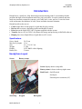
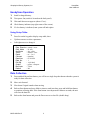
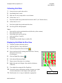
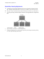
HandyScan
from GSSI
User’s Manual
The World Leader in
Subsurface Imaging™
Geophysical Survey Systems, Inc.
Tel 603.893.1109 • Fax 603.889.3984
[email protected]
www.geophysical.com
August, 2006
Copyright© 2001, 2006 Geophysical Survey Systems, Inc.
All rights reserved
including the right of reproduction
in whole or in part in any form
Published by Geophysical Survey Systems, Inc.
12 Industrial Way
Salem, New Hampshire 03079
Printed in the United States
GSSI, RADAN, and SIR are registered trademarks of Geophysical Survey Systems, Inc.
Geophysical Survey Systems, Inc.
HandySan
User’s Manual
Limited Warranty, Limitations Of Liability And Restrictions
Geophysical Survey Systems, Inc. hereinafter referred to as GSSI, warrants that for a period of
24 months from the delivery date to the original purchaser this product will be free from defects
in materials and workmanship. EXCEPT FOR THE FOREGOING LIMITED WARRANTY,
GSSI DISCLAIMS ALL WARRANTIES, EXPRESS OR IMPLIED, INCLUDING ANY
WARRANTY OF MERCHANTABILITY OR FITNESS FOR A PARTICULAR PURPOSE.
GSSI's obligation is limited to repairing or replacing parts or equipment which are returned to
GSSI, transportation and insurance pre-paid, without alteration or further damage, and which in
GSSI's judgment, were defective or became defective during normal use.
GSSI ASSUMES NO LIABILITY FOR ANY DIRECT, INDIRECT, SPECIAL, INCIDENTAL
OR CONSEQUENTIAL DAMAGES OR INJURIES CAUSED BY PROPER OR IMPROPER
OPERATION OF ITS EQUIPMENT, WHETHER OR NOT DEFECTIVE.
Before returning any equipment to GSSI, a Return Material Authorization (RMA) number must
be obtained. Please call the GSSI Customer Service Manager who will assign an RMA number.
Be sure to have the serial number of the unit available
MN70-380 Rev B
Geophysical Survey Systems, Inc.
HandySan
User’s Manual
FCC Notice (for U.S. Customers):
This device complies with part 15, class F of the FCC Rules:
Operation is subject to the following conditions:
1. This device many not cause harmful interference, and
2. This device must accept any interference received, Including interference that may cause
undesired operation
Warning: Changes or modifications to this unit not expressly approved by the party responsible for
compliance could void the user’s authority to operate the equipment.
Operation of this device is restricted to law enforcement, fire and rescue officials, scientific research
institutes, commercial mining companies, construction companies and private parties operating on behalf
of these groups. Operation by any other party is a violation of 47 U.S.C. § 301 and could subject the
operator to serious legal penalties.
Coordination Requirements
(a) UWB imaging systems require coordination through the FCC before the equipment may be used. The
operator shall comply with any constraints on equipment usage resulting from this coordination.
(b) The users of UWB imaging devices shall supply detailed operational areas to the FCC Office of
Engineering and Technology who shall coordinate this information with the Federal Government through
the National Telecommunications and Information Administration. The information provided by the
UWB operator shall include the name, address and other pertinent contact information of the user, the
desired geographical area of operation, and the FCC ID number and other nomenclature of the UWB
device. This material shall be submitted to the following address:
Frequency Coordination Branch, OET
Federal Communications Commission
445 12th Street, SW
Washington, D.C. 20554
ATTN: UWB Coordination
(d) Users of authorized, coordinated UWB systems may transfer them to other qualified users and to
different locations upon coordination of change of ownership or location to the FCC and coordination
with existing authorized operations.
(e) The NTIA/FCC coordination report shall include any needed constraints that apply to day-to-day
operations. Such constraints could specify prohibited areas of operations or areas located near authorized
radio stations for which additional coordination is required before operation of the UWB equipment. If
additional local coordination is required, a local coordination contact will be provided.
Notice: Use of this device as a wall imaging system requires the use of a “deadman switch” as
supplied by GSSI.
MN70-380 Rev B
Geophysical Survey Systems, Inc.
HandySan
User’s Manual
For U.S. Customers
Ground Penetrating Radar Coordination Notice And Equipment Registration
Note: This form is only for Domestic United States users. The Federal Communications
Commission (FCC) requires that all users of GPR who purchased antennas after July 15th, 2002
register their equipment and areas of operation. If you have purchased any of the antennas listed
in question 6 after July 15th, 2002, you must fill out this form and fax or mail to the FCC.
Failure to do this is a violation of Federal law.
1.
Date:
2.
Company name:
3.
Address:
4.
Contact Information [contact name and phone number]:
5.
Area Of Operation [state(s)]:
---Continued on next page.
MN70-380 Rev B
Geophysical Survey Systems, Inc.
6.
HandySan
User’s Manual
Equipment Identification:
Brand Name: Geophysical Survey Systems, Inc.
Antenna Model No. (center frequency): CHECK all antennas being registered.
Model
7.
Frequency
FCC ID
4105
2.0 GHz
QF74105
5100
1.5 GHz
QF75100
5101
1.0 GHz
QF75100
4108F
1.0 GHz
QF74108F
HandyScan
1.0 GHz
QF7HANDYSCAN
3101D
900 MHz
QF73101D
5103
400 MHz
QF75103
TerraVision
400 MHz
QF7TERRAVISION
5104
270 MHz
QF75104
5106
200 MHz
QF75106
Receipt Date Of Equipment:
Fax this form to the FCC at: 202-418-1944
Or
Mail to:
Frequency Coordination Branch, OET
Federal Communications Commission
445 12th Street, SW
Washington, D.C. 20554
ATTN: UWB Coordination
Do not send this information to GSSI.
MN70-380 Rev B
Geophysical Survey Systems, Inc.
HandySan
User’s Manual
Certificate
To Whom it may concern:
This is to certify that electromagnetic radiation emissions from transducers (antenna with
transmitting and receiving electronics) manufactured by Geophysical Survey Systems, Inc.
(GSSI) DO NOT constitute a safety or health hazard to operating personnel.
Emissions from GSSI transducers are below the 10mW/cm² (100W/m²) level specified by the
United States Occupational Safety and Health Administration (OSHA) regulations
Paragraph 1910.97 states:
"For normal environmental conditions and for incident electromagnetic frequencies from
100 MHz to 100 GHz, the radiation protection guide is
10 mW/cm² (milliwatt per square centimeter) as averaged over any possible 0.1 hour
period."
Emissions data using GPR SIR System-10, SIR-2, SIR-3, SIR-4, SIR-8, SIR-20, SIR-2000 and
SIR-3000 (at the standard Pulse Repetition Frequency of 100 KHz) with the antenna Models
listed and levels of Electromagnetic Radiation are specified herein:
Following is the average power density data at 5cm and wide band.
ANTENNA
(MHz)
AVERAGE POWER DENSITY
(W/m2 @ 5 cm)
OSHA SPEC.
(W/m2)
100
Less than 0.0001
100
200
Less than 0.0001
100
300
Less than 0.0001
100
270
Less than 0.0001
100
400
Less than 0.0001
100
500
Less than 0.0001
100
900
Less than 0.0001
100
1000
Less than 0.0001
100
1600
Less than 0.0001
100
GEOPHYSICAL SURVEY SYSTEMS, INC.
Alan E. Schutz
Engineering Director
MN70-380 Rev B
Geophysical Survey Systems, Inc.
This page intentionally left blank.
MN70-380 Rev B
HandySan
User’s Manual
Geophysical Survey Systems, Inc.
HandySan
User’s Manual
Table Of Contents
Introduction
............................................................................................................ 1
Specifications ..................................................................................................... 1
HandyScan Layout...................................................................................................... 1
HandyScan Operation................................................................................................. 2
Using Setup Table: ............................................................................................. 2
Data Collection............................................................................................................ 2
Start/Kill Switch ........................................................................................................... 3
Data Review................................................................................................................ 3
Data Printout: .............................................................................................................. 4
Data Transfer to a PC ................................................................................................. 4
On Handyscan: ................................................................................................................. 4
Collecting Grid Data.................................................................................................... 5
Displaying Grid Data As Plan View ............................................................................. 5
Radar Wave Velocity Adjustments.............................................................................. 6
MN70-380 Rev B
Geophysical Survey Systems, Inc.
MN70-380 Rev B
HandySan
User’s Manual
Geophysical Survey Systems, Inc.
HandySan
User’s Manual
Introduction
HandyScan is a small-size, fully functional ground penetrating radar. It can instantly find the
position and depth of metal and non-metal bars, pipes and cables. It works in natural and manmade non-conductive materials (concrete, rock, sand, brick, water, and ice). It can also locate
voids and measure the thickness of walls, floors and other structural elements.
HandyScan allows the user to:
•
•
•
•
•
Collect single lines of data (page 4) or grid data for plan viewing.
Review data on screen, determine position and depth of features.
Print data on the Seiko DPU-3445-20 printer supplied with the system.
Transfer data to a PC in GSSI (*.dzt) format for storage and processing in RADAN software.
Display plan views (Depth Slices) of grid data on a PC screen.
Specifications
Survey depth:
Max survey length:
Size:
Weight:
Display:
Battery life:
20-30 cm
15 m
21 x 15 x 14.5 cm
2.4 lbs
LCD, B&W w/back lighting
2 hours
HandyScan Layout
Screen
Battery status
Screen displays data or setup table.
Battery status is shown in the top right corner.
Back Panel: On/Off switch
Serial port
External power connector (9V)
Start/Stop
Keypad
MN70-380 Rev B
Back panel
1
Geophysical Survey Systems, Inc.
HandySan
User’s Manual
HandyScan Operation
1.
Install a charged battery.
2.
Turn power On (switch is located on the back panel).
3.
Wait until data screen appears (about 15 sec).
4.
Check battery indicator (top right corner of the screen).
5.
If a low battery is indicated, turn system off and replace.
Using Setup Table:
1.
Press Set on the keypad to display setup table, then:
•
Up/down arrows to select a parameter,
•
Left/right arrows to change it.
Disp. Direction:
Disp. Mode :
Amplitude
:
X-axis
:
Depth
:
Contrast
:
Date/time
:
Data_No.
:
Dist adj.
:
Output
:
Baud rate
:
Default
:
normal / invert
B / AB
abs / offset
distance / time
ns / -3 to 3
(number)
05/10/2001
1
+0 [0.00m]
printer / computer
57600
NO
Data Collection
1.
Press and hold down Start button, you will hear a single beep that denotes that the system is
ready for data collection.
2.
Move unit forward.
3.
Slow down if signal sounds when moving.
4.
Release Start button and press Mark to insert a mark into data, press and hold Start button
to continue collecting data. If the Start button is not depressed within ten seconds, the unit
will close the data file.
5.
Release the Start button and press the Down arrow to close file (double beep).
MN70-380 Rev B
2
Geophysical Survey Systems, Inc.
HandySan
User’s Manual
Start/Kill Switch
The Start switch also has a deadman switch function. The FCC requires that when the operator
stops interacting with the system for ten seconds, the transmitter is to be shut off. This will also
close the data file that you have been acquiring. Thus, you will need to keep the Start switch on
the handle depressed at all times during data collection.
Note:
•
Pressing Start one more time after you have collected a file will erase the previously
collected data.
•
Print the data or transfer them to a PC if you wish to keep the record before collecting the
next line.
•
The HandyScan can store 15 m (50 ft) of data. The unit will stop collecting data after this
amount has been reached. You will need to start a new file to resume collecting data.
•
The HandyScan displays axes in metric units only, but the same data can be later displayed
using RADAN NT software on a PC in metric or English units.
Data Review
1.
Use right/left arrow keys to scroll data.
2.
Optimize data display:
•
Press Gain until best display of features is achieved. Gain status is shown at bottom left
(Gain can be used during collection as well).
•
Press PRCS, then up/down arrow to change processing method. PRCS method used is
shown
at bottom center.
•
Use Set to modify display setup (contrast, amplitude, depth scale, etc.).
3.
Label targets:
•
Use arrow keys to move the cursors and locate targets. The cross-hair X (position) and Y
(depth) are displayed in the top left corner.
•
Press Mark to label a target and display its X-Y along the right edge of screen (up to 7
targets).
Note: It is possible to transfer non-grid data to a PC and review them on the PC screen, taking
advantage of a higher quality display and (if installed) processing capability of RADAN
software. Please see Data Transfer (page 7) and RADAN manual for instructions on processing.
MN70-380 Rev B
3
Geophysical Survey Systems, Inc.
HandySan
User’s Manual
Data Printout:
1.
Install a charged battery in the printer.
2.
Connect printer to the serial port (back panel) using the supplied cable and turn it On.
3.
On setup screen, select Output to Printer.
4.
Press Set to return to data screen
5.
Press Print to print data.
Note: For more details see the User's Guide for Seiko Instruments printer model DPU-3445-20.
Data Transfer to a PC
Note: The file Handyfer.exe must be present on the PC.
1.
Connect Handyscan and PC using a 9-pin null modem cable.
2.
Start Handyfer.exe
on the PC and select the appropriate data type (Grid Lines 1-13,
14-26 or Non-grid Data).
On Handyscan:
3.
On setup screen, select Output to computer (binary).
4.
Set baud rate to 57600.
5.
Press Set to return to data screen.
6.
Press Print.
Displays scan # during transfer
When the data transfer is finished, PC will prompt you to save data.
MN70-380 Rev B
4
Geophysical Survey Systems, Inc.
HandySan
User’s Manual
Collecting Grid Data
1.
Secure the survey pad to the surface.
2.
Start HandyScan as usual.
3.
Make sure X-axis in setup table is set to distance.
4.
Collect lines 1 to 13.
•
Press Start (double beep) and transfer the data to the PC (see Transfer above).
5.
Collect lines 14 to 26.
•
Press Start (double beep) and transfer the data.
6.
Save the grid file when prompted.
Notes:
•
•
•
•
•
•
Start each line in the cross-hatched area (before the yellow contour).
Stay centered on the line.
Press Mark at the end of each line.
At the end of line 13 and 26:
Press Mark.
Then press Start (double beep) to end the file.
Displaying Grid Data As Plan View
1.
Complete grid data collection (above).
2.
Open the grid file (*.dzt) in RADAN.
3.
Click on StructureScan Process button
4.
Process and save the file (change the Radar Wave Velocity
and repeat, if necessary,
see next page).
5.
Click on Depth Slices button
6.
Select desired Maximum Depth.
7.
Drag a corner of the plan view to enlarge.
8.
Right-click and select Display Gain (and slice thickness,
if desired).
9.
View depth slices using the Slice Depth box.
.
.
10. Use mouse cursor to determine positions of targets (see right).
Use this information to mark targets on the paper pad.
11. Print the plan view or copy to clipboard as appropriate.
MN70-380 Rev B
5
10.0 in
15.0 in
Geophysical Survey Systems, Inc.
HandySan
User’s Manual
Radar Wave Velocity Adjustments
1.
Automated processing includes Migration which removes hyperbolic reflections from the
data. Migration requires Radar Wave Velocity to be set within ½ in/ns of the exact value.
2.
The exact velocity is usually not known, thus trial-and-error is the best way to determine it:
•
After first processing, maximize Display Gain and see if the hyperbolas have collapsed into
dots:
Raw Data
Velocity too high
Correct
Velocity too low
•
Correct velocity – data can be viewed in Depth Slices
•
Velocity too high or too low – process again, respectively decreasing or increasing velocity
in ½ in/ns steps until image looks correct.
MN70-380 Rev B
6