1
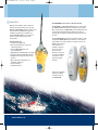
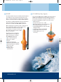
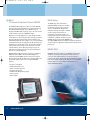
29570 mcmurdo cat
31/1/07
12:54
Page 1
EMERGENCY LOCATION BEACONS
McMurdo
Silver Point
Airport Service Road
Portsmouth
PO3 5PB
United Kingdom
Tel: +44 (0) 23 9262 3900
Fax: +44 (0) 23 9262 3998
E-mail: [email protected]
www.mcmurdo.co.uk
Distributors and agents throughout the world
Dealer:
EMERGENCY LOCATION BEACONS
29570 mcmurdo cat
31/1/07
12:54
Page 3
The Company
Established in 1937, McMurdo leads the way in the
development and manufacture of emergency location
beacons and NAVTEX technology.
Based in Portsmouth England, McMurdo first produced
a COSPAS-SARSAT approved EPIRB in July 1989.
McMurdo further galvanised its position as the leader
in safety equipment technology in 1992 with the
release of the first GMDSS approved Search And
Rescue Transponder (SART). Since that date we have
continually led the way in the functionality and
accuracy of emergency location beacons launching a
PLB (Personal Locator Beacon) for use on land, sea or
air in 2000. Also in that year GPS technology was
introduced to both the EPIRB and the PLB.
NAVTEX technology is another area where McMurdo
has considerable expertise, developing and
manufacturing NAVTEX receivers for both SOLAS and
non-SOLAS vessels.
The McMurdo name stands for high quality products
using the latest technology. Organisations such as the
Royal Navy and the US Coastguard understand the
importance of ultra-reliable high quality equipment
which is why they have chosen McMurdo products for
their vessels and their crew.
McMurdo products are used around the world, on
land, sea and in the air, where safety is important
you will find McMurdo.
2
www.mcmurdo.co.uk
Service and Spares
McMurdo has a complete customer services operation that handles the
repair and servicing of our full range of products. From scheduled
beacon battery changes to the service and repair of Navtex and VHF
equipment our team is here to help.
Our in-house service department operates in support of our worldwide
service agents who are fully trained and certified to service and repair
McMurdo equipment. For your nearest service agent please visit
www.mcmurdo.co.uk.
Contents
Glossary
How does an EPIRB work?
EPIRBs (Smartfind)
Personal Locator Beacons (Fastfind)
SART (Search And Rescue Transponder)
S-VDR Float Free Capsule
Accessories
Handheld VHF Radios
What is NAVTEX
Professional NAVTEX
Leisure NAVTEX
Technical Specifications
4
6
8
10
12
13
14
16
18
20
21
24
3
29570 mcmurdo cat
31/1/07
12:54
Page 5
Glossary
Automatic Activation
An EPIRB that is activated when it comes in contact with water
Manual Activation
An EPIRB that is activated by the user
Automatic Deployment
An EPIRB that is automatically released from its housing when
the integral HRU is submerged.
Manual Deployment
An EPIRB that is release from its bracket by hand. McMurdo
EPIRBs are available with either a manual “Carrysafe” bracket or
an Auto Housing.
Category 1 EPIRB
An EPIRB that is automatically deployed and activated when in
contact with water. The EPIRB may also be manually deployed
and activated.
Category 2 EPIRB
A manually deployed EPIRB. Once removed from its bracket
this EPIRB will be automatically activated when in contact
with water or can be manually activated.
Class 1 EPIRB or PLB
Rated to operate down to –40 degrees Celsius
Class 2 EPIRB or PLB
Rated to operate down to –20 degrees Celsius
COSPAS-SARSAT
International satellite system for search and rescue. A joint
operation between France, Canada, Russia and the USA who
monitor the 406 MHz satellite system.
ELT
Emergency Locator Transmitter. Aviation equivalent of
an EPIRB
EPIRB
Emergency Position Indicating Radio Beacon.
FAA
Federal Aviation Administration (USA)
FCC
Federal Communications Commission (USA)
GEOSAR
Geostationary Search And Rescue system. Part of the
COSPAS-SARSAT satellite system
GMDSS
Global Maritime Distress and Safety System
HRU
Hydrostatic Release Unit. A release mechanism activated by
water pressure.
MCC
Mission Control Centre. The MCC manages satellite information
from the LUT and sends an alert to the Rescue Coordination
Centre for the region.
MED
Marine Equipment Directive. European certification for
equipment that meets the standards required by the IMO and
SOLAS.
MOB
Man Overboard
NAVTEX
A system used for the automatic reception of localised maritime
safety and weather information.
NOAA
National Oceanic and Atmospheric Administration.(USA)
PLB
Personal Locator Beacon
RDF
Radio Direction Finder
RNLI
Royal National Lifeboat Institute
SAR
Search And Rescue
SOLAS
Safety Of Life At Sea. Minimum standards of safety set out by
the International Maritime Organisation
S-VDR
Simplified Voyage Data Recorder.
UIN
Unique Identifier Number programmed into an EPIRB or PLB
IMO
International Maritime Organisation
USCG
United States Coast Guard
LEOSAR
Low-altitude Earth Orbiting Search And Rescue system.
Wheelmark
Awarded to products that conform to International Maritime
Organisation (IMO) type approval
LUT
Local User Terminal. A ground receiving station that picks up the
initial EPIRB signal and relays it to the Mission Control Centre. The
LUT also calculates the position the signal was transmitted from.
4
MCA
Maritime and Coastguard Agency (UK)
www.mcmurdo.co.uk
5
29570 mcmurdo cat
31/1/07
12:54
Page 7
How does an EPIRB work?
An Emergency Position Indicating Radio Beacon (EPIRB) or
Personal Locator Beacon (PLB) is used to alert search and rescue
services in the event of an emergency. They do this by
transmitting a coded message on the 406 MHz distress
frequency. This message is relayed via satellite and earth station
to the nearest rescue co-ordination centre.
406 MHz EPIRBs and PLBs work with the Cospas-Sarsat polar
orbiting satellite system which provides true global coverage.
The system has an alert delay of typically 45 minutes dependant
on when the satellites come into view on the horizon.
The satellite can determine
the position of your
Smartfind E5 EPIRB or
Fastfind PLB to within 5km
(3 miles). The coded
message identifies the exact
vessel to which the E5 is
registered or the person the
Fastfind PLB is registered to.
This information allows the
rescue services to eliminate
false alerts and launch an
appropriate rescue.
The GPS enabled Smartfind Plus G5 406 MHz EPIRB and Fastfind
Plus PLB have built-in transmitters that will typically alert the
rescue services within 3 minutes. Smartfind Plus is capable of
providing typical positional accuracy of +/- 50 Metres and
position updates every 20 minutes, given a clear view skyward.
Both the Smartfind EPIRBs and Fastfind PLBs also have a
secondary distress transmitter. This transmits on 121.5 MHz and
is used for "homing" purposes. When the rescue services get
close, this allows them to direction find on the signal. To cater
for searches at night, the Smartfind EPIRBs have a high
brightness LED flashing light that aids final visual location.
6
www.mcmurdo.co.uk
Since its inception in 1982 the Cospas-Sarsat System has provided
distress alert information which has assisted in the rescue of over
18,865 persons in 5,317 distress situations. The Cospas-Sarsat
Programme assists search and rescue (SAR) activities on a
worldwide basis by providing accurate, timely, and reliable
distress alert and location data to the international community
on a non-discriminatory basis.
GPS EPIRBs
The GPS EPIRB and PLB have been designed to enhance further
the lifesaving capabilities of conventional beacons. The standard
Global Positioning System (GPS) uses an array of 27 satellites and
provides continuous positional information with a typical
accuracy of around 50m. A 406MHz EPIRB such as the Smartfind
Plus or PLB such as the Fastfind Plus has a built in GPS, when the
beacon is activated in an emergency, positional information is
incorporated into the distress message which it transmits.
This incorporation of positional information overcomes the
location problem when using geostationary satellites and can
greatly reduce the time it takes for the SAR authorities to arrive
on the scene. When speed of response and accuracy of location
are important considerations, then the GPS EPIRB offers the
best performance
7
29570 mcmurdo cat
31/1/07
12:55
Page 9
Smartfind
Meeting the demands of both commercial
mariners and recreational boaters, the new
McMurdo SMARTFIND heralds the arrival of the
next generation in EPIRB technology. This
compact and stylish unit is available as a
standard 406 MHz EPIRB or, for enhanced
position location, with a built in high
accuracy GPS.
The key features are:
■ Internationally Approved
■ Non hazardous battery for safe and
easy transportation
■ Unique CARRYSAFE bracket for
safe transportation
■ High brightness LED flashing locator lights
■ Integrated 12 channel GPS (PLUS version)
■ Comprehensive diagnostic and self-test
facilities
■ Once activated, will transmit for a
minimum of 48 hours
■ 5 year warranty*
■ 5 year battery life*
The SMARTFIND Series consists of two base models;
E5 SMARTFIND is a 406 MHz EPIRB designed to operate with
the COSPAS-SARSAT international search and rescue system.
Once removed from its CARRYSAFE mounting bracket the unit
can be activated automatically by immersion in water, or
manually by following the activation instructions printed on
the unit.
The G5 SMARTFIND PLUS has all the advanced features of the
standard E5 SMARTFIND with the addition of an integral 12
channel GPS receiver. The addition of a GPS receiver to the
EPIRB ensures that the
exact position of a
casualty is relayed to
the rescue services.
This can in turn
improve the speed of
recovery by updating
the position of the
beacon at regular
intervals.
A float free automatic
housing is available
for both versions of
the SMARTFIND
8
www.mcmurdo.co.uk
9
29570 mcmurdo cat
31/1/07
12:55
Page 11
FastFind PLB
The Fastfind and Fastfind Plus Personal Locator Beacons
feature the same advanced technology as found
in our range of EPIRBs. Designed using
miniaturised components to fit into an
ergonomically styled compact casing, both
versions employ a simple three-stage manual
operation and feature user replaceable
battery packs for use in temperatures as low
as –20 °C.
Carrying the Fastfind could not be simpler, both
versions are supplied with a lanyard and carry
case to enable the user to keep the PLB with
them at all times. These latest advanced
products from McMurdo have been
designed to provide professional and
recreational mariners, fishermen, light
aircraft pilots and those involved in
outdoor adventure activities with the
very best chance of being found without
delay in the event of an emergency.
10
www.mcmurdo.co.uk
Intended for use within the maritime, aviation and land
environments where permitted by national administrations.
■
■
■
■
■
■
■
■
■
■
■
Built-in 12 parallel channel GPS receiver (Fastfind PLUS only)
Visual indication of GPS acquisition
Internal GPS allows position updates
Global alert via COSPAS-SARSAT satellites
121.5 MHz homing frequency
Built in self test on 406 MHz and 121.5 MHz
Simple three stage manual activation
Once activated, will transmit for a
minimum of 24 hours
User replaceable battery packs (-20 °C)
Compact and lightweight
Accepts serialised or MMSI protocols
11
29570 mcmurdo cat
31/1/07
12:55
S4 SART
C1 S-VDR Float Free Capsule
The S4 Rescue SART offers proven reliability. Extremely simple to
use the S4 Rescue can be operated even with gloved or wet
hands. Its compact design makes it ideally suited for packing in
liferafts or as a carry off device according to SOLAS regulations.
In line with new IMO regulations, McMurdo has developed the C1
S-VDR Float Free Data Capsule. This unit duplicates and stores
critical voyage related data collected by the S-VDR. The C1 also
incorporates a GPS EPIRB to aid quick location and recovery.
The S4 Rescue is a 9GHz X-band Radar transceiver and has been
designed for assisting air/sea ship or survival craft rescue
operations in accordance with IMO, GMDSS requirements.
■
When a radar signal is received from a ship or aircraft, the S4
Rescue automatically transmits a response signal, which
clearly identifies the survival craft on the radar
screen by means of a stream of 12 in-line dots.
Once activated the S4 will remain in standby
mode for over 96 hours.
■
The S4 Rescue has been designed for
reliable operation in the toughest of
marine environments, in accordance
with IMO/GMDSS requirements.
■
■
■
■
■
■
■
■
■
12
Page 13
■
■
■
■
■
■
Ethernet interface
Storage memory options of 2 - 32 GB
Memory type ATA 2.5" solid state flash drive(s)
Protected 6 pin data/power connection
Integral 406 MHz GPS Beacon with 121.5 MHz
homing transmitter
7 day battery operation life (minimum)
Integrated HRU activated auto release
Integral grappling eyes to aid
sea recovery
Ship or survival craft options
Waterproof to 10mtrs
Buoyant
Compact and lightweight
Replaceable, 5 year** battery pack
Audio/visual indication of operation
Built-in test facility
Integral lanyard
Mounting options internal/external
www.mcmurdo.co.uk
13
29570 mcmurdo cat
31/1/07
12:56
Page 15
Accessories
Grab Bag
The Fastfind PLB Dive Canister
Designed for marine and aviation use, this
waterproof and buoyant Grab Bag is
perfect for holding emergency equipment.
Turned from a solid block of marine grade aluminium, anodised
to 25 microns and pressure tested to 150mtrs (500ft), the canister
is designed to be opened at the surface allowing quick and easy
access. The double ‘O’ ring seal protects the threads providing
watertight integrity to 15atm, preventing ingress of sand or other
debris, and a convenient nylon clip is provided to attach the
Canister. The Fastfind Dive Canister is the ultimate protection for
your Personal Locator Beacon (PLB).
■
■
■
■
High visibility
Buoyant
Waterproof
Dimensions - 35cm x 15cm x 24cm
Grab Bag XL
Made from high quality material
the Grab Bag XL has an external
EPIRB pouch and flare stowage
pockets.
■
■
■
■
■
Buoyant
Waterproof
Watertight zip and Velcro closure
Carry handles and shoulder strap
Large capacity
44cm X 22cm X 30cm
This underwater housing is
specifically designed to
protect the unique satellite
alerting Fastfind 406 PLB.
Providing rapid rescue
assistance anywhere in the
world utilising the COSPASSARSAT satellite arrays, the
Fastfind ensures total piece
of mind not only to the
Diver but their family and
support crew alike.
■
■
14
www.mcmurdo.co.uk
Dimensions - 162mm x 93.5mm
Weight - 900g
15
29570 mcmurdo cat
31/1/07
12:56
Page 17
R1 Waterproof Handheld
VHF Radio
R2 Handheld GMDSS VHF
Radio
The R1 VHF radio is designed specifically to
meet worldwide legislation, and exceeds the
demanding IMO requirements for GMDSS
survival craft radios. It is 100% waterproof
and designed to cope with the toughest
marine environments making it an ideal
“Fit and Forget” item.
The McMurdo R2 GMDSS fully featured
19 channel VHF radio fits securely and
comfortably in the palm of the hand. The
R2 GMDSS has been built to meet the
latest stringent IMO, GMDSS and ETSI
standards. This reliable and easy to use
radio is 100% waterproof and drop
tested to cope with the toughest marine
environments.
■
■
■
■
■
■
■
Tough, reliable 100% waterproof &
drop proof
Exceeds GMDSS specification for use
in Survival Craft
Easy to use
Three channels; 6, 13 and 16
Floats
Long life lithium battery
Test battery available
■
■
■
■
■
■
■
■
■
16
www.mcmurdo.co.uk
Fully featured all 19 Simplex channels
as permitted by GMDSS legislation
Superior voice quality and
fully waterproof
2.5 watts RF output
Selectable dual/tri watch function
Priority channel
All channel memory scan
8 hour battery life at -20°C
Variable LCD display illumination
Approved to latest GMDSS, IMO,
ETSI Resolutions
17
29570 mcmurdo cat
31/1/07
12:57
Page 19
McMurdo NAVTEX receivers are in widespread use by the world’s
merchant ships, navies and recreational boaters.
What is NAVTEX?
NAVTEX is a system for the broadcast and automatic reception
of maritime safety and weather information. NAVTEX provides
shipping with navigational and meteorological warnings and
urgent information through either on screen display or
automatic printouts from a dedicated receiver.
NAVTEX Coverage
NAVTEX messages are transmitted worldwide from local stations,
the number of stations grows month by month. Information
about all known NAVTEX stations can be found on our website
(www.mcmurdo.co.uk), details including name, position, range,
and operational status.
NAVTEX is a component of the IMO/IHO Worldwide Navigational
Warning Service (WWNWS) defined by the IMO. It has also been
included as an element of the Global Maritime Distress and
Safety System (GMDSS).
How does it Work?
NAVTEX transmissions are sent from localised transmitting
stations situated worldwide. The power of each transmission is
regulated so as to avoid the possibility of interference between
transmitters. Users can set their NAVTEX receivers to receive
specific message types and reject others. Messages such as
navigational and meteorological warnings and search and rescue
information are non-rejectable to ensure that ships equipped
with NAVTEX always receive the most vital information. Users
can choose to receive information from the single transmitter
that serves the sea area around their position, or from a number
of transmitters.
18
www.mcmurdo.co.uk
19
29570 mcmurdo cat
31/1/07
12:57
Page 21
NAV-7
Tri Channel Professional Colour NAVTEX
The McMurdo NAV-7 supports reception of all three NAVTEX
frequencies by providing simultaneous tri channel monitoring;
The 518 KHz English language service, 490 KHz national
language and 4209.5 KHz long range services can all be viewed
together within a single list of NAVTEX messages.
Message text is clearly displayed on a large daylight viewable
colour LCD screen. This offers paper white message presentation
and very high clarity under all light conditions thanks to the
adjustable backlight. The unit is simple to use; coloured headings
clearly identify message category types and give quick and easy
identification of the message content. The powerful automatic
sorting feature allows messages to be viewed on screen and
sorted by channel, station ID, message category or age. An
indexed message listing page allows for quick searching and
direct access to full message text.
McMurdo NAV-7 supports interface connection to Integrated
Navigation System (INS) or Electronic Chart Display and
Information Systems (ECDIS) and the connection of a printer.
Antenna options include the ACT-1 active antenna optimised to
provide high quality reception of all recognised NAVTEX
channels.
■
■
■
■
■
■
■
20
NAV6 Range
The NAV6 range offers dual channel
(518kHz & 490kHz) reception as standard.
Information is presented on a large and
easy to read LCD display. Weather and
navigation warnings, in English on 518 kHz
can be received every 4 hours from
transmitters all around the world. Local
language and small craft information is also
transmitted, on 490 kHz. In addition to dual
NAVTEX channel monitoring the NAV6plus can
also display NMEA data from your GPS or instrument system. An
electronic logbook is updated at regular intervals and can also be
printed out.
NAV6A PLUS
NAV6Aplus has all the features of the NAV6plus, but has been
designed for below deck mounting with a remote antenna
connection. This enables installers to select from a range of
suitable aerial options. This provides greater flexibility for leisure
boat owners and boat builders, who may choose a central multifunction antenna for several radios on board instead of a
dedicated NAVTEX antenna.
Large 6” colour display
Simple and intuitive to use
Easy to read extra large font
Tri channel monitoring
12V DC to 24V DC operating voltage
Soft key options
Printer output
www.mcmurdo.co.uk
21
29570 mcmurdo cat
31/1/07
12:57
Page 23
NAV6 Repeater
The NAV6repeater has the features of the NAV6plus without the
NAVTEX sensor, for use as a standalone NMEA repeater.
Features include:
■ Instrument repeater capable of displaying data in a choice
of formats.
■ Standard NMEA 0183 interface
■ When connected to a NAV6plus and NAV6hub,
NAVTEX information is also displayed.
■ 256 entry log book
■ Interfaces to a PC or printer
■ Suitable for cockpit mounting
■ Flush ‘panel mounting’
Four user views may be configured to show either 2, 3 or 4
panels. Each panel can be configured to show different
navigation information, such as position, waypoint, conning or a
combined view, from a range of NMEA inputs.
NAV6 Hub
The NAV6hub allows multiple NAV6 display units to be connected
together. Any combination of up to four NAV6plus/Aplus displays
or sensors can be connected to each other, in order to share
NAVTEX messages and NMEA data. The NAV6hub provides a
buffered NMEA 0183 input and routes NMEA data sources to all
displays in the system. A NMEA Data Combiner module can also
be fitted to allow up to 4 NMEA 0183 inputs to be merged into a
single NMEA 0183 data stream. The merged NMEA data can be
made available to other external equipment
22
www.mcmurdo.co.uk
Outputs are provided for connection to a roll printer or computer.
Feature
NAV6dual
NAV6plus
2
(518 & 490)
2
(518 & 490)
2
(518 & 490)
0
NMEA Auto
Station
•
•
•
NMEA GPS
Display
•
•
•
NMEA
Instrument
Display
•
•
•
NMEA
Logging
•
•
•
•
•
•
•
•
•
Receivers
Display
Backlight
Printer Data
Output
Antenna
Options
•
NAV6Aplus NAV6repeater
•
23
29570 mcmurdo cat
31/1/07
12:57
Page 25
Technical Specifications
Smartfind & Smartfind Plus
Fastfind & Fastfind Plus
406 Beacon Specification: Meets the
requirements of international standards:
Message formats PLB National, Standard, and User Location Protocol as
applicable, plus serial user (non-GPS version)
Smartfind in
CARRYSAFE
Bracket
COSPAS-SARSAT T.001 class 2, RTCM
SC110-STD Version 2 class 2, IEC 61097-2,
EN 60945, Part 80 of FCC regulations.
PLB temperature range: Operating: -20°c to + 55°c (class 2 battery)
-40°c to + 55°c (class 1 battery)
Storage: -40°c to +70°c
130mm
EPIRB temperature range: Operating 20ºC to +55ºC (Class 2), Storage -30ºC to
+70ºC
EPIRB sealing depth: Waterproof to 10 m
Operating life 24 hours (minimum)
Weight Approx. 0.3 kg (10 oz) with -20 battery pack
390mm
225mm
SOLAS Float-Free Housing -30ºC to +65ºC
(Class 2)
Battery life 5 years storage from date of manufacture
Approvals: COSPAS-SARSAT Approved, R&TTE Approved, FCC Approved
406 MHz transmitter
EPIRB Weight: 657g (1.5 lb)
Frequency 406.028 MHz
Float-Free Housing & EPIRB: 2130 g (4.7 lb)
Output power 5 Watts +/- 2 dB
406 MHz transmitter Frequency:
406.028MHz
Modulation Biphase L 1.1 +/- 0.1 radians
Output power: 5W + 2dB
Output power 50mW ERP
121.5MHz homing transmitter
Modulation AM, up or down swept tone
121.5 MHz transmitter
Output power: 50mW + 3dB PERP
GPS receiver (SMARTFIND Plus)
78.4mm
Maximum number of satellites tracked: 12
54mm
60mm
Transmit Antenna Type: Blade vertically
polarised, omni-directional
GPS Receive Antenna Type: Ceramic
dielectric patch
Type: Flashing white LED lamp
Message formats: EPIRB National,
Standard and User Location Protocol as
applicable, plus EIPRB user protocols.
Serialised, MMSI and radio call sign.
115mm
Auto FLOAT FREE housing
for Smartfind
Controls: Manual activation,
Self TEST switches
Beacon operation: Automatic activation
by seawater switch within 5 seconds
of immersion.Manual activation by
sealed switch.
134mm
www.mcmurdo.co.uk
Profile with -40
battery pack
(Class 1)
435mm
Operational life: 48 hours minimum
at -20ºC
24
147mm
Profile with -20
battery pack
(Class 2)
Battery Classed as non-hazardous for
transportation
Battery replacement interval: 5 years
108mm
146mm
Light output: > 0.75 candela over 75%
of the horizontal plane
25
29570 mcmurdo cat
31/1/07
12:57
Page 27
Technical Specifications
S4 SART
R1 VHF Radio
Receiver Response: 9.2-9.5 GHz, sensitivity better than -50 dBm
Transmitter Response: 12 forward and return sweeps through the range
9.2-9.5 GHz.
Nominal sweep times 7.5 _s forward and 0.4 _s return.
Radiated Power (ERP): Not less than 400 mW (+26 dBm)
Duration of Operation: 96 hours in standby condition followed by a
minimum 8 hours of transmission while being continually interrogated
with a pulse repetition frequency of 1 kHz.
Temperature Range: -20ºC to +55ºC operational -30ºC to +65ºC storage
Effective Antenna Height: 1 metre or greater.
Weight: 360g (without mast or bracket)
510g (with mast)
530g (with mast & bracket)
Dimensions: 264mm long x 90mm diameter
Battery replacement interval: 5 years
Approved to ETS300 - 225/A1: 1997 plus relevant section IMO, ITU, SOLAS
FCC part 80, (CFR47) GMDSS rules EU MED (Ship’s Wheel) approved
EMC Standard EN 300 828: 1998
Weight less than 400 g
Temperature -20°C to +55°C working, -30°C to +70°C storage
Battery Primary (lithium)
Battery storage life 4 years
Battery life 12 hours (10%/10%/80% duty cycle-transmit/receive/squelched)
Channels Ch 6, 13 and 16
Water resistance Waterproof to a depth of 1m
Buoyancy Unit will float
TRANSMIT
Output Power 0.5 watts ERP
Current Consumption 350mA
RECEIVE
Audio Output Power 0.4 watts (1kHz tone, 3kHz deviation)
Current Consumption 150mA at rated audio power 10mA squelched
101mm
173mm
340mm
264mm
283mm
90mm
55mm
71mm
26
www.mcmurdo.co.uk
58mm
27
29570 mcmurdo cat
31/1/07
12:57
Page 29
Technical Specifications
NAV-7
General Performance and Approvals: in accordance with the minimum
requirements of ETS300-225. IMO Resolutions A 694(17) and A809 (19) ITU
regulations appendices 18 and 19
SOLAS 1974 and amendments
EN 60945 (EMC)
EU Marine Equipment Directive (Ship’s Wheel)
FCC Part 80 GMDSS Rules (CFR47)
RF output power: 2 settings 2.5 Watts/1 Watt
Number of channels 19 Simplex channels
(6,8,9,10,11,12,13,14,15,16,17,67,68,69, 71,72,73,74,77) as permitted by
GMDSS legislation
Frequency range: 155 - 163MHz
Receiver A.F output power: 0.4 Watts
Operational function: Dual watch. Scan memory. Squelch. Volume. Scan all
(with delete). Scan Priority. Tri-watch (16, priority, working channel). All
the above subject to requirements of national regulatory authorities.
Illumination: Channel up/down, on/off, high/low power
Display: LCD indication of channel and other operational parameters.
Antenna: Removable - stud mounted for strength
Weight: Radio with Lithium battery 370g
Operating temperature -20°C to +55°C
Storage temperature -30°C to +70°C
Waterproof: Fully submersible to a depth of 1m including a 45°C thermal
shock
Drop resistance: Will withstand a 1m drop on any face onto a hard surface
Environment: Corrosion proof, UV resistant, oil resistant
Battery life: Lithium 8 hours minimum at -20°C (10% high power transmit,
10% receive, 80% squelched)
Lithium battery storage life 4 years
NiCad battery option
Frequencies: 490 kHz, 518 kHz, 4209.5 kHz
Antenna Input: 50 ohms
Antenna voltage: 12 VDC @ 100 mA(auto sensing)
Display: 1/2 VGA (480 x 320 pixels) Daylight viewable colour STN Variable
backlight
Controls: Backlight level / contrast, 4 key 2 axis navigation pad, enter key,
4 menu soft keys
Connection
Antenna: TNC
Power/NMEA 0183 (GPS) 15 way D-type
Alarm: 9 way D-type
Data output: Printer: RS232, INS Port: IEC61162-2 (RS422)
Alarm output: Relay contact: 1A @120VAC/24VDC (max)
Power: Voltage range: 9-32 VDC, Power Consumption: 5 W (max)
Technical Standards: IMO Resolutions MSC.148(77) A.2.1, A694 (17), SOLAS
Regulation IV/7.1.4, ITU-R M.540-2, ITU-R M.625-3, IEC60945-4.0, IEC611621,-2, IEC61097-6 CDV
Operating Temperature: -15 °C to +55 °C
Storage Temperature: -20 °C to +70 °C
Humidity: 0 to 95%
GMDSS NAVTEX
non-condensing
Mounting:
Desk-top, bulkhead
or flush panel
Dimensions:
219W x 151H x
76D mm (excluding
NAV7
connectors)
Weight: 1kg
219mm
76mm
151mm
R2 VHF Radio
Tri channel NAVTEX Antenna, 490 kHz, 518 kHz, 4209.5 kHz.
Supports NAV-7,
125mm
Screw-in whip
Nav6Aplus and Nav5plus.
antenna
Power: 12v DC supplied
by NAVTEX
Mounting:
1" 14TPI screw fitting
Bracket: Mounting
RG58
kit supplied
cable
& TNC
connector
Cable: 20m RG58,
1m earth cable
34mm
60mm
42mm
71mm
40 CTR
231mm
148mm
95mm
318mm
ACT-1
Earth wire
M5 x 0.8P
Ø 1” (25.4mm)
29 CTR
28
www.mcmurdo.co.uk
29
29570 mcmurdo cat
31/1/07
12:57
Page 31
Technical Specifications
NAV-6
NAVTEX SENSOR
Waterproof to IEC 60945.
Frequency Stability: +/-10 Hz.
RS485 serial data I/O port.
Data decoding in accordance with ITU-R 540-2.
Operating Temperature Range -10 to +50degC.
Humidity 0 to 95% non-condensing.
Weight (without cable) 420 g (approx.).
Industry standard 1"14tpi threaded base.
Extension Whip (option), length 45 cm/ 3/8" x 24 tpi thread.
NAV6 DISPLAY UNIT
Operating Temperature Range 0 to +50degC.
Humidity 0 to 95%. Weight (without cable) 445 g.
Display type: 1/2vga (480 x 320 pixels) 6"monochrome LCD with 4
grey levels and CFL backlight.
Controls: 4 x function keys, 4 x navigation keys. With LED backlight.
Alarm: Programmable Vital message reception acoustic alarm.
Message Storage: Sufficient non-volatile storage for more than 3 days of
NAVTEX transmissions under normal operating conditions.
Connection: 1 metre cable with screw terminal block.
Environmental: Inside/outside mounting.
Waterproof to IEC945
(exposed category), IEC 945
NAV 6
(EMC), CE marked.
Power requirements: Voltage
range 10.8V to 15.6V.
Consumption (Typical)
Backlight full 310 mA (3.8 W
at 12V).
Backlight off 165 mA (2.0 W
at 12V).
Sleep mode 115 mA (1.4 W
at 12V).
20mm
Data input: NMEA input
port, meets the electrical
138mm
requirements of NMEA 0183.
20mm
NMEA GPS/Instrument
system interface supports
NMEA 0183 V2.0 or higher.
Sensor
Input/output Interface
Specification: Preferred
NMEA sentences: RMC,
HDT, HDG, VBW, MWV,
VLW, DPT, ROT, VDR, RMB
and BWC. Minimum
recommended NMEA
sentences: RMC and RMB.
Data output:RS232 serial
data, supports the printing
of vessel ‘Log reports‘ and
NAVTEX message text to
NAV6printer or a
computer system running
147mm
105mm
compatible software.
219mm
Navtex
198mm
Navtex