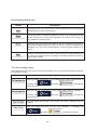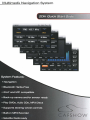
1
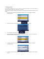
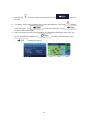
Multimedia Navigation System
2Din Quick Start c}dlEie
. .-'
r:~·
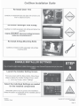
SHOW
Notices
NOTICE OF INTENDED USE
Some features of CarS how Entertainment Systems are not intended for viewing by the driver when the vehicle is in motion,
such as movie playback. When using navigation, minimize the amount of time spent viewing the screen and use voice
prompts as much as possible. Avoid prolonged use of the touch screen controls. Such use might distract the driver or
interfere with the driver's safe operation of the vehicle, and thus result in serious injury or death. Such use might also
violate state or local laws.
CarShow Entertainment Systems disclaims any liability for
any bodily injury or property damage that might result
from any improper or unintended use.
Copyright© 2012 by CarShow Entertainment Systems. All rights reserved. Except as permitted
under the Copyright Act of 1976, no part of this publication may be reproduced or distributed in
any form or by any means, or stored in a database or retrieval system, without the prior written
permission of CarS how Entertainment Systems.
About the Registered Marks
This product incorporates copyright protection technology that is protected by method claims
of certain U.S. patents and other intellectual property rights owned by Macrovision
Corporation and other rights owners. Use of this copyright protection technology must be
authorized by Macrovision Corporation, and is intended for limited viewing uses only unless
otherwise authorized by Macrovision Corporation. Reverse
engineering or disassembly is prohibited.
iPod® is a registered trademark of Apple Computer, Inc.
NOTE: Features and specifications listed in this manual are subject to change without notice.
1
......
Basic Functions
-)~.
·.\·,· ..:~
--. ~
:X
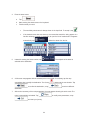
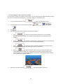
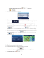
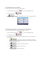
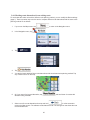
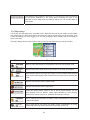
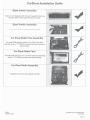
Screen Organization
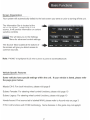
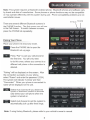
Your system will automatically default to the last screen you were on prior to turning off the unit.
The Information Bar is located at the
top of the screen. Depending on the
source, it will provide information or content
sensitive controls
The Source Tabs located at the bottom of
the screen will give you direct access to
common sources.
Note: "PHONE" is highlighted BLUE when a phone is paired to CarShowBiuetooth.
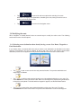
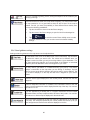
Vehicle Specifc Features
Some vehicles have special settings within the unit. If your vehicle is listed, please refer
the page given below.
Mazda CX-9: For clock intructions , please visit page 9
Subaru Forester: For steering wheel control functions, please visit page 10
Subaru Legacy: For steering wheel control functions, please visit page 10
Honda Accord: First source tab is labeled MAIN, please refer to Accord note on page 3
F150: Unit functions with SYNC technology. Some features in this guide may not applyO
2
..
.>..
'
·~:{..
.-
..,.. : .. .".
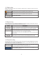
Radio
F150: Most functions on the unit are controlled by either SYNC or the Factory buttons.
Please refer to your Factory Owner's Manual for all other instructions.
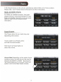
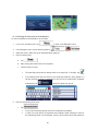
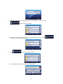
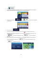
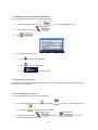
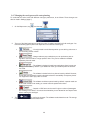
Radio and Satellite Display
--· ·- .
For Radio and Satellite functions, the upper
display provides a convenient location to view
Radio and Satellite information such as preset
stations, station ID and song and artist
information.
The Preset options for your radio may vary
depending on the source.
To set a station as a Preset, press
and hold the desired button .
Short touch the Preset button to
select that channel.
Accord Note: Depending on the model of your
CarShow system , the first Source Tab may be
labeled either AM/FM or MAIN. Selecting the
Tab labeled MAIN will conveniently switch the
system control to the Main Radio console.
3
1'-'t'..;.· -
,,! -...,; ' .r.,
FM2 103.7 Mhz
Stand lor
CRock
103.7Mhz
99.1Mhz
95.5Mhz
101.1Mhz
106.9Mhz
103.5Mhz
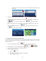
MAIN
Preset Channels
,,~.
SAT
,poo
CD
DVD
MPJ
PHONE
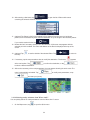
When the optional iPod interface is connected to a compatible iPod player, the audio files
stored on the iPod can be played through the system.
Note: Sleep mode should be enabled on the iPod to reduce battery drain if the iPod is left
connected with the vehicle off.
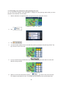
Touch Button Descriptions
Repeat the current played song
~-~~~Scan
and play songs in the
current folder. The next song will
be played after the current song
has played for several seconds.
-~~~~~~~ Play songs in the current folder
in random order.
Touch to enter category list. The
system categorizes into 6 options
•
Press once to display song
information.
Press twice to display spectrum
graphics.
Play A Song
Touch the song shown on playlist to play.
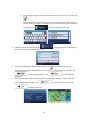
m
Select previous song
ml Select next song
D
Page up
D
Pagedown
ail Play/Pause
4
~~"·.
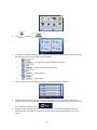
CD/DVD
CD/DVD
Play/Pause track
D
,.
stoptrack
Play previous song/chapter
1> 11
,......
Play next song/chapter
-
Repeat current song played
-
Change audio EQ setting
Change spectrum display
1;11.]..1 Play songs on disc in random order
Scan songs for several seconds
py song to Favorites folder
DVD Only
Long Touch in DVD mode to show the DVD
control screen. To return to full screen,
either touch the image or let the screen idle
for 10 seconds
Set up DVD
Change language
Show current title info
Main DVD menu
Shows information such as Chapter,
Time Elapsed, etc
5
•.
·.•
•
...,
-·.
A~
Repeat
Scan
Copy
SAT
CD Only
f(
11 11tlll1l
I
POD
co
DVD
MPJ
Bluetooth
--~~-:.~~~~
Hands-Free'·~--~-~
:~-1,
Note: This system requires a Bluetooth enabled phone. Bluetooth phones and software vary
by brand and date of manufacture. Some phones or phone functions may not be compatible
or may operate differently with this system during use. Phone compatibility problems are not
warrantable issues.
. Voicedial
BT M USIC
There are several different Bluetooth screens in
the PHONE function. The first screen you will see
is the Call Screen. To switch between screens,
press the PHONE tab repeatedly.
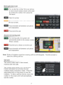
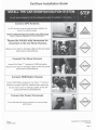
Pairing Your Phone
Place your phone into discovery mode.
Press the PHONE tab to open the
Bluetooth set-up page.
-
Press "Pair" to pair your cell phone for
the first time. You will only need
to do this once, unless you connect to a
different cell phone or the connection is
deleted.
"Pairing" will be displayed on the screen. After
the connection succeeds on your phone,
select "Rosen" and enter the password (1234).
The system will indicate "Linking" and then
"Connected." When your phone is connected its
name will be displayed on the unit.
Select Auto Connect If you desire the
system's Bluetooth feature to automati
cally detect your cell phone when the
system is turned on.
Select Auto Answer to set the system to
automatically pick up after three rings.
Note: If using factory Bluetooth, please refer to your vehicle's owner's manual.
6
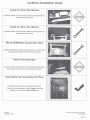
You can dial the number from your phone
or use the touch-screen shown at the right
by entering the number, then press the
Call button .
Clear last number
WMillilliiiiW Press to redial the last number dialed with
the touch screen .
Press to transfer call between cell phone
and car speakers.
Press to end the call .
Answer An Incoming Call
For incoming calls, the system will
automatica lly switch to the answer screen.
Press to answer.
· Press the icon to refuse or end the call
ifiMN Press to transfer call between cell phone
and car speakers.
Note: While in Navigation mode the incoming call box will disappear. Touch the screen to
show the incoming call box.
Call List
The call list can be used to view missed,
received and made calls.
The system wi ll not display your cell phone's
internal phonebook but will show the last
numbers missed, received or made. Press the
appropriate button on the screen to view the
numbers. To make a call from the list, touch the
number on the screen and it will automatically
dial the number.
7
.
'r..r""l ~·
'",.~~~
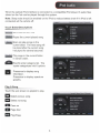
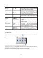
Setttngs
··: . .:. )~~
- :,
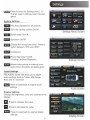
Press to enter the Settings Menu. To
change system settings, select desired
option.
System Settings
0\ '
.--1
'ft
:
• lP .. :•.
f!l
_____J
AUX
~~AMERA
The time displayed on all screens
!-cONTROLS
:-Y
: ;)
:L
r
AUDIO
E]
REAR
V •
DISPLAY
~
EXTRAS
7
TOUCH
o:!ETIINGS
Turn the backup camera On/Off
Settings Menu Screen
Button beep On/Off.
Spectrum On/Off
Display the microphone level. Press to
switch between "STD and HIGH"
if@ijl Guidepoint
Phone Reminder On/Off
(If using CarShow Bluetooth)
Settings Screen
Allows voice prompt to interrupt main
audio when directions are being given.
Audio Settings
The AUDIO screen will allow you to adjust
audio settings such as Treble, Mid Range,
Bass and 5.1 Channel.
-
Press to reset back to original audio
settings
Audio Screen
Display Settings
Change the brightness, color and contrast of the
display.
a
II
-
Press to increase the value
Press to decrease the value
Press to reset back to original display
settings
Display Screen
8
'.
~-.,
~:_,._'
\M~zda
~~- :.
CX-9 Clock Setup
:.__~!\·.'
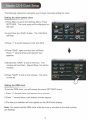
The following instructions will guide you through manually setting the clock.
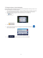
Setting the dash system clock
1.Press Menu to get to the Settings Menu. Press
SETTINGS. The clock setup will be displayed on
the right.
2.Long Press the "SAVE" button. The 12Hr/24Hr
will flash.
,I
'ff
.
'
•
AUX
•.
~
' CAMERA
~ONTROLS
~'':i)
-.»
,. '
:L
y
AUDIO
El
REAR
\.1 '"
~~·,,.,....,
DISPLAY
N
EXTRAS
/
TOUCH
O':{ETIINGS
3.Press "+" to switch between 12Hr and 24Hr.
4.Press "SAVE" again and the hour will flash.
Press "+" several times until desired hour
appears.
5.Short press "SAVE" to lock in the hour. The
minutes will now flash. Repeat Step 4 to set the
minutes.
6.Press "SAVE" to lock in the minutes. The clock
is now set.
Setting the OEM clock
To set the OEM clock, you will access the same SETTINGS menu.
1.Press "+" several times until desired hour appears.
2.Press "-'' several times until desired minutes appear.
3.The time you selected will now appear on the OEM clock display
Note: You cannot set the OEM clock while the hour or minutes on the dash system
are flashing .
9
I'.'
___J
·----'
'(·:;~1;
.
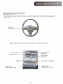
Subaru Steering Controls
. '"1,'.,. •
. ..... ·.?:\-
Steering Wheel Control Functions
The right side steering wheel controls are for the instrument cluster trip computer/info
display only.
Left Side
Controls Only _ _ _....._
Note: Some steering controls may differ from the picture above.
Reject Call
- - (Select systems only)
Answer call
(Select systems only)
10
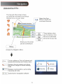
Understanding the Map
The top part of the screen shows
you what the next street is and which
direction to turn on your route
•tfJwa Frnot Royal Dullos Al•port
Select the Quick
Menu to access the
most used functions
0
Distance
16.9 km
Tlllle Lett
0:16
Arrival Time
These displays show
you the distance , time
left and the estimated
arrival time of your trip
17:22
Shows you the street
you are currently on
Access the Navigation Menu
1Find
an address or Point of Interest and
access the Favorites and History menu
the route details and allows
'---"',.__v_u_,e. you to edit, change or cancel existing
route
M Ro
1
1Displays
Show t~ap loisplays current position , surrounding
Settings
!customize the navigation software
11
My Route
Rnd
Show Map
map area and route.
11.
p
~
Settings
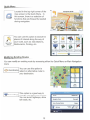
Quick Menu
Located in the top right corner of the
map screen is the Quick Menu. In
this screen , there is a selection of
functions that are frequently needed
during navigation.
p
Quick Place
Search
You can use this option to search for
places of interest along the way of
your route, such as: Gas Stations,
Restaurants, Parking, etc.
p
QulckPlace
search
~
Favorites
Avoid
•
Edit Route
~~
Route Settings Map Settings
Where Am 1?
cancel Route
\II
. ))
=
Modifying Existing Routes
You can modify an existing route by accessing either the Qu ick Menu or Main Navigation
menu
Route AlternatiVes
You can use this option to
l ~::1i'~ Route Aiternatlves select an alternative route to
your destination.
_c.
.
:
0
Green
51 ..
co,
Green 2
$3 ""
•Baltlmor
co,
®
ngton
option is a good way to
'1f' Route Settings This
change road types and modes.
'---------l
You can avoid highways, allow
toll roads, etc.
Vehicle
Navigation Mode
Route Planning MetOOd
12
1: 15
12.6...
1:25
13.2 ..
Green l
6t.•
co,
1:25
14.ht
More
Results
Default Car
On-road
Green
•
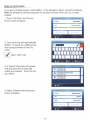
Enter or Find Address
If you are on the Map screen , press MENU . In the Navigation Menu, select Find Address.
Note: By default, the software proposes the country and state where you are currently
located.
1 . Touch "City Name" and the keyboard screen will appear.
2. Your current city will automatically
default. To search for a different city,
start typing each letter of the City
name
j ~ jrap to confirm city
3. A "Select City" screen will appear.
This will show a list of cities that
match your selection. Touch the city
you desire.
4. Select "Street" and the keyboard
screen wi ll appear.
United Kingdom
Oty
Street
13
london
<Street Name>
5. Start typing each letter of the street
name.
::
6. A Street Name list will appear.
Select the one you are looking for.
.
~
Bob 0 Link Clr
Great Falls, 22066
~
•
Colonel Lindsay Ct
Falls Church, 22043
7. Repeat these steps for House number,
or if you do not know it, you can select the
SELECT STREET option.
Colonel Lindsay Dr
Falls OWch, 22043
"'
E Unden St
Alelcandria, 22301
~ Back
8. A map will appear.
<t/ Next
Click Next and a short
summary of the route will flash on the
screen for a few seconds.
\.".•.
9. After the summary, the map
appears showing the entire route .
. . Go!
Results (129)
I' •
242 w Timon1um Rd
Lutherville T1momum
I Tap to start your journey.
~ Back
14
0
More
Safety Information and Precautions
WARNING! Please read and follow the following safety precautions.
Failure to follow the instructions below may increase
your risk of collision and personal injury.
The Rosen Navigation software is not a substitute for your personal judgment. The route suggestions should never
supersede any local traffic regulation or your personal judgment and /or knowledge of safe driving practices. Prior to
completing any maneuvers suggested by your Rosen Navigation software (for example, aU-turn or a left turn), verify that
you can legally and safely complete the maneuver. Do not follow route suggestions if they direct you to perform an unsafe
or illegal maneuver, would place you in an unsafe situation, or would route you into an area that you consider unsafe.
Do not use the Rosen Navigation software to locate emergency services (such as police, fire stations, hospitals, and
clinics). The database may not include all emergency service providers. Use your own best judgment and ask for directions
in these situations.
If the vehicle is in motion, only a passenger should program the Rosen Navigation software. The driver should not program
the system unless the vehicle is parked in a safe location.
The Rosen Navigation software's map database provides information on suggested routes without regard to factors that
may affect your driving experience or the time required to arrive at your destination. For example, the system does not
reflect road detours, closures or construction, some road characteristics (e.g., road surface, slope or grade, weight or height
restrictions, etc.), temporary traffic congestion, weather conditions, and similar factors.
Vehicle Position
The Rosen Navigation software's computer considers vehicle speed and heading changes, together with longitude and
latitude information, to accurately determine vehicle heading and position on a digital map.
Map and Information Database
The map database used by your Rosen Navigation software was created using high-resolution aerial and land based data
collection.
Car navigation maps are frequently updated. While the database was judged to be as accurate as possible at the time of its
release, a map database can never be 100% accurate. Road information that is maintained in the map databases, such as
turn restrictions or road names may change over time.
Errors or missing information in the map data are not covered by the Product Warranty. New and/or updates for the map
data are the responsibility of the End-user.
End-User License Agreement
Please refer to the Rosen Navigation User's Manual to review and accept the terms and conditions in the End-User License
before operating this product.
All rights reserved. Copyright 2012.
CS103 Rev A
Navigation User Manual
TURN BY TURN VOICE AND MAP NAVIGATION
MILLIONS OF INCLUDED POINTS OF INTEREST
3D BUILDING AND TOPOGRAPHY VIEWS
MULTIPLE LANGUAGES PRE-LOADED
BUILT-IN QUICK REFERENCE PAGES
2D, 3D AND SMART ZOOM FEATURES
Thankyouforchoosingourproductasyournavigator.Startusingyourdevicerightaway.Thisdocumentisthe
detaileddescriptionofthenavigationsoftware.Youcaneasilydiscoverthesoftwarewhileyouareusingit;
however,westillrecommendthatyoureadthismanualtofullyunderstandthescreensandfeatures.
TABLE OF CONTENTS
1WARNINGSANDSAFETYINFORMATION
2
2GETTINGSTARTED
3
2.1BUTTONSANDOTHERCONTROLSONTHESCREEN
2.1.1USINGKEYBOARDS
2.1.2BEYONDSINGLESCREENTAP
2.2MAPSCREEN
2.2.1NAVIGATINGONTHEMAP
2.2.2POSITIONMARKERS
2.2.3OBJECTSONTHEMAP
2.2.4MANIPULATINGTHEMAP
2.2.5QUICKMENU
2.2.6CHECKINGTHEDETAILSOFTHECURRENTPOSITION(WHEREAMI?)
2.3NAVIGATIONMENU
4
5
6
7
7
9
9
14
15
18
19
3ONROADNAVIGATION
20
20
3.1SELECTINGTHEDESTINATIONOFAROUTE
3.1.1ENTERINGANADDRESSORAPARTOFTHEADDRESS
21
28
3.1.2SELECTINGTHEDESTINATIONFROMTHEPLACESOFINTEREST
3.1.3SELECTINGAMAPLOCATIONASTHEDESTINATION
37
37
3.1.4SELECTINGTHEDESTINATIONFROMYOURFAVORITES
3.1.5ENTERINGTHECOORDINATEOFTHEDESTINATION
38
3.1.6BUILDINGAROUTEFROMTHELISTOFDESTINATIONS(CREATEROUTE)
40
3.2VIEWINGTHEENTIREROUTEONTHEMAP
41
41
3.3CHECKINGROUTEPARAMETERSANDACCESSINGROUTERELATEDFUNCTIONS
3.4MODIFYINGTHEROUTE
42
3.4.1SELECTINGANEWDESTINATIONWHENALREADYHAVINGAROUTE:NEWROUTE,WAYPOINTORFINALDESTINATION
42
3.4.2EDITINGTHELISTOFDESTINATIONS(EDITROUTE)
43
43
3.4.3PAUSINGTHEACTIVEROUTE
3.4.4CANCELINGTHEACTIVEROUTE
43
3.4.5CHECKINGROUTEALTERNATIVESWHENPLANNINGTHEROUTE
44
3.4.6CHECKINGROUTEALTERNATIVESFORANEXISTINGROUTE
45
46
3.4.7CHANGINGTHEROADTYPESUSEDINROUTEPLANNING
3.5SAVINGALOCATIONASAFAVORITEDESTINATION
47
1
4OFFROADNAVIGATION
48
4.1SELECTINGTHEDESTINATIONOFTHEROUTE
4.2NAVIGATINGINOFFROADMODE
48
48
5REFERENCEGUIDE
49
5.1CONCEPTS
5.1.1SMARTZOOM
5.1.2DAYTIMEANDNIGHTCOLORTHEMES
5.1.3ROUTECALCULATIONANDRECALCULATION
5.1.4GREENROUTING
5.1.5ROADSAFETYCAMERASANDOTHERPROXIMITYALERTPOINTS
5.1.6SPEEDLIMITWARNING
5.2SETTINGSMENU
5.2.1SOUNDANDWARNINGS
5.2.2CUSTOMIZEQUICKMENU
5.2.3ROUTESETTINGS
5.2.4GREENROUTINGSETTINGS
5.2.5MAPSETTINGS
5.2.6VISUALGUIDANCESETTINGS
5.2.7DISPLAYSETTINGS
5.2.8REGIONALSETTINGS
5.2.9TRIPMONITORSETTINGS
49
49
49
49
50
51
52
52
53
55
56
58
59
60
61
61
61
6GLOSSARY
62
7ENDUSERLICENSEAGREEMENT
64
8COPYRIGHTNOTE
67
1 Warnings and Safety information
The navigation system helps you find your way to your destination with a connected GPS receiver. The
software does not transmit your GPS position; others cannot track you.
It is important that you look at the display only when it is safe to do so. If you are the driver of the vehicle,
we recommend that you operate your software before you start your journey. Plan the route before your
departure and stop if you need to change the route.
You must obey the traffic signs and follow the road geometry. If you deviate from the recommended
route, your software changes the instructions accordingly.
Never place your device where it obstructs the driver's view, where it is in the deployment zone of an
airbag or where it might cause injuries in an accident.
For more information, consult the End User License Agreement (page 64).
2
2 Getting started
The software is optimized for in-car use. There is no need to use a stylus. You can use it easily by
tapping the screen buttons and the map with your fingertips.
When using the navigation software for the first time, an initial setup process starts automatically. Do as
follows:
1.
Select the written language of the application interface. Later you can change it in Regional
settings (page 61).
2.
Read the End User License Agreement. Tap
3.
The Configuration wizard starts. Tap
4.
Select the language and speaker used for voice guidance messages. Later you can change it in
Sound and Warnings settings (page 61).
5.
If needed, modify the time format and unit settings. Later you can change them in Regional
settings (page 61).
6.
If needed, modify the default route planning options. Later you can change them in Route settings
(page 1).
to continue.
to continue.
3
7.
The initial setup is now complete. The Configuration wizard can be restarted later from the Settings
menu (page 52).
After the initial setup, the Map screen appears and you can start using the software.
2.1 Buttons and other controls on the screen
When you are using the software, you usually tap buttons on the touch screen.
You only need to confirm selections or changes if the application needs to restart, it needs to perform a
major reconfiguration, or you are about to lose some of your data or settings. Otherwise, the software
saves your selections and applies the new settings without confirmation as soon as you use the controls.
Type
Example
Description
How to use it
Button
Tap it to initiate a function, to
open a new screen, or to set a
parameter.
Button
with value
Some buttons display the
Tap it once.
current value of a field or setting.
Tap the button to change the
value. After the change, the new
value is shown on the button.
Icon
Shows status information.
List
Grab the list anywhere and
When you need to select from
several options, they appear in a slide your finger up or down.
Depending on the speed of the
list.
sliding, the list will scroll fast or
slow, only a bit or till the end.
Tap it once.
Some icons also function as a
button. Tap them once.
Alternatively, move between
pages with the
and
buttons and tap the
value that you want.
4
Radio
button
When there are only a few
choices, radio buttons may be
used instead of lists. Only one
value can be selected.
Tap one of the buttons to
select a new value.
Switch
When there are only two
choices, a checkmark shows
whether the feature is enabled.
Tap it to turn the switch on or
off.
Slider
When a feature can be set to
different values in a range, the
software shows an indicator on
a gauge that displays and sets
the value.
Virtual
keyboard
Alphabetic and alphanumeric
keyboards to enter text and
numbers.
x
Drag the handle to
move the slider to its
new position.
x
Tap the slider where
you want the handle to
appear; the thumb
jumps there.
Each key is a touch screen
button.
2.1.1 Using keyboards
You only need to enter letters or numbers when you cannot avoid it. You can type with your fingertips on
the full-screen keyboards and you can switch between various keyboard layouts, for example English,
Greek or numerical.
Task
Switching to another keyboard layout, for
example from an English keyboard to a Greek
keyboard
Instruction
Tap the
button and select the new
keyboard layout from the list.
Correcting your entry on the keyboard
Tap
to remove the unneeded character(s).
Tap and hold the button to delete several characters or
the entire input string.
Entering a space, for example between a first
name and a family name or in multi-word street
Tap the
names
5
button at the bottom center of the screen.
Entering numbers and symbols
Tap
to switch to a keyboard offering numeric and
symbol characters.
Finalizing the keyboard entry (accepting the
suggested search result)
Tap
.
Finalising the keyboard entry (opening the list
of search results)
Tap
.
Tap
.
Tap
.
Finalising the keyboard entry (saving your
input)
Canceling the keyboard entry (returning to the
previous screen)
2.1.2 Beyond single screen tap
You usually need to tap the screen only once. However, some useful features can be accessed with
combined touch screen tapping. Those are the following:
Action
Details
Tapping and holding the
Tap and keep pressing the following buttons to reach extra functions:
screen
x
Tap and hold
screen appears.
x
Tap and hold any of the
,
,
,
,
, and
buttons on the Map screen: you can rotate, tilt or scale the map
continuously.
x
Tap and hold
on keyboard screens: you can delete several
characters quickly.
x
Tap and hold
continuously.
on list and menu screens: the Map
or
6
in long lists: you can scroll pages
Gestures (drag&drop)
You need to drag and drop the screen only in cases like:
x
Moving the handle on a slider.
x
Scrolling the list: grab the list anywhere and slide your finger up or down.
Depending on the speed of the sliding, the list will scroll fast or slow, only
a bit or till the end.
x
Moving the map in map browsing mode: grab the map, and move it in the
desired direction.
2.2 Map screen
2.2.1 Navigating on the map
This map shows the current position (the Vehimarker, a red arrow by default), the recommended route
(an orange line), and the surrounding map area.
When there is no GPS position, the Vehimarker is transparent. It shows your last known position.
You see colored dots circling around a satellite symbol in the top left corner. The more green dots you
see, the closer you are to get the valid GPS position.
When GPS position is available, the Vehimarker is displayed in full color, now showing your current
position.
There are screen buttons and data fields on the screen to help you navigate. During navigation, the
screen shows route information.
By default, only one data field is displayed in the bottom right corner. Tap this field to see all route data
fields.
7
Tap any of the data fields to suppress others and display only the selected one. The data fields are
different when you are navigating an active route and when you have no specified destination (the orange
line is not displayed).
Default data fields when cruising without a destination (tap and hold any of the fields to change its value):
Field
Description
Shows your current speed given by the GPS receiver.
Shows the speed limit of the current road if the map contains it.
Shows the current time corrected with time zone offset. The accurate time
comes from the GPS satellites, and the time zone information comes from the
map or it can be set manually in Regional settings.
(The current time is always displayed in the top left corner of menu screens.)
Default data fields when navigating a route (tap and hold any of the fields to change its value):
Field
Description
Shows the distance you need to travel on the route before reaching your final
destination.
Shows the time needed to reach the final destination of the route based on
information available for the remaining segments of the route. Historical traffic
data or traffic patterns are also taken into account whenever such information
exists.
The calculation cannot take into account traffic jams and other possible delays.
Historical traffic data can be taken into account if data is available.
Shows the estimated arrival time at the final destination of the route based on
information available for the remaining segments of the route. Historical traffic
data or traffic patterns are also taken into account whenever such infromation
exists.
The calculation cannot take into account traffic jams and other possible delays.
Historical traffic data can be taken into account if data is available.
8
2.2.2 Position markers
2.2.2.1 Vehimarker and Lock-on-Road
When your GPS position is available, the software marks your current position with the Vehimarker. By
default, this marker is a red arrow, but you can change this icon in Settings.
When on-road navigation is selected, the Vehimarker may not show your exact GPS position and
heading. If roads are near, it is aligned to the nearest road to suppress GPS position errors, and the
direction of the icon is aligned to the direction of the road.
If you select off-road navigation: The Vehimarker is at your exact GPS position. The direction of the icon
shows your current heading.
2.2.2.2 Selected map location (Cursor) and selected map object
You can mark a map location in the following ways:
x
Tap the map when navigating,
x
Tap the map when you are asked to confirm the destination at the end of a search, or
x
Tap the map in Find on Map (page 1)
When a map location is selected, the Cursor appears at the selected point on the map. The Cursor is
displayed with a radiating red dot (
) to make it visible at all zoom levels.
The location of the Cursor can be used as the destination of the route, you can search for Places around
it, or you can save this location as one of your Favorite destinations.
You can also select some of the objects on the map. If you tap the map at the icon of a Place of Interest,
the Place will be selected (you see a red circling border around the object), and you can get information
about this object or use it as a route point.
2.2.3 Objects on the map
2.2.3.1 Streets and roads
The software shows the streets in a way that is similar to how the paper road maps show them. Their
width and colors correspond to their importance: you can easily tell a freeway from a small street.
9
2.2.3.2 Turn preview and Next street
When navigating a route, the top section of the Map screen shows information about the next route event
(maneuver) and the next street or the next city/town.
There is a field in the top left corner that displays the next maneuver. Both the type of the event (turn,
traffic circle, exiting freeway, etc.) and its distance from the current position are displayed.
A smaller icon shows the type of the second next maneuver if it is near the first one. Otherwise, only the
next maneuver is displayed.
Most of these icons are very intuitive. The following table lists some of the frequently shown route events.
The same symbols are used in both fields:
Icon
Description
Turn left.
Turn right.
Turn back.
Bear right.
Turn sharp left.
Keep left.
Continue straight in the intersection.
Go left on the traffic circle, 3rd exit (next maneuver).
10
Enter traffic circle (second next maneuver).
Enter freeway.
Exit freeway.
Board ferry.
Leave ferry.
Approaching a waypoint.
Approaching the destination.
2.2.3.3 Lane information and Signposts
When navigating on multilane roads, it is important to take the appropriate lane in order to follow the
recommended route. If lane information is available in the map data, the software displays the lanes and
their directions using small arrows at the bottom of the map. Highlighted arrows represent the lanes you
need to take.
Where additional information is available, signposts substitute arrows. Signposts are displayed at the top
of the map. The color and style of the signposts are similar to the real ones you can see above road or by
the roadside. They show the available destinations and the number of the road the lane leads to.
All signposts look similar when cruising (when there is no recommended route). When navigating a route,
only the signpost that points to the lane(s) to be taken is displayed in vivid colors; all others are darker.
If you want to hide the currently displayed signposts, tap any of them and the normal Map screen returns
until new signpost information is received.
11
2.2.3.4 Junction view
If you are approaching a freeway exit or a complex intersection and the needed information exists, the
map is replaced with a 3D view of the junction. The lanes you need to take are displayed with arrows.
Signposts can also be present if information is available.
If you want to hide the currently displayed junction, tap the picture and the Map screen returns.
2.2.3.5 Freeway exit services
You may need a gas station or a restaurant during your journey. This feature displays a new button on
the map when you are driving on freeways.
Tap this button to open a panel with the details of the next few exits or service stations.
Tap any of them to display it on the map and add it as a waypoint to your route if needed.
If you want to display other types of Places for the exits, you can change the icons in Visual Guidance
settings (page 60).
12
2.2.3.6 3D object types
Your software supports the following 3D object types:
Type
Description
3D terrain
3D terrain map data shows changes in terrain, elevations or depressions in the land
when you view the map in 2D, and use it to plot the route map in 3D when you
navigate. Hills and mountains are shown in the background of the 3D map, and
illustrated by color and shading on the 2D map.
Elevated roads
Complex intersections and vertically isolated roads (such as overpasses or bridges)
are displayed in 3D.
3D landmarks
Landmarks are 3D artistic or block representations of prominent or well-known
objects.
3D buildings
3D block representation of full city building data containing actual building size and
position on the map.
2.2.3.7 Elements of the active route
Your software shows the route in the following way:
Symbol
Name
Current GPS position and Start
point
Description
Your current position displayed on the map. If roads are
near, it is aligned to the nearest road.
Normally if GPS position is available, the route starts
from the current position. If there is no valid GPS
position, your software uses the last known position as
the start point.
Waypoint (intermediate
destination)
An intermediate destination of the route before reaching
the final destination.
Destination (end point)
The final destination of the route.
Route color
The route always stands out with its color on the map,
both in daytime and in night color mode.
Streets and roads that are
excluded from the navigation
You can choose whether you want to use or avoid
certain road types (page 1). However, when your
software cannot avoid such roads, the route will include
them and it will show them in a color that is different
from the route color.
13
2.2.4 Manipulating the map
Tap the map anywhere to browse it during navigation. The map stops following the current position (the
Vehimarker, a red arrow by default, is not locked in a fix position on the screen any more) and control
buttons appear to help you modify the map view.
Action
Moving the map with
drag&drop
Button(s)
No buttons
Zooming in and out
,
Description
You can move the map in any direction: tap and hold
the map, and move your finger towards the direction
you want to move the map.
Changes how much of the map is displayed on the
screen.
Your software uses high-quality vector maps that let
you examine the map at various zoom levels, always
with optimized content. It always displays street
names and other text with the same font size, never
upside-down, and you only see the streets and
objects that you need.
Map scaling has a limit in 3D map view mode. If you
zoom out further, the map switches to 2D view mode.
Tap the button once to modify the view in large
steps, or tap and hold the button to modify it
continuously and smoothly.
Tilting up and down
,
Changes the vertical view angle of the map in 3D
mode.
Tap the button once to modify the view in large
steps, or tap and hold the button to modify it
continuously and smoothly.
Rotating left and right
Changes the horizontal view angle of the map.
,
2D or 3D view
,
Tap the button once to modify the view in large
steps, or tap and hold the button to modify it
continuously and smoothly.
Tap this button to switch between the 3D perspective
and 2D top-down map view modes.
14
Compass in 2D map
view mode
,
Compass in 3D map
view mode
,
The direction of the compass shows North. Tap the
button to switch to North-up view, and then tap again
to rotate the map in the previous direction.
The direction of the compass shows North. Tap the
button to switch to North-up view, and then tap again
to rotate the map in the previous direction.
Location information
Tap this button to open a new screen with
information about the selected map point, the Cursor.
Return to normal
navigation
Tap this button to move the map back to follow the
current GPS position. Automatic map rotation is also
re-enabled.
The map manipulation buttons disappear and
navigation continues.
Additional options
Tap this button to open a list of additional features
like saving the Cursor as a Favorite destination, or
searching for Places around the Cursor.
Select destination
Tap this button to select the Cursor as a new
destination. The route is automatically calculated.
2.2.5 Quick menu
The Quick menu is a selection of controls and functions that are frequently needed during navigation. It
can be opened directly from the Map screen by tapping
.
The menu will close after a few seconds of inactivity or if you tap
.
The menu will also close if you initiate simple controls like muting the device. In other cases tapping a
button will open a new screen with options.
Most of these functions are shortcuts. They are accessible from the menu system.
15
There are more functions available than the number of buttons in the menu. In Settings, you can choose
the function of each button (page 55). The following options are available:
Button
Description
Master Volume
This slider adjusts the volume of the voice guidance.
slider
This switch mutes all sounds of the device. Tap again to reenable sounds.
,
Shortcut for
More / Settings / Sound
and Warnings / Volume
/ Voice Guidance slider
More / Settings / Sound
and Warnings / Volume
/ Master switch
This function lets you search for a Place along your route or Find / Find Places /
Quick Search (page 28)
around your current location if there is no route calculated.
This button opens the list of your Favorite destinations.
Find / Favorite (page
37)
This button opens the History list. You can select one of your Find / History (page
Error! Bookmark not
previous destinations.
defined.)
This button opens the route editing function.
My Route / Edit Route
This button opens the route related settings.
More / Settings / Route
Settings (page 1)
This button opens the map related settings.
More / Settings / Map
Settings (page 59)
This button opens a special screen with information about the n/a
current position and a button to search for nearby emergency
or roadside assistance. For details, see the next chapter.
This button cancels the route and stops navigation. The button My Route / Cancel
Route (page 43)
is replaced with the next one if waypoints are given.
This button skips the next waypoint from the route.
16
n/a
This button opens a 2D map scaled and positioned to show the My Route / Overview
(page 41)
entire route.
This button opens the Visual Guidance settings screen.
More / Settings / Visual
Guidance (page 60)
This button lets you bypass parts of the recommended route.
My Route / Avoidances
This button opens the Trip Monitor screen where you can More / Trip Monitor
(page 1)
manage your previously saved trip logs and track logs.
This button opens the list of maneuvers (the itinerary).
With this function you can save the active route for later use.
Tap the top of the Map
screen during
navigation.
My Route / More / Save
Route
With this function you can replace the active route with a My Route / More / Load
Route
previously saved route.
With this function you can search for Places of Interest in Find / Find Places
(page 28)
various different ways.
This button opens the GPS Information screen with satellite Tap the top of the Map
screen when there is no
position and signal strength information.
GPS reception
17
2.2.6 Checking the details of the current position (Where Am I?)
This screen contains information about the current position (or about the last known position if GPS
reception is not available) and a button to search for useful Places nearby.
.
You can access this screen from the map in one of the following ways:
x
If the current street is displayed below the Vehimarker (the current position on the map), tap it to
open the Where Am I? screen.
x
Open the Quick menu and tap the
button.
Information on this screen:
x
,
x
: Altitude (elevation information coming from the GPS receiver - often inaccurate).
x
: House number on the left.
x
: House number on the right.
: Latitude and Longitude (coordinate of the current position in WGS84 format).
x
In the middle of the screen you can see whether the position is current, or the time left since it was
last updated.
x
Address details (when available) of the current position are also displayed at the bottom.
You can also perform some actions on this screen:
Tap
to save the current position as a Favorite destination.
18
You can also search for assistance near your current position. Tap
screen for the Quick search:
to open a new
The following services can be searched around the current position or the last known position:
x
: Car repair and roadside assistance services
x
: Medical and emergency services
x
: Police stations
x
: Gas stations
Tap any of the buttons, select a Place from the list, and navigate to it.
2.3 Navigation menu
You can reach all parts of the software from the Navigation menu.
You have the following options:
x
Tap
to select your destination by entering an address or selecting a place of
interest, a location on the map or one of your Favorite destinations. You can also look up your
recent destinations from the Smart History or enter a coordinate.
19
x
Tap
to display the route parameters and the route in its full length on the map.
You can also perform route-related actions such as editing or canceling your route, setting a start
point for the route, picking route alternatives, avoiding parts of the route, simulating navigation or
adding the destination to your Favorites.
x
Tap
x
Tap
to start navigating on the map. The button itself is a miniature live map
that shows your current position, the recommended route and the surrounding map area. Tap the
button to enlarge the map to the full screen.
to customize the way the navigation software works.
3 On-road navigation
When first started, your Rosen Navigation System calculates routes using the road network of the high
quality vector maps provided with the product.
You can set up your route in different ways:
x
If you need a route for immediate navigation, you can select the destination and start navigating to
it right away (normal navigation).
x
You can also plan a route independently of your current GPS position or even without GPS
reception (to achieve this, you need to turn off the GPS receiver and set a new starting point in My
Route / Edit Route by tapping the flag icon at the current position).
You can plan routes with multiple destinations. Select the first destination. Then select a second
destination ad add it to your route to create a multi-point route. You can add as many destinations to your
route as you like.
You can also use your Rosen Navigation System for off-road navigation. For details, see page 48.
3.1 Selecting the destination of a route
The software offers you several ways of choosing your destination:
x
Enter a full address or a part of an address, for example a street name without a house number or
the names of two intersecting streets (page 21).
x
Enter an address with ZIP code (page Error! Bookmark not defined.). This way you do not need
to select the name of the city and the search for street names might be faster as well.
x
Use a built-in Place of Interest as your destination (page 28).
x
Select a location on the map with the Find on Map feature (page 1).
x
Use a previously saved Favorite destination (page 37).
x
Select a location from the History of previously used destinations (page Error! Bookmark not
defined.).
x
Enter the coordinate of the destination.
20
3.1.1 Entering an address or a part of the address
If you know at least a part of the address, it is the quickest way to select the destination of the route.
Using the same screen, you can find an address by entering:
x
the exact address, including house number
x
the center of a city/town
x
an intersection
x
the midpoint of a street
x
any of the above, starting the search with the ZIP code (page Error! Bookmark not defined.)
3.1.1.1 Entering an address (United States)
To enter an address as the destination, do as follows:
1.
If you are on the Map screen, tap
2.
In the Navigation menu, tap the following buttons:
3.
By default, the software proposes the country and state where you are. If needed, tap
to return to the Navigation menu.
,
.
, enter the first few letters of the destination country or state on the keyboard,
and select one from the list. If you select a country without a state, you can search for a city/town in
all its states.
4.
Select a new city/town:
a.
Tap
. The city/town of your current location is offered by default. For a
local search, tap
city/town name.
to accept it, otherwise continue with entering the destination
b.
Start entering the name of the city/town on the keyboard.
c.
Find the city/town you need:
x
The most likely city/town name is always shown in the input field. To accept it, tap
.
21
x
If the desired name does not show up, the names that match the string appear in a
list after entering a couple of characters (to open the list of results before it appears
). Select the city/town from the list.
automatically, tap
5.
Enter the street name:
.
a.
Tap
b.
Start entering the street name on the keyboard.
c.
Find the street you need:
x
The most likely street name is always shown in the input field. To accept it, tap
.
x
If the desired name does not show up, the names that match the string appear in a
list after entering a couple of characters (to open the list of results before it appears
). Select the street from the list.
automatically, tap
6.
Enter the house number:
a.
Tap
b.
Enter the house number on the keyboard. (To enter letters, tap
c.
to finish entering the address. (If the entered house number
Tap
cannot be found, the midpoint of the street is selected as the destination.)
.
22
).
7.
A full screen map appears with the selected point in the middle. If necessary, tap the map
somewhere else to modify the destination. The Cursor (
) appears at the new location. Tap
to confirm the destination, or tap
to select a different
destination.
8.
After a short summary of the route parameters, the map appears showing the entire route. The
to modify route parameters, or tap
route is automatically calculated. Tap
and start your journey.
Tip!
If
you
know
that
you
will
use
this
destination
frequently,
before
tapping
to confirm the destination, put it on the list of your Favorites first: tap
then
, give a name for the new Favorite, and
to save the location. The map with the destination returns
tap
automatically. Now you can start your journey.
3.1.1.2 Entering the midpoint of a street as the destination
You can navigate to the midpoint of a street if the house number is not available:
to return to the Navigation menu.
1.
If you are on the Map screen, tap
2.
In the Navigation menu, tap the following buttons:
3.
Select the country, state and city as described earlier (page 21).
23
,
.
4.
Enter the street name:
.
a.
Tap
b.
Start entering the street name on the keyboard.
c.
Find the street you need:
x
The most likely street name is always shown in the input field. To accept it, tap
.
x
If the desired name does not show up, the names that match the string appear in a
list after entering a couple of characters (to open the list of results before it appears
automatically, tap
). Select the street from the list.
5.
Instead of entering the house number, tap
selected as the destination.
6.
A full screen map appears with the selected point in the middle. If necessary, tap the map
. The midpoint of the street is
somewhere else to modify the destination. The Cursor (
to confirm the destination, or tap
) appears at the new location. Tap
to select a different
destination.
7.
After a short summary of the route parameters, the map appears showing the entire route. The
to modify route parameters, or tap
route is automatically calculated. Tap
and start your journey.
24
3.1.1.3 Selecting an intersection as the destination
To enter an address as the destination, do as follows:
1.
If you are on the Map screen, tap
2.
In the Navigation menu, tap the following buttons:
3.
Select the country, state and city as described earlier (page 21).
4.
Enter the street name:
to return to the Navigation menu.
a.
Tap
b.
Start entering the street name on the keyboard.
c.
Find the street you need:
.
.
x
The most likely street name is always shown in the input field. To accept it, tap
.
x
If the desired name does not show up, the names that match the string appear in a
list after entering a couple of characters (to open the list of results before it appears
). Select the street from the list.
automatically, tap
5.
,
Enter the intersecting street name:
1.
Tap
.
x
If only a few intersecting streets exist, their list appears immediately.
x
In case of a longer street, the keyboard screen appears. Start entering the name of
the intersecting street on the keyboard. As soon as the street names that match the
25
entered string can be shown on one screen, their list appears automatically. Select
from the list.
6.
A full screen map appears with the selected point in the middle. If necessary, tap the map
) appears at the new location. Tap
somewhere else to modify the destination. The Cursor (
to confirm the destination, or tap
to select a different
destination.
7.
After a short summary of the route parameters, the map appears showing the entire route. The
to modify route parameters, or tap
route is automatically calculated. Tap
and start your journey.
3.1.1.4 Selecting a city/town center as the destination
The city/town center is not the geometric center of the city but an arbitrary point the map creators have
chosen. In towns and villages, it is usually the most important intersection; in larger cities, it is one of the
important intersections.
1.
If you are on the Map screen, tap
2.
In the Navigation menu, tap the following buttons:
3.
Select the country and state as described earlier (page 21).
4.
Select the destination city/town:
to return to the Navigation menu.
.
a.
Tap
b.
Start entering the name of the city/town on the keyboard.
c.
Find the city/town you need:
26
,
.
x
The most likely city/town name is always shown in the input field. To accept it, tap
.
x
If the desired name does not show up, the names that match the string appear in a
list after entering a couple of characters (to open the list of results before it appears
automatically, tap
). Select the city/town from the list.
5.
Instead of entering the street name, tap
city/town becomes the destination of the route.
6.
A full screen map appears with the selected point in the middle. If necessary, tap the map
somewhere else to modify the destination. The Cursor (
to confirm the destination, or tap
. This way the center of the displayed
) appears at the new location. Tap
to select a different
destination.
7.
After a short summary of the route parameters, the map appears showing the entire route. The
route is automatically calculated. Tap
to modify route parameters, or tap
and start your journey.
27
3.1.1.5 Tips on entering addresses quickly
x
When you are entering the name of a city/town or a street:
x
Only those letters are offered on the keyboard that appear in possible search results. All
other characters are grayed out.
x
As you are typing, the most likely result is always displayed in the input field. If the guess is
correct, tap
x
x
to select it.
After entering a couple of letters, tap
specified letters.
to list the items that contain the
You can speed up finding an intersection:
x
Search first for the street with a less common or less usual name; fewer letters are enough
to find it.
x
If one of the streets is shorter, search for that one first. You can then find the second one
faster.
x
You can search for both the type and the name of a road. If the same word appears in several
names, for example in the name of streets, roads and avenues, you can obtain the result faster if
you enter the first letter of the street type: For example, enter 'PI A' to obtain Pine Avenue and skip
all Pine Streets and Pickwick Roads.
x
You can also search in ZIP codes. As ZIP codes consist of only a few characters, this is usually
faster than entering the name of the city/town.
3.1.2 Selecting the destination from the Places of Interest
You can select your destination from the Places of Interest included with your software.
Using the same screen, you can find a Place in different ways:
x
with the Quick search feature, you can quickly find a nearby Place by its name
x
with the Preset search feature, you can find frequently searched types of Places with only a few
screen taps
x
you can search for a Place by its category
x
you can search for a Place by its name
In addition, you can search for special services from the 'Where Am I?' screen.
3.1.2.1 Quick search for a Place of Interest
The Quick search feature lets you quickly find a Place by its name. The search is always carried out
x
along the recommended route if it exists or
x
around your current location if there is no destination given.
1.
Start the Quick search function:
28
x
If you are on the Map screen, tap
x
If you are in the Navigation menu, tap
tap
and then tap
.
,
and then
.
2.
Using the keyboard, start entering the name of the Place.
3.
After entering a few letters, tap
containing the entered character sequence.
4.
(optional) The Places in the list are ordered by the length of the necessary detour (when navigating
a route) or by their distance from the current position (when no destination is given). If you need to
to open the list of Places with names
.
reorder the list, tap
5.
Browse the list if necessary and tap one of the list items. A full screen map appears with the
selected point in the middle. The name and address of the Place is displayed at the top of the
screen.
6.
(optional) Tap
the map.
7.
If necessary, tap the map somewhere else to modify the destination. The Cursor (
to see the details of the selected Place. Tap
at the new location. Tap
to select a different destination.
to confirm the destination, or tap
29
to return to
) appears
8.
After a short summary of the route parameters, the map appears showing the entire route. The
to modify route parameters, or tap
route is automatically calculated. Tap
and start your journey.
3.1.2.2 Searching for a Place of Interest using preset categories
The Preset search feature lets you quickly find the most frequently selected types of Places.
to return to the Navigation menu.
1.
If you are on the Map screen, tap
2.
In the Navigation menu, tap the following buttons:
3.
The preset search categories appear:
x
,
.
:
x
If an active route exists, gas stations are searched along the route.
x
If there is no active route (destination is not selected), they are searched around the
current position.
x
If the current position is not available either (no GPS signal), they are searched
around the last known position.
x
:
x
If an active route exists, parking lots are searched around the destination of the
route.
x
If there is no active route (destination is not selected), they are searched around the
current position.
x
If the current position is not available either (no GPS signal), they are searched
around the last known position.
30
x
:
x
If an active route exists, restaurants are searched along the route.
x
If there is no active route (destination is not selected), they are searched around the
current position.
x
If the current position is not available either (no GPS signal), they are searched
around the last known position.
x
:
x
If an active route exists, accommodation is searched around the destination of the
route.
x
If there is no active route (destination is not selected), they are searched around the
current position.
x
If the current position is not available either (no GPS signal), they are searched
around the last known position.
4.
Tap any of the quick search buttons to get an instant list of Places.
5.
(optional) The Places in the list are ordered by their distance from the current or last known
position, from the destination or by the length of the necessary detour. If you need to reorder the
list, tap
.
6.
Browse the list if necessary and tap one of the list items. A full screen map appears with the
selected point in the middle. The name and address of the Place is displayed at the top of the
screen.
7.
(optional) Tap
the map.
8.
If necessary, tap the map somewhere else to modify the destination. The Cursor (
to see the details of the selected Place. Tap
at the new location. Tap
to select a different destination.
9.
to return to
) appears
to confirm the destination, or tap
After a short summary of the route parameters, the map appears showing the entire route. The
route is automatically calculated. Tap
to modify route parameters, or tap
and start your journey.
31
3.1.2.3 Searching for a Place of Interest by name
You can search for Places of Interest by their names. You can search around different locations or along
your route in the whole Place database or in one Place category or subcategory only.
1.
If you are on the Map screen, tap
2.
In the Navigation menu, tap the following buttons:
3.
Tap
4.
Select the area around which the Place should be searched for:
5.
to return to the Navigation menu.
,
.
.
x
Tap
to search around the current position or if it is not available,
around the last know position. (The result list will be ordered by the distance from this
position.)
x
Tap
to search for a place within a selected city/town. (The result list will
be ordered by the distance from the center of the selected city/town.)
x
Tap
to search for a place around the destination of the active route.
(The result list will be ordered by the distance from the destination.)
x
Tap
to search along the active route, and not around a given point.
This is useful when you search for a later stopover that results in a minimal detour only,
such as searching for upcoming gas stations or restaurants. (The result list will be ordered
by the length of the necessary detour.)
(optional) If you have selected
, select the city/town to search in.
32
6.
Select one of the main Place categories (e.g. Accommodation) to search in or tap
to search among all Places.
7.
Select one of the Place subcategories (e.g. Hotel or Motel) to search in or tap
to search in the selected Place category.
8.
Tap
9.
Using the keyboard, start entering the name of the Place.
if you have not done it before.
33
10. After entering a few letters, tap
containing the entered character sequence.
to open the list of Places with names
11. (optional) The Places in the list are ordered by their distance from the current or last known
position, from the selected city/town, from the destination or by the length of the necessary detour.
.
If you need to reorder the list, tap
12. Browse the list if necessary and tap one of the list items. A full screen map appears with the
selected point in the middle. The name and address of the Place is displayed at the top of the
screen.
13. (optional) Tap
the map.
to see the details of the selected Place. Tap
14. If necessary, tap the map somewhere else to modify the destination. The Cursor (
at the new location. Tap
to select a different destination.
to return to
) appears
to confirm the destination, or tap
15. After a short summary of the route parameters, the map appears showing the entire route. The
to modify route parameters, or tap
route is automatically calculated. Tap
and start your journey.
3.1.2.4 Selecting nearby assistance from 'Where Am I?'
You can quickly search for nearby assistance from the 'Where Am I?' screen.
1.
On the Map screen, tap
to open the Quick menu.
34
2.
Tap
, and then
.
3.
Preset search categories appear, all for searching around the current position (or around the last
known position if the current position is not available):
x
: Car repair and roadside assistance services
x
: Medical and emergency services
x
: Police stations
x
: Gas stations
4.
Tap any of the quick search buttons to get an instant list of that type of Places.
5.
(optional) The Places in the list are ordered by their distance from the current or last known
position, from the selected city/town, from the destination or by the length of the necessary detour.
.
If you need to reorder the list, tap
6.
Browse the list if necessary and tap one of the list items. A full screen map appears with the
selected point in the middle. The name and address of the Place is displayed at the top of the
screen.
35
7.
(optional) Tap
the map.
8.
If necessary, tap the map somewhere else to modify the destination. The Cursor (
to see the details of the selected Place. Tap
at the new location. Tap
to select a different destination.
9.
to return to
) appears
to confirm the destination, or tap
After a short summary of the route parameters, the map appears showing the entire route. The
to modify route parameters, or tap
route is automatically calculated. Tap
and start your journey.
36
3.1.3 Selecting a map location as the destination
1.
If you are on the Map screen, tap
to return to the Navigation menu.
2.
In the Navigation menu, tap the following buttons:
3.
Locate your destination on the map: move and scale the map as needed.
4.
Tap the location that you want to select as your destination. The Cursor (
5.
Tap
6.
After a short summary of the route parameters, the map appears showing the entire route. The
,
.
) appears.
to select the Cursor as the destination.
route is automatically calculated. Tap
to modify route parameters, or tap
and start your journey.
3.1.4 Selecting the destination from your Favorites
You can select a location that you have already saved as a Favorite to be your destination. Adding a
location to the list of Favorite destinations is described on page 47.
1.
Access the list of Favorites:
x
If you are on the Map screen, tap
and then tap
37
.
x
If you are in the Navigation menu, tap
and then tap
.
2.
The list of Favorite destinations is displayed.
3.
Tap the Favorite that you want to set as your destination. If necessary, browse down to see more
and enter a few letters from the name of the Favorite
of the list or tap
destination.
4.
A full screen map appears with the selected point in the middle. If necessary, tap the map
somewhere else to modify the destination. The Cursor (
) appears at the new location. Tap
to confirm the destination, or tap
to select a different
destination.
5.
After a short summary of the route parameters, the map appears showing the entire route. The
route is automatically calculated. Tap
to modify route parameters, or tap
and start your journey.
3.1.5 Entering the coordinate of the destination
You can also select a destination by entering its coordinate. Do as follows:
1.
If you are on the Map screen, tap
2.
In the Navigation menu, tap
to return to the Navigation menu.
.
38
3.
Tap
4.
You can enter the latitude and longitude values in any of the following formats: decimal degrees;
degrees and decimal minutes; or degrees, minutes and decimal seconds.
5.
(optional) If necessary, tap
in UTM format.
6.
When finished, tap
7.
A full screen map appears with the selected point in the middle. If necessary, tap the map
.
then
and enter the coordinate
.
somewhere else to modify the destination. The Cursor (
to confirm the destination, or tap
) appears at the new location. Tap
to select a different
destination.
8.
After a short summary of the route parameters, the map appears showing the entire route. The
route is automatically calculated. Tap
to modify route parameters, or tap
and start your journey.
39
3.1.6 Building a route from the list of destinations (Create Route)
You can also build your route destination by destination from the My Route menu.
to return to the Navigation menu.
1.
If you are on the Map screen, tap
2.
In the Navigation menu, tap
3.
Tap
4.
There is only one line in the list of route points, the start point of the route, normally the current
GPS position.
5.
Tap
6.
The Destination menu appears and you can select the destination of the route the same way as
described in the previous sections.
7.
When the new destination is selected, the list returns.
8.
To add more destinations, tap
repeat the above procedure.
.
.
to select the destination.
where you want to insert the new route point in the list, and
40
3.2 Viewing the entire route on the map
It is easy to get a map overview of the active route. Do as follows:
to return to the Navigation menu.
1.
If you are on the Map screen, tap
2.
In the Navigation menu, tap
3.
Tap
. The active route is displayed in its full length on the map together with
additional information and controls.
.
3.3 Checking route parameters and accessing route related functions
You can check different parameters of the route recommended by the software.
1.
If you are on the Map screen, tap
2.
In the Navigation menu, tap
3.
You have the following options on this screen (for detailed instructions on how to use them, see
the next chapter):
to return to the Navigation menu.
.
x
to edit the route: to add or remove destinations or change their
Tap
sequence. You can also set a route start point other than your current location. This can be
useful to plan and save a future trip.
x
Tap
to display the entire route on the map.
x
Tap
to bypass a part of the route.
x
Tap
to delete the active route.
41
x
Tap
to open a list with more options like selecting from route
alternatives, changing route parameters, simulating the route, saving the active route or
loading a previously saved route.
x
Tap
to return to the Navigation menu.
3.4 Modifying the route
When navigation is already started, there are several ways to modify the active route. The following
sections show some of those options.
3.4.1 Selecting a new destination when already having a route: New Route, Waypoint or
Final Destination
If you already have a recommended route and you select a new destination as described in the above
sections, the application will ask you whether to start a new route, add a new waypoint (intermediate
destination) to the route or append the newly selected destination at the end of the current route.
x
Tap
to plan a new route to the newly selected location. The previous destination and
waypoint(s) are deleted.
x
Tap
to add the newly selected location as an intermediate destination to your route. The
other destinations of the route remain intact. Note: the new waypoint is placed among destinations
to keep the route optimal. To decide where a waypoint to appear, use the Edit Route feature.
x
Tap
to append the newly selected destination at the end of the route. The other
destinations of the route remain intact. The previous final destination is now the last waypoint.
42
3.4.2 Editing the list of destinations (Edit Route)
You can edit the route by modifying the list of destinations.
1.
If you are on the Map screen, tap
2.
In the Navigation menu, tap
3.
Tap
4.
You have the following options:
to return to the Navigation menu.
.
.
x
Tap
to add a new destination.
x
Tap
to delete a destination.
x
Tap
to reorder the list.
3.4.3 Pausing the active route
You do not need to pause the active route: when you start driving again, the software restarts the voice
instructions from your position.
3.4.4 Canceling the active route
To cancel the navigated route, do one of the following:
x
If you are on the Map screen, tap
you need to tap
x
and then tap
. (If you have a route with waypoints,
until all waypoints are deleted.)
and then tap
In the Navigation menu, tap
route is deleted with all its waypoints.
43
.. The active
3.4.5 Checking route alternatives when planning the route
You can select from different route alternatives or change the route planning method after you have
selected a new destination. Do as follows:
1.
Select a destination as explained earlier, and get to the route confirmation screen.
2.
Tap
.
3.
Tap
.
4.
You see the basic details of three route alternatives with the selected route planning method. Tap
any of them to see it on the map.
5.
Or if you cannot find a good alternative, tap
different routing methods.
6.
Select one of the route alternatives and tap
to return to the previous screen.
The software recalculates the route. The orange line now shows the new recommended route.
and scroll down for routes with
44
3.4.6 Checking route alternatives for an existing route
To recalculate the active route with a different route planning method, you can modify the Route settings
(page 1). There is another way to do this and to compare different route alternatives with the same route
planning method. Do as follows:
1.
If you are on the Map screen, tap
2.
In the Navigation menu, tap
3.
Tap
.
4.
Tap
.
5.
You see the basic details of three route alternatives with the selected route planning method. Tap
any of them to see it on the map.
6.
Or if you cannot find a good alternative, tap
different routing methods.
7.
for a few seconds to
Select one of the route alternatives then tap and hold
return to the Map screen. The software recalculates the route. The orange line now shows the new
recommended route.
to return to the Navigation menu.
.
and scroll down for routes with
45
3.4.7 Changing the road types used in route planning
To recalculate the active route with different road type preferences, do as follows. These changes can
also be made in Settings (page 1).
and then tap
.
1.
On the Map screen, tap
2.
Tap any of the listed road types to modify the route. If needed, scroll the list for all road types. You
have the following options (their order depends on the selected vehicle type):
3.
x
- You might need to avoid freeways when you are driving a slow car or
you are towing another vehicle.
x
- Charge roads are pay roads where you can purchase a pass or
vignette to use the road for a longer period of time. They can be enabled or disabled
separately from toll roads.
x
- The software includes toll roads (pay roads where there is a per-use
charge) in the routes by default. If you disable toll roads, your software plans the best tollfree route.
x
- The software includes ferries in a planned route by default. However,
a map does not necessarily contain information about the accessibility of temporary ferries.
You might also need to pay a fare on ferries.
x
- The software excludes unpaved roads by default: unpaved roads can
be in a bad condition and usually you cannot reach the speed limit on them.
x
- Carpool or HOV lanes can be used if a given number of passengers
are traveling in the vehicle. You should check whether you are allowed to use carpool lanes
before enabling this road type.
Tap
to confirm the changes. The software recalculates the route. The orange
line now shows the new recommended route.
46
3.5 Saving a location as a Favorite destination
You can add any location to Favorites, the list of frequently used destinations. Planning a route to one of
the Favorite destinations is described on page 37.
1.
Select a destination as described before. It can be an address, a Place, any location on the map, a
previously used destination from History, a coordinate or a location where a photo was taken.
2.
When the full screen map appears with the selected location in the middle, tap
.
3.
Tap
.
4.
(optional) Using the keyboard, you can change the name offered for the Favorite. Tap
enter numbers or symbols.
5.
Tap
to save the location as a new Favorite destination.
47
to
4 Off-road navigation
When first started, your Rosen Navigation System calculates routes using the road network of the high
quality vector maps provided with the product. You can switch the application to off-road mode in
Navigation settings in one of the following ways:
x
From the Main menu, tap
x
From the Map screen, tap
,
,
and then
and then
.
.
Most of the procedures described for on-road navigation also apply to off-road navigation. However, there
are some that are not available in this navigation mode (for example you cannot open the itinerary as you
have no maneuvers just route points and straight lines between them).
4.1 Selecting the destination of the route
Selecting the start point or a destination (waypoint or final destination) is the same as described at onroad navigation. The only difference is that route points are linked to form a route with straight lines
regardless of the road network and traffic regulations.
4.2 Navigating in off-road mode
The real difference between the on-road and off-road modes is the navigation itself. When you are on the
Map screen with an off-road route:
x
your position and heading is not aligned with the nearest road and
x
there is no turn by turn navigation just a recommended direction.
You see a light blue line drawn between your current position and the next destination to reach. The Turn
Preview field in the top left corner shows a compass with your bearing and the distance of the next
destination.
When you reach a waypoint, the light blue line will show the direction to the next destination. (Future legs
of the route are shown with orange lines.)
When you reach the final destination, navigation ends.
48
5 Reference Guide
On the following pages you will find the description of the different concepts and menu screens of the
software.
5.1 Concepts
5.1.1 Smart Zoom
Smart Zoom provides much more than just a usual automatic zoom feature:
x
While following a route: when approaching a turn, it will zoom in and raise the view angle to let
you easily recognize your maneuver at the next junction. If the next turn is at a distance, it will
zoom out and lower the view angle to be flat so you can see the road in front of you.
x
While driving without an active route: Smart Zoom will zoom in if you drive slowly and zoom out
when you drive at high speed.
5.1.2 Daytime and night color themes
The software uses different color themes during the day and during the night for both the map and the
menu screens.
x
Daytime colors are similar to paper road maps, and the menus are bright.
x
The night color themes use dark colors for large objects to keep the average brightness of the
screen low.
The software offers different daytime and night color profiles. It can also switch automatically between the
daytime and the night schemes based on the current time and GPS position a few minutes before
sunrise, when the sky has already turned bright, and a few minutes after sunset, before it becomes dark.
5.1.3 Route calculation and recalculation
Your software calculates the route based on your preferences:
x
Route planning methods:
x
: Gives a quick route if you can travel at or near the speed limit on all
roads. Usually the best selection for fast and normal cars.
x
: Gives a route that has the smallest total distance of all possible routes.
It can be practical for slow vehicles.
49
x
x
: Gives a quick but fuel efficient route based on the fuel consumption
data given in Green Routing settings (page 58). Travel cost and CO 2 emission calculations
are estimations only. They cannot take elevations, curves and traffic conditions into account.
x
: Results in a route with fewer turns and no difficult maneuvers. With
this option, you can make your software to take, for example, the freeway instead of a series
of smaller roads or streets.
Road types used or avoided in route calculation:
x
x
x
x
x
x
Your software automatically recalculates the route if you deviate from the proposed itinerary.
For further information about Route settings, see page 1.
5.1.4 Green routing
Route calculation is not only about finding the quickest or shortest route. For some of the vehicle types,
you can also check the fuel consumption and CO2 emission when planning a route, and you can create
cost effective routes with less effect on the environment.
In Settings, select
to enter the necessary parameters of your vehicle and the
average fuel price. You can also select whether you want to see the difference between your route and
the green route even if the selected routing method is not Green.
After the above parameters are set, select
as route planning method to get a fast but
also fuel efficient route. Note that travel cost and CO2 emission calculations are estimations only. They
cannot take elevations, turns, curves and traffic conditions into account. Also, this routing is not meant to
give you the "greenest" route of all. It is still important to travel quickly so the result is a fast route with low
fuel consumption and CO2 emission.
With a vehicle type where green routing is selectable, whichever route planning method is selected, the
Green details are also shown when you confirm the route:
50
If the selected route planning method is not Green, and you have allowed the application to show the
green alternative, the price, fuel consumption and CO2 emission differences between your selected route
and the Green route are also shown on this screen:
Tap the field with these details to switch the route to Green immediately.
5.1.5 Road safety cameras and other proximity alert points
There is a special proximity warning for road safety cameras (like speed or red light cameras) and other
proximity alert points (like schools or railroad crossings). These alert points are preloaded in the software.
You can download more from www.naviextras.com or you can upload points in a specific text file if
needed.
The application can warn you when you approach road safety cameras like speed cameras or dangerous
areas like school zones or railroad crossings. You can set up the different alert types individually in Sound
and Warning settings (page 53).
The following alert types are available:
x
Audio warning: beeps or the spoken type of the alert can be played while you are approaching one
of these points, or extra alert sounds if you exceed the given speed limit while approaching.
x
Visual warning: the type of the alert point, its distance and the related speed limit appear on the
Map screen while you are approaching one of these cameras. The distance from the camera is
also displayed.
For some of the alert points, the enforced or expected speed limit is available. For these points, the audio
alert can be different if you are below or above the given speed limit.
x
Only when speeding: The audio alert is only played when you exceed the given speed limit.
x
When approaching: The audio alert is always played. In order to draw your attention, the alert can
be different if you exceed the speed limit.
Note!
The warning for road safety cameras is disabled when the GPS position is not yet
available or if you are in certain countries where road safety camera warning is prohibited.
51
5.1.6 Speed limit warning
Maps may contain information about the speed limits of the road segments. The software is able to warn
you if you exceed the current limit. This information may not be available for your region (ask your local
dealer), or may not be fully correct for all roads in the map. Speed warning can be fine-tuned in Sound
and Warning settings (page 53).
You can set the relative speed above which the application initiates the warning.
The following alert types are available:
x
Audio warning: you receive a verbal warning when you exceed the speed limit with the given
percentage.
x
Visual warning: the current speed limit is shown on the map when you exceed it (for example:
).
You can also choose to see the speed limit sign on the map all the time.
5.2 Settings menu
You can configure the program settings, and modify the behavior of the software. Tap the following
buttons:
,
The Settings menu has several options. Tap
.
or scroll with your finger to see the full list.
Button
Description
Adjust the sound volume, mute your device or change the voice guidance
language. In addition, you can enable and set up different warnings and alerts.
The content of the Quick menu (page 15) is fully customizable. Tap the button you
want to change, and select its new function from the list.
These settings determine how routes will be calculated. Select the type of vehicle
you are driving, the road types used in route planning, and the route planning
method.
These settings determine how Green routes will be calculated. They are also used
to display the cost and CO2 emission of routes.
52
You can fine-tune the appearance of the Map screen. Adjust the map view to your
needs, choose suitable color themes from the list for both daytime and night use,
change the red arrow to a 3D car model, show or suppress 3D buildings, turn track
logging on or off, and manage you Place visibility sets (which Places to show on
the map).
Settings related to guidance on the map screen can be adjusted here.
Display related settings include separate skins for daytime and night use and the
brightness of the display.
These settings allow you to customize the application for your local language,
measurement units, time and date settings and formats, as well as to choose the
time zone.
Trip logs and track logs contain useful information about your trips. Trip logs can
be saved manually when you reach your destination or you can turn on the
automatic saving here.
Visit www.naviextras.com to get additional content, such as new maps or 3D
landmarks and useful applications.
Modify the basic software parameters set during the initial setup process. For
details, see page 3.
Delete all saved data and reset all settings to their factory defaults.
Run the Demo to watch sample route simulations to see how navigation works.
The About section provides you with product information. Read the Software and
Database End User License Agreement, or check the map and other contents of
the application. You can also access program usage statistics.
5.2.1 Sound and Warnings
Adjust the sound volume, mute your device or change the voice guidance language. In addition, you can
enable and set up different warnings and alerts.
Button
Description
Tap this button to adjust the volume of the different sounds in the application.
A new screen shows the different sound types and their controls. See below
for details.
This button shows the current voice guidance profile. By tapping the button,
you can select a new profile from the list of available languages and speakers.
Tap any of these to hear a sample voice prompt. Just tap
when you have selected the new spoken language.
53
Maps may contain information about the speed limits of the road segments.
The software is able to warn you if you exceed the current limit. This
information may not be available for your region (ask your local dealer), or may
not be fully correct for all roads in the map. This setting lets you decide
whether you wish to receive visible and/or audible warnings.
Adjust the slider to set the relative speed above which the application initiates
the warning.
The following alert types are available:
x
Audio warning: you receive a verbal warning when you exceed the
speed limit with the given percentage.
x
Visual warning: the current speed limit is shown on the map when you
exceed it.
If you prefer to see the speed limit sign on the map all the time (normally it is
shown only if your speed exceeds it), you can set it here.
This feature allows you to receive a warning when approaching a Road Safety
Camera. You must ensure on your own liability that using this feature is legal
in the country where you intend to use it.
This button is not displayed when GPS position is not available or if you are in
certain countries where road safety camera warning is prohibited. Even if the
button is available, you are responsible for checking whether it is legal to use
this feature at your location.
The application can warn you when you approach road safety cameras like
speed cameras or dangerous areas like school zones or railroad crossings.
Tap this button and set the different alert types individually.
The following alert types are available:
x
Audio warning: beeps or the name of the alert type can be played while
you are approaching the camera, or extra alert sounds if you exceed the
speed limit while approaching one of these cameras.
x
Visual warning: the type of the alert point, its distance and the related
speed limit appear on the Map screen while you are approaching one of
these cameras. The distance from the camera is also displayed.
For some of the alert points, the enforced or expected speed limit is available.
For these points, the audio alert can be different if you are below or above the
given speed limit.
x
Only when speeding: The audio alert is only played when you exceed
the given speed limit.
x
When approaching: The audio alert is always played. In order to draw
your attention, the alert can be different if you exceed the speed limit.
Road safety cameras are not displayed in the list when GPS position is not
available or if you are in certain countries where road safety camera warning is
prohibited.
54
Maps may contain driver alert information. Tap this button to turn on or off
these warnings and to set the distance from the hazard to receive the warning
at. These can be set individually for the different warning types.
You can control the volume of the following sound types:
Button
Description
This is the main volume control. These controls affect all below sounds. They
can also be accessed from the Quick menu.
These controls affect the volume of the guidance sounds (verbal instructions).
These controls affect the volume of the alert sounds (beeps).
These controls affect the volume of the background music.
Key sounds provide audible confirmation of either pressing hardware buttons
or tapping the touch screen. These controls affect key sounds.
Controls for each sound type:
Button
Volume slider
Description
Adjusts the volume of the related sound.
Use the switch to mute the related sound. The slider becomes inactive. Tap
again to re-enable.
5.2.2 Customize Quick menu
The content of the Quick menu (page 15) is fully customizable. Tap the button you want to change, and
select its new function from the list.
The list of available functions and their descriptions are on page 15.
55
5.2.3 Route settings
These settings determine how routes will be calculated.
Button
Description
You can edit the parameters of the vehicle profile.
On-road navigation creates a turn by turn itinerary using the road network on
the map. Switch to off-road navigation to navigate between destinations in a
straight line.
The route calculation can be optimized for different situations and vehicle types
by changing the planning method. See below for details.
To let the route fit your needs, you can also set which road types are to be considered for or to be
excluded from the route if possible.
Excluding a road type is a preference. It does not necessarily mean total prohibition. If your destination
can only be accessed using some of the excluded road types, they will be used but only as much as
necessary. In this case a warning icon will be shown on the My Route screen, and the part of the route
not matching your preference will be displayed in a different color on the map.
In the list of road types you can see in how many segments and what total length of the road type is used
in the current route.
Button
Description
You might need to avoid freeways when you are driving a slow car or you are
towing another vehicle.
Charge roads are pay roads where you can purchase a pass or vignette to use
the road for a longer period of time. They can be enabled or disabled separately
from toll roads.
The software includes toll roads (pay roads where there is a per-use charge) in
the routes by default. If you disable toll roads, your software plans the best tollfree route.
The software includes ferries in a planned route by default. However, a map
does not necessarily contain information about the accessibility of temporary
ferries. You might also need to pay a fare on ferries.
The software excludes unpaved roads by default: unpaved roads can be in a
bad condition and usually you cannot reach the speed limit on them.
Carpool or HOV lanes can be used if a given number of passengers are
traveling in the vehicle. You should check whether you are allowed to use
carpool lanes before enabling this road type.
56
Vehicle profiles:
When you tap
, you can set the following parameters:
Button
Description
Tap this button to rename the profile for something meaningful.
Enter the average consumption of your vehicle when used in built-up areas. The
unit for consumption can be set in Regional Settings.
Enter the average consumption of your vehicle when used on highways. The unit
for consumption can be set in Regional Settings.
Select the engine and fuel type of your vehicle. This helps in estimating the CO2
emission.
Enter the average fuel price for travel cost calculation. The currency can be set in
Regional Settings.
Set the maximum speed you travel with the vehicle.
Check this box to enable more settings for the below parameters.
Set the total length of the vehicle.
Set the width of the vehicle.
Set the height of the vehicle.
Set if there is a trailer attached to the vehicle.
Set the maximum allowed weight of the vehicle.
Set the actual weight of the vehicle.
Select one or more hazard types if the vehicle carries dangerous material.
57
Route Planning Method types:
Button
Description
Gives a quick route if you can travel at or near the speed limit on all roads. Usually
the best selection for fast and normal cars.
Gives a short route to minimise the distance to travel. It can be practical for slow
vehicles. Searching for a short route regardless of the speed, this route type is
rarely practical for normal vehicles.
Gives a quick but fuel efficient route based on the fuel consumption data given in
Green Routing settings (page 58). Travel cost and CO2 emission calculations are
estimations only. They cannot take elevations, curves and traffic conditions into
account.
Results in a route with fewer turns and no difficult maneuvers. With this option, you
can make your software to take, for example, the freeway instead of a series of
smaller roads or streets.
5.2.4 Green routing settings
These settings determine how Green routes will be calculated. They are also used to display the cost and
CO2 emission of routes.
Button
Description
Enter the average consumption of your vehicle when used in built-up areas. If
and select
necessary, tap
measurement unit.
to change the
Enter the average consumption of your vehicle when used on highways. If
and select
necessary, tap
measurement unit.
to change the
Select the engine and fuel type of your vehicle. This helps in estimating the CO2
emission.
Enter the average fuel price for travel cost calculation. If necessary, tap
and select
58
to change the currency.
If the selected routing method is not Green, you can have your route compared to
the best green alternative on the screen when confirming the route. If this
alternative is much better than the selected method, you can quickly switch to
Green mode.
5.2.5 Map settings
You can fine-tune the appearance of the Map screen. Adjust the map view to your needs, choose suitable
color themes from the list for both daytime and night use, change the red arrow to a 3D car model, show
or hide 3D buildings, turn track logging on or off, and manage you Place visibility sets (which Places to
show on the map).
The map is always shown on the screen so that you can see the effect when you change a setting.
Button
Description
Switch the map view between a 3D perspective view and a 2D top-down view.
Adjust the basic zoom and tilt levels to your needs. Three levels are available.
Switch between daytime and night color modes or let the software switch between
the two modes automatically a few minutes before sunrise and a few minutes after
sunset.
Select the color scheme used in daytime mode.
Select the color scheme used in night mode.
Replace the default position marker to one of the 3D vehicle models. You can
select separate icons for different vehicle types selected for route planning.
Separate icons can be used for car, pedestrian and the other vehicles.
Show or suppress 3D landmarks, 3D artistic or block representations of prominent
or well-known objects.
Show or suppress 3D city models, 3D artistic or block representation of full city
building data containing actual building size and position on the map.
59
Turn on or off track log saving, that is, saving the sequence of the locations your
journeys go through.
Select which Places to show on the map while navigating. Too many Places make
the map crowded so it is a good idea too keep as few of them on the map as
possible. For this, you have the possibility to save different Place visibility sets.
You have the following possibilities:
x
Tap the checkbox to show or hide the Place category.
x
Tap the name of the Place category to open the list of its subcategories.
x
to save the current Place visibility set or to load a
Tap
previously saved one. Here you can also revert to the default visibility
settings.
5.2.6 Visual guidance settings
Settings related to guidance on the map screen can be adjusted here.
The data fields in the corner of the Map screen can be customized. Tap this button
and select the values you want to see. The values can be different when you
navigate a route from when you are just cruising without a given destination. You
can select general trip data like your current speed or the altitude, or route data
related to your final destination or the next waypoint on your route.
You may need a gas station or a restaurant during your journey. This feature
displays a new button on the map when you are driving on freeways. Tap this
button to open a panel with the details of the next few exits or service stations. Tap
any of them to display it on the map and add it as a waypoint to your route if
needed.
Select the service types displayed for the freeway exists. Choose from the POI
categories.
Whenever adequate information is available, lane information similar to the real
ones on road signs above the road is displayed at the top of the map. You can turn
this feature on or off.
If you are approaching a freeway exit or a complex intersection and the needed
information exists, the map is replaced with a 3D view of the junction. You can turn
this feature on or let the map be displayed for the whole route.
Turn on the route progress bar to see your route as a straight line on the left side
of the map. The red arrow represents your current position and moves up as you
travel. Waypoints and Traffic events are also displayed on the line.
60
5.2.7 Display settings
Display related settings include menu animations, separate skins for daytime and night use and the
brightness of the display.
Select the style and colors of the application used in daytime mode.
Select the style and colors of the application used in night mode.
Adjust the display backlight.
5.2.8 Regional settings
These settings allow you to customize the application for your local language, measurement units, time
and date settings and formats, as well as to choose the time zone.
Button
Description
This button displays the current written language of the user interface. By tapping
the button, you can select a new language from the list of available languages. The
application will restart if you change this setting; you are asked to confirm this.
You can set the distance units to be used by the program. Your software may not
support all the listed units in some voice guidance languages.
Select between 12 and 24 hours time display and the various international date
display formats.
By default, time zone is taken from the map information and adjusted by your
current location. Here you can set time zone and daylight saving manually.
5.2.9 Trip monitor settings
Trip logs contain useful information about your trips. Trip logs can be saved manually when you reach
your destination or you can turn on the automatic saving here. You can access these logs in the Trip
monitor. Trip monitor is available from the More menu.
Trip monitor can record statistical data of your trips. If you need these logs later,
you can let the application save them automatically for you.
This is not a button. This line shows the current size of the trip database, the sum
of all trip and track logs saved.
61
Track logs, the sequence of the positions given by the GPS receiver, can be saved
together with trip logs. They can later be displayed on the map. You can let the
application save the track log whenever it saves a trip.
6 Glossary
2D/3D GPS reception
The GPS receiver uses satellite signals to calculate its (your) position and needs at least four signals to
give a three-dimensional position, including elevation. Because the satellites are moving and because
objects can block the signals, your GPS device might not receive four signals. If three satellites are
available, the receiver can calculate the horizontal GPS position but the accuracy is lower and the GPS
device does not give you elevation data: only 2D reception is possible.
Active route
The currently navigated route. Whenever the destination is set, the route is active until you delete it, reach
your destination or you quit the software. See also: Route.
City Center
The city/town center is not the geometric center of the city but an arbitrary point the map creators have
chosen. In towns and villages, it is usually the most important intersection; in larger cities, it is one of the
important intersections.
Color theme
Your software comes with different color themes for daytime or night use of the map and menu screens.
Themes are custom graphic settings and they can have different colors for streets, blocks or surface
waters in 2D and 3D modes, and they display shades or shadows in different ways in 3D mode.
One daytime scheme and one night scheme is always selected for the map and for the menus. The
software uses them when it switches from day to night and back.
GPS accuracy
Several factors have impact on the deviation between your real position and the one given by the GPS
device. For example, signal delay in the ionosphere or reflecting objects near the GPS device have a
different and varying impact on how accurately the GPS device can calculate your position.
62
Map
The software works with digital maps which are not simply the computerized versions of traditional paper
maps. Similarly to the paper road maps, the 2D mode of digital maps show you streets, roads, and
elevation is also shown by colors.
In 3D mode, you can see the altitude differences, for example valleys and mountains, elevated roads, and
in selected cities 3D landmarks and 3D buildings are also displayed.
You can use digital maps interactively: you can zoom in and out (increase or decrease the scale), you
can tilt them up and down, and rotate them left and right. In GPS-supported navigation, digital maps
facilitate route planning.
North-up map orientation
In North-up mode the map is rotated so its top always faces North. This is the orientation for example in
Find on Map. See also: Track-up map orientation.
Road Safety Camera
Special alert points for speed, red light or bus lane cameras. Different data sources are available. You
can configure the software to warn you when you approach one of these cameras.
Detecting the location of Road Safety Cameras is prohibited in certain countries. It is the sole
responsibility of the driver to check whether this feature can be used during the trip.
The software is capable of showing and warning for more than just cameras. Various other types of
proximity alert points like school zones and railroad crossings are also available.
Route
A sequence of route events, i.e. maneuvers (for example, turns and traffic circles) to reach the
destination. The route contains one start point and one or more destinations. The start point is the current
(or last known) position by default. If you need to see a future route, the start point can be replaced with
any other given point.
Track-up map orientation
In Track-up mode the map is rotated so its top always points in the current driving direction. This is the
default orientation in 3D map view mode. See also: North-up map orientation.
Vehimarker
The current position is shown with a red arrow on the map by default. The direction of the red arrow
shows the current heading. This position marker can be replaced with different vehicle and pedestrian
symbols. You can even specify different Vehimarkers for different route types (depending on which
vehicle type is selected for route calculation).
63
7 End User License Agreement
1 The contracting parties
1.1 This Agreement has been entered into by and between Nav N Go Kft. (registered seat: 23 Bérc utca,
H-1016 Budapest, Hungary; Company reg.no.: 01-09-891838) as Licensor (hereinafter: Licensor) and
You as the User (hereinafter: User; the User and the Licensor jointly referred to as: Parties) in subject of
the use of the software product specified in this Agreement.
2 Conclusion of the Agreement
2.1 The Parties hereby acknowledge that this Agreement shall be concluded by implicit conduct of the
Parties without signing the Agreement,
2.2 The User hereby acknowledges that following the lawful acquisition of the software product
constituting the object of this Agreement (Section 4), any degree of use, installation into a computer or
other hardware, installation of such hardware into a vehicle, pressing of the “Accept” button displayed by
the software during installation or use (hereinafter referred to as Use) shall mean that the User has
accepted the terms and conditions of this Agreement as legally binding.
2.3 This Agreement shall by no means authorise use of the software product by those persons having
unlawfully acquired the software product or having unlawfully installed it on a computer or in a vehicle.
3 Relevant laws and regulations
3.1 Any action related to this Agreement will be governed by the laws of the Republic of Hungary, with
specific reference to Act IV of 1959 on the Civil Code and to Act LXXVI of 1999 on Copyrights shall apply.
3.2 The original language version of this Agreement is the Hungarian version. This Agreement has
versions in other languages as well. In case of dispute the Hungarian version shall prevail.
4 Object of the Agreement and Termination
4.1 The object of this Agreement shall be the navigation guidance software product of Licensor
(hereinafter referred to as the Software Product).
4.2 The Software Product shall include the operating computer program, its complete documentation, the
map database pertaining thereto and any third-party content and services accessible through the
Software Product (hereinafter: Database).
4.3 Any form of display, storage, coding, including printed, electronic or graphic display, storage, source
or object code, or any other as yet undefined form of display, storage, or coding, or any medium thereof
shall be deemed parts of the Software Product.
4.4 Error corrections, additions, updates used by the User following the conclusion of this Agreement
shall also be deemed parts of the Software Product.
4.5 Your rights under this Agreement will terminate immediately without notice from Licensor if you
materially breach it or take any action in derogation of Licensor's and/or its licensors' rights to the
Software Product. Licensor may terminate this Agreement should any Software Product become, or in
Licensor's reasonable opinion likely to become, the subject of a claim of intellectual property infringement
or trade secret misappropriation. Upon termination, you will cease use of, and destroy Software Product
and confirm compliance in writing to Licensor
5 Rights under copyright
5.1 Unless otherwise provided by law or contractual provisions, the Licensor is the sole and exclusive
owner of all material copyrights vested in the Software Product.
5.2 Copyrights extend to the whole Software Product and to its parts separately as well.
5.3 The owner(s) of the copyrights of the Database forming part of the Software Product is (are) the
natural person(s) or corporate entity(ies) listed in the Appendix to this Agreement or in the “About” menu
item of the operating computer program (hereinafter referred to as Database Owner). The user's manual
of the Software Product includes the name of the menu option where all the owners of the Database
items are listed. The Licensor hereby states that it has obtained sufficient usage and representation rights
64
from the Database owners in order to utilize the Database, to offer it for utilization and to transfer it for
utilization as set forth in this Agreement.
5.4 Pursuant to this Agreement, all rights vested in the Software Product shall remain in the ownership of
the Licensor, except for those to which the User is entitled under law or by virtue of this Agreement.
6 Rights of the User
6.1 The User is entitled to install the Software Product into one hardware device (desktop, handheld,
portable computer, navigation device), and to run and use one copy of the Software Product or a
preinstalled copy of the Software Product thereon.
6.2 The User is entitled to make one backup copy of the Software Product. However, if the Software
Product operates after installation without the use of the original media copy, then the original media copy
shall be deemed to be a backup copy. In all other cases, the User is only entitled to use the backup copy
if the original media copy of the Software Product has been ascertainably and unequivocally rendered
unsuitable for its lawful and intended use.
7 Limitations of use
7.1 The User is not entitled
7.1.1 to duplicate the Software Product (to make a copy thereof);
7.1.2 to lease, rent or lend it or to transfer it to a third person for any reason;
7.1.3 to translate the Software Product (including translation (compilation) to other programming
languages);
7.1.4 to decompile the Software Product;
7.1.5 to evade the protection of the Software Product or to modify, circumvent or obviate such protection
through technological or by any other means;
7.1.6 to modify, extend, transform the Software Product (in whole or in part), to separate it into parts,
combine it with other products, install it in other products, utilize it in other products, not even for the
purpose of achieving interoperability with other devices;
7.1.7 apart from using the computer program, to obtain information from the Database as a part of the
Software Product, to decompile the Database, to use, copy, modify, extend, transform the Database in
whole or in part or the group of data stored therein, or to install it in other products or otherwise, utilize it
in other products or to transfer it, not even with the aim of achieving interoperability with other products.
7.2 The User may only use the contents available through the Software Product and provided by third
parties and the data received through the services provided by third parties (including but not limited to
the traffic data received from the RDS TMC traffic information service) for his/her own personal benefit
and at his/her own risk. It is strictly prohibited to store, to transfer or to distribute these data or contents or
to disclose them in full or in part to the public in any format or to download them from the product.
8 No warranty, limitation of liability
8.1 The Licensor hereby informs the User that although the greatest care was taken in producing the
Software Product, given the nature of the Software Product and its technical limitations, the Licensor does
not provide a warranty for the Software Product being completely error-free, and the Licensor is not
bound by any contractual obligation whereby the Software Product obtained by the User should be
completely error-free.
8.2 The Licensor does not warrant that the Software Product is suitable for any purpose defined either by
the Licensor or the User, and does not warrant that the Software Product is capable of interoperating with
any other system, device or product (e.g. software or hardware).
8.3 The Licensor does not assume any responsibility for damages incurred due to an error in the
Software Product (including errors of the computer program, the documentation and the Database).
8.4 The Licensor does not assume any responsibility for damages incurred due to the Software Product
not being applicable for any defined purpose, or due to the error or incompatibility of the Software Product
with any other system, device or product (e.g. software or hardware).
65
8.5 The Licensor also draws the attention of the User to the fact that, when using the Software Product in
any form of vehicle, observing the traffic regulations and rules (e.g. use of obligatory and/or reasonable
and suitable security measures, proper and generally expected care and attention in the given situation,
and special care and attention required due to the use of the Software Product) is the exclusive
responsibility of the User. The Licensor shall not assume any responsibility for any damages occurred in
relation to use of the Software Product in a motor vehicle.
8.6 By concluding the Agreement, the User shall, in particular, acknowledge the information stated in
Section 8 above.
9 Sanctions
9.1 The Licensor hereby informs the User that, if the Licensor finds its rights under the Copyright Act to
be breached, the Licensor may
9.1.1 seek judicial recognition of this breach;
9.1.2 demand that the breach cease and order the person in breach to refrain from continuing such
actions;
9.1.3 demand that the person under breach give proper compensation (even by way of publicity at the
expense of the person in breach);
9.1.4 claim the return of the increase of assets due to the breach;
9.1.5 demand the cease of the wrongful action and, demand restitution to its state before the breach was
committed at the expense of the person in breach, and may demand the destruction of instruments and
materials used to commit the breach as well as of the products created by the breach;
9.1.6 claim for damages.
9.2 The Licensor hereby also informs the User that the breach of copyrights and related rights is a crime
under Act IV of 1978 on the Hungarian Criminal Code, which may be sentenced of two years in prison in
basic cases and up to eight years in prison in aggravated cases.
9.3 Contents and services provided by third parties
The Licensor hereby excludes any liability of its own for the Database in the Software Product and for any
content or service provided by a third party by using the Database. The Licensor does not warrant the
quality, suitability, accuracy, fitness for a specific purpose or territorial coverage of the product or service
or the availability of the service, and it specifically excludes any liability for the suspension of the service,
and any damage arising in relation to the service or for complete cancellation of the service.
The relevant information and data in connection with the contents and services provided by third parties
are available at www.naviextras.com. The User hereby acknowledges that the contents and services
provided by third parties may only be used at the risk of the User and for the personal benefit of the User.
9.4 Contents and services provided by the Licensor or an agent of the Licensor
The Licensor or a contractual partner may offer various products and services to the User through
www.naviextras.com. The User may only use these services when the User has read and understood the
relevant end user license agreement(s) at www.naviextras.com and the User is obliged to use the
services in line with the terms and conditions thereof.
9.5 The parties hereby agree that the courts of the Republic of Hungary will have exclusive jurisdiction to
rule on any disputes arising in connection with this Agreement.
10. Anonymous data collection
10.1 The User hereby acknowledges that the Software Product may collect and store data connected to
the usage of the Software Product by the User (e.g. movement/route data, user interaction data). Such
data collection functions may be disabled or enabled by User any time from within the corresponding
menu. The collected data is connected to the device type identifier of the device running the Software
Product and not associated in any way with any personal information of the User or with the User itself.
10.2 The collected data may be uploaded to Licensor’s database and used exclusively for the purpose of
enhancing and improving the features and services of the Software Product and the Databases.
66
Uploading is executed through Licensor’s special software or by the User navigation device, and the
upload may be enabled or disabled by User. After successful data upload, the collected data is deleted
from the Software Product storage media.
10.3 Collected data is transmitted, stored and handled anonymously and no connection of the data with
the User shall be established by Licensor or any third party.
8 Copyright note
The product and the information contained herein are subject to change without prior notification.
This manual may not, in whole or in part, be reproduced or transmitted in any form either electronically or
mechanically, including photocopying and recording, without the express written consent of Rosen
Entertainment Systems.
© 2011 - Rosen Entertainment Systems
Data Source © 2006-2011 Tele Atlas. All rights reserved. This material is proprietary and the subject of
copyright protection, database right protection and other intellectual property rights owned by Tele Atlas
or its suppliers. The use of this material is subject to the terms of a license agreement. Any unauthorised
copying or disclosure of this material will lead to criminal and civil liabilities.
All rights reserved.
NOTE: Features listed in this Owner’s Manual may not be included in your Navigation version. All
features and specifications listed herein are subject to change without notice.
67
Copyright 2011 Rosen Entertainment Systems, All Rights Reserved
DP-1002 REV B