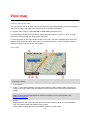
1
Mazda Navigation System NB1 Contents Read me first 6 Switching on and off ............................................................................................................................6 Setting up ............................................................................................................................................6 GPS reception .....................................................................................................................................6 Device not starting ...............................................................................................................................6 Take care of your device .....................................................................................................................6 The memory card 8 About your memory card .....................................................................................................................8 Inserting your memory card .................................................................................................................8 Removing your memory card ..............................................................................................................8 About TomTom HOME ........................................................................................................................8 Installing TomTom HOME ...................................................................................................................9 Initialising your memory card ...............................................................................................................9 Updating your device ...........................................................................................................................9 Backing up your navigation device ....................................................................................................10 Safety Notice 11 Safety settings ...................................................................................................................................11 The commander 12 About the commander .......................................................................................................................12 Using the commander .......................................................................................................................12 Planning a route 13 Planning a route ................................................................................................................................13 Route summary .................................................................................................................................15 LIVE summary ...................................................................................................................................15 Selecting a route type ........................................................................................................................16 Using arrival times .............................................................................................................................17 Navigation menu options ...................................................................................................................17 Planning a route in advance ..............................................................................................................18 Viewing route information ..................................................................................................................19 Voice control 21 Voice control ......................................................................................................................................21 About navigation device voice control ...............................................................................................21 Using voice control ............................................................................................................................21 Planning a journey using your voice .................................................................................................22 Entering addresses using your voice ................................................................................................23 The Driving View 24 About the Driving View ......................................................................................................................24 The Driving View ...............................................................................................................................24 Driving View Symbols ........................................................................................................................25 2 Advanced lane guidance 26 About lane guidance ..........................................................................................................................26 Using lane guidance ..........................................................................................................................26 Changing your route 27 Making changes to your route ...........................................................................................................27 Change route menu ...........................................................................................................................27 About waypoints ................................................................................................................................28 Adding the first waypoint to your route ..............................................................................................29 Adding further waypoints to your route .............................................................................................29 Changing the order of waypoints.......................................................................................................29 Deleting a waypoint ...........................................................................................................................30 Changing notification settings for a waypoint ....................................................................................30 Reactivating a waypoint ....................................................................................................................30 View map 32 About viewing the map ......................................................................................................................32 View map ...........................................................................................................................................32 Options ..............................................................................................................................................33 Cursor menu ......................................................................................................................................33 Map corrections 35 About Map Share ..............................................................................................................................35 Correcting a map error ......................................................................................................................35 Types of map correction ....................................................................................................................35 Sounds and voices 40 About sounds and voices ..................................................................................................................40 About computer voices ......................................................................................................................40 Selecting a voice ...............................................................................................................................40 Changing the volume level ................................................................................................................40 Settings 41 About Settings ...................................................................................................................................41 2D/3D settings ...................................................................................................................................41 Advanced settings .............................................................................................................................42 Change car symbol ...........................................................................................................................42 Home location....................................................................................................................................43 Favourites ..........................................................................................................................................43 Keyboard ...........................................................................................................................................44 Make your own menu ........................................................................................................................44 Map colours .......................................................................................................................................44 Manage POIs.....................................................................................................................................44 Reset factory settings ........................................................................................................................45 Planning settings ...............................................................................................................................45 Safety settings ...................................................................................................................................46 Show POI on map .............................................................................................................................46 Status bar ..........................................................................................................................................47 Maps ..................................................................................................................................................47 Turn off voice guidance / Turn on voice guidance ............................................................................47 Units ..................................................................................................................................................48 Version information ...........................................................................................................................48 3 Voices ................................................................................................................................................48 Points of Interest 49 About Points of Interest .....................................................................................................................49 Creating POIs ....................................................................................................................................49 Using POIs to plan a route ................................................................................................................51 Showing POIs on the map .................................................................................................................51 Calling a POI .....................................................................................................................................52 Setting warnings for POIs ..................................................................................................................52 Manage POIs.....................................................................................................................................53 Help 54 About getting help .............................................................................................................................54 Using Help to drive to a local service ................................................................................................54 Help menu options ............................................................................................................................54 Favourites 56 About Favourites ...............................................................................................................................56 Creating a Favourite ..........................................................................................................................56 Using a Favourite ..............................................................................................................................57 Changing the name of a Favourite ....................................................................................................58 Deleting a Favourite ..........................................................................................................................58 Services 59 About LIVE Services .........................................................................................................................59 Safety Notice .....................................................................................................................................59 Activating LIVE Services ...................................................................................................................59 LIVE Services subscriptions ..............................................................................................................59 About TomTom HD Traffic ................................................................................................................60 About Local Search ...........................................................................................................................60 Using local search .............................................................................................................................60 About Speed Cameras ......................................................................................................................61 Other services ...................................................................................................................................61 Traffic 62 About traffic information ....................................................................................................................62 About TomTom HD Traffic ................................................................................................................62 Safety Notice .....................................................................................................................................62 Using traffic information .....................................................................................................................62 Minimising delays ..............................................................................................................................63 Making commuting to work easier .....................................................................................................63 Getting more information about an incident ......................................................................................64 Checking traffic incidents in your area ..............................................................................................65 Changing traffic settings ....................................................................................................................66 Traffic incidents .................................................................................................................................66 Traffic menu.......................................................................................................................................67 Speed cameras 69 Important ...........................................................................................................................................69 About Speed Cameras ......................................................................................................................69 Speed camera warnings ....................................................................................................................69 4 Changing the way you are warned ....................................................................................................70 Speed camera symbols .....................................................................................................................70 Report button .....................................................................................................................................71 Reporting a new speed camera while on the move ..........................................................................72 Reporting a new speed camera while at home .................................................................................72 Reporting incorrect camera alerts .....................................................................................................72 Types of fixed speed camera you can report ....................................................................................73 Average speed check camera warnings ...........................................................................................73 Speed Cameras menu ......................................................................................................................74 Weather 76 About Weather...................................................................................................................................76 Requesting a weather report .............................................................................................................76 Types of location ...............................................................................................................................76 TomTom HOME 78 About TomTom HOME ......................................................................................................................78 Installing TomTom HOME .................................................................................................................78 MyTomTom account ..........................................................................................................................78 Updating your device .........................................................................................................................79 Introducing HOME help .....................................................................................................................79 Customer support 81 Getting help to use your navigation device .......................................................................................81 Status & information ..........................................................................................................................81 Addendum and Copyright 82 Copyright notices 84 Copyright notices ...............................................................................................................................84 5 Read me first Switching on and off Your Mazda NB1 switches on when your car engine starts and switches off automatically when you turn off your car's engine. Until a connection has been established between the main device and the Mazda NB1, the screen shows audio-related information and the Navi button on the main display is inactive. In the case of a cold boot of the navigation device, press the Navi button. A black screen is shown and it make take up to 30 seconds for the main screen to appear. Under extreme temperature conditions, the navigation device may not start. When the temperature is within the normal range again, the device should start. If the device fails to start automatically in this situation, stop your car engine and start the car engine again. Note: In some situations, your navigation system may restart when turning your key in the ignition from ACC-ON to the engine start position. If this happens, it may take up to 30 seconds for the main screen to appear on the navigation system. Setting up Important: Take care to select the correct language as the language you choose will be used for all text on the screen. When you first switch on your device, you have to answer a few questions to set up the device. Answer the questions by tapping the screen. GPS reception When you first start your Mazda NB1 navigation device, the device may need a few minutes to determine your GPS position and show your current position on the map. In future, your position will be found much faster, usually within a few seconds. In areas where GPS reception is not possible, such as tunnels, your location may not be accurate. Important: The GPS antenna is located in the dashboard so do not put objects on the dashboard. Device not starting In rare cases, your TomTom navigation module may not start correctly or may stop responding to your taps. For example, if the device temperature is too high or too low, the system shuts down. In rare circumstances, you may need to reset your navigation device. To reset your device, switch off the car engine and then remove the memory card. Re-insert the memory card and switch the car engine on again. Take care of your device It is important to take care of your device as follows: 6 Your device is not designed for use in extreme temperatures and any such exposure may cause permanent damage. Do not open the casing of your device under any circumstances. Doing so may be dangerous and will invalidate the warranty. Important: If you sell your car, you should remove all personal information from your navigation device first. To remove your personal information, tap Settings and then tap Reset factory settings. 7 The memory card About your memory card A memory card is supplied with your navigation system. It includes a map of your country or group of countries. Updates are regularly produced by TomTom, particularly for maps and services like speed cameras. These updates are only available for download by inserting your navigation system's memory card into a computer that is connected to the internet. Once your new vehicle has been delivered, if a newer version of your map is available within 60 days of first using your navigation device, you can download this map for free. Important: In order to qualify for the latest map guarantee you need to check if a new map is available within the 60 day period, and you are only entitled to one free map download. Inserting your memory card To insert your memory card into your Mazda NB1 in your car, do the following: 1. Switch off the ignition in the car so that the navigation system is switched off. 2. Open the sliding door and insert the memory card, taking care to handle it carefully and that it is the right way round. Note: Only use your memory card for operating and updating your navigation system. Do not insert the memory card into another vehicle or into any other device such as a camera. Removing your memory card To remove your memory card from your Mazda NB1 in your car, do the following: 1. Switch off the ignition in the car so that the navigation system is switched off. 2. Slide the door open and push gently on the memory card. 3. Remove the memory card, taking care to handle it carefully. About TomTom HOME Using TomTom HOME you can register and manage your navigation device to receive free updates and buy new services. It's a good idea to connect frequently to HOME so you can do the following: Download for free the most recent map available for your device, if you connect to TomTom HOME within 60 days of buying your device. Download for free updates for your device, including Map Share updates and other services included with your product. Add new items to your device, like maps, voices and POIs, as well as buy TomTom services and manage your subscriptions. Share your map corrections and other content with the TomTom community. Make and restore backups of your device. 8 When using HOME, you can get help with what you are doing from the HOME Help. You can also read about all the other things that HOME can do for you. Tip: We recommend using a broadband internet connection whenever you connect to HOME. Installing TomTom HOME The steps below refer to Internet Explorer on Windows XP. If you're using another browser or operating system, visit tomtom.com/support for more information. To install TomTom HOME on your computer, do the following: 1. Connect your computer to the internet. 2. Click the link below to download the latest version of TomTom HOME: tomtom.com/home 3. We recommend downloading the file to your computer by clicking Save. 4. Once the download is complete, click Open. 5. If you accidentally closed the Download complete window, locate the file TomTomHOME2winlatest.exe on your computer and double-click it. 6. If you get a security warning click Run. 7. Click Next, then click Install. The installation starts. 8. Once the installation is complete click Finish. Initialising your memory card To use a new or empty memory card with TomTom HOME, it needs to be initialised so that HOME can detect it. To initialise your card, do the following: 1. Switch on your Mazda NB1. 2. Insert the new memory card into your Mazda NB1. 3. Wait for a few seconds so that the card can be initialised by your Mazda NB1. 4. Remove the card from your Mazda NB1 and insert it into a card reader connected to your computer. Your new card is now ready for use with TomTom HOME. Updating your device Before you start, make sure you have a backup of your device or memory card. For more information, see Backing up your navigation device. You can check for updates for your maps, services and for a whole range of other free items or items for purchase. The instructions below describe how to update the TomTom application on your device. To check for an updated application version do the following: 1. Insert your memory card into the card reader connected to your computer. 2. Wait for TomTom HOME to start. 3. If HOME does not automatically check for updates, click Update my device in the HOME menu. 9 Note: if you would like to install an application you downloaded previously, click Add Traffic, Voices, Safety Cameras etc. > Items on my computer. 4. If a new application is available, it is listed on the next screen. 5. Make sure the new application is selected, then click Download updates. HOME downloads the selected items... 6. HOME then installs the selected items on your memory card. 7. Click Done. 8. Click Device > Disconnect Device in the HOME menu. You can then disconnect your card from your computer. Backing up your navigation device The easiest way to make a backup of all the contents of your TomTom navigation device is by using TomTom HOME. You can make one backup per device and store it on your computer. When you make a new backup, the old backup for that device is overwritten. 1. Insert your memory card into the card reader connected to your computer. TomTom HOME starts automatically. Tip: If TomTom HOME does not start, do one of the following: Windows: Click on the Start menu and go to All Programs > TomTom and then click on TomTom HOME. Mac: Click Go in the Finder menu and choose Applications, then double-click TomTom HOME. 2. Click Back up and restore in the HOME menu. 3. Click Back up my device. 4. Click Back up now. HOME backs up your device by backing up the contents of your memory card. 5. Wait until HOME has finished creating the backup, then click Done. To see where HOME saves your backups do one of the following: Windows: Click Tools > TomTom HOME Preferences and then select the Folder Preferences tab. Mac: Click TomTom HOME > Preferences... and then select the Folder Preferences tab. To restore a backup, click Back up and restore in the HOME menu and then click Restore my device. 10 Safety Notice Some TomTom navigation devices contain a GSM/GPRS module which can interfere with electrical devices such as cardiac pacemakers, hearing aids and aviation equipment. Interference with these devices may endanger the health or life of you or others. If your device includes a GSM/GPRS module, do not use it near unprotected electrical units or in areas where the use of mobile telephones is prohibited, such as hospitals and airplanes. Safety settings We recommend using the safety settings to make your driving as safe as possible. These are some of the options included in the safety settings: Show safety reminders Warn when driving faster than allowed If your device supports voice commands, you can also drive more safely by using voice commands to control your navigation device. 11 The commander About the commander Important: The commander is only available in the European Union. The commander is an input device located near the arm rest of your car in the central console. It has a central stick that you can move in the following ways: Push in Rotate left or right Push the stick forwards or backwards Push the stick left or right Using the commander Important: The commander is only available in the European Union. 1. Push in - selects the item in focus, for example, the volume control when focused on the middle panel of the status bar in the Driving View. Switches items on or off. 2. Rotate left or right - operates slider bars, such as the volume control, and zoom in/out in the Driving View. 3. Push forward or back - moves the focus around the different areas of the screen or around the map when browsing. 4. Push left or right - moves you between pages in a menu or between tabs on a screen. Examples of how to carry out common tasks using the commander To access the Main menu from the Driving View, push the button in. To zoom in or out in the Driving View, use rotate right and left. When focused on the map in the Driving View, push right to access the traffic menu. When focused on the map in the Driving View, push left to access the quick menu. When focused on the map in the Driving View, push back towards you to access the volume control in the centre panel of the status bar. To access the Driving View from the Main menu, push the stick back towards you until you are focused on the Done button, then push the button in. To move between letters on the keyboard screen, push left or right. Use push up or back to move to the letter above or below. You can also use rotate left or right to move between letters. 12 Planning a route Planning a route Important: In the interest of safety and to reduce distractions while you are driving, you should always plan a route before you start driving. To plan a route on your Mazda NB1, do the following: 1. Tap the screen to open the Main Menu. 2. Tap Navigate to or Drive to. 3. Tap Address. You can change the country or state setting by tapping the flag before you select a city. 4. Enter the town or city name, or the postcode. Tip: Instead of typing the address, tap the microphone button to enter the address by speaking to your Mazda NB1. Towns with similar names are shown in the list while you type. When the correct city or town appears in the list, tap the name to select the destination. 5. Enter the street name. Streets with similar names are shown in the list while you type. 13 When the correct street name appears in the list, tap the name to select the destination. 6. Enter the house number, then tap Done. 7. The location is shown on the map. Tap Select to continue or tap Back to enter another address. Tip: If you want your final destination to be a car park, tap Car park and select a location from the list of car parks close to your general destination. 8. When the new route is shown, tap Done. For more information about the route, tap Details. 14 To change your route, for example, to travel via a particular location or to select a new destination, tap Change route. Your Mazda NB1 starts to guide you to your destination, using spoken instructions and on-screen directions. Route summary The route summary shows an overview of your route, the remaining distance to your destination and the remaining estimated journey time. To view the route summary, tap the right-hand panel on the status bar in the Driving view or tap View route in the Main Menu and then tap Show route summary. If you have HD Traffic or an RDS-TMC receiver, the route summary also shows traffic information about delays on your route. LIVE summary LIVE summary shows LIVE Services information on your route. 15 To view LIVE summary information, tap the LIVE tab on the route summary screen. Tap any of the panels for more detailed information. The LIVE tab panels show the following information: Traffic on route - tap this panel to view detailed information about traffic delays and other incidents on your route. Speed cameras - tap this panel to open the Speed Camera menu. You can then report a speed camera or change your settings for speed camera warnings. Weather - tap this panel to view the latest weather reports. Note: LIVE Services are not available in all countries or regions, and not all LIVE Services are available in all countries regions. You may be able to use LIVE Services when travelling abroad. For more information on available services, go to tomtom.com/services. Selecting a route type Every time you plan a route, you can choose to be asked about the type of route you want to plan. To do this, tap Settings followed by Route planning and then tap Ask me every time I plan. The types of route you can choose from are as follows: Fastest route - the route which takes the least time. Eco route - the most fuel-efficient route for your journey. Shortest route - the shortest distance between the locations you set. This may not be the quickest route, especially if the shortest route is through a town or city. Avoid motorways - a route which avoids motorways. 16 Using arrival times When you plan a route, your Mazda NB1 asks you if you need to arrive at a particular time. Tap YES to enter a preferred arrival time. Your Mazda NB1 calculates your arrival time and shows you whether you will arrive on time. You can also use this information to work out when you need to leave. If your Mazda NB1 shows that you will arrive 30 minutes early, you can wait and leave in 30 minutes time, rather than arrive early. Your arrival time is constantly recalculated during your journey. The status bar shows whether you will arrive on time or if you are going to be late, as shown below: You will arrive 55 minutes before the arrival time you entered. If the estimated arrival time is more than five minutes before the time you entered, it is shown in green. You will arrive 3 minutes before the arrival time you entered. If the estimated arrival time is less than 5 minutes before the time you entered, it is shown in yellow. You will arrive 19 minutes late. If the estimated arrival time is later than the time you entered, it is shown in red. Tap Status bar in the Settings menu, to enable or disable arrival time notifications. To enable arrival time notifications, select Leeway. Status bar Navigation menu options When you tap Navigate to or Drive to, you can set your destination in many ways, not just by entering the address. The other options are listed below: Tap this button to navigate to your Home location. You will probably use this button more than any other. Home Tap this button to select a Favourite as your destination. Favourite 17 Tap this button to enter an address as your destination. Address Tap this button to select your destination from a list of places you have recently used as destinations. Recent destination Tap this button to navigate to a Point of Interest (POI). Point of Interest Tap this button to select a point on the map as your destination using the map browser. Point on map Tap this button to enter a destination using latitude and longitude values. Latitude Longitude Tap this button to use Local Search to help you find shops and businesses in and around your current location. Note: Only available on LIVE devices. Local search You can choose to search for shops and businesses near you, near your destination, near any other destination or in a city. For example, if you are looking for a swimming pool near your current location, enter 'swimming pool' and choose the best search result. Planning a route in advance You can use your Mazda NB1 to plan a route in advance, selecting your starting point and your destination. Here are some more reasons to plan a route in advance: Find out how long a journey is going to take before you start. You can also compare journey times for the same route at different times of the day or on different days of the week. Your Mazda NB1 uses IQ Routes when planning a route. IQ Routes calculates routes based on the real average speeds measured on roads. Study the route of a journey you are planning. Check a route for someone who is coming to visit you and then explain the route to them in detail. 18 To plan a route in advance, follow these steps: 1. Tap the screen to bring up the Main menu. 2. Tap the arrow button to move to the next menu screen and tap Plan route. This button is shown while there is no planned route on your Mazda NB1. 3. Select the starting point for your journey in the same way that you would select your destination. 4. Set the destination for your journey. 5. If Route planning settings are set to Ask me every time I plan, select the type of route you want to plan: Fastest route - the route which takes the least time. Eco route - the most fuel-efficient route for your journey. Shortest route - the shortest distance between the locations you set. This may not be the quickest route, especially if the shortest route is through a town or city. Avoid motorways - a route which avoids motorways. 6. Choose the date and time that you will make the journey you are planning. Your Mazda NB1 uses IQ Routes to work out the best possible route at that time. This is useful to see how long a journey takes at different times of the day or on different days of the week. Your Mazda NB1 plans the route between the two locations you selected. Viewing route information You can access these options for the route you last planned by tapping View route in the Main Menu or the Details button on the route summary screen. You can then select from the following options: Tap this button for a list of all the turn instructions on the route. This is very useful if you need to explain a route to someone else. Show instructions Tap this button to see an overview of the route using the map browser. Show map of route Tap this button to watch a demo of the journey. You can interrupt the demo at any time by tapping the screen. Show route demo 19 Tap this button to open the route summary screen. Show route summary Tap this button to see a preview of your destination. You can navigate to a car park near your destination, and view any available information about your destination, for example, the phone number. Show destination Tap this button to see all the traffic incidents on your route. Show traffic on route Note: This button is only shown if your device has either a traffic subscription or an RDS-TMC Receiver. Traffic information is not available in all countries or regions. For more information about TomTom traffic information services, go to tomtom.com/services. 20 Voice control Voice control There are two types of voice control. The first type is provided by Mazda and you can read about it in the guide that came with your car. The second type is provided by your navigation device and you can use it to plan routes and control other features of your navigation device. You do this by initially tapping the screen on the navigation device. About navigation device voice control Note: Voice control is not supported on all devices or in all languages. Instead of tapping the screen to control your Mazda NB1, you can use your voice to control your Mazda NB1. For example, to increase the volume on your Mazda NB1, you can say, "Increase volume" or "Volume 50%". To view the list of available commands, tap Help in the Main menu then tap Product manuals and then tap What can I say. Important: Voice control requires a computer voice. When there are no computer voices installed on your Mazda NB1, this feature is not available. To select a computer voice, tap Voices in the Settings menu, then tap Change voice and select a computer voice. Using voice control Voice control is switched on by default if it is supported by your chosen language. The following example shows how to use voice control to plan a journey to your Home address: 1. Tap the microphone button in the Driving view to turn on the microphone. You see a screen with examples of commands you can say. Tap Help in the Main menu then tap Product manuals followed by What can I say to see a full list of commands you can say. 2. When you hear "Say a command" followed by a tone, say a command of your choice. For example, you can say "Drive home". Your Mazda NB1 is only ready to listen after your hear the tone. While you are speaking the microphone monitor shows how well the device can hear your voice: 21 A green bar means the device can hear your voice. A red bar means your voice is too loud for the device to recognise individual words. A grey bar means your voice is too quiet for the device to recognise individual words. For some phrases, your Mazda NB1 repeats what you say and asks for confirmation. Tip: For the best recognition of what you say, speak normally without trying to articulate words in an unnatural way. If there is excessive road noise, for example, you may need to speak in the direction of the microphone. 3. If the command is correct, say "Yes." If the command is incorrect, say "No" and repeat the command after you hear the prompt and tone again. Your Mazda NB1 plans a route from your current location to your destination. Tip: To stop your Mazda NB1 from listening out for further commands, say "Cancel". To go back one step, say "Back". Planning a journey using your voice Note: It's not possible to plan a route using your voice for all maps in all countries, or in all languages. You can navigate to any of the following types of places using your voice: An address, including home. Cities and towns and their centres. Favourites. POI categories. POIs for named brands of, for example, restaurants, petrol stations, car rental and gyms. A recent destination. To plan a route to an address using speech, do the following: 1. Tap the voice control button in the Driving view. 2. When you hear the tone, you can say, for example "Drive to an address". Tip: Your device has either Navigate to or Drive to on the button in the Main Menu. When planning a route to an address using speech, say "Navigate to address" if the button shows Navigate to or "Drive to address" if the button shows Drive to. 22 3. Say the full address for your destination, for example, 112 James Street, London. Numbers can be pronounced naturally or one at a time. For example, 357 can be pronounced as "Three fifty seven" or "Three, five, seven". Your Mazda NB1 tells you what it heard. 4. Say "Yes" if the address is correct. If shown a list of addresses, say the list number for the correct address or say "none of these". If part of the address is incorrect, you can say something like "change the number", "change the street", "change the city" or "change the state" to correct the incorrect part. To begin again, say "start over". Your Mazda NB1 starts to guide you to your destination, using spoken instructions and onscreen directions. Tips: You can also use your voice to search for the nearest Point of interest (POI) category by saying something like "Drive to the nearest doctor". To select a Recent destination or a Favourite, say "Drive to a recent destination" or "Drive to a Favourite". Entering addresses using your voice Even if you don't use voice control to start planning a journey, you can still use your voice to enter the address. To start planning a journey tap Navigate to or Drive to in the Main menu, then tap Address, and then Spoken Address. Tap this button to enter an address entirely using speech. Spoken address helps you to enter information without tapping the screen. Spoken address Tips To make it easier to start entering an address using your voice, you can add this button to the Quick Menu on the Driving View. To do this, tap Make your own menu in the Settings menu and then tap Drive to spoken address. Your Mazda NB1 recognises places and street names when they are spoken in the local language using local pronunciation. Spoken address entry is not possible for postcodes which must be entered using the keyboard. 23 The Driving View About the Driving View When your Mazda NB1 device starts for the first time, you are shown the Driving View along with detailed information about your current position. Tap the centre of the screen at any time to open the Main Menu. The Driving View 1. Zoom button - tap the magnifying glass to show buttons for zooming in and out. 2. Quick menu - to enable the quick menu, tap Make your own menu in the Settings menu. 3. Your current position. 4. Road sign information or the next street name. 5. Traffic sidebar. Tap the sidebar to open the Traffic menu. The traffic sidebar is only shown if your device has either an HD Traffic subscription or an RDSTMC Receiver. Traffic information is not available in all countries or regions. 6. Microphone button for voice command and control. 7. The time, your current speed and the speed limit, if known. To see the difference between your preferred arrival time and your estimated arrival time, check the Leeway checkbox in the Status bar settings. Note: Not all options may be available. Tap this part of the status bar to switch between a 3D map and a 2D map. 8. The name of the street you are on. 9. Navigation instruction for the road ahead and the distance to next instruction. If the second instruction is less that 150m after the first instruction, you see it shown immediately instead of the distance. 24 Tap this part of the status bar to repeat the last voice instruction and to change the volume. You can also tap here to mute the sound. 10. The remaining journey time, the remaining distance and your estimated arrival time. Tap this part of the status bar to open the Route Summary screen. To change the information shown in the status bar, tap Status bar in the Settings menu. Driving View Symbols Sound muted - this symbol is shown when the sound has been muted. To turn the sound back on, tap the middle panel in the status bar. 25 Advanced lane guidance About lane guidance Note: Lane guidance is not available for all junctions or in all countries. Your Mazda NB1 helps you prepare for motorway exits and junctions by showing the correct driving lane for your planned route. As you approach an exit or junction, the lane you need is shown on the screen. Using lane guidance There are two types of lane guidance: Lane images To turn lane images off, tap Settings in the Main menu, then tap Advanced settings. Clear the checkbox for Show lane images. Tip: Tap anywhere on the screen to return to the Driving View. Instructions in the status bar Tip: If no lane guidance is shown in the status bar and all lanes are highlighted, you can use any lane. 26 Changing your route Making changes to your route After you plan a route, you may want to change the route or even the destination. There are various ways to change your route without the need to completely replan the entire journey. To change the current route, tap Change route in the Main menu: Tap this button to change the current route. This button is only shown while there is a planned route on your Mazda NB1. Change route Change route menu To change the current route or your destination, tap one of the following buttons: Tap this button to find an alternative to the current route. This button is only shown while there is a planned route on your Mazda NB1. This is a simple way to search for a different route to your current destination. Calculate alternative Your Mazda NB1 calculates a new route from your current location, to reach your destination using completely different roads. The new route is shown next to the original route so that you can select the route you want to use. Tap this button while driving on a planned route, to avoid a roadblock or traffic congestion on the road ahead. Your Mazda NB1 will suggest a new route which avoids the roads on your current route for the selected distance. Avoid roadblock If the roadblock or traffic congestion suddenly clears, tap Recalculate route to replan your original route. Important: Be aware that when a new route is calculated, you might immediately be asked to turn off the current road. 27 Tap this button to avoid traffic delays on a planned route. Minimise delays It is not always possible to avoid all traffic delays. Though your device continuously checks for delays on your route, you can tap this button to manually start a check. Your device then calculates the best route to avoid all or most of the delays. Note: This button is only shown if your device has either a traffic subscription or an RDS-TMC Receiver. Traffic information is not available in all countries or regions. For more information about TomTom traffic information services, go to tomtom.com/services. Tap this button to change the current destination. When you change the destination, you are shown the same options and asked to enter the new address in the same way as when you plan a new route. Change destination Tap this button to avoid part of the current route. You are shown a list of the street names on your route. When you tap one of the street names, your Mazda NB1 calculates a detour to avoid the selected street. The route summary shows both the new route and your original route. Avoid part of route Tap the panel on the right to select one of the routes and then tap Done. If you do not want to use either of the routes shown in the route summary, tap Change route to find another way to change your route. Tap this button to change your route by selecting a location you want to travel past, maybe so you can meet someone on the way. Travel via... When you select a location to travel past, you are shown the same options and asked to enter the new address in the same way as when you plan a new route. Your Mazda NB1 calculates the route to your destination via the selected location. The selected location is shown on the map using a marker. You receive a warning when you reach your destination and when you travel past a marked location. About waypoints Note: This feature is not available on all models of TomTom navigation device. You can choose to use waypoints for any of the following reasons: You want to travel along a certain road or through a certain area on the way to your destination. You want to make stops before reaching your final destination. Your route can include the following types of way points: Waypoints with notification - a waypoint that you are likely to want to stop and get out at, for example, a POI, a petrol station or a friend's house. You are notified when nearing and arriving at the waypoint with voice instructions or a message. 28 Waypoints without notification - a waypoint that you are using to help guide your route, for example, you want to travel from Amsterdam to Rotterdam using a certain highway. You are not notified when nearing the waypoint. Adding the first waypoint to your route To add the first waypoint to your route, do the following: 1. Tap the screen to bring up the Main menu. 2. Tap Change route. 3. Tap Travel via. Tip: You can also tap View map and then tap Travel via in the cursor menu. If your device supports Voice control, you also speak commands to add waypoints. 4. Choose the location for your waypoint from a choice of Home, Favourite, Address, Recent destination, POI or you can perform a search. On the route summary screen, a message confirms that the route is being recalculated to include the waypoint. On the Change route menu, the Travel via button changes to show that you now have one waypoint on your current route. Note: All waypoints are added initially as waypoints with notification. The maximum number of waypoints you can add is four. Adding further waypoints to your route To add more waypoints to your route after the first one has been added, do the following: 1. Tap the screen to bring up the Main menu. 2. Tap Change route. 3. Tap Travel via. Tip: If your device supports Voice control, you also speak commands to add waypoints. 4. Tap Add. 5. Choose the location for your waypoint from a choice of Home, Favourite, Address, Recent destination, POI or you can perform a search. A message tells you where in the list of waypoints the new one has been inserted. 6. Tap Done. On the route summary screen, a message confirms that the route is being recalculated to include your waypoints. 7. Repeat to add more waypoints. On the Change route menu, the Travel via button changes to show that you now have several waypoints on your current route. Note: All waypoints are added initially as waypoints with notification. Changing the order of waypoints Waypoints are automatically added in an optimised order but you can still change the order manually if you need to. To change the order of waypoints, do the following: 1. Tap the screen to bring up the Main menu. 29 2. Tap Change route. 3. Tap Travel via. You see a list of your waypoints. 4. Tap the waypoint you want to move up or down. You see a screen with the name of your waypoint at the top. 5. Tap Move up or Move down. Your waypoint changes its position in the list and you are immediately returned to your list of waypoints. Tip: You cannot move an unvisited waypoint into a list of already visited waypoints. Deleting a waypoint To delete a waypoint, do the following: 1. Tap the screen to bring up the Main Menu. 2. Tap Change route. 3. Tap Travel via. You see a list of your waypoints. 4. Tap the waypoint you want to delete. You see a screen with the name of your waypoint at the top. 5. Tap Delete. Your waypoint is deleted and you are immediately returned to your list of waypoints. Changing notification settings for a waypoint If a waypoint has notification switched on, you see an icon next to it in your list of waypoints. To switch notification on or off for a waypoint, do the following: 1. Tap the screen to bring up the Main menu. 2. Tap Change route. 3. Tap Travel via. You see a list of your waypoints. 4. Tap the waypoint that you want to change the notification setting for. You see a screen with the name of your waypoint at the top. 5. Tap Switch on/off notification. The notification setting changes for your waypoint and you are immediately returned to your list of waypoints. Tip: If a waypoint has already been visited, you cannot switch notification on or off. Reactivating a waypoint Note: You can only reactivate a waypoint that has already been visited. Visited waypoints are greyed out. To reactivate a waypoint, do the following: 30 1. Tap the screen to bring up the Main menu. 2. Tap Change route. 3. Tap Travel via. You see a list of your waypoints. 4. Tap the visited waypoint that you want to reactivate. You see a screen with the name of your waypoint at the top. 5. Tap Reactivate. The waypoint is deleted and reinserted into the list of waypoints that haven't yet been visited. 31 View map About viewing the map You can view the map in the same way as you might look at a traditional paper map. The map shows your current location and many other locations such as Favourites and POIs. To view the map in this way, tap View map or View route in the Main menu. You view different locations on the map by moving the map across the screen. To move the map, touch the screen and drag your finger across the screen. To select a location on the map, tap the location on the map. The cursor highlights the location and displays useful information about the location in an information panel. Tap the information panel to create a Favourite or plan a route to that location. View map Important: Not all features on this screen can be controlled using the commander. Use the touchscreen instead. 1. The scale bar 2. Traffic - current traffic incidents. Use the Options button to select whether traffic information is shown on the map. When traffic information is shown on the map, POIs and Favourites are not shown. Note: To use a TomTom traffic information service, you may need a subscription or a receiver. Traffic services are not supported in all countries or regions. For more information, visit tomtom.com/services. 3. Marker Markers point to your current location (blue), your home location (yellow) and your destination (red). The marker shows the distance to the location. Tap a marker to centre the map on the location pointed to by the marker. 32 You can also set your own marker. Tap the cursor button, then tap Set marker position to place a green marker at the cursor position. To turn markers off, tap Options, then Advanced and clear the Markers checkbox. 4. Options button 5. The cursor with street name balloon Tap the button in the street name balloon to open the cursor menu. You can navigate to the cursor position, make a Favourite of the cursor position, or find a Point of Interest near the cursor position. 6. The Find button Tap this button to find specific addresses, favourites or Points of Interest. 7. The zoom bar Zoom in and out by moving the slider. Options Tap the Options button to set the information shown on the map and show the following information: Traffic - select this option to show traffic information on the map. When traffic information is shown, POIs and Favourites are not shown. Note: To use a TomTom traffic information service, you may need a subscription or a receiver. Traffic services are not supported in all countries or regions. For more information, visit tomtom.com/services. Names - select this option to show street and city names on the map. Points of interest - select this option to show POIs on the map. Tap Choose POI to choose which POI categories are shown on the map. Images - select this option to show satellite images of the area being viewed. Satellite images are not available in every map or for every location on the map. Favourites - select this option to show your Favourites on the map. Tap Advanced to show or hide the following information: Markers - select this option to enable markers. Markers point to your current location (blue), your home location (yellow) and your destination (red). The marker shows the distance to the location. Tap a marker to centre the map on the location which the marker is pointing to. To create your own marker, tap the cursor button. Then tap Set marker position to place a green marker at the cursor position. To disable markers, tap Options, then tap Advanced and unselect Markers. Coordinates - select this option to show GPS coordinates in the lower left corner of the map. Cursor menu The cursor can be used to do more than highlight a location on the map. Position the cursor on a location on the map, then tap Cursor and then tap one of the following buttons: Tap this button to plan a route to the cursor position on the map. Navigate there 33 Tap this button to view information about the location on the map such as the address. View location Tap this button to create your own green marker and place it at the cursor position. If a green marker exists, this button changes to Delete marker. Set marker position Tap this button to find a POI near the cursor position on the map. For example, if the cursor currently highlights a restaurant location on the map, you can search for a nearby parking garage. Find POI nearby Tap this button to make a map correction for the cursor position on the map. You can make the correction only on your own map or you can share the correction with the TomTom Map Share community. Correct location Tap this button to create a Favourite at the cursor position on the map. Add as Favourite Tap this button to create a POI at the cursor position on the map. Add as POI Tap this button to travel via the cursor position on the map as part of your current route. Your destination remains the same as before, but your route now includes this location. Travel via... This button is only available while there is a planned route. Tap this button to centre the map on the cursor position. Centre on map 34 Map corrections About Map Share Map Share helps you correct map errors. You can correct several types of map error. To make corrections to your own map, tap Map corrections in the Settings menu. Note: Map Share is not available in all regions. For more information, go to tomtom.com/mapshare. Correcting a map error Important: For safety reasons, do not enter the full details of a map correction while you are driving. Mark the location of the map error instead and enter the full details later. To correct a map error, do the following: 1. Tap Map corrections in the Settings menu. 2. Tap Correct a map error. 3. Select the type of map correction you want to report. 4. Select how you want to select the location. 5. Select the location. Then tap Done. 6. Enter the details of the correction. Then tap Done. 7. Tap Send. The correction is saved. Types of map correction To make a correction to your map, tap Map corrections in the Settings menu, then tap Correct a map error. There are several types of map correction available. 35 Tap this button to block or unblock a street. You can block or unblock the street in one or both directions. For example, to correct a street near to your current location, do the following: (Un)block street 1. Tap (Un)block street. 2. Tap Near you to select a street near your current location. You can select a street by name, a street near your Home location or a street on the map. 3. Select the street or section of a street you want to correct by tapping it on the map. The street you select is highlighted and the cursor shows the name of the street. 4. Tap Done. Your device shows the street and whether the traffic is blocked or allowed in each direction. Important: Not all features on this screen can be controlled using the commander. Use the touchscreen instead. 5. Tap one of the direction buttons to block or unblock the flow of traffic in that direction. 6. Tap Done. Tap this button to correct the traffic direction of a one-way street, where the direction of traffic is different to the direction shown on your map. Reverse traffic direction Note: Reverse traffic direction only works for one-way streets. If you select a two-way street you will be given the chance to block/unblock the street rather than changing the direction. 36 Tap this button to change the name of a street on your map. For example, to rename a street near to your current location: 1. Tap Edit street name. Edit street name 2. Tap Near you. 3. Select the street or section of a street you want to correct by tapping it on the map. The street you select is highlighted and the cursor shows the name of the street. 4. Tap Done. 5. Type the correct street name. 6. Tap Done. Tap this button to change and report incorrect road turn restrictions. Change turn restrictions Tap this button to change and report the road speed limit. Change road speed Tap this button to add or remove a roundabout. Add or remove roundabout Tap this button to add a new Point of Interest (POI). For example to add a new restaurant near to your current location: 1. Tap Add missing POI. Add missing POI 2. Tap Restaurant in the list of POI categories. 3. Tap Near you. 4. Select the location of the missing restaurant. You can select the location by entering the address or by selecting the location on the map. Select Near you or Near home to open the map at your current location or at your Home location. 5. Tap Done. 6. Type the name of the restaurant then tap OK. 7. If you know the telephone number of the restaurant you can type it, then tap OK. If you don't know the number, just tap OK without typing a number. 37 Tap this button to edit an existing POI. You can use this button to make the following changes to a POI: Edit POI Delete the POI. Rename the POI. Change the telephone number of the POI. Change the category that a POI belongs to. Move the POI on the map. Tap this button to enter a comment about a POI. Use this button if you cannot edit the error with the POI using the Edit POI button. Comment on POI Tap this button to correct the location of a house number. Enter the address that you wish to correct and then indicate on the map the correct location of that house number. Correct house number Tap this button to edit an existing street. Once you have selected the street, you can select an error to report. You can select more than one type of error for a street. Existing street Tap this button to report a missing street. You have to select the start and end points of the missing street. Missing street Tap this button to report an error about a city, town or village. You can report the following types of error: City City is missing Wrong city name Alternative city name Other Tap this button to report an error about a motorway entrance or exit. Motorway entrance/exit Tap this button to report an error about a postcode. Postcode 38 Tap this button to report other types of corrections. These corrections are not immediately applied to your map but are saved in a special report. Other You can report missing streets, errors in motorway entrances and exits and missing roundabouts. If the correction you want to report is not covered by any of these report types, enter a general description then tap Other. 39 Sounds and voices About sounds and voices Your Mazda NB1 uses sound for some or all of the following: Driving directions and other route instructions Traffic information Note: To use a TomTom traffic information service, you may need a subscription or a receiver. Traffic services are not supported in all countries or regions. For more information, visit tomtom.com/services. Warnings that you set There are two types of voice available for your Mazda NB1: Computer voices Computer voices are generated by your Mazda NB1. They provide route instructions and read aloud city and street names, traffic and other useful information. Human voices These are recorded by an actor and only provide route instructions. About computer voices Your Mazda NB1 uses text-to-speech technology and computer voices to read the street names on your map as it guides you on your route. The computer voice analyses the whole phrase or sentence before speaking, to ensure that the sentence sounds as close as possible to natural speech. Computer voices can recognise and pronounce foreign towns and street names. For example, the English computer voice can read and pronounce French street names. Selecting a voice To select a different voice on your Mazda NB1, either tap Change voice in the settings menu or tap Voices, then tap Change voice and select the required voice. Changing the volume level You can change the volume on your Mazda NB1 in the Driving view. Tap the central panel on the status bar and move the slider to adjust the volume. The last route instruction is played so you can hear the new volume level. 40 Settings About Settings You can change the way your Mazda NB1 looks and behaves. Most of the settings on your device can be accessed by tapping Settings in the Main menu. 2D/3D settings Tap this button to set the default view of the map. To switch between 2D and 3D views while driving, tap the centre part of the status bar in Driving View. It is sometimes easier to view the map from above, such as when navigating a complex road network. 2D/3D settings The 2D view shows a two dimensional view of the map as though viewed from above. The 3D view shows a three dimensional view of the map as though you are driving through the landscape. The following buttons are available: In 2D view: rotate map in direction of travel - tap this button so the map is rotated automatically with the direction you are travelling always at the top. Switch to 3D view when following a route - tap this button to show the map automatically in 3D view when you are following a route. 41 Advanced settings Tap this button to select the following advanced settings: Advanced settings Show house number before street name - when this setting is selected, addresses are shown with the house number followed by the streetname, such as 10 Downing Street. Show street names - when this setting is selected, street names are shown on the map in the Driving View. You do not need to select this option when your Mazda NB1 is set to read aloud street names using a computer voice. Show next street name - when this setting is selected, the name of the next street on your route is shown at the top of the Driving view. Show current street name on map - when this setting is selected, the name of the street you are on is shown at the bottom of the Driving view. Show location preview - when this setting is selected, a graphical preview of your destination is shown during route planning. Enable automatic zooming in 2D view Enable automatic zooming in 3D view Show lane images - when this setting is selected, a graphical view of the road ahead shows which lane you need when you approach a junction or motorway exit. This feature is not available for all roads. Show tips - this setting switches tips on and off. Automatically adjust clock for time zone - when this setting is selected, your clock is automatically adjusted for your time zone. TomTom Places or Google - Local Search can use either TomTom Places or Google as the underlying search tool. Tip: If you don't have TomTom Places, try connecting to TomTom HOME to download all the latest updates for your navigation device. When Local Search uses TomTom Places, you can do the following: Find businesses and places by name, category or keyword for all connected countries. Search in your own language, when that language is supported. Detailed view per place including company description, keywords and opening hours for supported countries. Note: LIVE Services are not available in all countries or regions, and not all LIVE Services are available in all countries regions. You may be able to use LIVE Services when travelling abroad. For more information on available services, go to tomtom.com/services. Change car symbol Tap this button to select the car symbol that shows your current location in the Driving view. Change car symbol 42 Home location Tap this button to set or change your Home location. You enter the address in the same way as you do when you plan a route. Your Home location provides an easy way to plan a route to an important location. Home location For most people, your Home location will be your home address. However, you might prefer to set the location to another regular destination, such as your workplace. Favourites Tap this button to add, rename or delete Favourites. Favourites provide an easy way to select a location without the need to enter the address. They do not need to be favourite places, they can simply be seen as a collection of useful addresses. Favourites To create a new Favourite, tap Add. Then enter the location address in the same way that you enter an address when you plan a route. To view or change an existing Favourite, tap one of the items in the list. To see more Favourites on the map, tap the left or right buttons. 43 Keyboard Tap this button to select the keyboards that will be available for your use and the layout of the Latin keyboard. You use the keyboard to enter names and addresses, such as when you plan a route or search for the name of a town or a local restaurant. Keyboard Make your own menu Tap this button to add up to six buttons to your own personalised menu. If there are only one or two buttons in your menu, both buttons are shown in the Driving view. Make your own menu If you have three or more buttons in your menu, then a single button is shown in the Driving view which opens your menu when tapped. Map colours Tap this button to select the colour schemes for day and night map colours. Tap Search to search for a colour scheme by typing the name. Map colours Manage POIs Tap this button to manage your own Point of Interest (POI) categories and locations. Manage POIs You can set your Mazda NB1 to let you know when you are near to selected POI locations. For example, you could set the device to let you know when you are approaching a petrol station. You can create your own POI categories and add your own POI locations to these categories. You can, for example, create a new POI category called Friends. You could then add all your friends' addresses as POIs in this new category. Tap the following buttons to create and maintain your own POIs: Add POI - tap this button to add a location to one of your own POI categories. Warn when near POI - tap this button to set your Mazda NB1 to warn you when you are near selected POIs. Delete POI - tap this button to delete one of your own POI categories. Edit POI - tap this button to edit one of your own POIs. Add POI category - tap this button to create a new POI category. Delete POI category - tap this button to delete one of your own POI categories. 44 Reset factory settings Important: If you sell your car, you should remove all personal information from your navigation device first. To remove your personal information, tap Settings and then tap Reset factory settings. Tap this button to delete all your personal settings and restore the standard factory settings to your Mazda NB1. This is not a software update and will not affect the version of the software application installed on your Mazda NB1. Reset factory settings Important: This feature deletes all your personal settings! If you want to keep your personal information and settings, you should perform a full backup of your Mazda NB1 before you reset the device. You can then restore all your personal information and settings after you reset the device. This includes items such as your Home and Favourite locations, your personal menu and your POI categories and POI locations. Planning settings Tap the Planning settings button to set the way your Mazda NB1 calculates the routes that you plan. The settings for planning consist of several options that are spread over several screens. Each setting is described below. Planning settings Route planning Set the type of route you want your Mazda NB1 to calculate. Tap IQ Routes to set if you want the device to use IQ Routes information to help find the best route. Fastest route Choose whether you want to avoid motorways. Replanning settings Note: This setting is only available if your device has either a traffic subscription or an RDS-TMC Receiver. Traffic information is not available in all countries or regions. For more information about TomTom traffic information services, go to tomtom.com/services. Set whether you want your Mazda NB1 to replan the current route if a faster route is found while you are driving. This is useful if traffic builds up or clears further ahead on your route. Choose from the following settings: Always switch to that route - select this option to receive no messages when a faster route is found. The current route is automatically re-calculated to be the fastest one. 45 Ask me if I want that route - select this option to be asked if you want to take the new route. When asked if you want to take the alternative route, tap Yes to have the current route recalculated as the fastest one. Tap No if you don't want to take alternative route. Tap Info to see a summary of both the original and the alternative routes. You can then tap Done to take the fastest route or Current route to remain on your original route. Never change my route - select this option to receive no messages and simply be shown the new route on the screen. Map information settings Set whether you want to be warned if your route passes through an area where your map contains only limited information. Toll road, ferry, carpool lanes and unpaved road settings Set how your Mazda NB1 should manage each of these four road features when the device calculates a route. Carpool lanes are sometimes known as High Occupancy Vehicle Lanes and are not present in every country. To travel on these lanes, you may need to have more than one person in the car, for example, or the car may need to use environmentally-friendly fuel. Route summary Set whether you want the route summary screen to close automatically after you plan a route. If you select No, then you will need to tap Done to close the route summary screen every time you plan a route. Safety settings Tap this button to select the safety features you want to use on your Mazda NB1. Safety settings Show POI on map Tap this button to select the types of Point of Interest (POI) you want to see on the map. 1. Tap Show POI on map in the Settings menu. Show POI on map 2. Select the POI categories you want to be shown on the map. Tap Search and use the keyboard to search for a category name. 3. Select whether you want POIs to be shown in 2D or 3D views of the map. 4. Tap Done. Point of Interest locations are shown on the map as symbols. 46 Status bar Note: Not all options may be available. Tap this button to select the information you want to see on the status bar: Status bar Horizontal - show the status bar at the bottom of the Driving view. Vertical - show the status bar on the right-hand side of the Driving view. Maximum speed Important: The speed limit is shown next to your current speed. If you drive faster than the speed limit, you see a warning indicator in the status bar, for example the status bar pane turns red. Information about speed limits is not available for all roads. Current time Remaining distance - the distance to your destination. Leeway - your Mazda NB1 shows how late or early you will arrive, compared with your preferred arrival time that was set when you planned the route. Maps Tap this button to select the map you want to use for route planning and navigation. Although you can store more than one map on the device, you can only use one map at a time for planning and navigation. Maps To switch from the current map to plan a route in another country or region, simply tap this button. Note: The first time you switch to a map, you may need to connect to your MyTomTom account and activate the map. Turn off voice guidance / Turn on voice guidance Tap this button to switch off voice guidance. You will no longer hear spoken route instructions but you will still hear information such as traffic information and warnings. Turn off Voice guidance Voice guidance is also switched off if you tap Turn off sound in the Settings menu. Note: If you change the voice on your Mazda NB1, then voice guidance is automatically switched on for the new voice. Tap this button to switch on voice guidance and hear spoken route instructions. Turn on Voice guidance 47 Units Tap this button to set the units used on your Mazda NB1 for features such as route planning and weather reports. Units Version information Tap this button to find technical information on your Mazda NB1, such as the device serial number, application version and the map version. Version information You can also view the current status for GPS reception and your LIVE Services, if you have a subscription. Voices Tap this button to change the voice that gives spoken directions and other route instructions. Change voice A wide range of voices are available. There are computer voices which can read street names and other information directly from the map and there are human voices which have been recorded by actors. Tap this button to set the type of spoken directions and other route instructions your Mazda NB1 will read aloud. Voice settings 48 Points of Interest About Points of Interest Points of Interest or POIs are useful places on the map. Here are some examples: Restaurants Hotels Museums Parking garages Petrol stations Creating POIs Tip: For help on managing third party POIs, see: tomtom.com/13814 1. Tap the screen to open the Main menu. 2. Tap Settings. 3. Tap Manage POIs. 4. If there are no POI categories or the one you want to use does not exist, tap Add POI category and create a new category. Every POI must be assigned to a POI category. This means you need to have created at least one POI category before you can create your first POI. You can only add POIs to POI categories you have created. For more information on creating POI categories, read Managing POIs. 5. Tap Add POI. 6. Select the POI category you want to use for the new POI. 7. Tap a button to enter the POI address in the same way that you plan a route. The POI is created and saved in the selected category. Tap this button to set your Home location as a POI. This is useful if you decide to change your Home location, but first want to create a POI using the current Home address. Home 49 Tap this button to create a POI from a Favourite. Favourite You might want to create a POI from a Favourite because you can only create a limited number of Favourites. If you want to create more Favourites you need to delete some Favourites. To avoid losing a Favourite, save the location as a POI before you delete the Favourite. Tap this button to enter an address as a new POI. When you enter an address, you can choose from four options. Address City centre Street and house number Postcode Crossing or intersection Tap this button to select a POI location from a list of places you have recently used as destinations. Recent destination Tap this button to add a Point of Interest (POI) as a POI. For example, if you are creating a category of POIs for your favourite restaurants, use this option instead of entering the addresses of the restaurants. Point of Interest Tap this button to add your current location as a POI. For example, if you stop somewhere interesting, you can tap this button to create a new POI at the current location. My location Tap this button to create a POI using the map browser. Use the cursor to select the location of the POI, then tap Done. Point on map Tap this button to create a POI by entering latitude and longitude values. Latitude Longitude 50 Tap this button to use Local Search to search for shops and businesses in and around your current location. You can choose to search for shops and businesses near you, near your destination, near any other destination or in a city. Local search For example, if you are looking for a swimming pool near your current location, enter 'swimming pool' and choose the best search result. Using POIs to plan a route When you plan a route, you can use a POI for the destination. The following example shows how to plan a route to a car park in a city: 1. Tap Navigate to or Drive to in the Main menu. 2. Tap Point of Interest. 3. Tap POI in city. Tip: The last POI you viewed on your Mazda NB1 is also shown in the menu. 4. Enter the name of the town or city and select it when it is shown in the list. 5. Tap the arrow button to expand the list of POI categories. Tip: If you already know the name of the POI you want to use, you can tap Search by name to enter the name and select this location. 6. Scroll down the list and tap Car park. 7. The car park closest to your destination is shown at the top of the list. 8. The following list explains the distances shown next to each POI. How the distance is measured varies depending on how you initially searched for the POI: POI near you - distance from your current location POI in city - distance from the city centre POI near Home - distance from your Home location POI along route - distance from your current location POI near destination - distance from your destination 9. Tap the name of the car park you want to use and tap Done when the route has been calculated. Your Mazda NB1 starts to guide you to the car park. Tip: You can also use Local Search to find useful locations. For more information about Local Search and other LIVE Services, go to tomtom.com/services. Showing POIs on the map You can select the types of POI locations you want to see on your maps. 1. Tap Show POI on map in the Settings menu. 2. Select the categories you want to be shown on the map. 3. Tap Done. 51 4. Select whether you want to see POI locations in 2D and 3D views of the map. 5. Tap Done. The types of POI you have selected are shown as symbols on the map. Calling a POI Many of the POIs on your Mazda NB1 include phone numbers. This means that you can use your Mazda NB1 to find out the phone number for a POI, call them using a phone and then plan a route to the location of the POI. For example, you can search for a cinema, call to book a ticket and then plan a route to the cinema. 1. Tap Navigate to or Drive to in the Main menu. 2. Tap Point of Interest. 3. Select how you want to search for the POI. For example, if you want to search for a POI on your route, tap POI along route. 4. Tap the type of POI you want to navigate to. For example, if you want to call a cinema to reserve a ticket, tap Cinema and then select the name of the cinema you want to call. Then tap Show info to see the phone number. 5. Call the POI on a phone to, for example, reserve tickets or check their opening hours. 6. Tap Select. Your Mazda NB1 starts navigating to the POI. Setting warnings for POIs You can set a warning sound or message to be played or displayed when you approach a selected type of POI, such as a petrol station. The following example will show how to set a warning sound to be played when you are 250 metres from a petrol station. 1. Tap Manage POIs or Warn when near POI in the Settings menu. 2. Scroll down the list and tap Petrol station. Tip: To remove a warning, tap on the category name and then tap Yes. POI categories which have been set with a warning have a sound symbol next to the category name. 3. Set the distance as 250 metres and tap OK. 4. Select Sound effect and then tap Next. 5. Select the warning sound for the POI and then tap Next. 6. If you only want to hear the warning when the POI is directly on a planned route, select Warn only if POI is on route. Then tap Done. The warning is set for the selected POI category. You will hear a warning sound when you are 250 metres from a petrol station on your route. 52 Manage POIs Tap Manage POIs to manage your POI categories and locations. You can set your Mazda NB1 to let you know when you are near to selected POI locations. In this way you could, for example, set the device to let you know you when you are approaching a petrol station. You can create your own POI categories and add your own POI locations to these categories. This means you can, for example, create a new POI category called Friends. You could then add all your friends' addresses as POIs in this new category. Tap the following buttons to create and maintain your own POIs: Add POI - tap this button to add a location to one of your own POI categories. Warn when near POI - tap this button to set your Mazda NB1 to warn you when you are near selected POIs. Delete POI - tap this button to delete one of your own POI categories. Edit POI - tap this button to edit one of your own POIs. Add POI category - tap this button to create a new POI category. Delete POI category - tap this button to delete one of your own POI categories. 53 Help About getting help Tap Help in the Main menu to navigate to emergency services centres and other specialist services. For example, if you are involved in a car accident, you could use the Help menu to find the contact details for the nearest hospital, call them using a phone and tell them your exact location. Tip: If you do not see the Help button in the Main menu, tap Settings and then Safety settings. Clear the checkbox for Show only essential menu options while driving. Using Help to drive to a local service To use Help to locate a service centre and navigate from your current location to the centre, do the following: 1. Tap the screen to show the Main Menu. 2. Tap Help. 3. Tap Drive to help. 4. Select the type of service you require, for example, Nearest hospital. 5. Select a centre from the list, the nearest is shown at the top of the list. Your Mazda NB1 shows a description of the location. 6. To navigate your way to the centre by car, tap Navigate there. Your Mazda NB1 starts guiding you to your destination. Help menu options Note: In some countries, information may not be available for all services. Tap this button to navigate your way by car to a service centre. Drive to help Tap this button to see your current location on the map. Where am I? Tap this button to read a selection of guides, including a First Aid guide. Safety and other guides 54 Tap this button to read a selection of guides relating to your navigation device. You can also access on-device help using this button. Product manuals 55 Favourites About Favourites Favourites provide an easy way to select a location without the need to enter the address. They do not need to be favourite places, they can simply be seen as a collection of useful addresses. Creating a Favourite To create a Favourite, do the following: 1. Tap the screen to bring up the Main menu. 2. Tap Settings to open the Settings menu. 3. Tap Favourites. 4. Tap Add. Select the type of the Favourite by tapping one of the buttons described below: You can set your Home location as a Favourite. Home You cannot create a Favourite from another Favourite. This option will always be unavailable in this menu. To rename a Favourite, tap Favourites in the Settings menu. Favourite You can enter an address as a Favourite. Address Create a new Favourite by selecting a location from a list of your recent destinations. Recent destination Tap this button to use Local Search to find locations such as shops and businesses and save them as Favourites. For example, if you are looking for a swimming pool near your current location, enter 'swimming pool' and choose the best search result. Local Search 56 If you visit a POI you particularly like, for example a restaurant, you can add it as a Favourite. Point of Interest Tap this button to add your current location as a Favourite. For example, if you stop somewhere interesting, while you are there you can tap this button to create the Favourite. My location Tap this button to create a Favourite using the Map Browser. Select the location of the Favourite using the cursor, then tap Done. Point on map Tap this button to create a Favourite by entering latitude and longitude values. Latitude Longitude Tap this button to create a Favourite by saying the address. Spoken address Your Mazda NB1 suggests a name for your new Favourite. To enter a new name, there is no need to delete the suggested name, you just start typing. Tip: It is a good idea to give your Favourite a name that is easy to remember. 5. Tap OK. Your new favourite appears in the list. After you have added two or more Favourites, you are asked whether you make regular trips to the same locations. If you tap YES, you can enter these destinations as your favourite destinations. Every time you switch on your device, you can immediately select one of these locations as your destination. Using a Favourite You can use a Favourite as a way of navigating to a place without having to enter the address. To navigate to a Favourite, do the following: 1. Tap the screen to bring up the Main menu. 2. Tap Navigate to or Drive to. 3. Tap Favourite. 4. Select a Favourite from the list. Your Mazda NB1 calculates the route for you. 5. When the route is calculated, tap Done. 57 Your Mazda NB1 will immediately start guiding you to your destination with spoken instructions and visual instructions on the screen. Changing the name of a Favourite To change the name of a Favourite, do the following: 1. Tap the screen to bring up the Main menu. 2. Tap Settings to open the Settings menu. 3. Tap Favourites. 4. Tap the Favourite you want to rename. Tip: Use the left and right arrows to choose another Favourite from your list. 5. Type in the new name and then tap OK. 6. Tap Done. Deleting a Favourite To delete a Favourite, do the following: 1. Tap the screen to bring up the Main menu. 2. Tap Settings to open the Settings menu. 3. Tap Favourites. 4. Tap the Favourite you want to delete. Tip: Use the left and right arrows to choose another Favourite from your list. 5. Tap Yes to confirm the deletion. 6. Tap Done. 58 Services About LIVE Services Note: LIVE Services are not available in all countries or regions, and not all LIVE Services are available in all countries regions. You may be able to use LIVE Services when travelling abroad. For more information on available services, go to tomtom.com/services. The following LIVE Services may be available for your device. LIVE Services are subscription-based. HD Traffic Speed Cameras Weather Local Search QuickGPSfixTM Safety Notice Some TomTom navigation devices contain a GSM/GPRS module which can interfere with electrical devices such as cardiac pacemakers, hearing aids and aviation equipment. Interference with these devices may endanger the health or life of you or others. If your device includes a GSM/GPRS module, do not use it near unprotected electrical units or in areas where the use of mobile telephones is prohibited, such as hospitals and airplanes. Activating LIVE Services When you receive your car, you need to activate LIVE Services on your TomTom navigation device. This only has to be done once. To activate LIVE Services, do the following: 1. Tap Activate LIVE in the Main menu. 2. Follow the instructions to renew or extend your LIVE Services subscriptions if necessary. When activation is finished, you see the Main menu. LIVE Services are now ready for you to use. Note: Your navigation device comes with a limited free subscription to LIVE Services. LIVE Services subscriptions Checking your LIVE Services subscription You can check the status of your subscriptions at any time. In the Main Menu, tap Services and then tap My Services. Your Mazda NB1 also warns you when your LIVE Services subscription is approaching the renewal date. For more information about LIVE Services subscription and payment terms, go to tomtom.com/services. 59 Renewing your LIVE Services subscription using your device 1. In the Main Menu, tap Services and then tap My Services. The current status of your LIVE Services is shown. 2. Tap on the service you want to renew. Your Mazda NB1 confirms that you want to renew your subscription. 3. Tap Yes. The renewal request is sent to TomTom. You should complete payment online, on or before the date shown on your Mazda NB1. Renewing your LIVE Services subscription using TomTom HOME You can buy LIVE services as a pre-paid subscription using TomTom HOME as follows: 1. Start TomTom HOME on your computer. 2. Insert your memory card into your card reader. 3. In TomTom HOME, click Add Traffic, Voices, Safety Cameras etc. 4. Click LIVE Services. You can then choose from LIVE Service bundles available via subscription in the online shop. Follow the onscreen instructions or use the HOME Help to get more information. About TomTom HD Traffic TomTom HD Traffic is a unique TomTom service providing real-time traffic information. For more information about TomTom services, go to tomtom.com/services. In combination with IQ Routes, HD Traffic helps you plan the optimum route to your destination taking into account the current local traffic conditions. Your Mazda NB1 regularly receives information about the changing traffic conditions. If traffic jams or other incidents are found on your current route, your Mazda NB1 will offer to replan your route to try and avoid any delays. About Local Search Using local search, you can search the TomTom Places or Google listings to find shops and businesses, then plan a route to the destination you choose. Using local search To find a location using local search and plan a route there, follow the steps below. In this example, you search for a supermarket near to your current position. 1. Tap the screen to bring up the Main Menu, then tap Navigate to or Drive to. Tip: You can also set up a quick menu button for local search by tapping Settings and then Make your own menu. Select Navigate to local search address or Drive to local search address. 2. Tap the Local Search button. 3. Tap Search near you. 4. Type 'supermarket' then tap OK. 60 The locations that match your search are shown in a list with their distance from your current location and rating. 5. Tap one of the locations in the list. The location is shown on the map. Tap Show info to see more information about this location. 6. Tap Select. Choose whether you want to navigate there, show the location on a map, travel via that location or add it as a favourite. About Speed Cameras Note: LIVE Services are not available in all countries or regions, and not all LIVE Services are available in all countries regions. You may be able to use LIVE Services when travelling abroad. For more information on available services, go to tomtom.com/services. The Speed Cameras service warns you about the following roadside camera locations: Speed camera locations. Accident blackspot locations. Mobile speed camera locations. Average speed camera locations. Toll road camera locations. Traffic light camera locations. Other services Note: Only available on LIVE devices. The following services are also available on your Mazda NB1: Weather The Weather service gives you five-day weather reports for any location on your map. QuickGPSfix QuickGPSfix contains information about GPS satellite positions which helps your Mazda NB1 find your position faster. My Services To check your subscription, tap Services in the Main Menu and then tap My Services. Your Mazda NB1 tells you when your LIVE Services subscriptions are due for renewal. You can use your Mazda NB1 to tell TomTom that you wish to renew your current subscription. For more information about LIVE Services subscription and payment terms, go to tomtom.com/services. 61 Traffic About traffic information You can receive traffic information in two ways: TomTom HD Traffic Traffic Message Channel (RDS-TMC) Using traffic information, your Mazda NB1 can automatically adjust your route to minimise any delays. Note: LIVE Services are not available in all countries or regions, and not all LIVE Services are available in all countries regions. You may be able to use LIVE Services when travelling abroad. For more information on available services, go to tomtom.com/services. About TomTom HD Traffic TomTom HD Traffic is a unique TomTom service providing real-time traffic information. For more information about TomTom services, go to tomtom.com/services. In combination with IQ Routes, HD Traffic helps you plan the optimum route to your destination taking into account the current local traffic conditions. Your Mazda NB1 regularly receives information about the changing traffic conditions. If traffic jams or other incidents are found on your current route, your Mazda NB1 will offer to replan your route to try and avoid any delays. Safety Notice Some TomTom navigation devices contain a GSM/GPRS module which can interfere with electrical devices such as cardiac pacemakers, hearing aids and aviation equipment. Interference with these devices may endanger the health or life of you or others. If your device includes a GSM/GPRS module, do not use it near unprotected electrical units or in areas where the use of mobile telephones is prohibited, such as hospitals and airplanes. Using traffic information If you are using an RDS-TMC receiver to view TMC traffic information on your Mazda NB1, no connections need to be made as the receiver is built in to your device. The traffic sidebar is shown on the right side of the Driving view. The sidebar informs you about traffic delays while you drive, using glowing dots to show you where each traffic incident is located on your route. 62 The top of the traffic sidebar represents your destination and shows the total time delay due to traffic jams and other incidents on your route. The central section of the traffic sidebar shows individual traffic incidents in the order they occur on your route. The bottom of the traffic sidebar represents your current location and shows the distance to the next incident on your route. To make the traffic sidebar more readable some incidents may not be shown. These incidents will always be of minor importance and only cause short delays. The colour of the pointers, as shown below, gives you an instant indication of the type of incident: Unknown or undetermined situation. Slow traffic. Queueing traffic. Stationary traffic or road closure. Minimising delays You can use TomTom HD Traffic to minimise the impact of traffic delays on your route. To minimise delays automatically, do the following: 1. Tap Services in the Main Menu. 2. Tap Traffic. 3. Tap Traffic settings. 4. Choose between always taking the faster route automatically, being asked or never changing your route. 5. Tap Next and then Done. 6. Tap Minimise traffic delay. Your device plans the quickest route to your destination. The new route may include traffic delays and may remain the same as the original route. You can re-plan the route to avoid all delays, but this route is unlikely to be the quickest possible route. 7. Tap Done. Making commuting to work easier The Home to work or Work to home buttons in the Traffic menu lets you check your route to and from work with one tap of a button. 63 When you use either of these buttons, your device plans a route between your home and work locations and checks the route for possible delays. The first time you use Home to work, you must set your traffic home and work locations by doing the following: 1. Tap the traffic sidebar to open the Traffic menu. Note: If you already have a route planned, a summary of traffic incidents on your route is shown. Tap Options to open the Traffic menu. 2. Tap Show home-work traffic. 3. Set your home location and your work location. If you have already set the locations and want to change them, tap Change home-work. You can now use the Home to work and Work to home buttons. Note: The home location you set here is not the same as the home location you can set in the Settings Menu. In addition, the locations you use here do not have to be your actual home and work locations. If there is another route that you often travel, you can set Work/Home to use these locations instead. For example, to check for delays on your route home before you leave the office, do the following: 1. Tap the traffic sidebar to open the Traffic menu. Note: If you already have a route planned, a summary of traffic incidents on your route is shown. Tap Options to open the Traffic menu. 2. Tap Show home-work traffic. 3. Tap Work to home. The Driving View is shown and a message is displayed telling you about traffic incidents on this route. The Traffic sidebar also shows any delays. Getting more information about an incident To check for delays on your route, tap the traffic sidebar. Your navigation device shows a summary of the traffic delays on your route. 64 The total includes any delays due to traffic incidents and those due to busy roads, with information provided by IQ Routes. Tap Minimise delays to check if you can reduce the delay. Tap Options to open the Traffic menu. Note: You can also access the Show traffic on route screen by tapping the traffic area of the LIVE Route summary tab. Tap the left and right arrow buttons to move through each incident in turn, viewing the details of each one. This includes the type of incident, for example road works, and the length of delay caused by this incident. You can also access the details about individual incidents by tapping View map in the Main Menu and then tapping on the traffic incident symbol. When shown on the map, a traffic incident starts with an icon. In the case of a traffic queue, the direction of the incident is from the icon towards the other end. Checking traffic incidents in your area Get an overview of the traffic situation in your area, using the map. To find local incidents and their details, do the following: 1. Tap the traffic sidebar then tap Options to open the Traffic menu. 2. Tap View map. The map overview screen is shown. 3. If the map does not show your location, tap the marker to centre the map on your current location. 65 The map shows traffic incidents in the area. 4. Tap on any traffic incident to get more information. A screen is shown that gives you detailed information about the incident you chose. To display information about surrounding incidents use the left and right arrows at the bottom of this screen. Changing traffic settings Use the Traffic settings button to choose how traffic information works on your navigation device. 1. Tap the traffic sidebar then tap Options to open the Traffic menu. 2. Tap Traffic settings. 3. To hear a beep sound when a new traffic incident occurs on your route, select Report if traffic on route changes and then tap Done. 4. If a faster route is found while you are driving, Traffic can replan your journey to use the faster route. Select one of the following options and then tap Done. Always switch to that route Ask me if I want to change Never change my route Traffic incidents Traffic incidents and warnings are shown on the map, in the Driving View and on the Traffic sidebar. To find out more about an incident, tap Browse Map in the Main Menu. Tap on a traffic incident symbol on the map to see information about that incident. To display information about surrounding incidents, use the left and right arrows at the bottom of the screen. There are two types of incident and warning signs: Symbols shown in a red square are traffic incidents. Your navigation device can replan to avoid them. Symbols shown in a red triangle are weather related. Your device does not replan to avoid these warnings. Traffic incident symbols: 66 Accident Road works One or more lanes closed Road closed Traffic incident Traffic jam Weather related symbols: Fog Rain Wind Ice Snow Note: The incident avoided symbol is shown for any traffic incident that you avoid using a traffic service. Traffic menu To open the Traffic menu, tap the Traffic sidebar in the Driving View then tap Options, or tap Traffic in the Services menu. The following buttons are available: 67 Tap this button to re-plan your route based on the latest traffic information. Minimise traffic delays Tap this button to calculate the quickest route from your home location to your place of work and back. Show home-work traffic Tap this button for an overview of traffic incidents along your route. Tap the left and right buttons for more detailed information about each incident. Show traffic on route Tap Replan to replan your route and avoid the traffic incidents that are shown on the map. Tap this button to browse the map and see the traffic incidents shown on the map. View map Tap this button to change your settings for how the Traffic service works on your device. Change Traffic settings Tap this button to hear spoken information about traffic incidents on your route. Read aloud traffic info Note: Your TomTom device must have a computer voice installed to read information aloud. 68 Speed cameras Important Important: If you hear beeps and see no message on your screen, this is because you are in radio mode and the beeps are coming from your navigation device. The beeps are warning sounds given by the Speed Camera service to warn you of the presence of a speed camera. About Speed Cameras Note: LIVE Services are not available in all countries or regions, and not all LIVE Services are available in all countries regions. You may be able to use LIVE Services when travelling abroad. For more information on available services, go to tomtom.com/services. The Speed Cameras service warns you about the following roadside camera locations: Speed camera locations. Accident blackspot locations. Mobile speed camera locations. Average speed camera locations. Toll road camera locations. Traffic light camera locations. Speed camera warnings By default, warnings are given 15 seconds before you reach a speed camera location. To change the number of seconds or warning sound, tap Alert settings in the Speed Cameras menu. You are warned in three ways: Your device plays a warning sound. The type of speed camera and your distance from the camera location is shown in the Driving View. If a speed restriction has been reported for the camera, the speed is also shown in the Driving View. The location of the speed camera is shown on the map. Note: For average speed cameras, you are warned by a combination of icons and sounds at the start, middle and end of the average speed check zone. 69 Changing the way you are warned To change the way your Mazda NB1 warns you about speed cameras, tap the Alert settings button. You can then set how close you want to be to a speed camera before you are warned and what type of sound will be played. Alert settings For example, to change the sound that is played when you approach a fixed speed camera, do the following: 1. Tap Services in the Main Menu. 2. Tap Speed Cameras. 3. Tap Alert settings. A list of speed camera types is displayed. A speaker is shown next to the speed camera types that have been set for an alert. 4. Tap Fixed cameras. 5. Tap NO to keep the fixed speed camera alerts. 6. Enter the time in seconds for when a warning is given before you reach a camera. Then tap Next. 7. Tap the sound you want to be used for the warning. Tips: To switch off warning sounds for a camera type, tap Silence in step 7 above. You still see a warning in the Driving View if you switch off the warning sound. 8. Tap Done to save your changes. Speed camera symbols Speed cameras are shown as symbols on the Driving View. When you approach an area where an alert is located, you see a symbol and a warning sound is played. You can change both the warning sound and the number of seconds that the warning is issued before reaching the alert. Fixed speed camera Traffic light camera 70 Toll road camera Restricted road camera - located on a minor road that reduces traffic on a larger road Other camera Mobile camera hotspot Average speed check Accident black spot Bi-directional speed camera Ungated railway crossing Mobile speed camera Report button To show the report button in the Driving View, do the following: 1. Tap Services in the Main Menu. 71 2. Tap Speed Cameras. 3. Tap Enable report button. 4. Tap Done. The report button is shown on left-hand side of the Driving View or if you are already using the quick menu, it's added to the buttons available in the quick menu. Tip: To hide the report button, tap Disable report button in the Speed Cameras menu. Reporting a new speed camera while on the move To report a speed camera on the move, do the following: 1. Tap the report button shown in the Driving View or in the quick menu to record the location of the camera. If you tap the report button within 20 seconds of receiving a speed camera warning, you get the option to add a camera or remove a camera. Tap Add camera. 2. Tap Fixed camera or Mobile camera, depending on the type of camera you are reporting. 3. Select the camera location on the map and confirm that it is correct. 4. Tap the type of fixed camera you want to report, for example, a traffic light camera. Note: If the type of camera you choose has a speed restriction, you can also enter the speed. You see a message confirming that a report has been created. Reporting a new speed camera while at home You do not need to be at the location of a speed camera to report the new location. To report a new speed camera location while you are at home, do the following: 1. Tap Services in the Main Menu on your navigation device. 2. Tap Speed Cameras. 3. Tap Report safety camera. 4. Tap Fixed camera or Mobile camera depending upon the type of speed camera. 5. Use the cursor to mark the exact location of the camera on the map, then tap Done. 6. Tap Yes to confirm the location of the camera. 7. Tap on the type of camera you want to report and if necessary, choose the speed restriction for the camera. You see a message confirming that a report has been created. Reporting incorrect camera alerts You may receive an alert for a camera that is no longer there. To report an incorrect camera alert, do the following: Note: You can only report an incorrect camera alert while you are at the location. 1. While you are at the location of the missing camera, tap Report in the Driving View. Note: This must be done within 20 seconds of receiving the camera alert. 2. Tap Remove. 72 Types of fixed speed camera you can report When you report a fixed speed camera, you can select the type of fixed camera you are reporting. These are the different types of fixed speed camera: This type of speed camera checks the speed of passing vehicles. Speed camera This type of camera checks for vehicles breaking traffic rules at traffic lights. Traffic light camera This type of camera monitors traffic at toll road barriers. Toll road camera This type of speed camera checks the average speed of vehicles between two fixed points. Average speed check This type of camera checks traffic on roads where access is restricted. Vehicle restriction All other types of camera that do not fall into any of the above categories. Other camera Average speed check camera warnings There are several types of visual and audible warnings that you may see and hear when you meet an average speed check camera. You always receive a start and end zone warning regardless of the speed you are travelling at. Intermediate warnings, if given, occur every 200 meters. All the warnings are described below: 73 Start of zone warning As you approach the start of an average speed check zone, you see a visual warning in the top left hand corner of the Driving View with a distance to the camera underneath it. You hear an audible warning. You also see a small icon on the road showing the position of the average speed check camera at the start of the zone. Intermediate warning - type 1 Once in the speed check zone, if you are not speeding and have already received a start of zone warning, you see a visual warning in the Driving View. This reminds you that you are still in the speed check zone. Intermediate warning - type 2 Once in the speed check zone, if you are driving faster than the permitted speed and have already received a start of zone warning, you see a visual warning in the Driving View indicating the maximum permitted speed. You also hear a quiet audible warning. These warnings are there to remind you to slow down... Intermediate warning - type 3 Once in the speed check zone, if you are driving faster than the permitted speed and have not received a start of zone warning, you see a visual warning in the Driving View indicating the maximum permitted speed. You also hear a loud audible warning. These warnings occur at the FIRST intermediate point only and are there to remind you to slow down... End of zone warning As you approach the end of an average speed check zone, you see a visual warning in the Driving View with a distance to the camera shown underneath it. You hear an audible warning. You also see a small icon on the road showing the position of the average speed check camera at the end of the zone. Speed Cameras menu To open the Speed Cameras menu, tap Services in the Main Menu and then tap Speed Cameras. Tap this button to report a new speed camera location. Report speed camera 74 Tap this button to set the alerts you will receive and the sounds used for each alert. Alert settings Tap this button to disable alerts. Disable alerts Tap this button to enable the report button. The report button is shown in the Driving View or in the quick menu. When the report button is shown in the Driving View, this button changes to Disable report button. Enable report button 75 Weather About Weather Note: Only available on LIVE devices. The TomTom Weather service provides detailed weather reports and 5-day weather forecasts for towns and cities. The information is provided by local weather stations and is updated hourly. Note: For more information on available services, go to tomtom.com/services. Requesting a weather report To request a weather report for a specific location, such as the town or city for your final destination, do the following: 1. Tap Services in the Main Menu. 2. Tap Weather. 3. Tap Weather near you or Weather near destination to go directly to a weather summary. 4. Tap Weather near other location to choose your location using, for example, an address, Home, a Favourite or a POI. A summary weather report for that location is shown. Tap on any day of the week for a detailed weather report. Types of location You can request a weather forecast for different types of location. The following types of location are available: Tap this button to select your Home location. Home 76 Tap this button to select a Favourite location. Favourite Tap this button to enter an address. Address Tap this button to select a location in a list of recently used destinations. Recent destination Tap this button to select a location using a local search. Local search Tap this button to select a Point of Interest (POI). Point of Interest Tap this button to select your current location. My Location Tap this button to select a point on the map. Point on map Tap this button to enter a latitude and longitude map reference. Latitude Longitude Tap this button to enter an address by saying the address. Spoken address 77 TomTom HOME About TomTom HOME Using TomTom HOME you can register and manage your navigation device to receive free updates and buy new services. It's a good idea to connect frequently to HOME so you can do the following: Download for free the most recent map available for your device, if you connect to TomTom HOME within 60 days of buying your device. Download for free updates for your device, including Map Share updates and other services included with your product. Add new items to your device, like maps, voices and POIs, as well as buy TomTom services and manage your subscriptions. Share your map corrections and other content with the TomTom community. Make and restore backups of your device. When using HOME, you can get help with what you are doing from the HOME Help. You can also read about all the other things that HOME can do for you. Tip: We recommend using a broadband internet connection whenever you connect to HOME. Installing TomTom HOME The steps below refer to Internet Explorer on Windows XP. If you're using another browser or operating system, visit tomtom.com/support for more information. To install TomTom HOME on your computer, do the following: 1. Connect your computer to the internet. 2. Click the link below to download the latest version of TomTom HOME: tomtom.com/home 3. We recommend downloading the file to your computer by clicking Save. 4. Once the download is complete, click Open. 5. If you accidentally closed the Download complete window, locate the file TomTomHOME2winlatest.exe on your computer and double-click it. 6. If you get a security warning click Run. 7. Click Next, then click Install. The installation starts. 8. Once the installation is complete click Finish. MyTomTom account To download content and services using TomTom HOME, you need a MyTomTom account. You can create an account when you start using TomTom HOME. 78 Note: If you have more than one TomTom device, you need a separate MyTomTom account for each device. If you have a MyTomTom account, you can access the following benefits online using HOME or by using the MyTomTom section of tomtom.com: Services - click Services on the TomTom website to subscribe to services such as real-time traffic and safety camera information. Newsletters - click MyTomTom followed by Account details on the TomTom website to manage newsletter subscriptions and language preferences for product news Support - click My Questions on the TomTom website to track and view your case history and all email conversations you have with TomTom about technical support issues via the website. You can also update cases with new information. Orders - click My Orders on the TomTom website to view items you ordered from the TomTom website and your order history. TomTom Map Share - report and download map corrections by joining the Map Share community using HOME. You can then benefit from shared reporting of map issues such as missing streets and wrong driving instructions. Downloads - download free items using TomTom HOME. Updating your device Before you start, make sure you have a backup of your device or memory card. For more information, see Backing up your navigation device. You can check for updates for your maps, services and for a whole range of other free items or items for purchase. The instructions below describe how to update the TomTom application on your device. To check for an updated application version do the following: 1. Insert your memory card into the card reader connected to your computer. 2. Wait for TomTom HOME to start. 3. If HOME does not automatically check for updates, click Update my device in the HOME menu. Note: if you would like to install an application you downloaded previously, click Add Traffic, Voices, Safety Cameras etc. > Items on my computer. 4. If a new application is available, it is listed on the next screen. 5. Make sure the new application is selected, then click Download updates. HOME downloads the selected items... 6. HOME then installs the selected items on your memory card. 7. Click Done. 8. Click Device > Disconnect Device in the HOME menu. You can then disconnect your card from your computer. Introducing HOME help In the TomTom HOME Help topics you can find a lot more information about how HOME can help you to manage contents and services on your navigation device. You can also get help on the following: Initialising a memory card 79 Using a card reader Updating your device-account combination The TomTom Route Planner Downloading free or shared sounds, images and symbols Installing themes and extensions For information on how to create your own POIs, themes, voices, routes, colour schemes, symbols and sounds, see create.tomtom.com. 80 Customer support Getting help to use your navigation device You can get further help by going to tomtom.com and clicking Support. Status & information Tap this button to open the Status & information menu. Status & Information fthTap this button to view technical information about your device, such as your serial number for your device and the version of the main TomTom application. Version information Tap this button to see the current status for GPS reception. GPS Status Tap this button to check the status of your subscriptions to TomTom Services. Note: Only available on LIVE devices. My Services 81 Addendum and Copyright Important Safety Notices and Warnings Global Positioning System The Global Positioning System (GPS) is a satellite-based system that provides location and timing information around the globe. GPS is operated and controlled under the sole responsibility of the Government of the United States of America which is responsible for its availability and accuracy. Any changes in GPS availability and accuracy, or in environmental conditions, may impact the operation of your TomTom device. TomTom does not accept any liability for the availability and accuracy of GPS. Use with Care Use of a TomTom device for navigation still means that you need to drive with due care and attention. Aircraft and Hospitals Use of devices with an antenna is prohibited on most aircraft, in many hospitals and in many other locations. A TomTom device must not be used in these environments. How TomTom uses your data In order to deliver products and services to you, TomTom needs to use personal information about you. Products and services include downloadable maps, LIVE Services and technical support. TomTom adheres to European Union and other local privacy laws. Based on this, TomTom will only use your information for the purpose and duration for which it was obtained. TomTom will protect your information against misuse. If TomTom needs to know your location, we will ask you beforehand for permission and allow you to withdraw your permission at any time. As our user documentation can only provide information that is accurate at the time of publishing, you can find current and more detailed information on tomtom.com/privacy. CE marking This equipment complies with the requirements for CE marking when used in a residential, commercial, vehicular or light industrial environment, achieving all the appropriate provisions of the relevant legislation in the EU. R&TTE directive Hereby, TomTom declares that TomTom personal navigation devices and accessories are in compliance with the essential requirements and other relevant provisions of the EU Directive 1999/5/EC. The declaration of conformity can be found here: tomtom.com/legal. Specific Absorption Rate (SAR) compliance This GPS Navigation System is a radio transmitter and receiver. It is designed and manufactured not to exceed the emission limits for exposure to radio frequency (RF) energy set by the Federal Communications Commission of the U.S. Government. 82 The guidelines are based on standards that were developed by independent scientific organisations through periodic and thorough evaluation of scientific studies. The standards include a substantial safety margin designed to assure the safety of all persons, regardless of age and health. The exposure standard for wireless handsets employs a unit of measurement known as the Specific Absorption Rate, or SAR. The tests are performed in positions and locations (e.g., worn on the body) as required by the FCC for each model of usage. Pacemakers Pacemaker manufacturers recommend that a minimum of 15cm (6 inches) be maintained between a handheld wireless device and a pacemaker to avoid potential interference with the pacemaker. These recommendations are consistent with independent research and recommendations by Wireless Technology Research. Guidelines for people with Pacemakers You should ALWAYS keep the device more than 15cm (6 inches) from your pacemaker when turned ON. You should not carry the device in a breast pocket. If you have any reason to suspect that interference is taking place, turn OFF your device. Other Medical Devices Please consult your physician or the manufacturer of the medical device, to determine if the operation of your wireless product may interfere with the medical device. Connected networks Devices that contain a GSM module are intended for connection to the following networks: GSM/GPRS 900/1800 Exposure limits This device complies with radiation exposure limits set forth for an uncontrolled environment. In order to avoid the possibility of exceeding the radio frequency exposure limits, human proximity to the antenna shall not be less than 20cm (8 inches) during normal operation. This Document Great care was taken in preparing this manual. Constant product development may mean that some information is not entirely up to date. The information in this document is subject to change without notice. TomTom shall not be liable for technical or editorial errors or omissions contained herein; nor for incidental or consequential damages resulting from the performance or use of this material. This document contains information protected by copyright. No part of this document may be photocopied or reproduced in any form without prior written consent from TomTom N.V. Model names 1MI00, 1MI01, 1MI011 83 Copyright notices Copyright notices © 2012 TomTom N.V., The Netherlands. TomTom®, and the "two hands" logo, among others, are Trademarks owned by TomTom N.V. or one of its subsidiaries. Please see tomtom.com/legal for warranties as well end user license agreements applying to this product, as amended from time to time. Ordnance Survey © Crown Copyright Licence number 100026920. Data Source © 2012 TomTom All rights reserved. Some images are taken from NASA’s Earth Observatory. The purpose of NASA's Earth Observatory is to provide a freely-accessible publication on the Internet where the public can obtain new satellite imagery and scientific information about our home planet. The focus is on Earth’s climate and environmental change: earthobservatory.nasa.gov Linotype, Frutiger and Univers are trademarks of Linotype GmbH registered in the U.S. Patent and Trademark Office and may be registered in certain other jurisdictions. MHei is a trademark of The Monotype Corporation and may be registered in certain jurisdictions. Copyright © 2001-2010 VoiceBox Technologies, Inc. Registered in the U.S. Patent and Trademark Office. All rights reserved. Copyright © 2002-2012 Nuance Communications, Inc. All rights reserved. Nuance® is a registered trademark of Nuance Communications, Inc. and is used here under license. SVOX is a registered trademark of SVOX AG and is used here under license. Copyright © 1996 - 2009, Daniel Stenberg, <[email protected]>. All rights reserved. Copyright © 1998, 1999, 2000 Thai Open Source Software Center Ltd and Clark Cooper Copyright © 2001, 2002, 2003, 2004, 2005, 2006 Expat maintainers. Copyright © 1998-2003 Daniel Veillard. All Rights reserved. Copyright © 1995-1998 Eric Young ([email protected]). All rights reserved. Copyright © 1998 Red Hat Software Copyright © 1991-2, RSA Data Security, Inc. Created 1991. All rights reserved. Copyright © 2002, Xiph.org Foundation Software licences The software included in this product contains software that is licensed under the GNU General Public License, version2 (GPL v2), the GNU LESSER General Public License, Version 2.0 (LPGL v2) and the GNU LESSER General Public License, Version 2.1 (LGPL v2.1). Such software is copyrighted by several individuals. 84 Please refer to the terms and conditions of GPL v2, LGPL v2 or LPGL v2.1, as the case may be, at http://www.gnu.org/licenses/old-licenses/gpl-2.0.html, http://www.gnu.org/licenses/old-licenses/lgpl2.0.html and http://www.gnu.org/licenses/old-licenses/lgpl-2.1.html. The GPL/LGPL software is distributed in the hope that it will be useful, but WITHOUT ANY WARRANTY; without even the implied warranty of MERCHANTABILITY or FITNESS FOR A PARTICULAR PURPOSE. You can obtain the complete corresponding source code from us for a period of at least three (3) years from delivery of the product. Upon request, we will send you a CD with the corresponding source code. Furthermore, the software included in this product contains open sourced software (other than the software licensed under the GPLv2, LPGLv2 and LGPLv2.1) that is licensed under the BSD license, MIT license, zlib/libpng license. The product includes software developed by the OpenSSL Project for use in the OpenSSL Toolkit. (http://www.openssl.org/). Furthermore, the product includes the following third party software: Blowfish (The Blowfish Encryption Algorithm), ClipUtils (The Cohen-Sutherland line clipping algorithm), CoRDiC (Coordinate Rotation Digital Computer), Coroutine, MD5 (MD5 message-digest algorithm) and Ogg-Vorbis (Tremor-variable). 85