1
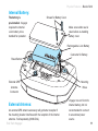
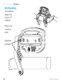
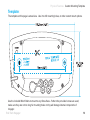
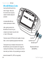
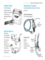
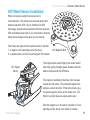
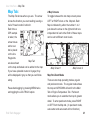
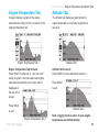
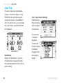
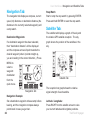
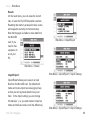
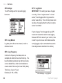
MOTO-GPS
Quick-Start » Screens
Main Tab
Map Tab
Engine
Temperature
Tab
Altitude Tab
User Tab
Navigation
Tab
Main Tab 2
Duel Map Screens
Use the
Pan/Zoom Mode
navigation switch
to move up and
down between
Engine
screens.
Temperature
Review
Altitude
Review
User Tab 2
Quick-Start » Buttons
Quick-Start
UP
Navigate tab screens and menus.
LEFT
Cancel, back, or change screens.
RIGHT
Confirm, select, or change screens.
DOWN
Navigate tab screens and menus.
MENU/POWER
Enter or exit
menu. Hold to
power off.
BACK
Backs out of
any screen or
menu. Press
2-3 times to
return to main
tab.
Trail Tech Voyager
ENTER
Confirm
changes or
switch to next
screen.
3
Introduction
Introduction
Trail Tech brings functionality and life to your
motor vehicle with high quality and innovation.
To ensure long and trouble-free operation, this
User’s Manual contains valuable information
about how to operate and maintain your digital
gauge properly.
PURCHASE DATE
Please read this manual carefully.
DEALER NAME
If you call to request service for your Voyager
digital gauge, you need the date of purchase,
dealer’s name, address, and telephone number.
Warranty service requires proof of purchase.
DEALER ADDRESS
DEALER PHONE
Keep this book and sales slip together for
future reference.
4
Trail Tech Voyager
Precautions
Precautions
WARNING:
• In order to change Voyager using a wall outlet,
Trail Tech’s wall charger (9000-ACA) is required.
Attempting to charge Voyager directly off an
outlet will result in failure of your Voyager Moto
GPS.
• Check gap between wheel sensor and magnet
periodically to ensure correct measurements and
reading on Voyager.
• Do not bend, twist, kink or abuse the sensor
cables.
• Read all instructions before using Voyager.
• Avoid contact with gasoline, degreasers or
other chemical cleaners.
• Do not disassemble Voyager or its
accessories.
• Do not operate Voyager while driving/riding.
• Do not wash with pressure washer.
• When installing Voyager, disconnect the
vehicle battery.
• When installing radiator hose temperature
sensors, make sure it fits BEFORE cutting the
radiator hose.
Trail Tech Voyager
• Do not rely on Voyager for operations requiring
absolutely precise measurements of distance
or direction. All GPS devices inherently contain
some amount of error. Use the wheel sensor for
the most precise data.
PAY ATTENTION TO THE TRAIL!
5
Frequently Asked Questions
FAQ
1. Voyager will not turn on: The internal
battery may need to be charged before use,
connect to vehicle power or use the wall charger
(wall charger sold separately.)
2. How long does the internal battery take to
charge fully? No need to pre-charge; connect
and ride. Voyager takes 3-8 hours to fully
charge depending on charge mode.
3. How do I get the best reception? The
internal antenna is designed for optimum
reception potential. If Voyager is mounted with
metal blocking the internal antenna, consider
purchasing the external antenna (9000-EAA).
4. How do I mount Voyager to my machine?
Vehicles with handlebars can use the included
handlebar mounting hardware. There are also
protective accessory mounts available, or utilize
the two mounting holes in the back of Voyager to
fix to a flat surface.
6
5. What kind of power does Voyager need for
proper operation? Voyager is intended to work
on regulated DC motorcycle power systems.
The DC input range is 12V to 65V.
DC power systems with a failing vehicle battery
may produce too low a system voltage (<11.5V)
to allow for proper operation.
6. Voyager kits include physical sensors,
magnets, and other cables. Why does
the unit need this if it’s a GPS? You can
use Voyager handheld without any sensors
connected. However, physically bolting Voyager
to your vehicle provides many advantages over
a conventional handheld GPS.
A. Power from the machine enables several
integration features, such as extended run-time
and maintenance-free charging.
B. The engine temperature sensor monitors
the health of your machine and enables two
major features: engine temperature diagnostics
Trail Tech Voyager
Frequently Asked Questions
and over-temp warning LEDs.
C. The ignition sensor tells Voyager when the
engine is running. This enables logging of tracks
only when engine is running and tachometer
display features.
D. The wheel sensor can also control when
to log, and provides a more accurate odometer
than GPS.
7. Do I really need a wheel sensor? My other
GPS unit gets along just fine without one. All
speed/distance data can be gathered from either
GPS or the wheel sensor. Voyager kits provide a
wheel sensor for several reasons:
A. When using a wheel sensor, Voyager knows
to stop logging when the vehicle stops moving.
When you start rolling again, the wheel sensor
tells Voyager which starts logging again (without
a GPS induced lag.)
B. The wheel sensor will track distance
regardless of GPS conditions. This is important
under several circumstances:
a. GPS cannot tell the difference between
a motorcycle moving under its own power or in
Trail Tech Voyager
the back of a truck.
b. The GPS signal can be lost, especially
around metal structures or in tunnels. With no
signal, speed and distance accuracy is lost.
c. GPS cannot see small changes in
elevation (i.e. whoops and ruts.) Over time this
will create significant odometer error.
d. GPS is accurate while travelling in
straight lines at constant velocity. However, tight,
fast corners will cause the GPS to skip over part
of your path. Over time this will contribute to
odometer error.
C. Trail Tech believes an accurate odometer
and hour meter are critical features. To maintain
this accuracy, kits are provided with a wheel
sensor included.
8. Can Voyager use GPX files? GPX (GPS
exchange format) is Voyager’s native format.
Import/export between the MicroSD and dozens
of software programs and web services.
7
Frequently Asked Questions
If the machine is within the acceptable range,
follow Trail Tech’s instructions for connect to
vehicle power (e.g. at the CDI input.)
9. Can Voyager be turned on and off
manually? Yes. Hold down the upper left
button to power Voyager off. Note that Voyager
has two types of sleep mode.
options to change when Voyager is used without
external power: See the “Sensor Notes” section
for details on the settings that need to change in
order to use Voyager without connecting one or
more of its sensors to a vehicle.
The first sleep mode shows the clock on
the screen. Some features are turned off to
conserve power, but Voyager is still alert to
come back on quickly when you are ready to
continue riding.
The second sleep mode turns Voyager off
completely to conserve as much power as
possible. You can alter the sleep mode timers in
Set > Power Settings > Power-Save >.
10. How do I run Voyager without connecting
it to a vehicle? Voyager provides an easy way
to change unit settings to accommodate a wide
variety of user needs. There are few menu
8
Trail Tech Voyager
Specifications
Specifications
Range
Feature
Description
Speed
SPD
0-999 MPH
Geodetic Datum
WGS84
Distance
DST
0-250,000 mi
GPS Chipset
MediaTek MT3329
Altitude
ALT
59,000 ft
Joystick
5-Position High-Tactile
Temperature
ENG
0-260ºC
Wheel Sensor
Non-contact Magnet Sensor
(32-499 ºF)
Temperature Sensors
External Ambient and
Function
Display
Accum. Run Time
CLOCK
0-1,000,000 hr
GPS Sample Rate
TIME
1-5 sec
Backlight
Engine Thermistor Sensors
LED Group
DISTANCE
1-15 m
Screen
400x240 WQVGA LCD
68.6mm (2.7”) Diagonal
58.8x35.3mm (2.3x1.4”)
Power
Description
External Power Input
12V-60V DC
Internal Battery
3.7V 900 mAh Li-Ion
Product Weight
6.1 oz. (172g) (0.38lbs.)
Power Wire
Red/Black Power Wire
Operation Temperature
0-60ºC (32-140ºF)
Battery Life (typical use)
11 hours
Storage Temeprature
-20-80ºC (0-175ºF)
Battery Life (100% backlight) 6 hours
Critical Engine Enviro.
Amber/Red LED Alerts
Battery Charge Time
Max Waypoints
300 waypoints
Max Track Points
72,500 points
Max Route Points
72,500 points
Max Tracks/Routes
300 each
Trail Tech Voyager
3-8 hours
Product Dimensions
113x62x28.2mm
(4.5x2.5x1.1”) WxHxD
9
Physical Features » Front of Unit
Physical Features
Internal GPS Antenna
Yellow LED
Red LED
Navigation
Switch (UP,
LEFT, RIGHT,
DOWN)
MENU Button
BACK Button
ENTER Button
MicroSD Card
Wheel Sensor
Engine Temperature Sensor
Connection Power
10
Ignition Sensor
Ambient Temperature Sensor
Trail Tech Voyager
Physical Features » Back of Unit
Internal Battery:
The battery is
pre-installed. Voyager
requires the internal
Li-Ion battery to be
installed for operation.
Screws for Battery Cover
Make sure rubber seal is
clean before re-installing
battery cover.
Rechargeable Li-Ion Battery
Connector for Battery
Reset Button
External GPS
Antenna
Connector
External Antenna:
An external GPS antenna accessory will get better reception if
the mounting location interferes with the reception of the internal
antenna. Sold separately (9000-EAA).
Trail Tech Voyager
Mounting
Holes
Voyager can run from the
internal battery, but it is
recommended to connect
to an external power
source.
11
Physical Features » Bar Mount
Bar Mounting:
The included bar
clamps fit 7/8”
through 1-1/8”
handlebars.
Place the nuts
and bolts as
shown.
Adjust angle
as required.
12
Trail Tech Voyager
Physical Features Custom Mounting Template
Template:
The template on this page is actual size. Use it to drill mounting holes, or other custom mount options.
Use the included M4x16 bolts to mount to any flat surface. If other than provided screws are used,
make sure they are not too long for mounting holes or they will damage internal components of
Voyager.
Trail Tech Voyager
13
Physical Features » SD Card
MicroSD Memory Cards:
Insert any MicroSD card into the
side of Voyager. Make sure
the card slot cover is properly
seated to maintain waterproof
properties.
An installed MicroSD card
enables import/export of tracks.
After exporting a track to the
MicroSD card, insert it into your
computer’s card reader to save the track
or view it in Ride Leader.
Tracks are saved in GPX format and viewable in Google
Earth, or other compatible programs with that format.
Tracks saved on your computer can be placed on the
MicroSD memory card, then imported onto Voyager for
viewing and route following. This is a great way to share
tracks with your friends, or for pre-planning your own trips.
Card Slot
Card Slot Cover
MicroSD Card
Replacement SD Card
(9000-MSPIG)
Must be formatted FAT. (NTFS not supported.)
14
Trail Tech Voyager
Physical Features » Power and Temperature Sensors
Vehicle Power:
Temperature Sensors:
Connect the power
cable directly to the
vehicle’s 12 volt battery.
A 0.5A fuse (not
provided) should be
used.
See model-specific instructions for mounting
procedure.
Cylinder Head Sensor:
For air-cooled machines.
Spark Plug
CHT
Temperature
Sensor
Power Wire
Ignition Sensor:
The ignition
sensor detects
the on/off status
of the engine.
When the
engine is shut
off, Voyager will
know to go to
sleep for power
conservation.
Trail Tech Voyager
Coil
Ignition
Sensor
Wrap
Spark Plug
Radiator Hose
Sensor:
In-line in
radiator hose
for water-cooled
machines.
Radiator
Hose
Radiator
Hose
Temperature
Sensor
15
Physical Features » Sensor Notes
Sensor Notes:
If you plan to not use one of the vehicle sensors,
settings in Voyager should be changed to account
for it:
1. No Wheel Sensor:
Voyager defaults to use the wheel sensor to
gather speed and distance measurements. If not
using the wheel sensor, Voyager should instead
use GPS to gather the speed and distance
measurements.
Set > Vehicle Sensors > Wheel Sensor: Disabled
2. No Engine Sensor / No Wheel Sensor
By default Voyager will not log unless it detects
signal from the wheel and/or the engine sensor. If
the sensors aren’t installed, you need to enable
logging regardless of connected sensors.
Set > Vehicle Sensors > Wheel Sensor: Disabled
Set > Vehicle Sensors > Engine Sensor: Disabled
3. No Vehicle Power Connection
Voyager charges its internal battery only when
16
the vehicle is running to avoid draining the vehicle
battery. If no vehicle power,
switch charge mode so that it always charges (even
in sleep mode.) This enables use of the wall charger
(sold separately 9000-ACA.)
Set > Power Settings > Battery Charger > Charge
Mode: Wall Plug
Voyager automatically stops logging when it enters
sleep mode. Change these settings to prevent Voyager
from going into sleep mode. (Remember to hold the
MENU button for 3 seconds to turn Voyager off.)
Set > Power Settings > Power-save > Sleep (Battery):
Always On
Set > Power Settings > Power-save > Turn Off:
Always On
Voyager can stay on for twice as long if you disable
the backlight. In typical use, you can expect 11 hours
of use with no backlight, or 6 hours with the backlight
enabled.
Set > Power Settings > Backlight >
Brightness > OFF
Trail Tech Voyager
Physical Features » Precision Wheel Sensor
ATV Wheel Sensor Installation:
While not required, using the wheel sensor is
recommended. It will collect more accurate speed and
distance data than GPS. Due to limitations in GPS
technology, physical sensors perform with more precision.
GPS sometimes loses track of your movements, while the
wheel sensor always knows when you are moving.
Two halves are required for the wheel sensor to function:
1. A magnet, on the spinning part of the wheel.
2. A speed sensor, on the non-spinning part of the wheel.
ATV Speed
Sensor
ATV Magnetic Bolt
The magnet spins around tripping the sensor switch
each time--giving Voyager speed, distance and time
data to compare with the GPS data.
The magnet is installed on the brake rotor because
it spins with the wheel. The provided magnetic bolt
replaces a stock rotor bolt. If that will not work, glue
the spare magnet in a hole on the brake rotor. (JB
Weld or a similar slow-cure epoxy works well.)
After the magnet is in, the sensor is placed on a nonspinning part the wheel, rotor shield, or bracket.
Trail Tech Voyager
17
Physical Features » Precision Wheel Sensor
Motorcycle Wheel Sensor Installation:
Motorcycle wheel sensors, like ATVs, need a magnet
placed on the spinning part of the wheel and the
sensor installed to a non-spinning area.
The magnet gets bolted or glued to the brake rotor.
The wheel sensor should be cable-tied to the brake
line, then attached to the brake caliper.
Magnet Passing Under Sensor
Voyager can tell precisely how far and fast it’s
traveled by how many times the magnet passes the
sensor.
Many Motorcycles and ATVs have special
installation procedures. Refer to the model-specific
instructions for more information.
Magnet Rotation Path
18
Trail Tech Voyager
Physical Features » Precision Wheel Sensor
Measure Wheel Size:
Knowing your exact wheel size it critical
for the wheel sensor to calculate correct
speed and distance data. The more
accurate the wheel size, the better
Voyager performs.
Wheel Size =
Wheel Diameter(mm)
x3.14
When comparing calibration to GPS
data, use a long straight section of road.
GPS has trouble with tight fast corners
and small vertical movements (causing
comparison inaccuracy.)
Method 1: Ruler
Find the circumference of front wheel by measuring
its diameter in millimeters. Multiply the Wheel
Diameter by 3.14. The result is your wheel size.
Method 2: Rolling
Diameter
x3.14
On a flat surface, mark the tire sidewall and the ground with a marking pen. Roll the wheel until the
mark on the tire completes one revolution and is back on the ground. Mark the ground at this location.
Measure the distance between the marks on the ground in millimeters (multiply inches by 25.4 to
convert to mm). Use this number for your wheel size. For accuracy, the rider’s weight should be on
the bike when making the measurement.
Trail Tech Voyager
19
User Interface » Main Tab
User Interface
Voyager has 7 tabbed screens: Main, Map,
Engine Temperature, Altitude, User Definable,
Navigation, and Satellites. Switch screens using
the joystick. You can always return to the Main
tab screen by pressing the BACK button, or
press the MENU button to change options.
Main Tab Screen 2:
There are two screens in the Main Tab, hinted by
the side arrow: . Using the joystick, press right
or left to move to the Main 2 screen.
Main Tab:
The Main
Tab displays
current trip
data being
received
from the
environment.
Main Tab 1
It displays current speed, altitude, engine
temperature, ambient temperature, time of day,
compass direction, and trip distance. The top
left icons are logging record/pause, engine
running and battery level. You can select metric
or English units in the Set>Unit Settings> menu.
20
To adjust trip distance (DST MI/WHL DST 1)
press and hold joystick in for 3 seconds. Screen
will display adjustment selection. Push the
joystick up to increase or down to decrease trip
distance. Press Enter button to set.
Main Tab 2
The Main 2 screen displays permanent
odometer and accumulated (permanent) run
time. It also displays maximum and average
speed for the current trip.
Trail Tech Voyager
User Interface » Map Tab
Map Tab:
The Map Tab shows where you are. The arrow
shows the direction you are travelling, leaving a
trail of “bread crumbs” behind it.
Each time a
GPS sample
is taken, the
arrow moves
and a new
dot is placed
on the line.
Waypoints
Map Tab
are also shown
on the map and labels can be added to the map.
If you have uploaded routes to Voyager, they
will be displayed in gray so that you can follow
along.
Pause data logging by pressing MENU twice
and toggling the LOG TRACK option.
Trail Tech Voyager
2 Map Screens
To toggle between the two map screens press
LEFT or RIGHT when on the Map tab. Each
Map is indicated by either the number 1 or 2
just above the arrow on the right and both are
independent of each other. Both of these maps
can be set to different zoom levels.
Map Screen 1
Map Screen 2
Map Pan/Zoom Mode
There are two map operating modes, regular
and pan/zoom mode. The regular mode shows
the map and UP/DOWN will scroll to the Main
Tab or Engine Temperature Tab. Pan/zoom
mode allows you to examine the map in greater
detail. To enter pan/zoom mode, press RIGHT
or LEFT from the Map tab. (In pan/zoom mode,
auto-center and auto-zoom will not function.)
21
Press ENTER to change
between pan and zoom modes (indicated by the
+ icon in the upper right corner of the screen.)
Pan Mode Indicator
Press BACK to go back to the Map Tab.
Press MENU to add waypoints, pause/resume
the trip, etc.
Press ENTER to change
between pan and zoom modes (indicated by the
+ icon in the upper right corner of the screen.)
Zoom Mode Indicator
Press BACK
to go back to
the Map Tab.
Map Zoom Mode
Zoom/Pan Timeout
By default the Map Pan and Zoom Screens have
a timeout function to keep you on the proper
Map Screen. By default the timeout is set for 30
seconds and then reverts you back to the Map
Screen. To adjust the length of the timeout:
Set > Map Settings > P/Z Timeout
Map Pan Mode
Press MENU to add waypoints, pause/resume
the trip, etc.
22
Trail Tech Voyager
User Interface » Engine Temperature & Altitude Tabs
Engine Temperature Tab:
Voyager displays a graph of the engine
temperature’s history for the current trip in the
engine temperature tab.
Altitude Tab:
The Altitude Tab displays a graph similar to
engine temperature, but shows height above
sea level.
Engine Temperature Tab 1
Engine Temperature Tab Screen 2:
Press RIGHT to enter tab 2. You can scroll
along the graph - the time stamp and engine
temperature selected by the cursor will be
displayed at
the top of the
screen.
Press BACK
to exit.
Altitude Tab Screen 2:
Press RIGHT to enter altitude tab screen 2.
Press BACK
to exit.
Altitude Tab 2
Engine Temperature Tab 2
Trail Tech Voyager
Altitude Tab 1
Note: Logging must be active to save engine
temperature and altitude history.
23
User Interface » User Tab
User Tab:
The user screens are customizable.
Choose 1-6 items for display. Press
RIGHT from the user tab to see the
second user screen. Press MENU to
edit. For each screen, you can change
the screen name, and what and items
are displayed.
User Screen 1
Data Blocks:
Display 1-6 data blocks. if you turn
off some blocks, Voyager will center
the remaining blocks on the screen for
better visibility.
24
User > User Screen Settings:
Edit the screen
title and choose
items to appear
on the screen.
You can have
1-6 blocks
displayed.
Choose from
the wide variety
of statistics
Voyager tracks
and is able to
display.
Trail Tech Voyager
Available Data Blocks for User Screens:
•
•
•
•
•
•
•
•
•
•
•
•
•
•
•
•
•
•
•
•
•
<OFF>
Altitude
Min Altitude
Max Altitude
Wheel Speed
GPS Speed
Wheel Odometer
GPS Odometer
Engine Acc. Run Time
GPS Acc. Run Time
Air Temperature
Engine Temperature
Max Engine Temperature
Avg Engine Temperature
Clock
Stop Watch
Heading
Compass Direction
Input Voltage
Internal Battery Voltage
Tachometer
Trail Tech Voyager
•
•
•
•
•
•
•
•
Wheel Distance (1)
GPS Distance (1)
Engine Trip Time (1)
GPS Trip Time (1)
Max Wheel Speed (1)
Max GPS Speed (1)
Avg Wheel Speed (1)
Avg GPS Speed (1)
•
•
•
•
•
•
•
•
Wheel Distance (2)
GPS Distance (2)
Engine Trip Time (2)
GPS Trip Time (2)
Max Wheel Speed (2)
Max GPS Speed (2)
Avg Wheel Speed (2)
Avg GPS Speed (2)
• Current (Battery Charger)
25
User Interface » Navigation and Satellite Tabs
Navigation Tab:
The navigation tab displays a compass, current
speed, trip distance or destination distance (the
distance to the currently selected waypoint) and
a stop watch.
Destination Waypoints:
If a destination waypoint has been selected,
then “destination distance” will be displayed
and the compass arrow will point towards the
desired waypoint (when it points straight up,
you are heading in the correct direction.) Press
MENU to
select a
waypoint
destination
from the
quick menu.
Navigation Tab
Navigation Example:
Set a destination waypoint at base camp before
leaving, and the navigation compass always
points back in case you get lost..
26
Stop Watch:
Start or stop the stop watch by pressing ENTER.
Press and hold ENTER to reset the stop watch.
Satellite Tab:
The satellite tab displays a graph of the sky and
the relative GPS satellite reception. The sky
graph shows the position of the satellites in the
sky.
Satellite Tab
The reception bar graph shows the relative
signal strength of each satellite.
Latitude / Longitude:
Press RIGHT from the satellite screen to view
your current latitude and longitude positions.
Trail Tech Voyager
Menu » Quick Menu
Menu
The menu consists of 3 menu tabs: Quick,
Ride and Set. The Quick menu has the most
frequently used commands, like toggling GPS
logging. The ride menu controls features related
to your current ride, or saving/loading tracks.
The set menu contains the system settings.
Enter the menu by pressing the MENU button.
Press LEFT on the joystick until the tab is
highlighted, then up/down to change tabs.
Log Track:
Toggle logging OFF/ON. Even if set to ON,
logging will still pause if Voyager is not moving,
or does not have a GPS fix.
Logging On
Quick Menu:
Logging On
In the quick menu you can toggle logging, reset
ride memory and trip distance, import/export
rides, add waypoints and select a destination
waypoint.
Logging On but not Active
Quick Menu
Trail Tech Voyager
Reset Ride Memory:
This will erase all tracks, routes, and waypoints
currently in memory, and will reset the trip
distance counters.
27
Menu » Quick Menu
Reset Trip Dist:
Reset Trip Distance(1) is visible both on the
Main screen and User screen. Voyager has a
second counter, Trip Distance(2) visible only on
the User screen. Trip Distance(2) can be reset
in the ride menu or by performing a ride memory
reset.
Import:
Import a GPX file from the MicroSD card. The
new route will be added to whatever Voyager
currently has in memory. By default, all GPX
tracks are imported as routes. Voyager displays
routes as grey lines and tracks as black lines.
This makes it easier to distinguish between
them. Change the import settings in the ride
menu to import GPX tracks as tracks.
Export:
Writes all tracks and waypoints to a file on the
MicroSD card. By default, it does not export
routes, but that can be changed in the ride
menu’s Export Options..
Add Waypoint (Current Pos):
Places a waypoint at your current position on
the map.
Select Destination:
Choose a previously set waypoint that you
would like to navigate to. After selection, the
Nav screen will display the selected waypoint,
distance to it, and the compass will point
towards it.
Select Destination Waypoint
28
Trail Tech Voyager
Menu » Ride Menu
Ride Menu:
The ride menu is where rides are maintained.
Start or stop tracks, or import/export to the
MicroSD card for use on your personal
computer. Routes can be loaded from the
MicroSD card for display on the map alongside
your current ride.
Tracks:
A track is made by logging movement. Tracks
can be started, renamed, erased, or imported/
exported. The display of tracks can be
individually toggled on/off.
Ride Menu > Tracks
Ride Menu
Difference between Tracks and Routes:
A route appears grey on Voyager. It is intended
to show where to ride (i.e. un-ridden trails and
roads.)
A track appears black on Voyager. It shows the
current ride (i.e. where you have been or are
currently riding.)
Trail Tech Voyager
Routes:
Routes can be erased, renamed, or individually
toggled on/off.
Ride Menu > Routes
29
Menu » Ride Menu
Waypoints:
Waypoint
display can
be toggled,
renamed,
selected
or added/
erased.
Ride Menu > Waypoints
When adding a waypoint, you have the choice
of adding the waypoint at your current position,
entering a latitude/longitude, or selecting by
crosshair. The crosshair selection opens the
map screen to let you place the waypoint
visually.
If you select a destination waypoint, Voyager
will know that you wish to navigate towards
it. On the Navigation tab the distance to the
selected waypoint will be shown (DEST DST)
and the compass arrow will point towards the
desired waypoint. When the compass arrow
points straight up, you are heading in the correct
direction.
Ride Menu > Waypoints > Select Destination
Ride Menu > Waypoints > Add Waypoint
30
Trail Tech Voyager
Menu » Ride Menu
Resets:
On the reset menu, you can erase the current
ride, or reset the Trip DST/stopwatch counters.
Resetting ride memory erases all tracks, routes,
and waypoints currently in internal memory.
Note that Voyager is unable to erase data from
the MicroSD
card; if you
need to free
up space, do
so on your
PC.
Ride Menu > Import/Export
Ride Menu > Resets
Import/Export:
Import/Export allows you to save to or load
files from the MicroSD card. By default both
tracks and routes import as routes (grey lines)
so that you can log tracks (black lines) over
them. In the import settings you can change
this behavior. (i.e. you want roads to import as
tracks and trails as routes, to tell the difference.)
Trail Tech Voyager
Ride Menu > Import/Export > Import Settings
Ride Menu > Import/Export > Export Settings
31
Menu » Ride Menu
Graphs Display:
On the graph screens, you can choose to show
either the current track, or a previously logged
track or route. If tracks have been imported
from the MicroSD card, their graphs may also be
loaded for graph viewing. If a GPX file is loaded
that does not contain engine temperature and/or
altitude data, then the graph will be empty.
100% of available space.)
2. Routes have a similar memory allocation
to tracks you can store 300 routes or 72,500
points. Notice in the screenshot below that
although there are more routes than tracks
loaded, they are less detailed and take up a
lower % of space.
3. A maximum of 300 waypoints can be stored.
Ride Menu > Graphs Display
4. The MicroSD card can also be filled up,
depending what size of card you are using.
Voyager is unable to erase data from the
MicroSD card; if you need to free up space, do
so on your PC.
Memory:
Voyager has several types of memory limitations
to be considered:
1. A maximum of 300 tracks and 72,500 point
can be loaded into internal memory at one
time. However, there is also a space limit (it is
possible for 1 extremely long track to take up
32
Ride Menu > Memory
Trail Tech Voyager
User Menu » Set Menu
Settings Menu:
The settings menu contains the options that
control the behavior of Voyager.
Unit > Speed/Distance Units:
Choose miles or kilometers.
Unit > Altitude Units:
Choose feet or meters.
Unit > Temperature Units:
Choose Fahrenheit or Celsius.
Unit Settings:
The Unit Settings menu allows you to choose
between metric or standard systems.
Unit > Clock Format:
Choose between 12H or 24H.
Unit > Time of Day:
Enter the current time in your time zone.
Unit > Tabs Timeout:
Change the length of time when left Tabs
collapse.
Trail Tech Voyager
33
Menu » Set Menu
Vehicle Sensors:
The Vehicle Sensors settings control sensor
logging behaviors.
Vehicle Sensors > Engine Sensor:
Enables or Disables engine sensor for logging.
Vehicle Sensors > PPR (Pulses Per Revolution):
This is the amount of time the spark plug fires per engine
revolution.
Vehicle Sensors > Sensitivity
Sensitivity for Voyager unit reading the pulses
from the spark plug.
Vehicle Sensors > Wheel Sensor:
Enables or Disables wheel sensor for logging.
Vehicle Sensors > Wheel Size:
This setting is critical for proper operation of
the wheel sensor. See the measure wheel size
section for more information.
Defaults:
Motorcycle:2110mm
ATV:1675mm
34
Vehicle Sensors > Speed/Dist
Speed and distance data pull location.
Vehicle Sensors > Accumulated Run Time:
Voyager defaults to “ENG or WHL” so that Accumulated
Run Time (the total time the vehicle has been running)
only increments when the wheel is rolling or the engine
is turned on. You can change it to increment when GPS
thinks it is moving. Over time this will cause inaccuracy
due to GPS signal wander. ART will not increment if
Voyager falls into sleep mode. By default, this will not
happen because wheel and engine activity will keep
Voyager awake.
Trail Tech Voyager
Menu » Set Menu
Power Settings:
The power settings let you choose the behavior
of the backlight, power-saving and charging.
Power > Backlight Level
Choose the brightness of the backlight, (off, low,
med, high).
Power > Timeout (BAT):
Set the amount of time the backlight stays lit
(since the last button press or wheel movement)
when running off the internal battery.
Power > Timeout (EXT):
Set the amount of time the backlight stays lit
(since the last button press, wheel movement, or
engine sensor) when connected to the external
vehicle power.
Trail Tech Voyager
Power > Sleep (Battery):
Set the amount of time to wait (after the last
button press, wheel movement, or engine
sensor) until Voyager enters sleep mode when
on internal battery. During sleep mode, the
screen is blank and Voyager conserves power.
Power > Sleep (Ext Pwr):
Set the amount of time to wait (after the last button
press) until Voyager enters sleep mode when on
external battery. During sleep mode, the screen is
blank and Voyager conserves power.
Power > Turn Off:
Voyager shuts down after the allotted time to
conserver power.
Power > Charge Mode:
Voyager is able to charge using the 9000-ACA
wall adapter or the vehicle’s internal regulated
AC or DC power. “Wall Plug” mode is meant for
use only when Voyager is plugged into the wall
using the AC adapter (if used on a vehicle, the
vehicle battery may eventually be drained.)
35
Menu » Set Menu
GPS Settings:
The GPS settings control map and logging
behaviors.
GPS > Log Method:
Log data points after a time interval, or after a
distance interval.
GPS > Log Frequency:
Controls the frequency that data points are
sampled and added to the current track log. The
less time/distance between log intervals creates
a more detailed files, while more time/distance
creates smaller file sizes (but lower fidelity data.)
Time(1 sec, 2 sec, or 5 sec)
Distance(1ft, 10ft, or 50ft)
36
GPS > Log Option:
IMPORTANT: This setting can cause Voyager
to not log. If set to “engine sensor” or “wheel
sensor,” then Voyager will not log unless the
sensor sees activity. This is to help create clean
log files, only logging when the wheel or engine
sensor is activated.
If set to “always,” then Voyager will use GPS
movement to determine when to stop logging.
Because GPS isn’t aware of your vehicle, it has
to wait for you to move a short distance before
turning logging on (thus somewhat less precise
than using sensors attached to the vehicle.)
GPS Settings > Log Option
Trail Tech Voyager
Menu » Set Menu
GPS Settings > Auto-Split:
Auto-Split automatically creates a new track
if Voyager does not sense a GPS signal for a
specific set distance while logging track is on.
Default set to 5 miles
(Off, 1, 5 and 10 miles)
GPS Settings > Coord Format:
Allows you to choose the Coordinance Display
Format.
(deg.dec), (deg, min.dec), or (deg, min, sec)
GPS Settings > Signal Bars:
If turned on, satellite signal strength
bars will appear on the main tab screen.
Map Display Settings:
The map display
settings let
you change
the behavior of
multiple map
screens.
Map Settings > Orientation:
Set how the map is displayed. If set to “track
up” then the map rotates on the screen in the
direction of travel. “North up” leaves the map
stationary on the screen and the cursor rotates
instead.
Map Settings > Pointer Size:
Select the size of the mouse pointer on the map
screen. Choose small, medium, or large.
Trail Tech Voyager
37
Menu » Set Menu
Map Settings > Map Screen (1 & 2):
“Auto-Center” Automatically pans the map as
you move so that your currently location is
always in the center of the screen. Auto-center
does not function in pan/zoom mode (see page
22.) “Fixed” fixes the map to one position on the
map.
Map Settings > Options > Waypoint Icons:
Select style of waypoint icons, basic “Dots” or
numbered “ID#’s”.
Map Settings > Options > Track/Route Labels:
Turn on or off track and route labels.
Warning LED Lights:
The warning
LED’s will turn
on or flash
when the
temperature
reaches set
points.
The warning LEDs are disabled by default. Here
are some suggested values:
90ºC (190ºF)
Yellow LED on:
100ºC (210ºF)
Red LED on:
110ºC (230ºF)
Yellow LED flash:
120ºC (250ºF)
Red LED flash:
Options > Track/Route Labels(Clipping):
Clipping distance allows the track/route labels
to automatically turn off when zoomed out at
a certian point. This keeps the screen from
becoming cluttered with labels
Map Settings > P/Z Timeout:
The Map Pan and Zoom Screens have a timeout
function to keep you on the proper Map Screen.
By default the timeout is set after 30 seconds it
will revert you back to the Map Screen.
38
Map Settings > Options > Waypoint Labels:
Choose size of waypoint labels.
(off, small, or large)
Trail Tech Voyager
Menu » Set Menu
Utility Menu:
This menu contains items not needed for normal
use.
Utility > Status Screen:
Provides an overview of system variables.
Utility > Software Update:
Upgrades Voyager software. Visit
www.trailtech.net for the latest releases. After
downloading from Trail Tech, copy the file to the
MicroSD card, then select it with this function.
Utility > Personal Information:
You are
encouraged to
input your name,
address and
phone number
for identification
purposes.
Utility > Demo Menu:
Allows you to play back a recorded track in
realtime. For demo purposes.
Utility > Service Menu:
Password protected features. Only available to
Trail Tech technicians.
Utility > Manage Settings:
Allows you to save and load your settings to
your SD card.
Trail Tech Voyager
39
RideLeader GPS File Editor
RideLeader GPS File Editor
RideLeader can be found on the CD included in
your Voyager kit, or online at
http://trailtech.net/ride_leader
Visit often for upgrades.
Note: RideLeader only compatible with Windows OS
Opening the GPX Editor:
Download or find the RideLeader folder on
your CD. Double-click the setup file to install
it to your computer. RideLeader will open
automatically after the quick installation.
RideLeader allows you to compile trail
systems (either from personal riding or online
downloads.) You can also draw your own tracks
overlayed on Google Earth or a street map.
This is a good way to organize, edit, and prepare
information for use on Voyager.
After you have prepared your tracks, you will
copy them to a MicroSD card, then import them
to Voyager. Because Voyager has memory
limits, the GPX editor is also useful to reduce the
size of tracks and merge tracks before importing.
40
RideLeader opens with no tracks loaded. The
first thing to do is load your tracks (or get them
directly from OHVtrails.net)
Trail Tech Voyager
RideLeader GPS File Editor
Importing:
The quickest way to get tracks is to use the
embedded OHVtrails.net feature. Make sure it is
checked on in the left trails panel, then go to the
Google Earth tab. If there are trails in your area,
you will see them with small trail icons. Click the
icon to move the trail into the local collection.
Importing:
The GPX Editor does best with GPX files, but
will also import NMEA, NGT, OSM and KML
files. Open files from the File menu, or dragand-drop.
On the included CD, there is a folder with
example files. Open the sample GPX file.
A trail system will appear, with motorcycle trails
colored orange and roads colored blue. The
Trail Tech Voyager
trails are orange because they are routes. They
will be imported into Voyager as grey lines,
ready to be ridden and overlaid with a bold
track. The roads are tracks, and will be imported
in Voyager as bold lines, so you can tell the
difference between a road and a trail.
By default, Voyager imports both tracks and
routes as greyed routes. You can change this
behavior so that tracks import as tracks in the
Voyager menu.
Imported Sample File
41
RideLeader GPS File Editor
Navigation:
A few simple tools control the view. The pointer
tool pans, and the hand tool selects tracks and
routes. The eyeglass tools or roller button on
your mouse controls zoom level.
Hand Tool, Pans
Editing:
The editing tools allow you to add, erase, split,
merge and simplify tracks
Cut\Split Track
Add Waypoint
On Selected
Delete
Selected
Pointer Tool, Select Tracks
Tabs switch between line-art preview and
Google Maps/Satellite/Earth view.
Google Maps Tab - Earth view. Hold down the
center mouse button to modify perspective.
42
Trail Tech Voyager
RideLeader GPS File Editor
Draw New Track:
On the Google-Maps tab, you can draw your
own trails and set waypoints anywhere on the
map. When drawing a route, click once on the
map for each data point (many data points make
up a track segment.)
Add
Waypoint
Draw a route by
clicking on the map
Reduce Number of Data Points:
Tracks created by some sources will have far too
many data points. To reduce file size, remove
some of the data points (so it loads faster in
Voyager.) Select the track with the select tool,
then press the Filter button in the toolbar.
Filter/Simplify
Simplify until you see detail being reduced.
Trail Tech Voyager
43
Openstreetmaps.org
OpenStreetMaps.org
Load street maps into Voyager:
Manually Select Export Tab
www.openstreetmaps.org
First, find the roads you want to
upload into Voyager. You should
only select the small area around
the planned ride, to reduce the
file sizes.
1. Go to Openstreetmaps.org.
2. Go to the Export tab.
3. Click on “Manually select a
different area.”
4. Click and drag a box on the
map that contains the roads you
want to upload to Voyager.
5. Click the Export button.
OSM XML Data
Export Button
The file will export in .OSM format which needs to be converted to .GPX for Voyager. Open the file
in RideLeader, then save as .GPX. Consider deleting excess waypoints and filtering down track data
points in RideLeader before saving the .GPX file (filtering allows Voyager to load many more tracks.)
44
Trail Tech Voyager
GPSbabel.org
GPS Babel
Convert other GPS files to GPX:
If you need to convert a rare GPS file format to
GPX, GPSBabel may be able to help.
“GPSBabel converts waypoints, tracks, and
routes between popular GPS receivers and
mapping programs.”
~ www.GPSbabel.org
Download and Install GPSBabel
Trail Tech Voyager
Run GPSBabel to convert the file to GPX.
Select the type of file you are trying to convert as
the input format and “GPX XML” as the export
format. Use the File Name button to select the
files, then click apply.
Before uploading the exported file to Voyager,
open it in the RideLeader to delete excess
waypoints and filter down the track data points.
File Name
GPX XML
Apply
45
Google Earth
Google Earth
Google Earth is an excellent
resource to view GPS tracks.
http://earth.google.com.
Use your mouse to spin the
planet, or shift+mouse to change
the 3D view angle.
You can view tracks exported from
Voyager, or downloaded from
OHVtrails.net or
Openstreetmaps.com.
You can also draw tracks that can
be imported into Voyager.
Google Earth at start
Tip: In Tools>Options...>3D View, increase the
Elevation Exaggeration to make mountainous
terrain more visually impressive.
46
Trail Tech Voyager
Google Earth
Draw and Export a Track to Voyager
To draw a track, click on the “Add Path”
button in the toolbar. A dialog box
appears (ignore it for now.) Using your
mouse cursor, click along the path right on top
of the Earth. After you have drawn the complete
line, click OK in the dialog box to save the
changes.
On the side of the screen in the Places sidebar,
right-click your new track and select “Save
Place As...” Google Earth will save it as a KML
file. You will need to convert the file to GPX
using GPSBabel, then it is ready to copy to the
MicroSD card for import into Voyager.
Trail Tech Voyager
Import a Track from Voyager
Google Earth can import GPX files directly from
Voyager. Select Export on Voyager to save the
file to the MicroSD card, then on your PC, dragand-drop the GPX file onto Google Earth.
During import, check all three boxes yes,
including Create KML LineStrings. It is likely that
once the track is loaded, there will be a lot of
named points visible that obscure the track line.
To remove them, in the sidebar expand “GPS
device,” then right-click on Tracks and select
Properties. Go to the “Style, Color” tab and click
the “Share Style” button. Modify Label and Icon
scale to 0. Do the same for Routes.
47
OHVtrails.net
OHVtrails.net
Download your adventure at
www.OHVtrails.net.
Download trails and load them
directly into Voyager. Entire trail
systems are at your fingertips.
Hiking trails not allowed; all included
trails are either motorcycle, ATV, or
snowmobile.
Hold down shift and click to tilt the
camera into 3D Google Earth mode.
You can also upload trails for overlay
viewing online among the stock
trails.
www.OHVtrails.net - Choose a Trail to Download
You can grab trails directly from within RideLeader by checking the OHVtrails.net checkbox. Go to the
Google Maps tab. Click on the trail marker icons to move the trail into RideLeader’s local collection.
48
Trail Tech Voyager
Glossary
Glossary
Ride
A “ride” is the collection of information Voyager
is currently logging and displaying (including the
map, altitude, engine temperature, trip distance,
etc.) The ride can be cleared by performing a
“reset ride memory.”
Track
Tracks appear on the map as dark black lines.
They are trails that have been logged on the
current ride. They can be imported/exported to
the MicroSD card.
Route
Routes appear on the map as grey lines. They
are intended to be imported from internet data
or previous rides and followed along. While
following, Voyager logs a new track that appears
black on top of the grey route line.
Trail Tech Voyager
Trip Distance
Trip distance is a measure of how far you have
travelled. While it is part of the current ride
memory, it can be reset independently. Trip
distance 1 is displayed on the main screen,
while a second trip distance can be selected to
appear on the user screen.
Destination Distance
The distance between your current position and
the currently selected waypoint. You can select
a new destination waypoint in
Ride Menu>Waypoints>Select Destination.
Trail Tech, Inc.
Thank you for using Voyager Moto-GPS. If you
have further questions, do not hesitate to call
Trail Tech at 360-687-4530, or email
[email protected].
49
LIMITED WARRANTY
Within one year from the date of original purchase, Trail Tech will repair or replace, at its option, any
Trail Tech powersport computer which is deemed defective in workmanship or materials. Please
contact Trail Tech or the dealer where the item was purchased for assistance.
CONFORMITÉ
Damage or injuries resulting from negligence or misuse are not covered by this warranty. Incidental
or consequential damages are specifically excluded.* This warranty gives you specific legal rights.
E UROPÉENNE
You may also have other rights which vary from state to state. *Because some states do not allow
the exclusion of incidental or consequential damages, this exclusion may not apply to you.
MADE IN AMERICA
Trail Tech and Voyager are trademarks of Trail Tech, Inc.
www.trailtech.net
360-687-4530
Manual Version 2.0