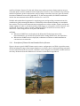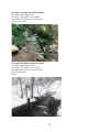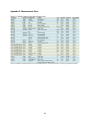
1
GAMUT Monitoring Quality Assurance and Quality Control Plan Version 1.2 May 16, 2014 Developed by: Amber Spackman Jones, Chris Cox, Joe Crawford, Dave Eiriksson, Jeffery S. Horsburgh i. Preface iUTAH (innovative Urban Transitions and Aridregion Hydrosustainability) has instrumented three Utah watersheds with environmental monitoring equipment in an effort to observe eco-‐hydrology of mountain to urban gradients. To ensure that researchers can have confidence in and to maximize the broad use of these datasets, quality assurance and quality control practices are needed. This document details a framework that will be followed to provide assurance regarding quality of these data. ii. Document Contributors, Roles, and Contacts Name Chris Cox Joe Crawford Role Watershed Technician Watershed Technician Dave Eiriksson Jeffery S. Horsburgh Amber S. Jones Watershed Technician Cyberinfrastructure Lead Cyberinfrastructure Data Manager Organization Utah State University Brigham Young University University of Utah Utah State University Email [email protected] [email protected] Utah State University [email protected] [email protected] [email protected] iii. Revision History Date Editors 2/25/2014 4/22/2014 Release Version 1.0 1.1 5/16/2014 1.2 Joe Crawford, Amber S, Jones Sections Modified Amber S. Jones Initial release Amber S. 3.2, 3.3, 3.6, 3.8.1.2, Jones, Chris 3.8.2.7, 3.9, 4.4.2, 4.4.5 Cox, Michelle Baker, Dave Bowling Appendix F Description Initial release Response to comments from GAMUT Leadership. Includes revisions indicating plans for roving spare sensors, a two-‐ hour threshold for data gaps, and directions for chemical disposal. Specific guidelines for chemical disposal iv. Identified Topics for Subsequent Versions 1. Research a. What are the QA/QC plans of other networks? b. Measurement procedures and instrument-‐specific sampling frequency 2. Quality Assurance a. Determination of implementation of factory maintenance schedules b. Documentation of factory maintenance in equipment database c. More detailed description of spare sensors for sensor replacement and field checks d. Discharge measurement procedures e. Reasonable sensor output ranges and additional rules for automated alerts f. Linear interpolation of temperature dependent aquatic calibrations g. Auto reset of precipitation gage on October 1 ii 3. Quality Control a. QC levels and process to achieve each b. Specific procedures for interpolation and smoothing c. Determination of rules for automated flagging d. Identification of flags implemented to qualify data e. QC workflow (i.e., what to flag, what to edit) 4. Appendix a. Better documentation of site specific details including photos b. Documentation of sensor heights and locations at all sites Table of Contents i. Preface .................................................................................................................................................................................... ii ii. Document Contributors, Roles, and Contacts ...................................................................................................... ii iii. Revision History .............................................................................................................................................................. ii iv. Identified Topics for Subsequent Versions .......................................................................................................... ii 1 Overview ............................................................................................................................................................................... 1 2 Quality Assurance and Quality Control .................................................................................................................... 1 3 Quality Assurance Plan ................................................................................................................................................... 1 3.1 Site Standardization ................................................................................................................................................ 1 3.1.1 Description of Climate Site and Standard Suite of Sensors ............................................................ 2 3.1.2 Description of Aquatic Site and Standard Suite of Sensors ............................................................ 3 3.2 Data Curation: Datalogger Files/Programs ................................................................................................... 5 3.3 Data Curation: Data Processing by the Sensor or the Datalogger ....................................................... 5 3.4 Data Curation: Operational Databases ............................................................................................................ 6 3.5 Equipment Management Database and Website ........................................................................................ 7 3.6 Replicate Sensors ...................................................................................................................................................... 7 3.7 Factory Maintenance Schedule ........................................................................................................................... 8 3.8 Field Maintenance Schedule and Procedures ............................................................................................ 10 3.8.1 Climate Stations ............................................................................................................................................. 10 3.8.2 Aquatic Sites .................................................................................................................................................... 11 3.9 Field Calibration Schedule and Procedures ............................................................................................... 13 3.10 Visual Data Monitoring ....................................................................................................................................... 13 3.11 Data Checking: Automated Alerts .................................................................................................................. 15 3.12 Recording Events ................................................................................................................................................... 15 4 Quality Control and Post Processing Plan ............................................................................................................ 15 4.1 Flagging and Qualifiers ........................................................................................................................................ 16 4.2 ODM Tools Python ................................................................................................................................................ 17 4.3 Quality Control Levels ......................................................................................................................................... 17 4.4 Data Processing ...................................................................................................................................................... 18 4.4.1 QC 0.1: Automated Checks and Flags ................................................................................................... 18 4.4.2 QC 0.2: Removal of Out-‐of-‐Range Data Values ................................................................................. 18 4.4.3 QC 0.3: Removal of Periods of Erroneous Data ................................................................................ 18 4.4.4 QC 0.4: Application of Drift Correction ................................................................................................ 19 4.4.5 QC 0.5: Fill Data Gaps ................................................................................................................................... 19 4.4.6 Final Data Evaluation .................................................................................................................................. 19 5 References ......................................................................................................................................................................... 20 Appendix A: Watershed and Site Specific Details ..................................................................................................... 21 iii A.1 Red Butte Creek ..................................................................................................................................................... 21 A.2 Logan River .............................................................................................................................................................. 26 A.3 Provo River .............................................................................................................................................................. 27 Appendix B: Protocols for Updating Datalogger Programs ................................................................................. 28 Appendix C: Measurement Plans ...................................................................................................................................... 30 Appendix D: Site Visit Checklist and Field Sheet ....................................................................................................... 32 Appendix E: Calibration/Maintenance Detailed Instructions ............................................................................. 34 E.1 Regular Geonor Precipitation Gage Maintenance .................................................................................... 34 E.2 Pressure Transducer Removal ......................................................................................................................... 34 E.3 EXO2 Sonde Calibration ...................................................................................................................................... 35 E.3.1 Basic Calibration ............................................................................................................................................ 35 E.3.2 Conductivity .................................................................................................................................................... 35 E.3.3 Dissolved Oxygen .......................................................................................................................................... 36 E.3.4 pH ......................................................................................................................................................................... 36 E.3.5 Total Algae ....................................................................................................................................................... 37 E.3.6 fDOM ................................................................................................................................................................... 38 E.4 Procurement Of Calibration Solutions, Dyes, And Chemicals ............................................................. 39 E.5 Preparation of Calibration Solutions ............................................................................................................. 40 E.5.1 Quinine Sulfate Solution for fDOM Sensor ......................................................................................... 40 E.5.2 Rhodamine WT Dye Solution for Total Algae Sensor .................................................................... 40 Appendix F: Chemical Disposal ......................................................................................................................................... 41 Appendix G: Station Problem Log Template ............................................................................................................... 43 iv 1 Overview iUTAH (innovative Urban Transitions and Aridregion Hydrosustainability) has established monitoring networks in three watersheds in northern Utah: the Logan River, the Provo River, and Red Butte Creek. These networks are intended to monitor Gradients Along Mountain to Urban Transitions (GAMUT) for water resources using a common suite of environmental sensors deployed at terrestrial/climate and aquatic sites. Protocols to ensure that the data are reliable and of high quality are integral to all environmental monitoring, but are particularly important given the geographic scope of the GAMUT network and the broad audience for which the data are intended. The intent of this plan is to specify and document the practices implemented by iUTAH GAMUT technicians and the iUTAH Cyberinfrastructure (CI) Team and that should be followed to ensure the data collected are of the highest quality. This plan describes the standardized framework under which GAMUT will operate its baseline collection efforts, and each section includes action items describing who is responsible for a task and the frequency with which it will be performed. Data will be associated with a version of this plan to document the protocols under which they were collected. Subsequent versions of this document will be developed as plans for quality assurance and quality control evolve. The Watershed Technicians are responsible for implementation of the plan and will review and update the plan every three months to begin with in collaboration with the CI Team. The research leads of the GAMUT network should review and approve each major version of the document. 2 Quality Assurance and Quality Control Campbell et. al (2013) differentiate between quality assurance and quality control of sensor data. Quality assurance (QA) refers to a “set of processes or steps taken to ensure that the sensor network and protocols are developed and adhered to in a way that minimizes inaccuracies in the data produced” whereas quality control (QC) “occurs after the data are generated and tests whether they meet the necessary requirements for quality outlined by the end users.” In short, quality assurance occurs prior to the collection of the data, and quality control occurs after the data are collected. They also point out that the implementation of QA/QC reduces the need for and expedites post processing. 3 Quality Assurance Plan Several aspects in the GAMUT network design contribute to quality assurance of the data. These include standardizing the design, sensor selection, programming, and deployment of the monitoring sites to the highest degree possible. Additionally, data management and implementation of CI are standardized across the sites to promote consistent data curation. Other standard quality assurance practices addressed in this document include steps for cleaning, maintenance, and calibration of equipment and sensors. 3.1 Site Standardization Standardization of monitoring sites helps facilitate comparison, interpretation, and utilization of data. The GAMUT Network was initially designed to maintain consistency in the type and placement of all sensors installed at a given type of monitoring site (climate or aquatic). Ideally, the location of each site would be such that measurements at the site are representative of a large area (valley scale). This enables more accurate interpolation between sites and minimizes any bias caused by 1 small local climatic features. To this end, efforts were made to position climate stations in open areas and aquatic stations within the main channel flow. However, due to utilization of previously installed equipment, permit requirements, and/or budget constraints, there are some deviations from these standards across sites (Appendix A). To the extent possible, all GAMUT installations include the instrumentation described in Sections 3.1.1 and 3.1.2. Reliable and standardized equipment for supplying power and providing communications also contribute to QA by ensuring that data are consistently collected and streaming to a centralized base station. The power and communications equipment at each site include a battery and power supply regulator, a radio or cell phone modem, a datalogger, a solar panel or ACDC converter, and an antenna. The battery, radio or modem, and datalogger are housed in an enclosure that is attached to a mast along with the solar panel and antenna. ACTIONS: ● When new GAMUT sites are deployed, the Watershed Technicians ensure that instrumentation is as consistent as possible with existing GAMUT sites, described here. ● When a new GAMUT sensor is deployed, technicians coordinate to make installations consistent across networks. 3.1.1 Description of Climate Site and Standard Suite of Sensors Figure 1 shows a typical GAMUT climate station sensor configuration, and Table 1 provides sensor details including the range of instrument heights across all sites. Due to anticipated deep snowpack at some stations and other site-‐specific constraints, sensor heights are somewhat variable between sites. Any deviations from the standard set of sensors are detailed in Appendix A. Figure 1. Typical GAMUT climate station. 2 Table 1. Standard GAMUT climate sensors Manufacturer Instrument Variables Sensor Placement Campbell HC2S3 Air Temperature/Relative Humidity 2 meters above ground Apogee ST110 Air Temperature 2 meters above ground Campbell CS106 Barometric Pressure Inside enclosure RM Young 5303 Wind Speed/Direction 5-‐7 meters above ground Geonor TB-‐200 Precipitation ~1 or 2.5 meters (2 pedestal options) above ground* Judd Communications Ultrasonic Depth Sensor Snow Depth 2 to 4 meters above ground* Hukseflux NR01 Incoming and Outgoing SW and LW Radiation 2 to 4 meters above ground* Apogee SP-‐230 Incoming SW Radiation 2 to 4 meters above ground* Apogee SQ-‐110 Incoming and Outgoing PAR 2 to 4 meters above ground* Apogee SI-‐111 Infrared Surface Temperature 2 to 4 meters above ground* Acclima ACC-‐SEN-‐SDI Soil Moisture, Temperature, Conductivity 5 cm, 10 cm, 20 cm, 50 cm, 100 cm** below ground Campbell CS210 Enclosure Humidity Inside enclosure Campbell 18166 Enclosure open door sensor Inside enclosure *The height of installation is based on the anticipated depth of snow accumulation. **Bedrock conditions at some sites preclude the installation of a sensor at 100 cm. At these sites, the “100 cm” sensor is installed as deep as possible. 3.1.2 Description of Aquatic Site and Standard Suite of Sensors Due to highly variable site conditions across the three GAMUT watersheds, there is no “standard” sensor mounting configuration for aquatic sites. Efforts were made to ensure that sensors were deployed in the main channel of flow, in uniform flow without excessive turbulence, and where sensors would not go dry. There is however, a standard suite of sensors at all sites across the GAMUT network (Table 2). Within each watershed, there are basic and advanced aquatic sites; the advanced sites include additional sensors. Deviations from this standardized set of sensors are detailed in Appendix A. 3 Table 2. Standard GAMUT aquatic sensors Manufacturer Instrument Variables Site Type YSI 599100-‐01 Dissolved Oxygen Basic/Advanced YSI 599870-‐01 Specific Conductivity -‐ Water Temperature Basic/Advanced YSI 599795-‐02 pH Basic/Advanced YSI 599101-‐01 Fluorescent Dissolved Organic Matter (fDOM) Advanced only YSI 599102-‐01 Blue Green Algae -‐ Chlorophyll a Advanced only Satlantic SUNA V.2 Nitrate Advanced only Campbell CS451 Water Depth Basic/Advanced FTS DTS-‐12 Turbidity Basic/Advanced Figure 2 shows an example aquatic site from the Red Butte watershed. At all sites, sensors are housed in acrylonitrile butadiene styrene (ABS) pipes that extend into the river. The YSI EXO sonde housings terminate in pump screens or a 4” ABS pipe cap with holes drilled into the bottom. The turbidity sensor housings terminate in pump screens with the bottom removed. Pressure transducer housings terminate with bolts extending through the diameter of the pipe to stop the sensor. Some sites employ hose clamps to secure pressure transducers to the pipes. All sites also have stage plates installed that are used to manually read and record the water level. Figure 2. Example aquatic station configuration. 4 3.2 Data Curation: Datalogger Files/Programs 3.3 Data Curation: Data Processing by the Sensor or the Datalogger Datalogger programs have been standardized between sites and across the three GAMUT watersheds to the maximum extent possible to ensure that the code and methods used to generate data are consistent. There are site specific components to each program (such as site identifiers and sensor calibration coefficients), but the baseline versions are the same between sites of the same type. Aspects of datalogger programs that facilitate data curation include: semantic consistency of variable names between sites, consistent averaging methods for the same variables, and designation of constant variables/offsets in a constants table specific to each site. Current and past datalogger programs and associated change log documents are housed on the iUTAH CloudShare. Datalogger files with associated date ranges are also stored and accessed on the iUTAH CloudShare. Raw data from each monitoring site are downloaded from remote sites on a regular schedule using Campbell Scientific’s Loggernet Software and are stored in comma delimited .dat files on the Loggernet Server using Loggernet’s native data format. Loggernet appends new data to the end of each datalogger file each time a station is polled for new data. The Loggernet Server machine is backed up with an incremental daily backup and a full backup weekly to offsite storage. Datalogger files are backed up as part of this process. Additionally, datalogger files are archived each time a change to the datalogger table definitions is made (e.g., when a new datalogger program is sent to the datalogger) or at least annually (a new data file is created at the beginning of each year). Protocols have been developed for uploading new datalogger programs to remote monitoring sites in efforts to minimize the loss of data and to ensure that old versions of datalogger files are archived and can be matched to the data collected using each program version (Appendix B). There are two types of changes to datalogger programs that could be executed: 1. In some cases, changes will be made to the programs for testing by the iUTAH Watershed Technicians. So long as these changes do not have a direct effect on the measurement sequences or output tables, the change can be implemented by the technician following the procedures put in place by the iUTAH CI Data Manager. 2. When a broad change needs to be implemented, as agreed upon by a majority vote of the Watershed Technicians, a simultaneous upgrade to a new version of the program at all GAMUT sites will be performed in coordination with the iUTAH MDF Data Manager. ACTIONS: ● The Watershed Technicians are responsible for maintaining and updating the datalogger programs and change logs on the iUTAH CloudShare when a new program is deployed to a site. ● The Data Manager is responsible for archiving datalogger files to iUTAH CloudShare whenever a new datalogger file is generated. ● The CI Team is responsible for the archival of datalogger files on the server. ● Updates to datalogger programs are initiated by Watershed Technicians when a change is required, and execution is coordinated between the Watershed Technician and the CI Team. All measured variables are considered to be continuous functions of time, but sensors must use discrete measurements to capture the behavior of a continuous variable. To do this accurately requires knowledge of how the instrumentation behaves in both static and dynamic conditions as 5 well as signal processing theory (Brock et al. 2001, WMO 2010). A casual comparison between projects similar to the GAMUT network (Little Bear River Research Watershed, USU Climate Network) reveals that there is little standardization of sampling rate and averaging methods, which appear to be somewhat arbitrary and based on researcher experience. A comprehensive investigation of measurement methods has yet to be undertaken, and the measurement procedures currently employed by the GAMUT network are based on a mixture of World Meteorological Organization (WMO) recommendations, manufacturer settings, power requirements, and researchers’ intuition. Nonetheless, consistent measurement procedures are followed between sites. See Appendix C for the current measurement plan. There are several sensors that include internal processing prior to the reporting of values. The FTS DTS-‐12 (aquatic turbidity) sensor makes 100 instantaneous readings over 5 seconds and reports a suite of output values (median, minimum, maximum, variance, etc. of the 100 values). The YSI EXO sonde also performs internal processing prior to reporting a value as follows: after the central wiper has wiped the sensors, each sensor on the sonde makes multiple readings, and rolling averages are computed. When the data are considered stable, a value is reported. Because stabilization occurs differently for each sensor, the total internal processing time will vary. However, this process is usually completed within 14 seconds after the wiping occurs. For other sensors, averaging has been incorporated in the datalogger programs for some variables to minimize spurious data points and capture conditions over the measurement recording interval. In general, data values are obtained by making measurements every 10 seconds and reporting the average every 15 minutes. For some sensors (pressure transducers, snow depth sensors, soil moisture sensors, precipitation gages), the persistence of anomalies necessitated the implementation of burst-‐style sampling where multiple measurements are made within a short period and statistics calculated in the logic of the datalogger program (Appendix C). Averaging periods and methods may be further adjusted, which will be documented in the datalogger change logs. ACTIONS: ● When new GAMUT sites are deployed, the Watershed Technicians ensure that the measurement plan is consistent with other GAMUT sites. ● When a new GAMUT sensor is deployed, technicians coordinate to make the method of measurement consistent with other sensors and between sites. ● Measurement sequences at each site are only changed during program updates following the workflow documented in Appendix B. ● For temporary experiments, additional tables will be added to the datalogger output files for separate output and to not interfere with baseline sampling efforts. The datalogger program will be updated to initiate and terminate the temporary effort according the workflow in Appendix B. 3.4 Data Curation: Operational Databases Cyberinfrastructure has been deployed to support the curation of streaming sensor data and make it available on the Internet. The Observations Data Model (ODM), a community standard for hydrologic data storage and retrieval (Horsburgh et al., 2008), has been implemented for the GAMUT data. Data stored according to ODM are housed in relational databases with complete metadata (Tarboton et al., 2008). Data are imported into the ODM databases (one for each watershed) using the ODM Streaming Data Loader (http://his.cuahsi.org/odmsdl.html), a program that runs on the Loggernet server and is administered by the CI Team. The Streaming Data Loader 6 is modified when changes are made to datalogger programs as specified by the workflow in Appendix B so as to maintain continuity in and availability of the data. ODM databases house the raw data collected at GAMUT sites as well as higher level data products generated in post processing. Note that as data products are created, the raw data are always retained. The performance of any data edits results in a new version of the data series. The database server on which the databases are hosted and the database files themselves are backed up regularly to offsite storage as part of the iUTAH server backups. ACTIONS: ● The Data Manager will work with the Watershed Technicians to create the metadata for new sites and new variables in the ODM databases. ● The Data Manager will map data files and ensure the proper scheduling and execution of the Streaming Data Loader. 3.5 Equipment Management Database and Website 3.6 Replicate Sensors To support quality assurance in the GAMUT network, the CI Team has developed and implemented a database and website to track equipment, deployments, and other events related to field equipment and site maintenance. The GAMUT technicians have access to the website (http://data.iutahepscor.org/gamutmanagment) to add and edit equipment, sites, site visits, and field activities including deployments, calibrations, and cleaning. The interface can be used to address questions such as what sensors are deployed at a site, the deployment history or factory service history of a sensor, and the history of field activities performed at a site. ACTIONS: ● The Watershed Technicians will record and input data related to equipment, site visits, deployments, calibrations, and other maintenance actions using this website on a regular basis. At minimum, site visits and field activities should be updated monthly. ● The CI Team will respond to issues with and provide support for the site. According to Campbell et al. (2013), the best practice for maintaining quality assurance is the deployment of replicate sensors. While this practice is cost prohibitive for most of the variables being monitored at GAMUT sites, there are replicate sensors deployed for air temperature, water temperature, and incoming shortwave radiation. Additional sensors are also necessary to perform checks on field sensors (Wagner et al., 2006) and for the replacement of sensors in the case of factory or lab maintenance. The Watershed Technicians have compiled inventories of the spare sensors at each institution (Table 3). The current plan for conducting independent checks on field sensors involves suites of replicate climate sensors and replicate aquatic sensors that will be rotated between watersheds. This roving set of sensors will be connected to a datalogger and temporarily deployed at each site once per year for at least 2 hours to verify readings measured by the installed sensors. 7 Table 3. GAMUT Spare Inventory as of April 2014 Model Description CS451 Pressure Transducer EXO2 Datasonde Basic EXO Sensors pH, Temp, Cond, DO Advanced EXO Sensors fDOM, BGA FTS Turbidity SQ-‐110 PAR SP-‐230 Incoming Solar SI-‐111 Surface Temp NR01-‐10 4 component rad PTB110 Barometer HC2-‐S3 Temp/RH ST110 Air Temp Judd DS Snow Depth 05103-‐45-‐5 Wind ACC-‐SEN-‐S DIP Soil Moisture Geonor T-‐200B Spare Vibrating Wire RF450 Radio NL200 Network Link CR3000 CR3000 Datalogger CR1000 CR1000 Datalogger CR800 CR800 Datalogger AM16/32B Multiplexor 18x16 enclosure 18x16 enclosure CS210 Enclosure Humidity Open Door Open Door Sensor Solartech SPM040P 40 W Panel Solartech SPM020P 20 W Panel Powerup BSP-‐6512 65 W Panel 110 ah battery 110 ah battery 35 ah battery 35 ah battery UU Spares 1 0 0 0 0 3 1 1 1 1 4 4 4 1 19 1 0 0 1 3 1 6 1 6 6 1 1 7 6 1 BYU Spares 3 0 0 0 0 3 0 0 0 1 2 3 5 0 28 1 0 0 0 2 0 4 2 4 3 1 1 7 1 0 USU Spares 1 1 1 0 1 2 0 1 0 0 1 1 2 0 38 1 3 1 0 3 0 4 1 2 4 3 2 2 9 0 ACTIONS: ● The Watershed Technicians will deploy spare sensors at each site at least annually for two hours to generate data for comparison to installed sensors. 3.7 Factory Maintenance Schedule Several of the manufacturers of sensors in the GAMUT network recommend regular factory maintenance, as detailed in Table 4. Whether factory maintenance will be conducted with the recommended frequency is yet to be determined, and might vary for each sensor model. Budget constraints, the quality of the data without factory service, and the amount of lost data will need to be considered by the Watershed Technicians and GAMUT research leads in making decisions about factory service frequency. When a sensor is sent to the factory for maintenance, entries will be made in the Equipment Management website detailing the retrieval, deployment of a backup sensor (when possible), and the factory service. 8 Table 4. Climate/Aquatic Station Sensor Recommended Factory Service Sensor Variable Recommended Factory Service Notes FTS DTS-‐12 Turbidity NTU 1 year $500/sensor YSI EXO pH Head pH 1 Year $170/sensor Replace when the sensor no longer gives reliable data. SUNA Nitrate Sensor** NO3 1 Year $1270/sensor HC2-‐S3 Temp/RH 1 year $120/sensor Expect 1% per year drift for RH. These sensors will drift more in high humidity areas than low humidity areas. CS106 Pressure 1-‐2 years $220/sensor CSI may start re-‐calibrating in-‐house soon. This would result in cheaper price. CS210 Enclosure Humidity N/A Replace every 3-‐5 years. NR01 4 component radiation 2 years. $750/sensor 5305 Wind N/A Replace bearings in field about every 5-‐6 years if noisy or low wind speed threshold is unacceptable. Propeller $8.64 x 2. Vertical shaft 31.90 x 2. SP-‐230 Incoming SW radiation 2 year $50/sensor SQ-‐110 PAR 2 year $50/sensor Researcher experience shows that PAR sensors degrade over time and need re-‐calibration. SI-‐111 Surface temperature 2 year $100/sensor TB-‐200 Precipitation When needed $250/sensor CR800/ CR1000 Datalogger 3 years $250/logger Internal Li Ion battery good for ~10 years. Recalibration ~$40 cheaper if documentation is not required. CR3000 Datalogger 3 years $305/logger Internal Li Ion battery good for ~10 years. ~$40 cheaper if documentation is not required. ACC-‐SEN-‐SDI Soil Moisture N/A Replace when necessary. *Recalibration prices current as of February, 2014 **As of version 1.0 these sensors are not yet deployed. 9 ACTIONS: ● Watershed Technicians will observe sensors and data to help determine whether factory maintenance should be performed according to the recommended schedule. Decisions will be made in consultation with the GAMUT research leads. ● Watershed Technicians will use the data from annual deployments of the roving suite of sensors to identify sensors that may need factory service/calibration. ● Watershed Technicians will make records of equipment retrievals, factory service events, and re-‐deployments in the Equipment Management website. 3.8 Field Maintenance Schedule and Procedures 3.8.1 Climate Stations Climate stations are mostly autonomous and require relatively little regular maintenance, though regular visits will be made to ensure that sensors are undisturbed and collecting data. Table 5 outlines recommended routine maintenance for sensors deployed at climate sites. Table 5. Climate Station Sensor Maintenance Recommendations Sensor Variable Regular Maintenance HC2-‐S3 Temp/RH Replace corroded, discolored, or clogged filters when necessary. CS106 Pressure Clean external case with damp lint-‐free cloth if necessary. NR01 4 component radiation Periodically clean dome with water/alcohol, inspect dome for condensation, perform instrument inversion test. 5305 Wind SP-‐230 Incoming SW radiation Periodically clean dust/organic deposits with water or alcohol. SQ-‐110 PAR Periodically clean dust/organic deposits with water or alcohol. SI-‐111 Surface temperature Apply spider repellent to entrance of sensor annually. Clean dust and dirt with cotton swab and alcohol when necessary. Judd Depth Sensor Snow Depth Check desiccant pack inside sensor when sensor is opened. NOTE: manufacturer does not recommend opening sensor. Check for insects in solar radiation shield. TB-‐200 Precipitation Service whenever bucket needs to be emptied, or at least 2 times/year. See Appendix E for more detail. ACC-‐SEN-‐SDI Soil Moisture Replace when necessary. Monthly visual/audio inspection. Check to ensure that propeller is spinning freely and no snow/ice buildup has occurred. ACTIONS: ● At a minimum, all climate sites should be visited every two months for cleaning and maintenance. The field checklist in Appendix D will be followed for each visit. ● For all site visits, field notes should be completed (Appendix D) and information about the visit then transferred to the Equipment Management website. ● Snow removal will be performed as needed in the winter (Section 3.8.1.1). ● Maintenance will be performed on Geonor gages at least every six months (Section 3.8.1.2). 10 3.8.1.1 Snow Removal During the winter, there will periodically be the need to clear the solar panels and radiometers of snow. This should be detectable by monitoring the weather, station power, and incoming shortwave radiation measurements and should be performed as soon as is practical following storm events. Detailed notes should be kept about timing of snow removal from radiometers and solar panels, as radiation data can be impacted by snow accumulation on the sensors. Experience and power budgeting indicates that stations should be fully functional for 7-‐10 days when solar panels are covered with snow. 3.8.1.2 Geonor Maintenance Geonor precipitation gauges require routine maintenance that should be performed when buckets need to be emptied, or at least twice per year. Note that the oil and antifreeze solutions are toxic and should not be disposed of at climate sites. Disposal will be in accordance with individual institution policies. See Appendix E for details on maintenance and Appendix F for details on chemical disposal. 3.8.1.3 Other maintenance tasks ● ● ● ● ● ● Periodically clean solar panels to remove dust buildup. Check level of radiation sensors and precipitation bucket. Adjust as necessary. Cut down vegetation under snow depth sensors prior to first snowfall. Change desiccant packs when enclosure relative humidity is >40%. Spray WD-‐40 in locks annually. Change signage when necessary. 3.8.2 Aquatic Sites Aquatic stations require regular calibration and cleaning. This should be performed no less than monthly, and ideally at two-‐week intervals based on the practices of similar monitoring networks and the necessary frequency for sonde calibration. More frequent site visits should be implemented if the monitoring of site data reveals issues that should be addressed (Wagner et al, 2006). Site visits include sensor cleaning and calibration and monitoring for ice buildup, debris buildup, and extreme low or high water levels. On a longer time scale, the station discharge rating curve will need to be monitored for stability. Table 6. Routine Aquatic Sensor Maintenance Recommendations Sensor Variable Regular Maintenance FTS DTS-‐12 Turbidity NTU Inspect wiper blade and replace if necessary. YSI EXO pH Head pH Replace when the sensor no longer gives reliable data. ACTIONS: ● Watershed Technicians will visit aquatic sites monthly, at a minimum. ● Regular cleaning and inspection will be performed for each site visit (Section 3.8.2.1). ● Deep cleaning will be performed as needed, at least every 6 months (Section 3.8.2.2). ● Stage will be recorded for each site visit (Section 3.8.2.3). ● The turbidity wiper blade and pressure transducer desiccant will be checked every visit and replaced as needed (Section 3.8.2.4 and 3.8.2.5). ● A baseflow discharge measurement will be established prior to 2014 spring runoff at each 11 ● site (Section 3.8.2.7). For all site visits, field notes should be completed and information about the visit then transferred to the Equipment Management website. Details regarding what should be included in aquatic station field notes are included in Appendix D. 3.8.2.1 Regular Cleaning Regular cleaning should be performed for every site visit. The EXO Sonde and turbidity sensor should be pulled and rinsed. A bucket of river water can be used to clean the sensors. Clean between the sensors on the sonde, but do not pull the individual sensors apart or force anything between them. The sensor housings should be checked for accumulation of leaves or debris. The pressure transducer should NOT be pulled for cleaning unless there is reason to suspect serious build-‐up of sediment of biological matter. If the pressure transducer must be pulled, the steps in Appendix E should be followed. 3.8.2.2 Deep Cleaning Several times each year, the probe housings and pump screens will need to be scrubbed to remove sediment and biological growth. This is most effectively done by removing the entire probe housings from the mounting structure and scrubbing with wire brushes. If the pressure transducer housing is removed, care should be taken to replace it in the same position so that the datum is unchanged. Notes should be made that it was removed and may have shifted. 3.8.2.3 Stage Reading At all sites with a stage plate, the stage should be read and recorded on the field sheet along with the date and time each time the site is visited. Stage should be recorded with a precision matching that of the stage plate markings. 3.8.2.4 Turbidity Wiper Blade The turbidity sensor wiper and wiper blade should be checked every site visit. The blade needs replacement when the blade becomes cracked or damaged. Cracks can be observed in the blade itself and will also be evidenced by streaks across the sensor face. The wiper blade is changed by loosening the thumbscrew to remove the entire wiper arm, then removing and replacing the rubber blade. If serious damage or corrosion is evident on the wiper arm, it may need replacing. Replacement of the wiper blade or wiper arm should be noted in the site visit notes. 3.8.2.5 Pressure Transducer Desiccant The pressure transducer has a tube of desiccant beads attached to the end of the cable in the enclosure. The desiccant will turn from blue to pink/purple when exposed to moisture and should be changed periodically. To change out the desiccant, fill a spare tube with loose desiccant and remove and replace the entire tube of desiccant. Alternatively, unscrew the top of the deployed tube and replace desiccant in the field. The expired beads inside of the tube can be discarded or re-‐ generated. Replacement of the desiccant should be noted in site visit notes. 3.8.2.6 Other Maintenance Tasks ● ● Clean solar panels Swap enclosure desiccant 3.8.2.7 Discharge Measurements Establishing a robust relationship between stage and discharge at GAMUT aquatic sites will require the development of detailed plans for measurement, maintenance, and evaluation of stage-‐ 12 discharge data. This will be accomplished in subsequent versions of this document. Initially, measurements will be conducted at all sites following the methods presented in Turnipseed and Sauer (2010). Water surface elevations and stage plate locations will also be surveyed concurrently with discharge. ACTIONS: • Watershed Technicians will secure surveying equipment at their home institutions. • Watershed Technicians will work to develop plans for measuring discharge across the range of flows. 3.9 Field Calibration Schedule and Procedures Several of the aquatic sensors are subject to drift that needs to be addressed by regular calibration. All of the calibration is performed on the YSI EXO sondes, and details can be found in the manual (Xylem, 2012). Steps are specified in Appendix E to provide complete documentation. Calibration is performed for DO, SC, pH, fluorescent dissolved organic matter (fDOM), blue-‐green algae and Chlorophyll (total algae). In general, these calibrations are performed on-‐site, in the field. Calibration criteria are adapted from Wagner et al. (2006). Note that calibrations as well as materials and standards used for calibration should be recorded on the field sheet and then entered into the Equipment Management website. Calibration will be conducted with at least monthly frequency under Version 1.0 of this document. The project will move to bi-‐weekly calibration as soon as is feasible. Note that some of the chemicals used for calibration may require special handling. To ensure safe handling of chemicals and solutions, the watershed technicians have Material Safety Data Sheets (MSDS) readily accessible for all of the materials they use. All hazardous materials and waste used in the field or the lab will be disposed of properly according to risk management procedures at each university. Under no circumstances shall hazardous waste be disposed of in the field. See Appendix F for details on chemical disposal. ACTIONS: ● Watershed Technicians will perform calibration checks and calibrations if needed at aquatic sites monthly, at a minimum. ● Calibrations will be recorded in field notes and then transferred to the Equipment Management website. ● Watershed Technicians will review the MSDS for each chemical used and follow procedures for disposal. 3.10 Visual Data Monitoring An important component of quality assurance for sensor data is actively monitoring the streams of data being collected. Incoming data from all sites will be visually checked by the GAMUT technicians using ODM Tools (http://his.cuahsi.org/odmtools.html, https://github.com/UCHIC/ODMToolsPyth on) or a similar software application. The data will be assessed following the workflow: 1. Perform visual checks data every 2-‐3 days. When this cannot be achieved due to sickness, vacation, etc., a technician from another watershed may fill in as needed. 2. Identify potential problems and QA/QC issues and document in Monitoring Log. 3. Prioritize and track problems. 4. Address problems based on priority in relation to other GAMUT tasks. 13 The monitoring log is not yet standardized, but whatever system is used should have the following characteristics (See example in Appendix G): ● QA/QC notes: Document any issues related to QA/QC. This could include increased drift or noise, changes in offsets, or unusual spikes. These notes will be used later for flagging or QC operations. ● Problems: Document and track the status of problems such as broken sensors or equipment in need of adjustment. Table 7 describes what to look for during visual checks. Initially this will require experience and could be somewhat subjective. In later versions of the QA/QC plan, there will be more rigorously defined pass/fail criteria. Problems will be addressed according to their priority level as determined by the Watershed Technician. Table 8 gives the framework to be used for determining priority. Table 7: Criteria to examine for visual data monitoring Item Description Variables Range Physically believable values (based on experience) All variables Internal Consistency Similar values for sensors measuring the same variable Air temperature, water temperature, sensor body temperature, solar radiation Spatial Consistency Measurements are consistent between sites where applicable Upstream vs. downstream discharge, General weather patterns, Typical elevation differences Persistence/Slope Changes in values are typical (spikes vs. flat line) All variables Physical Consistency Values should be consistent with physical processes Snow surface temperature (< 0), Soil temperature follow typical 1d heat transfer Equipment Considerations Monitor status of equipment Minimum water depths, Geonor bucket capacity and antifreeze mixture Table 8. Priority Levels for Station Monitoring Log Priority Level Description Timeframe for addressing Example Urgent Problem immediately affects key data Day Loss of power High Problem has minor effects on data Week Calibrations Medium Problem will eventually affect data Weeks Cleaning Low Unlikely to have effect on data Months Desiccant change ACTIONS: ● Watershed Technicians will review data and perform the above checks every 2-‐3 days. ● Watershed Technicians will maintain a “Monitoring Log” to document and prioritize observed issues at each monitoring site. ● Technicians will address issues in the field based on the priority level assigned. 14 3.11 Data Checking: Automated Alerts In order to identify potential issues in data streams occurring between regular visual checks of the data and to eventually reduce the required frequency of visual checks, the CI Team has deployed automated alerts. The alerts are implemented on the ODM databases in SQL Server and send email notifications to the appropriate Watershed Technician when data screening criteria are not met. Current data screening rules include: ● Check Battery: Battery voltage should be above 12 volts. This ensures that the site has adequate power and that the solar panel is functional. ● Check NANs: Reports if there are more than ten NAN/-‐INF values (i.e., “not a number” or “no data” values). This helps verify that sensors are collecting valid data. ● Check Repeats: Reports if there are more than fifteen consecutive unchanging values. This check also helps verify that sensors are collecting valid data as persistence can indicate a sensor malfunction. ● Check Latest: Data values should be reported within 24 hours. This checks that there is communication with a site and that all sensors are reporting values. Additional rules will be implemented as technicians identify conditions for which they wish to be notified (e.g., range checks, rate of change checks, checks for internal and external consistency). ACTIONS: ● The Data Manager will create automated alerts on the SQL Server and ensure that they are delivered to the Watershed Technicians on a daily basis. ● The Watershed Technicians will review the automated alerts daily to determine whether action needs to be taken or if records should be made in the “Monitoring Log”. ● The Watershed Technicians will determine desired rules for additional alerts. 3.12 Recording Events In order to prepare for post-‐processing of raw sensor data, records of events that may impact data values are being tracked in the Equipment Management website and database. These events include site visits and calibrations, but significant events also include environmental phenomena such as weather events, very low or very high water levels, dam releases, canal openings/closures, etc. Any events that may affect data quality should be recorded in the field sheets for each site visit and transferred to the Equipment Management database for later comparison with the data streams. Campbell et al. (2006) point out that it is crucial to record events in order to assist in identifying (or potentially disproving) that data are inaccurate. ACTIONS: ● Watershed Technicians will record significant events/issues to the Equipment Management website at least monthly. 4 Quality Control and Post Processing Plan QC consists of procedures that are implemented to identify and/or correct inaccurate data. Automated QC procedures are under development by the CI Team, and will primarily consist of automated flagging of data for subsequent review by GAMUT technicians. They will be based on rules determined by the GAMUT technicians, and may reflect the criteria implemented for automated alerts. 15 After the implementation of QA and based on the results of QC, there may be data that need to be adjusted (e.g., in the case of drift corrections) or even removed from the quality controlled data record. This will be performed in post processing, as may be the derivation of new data products from the raw data. In general, the Watershed Technicians will perform the post processing steps using tools developed and supported by the CI Team. The iUTAH Data Policy specifies that post processing of data products to be published within the iUTAH MDF will be completed within six months of data collection. As the GAMUT network is still under development, the goal for completion of post processing of initial GAMUT data is July 1. The variables for which it is anticipated that post processing will be performed and for which additional data series will be derived are listed in Table 9. Table 9. Variables for which quality control (QC) will be conducted and data products that will be derived Derived Derived Variables for QC Variables for QC Variables for QC Products Products AirTemp_avg Daily Max, Min VWC_5cm_avg WaterTemp_EXO RH DewPt_avg VaporPress_avg BP_avg WindSp_avg WindDir_avg WindDir_std Precip_tot JuddDepth_avg SWIn_NR01_avg SWOut_NR01_avg LWIn_Cor_NR01_avg LWOut_Cor_NR01_avg NetRad_NR01_avg PARIn_avg PAROut_avg TargTemp_SI111_avg SoilTemp_5cm_avg Daily Max, Min SoilCond_5cm_avg Daily Max Albedo 4.1 SpCond pH Permittivity_5cm_avg ODO VWC_10cm_avg ODO_Local SoiTemp_10cm_avg TurbMed SoilCond_10cm_avg Stage Permittivity_10cm_avg BGA VWC_20cm_avg Chlorophyll SoiTemp_20cm_avg fDOM Discharge Permittivity_20cm_avg VWC_50cm_avg SoiTemp_50cm_avg SoilCond_50cm_avg Permittivity_50cm_avg VWC_100cm_avg SoiTemp_100cm_avg SoilCond_100cm_avg Permittivity_100cm_avg Flags, or data qualifiers, may be used to provide annotations or descriptions about each data point. For Version 1.0 of this document, there are no specific data flags implemented for the GAMUT data, but details will be included in subsequent versions. Also, as automated QC develops, qualifiers will be implemented to automatically identify suspect data. Other purposes of flags include indicating whether a data point was estimated or if it is uncertain due to some environmental condition, spatial inconsistency, or internal inconsistency. Flags may also be applied manually and retroactively as the technicians perform post processing of the data, and flags should be used to qualify data points subject to processing steps requiring annotation (e.g., interpolation). 16 SoilCond_20cm_avg Flagging and Qualifiers ACTIONS: ● The CI Team will work on the implementation of automated flagging. ● The Watershed Technicians will determine the rules to guide automated flagging. ● The Watershed Technicians will compile a list of qualifiers to be used for flagging data. 4.2 ODM Tools Python 4.3 Quality Control Levels ODM Tools Python (https://github.com/UCHIC/ODMToolsPython) is a software application currently under development by the CI Team. It allows data managers to query and export, visualize, and perform QC editing of data stored in an ODM database. The program features tools for tasks such as interpolating missing or erroneous data points, filling data gaps, performing linear drift corrections, and functions for deriving new data series from existing data series. User-‐defined functions can also be implemented. Important functionality includes the automated scripting of edits to ensure that editing steps are traceable and reproducible. ODM Tools Python will be used by the Watershed Technicians to perform QC post processing edits on the sensor data streams. Note that the term ‘editing’ is used to refer to data corrections, but all edits will be performed on a copy of the raw data. The original, raw data will always be retained. The script generated by ODM Tools Python will serve as the record of all edits made to the raw data and can be executed at any time to regenerate the quality controlled dataset. ACTIONS: ● The CI Team will provide training and support for the use of ODM Tools Python. ● The Watershed Technicians will implement post processing using ODM Tools Python at least every three months. Post Processing should be completed six months after the collection of the raw data. The steps described in the applicable version of this plan will be followed. In the ODM semantics, “data series” are assigned “quality control levels” by a technician or data manager. The raw data streaming from the sensors are quality control level 0 (QC0) data. For the variables of interest, data series that have been reviewed, have corrections applied, and are approved by the GAMUT technicians are designated as quality control level 1 (QC1). As the Watershed Technicians perform post processing, intermediate quality control levels may be used as steps to achieve QC1. Steps for data processing are described in Section 4.4. As the project evolves and the GAMUT data are more broadly used, additional quality control levels may be employed. Proposed quality control levels are: ● Quality control level 0: Raw and unprocessed data that have not undergone quality control. ○ QC 0.1: Automated checks and automated flagging applied. ○ QC 0.2: Obvious out of range values removed. ○ QC 0.3: Periods of erroneous data removed. ○ QC 0.4: Linear drift correction applied. ○ QC 0.5: Data gaps filled ○ Final step: Visual checks performed and additional annotations added (events, comments, etc.) ● Quality control level 1: Quality controlled data that have passed QA/QC procedures such as sensor calibration and visual inspection and removal of obvious errors. These data are approved by Technicians as the best version of the data. 17 ● ● Quality control level 2: Derived products that require scientific and technical interpretation and may include multiple-‐sensor data (e.g., discharge derived from stage, basin-‐average precipitation derived from multiple rain gages). Quality control level 3+: Higher level data products involving analysis and interpretation. 4.4 Data Processing Wagner et al. (2006) specify that data corrections should not be made unless the source of error can be explained by the field notes or data from other stations or other variables. Note that complete and accurate field notes are essential to performing the quality control steps. It is also often helpful to check for internal consistency (related variables at the same site) and external consistency (same variable at different sites) when there are questions regarding phenomena in the data. More guidance for specific variables and sites will be developed in subsequent versions of this document. Because ODM Tools Python includes Python scripting of the steps to correct errors, all changes between QC0 to QC1 data will be recorded. Technicians should also record annotations in a document or as comments in the Python scripts to reflect why corrections were made. The process of achieving QC1 from QC0 will depend on the variable, and will likely evolve in subsequent versions of this document. At the most basic, data series will be visually reviewed by technicians to ensure that the data reflects site conditions and is the best approximation of accurate data available. Steps that are more involved for achieving QC1 will require several iterations of data review, some of which are detailed below. Additional steps may be implemented in subsequent versions of this document as familiarity with the sensor data develops. 4.4.1 QC 0.1: Automated Checks and Flags See Section 4.1. This functionality is still under development. 4.4.2 QC 0.2: Removal of Out-‐of-‐Range Data Values Anomalies may consist of data values outside of the expected measurement bounds for an instrument at a site during a time period. Anomalous data values will be identified as Technicians make visual inspections of the data and by using the threshold filters in ODM Tools Python. Options for addressing anomalous values include: ● Linear interpolation for short periods of anomalous values. The Technicians and GAMUT leadership have determined two hours as the maximum acceptable gap for linear interpolation. This may be variable and site specific. When linear interpolation is performed, a data qualifier will be added to flag the data. ● Deletion if the period of anomalous values is greater than what is acceptable for linear interpolation. ● Another correction method determined for that particular time period and particular variable. These may include estimates based on historic data, relationships with other stations or model results (Campbell et al., 2006). At this point, it is not foreseen that the GAMUT Watershed Technicians will perform this step, but it may be important to other researchers trying to fill gaps for higher-‐level data products. 4.4.3 QC 0.3: Removal of Periods of Erroneous Data There may be periods during data collection when the data reported by sensors is erroneous or in 18 question due to sensor malfunction or environmental conditions (e.g., DO sensor buried in sediment, soil moisture sensor affected by lightning). There may also be values at the maximum or minimum reporting level for a sensor, values that do not change during a measurement period (flat line), or values that change too greatly during a measurement interval. These periods will be identified by Technicians’ visual inspections, ODM Tools Python threshold filters, automated alerts, and by Technicians’ recordings of field conditions. The options for addressing periods of erroneous data are the same as those for the removal of out-‐of-‐range values. 4.4.4 QC 0.4: Application of Drift Correction Linear drift correction should be performed on those variables that are subject to instrument drift, fouling, and/or for which calibrations are performed (DO, SC, pH, fDOM, chlorophyll, blue green algae). Fouling, drift, and calibrations result in shifts for which retrospective correction is required. Note that many sensors will exhibit a shift after cleaning occurs even if there is no calibration performed, which should also be addressed through drift correction. The correction moves the points prior to calibration up or down to a specified value and regressively applies the correction to past values up to a specified point (the point in time of the previous cleaning or calibration). Linear drift correction may be performed via the ODM Tools Python interface. Wagner et al. (2006) provide additional guidance on drift correction, and there may be other types of drift correction implemented in subsequent versions of this document. 4.4.5 QC 0.5: Fill Data Gaps Data gaps should be detected by either visual inspection or by using a data gap filter in ODM Tools Python. Data gaps of less than two hours may be filled by linear interpolation according to the Watershed Technicians’ discretion . If the data gap is long, it should be left in the record. Data qualifiers should be added to flag any interpolated data, and may also be applied to annotate gaps in the record. At a higher level of quality control or in a subsequent version of this document, more advanced algorithms for filling data gaps may be implemented. 4.4.6 Final Data Evaluation A final data evaluation should be conducted to finalize the QC1 data series and review the corrections implemented. The following visual analyses may help in verifying that the QC1 data series make rational sense and represent the best estimate of actual conditions at the site: 1. Plot the QC0 and QC1 data series on the same plot and examine the differences. 2. Plot the QC1 data series with the same variable at other sites to verify that they make rational sense (e.g., discharge at a downstream site should exceed that of an upstream site where there are no diversions). 3. Plot the QC1 data series with any independent observations of the same variable at the same site (e.g., observations made using alternate sensors or field check instruments). Additionally, any annotations regarding environmental events, instrumentation malfunctions, or other pertinent details may be added as flags or as comments in the Python code. 19 5 References Brock, F. V. and Richardson, S.J., 2001. Meteorological measurement systems. Vol. 86. Oxford: Oxford University Press. Campbell, J.L., Rustad, L.E., Porter, J.H., Taylor, J.R., Ethan, W., Shanley, J.B., Gries, C., Henshaw, D.L., Martin, M.E., Wade, M., Boose, E.R., Dereszynski, E.W., 2013. Quantity is Nothing without Quality. Bioscience 63, 574–585. DOI: 10.1525/bio.2013.63.7.10 Horsburgh, J.S., Tarboton, D.G., Maidment, D.R., Zaslavsky, I., 2008. A relational model for environmental and water resources data. Water Resour. Res. 44. DOI: Artn W05406\nDoi 10.1029/2007wr006392 Tarboton, D.G., Horsburgh, J.S., Maidment, D.R., 2008. CUAHSI Community Observations Data Model (ODM) Version 1.1 Design Specifications. Consortium of Universities for the Advancement of Hydrologic Science. Available at: http://his.cuahsi.org/documents/odm1.1designspecifications.pdf Turnipseed, D.P., and Sauer, V.B., 2010, Discharge measurements at gaging stations: U.S. Geological Survey Techniques and Methods book 3, chap. A8, 87 p. (Also available at http://pubs.usgs.gov/tm/tm3-‐a8/.) Wagner, R.J., Boulger, R.W., Oblinger, C.J., Smith, B.A., 2006. Guidelines and Standard Procedures for Continuous Water-‐Quality Monitors : Station Operation, Record Computation, and Data Reporting. United States Geological Survey. Available at: http://pubs.usgs.gov/tm/2006/tm1D3/pdf/TM1D3.pdf World Meteorological Organization, 2010. Guide to Meteorological Instruments and Methods of Observation. WMO – No.8. World Meteorological Organization, 2008. Guide to Hydrological Practices. WMO – No.168. Volume 1 and 2. Xylem, 2012. EXO User Manual. YSI Incorporated. Yellow Springs, OH. Item # 603789, Revision C. 20 Appendix A: Watershed and Site Specific Details A.1 Red Butte Creek Site Name: Foothill Drive Advanced Aquatic Site Abbreviation: RB_FD_AA Lat/Long: 40.757225°, -‐111.833722° Deviations from Table 2 sensor list: None General comments: This site is somewhat difficult to access due to a steep bank. The easiest access point is ~20 feet downstream of the sensors. Photo: 21 Site Name: Cottams Grove Basic Aquatic Site Abbreviation: RB_CG_BA Lat/Long: 40.763958°, -‐111.828286° Deviations from Table 2 sensor list: None General comments: Photo: Site Name: Red Butte Gate Basic Aquatic Site Abbreviation: RB_RBG_BA Lat/Long: 40.774050°,-‐111.817798° Deviations from Table 2 sensor list: None General comments: Photo: 22 Site Name: Above Red Butte Reservoir Advanced Aquatic Site Abbreviation: RB_ARBR_AA Lat/Long: 40.779602°,-‐111.806669° Deviations from Table 2 sensor list: No pressure transducer at this site because of close proximity of USGS stream gauge. General comments: Photo: Site Name: Knowlton Fork Basic Aquatic Site Abbreviation: RB_KF_BA Lat/Long: 40.809522°,-‐111.765403° Deviations from Table 2 sensor list: None General comments: Photo: 23 Site Name: Green Infrastructure Research Facility (GIRF) Climate Site Abbreviation: RB_GIRF_C Lat/Long: 40.760800°,-‐111.830474° Deviations from Table 3 sensor list: None General comments: Photo: Site Name: Above Red Butte Reservoir Climate Site Abbreviation: RB_ARBR_C Lat/Long: 40.780567°, -‐111.807222° Deviations from Table 3 sensor list: None General comments: Photo: 24 Site Name: Todd’s Meadow Climate Site Abbreviation: RB_TM_C Lat/Long: 40.789054°,-‐111.796416° Deviations from Table 3 sensor list: This site includes an additional 9 soil moisture sensors and 9 soil oxygen sensors installed near the surface, just north of the climate tower. These were installed in October, 2013 to support research by Dr. Steven Hall. General comments: Photo: Site Name: Knowlton Fork Climate Site Abbreviation: RB_KF_C Lat/Long: 40.810122°, -‐111.766950° Deviations from Table 3 sensor list: None General comments: Photo: 25 A.2 Logan River Site Name: TWDEF Climate Site Abbreviation: L_TD_C Lat/Long: 41.864805°, -‐111.507494° Deviations from Table 3 sensor list: None Site Name: Franklin Basin Climate Site Abbreviation: L_FB_C Lat/Long: 41.949815, -‐111.581352 Deviations from Table 3 sensor list: None Site Name: Franklin Basin Aquatic Site Abbreviation: L_FB_A Lat/Long: 41.949815, -‐111.581352 Deviations from Table 3 sensor list: Not yet built. Site Name: Tony Grove Climate Site Abbreviation: L_TG_C Lat/Long: 41.885493, -‐111.568767 Deviations from Table 3 sensor list: Precipitation not measured due to the availability of SNOTEL precipitation data at same location. Site Name: Tony Grove Aquatic Site Abbreviation: L_TG_A Lat/Long: 41.876117, -‐111.564669 Deviations from Table 3 sensor list: Not yet built. Site Name: Waterlab Advanced Aquatic Site Abbreviation: L_USU_AA Lat/Long: 41.739034, -‐111.795741 Deviations from Table 3 sensor list: None Site Name: USU Campus Climate Site Abbreviation: L_USU_C Lat/Long: 41.742296, -‐111.811717 Deviations from Table 3 sensor list: A “co-‐op” station not operated or maintained by iUTAH. See weather.usu.edu. Site Name: Main Street Bridge Aquatic Site Abbreviation: L_MSB_A Lat/Long: 41.721091, -‐111.835096 Deviations from Table 3 sensor list: None Site Name: Golf Course Climate Site Abbreviation: L_GC_C Lat/Long: 41.721091, -‐111.835096 Deviations from Table 3 sensor list: None 26 Site Name: Mendon Road Advanced Aquatic Site Abbreviation: L_MR_AA Lat/Long: 41.720633, -‐111.886478 Deviations from Table 3 sensor list: None A.3 Provo River Site Name: Provo River Below Jordanelle Reservoir Aquatic Site Abbreviation: PR_BJ_AA Lat/Long: 40.59507, -‐111.42864 Elevation: 1790 meters Deviations from Table 2 sensor list: This Site does not include a CS451 (pressure transducer). General comments: You need a key to access the USGS shed. Every time the shed is open an alarm goes off. You need to send a text message to the Central Utah Water Conservancy District (CUWCD) at 801-‐376-‐0686 to let them know you are the one who set off the alarm. All flow data will be obtained from the CUWCD. Site Name: Beaver Divide Climate Station Site Abbreviation: PR_BD_C Lat/Long: 40.612508, -‐111.098289 Elevation: 2508 meters Deviations from Table 3 sensor list: This site does not have a Judd snow depth sensor, TB-‐200 (Geonor Precipitation gauge), CS106 (barometer), or NR01 (Hukseflux). This site does have a Campbell Scientific TE525-‐20 tipping bucket rain gauge. General comments: This site is located near a SNOTEL site as well as a Forest Service RAWS station. Precipitation and barometric data will be obtained from those sensors. Site Name: Trial Lake Climate Station Site Abbreviation: PR_TL_C Lat/Long: 40.678111, -‐110.9483 Elevation: 3040 meters Deviations from Table 3 sensor list: This site does not have a Judd snow depth sensor or TB-‐200 (Geonor Precipitation gauge). The solar radiation and wind sensors are located higher than sensors at other sites due to extreme snow depths during the wintertime. The wind sensor is 6.27 meters off the ground. General comments: This site is located near a SNOTEL site. Precipitation data will be obtained from those sensors. Photo: 27 Appendix B: Protocols for Updating Datalogger Programs Scenario 1: Update is planned out and is less time sensitive (e.g., addition/deletion of long term variable, additional tables being created because of adaptive sampling, etc.) NOTE: Data for 1-‐2 time steps may be lost during this process. 1. Technician modifies code in datalogger program and saves it as a new version. Changes that are specific to a site can be saved as sub-‐versions. 2. Technician documents all changes made to the program and rationale for the changes in a changelog file for each program in iUTAH CloudShare. Notes are made within a section for each new version of the file. 3. Technician communicates changes to other technicians and ensures that all sites are running the same baseline version of the program. 4. Technician uploads modified datalogger program to iUTAH CloudShare. NOTE: Baseline aquatic/terrestrial programs should be stored in the Templates folder. Site-‐specific programs should be stored in the associated folders. 5. Technician notifies CI Team via email. 6. Members of the CI Team connect to iUTAH LoggerNet server and perform the following: a. Downloads the latest data from the site b. Runs the Streaming Data Loader to make sure all data from the old program are loaded into the database c. Pauses the Streaming Data Loader d. Moves the old datalogger file into a backups folder e. Sends the new datalogger program to the site (this overwrites all data on the datalogger) f. Modifies the Streaming Data Loader configuration file to account for any changes to the datalogger file(s) imposed by the new program g. Restarts the Streaming Data Loader 7. The CI Team notifies the technician that the process has been completed 8. A record is logged in the equipment management database indicating that the program has changed. NOTE: The functionality for this step is not yet implemented. Scenario 2: Update is for troubleshooting/diagnostic purposes and is time sensitive NOTE: Some data may be lost under this scenario. 1. Technician modifies code of datalogger program and saves it as a new version that is to be used for diagnostics or troubleshooting 2. Technician documents all changes made to the program and rationale for the changes in a changelog file for each program in iUTAH CloudShare. Notes are made within a section for each new version of the file. 3. Technician notifies the CI Team that troubleshooting/diagnostics will take place. If available, the CI Team will coordinate a data download from the central Loggernet Server just prior to the diagnostic program being sent and pause the Streaming Data Loader. NOTE: If there is no central data download prior to sending a new program to the site, any data on the logger that has not been retrieved by the central Loggernet instance will be lost. 4. Technician connects to site of interest, and sends diagnostic program to the site. NOTE: This will destroy any data on the datalogger, and we are assuming this action effectively takes the site offline and any data collected during diagnostics/troubleshooting is not going to be loaded into the database. 28 5. Technician downloads any data resulting from the diagnostic program to his/her laptop at the end of troubleshooting activities if it needs to be saved. 6. When the troubleshooting/diagnostic program is terminated, the previous program (or a new program version) is loaded back onto the datalogger by the technician for normal operations. 7. Technician notifies the CI Team that the site has been placed back into normal operation. 8. The CI Team ensures that the Streaming Data Loader is started again for the site. Naming conventions for Datalogger Programs and files Naming conventions for datalogger programs are Watershed_Site_SiteType_Version.cr1 (e.g., RB_TM_Climate_V8.1.cr1). Naming conventions for the datalogger files are DataloggerModel_ Institution_Watershed_Site_SiteType_Data.dat (e.g., CR3000_USU_LR_GC_C_Data.dat. When the file is a backup and data are no longer being appended, the date range is appended to the file name (e.g., CR3000_USU_LR_GC_Data 2014-‐01-‐05_2014-‐02-‐09.dat) Figure B-‐1. Workflow for updating datalogger programs 29 Appendix C: Measurement Plans Table C-‐1. Baseline Aquatic Site Measurement Plan: *These variables are only measured at advanced aquatic sites. **Every 15 minutes, 25 measurements are made within about 20 seconds. The result is the average of the burst sample. 30 Table C-‐2. Baseline Climate Site Measurement Plan: * Measurements made every 10 seconds during the final minute of the 15-‐min interval. The result is the average of the final 6 measurements. ** Measurements made every 10 seconds during the final minute of the 15-‐min interval. The result is the average of the final 6 measurements with outliers (defined as >90% of the offset or <-‐10) excluded. 31 Appendix D: Site Visit Checklist and Field Sheet Climate Field notes can be kept by individual technicians as they see fit. Regardless of the format, notes should contain the following information at a minimum. ● Location ● Date/Time of arrival and departure ● Crew members ● Environmental observations, including the weather forecast if it is pertinent (e.g., big snowstorm is bearing down on SLC). ● Notes about anything that could potentially impact data quality. ● Notes about any activities performed during the field visit. Record approximate time of field activities if possible. Aquatic Field notes can be kept by individual technicians as they see fit. Regardless of the format, notes should contain the following information at a minimum. ● Location ● Date/Time of arrival and departure ● Crew members ● Whether or not probes were pulled from stream and associated times. ● Stage reading and associated time ● Weather observations, including recent weather or what is forecast (e.g., big rainstorm is bearing down on SLC). ● Notes about anything that could potentially impact data quality or help with post processing. ○ Ice/Debris buildup? ○ Clear or turbid water? ○ High or low water? ● Notes about any activities performed during the field visit (e.g., calibration, changing turbidity wiper blade, deploying sensor). Record approximate time of field activities if possible. ● If calibrating, note the following: ○ Time sensor was pulled/removed ○ Setpoint/Pre/Post values for each standard used ○ Temperature of fluorescent solutions used for temperature corrections ○ Anything that may have affected the quality of the calibration 32 Site Visit Checklist Location: Date/Time: Crew Members: Environmental Observations: Field Activities and Times: Stage Reading (Aquatic Stations Only) and Time: Notes: Calibration Checklist Time sensor was pulled/removed: Setpoint/Pre/Post values for each standard: Temperature of fluorescent solutions used for temperature corrections: Anything that may have affected the quality of the calibration: 33 Appendix E: Calibration/Maintenance Detailed Instructions E.1 Regular Geonor Precipitation Gage Maintenance 1. Connect to datalogger and record the most recent cumulative precipitation value. 2. Remove gage cover. 3. Empty the antifreeze/water/oil solution if necessary. 600 mm gages should be emptied when the bucket contains ~450-‐500 mm of liquid. 1000 mm gages should be emptied when the bucket contains 850-‐900 mm of liquid. 4. If gage is emptied, transfer water/antifreeze/oil solution to a 5-‐gallon carboy for transport away from field site. Dispose of antifreeze in accordance with university policies (See Appendix F). 5. Add fresh antifreeze and oil (if necessary). 3-‐4 L of antifreeze should be sufficient to prevent freezing. 6. Connect to datalogger and record current cumulative precipitation value. 7. Update the precip offset constant in the datalogger program to compensate for the removal and subsequent addition of liquid from the bucket. Once per year, perform checks on the vibrating wire sensor, using the following procedures: Empty Bucket Check 1. 2. 3. 4. Level bucket Check frequency with empty bucket Compare empty bucket frequency (f0) with f0 on calibration sheet If difference exceeds 10 Hz, calculate new value for constant “A” using the equation in section 5.4 of the Geonor Manual Precipitation in Bucket Check 1. Fill bucket with 1 kg of water, which is equivalent to exactly 50 mm of precipitation. 2. Send sensor back to Geonor for re-‐calibration if the addition of 1 kg of water does not result in increase of 47.5 cm -‐ 52.5 cm of precipitation on the datalogger. E.2 Pressure Transducer Removal The pressure transducer should NOT be pulled for cleaning unless there is reason to suspect serious build-‐up of sediment or biological matter. Pulling the pressure transducer affects the resulting data. If the pressure transducer is pulled, the following procedure should be followed: 1. Make a record that the probe was pulled. 2. Try to clear the holes that let water into the probe without removing the cap. It might be effective to gently use a cotton swab or a squirt bottle. Ensure that you do not create a seal on the cap of the sensor as this can damage the transducer’s membrane. The cap should only be removed as a last resort. If the cap is removed, DO NOT touch or apply pressure to the membrane. 3. With the cap in place, submerge the probe in water before returning it to the housing. 4. Pour water down the housing as the probe is re-‐deployed, and once submerged, gently shake the probe up and down. This may reduce the buildup of bubbles on the membrane and the effects of the bubbles diffusing from the membrane. 5. Ensure that the transducer is at the bottom of the housing before replacing the housing cap. You can usually feel and/or hear the sensor contacting the bolts at the bottom of the housing by gently shaking the sensor up and down. 6. Ensure that the housing cap is snugly secured to the housing. 34 E.3 EXO2 Sonde Calibration E.3.1 Basic Calibration All EXO sensors (except the temperature sensor) will periodically need to be calibrated. Multiple sensors of the same type can be calibrated concurrently by installing sensors of the same type on one sonde. Note that calibrations occur one after the other, not simultaneously. All of these procedures may be done in the field or lab except dissolved oxygen (DO), which must be calibrated in the field. After the initial deployment of the sonde, calibrations will generally be conducted in the field. The following steps should be followed for calibrations (adapted from Xylem, 2012). E.3.1.1 Calibration Set-‐Up 1. Triple rinse the EXO calibration cup with water, then rinse with a small amount of the appropriate calibration standard for the sensor to be calibrated. 2. Fill up the sensor cup with calibration standard to the first line for calibrating multiple sensors. Fill up the sensor cup to the second line for calibrating one or two sensors. 3. Carefully clean and dry the sensor that is installed on the EXO sonde. 4. Install the sonde guard over the probe 5. Immerse the probe in the standard and tighten the calibration cup onto the EXO sonde. E.3.1.2 KOR Software 1. Go to the ‘Calibrate’ menu in the KOR software and select the sensor to be calibrated. 2. Select the parameter for the sensor to be calibrated. 3. Enter the value of the standard. NOTE: Check that the value you enter is correct and its units match the units at the top of the menu. 4. Click ‘Start Calibration’ button. 5. Click ‘Graph Data’ button to compare pre-‐calibration and post-‐calibration values and verify that the value is within the acceptable margin of error. 6. Click ‘Complete’ when all points have been calibrated. 7. View, export, and/or print the calibration worksheet. E.3.2 Conductivity 1. Clean the conductivity cell with the soft brush that came with the sensor. 2. Rinse the calibration cup with a small amount of conductivity solution 3. Fill up the sensor cup with the proper amount of conductivity calibration solution (the solution needs to be > 1000 mS/cm). 4. Carefully immerse the probe into the solution making sure the standard is above the vent holes on the conductivity sensor. Gently rotate and/or move the sonde up and down to remove air bubbles. 5. Wait 1 minute for temperature equilibration. 6. In the Calibration menu, select ‘Conductivity’ and then select ‘Specific Conductivity’. 7. Enter the value of the standard you are using (NOTE: Check that the value you enter is correct and its units match the units at the top of the menu). 8. Click ‘Start Calibration’. 9. Wait until readings under ‘Current and Pending Data Points’ are stable (approximately 40 seconds). If the readings do not stabilize after ~ 40 seconds gently rotate the sonde to remove air bubbles or press the ‘Wipe Sensors’ button. 10. Click ‘Apply’ to accept calibration. 11. Click ‘Complete’. 35 12. Click ‘Exit’. 13. Rinse the sonde and sensor in tap or purified water and dry. E.3.3 Dissolved Oxygen 1. 2. 3. 4. 5. 6. 7. 8. 9. Fill up large bucket/pot with water from the river in which the sonde will be deployed. Turn on air pump to sparge the water. Insert sonde into the water. Wait approximately 15-‐20 minutes before proceeding to allow the temperature and oxygen pressure to equilibrate. In the calibration menu select ‘ODO’, and then select ‘ODO % Local saturation’ (this will also calibrate ODO mg/L). Click ‘1 Point’ for the Calibration Points. Click ‘Start Calibration’. Wait until readings under Current and Pending data points are stable (for approximately 40 seconds). Click ‘Apply’ to accept calibration. E.3.4 pH This is a three-‐point calibration. The rivers we are working in likely have pH between 6 and 10, so pH will need to be calibrated to pH 4, pH 7, and pH 10 buffer solutions. 1. Rinse the calibration cup with a small amount of the pH 4 buffer solution. 2. Pour the correct amount of pH 4 buffer solution the calibration cup. 3. Immerse the probe end of the sonde into the solution; making sure the sensor’s glass bulb is in the solution by at least 1 cm. 4. Allow at least 1 minute for temperature equilibration before proceeding. 5. In the Calibrate menu select ‘pH’. 6. Click ‘3 Point’ for the Calibration Points. 7. Enter ‘4’ as the value of the first standard 8. Enter ‘7’ as the value of the second standard 9. Enter ‘10’ as the value of the second standard NOTE: Observe the temperature reading. The actual pH value of all buffers varies with temperature. Enter the correct value from the bottle label for your calibration temperature for maximum accuracy. For example, the pH of one manufacturers’ pH 7 Buffer is 7.00 at 25° C, but 7.02 at 20°C (This information is located on the pH buffer label). 10. Click ‘Start Calibration’. 11. Wait until readings under ‘Current and Pending Data Points’ are stable (for approximately 40 seconds). It is best not to touch the sonde while stabilizing. If the sonde is having a difficult time stabilizing the data, press the ‘Wipe Sensor’ button. 12. Click ‘Apply’ to accept calibration. 13. Rinse the sonde in water. 14. Rinse the calibration cup in water. 15. Rinse the calibration cup with a small amount of the pH 7 buffer solution. 16. Pour the correct amount of the pH 7 buffer solution the calibration cup. 17. Immerse the probe end of the sonde into the solution; making sure the sensor’s glass bulb is in the solution by at least 1 cm. 18. Allow at least 1 minute for temperature equilibration before proceeding. 36 19. Click ‘Proceed’ in the pop-‐up window. 20. Wait until readings under ‘Current and Pending Data Points’ are stable (for approximately 40 seconds). 21. Click ‘Apply’ to accept the calibration. 22. Rinse the sonde and calibration cup in water. 23. Repeat Steps 15-‐21 for pH 10. 24. Click ‘Complete’. 25. Click ‘Exit. 26. Rinse the sonde and sensor in tap or purified water and dry. E.3.5 Total Algae The EXO total algae sensor measures chlorophyll a and blue-‐green algae separately (chlorophyll a + blue-‐green algae = total algae). To measure them accurately you must calibrate chlorophyll and blue-‐green algae individually. Each of these calibrations requires two points. One of the standards needs to be clear deionized or distilled water (0 mg/L), which must be calibrated first. The second standard is Rhodamine WT, a fluorescent dye that exhibits an inverse relationship with temperature, which must be accounted for when calibrating. Reference Table E-‐1 to obtain the correct calibration values for chlorophyll and blue-‐green algae Table E-‐1. Relationship between fluorescence of Rhodamine WT and temperature for calibration of the total algae sensor. Reproduced from Xylem (2012). Chlorophyll RFU (Relative Fluorescence Units) 1. Rinse the calibration cup with deionized or distilled water 2. Pour the correct amount of clear deionized or distilled water into the calibration cup. 3. Immerse the probe end of the sonde in the water. 4. In the Calibrate menu, select ‘BGA-‐PC/Chlor’. 5. Select ‘Chl RFU’. 6. Select ‘2-‐point calibration’. 7. Enter ‘0’ for the first standard value. 8. Enter the appropriate value from Table E-‐1 for the second standard value. To ensure accuracy, measure the temperature of the calibration solution with a handheld thermometer and linearly interpolate to attain the best possible fluorescence value. 9. Click ‘Start Calibration’. 10. While the readings are stabilizing, click the ‘Wipe Sensors’ button to activate the wiper to remove any bubbles. 11. Wait until readings are stable (about 40 seconds). 12. Click ‘Apply’ to accept calibration. 13. Rinse the calibration cup with a small amount of the Rhodamine WT standard. 14. Place the sensors in the Rhodamine WT standard. 15. Click ‘Proceed’ on the pop-‐up window. 37 16. While the readings are stabilizing, click the ‘Wipe Sensors’ button to activate the wiper to remove any bubbles. 17. Wait until readings are stable (about 40 seconds). 18. Click ‘Apply’ to accept calibration. 19. Click ‘Complete’. 20. Click ‘Exit’. 21. Rinse the sonde and sensor in tap or purified water and dry. Blue-‐green Algae RFU 1. Rinse the calibration cup with deionized or distilled water. 2. Pour the correct amount of clear deionized or distilled water into the calibration cup. 3. Immerse the probe end of the sonde in the water. 4. In the ‘Calibrate’ menu, select ‘BGA-‐PC/Chlor’. 5. Select ‘BGA RFU’. 6. Select ‘2-‐ point calibration’. 7. Enter ‘0’ for the first standard value. 8. Enter the appropriate value from Table E-‐1 for the second standard value. To ensure accuracy, measure the temperature of the calibration solution with a handheld thermometer and linearly interpolate to attain the best possible fluorescence value. 9. Click ‘Start Calibration’. 10. While the readings are stabilizing, click the ‘Wipe Sensors’ button to activate the wiper to remove any bubbles. 11. Wait until readings are stable (about 40 seconds). 12. Click ‘Apply’ to accept calibration. 13. Rinse the calibration cup with a small amount of the Rhodamine WT standard. 14. Place the sensors in the Rhodamine WT standard. 15. Click ‘Proceed’ on the pop-‐up window. 16. While the readings are stabilizing, click the ‘Wipe Sensors’ button to activate the wiper to remove any bubbles. 17. Wait until readings are stable (about 40 seconds). 18. Click ‘Apply’ to accept calibration. 19. Click ‘Complete’. 20. Click ‘Exit’. 21. Rinse the sonde and sensor in tap or purified water and dry. E.3.6 fDOM This procedure calibrates fDOM Quinine Sulfate Units (QSU)/ppb, and requires a two-‐point calibration. One of the standards needs to be clear deionized or distilled water (0 mg/L). The second standard is quinine sulfate, a dye with fluorescence intensity inversely related to temperature. This must be accounted for when calibrating quinine sulfate. Table E-‐2 should be referenced to obtain the value used in the calibration. ***DO NOT LEAVE SENSORS IN QUININE SULFATE SOLUTION FOR EXTENDED PERIODS. A CHEMICAL REACTION OCCURS WITH THE COPPER ON THE SONDE (SONDE BULKHEAD, COPPER TAPE) THAT DEGRADES THE SOLUTION AND CAUSES DRIFTING. *** 38 Table E-‐2. Effect of temperature on quinine sulfate fluorescence. 1. 2. 3. 4. 5. 6. 7. 8. 9. 10. 11. 12. 13. 14. 15. 16. 17. 18. 19. Rinse the calibration cup with deionized or distilled water Pour the correct amount of clear deionized or distilled water into the calibration cup. Immerse the probe end of the sonde in the water. In the ‘Calibrate’ menu, select ‘fDOM’, then select ‘QSU/ppb’. Select ‘2-‐point calibration’. Ender ‘0’ for the first standard value. Enter the appropriate value from the Table E-‐2 for the second standard value. To ensure accuracy, measure the temperature of the calibration solution with a handheld thermometer and linearly interpolate to attain the best possible fluorescence value. Click ‘Start Calibration’. Wait until the readings are stable (about 40 seconds). Click ‘Apply’ to accept calibration. Remove the central wiper from the EXO2 sonde before proceeding to the next step. Rinse the calibration cup with a small amount of the quinine sulfate standard. Place the sensor in the correct amount of 300 mg/L quinine sulfate standard in the calibration cup. Click ‘Proceed’ on the pop-‐up window. While the readings are stabilizing, click the ‘Wipe Sensors’ button to activate the wiper to remove any bubbles. Wait until readings are stable (about 40 seconds). Click ‘Apply’ to accept calibration. Click ‘Complete’. Click ‘Exit’. E.4 Procurement Of Calibration Solutions, Dyes, And Chemicals ● ● ● For the pH and Conductivity sensors, buffers for pH 4, 7, & 10 and Conductivity 1413 uS/cm solutions may be purchased from AquaPhoenix Scientific, Inc.: http://www.aquaphoenixsci.com/ . For the fDOM sensor, solid quinine sulfate dihydrate with a high purity (>99%) and 0.1 N (0.05 M) sulfuric acid may be purchased from Fisher Scientific: http://www.fishersci.com/ (item #6119-‐70-‐6). For the Total Algae sensor, Rhodamine WT dye in solution form may be purchased from Kingscote Chemicals: http://kingscotechemicals.com/ (item #106023). Rhodamine WT dye can vary somewhat in nominal concentration. The solution from Kingscote Chemicals is approximately 2.5%. 39 E.5 Preparation of Calibration Solutions E.5.1 Quinine Sulfate Solution for fDOM Sensor Use the following procedure to prepare a 300 μg/L solution of quinine sulfate (300 QSU) that can be used to calibrate the EXO fDOM sensor for field use. 1. Weigh 0.100 g of solid quinine sulfate dihydrate and quantitatively transfer the solid to a 100-‐mL volumetric flask. 2. Dissolve the solid in about 50 mL of 0.05 M (0.1 N) sulfuric acid (H2SO4). 3. Dilute the solution to the mark of the volumetric flask with additional 0.05 M sulfuric acid, and mix well by repeated inversion. This solution is 1000 ppm in quinine sulfate (0.1%). 4. Transfer 0.3 mL of the 1000 ppm solution to a 1000 mL volumetric flask. 5. Fill the flask to the top graduation with 0.05 M sulfuric acid. Mix well to obtain a solution that is 300 μg/L (300 QSU). 6. Store the concentrated standard solution in a darkened glass bottle in a refrigerator to retard decomposition. The dilute standard prepared in the previous step should be used within 5 days of preparation and should be discarded immediately after exposure to EXO’s metal components. Exposure of the dilute quinine sulfate solution to any copper-‐based component of the EXO sonde and sensors (primarily the wiper assembly) will begin to degrade the solution significantly within minutes. Thus, the calibration should be performed as quickly as possible upon immersion of the sensors into the quinine sulfate solution and the used standard should be discarded. When quinine sulfate standards are required in the future, perform another dilution of the concentrated solution. E.5.2 Rhodamine WT Dye Solution for Total Algae Sensor Use the following procedure to prepare a Rhodamine WT solution for use as a sensor stability check reagent for the EXO Total Algae (Chlorophyll and Blue-‐green Algae) sensor. 1. Accurately transfer 5.0 mL of the Rhodamine WT solution into a 1000 mL volumetric flask. 2. Fill the flask to the volumetric mark with deionized or distilled water and mix well to produce a solution that is approximately 125 mg/L of Rhodamine WT. 3. Transfer this standard to a glass bottle and retain it for future use. 4. Use a pipet to accurately transfer 5.0 mL of the solution prepared in the above step to a 1000 mL volumetric flask. 5. Fill the flask to the volumetric mark with deionized or distilled water. Mix well to obtain a solution, which is 0.625 mg/L in water (a 200:1 dilution of the concentrated solution). 6. Store the concentrated standard solution in a glass bottle in a refrigerator to retard decomposition. The dilute standard prepared in the previous step should be used within 24 hours of its preparation. 7. Discard the used standard. When Rhodamine standards are required in the future, perform another dilution of the concentrated Rhodamine WT solution after warming it to ambient temperature. 40 Appendix F: Chemical Disposal To ensure safe handling of chemicals and solutions, the watershed technicians have MSDS for all chemicals. All hazardous materials and waste used in the field or the lab will be disposed of properly according to federal regulations, as described below. Table F-‐1 lists the chemicals that the iUTAH technicians are currently working with and the proper methods of disposal. Table F-‐2. Chemicals used and methods of disposal. Hazardous Chemical Spill or Leak Response Material Buffer, pH 4 Buffer, pH 7 Buffer, pH 10 Conductivity Standard Solution 1413 μS/cm Sulfuric Acid 0.1 N STD Solution None Absorb spilled liquid with non-‐ Slowly pour material down the reactive sorbent material. Dispose of drain. as normal refuse. None Absorb spilled liquid with non-‐ Slowly pour material down the reactive sorbent material. Dispose of drain. as normal refuse. None Absorb spilled liquid with non-‐ Slowly pour material down the reactive sorbent material. Dispose of drain. as normal refuse. None Turn on the cold water tap, Absorb spilled liquid with non-‐ reactive sorbent material. Dispose of slowly pour material down the drain. as normal refuse. Sulfuric Acid Absorb spill with inert material, then place in a suitable container. Avoid runoff into storm sewers and ditches, which lead to waterways. Rhodamine FWT RED 25 Liquid Trimellitic Acid Quinine Sulfate Dihydrate Quinine Hemisulfate Contain and clean up spill immediately, prevent from entering floor drains. Soak up excess dye and place in waste disposal container, flush affected area with water. Sweep or vacuum up spillage and collection in a suitable container for disposal. Methanol Clean up with absorbent materials. Mop up and dispose of. 5186 Propylhyrol Solvent Disposal Method 41 Dispose of in University approved liquid waste container. Dispose of in University approved liquid waste container. At the UU, concentra-‐tions <0.625 may be disposed of down the drain. Dispose of in University approved liquid waste container. Dispose of in University approved solid waste container. When the hazardous waste containers are full, a “Hazardous Waste Pickup" form should be completed and submitted to the appropriate University Environmental Management or Environmental Health and Safety department, listed in Table F-‐2. Table F-‐2. Chemical waste pickup forms at each University. Institution Chemical Waste Pickup Form Website University of Utah http://ehs.utah.edu/research-‐safety/lab-‐management-‐system Utah State University http://rgs.usu.edu/ehs/htm/hazardous-‐waste-‐pickup Brigham Young University https://risk.byu.edu The following federal guidelines for waste disposal were taken from BYU Risk Management (https://risk.byu.edu/environmental/procedures.php). For unwanted lab materials generated in academic laboratories: • Each Unwanted Lab Material container must be removed within 6 months from the container’s accumulation start date. The start of the accumulation date is when the first drops of the unwanted material are added into the container. This date must be recorded online and/or on the label if necessary. • All containers must be kept closed when not in use. • "Working Containers" must be < 2 gallons and can remain open until the end of a shift or procedure, whichever comes first. • Containers must be labeled as "Unwanted Lab Materials". • Contents must be compatible with container. • When 55 gallons is exceeded, Unwanted Lab Material must be removed within ten days. • Only trained professionals can remove Unwanted Lab Materials from the laboratory. • Contact the appropriate department to schedule a pickup (Table F-‐2). For hazardous waste generated in non-‐laboratories: • No more than 55 gallons of waste may be stored in a laboratory. • Full containers must be marked with the date on which it was filled. • The space must be "under the control of the operator". This simply means that when nobody is in the space the door must be locked. • Waste containers must be in good condition and compatible with the type of waste being stored in them. Leaking containers are not acceptable. • Containers must be closed at all times except when adding or removing waste. "Closed" means that no waste can evaporate out of the container and that no waste would spill if the container were to tip over. • The container must be labeled with a description of its contents. This description must be in English and must include the chemical name. Chemical structures and/or formulas are not appropriate substitutes for their names. All components of the waste must be listed. • Training is required for anybody generating and handling hazardous waste. If you have not been trained on hazardous waste regulations, contact the Environmental Management/Environmental Health and Safety department at your university. • Contact the appropriate department to schedule a pickup (Table F-‐2). 42 Appendix G: Station Problem Log Template Example Monitoring Log: 2/7/2014 TWDEF ● QC – Weird spikes in humidity on 2/6 – 2/7. Maybe the sensor got wet? Waterlab ● No new problems noted Main Street ● QC – More recent high specific conductivity, might be correlated with turbidity to some extent Mendon ● QA – diurnal pH signal continues to get more amplified Golf Course ● No new problems noted Example Problem Tracking Table Date Site Problem Priority Status Comments 1/15/2014 Mendon New Desiccant Needed Low Unresolved 1/24/2014 Waterlab Database Low values persist when sonde is disconnected Unresolved 1/27/2014 Golf Course Diurnal signal Low in Judd Unresolved 2/1/2014 Main Street Battery Too Low Resolved High 43