1
http://www.CompeGPS.com
http://Support.CompeGPS.com
TWONAV SMARTPHONE 2.8
User manual
1
2
Introduction ....................................................................................................... 6
Start up & Maintenance ................................................................................... 7
2.1
2.2
2.3
3
Installation .............................................................................................................7
Application status ................................................................................................8
Updating the firmware .........................................................................................9
Operation ........................................................................................................... 9
3.1
Map window ..........................................................................................................9
3.1.1 Explore the map ........................................................................................... 9
3.1.1.1 Anchor ..................................................................................................... 9
3.1.2 Data mode ................................................................................................... 10
3.1.2.1 Basic functions ..................................................................................... 10
3.1.2.2 Additional functions ............................................................................. 11
3.1.3 Tool mode.................................................................................................... 12
3.1.3.1 Tool bar ................................................................................................. 12
3.1.3.1.1 Basic functions ................................................................................ 12
3.1.3.1.2 Additional functions ......................................................................... 13
3.1.3.2 Bottom bar ............................................................................................ 14
3.1.3.3 Hint ......................................................................................................... 14
3.2
3.3
Main menu ........................................................................................................... 14
Data lists .............................................................................................................. 15
3.3.1
3.3.2
3.3.3
3.3.4
3.3.5
3.4
3.5
4
Data pages........................................................................................................... 20
Contextual menu ................................................................................................ 21
Navigation ....................................................................................................... 22
4.1
4.1
4.2
4.3
4.4
4.5
5
Shifting over lists ........................................................................................ 16
Management of elements ......................................................................... 16
Actions on elements .................................................................................. 18
Order elements ........................................................................................... 19
2nd line data................................................................................................ 20
Modes................................................................................................................... 22
Triplog .................................................................................................................. 23
Select destination ............................................................................................... 24
Set your alarms ................................................................................................... 26
Follow indications .............................................................................................. 26
Trip review ........................................................................................................... 27
Maps ................................................................................................................. 28
5.1.1 What is a map? ........................................................................................... 28
5.1.2 Supported formats...................................................................................... 28
5.1.3 Properties .................................................................................................... 29
5.1.4 Multimaps .................................................................................................... 30
1
http://www.CompeGPS.com
6
http://Support.CompeGPS.com
Waypoints/Routes/Tracks ............................................................................. 30
6.1
Descriptions ........................................................................................................ 30
6.1.1 Waypoints .................................................................................................... 30
6.1.1.1 What is a waypoint? ............................................................................ 30
6.1.1.2 Supported formats ............................................................................... 31
6.1.1.3 Properties.............................................................................................. 31
6.1.1.4 Active Waypoints File.......................................................................... 31
6.1.2 Routes .......................................................................................................... 32
6.1.2.1 What is a route? ................................................................................... 32
6.1.2.2 Supported formats ............................................................................... 32
6.1.2.3 Properties.............................................................................................. 32
6.1.3 Tracks........................................................................................................... 33
6.1.3.1 What is a track? ................................................................................... 33
6.1.3.2 Supported formats ............................................................................... 33
6.1.3.3 Properties.............................................................................................. 33
6.2
Basic operations................................................................................................. 34
6.2.1 Creation of waypoints/routes/tracks ........................................................ 34
6.2.1.1 On the map ........................................................................................... 34
6.2.1.2 From data lists...................................................................................... 35
6.2.1.2.1 Waypoints lists................................................................................. 35
6.2.1.2.2 Routes lists....................................................................................... 35
6.2.2 Move position of waypoints....................................................................... 35
6.2.3 Add waypoints to a route/track ................................................................. 36
6.2.4 Graph representation of routes/tracks .................................................... 36
6.2.5 Add associated files to waypoints/routes/tracks.................................... 37
6.2.6 Navigate to a waypoint/route/track .......................................................... 38
6.2.6.1 Navigation elements............................................................................ 39
6.3
Advanced operations ......................................................................................... 39
6.3.1 Waypoints .................................................................................................... 39
6.3.1.1 Modifiy for all waypoints ..................................................................... 39
6.3.1.2 Reset ..................................................................................................... 39
6.3.2 Routes .......................................................................................................... 40
6.3.2.1 Modifiy for all waypoints ..................................................................... 40
6.3.2.2 Change the order of the waypoints in a route ................................. 40
6.3.2.3 Invert a route ........................................................................................ 40
6.3.2.4 Convert a route into a track ................................................................ 40
6.3.3 Tracks........................................................................................................... 40
6.3.3.1 Import altitudes .................................................................................... 40
6.3.3.2 Delete stopped points start/end ........................................................ 40
6.3.3.3 Reduce the number of points ............................................................ 40
6.3.3.4 Assign time/speed ............................................................................... 40
6.3.3.5 Delete aberrant points ........................................................................ 41
6.3.3.6 Invert track ............................................................................................ 41
6.3.3.7 Convert a track into a route................................................................ 41
6.3.3.8 Track legs ............................................................................................. 41
6.3.3.8.1 Create legs ....................................................................................... 41
2
http://www.CompeGPS.com
7
6.3.3.8.2 Operations with legs ....................................................................... 41
6.3.3.9 Share your tracks ................................................................................ 42
Additional features ......................................................................................... 43
7.1
7.2
Simulate ............................................................................................................... 43
Geocaching ......................................................................................................... 44
7.2.1
7.2.2
7.2.3
7.2.4
7.2.5
7.2.6
7.3
7.4
7.5
7.6
What is geocaching? ................................................................................. 44
Supported formats...................................................................................... 44
Create field notes ....................................................................................... 44
Set status for geocaches .......................................................................... 45
Add associated files with Land/Air ........................................................... 45
Navigate a geocache ................................................................................. 46
e-Roadbook ......................................................................................................... 47
7.3.1
7.3.2
7.3.3
7.3.4
8
http://Support.CompeGPS.com
What is an e-Roadbook? .......................................................................... 47
Supported formats...................................................................................... 47
Create an e-Roadbook with Land/Air ...................................................... 47
Navigate an e-Roadbook .......................................................................... 49
Amigos ................................................................................................................. 49
Internet content .................................................................................................. 51
Buy ....................................................................................................................... 51
Settings ............................................................................................................ 52
8.1
System ................................................................................................................. 52
8.1.1 Device .......................................................................................................... 52
8.1.1.1 Default settings .................................................................................... 52
8.1.1.2 Status report ......................................................................................... 52
8.1.1.3 About ..................................................................................................... 52
8.1.1.4 Activation information.......................................................................... 52
8.1.2 Language ..................................................................................................... 52
8.1.3 Map cache ................................................................................................... 52
8.1.4 Units ............................................................................................................. 53
8.1.5 Audio ............................................................................................................ 53
8.1.6 Folders ......................................................................................................... 53
8.1.7 Time zone .................................................................................................... 54
8.1.8 Coordinates ................................................................................................. 54
8.1.9 Window ........................................................................................................ 54
8.2
Map ....................................................................................................................... 54
8.2.1
8.2.2
8.2.3
8.2.4
8.2.5
8.2.6
8.3
Automaps..................................................................................................... 54
Autozoom..................................................................................................... 55
Re-center ..................................................................................................... 55
Orient map ................................................................................................... 56
CDEM reliefs ............................................................................................... 56
3D ................................................................................................................. 57
Display ................................................................................................................. 59
8.3.1
8.3.2
8.3.3
8.3.4
Tracks........................................................................................................... 59
Hint ............................................................................................................... 59
Rotate screen.............................................................................................. 60
Nightview ..................................................................................................... 60
3
http://www.CompeGPS.com
Pointer .......................................................................................................... 60
Themes ........................................................................................................ 61
Labels ........................................................................................................... 61
POI (Points Of Interest) ............................................................................. 62
Geocaching ................................................................................................. 62
8.3.5
8.3.6
8.3.7
8.3.8
8.3.9
8.4
Fields & Buttons ................................................................................................. 62
Data fields.................................................................................................... 62
Tool bar ........................................................................................................ 63
Map page ..................................................................................................... 64
Keys .............................................................................................................. 64
8.4.1
8.4.2
8.4.3
8.4.4
8.5
Alarms .................................................................................................................. 64
Data fields.................................................................................................... 64
Tracks........................................................................................................... 65
Leg change.................................................................................................. 65
Waypoints .................................................................................................... 67
Speedcams ................................................................................................. 67
Speed limit ................................................................................................... 68
Depth ............................................................................................................ 68
8.5.1
8.5.2
8.5.3
8.5.4
8.5.5
8.5.6
8.5.7
8.6
8.7
8.8
http://Support.CompeGPS.com
Training ................................................................................................................ 68
Vehicle ................................................................................................................. 68
Navigation ........................................................................................................... 69
8.8.1 Autoroute ..................................................................................................... 69
8.8.1.1 Restrictions ........................................................................................... 69
8.8.1.2 Recalculate ........................................................................................... 69
8.8.1.3 Calculation method.............................................................................. 69
8.8.2 Next waypoint ............................................................................................. 70
8.8.3 Estimated times .......................................................................................... 70
8.8.4 Slope ............................................................................................................ 71
8.9
Tracklog ............................................................................................................... 71
File ................................................................................................................ 71
Display ......................................................................................................... 72
Synchronization with navigation .............................................................. 72
8.9.1
8.9.2
8.9.3
8.10
8.11
Autonomy ......................................................................................................... 73
Communications ............................................................................................. 73
8.11.1
8.11.2
8.11.3
8.11.4
8.12
Calibration ........................................................................................................ 75
8.12.1
8.12.2
8.12.3
8.13
9
ANT+™ accessories............................................................................... 73
Credentials ............................................................................................... 74
FTP Wifi .................................................................................................... 74
GPS ........................................................................................................... 75
Altitude (Barometer) ............................................................................... 75
Bearing (Compass) ................................................................................. 76
Wheel perimeter ...................................................................................... 76
Advanced ......................................................................................................... 76
Management from a computer ..................................................................... 79
9.1
9.2
Open and analyse the data recorded by TwoNav ........................................... 80
Activate and transfer files between ‘Computer-TwoNav’ .............................. 80
4
http://www.CompeGPS.com
9.2.1
9.2.2
9.3
10
11
12
13
http://Support.CompeGPS.com
Via contextual menu .................................................................................. 80
Dragging files directly from the data tree................................................ 81
Update your device to the latest TwoNav version .......................................... 81
Warranty ....................................................................................................... 81
Appendix: Data fields ................................................................................. 83
Appendix: Tool bar buttons ....................................................................... 88
Appendix: Special characters ................................................................... 90
5
http://www.CompeGPS.com
http://Support.CompeGPS.com
1 INTRODUCTION
CompeGPS dedicates all its experience and effort to enable you get the best out
of your outdoor activities such as hiking, cycling, trail running, geocaching…
TwoNav offers directional assistance, both on-road and off-road activities, this
assistance is invaluable in order to increase the safety of your itineraries. Despite
this, under certain circumstances, you may be distracted by misuse of the
application, in this case it may become a hazard either for you or the
environment. Please, use TwoNav application with responsibility.
Even TwoNav offers you the possibility to use this application in any type of
vehicle but it is very important to take into consideration a series of
recommendations and regulations to properly use the application:
Fit TwoNav application correctly: TwoNav should be fitted in a place
where it will not obstruct your visibility. Moreover, it must be secured to
ensure it cannot fall off easily and hinder driving.
Do not handle TwoNav while driving: Plan all details regarding your
itinerary before starting the navigation. Any change must be done with the
vehicle stopped in a safe place (not on the road or kerbs).
Guided by sound indications: TwoNav application will warn you with
sound infications of upcoming manoeuvres and when to carry them out. A
glance at the visual information displayed by TwoNav may be useful in
order to know which path you should take, but you must resort to this
visual information only if you can do it safely (vehicle stopped). When
driving, you should always keep your eyes on the road.
Front-seat passenger can easily help you: The driver is always facing
the road, so if you have a front-seat passenger, CompeGPS strongly
recommends this person to be in charge of handling the TwoNav
application. The front-seat passenger will be able to make any clarification
or changes in the navigation.
Getting it wrong is not a problem: If any indication provided by TwoNav
cannot be followed, the application will automatically re-calculate a new
itinerary adapted to the new situation. This makes sure that you will
always reach your final destination.
Maps always contain errors: Remember that it is impossible to have
100% updated information for all your maps. So, new streets, changes in
street directions or road restrictions may invalidate partially the calculation
of your itinerary. It is very important to be aware of these changes and to
get adapted to the new situation.
6
http://www.CompeGPS.com
http://Support.CompeGPS.com
Traffic regulations have always preference: In order to fully comply the
traffic regulations of each country.
All new developments are based on suggestions and feedback from users like
you. If you would like to share your ideas and proposals with CompeGPS, feel
free to do it at http://CompeGPS.uservoice.com
If you have any questions or problems regarding the use of our products, please
contact the on-line technical support department of CompeGPS at
http://Support.CompeGPS.com
2 START UP & MAINTENANCE
2.1
Installation
In order to make TwoNav more accessible to you, CompeGPS has developed
two modes for the same outdoor application:
TwoNav (free mode): Certain usage limitations on functions.
TwoNav Premium: All functions with no limitations.
If you are using TwoNav in free mode, you have the opportunity to go Premium to
fully enjoy TwoNav. All you have to do is buy a full TwoNav license from:
www.CompeGPS.com: Search ‘TwoNav Multi-Platform’ product
App Store* (iPhone/iPad devices): Search ‘TwoNav Premium’ product
Google Play* (Android devices): Search ‘TwoNav Premium’ product
Important: The acquisition of the application via App Store/Google Play does not
allow installation on other platforms with different operating system.
You will only need to activate the software once, as it will remain activated the
next time you start up the software, and even after reinstalling or upgrading it on
the same device.
Note: Activation can be done connecting the device directly to internet, or via
manual process. If you have any questions or problems regarding the registration
process, please contact the on-line technical support department of CompeGPS
at http://Support.CompeGPS.com
7
http://www.CompeGPS.com
2.2
http://Support.CompeGPS.com
Application status
From ‘Main menu > Status’ you can check the status of general functions of
TwoNav application.
Triplog (recording of itinerary): ‘Triplog’ is the command allowing you to
manage the recording of your itinerary, your itinerary will be recorded
when ‘Triplog’ is started.
Reception and position of satellites: Check the number of satellites
available as well as their distribution orbiting over the vault and their
coverage.
By default, when TwoNav is launched, it will try to connect to available
satellites so that you can start working with GPS function. If GPS is
disconnected, TwoNav will not receive any position signal and many
application functions will stop working.
Possible states for GPS function:
S
Disconnected
Connecting
Error (not found)
Simulating
Connected (without position)
Connected (with position)
Connected (with position) and
recording track
Connect/Disconnect GPS function:
Press the central button to switch on/off the GPS of TwoNav.
Note: TwoNav will attempt to fix your current position, but if you are
somewhere without GPS coverage (for example: inside a building), GPS
status will turn into ‘Connected (without position)’.
8
http://www.CompeGPS.com
http://Support.CompeGPS.com
Audio level: Set the general audio and the volume of each audible
element individually.
2.3
Updating the firmware
TwoNav software is continually being improved in order to add new functionalities
and polish errors. Your device has several software levels:
Operating system: Executed under TwoNav and controling the more
basic operations of the device.
TwoNav: Executed over the operating system and interacting with you.
Visit regularly www.CompeGPS.com in order to be informed about the latest
version for your device and to get to know the steps to follow to update it.
3 OPERATION
3.1
Map window
3.1.1 Explore the map
Move map: In order to explore the surroundings, drag the map by
interacting with the interface.
Zoom map: Use the ‘Zoom’ buttons to adjust the zoom level.
Recenter map: Press the ‘Recenter’ button when you wish return to your
current position.
Note: Although the management of elements is centralized at ‘Main menu >
Data’, it is also possible to carry out many other actions directly from the map
window or using the contextual menu (check the chapter ‘Contextual menu’).
3.1.1.1 Anchor
To anchor a virtual position somewhere is to virtually replace your current
position for a new position in the map.
Once fixed, information displayed on proximity fields and ‘Hint’ function will be
based according to the new anchored position, and not on your real position.
Moreover, if 'Anchor here' is pinned, options such as 'Recenter' map will be
applied to the anchored waypoint instead of your current position.
9
http://www.CompeGPS.com
http://Support.CompeGPS.com
In order to anchor a position reproduce any of these options:
'Map window > Contextual menu > Anchor here'
'Main menu > Data > Item > Contextual menu of waypoint > Anchor here'
In order to unpin the fixation and restore the current position as the default one,
press: ‘Contextual menu on the map > Unanchor’.
3.1.2 Data mode
3.1.2.1 Basic functions
By default, data bar shows a few relevant data fields. Additionally, when
navigating a route/track, it has an extra state which shows altitude profile.
Press the button at the right side to switch between different status:
Hidden data bar
>>>>
Fields bar
>>>>
Graph bar
10
http://www.CompeGPS.com
http://Support.CompeGPS.com
The data fields contained in the data bar can be configured from ‘Main menu >
Settings > Fields & Buttons > Data fields’. You can also change a concrete data
field by opening the contextual menu on it.
Note: Access to the main menu directly by clicking on the data bar.
3.1.2.2 Additional functions
Additional functions on map window can be configured from ‘Main menu >
Settings > Fields & Buttons > Map page’.
Infocurrent: Information related to present position.
Default:
‘Off-Road’ mode: Compass
‘On-Road’ mode: Current street
Inside waypoint radius: Waypoint name (if waypoint has
associated files, click the clip icon to reproduce them).
Nextevent: Information related to the next position (direction and
distance). GOTO arrow shows direction of the following section of the
track. This parameter is the distance to calculate tangent to give direction.
Take the direction of this arrow as a reference to keep going your way.
Infonext: Information related to next events (not shown if no destination is
selected).
‘Off-Road’ mode: Name of the next waypoint (if waypoint has
description, it will be shown after the name).
‘On-Road’ mode: Next street (Some roads have information about
signposts. If this information is available ‘Infonext’ will show a
reproduction of the real signpost).
‘Infonext’ can be displayed in several states:
11
http://www.CompeGPS.com
1. One line
http://Support.CompeGPS.com
2. Extended
3. Text viewer (fully displayed)
3.1.3 Tool mode
In order to access to the ‘Tool’ mode, do a short tap on any place of the map.
‘Data’ mode
<< >>
‘Tool’ mode + ‘Hint’ function
3.1.3.1 Tool bar
Allows a quick access to some functions (its content can be configured from
‘Main menu > Settings > Fields & Buttons > Tool bar’):
3.1.3.1.1 Basic functions
Mark and edit waypoint: Create a waypoint at current position and
access to its properties to modify them.
2D/3D/3D+: Switch between different map perspectives: ‘2D > 3D > 3D+’.
12
http://www.CompeGPS.com
2D
>>>>
3D flat
>>>>
http://Support.CompeGPS.com
3D+
>>>>
13
3D+ only relief
Move map (Panning/Rotate): Move the map without changing its
orientation or change the orientation of the map in a clock-wise, anti clockwise sense or up/down.
Orient map (North up/Track up): The map may be fixed on the north or
rotate according to your movements.
Note: You can also include and remove the functions of the tool bar according to
your needs from ‘Main menu > Settings > Fields & Buttons > Tool bar’.
3.1.3.1.2 Additional functions
Extra buttons are automatically added to tool bar in specific situations:
Simulating mode: ‘Pause’, ‘Stop’ and several functions to manage the
speed of the simulation.
Navigating mode: ‘Next waypoint’ and ‘Previous waypoint’ to jump to next
waypoint or go back to the previous one.
Competing against the ‘Virtual Coach’: ‘Synchronize Virtual Coach’ to
automatically place the ‘Virtual Coach’ at your current position (only if
‘Virtual Coach’ function is enabled).
http://www.CompeGPS.com
http://Support.CompeGPS.com
Editing mode: When the edition of tracks/routes is finished, press ‘Close
edition’ to close the editing mode.
3.1.3.2 Bottom bar
Allows a quick access to some functions:
Main menu
Page tools
Data pages
Start/Pause
Note: Do a short tap again on the map to show ‘Hint’ information. ‘Tool’ mode
and ‘Hint’ will be automatically hidden after 3 seconds.
3.1.3.3 Hint
If ‘Hint’ function is enabled (‘Main menu > Settings > Display > Hint’), when
clicking any point on the map window, TwoNav will show useful information of the
specific point that you selected.
This function can be fully customized according to your will: add or exclude the
data fields that later on will be displayed on the map window: map information,
coordinates of this position, bearing to this position, distance to this position,
altitude of this position...
3.2
Main menu
From the main menu, you can manage most of the system’s functions by
accessing the different sections. Press on menu elements in order to activate
them or access their sub-menus.
14
http://www.CompeGPS.com
3.3
http://Support.CompeGPS.com
Data lists
List of maps
List of waypoints
List of tracks
At ‘Main menu > Data’, you will be able to manage the available files on your
device. Files to be taken into consideration on these lists are the files saved at:
Default folder for maps: ‘TwoNavData/Maps’
Default folder for your recorded tracks: ‘TwoNavData/Data/Tracklog’
Default folder for tracks/waypoints/routes: ‘TwoNavData/Data’
Although the management of elements is centralized at ‘Main menu > Data’, is
also possible to carry out many other actions directly from the map window or
using the contextual menu.
15
http://www.CompeGPS.com
http://Support.CompeGPS.com
Note: You can also transfer elements from Land/Air software (Windows/Mac
platforms), more information at http://www.CompeGPS.com
3.3.1 Shifting over lists
A scroll system has been developed in order to facilitate the shifting through
these lists, which allows for the movement around the different options by
dragging the finger upwards or downwards.
Short shift: The last displayed element will become the first on the list.
Long shift: The list will keep scrolling down and it will stop at the end or
by pressing on it.
If you want to move along the lists in a more accurate way, you may use the side
arrows to achieve a more controlled movement.
3.3.2 Management of elements
1. General view: Opened elements are placed at the top of the list with a
ticked square.
2. Open element: Press the name of the element.
>
>
>
>
>
>
>
>
16
http://www.CompeGPS.com
http://Support.CompeGPS.com
3. Check the properties: Press the name of the opened element. At
properties window, you can check all the information related to the
element and carry out several actions (available information will depend
on selected element).
>
>
>
>
>
>
>
>
>
>
>
>
>
4. Display subelements: Some elements might have subelements (for
example: waypoints or roadbook points), in order to display them press the
icon of the opened element. In order to hide them, press again the icon of
the element.
>
>
>
>
>
>
>
>
>
>
>
5. Close element: Press the ticked square of the element.
>
>
>
>
>
>
>
>
>
>
>
17
http://www.CompeGPS.com
http://Support.CompeGPS.com
3.3.3 Actions on elements
In data lists you are able to carry out several actions on elements using the
buttons at the bottom of the list, available functions will depend on selected
element:
‘Accept’
‘Cancel’
‘Go back’ to the previous window.
‘Add new item’ in a list of items.
‘Delete item’ in a list of items.
‘Refresh’, refreshes a list of items.
‘Rename item’ from a list of items.
‘Map window’, main application window.
‘Page tools’ allows you to open specific configuration tools of the
section where you are working in at the moment.
‘Navigate element’ shows a trip preview allowing to configure your
personal alarms before starting the navigation.
‘Zoom to it’ shows that element on map (preview window) allowing
you to zoom to it directly.
Only for maps: ‘Full list of maps’, TwoNav lists all available maps.
If not, it shows only the maps from your current area.
Only for waypoints: ‘Create new waypoint’
Only for routes: ‘Create new route’
18
http://www.CompeGPS.com
http://Support.CompeGPS.com
‘Graph representation’ of the selected element.
‘Alarms’ configuration.
‘Name filter’, elements which do not contain the entered combination
of characters will be automatically hidden.
‘Buy’, TwoNav features an on-line shop were you can buy any map
from the large portfolio of CompeGPS’ products.
‘Default configuration’ returns to the default configuration.
Note: Remember that you can also open the contextual menu to use more
functions on specific elements.
3.3.4 Order elements
Elements contained in any list can be ordered or filtered in different ways, press
‘Page tools’:
Name filter: Elements which do not contain the entered combination of
characters will be automatically hidden.
>>>>
Sort by: Set the rule to order the elements (by name, by proximity…).
19
http://www.CompeGPS.com
Waypoints non sorted
original list of waypoints
>>>>
http://Support.CompeGPS.com
Waypoints sorted
by proximity
3.3.5 2nd line data
TwoNav allows you the possibility to display more information for listed
waypoints/tracks. Extra information will be presented in a 2nd line right after the
name of the item with information such as date, distance, height, relative bearing
arrow… Select the information that you want to display from ‘Page tools > 2nd
line data'.
Note: Information contained in the 2nd line is only available for elements which
have been saved using TwoNav 2.5 or Land/Air 7.3 software (or higher).
3.4
Data pages
During your navigation, TwoNav records many interesting data, this information
(data fields) is usually very interesting to analyse and compare (speed, height,
distances...). Open data pages from:
20
http://www.CompeGPS.com
http://Support.CompeGPS.com
‘Main menu > Discover > Data page’
‘Bottom bar > Data page’
Data pages offer you an additional space to the data bar where a larger number
of data fields are displayed. When opening a contextual menu on a data field,
you will find the available functions associated to that field.
Data page
>>>>
Compass page
>>>>
Graph page
Data fields are configurable to have a different set for ‘On-Road’ or ‘Off-Road’
modes. Changes made in one mode will not affect the other.
The data fields contained in the data pages can be configured from ‘Main menu >
Settings > Fields & Buttons > Data fields’. You can also change a concrete data
field by opening the contextual menu on it.
3.5
Contextual menu
TwoNav uses contextual menus to enter the most adequate functions for each
moment using a quick shortcut: to open the contextual menu of any element
press on it for one second.
21
http://www.CompeGPS.com
http://Support.CompeGPS.com
Depending on the element on which you open the contextual menu, you may
enter different functions. You can access to the contextual menu of:
Map window
Data fields
Data lists
4 NAVIGATION
4.1
Modes
TwoNav has 2 navigation modes which can be selected by pressing the tabs of
the main menu:
The ‘On-Road’ mode is based on door to door navigation, using a
routable road map to automatically calculate the best route to
destination.
Note: ‘On-Road’ mode can only be used when a road maps is loaded.
The ‘Off-Road’ mode is based on the useage of previously created
references (waypoints/routes/tracks). Route will not be automatically
calculated, a straight line will link your current position to your
destination.
Note: ‘Off-Road’ mode can be used with any type map.
Important: Before you start navigating, it is very important to set your vehicle so
the system configuration and calculations will be adapted according to the
selected vehicle (‘Main menu > Settings > Vehicle’).
22
http://www.CompeGPS.com
4.1
http://Support.CompeGPS.com
Triplog
‘Status’ window has several buttons to control the ‘Triplog’ command during your
outdoor activities, by default your itinerary will be recorded when ‘Triplog’ is
started:
Start/Pause: Press this button to start the trip (select destination) or to
pause it at any moment (data fields, recorded track and other functions are
synchronized, so you will pause all counters until the trip is resumed
again).
Note: By default, 'Triplog' function is automatically start after TwoNav is
launched.
Stop: Press this button to finish the current trip and show the 'Trip review'.
The track of your trip is saved at ‘Tracklog’ folder. But you can directly review
your recorded tracks from the list of tracks (‘Main menu > Data > Tracks >
Tracklog’).
‘Tiplog’:
Stopped
‘Triplog’:
Recording
‘Triplog’:
Paused
Page tools:
More options
Once the trip is started, you can press ‘Page tools’ to find out more commands to
control the 'Triplog':
Trip review: Summary of your trip up to that moment, very useful to
analyse all kind of relevant data recorded during your itinerary.
Change destination: Define a new destination for your trip, keep
recording the current ‘Triplog’ or start a new one.
Reset ‘Triplog’: Start a brand new track at this point, data fields and
recorded track will be restarted again.
23
http://www.CompeGPS.com
http://Support.CompeGPS.com
‘Tracklog’ options: Options to control 'Tracklog' function.
A security system has been added to TwoNav in order to avoid losing tracks in
case you forget to start ‘Triplog’ function. If the option 'Save discarded Tracklog
in trash' is enabled, when options 'Pause' or 'Finish trip' are pressed, the
following movements will be automatically recorded as backup track copy inside
‘TwoNavData/Data/Tracklog/Trash’ folder.
Note: If you record more than one track at the same day, file’s names will be
distinguished by a number at the end of the file name. This number identifies the
order in which the tracks were created (for example: ‘2008-12-15-01.TRK’, ‘200812-15-02.TRK’…).
4.2
Select destination
Once you have pressed ‘Start!’, select your destination:
Place (waypoint/geocache/coordinates/…)
Waypoint: Select a waypoint among the waypoints loaded or
created by you.
Favourites: Create your own list of favourite places. By doing this,
you will be able to navigate to them quickly. In order to manage
your favourite places, press ‘Edit’ and create them.
Route: Select a route among the routes loaded or created by you.
Geocache: Select a geocache among the geocaches loaded or
created by you.
By map: Select directly on the map the exact location where you
want to navigate to.
Bearing: The destination point will be determined by setting the
bearing and the distance that you are about to navigate.
Address (only available when road maps are loaded): Enter any
address where you want to navigate to.
POI: Internet offers you an enormous database of points of interest
(gas stations, hospitals, cash dispensers…) that can be
downloaded and easily upload to TwoNav. Select the exact POI
where you want to navigate to.
Coordinates: Type the exact coordinates for your destination.
24
http://www.CompeGPS.com
http://Support.CompeGPS.com
Track (select a track among the tracks loaded or created by you)
Training (specially designed to improve your performance)
Free: No destination is determined. You set your own movements
with no restrictions.
Time: No destination is determined. Set the duration of your
training by time and once your goal has been reached, TwoNav will
show a warning message.
Distance: No destination is determined. Set the duration of your
training by distance and once your goal has been reached, TwoNav
will show a warning message.
Trackattack: TwoNav can use a previous track as a reference to
compare your current performance. Choose a track and start the
navigation. A simulation of that track will be played at its original
speed, so you can compete against it (‘Virtual Coach’). Trackattack
is based on two pointers: your current position and an additional
pointer, the ‘Virtual Coach’. Try to improve your results by
comparing your current and past performances on map or in graphs
in real time.
Go back (return to start point or home)
Start point: Go to the starting point of the recorded track directly
from your present position (straight line to the starting point).
Trackback: The currently recorded track up to this moment is
inverted, so you can navigate it in reverse. Inverted track file is
recorded with a different name: 'Trackback1', 'Trackback2’... By
pressing 'Trackback' the recorded track is inaltered and TwoNav
keeps recording it.
Home: Go home directly (you have to previously set your home
address from favourites management).
Historic (list of destinations recently selected)
Free (no destination is determined, set your own movements with no
restrictions)
25
http://www.CompeGPS.com
4.3
http://Support.CompeGPS.com
Set your alarms
Before you start navigating, at ‘Trip preview’ you can set your own alarms
warnings for data fields such as deviation from route, speed, altitude, slope, heart
rate…
Alarm warnings will be automatically displayed during the navigation in a pop up
window according to the preferences that you previously set on data fields.
Access full alarm configuration from ‘Main menu > Settings > Alarms’.
4.4
Follow indications
‘On-Road’
navigation
Track
navigation
Route
navigation
Waypoint
navigation
26
http://www.CompeGPS.com
http://Support.CompeGPS.com
Depending on the navigation type chosen, you will receive different indications to
reach your destination:
Place: A guide line will be drawn pointing to destination.
Track: The track to follow will be highlighted and TwoNav will alert you if
deviating from track.
Training: Data page with specific fields will be shown according to the
selected training mode. Moreover, ‘Trackattack’ mode will mark ‘Virtual
Coach’ position on the map.
Go back: ‘Start point’ and ‘Home’ get the same indications as ‘Place’
navigations while ‘Trackback’ indications are the same as if you were
navigating a track.
Historic: Indications will be the corresponding ones depending on the
navigation type (‘Place’, ‘Track’ or ‘Training’).
Free: Without indications.
4.5
Trip review
This function is basically a summary of your trip. ‘Trip review’ is very useful to
analyse all kind of data recorded during your itinerary. Check ‘Trip review’ from:
‘Page tools > Trip review’.
Among several categories of data, this page contains information such as
distances, altitudes, elapsed times, speeds, track points, energy data...
27
http://www.CompeGPS.com
http://Support.CompeGPS.com
‘Trip review’ also offers you the possibility to compare parts of your trip thanks to
graphic representations and leg analysis (sections of the same track divided by
time, distance…).
Note: You can review the ‘Trip review’ of the track you have done so far at any
moment from ‘Page tools > Trip review’.
5 MAPS
5.1.1 What is a map?
With TwoNav you are able to manage a great variety of maps. There are different
basic types of maps:
Vectorial: Road maps. With a vectorial map loaded you will be able to
unlock the ‘On-Road’ mode.
Topo: Topographic maps.
3D relieves: Elevation maps. *.CDEM maps contain information
related to the altitude of the ground. With a relief map loaded you
might display the maps in 3D+.
On-line map: Remote map accessible from internet.
Locked map: Map not activated. In order to start working with it, a
license code is required.
TwoNav automatically opens the best map based on your current position. If you
prefer to manage your maps manually, disable the ‘Auto-open maps’ function
from ‘Main menu > Settings > Map > Automap’.
Note: CompeGPS offers you a wide range of maps from all around the world to
complement your cartography, just visit http://www.CompeGPS.com
5.1.2 Supported formats
TwoNav can open the following map formats:
*.RMAP/*.RTMAP: CompeGPS’ raster map format
*.VMAP/*.MPVF: CompeGPS’ vectorial format
*.CDEM: 3D relief map
28
http://www.CompeGPS.com
http://Support.CompeGPS.com
See your list of available maps from ‘Main menu > Data > Maps’ (all maps
available at ‘TwoNavData/Maps’ folder for your present position).
Important: Remember that more map formats can be imported and converted to
the supported formats from Land/Air software (Windows/Mac platforms), more
information at http://www.CompeGPS.com
5.1.3 Properties
Enter the properties of a map from: ‘Main menu > Data > Maps > Press the name
of any opened element’:
Name: Name of the map file.
Description: Short description about the map by the provider.
Type: Type of map.
Scale: Meters of land per each map pixel.
Resolution: Meters that fit into the rectangles that make up the
landscape. The more meters fitting into a square, the more detailed map.
Primary: In case of conflict between maps, if this field is marked, other
maps will be adapted to this one.
Projection: Projection used to calibrate the map. There are several types
of cartographic projections classified depending on the areas they cover.
Extension: Width and height of the area covered by the map.
Lines/Columns: Number of lines/columns the landscape is made up of
(altitude/width)
Datum:
Used
to
translate
the
positions
of
elements
(waypoints/tracks/routes) to the exact position on the earth. Datum
systems is needed because the earth is an imperfect ellipsoid.
Memory used: RAM memory used by the uncompressed map.
Image: Name and size of the image used to produce the resulting map as
well as the color quality of the map.
Transparent: Regulate the level of transparency of the map allowing you
to work with several maps at the same time overlapping them in different
layers.
29
http://www.CompeGPS.com
http://Support.CompeGPS.com
Calibrating points: Number of points used to calibrate the map.
Far/Near zoom: Zoom configurations set by default.
Errors received: Comments regarding the map.
5.1.4 Multimaps
With TwoNav you can load more than one map at the same time. But if you have
two maps for the same area displayed on the interface, one of them can be
displayed at the top by superposition, select the map you wish to be placed at the
top/bottom and press: ‘Contextual menu on the map > Multimaps > Bring to
front/Send to back’.
6 WAYPOINTS/ROUTES/TRACKS
In addition to maps, you can also work with different position references for
guidance: waypoints (separate points), routes (a sequence of waypoints),
tracks (itinerary footprint)...
You can get these references by creating them yourself or from other sources
(friends,
webs,
meeting
planners...).
Manage
your
own
waypoints/routes/tracks from ‘Main menu > Data’.
6.1
Descriptions
6.1.1 Waypoints
6.1.1.1 What is a waypoint?
The waypoint is a point defined by a geographical position, latitude and longitude
coordinates and in most cases altitude, used by the GPS navigation tools.
Waypoints are represented on screen as points with name or representative icon.
The waypoints are kept inside Waypoints Files (usually in *.WPT format), so a
Waypoints File may contain one or more waypoints.
30
http://www.CompeGPS.com
http://Support.CompeGPS.com
6.1.1.2 Supported formats
TwoNav can open the following waypoint formats:
*.WPT
*.BWPT
*.LOC
*.GPX
*.KML
*.KMZ
See your list of available waypoints from ‘Main menu > Data > Waypoints’ (all
waypoints available at ‘TwoNavData/Data’).
Important: Remember that more waypoint formats can be imported and
converted to the supported formats from Land/Air software (Windows/Mac
platforms), more information at http://www.CompeGPS.com
6.1.1.3 Properties
Enter the properties of a waypoint/waypoint file from: ‘Main menu > Data >
Waypoints > Press the name of any opened element’:
General: General properties such as: name of the element, short name,
element description…
Coordinates: Geographical position of the waypoint.
Position: Values such as: altitudes, bearing, proximity...
View: Properties that are displayed on the map window such as: color,
text, zoom level (element is displayed according to a scale value)...
Associated: Attach image/sound/text/video files to this item. These files
will be displayed during the navigation when reaching the element.
6.1.1.4 Active Waypoints File
All waypoints must be contained in a waypoints file. You can have several
waypoints files opened, but created waypoints will be always saved inside an
Active Waypoints File (AWF).
By default, the Active Waypoints File is called ‘Waypoints.WPT’, but you can set
as Active Waypoints File any other file (marked with an asterisk): select ‘Set as
active waypoint’ option. When a new waypoints file is created, it will be
automatically set as active.
By pressing ‘Reset’ on any Active Waypoints File you will delete all the waypoints
contained in that specific Active Waypoints File.
31
http://www.CompeGPS.com
http://Support.CompeGPS.com
Note: Full customization of Active Waypoints Files can be check at: ‘Main menu
> Settings > Advanced > Active waypoints mode’.
6.1.2 Routes
6.1.2.1 What is a route?
A route is a group of waypoints ordered in a predetermined way. It is a way of
navigating that allows for planning a course from one place to another going
through various waypoints. Routes are used when it is not possible to reach a
place in a direct way (in straight line).
6.1.2.2 Supported formats
TwoNav can open the following route formats:
*.RTE
*.GPX
See your list of available routes from ‘Main menu > Data > Routes’ (all routes
available at ‘TwoNavData/Data’).
Important: Remember that more route formats can be imported and converted to
the supported formats from Land/Air software (Windows/Mac platforms), more
information at http://www.CompeGPS.com
6.1.2.3 Properties
Enter the properties of a route from: ‘Main menu > Data > Routes > Press the
name of any opened element’:
General: General properties such as: name of the element, short name,
element description, covered area and distance, altitudes as well as
properties that are displayed on the map window such as: color, text, type
of line...
Associated: Attach image/sound/text/video files to this item.
32
http://www.CompeGPS.com
http://Support.CompeGPS.com
6.1.3 Tracks
6.1.3.1 What is a track?
A track is a group of points ordered by time, where each point contains
information on the position, time and date, coordinates and, in most cases,
altitudes.
6.1.3.2 Supported formats
TwoNav can open the following track formats:
*.TRK
*.IGC
*.PLT
*.GPX
*.KML
*.KMZ
See your list of available tracks from ‘Main menu > Data > Tracks’ (all tracks
available at ‘TwoNavData/Data’).
Important: Remember that more track formats can be imported and converted to
the supported formats from Land/Air software (Windows/Mac platforms), more
information at http://www.CompeGPS.com
6.1.3.3 Properties
Enter the properties of a track from: ‘Main menu > Data > Tracks > Press the
name of any opened element’:
General: General properties such as: name of the element, short name,
element description, classification…
Leg analysis: Analyse sections of the same track divided by time,
distance...
Distances: Distance values recorded by GPS device such as: projected
distance (distance covered horizontally), distance with altitudes (real
distance covered outlining the orography of the ground), linear distance
(straight line between first and last point of the track), covered area…
Altitudes: Altitude values recorded by GPS device such as:
maximum/minimum altitude, slope, accumulated climb/descent, height
differences…
33
http://www.CompeGPS.com
http://Support.CompeGPS.com
Speeds: Speed values recorded by GPS device such as: maximum
speed, mean speed, pace, vertical speed…
Date/Time: General properties such as: date, departure/arrival time,
duration, stopped/moving time…
View: Properties that are displayed on the map window such as: color,
text, type of line...
Track points: Information related to the number of points contained in the
track, the recording interval of points, extra data fields (additional track
data)...
GPS: Information related to the GPS device that recorded the track.
Energy: Energy values recorded by GPS device such as: mass, age,
gender, mean power, climbing mean power…
Sensors: Information related to cadence, speed and heart rate recorded
by the GPS device using external ANT+™ sensors.
Associated: Attach image/sound/text/video files to this item. These files
will be displayed during the navigation when reaching the element.
6.2
Basic operations
6.2.1 Creation of waypoints/routes/tracks
6.2.1.1 On the map
1. On map window, do a long press at the exact location where you want to
create the reference and open the contextual menu.
2. Select ‘New’ and choose the type of item that you want to create
(waypoint/route/track).
3. Fill in the basic information of the item.
4. If you create a route/track, click successively on the map in order to create
the following points (waypoints are only based on single point with no
union between them). Once finished press ‘Close edition’ at the toolbar.
34
http://www.CompeGPS.com
http://Support.CompeGPS.com
6.2.1.2 From data lists
6.2.1.2.1 Waypoints lists
From the list of waypoints (‘Main menu > Data > Waypoints’) press ‘Create new
waypoint’ and select among several ways to set the position for the newly
created waypoint.
Address: Enter the address using the database of a vectorial map.
Bearing: Destination point will be determined introducing bearing and
distance values.
By map: Map window will be opened, select the exact location where you
want to create the waypoint.
Coordinates: Type the exact coordinates of the newly created waypoint.
Favourites: Select any of your waypoints categorized as favourites.
Present destination: Final point of your present navigation.
Present position: GPS position in which you are when creating the new
waypoint.
Waypoint: Add a waypoint from a waypoints file. All you have to do is
select the waypoint inside the concrete waypoints.
6.2.1.2.2 Routes lists
From the list of routes (‘Main menu > Data > Routes’) press ‘Create new route’.
The new route file will contain no waypoints, you will have to add them by
pressing ‘Create new waypoint’. Select among several ways to set the position
for the newly created waypoints (check other chapters in order to create
individual waypoints).
6.2.2 Move position of waypoints
1. Open the contextual menu on the waypoint and select ‘Edit’.
35
http://www.CompeGPS.com
http://Support.CompeGPS.com
2. Drag the waypoint to the exact point where you wish to place it.
3. Once finished press ‘Close edition’ at the toolbar.
Note: You can also move the position of waypoints by modifiying their
coordinates. Enter the properties of the waypoint and set the new coordinates,
checking that the datum and the projection are correct.
6.2.3 Add waypoints to a route/track
1. Open the contextual menu on the item and select ‘Edit’.
2. Select the waypoint after which you want to add a new waypoint doing a
short click.
3. Press the exact point where you wish to create the new waypoint.
4. Once finished press ‘Close edition’ at the toolbar.
Note: When entering the editor, the selected waypoint will be the last, so if you
press on the map, waypoints will be added to the last part of the element.
6.2.4 Graph representation of routes/tracks
Display a graph representation of your route/track, just enter the properties of the
element and press the button ‘Graph representation’. These are the available
functions on graphs:
Guiding Y axis: Bar serving as moving axis.
36
http://www.CompeGPS.com
http://Support.CompeGPS.com
Moving graph: Use ‘Zoom’ buttons to sections of the graph with more
detailed precision (graph scrolling can also be applied by dragging the
graph up and down as well as laterally).
Automatic re-center: Press ‘Re-center’ button to automatically recenter
the graph.
6.2.5 Add associated files to waypoints/routes/tracks
Your items can have associates files such as images, sounds, texts... Check the
associated files of your elements from data lists (‘Main menu > Data’).
Moreover, if individual waypoints have associated files, you will be able to
reproduce their associated files:
Automatically: When current GPS position is inside the radius of the
waypoint. Automatic play can be configured from ‘Main menu > Alarms >
Waypoints’.
Note: If radius of a waypoint is not defined, ‘Default radius for waypoints’
parameter will be taken into consideration.
Manually: When current GPS position is inside the radius of a waypoint
with associated file, ‘Infocurrent’ will show a symbol. Associated file will be
reproduced when clicking on it.
Important: Files can be easily associated using Land/Air software
(Windows/Mac platforms), more information at http://www.CompeGPS.com
Note: Rich-formatted HTML texts can be displayed on-screen using certain
HTML tags. This function has been specially designed for e-Roadbooks,
geocaching and routes. You only need to associate a *.HTML files using certain
HTML-formatted styles (such as font size, font color, title levels, text in blod, text
in italics, text underlined, background colour, text alignment, attached images…
37
http://www.CompeGPS.com
http://Support.CompeGPS.com
6.2.6 Navigate to a waypoint/route/track
You can navigate to any of your references from:
‘Main menu > Start!’
Data lists (‘Main menu > Data’): Select the item that you want to reach
and press ‘Navigate’.
Map window: Find the item that you want to reach, open its contextual
and press ‘Navigate’.
Navigation towards to the first waypoint will be activated from your current
position. If navigating routes/tracks, once the first point has been reached, you
will be guided to the second one, and so on.
‘Off-Road’ mode: A straight line will be displayed from your current
position to the next waypoint.
‘On-Road’ mode: TwoNav will try to automatically calculate a sub-route
through the streets in order to orientate you in detail with sound
indications.
38
http://www.CompeGPS.com
http://Support.CompeGPS.com
6.2.6.1 Navigation elements
Nextevent: Information related to the next
position (direction and distance). GOTO arrow
shows direction of the following section of the
track.
This parameter is the distance to calculate
tangent to give direction. Take the direction of
this arrow as a reference to keep going your
way.
Note: If you are over 50 metres far from the
track, the GOTO arrow will indicate the
perpendicular to the track instead of the
tangent. At this distance it will be considered
that you are off the way that you should be
following and that you must go back to it in
the most direct possible way (perpendicular).
Infocurrent: Information related to present position.
Infonext: Information related to next events.
Guide line: Your position will be joined to the track by means a
perpendicular line between them. When you are over 50 metres from the
track, this line will turn red.
Note: If the track has over 100 points, the guide line will indicate the
closest point to the track instead of the perpendicular.
6.3
Advanced operations
When waypoints/routes/tracks are created you can change and edit several
parameters from their properties window. Once your changes are done, save
them pressing ‘Save’.
6.3.1 Waypoints
6.3.1.1 Modifiy for all waypoints
If any of these properties is modified, it will be applied for all waypoints at the
same time.
6.3.1.2 Reset
By pressing ‘Reset’ at any Active Waypoints File (AWF), you will delete all the
waypoints of that specific active file.
39
http://www.CompeGPS.com
http://Support.CompeGPS.com
6.3.2 Routes
6.3.2.1 Modifiy for all waypoints
If any of these properties is modified, it will be applied for all waypoints at the
same time.
6.3.2.2 Change the order of the waypoints in a route
In order to change the order of the waypoints of a route, open the contextual
menu on the waypoint that you want to move and select ‘Move up’ or ‘Move
down’.
6.3.2.3 Invert a route
In order to display a route in the opposite sense to the default one (the begining
at the end and vicecersa), open the contextual menu of the route and select
‘Tools > Invert the route’.
6.3.2.4 Convert a route into a track
In order to change a route into a track, open the contextual menu of the route
and press ‘Tools > Change into a track’.
6.3.3 Tracks
6.3.3.1 Import altitudes
If you have a 3D relief map loaded (*.CDEM file), TwoNav will assign to each
point of the track its altitude considering the information of the loaded relief map.
6.3.3.2 Delete stopped points start/end
Track will omit the repetitive points from the beginning and the end where you
stopped before and after making the track.
6.3.3.3 Reduce the number of points
Track will be drawn by keeping the shape of the original track but according to
the number of points that you introduce.
6.3.3.4 Assign time/speed
Determine a time for departure and a constant speed so that TwoNav will
calculate the estimated time of arrival for each point in the track.
40
http://www.CompeGPS.com
http://Support.CompeGPS.com
6.3.3.5 Delete aberrant points
Points deviating excessively from the track will be considered errors, and so
deleted.
6.3.3.6 Invert track
In order to display a track in the opposite sense to the default one (the begining
at the end and vicecersa), open the contextual menu of the track and select
‘Tools > Reverse the track’.
6.3.3.7 Convert a track into a route
In order to change a track into a route, open the contextual menu of the track and
press ‘Tools > Change into a route’.
6.3.3.8 Track legs
6.3.3.8.1 Create legs
Create separated legs on an existing track: You may split the track in
several legs by opening the contextual menu on the point that divides the
two selected legs ‘Legs > Change leg here’.
At this moment, the leg closer to the end of the track will change colour to
highlight the difference between the two legs. The initial leg will remain the
original colour of the track.
Create new legs on the present track: If during the recording of the
present track you activate a pause from the ‘Status’ window, when starting
recording again, the new points will keep being recorded in the same file
as before the pause, but a new leg with the new points will be generated
automatically. This way, you will be able to make out easily the parts of the
present leg and apply independent modifications on them.
If there is a distance from the moment you paused the recording of the
track until you activated it again, the empty space passed in this time will
be visible on its display.
6.3.3.8.2 Operations with legs
If you open the contextual menu on a track leg in the navigation window from
‘Legs’ option, you will be able to check the properties of the leg, analyse it,
change into a new leg…
41
http://www.CompeGPS.com
http://Support.CompeGPS.com
6.3.3.9 Share your tracks
1. Select 'Main menu > Data > Tracks' and open the contextual menu and
select ‘Share > myTwoNav’.
2. Get registered and fill in the form with the most relevant data of the track.
Then you will be able to see the track report of this track.
3. With track report opened, you will be able to:
Share it on social networks (Facebook , Twitter…)
Print the track report
Send it by e-mail to any contact
Download the file
Important: At the same time that you share the track report with your
contacts, the file is also uploaded to myTwoNav (‘www.myTwoNav.com > My
Files').
myTwoNav is accessible from any computer with internet connection, allowing
you to manage all your tracks previously uploaded as well as check their track
report with detailed information, download files...
42
http://www.CompeGPS.com
http://Support.CompeGPS.com
7 ADDITIONAL FEATURES
7.1
Simulate
See a representation of your itinerary before starting the navigation. Choose your
type of simulation according to your needs:
A B (only in ‘On-Road’ mode): Proposed route will to go from point A
to point B. From ‘Main menu > Discover > Simulate’, choose two points
(waypoint/POI/address/favourites/…).
Reproduce track: Animation of the itinerary will be displayed. During the
animation, the simulated position will become the prevailing one instead of
your current position, position will be centred on it and the statistics will be
related to it. Do a track simulation from:
List of tracks: Open the contextual menu on the track that you
want to simulate and press ‘Play’.
Map window: Find the track that you want to simulate, open its
contextual and press ‘Play’.
With the simulation on, the simulated position will be displayed with a different
icon to distinguish it from your current position. At the same time, some tools to
manage the simulation will appear at the tool bar:
Pause: Pause function. Press it again to resume the simulation.
43
http://www.CompeGPS.com
http://Support.CompeGPS.com
FF/RW: Accelerate the simulation. Press it again to apply normal speed.
FF to next/RW to prev.: Jump to next event.
Stop: Stop the simulation (‘Main menu > Discover > Stop simulation’).
7.2
Geocaching
7.2.1 What is geocaching?
TwoNav provides you all the necessary tools to practice paperless geocaching.
Geocaching tools are centralized in ‘Menu > Discover > Geocaching’. Work with
geocaching files like as any other waypoints file, although geocaches include
extra information comparing to normal waypoints. Among information, you can
check notes from other users (logs) or even create your own notes.
7.2.2 Supported formats
In order to be fully compatible with paperless geocaching, waypoints’ file needs
to have geocaching extensions providing information about geocache
(description, difficulty, terrain…).
TwoNav can open the following geocaching formats:
*.WPT
*.BWPT
*.GPX
Note: *.LOC files will also be listed when choosing a geocaching destination, but
these files cannot be considered as fully compatible with geocaching because
they do not include geocaching extensions, so extra information as description or
field notes will not be available.
7.2.3 Create field notes
In addition to see field notes of other users, you can create your own field notes
regarding to any geocache:
Geocache currently set as destination: ‘Main menu > Discover >
Geocaching > Field notes’.
44
http://www.CompeGPS.com
http://Support.CompeGPS.com
Any geocache: ‘Main menu > Data > Waypoint > Properties > Field
notes’.
Fields notes are saved inside 'Geocache_visits.txt'. This file allows you to easily
upload your fields notes to any geocaching server from internet (for example:
www.geocaching.com).
Important: If you use other FTP client rather than Land/Air’s FTP client to
communicate iPhone/iPad with computer, configure it in binary mode. The file
‘Geocache_visits.txt’ could be corrupted.
7.2.4 Set status for geocaches
From ‘Main menu > Settings > Display > Geocaching > Hide found geocaches’,
you will be able to show/hide current geocaches.
Geocaches which have been labelled as ‘Found geocache’, will not appear in the
list. By doing this, there will be no need to see geocaches that were previously
found.
7.2.5 Add associated files with Land/Air
Geocaches can have associates files such as images, sounds, texts... They can
also be reproduced from ‘Main menu > Discover > Geocaching’, after setting
geocache as destination.
Although is not possible to edit geocaching files from TwoNav, edition can be
easily done from Land/Air software (Windows/Mac platforms), more information
at http://www.CompeGPS.com
Follow next steps to associate files to a geocaching file using Land/Air software:
1. Install Land/Air in your computer (Windows/Mac platforms), more
information at http://www.CompeGPS.com
2. Start Land/Air software and open geocaching files. Geocaches will appear
at ‘Waypoints’ section at the data tree.
3. Add files to geocache using one of these methods:
Drag files from Windows/Mac explorer: Keep the left mouse
button pressed on the file and drag it to the waypoint.
45
http://www.CompeGPS.com
http://Support.CompeGPS.com
Drag files from internet browser: Drag them directly from
browser. Just drag the image to waypoint at the tree.
Add them manually: From ‘Associated’ section at waypoint
properties.
4. Save the resulting file in *.WPT format: Open contextual menu on the
waypoints file and select ‘Save’.
5. Send the resulting file to your TwoNav device: Use ‘Send to’ function.
7.2.6 Navigate a geocache
You can navigate to a geocache from:
‘Main menu > Start!’
‘Main menu > Discover > Geocaching > Navigate’
List of waypoints: Select the geocache that you want to reach and press
‘Navigate’ button.
Map window: Find the geocache that you want to reach, open its
contextual and press ‘Navigate’ button.
46
http://www.CompeGPS.com
7.3
http://Support.CompeGPS.com
e-Roadbook
7.3.1 What is an e-Roadbook?
A roadbook is a diagram tool commonly used by rally co-drivers and walkers to
navigate an uncertain terrain. Roadbooks contains several pages of information:
charts, GPS coordinates, written instructions, manoeuvres…
e-Roadbooks, contain all this information in digital format with no need to read
indications in a book, TwoNav will display all manoeuvres in the screen.
7.3.2 Supported formats
TwoNav can open the following roadbook formats:
*.TRK
*.BTRK
Important: Remember that more roadbook formats can be imported and
converted to the supported formats from Land/Air software (Windows/Mac
platforms), more information at http://www.CompeGPS.com
7.3.3 Create an e-Roadbook with Land/Air
In order to make an e-roadbook you need several essential tools:
A track.
The book where items are stored with the images and descriptions.
Land/Air software (Windows/Mac platforms).
Follow next steps to create an e-Roadbook file using Land/Air software:
1. Install Land/Air in your computer (Windows/Mac platforms), more
information at http://www.CompeGPS.com
47
http://www.CompeGPS.com
http://Support.CompeGPS.com
2. Start Land/Air software and open the track file. Track will appear at ‘Track’
section at the data tree.
3. Once opened, open its contextual menu and select ‘Edit roadbook’.
4. A new window will appear containing all waypoints of the track. Place the
mouse at the exact location where there is something to highlight and
open the contextual menu on that point, press ‘Create a roadbook point
here’.
5. Now you can edit the roadbook point with relevant information:
Description: Write important manoeuvres, information about
monuments, notable facts…
Croquis: Associate image showing navigation signs for an easy
orientation.
Important: To associate images you should edit, cut and save
them using a suitable format (*.BMP) and size (128x128 pix.), so
that they can fit TwoNav interface. Search for the right image editor
to edit pictures.
6. Repeat this action for each roadbook point that you want to highlight.
7. If you wish, add files to the waypoints of the roadbook using one of these
methods:
Drag files from Windows/Mac explorer: Keep the left mouse
button pressed on the file and drag it to the waypoint.
48
http://www.CompeGPS.com
http://Support.CompeGPS.com
Drag files from internet browser: Drag them directly from
browser. Just drag the image to waypoint at the tree.
Add them manually: From ‘Associated’ section at waypoint
properties.
8. Save the resulting file in
*.BTRK format: Open
contextual menu on the
track file and select
‘Save’.
9. Send the resulting file to
your TwoNav device: Use
‘Send to’ function.
Important: Do not delete
the e-Roadbook in *.TRK
format since the resulting
*.BTRK is not editable. If
you want to change any
parameter, modify the
*.TRK file and save it
again in *.BTRK format.
7.3.4 Navigate an e-Roadbook
Like any other track, you can navigate an e-Roadbook from:
‘Main menu > Start!’
List of tracks: Select the e-Roadbook that you want to reach and press
‘Navigate’ button.
Map window: Find the e-Roadbook that you want to reach, open its
contextual and press ‘Navigate’ button.
7.4
Amigos
49
http://www.CompeGPS.com
http://Support.CompeGPS.com
This function ('Main Menu > Data > Amigos') is a location-aware
feature developed by CompeGPS allowing you to view the current location of
your contacts on the map in real time (and viceversa).
With 'Amigos' you can interact with friends while using TwoNav application:
Add contacts to your list of friends: Add your friends to your list of
contacts using either their e-mail address or mobile phone number.
Chat with your contacts
See your contacts on the map: See the tracks that your friends are
currently navigating. Press the title of the track and you will be able to
check out the 'Trip Review' of the track right up to this moment.
Navigate where your friends are: Find the friend that you want to reach,
open its contextual and press ‘Navigate’ button.
Interval of data refreshing automatically: Movements on map will be
more constant as interval refresh is lower.
Customize your own profile: Set your nickname, a short description
about yourself, a photo... All this information will be displayed at the list of
contacts of users.
In order to disconnect 'Amigos' open the contextual menu on your profile name
and press ‘Unregister’:
50
http://www.CompeGPS.com
http://Support.CompeGPS.com
Unlink this device: Log out the session on your current device.
Delete user account: Completely eliminate your ‘Amigos’ account.
7.5
Internet content
This function ('Main Menu > Data > Internet content') contains data available not
in computer nor in connected devices but in the internet allowing you to open and
work with on-line contents (maps/tracks/routes/waypoints) located on external
online servers.
1. At map window, center the map where you want to get elements.
2. Select 'Menu principal > Data > Internet content'. Then, TwoNav will start
looking for available content near to your current position.
3. In case any element near your position is found, basic information related
to this element will be presented in the 2nd line right after the name of the
item.
Note: To check basic properties of the item before downloading the file (file
name, file size…).
7.6
Buy
TwoNav features an on-line shop were you can buy any map from the large
portfolio of CompeGPS’ products. The on-line shop offers you a wide range of
map possibilities in multiple formats: topographic maps of the most prestigious
cartographic institutes of the world, navigable road maps from all around the
world, to avoid getting lost in any city, satellite images in high resolution...
51
http://www.CompeGPS.com
http://Support.CompeGPS.com
8 SETTINGS
8.1
System
8.1.1 Device
8.1.1.1 Default settings
Re-establish all the settable parameters to their initial status. All the options that
have been manipulated will be modified and set as default.
8.1.1.2 Status report
When ‘Status report’ is pressed, a *.ZIP file containing technical information of
the current status of the application is created at ‘TwoNavData/Data’.
Create a ‘Status report’ in order to help the technical support department to solve
any problem of TwoNav application, please contact the on-line technical support
department of CompeGPS at http://Support.CompeGPS.com
8.1.1.3 About
Check which TwoNav version you have in the device.
Note: In order to update the TwoNav software of your device or solve any kind of
problem with CompeGPS’ technical team, it is very important to know the exact
version of TwoNav that your device is working with.
8.1.1.4 Activation information
Status: TwoNav application registered/non-registered.
User’s name: Registered user. If device has internet connection, you can
enter here the registration code.
Device ID: Exclusive identifier for your device. This identifier is essential to
activate TwoNav as well as any map in the device.
8.1.2 Language
Set the language of the application. Interface texts and indication voices will use
the same language.
8.1.3 Map cache
When an on-line map is opened, downloaded map sections will be kept locally in
the device in a temporal folder (cache memory). By doing this you will be able to
52
http://www.CompeGPS.com
http://Support.CompeGPS.com
use that remote map without internet connection. TwoNav application will keep
the map area that you have selected in the device memory.
Set the maximum memory that you want to use to save map areas in cache.
8.1.4 Units
Set the type of measurement units to use in TwoNav.
8.1.5 Audio
Mute: Enable/Disable the general audio level of TwoNav application.
General: Manage the general audio level of TwoNav application.
Alarm: Regulate the audio level for alarms and radar warnings.
Clicks: Regulate the audio level for buttons pulses.
Voice: Regulate the audio level for voices indicating manoeuvres.
8.1.6 Folders
In order to show your elements (maps/waypoints/routes/tracks) in data lists
(‘Main menu > Data’), they have to be inside the right folder of the device. If not,
they will not be accessible from data lists.
Default folder for maps: ‘TwoNavData/Maps’
Default folder for your recorded tracks: ‘TwoNavData/Data/Tracklog’
Default folder for tracks/waypoints/routes: ‘TwoNavData/Data’
You can add more than one folder for each type of data. Then data list will also
contain in a single list all data from the different folders that you have set.
Note: If there is any other folder inside the one you
have selected, it will also be shown in the data list. For
example,
if ‘Pyrenees routes’ folder inside
‘TwoNavData/Data’, ‘Pyrenees routes’ will also be
shown in the data list.
53
http://www.CompeGPS.com
http://Support.CompeGPS.com
8.1.7 Time zone
Set the time that will appear by default in the application according to the
Universal Time Coordinates (UTC). You may also set the summer time
automatically.
Note: TwoNav keeps the time updated as long as the device receives a GPS
signal. Usually, inside the buildings the signal from satellites is not received
unless there is a repeater, so the time and night vision might be affected.
8.1.8 Coordinates
Type of coordinates: UTM, Latitude/Longitude, BGN…
Degree format: Configure the order in which the degrees are displayed.
Datum:
Used
to
translate
the
positions
of
elements
(waypoints/tracks/routes) to the exact position on the earth. Datum
systems is needed because the earth is an imperfect ellipsoid.
These settings will be used when introducing any coordinate into the application
as well as creating any element (waypoints/routes/tracks).
8.1.9 Window
Set the size of the application window and how the application must be run.
8.2
Map
8.2.1 Automaps
Auto-open maps: Opens the most suitable map for each situation.
Auto-open on-line maps: Opens the most suitable internet map.
Auto-open reliefs (*.CDEM): Opens the most suitable elevation map for
each situation (enabled independently from 'Auto-open maps').
If these options are enabled, TwoNav will try to load the best map for each
situation:
‘On-Road’ mode: The road map (*.VMAP) of the area will be loaded and
the rest will be closed.
‘Off-Road’ mode: The map with the best resolution (not an *.VMAP) will
be loaded and any other road map (*.VMAP) will be closed.
54
http://www.CompeGPS.com
http://Support.CompeGPS.com
Note: It is highly recommended to have this option always on, specially on those
situations in which you need to make a change in navigation mode.
Important: If you want to keep the loaded maps when changing from one mode
to another, deactivate this function.
8.2.2 Autozoom
If this option is enabled, TwoNav will calculate the most suitable zoom for the
present speed (the higher the speed, the further it will go):
No: Function disabled.
Automatic: Automatic zoom window.
Show destination: Zoom window including the current position and the
destination.
Show next event: Zoom window including the current position and the
following route/waypoint/…
Show all current leg: Zoom window including the current position and the
present leg or full track.
Fixed scale: Zoom window according to ‘Fix scale’ value.
Map scale: Zoom window according to the map scale.
If during the navigation ‘Force 2D’ is enabled, 2D map view will be automatically
set even other views are currently displayed.
8.2.3 Re-center
While navigating you may move the map to see other parts of the grounds, and
so losing the reference of your current position. In these cases, ‘Re-center’ button
is displayed on the screen.
Time to re-center: TwoNav has an automatic re-centring function, so if
map is not moved manually, it will be re-centred back to your current
position according to the set value.
Smooth re-center: Re-centring can be performed with a smooth
movement or instantaneously.
Re-center when editing: Automatic window re-centering while editing or
creating new points for routes/tracks. If disabled, map window will not be
55
http://www.CompeGPS.com
http://Support.CompeGPS.com
automatically refreshed, so you will need to move the map window
manually.
Note: If the function ‘Autozoom’ is activated, when pressing ‘Re-centrer’, the
zoom suitable for your present speed will also return, losing the variation of the
zoom level you may have done.
8.2.4 Orient map
Track up: Orient map towards your course, map will rotate to be adapted
to your present course. Perspective in front of you will be displayed on the
screen.
North up: Map is not oriented, your position will be marked with the
pointer in the centre of the screen and the pointer will rotate to show your
present course. The map will not rotate and the north will always be
upwards.
Note: You can modify this option from the tool bar.
8.2.5 CDEM reliefs
TwoNav may use elevation maps (grids with height information) to assign altitude
data on maps/tracks/waypoints/routes and then be able to display then
dimensionally.
Draw relief: Enable/Disable this function.
2D shaded relief: 2D maps can display relief shadows.
56
http://www.CompeGPS.com
http://Support.CompeGPS.com
Relief colors: Select between different hypsometric colors to display your
maps: high contrast colors, low contrast colors, default palette of colors…
Draw landscape with shadow: This visual option makes the relief
drawing more attractive.
Flat colour steps: Instead of using a fading colour, just one plain colour
for each height interval will be used.
Draw level lines: Altitude lines are drawn.
8.2.6 3D
TwoNav offers three visualizing modes so you have the most adequate
perspective in each moment.
‘2D’ mode: Zenith plan.
‘3D’ mode: Trimensional flat image with a perspective.
‘3D+’ mode: Holography of the terrain in real 3D (vectorial maps will not
be displayed in 3D+). This mode can only be displayed if you load:
3D relief map (*.CDEM)
Raster map (normally *.RMAP or *.ECW)
Important: Press ‘2D > 3D > 3D+’ button at the tool bar to switch between
viewing modes.
57
http://www.CompeGPS.com
2D
>>>>
3D flat
>>>>
http://Support.CompeGPS.com
3D+
>>>>
3D+ only relief
Altitude exaggeration: Multiplies the altitude of the relief to make a
clearer effect in 3D+.
Shading: Relief will be displayed in a clearer and attractive way, as it
features shadow simulations enhancing thus the variations of the ground.
This option is only effective on the 3D+.
Field of vision: Determines the angle from which the map will be seen.
When introducing angles over 60º, it will simulate a camera with wide
lenses.
Automatic inclination: Map perspective will change in real time
depending on device's inclination. In order to use this function, 3D+ has to
be enabled.
Foggy horizon: The furthest part to the perspective becomes faded,
creating a misty effect between the sky and the map that helps to
distinguish them more clearly.
3D quality: Customize the depth of the 3D quality from a list of different
degrees.
58
http://www.CompeGPS.com
http://Support.CompeGPS.com
Maximum tiles to show: Set the maximum number of map tiles to display
(the higher number of tiles displayed, the slower they will load).
Sea level: Fix the current value of the sea level to represent situations
where the height is under the sea level.
8.3
Display
8.3.1 Tracks
Draw arrows over the track: To easily know its direction.
Track variable color: Track can be represented using variable colors
representing all along the itinerary the variability of a specific track data
field (altitude, speed, slope, time, heart rate frequency...). Degradation
colors are related to different levels of the same field.
Navigating track:
Highlight navigating track: When navigating a track (active track)
you might see it highlighted from the rest of the tracks.
Navigating track color: The active track has a different color line
from the rest of the tracks.
Double line: The active track has a specific double line to easily
highlighted from the rest of the tracks.
8.3.2 Hint
This function can be fully customized according to your will: add/exclude the data
fields that later on will be displayed on the map window: map information,
coordinates of this position, bearing to this position, distance to this position,
altitude of this position...
59
http://www.CompeGPS.com
http://Support.CompeGPS.com
8.3.3 Rotate screen
If enabled, the screen of the device will be automatically adapted to the new
position.
8.3.4 Nightview
In low light conditions, the colors and brightness of TwoNav may dazzle. This
function reduces the brightness of the screen and displays an interface with
darker tones.
At night and tunnels: TwoNav changes automatically to night mode at
night and inside tunnels.
At night: Only at night (not for tunnels).
Not automatic: You will be able to set manually when you wish to have
the night mode on.
Note: TwoNav keeps the time updated as long as the device receives a GPS
signal. Usually, inside the buildings the signal from satellites is not received
unless there is a repeater, so the time and night vision might be affected.
8.3.5 Pointer
Pointer/Animation pointer: Icon that displays your current position on the
map.
Fixed ring and parallels: A circumference encircling your position will be
drawn and two lines will indicate the course.
60
http://www.CompeGPS.com
http://Support.CompeGPS.com
Fixed ring radium: It determines the size of the circumference
surrounding your position.
Draw prow lines parallels: Enable/Disable parallel lines of one of the
previous option.
Variable ring: Add more rings around your position. Define the radius of
the inner ring and the number of successive rings which will be equidistant
from the first inner ring.
View turning radius: When turning, the radius corresponding to the
circumference described will be displayed.
Prow lines (only in ‘On-Road’ mode): Set the length of the prow line:
Disabled
Pixels
Real distance
Expected distance in time (TwoNav will calculate the estimated
distance to be covered in that time at current speed)
Infinite
Extra elements: Extra elements can also be displayed according to
customized parameters.
Note: These properties depend on the selected vehicle.
8.3.6 Themes
Select among different colors the skin of TwoNav’s interface.
8.3.7 Labels
Font size labels: Font size for all waypoints.
Label color for new waypoints: Default label color for new waypoints
(waypoints already created will keep their original color).
Background color for new waypoints: Background color for waypoints.
Background transparent for new waypoints: Background can be
transparent.
61
http://www.CompeGPS.com
http://Support.CompeGPS.com
Waypoint icon position:
Elevated
Centered
Centered without background
Radius color: Default radius color for waypoints that display their radius.
Radius thickness: Default radius thickness for waypoints that display
their radius.
8.3.8 POI (Points Of Interest)
Active POIs: Add/Exclude the POI categories that are displayed on map
window. These POIs are provided by map cartographies.
Active personal POIs: Add/Exclude your personal POI that are displayed
on map window. These POIs are created by you.
Note: When selecting destination or pressing ‘Zoom to it’, all POIs information
will be displayed in preview window, although not being shown on the map
window.
8.3.9 Geocaching
Geocaches which have been labelled as ‘Found geocache’, will not appear in the
list. By doing this, there will be no need to see geocaches that were previously
found.
8.4
Fields & Buttons
8.4.1 Data fields
Data bar and data pages can be configured to fit your specific preferences,
customize TwoNav according to your needs by displaying the data fields that you
really need.
62
http://www.CompeGPS.com
http://Support.CompeGPS.com
Add data fields: By activating the ticked square.
Remove data fields: By deactivating the ticked square.
Order the data fields: By using ‘Up’/‘Down’ buttons.
Add/Remove pages to the default ones: By using ‘+’ and ‘-’ buttons.
Note: You can also change just one field by opening the contextual menu on it
(select ‘Change this field’).
Important: Get to know more about data fields in Appendix.
8.4.2 Tool bar
Tool bar can be configured to fit your specific preferences, customize TwoNav
according to your needs by displaying the tools that you really need.
63
http://www.CompeGPS.com
http://Support.CompeGPS.com
Add tools: By activating the ticked square.
Remove tools: By deactivating the ticked square.
Order the tools: By using ‘Up’/‘Down’ buttons.
Important: Get to know more about tool bar functions in Appendix.
8.4.3 Map page
Show/Hide the functions accessible from the map window.
8.4.4 Keys
Only for Android devices: Change the function of each device button.
8.5
Alarms
During your navigation, TwoNav may alert you when getting close to certain
points of special interest. You can also set your own alarm warnings when
exceeding limits.
8.5.1 Data fields
Alarms for data fields can be fixed according to your preferences, all you have to
do is set a maximum or/and a minimum value for each field. In case you do not
fix any value, the alarm will be deactivated with no effects during the navigation.
64
http://www.CompeGPS.com
http://Support.CompeGPS.com
Alarm warnings will be automatically displayed during the navigation in a pop up
window according to the preferences that you previously set on data fields.
Alarm warning in red: If you are exceeding the maximum value.
Alarm warning in blue: If you do not reach the minimum value.
Fix also a repetition interval for each alarm. In order to make the pop up window
disappear, do is a simple click on any part of the screen outside the warning
window.
Configure additional settings of the pop up window from ‘Main menu > Settings >
Advanced’.
8.5.2 Tracks
When you are getting away from the original track you can set an alarm to warn
you: activate ‘Deviation from route’ and set a maximum or/and minimum
deviation distance. Fix also a warning sound and a repetition interval.
8.5.3 Leg change
Original legs
Leg division: Distance
Leg division: Time
65
http://www.CompeGPS.com
http://Support.CompeGPS.com
TwoNav can display audio and visual pop up alarms at every leg change (every
kilometer, every hour... or according to your needs). Legs are equal divisions of
the track split based on a default interval set by you.
Important: Leg alarms during your navigation will only work if automatic legs are
enabled.
During your trip you will get a periodic report about your performance with
relevant information (pace, mean speed, climb, descent...). The division of the
track in equal legs is very useful to analyse all kinds of information and achieve a
better performance leg after leg (mainly designed for training purposes):
Leg type: Enable/Disable the division of the track in equal legs portions
(either by distance, time or aerial conditions).
Interval for leg analysis: Set the default value to create the division of
the track in legs. Once you have reached the default value, a brand new
leg will start lasting the same as the interval value.
Alarm on leg change: TwoNav can display a visual warning (pop up
window) each time you complete a leg.
Information on leg change: If 'Alarm on leg change' is enabled, define
which data field you want to displayed at the pop up window. This value
has been recorded during that specific leg.
Note: You can also start a brand new leg at any moment pressing 'Change leg'
at the tool bar.
66
http://www.CompeGPS.com
http://Support.CompeGPS.com
8.5.4 Waypoints
When you are getting close to any waypoint you can set an alarm to warn you:
Default radius for waypoints: Waypoint alarm will be displayed when
you are entering into the radius of any waypoint. Set that radius according
to your preferences.
Audible alarm at waypoints: Fix also a warning sound.
Start screen at waypoints: The screen of your device will be turned on
when entering into the radius of any waypoint.
Auto-play associated images/sounds/text/videos: Associated files can
be automatically displayed when you are entering into the radius of any
waypoint.
Important: You may also be alerted by the Points Of Interest (POIs) that you you
store at ‘TwoNavData/POI’. If you want to be alerted when reaching one of these
POIs, each one of them will have to be associated to a image/sound/text/video
file.
8.5.5 Speedcams
TwoNav will consider the introduced files at ‘TwoNavData/Radars’ folder as
speedcams. So when you are getting close to any traffic speedcam you can set
an alarm to warn you (an updated file with current speedcams is required).
Important: Update of radar files can be easily done from Land/Air software
(Windows/Mac platforms), more information at http://www.CompeGPS.com
Speedcam camera alarm: Enable/Disable this function.
Speed camera alarm distance: Set the minimum distance to warn you.
Show speedcams on the map: Show/Hide speedcams on map window.
Speed to alarm about radars: Set speed limitation to warn you about
near radars.
Update speedcams: The latest speedcams will be automatically updated
in your device.
67
http://www.CompeGPS.com
http://Support.CompeGPS.com
8.5.6 Speed limit
Set speed limit: Speed limit of each particular road will be considered by
default, but you can set a fix speed limit to warn you disregards the limit of
each road.
Speed alarm: When driving over the established speed limit a warning
display will be shown. Choose among different alarm displays.
Speed to block interface: User interface will be blocked when exceeding
this value. You will not be able to manipulate the application. Configure
this function according to laws of each country.
8.5.7 Depth
Before you enable/disable depth alarm, you must set the default value for
maximum draft (‘Draft’: only for ‘Boat’, depth to which a vessel is immersed):
Current
Next waypoint
Prow line
Fix also a warning sound and a repetition interval.
8.6
Training
Fix the training tools of TwoNav to your own needs:
Legs type: Detailed analysis of the track by ‘virtually’ dividing it in different
legs (portions of the track) either by distance, time or aerial conditions.
Analyse the legs of the track from its propierties, click on a leg to get more
information about it.
Energy calculation method: According to your preferences.
Gender/Weight/Age: Information used to calculate other data.
Maximum heart beat: Information used to calculate other data. If not
enabled, the maximum heart rate is calculated using Tanaka formula.
8.7
Vehicle
Before you start navigating, it is very important to set your vehicle so the system
configuration and calculations will be adapted according to the selected vehicle:
Pedestrian
Bike
Car
Boat
68
http://www.CompeGPS.com
http://Support.CompeGPS.com
By setting your vehicle, some parameters as well as aspects of the navigation
may vary depending on the selected vehicle: autorouting restrictions, street
directions, cruise speed, expected average speed, minimum moving speed,
content of function ‘Hint’…
The colour of the icon indicating your current position will change according to
the selected vehicle. Change pointer settings from ‘Main menu > Settings >
Display > Pointer’.
Important: Since marine navigation has special needs comparing to terrestrial
navigation, when ‘Boat’ vehicle is selected some special changes (in addition to
normal changes related to vehicle) will take place: different interface theme,
marine units, specific menu to select the final destination, specific data fields in
data bar and data pages, specific tool bar, function ‘Man Over board’ available
from the tool bar, marine charts are loaded if present (only if ‘Automaps’ function
is enabled)… ‘On-Road’ navigation has no sense in ‘Boat’, so ‘Off-Road’ mode
will be automatically enabled when ‘Boat’ is selected.
8.8
Navigation
Resume navigation at start: TwoNav proposes you the same destination
which was set last time application was closed.
8.8.1 Autoroute
The ‘On-Road’ navigation can be adjusted to automatically calculate your route,
so TwoNav will generate a planned itinerary according to your preferences.
8.8.1.1 Restrictions
Before you start navigating, it is very important to chose if the planned route that
you are about to navigate will be performed only on certain types of roads.
8.8.1.2 Recalculate
Before you start navigating your planned route, you must consider that during the
navigation you might get away from the planned route due to multiple facts. In
this case, TwoNav allows you to set values to recalculate your original route and
get on track again.
8.8.1.3 Calculation method
Before you start navigating, it is very important to chose if the planned route that
you are about to navigate will be automatically calculated by:
The shortest way
The fastest way
69
http://www.CompeGPS.com
http://Support.CompeGPS.com
8.8.2 Next waypoint
When navigating a route, you can select a required event to validate a waypoint
and switch to the following one:
Radius of the next waypoint: Enter inside the radius of the next waypoint
(only that one).
Radius of any next waypoint: Enter inside the radius of any of the next
waypoints (next one and any of the succeeding waypoints).
Roadbook mode: When entering the radius of any waypoint, it will be set
as next. When going out of it, next one will be activated. When following a
roadbook it is required to show the information of the current waypoint
while in its surroundings. This way, instructions for each point can be
followed correctly.
Bisector inside next waypoint: Enter inside the radius of next waypoint
and cross the bisector that is formed with the previous and next waypoint.
Bisector inside next waypoint or 10% of any waypoint: Same as the
previous, but if any waypoint is quite near (10% of its radius) it will be
validated and the next one will be activated.
Only buttons bar: Never change to next waypoint automatically, only
manually when 'Next waypoint' or 'Previous waypoint' buttons are pressed.
A default radius can be assigned for route waypoints, this value will be taken
when this information is not available. If radius for a concrete waypoint of the
route is defined, it will be respected. But in case that waypoint does not have a
specific radius, the default one will be used instead.
8.8.3 Estimated times
Configure the preferences to automatically calculate the estimated time of
destination arrival:
Use V-Map’s routing speed (only in ‘On-Road’ mode): Calculates the
estimated time of arrival taking into consideration the speed of the route.
Use navigated track time (only in ‘Off-Road’ mode): Calculates the
estimated time of arrival taking into consideration the time of the track.
Interval for partial mean speed: Calculates the estimated time of arrival
taking into consideration the partial mean speed of the selected interval of
time.
70
http://www.CompeGPS.com
http://Support.CompeGPS.com
Cruise speed: Expected mean speed according to the selected vehicle.
Default ‘Cruise speed’ value for each vehicle:
Pedestrian: 3 km/h
Bike: 15 km/h
Car: 80 km/h
Boat: 20 km/h
Note: If no 'Routing speed' or 'Track time' are available, ‘Mean Speed’ will be
used to calculate the estimated time of arrival.
8.8.4 Slope
In order to get slope data, TwoNav requires you to set the distance values to
calculate the following data:
Slope calculation distance: Used to calculate current ‘Slope’ data field.
Next slope distance: Used to calculate ‘Next slope’ data field.
8.9
Tracklog
Set the type of track recording that will be generated for your navigation
according to your preferences:
Start ‘Triplog’ at power on: TwoNav will automatically record by default
all your movements when you start using the application. This function is
very useful for users who forget to record the itinerary.
8.9.1 File
File format: Set the track format of the resulting file.
Recording interval:
By time: Set the time to create every new track point.
By distance: Set the distance to create every new track point.
Automatic: Track points will be automatically recorded when
changing course and depending on the speed.
Weak signal filter: If GPS signal is not reliable, points are ignored while
recording track. This prevents the recording of non reliable data.
Save discard ‘Tracklog’ in trash: If enabled, when options 'Pause' or
'Finish trip' are pressed, your following movements will be automatically
recorded as backup track copy inside ‘TwoNavData/Data/Tracklog/Trash’
71
http://www.CompeGPS.com
http://Support.CompeGPS.com
folder. This is a security system in order to avoid losing tracks in case you
forget to start ‘Triplog’ function.
Recovery time: When TwoNav is suddenly switch off, if you turn the
device on during the established interval, the previous data is recovered
and displayed again.
8.9.2 Display
Show current ‘Tracklog’ on map: If enabled, the track that is being
recorded will be shown on the map window.
Show current ‘Tracklog’ in list: If enabled, the track that is being
recorded will be listed in track list marked with ‘*’ (‘Main menu > Data >
Tracks’).
Track color: Set the colour for the generated track.
Thickness: Set the thickness for the generated track.
Points shown without reduction: Recorded track is visible on map
window, but only the latest points of the track are shown as they are
recorded (with no reduction of points). Set how long this section is.
Reduction for previous points: It is highly recommended to make a
reduction of the rest of the displayed track as well. Set a reduction to
display the previous points of the recorded track (all except the latest
points).
Important: These reductions does not affect the resulting track file (it will
keep all points). These functions only concern the track being displayed on
screen in order to save memory.
8.9.3 Synchronization with navigation
Select navigation when start recording 'Triplog': When 'Triplog > Start!'
is pressed, destination can be chosen from several options.
Force recording after navigation selection: When a new navigation is
started, the recording of the track is also started ('Triplog'), no need to
press 'Triplog > Record' each time.
Stop navigation when stop recording 'Triplog': When the recording of
the 'Triplog' is stopped, the current navigation is also stopped.
72
http://www.CompeGPS.com
http://Support.CompeGPS.com
Show 'Trip review' when stop recording 'Triplog': 'Trip review'
(properties of the recorded track) is not shown after the current ‘Triplog’ is
stopped.
Reset 'Triplog' recording when changing navigation: When a new
navigation is started, the recording of a new track is also started ('Triplog').
Note: TwoNav synchronizes at the same time the recorded track, the recorded
data fields and navigation (destination) to simplify the general use of the
application, but in some cases, you may prefer that some synchronization points
are disabled.
8.10
Autonomy
Maximize the autonomy of your device while running TwoNav:
Battery level
Shutdown screen: Time interval to automatically switch the screen off.
Do not shutdown if plugged: If enabled, screen shutdown time is not
applied, leaving the device with the screen on during all the trip.
Disconnect GPS if minimize: GPS behaviour when TwoNav is
disconnected if minimized.
Connection interval: Improve the autonomy of the device by setting the
connection interval of the GPS.
Disconnect GPS when stop: TwoNav will detect a stop in your itinerary
and will automatically disconnect the device.
8.11
Communications
8.11.1 ANT+™ accessories
Only iPhone/iPad devices: Your device is ANT+™ certified and compatible with
ANT+™ heart rate monitors, bike cadence sensors, bike speed sensors and bike
speed/cadence combo sensors.
Once the sensors are in place, select ‘Activate HR/Cad/SSp’. Then, the device
will start looking for the sensor signal. If it is available, it will be displayed. Data is
also stored for each recorded track point.
Important: Analyse all the information recorded by ANT+™ sensors using
Land/Air
software
(Windows/Mac
platforms),
more
information
at
http://www.CompeGPS.com
73
http://www.CompeGPS.com
http://Support.CompeGPS.com
Note: Use water, ECG gel or other conductive liquids to moisten the conductive
rubber contact, do not use vaseline or oils, they may insulate the transmitter
making it unable to detect the heart rate signals. Do not bend or stretch the
transmitter and keep it out of extreme cold and heat. Clean and dry the
transmitter carefully after use, do not store wet.
This product is ANT+™ certified and complies with
the following specified ANT+™ device profiles:
ANT+™ compatible products:
www.ThisisANT.com
8.11.2 Credentials
This section centralizes all on-line accounts in which you are logged in:
myTwoNav.com: The customer area of CompeGPS allowing you to:
Edit customer profile
Easily manage and install your products on devices
Validate products
Manage uploaded tracks to myTwoNav
Dropbox: Accessible from ‘Main menu > Data > Internet content’.
Amigos: Accessible from ‘Main menu > Data > Amigos’.
Note: Press the button to unlink any of your personal accounts.
8.11.3 FTP Wifi
Only iPhone/iPad devices: Your device can be connected to a computer to
send/receive data (waypoints/routes/tracks/maps) via a FTP system. Your device
and computer must be connected to the same Wifi network. Follow next steps to
connect both devices using Land/Air software:
1. Install Land/Air in your computer (Windows/Mac platforms), more
information at http://www.CompeGPS.com
2. Start TwoNav in your iPhone/iPad and activate ‘FTP Wifi’ function: ‘Main
menu > Settings > Communications > FTP’.
Note: Be sure that iPhone/iPad is connected to the same Wifi network
being used by your computer.
74
http://www.CompeGPS.com
http://Support.CompeGPS.com
3. From Land/Air select ‘Main menu > Communications > Connect to
iPhone/iPad’ and choose any of following options to detect your device:
Automatically: ‘Let Land/Air use 'Boujour' to detect iPhone/iPad’
(Land/Air will try to find your device).
Manually: ‘I will write the IP of my iPhone/iPad’ (enter the
requested fields with the properties shown in your iPhone/iPad).
4. Once connected, you will be able to see the content folders of iPhone/iPad
at the data tree of Land/Air software as well as send/receive data
(waypoints/routes/tracks/maps) via a FTP system.
Note: In addition to Land/Air software, you may connect your device to any FTP
client (for example: Filezilla) using the same properties shown in TwoNav when
‘FTP Wifi’ function is activated.
Important: If you use other FTP client than Land/Air software, configure it in
binary mode.
8.11.4 GPS
Settings to easily connect your GPS application:
Connect GPS at start: GPS connection can be established by default
when device is started.
8.12
Calibration
8.12.1 Altitude (Barometer)
TwoNav offers you different ways to determine the altitude value you are taking
during your navigations:
GPS: Altitude data from the GPS will be used.
75
http://www.CompeGPS.com
http://Support.CompeGPS.com
CDEM (Altitude map): Current altitude of the 3D relief map (3D relief map
must be loaded).
8.12.2 Bearing (Compass)
Bearing data determines the orientation of the map when the function ‘Orient
map: Track up’ is enabled. TwoNav offers you different ways to determine the
bearing you are taking during your navigations:
GPS: The latest positions received are used to calculate the bearing of
your current movements. As soon as you stop, this reference will not be
reliable, as there will be no reliable movements to calculate the bearing.
Compass: Data recorded from the compass will be used in order to
determine the orientation of the device.
Automatic (recommended):
Driving slowly: Data recorded from the compass will be used.
Driving fast: Data recorded from the GPS position will be used.
8.12.3 Wheel perimeter
Only iPhone/iPad devices: Enter here the wheel perimeter of your vehicle, this
information will be used to calculate other data.
8.13
Advanced
‘Advanced’ enables extra functions that are not frequently used and could add
unnecessary complexity to the application system:
Keyboard: Set the layout of the application keyboard.
Information in waypoints/tracks list: Display more information for listed
elements. Extra information will be presented in a 2nd line right after the
name of the item. Select the data fields that you want to display.
Active waypoints mode: Set working mode for Active Waypoints Files.
Basic: Fixed Active Waypoint File + autoload it at start.
Advanced: First waypoint opened will be the active and it will not
be autoloaded at start.
Click on Nextevent: Set the default destination when pressing
‘Nextevent’ function.
76
http://www.CompeGPS.com
http://Support.CompeGPS.com
77
Reload data when restarting: TwoNav loads you the same data which
was already opened last time application was closed.
Pop up for alarms: Fix the duration of the pop up window alarm.
Draw map corners: TwoNav draws on the map window the frames for all
the maps loaded in the application.
Lines in Infonext: Enter how many lines will be displayed in ‘Infonext’
function.
Zoom with double click
Permanent zoom click
Show route overview: When you are about to navigate
track/route/roadbook, you can display an overview look of the itinerary.
a
Lane info (only in ‘On-Road’ mode): In roads with several lanes,
TwoNav will inform you about which is the correct lane to take.
Antialias: Draw smoother lines in vectorial maps (*.VMAP).
Smoother: TwoNav calculates an interpolation of movement between the
positions that the GPS adopts with the aim of showing a gentler movement
to allow you a better perception of the speed at which we are driving in
http://www.CompeGPS.com
http://Support.CompeGPS.com
relation with the surroundings. By enabling this option, you will be able to
calculate the distance and the exact moment to carry out a manoeuvre.
This function also makes a prediction of GPS position, correcting delay on
the signal caused by the system showing current position almost in real
time.
Profiles ‘On-Road’/‘Off-Road’ mode: Since ‘On-Road’ and ‘Off-Road’
modes have different needs from each other, TwoNav displays different
options for each mode. If disabled, all options (menus and data fields) will
be the same for ‘On-Road’ and ‘Off-Road’ modes.
List menu: Choose between several modes to display submenus:
List Menu: Options are displayed on a continuous list.
Button menu: If there are more options than the screen can
display, more pages will be shown.
Minimum accumulated altitude: Fixes the minimum altitude to be
considered increase of altitude. Altitudes under this value will not be
considered increase.
Minimum moving speed: Set the minimum speed value to consider
movement. Speeds under this value will not be considered movement This
value is set by you.
Screenshot creates waypoint: A waypoint with an associated image is
created each time a screenshot is made. Picture is saved at
‘TwoNavData/Data’.
Download default data: Usually it becomes essential to have a base map
(internet map) in order to start working with TwoNav.
78
http://www.CompeGPS.com
http://Support.CompeGPS.com
GOTO arrow tangent at: GOTO arrow displays direction of the following
section of the track. Enter here the distance to calculate tangent to provide
the direction.
Exit waypoint after: If a track/route contains waypoints, navigation will
switch to next waypoint when leaving the current one. Enter here the
parameter which determines how far from the waypoint you have to go to
exit it.
9 MANAGEMENT FROM A COMPUTER
Land/Air is the perfect software to prepare and analyse all your outdoor activities
(Windows/Mac platforms). With Land/Air you will be able to analyse your trips
and manage all data recorded by TwoNav comfortably from home.
You can get the latest version of Land/Air from www.CompeGPS.com (learn
more about Land/Air by downloading the full manual).
After installing it, all you have to do is connect your TwoNav device to the
computer (Windows/Mac). Then Land/Air software will automatically detect the
device and display it at ‘Storage files' branch in the data tree.
Under the name of the device you can view its content classified by type of item
(tracks/routes/waypoints/maps).
79
http://www.CompeGPS.com
http://Support.CompeGPS.com
Once connected, you can perform various operations with the device:
Open and analyse the data recorded by TwoNav
Activate and transfer files between ‘Computer-TwoNav’
Update your device to the latest TwoNav version
9.1
Open and analyse the data recorded by TwoNav
While using Land/Air, open a file from a TwoNav device is as easy as do a
double click on its name at the tree data.
Once opened, the file will appear in the branch 'Open files' at the data tree. Then,
you will be able to start working with it: place it on the map window, analyse its
properties, compare its data using graph representations…
Note: Remember that opened file are still stored in the memory of the device. If
you want to save them on your computer, select ‘Save'.
9.2
Activate and transfer files between ‘Computer-TwoNav’
Important: If a file is protected it will require a license, so when transferring the
file, it will ask for register code to activate the license. If activation is not done,
you will not be able to use it in your TwoNav device.
Note: You can transfer more than one file at a time: hold down ‘Control’ key while
selecting the files.
9.2.1 Via contextual menu
Open the contextual menu on any element, either in the data tree or on the map
window and select ‘Send to’ and choose the final destination of the file.
80
http://www.CompeGPS.com
http://Support.CompeGPS.com
9.2.2 Dragging files directly from the data tree
You can move files from the data tree
by moving the files from its origin to
its final destination.
For example, if you want to move any
element from the internal memory of
your TwoNav device to the your
computer, drag the file from TwoNav
device’s folder to the branch ‘Open
files’.
Then,
the
element
will
be
automatically placed in the default
folder for that kind of files.
You can also do the opposite
process: drag open files (listed at
‘Open files’ branch of data tree) to
TwoNav devices listed at 'Storage
files' branch.
9.3
Update your device to the latest TwoNav version
Land/Air software can automatically update the TwoNav software of your device.
1. Connect the TwoNav device to the computer.
2. Once your TwoNav device appears listed at the data tree (‘Storage files’),
open its conextual menu and select ‘Update TwoNav software’.
3. Download and installation process will take several minutes.
4. When finished, you can boot the device normally.
10 WARRANTY
CompeGPS guarantees that this product is free from defects in material or
workmanship for two years from the date of purchase. During warranty period,
CompeGPS commits to repair any defective product or replace it for a functional
one, without guarantee about preservation of any data that may be stored in it.
81
http://www.CompeGPS.com
http://Support.CompeGPS.com
CompeGPS does not guarantee the quality of the included maps, being free of
any responsibility that may be derived from them.
Wear and tear effects that may happen in some elements (like screen, buttons,
rubber caps or moving parts) are out of guarantee.
Present warranty will be cancelled if any of the next circumstances happen:
1. Rough handling in any form: strong hits, pricks, torsions, compressions,
vibrations... Recharging battery while driving a motorbike or any other
vehicle which is causing vibrations is highlighted as a specific case of
rough handling.
2. Inappropriate exposure to water (for example: any type of exposition if
rubber caps are incorrectly adjusted or immersions even with caps
correctly placed), dust, extreme thermal conditions, corrosion, oxidation or
chemical substances.
3. Manipulation of the product by non-allowed devices or applications,
particularly if trying to install any other software than the authorized
(supplied exclusively in CompeGPS website: www.CompeGPS.com) or
using illegal activation keys not provided by CompeGPS.
4. Disassembling, modifying or repairing when not performed by CompeGPS
technical service.
CompeGPS will not be liable for any damage derived from the use or bad use of
the product, being free of any obligation if any accident occurs when the device is
used in any mean of transport.
Any demand must be contacted with CompeGPS by one of these ways:
Through the reseller that made the sale of the product.
On-line technical support department of CompeGPS
(http://Support.CompeGPS.com)
Once the contact has been confirmed, next steps to execute your guaranty will
be communicated to the client.
Any demand must come with its correspondent original receipt, where vendor
name and address, date and place of purchase and type of product must be
specified.
Any shipping costs are the sole responsibility of the customer.
82
http://www.CompeGPS.com
http://Support.CompeGPS.com
11 APPENDIX: DATA FIELDS
Check full list of data fields and their usage. These fields are displayed in the
data pages and the data bar, but you can configure which fields to show
according to your needs from ‘Main menu > Settings > Fields & Buttons > Data
fields’:
Accumulated climb: Total amount climbed from the begining of itinerary
up to the current position.
Accumulated descent: Total amount descended from the begining of
itinerary up to the current position.
Air pressure: Current air pressure.
Altitude at next: Predicted altitude to next waypoint if current trajectory is
maintained.
Altitude ground level: Altitude from the ground level.
Altitude: Altitude from the sea level.
Ascent to destination: Difference between the altitude of destination and
current altitude.
Ascent to next: Difference between the altitude of current waypoint and
the next waypoint.
Atmospheric pressure: Present atmospheric pressure provided by the
barometric altimeter.
Barometric altitude: Altitude provided by the barometric altimeter.
Battery: Remaining energy in your device.
Bearing to next: Course towards to the next waypoint.
Bearing: Current course.
Chronometer: Starts counting when started.
City: Current city.
Compass: Compass representation.
Coordinates: Coordinates of the current position
83
http://www.CompeGPS.com
http://Support.CompeGPS.com
Croquis: Image displaying manoeuvres.
Current depth: Current depth value taking as reference the nautical chart.
Current pace: Speed in minute/kilometer.
Current power: Current power at this moment.
Depth at next: Depth value at next waypoint
Depth at prow line: Current depth value at prow line.
Deviation from route: Distance to active route.
Differential GPS: GPS gives differential signal (submetric accuracy).
Distance to destination: Distance to destination (last waypoint of the
route).
Distance to next radar: Distance to next radar point.
Distance to next: Distance to the next waypoint.
Distance to virtual coach: Distance between your current position and
the position of the ‘Virtual Coach’.
Estimated hour at destination: Estimated time of arrival to destination
(last waypoint of the route) at present speed.
Estimated hour at next: Estimated time of arrival to the next waypoint (at
present speed).
Estimated time to destination (cruise): Estimated time to reach
destination (last waypoint of the route) at cruise speed.
Estimated time to destination: Estimated time to reach destination (last
waypoint of the route) at current speed.
Estimated time to next (cruise): Estimated time to reach next waypoint
at cruise speed.
Estimated timeto next: Estimated time to reach next waypoint at current
speed.
Free memory: Remaining memory in your device.
84
http://www.CompeGPS.com
http://Support.CompeGPS.com
GOTO arrow: Arrow that indicates the course towards to the next
waypoint.
GPS altitude: Present altitude provided by GPS rerceives via satellites.
GPS bearing: Direction followed according to the GPS system.
Graph: Representation of the track being covered.
HDOP: Horizontal Dilution Of Precision (estimated current accuracy of the
GPS).
%HRR: Heart Rate Reserve.
Heart rate zone (% Max.): Predefined heart rate intensity zones.
Heart rate zone (% Max-Rest): Predefined heart rate intensity zones
(Cardiac frequency in reserve).
L/D (instant glide ratio): Glide ratio dividing horizontal distance by
vertical (descending).
L/D goal: Minimum glide ratio required to reach your goal (going through
all intermediate waypoints).
L/D req.: Minimum glide ratio required to reach next waypoint (distance to
waypoint divided by waypoint’s altitude over ground level).
Land altitude: Altitude of the land provided by the 3D relief map
(*.CDEM).
Leg odometer: Distance covered from the begining of the current leg
section up to the current position. Value reseted every time a new leg
section is started.
Leg chronometer: Time elapsing the current leg section from the
begining of the current leg section up to the current position.
Leg mean speed: Average of all speeds values from the begining of the
current leg section up to the current position.
Leg mean pace: Average of all pace values from the begining of the
current leg section up to the current position (speed in minute/kilometer).
Leg accumulated climb: Total amount climbed from the begining of the
current leg section up to the current position.
85
http://www.CompeGPS.com
http://Support.CompeGPS.com
Leg accumulated descent: Total amount descended from the begining of
the current leg section up to the current position.
Magnetic bearing: Course followed according to the inner device
compass.
Maximum altitude: Reached during your itinerary.
Maximum power: Maximum power achieved from the begining of
itinerary.
Maximum speed: Maximum speed in current flight.
Mean moving pace: Average of all pace values above the minimum
speed movement.
Mean moving speed: Average of all speeds values above the minimum
speed movement.
Mean pace: Average of all pace values.
Mean power: Average of all power values.
Mean speed: Average of all speeds values.
Moving pace: Average of all pace values avoiding stopped points.
Next radar speed: Displays maximum speed allowed by the next radar.
Next slope: Slope till the distance set at 'Next slope distance'.
Next waypoint name: Name of the following waypoint.
Normal acceleration: Perpendicular to movement in circular movements.
Number of points: Track points saved up to current position.
Partial CO2 emission: CO2 emission from the beginning of itinerary.
Value reseted every time TwoNav is turned off.
Partial energy: Partial odometer energy.
Partial mean speed: Average of all speeds values from the beginning of
itinerary up to this moment.
PDOP: Position Dilution Of Precision (estimated current position accuracy
of the GPS).
86
http://www.CompeGPS.com
http://Support.CompeGPS.com
Place name: Name of the element of your current position.
Precision: Error margin of the GPS.
Radar icon: Displays an icon when entering the radius of a radar.
Radius turn: Radius of the turn that you are taking at the moment.
Route graph: Representation of the route being covered.
Route percentage: Percentage of the route that has been already done.
Signpost: If available, road indications are displayed.
Slope to destination: Remaining slope till destination is reached.
Slope to next kilometer: Remaining slope from your current position to 1
kilometer.
Slope to next waypoint: Slope from your current position to next
waypoint.
Slope: Slope of your current movement.
Speed limit: Speed limit established for the current road.
Speed: Current speed.
Stopped time: Total amount of time without moving.
Sunrise: Sunrise time.
Sunset: Sunset time.
Tangential acceleration: Component of linear acceleration tangent to the
path.
Temperature: Current temperature.
Time in movement: Total amount of time moving.
Time to virtual coach: Time difference between you and the ‘Virtual
Coach’.
Time without paquet: Elapsed time since last time GPS signal was
received.
87
http://www.CompeGPS.com
http://Support.CompeGPS.com
Time: Current time according to the selected time zone.
Total CO2 emission: CO2 emission of all your trips. Value not
automatically reseted every time TwoNav is turned off.
Total energy: Total odometer energy.
Total odometer: Accumulated distance of all your trips. Value not
automatically reseted every time TwoNav is turned off. (TwoNav can
calculate the total distance using different data calculations).
Track file name: Name of the current track.
Trip odometer: Distance covered from the beginning of itinerary. Value
reseted every time TwoNav is turned off.
Used satellites: Satellites fixed in current position.
VDOP: Vertical Dilution Of Precision (estimated current vertical accuracy
of the GPS).
Velocity made good: Right direction’s velocity component to the following
waypoint.
Vertical speed: Descending speed (vertical component of speed value).
Virtual free memory: Virtual free memory in your device.
Note: Due to platform restrictions, some functions may only be available in
certain TwoNav platforms.
12 APPENDIX: TOOL BAR BUTTONS
Check full list of tool bar buttons and their usage. These buttons are displayed in
tool bar, but you can configure which buttons to show according to your needs
from ‘Main menu > Settings > Fields & Buttons > Tool bar’:
3D mode: Switch between viewing modes (‘2D > 3D > 3D+’).
Activate GPS: Start/Stop GPS connection.
Alternate maps: TwoNav superimposes maps, so that you can display
two or more maps at the same time at map window.
88
http://www.CompeGPS.com
http://Support.CompeGPS.com
Change leg: Creates a new leg of the same track starting in the current
position.
Close edition: While editing any element, if pressed, the edition will be
finished.
Close tool mode: Button to easily close the tool bar mode
FF to next: Jump to next event of the itinerary.
FF: Accelerate the itinerary. Press it again to apply normal speed.
Full screen: Most of user interface elements will be hidden to get a wider
view of the map.
Less detailed map: TwoNav will try to load a map of lower resolution than
the currently loaded.
Man over board: If some falls into the water, route will be automatically
calculated to that point.
Mark and edit waypoint: Create new waypoint in current position and
access to its properties, so that you can customize them.
Mark roadbook point: Create new roadbook waypoint in current position
with default name and icon.
Mark waypoint: Create new waypoint in current position with default
name and icon.
More detailed map: TwoNav will try to load a map of higher resolution
than the currently loaded.
Mute: Sound level is totally reduced.
Navigate: Choose the destination that you are about to navigate.
New waypoint: Choose where to create new waypoint and access to its
properties, so that you can customize them.
Next waypoint: When navigating, switch to the next waypoint (only visible
when navigating a route/track which contains waypoints).
Open: Open any file.
Orient map: Track up/North up
89
http://www.CompeGPS.com
http://Support.CompeGPS.com
Page: Access to data pages.
Panning/Rotate: Map movement mode.
Pause: Pause the itinerary. Press it again to resume the simulation.
Previous waypoint: When navigating, switch to the previous waypoint
(only visible when navigating a route/track which contains waypoints).
RW to prev.: Jump to previous event of the itinerary.
RW: Accelerate the itinerary. Press it again to apply normal speed.
Screenshot: A screen picture is automatically taken.
Shutdown screen: When pressed, screen is directly turned off.
Start/Stop: Pause or stop your current navigation.
Stop: Stop the itinerary.
Synchronize Virtual Coach: Automatically places the ‘Virtual Coach’ at
your current position.
Take photo: A photo picture is automatically taken using the camera of
the device.
Window zoom: Draw an area on the map to zoom to it.
Zoom 100%: Zoom will be automatically set displaying map at its
maximum resolution.
Note: Due to platform restrictions, some functions may only be available in
certain TwoNav platforms.
13 APPENDIX: SPECIAL CHARACTERS
You may have to type signs that do not appear in the keyboard system.
In these cases, you will have to check this table of character equivalences, so
that you will know which sign to introduce:
‘A’
'C'
'D'
‘E’
'À', 'Á', 'Ä', 'Â', 'Å', 'Ã', 'Æ'
'Ç'
'Ð'
'É', 'È', 'Ë', 'Ê'
90
http://www.CompeGPS.com
‘I’
'N'
‘O’
'S'
'T'
‘U’
‘Y’
'Z'
'-'
'_'
'\'
http://Support.CompeGPS.com
'Í', 'Ì', 'Ï', 'Î'
'Ñ'
'Ó', 'Ò', 'Ö', 'Ô', 'Ø', 'Õ', 'Œ'
'Š', 'ß'
'Þ'
'Ú', 'Ù', 'Ü', 'Û'
'Ý', 'Ÿ'
'Ž'
' ' (space)
' ' (space)
' ' (space)
For example: If you have to type ‘LidlStraße’, press ‘S’ instead of ‘ß’.
91


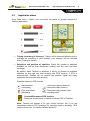
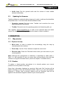
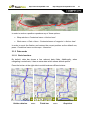
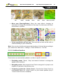
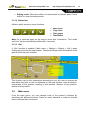
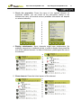
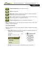
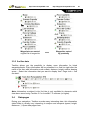
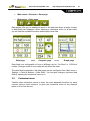

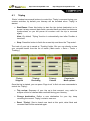

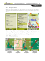
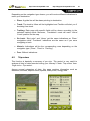
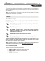
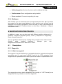
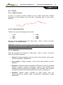
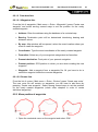
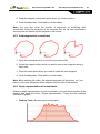

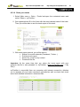
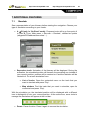
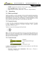
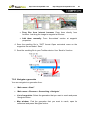
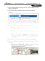
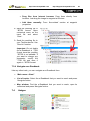

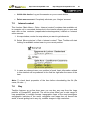
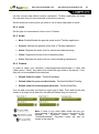
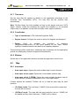
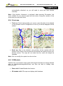
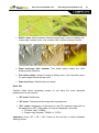
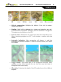
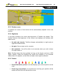

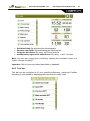
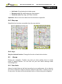
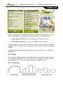


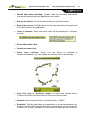
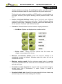

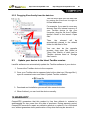
![TwoNav [platform][version]](http://vs1.manualzilla.com/store/data/006156663_1-5deaa8d48af303b2cc7eaad52ecbf272-150x150.png)
![TwoNav [platform][version]](http://vs1.manualzilla.com/store/data/006163237_1-2ed879c8b9cb83b9cbc3a5d3760a7be6-150x150.png)