1
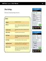
GPS Tuner
Version 5, 2008
Users’ Manual
GPS Tuner
version 5
– Users’ Manual
Table of Contents
Overview ............................................................................................................................................................................................3
Features .............................................................................................................................................................................................4
Installation .........................................................................................................................................................................................6
Registration .......................................................................................................................................................................................7
Quick Reference ................................................................................................................................................................................8
GPS Settings .......................................................................................................................................................................................9
Unit and Coordinate Settings ...........................................................................................................................................................10
Tracklog Settings ...............................................................................................................................................................................11
Other Settings ...................................................................................................................................................................................12
Using Maps ........................................................................................................................................................................................13
Creating Maps ...................................................................................................................................................................................14
Calibrating Maps ...............................................................................................................................................................................15
Map Calibrator ..................................................................................................................................................................................18
Map Settings ......................................................................................................................................................................................19
Map Tools ..........................................................................................................................................................................................21
Map Menu .........................................................................................................................................................................................22
Area Calculation ................................................................................................................................................................................23
Waypoint Manager ...........................................................................................................................................................................24
Waypoints and POIs ..........................................................................................................................................................................25
Track data ..........................................................................................................................................................................................26
Route ..................................................................................................................................................................................................27
Area data ...........................................................................................................................................................................................28
Digital Compass .................................................................................................................................................................................29
Trip Computer ...................................................................................................................................................................................31
NMEA Recording and playback ........................................................................................................................................................33
GPS Share ...........................................................................................................................................................................................34
Technical Specification ......................................................................................................................................................................36
Software License Agreement for GPS Tuner ...................................................................................................................................37
2
GPS Tuner
version 5
– Users’ Manual
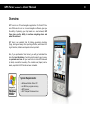
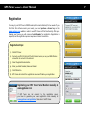
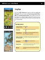
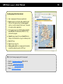
Overview
GPS Tuner is an off-road navigation application for Pocket PC devices. While most in-car or on-road navigation software gives you
the ability of planning your trip based on a road network, GPS
Tuner gives you the ability to continue navigating where and
when the roads end.
GPS Tuner is an excellent tool for hiking, geocaching, boating,
flying, driving and many other sporting activities, where monitoring of duration, distance and speed can be important.
Also, if you purchased a ‘Geo license’, you will get extended features like Area Calculation, a function which makes it easy to measure perimeter and area. All you need to do is active GPS and walk
(or drive) around the boundary. The created area (shape) can be
saved, exported in DXF format and even reloaded.
System Requirements:
Windows Mobile Pocket PC
20 MB free program memory
GPS Receiver
.NET Compact Framework 2.0
3
GPS Tuner
version 5
– Users’ Manual
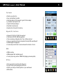
Features
Multilingual
25 Languages
Units and National Coordinate Formats
Optional Metric, Imperial or Nautical units
24 Coordinate Format supported (like WGS-84, British (OSGB36), NAD27, NAD83…)
Mapping
GPS Tuner supports JPG files as maps
Online map downloading from Google Maps and TerraServer
Easy Calibration on Pocket PC or using Desktop Map Calibrator (Freeware)
Auto map loading feature
Zoom and Pan by pen or joystick
Flexible layer and track/route display
Blank map support
Measure distances and define routes by drawing directly on the map
Navigation, Digital Compass
Real time rotating compass with large target arrow
Custom target from entered coordinate
Any waypoint, trackpoint or point of map can be selected as target
6 different types of Compass views
38 selectable Compass tools
Voice navigation and next turn indication for routes
4
GPS Tuner
version 5
– Users’ Manual
Trip Computer
Monitor your whole trip
Save, Load and Reset is possible
Push track data into Trip Computer to get a full track analysis
31 selectable Trip Computer tools
Graph for Altitude and Speed
Selectable tool window size
Speedometer with speed limit warning
Waypoints, POIs, Track, Routes
Waypoint, POI: GPX, LOC, KML files supported
Track, Route: GPX, TRK, KML files supported
Track recording by configurable Auto, Time or Distance interval
View your waypoints and tracks in Google Earth directly (KML export/import)
Flexible waypoint management
You can easily convert track to route and reverse the direction of route
NMEA
NMEA recording
NMEA playback (with selectable speed)
You can jump to any position of NMEA files (skipping unnecessary data)
GPS Share
Share your position in real time with other users
See your friends’ position displayed in GPS Tuner
Monitor your (and your friends’) position on your web browser
SMS interface
5
GPS Tuner
version 5
– Users’ Manual
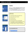
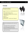
Installation
GPS Tuner runs on any Pocket PC 2003 (Windows Mobile 2003), Pocket PC 2003 Second
Edition (WM2003SE), and Windows Mobile 5 (WM5) devices. Before running GPS Tuner,
you must install .NET Compact Framework 2.0 on your PDA. The .NET Compact Framework 2.0 installer is included in the GPS Tuner installation package for your convenience.
Installation Steps:
1)
Download the GPS Tuner installer from the www.gpstuner.com site.
2) Connect your Pocket PC to your PC via ActiveSync.
3) Start the installer on your PC.
4) Follow the onscreen instructions.
5) Check the .NET Compact Framework 2.0 box if not already installed.
6) You may install GPS Tuner on your SD card instead of Main Memory. Accordingly,
it is recommended that you use a fast SD card for optimal performance.
7) After installation, the GPS Tuner icon will appear on the Start/Programs menu.
You can download GPS Tuner from:
http://www.gpstuner.com
6
GPS Tuner
version 5
– Users’ Manual
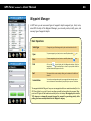
Registration
You may try out GPS Tuner in DEMO mode (with some limitations) for two weeks. If you
find that this software meets your needs, you must purchase a license key on the
www.gpstuner.com website in order to use GPS Tuner with full functionality. After purchasing your license, you will receive a Serial Number for registration. Registration is
required, and the registration process requires an Internet connection.
Registration Steps:
1)
Start GPS Tuner.
2) Connect your PDA to the host PC with Internet access, or use your WiFi Wireless
connection to connect to the internet.
3) Select Register/Activate button.
4) Enter you Serial Number, Name and E-mail.
5) Click OK button.
6) GPS Tuner will contact the registration server and finalize your registration.
Registering your GPS Tuner Serial Number manually at
www.gpstuner.com
If GPS Tuner can not connect to the registration server,
you have to generate your own registration code manually at
www.gpstuner.com/registration then enter it in GPS Tuner.
7
GPS Tuner
version 5
– Users’ Manual
8
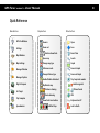
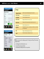
Quick Reference
Main Buttons
Map Buttons
Other Buttons
GPS Info Window
Zoom in
Open
Settings
Zoom out
Save
Buttons show/hide
Map Window
Map Settings
Manager Window
Manager Options
Digital Compass
Set Target
Open map
Search
Change map type
Graph
Fullscreen mode
Zoom in Graph
Change Infobox type
Zoom out Graph
Enable/Disable Autoselect
Trip Comp tool number
Flip/Rotate map
Speedometer
Select waypoint
Picture/Sound
Distance drawing
Route drawing
Trip Computer
Reset/Clear
Show/hide Area buttons
Add/Rec/Stop
URL
Keyboard on/off
Lock to North
GPS Tuner
version 5
– Users’ Manual
9
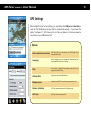
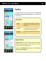
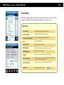
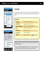
GPS Settings
When using GPS Tuner for the first time, you must define the COM port and Baud Rate in
order for the GPS Receiver and your PDA to communicate properly. If you choose the
option “Configure it!”, GPS Tuner will try to find your Receiver. In this case, please be
sure to turn on your GPS Receiver first!
Options
Auto connection/reconnection
GPS Tuner will try to reconnect to your GPS Receiver if the
communication is lost.
Averaging
When Averaging is on, the program will collect and use averaged coordinates if you are not moving.
Filter
If this option is enabled, Trip Computer works and Track is
logged only when PDOP<15.
Altitude Offset
Helps you to correct the altitude value
Minimum speed
Below this speed GPS Tuner will convert your speed to zero.
Distance Calculation
GPS Tuner calculates distances in 2D/3D/Auto mode
Port: Auto
GPS Tuner tries to search your GPS
GPS Tuner
version 5
– Users’ Manual
10
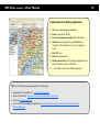
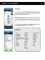
Unit and Coordinate Settings
You may choose between the three major units of measurement: Metric, Imperial, and
Nautical. All GPS data obtained from your GPS Receiver will be converted and correctly
displayed in your preferred measurement format.
Additionally, you may select your preferred Coordinate Grid and Datum format from
among the 24 different National Map Grids that are implemented in GPS Tuner, as well
as coordinate display type from any of three different types of Latitude/Longitude &
UTM. All coordinate display and input is based on these settings (except the GPS Info
Window display, which is always in WGS84 datum).
National Grids
Default (WGS84) Finnish (KKJ) Z3 Italian (ROME40) Z2 Australian (AGD84) Finnish (KKJ) Z4 New Zealand (GD49) Austrian (MGI) M28 German (DH) Z1 Norwegian (NGO48) Austrian (MGI) M31 German GK2 Swedish (RT90) 0gon Austrian (MGI) M34 German GK3 Swedish (RT90) 2.5gon0 British (OSGB36) German GK4 Swedish (RT90) 2.5gonV Dutch (AMERSFRT) German GK5 Swedish (RT90) 5gon0 Egyptian (EGY1907BB) Greek (GGRS87) Swedish (RT90) 5gonV European (ETRS89) Hungarian (EOV) Swedish (RT90) 7.5gonV European (ED1950) Indian (Bangladesh) Swiss (CH1903) LV03 Finnish (KKJ) Z1 Irish (IRLND65) USA (NAD27) Finnish (KKJ) Z2 Italian (ROME40) Z1 USA (NAD83) GPS Tuner
version 5
– Users’ Manual
11
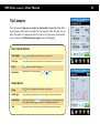
Tracklog Settings
To configure GPS Tuner track recording capability, select Settings/Track option.
Options
Autostart
After launching the program, GPS Tuner will start Track recording automatically .
Autosave
If you select this option, GPS Tuner saves your recorded track
automatically into the predefined folder when you quit the
program.
Auto Interval
GPS Tuner records the necessary points only according to the
given settings. GPS Tuner records a position:
Min. Angle:
If the direction change is greater than selected
AND
Min. Distance: If the distance from the last recorded point is
greater than selected OR
Max. Distance: If the distance from the last recorded point is
greater than selected OR
Max. Time:
If the time lapse since the last recorded point
greater than selected
Time Interval
GPS Tuner will record points according to your time settings. For
a detailed track record set a time interval 1 or 2 seconds.
Distance Interval
GPS Tuner records points based on your distance settings.
Start/Stop Track logging
Track logging can be easily activated and deactivated in the
Manager Options window.
GPS Tuner
version 5
– Users’ Manual
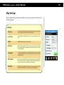
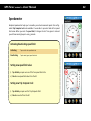
Other Settings
Define various uncategorized settings in this section.
Options
Language
Language of User Interface
GPS Share
Connect to GPS Share System and send/receive position data.
Enter your registered login and password and the interval of
data exchange.
Conn/Nav Sound
Enable/Disable the voice instructions for navigation and connection.
Position Sound
Enable/Disable the position processing sound
Color Scheme
Choose between Day or Night User Interface design. The ’Auto’
option sets Day/Night automatically, based on time and sunrise/
sunset values.
Screen Pager
Define a Hardware Button to switch to the next screen.
Saving Recovery Info
If this option is enabled, GPS Tuner creates backup files for track
and area recording in case of an unwanted system halt.
Waypoint option
GPS Tuner can notify you about waypoints near you. When
approaching a waypoint in the selected range, GPS Tuner displays a popup info window and plays a sound file (if it is attached to the waypoint).
12
GPS Tuner
version 5
– Users’ Manual
13
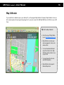
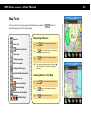
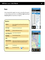
Using Maps
GPS Tuner can handle customized maps. The maps can be blank maps, as well as any
JPEG image file. JPEG maps can also be created from other image formats (GIF, PNG or
BMP) by the free desktop program Map Calibrator. The size limitation for the use of JPG
maps depends on your storage card capacity. By loading only the necessary area of map
files needed for your immediate use, GPS Tuner becomes a very “memory friendly” solution for large map images.
Basic Map Operations:
Press the
button
Opening Map
Press the
button then select JPG map file from the list
Changing Map Type
Press the
button to change map type (Bitmap, Blank Map, Online
Maps — like Google Maps or TerraServer Maps)
Zooming and panning
with five-way joystick
Use the middle button to switch between panning and zooming mode. Use
the four-way buttons for panning and the up & down buttons for zooming.
Zooming in/out
Press the
Panning the map
In order to move (pan) the map with your pen, simply drag it. If you click
shortly over a map position, GPS Tuner centerizes it.
Map menu
Tap & hold your pen over the map to reach the map menu. Please do not
move the pen!
Showing tool buttons
buttons for zooming in/out the map
GPS Tuner
version 5
– Users’ Manual
Creating Maps
Creating maps from printed maps
1)
Scan your printed map (with a scanner or a digital camera) and save it as a JPG
file.
2) Do not use progressive encoding during JPG saving.
3) Upload map image file to your Pocket PC (via ActiveSync / IrDA / Bluetooth or
copy it to a Memory Card).
4) Start GPS Tuner.
5) Open the map image file.
6) Set the calibration points. ) See details in the section “Calibrating maps”
Tip: When using a scanned/photographed map in GPS Tuner, please note the following:
When scanning maps for GPS Tuner, we suggest a 96 dpi resolution.
For best results, keep map pixel size under 5000 x 5000 pixels.
Keep file size under 20 MB (use higher compression if necessary).
Although GPS Tuner supports the calibration of rotated maps, for best results we
suggest to use North-oriented maps.
14
GPS Tuner
version 5
– Users’ Manual
15
Creating maps from desktop applications
1)
Start your desktop mapping application.
2) Export a map slice as JPG file.
3) Do not use progressive encoding during JPG saving.
4) Upload the map image file to your Pocket PC (via
ActiveSync / IrDA / Bluetooth or copy it to a Memory
Card).
5) Start GPS Tuner.
6) Open the map image file.
7) Obtain position data from the mapping. application and
set the calibration points in GPS Tuner.
8) ) See details in the section “Calibrating maps”
Tip: Try the following mapping applications for map export:
Google Earth (free application) – http://earth.google.com
Microsoft AutoRoute – http://www.microsoft.com/uk/homepc/autoroute/
Route 66 – http://www.66.com
List of other Desktop Mapping Applications: http://www.directionsmag.com/companies/products/category/
Desktop_Mapping/
GPS Tuner
version 5
– Users’ Manual
Creating maps from the internet
1)
Go to a mapping site (like www.expedia.com)
2) Export a map slice as JPG, GIF, PNG or BMP file (right
click over the image and select the Save image as...
option, or use the command “print screen”, then paste
into a photo editor application).
3) If the saved image is not a JPEG file please convert it
into a JPG file with desktop Map Calibrator or any
photo editor program
4) Upload the map image file to your Pocket PC (via ActiveSync / IrDA / Bluetooth or copy it to a Memory Card)
5) Start GPS Tuner
6) Open the map image file
7) Obtain position data from a mapping site (if possible)
and set the calibration points in GPS Tuner.
Tip: Try the following mapping sites for map export:
Expedia – http://www.expedia.com (Maps section)
Multimap – http://www.multimap.com
Google Maps – http://maps.google.com
Map24 – http://www.map24.com
16
GPS Tuner
version 5
– Users’ Manual
Calibrating Maps
After creating a map out of a picture file, you must calibrate it. This process adds two
geographical coordinates as reference points on the map. Only after calibrating the map
will GPS Tuner be able to display your correct position (or your partner’s position, track
and route) on the map. Calibration is easy, all you need to do is to provide the geographical coordinates of at least two points.
Calibration Steps:
1)
Open a map image file
2) Tap & hold a point on the map (if you are calibrating a map with active GPS, tap
your location on the map).
3) Select the option Add new/Calib point from the popup menu.
4) Enter the point’s Lat/Lon or UTM coordinate of the point or select one of your
waypoints. If you are using active GPS, GPS Tuner will enter your current coordinate into the text boxes.
5) Press the OK button and add another calibration point (if necessary).
6) Calibration points should be as far from each other as possible, and not be in
line (neither horizontally nor vertically)
After you have added or modified a calibration point, GPS Tuner saves your calibration data file automatically. The data of the calibrated map is stored in a .gmi file
with the same base name as the picture file. The map can be recalibrated any time.
The map image file and .gmi file have to be in the same folder. You can also see
your calibration points on the list in the Manager window.
17
GPS Tuner
version 5
– Users’ Manual
18
Map Calibrator
If you would like to calibrate maps on your desktop PC, use the program Map Calibrator (freeware). Map Calibrator is also useful to create map slices from a huge bitmap image file. You can also convert GIF, BMP and PNG files into JPG files to use in GPS
Tuner.
Tip: Get free Map Calibrator
Get a free copy of Map Calibrator on http://www.gpstuner.com
Map Calibrator can also open
and save waypoint, track, route
and area files.
You can download calibrated
maps from internet into Map
Calibrator and save them to use
on your PDA.
You can change the slice size
and JPEG file quality.
Map Calibrator also supports
National Map Grids.
GPS Tuner
version 5
– Users’ Manual
Map Settings
Reach the Map Settings by tapping the Map icon (you can also reach this window from
the Settings panel).
Settings:
Map Type
Choose between Bitmap, Blank Map, Google Map, Google Sat, TerraServer
Topo, TerraServer Sat or TerraServer Urban map type
Cursor Type
Choose between a Directional arrow or a Cross indicator as your cursor
type
Infobox
Selectable info box on top of the map screen
Autoselect
With this option enabled, GPS Tuner will try to find and load new maps
from a preconfigured map folder (and its subfolders) once you leave the
current map border.
Overlapping
To load a new map before you reach the edge of the current one, enable
the Overlapping function and enter its value (only works together with the
Autoselect option).
GPS Centered
With this option enabled, GPS Tuner centers the map to your GPS position.
If you pan the map while this option is enabled, it will automatically recenter to your position 5 seconds after the last interaction.
Rotate/Flip
With this option enabled, GPS Tuner flips (the bitmap map type) or rotates
(the Blank Map type) the map according to your moving direction.
19
GPS Tuner
version 5
– Users’ Manual
20
Settings:
Waypoint Density
Defines the amount of displayed waypoints & routepoints.
Track Density
Controls the displayed track details.
Track Width
Controls the displayed track width.
Track Arrows
Displays small direction arrows on your track.
Track Points
Displays small dots (representing the trackpoints) on your track.
Track Color
Defines the displayed track color.
Projection
Displays/disables a light cone according to your direction, or a red line to
your selected target.
Grid
Displays a Latitude/Longitude grid on the map.
Layers
Defines which objects are displayed on the map.
Tip: You can improve the displaying speed of the map by switching off unnecessary
display features.
Set Waypoint and Track Density to 1 or 2
Turn off Track Arrows and Points
Disable Map Grid display and Icons in Layer section
GPS Tuner
version 5
– Users’ Manual
21
Map Tools
You can control the map by map tools (buttons) very easily. Use
show/hide map tools in the map window.
buttons to
Measuring Distances:
Zoom in
1.)
Select
button from tools. Distance header
box will appear.
2.)
Click
button in the header to start measuring
and draw your path on the map
Change map type
3.)
Click
Fullscreen mode
4.)
After drawing a distance path you will see a
sign. This helps you to continue the drawing if
necessary.
Zoom out
Buttons show/hide
Open map
Change Infobox type
Enable/Disable Autoselect
button to reset the distance counter
Drawing Route on the Map:
Flip/Rotate map
Distance drawing
1.)
Select
button from tools. Route header box
will appear.
Route drawing
2.)
Click
button in the header and draw your
path on the map
3.)
Click
Show/hide Area buttons
Add/Rec/Stop
button to reset the route
GPS Tuner
version 5
– Users’ Manual
22
Map Menu
Several important operations are done through the map menu. To activate the map
menu, hold down your pen for half a second over the map (or over a waypoint). Please
do not move the pen!
Basic Operations
Add new...
You can add new Calibration Point, Waypoint, POI or Routepoint at this
map position. If your map is not yet calibrated, you will able to add a
Calibration Point only.
Set as Target
You can select this map position as target. If you have activated the menu
over a waypoint, the selected target will be the waypoint itself.
Set GPS Cursor
If your GPS is not active, you can relocate the GPS cursor to this map position.
Waypoint Operations
Additional operations can be done when bringing the map menu over a map object
(calibration point, waypoint, trackpoint, etc). The operations are similar to the ones
used in the context menus of the Manager window.
Generally you can View/Modify, Delete, Copy an object. You can also split or combine tracks, and delete track segments.
GPS Tuner
version 5
– Users’ Manual
Area Calculation
If you purchased a ‘Geo license’, you will get extended features like Area Calculation, a
function which makes it easy to measure perimeter and area. All you need to do is active
GPS and walk (or drive) around the boundary. The created area (shape) can be saved,
exported in DXF format and even reloaded.
Measuring steps:
1)
Load a map
2) Tap the
by icon or use a Blank map.
icon to show the Area Calculation toolbar.
3) Choose
icon for starting automatic recording (the recording interval is the
same as the Track recording interval and can be set in the Settings/Track section.
4) You also have the opportunity to manually add a point: tap the
button and
your actual position will be added to the already existing boundary points.
5) If you decide to finish measuring, tap the
button. The area (shape) will be
closed. Make sure that the polygon does not intersect itself.
6) The result (area and perimeter) is displayed in the map window (while the Label
layer is active), and in the Manager window (select View from the context
menu).
7) If you would like to save the Area file, please use the Save icon
in the Manager window. You can reload an Area file by selecting the
button.
23
GPS Tuner
version 5
– Users’ Manual
24
Waypoint Manager
In GPS Tuner you can use several types of waypoint objects: waypoint, poi, track, route,
area. With the help of the Waypoint Manager, you can easily create, modify, open, and
save any type of waypoint objects.
Basic Operations
Select type
Changes the type of listed waypoints by the combo box below the list.
Open
To open a waypoint, poi, track, route or area file please select
icon.
Save
To save a waypoint, poi, track, route or area file please select
Find
Click on the
icon to display the Find Waypoints window. Only the
waypoints containing the entered text or closer to your position than the
entered distance will appear on the list.
Sort
The waypoint list can be sorted by clicking on the header of the different
columns.
Context Menu
You can do several operations with your waypoint data through context
menus. Activate the Context Menu by tap & hold your pen over a list item.
icon.
The waypoints labeled ‘Waypoint’ are your own waypoints which are saved automatically in the
GPS Tuner folder (so you don’t have to save them manually before quitting the program). Waypoint and POI types will be loaded automatically at the next startup. We suggest you to use the
‘POI’ category as a temporally waypoint storage (for example for geocaching points), while
putting your own recorded positions into the ‘Waypoint’ category.
GPS Tuner
version 5
– Users’ Manual
25
Waypoints and POIs
A Waypoint is a geographical coordinate (latitude and longitude) with some additional
information such as: altitude, name, type, description, linked photo or sound. An important or significant waypoint is referred to as a ‘POI’ (Point of Interest), and is usually
saved for future reference. A good example of POI’s are geocaching points, or a favorite
restaurant.
Operations:
Add new...
Adds a new Waypoint/POI with this option. If your GPS is active, GPS Tuner
will fill out the actual coordinate.
Set as Target
Sets a Target Point to the selected Waypoint/POI.
Locate on Map
Displays the selected Waypoint on the map.
Copy as Route
Copies the Waypoint/POI as Route Point.
Copy as Waypoint/POI
Copies the Waypoint as POI (or POI as Waypoint).
View/Modify
View and modify Waypoint/POI data.
Delete
Delete Waypoint/POI with this function.
Clear all
Clears all Waypoints/POIs. While your waypoints are deleted physically, the
POI data will stay in the file (just unlinked from GPS Tuner). Please note
that you can not undo the Delete and Clear operations.
Open/Save
Open and save Waypoint/POI by the
and
buttons.
GPS Tuner
version 5
– Users’ Manual
26
Track data
With Track Logging enabled, GPS Tuner saves your path as trackpoints. Besides the geographical coordinates, also altitude, speed and heading information is saved.
Operations:
Set as Target
Sets the Target Point to the selected Trackpoint.
Locate on Map
Displays the selected Trackpoint on the map.
Copy as Route/Wayp/POI
Copies the Trackpoint as Routepoint/Waypoint/POI.
View
Displays Trackpoint data.
Delete/Clear all
Deletes one or all Trackpoint(s).
Split/Combine
Splits (divides into two segments) or combines the track.
Delete Segment
Deletes a whole track segment.
Simplify
Eliminates unnecessary points from the track line display.
Push to Trip Comp
Analyses the track by pushing its data into the Trip Computer. Your
current Trip Computer values will be lost.
Convert to Route
Converts track to route by eliminating unnecessary points.
Open/Save
Open and save a Track using the
and
buttons.
GPS Tuner
version 5
– Users’ Manual
27
Route
A chain of waypoints defines a route. You can create a route by defining the waypoints,
or convert a previously saved track into a route. GPS Tuner navigates you over your
route point by point (even accompanied by voice navigation).
Operations:
Add new...
Adds a new Waypoint/POI. If your GPS is active, GPS Tuner will fill out the
actual coordinate.
Set as Target
Sets Target Point to the selected Routepoint.
Locate on Map
Displays the selected Routepoint on the map.
Copy as Waypoint/POI
Copies the Routepoint as Waypoint/POI.
View/Modify
View and modify Waypoint/POI data.
Delete
Deletes Waypoint/POI.
Up/Down/Backtrack
Change the order of Routepoints by the Up and Down commands, or
change the direction of the whole route by the Backtrack command.
Clear all
Clear all Routepoints.
Open/Save
Open and save Route using the
and
buttons.
GPS Tuner
version 5
– Users’ Manual
28
Area data
If you record an area shape or load an area from a file, you can view or modify it in the
Manager Window. The Area Calculation Function is available with a Geo license of GPS
Tuner.
Operations:
Set as Target
Sets Target Point to the selected Area point.
Locate on Map
Displays the selected Area point on the map.
Copy as Route/Wayp/POI
Copies the Area point as Routepoint/Waypoint/POI.
View
Displays point, area and perimeter data.
Delete/Clear all
Deletes one or all Area point(s).
Delete Segment
Deletes a whole area segment.
Open/Save
Open and save Area using the
and
buttons.
Tip: If you export area shapes as DXF files, polygons will be saved in UTM coordinate
format (WGS84 datum).
Please note that DXF is an export format only, so you will not able to load DXF files
into GPS Tuner next time! We suggest to save areas also as GPX or TRK files.
GPS Tuner
version 5
– Users’ Manual
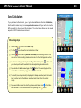
Digital Compass
With the help of the Digital Compass, you can easily get to a previously set geographical
coordinate, a selected waypoint, or pass along a way (or its waypoints) from the beginning to the end.
Setting Target:
1.)
Tap the Compass icon again, and type in the geographical coordinates of the target point or choose an
item from the waypoint list (
).
2.)
Then click on the ‘Set’ button.
3.)
To reset (clear) the target point, press ‘Reset’.
OR
1.)
Tap a point on the map and select the Set as target option from the appearing menu.
OR
1.)
Tap an object (waypoint, geocaching point, track point, route point, partner) on the map and select the
Set as target option from the appearing menu. Now the exact coordinates of the given object will become a target point.
If you set a route point to be a target point, and you come close to it, GPS Tuner will automatically select the
next route point in order to help you pass along your route continuously. You will see the direction of the next
target point displayed and also a small sign will appear which shows you which way to turn (this is especially
useful when driving your car). Also, before reaching turns, a human voice will tell you which way to turn, in a
distance depending on your speed. In case you set a Partner as a target point (moving target point), GPS Tuner
will continuously change the geographical coordinates of the target point (hold on target mode).
29
GPS Tuner
version 5
– Users’ Manual
30
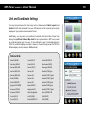
Compass Tools
You can choose from seven categories (Walking, Climbing, Biking, Driving, Boating, Flying, Custom) with predefined tools. Change categories by pressing Up and Down on the
joystick, or by clicking in the Map Options window.
Each category has three pages. The first page is dedicated to “no-target” navigation, the
second one for a single target and third one for route navigation. You can go to the next
or previous page by pressing Right and Left on the joystick, or by pressing the green arrows.
In the Digital Compass window there are seven configurable tool places for each category, containing 38 different tools. Change a tool by clicking on it.
Compass tools
Distance
Vertical Difference
Current Direction
Target Direction
Estimated Time Enroute (ETE)
Estimated Time of Arrival (ETA)
Target Info
Tilt
Altitude
Max Altitude
Min Altitude
Trip Length
Climb Elevation
Climb Distance
Climb Rate
Climb Time
Descent Elevation
Descent Distance
Descent Rate
Descent Time
Flat Distance
Flat Rate
Flat Time
Speed
Max Speed
Average Speed
Moving Average Speed
Vertical Speed
Acceleration
Max Acceleration
Min Acceleration
Total Time
Moving Time
Stopped Time
Next Turn
Sunrise
Sunset
Actual Time
GPS Tuner
version 5
– Users’ Manual
31
Trip Computer
The Trip Computer helps you to monitor the characteristics of your trip. While GPS is
active (the green Start button is pressed), the Trip Computer collects trip data. You can
define the number of tools/page and also the order of tools. By pressing the Graph button, you can view the Altitude and Speed graph (in case of tracklogging).
Trip Computer Options:
Tool number
Tap
icon to change the number of tools on a page (2,4 or 6).
Tool type
You are able to redefine a tool by clicking on it and selecting a new one from the list.
Reset
Tap
Open/Save
Opens and saves Trip Computer data by
button to reset the Trip Computer.
and
buttons.
Graph Options:
Show
Tap
icon in Trip Computer to view Altitude or Speed Graph.
Graph type
Change the type of Graph by the arrows in the headline or using the middle button.
Zoom & Pan
Zoom in/out the Graph by
buttons or using the Up & Down joystick buttons.
Pan the graph using the big green arrows or the Left & Right joystick buttons.
Info
By clicking on a point of the graph, you get detailed information about that point.
GPS Tuner
version 5
– Users’ Manual
Speedometer
Graphical speedometer helps you to visualize your actual movement speed. One configurable Trip Computer tool is also available. You are able to pre-select and set four speed
limit values. When you reach the speed limit, it changes its color from green to red and
you will hear warning beeps in every 3 seconds.
Activating/deactivating speed limit:
Activating
Tap one of the four speed limit circle
Deactivating
Tap the active (green) speed limit circle
Setting new speed limit value:
1)
Tap & hold your pen over one of the four speed limit circle
2) Select a new speed limit value from the list
Setting new Trip Computer tool:
1)
Tap & hold your pen over the Trip Computer field
2) Select a new tool from the list
32
GPS Tuner
version 5
– Users’ Manual
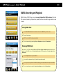
NMEA Recording and Playback
With the help of GPS Tuner, you can save and playback the NMEA sentences from the
GPS receiver (containing the position, speed, direction and satellite signal data in raw
format).
Saving NMEA data:
1.)
Press the Record button and set the location and name of the NMEA file you want to save.
2.)
Press the ‘Save’ button.
3.)
GPS Tuner starts NMEA recording automatically.
4.)
You can stop recording by pressing the Stop or Play buttons, and pause it by Pause button.
Replaying NMEA data:
When opening a TXT file containing NMEA data, GPS Tuner will turn simulation mode on and starts to play
back the recorded NMEA sentences. During simulation mode, GPS Tuner works as if it acquired signs from a
GPS Receiver.
1.)
Press the Play button and open an NMEA file.
2.)
You can define replay speed (0.25X—5X, with 1X being real-time speed)
3.)
You can jump to any position of the NMEA file (skipping unnecessary data) with the help of the trackbar.
4.)
You can stop replay by pressing the Stop or Record buttons, pause it by the Pause button.
33
GPS Tuner
version 5
– Users’ Manual
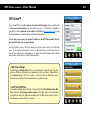
GPS Share™
If your Pocket PC has an active internet connection while traveling, then you will be able
to share your actual position with other GPS Tuner users. This function is available to
you after you have registered on the website of GPS Share (www.gpsshare.com), using
the Serial Number you acquired when purchasing the program.
You can also see your and your partners’ position on the GPS Share website. This feature turns GPS Tuner into a personal tracker.
Via the GPS Share service, GPS Tuner sends your actual position data to the GPS Share
server for your authorized partners to access. At the same time, you will access the positions of your partners who authorized you to share their position data as well. Partner
authorization can be done on the GPS Share website.
GPS Share settings
By selecting the Settings/Other option, you can enter your registered login and password, so GPS Share can identify you independently from your device. Depending on
your interval settings, GPS Tuner creates a connection with the GPS Share server,
transmits your actual position and downloads your partners’ data.
Start/Stop GPS Share
Active data exchange can be started or stopped with the Start GPS Share/Stop GPS
Share button in the Manager Option window. After GPS Tuner has downloaded
your partners’ data, their positions are displayed in the Map window and on the list
in the Manager window (Partner category).
34
GPS Tuner
version 5
– Users’ Manual
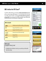
SMS Interface for GPS Share™
If your PDA is a Pocket PC Phone, you are able to remotely activate/deactivate GPS Share
service on your by sending a SMS message to it. You can start/stop the GPS or GPS Share
on your PDA, set the time interval or just simply get the actual position of your device in
an answer SMS. After you have sent a control SMS, you will get an answer SMS back with
the last known position of your PDA and your command status.
SMS Commands:
gs:PWD
All SMS has to start with "gs:PWD" where PWD is your GPS Share password.
start
Starting the GPS and GPS Share on your PDA
stop
Stopping the GPS and GPS Share on your PDA
interval X
Setting the time interval of GPS Share data exchange
gpsstart
Starting the GPS only
gpsstop
Stopping the GPS only
SMS Sample:
gs:mypass12 interval 30 start
This SMS will set the GPS Share's interval to 30 sec and start your GPS and GPS
Share data exchange.
35
GPS Tuner
version 5
– Users’ Manual
36
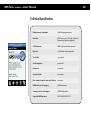
Technical Specification
Minimal memory requirement
15 MB free program memory
Resolution
QVGA (240 x 320) , VGA (480 x 640) and
Square screen types are supported
GPS Data format
NMEA 0183 standard data sentences
Map Grid
24 Coordinate Format supported
Track buffer
15.000 points
Custom waypoints
5.000 points
Routepoints
5.000 points
Area point buffer
5.000 points
Max. number of maps for auto select function
2000 maps
NMEA buffer (in each category)
5 NMEA sentences
Processing rate (in each category)
5 NEMA sentences/sec
Supported NMEA sentences
GGA, GSA, GSV, RMC, VTG
GPS Tuner
version 5
– Users’ Manual
Software License Agreement for GPS Tuner
DEFINITIONS
a) ("Megalith") refers to Megalith Products.
b) ("LICENSEE") refers to the entity acquiring this license.
GRANT OF LICENSE and DISTRIBUTION.
The OBJECT may be installed on one PocketPC device per licensee.
COPYRIGHT.
The SOFTWARE is owned by Megalith and is protected by Copyright laws and international treaty provisions.
OTHER RESTRICTIONS.
You may not rent or lease the SOFTWARE but you may transfer the SOFTWARE and accompanying written materials on a permanent basis provided you retain no copies
and the recipient agrees to the terms of the agreement. You may not reverse engineer, decompile or disassemble the SOFTWARE. If the SOFTWARE is an update, any
transfer must include the update and all prior versions in your possession.
PROPRIETARY RIGHTS.
All copyrights, patents, trade secrets, trademarks and other intellectual and proprietary rights in the SOFTWARE are and shall remain the valuable property of Megalith,
or the Author of the SOFTWARE. You agree to take all necessary steps to ensure that the provisions of this agreement are not violated by you or by any person under
your control or in your service.
LIMITED WARRANTY.
Megalith warrants that the SOFTWARE will operate substantially in accordance with its accompanying documentation for a period of trial days. This warranty is void if
failure of the SOFTWARE has resulted from accident, abuse or misapplication. YOU ARE THE ONLY BENEFICIARY OF THIS WARRANTY. YOU MAY NOT PASS THIS WARRANTY ON TO OTHERS. Although Megalith has tested the SOFTWARE on several software and hardware platforms, this SOFTWARE is licensed AS IS and you, the licensee,
are assuming the entire risk as to its quality and performance.
NO LIABILITY FOR CONSEQUENTIAL DAMAGES. IN NO EVENT SHALL Megalith BE LIABLE FOR ANY DIRECT, INDIRECT, SPECIAL, INCIDENTAL OR CONSEQUENTIAL DAMAGES WHATSOEVER (INCLUDING WITHOUT LIMITATION, DAMAGES FOR BUSINESS INTERRUPTION, LOSS OF PROFITS OR DATA, OR OTHER PECUNIARY LOSS) ARISING OUT
OF THE USE OF OR INABILITY TO USE THE SOFTWARE OR DOCUMENTATION EVEN IF Megalith HAS BEEN ADVISED OF THE POSSIBILITY OF SUCH DAMAGES. Megalith
SHALL HAVE NO LIABILITY FOR ANY DATA READ, ACCESSED, STORED OR PROCESSED WITH THE SOFTWARE, INCLUDING THE COSTS OF RECOVERING SUCH DATA. IN NO
CASE SHALL Megalith's LIABILITY EXCEED THE FEES PAID BY YOU FOR THE SOFTWARE. BECAUSE SOME STATES DO NOT ALLOW THE EXCLUSION OR LIMITATION OF
LIABILITY FOR CONSEQUENTIAL OR INCIDENTAL DAMAGES, THE ABOVE LIMITATION OR EXCLUSION MAY NOT APPLY TO YOU.
GENERAL
If any provision of this agreement is found to be invalid by any court of competent jurisdiction, the balance of this agreement shall remain in full force and effect.
GPS Tuner © 2008 - Megalith, Gabor Tarnok
37