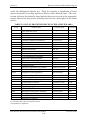
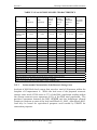
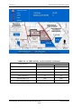
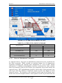
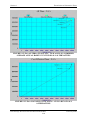
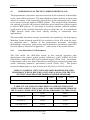
1
CENTRAL AND SOUTHERN FLORIDA PROJECT
EVERGLADES AGRICULTURAL AREA STORAGE RESERVOIRS
REVISED DRAFT
INTEGRATED PROJECT IMPLEMENTATION REPORT
ENVIRONMENTAL IMPACT STATEMENT
U.S. ARMY CORPS OF ENGINEERS
JACKSONVILLE DISTRICT
FEBRUARY 2006
SOUTH FLORIDA WATER
MANAGEMENT DISTRICT
This Report Contains 2 Volumes
You Are Here
Volume 1 – Main Report
• Abstract
• Foreword
• Executive Summary
• Table of Contents
• Section 1 – Introduction
• Section 2 – Existing Conditions / Affected Environment
• Section 3 – Future Without Project Conditions
• Section 4 – Identification of Problems and Opportunities
• Section 5 – Formulation of Alternative Plans
• Section 6 – The Selected Alternative Plan
• Section 7 – Environmental Effects of the Selected Plan
• Section 8 – Plan Implementation
• Section 9 – Summary of Coordination and Environmental Compliance
• Section 10 – Recommendations
• Section 11 – Glossary of Terms and Acronyms
• Section 12 – Preparers of the PIR
• Section 13 – References
• Section 14 – Index
Volume 2 – Annexes and Appendices
• Annex A – U.S. Fish and Wildlife Service Draft Fish and Wildlife
Coordination Act Report and U.S. Army Corps of Engineers
Responses
• Annex B – Section 404(b)(1) Evaluation
• Annex C – CZMA Consistency Evaluation
• Annex D – Revised Draft Project Operating Manual
• Annex E – RECOVER Reports
• Annex F – Water Quality Monitoring Plan
• Annex G – Legislative and Statutory Requirements
• Annex H – Pertinent Correspondence
• Appendix A – Engineering
• Appendix B – Economic and Social Considerations
• Appendix C – Environmental
• Appendix D – Recreation
• Appendix E – Real Estate
• Appendix F – Draft Water Quality Assessment Report
CENTRAL AND SOUTHERN FLORIDA PROJECT
EVERGLADES AGRICULTURAL AREA STORAGE
RESERVOIRS
REVISED DRAFT INTEGRATED
PROJECT IMPLEMENTATION REPORT
AND
ENVIRONMENTAL IMPACT STATEMENT
U.S. ARMY CORPS OF ENGINEERS
JACKSONVILLE DISTRICT
FEBRUARY 2006
SOUTH FLORIDA WATER
MANAGEMENT DISTRICT
This page intentionally left blank
Abstract
EVERGLADES AGRICULTURAL AREA STORAGE RESERVORS
INTEGRATED PROJECT IMPLEMENTATION REPORT
AND
ENVIRONMENTAL IMPACT STATEMENT
Responsible Agencies: The lead agency is the U.S. Army Corps of Engineers, Jacksonville
District. The South Florida Water Management District is the non-Federal cost-sharing partner
for the study.
Abstract: Current operations of the C&SF Project involve water supply and flood releases to
manage water levels in Lake Okeechobee, the Water Conservation Areas, and the East
Everglades. Lake management practices have resulted in higher than desirable lake levels
associated with periodic large freshwater discharges to both the Caloosahatchee and St. Lucie
River Estuaries, which has severely disrupted productivity in the ecological communities in
those estuaries. The high lake levels also damage the ecological communities within the lake’s
littoral zone. System changes have also resulted in water deliveries to the Greater Everglades
that include higher peak flows following major rain events, and flow rates that decline more
abruptly following the end of the wet season. While lowering lake levels is a recognized need,
there is also a need to maintaining existing levels of water supply for agricultural and public
purposes. These issues highlight the balance that the CERP, and the EAA Storage Reservoir
project as an integral part of the CERP, must achieve to be successful.
This integrated Revised Draft Project Implementation Report (PIR) and Draft Environmental
Impact Statement (DEIS) documents the selection of a recommended alternative plan, for
restoration of the South Florida ecosystem, located within the Everglades Agricultural Area. The
study area included portions of western Palm Beach County. The features of the plan include
an above ground reservoir, Stormwater Treatment Area (STA), and improvements to primary
and secondary canals. The reservoir covers approximately 31,000 acres, with a storage capacity
of 360,000 acre-feet. It is located on lands previously acquired for restoration activities in the
Everglades ecosystem by the Department of the Interior and the South Florida Water
Management District. It would provide water storage from Lake Okeechobee and the EAA basin
via the Miami Canal, North New River Canal, and Bolles and Cross Canals and redistribution of
water through improvements to these canals. Embankments enclosing the reservoir are 23 feet
high to accommodate extreme rainfall and wind events. Embankments would have a top width of
12 feet, and incorporate underground cutoff walls to provide stability and prevent excessive
seepage into adjoining areas. A 1,495 acre STA will provide water quality improvements for
waters directed south to meet natural system demands in the Everglades region. Additional
features include improvements to existing pump stations G-372 and G-370, construction of two
new pump stations, and construction of new borrow/seepage canals. The reservoir and STA
would contribute to Everglades restoration by improving the quantity, quality, timing and
distribution of water within the greater Everglades. The selected alternative plan will benefit
Lake Okeechobee, St. Lucie and Caloosahatchee Estuaries, Water Conservation Areas and
Everglades National Park. Additionally, the plan will have localized benefits include
wetlands, deep water refugia delivery canals, and terrestrial habitat.
THE OFFICIAL CLOSING DATE FOR THE
RECIEPT OF COMMENTS IS 45 DAYS FROM
THE DATE ON WHICH THE NOTICE OF
AVAILABILITY OF THIS EIS APPEARS IN
THE FEDERAL REGISTER.
EAA Storage Reservoir Revised Draft PIR and EIS
If you require further information on this
document, contact:
Ms. Rebecca Weiss
U.S. Army Corps of Engineers, P.O. Box 4970,
Jacksonville, Florida 32232-0019
Telephone: 904-232-1577
E-mail: [email protected]
February 2006
Abstract
This page intentionally left blank
EAA Storage Reservoir Revised Draft PIR and EIS
February 2006
Foreword
FOREWORD
A note to the reader of this Revised Draft PIR/SEIS
Prior to completion of this Revised Draft Project Implementation Report (PIR)
and Supplemental Environmental Impact Statement (SEIS), the State of Florida
determined that it was urgent to accelerate funding, design, and construction of
critical restoration projects to capture immediate environmental, social, and
economic benefits in the South Florida region. To that end, the State of Florida’s
“Acceler8” program was established, including the Everglades Agricultural Area
Reservoir A-1 project. The South Florida Water Management District (SFWMD)
is the state agency responsible for water resources management in South Florida
and acts as the non-federal sponsor for federal water resources projects,
including the Comprehensive Everglades Restoration Plan (CERP).
The
SFWMD is also responsible for implementing the Acceler8 program.
Since the SFWMD anticipated that the review of this Draft PIR/SEIS under the
CERP Programmatic Regulations, Corps of Engineers policy requirements, and
public and agency review requirements of NEPA, followed by subsequent
preparation and submittal of a Final PIR/SEIS for eventual Congressional
review and authorization were not likely to be completed on the construction
schedule originally established by the SFWMD for the Everglades Agricultural
Area Reservoir A-1 project, the SFWMD decided to pursue a Corps of Engineers
regulatory permit issued under Section 404 of the Federal Clean Water Act
(supported by a separate regulatory EIS) for the Acceler8 project so that
construction could begin as scheduled in 2006.
The Acceler8 project (Everglades Agricultural Area Reservoir A-1 project) is
similar to a component of the NEPA preferred alternative or Tentatively
Selected Plan, described in this Revised Draft PIR/SEIS. The SFWMD’s
proposed Acceler8 project represents approximately one-half the dimensions
(e.g., area and storage volume) of the PIR preferred alternative. The purposes of
the preferred alternative identified in this Draft PIR and the Acceler8 project are
consistent, but the completion of the Regulatory EIS and receipt of associated
permits and required land use approvals are expected to occur more quickly than
a final agency decision on this PIR/SEIS, thereby enabling the SFWMD to
initiate construction in 2006 as scheduled.
The Draft Regulatory EIS is available for public and agency review at the same
time as this Revised Draft PIR/SEIS for the proposed Federal project. For
details of the Acceler8 project, the reader is referred to the Regulatory EIS. The
availability of both documents will be noticed in the Federal Register and the
Regulatory SEIS will be posted on the Jacksonville Corps District web site
(http://www.saj.usace.army.mil/) and this Revised Draft PIR/SEIS is posted on
the CERP website (http://www.evergladesplan.org).
EAA Storage Reservoirs Revised Draft PIR and EIS
February 2006
Foreword
This page intentionally left blank
EAA Storage Reservoirs Revised Draft PIR and EIS
February 2006
Executive Summary
CENTRAL AND SOUTHERN FLORIDA PROJECT
EVERGLADES AGRICULTURAL AREA STORAGE RESERVOIRS
REVISED DRAFT INTEGRATED
PROJECT IMPLEMENTATION REPORT
AND
ENVIRONMENTAL IMPACT STATEMENT
EXECUTIVE SUMMARY
The U.S. Army Corps of Engineers (USACE), Jacksonville District in cooperation
with its co-sponsor, the South Florida Water Management District (SFWMD),
has prepared a Revised Draft Integrated Project Implementation Report (PIR)
and Environmental Impact Statement (EIS) for the Everglades Agricultural
Area (EAA) Storage Reservoirs project in western Palm Beach County, Florida.
This report describes the purpose and need for the project, location, and
evaluations conducted which affirmed that an above–ground storage reservoir in
the EAA is a cost-effective solution to achieving the benefits of the project and
the system-wide benefits for the South Florida ecosystem and the other waterrelated needs of the region identified in the Central and Southern Florida
(C&SF) Project Comprehensive Review Study (Restudy). The selected plan is
synonymous with the “Preferred Alternative” or “Preferred Plan” in the National
Environmental Policy Act (NEPA) regulations (40 CFR 1500-1508).
The selected plan will provide 360,000 acre-feet of above-ground storage volume,
and consists of two cells (Cell 1 and Cell 2, approximately 17,000 and 14,000
acres in size, respectively) each with a 12 foot storage depth. Features of the
selected plan include embankments, canals, pump stations, water control
structures, and environmentally responsible design features to provide fish and
wildlife habitat such as a buffer area, littoral area, and deep-water refugia. The
selected plan also includes canal conveyance improvements for the existing
Miami, North New River, and the Bolles and Cross Canals of the C&SF Project
and a stormwater treatment area (STA).
The purpose of this report is to support a new authorization for the project in
accordance with the requirements of Section 601(d) of the Water Resources
Development Act of 2000 (WRDA 2000).
PURPOSE AND NEED FOR THE STUDY
Currently, there is not enough storage in the regional water management
system in South Florida to prevent harm to natural system areas during wet
periods when high water levels in Lake Okeechobee must be lowered to maintain
flood control. Conversely, during dry periods, there is not currently enough
water available in the regional system to meet competing needs for
EAA Storage Reservoirs Revised Draft PIR and EIS
ES-i
February 2006
Executive Summary
environmental, agricultural, municipal, and Tribal water supplies. To address
these needs, the purpose of this project is to provide storage for releases from
Lake Okeechobee to reduce the harmful effects of flood control releases on the St.
Lucie and Caloosahatchee Estuaries, enable more effective management of
water levels in Lake Okeechobee to promote recovery of fish and wildlife habitat
resources in the lake, provide a source of additional water to improve fish and
wildlife habitat in the Everglades, and to provide an alternate source of water
for agricultural water supply needs in the EAA. The EAA is located in western
Palm Beach County between Lake Okeechobee and the Everglades Protection
Area (see Compartment "A", Figure 1).
FIGURE 1: PROJECT AREA
EAA Storage Reservoirs Revised Draft PIR and EIS
ES-ii
February 2006
Executive Summary
WHAT IS EXPECTED TO HAPPEN WITHOUT THE SELECTED PLAN?
Regional adverse ecological conditions in the project area, which would continue
without the selected plan, include large swings between unacceptable high and
low water levels in Lake Okeechobee. High water levels in Lake Okeechobee
frequently result in ecologically damaging flood control releases of fresh water to
the Caloosahatchee and St. Lucie Estuaries. These periodic harmful discharges
of excess water from Lake Okeechobee down the C-43 (Caloosahatchee) and C-44
(St. Lucie) canal/river systems would continue to severely disrupt the estuarine
ecosystems receiving these discharges. These extreme pulses of fresh water will
continue to decrease salinity in the estuaries and increase inflows of nutrients
and other contaminants into the estuaries, resulting in elevated turbidity levels,
algal plankton blooms, loss of normal sea grass cover, and declines in the
diversity and abundance of natural populations of invertebrates, fishes, and
other estuarine-dependent species. The flushing would also continue to stress
the estuarine fish and invertebrates that utilize this habitat as a nursery area.
Loss of juvenile fish and shellfish as prey for predatory fish and birds has a
cumulative adverse impact through the estuarine and marine food web,
including reducing the abundance and viability of commercially and
recreationally important fish and shellfish populations. The estuarine and
marine resources of the Caloosahatchee and St. Lucie Estuaries that are
currently affected by fresh water discharges from Lake Okeechobee cannot
recover unless additional storage is added to the regional water management
system to enable water management practices that can ameliorate the harmful
impact of those fresh water releases. The capability to release excess water in
Lake Okeechobee to the south to maintain flood control is also expected to
continue to be affected by the timing and conveyance of EAA runoff water to the
Everglades Construction Project STAs, potentially resulting in episodic by-pass
discharges of untreated water into the Everglades Protection Area.
Holding water levels in Lake Okeechobee higher than would otherwise be
preferable would also continue to adversely affect fish and wildlife habitat
resources within the lake. Without providing additional regional storage so that
lake levels may be more effectively managed, much of the lake's littoral zone
would still be under water at the start of the spring rainy season, reducing the
extent of this habitat. Since the littoral zone is critical foraging and nesting area
for wading birds (including the endangered Everglade snail kite), the
reproductive success of those species utilizing the littoral zone habitat is
expected to continue to be lower than is acceptable to maintain healthy, viable
populations of those species. Additionally, rainy season back-pumping of EAA
surface water into the lake to maintain flood control in the EAA will continue to
contribute to harmful high water levels in the lake, in addition to increasing
nutrient loading and turbidity levels in the lake. Storing nutrient-rich waters in
the lake would continue to cause reduced water clarity and periodic algal
EAA Storage Reservoirs Revised Draft PIR and EIS
ES-iii
February 2006
Executive Summary
blooms, which will continue to adversely affect submerged aquatic vegetation
and the habitat, diversity, and abundance of in-lake fish populations. During
dry times, withdrawals of Lake Okeechobee water for irrigation and municipal
and Tribal water supplies would continue to create harmful low water levels in
the lake and reduce the availability of water to maintain optimum flows and
levels in the Caloosahatchee and St. Lucie Estuaries.
Since discharging excess water during wet periods to tide is expected to continue
without the project, it is also expected that there will be less water available
than is necessary to maintain desirable water levels in the Everglades
Protection Area (including Everglades National Park) during dry periods.
ALTERNATIVE PLANS CONSIDERED
Initial plan formulation involved consideration of management measures that
would increase the capability to manage high water levels in Lake Okeechobee
and provide additional storage in the South Florida region. These were screened
from further consideration since it was reaffirmed through cost-effectiveness
analysis that an above-ground storage reservoir within the EAA is the most costeffective means of achieving the goals and objectives of the Comprehensive
Everglades Restoration Plan (CERP) and the specific benefits of the EAA
Storage Reservoirs project. To complete the plan formulation and evaluation, a
final array of alternative plans with differing configurations, depths, footprints,
and construction techniques were compared to determine the most cost-effective
plan.
All of the alternative plans include storing flood control releases from Lake
Okeechobee, providing an additional source of water for the Everglades
Protection Area, and providing an alternate source of agricultural water supply
for the EAA.
In addition to the “No-Action” alternative, five alternative plans that would
provide 360,000 acre-feet of storage in the EAA were developed. The alternative
plans are:
No- Action (future without project);
An approximately 62,000 acre earthen embankment reservoir with a
maximum normal pool storage depth of six-feet;
An approximately 38,000 acre earthen embankment reservoir with a
maximum normal pool storage depth of ten-feet;
EAA Storage Reservoirs Revised Draft PIR and EIS
ES-iv
February 2006
Executive Summary
An approximately 32,000 acre earthen embankment reservoir with a
maximum normal pool storage depth of 12-feet;
An approximately 32,000 acre roller compacted concrete embankment
reservoir with a maximum normal pool storage depth of 12-feet; and
An approximately 26,500 acre earthen embankment reservoir with a
maximum normal pool storage depth of 14-feet.
In addition, conveyance improvements to the following existing canals were
included in each of the alternative plans: Miami Canal, North New River Canal,
and Bolles and Cross Canals.
The alternative plans were compared using a system formulation and evaluation
approach to identify the alternative plan that maximizes net system-wide
benefits of the comprehensive plan. This was accomplished by evaluating
environmental benefits (habitat units) for the Caloosahatchee and St. Lucie
Estuaries, Lake Okeechobee, and the Everglades Protection Area as part of a
system formulation and evaluation analysis (i.e., the alternative plan plus all of
the other projects in the CERP compared to the future without-project
condition). An incremental analysis was also performed as part of the systemwide evaluation. A next-added incremental justification analysis was also
performed to determine if the benefits attributable to the selected plan are
sufficient to justify its cost as a stand-alone project (if no additional CERP
projects are built). The State of Florida's "Everglades Agricultural Area A-1
Project" being implemented through its "Acceler8" program is similar to the Cell
1 component of the selected plan, and was therefore evaluated as an increment
of the selected plan during the plan formulation and evaluation conducted for
this project.
SELECTED PLAN ELEMENTS
The selected plan, Alternative 4, features an approximately 31,000-acre aboveground reservoir impoundment with earthen embankments and a maximum
normal pool storage depth of twelve feet. The reservoir is divided into two cells,
Cell 1 and Cell 2, approximately 17,000 and 14,000 acres in size, respectively.
Both reservoir cells include individual inflow pump stations, discharge
structures, emergency overflow spillways, and seepage control canals with
associated structures. Total acreage required for the selected plan is estimated
to be 31,640 acres (including the area of the seepage canals to the south and
west of the reservoir). A stormwater treatment area comprised of approximately
1,495 acres is proposed east of the Miami Canal and west of the reservoir. The
layout of the selected plan is depicted in Figure 2.
EAA Storage Reservoirs Revised Draft PIR and EIS
ES-v
February 2006
Executive Summary
FIGURE 2: EAA RESERVOIR LAYOUT
Reservoir Design
The total storage surface area of the reservoir is approximately 31,000 acres
with a maximum normal pool depth of 12 feet deep, and provides 360,000 acrefeet of storage volume. Earthen embankments surrounding the reservoir will
have a minimum height of 23 feet above ground. The internal embankment
separating the two cells is 21 feet above ground.
Seepage Buffer
The 200 foot wide seepage buffer runs along the east, north, and western
boundaries of the reservoir. This seepage buffer will extend 200 feet from the
base of the embankment. In addition to providing its intended seepage
management function, it will also provide wildlife habitat within the project
footprint, encompassing a total of 560 acres. The design of the buffer is to mimic
an upland-wetland mosaic and allow for maintenance of the reservoir
embankment. The first 50 feet of the buffer from the toe of the embankment will
be an upland maintenance corridor. From 50 to 100 feet, the buffer area would
be re-graded to pre-construction elevations and allowed to re-vegetate naturally
as a wetland. From 100 to 200 feet, the buffer area would contain a deeper (-2
EAA Storage Reservoirs Revised Draft PIR and EIS
ES-vi
February 2006
Executive Summary
feet elevation from existing) excavated wetland interspersed with tree islands
sloped to 4 feet above existing grade. Tree islands will be approximately 50 feet
wide, providing approximately 95 acres of tree island habitat. Approximately
278 acres of wetland habitat will be created in the buffer. The elevated tree
islands will be planted with appropriate native tree species.
Deep-water Refugia and Littoral Zone
Deep-water fish refugia will be created by the existing agricultural ditches and
excavation of borrow pits within the reservoir. The area of the borrow pits is
approximately 170 acres. The existing ditches and borrow pits will provide
fish refuge during periods when the reservoir pool elevations approaches average
ground elevation.
The littoral zone feature will be created by constructing a 30 foot wide "shelf"
along the length of the seepage canal for approximately 110,000 feet. The
littoral shelf will provide an estimated 76 acres of habitat for fish and wildlife,
especially wading birds.
Pump Stations
The selected plan includes modifications to existing pump stations and
construction of new inflow and seepage management pump stations. G-370 is an
existing pump station that is currently being used as the STA 3/4 inflow.
Currently, stormwater runoff and Lake Okeechobee releases in the North New
River Canal pass through this pump station and into the STA 3/4 distribution
system. This pump will be modified to be used as the reservoir Cell 1 inflow as
well as inflow to STA 3/4. This will provide approximately 2,000 cubic feet per
second (cfs) of inflow from the North New River to Cell 1.
G-372 is an existing pump station that is currently being used as the STA 3/4
inflow. Stormwater runoff and Lake Okeechobee releases in the Miami Canal
pass through this pump station and into the STA 3/4 distribution system. This
pump will be modified to be used as the reservoir Cell 2 inflow structure. This
will provide approximately 3,000 cfs of inflow from the Miami Canal to Cell 2.
S-610 is the reservoir inflow pump station with a total pumping capacity of 2,505
cfs and is located on the east side of Cell 1 on the North New River Canal. The
S-611 is a seepage collection pump station for Cell 2 with a total pumping
capacity of 800 cfs.
EAA Storage Reservoirs Revised Draft PIR and EIS
ES-vii
February 2006
Executive Summary
Gated Culverts
The selected plan includes numerous gated culverts to facilitate the
management of water within the reservoir cells and to release water out of the
reservoir. S-601 is a 2,000 cfs outlet for Cell 1 into the North New River Canal
and is located near the southeastern corner of Cell 1 just north of the G-370
pump station. S-602 and S-603 are 3,000 cfs culvert structures located on the
southern Cell 1 levee and discharge into the STA 3/4 supply canal. S-604 is a
2,000 cfs culvert structure located in the internal reservoir levee (L-601i)
between Cells 1 and 2. S-604 is a 2,000 cfs culvert to provide flows between
Cells 1 and 2. S-605 is a 2,000 cfs inlet structure from North New River Canal,
via Pump Station G-370, into Cell 1. S-606 is a 2,000 cfs outlet structure from
Cell 1 to the STA 3/4 supply canal. S-607 is a 2,000 cfs outlet from Cell 2 to the
North New River Canal, via gated structure S-609. S-608 is a 2,000 cfs outlet
from Cell 2 into the Miami Canal. S-609 is a 2,000 cfs outlet from Cell 1 into the
North New River Canal.
Canals
The current design conveyance capacity of the Miami Canal of 3,000 cfs will be
increased by approximately 50% for an approximately 9 mile section of the canal.
The current design conveyance capacity of the North New River Canal of 4,000
cfs will be increased by approximately 150% for approximately 23 miles of the
canal between the reservoir and Lake Okeechobee. Improvements to the Bolles
and Cross Canals in order to allow water from Lake Okeechobee and the
northern portion of the EAA to be more effectively routed to the south require a
design capacity of 1,500 cfs. The increase in capacity requirements necessitated
an enlargement of the entire reach of the Bolles and Cross Canals totaling
approximately 17 miles. All of this canal work will be performed within the
existing SFWMD right-of-way
The functions of perimeter canals, C-601 and C-602, are for seepage collection
and conveyance of reservoir outlet flows. The seepage canals also serve as a
borrow source for construction of embankments. The new perimeter canals will
capture seepage at the western, northern, and eastern boundaries of the
reservoir. Seepage along the reservoir's southern boundary will be captured by
the existing STA 3/4 supply canal.
Embankments
The reservoir has perimeter embankments, L-601 and L-602, with a minimum
height of 23 feet above average ground. The height of the internal embankment
L-601i is 21 feet above average ground. Cut-off walls will be installed as part of
the embankment construction. The estimated depth of the cut-off wall is 35 feet
EAA Storage Reservoirs Revised Draft PIR and EIS
ES-viii
February 2006
Executive Summary
along the east, north, west, and STA 3/4 sides of the reservoir; a 50-foot deep cutoff wall will be installed along the Holey Land Wildlife Management Area to the
south of the reservoir.
Box Culvert and Bridges
The S-609 box culvert structure will be constructed underneath U.S. Highway
27. This structure will serve as a hydraulic connection between the EAA
reservoir and the North New River Canal. Bridge relocations will be required
due to channel improvements in the Miami, North New River, Bolles and Cross
Canals.
Stormwater Treatment Area
Operation of the selected plan involves capturing and storing regulatory releases
from Lake Okeechobee and runoff from the EAA and subsequently delivering the
stored water for water supply to the EAA and to meet hydrologic targets in the
WCAs and ENP. Although the selected plan works in concert with STA 3/4 of
the State of Florida’s Everglades Construction Project, it is anticipated that the
additional hydraulic and phosphorus loading associated with delivering
additional water to the WCAs and ENP to meet hydrologic targets will
occasionally exceed the treatment capacity of STA 3/4. To ensure that water
that is to be delivered to the WCAs and ENP meets water quality requirements,
a conceptual stormwater treatment area is included in the EAA Storage
Reservoir selected plan.
Approximately 1,495 acres of land already owned by the State of Florida and the
SFWMD adjacent to and in the southwest corner of the reservoir have been
identified as the likely site for the STA. Additional analysis will be conducted
prior to the Final PIR and during the detailed engineering and design phase of
the project to refine the design, cost, and operations of this STA. Sizing and
optimization of the proposed STA may include converting a portion of Cell 2 to a
STA.
Recreation
The planned recreation features will provide biking canoeing, fishing, hiking,
horseback riding, hunting, information/interpretive kiosks, motorized boat
access, nature study, trail heads with shade shelters, vehicular parking, wildlife
viewing, with opportunities attracting users from all around south Florida. The
reservoirs are likely to experience high visitation due to its geographic proximity
to the Holey Land Wildlife Management Area, STA 5 and STA 6 and due to large
public interest in the CERP.
EAA Storage Reservoirs Revised Draft PIR and EIS
ES-ix
February 2006
Executive Summary
PROJECT COST ESTIMATE
The estimated cost for the EAA Storage Reservoir selected plan is $912,895,089.
At this time, the cost estimate does not include any real estate, engineering,
design or construction costs for the proposed STA, which will be included as a
planning level cost estimate in the Final PIR. Preliminary estimate for the
proposed STA include an estimated real estate cost of $8,176,000 for the 1,495
acre site already identified and cost estimates for construction ranging from
$57,800,000 to over $150,000,000, based on comparative costs of similar
construction. The breakdown of the estimated cost for the EAA Storage
Reservoir selected plan is shown in Tables 1 and 2 (2005 price levels).
TABLE 1: SELECTED PLAN TOTAL COSTS
Borrow and Canal
$261,957,593
Levee construction
$191,732,312
Cutoff Wall
$86,086,678
Utility Relocations
$323,857
Bridges
NNR Canal Improvements
Miami Canal Improvements
Bolles & Cross Improvements
Pump Stations
Structures
Manatee Gates
Recreation
Total Construction Cost
$5,636,497
$35,443,519
$16,682,354
$20,745,203
$122,520,842
$14,714,934
$5,325,000
$342,300
$761,511,089
Real Estate
$80,134,000
S&A
$33,750,000
PED
$37,500,000
Total Estimated Cost*
*Does not include STA costs.
$912,895,089
TABLE 2: AVERAGE ANNUAL COSTS
Interest and Amortization
Operation & Maintenance
Monitoring
Total Annual Cost
EAA Storage Reservoirs Revised Draft PIR and EIS
ES-x
$60,156,678
$2,413,982
$350,000
$62,920,660
February 2006
Executive Summary
BENEFITS OF THE SELECTED PLAN
Alternative 4, the selected plan (preferred plan for purposes of NEPA), meets all
of the project-specific objectives established for the EAA Storage Reservoirs
project. The selected plan will improve habitat function and quality and native
plant and animal abundance and diversity in the greater Everglades ecosystem.
Based on the system formulation and evaluation, the selected plan is expected to
provide an aggregated total of 99,766 average annual habitat units for all
habitat types beneficially affected by the project, in comparison to the no-action
alternative. Habitat units gained would be in the Lake Okeechobee littoral zone,
the St. Lucie and Caloosahatchee Estuaries, and the Everglades Protection
Area. The average annual cost per average annual habitat unit is approximately
$627, which is well below the national average cost per unit of output for
ecosystem restoration projects.
The selected plan will provide additional water for the natural system in WCAs
3A and 3B and ENP which will be reserved or allocated for the natural system
by the State of Florida. The selected plan also provides additional water to meet
agricultural, municipal, and Tribal water supply needs. The selected plan was
also evaluated to determine effects on flood protection. The selected plan is not
expected to adversely affect flood protection, and may provide some incidental
improvement within the EAA.
Additionally, the selected plan is expected to provide the following local benefits:
incidental nutrient removal as a function of water retention and sediment
deposition (improving the function of downstream existing STAs); creation of
additional shallow seasonal wetlands (wading bird and fish habitat) in the
seepage canal littoral zones and seepage buffer areas; and creation of deep water
fish refugia in the flooded secondary agricultural canals inside the reservoir.
ADVERSE EFFECTS OF THE SELECTED PLAN
Although implementation of the selected plan may result in temporary or
permanent adverse effects, the beneficial effects of the plan significantly offset
those adverse impacts. The design of the selected plan also minimizes impacts
to cultural resources and fish and wildlife habitat and includes environmentally
responsible design features. Therefore, no separable fish and wildlife habitat,
cultural resources, or flood damage mitigation is required.
Potential adverse effects of a temporary nature include emission of dust,
mobilization of sediments and generation of noise during construction of
proposed structures, including excavation, earth moving and embankment and
STA construction. USACE construction specifications include appropriate
EAA Storage Reservoirs Revised Draft PIR and EIS
ES-xi
February 2006
Executive Summary
requirements to maintain noise generation, local water contamination and air
emissions within required limits.
Permanent habitat losses due to land conversion to deep water and structures
within the footprint would be offset by the gain in habitat quality in Lake
Okeechobee, the St. Lucie and Caloosahatchee Estuaries and the Everglades.
Permanent adverse effects include: effects on existing habitats, including
irreversible commitment and loss of atypical and remnant wetland habitats
inside the project footprint; loss of unique farmland and their agricultural
productivity; and potential effects on cultural resources, endangered species and
visual aesthetic effects. The selected plan would affect three farm parcels
covering approximately 32,000 acres and displace a maximum of 20 non-resident
owners. It would not impact any known historic or cultural resources. There
would be no adverse impacts on minority or disadvantaged populations.
Coordination is ongoing to assure that there are no adverse impacts on
endangered species. Consultation on the effects of the reservoir to the long-term
survival of the Florida panther is also on-going.
The selected plan ranked highest overall among the alternatives evaluated
based on the National Ecosystem Restoration (NER), National Economic
Development (NED), Environmental Quality (EQ), and Regional Economic
Development Effects (RED) accounts. Other considerations, including footprint,
construction risk and uncertainty, and public acceptability, were included in
plan comparison and selection considerations.
PROJECT JUSTIFICATION
Section 601(f)(2)(A) of WRDA 2000 provides that in carrying out an activity
authorized under WRDA 2000, the Secretary of the Army may determine that
the activity is justified by the environmental benefits derived by the South
Florida ecosystem and that no further economic justification is necessary,
provided that it is determined that the activity is cost-effective. This report
contains data and evaluations demonstrating that the selected plan is the most
cost-effective means of achieving system-wide benefits for the South Florida
ecosystem (including other water-related needs of the region) and the benefits of
the project. The selected plan is justified through: its incremental contribution
toward improving the functions and quality of estuarine habitat in the St. Lucie
and Caloosahatchee estuaries consistent with restoration objectives for those
estuaries; improving ecosystem function and increasing the spatial extent of
viable fish and wildlife in Lake Okeechobee; and improving ecosystem function
and increasing the spatial extent of viable fish and wildlife habitat in the
Everglades Protection Area, including Everglades National Park. Therefore, no
additional economic justification of the selected plan is included in the report.
EAA Storage Reservoirs Revised Draft PIR and EIS
ES-xii
February 2006
Executive Summary
"ACCELER8"
The State of Florida determined that it was urgent to accelerate funding, design,
and construction of critical restoration projects to capture immediate
environmental, social, and economic benefits in the South Florida region. To
that end, the State of Florida’s “Acceler8” program was established, including
the Everglades Agricultural Area Reservoir A-1 project. The South Florida
Water Management District (SFWMD) is the state agency responsible for water
resources management in South Florida and acts as the non-federal sponsor for
federal water resources projects, including this project. The SFWMD is also
responsible for implementing the "Acceler8" program.
The State of Florida's EAA Reservoir "Acceler8" project (Everglades Agricultural
Area Reservoir A-1 project) represents approximately one-half the dimensions
(e.g., area and storage volume) of the selected plan. The purposes, initial design,
and operational intent of the selected plan and the EAA "Acceler8" project are
consistent. SFWMD is currently completing detailed engineering and design
work on the EAA "Acceler8" project in order to initiate construction on the
"Acceler8" project in 2006 as scheduled.
ENVIRONMENTAL OPERATING PRINCIPLES
The proposed EAA Storage Reservoir is consistent with USACE's seven
"Environmental Operating Principles." These principles foster unity of purpose
on environmental issues, reflect a new tone and direction for dialogue on
environmental matters, and ensure that USACE employees consider
conservation, environmental preservation and restoration issues in all Corps
activities (http://www.hq.usace.army.mil/cepa/envprinciples.htm). The public
was encouraged to participate and provide commentary throughout the
compilation of the proposed project document through various letters,
documents, and a public forum. The proposed project would help to reverse
declining conditions in the Everglades and provide for a return to sustainable,
diverse conditions in the natural system. Beneficial effects in the environment
were predicted utilizing a peer-reviewed, scientific model for the hydrological
network of south Florida. No adverse effects on the human environment were
forecast as part of the modeling analysis. The proposed EAA Storage Reservoirs
project and PIR/EIS are in compliance with all pertinent laws and is consistent
with other restoration activities in south Florida occurring as part of the CERP.
In taking a watershed approach, the EAA Storage Reservoirs project would be
one of many projects that will beneficially affect the South Florida ecosystem.
EAA Storage Reservoirs Revised Draft PIR and EIS
ES-xiii
February 2006
Executive Summary
COST SHARING AND IMPLEMENTATION SCHEDULE
Responsibilities for implementing the selected plan will be shared by USACE, on
behalf of the Federal government, and the non-Federal sponsor, SFWMD.
USACE and SFWMD will cost share equally in the design of the projects
resulting from this plan. SFWMD has acquired the necessary lands, easements,
rights-of-way, relocation, and disposal areas (LERRD) and will operate and
maintain the completed project. Construction contracts to build the projects will
be managed by either USACE or SFWMD to maintain a 50/50 cost-share. Rules,
which determine how project responsibilities are shared, are established in
federal law and related implementing policies. Section 601 of WRDA 2000
provides in-kind cost sharing credit to the non-federal sponsor for design,
construction, operation, maintenance and for treatment of credit between
projects to maintain a 50/50 cost-share. This draft PIR includes
recommendations to credit the SFWMD for work completed under the "Acceler8"
program in advance of approval and authorization of the federal project. At this
time, it is anticipated that the SFWMD’s "Acceler8" project for the EAA Storage
Reservoir (190,000 acre-feet of storage and auxiliary structures and features)
will be included as an increment of Cell 1 of the selected plan.
Detailed design of the "Acceler8" project will be accomplished by SFWMD with
coordination and review by USACE. All project features will be designed in
accordance with USACE regulations and standards. Construction activities for
the "Acceler8" Everglades Agricultural Reservoir A-1 project will be in
accordance with the "Acceler8" program established by the State of Florida and
will be the responsibility of the SFWMD. Crediting for work performed by
SFWMD will be subject to project authorization and adherence to USACE design
standards and regulations.
The EAA Storage Reservoirs Final PIR/EIS is currently scheduled to be
completed in April 2006. Pending approval, authorization, and appropriation of
funds, construction of the Federal project is currently scheduled to be completed
in 2010. Detailed design and engineering analysis in support of initiation of
construction activities commenced in 2005 under the State of Florida's
"Acceler8" program with survey and subsurface geotechnical investigations.
Construction is expected to begin on the "Acceler8" project in May 2006. The
"Acceler8 project" is expected to be completed in 2009.
The total first cost of the project, including the value of LERRD and preconstruction engineering and design costs will be shared equally between the
Federal government and the non-Federal sponsor. The non-Federal sponsor will
provide cash or manage a portion of construction as necessary to meet its 50
percent share of the total first cost of the project to be balanced according to
Section 601 of WRDA 2000 to maintain a 50/50 cost share as measured
EAA Storage Reservoirs Revised Draft PIR and EIS
ES-xiv
February 2006
Executive Summary
cumulatively for the entire CERP Program. Table 3 shows cost apportionment of
the selected plan. The LERRD cost apportionment includes $64,958,000 in credit
to the Federal portion of the project. These were federal funds provided by the
Department of Interior (DOI) for the purchase of lands in Compartment A of the
Talisman Land Exchange pursuant to Section 390, of the Federal Agriculture
Improvement and Reform Act of 1996 (Public Law 104-127, 110 Stat. 1022).
The $64,958,000 contributed by DOI pursuant to the Farm Bill Section 390 of
the Federal Agriculture Improvement and Reform Act of 1996 (Public Law 104127, 110 Stat. 1022) is to be credited to the Federal share of the project cost
pursuant to Section 601 (e)(3) of WRDA 2000.
TABLE 3: COST APPORTIONMENT OF THE SELECTED PLAN
NonItem
Total
Federal
Federal
Construction
(with S&A)
$795,261,089
$372,739,545
$422,521,545
LERRD*
$80,134,000
$64,958,000
$15,176,000
PED
$37,500,000
$18,750,000
$18,750,000
Total**
$912,895,089
$456,447,545
$456,447,545
* LERRD represents Federal Farm Bill funds and State funds expended in 1999 for the lands, required
for the 360K 12’ plan. LERRD apportionment is currently being coordinated with SFWMD and DOI.
** Does not include STA costs.
UNRESOLVED ISSUES
USACE and the US Fish and Wildlife Service (USFWS) are engaged in formal
consultation under the Endangered Species Act to identify and evaluate
probable impact to the Florida panther. An initial determination of “may affect,
likely to adversely affect” was made for the endangered Florida panther because
the recommended reservoir site is in agricultural use and within the habitat
expansion area of the panther, requiring evaluation of cumulative impacts to
panther habitat, and issuance of a Biological Opinion by the USFWS. Additional
concerns about potential impacts to the wood stork and bald eagle are pending
based on completion of an evaluation of an ecological risk assessment on the
Woerner tract. USACE is working actively with USFWS to resolve the formal
consultation and expects timely resolution of these issues.
EAA Storage Reservoirs Revised Draft PIR and EIS
ES-xv
February 2006
Executive Summary
This page intentionally left blank
EAA Storage Reservoirs Revised Draft PIR and EIS
February 2006
Table of Contents
TABLE OF CONTENTS
EAA Storage Reservoirs Revised Draft PIR and EIS
i
February 2006
Table of Contents
This page intentionally left blank
EAA Storage Reservoirs Revised Draft PIR and EIS
ii
February 2006
Table of Contents
TABLE OF CONTENTS
SECTION 1
1.0 INTRODUCTION .......................................................................................................... 1-1
1.1
REPORT AUTHORITY............................................................................................ 1-1
1.1.1
Project Authorization ........................................................................................... 1-2
1.2
PURPOSE AND SCOPE........................................................................................... 1-6
1.3
PRIOR STUDIES, REPORTS, AND PROJECTS .................................................... 1-8
1.3.1
Flood Control Act of 1948................................................................................... 1-8
1.3.2
Flood Control Act of 1954................................................................................... 1-9
1.3.3
Flood Control Acts of 1958, 1960, 1962, and 1965............................................. 1-9
1.3.4
Flood Control Act of 1968................................................................................... 1-9
1.3.5
Public Law 91-282............................................................................................. 1-10
1.3.6
Everglades National Park Protection and Expansion Act of 1989 .................... 1-10
1.3.7
Water Resources Development Act of 1992...................................................... 1-10
1.3.8
Water Resources Development Act of 2000 (WRDA 2000)............................. 1-10
1.3.9
Other Studies, Reports, and Projects.................................................................. 1-10
1.4
PROJECT AREA..................................................................................................... 1-14
1.4.1
Primary Study Area/Everglades Agricultural Area ........................................... 1-14
1.4.2
Land Available for Everglades Restoration activities ....................................... 1-14
1.4.3
Other Areas Affected ......................................................................................... 1-17
1.5
PROJECT PARTNERS ........................................................................................... 1-18
1.6
DECISION TO BE MADE...................................................................................... 1-19
SECTION 2
2.0 EXISTING CONDITIONS/AFFECTED ENVIRONMENT......................................... 2-1
2.1
HISTORY AND PROCESS FOR DETERMINING EXISTING CONDITIONS.... 2-1
2.2
GENERAL ENVIRONMENT................................................................................... 2-2
2.3
GEOLOGY, TOPOGRAPHY, AND SOILS............................................................. 2-3
2.3.1
Geology................................................................................................................ 2-3
2.3.2
Topography .......................................................................................................... 2-3
2.3.3
Soils...................................................................................................................... 2-5
2.3.4
Unique Land Forms ............................................................................................. 2-6
2.4
HYDROLOGY .......................................................................................................... 2-6
2.4.1
Groundwater ........................................................................................................ 2-6
2.5
FLOOD PROTECTION LEVEL OF SERVICE....................................................... 2-7
2.6
CLIMATE.................................................................................................................. 2-7
2.6.1
General Climate ................................................................................................... 2-7
2.6.2
Evapotranspiration ............................................................................................... 2-8
2.7
AIR QUALITY.......................................................................................................... 2-8
2.8
NOISE........................................................................................................................ 2-8
2.9
VEGETATION AND COVER TYPES..................................................................... 2-8
2.9.1
Lake Okeechobee................................................................................................. 2-9
2.9.1.1
Aquatic........................................................................................................... 2-9
EAA Storage Reservoirs Revised Draft PIR and EIS
iii
February 2006
Table of Contents
2.9.1.2
Wetlands ........................................................................................................ 2-9
2.9.1.3
Exotic Plants ................................................................................................ 2-10
2.9.2
Northern Estuaries ............................................................................................. 2-10
2.9.3
Everglades Agricultural Area ............................................................................ 2-11
2.9.3.1
Aquatic......................................................................................................... 2-11
2.9.3.2
Wetlands ...................................................................................................... 2-13
2.9.3.3
Uplands ........................................................................................................ 2-13
2.9.3.4
Disturbed Communities ............................................................................... 2-13
2.9.3.5
Urban and Extractive Communities............................................................. 2-14
2.9.4
Water Conservation Areas 2 and 3 .................................................................... 2-14
2.10 FISH AND WILDLIFE ........................................................................................... 2-16
2.10.1
Lake Okeechobee............................................................................................... 2-16
2.10.2
Northern Estuaries ............................................................................................. 2-18
2.10.3
Everglades Agricultural Area ............................................................................ 2-19
2.10.3.1
Aquatic......................................................................................................... 2-20
2.10.3.2
Wetlands ...................................................................................................... 2-20
2.10.3.3
Uplands ........................................................................................................ 2-21
2.10.3.4
Disturbed and Urban/Extractive Communities............................................ 2-21
2.10.4
Water Conservation Areas ................................................................................. 2-21
2.10.5
Canals................................................................................................................. 2-23
2.11 THREATENED AND ENDANGERED SPECIES................................................. 2-23
2.11.1
Lake Okeechobee............................................................................................... 2-25
2.11.2
Northern Estuaries ............................................................................................. 2-25
2.11.3
Everglades Agricultural Area ............................................................................ 2-25
2.11.4
Water Conservation Areas ................................................................................. 2-26
2.11.5
Species Descriptions .......................................................................................... 2-26
2.11.5.1
Florida Panther............................................................................................. 2-26
2.11.5.2
West Indian Manatee ................................................................................... 2-26
2.11.5.3
Wood Stork .................................................................................................. 2-27
2.11.5.4
Bald Eagle.................................................................................................... 2-27
2.11.5.5
Audubon’s Crested Caracara ....................................................................... 2-28
2.11.5.6
Everglade Snail Kite .................................................................................... 2-28
2.11.5.7
Eastern Indigo Snake ................................................................................... 2-29
2.11.5.8
American Alligator ...................................................................................... 2-30
2.11.5.9
Sea Turtles ................................................................................................... 2-30
2.11.5.10
Smalltooth Sawfish ...................................................................................... 2-31
2.11.5.11
Opossum Pipefish ........................................................................................ 2-32
2.11.5.12
Okeechobee Gourd....................................................................................... 2-33
2.11.5.13
Johnson’s Seagrass....................................................................................... 2-33
2.11.6
State-Listed Species ........................................................................................... 2-35
2.12 ESSENTIAL FISH HABITAT ................................................................................ 2-35
2.13 WATER MANAGEMENT ..................................................................................... 2-36
2.14 WATER QUALITY................................................................................................. 2-38
2.14.1
Overview............................................................................................................ 2-38
2.14.2
Monitoring Programs ......................................................................................... 2-39
2.14.3
Water Quality Parameters of Interest................................................................. 2-39
EAA Storage Reservoirs Revised Draft PIR and EIS
iv
February 2006
Table of Contents
2.14.4
2.14.5
2.14.6
2.14.7
2.15
2.15.1
2.15.2
2.16
2.16.1
2.16.2
2.16.3
2.17
2.17.1
2.17.2
2.17.3
2.18
2.19
2.20
2.21
Lake Okeechobee and the EAA......................................................................... 2-41
Caloosahatchee River Basin .............................................................................. 2-42
St. Lucie River Basin ......................................................................................... 2-42
Water Conservation Areas ................................................................................. 2-42
SOCIOECONOMICS .............................................................................................. 2-42
EAA Socioeconomic Characteristics................................................................. 2-42
Socioeconomic Characteristics of the Reservoir Storage Area ......................... 2-45
LAND USE.............................................................................................................. 2-46
Land Use in the EAA......................................................................................... 2-46
Land Use in Compartment A ............................................................................. 2-48
Agriculture ......................................................................................................... 2-48
RECREATIONAL RESOURCES........................................................................... 2-48
Holey Land Wildlife Management Area............................................................ 2-49
Rotenberger Wildlife Management Area........................................................... 2-49
Stormwater Treatment Areas ............................................................................. 2-50
AESTHETICS.......................................................................................................... 2-51
CULTURAL RESOURCES .................................................................................... 2-52
HAZARDOUS, TOXIC, AND RADIOACTIVE WASTE (HTRW) ..................... 2-53
TRANSPORTATION, UTILITIES AND PUBLIC INFRASTRUCTURE............ 2-55
SECTION 3
3.0 FUTURE WITHOUT PROJECT CONDITIONS.......................................................... 3-1
3.1
FORECAST OF FUTURE CONDITIONS ............................................................... 3-1
3.1.1
Geology, Topography, and Soils ......................................................................... 3-2
3.1.2
Flood Protection Level of Service ....................................................................... 3-2
3.1.3
Climate................................................................................................................. 3-3
3.1.4
Air Quality ........................................................................................................... 3-3
3.1.5
Noise .................................................................................................................... 3-3
3.1.6
Vegetation and Cover Types................................................................................ 3-3
3.1.6.1
Lake Okeechobee........................................................................................... 3-3
3.1.6.2
Northern Estuaries ......................................................................................... 3-4
3.1.6.3
Everglades Agricultural Area ........................................................................ 3-4
3.1.6.4
Water Conservation Areas ............................................................................. 3-6
3.1.7
Fish and Wildlife.................................................................................................. 3-6
3.1.7.1
Lake Okeechobee........................................................................................... 3-6
3.1.7.2
Northern Estuaries ......................................................................................... 3-6
3.1.7.3
Everglades Agricultural Area ........................................................................ 3-6
3.1.7.4
Water Conservation Areas ............................................................................. 3-7
3.1.8
Federally-listed Threatened and Endangered Species ......................................... 3-8
3.1.9
State-listed species ............................................................................................... 3-9
3.1.10
Water Management.............................................................................................. 3-9
3.1.11
Water Quality..................................................................................................... 3-10
3.1.12
Sediment Quality ............................................................................................... 3-12
3.1.13
Socioeconomics ................................................................................................. 3-12
3.1.14
Land Use ............................................................................................................ 3-13
EAA Storage Reservoirs Revised Draft PIR and EIS
v
February 2006
Table of Contents
3.1.15
3.1.16
3.1.17
3.1.18
3.1.19
Recreational Resources...................................................................................... 3-14
Aesthetics........................................................................................................... 3-14
Cultural Resources ............................................................................................. 3-14
Hazardous, Toxic, and Radioactive Waste ........................................................ 3-14
Transportation, utilities and public Infrastructure ............................................. 3-14
SECTION 4
4.0 IDENTIFICATION OF PROBLEMS AND OPPORTUNITIES................................... 4-1
4.1
STATEMENT OF PROBLEMS AND OPPORTUNITIES ...................................... 4-1
4.1.1
Public Input in Developing Statement of Problems and Opportunities............... 4-1
4.1.2
Water Quality....................................................................................................... 4-2
4.1.2.1
Everglades and WCAs ................................................................................... 4-2
4.1.2.2
Lake Okeechobee........................................................................................... 4-2
4.1.2.3
Northern Estuaries ......................................................................................... 4-3
4.1.2.4
Opportunities.................................................................................................. 4-3
4.1.3
Environmental Resources .................................................................................... 4-4
4.1.3.1
Everglades and WCAs ................................................................................... 4-4
4.1.3.2
Lake Okeechobee........................................................................................... 4-5
4.1.3.3
Northern Estuaries ......................................................................................... 4-5
4.1.3.4
Opportunities.................................................................................................. 4-5
4.1.4
Fish and Wildlife.................................................................................................. 4-6
4.1.4.1
Everglades and WCAs ................................................................................... 4-6
4.1.4.2
Lake Okeechobee........................................................................................... 4-6
4.1.4.3
Northern Estuaries ......................................................................................... 4-6
4.1.4.4
Opportunities.................................................................................................. 4-6
4.1.5
Water Supply to Water Conservation Areas........................................................ 4-7
4.2
PLANNING OBJECTIVES AND CONSTRAINTS ................................................ 4-7
4.2.1
Project Evaluation Criteria and Evaluation Methods and Models....................... 4-8
4.2.1.1
Evaluation Tools ............................................................................................ 4-8
SECTION 5
5.0 FORMULATION OF ALTERNATIVE PLANS........................................................... 5-1
5.1
PRIOR FORMULATION FROM THE COMPREHENSIVE REVIEW
STUDY ................................................................................................................ 5-1
5.2
PLAN FORMULATION RATIONALE ................................................................... 5-2
5.2.1
Preliminary Screening.......................................................................................... 5-2
5.2.1.1
Additional Storage in Lake Okeechobee ....................................................... 5-3
5.2.1.2
Storage North of Lake Okeechobee............................................................... 5-5
5.2.1.3
Storage East and West of Lake Okeechobee ................................................. 5-6
5.2.1.4
Aquifer Storage and Recovery Systems (ASR) ............................................. 5-7
5.2.1.5
Flow-way (broad, shallow marsh areas for free flow of water from Lake
Okeechobee to WCAs) .................................................................................. 5-9
5.2.1.6
Storage South of Lake Okeechobee in the EAA.......................................... 5-10
5.2.2
Conclusions........................................................................................................ 5-11
EAA Storage Reservoirs Revised Draft PIR and EIS
vi
February 2006
Table of Contents
5.3
ALTERNATIVE PLANS ........................................................................................ 5-12
5.3.1
Evaluation Tools ................................................................................................ 5-12
5.3.2
Alternative Plans Descriptions........................................................................... 5-12
5.3.2.1
Reservoir Embankment Construction .......................................................... 5-17
5.3.2.2
Cut-off Wall ................................................................................................. 5-19
5.3.2.3
Wave Breaking Bench ................................................................................. 5-20
5.3.2.4
Riprap Slope Protection ............................................................................... 5-20
5.3.3
Pump Station Design.......................................................................................... 5-20
5.3.4
Culverts .............................................................................................................. 5-20
5.3.5
Ogee Spillways .................................................................................................. 5-21
5.3.6
Seepage Canals .................................................................................................. 5-21
5.3.7
Emergency Overflow Spillway.......................................................................... 5-22
5.3.8
Conveyance Canals Design................................................................................ 5-22
5.3.9
Flood Damage Reduction .................................................................................. 5-22
5.3.10
Land Requirements ............................................................................................ 5-22
5.3.10.1
Alternative 2................................................................................................. 5-22
5.3.10.2
Alternative 3................................................................................................. 5-23
5.3.10.3
Alternatives 4, 5, and 6 ................................................................................ 5-23
5.3.10.4
Acquisition and Construction Assumptions................................................. 5-23
5.3.11
Additional On-Site Management Measures....................................................... 5-24
5.3.11.1
Seepage Management Buffers ..................................................................... 5-24
5.3.11.2
Deep Water Refugia..................................................................................... 5-25
5.3.11.3
Littoral Shelves ............................................................................................ 5-26
5.3.11.4
Stormwater Treatment Area (STA) ............................................................. 5-26
5.3.12
Costs of Alternative Plans and Components...................................................... 5-26
5.3.12.1
Calculation of Average Annual Cost ........................................................... 5-28
5.3.12.2
Earthwork Cost Estimates............................................................................ 5-29
5.3.12.3
Pump Plant Cost Estimates .......................................................................... 5-29
5.3.12.4
RCC Cost Estimates..................................................................................... 5-30
5.3.12.5
Cut-Off Wall ................................................................................................ 5-30
5.3.12.6
Other Structures ........................................................................................... 5-30
5.3.12.7
Planning, Engineering and Design............................................................... 5-30
5.3.12.8
Construction Management ........................................................................... 5-30
5.3.12.9
Contingency ................................................................................................. 5-30
5.3.12.10
Real Estate Cost Estimates........................................................................... 5-31
5.4
COMPARING ENVIRONMENTAL EFFECTS AND PROJECT COSTS OF
ALTERNATIVE PLANS .................................................................................. 5-31
5.4.1
Environmental Effects ....................................................................................... 5-31
5.4.1.1
Fish and Wildlife.......................................................................................... 5-34
5.4.1.2
Water Quality............................................................................................... 5-34
5.4.1.3
Socioeconomics ........................................................................................... 5-34
5.4.2
Environmental Benefits ..................................................................................... 5-35
5.4.2.1
Quantification of Ecological Benefits Methodology ................................... 5-36
5.4.2.2
Summary of Annualized Benefits................................................................ 5-42
5.4.2.3
Quantification of System-Wide Benefits ..................................................... 5-47
5.4.3
Ecological Benefit Quantification of Local Environmental Design Features ... 5-47
EAA Storage Reservoirs Revised Draft PIR and EIS
vii
February 2006
Table of Contents
5.4.4
5.4.4.1
5.4.4.2
5.4.4.3
Risk and Uncertainty.......................................................................................... 5-49
Hydrologic Modeling................................................................................... 5-49
Engineering .................................................................................................. 5-50
Evaluation of System-wide Ecological Effects of Hydrologic
Performance Measures................................................................................. 5-50
5.4.4.4
Variability of Ecological Response Time .................................................... 5-51
5.4.4.5
Sequencing and Adaptive Assessment......................................................... 5-52
5.4.4.6
Construction Cost Estimates ........................................................................ 5-52
5.4.4.7
Project Schedule........................................................................................... 5-52
5.4.4.8
Land Available and Acquisition Issues........................................................ 5-52
5.4.5
Evaluation of Alternative Plans ......................................................................... 5-53
5.4.5.1
Evaluation Accounts .................................................................................... 5-56
5.4.5.2
NED Account............................................................................................... 5-56
5.4.5.3
NER Account ............................................................................................... 5-56
5.4.5.4
EQ Account.................................................................................................. 5-57
5.4.5.5
Regional Economic Development Account................................................. 5-58
5.4.5.6
OSE Account ............................................................................................... 5-58
5.4.5.7
Real Estate Considerations .......................................................................... 5-59
5.4.5.8
Construction Risk & Uncertainty................................................................. 5-59
5.4.5.9
Other Principals and Guidelines Criteria ..................................................... 5-61
5.4.6
Plan Comparison using Cost-Effectiveness and Incremental Cost Analyses
(CE/ICA)...................................................................................................... 5-62
5.5
IDENTIFICATION OF THE NATIONAL ECOSYSTEM RESTORATION
(NER) PLAN ..................................................................................................... 5-66
5.6
PERFORMANCE OF THE NEXT ADDED INCREMENT (NAI) ....................... 5-68
5.6.1
Lake Okeechobee NAI Performance ................................................................. 5-68
5.6.2
St. Lucie Estuary NAI Performance .................................................................. 5-69
5.6.3
Caloosahatchee NAI Performance..................................................................... 5-69
5.6.4
Ridge and Slough and Tree Island NAI Performance ....................................... 5-70
5.7
JUSTIFICATION OF THE TENTATIVELY SELECTED PLAN (TSP) ON A
NEXT-ADDED INCREMENT (NAI) BASIS .................................................. 5-70
5.7.1
Risk and Uncertainty.......................................................................................... 5-71
5.8
TRADE-OFF ANALYSIS....................................................................................... 5-71
SECTION 6
6.0 THE SELECTED ALTERNATIVE PLAN ................................................................... 6-1
6.1
DESCRIPTION OF PLAN COMPONENTS............................................................ 6-1
6.1.1
Features ................................................................................................................ 6-4
6.1.2
Pump Stations ...................................................................................................... 6-5
6.1.2.1
S-610 Pump Station ....................................................................................... 6-5
6.1.2.2
S-611 Pump Station ....................................................................................... 6-5
6.1.3
Gated Culverts ..................................................................................................... 6-6
6.1.3.1
S-601 Gated Culvert Structure....................................................................... 6-6
6.1.3.2
S-602 and S-603 Gated Culvert Structures.................................................... 6-6
6.1.3.3
S-604 Gated Culvert Structure....................................................................... 6-6
EAA Storage Reservoirs Revised Draft PIR and EIS
viii
February 2006
Table of Contents
6.1.3.4
S-605 Gated Culvert Structure....................................................................... 6-6
6.1.3.5
S-606 Gated Culvert Structure....................................................................... 6-7
6.1.3.6
S-607 Gated Culvert Structure....................................................................... 6-7
6.1.3.7
S-608 Gated Culvert Structure....................................................................... 6-7
6.1.3.8
S-609 Gated Culvert Structure....................................................................... 6-7
6.1.4
Existing Structures ............................................................................................... 6-8
6.1.4.1
G-370 Pump Station....................................................................................... 6-8
6.1.4.2
G-372 Pump Station....................................................................................... 6-8
6.1.4.3
G-374 A-F, G-377 A-E and G-380 A-F Gated Culverts ............................... 6-8
6.1.5
Canals................................................................................................................... 6-9
6.1.5.1
Perimeter Canal.............................................................................................. 6-9
6.1.5.2
C-601 Canal ................................................................................................... 6-9
6.1.5.3
C-602 Canal ................................................................................................... 6-9
6.1.6
Canal Modifications............................................................................................. 6-9
6.1.6.1
Miami Canal................................................................................................... 6-9
6.1.6.2
North New River Canal ................................................................................. 6-9
6.1.6.3
Bolles and Cross Canals............................................................................... 6-10
6.1.7
Levees ................................................................................................................ 6-10
6.1.8
Bridges ............................................................................................................... 6-11
6.1.9
Stormwater Treatment Area............................................................................... 6-11
6.1.10
Other Features.................................................................................................... 6-12
6.1.10.1
Wetlands Buffer ........................................................................................... 6-12
6.1.10.2
Deep-water Refugia and Littoral Zone ........................................................ 6-13
6.1.10.3
Recreation .................................................................................................... 6-13
6.2
COST ESTIMATE................................................................................................... 6-15
6.2.1
Initial Costs ........................................................................................................ 6-15
6.2.2
Investment Costs................................................................................................ 6-15
6.2.3
Operation, Maintenance, Repair, Replacement, and Rehabilitation Costs ........ 6-16
6.2.4
Annual Costs...................................................................................................... 6-17
6.3
SELECTED ALTERNATIVE PLAN ..................................................................... 6-17
6.4
DESIGN AND CONSTRUCTION CONSIDERATIONS...................................... 6-18
6.4.1
Embankments and Canals .................................................................................. 6-18
6.4.1.1
Reservoir Embankments .............................................................................. 6-18
6.4.1.2
General Construction Considerations .......................................................... 6-19
6.4.1.3
Seepage Canal and Seepage Buffer Area..................................................... 6-19
6.4.2
Structures/Structural Requirements ................................................................... 6-20
6.4.2.1
Design Criteria ............................................................................................. 6-20
6.4.2.2
Culverts ........................................................................................................ 6-21
6.4.2.3
Pump Stations .............................................................................................. 6-21
6.4.2.4
Bridges ......................................................................................................... 6-22
6.4.3
Mechanical and Electrical Requirements........................................................... 6-22
6.4.3.1
Utility Relocation......................................................................................... 6-22
6.4.3.2
Mechanical Design....................................................................................... 6-23
6.4.3.3
Electrical Design.......................................................................................... 6-30
6.5
LERRD CONSIDERATIONS................................................................................. 6-31
6.5.1
Lands and Interests in Lands and Costs............................................................. 6-31
EAA Storage Reservoirs Revised Draft PIR and EIS
ix
February 2006
Table of Contents
6.5.1.1
Existing Federal Project............................................................................... 6-31
6.5.1.2
Compartment A............................................................................................ 6-31
6.5.1.3
Bolles and Cross Canal Rights of Way........................................................ 6-32
6.5.1.4
Stormwater Treatment Area and STA 3/4 Supply Canal............................. 6-32
6.5.2
Uniform Relocation Assistance Act, PL 91-646................................................ 6-32
6.6
OPERATION AND MAINTENANCE CONSIDERATIONS ............................... 6-32
6.6.1
EAA Operations Maintenance Repair Replacement & Rehabilitation
(OMRR&R) ................................................................................................. 6-32
6.7
PLAN ACCOMPLISHMENTS............................................................................... 6-33
6.8
CONTRIBUTION TO ACHIEVEMENT OF INTERIM GOALS AND
TARGETS.......................................................................................................... 6-33
6.9
SUMMARY OF ECONOMIC, ENVIRONMENTAL, & OTHER SOCIAL
EFFECTS........................................................................................................... 6-35
SECTION 7
7.0 ENVIRONMENTAL EFFECTS OF THE SELECTED PLAN..................................... 7-1
7.1
GEOLOGY, TOPOGRAPHY, AND SOILS............................................................. 7-1
7.1.1
Geology................................................................................................................ 7-1
7.1.2
Topography .......................................................................................................... 7-1
7.1.3
Soils...................................................................................................................... 7-1
7.2
HYDROLOGY .......................................................................................................... 7-2
7.3
FLOOD PROTECTION LEVEL OF SERVICE....................................................... 7-3
7.3.1
Flood Protection Level of Service ....................................................................... 7-3
7.4
CLIMATE.................................................................................................................. 7-3
7.5
AIR QUALITY.......................................................................................................... 7-4
7.6
NOISE........................................................................................................................ 7-4
7.7
VEGETATION AND COVER TYPES..................................................................... 7-4
7.8
FISH AND WILDLIFE ............................................................................................. 7-6
7.8.1
Aquatic Fauna ...................................................................................................... 7-6
7.8.2
Wetland Fauna ..................................................................................................... 7-6
7.8.3
Upland Fauna ....................................................................................................... 7-7
7.8.4
Fauna of Disturbed Areas .................................................................................... 7-8
7.9
ENDANGERED, TREATENED, AND STATE LISTED SPECIES ....................... 7-8
7.9.1
Florida Panther..................................................................................................... 7-9
7.9.2
West Indian Manatee ........................................................................................... 7-9
7.9.3
Wood Stork ........................................................................................................ 7-10
7.9.4
Bald Eagle.......................................................................................................... 7-11
7.9.5
Audubon’s Crested Caracara ............................................................................. 7-12
7.9.6
Everglade Snail Kite .......................................................................................... 7-12
7.9.7
Eastern Indigo Snake ......................................................................................... 7-13
7.9.8
American Alligator ............................................................................................ 7-13
7.9.9
Sea Turtles ......................................................................................................... 7-13
7.9.10
Smalltooth Sawfish ............................................................................................ 7-14
7.9.11
Opossum Pipefish .............................................................................................. 7-14
7.9.12
Okeechobee Gourd............................................................................................. 7-14
EAA Storage Reservoirs Revised Draft PIR and EIS
x
February 2006
Table of Contents
7.9.13
7.9.14
7.10
7.11
7.12
7.12.1
7.12.2
7.12.3
7.12.4
7.12.5
7.13
7.14
7.15
7.16
7.17
7.18
7.19
7.20
7.20.1
7.20.2
7.20.3
7.20.4
7.21
7.21.1
7.21.2
7.21.3
7.21.4
7.21.5
7.21.6
7.21.7
7.21.8
7.22
7.23
Johnson’s Seagrass............................................................................................. 7-14
State-listed Species ............................................................................................ 7-15
ESSENTIAL FISH HABITAT ................................................................................ 7-15
WATER MANAGEMENT ..................................................................................... 7-16
WATER QUALITY................................................................................................. 7-17
Lake Okeechobee............................................................................................... 7-17
Caloosahatchee River and Estuary..................................................................... 7-18
St. Lucie River and Southern Indian Lagoon Estuary ....................................... 7-18
Everglades Protection Area (EPA) .................................................................... 7-18
Canal Modification ............................................................................................ 7-19
SOCIOECONOMICS .............................................................................................. 7-19
ENVIRONMENTAL JUSTICE .............................................................................. 7-21
LAND USE.............................................................................................................. 7-22
RECREATIONAL RESOURCES........................................................................... 7-23
AESTHETICS.......................................................................................................... 7-23
CULTURAL RESOURCES .................................................................................... 7-24
HAZARDOUS, TOXIC, AND RADIOACTIVE WASTE..................................... 7-25
TRANSPORTATION, UTILITITES, AND PUBLIC INFRASTRUCTURE ........ 7-25
Effects to Bridges and Intakes: .......................................................................... 7-25
Utility Re-Alignments........................................................................................ 7-26
Effects to Roadways: ......................................................................................... 7-27
Summary of Improvements................................................................................ 7-27
UNAVOIDABLE ADVERSE IMPACTS............................................................... 7-29
Soils.................................................................................................................... 7-29
Land Use (Agriculture) ...................................................................................... 7-30
Wetlands ............................................................................................................ 7-30
Water quality...................................................................................................... 7-30
Air quality .......................................................................................................... 7-30
Fish and Wildlife Resources .............................................................................. 7-30
Threatened and Endangered Species ................................................................. 7-30
Recreation .......................................................................................................... 7-30
IRREVERSIBLE AND IRRETRIEVABLE COMMITMENTS OF
RESOURCES .................................................................................................... 7-30
CUMULATIVE EFFECTS ..................................................................................... 7-31
SECTION 8
8.0 PLAN IMPLEMENTATION ......................................................................................... 8-1
8.1
DIVISION OF IMPLEMENTATION RESPONSIBILITIES................................... 8-1
8.1.1
Project Implementation Schedule ........................................................................ 8-2
8.1.2
Pre-Construction Engineering and Design Activities .......................................... 8-2
8.1.3
Implementation of Project Operations ................................................................. 8-3
8.2
COST SHARING....................................................................................................... 8-3
8.2.1
Cost Apportionment............................................................................................. 8-4
8.3
PROJECT OPERATIONS......................................................................................... 8-4
8.4
PROJECT ASSURANCES........................................................................................ 8-5
EAA Storage Reservoirs Revised Draft PIR and EIS
xi
February 2006
Table of Contents
8.4.1
Level of Service for Flood Protection.................................................................. 8-5
8.4.2
Effects on Legal Sources of Water ...................................................................... 8-6
8.4.3
Identification of Water to be Made Available for the Natural System ................ 8-7
8.4.4
Identification of Water for Other Water-Related Needs...................................... 8-8
8.5
PROJECT WATER QUALITY MONITORING PLAN .......................................... 8-9
8.6
ENVIRONMENTAL COMMITMENTS................................................................ 8-11
8.7
VIEWS OF NON-FEDERAL SPONSOR............................................................... 8-13
SECTION 9
9.0 SUMMARY OF COORDINATION AND ENVIRONMENTAL COMPLIANCE...... 9-1
9.1
SCOPING AND DRAFT EIS.................................................................................... 9-1
9.2
COORDINATION WITH EXISTING UTILITIES AND PUBLIC
INFRASTRUCTURE [373.1501(5)(E)].............................................................. 9-2
9.2.1
Summary of Utilities and Public Infrastructure within the Project Area............. 9-2
9.2.2
Summary of Coordination Efforts with Existing Utilities and Public
Infrastructure.................................................................................................. 9-4
9.3
CIRCULATION OF REVISED DRAFT PIR / EIS .................................................. 9-5
9.4
COMMENTS RECEIVED AND RESPONSES ....................................................... 9-5
9.5
COMPLIANCE WITH ENVIRONMENTAL LAWS, STATUTES AND
EXECUTIVE ORDER......................................................................................... 9-5
9.6
COMPLIANCE WITH FLORIDA STATUTES AND VIEWS OF NONFEDERAL SPONSOR......................................................................................... 9-6
9.6.1
Clean Air Act of 1972.......................................................................................... 9-6
9.6.2
Clean Water Act of 1972 ..................................................................................... 9-6
9.6.3
Coastal Zone Management Act of 1972 .............................................................. 9-7
9.6.4
National Environmental Policy Act of 1969........................................................ 9-7
9.6.5
Fish and Wildlife Coordination Act of 1958 ....................................................... 9-8
9.6.6
Migratory Bird Treaty Act and Migratory Bird Conservation Act...................... 9-8
9.6.7
Endangered Species Act of 1973 ......................................................................... 9-9
9.6.8
Magnuson-Stevens Fishery Conservation and Management Act ........................ 9-9
9.6.9
Marine Mammal Protection Act of 1972 ............................................................. 9-9
9.6.10
Estuary Protection Act of 1968.......................................................................... 9-10
9.6.11
National Historic Preservation Act of 1966 (Inter Alia)(PL 89-665, the
Archeology and Historic Preservation Act (PL 93-291), and executive
order 11593)................................................................................................. 9-10
9.6.12
Resource Conservation and Recovery Act of 1976; Toxic Substances
Control Act of 1976 ..................................................................................... 9-11
9.6.13
Farmland Protection Policy Act of 1981 ........................................................... 9-13
9.6.14
E.O. 11988, Flood Plain Management............................................................... 9-13
9.6.15
E.O. 11990, Protection of Wetlands .................................................................. 9-13
9.6.16
E.O. 12898, Environmental Justice.................................................................... 9-13
9.6.17
E.O. 13112, Invasive Species ............................................................................ 9-14
EAA Storage Reservoirs Revised Draft PIR and EIS
xii
February 2006
Table of Contents
SECTION 10
10.0 RECOMMENDATIONS.............................................................................................. 10-1
SECTION 11
11.0 GLOSSARY OF TERMS AND ACRONYMS ........................................................... 11-1
11.1 GLOSSARY OF TERMS ........................................................................................ 11-1
11.2 ACRONYMS........................................................................................................... 11-9
SECTION 12
12.0 PREPARERS OF THE PIR.......................................................................................... 12-1
SECTION 13
13.0 REFERENCES ............................................................................................................. 13-1
SECTION 14
14.0 INDEX.......................................................................................................................... 14-1
EAA Storage Reservoirs Revised Draft PIR and EIS
xiii
February 2006
Table of Contents
LIST OF TABLES
Table 1-1: Ongoing projects likely to affect the EAA Storage Reservoirs Project ............. 1-13
Table 2-1: Results of wetland extent field survey of Compartment A by interagency
ecological team............................................................................................... 2-13
Table 2-2: List of Protected Species in the Affected Area .................................................. 2-24
Table 2-3: EAA socioeconomic characteristics................................................................... 2-45
Table 2-4: Acreage by crop in the EAA. ............................................................................ 2-47
Table 2-5: Soil Clean-up Target Levels and SQAGs (Sediment Quality Assessment
Goals) ............................................................................................................. 2-55
Table 5-1: Cost per square-foot of water stored. ................................................................. 5-11
Table 5-2: Summary of reservoir alternatives. .................................................................... 5-13
Table 5-3: Alternative 2 design summary............................................................................ 5-14
Table 5-4: Alternative 3 design summary............................................................................ 5-15
Table 5-5: Alternatives 4 and 5 design summary. ............................................................... 5-16
Table 5-6: alternative 6 design summary............................................................................. 5-17
Table 5-7: Seepage canal design summary.......................................................................... 5-21
Table 5-8: Implementation assumptions and schedule of construction. .............................. 5-23
Table 5-9: Alternative Plan cost estimates........................................................................... 5-27
Table 5-10: Calculation of costs used in cost-effectiveness analysis ($1000)..................... 5-29
Table 5-11: Effects Evaluation: Categories of Natural and Cultural Resources Effects .... 5-32
Table 5-12: Area Converted From crops To Reservoirs...................................................... 5-35
Table 5-13: Comparison of sugarcane production Lost...................................................... 5-35
Table 5-14: RECOVER performance measures used for EAA Storage Reservoirs
Project............................................................................................................. 5-37
Table 5-15: Framework for Ecosystem Condition Benchmarks.......................................... 5-41
Table 5-16: EFfect of alternative implementation upon benefits. ...................................... 5-47
Table 5-17: WRAP scores for seepage buffer habitat. ....................................................... 5-48
Table 5-18: WRAP scores for littoral shelf habitat. ........................................................... 5-48
Table 5-19: Habitat units for environmentally responsible design features. ...................... 5-48
Table 5-20: Evaluation Matrix............................................................................................. 5-54
Table 5-21: Ecological outputs (average annual habitat units) used for CE/ICA................ 5-63
Table 5-22: Results of cost-effectiveness analysis. ............................................................. 5-63
Table 5-23: Results of incremental cost analysis: cost effective and best bUy plans
arrayed by increasing output for combined habitat (all plans)....................... 5-65
Table 5-24: Habitat units for Lake Okeechobee high water performance measures
(PMs) (LO-E3 and LO-E10 SA) for the five wettest years from the
modeling period of record. ............................................................................. 5-68
Table 5-25: Volume of backpumping in acre-feet from the Everglades Agricultural
Area into Lake Okeechobee through the S-2 and S-3 pump structures for
EAASR project alternatives. .......................................................................... 5-68
Table 5-26: Habitat units for St. Lucie Estuary for performance measure of reduction in
Lake Okeechobee regulatory releases (LORR) from the modeling period
of record. ........................................................................................................ 5-69
Table 5-27: Categorized data for the Caloosahatchee Estuary Performance Measure........ 5-69
EAA Storage Reservoirs Revised Draft PIR and EIS
xiv
February 2006
Table of Contents
Table 6-1: Reservoir Design Elevations ................................................................................ 6-3
Table 6-2: Cell 1 Reservoir Storage Calculations.................................................................. 6-3
Table 6-3: Cell 2 Reservoir Storage Calculations.................................................................. 6-3
Table 6-4: Wetlands Buffer and littoral zone ...................................................................... 6-13
Table 6-5: Summary of Recreation Costs and Benefits....................................................... 6-14
Table 6-6: Project Cost EAA Reservoir Alternative 4......................................................... 6-15
Table 6-7: Total interest during construction....................................................................... 6-16
Table 6-8: OMRR&R Cost Estimates.................................................................................. 6-17
Table 6-9: Average Annual Cost ......................................................................................... 6-17
Table 6-10: Selected Plan Costs .......................................................................................... 6-17
Table 8-1: Cost Appointment of the 12-Foot Deep Earthen Embankment Plan ................... 8-4
Table 8-2: Summary of Monitoring Program For CERP EAA Reservoir........................... 8-10
LIST OF FIGURES
Figure 1-1: Major CERP Features ....................................................................................... 1-12
Figure 1-2: Location of the EAA ......................................................................................... 1-15
Figure 1-3: The EAA and Vicinity ...................................................................................... 1-16
Figure 2-1: Existing Primary and Secondary Agricultural Canals in the Everglades
Agricultural Area.............................................................................................. 2-4
Figure 2-2: 1999-2000 FWC Land Cover within the Everglades Agricultural Area .......... 2-12
Figure 2-3: Census Tracts in the Everglades Agricultural Area and Vicinity ..................... 2-43
Figure 2-4: Existing Bridges, Roads and Structures within the EAA Storage Reservoir
Region ............................................................................................................ 2-58
Figure 5-1: Alternative 2 design layout. .............................................................................. 5-14
Figure 5-2: Alternative 3 Design Layout ............................................................................. 5-15
Figure 5-3: Alternatives 4 and 5 Design Layout.................................................................. 5-16
Figure 5-4: Alternative 6 Design Layout ............................................................................ 5-17
Figure 5-5: Typical Earthen Levee Section ......................................................................... 5-18
Figure 5-6: Typical RCC Levee Section.............................................................................. 5-19
Figure 5-7: Ecological benefits for Lake Okeechobee. ...................................................... 5-43
Figure 5-8: Ecological benefits for St. Lucie Estuary......................................................... 5-44
Figure 5-9: Ecological benefits for Caloosahatchee Estuary.............................................. 5-45
Figure 5-10: Ecological benefits for Ridge and Slough habitats. ........................................ 5-46
Figure 5-11: Ecological benefits for Tree Island Habitat. ................................................... 5-46
Figure 5-12: EAA Alternative Plans – CE/ICA Run on Combined Average Annual
Habitat Units for all alternatives. ................................................................... 5-64
Figure 5-13: EAA Cost Effective Plans – CE/ICA Run on all Alternatives. ...................... 5-64
Figure 5-14: Incremental cost analysis. cost effective and best buy plans ......................... 5-65
Figure 6-1: Project Area......................................................................................................... 6-2
Figure 6-2: Design Layout ..................................................................................................... 6-4
Figure 6-3: Bolles and Cross Canals.................................................................................... 6-10
Figure 6-4: Conceptual Cross-Section of the EAA Project Footprint Including the
Seepage/Habitat Buffer and Littoral Shelves ................................................. 6-12
Figure 6-5: Everglades Agricultural Area Conceptual Recreation Plan.............................. 6-14
EAA Storage Reservoirs Revised Draft PIR and EIS
xv
February 2006
Table of Contents
This page intentionally left blank.
EAA Storage Reservoirs Revised Draft PIR and EIS
xvi
February 2006
Section 1
Introduction
SECTION 1
INTRODUCTION
EAA Storage Reservoirs Revised Draft PIR and EIS
February 2006
Section 1
Introduction
This page intentionally left blank
EAA Storage Reservoirs Revised Draft PIR and EIS
February 2006
Section 1
1.0
Introduction
INTRODUCTION
The Central and Southern Florida (C&SF) Project Comprehensive Review Study,
known as the “Restudy”, was authorized by Section 309(l) of the Water
Resources Development Act of 1992 (P.L.102-580). This study was also
authorized by two resolutions of the Committee on Transportation and
Infrastructure,
United
States
House
of
Representatives,
dated
September 24, 1992. Section 528 of the Water Resources Development Act of
1996 provides specific direction and guidance for the Restudy.
The purpose of the Restudy was to reexamine the C&SF Project to determine the
feasibility of modifying the project to restore the South Florida ecosystem and to
provide for the other water-related needs of the region. Specifically, as required
by the authorizing legislation, the study investigated making structural or
operational modifications to the C&SF Project for improving the quality of the
environment; protecting water quality in the South Florida ecosystem;
improving protection of the aquifer; improving the integrity, capability, and
conservation of urban and agricultural water supplies; and, improving other
water-related purposes.
The Restudy recommended the Comprehensive
Everglades Restoration Plan (CERP) which identified 68 components,
individually focused at the local scale; however, ultimately benefiting the entire
Everglades ecosystem.
The Everglades Agricultural Area (EAA) Storage
Reservoirs Project is one of these components.
1.1
REPORT AUTHORITY
The EAA Storage Reservoirs study was authorized by the Water Resources
Development Act of 2000 (WRDA 2000). Congress approved the CERP as the
“framework for modifications and operational changes to the Central and
Southern Florida Project (C&SF) that are needed to restore, preserve and
protect the South Florida ecosystem while providing for other water-related
needs of the region, including water supply and protection (WRDA 2000)."
The direction and guidance for this project is contained within the CERP Master
Program Management Plan which was developed and approved by the U.S.
Army Corps of Engineers (USACE) and the South Florida Water Management
District (SFWMD). The USACE and SFWMD subsequently executed an
Agreement for the Design of Elements of the Comprehensive Plan for the
Everglades and South Florida Ecosystem Restoration Project (Design
Agreement) in May 2000, which outlined each party’s cooperation and
contribution requirements for CERP design, including this project.
The EAA Storage Reservoirs Project, as envisioned in this Project
Implementation Report (PIR)/Environmental Impact Statement (EIS), is
substantially similar to the project that was envisioned in the CERP as
EAA Storage Reservoirs Revised Draft PIR and EIS
1-1
February 2006
Section 1
Introduction
authorized per Section 601(b)(2)(C)(ii) of WRDA 2000. However, the project has
undergone design refinements due to external issues such as land availability
and dam safety requirements.
The PIR will address cost-effectiveness,
engineering feasibility, and potential environmental impacts of the project.
Formulation and evaluation of the alternative plans will be part of the PIR. The
plan formulation optimizes the project’s contributions towards achieving the
goals and purposes of the CERP. This is summarized in Section 5 of this
document.
The National Environmental Policy Act of 1969 (NEPA), as amended, is the
nation’s charter for environmental protection. NEPA establishes policy, sets
goals, and provides means for carrying out the policy. Section 102(2) of the Act
contains action-forcing provisions to make sure that Federal agencies act
according to the letter and spirit of the Act, including a provision to prepare a
detailed statement, now called an EIS, on the effects of a proposed Federal
action. The Federal regulations for implementing the procedural provisions of
NEPA were published by the Council on Environmental Quality (CEQ) in the
Code of Federal Regulations (CFR) as 40 CFR Parts 1500-1508 (43 Federal
Register 55978-56007, November 29, 1978).
USACE Regulation 200-2-2 provides guidance for implementation of the
procedural provisions of NEPA. It supplements CEQ regulations in accordance
with 40 CFR 1507.3 and is intended to be used only in conjunction with the CEQ
regulations. NEPA requires preparation of an EIS for authorization and
construction of major projects.
This study is being presented as an integrated PIR/EIS. Detailed results of the
many independent studies and investigations conducted are attached as
appendices. Interrelated summaries and important observations resulting from
these independent studies and investigations are used and encapsulated
throughout the main body of the report.
1.1.1
Project Authorization
Along with the C&SF Study, the study is authorized by Section 309(l) of the
Water Resources Development Act of 1992 (Public Law 102-580) which states:
“(1) CENTRAL AND SOUTHERN FLORIDA. -- The Chief of Engineers shall
review the report of the Chief of Engineers on central and southern Florida,
published as House Document 643; 80th Congress, 2nd Session, and other
pertinent reports, with a view to determining whether modifications to the
existing project are advisable at the present time due to significantly changed
physical, biological, demographic, or economic conditions, with particular
reference to modifying the project or its operation for improving the quality of the
EAA Storage Reservoirs Revised Draft PIR and EIS
1-2
February 2006
Section 1
Introduction
environment, improving protection of the aquifer, and improving the integrity,
capability, and conservation of urban water supplies affected by the project or its
operation.”
This study is also authorized by two resolutions of the Committee on
Transportation and Infrastructure, United States House of Representatives,
dated September 24, 1992. The first resolution states:
“Resolved by the Committee on Public Works and Transportation of the United
States House of Representatives, That the Board of Engineers for Rivers and
Harbors, is requested to review the report of the Chief of Engineers on Central
and Southern Florida, published as House Document 643, Eightieth Congress,
Second Session, and other pertinent reports, to determine whether modifications
of the recommendations contained therein are advisable at the present time, in
the interest of environmental quality, water supply and other purposes."
The second resolution states:
“Resolved by the Committee on Public Works and Transportation of the United
States House of Representatives, That the Board of Engineers for Rivers and
Harbors, is requested to review the report of the Chief of Engineers on Central
and Southern Florida, published as House Document 643, Eightieth Congress,
Second Session, and other pertinent reports, to determine whether modifications
of the recommendations contained therein are advisable at the present time, in
the interest of environmental quality, water supply and other purposes for Florida
Bay, including a comprehensive, coordinated ecosystem study with hydrodynamic
modeling of Florida Bay and its connections to the Everglades, the Gulf of
Mexico, and the Florida Keys Coral Reef ecosystem.”
The Water Resources Development Act of 1996 was enacted on October 12, 1996.
Section 528 of the Act (Public Law 104-303) entitled “Everglades and South
Florida Ecosystem Restoration” authorizes a number of ecosystem restoration
activities and also provides specific direction and guidance for the CERP.
(b) RESTORATION ACTIVITIES1. COMPREHENSIVE PLANA. DEVELOPMENTi. PURPOSE- The Secretary shall develop, as expeditiously as
practicable, a proposed Comprehensive Plan for the purpose of
restoring, preserving, and protecting the South Florida ecosystem.
The Comprehensive Plan shall provide for the protection of water
quality in, and the reduction of the loss of fresh water from, the
Everglades. The Comprehensive Plan shall include such features as
are necessary to provide for the water-related needs of the region,
EAA Storage Reservoirs Revised Draft PIR and EIS
1-3
February 2006
Section 1
Introduction
including flood control, the enhancement of water supplies, and other
objectives served by the Central and Southern Florida Project.
ii. CONSIDERATIONS- The Comprehensive Plan shall—
(I) Be developed by the Secretary in cooperation with the non-Federal
project sponsor and in consultation with the Task Force; and
(II) Consider the conceptual framework specified in the report titled
‘‘Conceptual Plan for the Central and Southern Florida Project
Restudy,” published by the Commission and approved by the Governor.
D. SUBMISSION- Not later than July 1, 1999, the Secretary shall—
i. Complete the feasibility phase of the Central and Southern Florida
Project comprehensive review study as authorized by section 309(l) of
the Water Resources Development Act of 1992 (106 Statue. 4844),
and by two resolutions of the Committee on Public Works and
Transportation of the House of Representatives, dated September 24,
1992; and
ii. Submit to Congress the plan developed under subparagraph (A)(i)
consisting of a feasibility report and a programmatic environmental
impact statement covering the proposed Federal action set forth in
the plan.
E. ADDITIONAL STUDIES AND ANALYSES- Notwithstanding the
completion of the feasibility report under subparagraph (B), the
Secretary shall continue to conduct such studies and analyses as are
necessary, consistent with subparagraph (A)(i).
In Section 601 of the Water Resources Development Act of 2000 (PL 106-541),
Congress approved the C&SF Project Comprehensive Review Study Integrated
Feasibility Report and Programmatic Environmental Impact Statement (known
as the “Restudy”), which describes and outlines the CERP:
(b) Comprehensive Everglades Restoration Plan –
1. Approval A. IN GENERAL. — Except as modified by this section, the Plan is
approved as a framework for modifications and operational changes to
the Central and Southern Florida Project that are needed to restore,
preserve, and protect the South Florida ecosystem while providing for
other water-related needs of the region, including water supply and
flood protection. The Plan shall be implemented to ensure the protection
of water quality in, the reduction of the loss of fresh water from, and the
improvement of the environment of the South Florida ecosystem and to
achieve and maintain the benefits to the natural system and human
environment described in the Plan, and required pursuant to this
section, for as long as the project is authorized.
EAA Storage Reservoirs Revised Draft PIR and EIS
1-4
February 2006
Section 1
Introduction
The Everglades Agricultural Area Storage Reservoir, Phase 1 consisting of a
240,000 acre-foot reservoir was one of the initial 10 projects authorized for
implementation in Section 601(b)(2)(C) of WRDA 2000.
2. SPECIFIC AUTHORIZATIONS C. INITIAL PROJECTS. — The following projects are authorized for
implementation, after review and approval by the Secretary, subject to
the conditions stated in subparagraph (D), at a total cost of
$1,100,918,000, with an estimated Federal cost of $550,459,000 and an
estimated non-Federal cost of $550,459,000:
ii. Everglades Agricultural Area Storage Reservoirs--Phase I, at a total
cost of $233,408,000, with an estimated Federal cost of $116,704,000
and an estimated non-Federal cost of $116,704,000.
D. CONDITIONS.—
i. PROJECT
IMPLEMENTATION
REPORTS.
—
Before
implementation of a project described in any of clauses (i) through
(x) of subparagraph (C), the Secretary shall review and approve for
the project a project implementation report prepared in accordance
with subsections (f) and (h).
ii. SUBMISSION OF REPORT. —The Secretary shall submit to the
Committee on Transportation and Infra-structure of the House of
Representatives and the Committee on Environment and Public
Works of the Senate the project implementation report required by
sub-sections (f) and (h) for each project under this paragraph
(including all relevant data and information on all costs).
iii.
FUNDING CONTINGENT ON APPROVAL. —No appropriation
shall be made to construct any project under this paragraph if the
project implementation report for the project has not been approved
by resolutions adopted by the Committee on Transportation and
Infrastructure of the House of Representatives and the Committee
on Environment and Public Works of the Senate.
Finally, Section 601(h)(4) of WRDA 2000 further requires that PIRs document:
4. PROJECT-SPECIFIC ASSURANCESA. PROJECT IMPLEMENTATION REPORTSi. IN GENERAL- The Secretary and the non-Federal sponsor shall
develop project implementation reports in accordance with section
10.3.1 of the Plan.
ii. COORDINATION- In developing a project implementation report,
the Secretary and the non-Federal sponsor shall coordinate with
appropriate Federal, State, tribal, and local governments.
iii. REQUIREMENTS- A project implementation report shall--
EAA Storage Reservoirs Revised Draft PIR and EIS
1-5
February 2006
Section 1
Introduction
(I) be consistent with the Plan and the programmatic regulations
promulgated under paragraph (3);
(II) describe how each of the requirements stated in paragraph (3)(B)
is satisfied;
(III) comply with the National Environmental Policy Act of 1969 (42
U.S.C. 4321 et seq.);
(IV) identify the appropriate quantity, timing, and distribution of
water dedicated and managed for the natural system;
(V) identify the amount of water to be reserved or allocated for the
natural system necessary to implement, under State law, subclauses
(IV) and (VI);
(VI) comply with applicable water quality standards and applicable
water quality permitting requirements under subsection (b)(2)(A)(ii);
(VII) be based on the best available science; and
(VIII) include an analysis concerning the cost-effectiveness and
engineering feasibility of the project.
1.2
PURPOSE AND SCOPE
The Everglades ecosystem stretches from Orlando through the Kissimmee Chain
of Lakes to Florida Bay. The goals and objectives of the Restudy include:
Enhance Ecologic Values
• Increase the total spatial extent of natural areas
• Improve habitat and functional quality
• Improve native plant and animal species abundance and diversity
Enhance Economic Values and Social Well Being
• Increase availability of fresh water (agricultural/municipal & industrial)
• Reduce flood damages (agricultural/urban)
• Provide recreational and navigation opportunities
• Protect cultural and archeological resources and values
The EAA Storage Reservoirs Project would contribute to the goals and objectives
of the Restudy by:
•
•
Reducing damaging high lake stages in Lake Okeechobee and regulatory
releases to the estuaries, thereby contributing to an increase in species
diversity and productivity within the lake littoral zone and in the
estuaries;
Reducing in back-pumping of from the EAA into Lake Okeechobee,
thereby contributing to an improvement in water quality in the lake;
EAA Storage Reservoirs Revised Draft PIR and EIS
1-6
February 2006
Section 1
•
•
•
Introduction
Storing of water during the wet season and releasing it to the Everglades
during the dry season, thereby contributing to improvements that benefit
water quality and hydro-patterns in the Everglades;
Improving flow equalization, by capturing peak storm events in the
reservoir for slow release to the Stormwater Treatment Areas (STAs),
thereby improving STA treatment performance, habitat and functional
quality, and native plant and animal species abundance and diversity;
and,
Providing a water storage facility for agricultural runoff, water supply and
flood protection, thereby improving the Lake’s ability to operate in a more
environmentally sustainable manner.
The goals and objectives of the EAA Storage Reservoirs Project include:
Habitat Restoration in Lake Okeechobee
• Restore lake littoral zone hydro-patterns
• Restore lake water quality
• Restore lake littoral zone habitat functional quality
• Restore lake littoral zone native plant and animal abundance and species
diversity
Habitat Restoration in the Caloosahachee and St. Lucie Estuaries
• Restore estuary hydro-patterns
• Restore estuary water quality
• Restore estuary habitat functional quality
• Restore estuary native plant and animal abundance and species diversity
Habitat Restoration in the Everglades Protection Area
• Restore Everglades hydro-patterns
• Restore Everglades water quality
• Restore Everglades habitat functional quality
• Restore Everglades native plant and animal abundance and species
diversity
The Restudy proposed the construction of above-ground reservoirs and
conveyance improvements within the EAA. The reservoirs would meet the
project objectives by reducing EAA irrigation demands on Lake Okeechobee, by
capturing regulatory releases from the lake, and by improving the timing of
environmental water deliveries the Water Conservation Areas (WCA). Simply
expressed, the EAA reservoir would reduce withdrawals from Lake Okeechobee
for irrigation during the dry season; store some excess runoff water so that it
does not contribute to lake level rises during the wet season, and thereby reduce
the magnitude of fluctuations in Lake Okeechobee water levels; taking the
EAA Storage Reservoirs Revised Draft PIR and EIS
1-7
February 2006
Section 1
Introduction
highest peaks off discharges to the eastern and western estuaries; and reducing
the range of lake levels by several inches.
Improvements to conveyance capacity in the Miami and North New River Canals
between Lake Okeechobee and the storage reservoir would be required to convey
additional Lake Okeechobee releases. Increased conveyance capacity of the
Bolles and Cross Canals between the Miami and Hillsboro Canals will also be
required to provide conveyance of reservoir agricultural water deliveries and to
allow inter-basin transfers to capture basin runoff.
For the purposes of plan formulation and in accordance with the language of the
Programmatic Regulations, the term “selected plan” is used throughout this
document to refer to the alternative selected for recommendation of
implementation. For the purposes of complying with NEPA implementing
regulations and in the spirit of NEPA, the plan that would be recommended for
authorization is termed the “preferred alternative." For NEPA, a plan is not
“selected” until it has been fully coordinated, subject to revisions based on public
involvement, then formally accepted by Congress or the Chief of Engineers, as
appropriate, and selected at the signing of a Record of Decision (ROD) or
FONSI. Throughout this document, the analysis includes the NEPA evaluation,
and uses the term “selected alternative” or “selected plan” interchangeably with
the preferred alternative. “Selected” throughout this document is meant to
discern which alternative the District Engineer of the Corps of Engineers
recommends to Congress or Chief of Engineers for further development and
implementation.
1.3
PRIOR STUDIES, REPORTS, AND PROJECTS
1.3.1
Flood Control Act of 1948
In 1947, 100 inches of rain fell on South Florida, more than tripling the region’s
total rainfall for 1945 and ending one of the worst droughts in Florida history.
In a few weeks, the rain had drenched farmland and filled lakes and canals.
Then in the space of just 25 days, two hurricanes and a tropical disturbance
placed more water on an already saturated area.
Acting upon the requests of many local agencies concerned with flood control and
water conservation, and under the authority of various flood control acts, river
and harbor acts of Congress, and resolutions of appropriate congressional
committees, USACE Jacksonville District conducted public hearings throughout
the area to determine the desires of the many local interests and to collect data
from which to formulate a plan.
A comprehensive report was prepared by USACE and submitted to higher
authority on December 19, 1947. This report stated that the problems of flood
EAA Storage Reservoirs Revised Draft PIR and EIS
1-8
February 2006
Section 1
Introduction
protection, drainage, and water control were considered to be physically
interrelated, and that the St. Johns, Kissimmee, Lake Okeechobee,
Caloosahatchee, and Everglades drainage areas all formed a single economic
unit. Accordingly, it recommended a comprehensive program in the interest of
“flood control, drainage and related purposes.” Congress approved the plan as
part of the Flood Control Act of June 30, 1948, and the report was published in
House Document No. 643, 80th Congress, Second Session.
The Governor of Florida approved the plan for the State of Florida in
February 1948. The following year, the Florida Legislature formed the Central
and Southern Florida Flood Control District, later to become SFWMD, to act as a
single agency with which the Federal government could deal on all matters of
local cooperation. Construction of the Federal project began in January 1950.
1.3.2
Flood Control Act of 1954
The C&SF Project, first phase, was authorized by the Flood Control Act of
June 30, 1948, for the purposes of flood control, water level control, water
conservation, prevention of salt water intrusion, and preservation of fish and
wildlife. The first phase consisted of most of the works necessary to afford flood
protection to the agricultural development south of Lake Okeechobee and to the
highly developed urban area along the lower East Coast of the state. The second
phase, consisting of all remaining works of the original Comprehensive Plan,
was authorized by the Flood Control Act of September 3, 1954.
1.3.3
Flood Control Acts of 1958, 1960, 1962, and 1965
Improvements in Hendry County and Nicodemus Slough (just west of Lake
Okeechobee) were added to the project by the Flood Control Acts of July 3, 1958,
and July 14, 1960, respectively. Improvements in Boggy Creek, Cutler Drain
Area, Shingle Creek, South Miami-Dade County, and West Palm Beach Canal
were added to the project by the Flood Control Act of October 23, 1962.
Improvements in southwest Miami-Dade County were added to the project by
the Flood Control Act of October 27, 1965. The same Act also modified the 1958
authorization for the Hendry County improvements.
1.3.4
Flood Control Act of 1968
The Flood Control Act of 1968 expanded the project to provide for increased
storage and conservation of water and for improved distribution of water
throughout much of the project area and added recreation as a project purpose.
Flood control measures for Martin County were added. The 1968 modifications
increased delivery of water to Everglades National Park.
EAA Storage Reservoirs Revised Draft PIR and EIS
1-9
February 2006
Section 1
1.3.5
Introduction
Public Law 91-282
Section 2 of Public Law 91-282 enacted June 19, 1970, authorized appropriations
for USACE to accelerate developing means to meet the water requirements of
the Everglades National Park (ENP). It also specified the minimal amount of
water that was to be delivered to the Park each year.
1.3.6
Everglades National Park Protection and Expansion Act of 1989
Section 104 of the Everglades National Park Protection and Expansion Act of
1989 (Public Law 101-229) directed USACE:
“to construct modifications to the Central and Southern Florida Project to
improve water deliveries into the park and shall, to the extent practicable, take
steps to restore the natural hydrological conditions within the park.”
In accordance with Public Laws 91-282 and 101-229, the project also delivers
water to ENP according to a set schedule.
1.3.7
Water Resources Development Act of 1992
The Water Resources Development Act of 1992 (Public Law 102-580) authorized
modifications to the C&SF Project for ecosystem restoration of the Kissimmee
River.
Both the Kissimmee River Restoration and the Headwaters
Revitalization Projects were authorized.
1.3.8
Water Resources Development Act of 2000 (WRDA 2000)
The implementation of the CERP was established as a national priority with the
approval of the WRDA 2000. Congress approved the CERP as the “framework
for modifications and operational changes to the Central and Southern Florida
(C&SF) Project that are needed to restore, preserve, and protect the South
Florida ecosystem while providing for other water- related needs of the region,
including water supply and flood protection.” The primary purpose of the CERP
is the restoration of the Everglades ecosystem, including specific safeguards to
ensure that the benefits to the natural system are achieved and maintained,
while providing for other water-related needs of the South Florida region.
1.3.9
Other Studies, Reports, and Projects
The CERP is comprised of 68 major components, which are grouped into over 40
projects (Figure 1-1). The projects are related to the EAA Storage Reservoir
project as they all work together to achieve CERP goals.
EAA Storage Reservoirs Revised Draft PIR and EIS
1-10
February 2006
Section 1
Introduction
Details on projects, studies, and program documents can be found on the
Internet at www.evergladesplan.org/pm/landing_pp.cfm. Projects of particular
relevance to the EAA Storage Reservoirs Project are:
•
•
•
•
•
•
•
•
•
•
•
•
•
•
•
•
•
C-43 Basin Aquifer Storage and Recovery - Part 2,
C-43 Basin Storage Reservoir - Part 1,
Caloosahatchee Backpumping with Stormwater Treatment,
Caloosahatchee River (C-43) Basin Aquifer Storage & Recovery Pilot,
Everglades Agricultural Area Storage Reservoirs - Phase 2,
Flow to Northwest & Central Water Conservation Area 3A,
Henderson Creek / Belle Meade Restoration,
Indian River Lagoon – South,
Lake Okeechobee Aquifer Storage & Recovery,
Lake Okeechobee Aquifer Storage & Recovery Pilot,
Lake Okeechobee Watershed,
Modify Holey Land Wildlife Management Area Operation Plan,
Modify Rotenberger Wildlife Management Area Operation Plan,
Water Conservation Area - 2B Flows To Everglades National Park,
Water Conservation Area - 3A / 3B Flows To Central Lake Belt (CLB),
Water Conservation Area 3 Decompartmentalization & Sheet Flow
Enhancement - Part 1,
Water Conservation Area 3 Decompartmentalization & Sheet Flow
Enhancement - Part 2.
SFWMD has undertaken the development of regional and sub-regional level
water supply plans to provide for better management of South Florida’s water
resources. The Lower West Coast Water Supply Plan was completed in
February 1994 (SFWMD, 1994b). The Interim Plan for Lower East Coast
Regional Water Supply (SFWMD, 1998d), which addresses water related needs
and concerns of southeastern Florida through the year 2010, and the Upper East
Coast Water Supply Plan (SFWMD, 1998b), which evaluates future 2020 water
demands and supplies for the Upper East Coast of Florida, were completed in
1998. A Lower East Coast Plan with a 2010 horizon was developed in 2000
(SFWMD, 2000).
Table 1-1 lists other projects or features that may affect the EAA Storage
Reservoir Project.
EAA Storage Reservoirs Revised Draft PIR and EIS
1-11
February 2006
Section 1
Introduction
FIGURE 1-1: MAJOR CERP FEATURES
EAA Storage Reservoirs Revised Draft PIR and EIS
1-12
February 2006
Section 1
Introduction
TABLE 1-1: ONGOING PROJECTS LIKELY TO AFFECT THE EAA STORAGE
RESERVOIRS PROJECT
Finish
Date
Project Name
Description
SFWMD Long-Term Plan (B&M 2003)
2006
STA-1E
2006
STA-1W
2006
STA-2
2006
STA-3/4
2006
STA-5
2006
STA-6
Convert downstream cells to SAV.
Additional compartmentalization, improved flow control, convert
additional cells to SAV, identify and implement BMPs.
Additional compartmentalization, convert additional cells to SAV, identify
and implement BMPs.
Additional compartmentalization, convert additional cells to SAV, identify
and implement BMPs.
Improved management and control of seepage, improved flow control,
convert additional cells to SAV, identify and implement BMPs.
Additional compartmentalization, improved flow control, add water supply
capability, convert additional cells to SAV, identify and implement BMPs.
Everglades Regulatory Program (McGinnes, et al. 2004)
2006
2006
C-139 Basin
EAA
Incorporation of BMPs.
Continuation of BMPs.
SFWMD Draft Adaptive Implementation Strategy (SFWMD 2004)
Expand with a fourth parallel cell of 2,015 acres and defer the planned
2006
STA-2
enhancements.
2006
STA-5
Expand with a third parallel flow-way of 2,560 acres.
2006
STA-6
Construct section 2 with enhancements and defer Section 1 enhancements.
2006
2006
Compartments
B&C
Conduct a regional feasibility study to determine the best use for the
remaining portions of Compartments B&C (e.g., adding redundancy to the
STAs, reducing TP, integrating Snail Farm property, connect Compartment
C to Miami Canal, flow equalization, increased water supply, improve L-7
and L-40 conveyance to minimize effect on Refuge).
EAA Regional Conduct a regional feasibility study to determine the optimum interbasin
Feasibility Study transfer alternatives within the EAA.
BMP: Best Management Plan
CERP: Comprehensive Everglades Restoration
Plan
SAV: Submersed Aquatic Vegetation
SFWMD: South Florida Water Management
District
STA: Stormwater Treatment Area
TP: Total Phosphorus
USACE: U.S. Army Corps of Engineers
WMA: Water Management Area
Sources: Burns & McDonald, 2003.
McGinnes, et. al., 2004.
SFWMD, 2004.
EAA Storage Reservoirs Revised Draft PIR and EIS
1-13
February 2006
Section 1
Introduction
1.4
PROJECT AREA
1.4.1
Primary Study Area/Everglades Agricultural Area
The EAA is located south of Lake Okeechobee in western Palm Beach County
and encompasses approximately 620,797 acres of highly productive agricultural
land comprised of rich organic peat or muck soils (Figure 1-2). A small portion of
the Study Area includes mucklands located in western Martin County.
Approximately 77% of the Study Area (553,000 acres) is in agricultural
production - now considered one of Florida’s most important agricultural regions
for cultivation of sugar cane. The Study Area extends south from Lake
Okeechobee to the northern levee of WCA-3A. The eastern boundary extends to
the L-8 Canal. The L-1, L-2, and L-3 levees represent westernmost limits.
Throughout this report the terms planning area refers to the entire Central and
Southern Florida Project, project area refers to the entire EAA basin, and the
project footprint includes those lands upon which by project features are
constructed.
1.4.2
Land Available for Everglades Restoration activities
Consistent with several environmental studies, federal and state laws, and
recommendations contained in early Restudy planning efforts, about 50,000
acres of land were acquired by the Department of the Interior (DOI) and the
SFWMD for the “acquisition of real property within the Everglades ecosystem”
in accordance with Section 390 of the Federal Agriculture Improvement and
Reform Act of 1996. A Framework Agreement that was entered into between
DOI, the Department of the Army, Florida Department of Environmental
Protection (FDEP), and SFWMD further states that the “parties expect the
prudent use of funds made available under Section 390 will yield a more natural
and sustainable ecosystem in South Florida.” The agreement provides a
framework for the Secretary of Interior to provide Section 390 funds to the other
parties for Everglades ecosystem restoration for both the acquisition of real
property and the construction of features that were intended to become part of
existing or future USACE projects. The agreement provided that except as
otherwise provided by law or agreed to by the Secretary of Interior, all Section
390 funds expended would be matched by non-federal funds on a dollar-for-dollar
basis. The agreement also provides: "Section 390 funds disbursed for the
acquisition of real property or the construction of features shall count as federal
funds for cost sharing purposes for Army projects. Funds provided by the nonfederal parties to match federal funds provided under Section 390 will be treated
as non-federal funds for cost-sharing purposes for Army projects. The value of
real estate acquired pursuant to this Article shall be the acquisition cost of such
real property for credit purposes under applicable cost-sharing principles."
EAA Storage Reservoirs Revised Draft PIR and EIS
1-14
February 2006
Section 1
Introduction
FIGURE 1-2: LOCATION OF THE EAA
EAA Storage Reservoirs Revised Draft PIR and EIS
1-15
February 2006
Section 1
Introduction
Planning performed during the Restudy did not optimize the design and
performance of individual features, including the EAA storage reservoirs. The
Restudy recommended the construction of three 20,000-acre above-ground
reservoirs with a total storage capacity of 360,000 acre-feet and up to 150%
conveyance capacity increases for the Miami and North New River Canals. For
modeling purposes, the reservoirs were located between the Miami and North
New River Canals adjacent to the northern boundary of STA-3/4 and the Holey
Land Wildlife Management Area. The complex negotiations leading up to land
acquisition resulted in the acquisition of Compartment A, shown in Figure 1-3.
Various site configurations (including both acquired lands and lands that are
presently in private ownership) were investigated to determine the most costeffective solution for the EAA reservoir.
FIGURE 1-3: THE EAA AND VICINITY
EAA Storage Reservoirs Revised Draft PIR and EIS
1-16
February 2006
Section 1
1.4.3
Introduction
Other Areas Affected
Other areas that will be affected by the EAA Storage Reservoir project include:
littoral and marsh areas of Lake Okeechobee; the downstream estuaries of St.
Lucie Canal (C-44) and the Caloosahatchee River (C-43); the northern WCAs,
including WCA-3A north of I-75, WCA-2A; and the Arthur R. Marshall
Loxahatchee National Wildlife Refuge (WCA-1).
Lake Okeechobee is located in south Central Florida, and occupies portions of
Glades, Hendry, Martin, Okeechobee, and Palm Beach Counties. The lake has
an area of approximately 700 square miles with its approximate center near 26°
56’ 55” north latitude, 80° 56’ 34” west longitude.
The St. Lucie Estuary is located within portions of both Martin and St. Lucie
Counties on the southeast coast of Florida. The two forks of the St. Lucie
Estuary, the North Fork and South Fork, flow together near the Roosevelt
Bridge at the City of Stuart, and then flow eastward approximately six miles to
the Indian River Lagoon and Atlantic Ocean at St. Lucie Inlet.
The Caloosahatchee River is the only flood-control outlet leading west from Lake
Okeechobee. It is part of the Okeechobee Waterway - the only navigable passage
in the State of Florida between the Gulf of Mexico and the Atlantic Ocean. The
river extends approximately 70 miles from Lake Okeechobee, through the
Caloosahatchee River Estuary, to the lower Charlotte Harbor Basin at San
Carlos Bay. The Caloosahatchee River passes through parts of Charlotte,
Glades, Hendry, and Lee Counties and dips slightly into Collier County.
The three WCAs cover 1,372 square miles and are located south of the Study
Area. WCA-1, also known as the Arthur R. Marshall Loxahatchee National
Wildlife Refuge, includes 227 square miles of Everglades wetland habitat. WCA2, the smallest, encompasses approximately 210 square miles. The area is
divided into two cells by a levee constructed in 1961. The north cell, WCA-2A,
covers 173 square miles, and the south cell, WCA-2B, covers 37 square miles.
WCA-3 was originally constructed as one basin covering an area of 915 square
miles. It is now divided into WCA-3A and WCA-3B by the L-67 borrow canals
which run northeast to northwest across the Broward-Dade County line. WCA3A has an area of 772 square miles and WCA-3B is 108 square miles.
Prior to the C&SF Project, the entire geographic area was a single large wetland
area comprised of sawgrass marshes, wet prairies, aquatic sloughs, and tree
island communities- all of which benefited from the expansive sheet flows of
water from Lake Okeechobee. Water management issues and problems,
prolonged seasonal patterns of water levels (hydroperiods), and increased
nutrient levels have resulted in the loss of tree island communities, conversion of
EAA Storage Reservoirs Revised Draft PIR and EIS
1-17
February 2006
Section 1
Introduction
once wet prairies into aquatic sloughs, and conversion of sawgrass marshes into
cattails and wet prairie communities.
1.5
PROJECT PARTNERS
For the purposes of NEPA and preparation of this report, SFWMD is the nonFederal sponsor and, as part of the CERP partnership, has several roles as
defined in the following Florida Statutes:
•
•
•
Florida Statute 373.470 (3)(c) requires the completion of a PIR prior to
SFWMD entering into a Project Cooperation Agreement with USACE;
Florida Statute 373.026 (8)(b) requires SFWMD submit a PIR to the
FDEP for approval prior to the allocation of funds for the construction of
CERP projects; and,
Florida Statute 373.1501(5) requires SFWMD to analyze and evaluate
water supply, water quality, flood protection, threatened and endangered
species, and other natural system and habitat needs and to determine
that components of the Plan are feasible, efficient, cost-effective, and
consistent with CERP purposes.
The missions of USACE are environmental restoration, flood damage reduction,
coastal navigation, regulatory permitting, shore protection, water supply,
recreation, and emergency management. SFWMD is a regional agency of the
State of Florida, and is charged with managing and protecting water resources of
the region by balancing and improving water quality, flood control, natural
systems and water supply.
While USACE’s missions of environmental restoration, flood damage reduction,
regulatory permitting and emergency management may affect the project, it is
not anticipated that they will detract from the goals and objectives of the EAA
Storage Reservoirs Project. It can also be said that SFWMD’s missions of
balancing and improving water quality, flood damage reduction, natural systems
and water supply should have no detrimental effect on the goals and objectives
of the EAA Storage Reservoirs Project.
While not officially noted as cooperating agencies for the purposes of NEPA, the
following state and federal agencies are members of the EAA Storage Reservoirs
Project Team, and have contributed to the development of the PIR/EIS: U.S.
Fish and Wildlife Service (USFWS), U.S. Environmental Protection Agency
(USEPA), Florida Fish and Wildlife Conservation Commission (FFWCC), and
Florida Department of Environmental Protection (FDEP). These agencies are
considered to be partners in CERP projects.
EAA Storage Reservoirs Revised Draft PIR and EIS
1-18
February 2006
Section 1
1.6
Introduction
DECISION TO BE MADE
The integrated PIR/EIS provides the documentation and coordination necessary
to seek Federal authorization for the selected plan. The PIR describes the
economic, environmental, and social benefits and costs of the final array of
alternatives and selected alternative plan. The PIR also documents the
involvement of Federal agencies, the state of Florida, and other non-Federal
entities that have been consulted in the development of the selected alternative
plan.
The decision makers must determine if constructing a reservoir and STA and
widening associated canals in order to capture Lake Okeechobee releases and
treat water delivered to the natural system meets the natural and local water
supply demands, reduces the withdrawals from the natural systems, provides
proper timing and distribution of water to the WCAs, and reduces freshwater
flows to the estuaries. The selected plan must also be consistent with the
mission of the agency, cost effective, and in the interest of the Federal and state
agencies involved. They must also decide if the location and size of the reservoir
and STA is suitable and the impacts acceptable. Included for their review is
documentation of the coordination, formulation, and analysis of project benefits
and impacts. This project is taken into consideration with other identified
CERP, State and National objectives for compliance and prioritization.
EAA Storage Reservoirs Revised Draft PIR and EIS
1-19
February 2006
Section 1
Introduction
This page intentionally left blank
EAA Storage Reservoirs Revised Draft PIR and EIS
1-20
February 2006
Section 2
Existing Conditions/Affected Environment
SECTION 2
EXISTING CONDITIONS/AFFECTED ENVIRONMENT
EAA Storage Reservoirs Revised Draft PIR and EIS
February 2006
Section 2
Existing Conditions/Affected Environment
This page intentionally left blank
EAA Storage Reservoirs Revised Draft PIR and EIS
February 2006
Section 2
2.0
2.1
Existing Conditions/Affected Environment
EXISTING CONDITIONS/AFFECTED ENVIRONMENT
HISTORY AND PROCESS FOR DETERMINING EXISTING
CONDITIONS
The development of agriculture within the EAA was substantially completed in
1962. Associated with that development was gathering extensive information on
soils, crops, water resources, and water management. The proposed EAA
reservoirs have been previously considered and studied as part of the C&SF
Project and CERP. The documents generated by these studies contain extensive
information regarding system-wide existing conditions as well as conditions
within the Study Area.
Subsequent to the completion of the Restudy, the EAA Storage Reservoir PIR
study was initiated. It focused on advanced plan formulation and design of the
proposed reservoirs. Collectively, the information contained in this large body of
prior planning efforts, studies, and reports provides documentation of
environmental, economic, social, and demographic conditions and serves as the
basis for projecting future conditions in the Study Area. In 2003, a South
Florida Water Management District (SFWMD)/United States Army Corps of
Engineers (USACE) report identified environmental conditions in the CERP
Study Area, including the EAA, based on available data (SFWMD, 2003a).
These referenced materials were expanded through additional data collection
efforts.
A December 2002 SFWMD document defines major basin (drainage basin
boundaries) and sub-basin boundaries within the EAA watershed (SFWMD,
2002). These boundaries are continuously changing because of land use changes,
land swapping, permit modifications, and other activities within the watershed,
as well as the implementation of projects related to the CERP.
USFWS prepared a preliminary report in 2003 on existing conditions in the EAA
(USFWS, 2003). This report summarized additional research information and
provided the results of a multi-agency wetland habitat verification and the
evaluation effort conducted during 2003.
Existing socioeconomic conditions were presented in a 2003 document by
SFWMD/USACE. This report focused on socioeconomic data related to EAA
agricultural production (SFWMD, 2003b). In January 2004, Dr. George Snyder
published a report on EAA soil subsidence and land use projections (Snyder,
2004). This report provided key information about existing conditions for
evaluating the future without the project. Information on existing flood control
conditions within the Study Area was gathered in 2003. The results were
published in February 2004 by SFWMD (SFWMD, 2004).
EAA Storage Reservoirs Revised Draft PIR and EIS
2-1
February 2006
Section 2
Existing Conditions/Affected Environment
Wetland Solutions, Inc. authored a water quality assessment report in
September 2004 that provided a preliminary assessment of likely water quality
impacts of the proposed EAA reservoir, both alone and in combination with
STAs. In addition, this report summarized relevant, existing water quality data
(USACE, 2004).
The quantity, timing, and distribution of the existing water and changes in
water patterns made by the project alternatives features were identified using
the South Florida Water Management Model (SFWMM), hydrologic performance
measures, and a probabilistic approach utilizing volume probability curves.
Hydraulic modeling results were combined with water quality modeling to
estimate impacts upon water quality as a result of the alternatives to achieve
the proposed action (USACE, 2005).
2.2
GENERAL ENVIRONMENT
This sub-section describes the physical, biological, and human environments of
those areas to be affected by the alternatives under consideration. The existing
conditions are presented in either a regional or area specific context depending
on the nature of the resource or the anticipated effect to that resource.
The EAA encompasses 620,797 acres of mostly existing or former agricultural
land. It is located south of Lake Okeechobee, extending to WCAs 1, 2A, 2B, 3A,
and 3B on the east and south borders and to the C-139 Basin on the western
border. Existing agriculture in the EAA is dominated by sugarcane production
with a smaller production of vegetables, rice, and sod.
The EAA contains an extensive network of canals.
report, these canals are divided into three types:
For the purpose of this
1. Primary - canals that convey water generally from Lake Okeechobee
through the EAA to coastal waters. Primary canals include the West
Boundary Canal, Miami, Hillsboro, West Palm Beach, L-8 Borrow, and
North New River Canals.
2. Secondary - canals that interconnect the primary canals.
Secondary
canals include the L-1 East, Bolles, Cross, and Ocean Canals.
3. Agricultural - canals that provide water management and control within
specific farming operations. Agricultural canals are very numerous and
generally unnamed.
The canals within the EAA serve multiple purposes including water routing for
water supply for agriculture, flood protection, and water supply for
environmental needs. Figure 2-1 shows the system of primary and secondary
canals that presently exist within the EAA. The Rotenberger and Holey Land
EAA Storage Reservoirs Revised Draft PIR and EIS
2-2
February 2006
Section 2
Existing Conditions/Affected Environment
Wildlife Management Areas (WMA), as well as the STAs, are also contained
within the EAA. The reservoir location in the Restudy is within the southern
portion of the EAA, north of the Holey Land WMA and SFWMD’s STA 3/4.
Additional lands, approximately 1,495 acres, which might be added to the project
footprint are located adjacent to Compartment A of the Talisman Land
Exchange property on the southwestern side, north of Holey Land and east of
the Miami Canal.
Surface waters adjacent to the EAA include Lake Okeechobee to the north and
the Everglades Protection Area (EPA) to the south and east. Lake Okeechobee is
a 730-square mile (1,891 km2) shallow natural lake that was formerly the
headwaters of the Everglades. Lake Okeechobee is now entirely enclosed within
a water control levee and most surface inflows and outflows, with the exception
of precipitation and evapotranspiration, receive some human regulation. There
are interior and exterior canals and ditches along almost the entire length of this
encircling levee. The WCAs are Everglades wetlands surrounded by levees and
water stages are highly managed. These WCAs typically include a rim canal
located on the inside of the levees next to the largely undisturbed peat soils and
wetland plant communities.
2.3
GEOLOGY, TOPOGRAPHY, AND SOILS
2.3.1
Geology
The EAA developed primarily on top of the Fort Thompson Formation
(Pleistocene age), with some Tamiami Formation (Pliocene) in the south. The
Fort Thompson Formation is comprised of interbedded sand, shell, and
limestone that control the movement of water through the ground in this area
(Puri and Vernon, 1964). The geology is not likely to be affected differently
under the final array of alternatives to be evaluated, and therefore will not be
included in subsequent analyses of the alternatives.
2.3.2
Topography
The topography of the lands surrounding Lake Okeechobee is flat to gently
sloping with an elevation ranging from 10 to 20 feet above mean sea level (msl).
The area can be divided into three physiographic regions: (1) the Sandy
Flatlands to the west and north of the lake which slope gently towards either the
lake or the Caloosahatchee Estuary; (2) the Eastern Flatlands to the east of the
lake which slope gently towards the lake; and, (3) the Everglades Region to the
southeast, south, and southwest of the lake which generally slope to the south
away from the lake (Klein et al, 1964; Lichtler, 1960).
The Lake Okeechobee mean water surface elevation is 14.5 feet above mean sea
level, although this level varies from one side of the lake to the other depending
EAA Storage Reservoirs Revised Draft PIR and EIS
2-3
February 2006
Section 2
Existing Conditions/Affected Environment
upon wind speed and direction. Lake depths within about a mile of the dike
range from 1 to 11 feet below the mean water level in natural areas, and are
approximately 38 feet below mean water level in the crest canal.
FIGURE 2-1: EXISTING PRIMARY AND SECONDARY AGRICULTURAL
CANALS IN THE EVERGLADES AGRICULTURAL AREA
EAA Storage Reservoirs Revised Draft PIR and EIS
2-4
February 2006
Section 2
2.3.3
Existing Conditions/Affected Environment
Soils
The EAA is primarily underlain by peat and muck although much of the peat
has been altered to muck by oxidation processes. The soils are predominantly
organic and contain some fine sands. The EAA is part of what was once the
largest region of organic soil in the world with a thickness up to 17 feet. The
organic soil is composed of brown to black peat and muck and currently has a
maximum thickness of approximately eight feet. The peat was formed primarily
from the detritus of native sawgrass. This region of organic soil was formed in a
limestone basin, which accumulated layers of peat from sawgrass and mud
brought in by fresh water flows from Lake Okeechobee. The peat in the
Everglades area ranges in age from approximately 3,600 to 5,250 years
(McDowell, et. al., 1969). Wetlands within the EAA contain calcitic mud (marl)
soils. This calcitic mud is exposed to short periods of standing water and is often
associated with thick algal mats and periphyton.
According to the U.S. Department of Agriculture (USDA) and Natural Resources
Conservation Service (NRCS) Soil Survey, 88% of the EAA is comprised of Terra
Ceia Muck, Pahokee Muck, Lauderhill Muck and Torry Muck. The remaining
12% contains 44 different types of soils. Eighty-four percent of Compartment A
is comprised of Pahokee Muck and Lauderhill Muck. The remaining 16% is
comprised of 19 different types of soils.
The agricultural productivity of the soil is affected by subsidence. Peat soils are
subjected to subsidence and surface elevation loss when drained. Oxidation is
caused by compaction and is the conversion of organic carbon in the soil to
carbon dioxide gas and water. It is an irreversible process. Until natural
drainage was disrupted, the EAA experienced an annual hydrocycle of 9 to 12
months of flood and 0 to 3 months of slight drainage. The historical sawgrass
peat accretion rate is estimated at 0.03 inches per year. Currently, instead of
accretion, there has been subsidence at a long-term average rate between 1 and
1.2 inches per year. In the 1900s, soil loss was attributed to aggressive water
management Seven hundred thousand acres of the EAA were drained to
facilitate agricultural production.
Currently, this area is Florida’s most
important agricultural region with approximately 77% of the EAA devoted to
agriculture production.
Studies from 1946 and 1996 suggest that in some areas of the Everglades,
one-half of the soil has been lost. The EAA lost up to 28% of its soils. WCA-3,
which had 3 to 5 feet of peat in 1946, showed only 1 to 3 feet of peat present in
1996, and some areas had less than one foot. Uncultivated areas have
experienced up to three feet of subsidence, which occurs when drainage
desaturates the peat soil (Shih, et. al., 1997). The resulting surface soil becomes
EAA Storage Reservoirs Revised Draft PIR and EIS
2-5
February 2006
Section 2
Existing Conditions/Affected Environment
less organic which slows the rate of subsidence. The differential rate of
subsidence in the past years has altered the slope of the land, which hinders
restoration of the natural flow system.
The flat topography, cohesiveness of the peat, and the levee systems allow for
little water erosion of the soils in the EAA. In addition, current agricultural
practices promote accumulation of chemicals in the soil.
2.3.4
Unique Land Forms
The Everglades itself is a unique geological feature that contains habitats found
nowhere else in the world and is referred to as an “American National Treasure.”
It combines a sub-tropical climate, a broad shallow river and a stunning
diversity of plants and animals in a complex and fragile ecosystem. The EAA
contains approximately 114 square miles (296 km2), or about 72,944 acres, of
wetlands. Therefore, wetlands in the area are an important feature to maintain
the desired water quality and provide a habitat for a wide variety of fish and
wildlife.
2.4
HYDROLOGY
The groundwater movement is generally toward the north for the western
portion of the reservoir site. It is generally toward the southwest for the eastern
portion of the reservoir site. The water table is generally at 9.8 ft. During a 30
day simulation that includes a 5-day 25-year storm event, the water table rises
to a peak of 11.5 ft.
The western portion of the reservoir site is generally higher than the eastern
portion. This topographic configuration produces a surface water movement that
is generally toward the east and southeast.
2.4.1
Groundwater
The Lake Okeechobee area contains a surficial aquifer system consisting of all
the rocks and sediments from land surface to the top of the limestone. In the
EAA, the high organic content of the soil makes the surficial groundwater
generally undesirable for domestic use except close to Lake Okeechobee. This
aquifer is recharged directly by two sources: Lake Okeechobee and rainfall.
Lake Okeechobee provides water for a variety of consumptive demands,
including urban drinking water, irrigation for agricultural lands, and recharge
for wellfields.
Beneath the surficial aquifer is the Floridan aquifer system. It is the largest
aquifer in Florida and the most productive in the world. This system underlies
an area of approximately 100,000 square miles (258,999 km2) in Florida,
EAA Storage Reservoirs Revised Draft PIR and EIS
2-6
February 2006
Section 2
Existing Conditions/Affected Environment
southeastern Alabama, southern Georgia, and southwestern South Carolina.
This aquifer is composed of a thick sequence of limestone layers and is divided
into Upper Floridan and Lower Floridan, by a less permeable middle confining
unit of carbonates. In the EAA, the water of the Floridan aquifer is rather salty,
particularly in the Lower Floridan (Sprinkle, 1989).
2.5
FLOOD PROTECTION LEVEL OF SERVICE
The EAA depends on the flood storage capacity of the WCAs, and to a lesser
extent, on Lake Okeechobee, as a means to remove water from the basin. In the
case of extreme events such as a hurricane, flood storage in Lake Okeechobee
becomes more important. Flood control works on Lake Okeechobee consist of a
system of about 1,000 miles (1,600 km) of encircling levees, designed to
withstand a severe combination of flood stage and hurricane occurrence, plus the
regulatory outlets of St. Lucie Canal and the Caloosahatchee River.
2.6
CLIMATE
2.6.1
General Climate
The climate of the Everglades is characterized by two seasons: the dry and wet
seasons. The dry season extends from November to April. The winter weather
cold air fronts that often pass through the region weekly bring cool, but rarely
freezing, temperatures. At this time of the year, there is low intensity, moderate
rainfall with about 25% of the area’s annual rainfall of 53 inches occurring
during the dry season.
During the wet season, the region experiences daily thunderstorms, intense
solar radiation, and high humidity. Seventy-five percent of the rain occurs in
this wet season and can include a variable number of extreme rainfall conditions
such as hurricanes and tropical storms. The wet season has a bimodal rainfall
pattern with one peak between May and June and the second peak between
September and October. Every 10 years or so, the region alternates between
flood and drought conditions. Annual rainfall, while averaging 53 inches, has
ranged from a low of 36 inches to a high of 100 inches.
Mean annual temperature for the South Florida ecosystem ranges from 72°F
(22°C) in the northern Everglades to 76°F (24°C) in the south (Thomas, 1974).
Mean monthly temperatures range from a low of 63°F (17°C) in January to a
high of 85°F (29°C) in August (Thomas, 1974).
Infrequently, freezing
temperatures and frost occur when arctic air masses follow winter cold fronts
into the area.
EAA Storage Reservoirs Revised Draft PIR and EIS
2-7
February 2006
Section 2
2.6.2
Existing Conditions/Affected Environment
Evapotranspiration
Evapotranspiration plays an important role in the climate of the South Florida
ecosystem and removes between 70% and 90% of the rainfall in undisturbed
South Florida wetlands (Duever, et. al., 1994). Evaporation from open water
surfaces peaks annually in the late spring when temperatures and wind speeds
are high and relative humidity is low. Evaporation is lowest during the winter
when the temperatures and wind speeds are low (Duever, et. al., 1994).
2.7
AIR QUALITY
USEPA and FDEP have established ambient air quality standards for the State
of Florida regarding six pollutants: carbon monoxide (CO), lead (Pb), nitrogen
dioxide (NO2), ozone (O3), particulate matter 10 microns or less in diameter
(PM10), particulate matter 2.5 microns or less in diameter (PM2.5), and sulfur
dioxide (SO2). These adopted standards are shown in Appendix C (Table C-25).
According to the 2001 Air Monitor report prepared by FDEP, air quality
parameters measured generally are all well within both National primary,
secondary, and Florida Standards on average. Only the eight-hour ozone
concentrations exceeded the Florida Standard, but met the National Standard.
2.8
NOISE
Noise in the EAA is not considered a problem because of its rural nature and
distances between noise-generating activities. Rural areas have noise levels
between 34-55 decibels and may approach 70 decibels along roads and near some
agricultural operations. Urban areas are generally about 60 decibels, but may
reach 90 decibels or greater in high-activity areas.
2.9
VEGETATION AND COVER TYPES
Within the vegetation and wildlife sections of this report, documentation of
resources is segregated by geographic area. Somewhat greater detail is provided
for the EAA to allow evaluation of the alternatives. Three other areas affected
by this project include: 1) within Lake Okeechobee or the basin; 2) the Northern
Estuaries Area (St. Lucie Estuary and Caloosahatchee River Estuary); and, 3)
Water Conservation Areas (WCAs).
Common names are used throughout the text, where possible. A list of common
vegetation can be found in Appendix C.
EAA Storage Reservoirs Revised Draft PIR and EIS
2-8
February 2006
Section 2
2.9.1
Existing Conditions/Affected Environment
Lake Okeechobee
The vegetation and cover types within the Lake Okeechobee region have been
greatly altered during the last century. Historically, the natural vegetation was
a mix of freshwater marshes, hardwood swamps, cypress swamps, pond apple
forests, and pine flatwoods. The freshwater marshes were the predominant
cover type throughout, especially along the southern portion of the lake where it
flowed into the Everglades. These marshes were vegetated primarily with
sawgrass and scattered clumps of Carolina willow, sweetbay, and cypress.
Hardwood swamps dominated by red maple, sweetbay, and sweetgum occurred
in riverine areas feeding the lake, while cypress swamps were found in
depressional areas throughout the region. Pine flatwoods composed of slash
pine, cabbage palm, and saw palmetto were prevalent in upland areas especially
to the north.
2.9.1.1
Aquatic
The majority of the surface of Lake Okeechobee is not vegetated and provides
open water (pelagic) habitat. Open water habitat within Lake Okeechobee
covers about 75% of the lake’s surface area.
The submergent vegetation of Lake Okeechobee is composed almost entirely of
hydrilla (an invasive exotic species), pondweed, bladderwort, and vallisneria.
The natant, or floating, component of the littoral zone consists of lotus lily,
fragrant water lily, water hyacinth, water lettuce, duckweed, Cuban bulrush,
coinwort, and ludwigia.
2.9.1.2
Wetlands
Lake Okeechobee has a diverse and extensive emergent littoral zone that
occupies approximately 400 km2 (about 25%) of the lake’s surface (Milleson,
1987). Littoral vegetation occurs along much of the lake’s perimeter, but is most
extensive along the southern and western borders (Milleson, 1987). The littoral
zone plant community is composed of a mosaic of emergent, submergent, and
natant plant species. A total of 30 distinguishable vegetative community types
are documented in a digital cover study (Richardson and Harris, 1995).
Emergent vegetation within the littoral zone is dominated by herbaceous species
such as cattail, spike rush, and torpedograss (an invasive exotic species). Many
of the native aquatic plant species have been adversely impacted, particularly on
the north end of the lake due to prolonged high water on the lake over the last
couple of years.
EAA Storage Reservoirs Revised Draft PIR and EIS
2-9
February 2006
Section 2
2.9.1.3
Existing Conditions/Affected Environment
Exotic Plants
The most recent vegetation mapping of the western Lake Okeechobee littoral
zone and marsh, conducted by SFWMD, clearly depicts the dynamic state of
vegetative succession within the littoral zone and the spread of less desirable
and invasive exotic species into new areas. Results of this vegetation mapping
show extensive areas of melaleuca along the rim canal and near shore; spike
rush particularly in the Moonshine Bay area; cattail mostly interspersed in
smaller stands; hydrilla where large monotypic floating and submergent mats
dominate in Fisheating Bay; and, large stands of torpedograss, which largely out
compete other species at most water levels.
2.9.2
Northern Estuaries
Seagrasses are undoubtedly among the most important vegetation of the St.
Lucie and Caloosahatchee River Estuaries as well as the Indian River Lagoon.
Seagrass meadows improve water quality by removing nutrients, dissipating the
effects of waves and currents, and by stabilizing bottom habitats thereby
reducing suspended solids. Seagrass beds support some of the most abundant
and diverse fish populations in the Indian River Lagoon. Seagrass and
macroalgae (collectively referred to as submerged aquatic vegetation, or SAV)
are highly productive areas and are perhaps the most important habitat of the
Indian River Lagoon (IRL CCMP, 1996).
In the St. Lucie Estuary, the predominant species of seagrass is shoalgrass.
Shoalgrass often occurs in shallower areas and is commonly used as an indicator
species for salinity tolerance ranges and general ecosystem health. Johnson’s
seagrass, listed as a threatened plant species by the National Oceanic and
Atmospheric Administration, may also occur in the vicinity of the St. Lucie
Estuary or Indian River Lagoon. In the Indian River Lagoon, turtlegrass occurs
in waters generally deeper than 1-2 feet and is often associated with
manateegrass.
In the Caloosahatchee River, the primary species of importance is vallisneria.
Like the seagrasses of the St. Lucie Estuary and Indian River Lagoon,
vallisneria is used extensively as an indicator species for a wide variety of other
biota for this area. Vallisneria is a valuable waterfowl food and is considered an
excellent plant for fish spawning areas along the river margin. In some areas,
vallisneria is declining due to competition with hydrilla and Eurasian
watermilfoil, an invasive exotic species (USACE, 1988).
The SAV communities have experienced substantial declines in acreage and
quality in recent years. An estimated 30% of the seagrass communities have
been destroyed in Florida’s estuaries since the 1940s. The Indian River Lagoon
EAA Storage Reservoirs Revised Draft PIR and EIS
2-10
February 2006
Section 2
Existing Conditions/Affected Environment
and Charlotte Harbor have each lost about 30% of their seagrass beds. Since
1987, more than 59,000 acres of seagrasses have been affected by several factors
including degraded water quality, dredging from boat propellers, freshwater
management, severe temperature variability, and others, resulting in a massive
die-off (Haddad and Sargent, 1994). The relationship between seagrass growth
and sustainability and light transparency has been well documented (Duarte,
1991; Kenworthy and Haunert, 1991; Goldsborough and Kemp, 1988; Stevenson,
et al., 1993; Dennison, et al., 1993). Discharges from Lake Okeechobee, with its
associated load of suspended and dissolved constituents such as sediments,
chlorophyll, and dissolved organic matter, may be impacting the riverine and
estuarine seagrass communities and the animals that depend on this habitat.
2.9.3
Everglades Agricultural Area
The diverse South Florida vegetation reflect the influences of the subtropical and
south temperate region of North America, as well as the endemic species that
have evolved in this unique environment. Currently, much of the native South
Florida landscape has been destroyed or substantially reduced by development,
hydrologic change, increased nutrients, and the invasion of exotic plants. South
of Lake Okeechobee, the historic pond apple swamps and sawgrass marshes
have been converted to agriculture. As a result, the only remnants of native
plant communities remain in the EAA and even those are highly disturbed.
The types and distribution of vegetation communities within the EAA are based
on FWC land cover data for 601,654 acres using 1999 and 2000 Landsat satellite
data (Figure 2-2 and Table C-28 in Appendix C). Land cover information was
not available for 19,143 acres of the EAA. Habitat types are divided into five
general groups: aquatic, wetland, upland, disturbed (mostly agricultural), and
urban/extractive. Each of these general habitat types is further separated to
provide more detailed information on the nature of the land cover. In all, 24 land
cover classes are represented within the EAA. Compartment A contains 15 land
cover classes.
2.9.3.1
Aquatic
The aquatic communities within the EAA include both natural and man-made
areas of open water such as canals, ditches, and ponds. Open water areas cover
1.7% of the area. The primary canals include Bolles, Cross, Hillsboro, Miami,
North New River, and West Palm Beach. The FWC land cover data did not
include canals; therefore, no areas of open water habitat are represented in the
data total for Compartment A. Based on USACE and SFWMD estimates,
Compartment A contains 583 acres of aquatic habitat associated with
agricultural canals.
EAA Storage Reservoirs Revised Draft PIR and EIS
2-11
February 2006
Existing Conditions/Affected Environment
2-12
February 2006
FIGURE 2-2: 1999-2000 FWC LAND COVER WITHIN THE EVERGLADES AGRICULTURAL AREA
EAA Storage Reservoirs Revised Draft PIR and EIS
Section 2
Section 2
2.9.3.2
Existing Conditions/Affected Environment
Wetlands
All of Compartment A of the Talisman Land Exchange property is considered to
be atypical jurisdictional wetlands based on hydric soils and hydrology. Wetland
vegetation is anticipated to return to the site should agricultural practices cease.
Approximately 206 acres on site were characterized by an interagency team as
functional wetlands, comprising approximately 0.65 % of the total area. These
functional wetlands were described in six categories based on the presence of
native or exotic/nuisance vegetation and the percentage of herbaceous or shrub
vegetation. Table 2-1 outlines the wetland categories and provides equivalent
FWC land cover types as described previously.
TABLE 2-1: RESULTS OF WETLAND EXTENT FIELD SURVEY OF
COMPARTMENT A BY INTERAGENCY ECOLOGICAL TEAM.
Category
1
2
3
4
5
6
Description
Example
Native Herbaceous Dominated
maidencane, saggitaria,
(<20% Shrub)
pickelweed
Native Mixed Herbaceous (20% to
49% Shrub)
Exotic/Nuisance Shrub (<20%
primrose willow, Brazilian
Herbaceous)
pepper, baccharis
Exotic/Nuisance Mixed Shrub (20%49% Herbaceous)
Exotic/Nuisance Herbaceous (<20% torpedograss, paragrass and
Shrub)
limpo grass
Exotic/Nuisance Mixed Herbaceous
(20%-49% Shrub)
Total for all Wetland Categories
Acres of Wetlands
(Number of
Wetlands)
Compartment A
13.07 (1)
0
1.73 (1)
0
3.45 (1)
187.63 (2)
205.88 (5)
Source: USFWS, 2003.
2.9.3.3
Uplands
Upland communities were characterized by using FWC land cover data.
Uplands cover 486 acres or 0.08% of the entire EAA. Upland land cover classes
include dry prairie, hardwood hammock and forests, pinelands, and mixed
hardwood pine forests in descending order of abundance. No upland land cover
classes occur within Compartment A.
2.9.3.4
Disturbed Communities
Disturbed communities consist of mostly agricultural lands including pasture
(improved and unimproved), row crops, sugarcane, citrus, and other agricultural
lands. Included in this general habitat type are two other cover classes: shrub
EAA Storage Reservoirs Revised Draft PIR and EIS
2-13
February 2006
Section 2
Existing Conditions/Affected Environment
and brushland, and exotic plant communities. The disturbed habitat types cover
69.5% of the total area with the vast majority of disturbed cover being
sugarcane. Within Compartment A, 79% of the area is classified as disturbed
with sugarcane also being the dominant cover.
2.9.3.5
Urban and Extractive Communities
The urban and extractive cover communities encompass 14% of the EAA land
area and consist of bare soil/clearcut areas (12%), low impact urban land (1%),
high impact urban land (less than 1%), and extractive areas (substantially less
than 1%). Most of the urban and extractive lands are concentrated around the
Belle Glade area. Bare soil/clearcut areas are associated with a recent timber
cutting operation, natural bare soils, and bare soil exposed due to clearing
vegetation. Low impact urban areas consist of either vegetated or non vegetated
lands within areas such as lawns, golf courses, road shoulders, and grassy areas
surrounding development. High impact urban areas are non vegetated sites
such as buildings, roads, and parking lots. Extractive cover areas consist of
surface mining operations such as limestone quarries, phosphate mines, and
sand pits as well as the associated industrial complexes.
Within Compartment A, 21% of the land is in the urban and extractive category,
with the majority being in the bare soils/clearcut subcategory (20%). The
remaining 1% of this category is divided between the low and high urban impact
land, with no extractive land designated.
2.9.4
Water Conservation Areas 2 and 3
Almost all of the WCAs are grass-dominated wetlands interspersed with tree
islands (hammocks) and willow strands. Tree islands are a unique feature of the
Everglades ecosystem. Tropical hardwoods are found on some of the relatively
unaltered tree islands in the southern portion of the area.
The basin marsh community type develops in broad, shallow to intermediate
depth basins with peat substrate. The dominant plant cover is sawgrass and/or
buttonbush and/or mixed emergents. In general, there are three recognizable
types of basin wetland communities present in the WCAs:
1. Sawgrass marsh composed of sawgrass with cattail, maidencane,
arrowhead, pickerelweed, willow, buttonbush, wax myrtle, and saltbush.
2. Wet prairie, composed of beak rush, spike rush, maidencane, string lily,
and white water lily.
3. Aquatic slough composed of white water lily, floating heart, spatterdock,
bacopa, and bladderwort.
EAA Storage Reservoirs Revised Draft PIR and EIS
2-14
February 2006
Section 2
Existing Conditions/Affected Environment
Forested wetlands in the WCAs include both strands and hydric hammocks. A
strand is a broad, shallow channel with peat over a mineral substrate that is
seasonally inundated by flowing water. Fire is occasional or rare in this wetland
community and dominant vegetation is cypress and/or willow. The following
vegetation species are associated with this community: pond cypress, bald
cypress, willow, buttonbush, wax myrtle, sawgrass, and royal fern.
A subtropical hydric hammock is a wetland forest community occurring in the
WCAs in lowlands over sandy, clay organic soil, often over limestone. Its water
regime is mesic to hydric and fire is rare or not a major factor. The following
species are associated with this community: sweet bay, red bay, cocoplum,
strangler fig, wax myrtle, willow, elderberry, hackberry, cabbage palm, red
maple, false nettle, water oak, hornbeam, and needle palm.
Major plant communities in WCA-2A now consist of remnant drowned tree
islands, open water sloughs, large expanses of sawgrass, and sawgrass
intermixed with dense cattail stands. Remaining tree islands are found
primarily at higher ground level elevations, located in the northwest corner of
WCA-2A. Remnant (drowned) tree islands, dominated primarily by willow, are
found scattered throughout the central and southern sections of WCA-2A.
Cattail distribution in WCA-2 reflects 4,400 acres in which cattails represent
more than 50% of the vegetation coverage and 24,000 acres of mixed or scattered
cattail (<50% coverage) present in the northeast portion of WCA- 2A.
Several studies conducted within WCA-2A show that cattail out-compete
sawgrass in their ability to absorb nutrients. There is increased cattail
production during years of high nutrient inflows (Toth, 1988; Davis, 1991).
Cattail is considered a high nutrient status species that is opportunistic and
highly competitive, relative to sawgrass, in nutrient-enriched situations (Toth,
1988; Davis, 1991). Davis (1991) concluded that both sawgrass and cattail
increased annual production in response to elevated nutrient concentrations, but
that cattail differed in its ability to increase plant production during years of
high nutrient supply.
The community structure and species diversity of Everglades vegetation located
north of I-75 (WCA-3A North) is very different from the wetland plant
communities found south of I-75 (WCA- 3A South). Improvements made to the
Miami Canal and impoundment of WCA-3A by levees have over-drained the
north end of WCA-3A and shortened its natural hydroperiod. These hydrological
changes have increased the frequency of severe peat fires that have resulted in
loss of tree islands, aquatic slough, and wet prairie habitat that were once
characteristic of the area. Today, northern WCA-3A is largely dominated by
sawgrass and lacks the natural structural diversity of plant communities seen in
southern WCA-3A.
EAA Storage Reservoirs Revised Draft PIR and EIS
2-15
February 2006
Section 2
Existing Conditions/Affected Environment
Over-drainage of the northwestern portion of WCA-3A has allowed the invasion
of a number of terrestrial species such as saltbush, dog fennel, and broomsedge.
Melaleuca has become well-established in the southeastern corner of WCA-3A
North, and is spreading to the north and west.
Vegetation located in the central and southern portion of WCA-3A probably
represents some of the best examples of original, undisturbed Everglades habitat
left in South Florida. This region of the Everglades appears to have changed
little since the 1950s, and contains a mosaic of tree islands, wet prairies,
sawgrass stands, and aquatic sloughs similar to those reported by Loveless
(1959).
The majority of vegetation within WCA-3A South can be described as typical
Everglades habitat with some exceptions due largely to the construction of
canals and levees which compartmentalize the WCAs.
2.10
FISH AND WILDLIFE
2.10.1
Lake Okeechobee
The area around Lake Okeechobee includes a wide variety of habitat
opportunities for wildlife, including wading and migratory birds, many
mammals, amphibians, and reptiles, as well as prey species such as crayfish,
prawns, apple snails, and aquatic insects. The USACE conducted a wildlife
survey within the western littoral zone of the lake gathering baseline data for
key habitat types for reptiles, amphibians, and migratory, and resident birds
(USACE, 1999).
Lake Okeechobee is home to a large number of fish species, some of which are
valued as commercial and sportfish, and others a key part of the littoral zone
food web. The USACE found numerous small fish species, including the
Cyprinodontids such as the golden topminnow, the least killifish, and the
Florida flagfish which are important food resources for wading birds,
amphibians, and reptiles. Over a five year period (1987-1991), mean annual
commercial harvest was 2,008 metric tons (Fox, et al., 1992, 1993).
Commercially important fish species included white catfish, bluegill, and redear
sunfish.
Trawl samples taken by the Florida Game and Fresh water Fish Commission
(GFC) from 1987 to 1991 included 25 fish species from the limnetic zone.
Threadfin shad were most abundant, and black crappie, most abundant in terms
of biomass. These two species, and Florida gar, gizzard shad, white catfish,
redear sunfish, and bluegill represented 98% of the total catch in terms of
number and weight in the trawl study (Bull, et al., 1995).
EAA Storage Reservoirs Revised Draft PIR and EIS
2-16
February 2006
Section 2
Existing Conditions/Affected Environment
Additionally, Furse and Fox (1994) revealed that numerous sportfish occur in
the littoral zone. The largemouth bass is one of the most popular gamefish in
the State of Florida, and is a major predator of small fish, amphibians, birds,
and reptiles. Additionally, the black crappie, bluegill, and redear sunfish are
sportfish found in high numbers in the littoral zone.
Macroinvertebrate species found by the USACE include the apple snail, an
important food resource of the snail kite, crayfish, grass shrimp, and Dytiscid
beetles.
Significant changes have been observed on the lake. Valuable fish habitat
including bulrush, spike rush, and SAV has been lost and/or replaced by exotic
species such as torpedograss and hydrilla. Reports of muddy, turbid water and
drowned vegetation are not uncommon among the public and fisherman.
Fishing guides report fish spawning has been poor for the last five years. Others
report that shiners (an important bait fish) are becoming increasingly difficult to
find and more and more fisherman are forced to the same areas to fish for them.
Peppergrass, a floating, leafed aquatic species, important as fish habitat, occurs
in deeper water. Once abundant on the lake, it has been severely impacted and
is observed mostly in isolated parts of the south end of the lake, notably South
Bay. In many people’s opinion, these adverse effects are largely due to the
sustained high water events persistent on the lake.
A major area of concern to the life cycle of fish and wildlife species is the western
littoral zone and marsh, which is representative of similar littoral resources
around the lake. The western littoral zone provides tremendous foraging and
nesting habitat for a wide range of avifauna. Previous studies (Smith and
Collopy, 1995; David, 1994) have documented birds (including state and
federally-listed species) such as wood stork, snail kite, great blue heron, white
ibis, pied-billed grebe, great egret, snowy egret, little blue heron, tricolor heron,
and common moorhen in the area. Other birds that may utilize the littoral zone
include the threatened bald eagle, black skimmer, brown pelican, double-crested
cormorant, and anhinga.
According to range maps presented by Conant and Collins (1991), reptile and
amphibian diversity should be quite high in littoral and marsh areas of the lake.
Studied species on Lake Okeechobee include the American alligator and the
Florida soft-shelled turtle. Currently, no published inventories are available on
the diversity of reptiles and amphibians inhabiting the western littoral zone of
Lake Okeechobee.
The USACE found large numbers of the greater siren along with the green water
snake and the banded water snake. Additional common species sampled
EAA Storage Reservoirs Revised Draft PIR and EIS
2-17
February 2006
Section 2
Existing Conditions/Affected Environment
included frogs such as the southern leopard frog, the green tree frog, and the
squirrel tree frog.
Several reports from local residents have confirmed sightings of non-native
species of lizards, such as the green iguana, the spiny-tailed iguana, and the
brown basilisk. Established populations of such species could be extremely
harmful to native reptile and amphibian populations.
Lake Okeechobee also provides major resources for mammals. The Okeechobee
Waterway, a designated channel that runs around the perimeter of the lake, as
well as across the lake, provides habitat for the endangered West Indian
manatee. Additionally, river otters, bobcats, and the Florida water rat, a species
of special concern as listed by the Florida Committee for Rare and Endangered
Plants and Animals, have been observed within the lake.
2.10.2
Northern Estuaries
The Northern Estuaries refer to the St. Lucie Estuary on the east coast of
Florida, which flows into another estuary, the southern end of the Indian River
Lagoon, and the Caloosahatchee Estuary on the west coast of Florida. The
Indian River Lagoon system is a biogeographic transition zone, rich in habitats
and species, with the highest species diversity of any estuary in North America
(Gilmore, 1977). Approximately 4,315 different plant and animal species have
been identified in the lagoon system. Included are 2,965 species of animals,
1,350 species of plants, 700 species of fish and 310 species of birds (IRL CCMP,
1996). Species diversity is generally high near inlets and toward the south, and
low near cities, where nutrient input, freshwater input, sedimentation, and
turbidity are high and where large areas of mangroves and seagrasses have been
lost. For biological communities and fisheries, seagrass and mangrove habitats
are extremely important (Virnstein and Campbell, 1987). Much of the habitat
loss has occurred as a result of the direct effects of shoreline development,
navigational improvements, and marsh management practices.
Most of the predominant freshwater fishes recorded from the lagoon system,
such as minnows, bullhead catfishes, and sunfishes are found mainly or
exclusively in the tributary streams including the streams feeding the St. Lucie.
Examples of other species in this habitat include all of the ubiquitous forms
mentioned above as well as Florida gar; gizzard shad; flagfish; bluefin killifish;
mosquitofish; least killifish; sailfin molly; inland silverside; gulf pipefish;
leatherjack gray snapper; Irish pompano; silver jenny; fat sleeper; bigmouth
sleeper; and, lined sole. Fish species that specialize in creek-mouth habitats
include: yellowfin menhaden, gafftopsail catfish, timucu, needlefish, gulf
killifish, striped killifish, mosquitofish, sailfin molly, lined seahorse, chain
pipefish, gulf pipefish, tarpon snook, Atlantic bumper, gray snapper, Irish
EAA Storage Reservoirs Revised Draft PIR and EIS
2-18
February 2006
Section 2
Existing Conditions/Affected Environment
pompano, silver jenny, great barracuda, gobies, sleepers, puffers, filefish, and,
many others.
In addition to finfish, the estuaries and Indian River Lagoon support a variety of
shellfish. Blue crabs, stone crabs, hard clams, and oysters are important
estuarine commercial species. The blue crab accounted for approximately 80% of
shellfish landings in the Indian River Lagoon between 1958 and 1988 (IRL
CCMP, 1996). Oysters are an important indicator organism and are known to be
sensitive to salinity changes in their environment.
The Caloosahatchee River Estuary starts at the Franklin Lock and continues
downstream nearly 30 miles to San Carlos Bay. Although various changes have
historically occurred in the Caloosahatchee Estuary (channelization, shoreline
hardening, point, and non-point source impacts), the estuary sustains numerous
and diverse fish and wildlife populations. Important resources within the
estuarine portions of the Caloosahatchee are SAV including seagrass, oyster
bars, open bottom community, and mangrove-lined shorelines.
These
communities provide important habitat supporting many wildlife species.
Manatees, waterfowl, and wading birds rely on seagrass communities as
foraging area. SAV are an integral nursery area for commercially and
recreationally important fish and shellfish. Seagrass communities provide
critical refugia for juvenile fish such as redfish, grouper, snook, and spotted
seatrout. In addition, the upper and middle portions of the Caloosahatchee
River support a blue crab fishery. Oyster bars and open bottoms of sand mud,
shell, and bedrock provide important habitat and food for other estuarine
species. They harbor a rich macro invertebrate community that is utilized by
wading and shorebirds and fish.
In the Caloosahatchee Estuary, mangroves support fish and macro invertebrate
communities by providing a protected nursery area. Important marine and
estuarine species that spend part of their life cycle in the mangrove community
include snook, snapper, tarpon, jack, sheepshead, red drum, ladyfish, blue crab,
and shrimp. Mangroves forests also provide important foraging and nesting
habitat for diverse populations of birds.
2.10.3
Everglades Agricultural Area
Altered native habitats dominate the EAA; however, remaining wetlands offer
some native habitat for fish and wildlife species. Although there are few
published fish and wildlife studies available for the area, lists of potentially
occurring and confirmed species have been compiled from a variety of sources
including: the FWC 1987-1993 Wildlife Observation Database, the FNAI
Element Occurrence Database (through 2002), the FWC Breeding Bird Atlas,
EAA Storage Reservoirs Revised Draft PIR and EIS
2-19
February 2006
Section 2
Existing Conditions/Affected Environment
and the FWC Wading Bird Rookery data. For additional information on fish and
wildlife resources in EAA, see the FWCA Report in Annex A, including wildlife
observations documented for Compartment A as part of field surveys of
wetlands.
General wildlife use of the area can be derived from information about the
present vegetation communities. The following sub-sections briefly discuss
typical wildlife use based on FWC land cover data of habitat types.
2.10.3.1
Aquatic
The distinction between wetland and aquatic habitat is sometimes not apparent;
however, aquatic habitat typically represents deeper, permanent water bodies
with little or no emergent vegetation. Similarly, aquatic fauna often move
between deeper water areas and wetlands depending upon habitat
requirements. Fish are the most common vertebrate found in aquatic habitats.
Typical species include largemouth bass, bowfin, Florida gar, and sunfish.
Mammals that are typically in aquatic habitat include the West Indian manatee
and river otter. Manatees are found in canals that interconnect with coastal
water bodies, whereas river otter may be found in all aquatic habitats as they
are capable of traversing some distance over land to reach water bodies where
they feed. Birds using aquatic habitats include ducks, wading birds (great blue
heron, great egret), aquatic birds (terns, cormorant, anhinga), and osprey. The
most conspicuous reptile observed in open water areas is the American alligator.
2.10.3.2
Wetlands
Herbaceous wetlands (sawgrass marsh, freshwater marsh, wet prairie) provide
habitat for a variety of birds due to the diversity of vegetation in adjacent
habitats. Examples of some of the many types of birds include: songbirds
(common yellowthroat, red-winged blackbird, boat-tailed grackle); marsh and
wading birds (least bittern, king rail, sora, green-backed heron, great blue heron,
great egret, limpkin); ducks and aquatic birds (American coot, common moorhen,
anhinga); and, birds of prey (osprey, red-shouldered hawk, Everglades kite).
Mammals that utilize these habitats include river otter, marsh rabbit, and
raccoon. Fish typical of these areas include mosquitofish, Florida gar, and
bluefin killifish. Reptiles and amphibians common to herbaceous wetlands
include: American alligator, water moccasin, water snake, Florida cooter,
southern leopard frog, and green tree frog.
Forested and shrub swamp fauna are home to a variety of mammals such as
white-tailed deer, marsh rabbit, Florida panther, cotton mouse, raccoon, fox
squirrel, and Florida black bear. These woody swamps are habitat for birds such
as barred owl, pileated woodpecker, red-bellied woodpecker, white-eyed vireo,
yellow-rumped warbler, and red-shouldered hawk. Reptiles and amphibians
EAA Storage Reservoirs Revised Draft PIR and EIS
2-20
February 2006
Section 2
Existing Conditions/Affected Environment
such as the rough green snake, eastern indigo, water moccasin, and southern
toad are often found in these areas.
2.10.3.3
Uplands
Upland communities consist of relatively open, herbaceous habitat such as dry
prairie to forested communities of varying vegetation composition such as
hardwood hammocks, pinelands, and a mixture of hardwoods and pine. Dry
prairies provide habitat for raccoon as well as the wide-ranging Florida panther.
Birds typical of this open habitat include common ground dove, eastern
meadowlark, and crested caracara.
2.10.3.4
Disturbed and Urban/Extractive Communities
Wildlife species that may be found in agricultural, urban or mining lands are
typically tolerant of open conditions, a certain amount of human activity, and
are not restricted to specialized habitats. Species found in these habitats
include: raccoon, boat-tailed grackle, bobwhite, cattle egret, black vulture,
turkey vulture, crested caracara, eastern meadowlark, northern mockingbird,
red-winged blackbird, white ibis, box turtle, and green anole. Some species that
require open habitat, such as burrowing owls, may make use of this habitat in
addition to dry prairie.
2.10.4
Water Conservation Areas
The WCAs as a whole contain a number of important species whose existence,
population numbers, and sustainability are markedly influenced by water levels.
The American alligator, a keystone Everglades species, has rebounded in terms
of population numbers since the 1960s when the reptile was placed on the
endangered species list by the USFWS. Alligators, it is believed, play an
important ecological function by maintaining "gator holes", or depressions, in the
muck which are thought to provide refuge for aquatic organisms during times of
drought and concentrates food sources for wading birds. High water during
periods of nest construction, which occurs from June to early July (Woodward, et
al., 1989), decreases the availability of nesting sites. If conditions become too
dry, either naturally or through water management practices, water levels may
fall too low to maintain gator holes, forcing the animal to seek other areas to
survive.
Other important reptile species commonly encountered within the Study Area
include a number of species of turtles, lizards, and snakes. Turtle species
include the snapping turtle, striped mud turtle, mud turtle, cooter, Florida
chicken turtle, and Florida softshell turtle. Lizards such as the green anole are
found in the central Everglades, and several species of skinks occur more
commonly in terrestrial habitats. Numerous snakes inhabit the wetland and
EAA Storage Reservoirs Revised Draft PIR and EIS
2-21
February 2006
Section 2
Existing Conditions/Affected Environment
terrestrial environments. Drier habitats support such species as the Florida
brown snake, southern ringneck snake, southern black racer, scarlet snake, and
two rattlesnake species. The eastern indigo snake, a Federally listed threatened
species, and the Florida pine snake, a state species of special concern, may also
exist in drier areas of the Study Area. Wetter habitats support more aquatic
species such as the water snake, the green water snake, mud snake, eastern
garter snake, ribbon snake, rat snake, and the Florida cottonmouth (McDiarmid
and Pritchard, 1978).
Important amphibians known to occur in South Florida include the Everglades
bullfrog, or pig frog, Florida cricket frog, southern leopard frog, southern chorus
frog, and various tree frogs common to tree islands and cypress forests.
Salamanders inhabit the densely vegetated, still or slow-moving waters of the
sawgrass marshes and wet prairies. They include the greater siren and the
Everglades dwarf siren. Toads such as the eastern narrow-mouth toad also
occur within the Study Area.
Colonial wading birds are a conspicuous component of the wildlife communities
that utilize the WCAs as both feeding and breeding habitat. These include 11
species of herons and egrets, two species of ibis, the wood stork, and the roseate
spoonbill (Robertson and Kushlan, 1984). Historically, white ibis has been the
most abundant colonial wading bird species within the WCAs. Surveys indicate
that the great egret is the second most abundant species (Frederick and Collopy,
1988). The great blue heron, little blue heron, tricolored heron, green-backed
heron, snowy egret, cattle egret, black-crowned night heron, and yellow-crowned
night heron, are also common wading bird species found throughout the WCAs.
The roseate spoonbill, a state listed species of special concern, and the wood
storks, a Federally listed endangered species, both occur within the WCAs. The
WCAs support additional aquatic avifauna, such as the limpkin, two species of
bitterns, the anhinga, as well as a number of resident and migratory waterfowl.
Aerial surveys indicate that white ibis, great egrets, great blue herons, wood
storks, little blue herons, snowy egrets, cattle egrets, and glossy ibis are the
most common wading bird species utilizing the WCAs, with populations varying
widely in relationship to seasonal water level fluctuations. Peak wading bird
use of the WCAs often occurs in January in synchrony with receding water
levels, with over 121,000 birds being observed at times. Lowest counts have
occurred during August with less than 15,000 birds counted. The white ibis is
typically the most abundant wading bird observed, with total monthly counts
varying as the birds move in and out of the WCAs in response to changing water
levels. Great egrets represented the second most abundant species of wading
birds observed.
EAA Storage Reservoirs Revised Draft PIR and EIS
2-22
February 2006
Section 2
Existing Conditions/Affected Environment
The Everglades fish community is composed of a variety of forage fish important
in the diet of many wading birds, sport fish, native species, and exotics
introduced partly through aquacultural practices and the aquarium trade.
Forage species include the Florida flagfish, bluefin killifish, least killifish,
shiners, mosquito fish, and sailfin molly.
Generally, Everglades sportfish are harvested from the borrow canals that
surround the marsh. As water levels in the canal and marsh rise, fish
populations disperse into the interior marsh and reproduce with minimum
competition and predation. As water levels recede, fish concentrate into the
deeper waters of the surrounding canals, where they become available as prey
for wildlife and fishermen. In some instances, the canal fishery has experienced
major fish kills due to overcrowding and oxygen depletion. The WCAs provide a
valuable sport fishery for South Florida. Many of the canals, notably along U.S.
41, I-75, and in the L-35B and L-67A, provide valuable recreational fishing for
largemouth bass, sunfish, oscar, gar, bowfin, catfish and other species.
Besides supporting a valuable recreational fishery for the region, WCA fish
communities provide a major food source for Everglade wading birds, alligators,
and other carnivorous reptiles and mammals. Fish community structure and
abundance is highly dependent on water levels. Consequently, fishing success
by humans or wildlife is also dependent on water levels (Dineen, 1974). For a
more complete listing of common Everglades fishes, reference Gunderson and
Loftus (1993).
Several game and non-game wildlife species occur within the WCA system
including: white-tailed deer, common snipe, and marsh rabbit. Blue-winged teal,
mottled ducks, and other game waterfowl are found in the sloughs of the
northeast corner. Feral hogs may also be present in drier areas or on tree
islands.
2.10.5
Canals
Approximately 23 miles along the North New River, 7 miles along the Bolles,
and 8.5 miles along the Cross Canal are proposed for expansion as part of the
EAA Reservoir project. The expansion zones are located within the EAA and are
expected to be similar. Fish species common to these canals include largemouth
bass, black crappie, redear sunfish, brown bullhead, least killfish, bluegill, and
mosquitofish.
2.11
THREATENED AND ENDANGERED SPECIES
Per the agreement between the USACE and U.S. Fish and Wildlife Service
(USFWS) and National Marine Fisheries Service (NOAA), the Draft PIR/EIS
also serves as the Biological Assessment for the purpose of Section 7 consultation
EAA Storage Reservoirs Revised Draft PIR and EIS
2-23
February 2006
Section 2
Existing Conditions/Affected Environment
under the Endangered Species Act. Table 2-2 contains a compilation of listed
species potentially occurring within the EAA or other affected areas. This subsection will state the federally-listed species that occur in each of the geographic
regions affected by this project; following that will be a description of the listed
species.
TABLE 2-2: LIST OF PROTECTED SPECIES IN THE AFFECTED AREA
Group
Scientific Name
Common Name
Felis concolor coryi
Trichechus manatus latirostris
Ajaia ajaja
Aramus guarauna
Caracara plancus audubonii
Egretta caerulea
Egretta thula
Egretta tricolor
Eudocimus albus
Flaco peregrinus
Falco sparverius paulus
Grus canadensis pratensis
Haliaeetus leucocephalus
Mycteria americana
Rostrhamus sociabilis plumbeus
Rynchops niger
Speotyto cunicularia floridana
Sterna antillarum
Florida panther
West Indian manatee
Roseate spoonbill
Limpkin
Crested caracara
Little blue heron
Snowy Egret
Tricolored heron
White ibis
Peregrine falcon
South American kestrel
Florida sandhill crane
Bald eagle
Wood stork
Everglades snail kite
Black skimmer
Florida burrowing owl
Least tern
Reptiles
Alligator mississippiensis
American alligator
and
Amphibians
Caretta caretta
Chelonia mydas
Drymarchon coaris couperi
Dermochelys coriacea
Eretmochelys imbricata imbricata
Gopherus polyphemus
Lepidochelys kempii
Microphis brachyurus lineatus
Pristis pectinata
Cucurbita okeechobeensis
Halophila johnsonii
Loggerhead sea turtle
Green sea turtle
Eastern indigo snake
Leatherback sea turtle
Hawksbill sea turtle
Gopher tortoise
Kemp’s ridley sea turtle
Opossum pipefish
Smalltooth sawfish
Okeechobee gourd
Johnson’s seagrass
Mammals
Birds
Fishes
Plants
Listed Status
FE, SE
FE, SE
SSSC
SSSC
FT, ST
SSSC
SSCC
SSCC
SSCC
SE
ST
ST
FT, ST
FE, SE
FE, SE
SSSC
SSCC
ST
FT (S/A),
SSC
FT, ST
FT, SE
FT, ST
FE, SE
FE, SE
SSSC
FE, SE
FSSC
FE, SE
FE, SE
FT
Listed Status Key: F=Federal; S=State; E=Endangered;
T= Threatened; SSC=Species of Special Concern;
S/A=Similarity of Appearance
EAA Storage Reservoirs Revised Draft PIR and EIS
2-24
February 2006
Section 2
2.11.1
Existing Conditions/Affected Environment
Lake Okeechobee
Even with habitat fragmentation and degraded ecological communities, Lake
Okeechobee provides habitat for a diversity of wildlife including federally and
state listed plants and wildlife. Species covered in this sub-section include only
those species occurring within or using the lake’s open water habitat, SAV, or
fringing littoral marshes, rather than the entire watershed.
The lake and its associated wetlands provide habitat for federally protected
species including the bald eagle, wood stork, snail kite, West Indian manatee,
American alligator, and the Okeechobee gourd. Bald eagle nests are found along
or near Lake Okeechobee. The wood stork uses a variety of wetlands to forage
for small invertebrates that are found concentrated in receding water levels.
Snail kites prey exclusively on apple snails that have been historically abundant
in and around the Lake Okeechobee and its marshes. Portions of the lake and
surrounding areas are designated as critical habitat. The West Indian manatee
can access the lake from either the east or west through either the
Caloosahatchee River or the St. Lucie Canal. The Okeechobee gourd occurs in
shrubby locations along the southern shore of the lake.
2.11.2
Northern Estuaries
Many of the protected species known from the EAA or Lake Okeechobee also
occur in the northern estuaries. These include various wading birds (including
the federally endangered wood stork), American alligator, West Indian manatee,
and bald eagle. Manatees are an opportunistic herbivore that feed on a wide
variety of plants including vallisneria, an important food resource in the
Caloosahatchee Estuary. They are also known from the St. Lucie Estuary and
venture up river through the locks of the St. Lucie Canal.
Species that occur occasionally in both estuaries include five species of sea
turtles, two species of fish, and Johnson’s seagrass. The turtle species are
protected under both state and federal law and include the Atlantic loggerhead,
Atlantic green turtle, leatherback turtle, Atlantic hawksbill, and Kemp’s ridley
turtle. The two protected fish species that occur are the opossum pipefish and
smalltooth sawfish.
2.11.3
Everglades Agricultural Area
Although the EAA is predominantly agricultural land, with remnant pockets of
natural wetlands and a network of canals, it provides habitat for the following
federally-listed species: Florida panther, West Indian manatee, wood stork, bald
eagle, American alligator, and Eastern indigo snake. Although Audubon’s
crested caracaras have not been documented within the EAA Project footprint,
individuals may pass through, forage, or even nest in the area periodically.
EAA Storage Reservoirs Revised Draft PIR and EIS
2-25
February 2006
Section 2
2.11.4
Existing Conditions/Affected Environment
Water Conservation Areas
Federally protected species occurring both in the EAA and WCAs include many
of the protected species in the South Florida region including the American
alligator, bald eagle, wood stork, Audubon’s crested caracara, Everglades snail
kite, Florida panther, and possibly the Eastern indigo snake. The WCAs also
have designated critical habitat for the Everglades snail kite in WCA-2 and
WCA-3A.
2.11.5
Species Descriptions
2.11.5.1
Florida Panther
The endangered Florida panther [Felis (Puma) concolor coryi] is one of the most
endangered large mammals in the world, being the only extant breeding puma
population east of the Mississippi River and presently only found in Florida.
The panther prefers native upland forests to the wetlands and disturbed
habitats types found in Compartment A (USFWS 1999). Although the core
population is currently located southwest of the EAA project footprint, panthers
range throughout central and southern Florida. Existing data was searched to
document panther use of the habitat or movement through the region. The
Florida panther was monitored from February 1981 to June 2001 using radio
telemetry from aircraft by the FWC, ENP, and Big Cypress National Preserve.
The data, maintained by the FWC, was searched and documented for panther
occurrences within the EAA. In addition, panther road kill data was searched;
however, no road kills occurred within the EAA, with the closest road kill located
two miles west of the EAA boundary.
The EAA is included in the panther’s habitat range and three Florida panthers
(numbers 26, 43 and 90) have been documented in the EAA. Secondary zone for
the panther is located adjacent to the EAA area. No occurrences within
Compartment A have been documented.
2.11.5.2
West Indian Manatee
The endangered West Indian manatee (Trichechus manatus) is a large, aquatic
mammal that migrates along the Florida coast through fresh, brackish, and
marine waters, and exhibits a seasonal distribution based on water
temperatures. Waters colder than 20 degrees Celsius increase the manatee’s
susceptibility to cold-stress and cold-induced mortality. Distribution is also
controlled by aquatic vegetation availability, proximity to water channels of at
least 2 meters in depth, and location of fresh water sources (USFWS, 1999).
Manatees are currently able to access canals within the EAA including those
associated with Compartment A and the three canals slated for expansion.
EAA Storage Reservoirs Revised Draft PIR and EIS
2-26
February 2006
Section 2
Existing Conditions/Affected Environment
Manatees are also found in other inland fresh waters that may be affected by the
EAA Project, such as Lake Okeechobee, SLE, and CE. This slow-moving aquatic
mammal is an opportunistic herbivore feeding on a variety of submergent,
emergent, or floating aquatic vegetation including bank grasses and overhanging
plants. A study is currently underway to document the use of canals by the
manatee (Ferrell, D. [personal communication] USFWS, 2004). Watercraft
collisions, water control structures, and navigational locks are principal hazards
to manatees.
A survey of manatee accessibility performed by the CERP Interagency Manatee
Task Force (Manatee Task Force), consisting of representatives from the
USFWS, FWC, USACE, SFWMD, U.S. Geological Survey (USGS), National Park
Service, and the Miami-Dade Department of Environmental Resources
Management, shows that manatees access canals within the EAA by navigating
from the Okeechobee Waterway through the gates at structures S-351, S-352, or
S-354. A manatee habitat suitability survey was also performed in 178 miles of
canals within the EAA. The survey was conducted using the following criteria:
canal configuration, forage availability, refugia, temperature, presence of
structures, mortality/rescue incidents, boat ramps, watercraft, and structure
accessibility. The Manatee Task Force concluded the risks of manatee
entrapment/mortality in the EAA canals outweigh the availability of suitable
manatee habitat (CERP Interagency Manatee Task Force, 2004).
2.11.5.3
Wood Stork
The endangered wood stork (Mycteria americana) is a long-legged wading bird
that typically forages in freshwater marshes, ponds, ditches, tidal creeks and
pools, impoundments, pine/cypress depressions, and swamp sloughs (USFWS,
1999). The wood stork has been documented in EAA wetlands, temporarily
flooded fields, and in associated canals and ditches. In addition, wood stork
nesting colonies are within foraging range of the project footprint and occur
adjacent to Lake Okeechobee and downstream in the EPA. Wood storks may
also forage within the SLE and CE areas.
Wood storks are large, long-legged wading birds. They have a heavy bill that is
used to locate prey items, mostly fish and crustaceans, by touch in shallow
water. Prey must be concentrated in high densities to forage effectively;
therefore, wood storks frequent drying wetland pools. Nesting occurs in treestypically cypress-and communal nest sites occur or have occurred in all South
Florida counties.
2.11.5.4
Bald Eagle
Although the threatened bald eagle (Haliaeetus leucocephalus) has been
proposed for delisting under the ESA (64 FR 36453), it is still protected under
EAA Storage Reservoirs Revised Draft PIR and EIS
2-27
February 2006
Section 2
Existing Conditions/Affected Environment
the ESA, the Bald and Golden Eagle Protection Act (16 U.S.C. § 668 et seq.), and
Migratory Bird Treaty Act (16 U.S.C. § 703 et seq.). Bald eagles are the largest
raptor in the eastern United States and are known to breed throughout Florida.
Nest sites are usually located near large rivers, lakes, or estuaries where they
feed primarily on fish and water-dependent birds. Bald eagle distribution is
influenced by the availability of suitable nest and perch sites near large open
water bodies, typically with high amounts of water-to-land edge (USFWS, 1999).
Bald eagle nests have been documented within the EAA, around Lake
Okeechobee, and in conjunction with the SLE and CE. No known active or
inactive nest sites are located adjacent to the EAA Project footprint. The FWC
Bald Eagle Nest Locator Database was checked for the presence of eagle nests.
This data uses annual aircraft surveys to develop their information. Five eagle
nests are located in the Palm Beach County portion of the EAA.
2.11.5.5
Audubon’s Crested Caracara
The threatened Audubon’s crested caracara (Polyborus plancus audubonii) is a
large raptor that was once a common resident from northern Brevard County
south to Hendry County, although sporadic sightings throughout peninsular
Florida have occurred. The caracara is listed as threatened by the federal
government and by the State of Florida. The greatest abundance of breeding
and nesting activities is in a five county area north and west of Lake Okeechobee
(Glades, Desoto, Highlands, Okeechobee and Osceola Counties). This species
generally favors dry or wet prairies with scattered cabbage palms. The caracara
also now uses improved or semi-improved pasture with seasonal wetlands as
habitat. They prefer to nest in cabbage palms surrounded by low ground cover.
Caracaras are opportunistic feeders eating carrion or live prey. Prey items
include small mammals (rabbits, opossums, rats, mice squirrels), frogs, lizards,
fish, young birds, and insects (USFWS, 1999). Average home range is 1,552 HA,
although juvenile caracaras are nomadic and numerous sightings occur outside
the five-county core area.
Within the EAA, sparse sightings of the caracara are noted. One observation of
a caracara was documented by the FNAI along L-3 in 1978. Another observation
was made by the USFWS; however, the location within the EAA was noted only
as a roadside survey. There are no known nest sites located on or in close
proximity to the EAA project footprint.
2.11.5.6
Everglade Snail Kite
The endangered Everglade snail kite (Rostrhamus sociabilis plumbeus) is a
medium sized raptor and food specialist that feeds almost entirely on apple
snails (Pomacea paludosa) which are found in palustrine emergent, long
hydroperiod wetlands (USFWS, 1999). It is restricted to clear, calm waters of
EAA Storage Reservoirs Revised Draft PIR and EIS
2-28
February 2006
Section 2
Existing Conditions/Affected Environment
freshwater marshes and edges of lakes in South and Central Florida including
Palm Beach and Hendry Counties. Nearly continuous flooding is required to
sustain apple snail populations. Snail kites require small trees or shrubs near
foraging areas as nest sites. Appropriate habitat for apple snails and snail kites
is not expected within the current wetlands in Compartment A and associated
canals and are not expected within the project reservoir, seepage/habitat buffer,
or littoral shelves along the seepage canal (USFWS, 2005).
Designated critical habitat for the snail kite exists on the western side of Lake
Okeechobee and portions of the EPA downstream, including WCA 2 and 3A.
They were also sighted in the Holey Land WMA. Wood storks and snail kites
have overlapping ranges, but different feeding mechanisms and require different
hydrologic conditions for optimum feeding. Historically, both have survived with
the hydrologic variability characteristic of the natural system. The reduced
heterogeneity and extent of natural area of the present system make the snail
kites more vulnerable to natural and human-caused threats (USFWS, 1999).
The critical habitat on Lake Okeechobee tends to have suitable habitat even
during wet and dry years, whereas water stages in WCA-3A fluctuate greatly
during wet and dry years.
2.11.5.7
Eastern Indigo Snake
The historical range of the threatened eastern indigo snake (Drymarchon corais
couperi) was throughout Florida, and the coastal plain of Georgia, Alabama, and
Mississippi. Today, it is present only in Georgia and throughout Florida, but its
abundance is reduced to a point where it is uncommon. Habitat for the indigo
snake includes pine flatwoods, scrubby flatwoods, high pine, dry prairie, tropical
hardwood hammock, edges of freshwater marshes, agricultural fields, coastal
dunes, and human-altered habitats (USFWS, 1999). The snake inhabits
primarily drier areas including agricultural fields and the margins of freshwater
marshes, and may be present within Compartment A and along the canals
slated for expansion. The snake is also present within the EPA and in areas
surrounding Lake Okeechobee.
The milder climate of Central and South Florida may not require indigo snakes
to have underground thermal refugia as they do farther north; yet they
frequently use natural holes, gopher tortoise burrows, trash piles and the like
even in warmer South Florida. They use a variety of food sources including fish,
frogs, toads, lizards, turtles and their eggs, small alligators, birds and small
mammals (USFWS, 1999).
The eastern indigo snake is not documented by the FWC or FNAI to be
specifically in the EAA, but it likely is found in the uplands and margins of
EAA Storage Reservoirs Revised Draft PIR and EIS
2-29
February 2006
Section 2
Existing Conditions/Affected Environment
wetlands or agricultural areas. They typically range over large areas with adult
males traveling as much as 158 HA to 224 HA in the summer.
2.11.5.8
American Alligator
The American alligator (Alligator mississippiensis) is a common inhabitant of
freshwater and estuarine lakes, ponds, sloughs, swamps, and canals throughout
South Florida. It is protected as a threatened species by the federal government
due to its similarity of appearance to other endangered crocodilian species. The
American alligator is commonly found in aquatic habitats within the EAA. This
project is not likely to have an effect on the alligator, and as such, will not be
addressed any further in alternatives analysis.
2.11.5.9
Sea Turtles
The endangered leatherback sea turtle (Dermochelys coriacea) is the largest of
the sea turtles. The leatherback turtle regularly nests on the east coast of
Florida, with the nesting and hatching season lasting from mid-February to midNovember. The adults are highly migratory and spend the most time in the
pelagic zone compared to the other sea turtles. They have been found to exhibit
broad thermal tolerances (NMFS & USFWS, 1995). Nesting females prefer
high-energy beaches with deep, unobstructed access. Based on surveys of nests
in South Florida, they nest mainly in Palm Beach County, and secondly Martin
County. Leatherback turtles appear to feed primarily on jellyfish. The status of
leatherback populations in the U.S. is not known; intensive studies of nesting
leatherback turtles have occurred at Sandy Point National Wildlife Refuge in
U.S. Virgin Islands (USFWS, 1999).
The endangered hawksbill sea turtle (Eretmochelys imbricata imbricata) is
commonly found in the Caribbean Sea and waters on either side of Florida. In
particular, they are regularly seen in the waters of the Florida Keys and reefs off
Palm Beach County. In contrast to the green and loggerhead sea turtles, the
hawksbill sea turtle nests in low densities on South Florida beaches, with
aggregations typically in the range of a few dozen individuals. Hawksbill turtles
inhabit the pelagic zone in their early years, then come closer to shore near coral
reefs, but may also inhabit mangrove-fringed bays and estuaries. In the nearshore habitat, they primarily feed on sponges (USFWS, 1999).
The endangered Kemp’s ridley sea turtle (Lepidochelys kempii) is the smallest
and most endangered (in the western hemisphere) of the sea turtles, and is
extremely rare in Florida. Juvenile turtles may be found along the eastern
seaboard and in the Gulf of Mexico. Nesting in Florida is very rare, with only
five reported occurrences. Kemp’s ridley turtles are mostly carnivorous, eating
mainly crabs and other shallow, benthic organisms. The current estimate of
nesting females, based on nest surveys and various factors for clutch size and
EAA Storage Reservoirs Revised Draft PIR and EIS
2-30
February 2006
Section 2
Existing Conditions/Affected Environment
average number of nests, ranges between 509-740 females (NMFS & USFWS,
1995; USFWS, 1999).
The threatened green sea turtle (Chelonia mydas) nests regularly in South
Florida where the nesting and hatching season lasts from May to November.
Important feeding areas for the green sea turtle include Indian River Lagoon,
Florida Keys, Florida Bay, Homosassa River, Crystal River, and Cedar Key.
Green sea turtles occupy three habitat types: high-energy oceanic beaches,
convergence zones in the open ocean, and benthic feeding grounds in shallow,
protected waters. A survey of green sea turtle nests conducted from 1985 to
1995 showed that Palm Beach County has the second highest percentage of
green sea turtle nests in Florida (USFWS, 1999). Green sea turtles are
primarily herbivorous, eating seagrasses and algae in the benthic feeding
grounds. While in the pelagic zone, they may also eat shellfish, jellyfish, and
other organisms (NMFS & USFWS, 1995).
The threatened loggerhead sea turtle (Caretta caretta) is the most common sea
turtle in South Florida. The geographic range of its habitat is temperate and
tropical waters worldwide. Within Florida, 80% of the nesting occurs on the east
coast of Florida, especially from Brevard through Broward Counties. The
nesting and hatching season runs from mid-March to November. Nesting
females prefer moderate to high-energy beaches with steep slopes. Loggerhead
turtles inhabit a variety of habitats, from turbid, muddy-bottom bays along the
northern Gulf of Mexico coast, to clear, sandy-bottom reefs and shoals of the
Caribbean. Upon hatching, juveniles swim out to Sargassum areas in the
pelagic zone, and stay there until they reach sub-adulthood. At that point, they
migrate to nearshore and estuarine waters. Loggerhead turtles primarily eat
benthic invertebrates, such as snails, bivalve mollusks (e.g., clams), and crabs
(USFWS, 1999). Loggerhead monitoring suggests that population levels in
Florida have remained stable (NMFS & USFWS, 1995).
Environmental threats to sea turtles in the marine environment include: gas
and oil drilling; loss of seagrass habitat; development; pollution; fishing-related
activities; underwater explosions; dredging; boat collisions; entanglement;
ingestion of debris; and poaching. Nesting-related threats include: artificial
lights; beach nourishment activities; human presence; poaching; recreational
equipment; and habitat loss (USFWS, 1999).
2.11.5.10 Smalltooth Sawfish
The endangered small-toothed sawfish (Pristis pectinata) is one of two species of
sawfish that inhabit U.S. waters. Smalltooth sawfish commonly reach 5.5
meters in length, and may grow to 7 meters. Little is known about the life
history of these animals, but they may live up to 25-30 years and mature after
EAA Storage Reservoirs Revised Draft PIR and EIS
2-31
February 2006
Section 2
Existing Conditions/Affected Environment
about 10 years. Like many elasmobranches (e.g., sharks), smalltooth sawfish
are ovoviviparous, meaning the mother holds the eggs inside of her until the
young are ready to be born; although there are no studies on actual litter size, its
similarity in size and habitat to the largetooth sawfish suggests litter size may
be in the range of 1-13 individuals. Sawfish species inhabit shallow coastal
waters of tropical seas and estuaries throughout the world. They are usually
found in shallow waters very close to shore over muddy and sandy bottoms.
They are often found in sheltered bays, on shallow banks, and in estuaries or
river mouths. Sawfish are among the few elasmobranchs that are known from
freshwater systems in many parts of the world (NMFS, 2000).
Smalltooth sawfish have been reported in both the Pacific and Atlantic Oceans,
but the U.S. population is found only in the Atlantic. Historically, the U.S.
population was common throughout the Gulf of Mexico from Texas to Florida,
and along the east coast from Florida to Cape Hatteras; historical records also
indicate the smalltooth sawfish were found in the lower reaches of the St. Johns
River and Indian River lagoon. The current range of this species has contracted
to peninsular Florida, and smalltooth sawfish are relatively common only in the
Everglades and Florida Keys; the presence of this species appears to have been
abolished from Indian River lagoon. No accurate estimates of abundance trends
over time are available for this species. However, available records, including
museum records and anecdotal fisher observations, sawfish have declined
dramatically in U.S. waters over the last century (NMFS, 2000).
Smalltooth sawfish generally eat whatever small schooling fish may be
abundant locally, such as mullet. They may also feed on crustaceans and other
benthic organisms. The sawfish has been seen as “stirring the mud with its saw”
to locate its prey, or attacking schools of small fish by slashing sideways with its
saw and eating the wounded fish (NMFS, 2000).
2.11.5.11 Opossum Pipefish
The opossum pipefish (Microphis brachyurus lineatus), a species of special
concern and candidate species, is a circumtropical species and is mainly found in
southeast Florida and the Rio Grande River, Texas. In southeast Florida, the
opossum pipefish typically inhabits dense emergent bank vegetation usually
dominated by Panicum spp. and Polygonum spp. (Gilmore and Gilbert 1992).
The species has consistently been collected only from the Loxahatchee River
drainage, St. Lucie River, Sebastian Creek, the St. Lucie Canal at Lake
Okeechobee (Gilmore and Hastings 1983), and in relief canals associated with
tributaries. It is able to negotiate its way through canal locks, as evidenced by
its occurrence in Lake Okeechobee (Gilmore and Gilbert 1992). The opossum
pipefish matures, mates, and releases its progeny in fresh water in dense
emergent bank vegetation. Egg brooding is performed exclusively by the males,
EAA Storage Reservoirs Revised Draft PIR and EIS
2-32
February 2006
Section 2
Existing Conditions/Affected Environment
with the number of eggs carried being a function of the size of the individual
(Gilmore and Gilbert 1992). Newly released larvae must have brackish
oligohaline-mesohaline conditions (18 ppt salinity) to survive, and are adapted
for downstream transport to estuarine and marine environments during the wet
season (Frias-Torres, 2002). Juveniles subsequently move offshore, where they
become associated with pelagic rafts of floating vegetation, in which they remain
for an indeterminate length of time. Opossum pipefish are carnivorous, preying
on crustaceans and small fish as ambush predators in dense vegetation.
Major threats to the opossum pipefish are habitat destruction, declining water
quality, and an increase in disease. Vegetation elimination destroys adult
pipefish breeding and feeding habitat.
2.11.5.12 Okeechobee Gourd
The Okeechobee gourd (Cucurbita okeechobeensis) is the only federally-listed
plant species occurring in the vicinity of the EAA. This endangered plant once
grew extensively in the pond apple swamps south of Lake Okeechobee; however,
conversion of these habitats for agriculture has eliminated most (95%) of the
natural habitat. The vine is restricted to eleven sites along the southern shore of
Lake Okeechobee in Palm Beach County and nine sites in Volusia County. Lake
level fluctuations seem to be required to facilitate dispersal and destroy
competition from weed species. The Okeechobee gourd requires trees or shrubs
(typically pond apple, but also willow or cypress) to support vines above rising
water levels during the wet season. The gourd also occurs on elevated, sunny
alligator nests along Lake Okeechobee. The occurrence of gourds is temporary;
therefore, they may disappear from a known location and reoccur when suitable
conditions occur.
2.11.5.13 Johnson’s Seagrass
The threatened Johnson’s seagrass (Halophila johnsonii) has been found growing
only along approximately 200 km of coastline in southeastern Florida from
Sebastian Inlet, Indian River County to northern Key Biscayne. This narrow
range and apparent endemism indicates that Johnson’s seagrass has the most
limited geographic distribution of any seagrass in the world.
Johnson’s seagrass occurs in dynamic and disjunct patches throughout its range.
Growth appears to be rapid and leaf pairs have short life spans while
horizontally spreading from dense apical meristems (Kenworthy 1997).
Kenworthy suggested that horizontal spreading rapid growth pattern and a high
biomass turnover could explain the dynamic patches observed in distribution
studies. New information reviewed in Kenworthy (1999, 1997) confirms H.
johnsonii’s limited geographic distribution in patchy and vertically disjunct
areas between Sebastian Inlet and northern Biscayne Bay.
EAA Storage Reservoirs Revised Draft PIR and EIS
2-33
February 2006
Section 2
Existing Conditions/Affected Environment
Within its range, Johnson’s seagrass critical habitat designations have been
designated for 10 areas: a portion of the Indian River Lagoon, north of the
Sebastian Inlet Channel; a portion of the Indian River Lagoon, south of the
Sebastian Inlet Channel; a portion of the Indian River Lagoon near the Fort
Pierce Inlet; a portion of the Indian River Lagoon, north of the St. Lucie Inlet; a
portion of Hobe Sound; a site on the south side of Jupiter Inlet; a site in central
Lake Worth Lagoon; a site in Lake Worth Lagoon, Boynton Beach; a site in Lake
Wyman, Boca Raton; and a portion of Biscayne Bay.
The essential features of habitat appear to be adequate water quality, salinity,
water clarity and stable sediments free from physical disturbance. Important
habitat characteristics include shallow intertidal as well as deeper subtidal
zones (2-5 m). Water transparency appears to be critical for Johnson’s seagrass,
limiting its distribution at depth to areas of suitable optical water quality
(Kenworthy 1997). In areas in which long-term poor water and sediment quality
have existed until recently, such as Lake Worth Lagoon, H. johnsonii appears to
occur in relatively higher abundance perhaps due to the previous inability of the
larger species to thrive.
These studies support unconfirmed previous
observations that suspended solids and tannin, which reduce light penetration
and water clarity, may be important factors limiting seagrass distribution. Good
water clarity is essential for Halophila johnsonii growth in deeper waters.
Johnson’s seagrass occurs over varied depths, environmental conditions,
salinities, and water quality. In tidal channels H. johnsonii is found in coarse
sand substrates, although it has been found growing on sandy shoals, in soft
mud near canals and rivers where salinity many fluctuate widely (Virnstein et
al. 1997). Virnstein has called Johnson’s seagrass a “perennial opportunistic
species.” Within study areas in the Indian River Lagoon, H. johnsonii was found
by itself, with other seagrass species, in the intertidal, and (more commonly) at
the deep edge of some transects in water depths of up to 180 cm. H. johnsonii
was found shallowly rooted on sandy shoals, in soft mud, near the mouths of
canals, rivers and in shallow and deep water (Virnstein et al. 1997).
Additionally, recent studies have documented large patches of Johnson’s
seagrass on flood deltas just inside Sebastian Inlet, as well as far from the
influence of inlets (reported at the workshop discussed in Kenworthy, 1997).
These sites encompass a wide variety of salinities, water quality, and substrates.
Areas of concern include seagrass beds located in proximity to rivers and canal
mouths where low salinity, highly colored water is discharged. Freshwater
discharge into areas adjacent to seagrass beds may provoke physiological stress
upon the plants by reducing the salinity levels. Additionally, colored waters
released into these areas reduce the amount of sunlight available for
EAA Storage Reservoirs Revised Draft PIR and EIS
2-34
February 2006
Section 2
Existing Conditions/Affected Environment
photosynthesis by rapidly attenuating shorter wavelengths of Photosynthetically
Active Radiation.
Continuing and increasing degradation of water quality due to increased land
use and water management threatens the welfare of seagrass communities.
Nutrient over enrichment caused by inorganic and organic nitrogen and
phosphorous loading via urban and agricultural land run-off stimulates
increased algal growth that may smother Johnson's seagrass, shade rooted
vegetation, and diminish the oxygen content of the water. Low oxygen
conditions have a demonstrated negative impact on seagrasses and associated
communities.
2.11.6
State-Listed Species
Many wading birds that utilize the marsh zone and adjacent wetlands are listed
by the State of Florida as threatened (Florida sandhill crane) or species of
special concern (snowy egret, little blue heron, limpkin, tricolored heron, and
white ibis). They frequently forage along the lake margins or canals. Eleven or
more active rookeries of wading birds occur along lands near Lake Okeechobee
with many containing state-listed wading birds such as little blue heron, white
ibis, and tricolored heron. Also, Lake Okeechobee is utilized for foraging and
resting areas by migratory birds and waterfowl along the Atlantic flyway.
The FWC compiles wading bird rookery data within the State of Florida. Three
wading bird rookeries were identified within the EAA, but no rookeries were
identified within Compartment A. One rookery was located west of the North
New River Canal and contained two state-listed species, little blue heron and
tri-colored heron, based on a survey in the spring of 1999. In another rookery,
located south of the Hillsboro Canal, just east of the North New River
intersection, three state-listed wading bird species (little blue heron, tri-colored
heron and white ibis) were observed, also during the 1999 survey. The third
rookery, located along the southern shore of Lake Okeechobee, did not contain
listed wading birds
Several state listed species were observed on the project site during field surveys
of Compartment A (USFWS 2005). Specifically, the Florida burrowing owl,
which is also guaranteed protection under the Migratory Bird Treaty Act, was
observed. Although burrows were not observed, suitable habitat for the owl may
exist on agricultural lands and canal banks.
2.12
ESSENTIAL FISH HABITAT
The Magnuson-Stevens Fishery Conservation and Management Act, 16USC
1801 et seq. Public Law 104-208 reflects the Secretary of Commerce and Fishery
Management Council authority and responsibilities for the protection of
EAA Storage Reservoirs Revised Draft PIR and EIS
2-35
February 2006
Section 2
Existing Conditions/Affected Environment
Essential Fish Habitat (EFH). Federal agencies that fund, permit, or carry out
activities that may adversely impact EFH are required to consult with the
National Marine Fisheries Service (NMFS) regarding the potential effects of
their actions on EFH. In conformance with the 1996 amendment to the Act, the
information provided in this Integrated Environmental Impact Statement (EIS)
will comprise the required EFH assessment and has been coordinated with
NMFS.
The EFH located within the area affected by the EAA Storage Reservoir occur
within the St. Lucie River Estuary and Southern Indian River Lagoon on the
Atlantic coast and the Caloosahatchee River Estuary on the Gulf coast.
The St. Lucie River Estuary and the Southern Indian River Lagoon are within
the jurisdiction of the South Atlantic Fishery Management Council (SAFMC)
and are located in areas designated as EFH for wormrock, live bottom habitat,
red drum, shrimp, spiny lobster, and the snapper-grouper complex. In addition,
the nearshore hardbottom habitat outside of the St. Lucie and Ft. Pierce Inlets
areas is designated as Essential Fish Habitat-Habitat Areas of Special Concern
(EFH-HAPC) for the snapper-grouper complex.
The Caloosahatchee River Estuary is within the jurisdiction of the Gulf of
Mexico Fishery Management Council (GMFMC). In the estuary EFH is defined
as all estuarine waters and substrates (mud, sand, shell, rock and associated
biological communities), including the sub-tidal vegetation (seagrasses and
algae) and the adjacent inter-tidal vegetation (marshes and mangroves). The
estuary provides EFH for adult and juvenile brown shrimp (Penaeus aztecus),
pink shrimp (Penaeus duorarum), white shrimp (Penaeus setiferus), gray
snapper (Lutjanus griseus), red drum (Sciaenops ocellatus), Spanish mackerel
(Scomberomorus maculates), spiny lobster (Panulirus argus), stone crab
(Menippe mercenaria), and gulf stone crab (Menippe adina).
2.13
WATER MANAGEMENT
This sub-section summarizes the existing water management system in the
Study Area. The summary addresses the status of the Everglades Program, as
defined in the 1994 Everglades Forever Act (EFA), and its implications for the
Project. Also covered are hydrography, drainage basins, water management
practices, and the major groundwater/hydrogeologic features in the Study Area.
Currently, water levels in Lake Okeechobee are regulated by a complex system
of pumps and locks. The regulation schedule attempts to achieve the multipleuse purposes as well as provide seasonal lake level fluctuations. The schedule
maintains a low lake stage to provide both storage capacity and flood protection
for surrounding areas at the beginning of the summer wet season. At the end of
EAA Storage Reservoirs Revised Draft PIR and EIS
2-36
February 2006
Section 2
Existing Conditions/Affected Environment
the wet season, the beginning of winter, lake levels are higher to store water for
the upcoming spring dry season. The general plan of operation for Lake
Okeechobee is based on the following: 1) flood protection from lake waters and
water driven by hurricane winds on lands adjacent to the lake; 2) maintenance
of an eight-foot navigation channel across Lake Okeechobee, as part of the
Okeechobee Waterway; and, 3) storage of water to supply needs of the Lake
Okeechobee service area.
Flood control improvements around Lake Okeechobee consist of a system of
approximately 1,000 miles (1,600 km) of encircling levees, designed to withstand
a severe combination of flood stage and hurricane occurrence, plus the
regulatory outlets to the St. Lucie Canal and the Caloosahatchee River. The
design discharge of Moore Haven Spillway to the Caloosahatchee River is
9,300 cubic feet per second (cfs) [260 cubic meters (m3)/second (sec)]; that of St.
Lucie spillway is about 16,000 cfs (450 m3/sec). Following removal of local
runoff from the agricultural areas south of the lake, an additional regulatory
capability of several thousand cfs is available through the Miami, North New
River, Hillsboro, and West Palm Beach Canals by pumping into the three WCAs.
The EAA is located south of Lake Okeechobee within a belt of highly organic
hydric soils originally deposited by the historic Everglades wetland called the
“River-of-Grass.” The organic soils have served as a fertile agricultural area
since they were initially drained. Over-drainage and environmental impacts
eventually led to the completion of the C&SF Project. The C&SF Project’s
intention was to provide water storage in the WCAs and to better control water
levels in the Everglades for multiple purposes. As a result, the EAA contains an
elaborate canal system. The construction of canals, levees, and roads has
eliminated the historical freshwater sheet flow and resulted in changes in the
timing and quantity of flow within the system that have influenced water
quality conditions and impacted the downstream EPA.
The revised water management system allowed extensive agricultural
development in the EAA. However, environmental effects continued to be
observed in the downstream areas of the remaining Everglades ecosystem.
Increased loading of phosphorus from the EAA was found to be causing
unacceptable ecological changes to the WCAs and the ENP, which comprise the
EPA. The Everglade Forever Act required that all waters discharged to the EPA
meet applicable water quality standards. Phase I water quality measures
included design and construction of a number of STAs by SFWMD. These STAs
were intended to provide an interim reduction in the observed phosphorus loads.
In addition, a broad suite of agricultural best management practices (BMPs)
were implemented to further lower phosphorus discharges to the EPA. Based on
a phosphorus water quality criterion of 10 µg/L, additional activities were
determined to be necessary to ensure eventual compliance within the EPA. A
EAA Storage Reservoirs Revised Draft PIR and EIS
2-37
February 2006
Section 2
Existing Conditions/Affected Environment
long-term plan for achieving this compliance was published by SFWMD in
October 2003 (Burns & McDonnell, 2003).
2.14
WATER QUALITY
2.14.1
Overview
Water quality information focuses upon the EAA as the area of expected primary
impacts. However, the water quality of the larger area is dependent on Lake
Okeechobee water quality to the extent that these waters are released to the
various receiving waters. Lake Okeechobee water is conveyed to receiving water
bodies by canals and primary and secondary tributaries. Receiving waters are
St. Lucie and Caloosahatchee River Estuaries, including Indian River Lagoon
and Charlotte Harbor, and the northern WCAs.
Nutrients such as phosphorous and nitrogen compounds are a concern in the
WCAs and EPA. When there are sufficient levels of both nutrients present,
cattails and other invasive species displace native sawgrass. There are many
natural and human sources of nitrogen compounds. However, vegetation growth
is limited by the comparative lack of phosphorous compounds. These come
primarily from agricultural fertilizers and decomposition of the peat soils in the
area. Decomposition of peat soils in the EAA is accelerated by continued
agricultural use. Thus, phosphorous is a parameter of particular concern
regarding water from Lake Okeechobee and the EAA.
Agricultural BMPs were implemented in the EAA in 2000, with the result of
improving water quality. However, this area remains a primary source of
pollutants for the WCAs. The WCAs form the remnant wetland communities for
the northern section of the Everglades system. These areas have been isolated
from contiguous lands by a series of levees and pump stations. Water moving
south from the lake and EAA is pumped through the WCAs, thereby making
these areas nutrient filters for downstream basins. A highly altered hydroperiod
results from the presence of various levees and pumping schedules. These
factors may worsen water quality conditions in the WCAs and are consistent
with the general degradation of water quality in areas along the canals and
pump stations when compared to conditions in the central portions of the basins.
Construction of STAs upstream of the WCAs will serve to improve water quality
conditions through time; however, other problems may persist.
The L-8, West Palm Beach, Hillsboro, North New River, and Miami Canals from
Lake Okeechobee to the L-4, 5, 6, and 7 Canals, which roughly define the EAA,
have poor water quality with extremely high nutrient and low dissolved oxygen
levels. Other problems include pesticides, biological oxygen demand, bacteria,
and suspended solids. Fish kills occur periodically in the West Palm Beach
Canal after heavy rains drain from the Chemair Spray hazardous waste site.
EAA Storage Reservoirs Revised Draft PIR and EIS
2-38
February 2006
Section 2
2.14.2
Existing Conditions/Affected Environment
Monitoring Programs
SFWMD maintains a water quality monitoring network for surface waters
within and at the boundaries of the EAA. These surface water samples have
been analyzed for multiple constituents. The samples have been acquired at
various frequencies from a variety of sampling stations over the years. These
water quality data are compiled in SFWMD’s database DBHYDRO and available
through Internet search (http://www.sfwmd.gov/org/ema/dbhydro/). Additional
data sources include: USEPA, the USGS, FDEP, and numerous public and
private research and monitoring efforts.
FDEP has defined most of the primary and secondary canals within the EAA
(Miami, Hillsboro, North New River, West Palm Beach, Bolles and Cross Canals)
as Class III Waters with a designated use of “recreation, propagation and
maintenance of healthy, well-balanced population of fish and wildlife.”
Agricultural canals are regulated as Class IV Waters designated for
“agricultural water supply.” A summary of applicable water quality criteria for
Class III and IV Waters of the state as defined in Section 62-302.530, FAC, may
be found in Appendix C.
While most of the surface water quality monitoring has been performed by
SFWMD, other agencies have cooperated in the monitoring effort, including
USEPA, USGS, FDEP, and the USACE. Surface water samples and field
measurement data were collected near the water surface. Samples and data
generally were collected at routine frequencies so they were not biased by water
management practices or season of the year. Analytical procedures were
typically USEPA methods that were approved by CERP oversight.
Information in this sub-section is intended to be general summary data. It
should be useful in providing a broad understanding of water quality in the
various water bodies of interest. It must be noted that any monitoring program
has limitations with regard to the detail to which data may be interpreted. For
example, water samples and field measurement data were routinely collected
near the water surface. Sampling at the surface of a water body may or may not
yield analytical data that reflect the water quality of the entire water column.
The water columns in some Florida canals have been seen to stratify, allowing
substantial water quality (e.g., dissolved oxygen, nutrients) differences to
develop in the near-surface water and water closer to the canal bottom. Please
see Appendix C for more detail on water quality data.
2.14.3
Water Quality Parameters of Interest
Field measurement parameters include specific conductance, pH, and dissolved
oxygen. Specific conductance, the ability of a water sample to carry an electrical
EAA Storage Reservoirs Revised Draft PIR and EIS
2-39
February 2006
Section 2
Existing Conditions/Affected Environment
current, provides a measure of the dissolved solids such as sodium chloride,
calcium carbonate, and sulfate, which have an electrical charge when they
dissolve. There are levels of salt that will adversely affect aquatic plants and
animals. This level is different for each species. Measuring pH determines how
acidic or basic the water is. Aquatic plants and animals are generally only able
to tolerate a narrow range of pH values. Oxygen is necessary for aquatic plants
and animals to live and either dissolves into water at the water-and-air interface
or during photosynthesis by aquatic plants. Low dissolved oxygen may be an
indicator of high organic loadings and is associated with foul smelling water.
Solids and chemical ions are determined during laboratory testing. These tests
provide general water quality information. Suspended solids and turbidity are
often related. The suspended solids test measures particulates that are in the
water column at the time of sampling. These solids may be microscopic plants
(algae), fine silt, and/or clay suspended by wave action or water movement.
Turbidity measures the light scattering caused by particulates in the water
column. Light scattering may limit the amount of light that bottom dwelling
plants receive and may reduce the aesthetic appeal of a water body.
Major ions of interest are chloride, sulfate, calcium, sodium, and iron. These
chemical constituents are normally present in natural surface waters, but may
sometimes limit water use when present in excess, causing problems with water
hardness, color and staining, and excessive saltiness. Alkalinity is important for
measuring carbonate and other acid and base buffering ions in natural waters.
Nitrogen and phosphorus are typically the most important nutrients with regard
to aquatic plant growth. In water, excessive growth of plants cannot be
sustained and may act to deplete dissolved oxygen. Nitrogen (N) in the forms of
nitrate (NO3) and nitrite (NO2) are commonly analyzed together with a single
test and the results are often identified as NOx-N. Ammonia and NOx-N are
available for plant uptake. Total Kjeldahl nitrogen measures ammonia nitrogen
and nitrogen incorporated into organic compounds and plant and animal cells
but not NOx-N. Ortho phosphate (PO4 or oP) and total dissolved phosphorus
(TDP) are forms of phosphorus that are not bound in plant and animal cells or
water column particulates and may be available for plant uptake. The total
phosphorus (TP) test measures oP, TDP, and phosphorus bound in plant and
animal cells and water column particulates.
Pesticides and mercury can have detrimental effects on aquatic life. Poisons,
such as pesticides and mercury, can also have direct adverse effects on human
health. Ametryn, atrazine, simazine, and toxaphene are pesticides of interest in
the area. Recent post-remediation testing of the Woerner Farm #3 property
located in the extreme northern portion of the Compartment A footprint yielded
elevated levels of toxaphene. The USFWS has performed an environmental risk
EAA Storage Reservoirs Revised Draft PIR and EIS
2-40
February 2006
Section 2
Existing Conditions/Affected Environment
assessment and determined that toxaphene, at possible action levels, is widely
distributed in the shallow soil layer within the Woerner Farm #3 area. In the
event that the FDEP affirms that potentially harmful levels of toxaphene are in
the soil, it will likely mandate additional remediation (by the responsible party)
for site closure and for issuance of a water quality certification (WQC) for
operations. However, no determination has been made and the USFWS is
presently coordinating directly with the SFWMD in order to achieve resolution
to this matter. Additionally, testing for mercury includes total mercury and
total methyl mercury, which is more likely to be accumulated in the food chain.
2.14.4
Lake Okeechobee and the EAA
Water quality data for the different system components for the Study Area are
presented in Table C-8 (Appendix C) as arithmetic means of data acquired after
2000. Since algae tend to increase water column pH during the oxygen-forming
photosynthesis process, it is common to see higher levels of dissolved oxygen
occurring in water with higher pH. Lake Okeechobee had the highest dissolved
oxygen and pH averages for the area waters. The STAs, WMAs, and EPA had
lower values, perhaps reflecting shading of surface water by emergent vegetation
that would contribute little oxygen to the water column.
Dissolved solids, as indicated by specific conductance, averaged highest in the
secondary and agricultural canals. Nutrients, solids, and ionic chemicals also
tended to have the highest concentrations in these canals. These elevated
averages may be caused in part by turbulence created during pumping activities
in these shallow canals that might re-suspend solids that had previously settled
to the bottom. Of all of the parameters shown in the above table, only specific
conductance and dissolved oxygen (DO) were found to have averages that exceed
Florida water quality standards for their respective classification. Water in the
agricultural canals averaged at 1600 uS/cm which exceeds the applicable Class
IV criterion of 1275 uS/cm. As stated above, the recorded levels may be caused
by pump-related turbulence. For both primary and secondary canals, DO
averages fell short of the Class III (minimum) criterion of 5.0 mg/l with readings
of 4.87 and 4.06, respectively. These lower levels are likely attributed to
biochemical oxygen demand (BOD) resulting from the biological response to
organic chemical laden runoff. In an effort to minimize low DO occurrences, the
detailed design and long term project operations will investigate and, if
practicable, may implement actions to minimize low DO concentrations.
The STAs, WMAs, and EPA averaged lowest for nitrogen and phosphorus forms.
Emergent plant communities in these areas appear to effectively reduce the
concentrations of nutrients in the water column. Pesticides and mercury were
found in most locations where sampling occurred.
EAA Storage Reservoirs Revised Draft PIR and EIS
2-41
February 2006
Section 2
2.14.5
Existing Conditions/Affected Environment
Caloosahatchee River Basin
Water quality conditions are degraded in the upper and lower areas of the
Caloosahatchee River basin due to agricultural and urban runoff, respectively.
The channelized section of the river also shows degraded water quality
conditions, due to agricultural inputs, as compared to tributaries lying in less
developed areas of the basin. Problems associated with the degraded areas of
the basin are typified by low dissolved oxygen levels, elevated conductivity, and
decreased biodiversity. Conditions in the urbanized sections of the basin are
influenced by non-point stormwater flows, and are manifested in the river by
elevated chlorophyll levels, algal blooms, periodic fish kills, and low dissolved
oxygen levels. Although wastewater discharges remain a problem, the estuary is
presently more seriously affected by high-nutrient waters from the river and
tributaries, and stormwater runoff from cities. Nutrient and chlorophyll levels
are high, and small algal blooms occur regularly.
2.14.6
St. Lucie River Basin
Water quality conditions along the St. Lucie River are rated as good in less
developed areas of the basin. However, conditions are degraded in urbanized
areas and along the extensive network of canals that drain this area. The worst
water quality conditions in the Martin and St. Lucie County area are reported in
the St. Lucie River and the canals leading from the EAA. As described above,
the major sources of pollution in this basin are urban runoff, agriculture,
rangeland runoff, boat discharge, and sewage overflows. Water quality in the
south section of the Indian River Lagoon was rated as fair by a National Estuary
Program technical report (Woodward-Clyde Consultants, 1994).
2.14.7
Water Conservation Areas
The 1996 305(b) report classifies water quality conditions as good in the
northernmost areas of WCA-2 transitioning to a fair condition throughout most
of the remainder of the basin. Poor water quality conditions are shown to exist
along the L-38E Canal. Water quality in WCA-3A are rated as fair north of the
county line, and are rated as good on the south side of the line. The ten-year
trend does not show significant changes have occurred in the basin.
2.15
SOCIOECONOMICS
2.15.1
EAA Socioeconomic Characteristics
The proposed storage reservoir is located in the southern portion of the EAA.
Eleven census tracts are partially located within the EAA, with Tracts 7903 in
Palm Beach County and 0200 in Hendry County being only partially within the
target area (Figure 2-3). Three incorporated population centers are within the
EAA Storage Reservoirs Revised Draft PIR and EIS
2-42
February 2006
Section 2
Existing Conditions/Affected Environment
EAA: the Cities of Pahokee, Belle Glade, and South Bay. These centers have a
significant impact on the demographics of certain tracts and the EAA as a whole.
The total estimated population in the EAA in 2000 was 42,265 persons.
FIGURE 2-3: CENSUS TRACTS IN THE EVERGLADES AGRICULTURAL AREA
AND VICINITY
EAA Storage Reservoirs Revised Draft PIR and EIS
2-43
February 2006
Section 2
Existing Conditions/Affected Environment
From a socioeconomic perspective this area is generally “very depressed,” but
has significant community cohesion. It is an aging area that is likely to continue
to see a loss of working age, educated population - typical of patterns seen in
many rural areas throughout the United States. There is a high concentration of
minority individuals, both African-Americans and Hispanics, with their numbers
far exceeding non-minorities. Income levels are well below state averages with
one-third to one-half of the families living in poverty.
Educational achievement in the EAA is low compared to Florida averages, with
less than 10% of the area’s adults having any formal education beyond high
school and only about one-half having graduated from high school. About onefourth of the adults did not complete ninth grade.
While Florida has experienced a population increase of almost 25% in the ten
years between the 1990 and 2000 censuses, the EAA population decreased 5%
from 44,700 to 42,265 persons. The population decline most likely reflects the
mechanization of agricultural processes and out-migration of youth (USACE and
SFWMD, 2003). Reflective of the population decline, the EAA experienced
between 1990 and 2000, the area has seen a decrease in families. Nine of the
eleven census tracts saw a decrease of 10% to 20% in the number of families. The
number of families in the three municipalities also declined.
The southern and central sections of the EAA have a very low population. Table
2-3 provides an overview of the socioeconomic characteristics within each of the
census tracts in the EAA.
A high percentage of the population within the EAA is clustered near Lake
Okeechobee, within and adjacent to the incorporated areas. Census tracts
comprising over 80% of the surface area in the EAA contain just over 4% of the
total population.
When viewing the 2000 income data for the EAA as a percentage of Florida
incomes, the relative poverty of the EAA population is very visible. Median
income levels of eight of the eleven tracts are less than three-quarters of
Florida’s median household and family income. Per capita income differences
are more severe, with six of the tracts having less than one-half of the statewide
average per capita income. Additionally, the per capita income of Florida is
higher than that of all tracts in the EAA. The disparity between the Florida
values and the individual tract values is much greater than in 1990.
Service-oriented occupations comprise the majority of employment in the EAA.
Farming occupations represent a small percent of the workforce, reflective of the
modernization of farming operations, while production, mostly related to
agriculture, continues to be a major occupation in the EAA.
EAA Storage Reservoirs Revised Draft PIR and EIS
2-44
February 2006
Section 2
Existing Conditions/Affected Environment
TABLE 2-3: EAA SOCIOECONOMIC CHARACTERISTICS
1990
Population
Area
Florida
EAA
Hendry County
Tract 200
2000
Population
Percent
Change
1990 2000
Persons
per Square
Mile in
2000
Median
Household
Income in
2000
12,937,926
44,700
15,982,378
42,265
23.5%
-5.4%
296
44
$ 38,819
$ 21,557
8,535
7,506
-12.1%
102
$ 31,760
$ 13,047
Palm Beach Co.
Tracts
7903
675
5,729
748.7%
5
$ 58,770
8001
3,459
3,727
7.7%
104
$ 23,081
8002
6,377
5,360
-15.9%
836
$ 23,625
8101
5,554
6,229
12.2%
141
$ 33,906
8102
1,137
1,091
-4.0%
1254
$
8201
5,433
4,355
-19.8%
9467
$ 17,004
8202
3,295
2,976
-9.7%
8043
$ 15,000
8203
4,626
4,763
3.0%
258
$ 28,409
8301
2,154
1,737
-19.4%
22
$ 24,125
8302
4,130
4,521
9.5%
419
$ 25,227
Cities
Belle Glade
16,177
14,999
-7.3%
3226
$ 22,715
Pahokee
6,822
5,822
-14.7%
1080
$ 26,731
South Bay
3,358
3,895
16.0%
1437
$ 23,558
* Derived from the U.S. Census 1990 and 2000. Data for census tracts 0200 and 7903
is not representative of the EAA area because large portions of these tracts lie
outside the target area. Tract 8102 has no households or families.
Sources: US Census 1990; US Census 2000; USACE, SFWMD, 2003
2.15.2
Per Capita
Income in
2000
$
21,177
$ 9,303
$ 10,301
$ 12,756
$ 8,022
$ 8,776
$ 8,056
$ 12,592
$ 7,676
$ 9,239
$ 11,159
$ 10,346
$ 9,126
Socioeconomic Characteristics of the Reservoir Storage Area
Analysis of 2000 block level census data reveals a total of 20 persons within the
footprint of Compartment A. While the land area of the proposed reservoir
storage areas totals 35,526 acres or 5.7% of the EAA, population residing within
the storage reservoir area represents 0.05% of the EAA total population. The
purchase agreement between the DOI, SFWMD and the landowners allowed
farming to continue on most of the land until March 31, 2005. After March 2005,
land may be leased for agricultural purposes until needed by USACE for
restoration purposes.
EAA Storage Reservoirs Revised Draft PIR and EIS
2-45
February 2006
Section 2
Existing Conditions/Affected Environment
2.16
LAND USE
2.16.1
Land Use in the EAA
The EAA is situated to the south of Lake Okeechobee within portions of Palm
Beach and Hendry Counties. Bordering the EAA to the south and east are
WCA-1 (otherwise known as the Arthur R. Marshall Loxahatchee National
Wildlife Refuge), WCA-2, and WCA-3. The EAA encompasses an area of
620,797 acres. Included in the EAA are the Rotenberger and Holey Land WMAs
(approximately 25,000 acres and 35,500 acres, respectively) and six STAs
(totaling approximately 36,400 acres).
The FWC land cover data is presented more fully in the previous Plant
Communities section. Currently, land in the EAA is primarily in agricultural
production, with sugarcane being the primary crop. Secondary agricultural uses
include vegetables, rice, sod, and improved pasture. The dominant land use in
the EAA, based on the FWC land cover data, is sugarcane, which utilizes 68% of
the land area. Bare Soil/Clearcut covers almost 12% of the remaining land area
and sawgrass marsh another 6.5%. No other land cover classes contain more
than 3% of the land area.
The EAA began agricultural production in the early 20th century. However, it
was not until the first dredging of Lake Okeechobee in 1919, the opening of the
Palm Beach Canal, and the freeze of February 3, 1917, that farming emerged as
an important economic activity in the area. The initial draining of the rich
“muck” soils created opportunities for vegetable production.
Most of the land was owned by either the State of Florida or the Southern Land
and Timber Company. Initially, farmers were allowed to farm the land without
purchasing the property or paying rent. This resulted in the development of
agricultural settlements along the southern shore of Lake Okeechobee. These
settlements evolved into the three municipalities of Pahokee, Belle Glade, and
South Bay, with incorporations beginning as early as 1922.
A hurricane that battered the area in September 1928 had far-reaching impacts
on the area’s land use. The hurricane’s death toll of over 1,800 persons and
extensive physical damage, caused by wind-driven waters of Lake Okeechobee
overflowing into populated areas, led to the construction of the Herbert Hoover
Dike around Lake Okeechobee to control future flooding.
After construction of the Herbert Hoover Dike, farming activities significantly
increased. The EAA was formally created in the 1940s when one-half of the
Everglades Economic Region, consisting of 1.6 million acres, was drained for
agriculture and urban development.
EAA Storage Reservoirs Revised Draft PIR and EIS
2-46
February 2006
Section 2
Existing Conditions/Affected Environment
Sugarcane production began with the construction of the Clewiston Sugar Mill in
1929. Prior to the Cuban revolution of 1959, 50,000 acres of the EAA were
devoted to sugar cultivation. Imposition of the Cuban Embargo in the early
1960s, the arrival of Cuban refugees skilled in sugar production, and
abolishment of the production limitation imposed by the “Sugar Act” in 1974,
enabled the EAA to become the leading cane sugar production area in the United
States. In 1995, over 500,000 acres were devoted to sugarcane production.
In 2002, the Study Area contained about 505,000 acres in agricultural products
cultivation, about 90% of which is in Palm Beach County and 10% in Hendry
County. In the 2000-2001 fiscal year, approximately $1.2 billion in agricultural
sales were produced in the EAA, representing about one-seventh of Florida’s
total agricultural sales. The estimated $1.2 billion in sales is believed to result
in a total of $2.8 billion in the two counties’ economies, based on applied
multipliers.
About nine out of every ten (86.8%) crop yielding acres in the EAA are associated
with sugarcane. The remaining acreage is split between rice, sod, row crops, and
other agricultural uses. Table 2-4 shows acreage of agricultural uses in the
EAA.
TABLE 2-4: ACREAGE BY CROP IN THE EAA.
Crop
Sugarcane*
Row**
Sod
Nursery
Pastures
Miscellaneous
Palm Beach
County Acreage
Hendry County
Acreage
Total Acreage
423,358
45,442
468,800
—
16,347
—
9,846
—
618
16,347
9,846
618
1,075
1,884
2,959
4,031
2,939
6,970
Total
455,275
50,265
505,540
* Includes rice and corn grown as rotation crops.
** Includes 1,814 non-productive acres associated with service area for row crops.
Source: USACE and SFWMD, 2003.
Percent of
Total Acreage
92.7%
3.2%
1.9%
0.1%
0.6%
1.4%
100.0%
SFWMD anticipates a decline in sugarcane production within the EAA from
529,920 acres (1995 condition) to 491,520 acres (2050 condition) due to the
purchase of agricultural land for restoration projects. Sugarcane production will
also be directly related to future U.S. government import/export policies and
relationship with Cuba.
EAA Storage Reservoirs Revised Draft PIR and EIS
2-47
February 2006
Section 2
Existing Conditions/Affected Environment
There are six sugar mills and one refinery (South Bay) currently operating in the
EAA, with an additional mill and refinery in Clewiston also serving the area.
The combined capacity of these mills is over 17 million tons. Three major
entities - U.S. Sugar Corporation, Florida Crystals Corporation, and Sugarcane
Growers Cooperative (SCGC) - provide the majority of the sugarcane production
in the EAA.
2.16.2
Land Use in Compartment A
Land use in this area is comprised almost exclusively of Sugarcane (77%) and
Bare Soil/Clearcut (20%). Other agricultural uses, wetlands, uplands, urban and
extractive uses comprise the remaining three percent of the land area.
2.16.3
Agriculture
There is a large amount of agricultural lands surrounding Lake Okeechobee.
About 505,000 acres are farmed in the EAA (UFBEBR, 2002), and sugarcane
was harvested from about 86.8% of that acreage in 2002. Much of this acreage is
likely categorized as unique farmland based upon its location, growing season,
and high value crops, including sugarcane and vegetables.
Continued
agricultural production in the EAA has become increasingly controversial. Some
of the factors that may affect EAA agriculture include, water quality concerns,
soil subsidence, and urban encroachment.
The water quality concerns,
particularly phosphorus loading, are being addressed through best management
practices, stormwater treatment areas, and growing use of organic farming
practices and rice cultivation in rotation with sugarcane production. Although
sugarcane cultivation in the EAA has come under some sharp criticism in recent
years, sugarcane is recognized as the most appropriate crop for this region.
Sugarcane requires less phosphorus fertilizer than other crops grown in the EAA
(Sanchez, 1990), and sugarcane has been found to remove 1.79 times more
phosphorus than was applied as fertilizer (Coale, et al., 1993). Florida
sugarcane only requires small amounts of pesticides due to disease resistant and
tolerant cultivars, and cultivation instead of herbicides for weed control.
Sugarcane also tolerates greater variability in water table levels, allowing for
more flexible water management strategies (Glaz, 1995).
2.17
RECREATIONAL RESOURCES
Several recreational opportunities exist on public lands within the EAA, such as
the Holey Land WMA, Rotenberger WMA, and Lake Harbor Public Small Game
Hunting Area. These offer significant recreational opportunities for visitors and
tourists to the area. Each is different, but likely shares a patron base interested
in sports recreation and outdoors activity. Many of the areas are adjacent to the
proposed storage reservoir.
EAA Storage Reservoirs Revised Draft PIR and EIS
2-48
February 2006
Section 2
2.17.1
Existing Conditions/Affected Environment
Holey Land Wildlife Management Area
Holey Land WMA contains approximately 35,000 acres and is operated by FWC.
Holey Land WMA is bordered by Compartment A to the north and to the east.
Primary recreational activities associated with the WMA are hunting, fishing,
camping, hiking, and bicycling along L-5 and Miami Canal levees. Future
activities or development may focus on improved access, wildlife viewing, and
other non-consumptive activities.
The environment of Holey Land WMA has changed since 1991 due to
rehydration under the Holey Land Restoration Project. Since hydrologic
restoration began in 1991, Holey Land’s recreational use has shifted from
hunting toward fishing in perimeter canals and waterfowl hunting. Fishing is
also allowed at the G-204, G-205, and G-206 culverts. Access for motorboats and
airboats is provided at the G-200 and G-201 pump stations.
Game species occurring in Holey Land include white-tailed deer, common snipe,
hog, and marsh rabbit; blue-winged teal, mottled ducks, and other game
waterfowl which are found in sloughs in the NE corner of the WMA. Limited
alligator hunting is currently administered on Holey Land WMA as part of the
FWC’s Public Waters Alligator Hunt program.
The direct economic contribution to the economy by recreational use of the Holey
Land WMA was estimated at $137,606 for 2001. The net contribution in total
consumer revenue of Holey Land during that same year was estimated at
between $65,659 and $131,138.
2.17.2
Rotenberger Wildlife Management Area
Rotenberger WMA encompasses approximately 25,000 acres and is also operated
by FWC. Compartment A is located to the East. Holey Land WMA, STA-5, and
STA-6 also border the site.
Recreational activities at Rotenberger WMA include hunting, fishing, and
camping. FWC seeks to expand the range of public use in the future by
improving access and informing the public of opportunities for wildlife viewing
and other non-consumptive activities (FWC, 1997b).
Deer hunting is the primary public use at Rotenberger. Other game species
include wild hogs, snipe, and waterfowl. Fishing is generally limited to borrow
pits along Powerline levee and Miami Canal bank. While hydropattern
restoration may result in increased production of forage fish for wading birds,
there will only be a few miles of distribution canal within the area, making
fishing from motorboats limited.
EAA Storage Reservoirs Revised Draft PIR and EIS
2-49
February 2006
Section 2
2.17.3
Existing Conditions/Affected Environment
Stormwater Treatment Areas
Within the EAA, there are a total of five STAs. All five of these STAs are in flow
through operations. One of these STAs, STA-3/4, is located adjacent to the
proposed EAA storage reservoir. A sixth STA, STA-1E, although not physically
located in the EAA, upon completion, will receive EAA runoff via the STA-1
Inflow and Distribution Works project located between STA-1W and STA-1E.
These man-made wetlands offer a potentially valuable recreational resource.
Recreational plans are being developed for the STAs to ensure that recreational
uses are consistent with the primary use of the STAs- to achieve specific water
quality improvements. To date, hunting has only been permitted in STA-5. The
annual FWC report for the 2002 to 2003 waterfowl hunt season indicated that
for this particular STA, 500 hunters were permitted and 1,715 ducks were
harvested. Supervised bird watching events have also been held recently in
some of the STAs.
The projects in the October 27, 2003 Everglades Protection Area Tributary
Basins Long-Term Plan for Achieving Water Quality Goals (Long-Term Plan)
were designed to achieve compliance with the water quality standards for the
EPA by December 31, 2006. One of the key assumptions during the development
of the Long-Term Plan was that Compartments B and C would be under
consideration for use as part of the EAA Storage Reservoirs Project through
Fiscal Year (FY) 2010 and for this reason should not be considered for other
Everglades restoration uses until FY 2011. Subsequent to completion of the
Long-Term Plan, it was determined that all of the EAA Storage Reservoirs
Project’s water storage goals could be achieved on Compartment A, and that
using Compartments B and C would not be a cost effective way to meet the
storage objectives of the EAA Storage Reservoirs Project (Phase 1 and 2). In
light of the availability of the land in Compartments B and C, the SFWMD
proposed to initially expand STA-2 with a new 2,000-acre Cell 4 and to initially
expand STA-5 with a new 2,055-acre third flow-way to assist in maximizing the
treatment effectiveness of the STAs in improving water quality entering the
EPA. The SFWMD submitted a revised Part 2 of the Long-Term Plan to the
FDEP in November 2004, requesting approval to revise the Long-Term Plan to
include the addition of STAs on Compartments B and C, including the initial
expansions. FDEP approved this request in December 2004. The initial
expansions, which are currently in the design phase, are scheduled to start
construction in January 2006 and to be flow-capable by December 31, 2006.
On a parallel path with the development of the EAA Storage Reservoirs Project
PIR, the SFWMD is proceeding with the design of additional treatment areas on
the remaining acreage of Compartments B and C to further assist in maximizing
the effectiveness of the STAs in improving water quality entering the EPA. A
Regional Feasibility Study which has been underway during 2005 is intended to
EAA Storage Reservoirs Revised Draft PIR and EIS
2-50
February 2006
Section 2
Existing Conditions/Affected Environment
determine the optimal configuration and operation of the additional treatment
areas on Compartments B and C. Because the results of the Regional Feasibility
Study are not expected to be available until late 2005 assumptions about the
final configuration and operation of the Compartments B and C STAs could not
be included in the modeling for the EAA Storage Reservoirs PIR. Once the
results of the Regional Feasibility Study are available, and an operating plan for
the build out of STAs on Compartments B and C has been approved, this
information can be incorporated into the EAA Storage Reservoirs Project phases
as appropriate.
2.18
AESTHETICS
The Lake Okeechobee area is characterized by two types of scenery: open lake
views, distinguished by a vast expanse of water with a vanishing horizon, and
littoral zone viewsheds, characterized by various types of marshes, serving as a
backdrop for wildlife. Hardwood swamps are found landward of the Herbert
Hoover Dike (HHD), primarily on the west side of the lake. Significant exotic
and invasive vegetation species (melaleuca, Australian pine, torpedograss,
cattail) are intruding into stands of native species that tends to diminish
biological diversity and existing aesthetics in those areas. In the Indian Prairie
region of the lake, expansion of torpedograss and cattail particularly, have
affected aesthetic qualities of the lake.
Some remnants of the historical willow swamp vegetation still can be found
(Lodge, 1994). The HHD sideslopes are generally well grassed but contain some
exotic and/or dead vegetation that degrades the distant uniform appearance.
However, the dike affords a panoramic view of the lake from its crest, which can
be magnificent during a sunset or sunrise. Shoreline trees generally enhance
the rim canal aesthetics when viewed from a distance.
Melaleuca control programs have left hundreds of acres of dead melaleuca forest
standing, which affects the overall aesthetics north of the Old Moorehaven
Canal. Substantially altered water levels could have a detrimental effect on
many aspects of the region’s viewable resources. Development is a nominal
aesthetic impact to this region’s aesthetics at the present.
The visual characteristics of the EAA can simply be described as agricultural
lands. The land is quite flat with few natural topographic features. Much of the
visible topographic features are associated with canals, levees, and agricultural
fields. Agriculture is dominated by sugarcane production, with lesser amounts of
sod, vegetables, and rice production. The area is open with a low population
density and few buildings or other structures. This use produces a uniform and
organized appearance to the landscape. There are few trees or other non-
EAA Storage Reservoirs Revised Draft PIR and EIS
2-51
February 2006
Section 2
Existing Conditions/Affected Environment
agricultural vegetation.
marginal value.
The visual aesthetics are rather monotonous and of
Along the St. Lucie Canal, much of the interior region is ditched for farming or
range practices that have altered the natural vegetation and aesthetic resources
of those areas. Many of the rural areas possess good scenic quality on a small
scale. Orange groves, combined with scattered trees and forests, provide a
tranquil backdrop to this rural agricultural setting.
The Caloosahatchee River Basin regional aesthetic overview is characterized by
the Caloosahatchee River corridor, the Gulf of Mexico coastal plain, and
surrounding uplands. The Caloosahatchee River is a linear body of water whose
width allows observation of shoreline vegetation that includes texture, color, and
wildlife varieties of interest and beauty. Minor urban impacts exist along the
Caloosahatchee until the Fort Myers area where impacts increase noticeably.
The coastal segments of the region possess a higher degree of aesthetic quality
within the visual environment. State Parks, WMAs, and Wilderness Areas
secure natural resources of prominent aesthetics. Much of the region’s interior
aesthetics are comprised of forested wetlands and irrigated pasturelands of
moderate aesthetic quality. Many of the regional rural areas possess scenic
quality on a small scale. Rural areas are largely pine forested with some oak,
hickory, and gum associations. Air traffic noise is an increasing adverse
aesthetic impact. Development pressures are an increasing concern to natural
and aesthetic resources.
The visual landscape of the WCAs is overwhelmingly flat. Landscape features
include typical canals, levees and prairie wetland communities. Access points to
the interior of the areas are limited. WCA-1 is operated as a wildlife refuge and
offers opportunities for observation of migratory game birds during winter
months. Although some of the marshlands have been degraded in visual quality
by over-flooding and loss of tree islands, other areas, such as the south-central
region of WCA-3A, still preserve good examples of original, undisturbed
Everglades’ communities, with a mosaic of tree islands, wet prairies, sawgrass
expanses, and deeper sloughs. From the elevated viewpoint of the Eastern
Perimeter Levee system, the view westward to the marshes is panoramic,
though mostly homogenous.
2.19
CULTURAL RESOURCES
Compartment A contained no areas considered to be high probability and it was
determined a CRM survey was not necessary. Continuous agricultural use and
both road and canal construction have heavily disturbed the area. A review of
the Florida master Site Files, a site visit and consultation with the State
EAA Storage Reservoirs Revised Draft PIR and EIS
2-52
February 2006
Section 2
Existing Conditions/Affected Environment
Historic Preservation Officer (SHPO) determined that it contains no areas
considered high probability
Consultations with SHPO for Compartment A is complete, and it was
determined there are no cultural concerns within either areas. A professional
evaluation of Bolles/Cross Canal and 8PB50 was conducted and it was
recommended that neither the canal nor 8PB50 site was historically significant.
Final determination on Bolles/Cross Canal and 8PB50 with the SHPO is
pending. Consultation with the SHPO for the North New River and Miami
Canals is ongoing. An evaluation to determine the historical significant of each
is necessary and project construction will not commence until coordination with
SHPO, Miccosukee and Seminole tribes and all concerned parties is complete
The Project will comply with Section 106 of the National Historic Preservation
Act of 1966 (PL89-665), as amended in 2000, it’s implementing regulations (36
CFR 800) and the Archaeological and Historic Preservation Act of 1974 (PL93291), as amended
2.20
HAZARDOUS, TOXIC, AND RADIOACTIVE WASTE (HTRW)
Compartment A is made up of 34 individual tracts of land. These properties or
tracts comprise approximately 31,500 acres in the southern portion of the
Everglades Agricultural Area in southwestern Palm Beach and southeastern
Hendry Counties. Historical land use consisted primarily of cattle farming, sod,
vegetable and sugar cane farming, fish nursery, aggregate mining, and tree
nursery operations. The cumulative results of the Contamination Assessment
Activities, Ecological Risk Assessment and Corrective Actions indicate that no
further actions are required on the subject parcels within the proposed EAA
Reservoir footprint.
According to the EAASR1 Environmental Summary Document (URS, 2003), over
19 environmental engineering companies and consultants have conducted some
type of environmental assessment and/or corrective actions on the tracts of the
subject area beginning in 1989, with work projected until at least 2007. Phase I,
Phase II, and Ecological Risk Assessments have been conducted over the 18-year
time frame. During this 18-year time frame, 148,160-acres of southern EAA
land encompassing the state and federally owned lands and four stateconstructed Everglades Construction Project STAs (consisting of over 30
individual tracts of land) were assessed for contamination. When evaluated as a
whole unit, the Phase I and Phase II environmental site assessments (ESAs)
provide a comprehensive overview of the properties, identify point sources
including chemical storage and mixing areas, agrochemical and petroleum
storage tanks, refueling and maintenance areas and residual agrochemicals and
soil addenda in cultivated areas. Assessments have been conducted at point
EAA Storage Reservoirs Revised Draft PIR and EIS
2-53
February 2006
Section 2
Existing Conditions/Affected Environment
source areas and, where present, impacted media abated. In 2003, the SFWMD
reported there were 17 areas remaining that required closure, including three
tracts that had not been evaluated. According to the SFWMD, the closure of the
17 areas and/or evaluations will be completed by 2007.
Evaluation of samples collected from the cultivated areas have identified
localized areas of agrochemical (toxaphene) impacts at Tract No. 100-039—
Woerner Farm #3, which was targeted for abatement and remediated. However,
the clean-up effort failed to achieve the site specific clean-up goals for toxaphene.
As a result of this finding, the Fish and Wildlife Service has recommended that,
at a minimum, a more rigorous environmental risk assessment be conducted by
the responsible party. In the event that additional clean-up sufficient to reduce
toxaphene to levels not threatening to future fish and wildlife utilization is
warranted, remediation would precede the operation of the reservoir in the
contaminated zone. To date, with the exception of this one tract, elevated levels
of persistent or toxic chemicals have not been detected, or only detected at low
levels below thresholds of concern for ecological integrity.
Additional lands owned by either the State of Florida or the SFWMD, located
between Compartment A and the Miami River Canal along the northern
boundary of Holey Land make up three previously assessed tracts—Tract No.
100-103 Farm 15, Tract No. 100-018, and Tract No. 100-019, respectively. The
URS summary document reported the environmental status of each tract as
follows:
•
•
•
Tract No. 100-103 Farm 15 was divided into three monitoring units—
Pump Station, Equipment Staging Area, and Cultivated Crop Area. Only
the Pump Station portion of the site required closure; the Equipment and
Crop areas were determine by the USFWS and FDEP to require no
further action (NFA).
Tract No. 100-018 was designated as requiring no further action.
Tract No. 100-019 was designated as requiring no further action
In addition to the above, several site visits were conducted at locations identified
in the HTRW database over the past few years. The HTRW database review of
existing conditions found the project site to be free of hazardous and toxic
materials and waste. The property surrounding the potential project site did not
have discolored soils or stressed vegetation, or any other indicator of
contamination levels requiring cleanup. No hazardous substances in connection
with identified uses were observed. However, the database search did reveal
that a road adjacent to the original Restudy proposed 60,000-acre (24,281 ha)
storage area did have a toxic release to the north of the northernmost
20,000-acre (8,094 ha) storage cell. This spill poses a low risk to the site.
EAA Storage Reservoirs Revised Draft PIR and EIS
2-54
February 2006
Section 2
Existing Conditions/Affected Environment
Canals sediments in the primary canals--Miami, North New River, Cross, and
Bolles--have been sampled and analyzed in conjunction with the SFWMD
DBHYDRO database.
Data indicates that sediments contain persistent
pesticides--DDT and its degradation products most prevalent. The sum of DDT
and DDT products in recent samples reaches one- to five-tenths of a milligram
per kilogram of sediment [0.1 mg/kg (ppb)–0.5 mg/kg (ppb)] are shown in Table
2-5.
TABLE 2-5: SOIL CLEAN-UP TARGET LEVELS AND SQAGS (SEDIMENT
QUALITY ASSESSMENT GOALS)
SQAG1
Parameter
4, 4’ - DDT
Soil Cleanup Target Levels2
Units
ug/kg
TEL
PEL
Residential
Groundwater
Leachability
1.19
4.77
3300
11000
Sample Analytical
Result (Max.)
500
When these values are compared to action levels (Chapter 62-777, F.A.C), the
comparison reveals that canal sediment samples will typically exceed the SQAGs
but never exceed State of Florida clean-up targets. Given the present elevated
chloro-pesticide levels, and the disposition of the media within which it is
contained, no remediation of canal material is required.
However,
environmental protection measures shall be specified for the construction phase
of the proposed project. These measures will consist of, but not be limited to, the
use of turbidity curtains, settling basins, and the encasement of canal materials
in the constructed levees, as appropriate.
2.21
TRANSPORTATION, UTILITIES AND PUBLIC INFRASTRUCTURE
Due to its primarily agricultural and rural nature, local public infrastructure in
the EAA is very limited. The only public utilities that provide services in the
EAA are operated by and generally limited to the city limits of the small cities of
Belle Glade, South Bay and Pahokee on the south side of Lake Okeechobee.
The road network in the EAA is also limited and is a mix of municipal, county,
state and federal roads, located primarily in the northern portion of the EAA.
State Road (SR) 80 is a major east - west road that runs through this area
between West Palm Beach and Ft. Myers. Located immediately east of the
proposed EAA Reservoir project is US 27 (also known as SR 25). It is the only
major north – south road in this area and runs parallel to the west side of the
North New River Canal (also known as the L-18 / L-19 / L-20 canal) from the
Dade – Broward county area north to South Bay and then west around the
southern and western portions of Lake Okeechobee where it then heads north in
the state. US 27 is a major north-south route in and out of south Florida for
evacuation and commerce purposes. Most of the road network outside the
EAA Storage Reservoirs Revised Draft PIR and EIS
2-55
February 2006
Section 2
Existing Conditions/Affected Environment
urbanized area and south of Lake Okeechobee is off the major state and federal
roads and consists of local, unpaved farm roads.
FPL has several major transmission lines that are located in the northern,
eastern and southern portions of the EAA, but none that are located
immediately adjacent to or traverse the proposed EAA Reservoir. These
transmission lines include the Corbett – Orange River 230 kV transmission line
that runs through the northern portion of the EAA, approximately 3 miles north
of the Cross and Bolles canals, between the West Palm Beach area and Ft.
Myers; the Andytown – Corbett and Andytown – Martin 500 kV transmission
lines that run immediately west of and parallel to the L-6 and L-7 levees and
WCA Nos. 1 and 2A; the Levee – Midway 500 kV transmission line that runs
one mile west of these two 500 kV transmission lines until it turns south and
runs long the west side of the North New River Canal, US 27, and STA 3/4
(south of the proposed EAA Reservoirs); and the Andytown – Orange River 500
kV transmission line that runs along the south side of STA 3/4 and the Holey
Land, north of the L-5 levee, the Palm Beach – Broward County line, and WCA
No. 3 from US 27 west to Ft. Myers.
Bell South and four fiber optic communications companies (WilTel
Communications, Epik Communications, Broadwing Communications, and
Northstar Communications) have a major underground trunk route that runs
along the west side of US 27 within the Florida Department of Transportation
(FDOT) right-of-way for US 27. There are no cell towers in the immediate
vicinity of the EAA Reservoir and canal enhancement projects.
Except for the major electrical transmission lines along the eastern, northern
and southern portions of the EAA and the major fiber optic lines along US 27,
most of the existing utilities within the EAA study area and the proposed EAA
Reservoir and along the North New River, Miami, and Cross and Bolles canals
are local distribution type facilities that provide service to existing land uses
and/or previous property owners or land uses. Aerial telephone lines are
typically co-located on the same poles with electrical distribution lines under a
cooperative cost-share arrangement between FPL, Bell South and other
telecommunications companies.
There is an existing FPL distribution line along the main east-west drainage
canal that provides power to the on-site pump stations that serve the existing
farming operations on the Compartment A lands (formerly known as the
Talisman Lower Ranch) and previously provided power to the Talisman Sugar
Mill that has since been removed. This distribution line will be removed as part
of the construction of the EAA Reservoirs project. Other remaining distribution
lines in the EAA Reservoirs area will also be removed once the project design
EAA Storage Reservoirs Revised Draft PIR and EIS
2-56
February 2006
Section 2
Existing Conditions/Affected Environment
has been finalized and it has been determined if any of them need to remain on
an interim basis for construction purposes.
In the area between the proposed EAA Reservoir and Lake Okeechobee where
there are proposed canal conveyance improvements to the North New River
Canal, there are a number of bridges with telephone and communications lines
and, in some cases, water and sewer lines suspended from them. Most of these
bridges will need to be replaced and the utilities will be relocated as part of the
bridge construction projects. In the case of the proposed canal conveyance
improvements to the Cross and Bolles canals, the need for relocations of existing
utility facilities that cross or run parallel to the Cross and Bolles canals will
depend on the final project design and the location of the additional right-of-way
to be acquired to implement the improvements. This includes one FPL 138kV
transmission line that crosses the Bolles Canal approximately 2 miles west of
US 27.
There is also a Florida East Coast Railroad line that traverses the northern
portion of the EAA and includes spurs that provides service to the major sugar
mills in the area.
They cross the Miami Canal in two locations, one
approximately 2 miles north of the Bolles Canal (L-21) and one approximately 3
miles south of the Bolles Canal.
The following map, Figure 2-4, depicts the existing bridges, roads and structures
within the EAA Storage Reservoir region.
On the follow map, most of the bridges shown are not FDOT bridges. Only three
of the existing bridges shown are FDOT and will be affected by the project.
Those three are: SR-80 and SR-827 bridges over North New River and the U.S.
27 Bridge over the Bolles Canal. One new bridge or culvert will be constructed
on U.S. 27 at the location of S-609.
EAA Storage Reservoirs Revised Draft PIR and EIS
2-57
February 2006
Section 2
Existing Conditions/Affected Environment
FIGURE 2-4: EXISTING BRIDGES, ROADS AND STRUCTURES WITHIN THE
EAA STORAGE RESERVOIR REGION
EAA Storage Reservoirs Revised Draft PIR and EIS
2-58
February 2006
Section 3
Future Without Project Conditions
SECTION 3
FUTURE WITHOUT PROJECT CONDITIONS
EAA Storage Reservoirs Revised Draft PIR and EIS
February 2006
Section 3
Future Without Project Conditions
This page intentionally left blank
EAA Storage Reservoirs Revised Draft PIR and EIS
February 2006
Section 3
Future Without Project Conditions
3.0
FUTURE WITHOUT PROJECT CONDITIONS
3.1
FORECAST OF FUTURE CONDITIONS
This section describes the most likely condition of the physical, biological, and
human environments in the EAA and other affected areas in the year 2050 if the
EAA Storage Reservoirs project is not constructed. The planning period from
present-day through the year 2050 is used for analysis and forecasting the
future “without project” and “with project” conditions, and for considering the
impacts of alternative plans. It is the period of time necessary to analyze
project/plan impacts.
The future without project condition describes what is assumed to be in place if
none of a study's alternative plans are implemented. The without-project
condition is the same as the “no action” alternative required by the Federal
regulations implementing the National Environmental Policy Act of 1969
(NEPA). The future without condition forecast provides a description of
anticipated actions external to the project and the anticipated consequences of
these actions.
Future with project conditions describe the anticipated effects attributable to the
implementation of each alternative plan that is being considered in this study.
With project conditions are developed for each alternative plan; therefore, there
are as many with project conditions, as there are alternative plans.
The differences between the “without project” condition and the “with project”
condition are the effects or impacts of the plan.
In forecasting the future, consideration is given to discernable trends in
conditions, impacts of known future projects and programs, and available
forecasts of basic driving forces such as population growth.
Within the EAA, it is anticipated that Compartment A in the “without project”
condition would remain in State ownership and would continue in agricultural
and open space uses. Compartments B and C will be used in SFWMD’s
expansion of Everglades Construction Project STAs 2 and 5/6, respectively. In
the larger Study Area, land use would not change dramatically from existing
conditions. The areas around the Cities of Belle Glade, Pahokee, and South Bay
would receive almost all the population growth while the remainder of the EAA
would remain in agricultural and conservation uses through the year 2050.
As noted in the existing conditions, the organic soils of the EAA have been
decomposing due to the introduction of oxygen into the upper layers. There is
also direct loss of some soil with crops such as sod production. This subsidence
of the land is a major trend that will control much of the future of the EAA. It is
EAA Storage Reservoirs Revised Draft PIR and EIS
3-1
February 2006
Section 3
Future Without Project Conditions
projected that by 2050, about half the EAA would have soils less than 8-inches in
depth. Most of these shallow soils would be south of the Bolles Canal. Without
new production practices, sugarcane production would be difficult and costly.
The area of these comparatively thin soils should be suitable for pasture, but not
for vegetables. With reduced soil depth to store moisture, water control becomes
crucial for any production of crops.
Whether or not there is extensive agricultural use of lands in the EAA from now
until 2050 depends on many factors that are difficult to predict, such as
commodity prices and governmental policies. The Comprehensive Plans of Palm
Beach and Hendry Counties and the cities in the EAA will play key roles in
determining future land use of the area. Palm Beach County, through its Future
Land Use Plan and Managed Growth Tier System, appears committed to
limiting westward expansion of the Urban/Suburban area.
Large areas
designated for Conservation west of the urbanized area would help achieve this
goal.
The EAA would be affected by a variety of existing and proposed projects:
SFWMD Long-term Plan, SFWMD Everglades Regulatory Program, and
SFWMD Adaptive Implementation Strategy. Many of these projects are
scheduled for completion before 2050. Most are associated with lowering total
phosphorus (TP) concentrations entering the EPA. They will also affect other
water quality parameters and the management of water in the EAA.
3.1.1
Geology, Topography, and Soils
Soil conditions in 2050 are expected to continue to subside in the EAA region,
impacting agricultural productivity, costs, and water control. As soil subsides, a
minor lowering of topography would be expected.
3.1.2
Flood Protection Level of Service
The EAA has very little natural drainage and depends on large pump stations to
prevent floods from heavy rains. Pumps move excess water from the EAA to
Lake Okeechobee or the Water Conservation Areas during wet months (Fernald
and Patton, 1984). Construction of the EAA Reservoir Project will remove
31,000 acres of land from the drainage system providing incidental flood control
improvement.
Lake Okeechobee should remain the primary reservoir of the C&SF Project
through 2050 with or without the EAA Storage Reservoirs project (the “without
project” condition). A series of structures situated around the lake in the EAA
provide flood protection, control drainage, and facilitate navigation. USACE
could continue operating the primary structures and navigation locks through
2050 and maintain the regulation schedule. SFWMD would continue to operate
EAA Storage Reservoirs Revised Draft PIR and EIS
3-2
February 2006
Section 3
Future Without Project Conditions
and maintain the secondary water control structures and pump stations
(Fernald and Patton, 1984).
Water levels in the lake should continue to be managed through 2050 according
to a regulation schedule that is jointly developed by the SFWMD and USACE.
The schedule would likely be modified as other CERP projects are completed.
The present schedule is designed to maintain a minimum level during the wet
season in order to provide storage capacity for excessive amounts of rainfall and
to prevent flooding in surrounding areas. With completion of above ground
reservoirs and STAs in the Lake Okeechobee watershed and the proposed C-43
basin between the present and 2050, it is reasonable to expect that both this low
level and the maximum stage at the end of the wet season would be reduced
accordingly. Through 2050, the Caloosahatchee and St. Lucie Rivers should
remain the primary outlets for release of flood waters when the Lake is above
regulation schedule stages.
3.1.3
Climate
The observed trend for global warming is expected to continue, but with little
effect in the EAA. The attendant 0.8-foot rise in sea level is not expected to
influence the project site, given its interior location, and would not affect plan
selection. The final array of plans all consists of 360,000 acre-feet reservoirs in
various configurations. The local climate of the EAA should not change from the
present to 2050.
3.1.4
Air Quality
Air quality between the present and 2050 should not change significantly from
existing conditions.
3.1.5
Noise
As additional areas are developed within designated growth boundaries around
cities, noise from general traffic, construction, and other vehicles would be
expected to increase modestly between the present and 2050.
3.1.6
Vegetation and Cover Types
3.1.6.1
Lake Okeechobee
Without the EAA Storage Reservoirs project, there would be continued use of
Lake Okeechobee to store water for agricultural and flood control needs. High
water levels in the lake would continue to adversely affect shallow littoral zone
habitat, and deeper littoral zones would remain without vegetation in 2050. In
EAA Storage Reservoirs Revised Draft PIR and EIS
3-3
February 2006
Section 3
Future Without Project Conditions
addition, the continued storage of nutrient-rich waters would maintain reduced
water clarity that in turn adversely affects SAV areas.
3.1.6.2
Northern Estuaries
Between now and 2050, continued regulatory releases from Lake Okeechobee to
the Caloosahatchee and St. Lucie River watersheds would further exacerbate
stormwater impacts to the estuaries by releases of freshwater impulses. During
the wet season, large pulses of freshwater should decrease salinity, increase
nutrient inflow and increase turbidity to the estuary, thereby adversely affecting
seagrasses.
3.1.6.3
Everglades Agricultural Area
Without the EAA Storage Reservoirs project, vegetation communities similar to
those described in the Existing Conditions section would continue to exist in
Compartment A and the entire EAA between now and 2050.
Future
environmental conditions in the EAA without the Project should be influenced
by regional trends of soil subsidence and improving surface water quality. Of
the two trends, soil subsidence should have a greater effect on the plant
communities of the region. During the planning period, continued long-term
physical changes in the soil of the region would result in some shifts in land use
and vegetation cover, primarily in the most abundant land cover categorydisturbed agricultural lands. It would also affect remnant upland and wetland
communities within the region. Changes expected within the EAA include
continued loss of topsoil over time with current soil loss estimated at 0.6 inches
per year (Snyder, 2004). This rate of soil loss should continue, although some
evidence suggests that as soils become more mineralized, oxidation of the soil
and consequently, subsidence, will decrease. Regardless, changes in land cover
should occur as a result of soil subsidence within the project planning period. In
general, agriculture soils in the EAA evolve through a progression of agricultural
uses depending upon amount of topsoil available. It should be noted that this
discussion is related to generalized trends on how subsidence affects land cover,
without consideration of the important forces of politics and economics on
agriculture.
Historically, vegetables were the primary crop in the upper Everglades from the
1930s through the 1940s which required deeper soils and good water control. As
soil subsidence continued, sugarcane emerged as the primary crop due to its
ability to tolerate wetter, shallower soils. Wetter soils result from the reduced
ability to effectively drain shallow soils and the lowered land surface elevation
due to subsidence. As the soil layer diminishes over the bedrock, agricultural
products tolerant of wetter conditions such as rice or some pasture grasses are
favored and replace sugarcane. However, continued changes in agricultural
practices and/or cultivars may extend the time period for practical use of some
EAA Storage Reservoirs Revised Draft PIR and EIS
3-4
February 2006
Section 3
Future Without Project Conditions
crops, so the ability to predict the land use and cover in the EAA over the next
50 to 60 years is imprecise.
Geographic differences exist in the depth of soils within the EAA. Thicker soils
are more prevalent in the north near Lake Okeechobee and thinner soils more
common to the south. This suggests that changes within the EAA over the next
60 years would occur in the southern portions of the EAA and move northward.
Changes to the remnant “natural” communities on lands within the EAA are
dependent upon the overall agricultural use of the region and resultant water
management. Water management of the STAs and WMAs would continue with
little changes in vegetation cover anticipated in these areas. With continued use
of the EAA region for agriculture through the year 2050, no significant net
increase or decrease in aquatic areas within the EAA should occur without the
Project. For remnant wetlands, continued subsidence of lands surrounding
existing, small, isolated wetlands could slightly increase the extent of wetlands
into formerly cultivated lands. Larger scale changes in wetland cover could
occur in some areas if agriculture is abandoned in some portions of the EAA.
Cessation of active drainage of the agricultural fields by pumping, would likely
cause the fallow lands to revert to wetlands. Similarly, upland community
margins could change to transitional wetlands, if the surrounding landscape
becomes wetter, slightly, but not significantly reducing upland communities.
Predictions for disturbed land covers (which include all agricultural lands)
through the year 2050 are that no net increase or decrease in disturbed area
would occur, but shifts between specific agricultural cover types could occur.
About half the EAA could remain suitable for present day crops and the
remainder could shift to more water tolerant crops (Snyder, 2004).
For urban and extractive cover types, there should be an increase in the urban
area around the existing population centers of Pahokee, Belle Glade, and South
Bay. By 2050, there should not be an additional increase or decrease in
extractive land cover in the EAA.
Without development of a water storage reservoir, Compartment A would
remain as disturbed land (agricultural), although some crop changes could result
over time as soil thickness decreases. These changes would likely result in a
conversion of vegetable crops to sugarcane, and some conversion of wetter
sugarcane land to other wet tolerant crops such as rice or wetter pasture
grasses. Therefore, existing vegetation communities generally represent future
conditions within Compartment A with some shift to crops tolerant of wetter
conditions and minor shifts in remnant natural communities to those tolerant of
increased water inundation. All or part of Compartments B and C will be
converted to STAs, which would result in submergent and emergent vegetation.
EAA Storage Reservoirs Revised Draft PIR and EIS
3-5
February 2006
Section 3
3.1.6.4
Future Without Project Conditions
Water Conservation Areas
Without reservoir storage capacity, water released to the WCAs could continue
to be difficult to manage. The WCAs need water to sustain ecological needs
during the dry season and protection from large freshwater releases related to
flood control during the wet season. Continuation of the altered hydroperiods
within the WCAs could have adverse effects on marsh communities and tree
islands.
3.1.7
Fish and Wildlife
3.1.7.1
Lake Okeechobee
The desired restoration of historic water fluctuations within Lake Okeechobee
could not be accomplished by 2050 without the Project. Although recent
modifications to the lake’s regulation schedule will assist in the restoration of
Lake Okeechobee, the full benefit would not be fully realized without the
available storage of the EAA reservoir. Continued artificially high water levels
within the Lake Okeechobee basin reduces the availability of bedding habitat for
fishes, and changes the extent and composition of the emergent and submergent
vegetation communities. If opportunities for lower water levels were allowed,
this would provide good foraging for wading birds and other birds dependent
upon aquatic prey species by concentrating prey and exposing additional shallow
water habitat.
3.1.7.2
Northern Estuaries
Continued regulatory releases from Lake Okeechobee would adversely affect the
estuarine water quality and the plants and animals within the estuary.
Reduction of health or extent of the SAV has deleterious impacts to the
estuarine fish and invertebrates that utilize this habitat as a nursery area.
Loss of juvenile fish and shellfish as prey for predatory fish and birds has a
cumulative adverse impact through the estuarine and marine food web, as well
as directly reducing commercially important fish and shellfish.
3.1.7.3
Everglades Agricultural Area
Without the Project, no significant change would likely result to fish and wildlife
populations in Compartment A. Regional trends that could shape future
conditions in Compartment A as well as the whole EAA, through the planning
period include: 1) minor changes in land cover/use caused by wetter conditions
from soil subsidence; and, 2) improved surface water quality. Minor changes in
regional land cover were discussed previously. In general, shifts to somewhat
wetter conditions in the EAA would favor wetland fauna or wetland dependent
EAA Storage Reservoirs Revised Draft PIR and EIS
3-6
February 2006
Section 3
Future Without Project Conditions
fauna tolerant of the disturbed conditions in agricultural production areas.
Some displacement of wildlife could result from expansion of urban or extractive
land cover types within the EAA; however, these changes are not likely to affect
Compartment A.
Regional trends in water quality within the EAA should affect fish, aquatic or
wetland wildlife populations directly or indirectly by affecting prey or forage
used by wetland dependent species. Nutrient loadings to surface water would
generally decrease through the project planning period. Slight declines in
turbidity and suspended solids, sulfate concentrations, pesticides, and specific
conductance in canals should continue. Thus, through the year 2050 under
“without project” conditions, water quality should continue to generally improve.
This will improve fish populations by increasing water clarity and allowing
increased coverage of important fish habitat such as SAV. The general
improvement of water quality within canals should somewhat benefit resident
fish or wildlife directly; however, downstream receiving waters and fauna would
significantly benefit. Although the canals contribute to significant amounts of
open water areas in the EAA and Compartment A, they have low habitat value
due to their construction and management. These can lessen potential benefits
to resident wildlife compared to more natural shallow, open water habitat.
Canals generally lack littoral zones due to steeply sloped sides. These canals
have reduced emergent or submergent vegetation due to vegetation management
used to maintain conveyance capacities and levee integrity. Consequently,
without the Project, wetlands, particularly marshes, should benefit by nutrient
reductions since cattail-dominated freshwater marshes arise in nutrient-rich
conditions, whereas sawgrass is favored in nutrient-poor conditions.
3.1.7.4
Water Conservation Areas
Both water supply and water quality affect fish and wildlife in the WCAs. From
a quantity, timing, and distribution standpoint, the future-without-project
condition may further degrade or improve slightly. The current system does not
allow water managers the flexibility of providing water to the WCAs during the
dry season for ecological needs. This increases the susceptibility of these area to
large freshwater releases related to flood control. Continuation of altered
hydroperiods within the WCAs could have adverse effects on marsh communities
and tree islands as well as the wildlife that depend on them.
Current trends in water quality within the WCAs impact fish, aquatic or
wetland wildlife populations directly and indirectly by affecting prey or forage
used by wetland dependent species. Stormwater Treatment Areas built as part
of the Everglades Construction Project are expected to improve the quality of
water going into the WCAs. Nutrient loadings to surface water will decrease
through the project planning period. Thus, through the year 2050 under
EAA Storage Reservoirs Revised Draft PIR and EIS
3-7
February 2006
Section 3
Future Without Project Conditions
“without project” conditions, water quality should continue to improve. This
could improve fish populations by increasing water clarity and allowing
increased coverage of important fish habitat.
3.1.8
Federally-listed Threatened and Endangered Species
Without the Project, use of the EAA and Compartment A by most endangered,
threatened, or state-listed wildlife should not change during the planning period
through 2050. Exceptions may include the federally endangered West Indian
manatee, the threatened crested caracara and the Florida burrowing owl, a
state-listed species of special concern. Studies are currently underway to
document use of the canals by manatees. A preliminary map has been produced
that shows over half the canals within the EAA are accessible to manatees.
Maintenance dredging or other construction/repair activities may create
obstruction for manatees. Manatees within the canals may continue to become
entrapped within the system and suffer harm or mortality due to poor quality
habitat and inability to navigate to more suitable habitat.
Other federally-listed species occurring in the EAA include the crested caracara,
which is known to use Compartment A. Caracara use a variety of open habitat,
both upland and wetland, for foraging. Maintenance of an open agricultural and
wetland mix in Compartment A under the “without project” condition would
continue to provide habitat for the caracara.
Water quality improvements in the WCAs would benefit the wood stork, snail
kite, and bald eagle by increasing the available forage, improving access to prey
species and reducing possible exposure to contaminants including pesticides.
Somewhat improved water clarity and reduced nutrients improve habitat for the
apple snail and increase successful foraging by the Everglades snail kite.
However, the limited number of shallow open water or marsh communities in
the EAA would minimize benefits of improved water quality to snail kite
populations.
The without project condition could contribute to the decline of the Okeechobee
gourd which is typically found around Lake Okeechobee. Water management
practices in the future could contribute to promoting nuisance / exotic vegetation
around Lake Okeechobee, which could out-compete the gourd.
Other federally-listed species that would be unaffected by the “without project”
condition include the Florida panther, Eastern indigo snake, and the
Okeechobee gourd. No changes to limited Florida panther use of the EAA would
likely result from the “without project” condition. The eastern indigo snake may
continue to use some marginal habitat on Compartment A.
EAA Storage Reservoirs Revised Draft PIR and EIS
3-8
February 2006
Section 3
Future Without Project Conditions
In the estuarine areas of the St. Lucie and Caloosahatchee watersheds,
continued pulse releases of freshwater from Lake Okeechobee would further
degrade the water quality of the estuaries and continue the high fluctuations in
salinity. This would have a continued adverse affect on Johnson’s sea grass, and
it is possible that the spatial extent of this seagrass would continue to decline.
Loss of additional SAV could affect federally listed species such as sea turtles
and manatees by reducing available grazing areas. The loss of suitable habitat
for smaller fishes and further decline of water quality would also likely have an
adverse effect on the smalltooth sawfish. Smalltooth sawfish may be especially
vulnerable to coastal habitat degradation due to their affinity to shallow,
estuarine systems. Because of the slow individual growth, late maturation, and
low fecundity, long-term commitments to habitat protection are necessary for the
eventual recovery of the species (NMFS, 2000).
3.1.9
State-listed species
The Florida burrowing owl was documented in Compartment A. If the owls are
resident to the area and have burrows within Compartment A, burrowing owl
use without the Project could continue until soil subsidence and wetness make it
unacceptable for burrow construction and maintenance. This species generally
uses open upland habitat such as dry prairie or pastures.
Regional environmental trends in the EAA that would continue with or without
the Project, include soil subsidence and gradually increasing soil wetness. As
subsidence continues, slight expansion of wetland habitat may slightly benefit
some wetland dependent species. Region-wide improvements of water quality
would generally benefit state-listed wading birds (little blue heron, tri-colored
heron, snowy egret, reddish egret, white ibis, limpkin, and roseate spoonbill).
Continued adverse affects on listed wading birds could result from the “without
project” condition in both Lake Okeechobee and the WCA since regulation of
surface water levels may compromise ecological needs for flood control needs.
3.1.10
Water Management
The land use of the area should remain primarily agriculture with a growth in
urban areas, primarily at the expense of pasture through 2050.
EAA
agricultural activities, and to a certain extent, areas along the Caloosahatchee
and St. Lucie Rivers, utilize canals and culverts associated with Lake
Okeechobee as a source of irrigation water. Although the current configuration
of the lake was designed primarily to provide drainage, flood control and water
supply benefits, the single largest demand on Lake Okeechobee today and
through 2050 is to provide water for agricultural irrigation.
EAA Storage Reservoirs Revised Draft PIR and EIS
3-9
February 2006
Section 3
Future Without Project Conditions
Future water management without the Project should be subject to minimal
changes through 2050.
3.1.11
Water Quality
Many other projects scheduled for completion within the planning period have
the specific purpose of lowering total phosphorus (TP) concentrations entering
the EPA and will also affect a variety of other water quality parameters. Some
of the projects will not show effects in the near future. For example, the overall
goal of the Lake Okeechobee Protection Plan is to reduce TP loading from the
watershed to the lake to an average of 140 metric tons per year from all sources.
The Lake Okeechobee Priority basins contribute an approximate average annual
P loading to the lake of 322 metric tons, which is over 60% of the total P load
(515 metric tons/yr) currently entering Lake Okeechobee. Assuming a 25% BMP
reduction and a P-load TMDL of approximately 80 metric tons/year (approx. half
of the total TMDL for the north rim of Lake Okeechobee, only) this leaves
another approximate 102 metric tons/yr (or, so) of P load from the southern Lake
Okeechobee basins that must be removed in order to achieve the overall Lake
TMDL goal. This load is expected to eventually result in lower average in-lake
TP concentration. However, this improvement is not expected to be achievable
for at least 30 years following the mandated 2015 project completion date. This
gradual reduction of TP concentration in the lake water column is expected due
to the phosphorus trapped in sediments that will be released for years after TP
levels in the water have dropped (FDEP, 2001).
Several other basins and watersheds are being incorporated into the EAA
through the STAs. Although not directly a part of the EAA, water quality
improvements in contributing basins would affect interior water quality,
especially in the STAs.
Total phosphorus is a parameter of particular concern in the EAA. Currently,
implemented BMPs in the EAA have resulted in reductions of TP meeting or
exceeding the 25 % reduction required for compliance (McGinnes, et al., 2004).
In addition, the STAs have performed better than predicted and are planned to
be further enhanced until completion in 2006 (B&M, 2003; Piccone, et al., 2004).
Additional projects that could improve water quality parameters are the
improved operation of Holey Land and Rotenberger WMAs, which could increase
nutrient removal efficiencies in these natural wetland areas through better
hydroperiod management. Also, any conversion of EAA lands from sugarcane
farming to fallow lands (possibly natural wetlands) would further reduce TP
loads downstream.
EAA Storage Reservoirs Revised Draft PIR and EIS
3-10
February 2006
Section 3
Future Without Project Conditions
Assuming the successful implementation of all of these projects there would be a
continuing decline of TP concentrations within the surface waters of the EAA.
Several other water quality parameters could be expected to change in response
to anticipated activities and land use changes in the EAA over the planning
period. For example, concentrations of organic nitrogen could decrease in
response to the water quality programs being implemented in Lake Okeechobee,
in the contributing basins to the EAA, and within the EAA. Total nitrogen
concentrations have been declining in the EAA canals since at least the 1970s,
apparently in response to changing farming practices and BMPs. These nitrogen
concentrations should eventually level off at approximately 2 to 2.2 milligrams
per liter (mg/L) based on normal background concentrations typical of South
Florida wetlands.
Dissolved oxygen (DO) concentrations in the EAA canals have averaged between
3.9 and 4.8 mg/L over the past four decades with no clear temporal trends.
These concentrations could increase slightly as a result of decreased nutrients in
Lake Okeechobee. The water in the canals is largely from the lake. Lower
nutrients in the lake will result in reduced levels of algae. This in turn would
reduce the organic load to the canals allowing dissolved oxygen levels to rise
slightly in the future. However, due to the physical nature of the canals and
their position in an area of wetlands and organic soils, DO concentrations should
continue to be depressed below the 5 mg/L Class III water quality criterion. DO
concentrations within the STAs and within natural wetlands in the Holey Land
and Rotenberger WMAs should remain similar to current conditions (typically <
4 mg/L).
Specific conductance increased in the EAA canals until the 1980s to an average
of about 1,028 microSiemens per centimeter (μS/cm) and has been decreasing
since that time. This decreasing specific conductance trend should continue in
light of changing agricultural practices in the EAA to near historic levels,
approximately 600 μS/cm, by the end of the planning period.
Levels of turbidity and suspended solids have declined slightly in the EAA
canals in the past decade. A continuing trend of decreasing concentrations is
expected in light of the variety of water quality improvement projects in and
around the EAA. This trend could result in EAA canal concentrations of
turbidity and suspended solids less than 10 Nephelometric Turbidity Units
(NTU) and 10 mg/L, respectively.
Sulfate concentrations in the EAA canals increased from the earliest records in
the 1930s through the 1980s when they reached a maximum decade average
concentration of about 97 mg/L.
Since 2000, average canal sulfate
concentrations have declined to 1930s levels (about 42 mg/L). Total mercury
EAA Storage Reservoirs Revised Draft PIR and EIS
3-11
February 2006
Section 3
Future Without Project Conditions
concentrations have also decreased in the EAA canals over the past decade. This
trend should continue under the “without project” condition.
Concentrations of some key pesticides that are frequently found in the EAA
canals have declined precipitously over the past three decades. For example,
average canal water concentrations for atrazine have declined from 1.2 to
0.6 μg/L since the 1980s. The average simazine concentration has declined from
2.2 to 0.08 μg/L over the same period. This trend should continue through 2050.
3.1.12
Sediment Quality
The flat terrain of the EAA limits the movement of water through the canals.
Generally, water movement occurs only when water is pumped. As a result,
there is little erosion and deposition of sediments in the canals and little
maintenance dredging of the canals. Thus, during the planning period through
2050, the sediments should show little change from existing conditions in the
“without project” condition.
3.1.13
Socioeconomics
In general, South Florida should continue strong economic and population
growth through 2050. The areas on the east coast of Martin and St. Lucie
Counties and west coast of Lee County should participate in this growth. Other
localities in the area of interest would not share in this overall trend. The
important features of the economic landscape are agricultural activity, fishing,
tourism, and recreation and should continue to be the case for 2050.
The Caloosahatchee River region is one of the fastest growing areas in the
nation. The population is expected to increase 63% by 2015. Then the growth
rate should level off to achieve an additional 36% by 2050. Population in Martin
and St. Lucie Counties should double by 2050.
Despite population loss in the EAA between 1990 and 2000, the area should see
significant population growth in the planning period. Palm Beach County’s
population is projected to increase 64%, from 1.13 million to 1.86 million, over
the thirty year period from 2000 to 2030 (BEBR, 2002).
Assuming a
conservative 1% annual growth rate between 2030 and 2050, Palm Beach
County’s population would grow to 2.27 million. Hendry County has a much
smaller population but should grow 71%, from 36,000 to 62,000 between 2000
and 2030. Assuming the same 1% annual growth rate from 2030 to 2050,
Hendry County’s population would grow to 75,000 persons.
Compartment A under the “without project” condition would not have significant
direct or indirect effects on population within the EAA or the South Florida
Region as measured by displaced population from Compartment A and induced
EAA Storage Reservoirs Revised Draft PIR and EIS
3-12
February 2006
Section 3
Future Without Project Conditions
population growth. The 2000 U.S. Census reported 20 persons living along the
eastern border of Compartment A. The purchase agreement between the United
States Department of Interior (DOI), SFWMD and the landowners allowed
farming to continue on most of the land until March 31, 2005. After March 2005,
land could be leased for agricultural purposes until needed by USACE for
restoration purposes.
Under the “without project” condition, likely land uses in Compartment A would
not have a significant effect on future population growth in other areas resulting
from agricultural uses of the area or conversion to open space uses. Palm Beach
County’s “Agriculture Production” land use designation on Compartment A
restricts residential development to farm labor quarters and camps, caretaker’s
quarters (e.g., for pump houses), and dwelling quarters and farm residences for
bona fide farm operations. Consequently, future residential development
potential on the property is limited by the land use designation, whether the
property remains in agricultural uses or is converted to open space. Even in the
unlikely event that the land use designation was changed to allow higher
density residential development, lack of central water and sewer infrastructure
effectively preclude most residential development.
3.1.14
Land Use
Palm Beach County’s Managed Growth Tier System (MGTS), adopted in 1999,
designates all land in the EAA as Glades Rural Tier, Urban Glades Tier, or
Conservation. Glades Rural Tier was established to protect valuable agriculture
areas and has only limited residential development potential. The Urban Glades
Tier encompasses 26,532 acres and is comprised of the Cities of Belle Glade,
Pahokee, South Bay, and an Urban Services Area surrounding the three areas.
Within the Palm Beach County portion of the EAA, new growth will be
channeled to the Urban Glades Tier, which contains a significant percentage of
the county’s remaining undeveloped land with urban residential development
potential. Within the Glades Rural Tier, maximum residential densities of one
dwelling unit per 10 acres may be allowed. Similarly, in Hendry County, growth
will be directed to near Lake Okeechobee with areas to the south designated for
agricultural land uses.
Land use changes should influence future water quality conditions. It has been
estimated that due to oxidation and subsidence of organic soils (Histosols) and
based on standard farming practices, about 62,000 acres of the 570,000 acres of
arable land would be unusable for any current agricultural use by 2050
(Snyder, 2004). An additional 241,000 acres would only be useable for highly
water tolerant crops within that same period. Smaller acreages could be lost to
farming if soils conserving farming practices are implemented in the near future.
EAA Storage Reservoirs Revised Draft PIR and EIS
3-13
February 2006
Section 3
Future Without Project Conditions
For the purposes of this forecast, it is assumed that areas of the EAA lost to
farming would be converted to relatively natural wetland areas. Other land use
changes should be relatively minor in the EAA. No significant urban or
commercial development should occur except for the urban service areas of Belle
Glade, Pahokee, and South Bay during the project planning period.
Along the west coast of Lee County and the east coasts of Martin and St. Lucie
Counties, a significant expansion of urban area should occur by 2050.
Under the “without project” condition, land use on Compartment A would be
either open space or agriculture. There would be no significant direct effects on
land use from the “without project” condition.
3.1.15
Recreational Resources
Between the present and 2050, recreational resources within the area and the
EAA should not change significantly under the “without project” condition.
Recreation on Compartment A in the “without project” condition would include
hunting, fishing, nature study, and hiking.
3.1.16
Aesthetics
Under the “without project” condition, little change in the landscape is expected
between the present and 2050. The visual environment should remain as
described in the existing conditions.
3.1.17
Cultural Resources
Land use in Compartment A and canals are not anticipated to change.
Therefore, no impacts anticipate.
3.1.18
Hazardous, Toxic, and Radioactive Waste
Under the “without project” condition, much of the EAA should remain in
agriculture or open space uses. With agricultural land use, could be the
potential of additional toxic releases between the present and 2050. This
potential exists because of the use of fuel and agricultural chemicals on the
lands and roads of the EAA and on Compartment A.
3.1.19
Transportation, utilities and public Infrastructure
Utilities and infrastructure are not anticipated to change significantly in the
future without condition, as the project area would remain agricultural or revert
to natural wetlands. Transportation corridors, such as US 27, are anticipated to
EAA Storage Reservoirs Revised Draft PIR and EIS
3-14
February 2006
Section 3
Future Without Project Conditions
expand in future development plans.
The future without condition for
transportation and association structures for future roadway development would
follow the Department of Transportation's plans. Details of future expansions
will be provided in the Final PIR.
EAA Storage Reservoirs Revised Draft PIR and EIS
3-15
February 2006
Section 3
Future Without Project Conditions
This page intentionally left blank
EAA Storage Reservoirs Revised Draft PIR and EIS
3-16
February 2006
Section 4
Identification of Problems and Opportunities
SECTION 4
IDENTIFICATION OF PROBLEMS
AND OPPORTUNITIES
EAA Storage Reservoirs Revised Draft PIR and EIS
February 2006
Section 4
Identification of Problems and Opportunities
This page intentionally left blank
EAA Storage Reservoirs Revised Draft PIR and EIS
February 2006
Section 4
4.0
4.1
Identification of Problems and Opportunities
IDENTIFICATION OF PROBLEMS AND OPPORTUNITIES
STATEMENT OF PROBLEMS AND OPPORTUNITIES
Water resources projects are planned and implemented to solve problems, meet
challenges, and seize opportunities. A problem can be thought of as an
undesirable condition, while an opportunity offers a chance for progress or
improvement. The identification of problems and opportunities focuses the
planning effort and aids in the development of objectives. Problems and
opportunities can also be viewed as local and regional resource conditions that
can be modified in response to expressed public concerns. This section identifies
the concerns and needs of the affected public and describes problems the EAA
Storage Reservoir project is attempting to resolve, as well as opportunities to
benefit the natural and human environment.
The Study Area encompasses the Lake Okeechobee Service Areas, which
includes agricultural, Tribal, and municipal water users in the local basins
within the Lake Okeechobee watershed and the Everglades Agricultural Area.
Water from the lake also serves as a backup source of water supply for the
heavily populated and growing areas of the lower East Coast of Florida. Current
operations for the C&SF Project involve water supply and flood releases to
manage water levels in Lake Okeechobee, the WCAs, and the East Everglades.
System changes have resulted in peak flows that are higher, following major
rain events, and flow rates that decline more abruptly following the end of the
wet season. Flows to the Everglades from Lake Okeechobee have shifted from
primarily wet season flows in response to rainfall, to controlled dry season
deliveries in response to urban and agricultural water demands. Channelization
and impoundment have disrupted the annual pattern of rising and falling water
depths in the remaining wetlands of South Florida.
Lake management practices result in higher than desirable lake levels
associated with periodic large freshwater discharges to both the Caloosahatchee
and St. Lucie River Estuaries, which has severely disrupted productivity in the
ecological communities in those estuaries. The high lake levels also damage the
ecological communities within the lake’s littoral zone. Environmentalists and
scientists within the environmental community endorse lowering lake levels
while recognizing the need to maintain existing levels of water supply for
agricultural and public purposes. These issues highlight the balance that the
CERP, and the EAA Storage Reservoir project as an integral part of the CERP,
must achieve to be successful.
4.1.1
Public Input in Developing Statement of Problems and Opportunities
NEPA requires full public participation in the planning and decision-making
process. As such, a Public Involvement Program was established for this Project
EAA Storage Reservoirs Revised Draft PIR and EIS
4-1
February 2006
Section 4
Identification of Problems and Opportunities
(please refer to the Appendices for additional detail). Four distinct initiatives
were undertaken to garner public input:
•
•
•
•
Establishment of a website (www.evergladesplan.org) to provide
information and communication paths.
Submission of scoping letter to identified Project stakeholders providing a
description of the EAA Storage Reservoir project and identifying points of
contact for more information or registering concerns.
Two public workshops were conducted in Spanish and English at Belle
Glade in August 2001 and January 2003.
A series of PDT meetings (that were open to the public) were held within
50 miles of the Study Area.
Many of the issues identified through this process are related to the conflict
between encroaching human development and the natural environment. Public
comments generally supported the Project’s goals and objectives, but expressed
concern over the length of the Project schedule. There was skepticism regarding
the cost-effectiveness of storage reservoirs versus storing water in Lake
Okeechobee or the WCAs due to increased evaporation and seepage from the
reservoirs. Suggestions were put forth by the public to investigate alternate
approaches to restoring historic flows and flow-ways. Many of the public
comments were concerns regarding potential impact to jobs in the Study Area.
4.1.2
Water Quality
4.1.2.1
Everglades and WCAs
The conversion of historic wetlands south of Lake Okeechobee into agricultural
land with its attendant water management practices has altered the frequency,
duration, and magnitude of interannual wet and dry cycles, and introduced high
nutrient loading into portions of the regional water management system. Runoff
from the EAA contains significant quantities of nutrients. Those nutrients most
notably recognized include phosphorous derived from agricultural practices. The
hydrology and vegetative communities of the remaining Everglades have become
altered by the operations of the C&SF Project and the discharge of high levels of
water-borne nutrients.
The resulting loss in spatial extent increased
concentrations of pollutants in remaining natural system surface waters,
sediments, and wetlands.
4.1.2.2
Lake Okeechobee
High levels of nutrients and other pollutants enter Lake Okeechobee from
tributary basins north, east, and west of the lake and are back-pumped to Lake
Okeechobee from the EAA. The discharge of nutrients has contributed to the
EAA Storage Reservoirs Revised Draft PIR and EIS
4-2
February 2006
Section 4
Identification of Problems and Opportunities
eutrophic state of the lake, although it should be noted that the EAA is not the
largest source of nutrients entering Lake Okeechobee. There are other larger
sources of nutrients to the lake, notably the Kissimmee River basin and the
Taylor Creek/Nubbin Slough Basin. Lake Okeechobee is designated as a Class I
water body according to the Florida Administrative Code (FAC). This means
that it is used as a potable water supply source. However, in a recent listing of
water body sites where water quality was not adequate to sustain its designated
uses prepared by FDEP, Lake Okeechobee had several monitoring stations
where excessive nutrients, low levels of dissolved oxygen and high
concentrations of unionized ammonia, iron, chlorides and coliform bacteria were
found. Several ongoing restoration efforts, coupled with recently implemented
best management practices have resulted in improved water quality for the lake;
however, water quality remains a problem. FDEP has recently adopted a total
maximum daily load (TMDL) of 140 metric tons (tonnes) of phosphorus for all
sources to Lake Okeechobee.
4.1.2.3
Northern Estuaries
Periodic releases of large amounts of freshwater from Lake Okeechobee via the
C-44 Canal to the St. Lucie River and Estuary and southern Indian River
Lagoon and via the C-43 Canal to the Caloosahatchee River and Estuary have
had extremely destructive effects upon the ecological communities in these
receiving water bodies.
These releases deliver turbidity, sediments and
nutrients to the estuaries. They also alter the salinity levels in these estuaries.
4.1.2.4
Opportunities
The EAA Storage Reservoir project represents an opportunity to improve the
environment and assist in the restoration of the Everglades ecosystem.
Currently, periodic regulatory releases from Lake Okeechobee to prevent
flooding damage the northern estuaries. In addition, much of the supplemental
water supply needed during the dry season by the EAA is met by deliveries from
Lake Okeechobee. Additional water storage in the EAA will reduce the impact
of harmful discharges of fresh water to the estuaries and lessen the dependency
of agricultural water users in the basin on Lake Okeechobee releases for
irrigation water. This will reduce agricultural water supply demands on the
lake and allow it to be operated to provide additional supplemental
environmental deliveries of water to the Water Conservation Areas and
Everglades National Park and to meet other water related needs, including
water supply and resource protection.
Properly sized and designed storage areas have the potential of improving the
quality of water being delivered to the natural system. This improvement is
achieved by a reduction in Lake Okeechobee regulatory releases to the estuaries,
reduction in Lake Okeechobee backpumping and balancing the timing and
EAA Storage Reservoirs Revised Draft PIR and EIS
4-3
February 2006
Section 4
Identification of Problems and Opportunities
distribution of flow to the STA’s. Nutrient removal by biological and physical
means could occur within the storage reservoirs through uptake by plants and
microorganisms, as well as by physically slowing water and causing sediments
laden with nutrients and agricultural chemicals to settle out of the water
column. During certain hydrologic conditions, operation of a storage reservoir
may require additional water quality treatment capacity to meet desired water
quality goals in the WCAs. An evaluation of the need for supplemental STA
treatment capacity will be completed during the project detailed design phase.
4.1.3
Environmental Resources
4.1.3.1
Everglades and WCAs
The predrainage landscapes of the EAA and WCAs consisted of complex mosaics
of habitat types interspersed variously on the flat peat bed that had accumulated
over the past 5,000 years. These habitat types and the associated peat
developed in response to the expansive sheet flows of water from Lake
Okeechobee, the seasonality of rain, and fire. The remnants of this vast complex
of vegetative and aquatic communities can be found in the tree islands, sawgrass
strands, wet prairies, and aquatic sloughs in the ENP.
Construction and operation of the C&SF Project and its subsequent modification
of the natural system have contributed to the reduction in spatial extent and
resiliency of the Everglades. Current operations of the C&SF Project involve
water supply and flood releases to manage stage levels in Lake Okeechobee, the
WCAs, and the East Everglades. System changes have resulted in peak flows
that are higher, following major rain events, and flow rates that decline more
abruptly following the end of the wet season. Flows to the Everglades from Lake
Okeechobee have shifted from primarily wet season flows in response to rainfall
to controlled dry season deliveries in response to urban and agricultural water
demands. Channelization and impoundment have disrupted the annual pattern
of rising and falling water depths in the remaining wetlands of South Florida.
The network of C&SF Project canals has accelerated the spread of polluted
water, sediments, and exotic species. These cause reduced system-wide levels of
primary and secondary production and changes in the proportions of community
types within the remaining Everglades system. The result is reduced water
storage capacity in the remaining natural system and an unnatural mosaic of
impounded, fragmented, over-inundated, and over-drained marshes.
Specific water management issues and problems differ within each WCA.
Generally, the extreme wet-dry cycle and increased nutrient levels within WCAs
have resulted in the loss of tree island communities and conversion of once wet
prairies into aquatic sloughs.
EAA Storage Reservoirs Revised Draft PIR and EIS
4-4
February 2006
Section 4
4.1.3.2
Identification of Problems and Opportunities
Lake Okeechobee
Ecosystem damage in the Lake Okeechobee littoral zone includes the loss of
beneficial plant life as well as continued growth and colonization by melaleuca,
torpedo grass, and other exotic plants. Prolonged high water levels stress native
vegetation. This stressed native community provides an opportunity for exotic
species to invade areas previously occupied by native species. These exotics are
able to aggressively and successfully compete with native species.
4.1.3.3
Northern Estuaries
Releases from Lake Okeechobee to the C-44 and C-43 canals inject large
amounts of freshwater and pollutants into the St. Lucie River and Estuary,
southern Indian River Lagoon, and the Caloosahatchee River and Estuary.
Seagrass beds in these estuaries are stressed, reduced, and eliminated by
salinity fluctuations, turbidity, sedimentation, nutrient enrichment, and algal
blooms. Oysters have also largely been eliminated from the estuaries because of
the freshwater pulses and lack of substrate. Submerged aquatic vegetation and
oyster reefs are important habitats for fish and other organisms.
4.1.3.4
Opportunities
The EAA Storage Reservoir project, if properly designed, is an opportunity to
improve water deliveries to the WCAs (via the existing STAs) and incrementally
improve the ecological communities in the WCAs, Everglades National Park,
Lake Okeechobee, and the two estuaries. This is accomplished by storing
regulatory releases from Lake Okeechobee to the northern estuaries, eliminating
backpumping of water from the EAA to the lake, providing an additional
increment of storage volume to allow lowering of Lake Okeechobee water levels,
and providing an additional source of water to meet environmental targets in the
WCAs and Everglades National Park.
During the wet season, storage within the EAA will help reduce ecologically
damaging discharges to the estuaries and high water conditions in the WCAs, as
well as reducing backpumping of agricultural runoff into Lake Okeechobee.
Regional above-ground storage within the EAA could capture and store EAA
runoff or excess water from Lake Okeechobee during the wet season.
During the dry season, reservoir releases could be made to the primary canals
for municipal, Tribal, and agricultural irrigation and for restoration of the
downstream Everglades ecosystem. Lake Okeechobee would then no longer be
the only supplemental source for meeting EAA irrigation demands. During the
periods when supplemental irrigation requirements could not be met by the EAA
storage reservoirs, water supply releases from Lake Okeechobee could still be
provided.
EAA Storage Reservoirs Revised Draft PIR and EIS
4-5
February 2006
Section 4
Identification of Problems and Opportunities
4.1.4
Fish and Wildlife
4.1.4.1
Everglades and WCAs
Human-induced changes in and around the Study Area have resulted in a
substantial reduction in habitat quality for fish and wildlife. In the WCAs, the
population of alligators has increased, but nesting success is affected by water
levels. Colonial wading birds’ feeding and breeding success is also affected by
ponded, deep water areas, and altered timing of seasonal drying. During periods
of extended high water, accumulation of dead plant material interferes with fish
spawning and exerts a large oxygen demand causing fish kills. The fish
community structure and abundance is highly dependent on water levels. The
fish communities, in turn, provide a major food source for wading birds,
alligators, and other carnivores.
4.1.4.2
Lake Okeechobee
In the littoral zone of Lake Okeechobee, the more constant high water levels do
not allow for the periodic wetting and drying necessary for the germination of
several plant communities, such as willows, which provide nesting substrates for
snail kites and wading birds. Fish suffer adverse impacts due to loss of subaquatic vegetation and other beneficial plant life that serves as breeding ground
and affords protection for juveniles.
4.1.4.3
Northern Estuaries
Releases from Lake Okeechobee to the St. Lucie River and Estuary, southern
Indian River Lagoon, and Caloosahatchee River and Estuary have caused
declines in submerged aquatic vegetation, benthic invertebrate, and oyster
populations. They are important because they provide habitat, food, and oxygen
for fish, reptiles, mammals, and invertebrates. Populations of many important
recreational and commercial fish have declined due to water pollution and losses
of habitat. There are also decreased populations of seabirds, wading birds, and
shorebirds due to loss of habitat. In the St. Lucie Estuary, sores on fish have
been correlated to large freshwater discharges from Lake Okeechobee.
4.1.4.4
Opportunities
Presently, the design of the major canals within the EAA is constrained in
moving water internally within the EAA or from Lake Okeechobee to the south.
By incorporating expanded or modified EAA canals with a new water storage
area(s), the increased operational flexibility, increased conveyance capacity and
converting 32,000 acres of farmland to a storage reservoir could provide
additional flood protection to the EAA while protecting the WCAs, Lake
EAA Storage Reservoirs Revised Draft PIR and EIS
4-6
February 2006
Section 4
Identification of Problems and Opportunities
Okeechobee littoral shelves and subaquatic vegetation, and the northern
estuaries from damaging high water levels and untimely discharges. When Lake
Okeechobee exceeds its regulation schedule, water that currently impacts the
lake’s littoral zone or disrupts the ecological communities in the northern
estuaries, could be moved southward into new storage areas and then, water
quality permitting, to the WCAs.
4.1.5
Water Supply to Water Conservation Areas
The C&SF Project compartmentalized natural system areas into Water
Conservation Areas (WCAs) to control flooding and to provide a source of water
to meet water supply demands. This compartmentalization has altered the
hydrologic regime of the natural system communities within the WCAs,
including modifying the frequency and duration of hydroperiods and
hydropatterns and the magnitude of interannual wet and dry cycles. A portion
of the water from the WCAs is allocated to water supply for the heavily
populated lower East Coast. Water in the WCAs is needed for industrial,
commercial, agricultural, municipal, and residential uses, as well as for
protecting the surficial aquifer from salt water intrusion. The WCAs also
function as a source of water for Everglades National Park. These competing
functions have also lowered the regional ground water in and adjacent to the
WCAs.
The EAA Storage Reservoir project represents an opportunity to improve the
quantity and timing of delivery of water from the C&SF Project released to
natural system communities in the WCAs, particularly WCAs 3A and 3B. Water
in Lake Okeechobee that is currently discharged to tide via regulatory releases
can be diverted and stored in a reservoir and subsequently delivered to meet
environmental targets. Similarly, runoff originating in the EAA can be captured
and stored in the reservoir and subsequently released for agricultural water
supply purposes.
The EAA Storage Reservoir project will also moderate the flow to STA 3/4. This
should enhance the efficiency and longevity of that STA. Reduced nutrient
loading coming from the EAA via sequestration in the reservoir should provide
long-term water quality benefits to the natural areas in the downstream WCAs.
4.2
PLANNING OBJECTIVES AND CONSTRAINTS
The planning objectives of the project are:
•
•
Improve the timing of environmental deliveries of water to the WCAs,
Reduce regulatory releases of water from the EAA to the WCAs,
EAA Storage Reservoirs Revised Draft PIR and EIS
4-7
February 2006
Section 4
•
•
Identification of Problems and Opportunities
Reduce regulatory releases of water from Lake Okeechobee to the St.
Lucie and Caloosahatchee estuaries,
Increase flood protection within the EAA.
Flood protection benefits provided by this project will be considered incidental to
the additional water management improvements within the EAA.
The constraints are:
•
•
•
•
•
4.2.1
Maintain existing levels of flood protection to agricultural and urban
lands (Savings Clause [Section 601 (h)(5) of WRDA 2000]).
Maintain levels of service for existing (Savings Clause) legal users.
Minimize impacts to cultural, historical and archaeological resources.
Minimize adverse socioeconomic impacts on the local and regional
economies.
For the EAA Storage Reservoir Project the key water quality constituents
defined by FDEP for discharges to Class III and IV waters are constraints.
Project Evaluation Criteria and Evaluation Methods and Models
The general project evaluation criteria can be summarized into three categories
consistent with the CERP:
•
•
•
Enhance Ecological Values
Enhance Economic Values and Social Well Being
Cost, Risk, and Uncertainty
Using these general criteria as guidelines, project-specific performance measures
and evaluation methods were established to evaluate alternative plans. Section
5.3 contains additional information on project-specific performance measures
utilized to depict ecosystem restoration benefits. Annexes E and G contain
additional information on other criteria used to evaluate alternative plans.
4.2.1.1
Evaluation Tools
The following modeling tools were used in the development, optimization, and
evaluation of the project:
•
Modflow - A three dimensional computer program that is generally used
to model the hydrogeology of large areas including their associated
hydraulic features. This model has been used to evaluate potential off-site
impacts including location and magnitude. This model also is being
utilized to evaluate the potential use of cut-off walls to ensure that off-site
impacts are within acceptable limits.
EAA Storage Reservoirs Revised Draft PIR and EIS
4-8
February 2006
Section 4
•
•
•
•
•
•
•
Identification of Problems and Opportunities
SEEP/W - A two dimensional finite elements computer program. This
program is generally used to evaluate relatively smaller areas than the
Modflow program. This program has been used to evaluate total seepage
from the reservoirs, seepage quantities to the seepage collection canal,
exit gradients, and effects of the buffer on the seepage flow.
SFWMM - Stage-duration curves, hydrographs, water budget analysis,
savings clause, and water reservations.
Natural Systems Model (NSM) - Used to characterize pre-drainage
conditions in the EAA Storage Reservoirs Project area.
HEC-RAS - Alternative canal improvements and hydraulic profiles.
SEEP/W, Modflow- Seepage collection requirements, effective use interior
cells, seepage reduction, seepage buffers and collection operations, flood
damage reduction, and savings clause.
MIKE-SHE (will be used for the Final PIR) – Final hydraulic structure
designs.
IWRPlan - Decision support software.
EAA Storage Reservoirs Revised Draft PIR and EIS
4-9
February 2006
Section 4
Identification of Problems and Opportunities
This page intentionally left blank
EAA Storage Reservoirs Revised Draft PIR and EIS
4-10
February 2006
Section 5
Formulation of Alternative Plans
SECTION 5
FORMULATION OF ALTERNATIVE PLANS
EAA Storage Reservoirs Revised Draft PIR and EIS
February 2006
Section 5
Formulation of Alternative Plans
This page intentionally left blank
EAA Storage Reservoirs Revised Draft PIR and EIS
February 2006
Section 5
5.0
5.1
Formulation of Alternative Plans
FORMULATION OF ALTERNATIVE PLANS
PRIOR FORMULATION FROM THE COMPREHENSIVE REVIEW
STUDY
In 1999, USACE completed a comprehensive review study of the C&SF project
(a.k.a. “Restudy”). The purpose of the Restudy was to reexamine the C&SF
Project to “determine the feasibility of structural or operational modifications to
the project essential to the restoration of the Everglades and the South Florida
ecosystem, while providing for other water-related needs such as urban and
agricultural water supply and flood protection in those areas served by the
project" (WRDA 1996). The intent of the study was to evaluate conditions within
the South Florida ecosystem and make recommendations to modify the C&SF
project to restore important functions and values of the Everglades and South
Florida ecosystem and plan for the water resources needs of the people of South
Florida for the next 50 years. The selected plan (Alternative D13-R) was
published as the “Final Integrated Feasibility Report and Programmatic Impact
Statement (PEIS) for the C&SF Project” in April 1999.
The plan formulation and evaluation process employed during the Restudy
utilized a base set of management measures identified during the
reconnaissance phase of the study from which the team formulated
comprehensive plan alternatives in a “building block” fashion to achieve desired
objectives. In building alternative plans, the Restudy Team considered costeffective means to achieving the desired output. For example, if a particular
least cost component (e.g., increased in-lake storage was the least cost storage
option) resulted in an unacceptable adverse impact, then the team selected the
next least cost component (e.g., the EAA storage reservoirs) that was effective
(greater output) for achieving planning objectives without creating unacceptable
adverse impacts elsewhere in the system. The evaluations conducted during the
Restudy confirmed that Alternative D13-R resulted in substantial improvements
over the other alternative plans in natural system areas in the WCAs and ENP
without compromising Lake Okeechobee water levels or water supply to the
Lake Okeechobee and Lower East Coast Service Areas in a cost-effective
manner.
Since storage of water within the EAA had been established as one of the
primary management measures contributing to the goals and purposes of the
Restudy, approximately 45,000 acres were acquired in the EAA (the Talisman
Lands Exchange Transaction) using federal funds appropriated to the
Department of Interior under the authority of the 1996 Farm Bill (Federal
Agriculture Improvement and Reform Act of 1996, Public Law 104-127, 110 Stat.
1022). As the Restudy neared completion, there was an effort to identify early
opportunities to obtain system-wide benefits by utilizing readily available lands.
Therefore, the EAA Storage Reservoirs component of the CERP was separated
EAA Storage Reservoirs Revised Draft PIR and EIS
5-1
February 2006
Section 5
Formulation of Alternative Plans
into two phases to expedite implementation. The first phase included the
construction of two equally sized compartments of 20,000 acre at 6-feet
maximum depths. This first phase was conditionally authorized by Congress in
Section 601 of the Water Resources Development Act of 2000 (Public Law (PL
106-541). Based on this phased approach, a PMP was prepared to address the
EAA Storage Reservoirs Project - Phase 1. However, as the Phase 1 PIR/EIS
progressed, it became apparent that formulating and evaluating the two phases
separately would result in an incomplete solution to the problems the EAA
Storage Reservoirs project was intended to address. Not constraining the plan
formulation and evaluation and design to phases or the three cell configurations
as initially authorized allowed the design optimization to develop a more costeffective plan than would have resulted from a phased approach. Therefore, it
was subsequently determined that the entire EAA project should be formulated
and evaluated as one project. This will require modification to the existing
authorized project.
Plan formulation for this project implementation report focused on affirming
that an above-ground storage reservoir in the EAA continues to meet the goals,
objectives, and purposes for the project. The problems, opportunities, goals and
objectives and constraints described in the existing and future without-project
steps in this report are generally unchanged from those identified in the
Restudy. Modifications to the without project condition, notably the acquisition
of the Talisman lands, is addressed and does not impact plan selection.
In general, the plan formulation was conducted by affirming that above –ground
storage in the EAA is a cost-effective solution to achieving the benefits identified
in the Restudy by screening different storage locations within the system. This
screening analysis concluded that storage within the EAA is the most costeffective method to begin achieving the goals and regional storage objectives of
CERP. To complete the plan formulation, alternative plans with different
configurations and sizes were compared to determine the cost-effectiveness of
various storage depths, including a range of footprints and different construction
techniques. Additionally, on-site management measures were developed and
evaluated.
5.2
PLAN FORMULATION RATIONALE
5.2.1
Preliminary Screening
Lake Okeechobee is considered the “liquid heart” of South Florida’s
interconnected Kissimmee River/Lake Okeechobee/Everglades systems. It is the
critical source of water for other wetland components of the South Florida
ecosystem, the Lake Okeechobee service area, the remaining portions of the
historic Everglades, the urbanized areas of the Lower East Coast of Florida, and
Florida Bay.
EAA Storage Reservoirs Revised Draft PIR and EIS
5-2
February 2006
Section 5
Formulation of Alternative Plans
Prior planning efforts have concluded that additional water storage areas must
be located near Lake Okeechobee as this will ensure a robust hydraulic
connection to the lake and the flexibility needed to better manage high water
levels in the lake. Proposed locations and management measures for achieving
additional water storage in the vicinity of Lake Okeechobee include:
1.
2.
3.
4.
5.
6.
Additional Storage in Lake Okeechobee,
Storage North of Lake Okeechobee,
Storage East and West of Lake Okeechobee,
Aquifer Storage and Recovery Systems (ASR)
Flow-way from Lake Okeechobee to WCAs, and,
Storage South of Lake Okeechobee in the EAA (recommendation of
Restudy).
In this section, the efficacy and environmental implications of each of these
locations and management measures are assessed, in addition to a consideration
of cost-effectiveness.
5.2.1.1
Additional Storage in Lake Okeechobee
Additional water storage could be accommodated in Lake Okeechobee. Storage
could be provided by adjusting the lake regulation schedule (known as WSE 25
and set to allow lake levels to fluctuate between 15.5 and 17.5 NGVD) to allow
higher lake levels to provide the needed dry season environmental and
agricultural deliveries, while restricting the wet season discharge to the
estuaries and WCAs. In order to maintain protection of surrounding land uses,
the Herbert Hoover Dike (HHD) around the lake would also need to be modified
to accommodate the higher water levels.
Additional water stored in the lake could meet the following project planning
objectives:
1. Improve the timing of environmental deliveries of water to the WCAs.
More water would be available to meet the needs of the natural system
when the natural system needs it.
2. Reduce Lake Okeechobee regulatory releases of water to the WCAs. The
lake could hold back water and not send it to the WCAs when the WCAs
already have too much water.
3. Reduce regulatory releases of water from Lake Okeechobee to the St.
Lucie and Caloosahatchee Estuaries. The lake could hold back water and
not send it to the estuaries in such large volumes that their natural
salinity regimes are harmed.
EAA Storage Reservoirs Revised Draft PIR and EIS
5-3
February 2006
Section 5
Formulation of Alternative Plans
4. Meet agricultural demands within the EAA. This is the current condition.
Water is provided to meet the needs of agriculture.
5. Increase flood protection within the EAA. Water could be backpumped
(this is allowed under current law without having to treat the water) from
the EAA to storage within the lake to reduce flood damage.
This management measure and location was rejected because the harmful
impacts to the Lake Okeechobee littoral zone would outweigh the benefits and
this is consistent with the “Options for Consideration” by the Governor’s
Commission for a Sustainable South Florida, 1995. The lake’s natural resources
are dependent on the littoral zone since it provides nursery areas, spawning
areas, foraging areas, and roosting areas required for the completion of life
cycles. The frequency and duration of inundation of the lake littoral zone would
increase with higher lake levels under a revised regulation schedule, which
would have severe impacts on the littoral zone. High lake stages result in loss of
beneficial littoral zone plant communities in favor of introduced exotics (e.g.,
torpedo grass) as well as impacts to wading birds and other water-dependent
wildlife. Higher lake stages are also associated with increased in-lake nutrient
loading, turbidity, and increased frequency of blue-green algal blooms (SFWMD,
2000).
During development of the CERP, it was important to make progress toward all
ecological and hydrological targets; achieving a target in one area or toward
some planning objective should not cause damage to another area or be at the
expense of other objectives. While it was not possible to achieve every
performance measure target, resulting in the need to make trade-offs among
competing objectives (e.g., between providing additional storage in the Lake
Okeechobee region and minimizing impacts to the lake’s littoral zone),
guidelines were established to set priorities among performance measure
targets. One of the guidelines was that Everglades restoration should not cause
additional, long-term ecological damage. Since there are other means of
providing storage adjacent to Lake Okeechobee without causing ecological
damage to the lake’s littoral zone, this option (increased in-lake storage) is
determined to be less effective and less acceptable than other regional storage
options included in the CERP recommended plan (D-13-R) (USACE & SFWMD,
Final Feasibility Report, 1999). It is anticipated that an additional 0.8 feet of
storage in the lake would result in significant habitat loss. Evaluations
performed during the Restudy indicated that this would result in a reduction in
140,000 habitat units.
It was also noted that increasing the capacity of Lake Okeechobee would result
in an increased risk of regulatory releases to the Atlantic and Gulf estuaries and
the Everglades. Such regulatory releases would occasionally be necessary to
keep the lake level from exceeding maximum levels and would be expected to
EAA Storage Reservoirs Revised Draft PIR and EIS
5-4
February 2006
Section 5
Formulation of Alternative Plans
adversely affect natural system areas receiving such discharges. Increasing lake
levels would also create additional operation, maintenance, and rehabilitation
and repair requirements to ensure that the Herbert Hoover Dike surrounding
Lake Okeechobee could safely contain the volume of additional water.
5.2.1.2
Storage North of Lake Okeechobee
The Comprehensive Plan (Restudy) includes water storage and water quality
treatment north of Lake Okeechobee with the objectives of improving water
quality entering the lake and reducing the duration and frequency of both high
and low water levels in Lake Okeechobee. The Lake Okeechobee Watershed
Study is currently underway that includes formulation and evaluation of the
Restudy Compartment A (North of Lake Okeechobee Storage Reservoirs),
Compartment W (Taylor Creek/ Nubbin Slough Storage and Treatment Area),
and Lake Okeechobee Watershed Water Quality Treatment Facilities. These
features total approximately 250,000 acre-feet of storage and 11,875 acres of
STAs.
These reservoirs could be expanded to include a portion of the storage that the
EAA Storage Reservoirs project is designed to hold. Additional water stored in
above ground reservoirs north of the lake could meet the following planning
objectives:
1. Improve the timing of environmental deliveries of water to the WCAs.
More water could be stored north of the lake and moved to the lake and
then southward through the EAA to the WCAs to meet the needs of the
natural system.
2. Reduce Lake Okeechobee regulatory releases of water to the WCAs. The
north of lake storage could withdraw water from or capture water before it
enters the lake. This would reduce the need to release lake water
southward to the WCAs to meet regulation schedules when the WCAs
already have too much water.
3. Reduce regulatory releases of water from Lake Okeechobee to the St.
Lucie and Caloosahatchee Estuaries. The north of lake storage could
withdraw water from or capture water before it enters the lake. This
would reduce the need to release lake water to meet regulation schedules
to the east and west estuaries in such large volumes that their natural
salinity regimes are harmed.
4. Meet agricultural demands within the EAA. More water could be moved
from north of the lake to the lake and thence southward to the EAA to
meet the needs of agriculture.
5. Increase flood protection within the EAA (flood runoff could be
backpumped from the EAA through the lake to storage north of the lake
to reduce flood damages).
EAA Storage Reservoirs Revised Draft PIR and EIS
5-5
February 2006
Section 5
Formulation of Alternative Plans
This location would require that the runoff from the EAA be pumped north
through Lake Okeechobee and again pumped into storage reservoirs. This
would require extensive pumping facilities to physically transfer the water, as
well as treatment of the water before allowing it to enter the lake and again
prior to discharging back to the lake to meet current state water quality
standards. It should also be noted that expanding the size of the reservoirs will
take additional property off the tax roles in largely rural counties. This would be
expected to have negative impacts on the socioeconomic components of the
environment in these counties.
5.2.1.3
Storage East and West of Lake Okeechobee
The Comprehensive Plan includes water storage in the basins to the east and
west of the lake. For the C-43 basin west of the lake, the objectives are
capturing basin runoff and releases from the lake to provide water supply,
attenuation of regulatory releases, water supply deliveries to the Caloosahatchee
Estuary, and water quality benefits to reduce salinity and nutrient impacts of
runoff to the estuary. For the C-44 basin east of the lake, which is incorporated
into the Indian River Lagoon PIR, the objectives of the storage reservoirs are
capturing basin runoff to provide flood flow attenuation to the estuary, water
supply deliveries to the estuary, and water quality benefits to the St. Lucie
Estuary by reducing salinity and nutrient impacts of runoff to the estuary. The
C-43 Basin Storage Reservoirs project implementation report is currently
underway and includes formulation and evaluation of Restudy Compartment D
(C-43 Basin Storage Reservoir) estimated in the Comprehensive Plan to total
approximately 160,000 acre-feet of storage. The Indian River Lagoon PIR has
been completed and approved by the Chief of Engineers, and includes the C-44
reservoir, totaling approximately 33,150 acre-feet of storage and 6,000 acres of
STAs. (The Indian River Lagoon [IRL] project includes other project features
outside of the C-44 basin.)
These reservoirs could conceivably be expanded to include the additional storage
that the EAA Storage Reservoirs project is intended to hold. Additional water
stored in above-ground reservoirs to the west and east of the lake could meet the
following planning objectives:
1. Improve the timing of environmental deliveries of water to the WCAs.
More water could be moved from east or west of the lake to the lake and
then southward through the EAA to the WCAs to meet the needs of the
natural system.
2. Reduce Lake Okeechobee regulatory releases of water to the WCAs. The
storage east or west of the lake could receive water from or hold water
back from entering the lake. This would reduce the need to release lake
EAA Storage Reservoirs Revised Draft PIR and EIS
5-6
February 2006
Section 5
Formulation of Alternative Plans
water southward to the WCAs to meet regulation schedules when the
WCAs already have too much water.
3. Reduce regulatory releases of water from Lake Okeechobee to the St.
Lucie and Caloosahatchee Estuaries. Storage in both the C-44 and C-43
basins to the east and west of the lake can hold water back and not send it
to the lake or the estuaries. This would reduce the need to release lake
water to meet regulation schedules to the east and west estuaries in such
large volumes that their natural salinity regimes are harmed.
4. Meet agricultural demands within the EAA. More water could be moved
from east and west of the lake to the lake and then southward to the EAA
to meet the needs of agriculture.
5. Increase flood protection within the EAA. Flood runoff could be
backpumped from the EAA through the lake to storage east and west of
the lake to reduce flood damages.
To capture excess agricultural runoff from the EAA, like the north of Lake
Okeechobee location, the water would be pumped north through Lake
Okeechobee and again pumped east or west into storage reservoirs. This would
require new, massive pumping systems and treatment systems for the water.
Treatment is required before water is allowed to enter Lake Okeechobee and
again prior to discharging back to the lake to meet current state water quality
standards.
Water stored in expanded reservoirs east and west of Lake Okeechobee must
ultimately be released either back to the lake to increase the quantity of water
delivered to the Everglades or to one or both estuaries. While peak regulatory
releases to the estuaries may be further moderated with additional storage east
and west of Lake Okeechobee, it seems likely that this concept could result in
more freshwater sent to the estuaries than is being planned for in the C-43
Basin Storage Reservoir and IRL-South projects and less efficient delivery of
additional water to the WCAs. Thus, this location most likely would not achieve
the entire ecosystem benefits in the Caloosahatchee and Indian River Estuaries
that would be achieved by locating the EAA Storage Reservoirs project
elsewhere.
Expanding the size of the reservoirs for this option will also take additional
property off the tax roles in largely rural counties. This would be expected to
have negative impacts on the socioeconomic components of the environment in
these counties.
5.2.1.4
Aquifer Storage and Recovery Systems (ASR)
The Comprehensive Plan already includes the Lake Okeechobee ASR
Compartment (Compartment GG) as well as the C-43 Basin ASR Compartment
EAA Storage Reservoirs Revised Draft PIR and EIS
5-7
February 2006
Section 5
Formulation of Alternative Plans
(Compartment D). The former includes a series of 200 aquifer storage and
recovery wells adjacent to Lake Okeechobee with a capacity of 5 million gallons
per day each (1 billion gallons per day in total) and associated pre and post
water quality treatment facilities to treat the water to drinking water standards
prior to injection into the Upper Floridan Aquifer and after recovery from the
aquifer. The latter includes a series of 44 ASR wells in the C-43 basin with a
capacity of 5 million gallons each per day (220 million gallons per day in total)
and associated pre and post water quality treatment facilities.
In terms of acre-feet of storage, each well in the ASR system would have the
capacity to inject 5,601 acre-feet of water into the Upper Floridan Aquifer (for
later retrieval) on an annual basis, provided enough water was available within
the natural system (from rainfall, runoff, etc.) to do so. (To actually calculate
expected storage within the ASR system would require running simulations
using the 31-year period of record to determine when, historically, there was
sufficient or excess water available to be injected into the Aquifer.) The
combined capacities of the Lake Okeechobee and the C-43 basin ASR projects
would thus be 1,366,625 acre-feet per year. The ASR pilot project and regional
study are currently underway to address some of the technical and regulatory
uncertainties associated with implementing ASR systems on a large scale, such
as options for surface water withdrawal, injection and pumping cycles, water
quality, the effects of pumping cycles on groundwater and ecosystems, and
appropriate siting of ASR wells. While test results will not be available until
2010, presumably the ASR systems could be expanded in terms of number of
wells or well pumping capacity for injection and retrieval of water to include the
additional storage that the EAA Storage Reservoirs project requires.
Additional water stored in underground ASR systems, either surrounding Lake
Okeechobee or within the EAA region, could meet the following EAA planning
objectives:
1. Improve the timing of environmental deliveries of water to the WCAs.
More water could be stored in ASRs surrounding the lake and moved to
the lake and then southward through the EAA to the WCAs to meet the
needs of the natural system.
2. Reduce Lake Okeechobee regulatory releases of water to the WCAs. The
ASRs surrounding the lake and those in the Caloosahatchee basin could
withdraw water from the lake. This could reduce the need to make lake
regulatory releases southward to the WCAs when the WCAs already have
too much water.
3. Reduce regulatory releases of water from Lake Okeechobee to the St.
Lucie and Caloosahatchee Estuaries. The ASRs surrounding the lake and
those in the Caloosahatchee Basin could withdraw water from the lake.
This could reduce the need to make lake regulatory releases to the east
EAA Storage Reservoirs Revised Draft PIR and EIS
5-8
February 2006
Section 5
Formulation of Alternative Plans
and west estuaries in such large volumes that their natural salinity
regimes are harmed.
4. Meet agricultural demands within the EAA. More water could be moved
from north of the lake to the lake and then southward to the EAA to meet
the needs of agriculture.
Storing additional water in ASR systems rather than in reservoirs raises a high
level of technological and regulatory uncertainty. There are ongoing ASR pilot
projects and regional studies to address these uncertainties. While the
technological and regulatory uncertainties will likely be reduced as a result of
the pilot project results, it is still not likely that large-scale ASR systems capable
of storing the volumes of water associated with regulatory releases will be
implemented in an expedited manner. Uncertainties related to required water
quality treatment technologies and recovery efficiencies (currently, only 70% of
the water injected into ASRs is assumed to be recoverable) also greatly affect
ASR project cost estimates. Further, ASR has a slower rate of water capture
and discharges compared to above-ground reservoirs. The rate of capture (from
Lake Okeechobee or a canal) is limited at each well site (to a maximum of 15
acre-feet per day, as compared to 6,942 acre-feet per day on average for each
pump at above ground storage reservoirs to capture from the lake or a canal).
This would significantly limit the system’s ability to store regulatory releases
from the lake needed to keep the lake below its maximum allowable level.
5.2.1.5
Flow-way (broad, shallow marsh areas for free flow of water from Lake
Okeechobee to WCAs)
A flow-way is a passive measure generally described as a broad, shallow marsh
area that is used to freely-flow water from Lake Okeechobee to one or more of
the WCAs. This management measure was developed during the Restudy to
restore sheet flow between the EAA and the WCAs. The flow-way would provide
for sheet flow and dynamic water storage. Various flow-way designs were
considered ranging from 1 to 3 miles wide and varying lengths to identify
relative differences in the hydrological and environmental response.
The evaluation of this concept showed a number of problems concerning
feasibility, such as soil subsidence in the EAA, evapotranspiration losses,
seepage management, vegetation management, timing of flows and frequency of
flow events and the feasibility of acquiring necessary real estate interests.
Additional EAA issues included numerous roads, bridges, and railroad
relocations that would be required if a flow-way divides the entire EAA.
Soil subsidence in the EAA has substantially reduced ground levels in the
southern portions of the EAA and would reduce the hydraulic head that would
drive the southward flow of water; hence, velocities and flow rates would be
greatly reduced. By spreading the water over shallower areas (as opposed to
EAA Storage Reservoirs Revised Draft PIR and EIS
5-9
February 2006
Section 5
Formulation of Alternative Plans
reservoirs) and because a marsh habitat would have to be kept hydrated, the
evapotranspiration loss would be much higher than for reservoirs, thereby
significantly reducing the storage value of these areas. A long, rectangular
configuration would have a 75% longer levee than a traditional storage reservoir,
thus increasing environmental impacts, project cost, and the area devoted to
seepage management features. Because nutrient-laden soil would be flooded for
the flow-way, the vegetation most likely to dominate would be cattails and other
invasive exotics that would degrade the Everglades habitat.
Flow-ways would not “hold back” water going to the WCAs and the delivery of
that water would exacerbate the already high stages in the northern parts of the
WCAs. Thus, the timing of flows from flow-ways would not be manageable or
beneficial for the remaining Everglades. Perhaps the most crucial element,
water flowing from the lake to the WCAs is not present in dry or even normal
years. For example, during long periods (e.g., from 1970-1982 and 1985-1994 in
the hydrologic modeling period of record), no significant excess lake water would
be available for delivery to the flow-way. Only demand releases to the
Everglades were made from the lake during those periods. Water delivered to
the Everglades on a demand basis, through a flow-way, would not be efficient
due to increased travel times and increased evapotranspiration losses. The only
years in the period of record where water could flow through the flow-way for
long durations were wet periods like 1969-1970, 1982-1983, and 1994-1995. In
those years, the stages in the WCAs were already too high and additional flow
from flow-ways would have been damaging, not beneficial. Perhaps the most
important reason why flow-ways were not included in the Comprehensive Plan
was because of the significant water losses that would be unacceptable in an
ecosystem in which dry season performance was already impacted. Flow-ways
would place an additional hydrological demand on the system.
5.2.1.6
Storage South of Lake Okeechobee in the EAA
Creating above-ground reservoirs south of Lake Okeechobee in the EAA could
meet all the planning objectives:
1. Improve the timing of environmental deliveries of water to the WCAs,
2. Reduce regulatory releases of water from the EAA to the WCAs,
3. Reduce regulatory releases of water from Lake Okeechobee to the St.
Lucie and Caloosahatchee estuaries,
4. Meet agricultural demands within the EAA, and,
5. Increase flood protection within the EAA.
This option would avoid pumping water through Lake Okeechobee with its
attendant treatment requirements. It has the advantage of robust hydraulic
connections with both the lake and the EAA through the existing canals. It also
EAA Storage Reservoirs Revised Draft PIR and EIS
5-10
February 2006
Section 5
Formulation of Alternative Plans
has the advantage of potential enhancement of STA operation by intercepting
peak flows during wet periods and retaining water during dry periods while
metering water output to the STAs.
Depending upon placement and the size of the reservoirs, this option may
remove property from the tax roles in Palm Beach County, with its associated
negative impacts on the socioeconomic components of the environment in this
county. However, it should be noted that the Talisman lands within the EAA
have already been acquired via an appropriation of Federal funds and SFWMD
funds in anticipation of implementation of a project contributing to the overall
restoration of the South Florida ecosystem. According to the Palm Beach County
Property Appraiser, the value of land in the EAA decreases with distance from
Lake Okeechobee. Land near the Everglades Construction Project STAs and
WMAs at the south end of the EAA was valued at a little more than 40% of the
value per acre of the land next to the lake. Apparently, this is related to the
relatively poor agricultural productivity of this land when compared to the land
adjacent to the lake. For the same reason, large acreages of land are available in
the southern end of the EAA. Some of the parcels in this area are also adjacent
to STAs to receive reservoir water and the canals to connect the reservoirs with
Lake Okeechobee.
5.2.2
Conclusions
Based on the above-described screening analysis, there is no compelling reason
to pursue meeting the planning objectives elsewhere within the study area.
Also, cost-effectiveness analyses performed during the Restudy demonstrated
that the EAA storage reservoirs were more cost-effective on a cost per acre-foot
of storage than most of the options described above. Table 5-1 displays the
average annual cost per acre-foot storage. Although the C-43 basin was also
demonstrated to be more cost-effective, the cost of back-pumping the stored
water “through the lake” to meet the EAA planning objectives is not captured in
this cost and would greatly increase the cost of storing water in this location.
TABLE 5-1: COST PER SQUARE-FOOT OF WATER STORED.
Option
Storage North of Lake Okeechobee
Storage West of Lake Okeechobee (C-43)
Storage East of Lake Okeechobee (C-44)
Aquifer Storage and Recovery (ASR)
Storage South of Lake Okeechobee in the EAA
* In 1999 dollars
Cost* per Acre-Foot
$374
$134
$328
$822
$181
In summary, initial screening determined the project as described in the
Restudy achieves the desired benefits in a cost-effective manner. Based upon
the information, it is apparent the best location for the proposed reservoirs is
EAA Storage Reservoirs Revised Draft PIR and EIS
5-11
February 2006
Section 5
Formulation of Alternative Plans
within the EAA, south of Lake Okeechobee. Five parcels were identified as
possible locations shown in Figure 1-3. Two adjacent parcels totaling 31,494
acres were identified as Compartment A. Two other adjacent parcels totaling
9,302 acres became Compartment B. The last parcel of 8,884 acres was
identified as Compartment C.
5.3
ALTERNATIVE PLANS
The formulation and evaluation of alternative plans were consistent with the
Draft Program-Wide Guidance Memorandums #1 and #2 regarding the
development of design alternatives to optimize project features, costeffectiveness, and satisfaction of the requirements of the CERP Programmatic
Regulations. Different storage configurations, various storage depths, a range of
footprints, and several construction techniques were developed and evaluated.
Additionally, on-site management measures were developed and evaluated to
provide additional ecological benefits.
5.3.1
Evaluation Tools
The modeling tools used in the development, optimization, and evaluation of the
alternatives consisted principally of a regional-scale hydrologic simulation model
(the South Florida Water Management Model) and other modeling tools. These
are described in an earlier section (4.2.1).
5.3.2
Alternative Plans Descriptions
A total number of six alternative plans were considered as part of the plan
optimization process. Alternative 1 is the "No Action" plan, and the remaining 5
plans all have a storage capacity of 360,000 acre-feet. The maximum normal
pool depths for the alternatives are 6 feet, 10 feet, 12 feet, and 14 feet. The
alternatives are similar with the exception of reservoir footprint, embankment
height, and embankment construction method. Four alternatives are designed
with earthen fill embankments and 1 alternative was designed using roller
compacted concrete (RCC) embankment construction. RCC construction was
evaluated as a possible cost-saving construction method during a value
engineering exercise after the initial construction and cost estimates of the
earthen embankment plans. The RCC design and planning cost estimate was
developed for the 12-foot storage depth alternative, as this depth and
configuration was indicated as the most cost-effective plan.
All of the “action” alternatives include inflow pump stations (using existing and
new pump stations), gated discharge spillways to North New River and Miami
Canals and STA-3/4, an internal embankment and internal gated spillway(s) for
cell stage equalization, and seepage control canals with associated structures.
Table 5-2 provides a summary of reservoir alternatives.
EAA Storage Reservoirs Revised Draft PIR and EIS
5-12
February 2006
Section 5
Formulation of Alternative Plans
TABLE 5-2: SUMMARY OF RESERVOIR ALTERNATIVES.
Alternative
Designation
Alt 2
Depth
(ft)
6
Area
(Ac)
62,000
Storage
(acre-feet)
360,000
Alt 3
10
38,000
360,000
Earthen
Alt 4
12
32,000
360,000
Earthen
Alt 5
12
32,000
360,000
RCC
Alt 6
14
26,500
360,000
Earthen
Embankment Type
Earthen
Embankment heights were set approximately 6.7 feet and 7.7 feet (11 feet and
12 feet above normal pool) above maximum surcharge pool elevations for earthen
and RCC levee designs, respectively. An internal embankment that runs north
to south was included to compartmentalize the reservoirs, thus creating 2 cells,
which adds operational flexibility, and reduces perimeter embankment height by
reducing the wind setup/wave run up fetch length.
Seepage would be
intercepted and collected in a canal that runs along the reservoir’s western,
northern, and eastern boundaries. The existing STA-3/4 supply canal would be
utilized to intercept seepage to the south. A 35-foot wide littoral shelf was
included along the entire length of the seepage canal. A 200-foot wide seepage
management buffer was included along the entire length of the seepage canal.
In addition to serving as a seepage management measure, this feature could also
could provide environmental benefits (habitat for fish and wildlife). It is
expected that the proposed reservoirs will improve the performance of STA-3/4
by acting as a surge tank to equalize flows. The EAA reservoirs will also
improve water quality by providing residence time for settling of contaminants
prior to input into STA-3/4.
Alternative plans are shown in Figures 5-1 through 5-4. Reservoir design
parameters for each of the alternatives are summarized in Tables 5-3 through 56. The footprint, pumps, and structures are identical for the earthen and RCC
embankment alternatives.
EAA Storage Reservoirs Revised Draft PIR and EIS
5-13
February 2006
Section 5
Formulation of Alternative Plans
FIGURE 5-1: ALTERNATIVE 2 DESIGN LAYOUT.
TABLE 5-3: ALTERNATIVE 2 DESIGN SUMMARY.
Design Parameter
Parameter Values
Storage Area (acres)
Cell 1
17,000
Cell 2
45,000
Normal Pool Depth (feet)
6
6
Total Fill Rate (cfs)
2,775
5,200
Time to Fill (days)
19
26
Drawdown Rate (cfs)
4,000
6,000
Time to Drawdown (days)
13
23
EAA Storage Reservoirs Revised Draft PIR and EIS
5-14
February 2006
Section 5
Formulation of Alternative Plans
FIGURE 5-2: ALTERNATIVE 3 DESIGN LAYOUT
TABLE 5-4: ALTERNATIVE 3 DESIGN SUMMARY.
Design Parameter
Parameter Values
Storage Area (acres)
Cell 1
17,000
Cell 2
21,000
Normal Pool Depth (feet)
10
10
Total Fill Rate (cfs)
3,300
4,200
Time to Fill (days)
26
24
Drawdown Rate (cfs)
4,000
4,000
Time to Drawdown (days)
21
25
EAA Storage Reservoirs Revised Draft PIR and EIS
5-15
February 2006
Section 5
Formulation of Alternative Plans
FIGURE 5-3: ALTERNATIVES 4 AND 5 DESIGN LAYOUT
TABLE 5-5: ALTERNATIVES 4 AND 5 DESIGN SUMMARY.
Design Parameter
Parameter Values
Cell 1
Cell 2
Storage Area (acres)
17,000
14,500
Normal Pool Depth (feet)
12
12
Total Fill Rate (cfs)
3,900
3,000
Time to Fill (days)
26
24
Drawdown Rate (cfs)
4,000
4,000
Time to Drawdown (days)
26
21
EAA Storage Reservoirs Revised Draft PIR and EIS
5-16
February 2006
Section 5
Formulation of Alternative Plans
FIGURE 5-4: ALTERNATIVE 6 DESIGN LAYOUT
TABLE 5-6: ALTERNATIVE 6 DESIGN SUMMARY.
Design Parameter
5.3.2.1
Parameter Values
Storage Area (acres)
Cell 1
17,000
Cell 2
9,500
Normal Pool Depth (feet)
14
14
Total Fill Rate (cfs)
3,900
3,000
Time to Fill (days)
26
24
Drawdown Rate (cfs)
4,000
4,000
Time to Drawdown (days)
26
21
Reservoir Embankment Construction
As indicated above, two types of embankment construction were considered for
the EAA reservoirs. These include an earthen design for all alternatives
evaluated including the selected plan (Alternative 4), and an RCC design
(Alternative 5). Earthen embankments would be constructed in their entirety
from the materials found on the Project site (limestone layer found under the
cap-rock layer). RCC embankments would be built solely of the processed caprock layer, with the addition of Portland cement and fly ash shipped in from
external sources. The majority of the materials would come from borrow areas
within the reservoir footprint while a small portion would be provided from the
EAA Storage Reservoirs Revised Draft PIR and EIS
5-17
February 2006
Section 5
Formulation of Alternative Plans
excavation of the seepage collection canal. The seepage canal construction would
produce between 5% and 10% of the embankment material. The borrow pits
would produce the required balance of embankment material. Embankments
will be constructed with a crest width of 12 feet. Earthen embankments would
have 1 (vertical) on 3 (horizontal) slopes on both sides. The exterior RCC
embankments would be built with a vertical face on the flood, or interior, side
and a stepped face on the exterior or dry side of the reservoirs. The stepped face
would consist of three equally spaced steps. A 20-foot wide maintenance/service
road would be placed on the toe of the exterior side of either type of
embankment. The road would be unpaved and constructed with the same
limestone material used for the embankment. The interior slopes of the earthen
embankments would be protected with riprap, while the outside slopes would be
grassed. Neither face of the RCC embankment requires any protection or cover.
The embankment located between cells 1 and 2 would not have a service road at
the toe. However, both sides of this “internal” embankment would be protected
by riprap. See Figure 5-5 for a typical earthen levee section and Figure 5-6 for a
typical RCC levee section.
FIGURE 5-5: TYPICAL EARTHEN LEVEE SECTION
EAA Storage Reservoirs Revised Draft PIR and EIS
5-18
February 2006
Section 5
Formulation of Alternative Plans
FIGURE 5-6: TYPICAL RCC LEVEE SECTION
Currently, the total construction cost estimates are within approximately 7% for
both the earthen and RCC embankments.
Design assumptions and
requirements have been refined based upon the results of a project recently
constructed and operated by the SFWMD. The objectives of this project, called
“Temporary Test Embankment Cell Construction,” were to: 1) obtain
performance data on the seepage potential at the reservoir site, 2) evaluate the
suitability of on-site materials for embankment construction and slope
protection, and, 3) determine the suitability of cap rock for chimney and drain
materials.
5.3.2.2
Cut-off Wall
Based on the preliminary evaluation of embankment stability and potential offsite impacts, cut-off walls will be needed for the EAA reservoirs. The cut-off wall
would ensure that off-site impacts are within acceptable limits and that exit
gradients have adequate safety factors against potential piping failure. For
earthen embankments, it is estimated that a 35 feet cut off wall will be needed
along the east side (US-27), north and west sides (agricultural areas), and along
STA 3/4 side in the south. Along the Holey land area to the southwest, a 50-foot
deep cut-off wall is recommended.
For the roller compacted concrete
embankment, a 50-foot deep cut-off wall is recommended along the entire
reservoir perimeter. The cut-off wall will be composed of soil-bentonite mix with
a minimum width of 3 feet. The cut-off wall evaluation is presented in details in
the Engineering Appendix.
EAA Storage Reservoirs Revised Draft PIR and EIS
5-19
February 2006
Section 5
5.3.2.3
Formulation of Alternative Plans
Wave Breaking Bench
A wave breaking bench is planned to be constructed along the inside face of the
exterior embankment (not the embankment which separates cell 1 and 2) for
either type of embankment construction. This wave-breaking bench will be
constructed to an elevation of 3 feet below the Maximum Surcharge Water Level.
The bench will be 25 feet wide on the top, with 1V on 3H side slope. The wavebreaking bench will be constructed from limestone material.
5.3.2.4
Riprap Slope Protection
The interior face of the earthen reservoir embankment will be protected with a
24-inch thick layer of riprap revetment for erosion protection against wave
action and water level fluctuation. The material for this riprap will come from
blasting the cap-rock layer immediately below the superficial peat-silt layer
overlaying the EAA Study Area. In contrast to the embankment fill material, the
excavation of the seepage canal is expected to produce the required volume of
rock needed for the riprap revetment. The revetment will cover the entire
interior face of the embankment from top to bottom, including the wavebreaking bench. A geotextile filter fabric will be placed under the riprap
revetment layer.
5.3.3
Pump Station Design
The new pump stations are reservoir inflow structures. The pump stations will
capture basin storm runoff, regulatory releases from Lake Okeechobee, and
backpump seepage intercepted in the reservoir seepage canals.
Pump sizes were based on flow data for the Miami and North New River Canals.
Maximum monthly average flows for the Miami and North New River Canals
were obtained from the SFWMD Model (2 x 2) CERP1 model run. Based on the
fact that Lake Okeechobee regulatory releases occur over an extended time
period, pump stations will have sufficient capacity to fill the reservoirs within a
period of 30 days or less. For the final PIR, pump station capacities will be
optimized using the sub-regional MIKE SHE model.
5.3.4
Culverts
A one design box culvert structure is considered the best for construction
efficiency, operation and maintenance activities, and economics of cost.
Therefore, an optimization process resulted in a 10 ft by 10 ft (height vs. width)
box culvert structure. The EAA Storage Reservoir design includes numerous
gated box culverts. Construction material for all culverts is to be reinforced
concrete.
EAA Storage Reservoirs Revised Draft PIR and EIS
5-20
February 2006
Section 5
5.3.5
Formulation of Alternative Plans
Ogee Spillways
The gated outlet spillways were sized to meet water supply demand in the EAA.
Water supply demand in the EAA was estimated to be approximately 2,000 cfs.
This value was determined by analyzing historical flow data for the S-351, S-352
structures (outlet structures from Lake Okeechobee into Miami, North New
River, and Hillsboro Canals) and the S-6, S-7, and S-8 pump stations. Maximum
monthly flow averages were extracted from periods when releases were made
from the S-351 and S-352 structures and no flows were made to the WCAs (out
of EAA) via the S-6, S-7, and S-8 pump stations. This maximum monthly
average flow value was assumed to be the water supply demand in the EAA.
The capacity for the gated outlet spillways to STA-3/4 was based on
recommendations from the Basin Specific Feasibility Studies Report (September
17, 2002). Based on this report, the capacity of the outlet spillways was sized to
discharge approximately 6,000 cfs. The reservoir outlet spillways to STA-3/4
will discharge into the existing supply canal that is located north of STA-3/4.
5.3.6
Seepage Canals
The seepage canals are located along and parallel to the reservoir’s west, north,
and eastern boundaries. Seepage canal design information is summarized below
in Table 5-7. Seepage rates were based on analyses performed by the
Geotechnical Branch. An approximate safety factor of 2.5 was applied for design
capacities in recognition of the region’s geological irregularities with respect to
seepage rates. The seepage canals convey intercepted seepage by gravity flow
that may then be backpumped into the reservoirs by the seepage return pumps.
The design optimal seepage canal stage and the hydraulic design for seepage
canals will be evaluated, optimized and finalized during the project design
phase.
TABLE 5-7: SEEPAGE CANAL DESIGN SUMMARY.
Design Parameters
Slope Vertical to Horizontal
Values
1 on 2
Bottom Width (ft)
10
Depth (ft)
16
Littoral Shelf Width (ft)
35
Average Ground El. (ft NGVD)
12
EAA Storage Reservoirs Revised Draft PIR and EIS
5-21
February 2006
Section 5
5.3.7
Formulation of Alternative Plans
Emergency Overflow Spillway
All alternatives were designed to contain the routed Probable Maximum Flood
(PMF) without the use of an emergency overflow spillway. Since this is an
overground reservoir the PMF is same as capture of the Probable Maximum
Precipitation (PMP) event on the reservoir. Use of an emergency overflow
spillway will be investigated and included in the design phase.
5.3.8
Conveyance Canals Design
Back water computations using HEC RAS were performed to determine existing
conveyance capacity for the Miami and North New River Canals. Based on these
runs, the existing capacities for the Miami and North New River Canals were
3,000 and 2,000 cfs, respectively. Canal conveyance improvements up to 150%
were estimated for both the North New River and Miami Canals. Additional
conveyance improvements may be necessary to reduce irrigation demands upon
Lake Okeechobee. These improvements will be determined through a water
budget routings analysis to be performed by the sub-regional Mike-SHE model
in the final PIR.
5.3.9
Flood Damage Reduction
The EAA storage reservoirs design will be required to meet the Savings Clause
requirements of maintaining existing Level of Service (LOS) for flood protection
(see Annex G for results of this evaluation). As previously discussed, any flood
protection improvements or benefits that result from the implementation of this
Project are considered incidental, and not a specific project goal. The existing
flood protection, better described as flood damage reduction, contains a removal
rate of ¾-inch per day for the EAA basin. However, removing runoff (untreated
agricultural runoff) at this rate is not desirable due to water quality concerns in
the WCAs and Lake Okeechobee. By providing 360,000 acre feet of storage
capacity that is not currently available, the EAA reservoirs will significantly
reduce (though not eliminate) pumping of runoff into Lake Okeechobee flows to
the WCAs. The sub-regional MODFLOW model will be the design tool utilized
to ensure that the EAA Project meets the Savings Clause requirements for LOS
flood projection.
5.3.10
Land Requirements
5.3.10.1
Alternative 2
Approximately 62,000 acres would be required for the Alternative 2. This
alternative would use the entire footprint of Compartment A, comprised of
approximately 31,500 acres owned by SFWMD. All remaining lands required for
EAA Storage Reservoirs Revised Draft PIR and EIS
5-22
February 2006
Section 5
Formulation of Alternative Plans
this alternative would be lands between the Miami Canal and North New River
Canal, west and north of Compartment A. Of the remaining 30,500 acres
required, the SFWMD owns approximately 900 acres and the State of Florida
owns approximately 1,520 acres. The remaining lands comprising approximately
28,080 acres would have to be acquired from private interests. A portion of the
lands within the alternative were part of the original property of the “Talisman”
exchange/acquisition. There are over 35 separate ownerships. It is estimated 20
to 24 parcels would have to be acquired by condemnation.
5.3.10.2
Alternative 3
Approximately 38,000 acres would be required for the Alternative 3. This
alternative would use the entire footprint of Compartment A, comprised of
approximately 31,500 acres owned by SFWMD. All remaining lands required for
this alternative would be lands between the Miami Canal and North New River
Canal, west and north of Compartment A. Of the remaining 6,500 acres
required, the SFWMD owns approximately 900 acres and the State of Florida
owns approximately 1,470 acres. The remaining lands comprising approximately
4,130 acres would have to be acquired from private interests. A portion of the
lands within the alternative were part of the original property of the Talisman
exchange/acquisition. It is likely all of this approximately 4,130 acres would
have to be condemned.
5.3.10.3
Alternatives 4, 5, and 6
Alternatives 4, 5, and 6 are within the footprint of Compartment A, owned by
SFWMD and part of the Talisman acquisition.
5.3.10.4
Acquisition and Construction Assumptions
Table 5-8 indicates the results of the varied construction periods, due to land
acquisition requirements, of the alternatives.
TABLE 5-8: IMPLEMENTATION ASSUMPTIONS AND SCHEDULE OF
CONSTRUCTION.
Additional Acres Land Certification
Needed
Schedule
Construction
Schedule
Alternative
Total Acres
Alt 2
62,000
30,500
June 2011
Dec 2014
Alt 3
38,000
6,500
June 2009
Dec 2012
Alt 4 and 5
32,000
0
March 2007
Oct 2010
Alt 6
26,500
0
March 2007
Oct 2010
EAA Storage Reservoirs Revised Draft PIR and EIS
5-23
February 2006
Section 5
5.3.11
Formulation of Alternative Plans
Additional On-Site Management Measures
The following environmental management measures have been developed to
provide an increase in spatial extent of natural areas adjacent to or within the
EAA storage reservoirs or to ensure that the project will not adversely affect
downstream natural areas. Since the final alternative will be selected based
upon system-wide benefits, these measures were developed (description, cost,
benefits, etc.) to fit any configuration of storage formulated.
These
environmental management measures are separable elements that provide
primarily “local” benefits although they would also contribute to the spatial
extent and functional value of various Everglades natural resources. These
management measures include:
•
•
•
•
Seepage management buffers – areas that would “catch” seepage waters
and keep seepage waters from surrounding lands.
Aquatic deep water refugia – a place that is kept wet during dry down
that mobile organisms could use and that would keep a healthy “stock”
population (this measure is not intended to add any additional cost to the
project).
Littoral zones – areas around the seepage canals where during high
water, vegetation would provide valuable habitat for aquatic species, as
well as absorb some of the nutrients.
Stormwater treatment area (STA) – a water quality treatment area
associated with the reservoir to provide treatment of the additional
quantity of water to be delivered to the Everglades. The STA could be
designed to operate in conjunction with STA 3/4 or as a stand-alone
treatment cell.
This draft PIR does not include any real estate,
engineering, design or construction costs for the proposed stormwater
treatment area, which will be included at a Planning level cost estimate in
the Final PIR. Current rough order of magnitude costs for the proposed
STA include an estimated real estate cost of $8,176,000 and cost estimates
for construction ranging from $57,800,000 to in excess of $150,000,000,
based on comparative costs of similar construction.
5.3.11.1
Seepage Management Buffers
In an effort to help manage seepage from the EAA Storage Reservoirs, it is
recommended that a seepage buffer 200 feet wide be created along the eastern,
northern and western exterior levees of the storage reservoirs to improve the
function of the seepage canals, and potentially provide a secondary benefit as
wildlife habitat. The seepage management buffer will contain a mosaic of
naturally vegetated wetland and terrestrial habitats, which offer the optimum
habitat for a high diversity of species. The buffer will include a 50-foot wide
bench and maintenance area along the toe of the levee to allow for equipment
EAA Storage Reservoirs Revised Draft PIR and EIS
5-24
February 2006
Section 5
Formulation of Alternative Plans
access during routine maintenance, and the remaining 150 feet will be
minimally contoured to create a mosaic of wetland and upland habitat types
such as emergent marsh and tree islands. Although wider vegetated wildlife
buffers and corridors are usually more desirable and offer increased
opportunities for escape cover and nesting sites than narrower buffers, there is
no exact width above which wildlife thrives and below which they are
nonexistent (Henry, et., al., 1999, Wenger 1999).
The four different depths and configurations considered for the 360,000 acre-foot
reservoirs result in varying seepage buffer acreage. Based on a buffer width of
200 feet, Alternatives 2 through 6 would allow buffers ranging from about 450 to
760 acres. These buffers would serve as natural transition zones, provide
habitat for wildlife, and provide essential life support for amphibian and reptile
species (USFWS and FWC 2004). The wetland portion of the buffer will be
hydrated by water seeping from the reservoirs and will provide habitat for a
variety of aquatic species and wading birds. The tree island portion of the buffer
will also provide habitat for wildlife including nesting and roosting habitat for
species using the adjacent reservoir and buffer area wetlands. Buffers also serve
as important wildlife travel corridors and safety barriers between constructed
features and developed or agricultural areas.
The importance of wetlands in South Florida has been documented and it is
known that undesirable changes and substantial losses have occurred over the
last century. Wetland gains are linked to: 1) increased wildlife diversity and
abundance; 2) improved water quality; 3) increased water storage capacity; 4)
enhanced downstream functions of the natural environment; and, 5) improved
human interests. Helping to reverse the historic trend of wetland losses by
gains in wetland acreage and quality would be a significant achievement.
5.3.11.2
Deep Water Refugia
Even though the storage reservoirs will be designed to hold and retain at least
some amount of water at all times, there may be times of extreme drought in
which it will more than likely dry out. Deep water refugia are areas within a
reservoir that are deep enough to maintain some standing water, at least 3 or 4
feet in depth, when the rest of the reservoir dries out.
Deep water refugia would significantly reduce mortality of and provide
important habitat for aquatic wildlife during periods of dry-out. They would act
as an important “seed source” of aquatic organisms for when the reservoirs
become rehydrated. They would also provide temporary feeding grounds for
wading birds while the rest of the reservoir is dry.
EAA Storage Reservoirs Revised Draft PIR and EIS
5-25
February 2006
Section 5
5.3.11.3
Formulation of Alternative Plans
Littoral Shelves
Littoral shelves are shallow-water areas around the shorelines of the seepage
canals where sunlight usually penetrates to the bottom. Aquatic vegetation,
such as emergent and submergent plants, can grow in these areas. Not only
would littoral shelves and their associated vegetation provide excellent aquatic
habitat for fish and other aquatic organisms, they would also provide water
quality improvements due to the removal of nutrients by the vegetation, and
increase recreational opportunities, such as fishing. The littoral shelves would
be constructed by scraping down the peat layer.
5.3.11.4
Stormwater Treatment Area (STA)
Operation of the EAA Storage Reservoir project involves capturing and storing
regulatory releases from Lake Okeechobee and runoff from the Everglades
Agricultural Area and subsequently delivering the stored water for to the
Everglades Agricultural Area and to meet hydrologic targets in the Water
Conservation Areas (WCAs) and Everglades National Park (ENP). Although the
alternative plans work in concert with STA 3/4, it is anticipated that the
additional hydraulic and phosphorus loading associated with delivering
additional water to the WCAs and Everglades National Park to meet hydrologic
targets will occasionally exceed the treatment capacity of STA 3/4.
To ensure that water that is to be delivered to the WCAs and Everglades
National Park meets water quality requirements, a conceptual STA is included
as an additional on-site management measure. Additional analysis will be
conducted prior to the Final PIR and during the detailed engineering and design
phase of the project to refine the design, cost, and operations of this STA. The
optimization of the proposed STA may include utilizing a portion of Cell 2 of the
reservoir for water quality treatment.
5.3.12
Costs of Alternative Plans and Components
Construction cost estimates for the various alternatives were made in the MicroComputer Aided Cost Estimating System software (MCACES) version 5.31. The
basis of the cost estimates was the scope of work provided by the engineering
technical lead. The scope of work provided a layout of the plan features, a
description of the major feature’s special considerations, quantity calculations,
and specific reference to particular structures. Cost estimates for culvert
spillways, culvert structures, and pump plants were produced in cost models
from quantities provided. The final alternate costs were produced in spreadsheet
format by extending the unit cost produced in MCACES by quantities provided
in Table 5-9. Additional costs for water quality monitoring, recreation features,
and operations and maintenance of recreation features have been developed and
EAA Storage Reservoirs Revised Draft PIR and EIS
5-26
February 2006
Section 5
Formulation of Alternative Plans
are equal for all alternative plans, these costs will only be included the costs of
the selected alternative plan (Section 6).
TABLE 5-9: ALTERNATIVE PLAN COST ESTIMATES.
EARTHEN EMBANKMENT LEVEES
RCC
Alternative 2
Alternative 3
Alternative 4
Alternative 6
Alternative 5
Borrow and Canal
$270,336,727
$246,263,659
$261,957,593
$301,143,945
$124,001,000
Levee
construction
$174,937,875
$165,977,864
$191,732,312
$191,593,171
$296,594,000
Cutoff Wall
$19,031,423
$40,873,427
$86,086,678
$87,729,623
$122,690,000
Utility Relocations
$323,857
$323,857
$323,857
$323,857
$323,857
Bridges
$5,903,208
$5,903,208
$5,636,497
$5,636,497
$5,636,497
NNR Canal
Improvements
$38,987,754
$31,190,561
$35,443,519
$34,025,720
$35,443,519
Miami Canal
Improvements
$29,013,275
$34,090,418
$16,682,354
$15,957,273
$16,682,354
Bolles & Cross
Improvements
$20,432,385
$20,745,203
$20,745,203
$20,745,203
$20,745,203
Pump Stations
$115,441,032
$108,352,882
$122,520,842
$132,402,279
$122,520,842
Structures
$17,116,634
$14,714,934
$14,664,934
$14,664,934
$14,714,934
Manatee Gates
$5,375,000
$5,375,000
$5,375,000
$5,375,000
$5,375,000
Total Construction
Cost
$696,899,170
$673,811,013
$761,168,789
$809,597,502
$764,727,206
Real Estate
$329,739,000
$115,313,000
$80,134,000
$67,426,000
$80,134,000
S&A
$33,750,000
$33,750,000
$33,750,000
$33,750,000
$33,750,000
PED
$37,500,000
$37,500,000
$37,500,000
$37,500,000
$37,500,000
$1,098,150,988 $900,478,130
$912,552,789
$944,976,691
$916,061,206
Total Estimated
Cost
EAA Storage Reservoirs Revised Draft PIR and EIS
5-27
February 2006
Section 5
5.3.12.1
Formulation of Alternative Plans
Calculation of Average Annual Cost
Data for initial construction/implementation, land acquisition, monitoring, and
periodically recurring costs for OMRR&R (operation, maintenance, repair,
replacement, and rehabilitation), have been developed through engineering
design and cost estimation, and real estate appraisal efforts. Details of that data
development are explained and discussed elsewhere in this report. For economic
evaluation of alternative plans on a comparable basis, these cost estimates are
further refined through present worth calculations, use of appropriate price
levels, and consideration of the timing of project expenditures.
Costs represent the difference between conditions without any plan (the without
project condition) and conditions with an alternative plan. For purposes of this
report and analysis, NED costs (National Economic Development Costs, as
defined by Federal and Corps of Engineers policy), are expressed in 2005 price
levels based on costs estimated to be incurred over a 39-year period of analysis.
Costs of a plan represent the value of goods and services required to implement,
operate, and maintain the plan.
The timing of when a plan’s costs are incurred is important. Construction and
other initial implementation costs cannot simply be added to periodically
recurring costs for project operation, maintenance, and monitoring. Also,
construction costs incurred in a given year of the Project can’t simply be added to
construction costs incurred in other years if meaningful and direct comparisons
of the costs of the different alternatives are to be made. A common practice of
equating sums of money across time with their equivalent at an earlier single
point in time is the process known as discounting. Through this mathematical
process, which involves the use of an interest rate (or discount rate) officially
prescribed by Federal policy for use in water resource planning analysis
(currently set at 5.125% per year), the cost time streams of each alternative are
mathematically translated into a present worth value. This present worth value,
calculated for this study as of the beginning of the period of analysis (2011), can
then be directly and meaningfully compared between the plans being considered
in this study. An annual value, equivalent to the present worth, can also be
computed for the 39-year period of analysis. This average annual value
represents an equivalent way of expressing the costs of a plan. The various costs
estimated to be incurred over time to put each plan into place and operating
have been computed and expressed as both a present worth value and an
average annual equivalent value. USACE Engineering Regulation 1105-2-100
requires that average annual equivalent costs be used for cost-effectiveness and
incremental cost analyses (CE/ICA).
In general, since all the alternatives provide 360,000 acre-feet of storage, the
difference in costs for the various alternatives are due to different real estate
EAA Storage Reservoirs Revised Draft PIR and EIS
5-28
February 2006
Section 5
Formulation of Alternative Plans
costs (because of varying land area requirements, i.e., alternative “footprints”,
and time required for land acquisition), varying material and operational costs,
and varying interest during construction (IDC) costs. Construction, real estate,
IDC, total investment, present worth, and average annual equivalent costs for
the EAA alternatives are presented in Table 5-10.
TABLE 5-10: CALCULATION OF COSTS USED IN COST-EFFECTIVENESS
ANALYSIS ($1000).
COST
Component
Alternative 2
Alternative 3
Alternative 4
Lands
$329,739
$115,313
$80,134
Construction
$768,149
$745,061
$832,419
Total First Cost
$1,097,888
$860,374
$912,553
IDC
Construction
$71,281
$69,138
$77,244
IDC Real
Estate
$67,972
$23,771
$16,519
$1,237,141
$953,283
$1,006,316
$1,010,205
$1,043,911
$60,534
$51,548
$60,136
$60,369
$62,383
O&M (annual)
$2,665
$2,287
$2,409
$2,286
$2,322
Total Average
Annual Cost
$63,199
$53,835
$62,545
$62,655
$64,705
Total
Investment
Annual
Equivalent
5.3.12.2
Alternative 5
$80,134
$835,977
$916,111
$77,575
$16,519
Alternative 6
$67,426
$880,848
$948,274
$81,738
$13,899
Earthwork Cost Estimates
The earthwork cost estimates for levees, canals, berms, swales, and other
general earthwork, used standard construction techniques and standard
equipment. The cost estimates for this work relied on equipment manufacturers’
data. The haul distances for trucking operations were approximations based on
general assumption about the location of borrow areas. The cost estimates relied
on data provided by designers for quantity estimates of cut and fill, suitable and
unsuitable material, rock and overburden, and swell and compaction factors.
5.3.12.3
Pump Plant Cost Estimates
Pump plant cost estimates were produced by incorporating data provided by
designers relating to pump capacity, number of pumps, concrete quantity,
EAA Storage Reservoirs Revised Draft PIR and EIS
5-29
February 2006
Section 5
Formulation of Alternative Plans
station dimensions, and dewatering plan. The data served as the basis for
modifying a standard cost estimate for a pump plant of the same type. The
particular standard pump plant cost estimate was derived from the government
estimate of cost and the contract cost for a pump plan under construction or
recently completed.
5.3.12.4
RCC Cost Estimates
Construction cost estimates for RCC were produced by incorporating data
provided by designers. The data provided RCC quantity, wave break quantity,
and foundation treatment quantities. The cost estimates incorporate
assumptions regarding haul distances for processed material, material
processing, the mix design, and distribution and compaction of the RCC.
5.3.12.5
Cut-Off Wall
Cut-off wall estimates were developed from information provided about length
and depth. The developed cost estimate relies on assumptions about mix design,
excavation techniques, method of wall construction, and capping technique.
5.3.12.6
Other Structures
Other structures (overflow weir, spillways) had cost estimates developed from
MCACES cost data, recent material quotes, and historical data. The basis of the
cost estimates were general descriptions of the structure and required capacity.
5.3.12.7
Planning, Engineering and Design
Planning, engineering, and design costs were estimated by the various
engineering team members and provided for inclusion in the cost estimate.
5.3.12.8
Construction Management
Construction management costs were estimated by the Construction Operations
Division.
5.3.12.9
Contingency
A construction contingency of 25% of construction cost was used for all
construction other than the pump plant where a contingency of 15% of
construction cost was used. No statistical analysis of cost risk was performed.
The major factors influencing the construction contingency cost are:
•
The estimate of rock quantity and usable material percentage: The rock
elevations were provided and were based on available borings data.
EAA Storage Reservoirs Revised Draft PIR and EIS
5-30
February 2006
Section 5
•
•
•
Formulation of Alternative Plans
Normal variations are expected as the subsurface investigations are
made.
Haul distances for trucking operations: Haul distances were analyzed to
identify reasonable areas with the required carrying capacity. Normal
variances are expected in routing.
The structure construction quantities: The structure quantities were
calculated from standard designs. Normal variations are expected in sitespecific designs.
The levee and canal alignments and cross-sections: A change that could
affect quantity was not anticipated. Normal design variances are
expected as more specific site data is acquired.
5.3.12.10 Real Estate Cost Estimates
Real Estate cost estimates were provided and estimated by the various real
estate team members and provided for inclusion in the cost estimate. The real
estate cost estimates were based on SFWMD’s actual acquisition costs and
actual administrative costs for lands owned by SFWMD, and the estimated
acquisition and administrative costs which would be incurred during acquisition
of lands owned the State of Florida and private interests.
Approximately 1,495 acres of land already owned by the State of Florida and the
South Florida Water Management District adjacent to and in the west corner of
the reservoir have been identified as the likely site for the proposed STA.
Estimated real estate cost for 1,495 acres of land is $8,176,000. Real estate and
other cost estimates for the construction and operation of the proposed STA are
not included at this time in the Total Annual Average Costs since the STA is
conceptual in nature. Additional analysis will be conducted prior to the Final
PIR and possibly during the detailed engineering and design phase of the project
to refine the design, cost, and operations of this stormwater treatment area.
5.4
COMPARING ENVIRONMENTAL EFFECTS AND PROJECT COSTS
OF ALTERNATIVE PLANS
5.4.1
Environmental Effects
Effects of the alternatives on natural and cultural resources are displayed in
Table 5-11. Additional information regarding the different alternatives is given
in Appendix C. A more thorough discussion of the environmental effects on the
Selected Alternative Plan can be found in Section 7.
EAA Storage Reservoirs Revised Draft PIR and EIS
5-31
February 2006
Formulation of Alternative Plans
Good
No change
No change
No change
Good
Good
Low noise (34-55
decibels)
Pockets of remnant
wetlands; fair
quality, moderate
exotics
Mostly agricultural
land; canals
provide aquatic
habitat
Groundwater
Air Quality
Noise
Natural
wetlands
Fish and
Wildlife
Habitat
~37,000 ac of
aquatic habitat;
seepage buffer
provides
wetland/upland
mosaic; earthen
levee provides
upland habitat
~60,000 ac of
aquatic habitat;
seepage buffer
provides
wetland/upland
mosaic; earthen
levee provides
upland habitat
5-32
220 acres existing
wetlands lost
Minor adverse
effects from
pumps
Temporary rise in
noise levels from
construction
Minor adverse
effects from
pumps
Temporary rise in
noise levels from
construction
359 acres of
existing wetlands
lost
Minor benefit
38,000 acres
Alternative 3
360k ac-ft
reservoir with 10’
max depth
Minor benefit
62,000 acres
Alternative 2
360k ac-ft
reservoir with 6’
max depth
EAA Storage Reservoirs Revised Draft PIR and EIS
Slight effect;
increasing
population may
decrease surficial
aquifer
0 acres
0 acres
Alternative 1
“No Action”
(Future without
project)
Soils (Prime
and Unique
Farmland)
Categories of
Existing Condition
Effects
~31,000 ac of
aquatic habitat;
seepage buffer
provides
wetland/upland
mosaic; earthen
levee provides
upland habitat
206 acres existing
wetlands lost
Minor adverse
effects from
pumps
Temporary rise in
noise levels from
construction
Minor benefit—
may provide
additional source
of recharge
32,000 acres
Alternative 4
360k ac-ft
reservoir with 12’
max depth
(Earthen)—
Selected
Alternative Plan
~31,000 ac of
aquatic habitat;
seepage buffer
provides
wetland/upland
mosaic; RCC
provides no habitat
206 acres existing
wetlands lost
Minor adverse
effects from
pumps
Temporary rise in
noise levels from
construction
Minor benefit—
may provide
additional source
of recharge
32,000 acres
Alternative 5
360k ac-ft
reservoir with 12’
max depth (RCC)
February 2006
~26,000 ac of
aquatic habitat;
seepage buffer
provides
wetland/upland
mosaic; earthen
levee provides
upland habitat
206 acres existing
wetlands lost
Minor adverse
effects from
pumps
Temporary rise in
noise levels from
construction
Minor benefit—
may provide
additional source
of recharge
26,500 acres
Alternative 6
360k ac-ft
reservoir with 14’
max depth
TABLE 5-11: EFFECTS EVALUATION: CATEGORIES OF NATURAL AND CULTURAL RESOURCES EFFECTS
Section 5
15 species; 1
critical habitat
None
Cultural
Resources
Irreversible
and
Irretrievable
Commitments
of Resources
None
No change
Some
improvement in
water quality to
Everglades from
ECP STAs
Cultural resources
survey of
additional land
may be necessary
5-33
Cultural resources
survey of
additional land
may be necessary
Not applicable for
reservoir site;
cultural resources
survey of Miami
and NNR canals
pending
32,000 acres
converted to
reservoir; fish and
wildlife habitat
permanently
altered to mostly
aquatic; moderate
amount of
limestone used for
reservoir
construction
Benefit recovery
of snail kite,
smalltooth
sawfish, opossum
pipefish, Johnson’s
seagrass; loss of
31,000 ac of
potential panther
habitat
Not applicable for
reservoir site;
cultural resources
survey of Miami
and NNR canals
pending
62,000 acres
38,000 acres
32,000 acres
converted to
converted to
converted to
reservoir; fish and reservoir; fish and reservoir; fish and
wildlife habitat
wildlife habitat
wildlife habitat
permanently
permanently
permanently
altered to mostly
altered to mostly
altered to mostly
aquatic; significant aquatic; significant aquatic; significant
amount of
amount of
amount of
limestone used for limestone used for limestone used for
reservoir
reservoir
reservoir
construction
construction
construction
Benefit recovery
of snail kite,
smalltooth
sawfish, opossum
pipefish, Johnson’s
seagrass; loss of
31,000 ac of
potential panther
habitat
Increase efficiency
of STAs; reduce
number of Lake
regulatory releases
to the estuaries;
may have few
reservoir
drydowns
Increase efficiency
of STAs; reduce
number of Lake
regulatory releases
to the estuaries;
may have
moderate reservoir
drydowns
Benefit recovery
of snail kite,
smalltooth
sawfish, opossum
pipefish, Johnson’s
seagrass; loss of
37,000 ac of
potential panther
habitat
February 2006
Not applicable for
reservoir site;
cultural resources
survey of Miami
and NNR canals
pending
26,500 acres
converted to
reservoir; fish and
wildlife habitat
permanently
altered to mostly
aquatic; large
amount of
limestone used for
reservoir
construction
Increase efficiency
of STAs; reduce
number of Lake
regulatory releases
to the estuaries;
reservoir
drydowns minimal
Benefit recovery
of snail kite,
smalltooth
sawfish, opossum
pipefish, Johnson’s
seagrass; loss of
26,000 ac of
potential panther
habitat
Formulation of Alternative Plans
Increase efficiency
of STAs; reduce
number of Lake
regulatory releases
to the estuaries;
may have few
reservoir
drydowns
Increase efficiency
of STAs; reduce
number of Lake
regulatory releases
to the estuaries;
may have frequent
reservoir
drydowns
Benefit recovery
of snail kite,
15 species; 1
smalltooth
critical habitat;
sawfish, opossum
Lake and estuarine pipefish, Johnson’s
habitat quality may seagrass; loss of
degrade
60,000 ac of
potential panther
habitat
EAA Storage Reservoirs Revised Draft PIR and EIS
No significant
cultural resources
found in
Compartment A
Varies between
poor to good in
different
geographic
regions; some
Water Quality areas have high
levels of nutrients
and/or pesticides;
high number of
Lake regulatory
releases
Threatened
and
Endangered
Species
Section 5
Section 5
5.4.1.1
Formulation of Alternative Plans
Fish and Wildlife
All wildlife sightings listed in Table 2-7 document wildlife observations for
Compartment A. They were based on direct observations by an interagency field
team evaluating wetlands in the EAA. As such, the compiled list is skewed
toward wetland dependent species even though this type habitat is relatively
scarce. In addition, Alternative 2 and Alternative 3 reservoir footprints contain
significant areas outside Compartment A that were not visited; however, the
habitats are similar to that observed within Compartment A. Therefore, it is
assumed that resident, transient, and migratory wildlife utilizing this area will
be similar to those in Component A.
5.4.1.2
Water Quality
The EAA Storage Reservoir project is expected to improve water quality
conditions in the Study Area, as well as in Lake Okeechobee, the Caloosahatchee
Estuary, the St. Lucie Estuary, and the EPA. The proposed storage reservoirs
would reduce pollution loading into downstream receiving water bodies through
the attenuation of surface flows and reduction of associated pollutant loads prior
to discharge.
Steady-state modeling was performed to examine the water quality effects of the
reservoir. For this analysis, pollutant removal and outflow concentration were
determined primarily for total phosphorus. Total phosphorus was examined in
detail, because of its place as the pollutant of primary concern. The design inflow
rates were taken from the SFWMM simulation output. Detailed analyses can be
found in the Water Quality Assessment Report in Appendix F. The metering of
water from the proposed storage reservoir into the STAs would allow them to
consistently improve water quality before release to the EPA.
The four alternatives are all expected to have a significant positive impact upon
water quality released to STA3/4. Alternatves 4 & 5 produce the lowest total
phosphorus concentration. A reservoir is expected to also provide some
improvement in water quality for other nutrients, metals, and
pesticides/herbicides.
5.4.1.3
Socioeconomics
Project alternatives were analyzed for potential social and economic impacts.
Social and/or economic impacts that could occur are the following:
a)
b)
c)
d)
Induced substantial population growth;
Displaced on-site population;
Substantial employment losses; and,
Increased demand on community services causing service level reductions.
EAA Storage Reservoirs Revised Draft PIR and EIS
5-34
February 2006
Section 5
Formulation of Alternative Plans
Construction and operation of the alternatives could cause social and economic
impacts, however, the alternatives will not have significant direct or indirect
effects on population within the EAA or the South Florida region as measured by
displaced population from Compartment A and induced population growth.
The conversion to reservoirs will eliminate the production value of sugarcane
and other crops. Table 5-12 below shows the acreage of certain crops that would
be converted with a particular alternative (Water & Air Research, 2005).
TABLE 5-12: AREA CONVERTED FROM CROPS TO RESERVOIRS.
Crops
Alternative 2
(acres)
Alternative 3
(acres)
Alternatives 4 and 5
(acres)
Alternative 6
(acres)
Sugarcane
Row crops
Other agricultural
47,628
620
302
28,423
620
180
23,635
620
141
19,706
620
165
At any given time, a sugarcane farm will have 25% devoted to planting, 25% first
ratoon, 25% second ratoon, 12.5% fallow, and 12.5% in roads, canals, and
ditches. In 2002, Palm Beach County had 328,000 harvested acres of sugarcane,
yielding 39.5 tons/acre, and producing 12,851,000 tons. Average price per ton in
the U.S. in 2002 was $28.40, yielding an approximate value of sugarcane
production in Palm Beach County of $364 million. Table 5-13 below shows the
comparison between the different alternatives in terms of lost sugarcane
production and the percentage of 2002 Palm Beach County sugarcane production
lost.
TABLE 5-13: COMPARISON OF SUGARCANE PRODUCTION LOST.
Production
Alternative 2
Alternative 3
Alternatives 4 and 5
Alternative 6
Sugarcane harvested
933,000 tons
557,000 tons
463,000 tons
386,000 tons
Value of harvest
26.5 million
$15.8 million
$13.1 million
$11.0 million
% total value
7.3%
4.3%
3.6%
3.0%
5.4.2
Environmental Benefits
Because CERP projects are required to be selected and justified based on their
system-wide benefits, the evaluation process was based on the system-wide
performance measures developed by the Restoration Coordination and
Verification (RECOVER) team. This project is expected to primarily benefit the
following areas: Lake Okeechobee littoral zone, St. Lucie Estuary,
Caloosahatchee Estuary, and the Greater Everglades (WCAs 2, 3, and
Everglades National Park). Below are detailed descriptions of the benefits to
EAA Storage Reservoirs Revised Draft PIR and EIS
5-35
February 2006
Section 5
Formulation of Alternative Plans
each region. In addition to system-wide performance measures, an evaluation
methodology was developed to capture localized alternative effects.
5.4.2.1
Quantification of Ecological Benefits Methodology
A method was developed and used to evaluate project alternatives and quantify
ecological benefits associated with the alternative plans. The method produced
quantitative output that allowed the study team to compare ecosystem benefits
across all alternatives. The method used performance measures developed and
agreed upon by the study team and RECOVER. These performance measures
have quantifiable and well-defined targets, and tools available to predict
performance. The evaluation method was developed to be as simple as possible,
readily understandable, and agreeable to all parties and participants involved
with the Project.
5.4.2.1.1
Division of Project Area into Regions
Most of the ecological benefits to be derived from this Project are expected to
occur on a system-wide level. To facilitate quantifying ecological benefits, the
Project area was divided into four major ecologic zones based on general
ecological characteristics unique to each region. These ecologic zones include: 1)
Lake Okeechobee, 2) St. Lucie Estuary, 3) Caloosahatchee Estuary, and, 4) the
Greater Everglades (WCAs 2, 3, and Everglades National Park).
5.4.2.1.2
Performance Measure Assessment Methodology
This methodology provided a framework for quantifying ecological benefits for
project alternatives. Benefits were quantified as an ecological benefits index by
aggregating all performance measure values applicable to a given ecological zone
into a single equation, yielding a single benefits value similar to the
Hydrogeomorphic Method (Smith, et. al., 1995; Smith and Wakeley 2001). This
approach allowed a convenient means for weighting performance measures and
provided a process for removing bias that could be incurred from correlated (i.e.,
dependent) performance measures. Finally, the process provided the capability
of converting the ecological index values into Habitat Units.
5.4.2.1.3
Use of EAA Storage Reservoirs Performance Measures
Initially, a total of 14 system-wide performance measures were selected for this
Project from applicable performance measures from the CERP Regional
Evaluation Team (RET). The performance measures were limited to those that
might show differences between with and without project conditions and were
refined to increase the sensitivity of the model output. All of the performance
measures used hydrologic targets. To make the correlation between hydrologic
output and ecosystem functions, the Ecological Sub-team used the Conceptual
EAA Storage Reservoirs Revised Draft PIR and EIS
5-36
February 2006
Section 5
Formulation of Alternative Plans
Ecological Models developed for each region by the RECOVER team as well as
information contained within the performance measure documentation sheets.
Each one the performance measures addressed one of the specific project
objectives. For example, one of the performance measures entitled, “Lake
Okeechobee Extreme High Stage” addressed the stated project objective of
“Habitat Improvement of Lake Okeechobee.”
TABLE 5-14: RECOVER PERFORMANCE MEASURES USED FOR EAA
STORAGE RESERVOIRS PROJECT.
PM
Project Objective
Performance Measure
Target
LO-E3
Habitat
improvement of
Lake Okeechobee
Lake Okeechobee
Extreme High Lake
Stage
No events above 17 feet
LO-E10
Habitat
improvement of
Lake Okeechobee
Lake Okeechobee
Stage Envelope
Minimize deviation from stage envelope (less
than 192 feet-weeks)
St. Lucie Salinity
Envelope
Low flow target less than 350 cfs for 207
months
No Lake Okeechobee regulatory discharges
No more than 21 months of mean monthly flows
between 2000-3000 cfs
No more than 12 months of mean monthly flows
of greater than 3000 cfs
Caloosahatchee
Estuary Salinity
Envelope
Freshwater discharges from the C-43 canal at S79 to be maintained between 300-2800 cfs
<70 months with mean monthly flow <300 cfs;
months with low flow should occur in the dry
season (Nov-May)
<7 months with mean monthly flows >4500 cfs
NE-E1
Habitat
improvement of St.
Lucie Estuary
NE-E3
Habitat
improvement of
Caloosahatchee
Estuary
GE-E2
Habitat
Inundation Pattern in
NSM 4.6 envelope for number of inundation
improvement of the
the Greater Everglades events and mean duration in weeks of each event
Everglades
Wetlands
for each indicator region
Protection Area
GE-E3
Habitat
improvement of the
Everglades
Protection Area
Extreme High and
Low Events in the
Greater Everglades
Wetlands
NSM 4.6 envelope for extreme high and low
events and the number and mean duration in
weeks of high and low events for each indicator
region
GE-E6
Habitat
improvement of the
Everglades
Protection Area
Species Richness
Suitability for
Everglades Tree
Islands
NSM 4.6 envelope for hydroperiod of tree
islands for each indicator region
For purposes of this analysis, all applicable performance measures for a given
geographic region were used when possible. The SFWMM provided the output
EAA Storage Reservoirs Revised Draft PIR and EIS
5-37
February 2006
Section 5
Formulation of Alternative Plans
for all the performance measures used. The uncertainty regarding the ability of
SFWMM to show differences among alternatives may be found in the Risk and
Uncertainty section. After examining the model output, the Ecological Sub-team
decided upon a final subset of nine performance measures that best encompasses
and reflects project objectives to quantify ecological output. These system-wide
performance measures are quantifiable, predictive, and possess environmental
outputs capable of evaluating differences and benefits between alternatives.
They have the greatest potential of being used in the alternative evaluation and
selection process. Table 5-14 displays the performance measures, associated
targets, and the associated project objectives. Detailed information regarding
performance measure descriptions, targets, justifications, current conditions,
and evaluation methods may be found in the RET performance measure
documentation sheets (USACE, 2004b).
Besides the RECOVER performance measures, two other performance measures
were developed to capture water quality benefits to the lake and the greater
everglades: backpumping volume to Lake Okeechobee and STA bypass volume,
respectively. The target for both of these performance measures is to minimize
the volume of water that is backpumped to the lake and the volume of water
that bypasses STA-3/4.
5.4.2.1.4
Predictive Evaluation Tools and Operational Assumptions
Like many other CERP projects, the Natural Systems Model (NSM) has been
used to characterize pre-drainage conditions in the Project area. The operational
assumptions used as input into the SFWMM runs include the current WSE for
Lake Okeechobee regarding regulatory releases from the lake. For the existing
and future without project conditions, the water from the lake regulatory
releases is sent to tide through the St. Lucie and Caloosahatchee Estuaries, and
runoff water from the agricultural area is released to the WCAs.
For the with project condition, once the lake stage goes higher than a certain
stage, water is released first to the reservoirs (cell 2); if the lake stage continues
to go beyond an upper limit stage, then water would be released to tide.
As the reservoir stage increases in response to receiving water from Lake
Okeechobee and/or from surrounding agricultural runoff, it is possible to
intentionally deliver water to downstream natural areas via STA-3/4 in response
to downstream environmental demands, or to local agricultural stakeholders to
help meet water supply demands that would otherwise be met via deliveries of
water from the regional water management system. In addition to planned
releases, it is anticipated that there will be periods during which releases from
the reservoir will be necessary to maintain reservoir stages at safe/acceptable
levels and/or in preparation for storm events. As a guiding principle, it is
EAA Storage Reservoirs Revised Draft PIR and EIS
5-38
February 2006
Section 5
Formulation of Alternative Plans
intended that the reservoir will be operated in a manner consistent with
restoring and/or sustaining hydrologic conditions in natural areas necessary to
protect fish and wildlife.
5.4.2.1.4.1 Operations under Existing Conditions (Start-up Operations)
It is recognized that the timing and volumes of deliveries from the reservoir to
downstream natural areas could be affected by many existing operational and
structural constraints of the regional water management system. Many
constraints are planned to be reduced and/or eliminated by the time the EAA
Reservoir becomes operational. If the EAA Reservoir is completed prior to the
scheduled completion date presented in this document, it is possible that the
operation of the reservoir will be constrained by some existing operational and
structural constraints.
Examples of such potential constraints include
limitations imposed by downstream structure capacities, and special water
management operations tailored toward yielding very specific hydrologic
conditions during specific periods of the year.
Until such time that additional water can be delivered in a manner consistent
with restoring and/or sustaining hydrologic conditions necessary to protect fish
and wildlife, total volumes of water made available by the EAA Reservoir project
for introduction to the Everglades Protection Area are likely to remain near
existing levels. If existing constraints still exist upon completion of construction,
it is intended that the reservoir will be operated in the presence of existing
constraints:
•
•
•
to receive water from Lake Okeechobee and/or from surrounding
agricultural runoff;
to deliver water from the reservoir to downstream natural areas via STA3/4 during the dry season, only at times of natural system need; and
to deliver water from the reservoir to meet local agricultural water supply
demands that would otherwise be met via deliveries from the regional
water management system.
In addition to planned releases, it is anticipated that there will be periods during
which releases from the reservoir will be necessary to maintain reservoir stages
at safe/acceptable levels and/or in preparation for storm events.
The benefits quantified below are based on conditions that are consistent with
the preliminary operations characterized above.
5.4.2.1.4.2 Operations under Future Conditions (Future Operations)
EAA Storage Reservoirs Revised Draft PIR and EIS
5-39
February 2006
Section 5
Formulation of Alternative Plans
It is anticipated/planned that projects such as the Modified Water Deliveries to
Everglades National Park Project will have reduced and/or eliminated many
existing operational and structural constraints by the time the EAA Reservoir
Project becomes operational. Consistent with the general operational intent of
the EAA Reservoir, it is intended that the reservoir will be operated in a manner
consistent with restoring and/or sustaining hydrologic conditions necessary to
protect fish and wildlife. Toward that end, it is intended that the reservoir will
be operated in the absence of existing constraints:
•
•
•
to receive water from Lake Okeechobee and/or from surrounding
agricultural runoff;
to deliver water from the reservoir to downstream natural areas via STA3/4 during the wet and dry seasons in a manner consistent with stage
and/or volume-based restoration targets; and
to deliver water from the reservoir to meet local agricultural water supply
demands that would otherwise be met via deliveries from the regional
water management system.
Once existing constraints on operations are reduced and/or eliminated such that
additional water could be delivered in a manner consistent with restoration
goals, total volumes of water made available by the EAA Reservoir project for
introduction to the Everglades Protection Area are anticipated to be greater than
existing levels. Such deliveries will be released to the Everglades Protection
Area by way of STA-3/4. Because the volumes of water to be delivered to the
Everglades Protection Area are likely to increase in the future and/or as more
CERP projects are constructed, it is possible that additional STA optimization
and/or capacity might be required to handle the additional hydraulic and
nutrient loading rates associated with CERP-like deliveries. The potential need
for additional STA optimization and/or capacity is being investigated.
5.4.2.1.5
Quantifying Performance Measures
Where possible, performance measure targets and scores were converted into a
standardized scale of ecosystem conditions on a 0.1-1 scale and used in
aggregation equations. The framework for ecosystem condition benchmarks
could be presented as indicated below (Table 5-15):
The Indian River Lagoon South Project used such a system to convert certain
performance measure values from a raw score or percent target achieved to
ecosystem condition, or “quality values.” The quality values were defined based
on known ecological principles for the potential effects of the project performance
measures. The “quality” factor applied in subsequent calculations was a
measure of the quality of the resource, as applied to a specific restoration
objective.
EAA Storage Reservoirs Revised Draft PIR and EIS
5-40
February 2006
Section 5
Formulation of Alternative Plans
TABLE 5-15: FRAMEWORK FOR ECOSYSTEM CONDITION BENCHMARKS
Score
Condition
0.9-1.0
Fully restored
0.8-0.9
Mostly restored
0.6-0.8
Functional and sustainable
0.4-0.6
Minimally sustainable
0.2-0.4
Declining
0.01-0.2
Fully degraded
After each performance measure was quantified for a given ecological region, an
ecological benefits index was calculated for that region by aggregating the
performance measure values into an equation to produce a single ecological
benefits index value for the region. This provided a means for addressing nonindependence between performance measures and allowed a means for
weighting more important performance measures. The approach is similar to
what is used in the Hydrogeomorphic Method (HGM) for wetland assessment
models (Smith, et. al., 1995; Smith and Wakeley 2001). With HGM, these
equations are used to derive functional capacity indices for evaluating wetlands.
The same approach can be used to derive a single evaluation or benefits value
for a given alternative based on all of the performance measures applicable to a
given ecological region. By applying various mathematical functions to the
equation, the approach provides a means for addressing correlated performance
measures and adjusting performance measure weighting factors.
Thus,
interactions that may exist between and among performance measures can be
addressed. The weighting factors applied are for descriptive purposes only, and
should not be construed as a final weighting. The same applies for how
correlated performance measures are handled. The justification for any and all
weighting that may be conducted in the analysis should be documented in detail.
Factors that should be considered when determining performance measure
weighting include uncertainty in hydrologic metrics, degree of development,
calibration, and validation of the PM, degree of justification based on the best
available scientific research, and importance of the PM as an indicator in
shaping the ecosystem.
The equation below provides an example for performance measures that apply to
Lake Okeechobee. If we assume that each is independent of one another, and all
are equally weighted, an ecological benefits index for the lake (EBILO) can be
calculated by aggregating the individual performance measures into an equation
as follows:
EBILO = (QILO-E3 + QILO -E10)/2
EAA Storage Reservoirs Revised Draft PIR and EIS
5-41
February 2006
Section 5
Formulation of Alternative Plans
where QILO -E3 and QILO-E10 refer to Lake Okeechobee stages quality index
values.
As another step, the mean ecological benefits index (MEBI) may be calculated by
adding up the ecological index values for the lake, estuaries, and Greater
Everglades and dividing by four:
MEBI = (EBILO + EBISLE + EBICE + EBIGE)/4
This equation assumes that all four ecological regions are equally important, and
thus equally weighted.
The two water quality performance measures, backpumping and bypass, did not
lend themselves to having the raw data converted to a quality value due to the
uncertainty in correlating the raw data to a particular type of habitat. For those
two performance measures, volume of water was directly used to compare the
alternatives.
5.4.2.2
Summary of Annualized Benefits
The following sub-sections describe the annualized ecological benefits to the four
geographic regions. As previously described, ecological benefit index scores for
each region were multiplied by the acreage of the affected area to obtain Habitat
Units.
5.4.2.2.1
Lake Okeechobee
The Project shows a clear improvement in high water conditions for Lake
Okeechobee compared to the future-without-project condition (Figure 5-7). The
step-wise trend for the 360,000 acre-feet-with-all-CERP reflects the effects of
other CERP storage projects coming on-line according to the MISP. Benefits for
Alternative 2 and 3 begin later than for the rest of the plans due to the
additional time to acquire more lands. The project provides no measurable
improvement in low water conditions in Lake Okeechobee.
The Project shows a reduction in backpumping volumes from the EAA into Lake
Okeechobee through the S-2 and S-3 structures compared to the future without
project condition. This decrease in volume of water between future without
project and with the project is 1,328,898 acre-feet (with-CERP analysis). While
the ecological benefits for this reduction are difficult to define, the decrease in
backpumping will reduce nutrient, trace metal, and pesticide loading to the lake,
thereby improving the overall habitat. In looking at sensitivity runs of the
SFWMM, the team noted a direct relationship between increasing the reservoir
storage volume with the reduction of backpumping to the lake.
EAA Storage Reservoirs Revised Draft PIR and EIS
5-42
February 2006
Section 5
Formulation of Alternative Plans
FIGURE 5-7: ECOLOGICAL BENEFITS FOR LAKE OKEECHOBEE.
The affected area for the lake is the littoral zone, which consists of
approximately 96,000 acres.
5.4.2.2.2
St. Lucie Estuary
The performance measure for the salinity envelope for the St. Lucie Estuary has
four targets dealing with flows into the estuary. The only target the Project does
not successfully reach is flows less than 350 cfs for at least 207 months out of the
36-year period of record, with a with-CERP score of 0.66. The model output did
show the Project has a significant benefit in regard to the number of regulatory
releases from Lake Okeechobee. This benefit is seen in Figure 5-8. As in Lake
Okeechobee, the benefits for Alternatives 2 and 3 are delayed compared to the
other alternatives. The saw tooth pattern depicted in all the alternatives,
including the future without project, is due to the periodic high regulatory
releases from Lake Okeechobee, which have detrimental effects on the estuary.
For the with-CERP analysis, this saw tooth pattern is combined with the onset
of other CERP water storage projects. Once all the CERP projects come on-line,
we expect no further detrimental regulatory releases from the lake. While this
project alone cannot achieve full restoration of the estuary, it does provide
significant improvement for the 922 affected acres by greatly reducing the
number of regulatory releases, which has shown to be damaging to the
submerged aquatic vegetation, oysters, fish, and other fauna within that habitat.
EAA Storage Reservoirs Revised Draft PIR and EIS
5-43
February 2006
Section 5
Formulation of Alternative Plans
FIGURE 5-8: ECOLOGICAL BENEFITS FOR ST. LUCIE ESTUARY.
5.4.2.2.3
Caloosahatchee Estuary
This analysis showed that during high flow rates, when the reservoirs are used
to provide storage of Lake Okeechobee water, the Project provides benefits to the
Caloosahatchee Estuary. The quality index scores for the future without project
and 360,000 acre-foot volume reservoirs are 0.32 and 0.81, respectively. This is
expected from properly performing reservoirs in this location. The purpose of
the EAA reservoirs is to store water from Lake Okeechobee during high water
events to reduce regulatory releases to the estuaries and then to provide this
water, which would have otherwise been lost to tide, to the EPA to the south
during dryer periods. This Project alone would not be expected to provide
additional water to the estuaries during low flow periods, and will depend upon
the other elements of the CERP to provide those low flows that are necessary for
the full restoration of the estuary. Figure 5-9 shows the annualized benefits to
this estuary. These benefits have a similar pattern to that of the St. Lucie
Estuary, whereby periodic regulatory releases are expected to continue until all
CERP water storage projects come on-line. The main difference between this
estuary from the St. Lucie Estuary is that the Project alone is not expected to
benefit the Caloosahatchee Estuary. While the EAA reservoirs would capture
regulatory releases from the lake, the model output shows that this alone will
not restore the estuary, due to the high inflow of water from the Caloosahatchee
basin runoff. The manner in which the Project helps the estuary is to capture
Lake Okeechobee release water, and allow the other CERP projects, such as the
EAA Storage Reservoirs Revised Draft PIR and EIS
5-44
February 2006
Section 5
Formulation of Alternative Plans
C-43 Reservoir, to capture basin runoff without the added burden of Lake
Okeechobee water.
FIGURE 5-9: ECOLOGICAL BENEFITS FOR CALOOSAHATCHEE ESTUARY.
5.4.2.2.4
Greater Everglades
The model output shows an overall slight benefit to the ridge and slough habitat
within WCAs 2 and 3 between the future without project and the 360,000 acrefoot reservoir, with quality index scores of 0.75 and 0.88, respectively. A larger
benefit is seen for the tree islands, with scores of 0.67 and 0.86 between future
without project and the project, respectively. While the improvement to the
habitat may be slight, the effects are far-reaching, covering at least 257,586
acres of ridge and slough habitat, with 11,788 acres of that consisting of the tree
islands. Annualized benefits are shown for these habitats in Figures 5-10 and
5-11. As in the other geographic regions, Alternatives 2 and 3 have delayed
benefits due to the time required for buying additional land. This particular
model output shows the future-without-project benefits increasing in the future.
This relationship is thought to be the influence of rain-driven operations, which
is actually part of full CERP implementation. A revised model run will be
conducted with the corrected future assumptions, and revised ecological benefit
calculations will be completed for the final PIR. Ridge and slough and tree
island outputs were not calculated for Everglades National Park, even though it
is expected that project implementation will increase the quantity and improve
the timing of water delivered to the Park consistent with restoration objectives
EAA Storage Reservoirs Revised Draft PIR and EIS
5-45
February 2006
Section 5
Formulation of Alternative Plans
FIGURE 5-10: ECOLOGICAL BENEFITS FOR RIDGE AND SLOUGH HABITATS.
FIGURE 5-11: ECOLOGICAL BENEFITS FOR TREE ISLAND HABITAT.
EAA Storage Reservoirs Revised Draft PIR and EIS
5-46
February 2006
Section 5
5.4.2.3
Formulation of Alternative Plans
Quantification of System-Wide Benefits
The combined average annual habitat units (CAAHUs) from each ecological
region, described above, were combined using the following equation:
CAAHUs = HULO + HUSLE + HUCE + HURS + HUTI/5.776
where :
HULO is the Habitat Units for the Lake Okeechobee region
HUSLE is the Habitat Units for the St. Lucie Estuary region
HUCE is the Habitat Units for the Caloosahatchee Estuary region
HURS is the Habitat Units for the Ridge and Slough habitat
HURI is the Habitat Units for the Tree Island habitat
The 5.776 denominator for the tree island variable is to account for overlap in
the geographic regions of the ridge and slough and tree island variables.
Although weighing could have been performed, this would not have affected the
final ranking. Table 5-16 indicates the results that the varied construction
periods have on average annual outputs yielded by the four alternatives, due to
land acquisition requirements.
TABLE 5-16: EFFECT OF ALTERNATIVE IMPLEMENTATION UPON
BENEFITS.
Ecological Region
Alternative 2
Alternative 3
Alternatives 4, 5 and 6
Lake Okeechobee
26363
27866
29358
Saint Lucie Estuary
164
175
180
Caloosahatchee Estuary
17422
18567
19667
Ridge and Slough
46385
48257
50040
Tree Island
2627
2819
3012
Combined Adjusted AAHUs
90798
95362
99776
5.4.3
Ecological Benefit Quantification of Local Environmental Design Features
The Ecological Sub-team quantified environmental design features that would
result in additional project costs. The team based their scoring methodology on
the WRAP, which is the wetland functional assessment methodology used by the
USACE Jacksonville District Regulatory Division and the SFWMD Regulatory
section. The team evaluated the entire seepage buffer as a wetland/tree island
mosaic habitat. Each WRAP variable is scored on a 0-3 range. These variable
scores are then summed and divided by the total possible score of 18 (6 variables
x 3) to obtain the final WRAP score. The landscaped buffer was weighted by 1.5
to account for the synergistic habitat use between the wildlife habitat created by
landscaping and planting and the aquatic habitat of the reservoirs that would be
EAA Storage Reservoirs Revised Draft PIR and EIS
5-47
February 2006
Section 5
Formulation of Alternative Plans
used by particular species, such as osprey. Table 5-17 shows the scores for the
WRAP variables and final score out of a 0 to 1 score range for the seepage buffer
habitat. For the littoral shelf, the team used only those WRAP variables that
were applicable to the habitat. The scores for Littoral Shelf Habitat are shown
in Table 5-18.
TABLE 5-17: WRAP SCORES FOR SEEPAGE BUFFER HABITAT.
WRAP Variable
Existing Condition
WRAP Score
Without Landscaping
WRAP Score
With Landscaping
WRAP Score
1
0.75
2
.1
0
2
1
0.5
1.75
.5
0.5
2
1
1
2
1
2.25
2.25
0.26
0.28
1 (0.67 * 1.5)
Wildlife Utilization
Wetland Overstory/Shrub
Canopy of Desirable Species
Wetland Vegetative Ground
Cover of Desirable Species
Adjacent Upland/Wetland
Buffer
Wetland Hydrology
Water Quality Input and
Treatment
Final Score
TABLE 5-18: WRAP SCORES FOR LITTORAL SHELF HABITAT.
WRAP Variable
Without Littoral Shelf
WRAP Score
With Littoral Shelf
WRAP Score
Wildlife Utilization
1.5
1.75
Wetland Vegetative Ground Cover of Desirable Species
0
1.75
Wetland Hydrology
0
1.75
Final Score
0.17
0.58
To convert these scores to Habitat Units, they were multiplied by the acreage of
the buffer area. Table 5-19 shows the habitat units lift incurred with additional
project costs.
TABLE 5-19: HABITAT UNITS FOR ENVIRONMENTALLY RESPONSIBLE
DESIGN FEATURES.
Environmental Feature
Habitat Units
Without Feature
Habitat Units Total
With Feature HU Lift
200’ seepage buffer (560 ac)
157
560
Littoral Shelf (76 ac)
13
44
EAA Storage Reservoirs Revised Draft PIR and EIS
5-48
Total Cost
Total
Cost/HUs
403
$500,000
$1241/HU
31
$40,250
$1298/HU
February 2006
Section 5
Formulation of Alternative Plans
The team feels the Habitat Units, which encompass the habitat provided for a
diversity of wetland species, gained by these environmental features outweigh
the additional cost for creating those features.
5.4.4
Risk and Uncertainty
Risk and uncertainty associated with the project were considered, including the
adaptive assessment strategy.
5.4.4.1
Hydrologic Modeling
To formulate, evaluate, assess, and adaptively manage the CERP and this
project, regional hydrologic simulation models, the SFWMM and the Natural
Systems Model (NSM) were used. Both models use two-mile square grids with
resolution based on available spatially distributed data. These models have
been peer reviewed and represent the best available science and are considered
reliable for current decision-making processes (and have been repeatedly used to
support decision-making). However, there are inherent uncertainties in the
prediction of ecological benefits or impacts as well as the functions associated
with the reservoirs themselves.
These models depict general hydrologic conditions that are assumed to be
representative throughout the individual 4-square-mile area (or in the case of
Lake Okeechobee, the entire lake) grid cells that comprise the model. Therefore,
they may not be fine enough in their resolution to simulate minor hydrologic
changes that would result from variations in topography, soils, and vegetation
within the grid cells, but which may be significant in terms of ecological
response. Even if the hydrologic model shows differences in alternative plans in
relationship to hydrologic targets, it is often difficult to discern the ecological
magnitude of the relative differences between alternatives. Also, the relative
size difference between the reservoirs and the affected areas (Lake Okeechobee,
the St. Lucie and Caloosahatchee Estuaries, and WCA-3) is such that even large
changes in volume of water stored within the reservoirs cannot be easily seen
when water is spread over such a large area. Thus, with the combined effect of
the model grid size and scale of reservoirs compared with the ecosystem, the
model cannot readily discern the differences among alternatives.
The uncertainties in using these models to predict reservoir function relate to
the use of historical data, including:
1. Failure to be filled by the time of commissioning.
2. Mean flow below what has been expected.
3. Clustering of wet and dry years, especially occurrence of a prolonged dry
period.
4. Faster reservoir sedimentation than expected.
EAA Storage Reservoirs Revised Draft PIR and EIS
5-49
February 2006
Section 5
Formulation of Alternative Plans
The risks due to this project are:
1. Risk to downstream settlement due to dam breach.
2. Higher than expected downstream damages during release of major floods
due to infrastructure encroachment of flood plains.
To minimize these risks, a sub-regional model was used to determine seepage
rates and probability of spillover and the reservoirs operations manual will
include management measures such as:
1. Developing a reservoir regulation schedule.
2. Creating flood storage prior to predicted storm.
3. Design of outlet structures to handle release water after a major storm in
preparation for a subsequent storm.
5.4.4.2
Engineering
The risk and uncertainty associated with the construction and operation of the
features of the EAA Storage Reservoirs project and earthen embankment
construction should be minimal.
All features have been designed and
constructed through established and applied technology. Additionally, both the
USACE and the SFWMD have extensive and reputable credibility in the design,
construction, and operation and maintenance of the proposed features from
previous water resources planning efforts.
However, there are uncertainties associated with the construction of an RCC
embankment. These include, 1) the fact that the USACE and SFWMD both
have more experience constructing earthen levees in South Florida than RCC
structures of this scale; 2) the current shortage of Portland cement in South
Florida which could significantly increase RCC cost estimates (the USACE’s
Cost Engineering Branch is currently investigating this cost issues to determine
if changes to future cost estimates are appropriate); and, 3) the fact that limited
geotechnical data is available for the entire area being considered for the
reservoirs, which could affect the cost estimates for foundation treatment and
cut-off wall required for RCC construction (both the USACE and SFWMD are
currently collecting additional geotechnical data within the Study Area that will
be available for use in the final PIR).
5.4.4.3
Evaluation of System-wide Ecological Effects of Hydrologic Performance
Measures
Hydrologic performance measures are useful for determining and comparing the
effects of alternative plans. However, to determine a plan’s outputs for purposes
of depicting NER benefits, the assumption is made that the hydrologic
EAA Storage Reservoirs Revised Draft PIR and EIS
5-50
February 2006
Section 5
Formulation of Alternative Plans
performance measures fully characterize all of the attributes of ecosystem
functions, since the analytical tool for system-wide effects is a hydrologic
simulation model. This assumption results in some uncertainty with respect to
the evaluation of system-wide ecological responses because not all ecological
attributes can be simply reduced to hydrologic terms. However, to reduce some
levels of uncertainty, the hydrologic performance measures have been related to
certain ecological attributes by the Ecological Sub-team.
Another uncertainty exists in the correlation between small hydrologic changes
seen in the outputs of a regional model, and the ecological significance of those
changes. The hydrologic change in a model grid cell, indicator region, or
geographic sub-region that may result from individual projects is typically small
in relative magnitude. Although target conditions are established for these
hydrologic performance measures, the scientists on the ecological subteam have
determined that the relatively small differences between alternatives (difference
of less than 10%) for some of the performance measures does not lend itself to
meaningful ecological differences. Therefore, there is some uncertainty in
predicting the extent of system-wide change in ecological attributes due to
relatively small differences in the hydrologic changes associated with
incremental implementation of individual CERP projects.
To reduce the uncertainty in evaluating relative differences among the
alternatives, the ecological subteam accepted only those scores of differences of
at least 10 percent. In light of these uncertainties, the predicted ecological
benefits should be considered in terms of trends and relative differences among
the alternatives.
5.4.4.4
Variability of Ecological Response Time
Determining the individual variable spatial response to hydrologic change of
each attribute within an ecosystem is uncertain at best. Each of the conceptual
ecological models (CEMs) that are the basis for the system-wide hydrologic
performance measures encompass multiple ecological attributes (for example,
oyster beds, submerged aquatic vegetation, and fish populations are all
attributes of the St. Lucie Estuary CEM).
Each attribute may vary
independently in the response time to changes in hydrology. Changes in
freshwater wetland vegetation will be gradual and increase over time as
hydropatterns and hydroperiods within the natural system are altered; changes
in estuarine vegetation typically occur on a shorter time scale. Depending on the
life cycles, different resources in the natural system will differ in ecological
response time.
Also, different aspects of wildlife responses to hydrologic change occur over
different time scales. For example, snail kite nesting and foraging is dependent
EAA Storage Reservoirs Revised Draft PIR and EIS
5-51
February 2006
Section 5
Formulation of Alternative Plans
on water stages at certain times of the year, and beneficial responses are
anticipated to begin immediately with the operations of the reservoirs. Actual
restoration of colonization numbers in Lake Okeechobee and WCA-3 may take
several nesting seasons.
5.4.4.5
Sequencing and Adaptive Assessment
The CERP consists of 68 major components and six pilot projects. Significant
uncertainty associated with the individual compartments and the
Comprehensive Plan was recognized during the Restudy. There are a large
number of potential combinations of these compartments that may result from
differences in design and operational schedules developed through the PIR
process. Even as planning efforts for the separate projects evolve, there are also
changes in budgets, policies, resource demands, and operation principles. As
such, a fundamental implementation principle for the CERP is to utilize
adaptive assessment and management in order to continually refine and
improve the performance of the CERP. Incremental revisions throughout the
planning and implementation process of the CERP will lead to optimal designs
and operations of projects to improve performance. The order and schedule for
project implementation will also be optimized to achieve the desired ecological
responses. The use of the adaptive assessment policy minimizes the effects of
uncertainty with respect to the effects of CERP projects on the natural system
and other water-related needs of the region related to the design and
implementation of the CERP.
5.4.4.6
Construction Cost Estimates
No statistical analysis of cost risk was performed. Normal design variances are
expected and normal contingency values are used. The risk of cost overruns is
considered to be low.
5.4.4.7
Project Schedule
It is not anticipated that any new tasks will be required that would increase
overall project delivery dates. As such, no negative impacts to project schedules
are anticipated.
5.4.4.8
Land Available and Acquisition Issues
There is some uncertainty associated with the land availability, cost, and time to
acquire the additional lands necessary for the construction, operation, and
maintenance of Alternatives 2 and 3.
EAA Storage Reservoirs Revised Draft PIR and EIS
5-52
February 2006
Section 5
5.4.5
Formulation of Alternative Plans
Evaluation of Alternative Plans
Each alternative plan has been evaluated by analyzing the effects of the plans
against various sets of evaluation categories and criteria. The results of the
evaluations listed in Table 5-20 were arrayed and compared to identify
significant differences among the plans.
EAA Storage Reservoirs Revised Draft PIR and EIS
5-53
February 2006
Avg Ann HUs
Avg Ann Ac-Ft
NER Account
Environmental Output
Water Deliveries to ENP
1
1
6
6
Rank
Rank
Rank
1
2
1
1
1
6
6
1
1
1
1
6
6
Rank
Rank
0
0
0
0
Value
1 (w/o proj)
87,280
900,00
0
$1,100
$65.0
Value
6
1
1
3
2
4.5
6
3
4
1
1
2
2
2
2.5
1
2
Rank
2
91,814
918,00
0
$860
$55.6
Value
EAA Storage Reservoirs Revised Draft PIR and EIS
5-54
3
2
2
2
3
4.5
5
5
5.5
2
2
3
4
3
5
5
5
96,244
920,00
0
$912
$64.9
Value
Alternative
Rank
3
TABLE 5-20: EVALUATION MATRIX
Note: Ranks are 1 for lowest performance/ delivery thru 6 for highest performance/ delivery
RED Account
Employment (during
const.)
Employment (post-const.)
Agricultural Production
Local Farm Tax Revenues
EQ Account
Fish and Wildlife Impacts:
1. In Reservoir
Rank
2. On Embankments
Rank
3. Seepage Buffer Areas Rank
T&E Species
Rank
Aesthetics
Rank
Cultural Resources
Rank
Air Quality
Rank
Water Quality (nutrients)
Rank
Total Project Cost
Cost (Avg Annual)
Recreation benefits
Units
Avg Ann $
($1,000)
Initial Cost $
($1,000)
Rank
NED Account
Category of Effect
Section 5
5
3.5
3.5
4
5
4.5
3
5
5.5
3.5
5
4.5
5.5
5
5
4
4
Rank
4
96,244
920,00
0
$916
$65.0
Value
5
2
3.5
3.5
5
5
1
3
2
1
3.5
5
4.5
5.5
5
2.5
3
3
Rank
4
5
5
6
5
4.5
3
5
4
5
2
6
3
5
5
2
1
Rank
February 2006
96,244
912,00
0
$948
$67.1
Value
6
Formulation of Alternative Plans
Rank
Rank
# farms
Rank
Rank
Rank
Rank
Rank
Rank
Rank
Rank
Rank
Rank
Rank
Rank
Rank
Rank
Rank
OSE Account
Public Health and Safety
Subsidence
Real Estate Considerations
Total Acres (for info only)
Loss of Farms
RE Cost Variability
RE Funding Stream
RE Availability
Construction Risk &
Uncertainty
Experienced Contractor Avail
Level of Difficulty
Cement Price & Availability
Fuel Costs
Site & Geology Risk
Seepage Control
Cost Variability
O&M Mowing/ Erosion Cont.
Funding Stream
Other Principles & Guidelines
Criteria
Efficiency
Acceptability
Effectiveness
1
1
1
6
6
6
6
6
6
6
6
6
6
6
6
6
6
1
1 (w/o proj)
Value
Rank
60,000
70
Value
2
2
2
2
3.5
3.5
3.5
3
3.5
3.5
3.5
2.5
3
1
1
1
1
3.5
2
Rank
EAA Storage Reservoirs Revised Draft PIR and EIS
5-55
3
37,920
15
Value
Note: Ranks are 1 for lowest performance/ delivery thru 6 for highest performance/ delivery
Units
Category of Effect
Section 5
4.5
4
3
3.5
3.5
3.5
3
3.5
3.5
3.5
2.5
3
2
2
2
2
3.5
3
Rank
31,494
3
Value
Alternative
4
4.5
5.5
5
3.5
3.5
3.5
3
3.5
3.5
3.5
2.5
3
4.5
4.5
4.5
4.5
3.5
4.5
Rank
31,494
3
Value
5
6
3
5
1
1
1
3
1
1
1
5
3
4.5
4.5
4.5
4.5
1
4.5
Rank
3
5.5
5
3.5
3.5
3.5
3
3.5
3.5
3.5
2.5
3
3
3
3
3
3.5
6
Rank
February 2006
26,176
3
Value
6
Formulation of Alternative Plans
Section 5
5.4.5.1
Formulation of Alternative Plans
Evaluation Accounts
Effects of the alternatives in the four evaluation accounts listed in the P&G
which include – National Economic Development (NED)/ National Ecosystem
Restoration (NER), Regional Economic Development (RED), Environmental
Quality (EQ), and Other Social Effects (OSE).
5.4.5.2
NED Account
The NED Account is represented by Average Annual Cost, Total Project Cost
and Recreation Benefits. The Average Annual Cost and Total Cost were based on
the actual dollar amounts and were ranked accordingly. The Recreation Benefits
ranks were based on consensus between project team planners and economists,
with rankings derived from estimated recreation benefits.
The “without project” ranked best for the Average Annual Cost because it has no
cost, while the Alternative 6 ranks the worst as it has the highest project cost
among the alternatives. Similarly, the Total Project Cost followed the same
ranking logic as the Average Annual Cost component, with “without project”
condition achieving the highest rank due to no cost and Alternative 6 ranked
lowest, due to higher costs than the other alternatives.
Alternatives 3, 4 and 6 achieved the highest ranking for the Recreation because
they maximized recreation potential compared to the other alternatives, while
the “without plan” condition achieved the lowest score due to the lack of
recreational opportunities. Additional information can be found in Appendix C,
Socio-Economics.
5.4.5.3
NER Account
The National Ecosystem Restoration account is represented by Environmental
Output and Water deliveries to Everglades National Park. The NER account is
ranked by the number of average annual habitat units produced by construction
of an alternative and average annual acre feet of water delivered to ENP as a
result of the alternative plans. The rankings given to items in the NER account
were determined by members of the project’s ecological subteam.
Alternatives 4, 5, and 6, having identical production of average annual habitat
units, all achieved the highest ranking for environmental output, while the
“without project” condition achieved the lowest ranking.
Alternatives 4 and 5 ranked highest in water deliveries to ENP (identical
rankings due to identical delivery capacity), while Alternative 1 (without plan)
ranked lowest. Additional information can be found in Appendix E,
Environmental Appendix.
EAA Storage Reservoirs Revised Draft PIR and EIS
5-56
February 2006
Section 5
5.4.5.4
Formulation of Alternative Plans
EQ Account
For the EQ account, alternatives were ranked for Fish & Wildlife Impacts,
Threatened & Endangered Species, Aesthetics, Cultural Resources, Air Quality
and Water Quality. For the Fish & Wildlife Impacts, alternatives are ranked for:
in reservoir impacts; embankment impacts; seepage buffer area impacts and
existing wetland impacts. The ranks were determined by the ecological subteam
(USACE, USFWS, EPA, FWC and SFWMD) in consideration of how each
alternative is affected.
Alternatives 4, 5, and 6 have similar in reservoir impacts, because, generally, a
deeper reservoir is better for fish habitat, while the “without project” condition
alternative ranked the lowest. Embankment Impacts are relatively the same for
each of the alternatives that include earthen embankments while the
Alternative 1 and 5 provide no embankment habitat. Alternative 2 ranked best
for Seepage Buffer Impacts because the larger footprint provides more seepage
buffer. Conversely, the Alternative 1 (without project) condition provides no
seepage buffer habitat and ranked lowest among the alternatives.
For Threatened & Endangered Species, Alternatives 3, 4, and 6 produce similar
benefits while Alternative 5 (concrete embankment) would not offer viable
habitat for the list species considered.
For aesthetics, the concrete is not a “natural” feature relative to earthen
embankments. Trees, however, are expected to grow in the seepage buffer but it
may take 10 years before the trees grow large enough to hide the embankment.
The higher the levee or larger the footprint, the lower the score, as man-made
features are not aesthetically pleasing for an environmental restoration project.
Alternatives 3 and 4 rank the best while Alternatives 1 and 5 ranked worst.
Smaller footprint reservoir alternatives and Alternative 1 (without project) are
desirable for not disturbing cultural resources. The Alternative 1 condition is the
best because no lands are disturbed, while the Alternative 2 is the worst because
of the large footprint.
The main criteria for Air Quality ranking is the pumping capacity required for
each alternative depth. The larger pumps will produce more “pollution”, leading
to lower air quality. Alternative 2 requires a total of 8,000cfs of pumping,
Alternative 3 requires 7,500cfs of pumping, Alternatives 4 and 5 require 6,900cfs
of pumping and Alternative 6 requires 7,600cfs of pumping. Therefore,
Alternative 1 ranked the highest, while the Alternative 2 ranks the lowest.
EAA Storage Reservoirs Revised Draft PIR and EIS
5-57
February 2006
Section 5
Formulation of Alternative Plans
Water Quality is generally determined by depth. Deeper reservoirs provide less
chance for of reservoir dry-down and possible remobilization of nutrients and
other constituents that have settled into reservoir sediments. Therefore
Alternative 6, because it is deepest, ranks the highest while the “without project”
condition ranks the lowest. Additional information can be found in Appendix E,
Environmental Appendix.
5.4.5.5
Regional Economic Development Account
The Regional Economic Development (RED) account is represented by
Employment created during construction, Employment created after
construction, Agricultural Production and Local Farm Tax Revenues. The
benefits were generated using RIMS II multiplier programs and local tax rolls.
Employment during construction is based on RIMS II output, which is derived
using construction costs. Alternative 6 has the highest construction cost, thus
the greatest regional multiplier effect, while Alternative 1 creates no regional
employment benefits.
Employment after construction is based on O&M costs. Greater O&M efforts
generally require more manpower. Alternative 2 is more costly due to the larger
footprint while Alternative 1 condition carries no O&M cost.
The larger footprint alternatives will take more agricultural land out of
production, while Alternative 1 leaves all lands in production. The lands that are
in production will continue to generate tax revenue. Alternative 1 will remain
the best for both agriculture related components in the RED account. Additional
information can be found in Appendix C, Economic and Social Considerations.
5.4.5.6
OSE Account
The Other Social Effects (OSE) account considers the effects of alternative plans
in areas that are not already contained in the NED and RED accounts. The
categories of effects contained within the OSE account include:
•
•
•
•
•
Urban and community impacts,
Life, health, and safety factors,
Displacement,
Long-term productivity, and
Energy requirements and energy conservation.
The EAA alternative restoration plans could result in beneficial and adverse
OSE within the study area. The alternative restoration plans could have positive
or adverse OSE impacts on the study area associated with (1) plan
EAA Storage Reservoirs Revised Draft PIR and EIS
5-58
February 2006
Section 5
Formulation of Alternative Plans
implementation, including land acquisition, project construction, and operations
and maintenance (O&M) activities, and (2) operation of the modified C&SF
system. As in the case of the NED effects, the OSE account is concerned with
the net effects of the alternative plans (i.e., the differences between the withand without-project future conditions).
5.4.5.7
Real Estate Considerations
Evaluation of Real Estate considerations is based on the number of parcels to be
acquired for different reservoir footprints, escalating land values, and sponsor
ability to acquire parcels. The ranking of the alternatives are uniform across
each of the real estate factors.
5.4.5.8
Construction Risk & Uncertainty
Risk and uncertainty effects associated with planning, design and constructing
the EAA reservoirs are identified in each alternative with sensitivity to methods
and materials to be used for the identified alternative. A listing of the specific
risk and uncertainties have been developed for identification and ranking where
numerical measures are available to support their evaluation.
For
simplification, these effects are identified as Construction Risk and Uncertainty.
The following information details are provided in support of the numerical
ranking provided in the table.
Experience and contractor availability is rated higher for Earthen Embankment
construction due to the larger number of experienced heavy construction
contractors in the region. RCC is rated slightly lower even though credible and
capable contractors would be expected to respond. Several regional and also
national contractors may be attracted for the scope of work defined for all plans.
Level of difficulty - contractors will incur higher risk and uncertainty in pricing
and performance for RCC compared to Earthen Embankment. RCC is still
considered a developing technology and is much more sensitive for QA/QC,
particularly with regard to mix control (processing aggregate and fines) and
moisture control. Placement techniques are to be developed in greater detail;
i.e., use of forms and slope placement for three ~8.66-foot steps. RCC has been
developing with broader usage over the past decade and a half. Originally
developed for severe and intensive applications such as intermodal shipping and
forestry operations and military tank trails and staging areas; it is widely used
in dam structures as it will be with EAA. Earthen Embankment is given an
edge due to simplicity, but it remains material quantity sensitive with higher
costs than RCC.
Volatility of availability and cost for cement is identified as a significant risk for
RCC. Cement is only available from large regional suppliers such as Titan
EAA Storage Reservoirs Revised Draft PIR and EIS
5-59
February 2006
Section 5
Formulation of Alternative Plans
Florida Cement and CSR Rinker. Recent concerns with cement availability have
proven Florida is in a unique market with demand exceeding all historic records.
Florida was named a leading national “hot market” with the other two prevalent
developing geographic areas, Texas and California. In 2001, estimating future
projects, recently or currently bidding, developed concrete unit pricing of $65/CY.
For these same projects, estimating now has concrete at $95/CY (a 46%
increase). Regional cement production increases are under development, but
much will go to current distribution networks and record level imported cement
is also linked to Florida cement operators. Expansion efforts by the cement
industry typically take up to four years with permitting and construction.
Fuel pricing variability will apply nearly equal to both Earthen Embankment
and RCC alternatives. Alternative pool depths also affect quantities of materials
to be placed and operations costs of fuel-powered equipment. December 2004
pricing for on-road and off-road diesel was $1.19 and $0.93. Mid-2005 estimated
pricing is $2.01 and $1.80 (+67% and +94%). While the RCC footprint is smaller,
it involves hauling from a central batch plant and is equipment sensitive for
placing.
Site and geology risks include additional foundation preparation required for
RCC where cap rock thins out, and available quantities of near by borrow source
materials for both systems. Current assumptions for foundation prep and
correction of defects are estimated at approximately 20% for RCC embankment.
RCC requires general removal of peat and undesirable surface material cleanup,
dental concrete work; thin caprock and existing cavities sections require full or
partial depth RCC placement. Formation of cracks will contribute to through
seepage (no waterstops). An Earthen Embankment requires general removal of
peat and undesirable surface material cleanup, and some dental concrete work.
The basic difference in site and geology relates to quantities of materials to be
placed. The RCC section has an advantage with the smaller footprint and less
total quantities of materials placed. The seepage canals provide most of the
needed materials – blasted rock, silty-sands, and remaining is quarried near the
centrally located batch plants. The Earthen Embankment also uses the seepage
canals and central borrow areas for available embankment fill materials. The
interior for both systems includes earth embankments that are soil-cement and
riprap covered, and these embankments are placed to reduce wave run up.
Silty-sands excavated in the wet require drying by turning and disking prior to
use. RCC is given an advantage for erosion control as the Earthen Embankment
requires riprap to the top of inside face and stone for crest as a wearing surface.
Seepage control is provided by bentonite filled slurry walls. The depths of the
slurry wall for the Earthen Embankment vary from 35- to 50-Foot. The depth of
the slurry wall is 50-Feet for RCC due to having a smaller section increasing.
EAA Storage Reservoirs Revised Draft PIR and EIS
5-60
February 2006
Section 5
Formulation of Alternative Plans
Seepage control is not required along the common Phase 1, Cell1 and STA
embankment section. Some measure of seepage control will be developed for
Holey Land for both systems. The Earthen Embankment cutoff has an
advantage with less quantities and depths.
Cost Variability issues include risk and uncertainty as are addressed within this
paper, but also consider a deviation in estimated probable cost by the COE and
SFWMD methods and quantities for both Earthen Embankment and RCC.
O&M Delta considers only additional slope areas to be maintained with Earthen
Embankment for erosion repair and mowing. Applying $1,500/Acre/Year, the 6-,
10-, 12- and 14-Foot has $8.9, $7.9, $7.7, and $7.8 million, respectively (present
worth).
Assuming a continued funding stream, both methods are considered nearly
equal. However, should the contract be terminated for convenience, the RCC
plant demobilization is considered an additional cost/risk. The additional
schedule for the acquisition of real estate for Alternative 2 is considered
elsewhere in the table.
Other construction process effects are measured under broader and related
categories. These other categories include: Environmental Quality – Air
Quality; Social Economic - 8A involvement; Regional Economic Development Employment (during construction) and Tax Revenues.
First, in terms of air quality, both systems have airborne particulates; however,
measures will be taken to minimize dust from excavation and embankment fill
and compaction operations by maintaining moisture levels in soils and along
haul routes. Also management from airborne particulates from batch plant
operations will be required. A slight advantage is given to the earth placement
process. Aesthetics is addressed under Environmental Quality and is not
addressed from Construction perspective.
Addressing Social Economic and Regional Economic Development, the 8A
contract provision will be met by both systems, and employment during
construction and tax revenues is also addressed within their respective category.
Additional information can be found in the Engineering Appendix (Appendix A).
5.4.5.9
Other Principals and Guidelines Criteria
Other Principal and Guidelines Criteria identified by Corps planning guidance
include Efficiency, Acceptability, Effectiveness and Completeness. Efficiency is
based on the cost per habitat unit of each alternative. Acceptability is the
likelihood that there will be acceptance of the project among all stakeholder
EAA Storage Reservoirs Revised Draft PIR and EIS
5-61
February 2006
Section 5
Formulation of Alternative Plans
groups (“1” means no acceptance, “6” means greatest acceptance among
stakeholders). Effectiveness is based on achievement of planning objectives and
generation of habitat units (“1” represented the alternative with the least
number of planning objectives while a “6 “represented the alternative the
achieved the greatest number of planning objectives). Completeness is uniform
for each of the project alternatives, and therefore is not included in the
evaluation matrix.
5.4.6
Plan Comparison using Cost-Effectiveness and Incremental Cost Analyses
(CE/ICA)
Cost-effectiveness analysis begins with a comparison of the costs and outputs of
alternative plans to identify the least cost plan for every level of output
considered. Alternative plans are compared to identify those that would produce
greater levels of output at the same cost, or at a lesser cost. Alternative plans
identified through this comparison are the cost-effective alternative plans. Next,
through an incremental cost analysis, the cost-effective alternative plans are
compared to identify the most economically efficient alternative plans, that is,
the “Best Buy” alternative plans that produce the “biggest bang for the buck.”
Cost-effective plans are compared by examining the additional (incremental)
costs for the additional (incremental) amounts of output produced by
successively larger cost effective plans. The plans with the lowest incremental
costs per unit of output for successively larger levels of output are the “Best Buy”
plans. The results of these calculations and comparisons of costs and outputs
between alternative plans provide a basis for addressing the decision question
“Is it worth it?”
System formulation outputs used for CE/ICA are displayed in Table 5-21. The
basis for average annual output calculations was previously explained. Note
that the output values reflect the differences between without project and with
project on an average annual basis (i.e., ecological “lift” provided by each of the
alternatives).
EAA Storage Reservoirs Revised Draft PIR and EIS
5-62
February 2006
Section 5
Formulation of Alternative Plans
TABLE 5-21: ECOLOGICAL OUTPUTS (AVERAGE ANNUAL HABITAT UNITS)
USED FOR CE/ICA.
Average Annual Habitat
Units
Alternative 2
Alternative 3
Alternatives 4, 5 and 6
Lake Okeechobee
26363
27866
29358
Saint Lucie Estuary
164
175
180
Caloosahatchee
17422
18567
19667
Ridge and Slough
46385
48257
50040
Tree Island
2627
2819
3012
Adjusted Total*
90798
95362
99776
* Note: Totals are not additive due to the fact that tree island habitat units are adjusted (divided by a factor of
5.776) to account for geographic overlap with ridge and slough habitat.
Table 5-22 and Figures 5-12 and 5-13 represent the results of the costeffectiveness analysis for the five alternatives. Figure 5-13 shows costs and
outputs for all alternative plans. Table 5-22 shows that both the 10-foot
alternative (Alternative 3) and the 12-foot (Alternative 4) earthen alternative
are cost-effective. The 10-foot alternative costs $53.8 million on an average
annual basis, provides 95,362 average annual habitat units, and costs $565 on
an average annual basis per average annual habitat unit. The 12-foot earthen
alternative costs $ 62.5 million on an average annual basis, provides 99,776
average annual habitat units, and costs $627 on an average annual basis per
average annual habitat unit. Figure 5-13 shows these cost-effective plans.
TABLE 5-22: RESULTS OF COST-EFFECTIVENESS ANALYSIS.
Average Annual
Habitat Units
Average Annual
Cost
Cost per
Habitat Unit
Cost Effective?
Alternative 2
90,798
$63,198,831
$696
No
Alternative 3
95,362
$53,834,816
$565
Yes
Alternative 4
99,776
$62,545,505
$627
Yes
Alternative 5
99,776
$62,654,650
$628
No
Alternative 6
99,776
$64,705,127
$649
No
EAA Storage Reservoirs Revised Draft PIR and EIS
5-63
February 2006
Section 5
Formulation of Alternative Plans
FIGURE 5-12: EAA ALTERNATIVE PLANS – CE/ICA RUN ON COMBINED
AVERAGE ANNUAL HABITAT UNITS FOR ALL ALTERNATIVES.
FIGURE 5-13: EAA COST EFFECTIVE PLANS – CE/ICA RUN ON ALL
ALTERNATIVES.
EAA Storage Reservoirs Revised Draft PIR and EIS
5-64
February 2006
Section 5
Formulation of Alternative Plans
Next, an incremental cost analysis was performed on these cost-effective plans.
Table 5-23 shows these results. The first Best Buy plan, the 10-foot alternative,
exhibits an incremental cost of $565 per habitat unit, delivering a total of 95,362
average annual habitat units. The second Best Buy plan, the 12-foot earthen
alternative, delivers an additional 4,414 average annual habitat units at an
incremental cost of $1,973 per habitat unit. These results are displayed in
Figure 5-14.
FIGURE 5-14: INCREMENTAL COST ANALYSIS. COST EFFECTIVE AND BEST
BUY PLANS
TABLE 5-23: RESULTS OF INCREMENTAL COST ANALYSIS: COST
EFFECTIVE AND BEST BUY PLANS ARRAYED BY INCREASING OUTPUT FOR
COMBINED HABITAT (ALL PLANS).
Average
Annual Cost
Output
Average
Cost Per
Output
ALT 1
$0
0
ALT 3
$53,834,820
ALT 4
$62,545,505
Incremental
Average
Annual Cost
Incremental
Output
Incremental
Cost Per
Output
N/A
N/A
N/A
N/A
95,362
$565
$53,834,820
91,814
$565
Best
Buy
99,776
$627
$8,710,689
4,414
$1,973
Best
Buy
EAA Storage Reservoirs Revised Draft PIR and EIS
5-65
Best
Buy?
February 2006
Section 5
5.5
Formulation of Alternative Plans
IDENTIFICATION OF THE NATIONAL ECOSYSTEM RESTORATION
(NER) PLAN
In identification of the National Ecosystem Restoration (NER) plan, USACE
Engineering Regulation 1105-2-100, Appendix E, Section V requires that
decision-makers take into account achievement of planning objectives, the
results of CE/ICA, the significance of project outputs, the four Principles and
Guidelines criteria of acceptability, completeness, effectiveness, and efficiency,
and risk and uncertainty considerations. Based on the results of CE/ICA alone,
and observing the breakpoint between the first and second Best Buy plans, a
recommendation might be made to select the 10-foot earthen embankment
because it has the lowest incremental costs per unit of output of any of the
alternatives at $565 per average annual habitat unit. However, Alternative 4 is
cost-effective in that it delivers the same or more output than Alternative 2 and
Alternative 6 at lower cost. It is also a Best Buy plan, delivering more output
(4,430 habitat units) than Alternative 3, albeit at a higher incremental cost per
unit of output. Alternative 4 meets the strict CE/ICA criteria set by ER 1105-2100.
In interpreting the results of the incremental cost analysis, it should also be
noted that Alternative 4’s total investment cost is $53 million greater than
Alternative 3 ($1,006.3 million versus $953.3 million), a 5.6% increase. At the
same time, outputs on an average annual basis increase by nearly 5% between
Alternative 3 and Alternative 4, from 95,362 AAHU’s to 99,776 AAHU’s. The
requirement to use average annual costs in CE/ICA unfavorably reflects the
incremental cost per unit of output of the Alternative 4. Average annual cost
calculations penalize the Alternative 4 due to present worth calculations.
Alternative 4 is more acceptable to stakeholders within the EAA, the local
sponsor, and potentially to federal policy-makers, primarily because the
reservoir footprint can be accommodated completely within lands already
acquired by the Federal government and the local sponsor. There are several
advantages of not having to acquire additional lands. First, local stakeholders
within the EAA have voiced opposition to having additional lands taken out of
agricultural production. Detrimental impacts to the local farming economy and
to the viability of such EAA business concerns as sugar mills have been raised in
objection to utilizing an additional approximately 6,500 acres required for
Alternative 3. The local sponsor, state, and federal interests mounted a very
significant land acquisition effort for this facility beginning in the mid 1990s
culminating in the purchase of the Talisman Sugar Corporation land holdings.
Subsequently, a number of land exchanges with other land owners in the vicinity
were executed to consolidate the Talisman land into a contiguous, usable
footprint. All the partners invested substantial time and effort in this successful
undertaking. At this time, the local sponsor believes that the acquisition of
EAA Storage Reservoirs Revised Draft PIR and EIS
5-66
February 2006
Section 5
Formulation of Alternative Plans
additional, contiguous land may require condemnation which would make the
acquisition economically unfeasible and extend the implementation timeframe to
an unacceptable degree. In the complicated land exchanges that took place in
connection with the Talisman land purchase, some privately-held lands were
given to the SFWMD to build reservoirs in exchange for lands assumed to be
outside the reservoirs footprint, with the promise that the SFWMD would not
return later to acquire those exchanged lands as well. The unacceptability of
breaking this agreement to all parties is self-evident. From a Federal policy
perspective, there is also a reluctance to acquire additional private real estate
when the project objectives can be achieved on real estate already owned by the
state. USACE policy seeks to minimize real estate costs as a percentage of total
project costs.
In terms of additional criteria employed to identify the NER plan, both
Alternatives 3 and 4 deliver significant (as defined through institutional,
technical, and public recognition) outputs to the Greater Everglades ecosystem –
increased habitat in the St. Lucie and Caloosahatchee Estuaries, Lake
Okeechobee, and in the Ridge and Slough and Tree Island habitats of the
Everglades itself. However, Alternative 4 reasonably maximizes those outputs,
providing 4,406 more habitat units on an average annual basis. Considering
completeness, both Alternatives 3 and 4 are equally complete plans – other
features are not required for the EAA storage reservoirs to function as designed.
Similarly, the efficiency of both plans is demonstrated through the results of
CE/ICA, although Alternative 3 is slightly more efficient in terms of cost per unit
of output on an average annual basis ($565) versus Alternative 4’s $627. In the
area of effectiveness, modeling results indicate that the greater water depth of
Alternative 4 reduces evapotranspiration, which actually increases the available
hydrologic flow to the ENP. Unfortunately, water volumes are not reflected in
the ecological habitat unit calculations (the ENP is outside the spatial extent for
which habitat units were calculated). Nonetheless, Alternative 4 appears to be
more effective in terms of water conservation and water quantity.
Finally, in terms of the risk and uncertainty criterion, by definition there is
greater risk and uncertainty in having to purchase additional lands for project
construction (as with Alternatives 2 and 3), with potential delays in land
acquisition and known delays in the project construction schedule, than there is
with Alternative 4 where all the necessary real estate already in state
ownership.
Thus, taking all the ER 1105-2-100 criterion into account, Alternative 4 was
identified as the NER plan. It is the most acceptable and effective alternative,
as well as being complete and efficient. It proves the greatest amount of
significant outputs, and also poses less risk and uncertainty than Alternative 3.
EAA Storage Reservoirs Revised Draft PIR and EIS
5-67
February 2006
Section 5
5.6
Formulation of Alternative Plans
PERFORMANCE OF THE NEXT ADDED INCREMENT (NAI)
The programmatic regulations require evaluation of the tentatively selected plan
as the “next-added increment.” The next-added increment analysis evaluates the
effects, or outputs, of the tentatively selected plan as the next project to be added
to the group of already approved CERP projects. This analysis helps illuminate
the amount of benefits the selected alternative plan contributes without regard
to future CERP projects. It also helps to ascertain whether sufficient benefits
would accrue to the selected alternative plan to justify the cost, if no additional
CERP projects (other than those already existing or authorized) were
implemented.
The next added increment analysis used model runs provided by the Interagency
Modeling Center designed specifically for evaluation of the NAI using the startup operating plan.
Details on the performance measures, evaluation
methodology, and quality index scores used to determine the habitat units (HU)
for each region is described in Appendix C. A discussion of the results follows.
5.6.1
Lake Okeechobee NAI Performance
The NAI model run (NAI-S5A) based on the start-up operating plan
demonstrates the project would produce additional 14,601 AAHUs for Lake
Okeechobee compared to 2050 future-without-project (Table 5-24). In addition,
backpumping values into Lake Okeechobee would be less, reducing loading from
canals containing primarily agricultural run-off (Table 5-25). The project
reduces backpumping by a total volume (over 36 years) of 100,000 acre-feet.
TABLE 5-24: HABITAT UNITS FOR LAKE OKEECHOBEE HIGH WATER
PERFORMANCE MEASURES (PMS) (LO-E3 AND LO-E10 SA) FOR THE FIVE
WETTEST YEARS FROM THE MODELING PERIOD OF RECORD.
HUs using high water PMs, wettest years
2000B3
2050B3
NAIS5a
41760
42004
56605
TABLE 5-25: VOLUME OF BACKPUMPING IN ACRE-FEET FROM THE
EVERGLADES AGRICULTURAL AREA INTO LAKE OKEECHOBEE THROUGH
THE S-2 AND S-3 PUMP STRUCTURES FOR EAASR PROJECT ALTERNATIVES.
2050B3
NAIS5a
S2 total ac-ft
334,497
240,456
S3 total ac-ft
87,484
81,328
Total Volume ac-ft
421,981
321,784
EAA Storage Reservoirs Revised Draft PIR and EIS
5-68
February 2006
Section 5
5.6.2
Formulation of Alternative Plans
St. Lucie Estuary NAI Performance
Lake Okeechobee Regulatory releases (LORR) were the only RECOVER
performance measure that demonstrated a significant change with project
implementation for the St. Lucie Estuary (Table 5-26). On a next-added
incremental basis, the project will contribute 259 AAHUs to the St. Lucie
Estuary be reducing regulatory releases.
TABLE 5-26: HABITAT UNITS FOR ST. LUCIE ESTUARY FOR PERFORMANCE
MEASURE OF REDUCTION IN LAKE OKEECHOBEE REGULATORY
RELEASES (LORR) FROM THE MODELING PERIOD OF RECORD.
5.6.3
St. Lucie Estuary HUs
2000B3
2050B3
NAI-S5a
LORR PM
9
18
277
Caloosahatchee NAI Performance
For the Caloosahatchee Estuary, at low flow rates (<300 cfs) and at optimal flow
rates (300-1500 cfs) the NAI-S5A alternative performs slightly worse than the
2050B3 (Table 5-27) (186 events compared to 167 events, and 113 events
compared to 125 events, respectively). This slight decline in performance is
expected, since Lake Okeechobee discharges will be stored in the reservoir
instead of the C-43 Canal and basin. Furthermore, as a result of further study
in the basin (notably, the Caloosahatchee Water Management Plan) there has
been a reduction in the volume of runoff from the C-43 basin originally thought
to be available for capture, storage, and delivery to meet environmental targets
in the Caloosahatchee Estuary. This reduction is not a function of EAA project
implementation.
Without a significant modification to proposed project
operations, the reservoir can not be operated to provide an additional source of
water to meet salinity targets in the Caloosahatchee Estuary.
TABLE 5-27: CATEGORIZED DATA FOR THE CALOOSAHATCHEE ESTUARY
PERFORMANCE MEASURE.
2000B3
2050B3
NAI-S5a
<300 cfs
177
167
186
300-500
30
41
30
500-800
28
30
34
800-1500
50
54
49
1500-2800
65
57
64
2800-4500
45
45
40
>4500
37
38
29
EAA Storage Reservoirs Revised Draft PIR and EIS
5-69
February 2006
Section 5
Formulation of Alternative Plans
However, during high flow rates (>2800 cfs), when the reservoir is used to
provide storage of Lake Okeechobee water, the selected alternative performs
slightly better than the 2050B3 (69 events compared to 83 events, respectively).
However, none of these alternatives are significantly different from the others.
5.6.4
Ridge and Slough and Tree Island NAI Performance
Ridge and slough and tree island ouputs were not calculated for the next-added
increment model run due to difficulties of modeling rain-driven operational
triggers in the Everglades. Initial model runs indicate that the rain-driven
triggers sometimes cause additional water to be imported into the WCAs at
times when modeled water levels are already high to ensure that stage recession
in those areas follows NSM-like patterns. However, the performance measures
used to calculate ridge and slough and tree island habitat units would score such
effects negatively.
Therefore, it was determined to take a conservative
analytical approach and not quantify next-added incremental habitat unit
outputs for these indicators for this revised draft PIR/EIS. Instead, the
operating plan calls for releasing the water stored in the reservoir when stages
in the WCAs indicate that additional water should be provided to those areas
based on monitoring and adaptive management principles.
5.7
JUSTIFICATION OF THE TENTATIVELY SELECTED PLAN (TSP) ON
A NEXT-ADDED INCREMENT (NAI) BASIS
Section 385.9 ("Implementation Principles") of the CERP Programmatic
Regulations required that "individual projects shall be formulated, evaluated,
and justified based on their ability to contribute to the goals and objectives of the
Plan and on their ability to provide benefits that justify costs on a next-added
increment basis." The EAA Storage Reservoirs project's contribution to the goals
and objectives of the CERP were evaluated by quantifying the increase in
environmental benefits (habitat units) in Lake Okeechobee, the Caloosahatchee
and St. Lucie Estuaries, and the ridge and slough and tree island communities
in the Water Conservation Areas with all of the rest of the CERP compared to
future without-project conditions. As expected, although the with-project nextadded incremental performance was improved for Lake Okeechobee and the
estuaries, the magnitude of the improvement was not as great as that calculated
for the system formulation.
One simple additional measure of next-added incremental justification is the
relative cost-effectiveness of above-ground storage in the CERP capable to store
regulatory releases from Lake Okeechobee and act as a source of additional
environmental water supply to the WCAs and Everglades National Park. The
EAA Storage Reservoirs project (360,000 ac. ft. of storage capacity) will provide
approximately one-fifth of all of the above-ground storage capacity included in
the CERP (1,543,270 ac. ft.), and a large fraction of the total storage capacity in
EAA Storage Reservoirs Revised Draft PIR and EIS
5-70
February 2006
Section 5
Formulation of Alternative Plans
the CERP can not function as source of additional water to the WCAs or ENP
without extensive modification and likely substantially increased cost (compared
to original designs and cost estimates).
Furthermore, since the land for this project has already been acquired by the
Federal Government and the State of Florida for ecosystem restoration in South
Florida, and further considering that implementation of additional storage at the
project location will immediately result in the ability to reduce the harmful
effects of high water levels on the littoral zone in Lake Okeechobee and reduce
the magnitude and frequency of regulatory releases from to the Caloosahatchee
and St. Lucie estuaries, the immediate, independent beneficial effects of the
EAA Storage Reservoirs project justify project implementation, even if no other
CERP projects are authorized or implemented. In fact, the need for additional
regional storage at this location to accomplish these objectives is so acute that
the State of Florida has begun advance design and construction work on a
component of this project through its "Acceler8" program; initial construction on
the Acceler8 project is scheduled to begin in 2006.
5.7.1
Risk and Uncertainty
As noted in section 5.4.2.1.4.1, once existing constraints on operations are
reduced and/or eliminated such that additional water could be delivered in a
manner consistent with restoration goals, total volumes of water made available
by the EAA Reservoir project for introduction to the Everglades Protection Area
are anticipated to be greater than existing levels. Because the volumes of water
delivered into the Everglades Protection Area under “restored” conditions are
likely to be greater than existing volumes, it is possible that additional STA
optimization and/or capacity might be required to handle the additional
hydraulic and nutrient loading rates associated with CERP-like deliveries. The
potential need for additional STA optimization and/or capacity is being
investigated including development of Planning level cost estimate in the Final
PIR
5.8
TRADE-OFF ANALYSIS
Habitat units were weighed equally and summed to arrive at total habitat unit
outputs for each alternative. This method takes into consideration the trade-offs
in environmental performance for each of the natural system areas evaluated to
achieve the best possible overall beneficial effect that can be achieved with a
single optimized reservoir plan.
EAA Storage Reservoirs Revised Draft PIR and EIS
5-71
February 2006
Section 5
Formulation of Alternative Plans
This page intentionally left blank
EAA Storage Reservoirs Revised Draft PIR and EIS
5-72
February 2006
Section 6
The Selected Alternative Plan
SECTION 6
THE SELECTED ALTERNATIVE PLAN
EAA Storage Reservoirs Revised Draft PIR and EIS
February 2006
Section 6
The Selected Alternative Plan
This page intentionally left blank
EAA Storage Reservoirs Revised Draft PIR and EIS
February 2006
Section 6
6.0
The Selected Alternative Plan
THE SELECTED ALTERNATIVE PLAN
The Selected Plan, Alternative 4, features a reservoir impoundment with a
maximum normal pool storage depth of 12 feet at approximately 31,000 acres of
above ground surface area storage. The reservoir is divided into two cells, Cell 1
and Cell 2, approximately 17,000 and 14,000 acres in size, respectively. Both
reservoir cells include individual inflow pump stations, discharge structures,
emergency overflow spillways, and seepage control canals with associated
structures. Total acreage required for the reservoir and seepage control canals is
31,640 acres. After Alternative 4 was selected as the recommended plan, the
design was optimized to exclude Section 13, Township 46 South, Range 35 East
consisting of 640 acres and to add seepage canals to the south and west. The
exclusion of Section 13 was due to its location in the northwest corner and the
fact that to include the Section would require the construction of three miles of
levee and seepage canal with an increase in storage capacity of approximately
7,680 acre feet. Excluding the Section would reduce the levee and seepage canal
construction by two miles thereby reducing the costs of the reservoir without
significantly reducing the planned capacity.
The reservoir may provide
opportunities to increase flood damage reduction capabilities through
operational changes to the C&SF Project and local drainage systems.
Additionally, the reservoir may provide limited water quality improvements. A
stormwater treatment area comprised of approximately 1,495 acres is proposed
east of the Miami Canal and west of the reservoir.
For the purposes of plan formulation and in accordance with the language of the
Programmatic Regulations, the term “selected plan” refers to the alternative
that has been selected for recommendation of implementation. For the purposes
of complying with the National Environmental Policy Act (NEPA) and in the
spirit of NEPA, the plan that would be recommended for authorization is termed
the “preferred alternative”. For NEPA, a plan is not “selected” until it has been
fully coordinated, is subject to alterations based on public involvement, and is
then formerly accepted by Congress or the Chief of Engineers, as appropriate,
and authorized with the signing of a ROD or FONSI. Throughout this
document, the analysis includes the NEPA evaluation, and uses the term
“selected alternative” or “selected plan” interchangeably as the preferred
alternative. “Selected” throughout this document is meant to discern which
alternative is recommending to Congress or Chief of Engineers for further
development and implementation.
6.1
DESCRIPTION OF PLAN COMPONENTS
The Study Area is located in western Palm Beach County, in the southern
portion of the EAA, south of Lake Okeechobee and west of Water Conservation
Area 1 and Water Conservation Area 2. The project site is a total of
approximately 33,135 acres of land needed for the footprint of the selected plan,
EAA Storage Reservoirs Revised Draft PIR and EIS
6-1
February 2006
Section 6
The Selected Alternative Plan
including the reservoir, stormwater treatment area (STA), structures, and
canals and is located north of the Holey Land WMA and STA 3/4, west of the
North New River Canal, and east of the Miami Canal. The Study Area offers the
distinct advantage of close proximity to both the North New River and Miami
Canals and an existing canal conveyance network. A site location map of the
project area is shown below in Figure 6-1.
FIGURE 6-1: PROJECT AREA
The purpose of the Project is to store runoff from the EAA and discharges from
Lake Okeechobee. Water stored in the reservoir will be used to meet EAA
irrigation demands and to provide an additional source of water to meet
environmental demands in the ridge and slough Everglades habitat in WCAs 2
and 3. Under normal conditions, water will be delivered from the project to the
WCAs via STA 3/4 (part of the Everglades Construction Project). The reservoir
will improve the performance of STA 3/4 by acting as surge tanks to equalize
flows. The EAA reservoir and STA will also improve water quality by providing
residence time for settling of contaminants prior to input into STA 3/4.
EAA Storage Reservoirs Revised Draft PIR and EIS
6-2
February 2006
Section 6
The Selected Alternative Plan
The reservoirs will augment and enhance other regional CERP projects as well
as the SFWMD Long-term Plan, SFWMD Everglades Regulatory Program, and
SFWMD Adaptive Management Strategy.
The Project is an integral part of the CERP. Ecological restoration of the
Everglades will require a significant increase in the quantity of water made
available or retained for the natural system. The goals of the Project are:
improve timing of environmental deliveries to the WCAs including reducing
damaging flood releases from the EAA to the WCAs, reduce Lake Okeechobee
regulatory releases to the Caloosahatchee and St. Lucie Estuaries, and meet
supplemental agricultural and environmental demands for water supply.
Design efforts are reviewing various combinations of reservoir footprint and pool
depths while seeking to maximize the project benefits while minimizing the
overall costs. The current storage reservoir project is being planned for
Compartment A that lies between the Miami Canal and North New River Canal.
The design elevations for the reservoir and each cell are shown on Table 6-1,
Table 6-2 and Table 6-3 respectively. The design layout is shown in Figure 6-2.
TABLE 6-1: RESERVOIR DESIGN ELEVATIONS
Parameter
Top Of Levee
Maximum Surcharge Pool
Maximum Normal Pool
Height
(Feet)
23.0
16.3
12.0
TABLE 6-2: CELL 1 RESERVOIR STORAGE CALCULATIONS
Cell 1
Storage Area
Maximum Normal Pool Depth
Storage
Fill Rate at 3,900 cfs
Time to Fill 4 feet at 3,900 cfs
Drawdown Rate at 4,000 cfs
Time to Drawdown 4 feet at 4,000 cfs
+ 17,000 acres
12 feet
+ 200,000 ac-ft
0.5 ft/day
8.8 days
0.5 ft/day
8.6 days
TABLE 6-3: CELL 2 RESERVOIR STORAGE CALCULATIONS
Cell 2
Storage Area
Maximum Normal Pool Depth
Storage
Fill Rate at 3,000 cfs
Time to Fill 4 feet at 3,000 cfs
Drawdown Rate at 4,000 cfs
Time to Drawdown 4 feet at 4,000 cfs
EAA Storage Reservoirs Revised Draft PIR and EIS
6-3
+ 14,000 acres
12 feet
+ 160,000 ac-ft
0.4 ft/day
9.4 days
0.6 ft/day
7.0 days
February 2006
Section 6
The Selected Alternative Plan
FIGURE 6-2: DESIGN LAYOUT
Note: The Design Layout does not show the location of the Proposed STA.
6.1.1
Features
The Project has the following features:
1. Pump Stations
o S-610
o S-611
o Modified G-372
o Modified G-370
2. Structures
o S-601 through S-609 Gated Culverts
3. Canals
o C-601 Canal (Cell 1 Borrow/Seepage/Conveyance)
o C-602 Canal (Cell 2 Borrow/Seepage Canal)
o Improved North New River Canal
EAA Storage Reservoirs Revised Draft PIR and EIS
6-4
February 2006
Section 6
The Selected Alternative Plan
o Improved Miami Canal
o Improved Supply Canal
o Improved Bolles and Cross Canals
4. Levees
o L-601 Levee (Cell 1 Perimeter Levee)
o L-601i Levee (Internal Levee separating Cells 1 and 2)
o L-602 Levee (Cell 2 Perimeter Levee)
Stormwater Treatment Area
Approximately 1,495 acres of land already owned by the State of Florida and the
South Florida Water Management District adjacent to and in the southwest
corner of the reservoir has preliminarily been identified as the site for the
stormwater treatment area.
6.1.2
Pump Stations
6.1.2.1
S-610 Pump Station
S-610 is the reservoir inflow pump station with a total pumping capacity of 2,505
cfs and is located on the east side of Cell 1 on the North New River Canal. The
pump station is designed to capture runoff and Lake Okeechobee releases in the
North New River Canal. S-610 is a 9-bay pump station with six 360 cfs diesel
engine driven pumps and three 115 cfs electric motor driven pumps. All six
diesel engine driven pumps are used during maximum flood control operations.
The 115 cfs and 360 cfs pumps can be used to backpump seepage and maintain
the perimeter seepage canal levels during non-runoff event times. Although
electric motor driven pumps are presented for seepage pumping, for operational
flexibility, any combination of pumps can be used to maintain optimum seepage
canal levels.
6.1.2.2
S-611 Pump Station
The S-611 is a seepage collection pump station for Cell 2. This pump station
pumps water from the seepage canal, C-602. S-611 is a four bay pump station
with two 300 cfs diesel engine driven and two 100 cfs electric motor driven
pumps. The pump station provides a total pumping capacity of 800 cfs. It is
located near the southwestern corner of Cell 2 near existing pump station G-372.
For operational flexibility, either one electric motor driven pump or both can be
used to maintain optimum seepage canal levels.
EAA Storage Reservoirs Revised Draft PIR and EIS
6-5
February 2006
Section 6
The Selected Alternative Plan
6.1.3
Gated Culverts
6.1.3.1
S-601 Gated Culvert Structure
The structure is the outlet for Cell 1 into the North New River Canal and is
located near the southeastern corner of Cell 1 just north of the G-370 pump
station. S-601 is a two barreled, gated box culvert structure. The design flow is
2,000 cfs with a design head of 3.5 feet. The culvert barrels are typical box
culverts with dimensions of 10 feet in height, 10 feet in width and 200 feet in
length. The barrel invert is set at elevation –1.0 ft-NGVD. The structure will
discharge into an outlet channel and into the North New River Canal via the
existing bridge that serves the G-370 pump station.
6.1.3.2
S-602 and S-603 Gated Culvert Structures
These structures are the outlet for Cell 1 into STA 3/4. S-602 and S-603 are four
barreled, gated box culvert structures. The design flow is 3,000 cfs with a design
head of 2.5 feet. The culvert barrels are typical box culverts with dimensions of
10 feet in height, 10 feet in width and 200 feet in length. The barrel invert is set
at elevation 1.0 ft-NGVD. S-602 and S-603 are located on the southern Cell 1
levee just north of the STA 3/4 supply canal. The structures will discharge into
the STA 3/4 supply canal and then into STA 3/4 via existing gated structures G374 A-F, G-377 A-E and G-380 A-F.
6.1.3.3
S-604 Gated Culvert Structure
The structure is an interior bi-directional structure that hydraulically connects
reservoir Cells 1 and 2. S-604 is a three barreled, gated box culvert structure.
The design flow is 2,000 cfs with a design head of 2 feet. The culvert barrels are
typical box culverts with dimensions of 10 feet in height, 10 feet in width and
200 feet in length. The barrel invert is set at elevation 0.0 ft-NGVD. S-604 is
located in the internal reservoir levee (L-601i) between Cells 1 and 2.
6.1.3.4
S-605 Gated Culvert Structure
The structure is an inlet structure from North New River Canal into Cell 1.
Pump Station G-370 will pump from North New River Canal into a ring levee.
When the stage in the ring levee is sufficient for making discharges, the gates
from S-605 will be opened to release flows into Cell 1. S-605 is a three barreled,
gated box culvert structure. The design flow is 2,000 cfs with a design head of 1.5
feet. The culvert barrels are typical box culverts with dimensions of 10 feet in
height, 10 feet in width and 200 feet in length. The barrel invert is set at
elevation 0.0 ft-NGVD. S-605 is located in the ring levee near the south eastern
corner of Cell 1.
EAA Storage Reservoirs Revised Draft PIR and EIS
6-6
February 2006
Section 6
6.1.3.5
The Selected Alternative Plan
S-606 Gated Culvert Structure
The structure is an inlet structure from North New River Canal into STA 3/4.
Pump Station G-370 will pump from North New River Canal into a ring levee.
When the stage in the ring levee is sufficient for making discharges, the gates
from S-606 will be opened to release flows into the STA 3/4 supply canal. S-606
is a two barreled, gated box culvert structure. The design flow is 2,000 cfs with a
design head of 2 feet. The culvert barrels are typical box culverts with
dimensions of 10 feet in height, 10 feet in width and 200 feet in length. The
barrel invert is set at elevation 1.0 ft-NGVD. S-606 is located in the ring levee
near the south eastern corner of Cell 1.
6.1.3.6
S-607 Gated Culvert Structure
The structure is the outlet for Cell 2 into the North New River Canal. The
structure will discharge into the Cell 1 seepage canal (C-601 north) and into the
North New River Canal via gated structure S-609. S-607 is a two barreled,
gated box culvert structure. The design flow is 2,000 cfs with a design head of 3.5
feet. The culvert barrels are typical box culverts with dimensions of 10 feet in
height, 10 feet in width and 200 feet in length. The barrel invert is set at
elevation –1.0 ft-NGVD. Structure S-607 is located near the northeastern corner
of Cell 2.
6.1.3.7
S-608 Gated Culvert Structure
The structure is the outlet for Cell 2 into the Miami Canal. S-608 is a two
barreled, gated box culvert structure. The design flow is 2,000 cfs with a design
head of 3.5 feet. The culvert barrels are typical box culverts with dimensions of
10 feet in height, 10 feet in width and 200 feet in length. The barrel invert is set
at elevation –1.0 ft-NGVD. S-608 is located near the southwestern corner of Cell
2 just north of the G-372 pump station. The structure will discharge into an
outlet channel and into the Miami Canal via the existing bridge that serves the
G-372 pump station.
6.1.3.8
S-609 Gated Culvert Structure
The structure is a bi-directional inlet and outlet structure that hydraulically
connects the EAA reservoir to North New River Canal. S-609 is a six barreled,
gated box culvert structure. The design flow is 2,000 cfs with a design head of 0.5
feet. The culvert barrels are typical box culverts with dimensions of 10 feet in
height, 10 feet in width and 300 feet in length. The barrel invert is set at
elevation –1.0 ft-NGVD. S-609 is located near the northeastern corner of Cell 1
near pump station S-610. This structure will be constructed underneath U.S.
Highway 27.
EAA Storage Reservoirs Revised Draft PIR and EIS
6-7
February 2006
Section 6
The Selected Alternative Plan
6.1.4
Existing Structures
6.1.4.1
G-370 Pump Station
G-370 is an existing pump station that is currently being used as the STA 3/4
inflow. Stormwater runoff and Lake Okeechobee releases in the North New
River Canal pass underneath the bridge on US 27 through this pump station
and into the STA ¾ distribution system. For the EAA Storage Reservoir Project,
this pump station will be used as the reservoir Cell 1 inflow as well as inflow to
STA 3/4. This is a six bay pump station with three 925 cfs diesel pumps and
three 75 cfs electric driven seepage pumps. The total flood control capacity is
2,775 cfs. For the EAA Storage Reservoir Project, the capacity of G-370 will be
reduced to approximately 2,000 cfs due to the increase in head required. The
pump station is located at the southeastern corner of Cell 1 adjacent to U.S.
Highway 27 and the North New River Canal.
6.1.4.2
G-372 Pump Station
G-372 is an existing pump station that is currently being used as the STA 3/4
inflow. Stormwater runoff and Lake Okeechobee releases in the Miami Canal
pass through this pump station and into the STA 3/4 distribution system. For
the EAA Storage Reservoir Project, this pump station will be used as the
reservoir Cell 2 inflow structure. This is a seven bay pump station with four 925
cfs diesel engine driven pumps and three 75 cfs electric driven seepage pumps.
The total flood control capacity is 3,700 cfs. For the EAA Storage Reservoir
Project, the capacity of G-372 will be reduced to approximately 3,000 cfs due to
the increase in head required. The pump station is located at the southwestern
end of Cell 2 adjacent to the Miami Canal.
6.1.4.3
G-374 A-F, G-377 A-E and G-380 A-F Gated Culverts
Existing control structures G-374 A-F, G-377 A-E and G-380 A-F are a series of
six, five, and six barreled gated box culvert structures, respectively. Flows from
the Miami and North New River Canals are conveyed through the STA 3/4
supply canal and distributed through these control structures into STA 3/4. The
total capacity for these structures is approximately 6,000 cfs. The structures are
double-barreled stop log riser structures. For the EAA Storage Reservoir Project
these structures will continue to function as the STA 3/4 inflow structures.
These structures are located along the northern boundary of STA 3/4.
EAA Storage Reservoirs Revised Draft PIR and EIS
6-8
February 2006
Section 6
The Selected Alternative Plan
6.1.5
Canals
6.1.5.1
Perimeter Canal
The functions of perimeter canals, C-601 and C-602, are for seepage collection
and conveyance of reservoir outlet flows. The canals are also required as a
borrow source for construction of levees. The new perimeter canals will capture
seepage to the western, northern, and eastern boundaries. Seepage along the
reservoirs southern boundary will be captured by the existing STA 3/4 supply
canal.
6.1.5.2
C-601 Canal
Canal C-601 is the Cell 1 perimeter seepage/conveyance canal. The canal is
located along the Cell 1 northern and eastern boundaries. The north section of
C-601 is used for both seepage collection and conveyance of Cell 2 discharge
through the S-607 structure. The eastern reach of C-601 is used for seepage
collection. Seepage flows in the canal are collected by the S-610 pump station
and returned to the reservoir.
6.1.5.3
C-602 Canal
Canal C-602 is the Cell 2 perimeter seepage canal. The canal is located along
the Cell 2 northern and western boundaries. The north section of C-601 is used
for both seepage collection and conveyance of Cell 2 discharge through the S-607
structure. The eastern reach of C-601 is used for seepage collection.
6.1.6
Canal Modifications
6.1.6.1
Miami Canal
The design capacity of the Miami Canal is 3,000 cfs. The conveyance capacity of
the Miami Canal would have to be increased by approximately 50% as
determined by the hydraulic analysis. The increase in capacity requirements
necessitated an enlargement of an approximate 9 mile section of canal. All of
this work will be performed within the existing SFWMD right of way of the
Miami Canal.
6.1.6.2
North New River Canal
The design capacity of the North New River Canal is 4,000 cfs. The conveyance
capacity of the North New River Canal would have to be increased by
approximately 150% as determined by the hydraulic analysis. The increase in
capacity requirements necessitated an enlargement of an approximate 22.5 mile
section of canal between the reservoir and Lake Okeechobee. The North New
EAA Storage Reservoirs Revised Draft PIR and EIS
6-9
February 2006
Section 6
The Selected Alternative Plan
River Canal channel improvement is constrained by U.S. 27 on the west bank.
All of this work is planned to be performed within the existing SFWMD right of
way of the North New River Canal
6.1.6.3
Bolles and Cross Canals
Improvements to the Bolles and Cross Canals will allow water from Lake
Okeechobee and the northern portion of the EAA to be more effectively routed to
the south. The design capacity determined for these canals is 1,500 cfs. The
existing capacities of these canals are severely limited due to their shallowness.
The increase in capacity requirements necessitated an enlargement of the entire
reach of both canals. The length of Bolles and Cross Canals are approximately
7.7 and 8.8 miles, respectively. All of this work will be performed within the
existing SFWMD right of way of the Bolles and Cross Canals. The location of the
Bolles and Cross Canals are shown on Figure 6-3.
FIGURE 6-3: BOLLES AND CROSS CANALS
6.1.7
Levees
The reservoir has perimeter levees, L-601 and L-602, with a minimum height of
23 feet above average ground for both earthen and RCC designs. The height of
the internal levee L-601i is 21 and 19.2 feet above average ground for the
earthen and RCC designs, respectively.
EAA Storage Reservoirs Revised Draft PIR and EIS
6-10
February 2006
Section 6
The Selected Alternative Plan
Cut-off walls will be installed as part of the levee or embankment construction.
For earthen embankments, the estimated depth of the cut-off wall is 35 feet
along the east, north, west, and STA3/4 sides of the reservoir. A 50-foot deep
cut-off wall will be installed along the Holey Land area.
6.1.8
Bridges
The S-609 box culvert structure will be constructed underneath U.S. Highway
27. This structure will serve as a hydraulic connection between the EAA
reservoir and the North New River Canal. More detail on structure S-609 is
provided in Section A-2.4.2.2.1.2 and Plate C-5 in the Engineering Appendix
(Appendix A).
Bridge relocations/replacements will be required due to channel improvements
in the Miami, North New River, Bolles and Cross Canals. Improvements to the
Miami Canal will necessitate the replacement of 2 bridges. Improvements to the
North New River Canal will necessitate the replacement of 7 bridges.
Improvements to the Bolles Canal will necessitate the replacement of 3 bridges.
Improvements to the Cross Canal will necessitate the replacement of 5 bridges.
6.1.9
Stormwater Treatment Area
Operation of the EAA Storage Reservoir selected plan involves capturing and
storing regulatory releases from Lake Okeechobee and runoff from the
Everglades Agricultural Area and subsequently delivering the stored water for
both water supplies to the Everglades Agricultural Area and to meet hydrologic
targets in the WCAs and Everglades National Park. Although the selected plan
works in concert with STA 3/4, it is anticipated that the additional hydraulic and
phosphorus loading associated with delivering additional water to the WCAs and
Everglades National Park to meet hydrologic targets will occasionally exceed the
treatment capacity of STA 3/4. To ensure that water that is to be delivered to
the WCAs and Everglades National Park meets water quality requirements, a
conceptual STA is included in the EAA Storage Reservoir selected plan.
Approximately 1,495 acres of land already owned by the State of Florida and the
South Florida Water Management District adjacent to and in the southwest
corner of the reservoir have been identified as the likely site for the STA.
Additional analysis will be conducted prior to the Final PIR and during the
detailed engineering and design phase of the project to refine the design, cost,
and operations of this storm water treatment area. Sizing and optimization of
the proposed STA may include converting a portion of Cell 2 to a STA as well.
EAA Storage Reservoirs Revised Draft PIR and EIS
6-11
February 2006
Section 6
The Selected Alternative Plan
6.1.10
Other Features
6.1.10.1
Wetlands Buffer
A 200-foot buffer area runs along the east, north, and western boundaries of the
reservoir. This seepage buffer will extend 200 feet from the base of the
embankment. It will provide both seepage control and wildlife habitat within
the project footprint, encompassing a total of 560 acres. The design of the buffer
is to mimic an upland-wetland mosaic and allow for maintenance of the reservoir
embankment (Table 6-4). The first 50 feet of the buffer will be an upland
maintenance corridor. From 50 to 100 feet, the buffer area would be regarded
post-construction to the existing grade and allowed to re-vegetate naturally as a
wetland. From 100 to 200 feet, the buffer area would contain a deeper (-2 feet
elevation from existing) excavated wetland interspersed with tree islands sloped
to 4 feet above existing grade. Tree islands will be approximately 50 feet wide,
and occupy approximately 75% of the total length of linear feet of buffer area.
Therefore, approximately 95 acres of tree island habitat will be provided within
the buffer. Wetlands created and restored in the buffer footprint will be
approximately 404 acres of wetland habitat. The wetland portions would be
hydrated by rainfall, seepage from the reservoir, and perhaps groundwater
“backed up” from the cut-off walls. The elevated tree islands will be planted
with native tree vegetation of appropriate species. See Figure 6-4 for a
conceptual cross section.
FIGURE 6-4: CONCEPTUAL CROSS-SECTION OF THE EAA PROJECT
FOOTPRINT INCLUDING THE SEEPAGE/HABITAT BUFFER AND LITTORAL
SHELVES
EAA Storage Reservoirs Revised Draft PIR and EIS
6-12
February 2006
Section 6
The Selected Alternative Plan
TABLE 6-4: WETLANDS BUFFER AND LITTORAL ZONE
Feature
Wetland
Upland
Littoral Shelf
50' Corridor to
Eventually
Return to Wetland
Ave. Width (ft)
60
50
30
50
Length (lf)
110,000
82,500
110,000
110,000
Area (Acres)
152
95
76
126
Totals
278
95
76
Notes:
1. Wetland and Upland average width is calculated by assuming an average depth of 1 foot.
Which results in an average Wetland strip width of 60 linear feet and 50 linear feet Upland.
2. It is assumed that the Seepage Buffer will occur all along the east, north, and west sides of the
project site for a total length of 110,000 linear feet.
3. It is assumed that the upland (tree islands) will occupy only 75% of the total length since it
takes 25% more material from the excavated wetland to built each linear foot of upland (i.e.
there will be only 75 linear feet of upland for each 100 of wetland.)
6.1.10.2
Deep-water Refugia and Littoral Zone
Deep water refugia are created by the existing agricultural ditches and
excavation borrow pits within the reservoir. The area of the borrow pits is
approximately 170 acres. The existing ditches and borrow pits provides fish
refuge during periods when the reservoir pool elevations approaches average
ground elevation. The littoral zone will be located along the length of the seepage
canal for approximately 110,000 feet. The shelf would be approximately 30 to
35-feet wide. The first 15-foot wide section would be contoured to a 1V:5H slope.
Where the caprock intersects the littoral shelf it will be sloped to the extent
practicable. The second 15-foot wide section would be contoured to a 1V:2H
slope. The littoral shelves would be constructed by scraping the peat layer
adjacent to the canals. The shelf should provide an estimated 76 acres of habitat
for fish and wildlife, especially wading birds.
6.1.10.3
Recreation
The justification of incurring additional costs for recreation features is derived
by utilizing a benefit to cost ratio. The detailed evaluation of these features is
presented in Appendix D. Because the total recreation features (Figure 6-5) was
the same for all action alternatives considered, only the selected alternative plan
was evaluated in Appendix D. These average annual recreation benefits and
costs are summarized in Table 6-5. The evaluation indicates there are 6.7 times
more benefits than costs. The benefit to cost ratio for the recreation features
equals 6.7 to 1, with net annual benefits equaling $185,700.
EAA Storage Reservoirs Revised Draft PIR and EIS
6-13
February 2006
Section 6
The Selected Alternative Plan
FIGURE 6-5: EVERGLADES AGRICULTURAL AREA CONCEPTUAL
RECREATION PLAN
TABLE 6-5: SUMMARY OF RECREATION COSTS AND BENEFITS
Annual Costs
Total Recreation Costs
$342,300
Interest during PED and Construction
$38,500
Total Investment Cost
$380,800
Average Annual Cost
$27,800
Interest
$23,100
OMRR&R
$4,700
Annual Benefits
Unit Day Value
Daily Use
Annual Use (100 users x 365 days)
Average Annual Benefit
Benefit to Cost
Net Annual Benefits
EAA Storage Reservoirs Revised Draft PIR and EIS
6-14
$5.85
100 users
36,500
$213,500
6.7 to 1
$185,700
February 2006
Section 6
The Selected Alternative Plan
6.2
COST ESTIMATE
6.2.1
Initial Costs
The total estimated initial cost for the selected alternative plan is $912,895,089.
This does not include any real estate, engineering, design or construction costs
for the proposed stormwater treatment area, which will be included at a
Planning level cost estimate in the Final PIR. Current rough order of magnitude
costs for the proposed STA include an estimated real estate cost of $8,176,000
and cost estimates for construction ranging from $57,800,000 to in excess of
$150,000,000, based on comparative costs of similar construction. The estimated
cost of the selected alternative plan features, including real estate (lands and
damages), is shown in Table 6-6.
TABLE 6-6: PROJECT COST EAA RESERVOIR ALTERNATIVE 4
Borrow and Canal
$261,957,593
Levee construction
$191,732,312
Cutoff Wall
$86,086,678
Utility Relocations
$323,857
Bridges
NNR Canal Improvements
Miami Canal Improvements
Bolles & Cross Improvements
Pump Stations
Structures
Manatee Gates
Recreation
Total Construction Cost
$5,636,497
$35,443,519
$16,682,354
$20,745,203
$122,520,842
$14,714,934
$5,325,000
$342,300
$761,511,089
Real Estate
$80,134,000
S&A
$33,750,000
PED
$37,500,000
Total Estimated Cost*
$912,895,089
*Real estate, engineering, design and construction costs for the STA have not been added to this
table as a conceptual design has not been completed. Additional analysis will be conducted prior
to the Final PIR and during the detailed engineering and design phase of the project to
determine the final design, size, costs, and operations of the STA.
6.2.2
Investment Costs
Department of the Army Engineering Regulation (ER) 1105-2-100 requires that
interest during construction (IDC) be computed which represents the
opportunity cost of capital incurred during the construction period. Interest was
computed for construction and pre-construction engineering and design (PED)
costs from the middle of the month in which the expenditures were incurred
EAA Storage Reservoirs Revised Draft PIR and EIS
6-15
February 2006
Section 6
The Selected Alternative Plan
until the first of the month following the estimated construction completion date.
Interest during construction is shown within Table 6-7.
TABLE 6-7: TOTAL INTEREST DURING CONSTRUCTION
COST COMPONENT
Construction Features
$832,761,089
Real Estate
$80,134,000
Total Initial Cost
$912,895,089
Interest During Construction
IDC Construction
$77,244,499
IDC Real Estate
$16,518,781
IDC Recreation
$31,766
Total Interest During Construction
$93,795,046
The cost of a project is the investment incurred up to the beginning of the period
of analysis. The investment cost at that time is the sum of construction and
other initial cost such as real estate and PED cost plus interest during
construction. The IDC for the construction element of the selected alternative
plan is $77,244,499.
Interest during construction was computed for real estate using the date the
lands are to be certified for the project. The total IDC on real estate is estimated
to be $16,518,781. The average annual water quality monitoring costs are
estimated to be $350,000 (see Annex F).
6.2.3
Operation, Maintenance, Repair, Replacement, and Rehabilitation Costs
Annual operation and maintenance costs were estimated for the construction
features of the selected alternative plan. The operation and maintenance costs
were determined by extrapolation from operational cost histories supplied by the
SFWMD, by using industry standard cost data and by using data from past and
projected future cost trends. The average annual operation, maintenance,
repair, replacement and rehabilitation (OMRR&R) costs are estimated to be
$2,413,982 (Table 6-8).
EAA Storage Reservoirs Revised Draft PIR and EIS
6-16
February 2006
Section 6
The Selected Alternative Plan
TABLE 6-8: OMRR&R COST ESTIMATES
Item
Spillway (2000 cfs)
Spillway (3000 cfs)
New Pump Station (2,000 cfs)
New Pump Station (3,000cfs)
Embankment Maintenance
Road Maintenance
Invasive Plant Control - Reservoir
Invasive Plant Control - Buffer Area
Supervision & Monitoring
Recreation Maintenance
Quantity
5
2
1
1
Estimated Annual
Cost
$ 245,000
$ 112,000
$ 300,000
$ 400,000
$ 108,871
$ 34,881
$ 555,717
$ 47,575
$ 605,238
$ 4,700
TOTAL
6.2.4
$2,413,982
Annual Costs
Investment costs were converted to annual costs using an interest rate of 5 1/8
percent and a period of analysis of 39 years to compute interest and
amortization. Annual operation and maintenance costs and monitoring and
adaptive assessment costs were then added to the interest and amortization
costs to determine the average annual cost, which is $62,920,660 for the selected
alternative plan (Table 6-9).
TABLE 6-9: AVERAGE ANNUAL COST
Interest and Amortization
Operation & Maintenance
Monitoring
Total Annual Cost
6.3
$60,156,678
$2,413,982
$350,000
$62,920,660
SELECTED ALTERNATIVE PLAN
Selected Alternative Plan Costs-Provide a general breakdown of all the costs
associated with the selected alternative plan. Include costs for: construction;
lands, easements, relocations, rights-of-way and disposals (LERRDs); operations
and maintenance, repair, rehabilitation, and replacement (OMRR&R); and
project monitoring (Table 6-10).
TABLE 6-10: SELECTED PLAN COSTS
COST COMPONENT
Construction Features
Real Estate
Total Initial Cost
Total Interest During Construction
Total Project Investment
Total Annual Equivalent Cost
EAA Storage Reservoirs Revised Draft PIR and EIS
6-17
$832,761,089
$80,134,000
$912,895,089
$93,795,046
$1,006,690,135
$60,158,576
February 2006
Section 6
The Selected Alternative Plan
6.4
DESIGN AND CONSTRUCTION CONSIDERATIONS
6.4.1
Embankments and Canals
6.4.1.1
Reservoir Embankments
The embankments for the EAA Reservoir will be constructed in their entirety
from materials found on the Project site. Earthen embankments will be
constructed as “zoned” type embankments, see typical sections in Appendix A on
Plates G-2 through G-4. This is defined as an embankment with zones of
differing gradations. The center or the core of the embankment is made of a
selected graded material that will provide the low permeability properties
desired. Other zones surrounding the core (random fill) usually do not require
the low permeable properties of the core, but need to be structurally stable. This
type of zoned embankment construction will minimize the amount of processing
required on the excavated material, hence, reducing the cost. Based on site
geology, the core material will be obtained from the silty sand/limestone layer
the lies below the caprock layer. It is believed that the material obtained from
this layer will not need any processing to obtain the desired properties once in
place. The random fill material, or the exterior layer of the embankments, is
defined as the material to be obtained from the blasting of the top caprock layer,
mixed with the additional silty sand/limestone materials material and any other
surplus of suitable material obtained from the excavation operations. No specific
processing is assumed for this type of material. However, rock blasting
operations must be designed to produce the desired aggregate size which
typically has a maximum particle size of 8 inches.
The reservoir embankments will be constructed with a 12-foot wide crest.
Earthen embankments will have 1V on 3H slopes on both sides. A 20-foot wide
maintenance/service road will be placed on the toe of the exterior side of the
embankment. The road will be unpaved, and constructed with random fill
material. The interior slopes of the exterior embankment, facing the inside of
the reservoir, will be protected with riprap and soil-cement, while the outside
slopes will be grassed. Some of the design features are presented below.
6.4.1.1.1
Wave Breaking Bench
A wave breaking bench will be constructed along the inside slope of both types of
reservoir embankments. This wave-breaking bench will be constructed to an
elevation 3 feet below the Maximum Surcharge Water Level. The bench will be
25 feet wide on the top, with 1V on 3H side slope. The wave-breaking bench will
be constructed with random fill material and protected, see details.
EAA Storage Reservoirs Revised Draft PIR and EIS
6-18
February 2006
Section 6
6.4.1.1.2
The Selected Alternative Plan
RipRap Slope Protection
The interior face of the earthen reservoir embankment will be protected with a
24-inch thick layer of riprap revetment for erosion protection against wave
action and water level fluctuation. The material for this riprap will come from
blasting the caprock layer immediately below the superficial peat-silt layer
overlaying the EAA area. The riprap revetment will cover the top sloped face of
the embankment and the top of the wave breaking berm. The sloped face of the
wave breaking berm will be protected with a 12-inch thick layer of soil-cement.
Geotextile filter fabric will be placed under the riprap revetment layer.
6.4.1.1.3
Soil-Cement Slope Protection
The slope face of the wave breaking berm for the earth embankments will be
protected by a 12-inch layer of cement treated soil. The soil will be select fill
from the layer under the caprock. An approximate 12% Portland Cement will be
added into the soil, together with a designed amount of water, mixed in a pugmill, placed and compacted.
6.4.1.2
General Construction Considerations
6.4.1.2.1
General Embankment Foundation Preparation
The reservoir embankment foundation footprint should be cleared of the peat-silt
layer, to the caprock. The embankment fill material will be placed and
compacted directly over the caprock. About one foot of the caprock layer will be
scrapped off to secure an even and stable foundation for the embankment.
6.4.1.2.2
Peat-Silt Layer
During excavation of the seepage collection canal, clearing of the embankment
footprint and excavation of the borrow pits, a substantial quantity of peat-silt
material will be generated. Although some of this material will be used in the
creation of tree islands in the exterior seepage buffer, there will be a surplus of
this type of material. The surplus material may be placed back into the borrow
pits.
6.4.1.3
Seepage Canal and Seepage Buffer Area
6.4.1.3.1
Seepage Canal
Excavation of the seepage canal and borrow pits will require clearing of the peatsilt layer, followed by blasting of the caprock layer prior to the excavation of silty
sand/limestone layer. The seepage canal is 50 feet wide at the bottom and 18
feet deep. The side slopes are 1V:2H. A 30-foot wide environmental littoral shelf
EAA Storage Reservoirs Revised Draft PIR and EIS
6-19
February 2006
Section 6
The Selected Alternative Plan
will be built on the reservoir side of the canal by scrapping of the peat layer with
no additional blasting. The littoral shelf will be built at a 1V:5H slope for the
first 15 feet and 1V:2H slope to the canal base. Where the caprock intersects the
littoral shelf it will be sloped to the extent practicable. The seepage collection
canal will be located along the exterior of the east, north and west sides of the
reservoir.
6.4.1.3.2
Seepage Buffer
The seepage buffer will be a minimum of 200 feet wide, measured from the
reservoir’s edge of the service road to the beginning of the littoral shelf within
the seepage canal. These areas will be provided with intermittent wetland and
island zones to provide environmental benefits for fish and wildlife.
6.4.2
Structures/Structural Requirements
6.4.2.1
Design Criteria
6.4.2.1.1
Loading Conditions
Each standard design is developed to withstand usual, unusual, and extreme
loading conditions. Usual loading conditions include loads most frequently
experienced by the structural system when performing its primary function
throughout its normal service life. Unusual loading conditions, such as
construction or maintenance operations, produce short duration loads, and their
occurrence is not frequent. Extreme conditions such as the standard project
floods, and hurricane wind force is the worse case scenario; extreme loads
represent the widest deviation from the usual and unusual loading conditions.
6.4.2.1.2
Stability
EC 1110-2-291 criteria are followed for the Stability Analysis of Concrete
Structures, which includes the overturning, bearing, and sliding checks. A
structure importance factor and site information factor of 1.0 has been assumed
for design.
6.4.2.1.3
Concrete
EM 1110-2-2104, Strength Design for Reinforced Concrete Hydraulic Structures
and ACI-318-99, Building Code Requirements for Structural Concrete are used
for structural concrete design. A compressive strength of 3-ksi and yield
strength of 60-ksi for tension reinforcement has been assumed for design.
EAA Storage Reservoirs Revised Draft PIR and EIS
6-20
February 2006
Section 6
6.4.2.1.4
The Selected Alternative Plan
Steel Sheet Pile
EM 1110-2-2504, Design of Sheet Pile Walls is used to design wing walls and
cofferdams. Yield strength of 50-ksi has been assumed for sheet pile design.
6.4.2.1.5
Structural Steel
The Manual of Steel Construction, Allowable Stress Design, 9th Edition, is used
to design swales and struts for cofferdams. Yield strength of 50-ksi is assumed
for structural steel.
6.4.2.2
Culverts
6.4.2.2.1
General
The Project includes nine gated multi-barrel concrete box culverts. Proposed
culvert structures are standardized to simplify their design, construction, and
future operations and maintenance. At roadway crossings, culvert designs are in
accordance with AASHTO and FDOT standards. Refer to the structural plates
for the typical culvert arrangement, hydraulic design data, flow capacities and
sizes.
The gated culverts will include precast reinforced concrete box culverts with a
front gate monolith, rear headwall, and steel sheet pile wing walls. Foundations
include typical bedding requirements. The gate wells include an operation
platform to support the gate hoist mechanisms. Gate hoists include both local
and remote controls. Separate head and tail water gage stations are installed
adjacent to the structures.
Stone protection is used for upstream and
downstream channel erosion control.
Culvert installation is performed using the cut-and cover method, with
sequential partitioned steel sheet pile cells.
Cell sizes are limited by
groundwater control using well point systems. Gate wells may require a sealedbottom cofferdam system.
6.4.2.3
Pump Stations
6.4.2.3.1
General
Drawings have been provided in Appendix A to illustrate the main features of
the two new pump stations, S-610 and S-611, with separate plates included to
show typical plans and elevations for each station. Also included are the
hydraulic data sheets with number of pumps, pumps sizes, and operational
water surface levels.
EAA Storage Reservoirs Revised Draft PIR and EIS
6-21
February 2006
Section 6
6.4.2.3.2
The Selected Alternative Plan
Construction Materials
The superstructures for all pumping stations are constructed with reinforced
concrete. For large pumping stations, the substructure is constructed with mass
concrete. Substructures for medium and small pumping stations are constructed
with reinforced concrete.
6.4.2.4
Bridges
The S-609 box culvert structure will be constructed underneath U.S. Highway
27. This structure will serve as a hydraulic connection between the EAA
reservoir and the North New River Canal. More detail on structure S-609 is
provided in Section A-2.4.2.2.1.2 and Plate C-5 in the Engineering Appendix
(Appendix A).
Bridge relocations will be required due to channel improvements in the Miami,
North New River, Bolles and Cross Canals.
6.4.3
Mechanical and Electrical Requirements
6.4.3.1
Utility Relocation
6.4.3.1.1
General
Since the EAA is located in a rural and largely undeveloped area in
southwestern Palm Beach County, the need for utility relocation has been
minimized. Conflicts with existing or proposed utilities have been avoided by
design modification whenever possible. All known necessary utility relocations
are detailed in Appendix A, since accounting for the impact of any construction
interference is an essential part of project planning.
Conveyance canal improvements for the North New River canal will involve
widening of the canal, and, because of this work, utility relocation is anticipated
in conjunction with the replacement of two bridges. Fiber optic communication
lines are attached to one bridge, and a water main to the other. Relocation of
utilities attached to bridges will be included as part of the bridge construction
project. A high voltage electrical transmission line, and an aerial electrical
distribution line and telephone line will also require relocation due to canal
improvements near Lake Okeechobee. Relocation of an overhead electrical
distribution line and telephone line the crosses through the reservoir area is also
anticipated. The need for additional required utility relocation may be found
once pre-construction project survey information is available.
EAA Storage Reservoirs Revised Draft PIR and EIS
6-22
February 2006
Section 6
6.4.3.2
The Selected Alternative Plan
Mechanical Design
Pump Station General Information and Size Criteria
The new pumping stations of the Project shall be categorized as medium-sized.
For the purpose of this study, a pump station is considered medium-sized if it
has least one pump with a capacity greater than 75 cfs, and no pumps with a
capacity greater than 450 cfs. By contrast, existing pump stations G-370 and G372 are categorized as large pumping stations because the largest pumps in each
station have 925 cfs capacity.
The pump stations shall be designed in accordance with Hydraulic Institute
Standards, EM 1110-2-3102 (General Principles of Pumping Station Design and
Layout), EM 1110-2-3105 (Mechanical and Electrical Design of Pumping
Stations). The pumping stations will also follow the guidance of ETL 1110-2-313
(Hydraulic Design Guidance for Rectangular Sumps of Small Pumping Stations
with Vertical Pumps and Ponded Approaches). The use of formed suction
intakes and siphon discharges for the larger pumps at these stations shall be
evaluated during preparation of the plans and specifications for each specific
pumping station, and shall be based upon the channel intake design, the
required pumping heads, and life cycle cost analysis.
It is assumed that mixed flow or vertical axial flow pumps will be used for all
pumping stations. All of the pumps will be water-lubricated. The medium-sized
pumping stations will be designed with vertical, axial flow pumps with either a
horizontal or siphon type discharge. Pumping station criteria and information is
located in Appendix A on Table A-33, EAA Pumping Station Information.
6.4.3.2.1
Medium-Sized Pumping Stations
Pumping stations categorized as medium-sized pumping stations are S-610 and
S-611. S-610 is located along the North New River Canal and has a capacity of
2505 cfs, and S-611 is located along the Miami Canal and has a capacity of 800
cfs.
6.4.3.2.2
Pumps: Pumping Capacity, Pump Sizes, and General Information
The medium-sized pumping stations will have four and nine pumping systems.
The pumps in each of the stations will be axial-flow-type vertical-shaft pumps.
Power to the pumps will be provided by either diesel engines through right angle
reduction gear drives or by direct-drive electric motors. Appendix A, Table A-33
lists the number of pumps, the capacities of the pumps, the drives, etc., for each
of the pumping stations in the EAA.
EAA Storage Reservoirs Revised Draft PIR and EIS
6-23
February 2006
Section 6
The Selected Alternative Plan
Medium-sized pumping stations will be configured similar to that shown on
Plates M-1 through M-6. Plates M-1 through M-3 show the plan and sections for
four-bay pumping station S-611. Plates M-4 through M-6 show the other
medium-sized pumping station, S-610, which is a nine-bay station. The pumps
at both medium-sized pumping stations are expected to run at less than 500 rpm
with an efficiency of about 80%. The diesel engine pump drives should be in a
range of from 1330 to 1630 horsepower each. The electric motor pump drives
should be 400 or 500 horsepower each.
Each of the medium-sized pumping stations will include various support items
including the following:
1. Diesel fuel system, including vaulted double-wall aboveground fuel
storage tanks capable of holding enough fuel to operate all of the engine
driven pumps and the emergency generator continuously for 7 days. Day
tanks shall be provided and sized to adequately supply the diesel engine
pump drives and generator within the limitations of NFPA 37. The FAC
shall be followed in designing the fuel system for the pumping station.
2. An overhead bridge- type electric crane/hoist will typically be used. The
crane/hoist shall be capable of lifting and moving loads up to the heaviest
loads in the pumping station. The crane/hoist will handle pumping
station equipment such as the diesel engine pump drives, reduction gears,
and the pumps during initial installation as well as for general service
thereafter.
3. Potable water system and a septic system for the plumbing fixtures.
4. Plumbing facilities to include a toilet with a water closet, a lavatory, and a
kitchen-type sink.
5. Ventilation system to provide fresh air in the pump bays, generator area,
and toilet room.
6. Air-conditioning system for the office.
7. Stilling wells containing float switches to be used for pump operations and
water level monitoring.
8. Trash rake/rack system will be an automatic, continuously rolling, flex
rake and trash rack system such as that manufactured by Duperon.
9. An emergency generator to supply power to the electrical equipment at
the stations in the event of commercial power outage. This will include
EAA Storage Reservoirs Revised Draft PIR and EIS
6-24
February 2006
Section 6
The Selected Alternative Plan
providing power for the lights, controls for the pumps, ventilation fans,
trash rake, etc. The emergency generator will not be sized to handle the
load for the electric motor pump drives.
10. Controls systems for the engine/motor pump drives. These systems shall
be as described in the Electrical Design section below.
11. During the detailed design, the designer shall coordinate with local and
state authorities to ensure that the various permits (air, fuel, etc.) are all
adequately addressed.
6.4.3.2.3
Pump Intake and Discharge Design
The larger pumps for the medium-sized pumping stations may be designed with
Formed Suction Intakes (FSI) and may include siphon discharges.
A
representative example section of a pumping station with an FSI and a siphon
discharge is shown on Appendix A Plate M-7. FSIs have been shown to be more
efficient than typical suction bell intakes, but the design decision on whether to
use them will be based on comparing potential efficiency savings with increased
construction costs over the life of the project.
In order to reduce the engine size and horsepower (and fuel) required to
overcome the head on the large pumps, siphoning discharge systems may be
used. If a siphon discharge system is used, priming would be accomplished by
means of a station vacuum system; however, with the impeller submerged as
shown and depending on the characteristics of the equipment offered, the
pumping systems should be capable of being self-priming in an emergency.
During self-priming, the engine pump drives may be subjected to momentary
overload. Again, the design decision on whether to use siphon discharges for the
larger pumps in the medium-sized pumping stations will be based on comparing
potential savings on the cost of the diesel engine pump drives and the lower fuel
requirements with the increased construction costs over the life-cycle of the
pumping station. Note that if the siphon discharge is used, each pump discharge
tube will be provided with twin vertical-lift type backflow gates, as shown on
Appendix A, Plate M-7, with relief flaps located at the siphon terminus. The
gates are needed to prevent the possibility of reverse siphoning and backflow due
to incomplete breaking of the prime during pump shut-down. Each gate will be
raised and lowered by a single screw-stem with a Limitorque-type electric motor
operator controlled from within the station.
For discharge pipes that will be below high water levels, a second means of
preventing backflow will also be incorporated. The discharge pipes will have
their upper invert elevation (summit) above the high water level on the
discharge side. The siphon would then self-break.
EAA Storage Reservoirs Revised Draft PIR and EIS
6-25
February 2006
Section 6
The Selected Alternative Plan
During design development, the discharge arrangement will be selected based on
a life cycle cost analysis of the operational and construction costs.
6.4.3.2.4
Large-Sized Pumping Stations
G-370 and G-372 are already existing large-sized pumping stations located
adjacent to the Project. SFWMD constructed G-370 and G-372 within the last
five years to provide restoration water for STA-3/4. G-370 is located along the
North New River Canal and has three 925 cfs diesel driven pumps, with a design
capacity of 2775 cfs. G-372 is located along the Miami Canal and has four 925
cfs diesel driven pumps, with a design capacity of 3700 cfs.
In addition, both G-370 and G-372 have three small 75 cfs electric motor driven
pumps included in their design for seepage control, and these six existing 75 cfs
pumps will continue to be used for STA-3/4 control seepage. EAA project seepage
control requirements will be met with the new medium-sized pumping stations.
Modifications needed in order to use the large pumps of G-370 and G-372 to fill
the EAA reservoir are discussed and described below.
6.4.3.2.5
Pumping Station Modifications – General
G-370 and G-372 need to be modified to pump water to fill the EAA reservoir to
a maximum water depth of 12 feet, because this is so much more than what
these pumping stations were originally designed to do, which is pump water to
fill STA-3/4 at a maximum water depth of 5 feet.
The prevailing EAA project area ground level is 10 feet NGVD, while the
maximum water level of STA-3/4 is 15 feet NGVD, and maximum pumped level
of the EAA reservoir is 22 feet NGVD. In addition, G-370 will need to be able to
pump to an elevation of 23 feet NGVD, since its output will flow into discharge
impoundment from which gated culverts will direct water to either STA-3/4 or
the EAA reservoir.
The amount of pump flow or capacity depends on two basic components: The
design of the pump and the amount of power available from the engine. Because
flow is a result of the relationship between the available horsepower and the
amount of head, as well as the design of the pump and its efficiency, if the pump
could still operate at the increased head with the same available horsepower, the
flow for each pump would drop. The reduction in flow is also tied into the design
of the pump and the impeller, and in order to keep the system on the pump’s
operational curve, additional horsepower will be required even with a reduction
in flow.
EAA Storage Reservoirs Revised Draft PIR and EIS
6-26
February 2006
Section 6
6.4.3.2.6
The Selected Alternative Plan
Pumping Station Modification Recommendations
Pump station, pump, and engine design modifications for G-370 and G-372
include the following systems:
a) Pump Station
• Backflow gates for each large pump
• Dewatering bulkheads or stoplogs
b) Pump changes
• New impellers
• Pump speed increase
c) Diesel engine
• Speed increase
• Turbo-charging
• Auxiliaries (heat exchangers, silencers, etc.)
• Controls
d) Reduction Gear and power transmission shaft
Pumps at G-370 and G-372 were designed using a discharge chamber as the sole
means of backflow prevention, and order to protect against water flowing back
from the EAA reservoir through the pumps, both backflow gates and emergency
bulkheads must be added to the pump discharge arrangement.
Modification design details are provided below.
6.4.3.2.7
Pumping Station Modification Details
Pump and engine manufacturers have been consulted, and the following
modifications are recommended for efficient operation at the increased head
requirements and have enough flow to maintain 700 cfs for G-370 and 750 cfs at
G-372. Although it may be possible to change the operating system pump curve
by using the pump similarity laws and merely increase the pump speed 10%
from 113 to 124 RPM, this would result is operating with greater reductions in
both flow and efficiency 20% or more less than the normally preferred 80%.
Present Engine Rating:
G-370 - 1360 hp, present rating for 8 cylinder engine, 170 hp per cylinder
G-372 - 1530 hp, present rating for 9 cylinder engine, 170 hp per cylinder
Preliminary Horsepower Rating Required for 12-foot EAA reservoir:
G-370 - 2060 hp rating, when increasing pump speed 10% with the new impeller,
G-372 – 2070 hp rating, keeping the same pump speed and a new impeller.
EAA Storage Reservoirs Revised Draft PIR and EIS
6-27
February 2006
Section 6
The Selected Alternative Plan
Engines now operate at 720 RPM, but speed can be increased as high as 900
RPM.
Although horsepower increases with RPM, the maximum normally aspirated
design output is 200 hp per cylinder, or 1600 hp at G-370 and 1800 hp at G-372.
Unless horsepower requirements can be reduced by changing the pump
discharge design, the only way to have enough horsepower is to turbo-charge the
engines at both pumping stations. Turbo-charging this type of engine allows 280
to 350 hp per cylinder to be produced. An engine turbo charging design should be
selected so the operational horsepower requirement is at least 50% of the rated
output. This means that in cases of low head differential between intake and
discharge, the flow might need to be restricted to create head and put enough
load on the engine.
Fairbanks-Morse (F-M) engines are capable of operating at 110% of the rated
output for a 2 hour overload period. F-M has verified that all F-M engines can
satisfy this requirement which is considered an industry standard.
Modified G-370 pump design as proposed by the pump manufacturer, Flowserve,
assumes a 10% increase in speed. Either changing the gear ratio or increasing
the engine speed could achieve this increase. Coordination with both F-M and
Philadelphia Gear will determine which change is more effective. The design of
the reduction gears, shafts, and power transmission components need to be
checked to see whether capable of handling the increased horsepower and
maintaining the recommended safety factor.
Engine modifications will require upgrades and changes in some auxiliaries. The
raw cooling water flow can likely be increased using the same pumps and
adjusting the orifices. The heat exchangers are believed to be the plate and
frame design, and it may be possible to merely extend their area and capacity.
The silencers may need to be upsized to handle the higher engine operational
level.
6.4.3.2.8
Backflow Prevention Modification Details
The original design of G-370 and G-372 used the control of a discharge chamber
as the only means of backflow prevention. However, the maximum EAA
reservoir depth of 12 feet makes it necessary to add both backflow control gates
and an arrangement for inserting stop logs or dewatering bulkheads. The
backflow gate and bulkhead system is needed to provide two means of backflow
prevention, a design requirement for cases when the pump discharge is located
below the discharge water maximum water level. A means for inserting stop
logs downstream of the backflow gates is needed to allow the backflow gates to
EAA Storage Reservoirs Revised Draft PIR and EIS
6-28
February 2006
Section 6
The Selected Alternative Plan
be isolated and the discharge area dewatered for access for maintenance and
repairs.
Backflow gates will be installed at the discharge tube of each large pump. The
gates will be twin vertical-lift roller gates in a bulkhead configuration with relief
flaps located at the siphon discharge terminus as shown on Plate M-7. Primary
functions of the gates are to protect against backflow during pump shut-down
and non-pumping periods when the discharge pool is above the invert (summit),
and to prevent possibility of reverse siphoning due to incomplete breaking of
prime during shut-down of pumps. Each gate will be raised and lowered by a
single screw-stem with a Limitorque-type electric motor operator controlled from
within the station.
6.4.3.2.9
Gated Culverts
The gated culverts will use a slide type gate mechanism, which, because of the
head requirement, will need to be constructed of stainless steel. If increased
water-tightness is desired, resilient rubber seals will be part of the design.
The culvert gate will be a commercially available self-contained stainless steel
gate unit similar to those manufactured by Waterman Industries, Inc., and
Hydro Gate Corporation. The gate will be designed to meet American Water
Works Association leakage requirements for sluice gates. An electric operator
will operate the rising stem of design suitable for attaching to a concrete
bulkhead. The electric operator will include, but not be limited to, the motor,
actuator unit gearing, limit switch gearing, position limit switches, torque
switches, stem nut, declutch lever, high precision gate position potentiometer,
and hand wheel as a self-contained unit. The actuator will have sufficient
capacity to raise or lower the gate at a speed of 6-inch/min against the operating
heads. The hand wheel will operate in the clockwise direction to close. External
declutch lever will be padlockable in either the manual (hand wheel) or motor
mode.
6.4.3.2.10 Generator
Each gated culvert will have an emergency backup generator fueled with liquid
petroleum gas (LPG), located in a control room. A generator is required because
of the need to assure gated culvert operation during commercial power outages.
An underground LPG tank with sufficient capacity to assure operation of the
culvert gates for at least 7 days will be used.
EAA Storage Reservoirs Revised Draft PIR and EIS
6-29
February 2006
Section 6
The Selected Alternative Plan
6.4.3.3
Electrical Design
6.4.3.3.1
Pump Stations
Electrical service will need to be furnished to the new pump stations.
Commercial power is the primary source of power with diesel generators
providing backup power as applicable.
The electrical service shall include power distribution, power for the pumps and
auxiliary systems, equipment monitoring systems, communications systems and
general facilities electrical, such as exterior and interior lighting, receptacles,
grounding systems, and water level and other fluids monitoring systems. The
electrical systems shall be located in an appropriate enclosure protected from the
elements. Coordination with the local power company for the sources of power,
new power line routings to the pump stations and any associated costs for
building the new power lines shall be conducted as warranted by the design. A
480-volt, three phase, electrical service shall be provided by the local utility
company. 480-volt, three phase engine-generator units shall be provided to
supply backup electrical power for pumping station operations. Transient
Voltage Surge Suppression (TVSS) shall be provided at the service entrance.
6.4.3.3.2
Gated Culverts
A single line diagram is shown on Plate E-6. As a minimum, each structure’s
electrical system shall contain the following:
The electrical service shall include power distribution, power for the main and
auxiliary systems, equipment monitoring systems, communications systems and
general facilities electrical, such as exterior and interior lighting, receptacles,
grounding systems, and water level and other fluids monitoring systems. The
electrical systems shall be located in an appropriate enclosure protected from the
elements. A 120/240 volt single phase or 208Y/120 volt, three phase, electrical
service shall be provided by the local utility company. A 120/240 volt single
phase or 208Y/120 volt, three phase engine-generator units shall be provided to
supply necessary electrical power for gate operations. TVSS shall be provided at
the service entrance.
6.4.3.3.3
Off-Site SCADA (OS-SCADA)
The OS-SCADA system shall control main and auxiliary equipment, as well as
monitor level sensing devices at each facility. The station equipment, controls,
and sensing devices at the facility shall provide status and receive control
signals from the OS-SCADA system. The remote automation components
installed at the pump station and other structures are the remote terminal unit
(RTU) (shown on Plate E-7) and communication channel to the SFWMD control
EAA Storage Reservoirs Revised Draft PIR and EIS
6-30
February 2006
Section 6
The Selected Alternative Plan
center. The access for the RTU to the control center is via microwave gateway.
The automation components of all pump stations and structures that will
eventually be operated and maintained by SFWMD and must conform to
SFWMD standards in order to (1) achieve cost efficiency in design, construction,
operation and maintenance, and, (2) meet safety, reliability, and performance
requirements during routine and emergency operations. The automation
components are broadly defined to include hardware, software, communications
and user interface elements.
6.5
LERRD CONSIDERATIONS
6.5.1
Lands and Interests in Lands and Costs
6.5.1.1
Existing Federal Project
The Miami Canal (L-25, L-24 and L-23) and the North New River Canal (l-20, L19 and L-18) are all part of the original C&SF Project and lie fully or partially
within the lands required for construction, operation, maintenance, repair,
replacement and rehabilitation of the Project. All improvements to the Miami
Canal will be conducted within the existing right of way owned in fee or
perpetual easement by SFWMD. All improvements to the North New River
Canal will be conducted within the existing right of way owned in fee or
perpetual easement by SFWMD. SFWMD will not receive credit for the provision
of these lands or interests in land for the EAA Reservoir Project. The interests
owned by SFWMD will be the required estate for these lands.
6.5.1.2
Compartment A
Fee title will be required for the project footprint of the EAA Reservoir, the
seepage buffer area, and seepage canals. The EAA Reservoir, the seepage buffer
area, and seepage canals require 30,735.48 acres in Compartment A, of which
29,749.18 acres were acquired in the Talisman exchange/acquisition. The
remaining 966 acres in Compartment A were acquired by SFWMD. In March
1999, the “Talisman Exchange and Purchase and Sale Agreement” effected
transactions pursuant to which the landowners in the EAA would sell lands to,
or exchange lands, with other landowners and the SFWMD in order for SFWMD
to own contiguous parcels of land in the southern portion of the EAA for the
purposes of Everglades restoration. As part of the transaction, SFWMD
contributed total payment to buy out the farming reservation held by the St. Joe
Paper Company. As per the terms of the Cooperation Agreement between the
SFWMD and the DOI, SFWMD elected to apply program income revenue
towards the repayment of its contribution. If the program income revenue does
not totally satisfy the repayment of SFWMD’s contribution, SFWMD will seek
credit for the balance of its contribution as an allowable project expense for costsharing purposes. The federal funds contributed by DOI pursuant to the Farm
EAA Storage Reservoirs Revised Draft PIR and EIS
6-31
February 2006
Section 6
The Selected Alternative Plan
Bill Section 390 of the Federal Agriculture Improvement and Reform Act of 1996
(Public Law 104-127, 110 Stat. 1022) will be credited to the federal share of the
project cost pursuant to Section 601 (e)(3) of the Water Resources Development
Act of 2000. The state funds contributed by SFWMD for the acquisition of the
Talisman property, subject to the paragraph above, and the state funds for the
acquisition of the Woerner Property will be credited to the state.
6.5.1.3
Bolles and Cross Canal Rights of Way
The Bolles Canal runs from the Miami Canal east to the North New River
Canal. The Cross Canal runs from the North New River Canal east to the
Hillsboro Canal. The rights of way for these two canals total approximately 470
acres. These lands were acquired prior to 1955; therefore, the SFWMD will
receive its actual acquisition costs. The interests owned by SFWMD will be the
required estate for these lands, totaling approximately 470 acres.
6.5.1.4
Stormwater Treatment Area and STA 3/4 Supply Canal
The STA is anticipated to be constructed on lands owned in fee by the SFWMD
and State of Florida and the existing supply canal running from the Miami
Canal east and south to STA 3/4 will be utilized as a reservoir seepage canal and
to supply water to the reservoir. The SFWMD will receive credit for actual
acquisition and administrative costs. Fee title will be the required estate for
these lands, totaling approximately 2,030 acres. Land required for proposed
STA includes an estimated real estate cost of $8,176,000.
6.5.2
Uniform Relocation Assistance Act, PL 91-646
There are no residential relocations entitled to Uniform Relocation Assistance
Benefits associated with project implementation. There are no businesses
requiring relocation as a result of this Project; therefore, there are no additional
persons or businesses entitled to Uniform Relocation Assistance Benefits, Public
Law (PL) 91-646, as amended. All relocation benefits were included as part of
the Talisman exchange/acquisition agreement.
6.6
OPERATION AND MAINTENANCE CONSIDERATIONS
6.6.1
EAA Operations Maintenance Repair Replacement & Rehabilitation
(OMRR&R)
Due to the many differing components of this project, the OMRR&R
requirements are varied and complex. They include grass mowing, invasive
species control, pump maintenance, structure maintenance, building
maintenance, road maintenance, and erosion control. Each of these components
EAA Storage Reservoirs Revised Draft PIR and EIS
6-32
February 2006
Section 6
The Selected Alternative Plan
requires a detailed plan and forecast to assure the long-term viability and
operability of the project, as constructed.
6.7
PLAN ACCOMPLISHMENTS
The selected alternative plan and preferred plan for purposes of NEPA, would
meet all of the project-specific objectives established for the EAA Storage
Reservoir. It is expected to provide an aggregated 96,244 average annual
habitat units, in comparison to the no-action alternative. It is expected to
deliver, on average, 920,000 annual acre-ft of water to the Everglades. Habitat
units gained would be in Lake Okeechobee littoral zone, where an average
increase in spatial extent is expected, in the St. Lucie and Caloosahatchee
estuaries, and in the Water Conservation Areas. Additionally, the Reservoir
itself is expected to provide the following local benefits: incidental nutrient
removal as a function of water retention and sediment deposition (improving the
function of downstream existing stormwater treatment areas; creation of
additional shallow seasonal wetlands (wading bird and fish habitat) in the
seepage canal littoral zones and seepage buffer areas; and creation of deep water
fish refugia in the flooded secondary agricultural canals inside the reservoir.
The plan would improve habitat function and quality and it would improve
native plant and animal abundance and diversity.
6.8
CONTRIBUTION TO ACHIEVEMENT OF INTERIM GOALS AND
TARGETS
To conduct its evaluation, RECOVER first considered the LAI modeling runs for
each alternative plan to ensure that each alternative was still consistent with
system formulation. The results of this screening confirmed that no alternative
plan performed significantly better or worse when considering all other CERP
projects in the simulation. The next step in RECOVER’s evaluation was to
consider the NAI to determine if differences occurred among alternative plan
performance. Review of RECOVER’s system-wide performance measures as well
as additional relevant information mentioned in the report indicates that the
Project meets its goals of: (1) improving habitat in Lake Okeechobee and the
estuaries by reducing EAA irrigation demands on Lake Okeechobee and
providing storage of regulatory releases from Lake Okeechobee, (2) improving
habitat in the EPA by providing adequate timing of environmental water
deliveries and providing storage of regulatory releases from Lake Okeechobee,
and, (3) increasing flood protection within the EAA.
The project has a positive effect upon the lake’s littoral zone wetlands reducing
the number of high stages (greater than 15 feet for 365 days or more). Operating
at lower stages will help maintain the nutrient budget of the lake. EAA
backpumping to the lake as well as STA bypasses both declines under the future
with project (next added increment).
EAA Storage Reservoirs Revised Draft PIR and EIS
6-33
February 2006
Section 6
The Selected Alternative Plan
For the Caloosahatchee Estuary, the NAI alternative plans are slightly better
than the future without project. During the dry season, the NAI alternative
plans show increased number of months with flows less than 300 cfs with no
substantial differences between the alternatives. This increase would negatively
affect the salinity conditions within the estuary. For the St. Lucie Estuary, the
NAI alternative plans are slightly better than the future without project. The 14day moving-average of flows greater than 2000 cfs, including lake releases, is
better for the NAI alternative plans than the future without project. For Lake
Worth Lagoon there were no significant differences between the future without
project and the NAI alternative plans.
Larger Lake Okeechobee regulatory releases to the south benefit the system by
reducing adverse impacts to estuaries and lowering seasonally high stages in the
lake. Fewer water supply releases from Lake Okeechobee for EAA irrigation are
considered a benefit, leaving more water in the lake for the natural system.
Water supply to the EAA from Lake Okeechobee under the NAI is less than half
that of the future without project condition. Significant increases in
evapotranspiration result in a reduction in total water available in the regional
system. However, total losses from evapotranspiration under the next added
increment are much lower than the total losses to tide under the future without
project condition and direct rainfall into the reservoir also offsets
evapotranspiration losses.
In the Greater Everglades, there are no significant differences between the four
NAI alternative plans, or between the NAI alternative plans and the future
without project condition when the full 36-year POR is averaged; however,
RECOVER did note some small differences, suggesting that significant
differences might be observed if only the wettest and driest years were
examined. There were consistent small differences between the four NAI
alternative plans and the future without project condition in the marl marsh
indicator regions. Similarly, there was a small difference between the four NAI
alternative plans and the future without project for GE-E1, suggesting that the
project may provide some benefit in terms of fewer dryouts in Shark River
Slough.
The EAA storage reservoir provides water quality treatment benefits both
within reservoir as well as down stream in the STAs. The reservoir itself
provides additional retention time increases, the settling rate of particulate
matter lowering water column TP along the flow path of the STA, and
maintaining TP loads further away from the GE. Additional storage capacity in
the reservoir will aid in keeping STAs saturated during the dry season,
potentially lowering the level of nutrient flux from sediments. Lowering the
volume delivered to the STAs lowers the probability that STAs will be loaded
EAA Storage Reservoirs Revised Draft PIR and EIS
6-34
February 2006
Section 6
The Selected Alternative Plan
beyond their design capacity. RECOVER also recently received two DRAFT
water quality reports and will provide further comments as needed. This
information was only recently provided to RECOVER (7-26-05 and 7-28-05).
RECOVER reviewed the Draft Water Quality Reports (Wetland Solutions, Inc.
2004 and Water and Air Research, Inc. 2005) and most RECOVER comments
were consistent with the reports. The key factors recognized by the reports and
RECOVER are the importance to maintain water in the reservoir when possible,
optimize hydraulic residence time, provide steady flows to the STAs, and
maintain hydrated soils in the STAs.
The RECOVER evaluation team recognizes that additional modeling runs have
not yet been run by the IMC. RECOVER expects to review this additional output
and will provide additional comments where necessary. In addition to the system
wide evaluation of the Project, RECOVER also evaluated the quantification of
ecological benefits methodology. This review will be submitted as a separate
report. Annex E contains the modeling results used by the RECOVER ET review
team.
6.9
SUMMARY OF ECONOMIC, ENVIRONMENTAL, & OTHER SOCIAL
EFFECTS
The primary economic effects of the project are the costs of implementation, and
the ecosystem restoration and improvement effects. The project cost (NED cost)
represents the largest monetarily expressed impact of plan implementation.
Project costs have regional impact dimensions as well, as expenditures on the
project can cause changes in local and regional earnings, sales, and employment,
due to the ripple effect of project spending throughout the regional economy. The
most significant beneficial effect of the project is the ecosystem improvement
expected to result from the plan.
The EAA Storage Reservoir features will provide important storage functions
essential to the overall restoration of the freshwater marshes and the estuaries
and the downstream Everglades.
The project will permanently remove
thousands of acres of land from agricultural production. These impacts may be
felt locally and/or regionally as the economic base derived from agriculture is
incrementally reduced relative to other sectors of the economy. The overall
benefit to the regional system is expected to be far greater than the localized
adverse effects. The project will benefit South Florida ecosystems. Specifically,
it will benefit the St. Lucie and Caloosahatchee Estuaries and Lake Okeechobee
as well as improve the quality and timing of water delivery to the STAs for
improved water treatment within the STAs. Benefits to the Caloosahatchee and
St. Lucie Estuaries will result from reducing the extreme discharges to the
estuaries. Ecological benefits from this project include:
EAA Storage Reservoirs Revised Draft PIR and EIS
6-35
February 2006
Section 6
•
•
•
•
•
•
•
•
The Selected Alternative Plan
Salinities in the riverine portions of the Caloosahatchee River will
increase to allow oyster reef growth;
Expansion of 18 acres of oyster beds in the Caloosahatchee Estuary to 100
acres in the next 10 to 15 years;
Increase the spatial extent and improve the function of submerged aquatic
vegetation the Caloosahatchee River and Estuary;
Salinities in the St. Lucie Estuary will be between 350 to 2,000 cfs to
allow oyster reef growth;
Expansion of oyster beds in the St. Lucie Estuary to approximately 890
acres of oysters;
Increase the spatial extent and improve the function of submerged aquatic
vegetation the St. Lucie Estuary; and,
Increase the health of fish in the St. Lucie and Caloosahatchee Estuaries
by reducing prolonged discharges of large volumes of lake water. Rather
than relying on Lake Okeechobee to provide water storage, use of the
proposed EAA reservoirs with other CERP reservoirs and ASR for water
storage will have beneficial effects to the health and ecology of the lake.
Reduction of extreme high and low levels in Lake Okeechobee, resulting
in:
o Increase in the amount and quality of submergent and emergent plant
communities in Lake Okeechobee; and,
o Improve foraging and habitat for wading birds and native fish. Some
improvement to lake water quality will occur as a result of the Project
by redirecting nutrient rich EAA drainage to the reservoirs rather that
directly to Lake Okeechobee.
Improvements to the water quality entering the WCAs will result from the
ability to more effectively store water within the proposed EAA reservoirs by
metering peak flows in the STAs. STAs are intended to provide treatment
rather than store water; however, during the wet season and flood events, they
have been used to provide both functions. Creation of the reservoirs will provide
the needed storage function, allowing the STAs primary use as water treatment
facilities. Increased residence times of water within the STAs will ensure better
treatment of waters released to the WCAs and have beneficial water quality
effects on all downstream ecosystems.
The selected alternative plan would affect 3 farm parcels covering about 33,135
acres, would displace a maximum of 20 resident non-owners. It would not
impact any known historic or cultural resources. There would be no adverse
impacts on minority or disadvantaged populations. Permanent habitat losses
due to land conversion to deep water and structures within the footprint would
be offset by the gain in habitat quality in Lake Okeechobee, the northern
estuaries and the WCAs.
EAA Storage Reservoirs Revised Draft PIR and EIS
6-36
February 2006
Section 7
Environmental Effects of the Selected Plan
SECTION 7
ENVIRONMENTAL EFFECTS OF THE SELECTED PLAN
EAA Storage Reservoir Revised Draft PIR and EIS
February 2006
Section 7
Environmental Effects of the Selected Plan
This page intentionally left blank
EAA Storage Reservoir Revised Draft PIR and EIS
February 2006
Section 7
7.0
Environmental Effects of the Selected Plan
ENVIRONMENTAL EFFECTS OF THE SELECTED PLAN
This section documents the environmental impacts and benefits of the selected
plan (the preferred alternative).
It presents detailed analysis on the
environmental effects including unavoidable adverse effects, irreversible and
irretrievable commitments of resources, cumulative effects, and environmental
commitments. Documentation also is provided for a comprehensive review of
water resources issues, including water supply, flood protection, threatened and
endangered species, and other natural system and habitat needs. In addition,
this section provides recommendations to minimize the potential impacts
identified for the preferred alternative.
7.1
GEOLOGY, TOPOGRAPHY, AND SOILS
7.1.1
Geology
Some caprock would be removed on site for use as construction material for
embankments. Most of this limestone caprock would be obtained from widening
of canals and during excavation of deep water refugia within the reservoir. The
underlying regional geology would not be affected.
7.1.2
Topography
The plan includes conversion of relatively flat, uniform agricultural lands to a
reservoir with deep water and embankments up to 23 feet above existing grade
(generally 12 ft NGVD). The seepage buffer on the east, west, and north of the
project site would have a 100 foot wide strip returned to existing grade, with the
remainder of the buffer contoured as an upland and wetland mosaic of
appropriate topography. Contouring of the STA component and canal littoral
shelves would lower existing topography to mimic suitable depths for longhydroperiod wetlands. These topographic changes, along with operations of the
reservoir, would significantly alter the current surface hydrology of the property.
7.1.3
Soils
Soils in the construction footprint will be redistributed by construction activities
and excavation for embankment materials. Soils that remain undisturbed
within the reservoir footprint would be impacted during operations of the
reservoir, as a layer of fine sediments containing a high level of organic debris
and nutrients will settle from the overlying water to coat the bottom. The low
oxygen environment that is expected at the bottom of the reservoir will act to
preserve organic material in the remaining soils and in the sediment.
Soils within the canals will also be removed during widening. Littoral shelves
constructed within the seepage canals would experience sediment deposition as
EAA Storage Reservoirs Revised Draft PIR and EIS
7-1
February 2006
Section 7
Environmental Effects of the Selected Plan
sediment and plant material settle post-construction and produce peat/mucky
soils over time. Soils within the buffer area and STA are anticipated to remain
hydric and retain muck properties or revert to muck properties postconstruction.
The soils on the project site are classified as Unique Farmland by the NRCS.
Coordination was completed with USDA/NRCS and a determination was made
that 31,473 acres of Unique Farmland would irretrievably be lost through
conversion of the project site to an open water reservoir. This represents
approximately 8% of farmland in the county of this quality to be converted.
Refer to the Pertinent Correspondence Annex H, correspondence with NRCS for
details.
The project may benefit soils regionally, as better water management practices
may reduce the rate of soil subsidence in areas surrounding the reservoir. This
proposed reservoir, in combination with other CERP water storage elements, is
expected to ultimately improve hydroperiods in the Water Conservation Areas
and reduce subsidence of soils there. Overall, significant impacts to soils are
anticipated to be minor and localized. Some beneficial impacts are associated
with implementation of the proposed project. However, the conversion of prime
farmland is anticipated to be significant and irretrievable.
7.2
HYDROLOGY
Construction and operation of the proposed reservoir, canals and STA would
permanently affect surface hydrology. At present and under the no-action
alternative, water flows are/would be controlled by agricultural water
management practices. Post construction water will be pumped into the surface
reservoir and contained within the reservoir, the STA or the adjacent canals.
Some of the impounded water would seep under cut-off walls surrounding the
impoundment and re-emerge within the seepage buffer or seepage canal
collection system. The exception is within the southwest corner of the project
site. The areas that are anticipated to be affected are the Holey Land WMA and
Rotenberger WMA. Modflow modeling indicates that at extreme conditions
(water impounded at 12 feet within the reservoir), ground water stages could
increase by up to +1.0 feet, with stages lowering into a southward direction,
away from the reservoir. The associated affects on the water stages within these
WMAs is currently under investigation and will be updated in the final PIR.
The groundwater aquifers may be impacted by the proposed action. The
reservoir would act to recharge the surficial aquifer. The reservoir water would
be in direct contact with the surficial aquifer through the surface soils. The
surficial aquifer will be recharged by the reservoir and it is expected to show
higher post-construction levels over the EAA region.
EAA Storage Reservoirs Revised Draft PIR and EIS
7-2
February 2006
Section 7
Environmental Effects of the Selected Plan
7.3
FLOOD PROTECTION LEVEL OF SERVICE
7.3.1
Flood Protection Level of Service
The original drainage design for the EAA was nominally based on a rainfall
event with a return frequency of 10 years. The capacity of the primary pump
stations serving the Miami, North New River, Hillsborough and West Palm
Beach Canals is 20,645 cfs. The service area has decreased from approximately
591,755 acres to about 499,800 acres as a result of removing the Rotenberger
and Holey Land WMAs, as well as construction of STAs. Pump stations G-370
and G-372, replacing the roles of S-7 and S-8 in draining the EAA, also act to
increase the total drainage pump capacity.
Flood protection in the EAA would be improved by ensuring the major canals are
adequate to take advantage of the increased drainage rate resulting from
improvements in the EAA. Increasing the capacity of the Bolles and Cross
Canals will improve flood protection during localized rain events by allowing
more efficient movement of water between the Miami, North New River,
Hillsboro, and West Palm Beach Canal basins. The rate of inflow into the STAs
will continue to be limited by the capacity of the inflow pump stations and
internal control structures.
As an additional benefit, canal improvements will increase the storage capacity
within the canals themselves. Increasing the width of the Miami, North New
River, Bolles, and Cross Canals’ conveyance will create additional storage. This
will help attenuate flows at the beginning of storm events.
The proposed storage reservoir, canal improvements, and STA would add to the
storage capacity for area flood waters. The system also would introduce
additional flexibility in developing plans for extreme events such as a hurricane.
Thus, there is a beneficial impact of the proposed action upon flood protection
level of service.
7.4
CLIMATE
The proposed action is not expected to significantly impact the general climate of
the EAA. There may be some minor impacts on local microclimates as a result of
the presence of a large body of water or the dikes containing the reservoir. This
will take the form of altered wind directions, slightly moderated temperatures,
and an increased likelihood of fog formation. The proposed action may
significantly lessen the impact of stormwater from hurricanes and other storms.
The reservoir may be used to help control floodwaters and related environmental
damage.
Replacement of crops with open water will act to increase
evapotranspiration, which may have a minor, very local effect.
EAA Storage Reservoirs Revised Draft PIR and EIS
7-3
February 2006
Section 7
7.5
Environmental Effects of the Selected Plan
AIR QUALITY
The operation of heavy equipment used for construction of the reservoir and
supporting facilities and the operation of pumps and other equipment associated
with the proposed action may have some impact upon the local air quality,
primarily in the form of elevated particulates, nitrogen oxides, and volatile
organic compounds. Reservoir pumps and associated equipment would be
powered by diesel engines or additional electrical power with appropriate backup
generators.
The area is rural and the existing air quality is good to moderate. The
additional loading of engine gases should not substantially impact the quality of
the air in the region.
Every Federally funded project must be consistent with state plans for
implementing the provisions of the Clean Air Act Amendments (State
Implementation Plans).
This project is in conformance with the State
Implementation Plan because it would not cause violations of the National
Ambient Air Quality Standards.
7.6
NOISE
The construction of the proposed reservoir and attendant structures will result
in a temporary increase in sound levels in the vicinity of active construction.
The operation of the pumps associated with the storage reservoir will increase
sound levels in their vicinity. Use of emergency generators will further elevate
the sound levels. The absence of a significant population minimizes the impacts
of these increases in sound levels. No significant impacts to wildlife have been
observed in the vicinity of other similar pump stations in the general area.
Minor impacts to noise quality are anticipated.
7.7
VEGETATION AND COVER TYPES
Most existing plant cover within the approximately 35,500 acre footprint for the
proposed alternative would be removed by the reservoir, canal and STA
construction. In general, construction will largely displace existing vegetation
communities with aquatic habitat (water-covered reservoir areas) or maintained
uplands (embankments, roads, berms). The majority of the land will be
water-covered to a depth of 12 feet. The reservoir will most closely resemble an
open-water lake community with significant differences. The reservoir will lack
much of a highly productive littoral zone because of the necessity to construct
relatively steep sides to maximize water storage capacity. Side slopes of the
earthen embankments are planned at a 3 to 1 ratio with riprap along the inside
slopes.
EAA Storage Reservoirs Revised Draft PIR and EIS
7-4
February 2006
Section 7
Environmental Effects of the Selected Plan
However, the proposed project’s footprint currently is dominated by the
disturbed agricultural land and associated features (roads, staging areas).
According to an interagency wetland assessment of the site, including the area
proposed for the STA placement, 206 acres of functional wetland habitat would
be removed by the project construction (USFWS, 2003).
A 200-foot buffer area is proposed for creation along the east, north, and western
boundaries of the reservoir. This seepage buffer will extend 200 feet from the
base of the embankment. It will provide both seepage control and wildlife
habitat within the project footprint, encompassing a total of 560 acres. The
design of the buffer is to mimic an upland-wetland mosaic and allow for
maintenance of the reservoir embankment. The first 50 feet of the buffer will be
an upland maintenance corridor. From 50 to 100 feet, the buffer area would be
regarded post-construction to the existing grade and allowed to re-vegetate
naturally as a wetland. From 100 to 200 feet, the buffer area would contain a
deeper (-2 feet elevation from existing) excavated wetland interspersed with tree
islands sloped to 4 feet above existing grade. Tree islands will be approximately
50 feet wide, and occupy approximately 75% of the total length of linear feet of
buffer area. Therefore, approximately 95 acres of tree island habitat will be
provided within the buffer. Wetlands created and restored in the buffer
footprint will be approximately 404 acres of wetland habitat. The wetland
portions would be hydrated by rainfall, seepage from the reservoir, and perhaps
groundwater “backed up” from the cut-off walls. The elevated tree islands will
be planted with native tree vegetation of appropriate species.
In addition, a littoral shelf would be constructed within the seepage canal
surrounding the seepage buffer and project site. The littoral zone will be located
along the length of the seepage canal for approximately 110,000 feet. The shelf
would be approximately 30 feet wide. The first 15 foot wide section would be
contoured to a 1V:5H slope. The second 15 foot wide section would be contoured
to a 1V:2H slope. The littoral shelves would be constructed by scraping the peat
layer adjacent to the canals. The shelf should provide an estimated 76 acres of
habitat for fish and wildlife, especially wading birds.
The STA component would convert approximately 1,495 acres of agricultural
land to a shallow, long-hydroperiod, vegetated wetland for the purposes of
removal of nutrients. This will add wetland functionality, but may not be
suitable for wildlife habitat.
A significant EAA study objective is to reduce lowering of Lake Okeechobee for
EAA irrigation withdrawals during the dry season and reduce discharges of
storm water by back-pumping into the Lake during the rainy season. The
overall potential effect is a reduction in extreme lake levels, both high and low;
EAA Storage Reservoirs Revised Draft PIR and EIS
7-5
February 2006
Section 7
Environmental Effects of the Selected Plan
and a reduction in adverse high water stage discharges to the estuaries. In
addition to benefiting the estuaries, removal of the most extreme high and low
water stages should allow some recovery of the currently stressed Lake littoral
zone.
7.8
FISH AND WILDLIFE
7.8.1
Aquatic Fauna
Small areas of existing open water habitat would be lost under the construction
footprint. Once the reservoir is constructed, aquatic (open water) habitat will
substantially increase. The open water reservoir will likely harbor fish typical of
nearby canals. Water would be conveyed to the reservoirs by these canals which
also act as conduits for the introduction of many aquatic organisms, including
fish. Species that will likely inhabit the reservoirs include: largemouth bass,
black crappie, redear sunfish, shad, bluegill, and mosquitofish, among others.
Diversity of invertebrates living in reservoirs can be low, especially in deepwater
systems that lack emergent vegetation. Invertebrates typically found in lake
sediments that provide forage for fish include chironomids, crayfish, and shrimp.
In general, shallow water fish bedding and rearing habitat will be limited to the
margins of the reservoir. The reservoir’s limited littoral zone may tend to reduce
populations of fish species dependent upon this habitat for reproduction and
sheltering juveniles.
Amphibians and aquatic reptiles including frogs, turtles, snakes, and alligators
will likely inhabit the deepwater reservoir. Limited emergent vegetation in the
reservoir will also affect these organisms by reducing available forage, cover, and
reproductive habitat. The reservoir will also create foraging habitat for osprey,
bald eagle, terns, cormorant, and other aquatic birds that feed on fish. Ducks
may also use the reservoir, but low cover of submergent and emergent
vegetation may limit the habitat value. Mammals in the reservoir will likely be
limited to river otter.
A littoral zone will be constructed between the reservoir embankment and the
seepage canal outside of the reservoir. The STA would be constructed adjacent
to the south-western portion of the reservoir between the reservoir and the
Miami Canal.
The littoral zone and STA would provide habitat for
invertebrates, fish, and amphibians.
7.8.2
Wetland Fauna
At least 206 acres of functional existing wetlands will be displaced by the
reservoir footprint. Actual habitat loss for wading birds likely will exceed the
206 acres of identified wetlands, as flooded sugarcane fields provide seasonal
foraging habitat for a variety of wading and shorebirds. Wildlife observed using
EAA Storage Reservoirs Revised Draft PIR and EIS
7-6
February 2006
Section 7
Environmental Effects of the Selected Plan
herbaceous and shrub wetlands include marsh rabbit, red-winged blackbird,
roseate spoonbill, anhinga, great egret, green-backed heron, belted kingfisher,
little blue heron, tri-colored heron, and common moorhen, among others. These
species are expected to occur in the seepage buffer, littoral zone, and STA
constructed outside the reservoir.
Within the reservoir, some emergent wetlands may develop along a narrow shelf
on the margins of each reservoir cell. Vegetation along the shelf will likely be
dominated by herbaceous cover with occasional areas of shrubs. Woody species
will likely be managed to maintain low stature along the upland embankments.
Many of the species observed in the existing wetlands will use littoral zone
wetlands in the reservoir.
Creation of wetlands within seepage buffers is proposed as part of the preferred
alternative. These seepage buffers would be located within the reservoir
footprint, exterior to the reservoir embankment.
Under the preferred
alternative, approximately 404 acres of valuable wetland habitat would be
created within the footprint. The STA would add approximately 1,495 acres of
functional wetlands to be utilized by wildlife. The seepage buffer would help to
reduce adverse water quality effects of seepage water. The STA would further
filter any discharged water routed to natural areas downstream of the project
site. Both the seepage buffer and the STA are anticipated to provide habitat for
macroinvertebrates, amphibians, reptiles, wading and aquatic birds, and small
mammals.
The seepage buffer will contain upland “islands” between the wetland area and
the littoral zone. This wetland/upland mosaic will provide habitats for a variety
of species that require both these habitat types to survive.
7.8.3
Upland Fauna
No existing natural upland communities will be displaced by the proposed
reservoir footprint, although some agricultural areas may provide terrestrial
“upland-like” habitat for some species.
Construction of both reservoir cells would create a system of interconnected
upland embankments separating the reservoir cells. These embankments will
allow for flexible water management. The upland embankments will not
technically be upland communities within the land cover classification, but they
will partially function as an upland habitat. They would provide some upland
habitat as resting, basking, and burrowing places for birds and reptiles; provide
corridors for non-aquatic species and nesting habitat for aquatic turtles,
ground-nesting birds, snakes and possibly alligators. The presence of the
embankments will help to improve wildlife and plant diversity in an area to be
EAA Storage Reservoirs Revised Draft PIR and EIS
7-7
February 2006
Section 7
Environmental Effects of the Selected Plan
dominated by aquatic habitat. Use of the embankments by vehicles may make
resident and transient wildlife somewhat more vulnerable to road kill since
upland habitat will be scarce in the vicinity of the reservoir.
7.8.4
Fauna of Disturbed Areas
Approximately 33,500 acres of disturbed agricultural habitat would be replaced
by the construction of the preferred alternative. These habitats represent the
most extensive landscape feature throughout the region.
Although they
historically replaced native wetland communities, they still provide some
wildlife benefits, providing feeding areas, cover, or breeding/nesting habitat for
generalist wildlife species that can use a broad range of environmental
conditions such as boat-tailed grackle, cattle egret, common nighthawk, killdeer,
turkey vulture, and treefrogs. A few more specialized species such as burrowing
owl or woodstork may also use these lands where the habitats marginally meet
certain environmental needs.
Flooded sugarcane fields provide seasonal
foraging habitat to a variety of wading and shorebirds.
Conversion of agricultural land to an open water reservoir would reduce the
potential habitat for terrestrial wildlife. The USFWS has noted that although
there would be an overall loss of habitat for terrestrial and shallow water species
with the conversion of agricultural lands and associated canals, this may be
beneficial overall, as prey on agricultural lands “may be potentially hazardous to
wading birds” (USFWS 2005)
Temporary adverse effects on wildlife are anticipated during construction due to
noise, land grading, and lighting. Commitments to the protection of wildlife
during the construction phase are documented in the Environmental
Commitments section of the PIR. Wildlife is anticipated to return to the area
after construction. Overall wildlife habitat benefits are expected to occur in the
littoral zone of Lake Okeechobee, the St. Lucie and Caloosahatchee estuaries,
and natural areas downstream. Reducing Lake Okeechobee high water events
should increase appropriate nesting and foraging habitat for wading birds and
habitat for fish and invertebrate reproduction. In addition, the reduction of
pulsed releases to the St. Lucie and Caloosahatchee Estuaries during the wet
season should benefit fish and wildlife resources in these regions. Overall, the
project is anticipated to significantly benefit fish and wildlife resources.
7.9
ENDANGERED, TREATENED, AND STATE LISTED SPECIES
According to terms of an agreement between the USACE, USFWS, and NOAA,
this Draft PIR/EIS also acts as the Biological Assessment for the purpose of
Section 7 consultation under the Endangered Species Act. Table 2-6 is a list of
endangered, threatened, and species of special concern known in the EAA
vicinity or other affected areas. However, this table does not provide an overall
EAA Storage Reservoirs Revised Draft PIR and EIS
7-8
February 2006
Section 7
Environmental Effects of the Selected Plan
indication of use by protected species since many listed species can use
Disturbed (agricultural) or Urban and Extractive habitats.
7.9.1
Florida Panther
The Florida panther may be adversely affected by the proposed placement or
construction of the reservoir and STA. While the proposed project site is located
outside the primary and secondary zone for the panther, it may utilize cover
types that occur in the project footprint. In addition, the proposed site is within
the panther dispersal zone and historic panther home range. The panther
secondary zone is adjacent to the site, and telemetry data indicates that
panthers have used adjacent areas, especially along the Miami canal. Once
construction of the reservoir is complete, panthers may be forced to travel
greater distances to cross or skirt portions of the EAA. There may be a loss of
potential ranging, resting, and foraging habitat for the panther as a result of
converting wetland, agricultural, and terrestrial areas in Compartment A to an
aquatic system. The seepage/habitat buffer, reservoir embankment, and STA
may partially compensate for the loss of ranging lands and potential habitat for
the panther within the project footprint. It is also anticipated that the project
would improve panther habitat within the WCAs with long term operation. The
USACE has determined that the project “may adversely affect” the panther. A
biological assessment on the panther is being prepared and will be coordinated
with the USFWS.
7.9.2
West Indian Manatee
As discussed in Section 2, manatees are currently able to access canals within
the EAA, including those associated with the project site and the canals slated
for expansion. Manatees have been documented in the area and have even
gained access into the STA 3/4 water control structures adjacent to
Compartment A. Manatee concerns relating to the footprint of the EAA Project
are mainly due to the operation of structures including pump stations and
spillway culverts.
As the manatees currently have access to canals within the EAA, there exists
the possibility for harm and/or mortality of manatees as a result of construction
activities associated with canal expansion, including blasting, dredging, and
watercraft activities.
Cumulative adverse impacts to the manatee could result from construction of the
Miami, North New River, Bolles, and Cross Canals as well as numerous
agricultural canals and from concurrent or future projects in the EAA.
Construction of the canals has allowed the manatee to enter a region that it did
not historically access; this, combined with the unsuitable habitat of the canals,
increases the risk of manatee mortality (USFWS, 2005). Other projects that are
EAA Storage Reservoirs Revised Draft PIR and EIS
7-9
February 2006
Section 7
Environmental Effects of the Selected Plan
concurrent with this project include the Everglades Construction Project, in
particular, the proposed expansion of STAs 2 and 5. These projects, like the
Selected Plan, will have various pump stations and other structures that may
pose a risk to the manatee.
In order to protect the manatee and reduce the risk of adverse impact, the Corps
will implement the following conservation measures:
The USFWS’s Standard protection measures for the Florida Manatee will be
used during all construction-related activities where appropriate, including
observer protocols upstream and downstream of turbid conditions to ensure
manatees are not in the vicinity during construction.
The Manatee Blasting Protocol will be used when explosives are required,
including having ground and boat observers, and turbidity curtains or other
temporary barrier to keep manatees out of the danger zone of the canal.
Intake canals and structures for the proposed project would include an
aluminum grate extending from the bottom of the structure to approximately
one foot above high water, with 8- inch bar spacing. The grates can be designed
for temporary removal in the event of a water emergency. The Interagency
Manatee Task Force has recommended that barriers be placed at the Lake
Okeechobee structures (S-351, 352, and 354) to prevent manatees from entering
the EAA. If barriers are in place prior to construction of the EAA Project,
adverse effects to manatees in the EAA will be minimized, and observer
protocols and barriers at individual structures of the EAA Project will be
unnecessary. The manatee barriers would be in place prior to any operational
testing of pumps associated with the proposed project.
With these conservation measures in place, the USACE determines that the
Selected Plan “may affect, but is not likely to adversely affect” the manatee.
7.9.3
Wood Stork
Wood storks typically forage in a variety of wetlands throughout the state, often
far from known rookeries. However, during breeding season, productive
wetlands providing good forage near rookeries are important to reproductive
success. Seasonally flooded agricultural fields are also wood stork foraging
habitat (Pearlstine et al. 2004). Loss of foraging habitat will occur in the project
footprint as a result of reservoir construction, both from elimination of at least
206 acres of functional wetlands and the loss of seasonally flooded agricultural
fields. As embankments will be steep and covered with riprap/rock along the
interior face of the reservoir, the embankments will likely provide limited
resting/foraging areas for wood storks. Of greater importance to wood storks is
EAA Storage Reservoirs Revised Draft PIR and EIS
7-10
February 2006
Section 7
Environmental Effects of the Selected Plan
the shallow habitat that may be created during the dry (breeding) season in the
main portion of the reservoir, since wood storks require shrinking wetlands to
concentrate food resources for their specialized feeding. Listed wading birds
(including wood storks) and other wetland dependent fauna will also benefit
from the deep-water refugia created within the reservoirs. These refugia may
become important foraging areas for listed wading birds during extreme
drought. This will possibly create opportunities for wading bird foraging. Also,
the short-hydroperiod wetlands within the 560-acre seepage/habitat buffer, the
long-hydroperiod wetlands within the approximately 1,495 acre STA, and the 76
acres of contoured littoral shelves along the seepage canal may provide suitable
habitat for wood stork foraging and compensate for some of the loss of existing
wetlands and temporarily flooded fields. Wood storks have been documented
foraging along the margins of canals. Foraging opportunities along the Miami,
North New River, Cross, and Bolles Canals may be temporarily disrupted during
canal expansion activities. However, no long-term effects are expected.
Although drydowns within the reservoir could concentrate and improve prey
availability for wood storks, the potential remobilization of contaminants is of
concern. When aquatic areas such as a reservoir dry and are subsequently
rehydrated, there is the potential for harmful contaminants such as mercury to
be remobilized and ingested by prey species or by wood storks directly while
feeding, thus negatively impacting the stork. The operation of the reservoir will
be such that complete drydown of the reservoir cells will be minimized. The
USFWS and FFWCC will be involved in developing the operations manual. The
Habitat Guidelines for the Woodstork in the Southeast Region will be
incorporated into the construction specifications. The USACE determines that
this project “may affect, but is not likely to adversely affect” the wood stork.
7.9.4
Bald Eagle
Bald eagles use the EAA and open water for occasional foraging; however, no
eagle nests are documented in the vicinity of the project site. Eagles prefer
using available open water areas near Lake Okeechobee for both nesting and
foraging. Replacement of agricultural lands by open water reservoirs should not
adversely affect bald eagle populations and may improve open water foraging
areas. However, as discussed above regarding wood storks, when aquatic areas
such as a reservoir dry and are subsequently rehydrated, there is the potential
for harmful contaminants such as mercury to be remobilized and ingested by
prey species of the bald eagle, thus negatively impacting the eagle. Reservoir
drydowns will be minimized to the extent practicable. Also, the Management
Guidelines for the Bald Eagle in the Southeast Region and Bald Eagle Standard
Local Operating Procedures for Endangered Species will be used during
construction of the EAA Project. If new electrical lines are constructed near
open water to service new pumps, the publication "Suggested Practices for
EAA Storage Reservoirs Revised Draft PIR and EIS
7-11
February 2006
Section 7
Environmental Effects of the Selected Plan
Raptor Protection on Power lines: The State of the Art in 1996" shall be
consulted for recommended measures to protect bald eagles from electrocution.
The USACE determines that this project “may affect, but is not likely to
adversely affect” the bald eagle.
7.9.5
Audubon’s Crested Caracara
Audubon’s crested caracara is a widely foraging species using agricultural lands.
Juveniles are nomadic, foraging sporadically over much of the agricultural lands
in the EAA. Since the project footprint is outside their core breeding and nesting
areas, it is unlikely that loss of foraging habitat will adversely affect this species.
If caracaras or nests are encountered on the site, the USFWS will be consulted to
ensure caracaras are not affected by the proposed activities. The USACE
determines there will be “no effect” on the caracara.
7.9.6
Everglade Snail Kite
Although conditions may be suitable for apple snail populations in some isolated
wetlands, canals, and ditches in Compartment A, no apple snails were observed
during ground surveys and it is doubtful that these areas could support viable
long-term apple snail populations. In addition, due to fluctuations in water
levels and absence of vegetation, it is unlikely that apple snails would establish
populations inside the EAA Project reservoir and along the embankment system
once construction is complete. Therefore, significant foraging habitat impacts for
snail kites are not expected in Compartment A or the reservoir as a result of the
EAA Project Selected Plan. Due to the expected short-hydroperiod of the
wetland portion of the seepage/habitat buffer and littoral shelves along the
seepage canal, conditions suitable to apple snail reproduction and snail kite
foraging are possible, but unlikely.
This project may impact water stage conditions in WCA 2 and 3. The initial
operating plan has been designed to minimize increases in high stage events and
low stage withdrawals. In addition, littoral zones around Lake Okeechobee
should significantly benefit from reduction in high stage events. This should
benefit the conditions for apple snail populations and subsequently snail kites in
the Lake Okeechobee littoral zone. The initial operations plan would be in place
until other CERP features are functional and can receive the additional water
that can be made available by the EAA Storage Reservoir. With all CERP
projects functioning, the long-term operational plan of EAA should improve
habitat for apple snails. Therefore foraging habitat for snail kites should
improve with this project. The USACE determines that this project “may affect,
but is not likely to adversely affect” the snail kite or its critical habitat.
EAA Storage Reservoirs Revised Draft PIR and EIS
7-12
February 2006
Section 7
7.9.7
Environmental Effects of the Selected Plan
Eastern Indigo Snake
Eastern indigo snakes were not documented in Compartment A, although
available habitat is present but marginal. They are a wide-ranging species
capable of utilizing a variety of habitats; therefore, they could occur within the
affected area.
Construction of the 31,000-acre reservoir on primarily
agricultural land will result in the removal of potential habitat for the indigo
snake. However, as the exterior embankments will be covered with soil and
grass, they are expected to provide potential habitat for the snake. Also, the 50foot wide upland portion of the seepage/habitat buffer may provide some
improved habitat over that currently found within the buffer footprint. The use
of the maintenance roads may make wildlife using these areas more vulnerable
to road kill. There exists the possibility of mortality of individual indigo snakes
during construction and upon initial flooding of the reservoirs. The Standard
Protection Measures for the Eastern Indigo Snake (USFWS, 2002) will be
followed during construction. The initial flooding of the reservoir would be at a
rate of one half inch per day until a depth of six inches is attained in order to
minimize negative impacts to the Eastern indigo snake. The USACE determines
that the project “may affect, but is not likely to adversely affect” the indigo
snake.
7.9.8
American Alligator
The American alligator is a common species in the EAA occurring in open water
habitat and wetlands. The alligator was documented in wetlands and canals in
Compartment A. Although alligators will be affected by reservoir construction
and canal expansion, they are a mobile species capable of retreating to
unaffected areas. No alligator populations will be significantly or permanently
affected. Once construction is completed, open water habitat will be greatly
increased, expanding use by alligators. Embankments will likely create some
suitable nest substrate for alligators. There will be “no effect” on the alligator.
7.9.9
Sea Turtles
One of the objectives of this project is to reduce Lake Okeechobee regulatory
releases to the St. Lucie and Caloosahatchee Estuaries, and thereby improve the
water quality and salinity regime of the estuaries. This project, in concert with
other CERP projects, is expected to improve estuarine habitat conditions,
including benefiting oyster bars and increasing the spatial extent of submerged
aquatic vegetation. Improving the overall health of the estuary will benefit subadult sea turtles in the water that may forage in estuarine areas by increasing
their food sources. For the aquatic environment, the USACE determines this
project “may affect, but is not likely to adversely affect” the sea turtles. As this
project will not affect the beaches, the USACE makes a determination of “no
effect” on the nesting habitat of sea turtles.
EAA Storage Reservoirs Revised Draft PIR and EIS
7-13
February 2006
Section 7
7.9.10
Environmental Effects of the Selected Plan
Smalltooth Sawfish
As stated above, this and other CERP projects are expected to improve estuarine
conditions. A more stable salinity regime should result in increased submerged
aquatic vegetation coverage and increased populations of small fish and benthic
organisms, which are a food source for the sawfish. As such, the USACE
determines this project “may affect, but is not likely to adversely affect” the
sawfish.
7.9.11
Opossum Pipefish
Besides improving estuarine conditions, this project is expected to improve the
littoral zone of Lake Okeechobee. Opossum pipefish have been documented in
the St. Lucie Canal and the lake, and require dense emergent vegetation for
breeding. This and other CERP projects are expected to improve water stages in
Lake Okeechobee, which would result in benefits to the littoral zone, and reduce
the amount of backpumping of agricultural runoff to the lake. These benefits to
the water quality and vegetation of the lake would increase the food source and
breeding area for the opossum pipefish. The USACE determines this project
“may affect, but is not likely to adversely affect” the opossum pipefish.
7.9.12
Okeechobee Gourd
The current survival of the Okeechobee gourd is threatened by Lake Okeechobee
water regulation practices and the expansion of exotic vegetation (primarily
Melaleuca) (USFWS, 1999). This project is expected to improve water stages in
the lake, which may help to reduce the extent of exotic vegetation. The effects of
this project on the Okeechobee gourd, if any, are expected to be beneficial. The
USACE determines this project “may affect, but is not likely to adversely affect”
the Okeechobee gourd.
7.9.13
Johnson’s Seagrass
One of the objectives of this project is to reduce Lake Okeechobee regulatory
releases to the St. Lucie Estuary, and thereby improve the water quality and
salinity regime of the area. This project, in concert with other CERP projects, is
expected to improve estuarine habitat conditions, including benefiting oyster
bars and increasing the spatial extent of seagrasses. Current modeling results
from the South Florida Water Management Model (SFWMM) indicate a
reduction in regulatory releases by approximately 25 percent. The estuary is
likely to have more stable salinity concentrations, and the reduction of releases
from the lake is expected to also reduce the concentration of nutrients and
pesticides going into the estuary. This project is expected to have a beneficial
EAA Storage Reservoirs Revised Draft PIR and EIS
7-14
February 2006
Section 7
Environmental Effects of the Selected Plan
effect on Johnson’s seagrass. The USACE determines this project “may affect,
but is not likely to adversely affect” Johnson’s seagrass.
7.9.14
State-listed Species
Eleven state-listed bird species are documented from the EAA and five are
known to occur within Compartment A. These are the little blue heron, roseate
spoonbill, tricolored heron, white ibis and burrowing owl. It is likely that the
eight additional state-listed wading birds occasionally use Compartment A,
including the area of the preferred alternative. No nesting colonies of wading
birds occur in Compartment A; however, foraging habitat will be temporarily
affected by reservoir construction. Compartment A does not occur in the vicinity
of off-site wading bird nesting colonies where there would be important foraging
areas during the crucial nesting season. Although there will be temporary
effects to wetland foraging areas used by state-listed wading birds, these mobile
species will take advantage of other similar areas within the EAA. Once
construction is completed, a littoral zone and other wetlands in the seepage
buffer outside the reservoir will replace some foraging habitat.
Compartment A likely contains burrows of the Florida burrowing owl, based on
sightings of owls by an interagency field team. This owl is a state species of
special concern. These birds use dry prairies, pastures, and agricultural areas to
construct their underground burrows for nesting and cover. They exhibit some
nest site fidelity; however, they will not use burrows if environmental conditions
are not favorable. They require open land and dry soils. If construction occurs
in the vicinity of owl burrows, a take permit will be required from the State of
Florida to destroy the burrow. If required, burrow destruction should be
undertaken prior to the nesting season, to ensure minimal disruption to the
reproductive effort of the owls. Typically, burrowing owls will construct new
burrows away from areas under active disturbance. Thus, construction should
be staged so that lands around the “taken” burrows are unattractive for burrow
reconstruction.
The gopher tortoise, a state species of special concern, was not documented
within the project site. The heavy agricultural use of most of the area and lack
of deep, well-drained sands reduces the likelihood of use by tortoises.
7.10
ESSENTIAL FISH HABITAT
Excess stormwater that is discharged from Lake Okeechobee to the Atlantic
Ocean through the St. Lucie River is very damaging to the St. Lucie and
Southern Indian River Lagoon Estuaries.
Likewise, excess stormwater
discharged to the Gulf of Mexico through the Caloosahatchee River is damaging
to the Caloosahatchee Estuary. The proposed EAA Storage Reservoir will
reduce the volume of freshwater releases to the estuaries thereby reducing the
EAA Storage Reservoirs Revised Draft PIR and EIS
7-15
February 2006
Section 7
Environmental Effects of the Selected Plan
frequency and severity of flushing events, algal blooms, turbid water and fish
kills. The proposed project is also expected to slightly improve the water quality
in Lake Okeechobee thus reducing pollutant loads to the estuaries. Reducing of
salinity and nutrient fluctuations caused by large pulsed fresh water flows
would allow seagrass and mangrove habitat conditions in the downstream
estuaries to improve.
With these improvements in water quality, the
appropriate conditions for sensitive estuarine biota, such as species dependent
on this habitat for egg, larval, and juvenile stages, are anticipated to benefit or
rebound.
All construction features of the proposed project are well inland of any Essential
Fish Habitat. Standard best management practices to reduce erosion and
downstream turbidity will be included in the construction specifications. The
USACE has determined that construction activities would have no adverse
impact on EFH in the downstream estuaries and that implementation of the
project would have a positive affect on EFH.
7.11
WATER MANAGEMENT
The purpose of the Preferred Alternative is to store water from Lake Okeechobee
during high water events to reduce the level in the lake, reduce regulatory
releases to the estuaries, and to provide this water when it is needed to the EPA
to the south. Periodic regulatory releases from the lake are expected to continue
until all CERP water storage projects come on-line.
The existing water management system in the Study Area will be modified by
the proposed action to enhance water storage outside of Lake Okeechobee. The
Regulation Schedule of the Lake and WCAs may be adjusted to take advantage
of additional off-lake water storage capacity as it is constructed and becomes
operational.
Improvements to the conveyance capacity of the Bolles, Cross, North New River,
and Miami Canals will improve the interconnection between the primary basins
of the EAA. This will facilitate the distribution of excess surface water between
basins. The benefits will include a reduction in drainage pumping from EAA
basins that have received localized rainfall and a reduction in irrigation
pumping to EAA basins that lack sufficient rainfall. This benefit has been
demonstrated at the subbasin level as part of the success of the pumping BMPs
implemented by EAA farmers.
In order to meet capacity requirements for water conveyance to the proposed
storage reservoir, deepening the North New River, Cross and Bolles Canals is
proposed. Pump stations and conveyance structures are proposed on the North
New River canal and within Compartment A. Water would be pumped to the
EAA Storage Reservoirs Revised Draft PIR and EIS
7-16
February 2006
Section 7
Environmental Effects of the Selected Plan
proposed storage reservoir with the improved conveyance between Lake
Okeechobee and the reservoir.
The principal change in water management will be an increase in the number of
structures (embankments, pumps, weirs, and canals) associated with the storage
reservoir and its operation. A complex operation schedule will be designed and
implemented to maximize the benefits of the storage reservoir. This includes the
start-up operating plan, which would be put into effect upon issuance of the
water quality certification (WQC) for the construction phase of the project. The
release of stored reservoir water through the STA to receiving bodies will be
conducted in a gradual manner in order to ensure that reservoir releases do not
adversely impact the Everglades Construction Project or Everglades Protection
Area. However, water will be pumped into and out of the storage reservoir,
requiring fuel, generating atmospheric emissions, and causing additional noise
in the vicinity of the facilities.
7.12
WATER QUALITY
The proposed action is expected to improve water quality in the EAA, as well as
in Lake Okeechobee, the Caloosahatchee Estuary, the St. Lucie Estuary, and the
Everglades Protection Area (Water Conservation Areas). The proposed storage
reservoir will reduce pollution loading into downstream receiving water bodies
through the attenuation of surface flows and reduction of associated pollutant
loads prior to discharge. The metering of water from the proposed storage
reservoir into the STAs will allow them to consistently improve water quality
before release to the WCAs and eventually to the EPA.
7.12.1
Lake Okeechobee
Lake Okeechobee is currently managed for many, often conflicting, uses. The
Preferred Alternative will act to reduce high water conditions in Lake
Okeechobee by up to eight inches compared with the future-without-project
condition. It will provide no measurable improvement in low water conditions in
the lake. The Preferred Alternative will reduce the volume of backpumping from
the EAA into the lake through the S-2 and S-3 structures by about 1,328,898
acre-feet. This will act to reduce nutrient, trace metal, and pesticide loading to
the lake, thereby incrementally improving the lake’s water quality. The reduced
lake levels and improved water quality will provide a positive impact to the
biology of the lake’s 96,000 acre littoral zone.
The primary cause of pollutant loading in Lake Okeechobee is re-suspension of
nutrient-laden lake sediments during strong wind events (Reddy, et. al., 1995).
The proposed action does not address this internal source of pollution.
EAA Storage Reservoirs Revised Draft PIR and EIS
7-17
February 2006
Section 7
7.12.2
Environmental Effects of the Selected Plan
Caloosahatchee River and Estuary
The Preferred Alternative will reduce the number of regulatory releases from
Lake Okeechobee to the Caloosahatchee Estuary. High volume releases of water
discharged from Lake Okeechobee to the Gulf of Mexico through the
Caloosahatchee River are very damaging to the estuary. The proposed action
will reduce these discharges by storing excess runoff from Lake Okeechobee in
the proposed reservoir system and releasing the water to the south rather than
the west. This will reduce the levels of non-point source pollutant loading to
basin waters during the wet season, in general, and Lake Okeechobee flood
control discharges in particular. The slightly improved water quality of Lake
Okeechobee will result in a corresponding reduction in pollutant loads to the
Caloosahatchee Estuary. In this way, the Preferred Alternative will provide
some improvement for the submerged aquatic vegetation, oysters, fish, and other
fauna in this estuary. The effect of the proposed reservoir is diluted by the
volume of freshwater from Caloosahatchee basin runoff that will not be affected
by the Preferred Alternative.
7.12.3
St. Lucie River and Southern Indian Lagoon Estuary
The Preferred Alternative will reduce the volume of regulatory releases from
Lake Okeechobee to the St. Lucie Estuary. This will provide significant
improvement for the 922 acres of the St. Lucie Estuary affected by the releases.
This will reduce damage to the submerged aquatic vegetation, oysters, fish, and
other fauna in this estuary.
7.12.4
Everglades Protection Area (EPA)
The volume, timing, and quality of water delivered to the EPA will be greatly
improved by implementation of the proposed action. Significantly more water of
higher quality is planned to be released into the EPA over current conditions.
The proposed storage reservoir will receive water from Lake Okeechobee. That
water may be used for irrigation in the EAA and/or released through STAs to the
EPA. In addition to the anticipated supplementary total phosphorus removal to
be achieved by the ECP STAs, southerly flows from Cell #2 may be directed
through the proposed adjacent STA. If this wetland treatment yields effluent
consistent with the Everglades Forever Act criteria, these reservoir flows may be
routed directly to the EPA, At times when project STA effluent does not comply
with EFA limits, project STA flows may be routed to yet another ECP STA so
that flows to may be treated to required levels. Not only will the flow to the EPA
be increased, but peak flows will be reduced, thereby reducing the impact upon
the EPA ecosystems. Further, the regulation schedule for storage reservoir will
provide a more consistent supply of water to the STAs, thereby allowing them to
be more efficient in reducing contaminant concentrations before release to the
EPA.
EAA Storage Reservoirs Revised Draft PIR and EIS
7-18
February 2006
Section 7
Environmental Effects of the Selected Plan
Releases of water from the proposed reservoir to the EPA to the south will
benefit the ridge and slough habitat and particularly the tree islands in this area
as compared to the future-without-project condition. The positive impacts to
these habitats will be subtle. However, it will affect large areas - at least
257,586 acres of ridge and slough habitat and 11,788 acres of tree islands.
7.12.5
Canal Modification
The presence of DDT, its degradation products, and other pesticides in the
sediments of the North New River, Cross, and Bolles Canals represent a
potential environmental impact resulting from the proposed action. Increasing
the capacity of the canals for the flow of water will require removal of a certain
amount of the sediments from their respective bottoms. In order to avoid the
exposure of these chemicals to adjacent soils and wetlands, the Corps would
implement environmental protection measures that isolate potentially
contaminated soil. The proposed action includes proper handling and disposal of
contaminated sediments. This will consist of measuring levels of pesticides in
undisturbed sediments, avoiding disturbance of contaminated sediments where
possible, and isolating, removed contaminated sediments by installing such
features as turbidity curtains and/or settling basins.
Sediments would be
disposed of in an approved manner, consistent with the level and nature of
contamination. For example, sediment laden with compliant, albeit elevated,
levels of chloro-pesticide concentrations will be either immobilized as fill
material during new embankment construction; or disposed of in accordance
with State environmental regulations. Thus, negative impacts from removing
and managing presently unconfined contaminated sediments is planned to be
minimal to non-existent.
7.13
SOCIOECONOMICS
Social and/or economic impacts that could occur with construction and operation
of the Preferred Alternative are the following:
1.
2.
3.
4.
Induced substantial population growth;
Displaced on-site population;
Substantial employment losses; and,
Increased demand on community services causing service level reductions.
Construction and operation of the Preferred Alternative will not have significant
direct or indirect effects on populations within the EAA or South Florida Region
as measured by displaced population from Compartment A and induced
population growth. The 2000 U.S Census reported 20 persons living along the
eastern border of Compartment A. The purchase agreement between the DOI,
SFWMD and the landowners allowed farming to continue on most of the land
EAA Storage Reservoirs Revised Draft PIR and EIS
7-19
February 2006
Section 7
Environmental Effects of the Selected Plan
until March 31, 2005. After March 2005, land could be leased for agricultural
purposes until needed by the USACE for restoration purposes.
The Preferred Alternative will not have a significant effect on future population
growth in other areas resulting from conversion of the site from agricultural use
to a reservoir.
Palm Beach County’s “Agriculture Production” land use
designation restricts residential development to farm labor quarters and camps,
caretaker’s quarters (e.g., for pump houses), and dwelling quarters and farm
residences for bona fide farm operations. Consequently, future residential
development potential is limited by the land use designation, whether the
property remains in agricultural use or is converted to a storage reservoir.
Conversion from predominantly agricultural use to a storage reservoir will
indirectly affect population by changing the type and number of employees
working in the area. Agricultural employment under the preferred alternative
was estimated to be 74 persons based on an employee to acreage ratio of one
full-time farm worker per 289 acres of sugarcane (Roka & Cook, 1998).
The conversion to a reservoir will also eliminate the production value of
sugarcane and other crops. The Preferred Alternative covers approximately
23,791 acres in sugarcane, 620 acres in row crops, and 142 acres in other
agricultural lands (Water & Air Research, 2005). Sugarcane production on the
Preferred Alternative in 2002 was estimated to be 469,852 tons with a value of
$13.3 million or about 3.7% of total sugarcane production value in Palm Beach
County.
Construction, operation, and maintenance of a storage reservoir will generate
demand for workers.
This will have a positive impact through direct
employment and spin-off service employment within the region. The need for
construction materials, such as concrete, will also be filled locally. Once
completed, operation and maintenance personnel will also be needed and filled
primarily from the local (i.e., West Palm, Beach-Boca Raton MSA, Miami-Ft.
Lauderdale CMSA, Ft. Pierce-Port St. Lucie MSA, and Glades and Hendry
Counties) area. The primary local benefits will be direct employment, direct
purchase of construction materials as well as secondary/induced jobs (economic
activity). Construction, operation, and maintenance employment has not been
determined. Approximate construction costs are $379 million; annual operations
and maintenance costs are estimated to be $28 million.
Water quality improvements in Lake Okeechobee, the Everglades, St. Lucie
Estuary, and other areas resulting from the storage reservoir and other CERP
projects should have a significant, positive indirect effect on economic activity in
the region through revenues from increased fisheries production and an increase
in tourism-related expenditures.
EAA Storage Reservoirs Revised Draft PIR and EIS
7-20
February 2006
Section 7
Environmental Effects of the Selected Plan
Increased water storage capacity should reduce agricultural flood damage
thereby indirectly affecting agricultural employment. Computation of flood
damages (in dollars) based on seasonality of crops within the sub-basin
containing Compartment A has not yet been completed. The additional water
storage should enhance economic values and social well-being in urban areas
near Lake Okeechobee by reducing the number of structures affected by flooding.
The storage reservoir will also increase the viability of agriculture through
maintenance of high water tables, which is thought to be a key to reducing
subsidence (Snyder, 2004).
Development of the storage reservoir will not have significant effects on
community infrastructure and services. Infrastructure in the area is limited to
roads, electric, and telephone service. Roads could be temporarily affected by
traffic from construction activities; however, effects should be minor.
Community services such as schools, public protection, and fire and emergency
management services should be essentially unchanged.
7.14
ENVIRONMENTAL JUSTICE
In accordance with Executive Order 12898, USACE has made achieving
environmental justice part of its mission. While the President’s Executive Order
on Environmental Justice made this directive explicit, it is implicit in NEPA and
in planning regulations that USACE and SFWMD planners must conduct an
objective evaluation of all project objectives in terms of their social and economic
performance.
This is accomplished by identifying and addressing, as
appropriate, disproportionately high and adverse human health or
environmental effects of its programs, policies, and activities on minority
populations and low-income populations. In public outreach efforts to date, the
following potential environmental justice problems have been identified for the
EAA Storage Reservoir project:
•
•
•
Displacement of minority or low income inhabitants of land within the
footprints of land purchases required for each of the EAA Storage
Reservoir project alternatives.
Change in conveyance of water required by the alternatives causing
flooding or related issues that would disproportionately impact minority
groups or low income class groups.
Loss of jobs for low income and minority workers as a result of acquiring
agricultural land for the construction of reservoir(s).
The EAA Storage Reservoir project is an opportunity to address these potential
problems.
By judicious selection of possible locations for the proposed
reservoir(s) displacement of minority or low-income inhabitants has been
EAA Storage Reservoirs Revised Draft PIR and EIS
7-21
February 2006
Section 7
Environmental Effects of the Selected Plan
avoided. In addition, land that has historically been used for agriculture, but
now has limited agricultural value, will be used for the EAA Storage Reservoir
project. This will minimize the potential direct loss of jobs. The EAA Storage
Reservoir project can support the remaining agriculture in the EAA. In fact, it
could improve agriculture by augmenting water supply and flood control for the
EAA. It should also be noted that the EAA Storage Reservoir project is expected
to contribute to hydrological and water quality improvements in Lake
Okeechobee, coastal estuaries, and the historic Everglades. In addition,
reduction of backpumping EAA run-off will improve water quality in the rim
canal where South Bay and Belle Glade Municipalities currently withdraw
water for potable supply. Recreational benefits specific to the project are
discussed in detail in Appendix D that contains a description of the recreational
plan that is being proposed for EAA Storage Reservoir.
Socioeconomic
development activities resulting from construction of the EAA Storage reservoir
should include but are not limited to construction symposiums, contract
opportunity assistance for small business involvement and job cross training for
local residents. These all act to make the area more attractive to visitors and in
turn, may provide jobs and subsistence for low income and minority populations
of the area.
7.15
LAND USE
The selected plan was analyzed for potential land use effects relative to:
1. Development trends;
2. Consistency with existing plans and policies; and,
3. Compatibility with surrounding land use.
Construction and operation of the selected plan will not have significant direct or
indirect effects on development trends in the EAA. Conversion of the Preferred
Alternative land area to reservoir storage will have minimal effects on growth
trends since the development potential of the property is already extremely
limited and the net change in employment will be small relative to EAA
employment.
The Preferred Alternative will be consistent with land use plans and policies in
the Palm Beach County Comprehensive Plan. Compartment A is in the Glades
Tier and has an Agricultural Production land use designation. Implicit in the
purchase by DOI and SFWMD is conversion of land from agricultural uses to
reservoir storage and natural area. Conversion to either of these uses is
consistent with the Future Land Use Plan for Palm Beach County and will not
significantly affect surrounding land uses. A storage reservoir and natural areas
on Compartment A would be compatible with surrounding land uses, and land
EAA Storage Reservoirs Revised Draft PIR and EIS
7-22
February 2006
Section 7
Environmental Effects of the Selected Plan
uses in the area generally, which are almost exclusively in agricultural or
conservation uses.
7.16
RECREATIONAL RESOURCES
The Preferred Alternative was analyzed for potential effects to:
1. Existing recreational facilities; and,
2. Potential for future recreational usage.
Currently, there is no state or county recreational facility on Compartment A
that would be affected by the EAA Storage Reservoir project. Construction and
operation of a storage reservoir should increase recreational opportunities
on-site and within the EAA as well as indirectly in the region when compared to
existing conditions.
Recreation infrastructure would be developed consistent with the CERP Master
Recreational Plan (MRP). Providing recreational opportunities is one of the
C&SF Project purposes. The CERP MRP will identify and evaluate potential
new recreation, public use and educational opportunities within CERP projects.
Its primary purpose is to develop a comprehensive plan for recreational needs
within the C&SF Project and to implement the recommendations of the MRP.
Development of the storage reservoir will indirectly improve recreational
opportunities in other areas such as the Everglades and Lake Okeechobee by
changing the quality, quantity, and timing of water flowing to these areas.
7.17
AESTHETICS
Visually, the EAA is quite flat with few natural topographic features. The
Preferred Alternative will construct embankments and other structures to
contain and operate the reservoir. These will introduce some topography to the
area that will draw the eye and lend some contrast to the monotonous
agricultural area. This will impact the aesthetics of the area, viewed by some as
a positive change and by others as a negative change. There will also be a
200-foot wide seepage buffer on the eastern, northern, and western sides of the
reservoir. This will have a mix of wetland and upland habitats. This natural
area surrounding the sides of the reservoir will improve the aesthetic value of
the reservoir and, over time, may conceal the lower section of the embankment.
Therefore, there would be minor impacts to aesthetics associated with
implementation of the proposed plan.
EAA Storage Reservoirs Revised Draft PIR and EIS
7-23
February 2006
Section 7
7.18
Environmental Effects of the Selected Plan
CULTURAL RESOURCES
Construction and operation of the Reservoir would have no effects on cultural
resources. A review of the Florida Master Site Files, and a site visit determined
the project site contained no recorded historical properties. The property has
been heavily impacted by long-term agricultural practices and both road and
canal construction, resulting in a highly disturbed landscape. SHPO concurred
with the recommendation that no cultural resource survey was necessary, with
the conditions that the project manager complete Archaeological Resource
Manager’s training or a professional archaeological consultant to be on call to
perform periodic monitoring throughout the ground-disturbing phase of the
project. Consultation with the SHPO for the project site (Compartment A) is
complete.
The Florida Master Site Files were reviewed and site visits conducted on the
major canal system within the EAA to evaluate the historical significance and
the potential impact by the canal modifications to the area. SHPO expressed
concern that the Bolles, Cross, Miami and New River Canals may be potentially
eligible for the National Register of Historic Places since they were constructed
over 50 years ago. Proposed modifications to the canals as part of the Project
may have an adverse impact on the historical integrity of the canals. A
documented prehistoric site is located at the junction of the Bolles, Cross and
New River Canals. There are also documented historic sites on the south side of
Lake Okeechobee around the junctions of Lake Okeechobee and both the Miami
and North New River Canals.
Evaluation of the historical eligibility of the Bolles, Cross, Miami, and North
New River Canals, and surveys of the prehistoric site at the junction of Bolles,
Cross and New River Canals are currently pending.
Consultation with SHPO, site file reviews, cultural resource surveys, and
determinations of significance and eligibility for listing of historic properties
(archaeological, architectural, and historic resources) to the National Register of
Historic Places, will continue until the Section 106 process of the National
Historic Preservation Act of 1966, as amended, and 36 C.F.R., Part 800,
Protection of Historic Properties, and the National Environmental Policy Act of
1969, as amended, is complete. Consultation with the Miccosukee and Seminole
tribes addressing potential cultural concerns in the project area is currently
underway.
If surveys locate historic properties listed or eligible for listing in the National
Register of Historic Places, measures would be taken to avoid, minimize, or
mitigate adverse impacts to those sites.
EAA Storage Reservoirs Revised Draft PIR and EIS
7-24
February 2006
Section 7
Environmental Effects of the Selected Plan
The Project complies with Section 106 of the National Historic Preservation Act
of 1966 (PL89-665), as amended in 2000, its implementing regulations (36 Code
of Federal Regulations [C.F.R.] Part 800) and the Archaeological and Historic
Preservation Act of 1974 (PL93-291), as amended.
7.19
HAZARDOUS, TOXIC, AND RADIOACTIVE WASTE
The EAA Storage Reservoir project will involve operation of heavy equipment for
construction of the storage reservoir and associated structures.
Heavy
equipment also will be used to increase the depth of selected canals to allow
adequate movement of water between Lake Okeechobee and the proposed
storage reservoir. The sediments of these canals contain pollutants that require
proper handling. Both the equipment and contaminated sediments represent
potential for hazardous and toxic material and waste to be released to soils and
waters of the area.
Operation of heavy equipment requires fuel, lubrication, hydraulic fluid, and
some field maintenance. Fueling stations may have spills associated with filling
field tanks or transferring fuel to equipment. Tanks may also develop leaks
under typical field conditions. Equipment may experience failures and/or
accidents that release fluids.
Though pesticide levels in some canal sediments will require careful handling to
keep the pesticides from dispersing into the ambient environment, it should be
noted that contamination of the environment is not anticipated. Despite the
nature of the dredging operations and the quantity of materials that will be
handled, the implementation of procedures mentioned in Section 8 should prove
adequate in the prevention of non-compliant pesticides exposure.
7.20
TRANSPORTATION, UTILITITES, AND PUBLIC INFRASTRUCTURE
7.20.1
Effects to Bridges and Intakes:
1. FDOT Bridges - Two bridges will be affected by the increased conveyance
for the NNR Canal. The two bridges are those for SR-80 and SR-827 that
cross over the NNR Canal. One bridge (US 27) would be affected by the
increased conveyance requirement for the Bolles Canal. Replacement of
the bridges will be done in close coordination with FDOT during the
project design phase, if approved. The bridges would be designed and
constructed in accordance with both FDOT and USACE standards. When
in conflict, the most stringent standard will apply. Construction of the
bridges will be done to maintain traffic at all times by sequencing
demolition and construction one lane at a time with alternating one way
traffic. All safety, signage, flagging, etc. requirements will be included in
the design.
EAA Storage Reservoirs Revised Draft PIR and EIS
7-25
February 2006
Section 7
Environmental Effects of the Selected Plan
2. Railroad Bridges - Three railroad bridges would be affected by the
increased conveyance requirements for the NNR and Miami Canals. One
railroad bridge crosses the NNR and two cross the Miami Canal. The
bridge across the NNR is owned by Florida East Coast Railway (F.E.C.
RY.). Of the two bridges across the Miami Canal, one is owned by U.S.
Sugar Corp; the second is owned by Seaboard System Railroad.
Replacement of the affected bridges will be in close coordination with the
owners and to the applicable railroad design and construction standards.
An attempt to maintain railroad traffic across the NNR and Miami Canals
will depend on rerouting shipments where possible, during the demolition
and construction of any of the impacted bridges. In the case that traffic
can not be rerouted or maintained in any other way, a temporary bridge
will be erected beside the existing bridge during the construction of the
new bridge.
3. Privately Owned Agricultural Traffic Bridges - Nine privately owned
bridges would be affected by the increased conveyance requirement for the
NNR. Two privately owned bridges would be affected by the increased
conveyance requirement of the Miami Canal. Five privately owned
bridges will be affected by the increased conveyance requirement of the
Cross Canal. One privately owned bridge will be affected by the
conveyance requirement of the Bolles Canal. These bridges will be
replaced in kind, type and size, and meeting present day FDOT standards
and requirements. The bridges will be replaced in a manner that will
interrupt traffic for the agricultural haulers and vehicular traffic as little
as possible. There are enough bridges and they are close enough to each
other that traffic can be rerouted. Traffic on the levees along the canal
banks is an everyday event and we do not foresee problems with rerouting
traffic through other bridges while others are being replaced.
4. Pump Station Intake Structures and Other Control Structures - There are
many of these categories of structures that will need to be replaced due to
the canal improvement work. Each structure will be replaced with the
same type, capacity and operationally sound structure. Interim pumps
will be provided for critical water supply canals during normal flow
interruption.
7.20.2
Utility Re-Alignments
Utility relocation is anticipated in conjunction with the replacement of two
bridges. Fiber optic communication lines are attached to one bridge, and a water
main to the other. Relocation of utilities attached to bridges will be included as
part of the bridge construction project. A high voltage electrical transmission
line, and an aerial electrical distribution line and telephone line will also require
relocation due to canal improvements near Lake Okeechobee. Relocation of an
overhead electrical distribution line and telephone line that crosses through the
EAA Storage Reservoirs Revised Draft PIR and EIS
7-26
February 2006
Section 7
Environmental Effects of the Selected Plan
reservoir area is also anticipated. The need for additional required utility
relocation may be found once pre-construction project survey information is
available.
7.20.3
Effects to Roadways:
New Structure on U.S.-27 - A new structure (S-609) will need to be constructed
on U.S.-27 in order to provide access from the EAA Reservoir Cell 1 to the NNR
Canal. This will be a new bridge or gated culvert structure. Design and
construction of this structure, bridge or culvert, will be done in close coordination
with FDOT since the beginning of the Design Phase. The structure would be
designed and constructed in accordance with both FDOT and USACE standards.
When in conflict, the most stringent standard will apply. Construction of the
structure will be done in a manner in which traffic will be maintained at all
times. This will be accomplished by constructing one half of it at a time,
alternating one way traffic. All support infrastructure, safety, signage, flagging,
etc. requirements will be included in the design.
7.20.4
Summary of Improvements
1. North New River (NNR) - Structures are itemized from north towards
south along the canal. The following structures exist along the banks of
the NNR or cross over it.
Railroad Bridges
1
FDOT Bridges
2
Privately Owned Bridges
9
Privately Owned Pump Stations
and Intake Structures
10
Other Structures
9
Owned by Florida East Coast Railway. Located 1,330 LF
north of SR-80 along the NNR. Bridge affected by canal
enlargement and will have to be replaced.
One is the SR-80 bridge over NNR, and the second is the
SR-827 bridge over NNR. Bridge affected by canal
enlargement and will have to be replaced.
Mainly owned by agricultural companies in the area.
Providing access from sugar cane fields east of NNR to
U.S. 27 on the west side. Bridge affected by canal
enlargement and will have to be replaced.
Mainly owned by agricultural companies in the area.
Supplying water from NNR to sugar cane fields. Intake
structures consist of submerged pipes with a few Ogee
type spillways. Intake structures affected by canal
enlargement and will have to be replaced. Pump stations
are mostly far enough from NNR bank probably not to be
affected by project.
Mainly owned by agricultural companies in the area.
Supplying water from NNR to sugar cane fields. Intake
structures consist of gated pipe culverts and Ogee type
spillways. Intake structures affected by canal
enlargement and will have to be replaced.
EAA Storage Reservoirs Revised Draft PIR and EIS
7-27
February 2006
Section 7
Environmental Effects of the Selected Plan
2. Miami Canal - Structures are itemized from north towards south along
the canal. The following structures exist along the banks of the Miami
Canal or cross over it:
FDOT Bridges
4
Railroad Bridges
3
Privately Owned Bridges
2
Privately Owned Pump Stations
and Intake Structures
4
Other Structures
11
Two, double span bridges over Miami Canal in the
vicinity of Hoover Dike. These two bridges will not be
affected by the project. One abandoned bridge or remains
of it. This bridge is outside of the limits of the canal
improvements. One Old U.S. 27 bridge over Miami
Canal. This bridge will not be affected by the project.
One railroad bridge owned by Florida East Coast Railway
(F.E.C. RY.). This bridge will not be affected by the
project. One railroad and vehicular bridge owned by U.S.
Sugar Corporation will be affected by canal enlargement
and will have to be replaced. One railroad bridge owned
by Seaboard System Railroad will be affected by canal
enlargement and will have to be replaced.
Mainly owned by agricultural companies in the area.
Providing access from sugar cane fields from east to west
and vice versa over the Miami Canal. The bridges will be
affected by canal enlargement and will have to be
replaced.
Mainly owned by agricultural companies in the area.
Supplying water from Miami Canal to sugar cane fields.
Intake structures consist of submerged pipes with a few
Ogee type spillways. Intake structureswill be affected by
canal enlargement and will have to be replaced. Pump
stations are mostly far enough from canal bank probably
not to be affected by the project.
Mainly owned by agricultural companies in the area.
Supplying water from canal to sugar cane fields. Intake
structures consist of gated pipe culverts and Ogee type
spillways. The Intake structures will be affected by canal
enlargement and will have to be replaced.
EAA Storage Reservoirs Revised Draft PIR and EIS
7-28
February 2006
Section 7
Environmental Effects of the Selected Plan
3. Cross Canal - Structures are itemized from west towards east along the
canal. The following structures exist along the banks of the Cross Canal
or cross over it:
Privately Owned Bridges
5
Privately Owned Pump Stations
and Intake Structures
3
Mainly owned by agricultural companies in the area.
Four are bridges and one consists of culverts under Duba
Road across the canal. Providing access from sugar cane
fields from north to south and vice versa over the Cross
Canal and from and to SR-827. The bridges will be
affected by canal enlargement and will have to be
replaced.
Mainly owned by agricultural companies in the area.
Supplying water from Cross Canal to sugar cane fields.
Intake structures consist of submerged pipes with a few
Ogee type spillways. The intake structures will be
affected by canal enlargement and will have to be
replaced. Pump stations are mostly far enough from canal
bank probably not to be affected by the project.
4. Bolles Canal - Structures are itemized from east towards west along the
canal. The following structures exist along the banks of the Bolles Canal
or cross over it:
FDOT Bridges
1
Privately Owned Bridges
1
Privately Owned Pump Stations
and Intake Structures
2
Other Structures
4
US-27 bridge over Bolles Canal will be affected by canal
enlargement and will have to be replaced.
Consists of culverts under a road crossing the canal.
Owned by agricultural Company. This crossing will be
affected by canal enlargement and will have to be
replaced.
Mainly owned by agricultural companies in the area.
Supplying water from Bolles Canal to sugar cane fields.
Intake structures consist of submerged pipes with a few
Ogee type spillways. The intake structures will be
affected by canal enlargement and will have to be
replaced. The pump stations are mostly far enough from
canal bank probably not to be affected by the project.
Mainly owned by agricultural companies in the area.
Supplying water from canal to sugar cane fields. The
intake structures consist of gated pipe culverts and Ogee
type spillways. The intake structures will be affected by
canal enlargement and will have to be replaced.
7.21
UNAVOIDABLE ADVERSE IMPACTS
7.21.1
Soils
Approximately 31,473 acres of unique farmland soils will be permanently
converted to reservoir bottoms on the proposed project site.
EAA Storage Reservoirs Revised Draft PIR and EIS
7-29
February 2006
Section 7
7.21.2
Environmental Effects of the Selected Plan
Land Use (Agriculture)
About 33,500 acres of agricultural lands will be permanently removed from
production due to the construction of the proposed large above-ground storage
reservoir, STA, and associated features.
7.21.3
Wetlands
Approximately 206 acres of functional wetlands and approximately 33,294 acres
of atypical (agricultural) wetlands would be permanently altered within the
project footprint.
7.21.4
Water quality
Temporary increases in turbidity of local waters are expected from the
deepening of canals and by the construction of the components of the large
above-ground storage reservoir.
7.21.5
Air quality
Fugitive dust and vehicle exhaust from vehicular traffic and earth moving will
be unavoidable.
7.21.6
Fish and Wildlife Resources
Localized, temporary disturbances to fish and wildlife are expected from
deepening of canals and construction of embankments and other structures.
7.21.7
Threatened and Endangered Species
Usable habitat for the Florida Panther may be reduced.
7.21.8
Recreation
Limited, temporary impacts to recreation resources (canal fisheries for example)
are expected during construction.
7.22
IRREVERSIBLE AND IRRETRIEVABLE COMMITMENTS OF
RESOURCES
Construction of the EAA Storage Reservoir project will include many features
considered permanent as well as modifications to existing C&SF Project
features, which may be deemed irreversible. This will include construction of an
approximately 31,000 acre reservoir and deepening of approximately 38 linear
EAA Storage Reservoirs Revised Draft PIR and EIS
7-30
February 2006
Section 7
Environmental Effects of the Selected Plan
miles of canals. Such construction and structural modifications are proposed on
such a scale that these features represent an irreversible and irretrievable
commitment of resources.
Resources to be committed if the project is approved include state and federal
funding to purchase lands and labor, energy and project materials to build,
operate, and maintain the Project. Fish and wildlife habitat will be permanently
altered (converted to open water, particularly in the case of a storage reservoir).
These lands will likely be inundated for much of the year. Another resource that
may be impossible to replace is the caprock. It is proposed to be broken at the
top of the limestone formation underlying the soils in the area of the EAA
Storage Reservoir project. In addition, soils classified by the USDA/NRCS as
Unique Farmland would be permanently taken from agricultural use.
7.23
CUMULATIVE EFFECTS
The EAA Storage Reservoir project is a proposed part of the CERP. Large areas
north of Lake Okeechobee, within the EAA, around the lake, in the
Caloosahatchee River Basin, and on the Upper East Coast will be used to
increase water storage for the overall gain and long-term benefit of the regional
system. These project features will provide important storage functions and are
essential to the overall restoration of the freshwater marshes and the estuaries
of the area.
The CERP contains 68 components that total approximately 217,000 acres of
new reservoirs and wetlands-based water treatment areas. This plan increases
the supply of fresh water for the Everglades and South Florida ecosystem and
improves the quantity, quality, timing, and delivery of water to the natural
system. CERP includes the following structural and operational changes to the
existing C&SF Project:
•
•
•
•
•
Construction of 181,250 acres of surface water storage reservoirs with a
capacity to store 1,543,270 acre-feet of water;
WPAs consisting of multi-purpose water management areas in Palm
Beach, Broward, and Miami-Dade Counties between urban areas and the
eastern Everglades;
Aquifer storage and recovery (ASR) wells around Lake Okeechobee, in the
WPAs, and in the Caloosahatchee River basin capable of pumping as
much as 1.6 billion gallons of water a day;
Construction of 35,600 acres of STAs;
Removal of more than 240 miles of project canals and internal
embankments within the Everglades;
EAA Storage Reservoirs Revised Draft PIR and EIS
7-31
February 2006
Section 7
•
•
•
Environmental Effects of the Selected Plan
Modifications to 11,000 acres of existing limestone quarries in the Lake
Belt region of northern Miami-Dade County for water storage for urban
areas and the natural environment;
Construction of new wastewater reuse facilities and modifications to an
existing waste water reuse facility to supply up to 220 million gallons per
day of treated, clean water to the natural system; and
Pilot projects to address uncertainties associated with some of the
physical features that are proposed in the CERP.
A number of operational components have also been identified in the CERP and
will, in most cases, occur in conjunction with related construction features. The
operational features in the CERP include: a modified Lake Okeechobee
regulation schedule; environmental water supply deliveries to the
Caloosahatchee and St. Lucie Estuaries; modifications to the regulation
schedules for WCAs 2A, 2B, 3A, 3B, and the current rainfall delivery formula for
ENP; modified Holey Land Wildlife Management Area Operations Plan;
Modified Rotenberger Wildlife Management Area Operations Plan; a
modification for coastal wellfield operations in the Lower East Coast (LEC); LEC
utility water conservation; and operational modifications to the southern portion
of L-31N and C-111.
Project features will cause some adverse consequences to agricultural land uses permanently removing tens of thousands of acres from agricultural production.
These impacts may be felt locally and/or regionally as the economic base derived
from agriculture is incrementally reduced relative to other sectors of the
economy. The overall benefit to the regional system is expected to be far greater
than the localized adverse effects. As these features occur disparately across the
landscape within different hydrologic basins, and as distinct units rather than
multiple features within a single watershed, they will not likely result in a
significantly detrimental cumulative effect.
The EAA Storage Reservoirs project is part of the CERP. Large areas north of
Lake Okeechobee, within the EAA, around the lake, in the Caloosahatchee River
basin, and on the upper east coast are anticipated to be used to increase water
storage for the overall gain and long-term benefit of the regional system. These
project features will provide important storage functions and the Restudy
deemed them essential to the overall restoration of the freshwater marshes and
the estuaries and the downstream Everglades. Project features will cause some
adverse consequences to agricultural land uses - permanently removing tens of
thousands of acres from agricultural production. These impacts may be felt
locally and/or regionally as the economic base derived from agriculture is
incrementally reduced relative to other sectors of the economy. The overall
benefit to the regional system is expected to be far greater than the localized
adverse effects. As these features occur disparately across the landscape within
EAA Storage Reservoirs Revised Draft PIR and EIS
7-32
February 2006
Section 7
Environmental Effects of the Selected Plan
different hydrologic basins, and as distinct units rather than multiple features
within a single watershed, they will not likely result in a significantly
detrimental cumulative effect.
As part of the CERP, the proposed EAA reservoirs will benefit South Florida
ecosystems. Specifically, the proposed EAA reservoirs will benefit the St. Lucie
and Caloosahatchee Estuaries and Lake Okeechobee as well as improve the
quality and timing of water delivery to the STAs for improved water treatment
within the STAs.
Benefits to the Caloosahatchee and St. Lucie Estuaries will result from reducing
the extreme discharges to the estuaries. Ecological benefits from this project, in
addition to other CERP projects, include:
•
•
•
•
•
•
•
•
•
Salinities in the riverine portions of the Caloosahatchee River will
increase to allow oyster reef growth;
Expansion of 18 acres of oyster beds in the Caloosahatchee Estuary to
100 acres in the next 10 to 15 years;
Increase the spatial extent and improve the function of submerged aquatic
vegetation the Caloosahatchee River and Estuary;
Salinities in the St. Lucie Estuary will be between 350 to 2,000 cfs to
allow oyster reef growth;
Expansion of oyster beds in the St. Lucie Estuary to approximately
890 acres of oysters;
Increase the spatial extent and improve the function of submerged aquatic
vegetation the St. Lucie Estuary; and,
Increase the health of fish in the St. Lucie and Caloosahatchee Estuaries
by reducing prolonged discharges of large volumes of lake water. Rather
than relying on Lake Okeechobee to provide water storage, use of the
proposed EAA reservoirs with other CERP reservoirs and ASR for water
storage will have beneficial effects to the health and ecology of the lake.
Reduction of extreme high and low lake levels will:
Increase the amount and quality of submergent and emergent plant
communities in Lake Okeechobee; and,
Improve foraging and habitat for wading birds and native fish.
Some improvement of Lake Okeechobee water quality could be expected as a
result of operations of the proposed EAA project, which will redirect EAA
stormwater runoff to the reservoirs rather than directly to Lake Okeechobee.
Improvements to the water quality entering the WCAs will result from the
ability to more effectively store water within the proposed EAA reservoirs by
metering peak flows in the STAs. STAs are intended to provide treatment
rather than store water; however, during the wet season and flood events, they
EAA Storage Reservoirs Revised Draft PIR and EIS
7-33
February 2006
Section 7
Environmental Effects of the Selected Plan
have been used to provide both functions. Creation of the reservoirs will provide
the needed storage function, allowing the STAs primary use as water treatment
facilities. Increased residence times of water within the STAs will ensure better
treatment of waters released to the WCAs and have beneficial water quality
effects on all downstream ecosystems.
EAA Storage Reservoirs Revised Draft PIR and EIS
7-34
February 2006
Section 8
Plan Implementation
SECTION 8
PLAN IMPLEMENTATION
EAA Storage Reservoirs Revised Draft PIR and EIS
February 2006
Section 8
Plan Implementation
This page intentionally left blank
EAA Storage Reservoirs Revised Draft PIR and EIS
February 2006
Section 8
8.0
Plan Implementation
PLAN IMPLEMENTATION
The conditionally authorized Phase 1 EAA Project has been reevaluated. It has
been determined that to optimize the design, it is no longer necessary to phase
this Project. The three reasons for initially phasing this Project were because it
was believed that:
1. Only a portion of that lands needed for the entire project had been
acquired by the DOI and SFWMD,
2. There was an opportunity to construct a portion of this Project in a
manner that is mutually beneficial for the Comprehensive Plan and the
sponsor’s Everglades Construction Project,
3. The expedited construction of portions of this Project would provide
multiple environmental, water supply, and flood protection benefits.
Because it has been determined that all benefits anticipated for this Project can
be achieved with lands already acquired, there is no longer any need to phase
the implementation.
8.1
DIVISION OF IMPLEMENTATION RESPONSIBILITIES
Responsibilities for implementing the Selected Alternative Plan (Selected Plan)
will be shared by USACE, on behalf of the Federal government, and the nonFederal sponsor, SFWMD. USACE and SFWMD will cost share equally in the
design of the projects resulting from this plan. SFWMD has acquired the
necessary lands, easements, rights-of-way, relocation, and disposal areas
(collectively referred to as LERRD) and will operate and maintain the completed
Project. Construction contracts to build the projects will be managed by either
USACE or SFWMD to maintain a 50/50 cost. Rules, which determine how
project responsibilities are shared, are established in federal law and related
implementing policies. Section 601 of WRDA 2000 provides in-kind cost sharing
credit to the non-federal sponsor for design, construction and operational and
maintenance and for treatment of credit between projects to maintain a 50/50
cost share. The draft PIR includes recommendations to credit the non-federal
sponsor for work completed under the Acceler8 program in advance of approval
and authorization of the federal project. At this time, it is anticipated that the
Selected Plan will include SFWMD’s Acceler8 project for the EAA Storage
Reservoir (190,000 acre-feet of storage and appurtenant structures and
features).
Detailed design of the Acceler8 project will be accomplished by SFWMD with
coordination and review by USACE under the Acceler8 program. All project
features will be designed in accordance with USACE regulations and standards.
Construction activities for the Acceler8 project will be in accordance with the
Acceler8 program and will be the responsibility of SFWMD. Crediting for work
EAA Storage Reservoirs Revised Draft PIR and EIS
8-1
February 2006
Section 8
Plan Implementation
performed by SFWMD will be subject to project authorization and adherence to
USACE design standards and regulations.
8.1.1
Project Implementation Schedule
The EAA Storage Reservoir Final PIR/EIS is currently scheduled for April 2006.
Upon approval and authorization, construction of the federal project can begin as
early as 2008 depending on the availability of the federal appropriation, and is
expected to be completed in 2011. Detailed design and engineering analysis in
support of initiation of construction activities commenced in 2005 under the
Acceler8 program with survey, subsurface geotechnical investigations and a
basis of design report. Construction is expected to begin on Acceler8 project in
May 2006. The Acceler8 project is expected to be completed in 2009.
8.1.2
Pre-Construction Engineering and Design Activities
Pre-construction engineering and design activities will be in accordance with the
joint USACE and SFWMD Acceler8 program. Preliminary design activities,
which include survey and geotechnical investigations as well as cultural
resources compliance, commenced in early 2005. Under the Acceler8 program,
SFWMD has prepared a Basis of Design Report (BODR) for the EAA Storage
Reservoir Acceler8 project. The BODR includes all engineering assumptions and
conceptual designs for the Acceler8 project features. Upon final approval of the
BODR, SFWMD will prepare initial, intermediate, and final plans and
specifications for construction contract award.
All design work will be
coordinated and reviewed with USACE to ensure that the work to be constructed
as part of the Acceler8 project will meet USACE standards and regulations.
Operation of the EAA Storage Reservoir selected plan involves capturing and
storing regulatory releases from Lake Okeechobee and runoff from the
Everglades Agricultural Area (EAA) and subsequently delivering the stored
water for both water supply to the EAA and to meet hydrologic targets in the
Water Conservation Areas (WCAs) and Everglades National Park (ENP).
Although the selected plan works in concert with Stormwater Treatment Area
3/4 (STA 3/4) of the State of Florida’s Everglades Construction Project, it is
anticipated that the additional hydraulic and phosphorus loading associated
with delivering additional water to the WCAs and ENP to meet hydrologic
targets will occasionally exceed the treatment capacity of STA 3/4. To ensure
that water that is to be delivered to the WCAs and ENP meets water quality
requirements, a conceptual stormwater treatment area is included in the EAA
Storage Reservoir selected plan.
Real estate, engineering, design and construction and maintenance costs for the
stormwater area treatment area have not yet been added to the costs of the
project, as a conceptual design has not yet been completed. Current rough order
EAA Storage Reservoirs Revised Draft PIR and EIS
8-2
February 2006
Section 8
Plan Implementation
of magnitude costs for the proposed STA include an estimated real estate cost of
$8,176,000 and cost estimates for construction ranging from $57,800,000 to in
excess of $150,000,000, based on comparative costs of similar construction. A
reconnaissance level cost estimate will be prepared for the Final PIR/EIS.
Additional analysis will be conducted during the detailed engineering and design
phase of the project to refine the design, costs, and operations of the stormwater
treatment area
8.1.3
Implementation of Project Operations
The Draft Project Operating Manual for the EAA Storage Reservoir Project (see
Annex D) will be modified and revised, as necessary, through several project
phases. During the Detailed Design and Plans and Specifications Phase, the
Draft Project Operating Manual will be modified as needed to define temporary
operations to be used during construction. These temporary operations are also
known as Interim Operations during Construction. As construction of the
project nears completion, the Draft Project Operating Manual will be further
modified to focus on operations during the Operational Testing and Monitoring
Phase. Knowledge gained from the Operational Testing and Monitoring Phase
will then be incorporated into a revision of the Draft Project Operating Manual,
which will be coordinated with SFWMD and the USACE South Atlantic Division
(SAD), and will supersede all other iterations of the Draft Operating Manual.
The final version of the Project Operating Manual will be used by SFWMD when
the SFWMD accepts responsibility for long-term operations of the project.
8.2
COST SHARING
Responsibilities for implementing the Selected Plan will be shared by USACE,
on behalf of the Federal government, and the non-Federal sponsor, SFWMD.
The USACE and SFWMD will cost-share equally in the design of the projects
resulting from this plan. The SFWMD has acquired the necessary lands,
easements, rights-of-way, relocation, and disposal areas (collectively referred to
as LERRD); and operate and maintain the completed project. Construction
contracts to build the projects will be managed by either USACE or SFWMD to
maintain as close to a 50/50 cost share as possible to meet the overall CERP
program goal of a 50/50 federal/non-federal cost share.
Rules, which determine how project responsibilities are shared, are established
in Federal law and the Administration's implementing policies. Section 601 of
WRDA 2000 provides in-kind cost sharing credit to the non-Federal sponsor for
design, construction, and operational and maintenance and for treatment of
credit between projects to maintain a 50/50 cost share. The PIR recommends
crediting the non-Federal sponsor for work completed under the Acceler8
program in advance of approval and authorization of the Federal project. Also,
since recreational opportunities are one of the original CERP objectives,
EAA Storage Reservoirs Revised Draft PIR and EIS
8-3
February 2006
Section 8
Plan Implementation
planning, design, and construction of recreation features are cost-shared equally
by the Federal government and the non-Federal sponsor; however, operation and
maintenance of the recreation features is a non-Federal responsibility.
8.2.1
Cost Apportionment
Table 8-1 includes an apportionment of construction of the Selected Plan.
TABLE 8-1: COST APPOINTMENT OF THE 12-FOOT DEEP EARTHEN
EMBANKMENT PLAN
Item
Total
Federal
Non-Federal
Construction
$795,261,089
$372,739,545
$422,521,545
LERRD*
$80,134,000
$64,958,000
$15,176,000
PED
$37,500,000
$18,750,000
$18,750,000
Total*
$912,895,089
$456,447,545
$456,447,545
*Does not include proposed STA costs.
The LERRD cost apportionment includes $64,958,000 in credit to the Federal
portion of the project. These were federal funds provided by the Department of
Interior (DOI) for the purchase of lands in Compartment A of the Talisman Land
Exchange pursuant to Section 390, of the Federal Agriculture Improvement and
Reform Act of 1996 (Public Law 104-127, 110 Stat. 1022). The $64,958,000
contributed by DOI pursuant to the Farm Bill (Section 390 of the Federal
Agriculture Improvement and Reform Act of 1996; Public Law 104-127, 110 Stat.
1022) is to be credited to the Federal share of the project cost pursuant to
Section 601 (e)(3) of the Water Resources Development Act of 2000.
8.3
PROJECT OPERATIONS
Revisions to the initial Draft Project Operating Manual will be completed during
the Detailed Design Phase to refine project operations. This revised Project
Operating manual will incorporate any modifications from the Detailed Design
Phase and when practicable, include actions related to improving water quality.
USACE and SFWMD will share in the responsibilities for conducting water
management operations during the Operational Testing and Monitoring Phase.
After long-term operations are underway by the non-Federal sponsor, if
changing conditions (including implementation of other CERP projects and nonEAA Storage Reservoirs Revised Draft PIR and EIS
8-4
February 2006
Section 8
Plan Implementation
CERP activities) require revisions to the Project Operating Manual, those
revisions will be completed in accordance with the process outlined in the CERP
Programmatic Regulations and applicable USACE regulations, consistent with
applicable NEPA requirements.
8.4
PROJECT ASSURANCES
This project implementation report includes the identification of water for the
natural system and the identification of water for other water-related needs of
the south Florida region from the project. It also evaluates the project’s effects
on existing legal sources of water and effects on the level of service for flood
protection as required by WRDA 2000, and addresses related state assurances
requirements.
The hydrologic modeling, analytical procedures, and calculations performed for
these initial evaluations were generally based on the information contained and
the procedures developed for the draft programmatic guidance memoranda 3
(“Savings Clause Requirements”) and 4 (“Identifying Water Needed to Achieve
the Benefits of the Plan”). Because the guidance memoranda have not been
finalized, all of the data and information contained in this draft report are
considered to be preliminary and subject to change as a result of further
evaluations that may be performed to maintain consistency with the approved
final programmatic guidance memoranda. An explanation of the hydrologic
modeling, evaluation methods, and the results of these evaluations is included in
Annex G ("Legislative and Statutory Requirements") of this report
8.4.1
Level of Service for Flood Protection
The primary purpose of the Project is to store runoff from the EAA and
discharges from Lake Okeechobee to improve ecological functions in Lake
Okeechobee, the St. Lucie and Caloosahatchee Estuaries, and the EPA. The
storage of up to 360,000 acre-feet of water in an above ground reservoir operated
at a normal above ground pool depth of 12 feet will incidentally improve flood
protection by removing 32,000 acres from the drainage basin. A reservoir of this
size may be expected to increase average elevations of groundwater in adjacent
lands unless appropriate flood mitigation measures are included as part of the
TSP. Sub-regional hydrologic modeling conducted using the MODFLOW (a
three-dimensional groundwater flow model) and SEEP/W (a two-dimensional
finite element model) to determine the TSP’s effects on the level of service for
flood protection in effect as of December 2000.
An initial evaluation of potential project effects has been conducted for the
Project using the MODFLOW model. The results of the initial evaluation
indicate that the Project may increase groundwater elevations in portions of STA
3/4 adjacent to the Project and in a small area of the Holey Land WMA. A slight
EAA Storage Reservoirs Revised Draft PIR and EIS
8-5
February 2006
Section 8
Plan Implementation
increase in groundwater elevations beneath STA 3/4 is not expected to adversely
affect water quality treatment functions of that project and can be further
managed by project surface water operations considering these groundwater
deliveries. The effects within the Holey Land WMA are confined to within
approximately 500 to 1000 feet of the EAA Storage Reservoir Project footprint,
and are not expected to adversely affect fish and wildlife habitat and
recreational use functions of that area and can be further managed by project
surface water operations considering these groundwater deliveries
The selected plan includes a buffer area surrounded by a seepage collection
canal including seepage return pumps to manage seepage within the project
footprint. Due to the inclusion of this feature, the initial evaluation did not
indicate that there was an effect on groundwater elevations in agricultural lands
north of the project site beyond the project footprint due to the southeasterly
gradient of groundwater in this area. The design of the selected plan also
includes a cutoff wall beneath the levee to provide additional stability and
seepage control. The cutoff wall would provide additional control of seepage
resulting from the hydraulic head created by the storage of water in the
reservoir. This feature is included in the cost estimate for the selected
alternative plan. Due to the location of the proposed buffer and seepage
collection system west of the FDOT right-of-way for US 27 and the results of the
preliminary hydrologic and hydraulic modeling analyses to date, which indicate
that the proposed EAA Reservoir project is not expected to result in increased
water levels in adjacent canal systems, the EAA Reservoir Project is not
expected to adversely impact the integrity of US 27.
8.4.2
Effects on Legal Sources of Water
In general, the Project is designed to reduce damaging high water levels in Lake
Okeechobee and reduce the volume, frequency, and duration of ecologically
damaging discharges to the Caloosahatchee and St. Lucie estuarine systems.
The Project is also intended to collect and store runoff from the EAA and to
provide a supplemental source of water for agricultural users in the EAA and an
additional source of water for fish and wildlife in WCAs 2 and 3.
In accordance with Section 601(h) (5) (A) of WRDA 2000 (P.L. 106-541), CERP
projects may not eliminate or transfer existing (as of December 2000) legal
sources of water for:
•
•
•
•
•
agricultural or urban water supplies;
an allocation or entitlement to the Seminole Tribe of Florida;
the Miccosukee Tribe of Indians of Florida;
water supply for Everglades National Park; or
water supply for fish and wildlife
EAA Storage Reservoirs Revised Draft PIR and EIS
8-6
February 2006
Section 8
Plan Implementation
Until a new source of water of comparable quantity and quality is available to
replace the water lost as a result of project implementation.
The analysis of effects on existing legal sources was conducted by evaluating
water supply performance measures, including stage and volume probability
curves for basins and/or indicator regions and water budget data produced by
the South Florida Water Management Model. To identify project effects, the
regional water management system, including the operations of the selected
plan, was simulated with the regional model, and the modeled outputs were
compared to those produced for the base condition representative of conditions
as of December 2000 (the Pre-CERP Baseline).
To evaluate project effects on the legal sources for the above-listed user groups,
the sources supplying water to those user groups as of December 2000 must be
identified and the project’s potential effects on those sources must be evaluated.
In general, the selected plan increases the quantity of water available from
existing legal sources for agricultural and urban water supplies, Seminole and
Miccosukee Tribal water supplies, Everglades National Park, and fish and
wildlife compared to Pre-CERP Baseline quantities. Implementation of the
selected plan will also result in a transfer of a portion of the existing legal source
for agricultural water supply in the Everglades Agricultural Area from Lake
Okeechobee to water supplied by the reservoir. However, implementation of the
selected plan will not preclude operation of the C&SF project to deliver water
from Lake Okeechobee to meet agricultural water supply needs or to the WCAs
and Everglades National Park to meet environmental demands for water supply
in those areas. Therefore, no additional sources of water need to be identified
due to the partial transfer resulting from project implementation since Lake
Okeechobee will continue to provide water to agricultural users and the WCAs
and Everglades National Park. An explanation of the modeling performed,
analytical methods, and the results of this evaluation are contained in Annex G
of this report.
8.4.3
Identification of Water to be Made Available for the Natural System
As discussed above, the EAA Storage Reservoir Project is intended to
beneficially affect environmental conditions in Lake Okeechobee, the St. Lucie
and Caloosahatchee Estuaries, and the Water Conservation Areas and
Everglades National Park.
Beneficial effects in Lake Okeechobee and the Caloosahatchee and St. Lucie
Estuaries are achieved by reducing harmful water levels in Lake Okeechobee
and the volume, frequency, and duration of damaging freshwater discharges to
EAA Storage Reservoirs Revised Draft PIR and EIS
8-7
February 2006
Section 8
Plan Implementation
the estuaries via the C-43 (Caloosahatchee) and C-44 (St. Lucie) Canals. For
these three benefit regions (Lake Okeechobee, St. Lucie Estuary, Caloosahatchee
Estuary), the primary beneficial environmental effect is to improve fish and
wildlife habitat in those areas by lowering damaging high water levels and by
reducing damaging discharges of freshwater; therefore, the selected plan was not
formulated and will not be operated to make available additional water for the
protection of fish and wildlife in those areas. However, the existing water
delivered to those areas for the protection of fish and wildlife was considered as
part of the evaluation performed to identify and quantify the beneficial effects of
the project.
To identify the quantity of water made available by the selected plan for the
protection of fish and wildlife in the Water Conservation Areas and Everglades
National Park, the selected plan's effects were evaluated by comparing depth
and flow volume probability curves using data produced by the South Florida
Water Management Model. To identify project effects, the regional water
management system including the operations of the selected plan were
simulated with the model and the modeled outputs were compared to those
produced for the base condition representative of current conditions (the
Existing Condition PIR Baseline).
The results of this evaluation indicated that the selected plan will provide
additional water for the protection of fish and wildlife in WCAs 3A and 3B and
Everglades National Park, which will be reserved or allocated for the natural
system under State of Florida law in accordance with the requirements of
Section 601(h)(4) of the Water Resources Development Act of 2000. A detailed
explanation of the modeling performed, analytical methods, and the results of
these evaluations are contained in Annex G of this report.
8.4.4
Identification of Water for Other Water-Related Needs
In addition to maintaining the quantity of water available to meet water supply
demands as of December 2000 and increasing the quantity of water available
that is beneficial for the protection of fish and wildlife, it is also anticipated that
some CERP projects, including the EAA Storage Reservoir project, will increase
the amount of water available for other water-related needs of South Florida,
including providing water to meet additional and future water supply demands
and for the prevention of saltwater intrusion into the freshwater aquifer.
Similar to the process for identifying water made available for the protection of
fish and wildlife, to evaluate the selected plan's effects on water for other waterrelated needs, the selected plan was modeled with the South Florida Water
Management Model and the modeled outputs were compared to those produced
for the base condition representative of current conditions (the Existing
EAA Storage Reservoirs Revised Draft PIR and EIS
8-8
February 2006
Section 8
Plan Implementation
Condition PIR Baseline).
The selected plan's effects were evaluated by
comparing water supply performance measures and water budget data for those
basins affected by the project.
The results of the evaluation indicate that selected plan will increase the
quantity of water available in the C&SF Project to meet water supply and
resource protection needs. A detailed explanation of the modeling performed,
analytical methods, and the results of these evaluations are contained in Annex
G of this report.
8.5
PROJECT WATER QUALITY MONITORING PLAN
The objective of the EAA Storage Reservoir Water Quality Monitoring Plan is to
provide accurate data that will permit the evaluation of changes in the quality of
the waters as a result of construction and operation of proposed project. A
separate ecological plan will also monitor and/or evaluate monitoring data
descriptive of ecosystem responses to habitat enhancement in the littoral and
seepage zones and improved treatment within the STAs that are expected to
provide effluent of a quality (less than 10 ppb P) suitable for release into the
EPA. In addition, the final monitoring should provide information on the
engineering components [reservoirs, STAs, and restored habitats] efficiencies
ultimately supporting the adaptive management process.
Restoration Coordination and Verification (RECOVER) and the project delivery
team (PDT) recognize that the effects from implementing the CERP projects
must be monitored at both system-wide and local scales. The design and
implementation of system-wide monitoring is the responsibility of RECOVER,
while the design and implementation of monitoring to determine local effects
and project performance is the responsibility of the PDT. To implement the
system-wide program, RECOVER has developed the CERP Monitoring and
Assessment Plan (MAP). However, the MAP does not extend comprehensively
into the EAA. As a result, the RECOVER system-wide monitoring plan was not
available to be referenced for development of the project-specific plan. The local
project monitoring plan will be based upon applicable northern everglades
elements identified in the SFWMD’s DBHYDRO database that, due to location,
can be used to collect data at strategic locations. Project specific monitoring
shall be coordinated to ensure that measures and targets selected by the project
teams are consistent with system-wide measures and that duplication of effort is
avoided. The EAA Storage Reservoir Phase I Water Quality Monitoring Plan
will utilize the results of pre-existent, routine SFWMD monitoring efforts within
the project area of the EAA whenever possible. In order to detect projectinduced changes to water quality, different or additional parameters and
sampling sites shall be incorporated into this monitoring plan for the collection
of data immediately upstream and/or downstream of key reservoir structures
EAA Storage Reservoirs Revised Draft PIR and EIS
8-9
February 2006
Section 8
Plan Implementation
during the pre-construction engineering and design (PED) phase.
The
monitoring schemes for the project are detailed in Annex F and summarized in
Table 8-2.
TABLE 8-2: SUMMARY OF MONITORING PROGRAM FOR CERP EAA
RESERVOIR
Medium
Group
Parameters
Construction
Startup
Stabilization
(Preliminary FlowThrough)
Normal FlowThrough (Long-Term)
Field
Parameters
Dissolved oxygen,
conductivity, pH,
temperature
Probe, Biweekly, at inflow
and outflow
Water
Nutrients
TP, TRP (total
reactive ortho-P),
TKN, NH3,
NO2+3
Grab, monthly, at
inflow, outflow and
Grab, monthly, at
inflow and outflow structure located in
berm between
compartments
Grab, monthly, at
inflow and outflow
Water
Physical
Alkalinity
Chloride,Hardness,
turbidity, TSS, color
Grab, monthly at
Grab, monthly at
inflow and outflow
inflow and outflow
Grab, monthly, at
inflow and outflow*
Water
Trace
Metals
Cu
Grab, at end of
startup, at inflow
and outflow
Grab, monthly at
inflow and outflow
Grab, monthly at
inflow and outflow**
Water
Trace
Metals
As, Fe, Zn
Grab, at end of
startup, at inflow
and outflow
Grab, quarterly, at
inflow and outflow
Water/Soil
(Sediment)
Pesticides +
W-PEST-CL, WPEST-NP, WCARB, WUHERB-MS, WWSOL-NP
One-time Grab, at
beginning of
startup, at inflow,
outflow, and
before/after
dividing berm
None
Grab, quarterly, at
inflow and outflow**
Water
Mercury +
Total Mercury and
Methyl mercury
Grab, quarterly at
inflow and outflow
Grab, quarterly at
inflow and outflow**
None. To occur
during long-term
monitoring only.
Quarterly, 100
mosquitofish at
interior sites and one
downstream site;
Annually, Five or
more Sunfish and 5 or
more largemouth bass,
at interior sites and
one downstream site
soil cores, at end of
stabilization, at
inflow and outflow
soil cores, Annually,
at inflow and
outflow**
Water
Fish Tissue
Mercury +
Mercury
Sediment
Mercury +
Total Mercury,
Methyl mercury,
Acid volatile
sulfides, moisture
content, TOC
Sediment
Trace
Metals
Al, Cu, Fe, and
Zn
Turbidity only*
None. To occur
during long-term
monitoring only.
Probe, monthly, at
inflow and outflow
Probe, monthly, at
inflow and outflow*
Grab, quarterly, at
inflow and outflow
Prior to flooding,
soil cores (0-4
cm horizon) at 6 One-time.
representative
interior sites
None.
EAA Storage Reservoirs Revised Draft PIR and EIS
8-10
February 2006
Section 8
8.6
Plan Implementation
ENVIRONMENTAL COMMITMENTS
The U.S. Army Corps of Engineers, its non-Federal sponsor the South Florida
Water Management District, and contractors commit to avoiding, minimizing, or
mitigating for adverse effects during construction activities by taking the
following actions:
1. Employ best management practices with regard to erosion and turbidity
control. Prior to construction, the construction team should examine all areas of
proposed erosion/turbidity control in the field, and make adjustments to the plan
specified in the plan control device as warranted by actual field conditions at the
time of construction.
2. The contract specifications will prohibit the contractor from dumping oil, fuel,
or hazardous wastes in the work area and will require that the contractor adopt
safe and sanitary measures for the disposal of solid wastes. A spill prevention
plan will be prepared by the contractor.
3. Demolition debris would be transported to a landfill or otherwise disposed of
in accordance with Federal, State, and local requirements. Concrete or paving
materials would be disposed of in accordance with Federal, State, and local
requirements.
4. Contractor staff would be informed of the potential presence of threatened
and endangered species in the project area, the need for precautionary measures
and the Endangered Species Act (ESA) prohibition on taking listed species.
Construction contractors will be trained and briefed on how to identify the wood
storks and bald eagles in the area. The USFWS will be notified upon
observation of any stork or eagle nesting activity.
5. The following special measures will be incorporated during project
construction to minimize effects to any listed species that may be present: a)
Standard protection measures for the Eastern Indigo Snake; b) Management
Guidelines for the Bald Eagle in the Southeast Region and Bald Eagle Standard
Local Operating Procedures for Endangered Species; and c) Habitat Guidelines
for the Woodstork in the Southeast Region.
6. If new electrical lines are constructed near open water to service new pumps,
the publication Suggested Practices for Raptor Protection on Power lines: The
State of the Art in 1996 shall be consulted for recommended measures to protect
bald eagles from electrocution.
EAA Storage Reservoirs Revised Draft PIR and EIS
8-11
February 2006
Section 8
Plan Implementation
Both the FFWCC and the USFWS have been consulted for recommendations on
avoidance of impacts to federally listed and state listed species. Both the
FFWCC and USFWS will be consulted in the event that colonial or solitary
wading bird nests are observed within the construction footprint. In addition,
Florida burrowing owls are known to inhabit ruderal areas, such as canal banks
and road berms, in the vicinity of the project. Eagle, wood stork, and burrowing
owl surveys will be performed prior to the start of construction. If owls are
observed within the EAA Storage Reservoir construction footprint, the FFWCC
will be consulted for management measures and the contractor may be required
to obtain a permit. More information on FFWCC permit requirements and
applications can be found on the web at:
http://wld.fwc.state.fl.us/permits/permits.html
If bald eagle nests are encountered on the project footprint, the USFWS’s
Habitat Management Guidelines for the Bald Eagle in the Southeast Region will
be implemented during construction of the EAA Project.
The USFWS will be notified upon locating a dead, injured, or sick wood stork or
bald eagle before, during, and after construction of the reservoir.
7. For the manatee, the following Standard Protocols will be used during
construction: a) Protocols to Minimize/Avoid Entrapment at structures; b)
Protocols for Existing and New Culverts based on the size of culverts; c) the
Manatee Blasting Protocol when explosives are required; d) Ground Observer
Protocols; as well as the Standard Manatee Construction Conditions. In
addition, intake canals and/or structures will include an aluminum grate from
the bottom of the structure to approximately 1 ft above high water, with 8 inches
of bar spacing, or a similar exclusion feature. The features will be designed for
temporary removal in the event of a water emergency.
If barriers are in place at the Lake Okeechobee structures S-351, S-352, and S354, to prevent manatees from entering the EAA, prior to initial construction of
the EAA Project, adverse effects to manatees in the EAA will be minimized, and
observer protocols and barriers at individual structures of the EAA Project will
be unnecessary.
8. The Corps and the SFWMD agree to maintain an open and cooperative
consultation process with the USFWS and FFWCC throughout the design,
construction, and operation of this restoration project.
9. A monitoring program will be established to assess mercury levels and other
contaminants within the water column, including before drying and upon
rehydration of the reservoir. Additional monitoring will be performed at inflow
and outflow points. The monitoring program will also include assessing mercury
EAA Storage Reservoirs Revised Draft PIR and EIS
8-12
February 2006
Section 8
Plan Implementation
levels and other persistent contaminants in prey fish (mosquitofish, sunfish, and
largemouth bass) within the reservoir, and downstream area. In the event that
ecological risks from contaminants to listed species become evident through
sampling regimes and monitoring, the USACE will consult with the USFWS to
determine if reinitiating consultation in accordance with section 7 of the ESA is
necessary.
10. The initial flooding of the reservoir would occur at a rate of 0.5 inch per day
until a depth of 6 inches is attained in order to minimize negative impacts to the
Eastern indigo snake. The reservoir will also be initially filled at a rate of 1 inch
per day from the 6-inch to 12-inch water depth to allow additional time for other
terrestrial wildlife to vacate the area.
11. To protect cultural resources conditions stipulated by the SHPO will be
followed. Language will be included in construction contract specifications
outlining the steps to be taken in the event that undiscovered historical
properties are encountered. An informational training session, developed by a
professional archaeologist, will be conducted for the contractor’s personnel to
explain what kinds of archaeological/cultural materials might be encountered
during construction of the impoundment, and the steps to be taken in the event
these materials are encountered. A professional archaeologist will conduct
periodic monitoring of the project area during construction to determine if
activities are impacting unanticipated cultural resources.
12. As required under WRDA 2000, water to be reserved for ecosystem
restoration was evaluated. This is addressed in Annex G of this report.
13. As likewise required under WRDA 2000, the selected alternative plan has
been evaluated in the light of its potential effects on existing legal sources of
water and the level of service for flood protection. This is addressed in Annex G
of this report.
14. Compliance with the State of Florida’s legislative and statutory
requirements for approval of CERP projects are also addressed in Annex G.
8.7
VIEWS OF NON-FEDERAL SPONSOR
The Draft EAA Storage Reservoir PIR is the result of analysis and studies
dating back over ten years. The C&SF Project resulted in unanticipated adverse
impacts to the Everglades Protection Area. The EAA Storage Reservoir project
will help moderate the unnatural highs and lows currently experienced in Lake
Okeechobee and the Water Conservation Areas. The storage created by this
project may provide ecological benefits including reduced nutrient loading to
Lake Okeechobee, St. Lucie Estuary, Caloosahatchee Estuary, and the
EAA Storage Reservoirs Revised Draft PIR and EIS
8-13
February 2006
Section 8
Plan Implementation
Everglades Protection Area downstream including Water Conservation Areas 2
and 3 and Everglades National Park.
The goals for this Project are a synthesis of federal, state and local objectives
from the Restudy (Central & Southern Florida Project Comprehensive Review
Study, 1999) and regional objectives outlined by the Governor’s Commission for
a Sustainable Florida. The success of this plan is dependent upon its many
contributors. The Corps and the SFWMD played key leadership roles. However,
without the skilled and persistent support of important contributors from the
Department of Environmental Protection, Florida Fish & Wildlife Conservation
Commission and U.S. Fish and Wildlife Service, this plan would not be the
example of environmental restoration that it surely is.
The EAA Storage Reservoir Project – Phase I is one of the initial 10 projects
authorized for implementation in Section 601(b) (2) (C) of WRDA 2000.
According to the CERP Master Implementation Sequencing Plan, the project is
“Band 1” and is scheduled to be completed and operational by October 2010. In
an effort to ensure achievement of this schedule, the SFWMD plans to move
forward with detailed design and construction of Compartment A1 of the EAA
Storage Reservoir under the State of Florida’s Acceler8 Program. It is
anticipated that some refinements in design and estimated cost will result from
value engineering and other efforts to ensure cost-effectiveness of the final plans
and specifications. SFWMD fully intends to collaborate with the U.S. Army
Corps of Engineers throughout the detailed design and engineering efforts.
The SFWMD is proud to be a partner with the U.S. Army Corps of Engineers on
the EAA Storage Reservoir and is supportive of this vital and exciting project.
EAA Storage Reservoirs Revised Draft PIR and EIS
8-14
February 2006
Section 9
Summary of Coordination and Environmental Compliance
SECTION 9
SUMMARY OF COORDINATION AND
ENVIRONMENTAL COMPLIANCE
EAA Storage Reservoirs Revised Draft PIR and EIS
February 2006
Section 9
Summary of Coordination and Environmental Compliance
This page intentionally left blank
EAA Storage Reservoirs Revised Draft PIR and EIS
February 2006
Section 9
9.0
Summary of Coordination and Environmental Compliance
SUMMARY OF COORDINATION AND ENVIRONMENTAL
COMPLIANCE
9.1
SCOPING AND DRAFT EIS
A Notice of Intent to prepare a Draft Environmental Impact Statement for the
EAA Storage Reservoir was published in the Federal Register Volume 67, No. 36
on February 22, 2002. A scoping letter for the EAA Storage Reservoir project
was mailed on July 16, 2002, to over 150 recipients, including federal, state, and
local agencies; Native American Tribes; private organizations; and, interested
parties to solicit their views, comments, and information about resources, study
objectives, alternatives, and important features within the Study Area. In
addition, the following activities have taken place to involve the public in the
planning process:
•
•
•
•
•
•
•
•
•
Establishment of a website (www.evergladesplan.org) to provide
information and communication paths.
Submission of scoping letter to identified Project stakeholders providing a
description of the EAA Storage Reservoir project and identifying points of
contact for more information or registering concerns.
Two public workshops were conducted in Spanish and English at Belle
Glade in August 2001 and January 2003.
A series of PDT meetings (that were open to the public) were held within
50 miles of the Study Area.
A Project Overview of the EAA Storage Reservoir at the South Florida
Water Management District Governing Board Meeting in October 2005.
Miscellaneous public workshops and Water Resource Advisory Committee
Meetings in November and December of 2005 on project features.
Individual project overview meetings with Florida Power and Light and
Florida Department of Transportation in 2005.
Individual project overview meetings with local 298 Districts, agricultural
interests and government agencies in November and December 2005.
Information developed from NEPA scoping and outreach processes and other
sources were used in project planning to identify problems and opportunities
associated with the EAA Storage Reservoir project. Many of the issues are
related to the conflict between encroaching human development and the natural
environment. Public comments generally supported the projects goals and
objectives, but expressed concern over the length of the project schedule. There
was public skepticism over the cost effectiveness of storage reservoirs over
storing water in Lake Okeechobee or the Water Conservation Areas because of
increased evaporation and seepage from the reservoirs. Suggestions were also
put forth by the public on investigating alternative approaches to restoring
EAA Storage Reservoirs Revised Draft PIR and EIS
9-1
February 2006
Section 9
Summary of Coordination and Environmental Compliance
historic flows and flow-ways. Many of the public comments expressed concern
over potential impact on jobs in the EAA.
The Notice of Availability (NOA) of the Draft EIS appeared in the Federal
Register Volume 70, No. 198 on October 14, 2005. In addition, the NOA was
mailed to interested and affected parties by letter dated September 26, 2005.
Comments and responses to those comments have been incorporated into the
Revised Draft EIS in Annex H.
9.2
COORDINATION WITH EXISTING UTILITIES AND PUBLIC
INFRASTRUCTURE [373.1501(5)(E)]
Section 373.1501(5)(e), F.S. requires the SFWMD to “Ensure that
implementation of project components is coordinated with existing utilities and
public infrastructure and that impacts to and relocation of existing utility and
public infrastructure are minimized.” The following is a description of this
coordination.
9.2.1
Summary of Utilities and Public Infrastructure within the Project Area
Due to its primarily agricultural and rural nature, local public infrastructure in
the EAA is very limited. The only public utilities that provide services in the
EAA are operated by and generally limited to the city limits of the small cities of
Belle Glade, South Bay and Pahokee on the south side of Lake Okeechobee.
The road network in the EAA is also limited and is a mix of municipal, county,
state and federal roads, located primarily in the northern portion of the EAA.
State Road (SR) 80 is a major east - west road that runs through this area
between West Palm Beach and Ft. Myers. Located immediately east of the
proposed EAA Reservoir project is US 27 (also known as SR 25). It is the only
major north – south road in this area and runs parallel to the west side of the
North New River Canal (also known as the L-18 / L-19 / L-20 canal) from the
Dade – Broward county area north to South Bay and then west around the
southern and western portions of Lake Okeechobee where it then heads north in
the state. US 27 is a major north-south route in and out of south Florida for
evacuation and commerce purposes. Most of the road network outside the
urbanized area and south of Lake Okeechobee is off the major state and federal
roads and consists of local, unpaved farm roads.
FPL has several major transmission lines that are located in the northern,
eastern and southern portions of the EAA, but none that are located
immediately adjacent to or traverse the proposed EAA Reservoir. These
transmission lines include the Corbett – Orange River 230 kV transmission line
that runs through the northern portion of the EAA, approximately 3 miles north
of the Cross and Bolles canals, between the West Palm Beach area and Ft.
EAA Storage Reservoirs Revised Draft PIR and EIS
9-2
February 2006
Section 9
Summary of Coordination and Environmental Compliance
Myers; the Andytown – Corbett and Andytown – Martin 500 kV transmission
lines that run immediately west of and parallel to the L-6 and L-7 levees and
WCA Nos. 1 and 2A; the Levee – Midway 500 kV transmission line that runs
one mile west of these two 500 kV transmission lines until it turns south and
runs long the west side of the North New River Canal, US 27, and STA ¾ (south
of the proposed EAA Reservoirs); and the Andytown – Orange River 500 kV
transmission line that runs along the south side of STA ¾ and the Holey Land,
north of the L-5 levee, the Palm Beach – Broward County line, and WCA No. 3
from US 27 west to Ft. Myers.
Bell South and four fiber optic communications companies (WilTel
Communications, Epik Communications, Broadwing Communications, and
Northstar Communications) have a major underground trunk route that runs
along the west side of US 27 within the FDOT right-of-way for US 27. There are
no cell towers in the immediate vicinity of the EAA Reservoir and canal
enhancement projects.
Except for the major electrical transmission lines along the eastern, northern
and southern portions of the EAA and the major fiber optic lines along US 27,
most of the existing utilities within the EAA study area and the proposed EAA
Reservoir and along the North New River, Miami, and Cross and Bolles canals
are local distribution type facilities that provide service to existing land uses
and/or previous property owners or land uses. Aerial telephone lines are
typically co-located on the same poles with electrical distribution lines under a
cooperative cost-share arrangement between FPL, Bell South and other
telecommunications companies.
There is an existing FPL distribution line along the main east-west drainage
canal that provides power to the on-site pump stations that serve the existing
farming operations on the EAA Reservoir lands (formerly known as the
Talisman Lower Ranch) and previously provided power to the Talisman Sugar
Mill that has since been removed. This distribution line will be removed as part
of the construction of the EAA Reservoirs project. Other remaining distribution
lines in the EAA Reservoirs area will also be removed once the project design
has been finalized and it has been determined if any of them need to remain on
an interim basis for construction purposes.
In the area between the proposed EAA Reservoir and Lake Okeechobee where
there are proposed canal conveyance improvements to the North New River
Canal, there are a number of bridges with telephone and communications lines
and, in some cases, water and sewer lines suspended from them. Most of these
bridges will need to be replaced and the utilities will be relocated as part of the
bridge construction projects. In the case of the proposed canal conveyance
improvements to the Cross and Bolles canals, the need for relocations of existing
EAA Storage Reservoirs Revised Draft PIR and EIS
9-3
February 2006
Section 9
Summary of Coordination and Environmental Compliance
utility facilities that cross or run parallel to the Cross and Bolles canals will
depend on the final project design and the location of the additional right-of-way
to be acquired to implement the improvements. This includes one FPL 138kV
transmission line that crosses the Bolles Canal approximately 2 miles west of
US 27.
There is also a Florida East Coast Railroad line that traverses the northern
portion of the EAA and includes spurs that provides service to the major sugar
mills in the area.
They cross the Miami Canal in two locations, one
approximately 2 miles north of the Bolles Canal (L-21) and one approximately 3
miles south of the Bolles Canal.
9.2.2
Summary of Coordination Efforts with Existing Utilities and Public
Infrastructure
Coordination on the EAA Project has been carried out since the mid-1990’s as
part of the SFWMD’s outreach efforts on the initial Restudy Project, Lake
Okeechobee Watershed Management Study, and the development of the Lower
East Coast Water Supply Plan. This has included interacting with the
municipal and county governments who have jurisdiction in the EAA, the
applicable local drainage districts and local utilities, the Treasure Coast
Regional Planning Council, the Florida Department of Transportation, Florida
Power and Light Co., phone/fiber optic companies and other interested parties.
In addition to the above efforts, the SFWMD has been involved in a number of
meetings and other coordination efforts with the District 4 Office of the Florida
Department of Transportation regarding scheduled FDOT road projects on US
27 and SR 80, permitting and work coordination requirements, and design
considerations to avoid impacts to the integrity of adjacent road bed of US 27 in
particular. At this time, FDOT has advised us that they have sufficient right-ofway along US 27 in the vicinity of the proposed EAA reservoir project for any
future road improvements that may be required. Based on these efforts to date,
it is anticipated that the EAA Reservoir project can be built without adversely
impacting FDOTs existing or future facilities in this area.
The SFWMD has also been involved in a number of meetings with FPL
regarding the transmission and distribution facilities in the EAA area, including
those located in the vicinity of the EAA Reservoir project site and the canal
conveyance improvement projects. Discussions regarding the EAA Reservoir
project site have focused on the removal of unneeded existing power distribution
facilities and future power distribution needs while discussions regarding the
canal conveyance improvement projects have focused on possible impacts to
existing permitted FPL facilities that cross these canals. No un-resolvable
issues have been identified to date.
EAA Storage Reservoirs Revised Draft PIR and EIS
9-4
February 2006
Section 9
Summary of Coordination and Environmental Compliance
As a result of the SFWMD’s experience during the construction of STA ¾,
including the associated bridge construction on US 27, in working with those
utilities located on the west side of US 27, it is not anticipated that substantial
relocations of utilities will be required to construct this project.
9.3
CIRCULATION OF REVISED DRAFT PIR / EIS
The Revised Draft EIS is anticipated to be released in February 2006. It will be
circulated for a minimum of 45 days after noticing in the Federal Register.
Copies of the Revised Draft EIS will be mailed to appropriate Federal and State
agencies, Native American Tribes, Environmental groups, interested public, as
well as persons whom had commented on the draft EIS. Public libraries in the
project will be provided copies to maintain in the reference section of the
libraries. The Revised Draft EIS will also be posted electronically for web
viewing. A public meeting is anticipated to be held in March 2006 to receive
comments on the Revised Draft PIR/EIS.
9.4
COMMENTS RECEIVED AND RESPONSES
Several comments were received in response to the Draft EIS. A matrix of the
comments and responses, as well as copies of the correspondence, has been
provided in Annex H.
9.5
COMPLIANCE WITH ENVIRONMENTAL LAWS, STATUTES AND
EXECUTIVE ORDER
The following documents the compliance with applicable environmental laws,
statutes, or executive orders (E.O.) and the coordination that has been completed
with respect to those laws. Letters of correspondence with appropriate agencies
is included in Annex A and Annex H, as applicable. The following descriptions
also indicate the status of any on-going or compliance issues.
In as much as construction activities on the EAA Storage Reservoir Acceler8
Project are scheduled to begin in December 2005 in accordance with the schedule
for the State of Florida’s Acceler8 program, SFWMD will be responsible for
obtaining permits issued under the authority of Section 404 of the Federal Clean
Water Act. The Acceler8 design, although similar to the PIR, will address
impacts, benefits, and compliance with environmental regulations through the
Section 404 permitting process with the USACE Regulatory Division. SFWMD
will also be responsible for obtaining the Section 401 (Clean Water Act) water
quality certification or waiver of water quality certification, as appropriate, from
the State of Florida. Typically, water quality certification is obtained through
the State of Florida’s regulatory program established under the authority of
Chapter 373, Florida Statutes. Section 402 (National Pollutant Discharge
Elimination System, a.k.a. “NPDES”) permits required under the Clean Water
EAA Storage Reservoirs Revised Draft PIR and EIS
9-5
February 2006
Section 9
Summary of Coordination and Environmental Compliance
Act will also be required for the construction (non-point source runoff) of project
features. This program has been delegated by the U.S. Environmental Protection
Agency for implementation to FDEP. NPDES permits for construction of project
features under the Acceler8 program prior to Federal approval and authorization
of the Selected Plan for the federal EAA Storage Reservoir will be the
responsibility of SFWMD. At this time, it is not envisioned that an NPDES
permit will be required for the operation of the EAA Storage Reservoir Project,
as the project does not involve treatment or the discharge of pollutants.
Depending upon the schedule for obtaining Federal review and approval of the
project, USACE will obtain the necessary permits to construct and perform
initial operational testing and verification of remaining project features. The
cost and schedule for obtaining the necessary permits are included in the project
management plan.
9.6
COMPLIANCE WITH FLORIDA STATUTES AND VIEWS OF NONFEDERAL SPONSOR
SFWMD will be responsible for obtaining permits required by the State of
Florida in accordance with Chapters 373 and 403 of the Florida Statutes.
Depending upon the schedule for obtaining Federal review and approval of the
project, USACE will obtain the necessary permits to construct and perform
initial operational testing and verification of remaining project features. The cost
and schedule for obtaining the necessary permits are included in the project
management plan.
9.6.1
Clean Air Act of 1972
The existing air quality within South Florida is considered good. Additionally,
the region meets current National Ambient Air Quality Standards, a condition
requisite for its declaration as a “nonattainment area” (PBC Amb. Mon. Group,
2004). The only potential source of air pollution would be from pump station(s).
Pursuant to rule 62-210.300(3)(a)(21)(b), operations staff will be required to
determine if stations will be exempt from air permitting or if an air general
permit will be required. This project has been and will continue to be
coordinated with U.S. Environmental Protection Agency for compliance with
Section 309 of the Act. A Title V Source air permit application will be submitted
to the Environmental Health and Engineering Section of the County's
Department of Health prior to construction.
9.6.2
Clean Water Act of 1972
All State water quality standards will be met. A Section 404 (b)(1) evaluation is
included in Annex B of the Revised Draft PIR/EIS. The Water Quality
EAA Storage Reservoirs Revised Draft PIR and EIS
9-6
February 2006
Section 9
Summary of Coordination and Environmental Compliance
Certification (WQC) will be met by an NPDES permit.
compliance with this Act.
9.6.3
The project is in
Coastal Zone Management Act of 1972
The State Clearinghouse provided comments on September 13, 2002, in response
to a scoping letter and indicated probable consistency. A federal consistency
determination in accordance with 15 CFR 930 Subpart C is included in the
Revised Draft PIR/EIS in Annex C. The consistency review, delegated to the
State of Florida, will be performed during the coordination of the draft PIR.
9.6.4
National Environmental Policy Act of 1969
A scoping letter for the EAA Storage Reservoir project was mailed on July 16,
2002 to federal, state, and local agencies; Native American Tribes; private
organizations; and, interested parties to solicit their views, comments, and
information about resources, study objectives, alternatives, and important
features within the Study Area. In addition, the following activities have taken
place to involve the public in the planning process:
Established a website at http://www.evergladesplan.org/ to provide information
and communication paths to the computer-able portion of the population. Two
public workshops on the EAA Storage Reservoir project were held in Spanish
and English at Belle Glade in August 2001 and January 2003. A series of
Project Development Team (PDT) meetings open to attendance and comment by
the public. The first PDT meeting was held on March 13, 2001. All PDT
meetings were held within 50 miles of the project area.
Information developed from NEPA scoping and outreach processes and other
sources were used in project planning to identify problems and opportunities
associated with the EAA Storage Reservoir project. Many of the issues are
related to the conflict between encroaching human development and the natural
environment. Public comments generally supported the projects goals and
objectives, but expressed concern over the length of the project schedule. There
was public skepticism over the cost effectiveness of storage reservoirs over
storing water in Lake Okeechobee or the Water Conservation Areas because of
increased evaporation and seepage from the reservoirs. Suggestions were also
put forth by the public on investigating alternative approaches to restoring
historic flows and flow-ways. Many of the public comments expressed concern
over potential impact on jobs in the EAA.
The draft EIS was noticed in the Federal Register in October 2005 and released
to the public and agency for review and comment. Comments have been
reviewed, incorporated and responded to in preparation of the Revised Draft PIR
/ EIS. The comment and response matrix is included in Annex H.
EAA Storage Reservoirs Revised Draft PIR and EIS
9-7
February 2006
Section 9
Summary of Coordination and Environmental Compliance
The project is in compliance with the National Environmental Policy Act.
9.6.5
Fish and Wildlife Coordination Act of 1958
This project has been coordinated with USFWS and FFWCC. Planning Aid
Letters (PALs) have been received from the USFWS on a regular basis since
2002. The USFWS provided recommendations for on-site opportunities to
increase fish and wildlife habitat by including deep-water fish refugia within the
reservoir, a littoral shelf along the seepage canal, and short-hydroperiod wetland
and tree islands within the seepage buffer. The USFWS also provided
recommendations for both earthen and roller-compacted concrete (RCC) levees.
For earthen levees, the USFWS recommends that the exterior face of the
exterior levees be covered with soil to provide some vegetation for habitat and to
improve aesthetics. For RCC levees, the USFWS recommends including steps at
1 ft intervals to provide potential resting and feeding habitat for fish and
wildlife. The USFWS does not support constructing levees as flat concrete walls,
as vertical walls provide no potential habitat for fish and wildlife. They also
recommend that soil be placed along the east to southeast (leeward) levee as this
placement will minimize soil erosion from wind driven fetch, and that the
exterior face of the exterior RCC levees be covered with soil to provide some
vegetation for habitat and to improve aesthetics.
Regarding reservoir
operations, the USFWS recommends minimizing or avoiding drydown to ground
surface to reduce potential remobilization of methylmercury or other
contaminants into the water column upon reflooding.
The USFWS and the FFWCC have provided Draft Coordination Act Reports
(FWCA Report), which are included in this document in Annex A. Responses to
the FWCA Reports recommendations are also included in Annex A.
A PAL was received form the FFWCC on August 15, 2002. FFWCC concerns
included the water quality of the reservoir water and its influence on the nearby
stormwater treatment area; impacts on state-listed species; optimizing the
reservoir size to benefit Lake Okeechobee, the estuaries, and WCAs 2 and 3; and
potential contaminants on agricultural lands. Representatives from both
agencies have been involved in the project planning, development and
evaluation, with particular interests in effects to fish and wildlife resources and
natural wildlife management areas. Coordination continues with USFWS and
FFWCC. This project is in full compliance with the Act.
9.6.6
Migratory Bird Treaty Act and Migratory Bird Conservation Act
The project site currently is used for migratory birds (burrowing owls) that could
be affected by project activities. A burrowing owl survey will be conducted prior
to construction. Construction will not take place during the nesting season in the
EAA Storage Reservoirs Revised Draft PIR and EIS
9-8
February 2006
Section 9
Summary of Coordination and Environmental Compliance
event migratory bird nest sites are discovered. Also, with the construction of the
reservoir, habitat buffer, and littoral shelves, as well as its location adjacent to
natural areas, it is anticipated that migratory birds, especially wading birds,
would benefit by additional foraging areas provided by the project. The project is
in compliance with these Acts.
9.6.7
Endangered Species Act of 1973
Consultation for Threatened and Endangered Species was initiated with the
National Marine Fisheries Service (NOAA), and U.S. Fish and Wildlife Service
(USFWS) on July 16, 2002. A list of threatened and endangered species
resources and critical habitat was received from each agency. The USACE and
USFWS have been in continual coordination to assess potential impacts to the
species and identify special requirements for the alternatives. Per agreement
between the USACE and USFWS, the Draft PIR/EIS served as the Biological
Assessment, and a letter of determination has been sent to the USFWS for their
concurrence. The project is not expected to result in unavoidable adverse
impacts to most threatened or endangered species, and a determination of either
“no effect” or “may affect, not likely to adversely affect” for all but one species. A
determination of “may adversely affect” has been made for the Florida panther
due to loss of potential habitat. Formal consultation on the panther is currently
pending. In December 2005, The USACE received a request for additional
information on the Florida Panther. A Biological Assessment of the projects
affects to the panther is being prepared to address these concerns. The NMFS
concurrence on species within their jurisdiction is still pending as the agency
reviews information provided in the Draft PIR/EIS.
9.6.8
Magnuson-Stevens Fishery Conservation and Management Act
Consultation for the EAA Storage Reservoir was initiated in July 2002. The
NMFS responded on August 2, 2002, that adverse effects to fish resources and
Essential Fish Habitat (EFH) may occur as a result of this project. The NMFS
requested an evaluation of impacts to living marine resources, including
mangroves, seagrasses, live bottom communities, and the marine/estuarine
water column that may be impacted by activities or operations of the project
alternatives. The EFH assessment is contained within the body of the Draft
PIR/EIS, and has been submitted for coordination. By a letter dated November
17, 2005, the NMFS concurred that implementation of the project would not
have adverse impacts to EFH, and may, in fact have beneficial effects to EFH
resource. The project is in compliance with the act.
9.6.9
Marine Mammal Protection Act of 1972
The West Indian Manatee does occur within the project area. Incorporation of
the safeguards used to protect threatened or endangered species during
EAA Storage Reservoirs Revised Draft PIR and EIS
9-9
February 2006
Section 9
Summary of Coordination and Environmental Compliance
construction and operation would protect any marine mammals in the area;
therefore, we do not anticipate that the project will result in take as defined by
Marine Mammal Protection Act. Manatee protection is managed by the USFWS.
The CERP Interagency Manatee Task Force, a subteam of the Manatee Recovery
Team headed by the USFWS, recommended in a letter dated April 21, 2005, that
due to the risk of manatee entrapment within the EAA canal system resulting in
manatee rescues and mortality, the USACE and SFWMD should install manatee
barriers at the three main outlet structures (S-351, S-352, and S-354) from Lake
Okeechobee into the EAA. Coordination will continue with the USFWS.
9.6.10
Estuary Protection Act of 1968
The project will reduce the freshwater-pulsed flows to the downstream estuaries.
Fresh water flows are damaging to the estuaries, as salinity regimes are
constantly fluctuating and harming the health of vegetation, fish, and other
biota. This project is anticipated to benefit the St. Lucie and Caloosahatchee
Estuaries by capturing the freshwater in the storage reservoir; therefore
reducing the fresh water flows to the estuaries. This project is in full compliance
with the Act.
9.6.11
National Historic Preservation Act of 1966 (Inter Alia)(PL 89-665, the
Archeology and Historic Preservation Act (PL 93-291), and executive order
11593)
In accordance with procedures contained in Section 106 of the National Historic
Preservation Act of 1966 (Public Law 96-665) as amended in 1992 and 36
C.F.R., Part 800: Protection of Historic Properties; the National Environmental
Policy Act of 1969 as amended; Chapter 267, Florida Statutes; Florida’s Coastal
Management Program, and other implementing state regulations, in order to
evaluate the impact and adverse effects or potential adverse effects to historic
properties listed, or eligible for listing, to the National Register of Historic
Places, a cultural resources assessment has been conducted for the EAA Storage
Reservoir Project Area, Palm Beach and Hendry Counties, Florida.
The State Historic Preservation Officer’s (SHPO) initial response to the scoping
letter (DHR No. 2002-7052) stated that the potential exists for project activities
to have an effect on cultural resources listed or eligible for listing in the National
Register of Historic Places. A review of the Florida Master Site Files in June
2002, indicated no recorded archaeological or historic sites within Compartment
A. A site visit in August 2002 showed extensive agricultural disturbance.
Subsequent USACE correspondence with the SHPO, dated September 23, 2002,
recommended that a cultural resources survey would not be necessary for
Compartment A. The SHPO concurred in a letter (DHR No 2002-09656) dated
December 13, 2002, that due to a previous Phase I level investigation in 1996,
EAA Storage Reservoirs Revised Draft PIR and EIS
9-10
February 2006
Section 9
Summary of Coordination and Environmental Compliance
and the existing conditions, no cultural resources survey was necessary, subject
to the following condition:
A professional archaeologist is on-call and performs periodic monitoring
throughout the construction phase of the project
In a subsequent verbal conversation, the SHPO requested a site visit be made of
the Miami, North New River, and Bolles/Cross Canals to assess potential
impacts to cultural resources from increasing the canal conveyance. USACE
correspondence with the SHPO, dated March 19, 2004, recommended that a
cultural resources survey would not be necessary for the Bolles/Cross Canal
based on the history of land use, canal construction disturbance, and loss of soil
in the area. The SHPO requested a professional cultural resources survey in a
letter (DHR No 2004-2832) dated May 13, 2004, due to the existence of three
recorded historical properties cultural resources, North New River and
Bolles/Cross Canals and a prehistoric site, in the vicinity. The canal surveys are
currently in progress. USACE correspondence with the SHPO, dated 3 May
2005, recommended a cultural resource survey be conducted of the North New
River Canal and known prehistoric sites in the vicinity of the junction of the
Canal and Lake Okeechobee. The SHPO concurred with this recommendation
in a letter (DHR No. 2005-4654) dated 19 May 2005. A contract for the cultural
resources survey should be awarded early in 2006. Coordination of the results is
in progress.
9.6.12
Resource Conservation and Recovery Act of 1976; Toxic Substances Control
Act of 1976
Several site visits were conducted to locations identified in the HTRW database
over the past few years. The HTRW database review of existing conditions
found the potential project site to be free of hazardous and toxic materials and
waste. However, the database search did reveal that the road adjacent to a
possible site for the proposed 60,000-acre (24,281 HA) storage site did have a
toxic release to the north of the northernmost 20,000-acre (8,094 HA) storage
cell. This spill poses a low risk to the site.
According to the EAA Storage Reservoir Environmental Summary Document
(URS, 2003), over 19 environmental engineering companies and consultants
have conducted some type of environmental assessment and/or corrective actions
on the tracts of the subject area beginning in 1989, with work projected until at
least 2007. Phase I, Phase II, and Ecological Risk Assessments have been
conducted over the 18-year time frame.
Assessments covered 34 individual tracts of land and two wildlife management
areas. Section A1 (C1) makes up approximately one-third of the assessed area.
The Phase I and II Environmental Site Assessments (ESAs) were conducted at
EAA Storage Reservoirs Revised Draft PIR and EIS
9-11
February 2006
Section 9
Summary of Coordination and Environmental Compliance
32 of the 34 tracts. The Phase I ESAs identified 193 areas of concern ranging
from maintenance areas, to mix and load and staging areas chemical storage
buildings, to petroleum storage tanks, pump station, and refueling areas to
former airstrips. Three of the tracts within the project area, the Rotenberger
Wildlife Management Area, the Holey Land Wildlife Management Area and the
Talisman South Ranch #100-1002 have not been formally evaluated.
Of the 193 areas identified, a total of 59 areas warranted no further actions after
conducting the Phase II ESA. Additional assessments and/or corrective actions
beyond the Phase II ESA were conducted at 117 areas. The data from these
additional assessment/corrective action activities were submitted to the FDEP.
At tracts where ERAs were conducted, the data was submitted to the FWS. No
Further Actions (NFA), Site Rehabilitation Completion Orders (SRCO), or
concurrences were issued to each of the 117 areas by these two regulatory
agencies. Only 17 areas remain out of the 193 areas identified that will require
additional assessments, are being completed, or will require corrective actions.
None of these remaining areas lie within the project area with the exception of
the Woerner Farm #3 parcel. Recent post-remediation testing of the Woerner
Farm #3 property located in the northernmost portion of the Cell #1 footprint
yielded elevated levels of toxaphene. The Fish and Wildlife Service (FWS) has
performed an environmental risk assessment and determined that toxaphene, at
possible action levels, is widely distributed I the shallow soil layer within the
Woerner Farm #3 area. However, no final determination has been made and the
FWS is currently coordinating with the SFWMD to develop a plan of action for
final closure of the site.
Sediments in the primary canals (Miami, North New River, Cross, and Bolles)
have been sampled and analyzed in conjunction with the SFWMD DBHYDRO
database.
The data indicates that the sediments contain persistent pesticides – DDT and
its degradation products being the most prevalent. However, the sum of DDT
and DDT products in recent samples reaches one- to five-tenths of a milligram
per kilogram of sediment [0.1 mg/kg (ppb)– 0.5 mg/kg (ppb)], which is below the
State’s action levels (3300 ppb—Chapter 62-777, F.A.C Table 2: Soil Clean-up
Target Levels) and SQAGs (Sediment Quality Assessment Goals—1.19 ppb).
Sampling of the sediment will occur during construction. Proper handling and
disposal of contaminated sediments will consist of: 1) measuring levels of
pesticides in sediments, 2) avoiding disturbance of contaminated sediments
where possible, and, 3) isolating removed contaminated sediments and
placement of those sediments in a manner so as to inhibit the migration of
contaminants. Given adherence to the above specifications, this project is in
compliance with the Acts.
EAA Storage Reservoirs Revised Draft PIR and EIS
9-12
February 2006
Section 9
9.6.13
Summary of Coordination and Environmental Compliance
Farmland Protection Policy Act of 1981
This project has been coordinated with the Natural Resources Conservation
Service (NRCS) in accordance with the Act. The determination that unique
farmland would be taken out of production by implementation of this project has
been made by the NRCS in a letter dated May 6, 2005. Coordination with the
NRCS is in progress.
9.6.14
E.O. 11988, Flood Plain Management
The project has been evaluated in accordance with this Executive
Order. This project is in compliance.
9.6.15
E.O. 11990, Protection of Wetlands
Wetlands of marginal quality on-site will be eliminated with the construction of
reservoir. However, the reservoir design will include wetland features, such as a
vegetated habitat buffer, littoral shelves, and deep-water refugia. In addition,
the STA feature will provide additional wetland habitat. Justification for the
benefits to wetlands in the region of the project verses the removal of on-site
wetlands is documented in several sections of the PIR dealing with the analysis
of benefits to the region should the EAA Reservoir is built and functional. The
philosophy of CERP is that the individual components, or projects, of CERP to
restore Everglades’ wetland function and habitat compensate for the loss of onsite wetlands. The fresh water wetlands within project lands are degraded and
provide minimal functional habitat for fish and wildlife. The loss of function
resulting from constructing a reservoir at this location would be offset by
improvements to fish and wildlife habitat in the Lake Okeechobee, WCA-2 and
3, and the St. Lucie and Caloosahatchee Estuaries. Additional features, such as
deep water refugia, littoral shelves, and the ecological buffer zone are meant to
provide opportunities for fish and wildlife utilization and replace areas of
functional wetlands. Overall, the storage reservoir is anticipated to benefit the
adjacent wetland systems. This project is in compliance with the goals of this
Executive Order.
9.6.16
E.O. 12898, Environmental Justice
Executive Order 12898 requires the Federal Government to achieve
environmental justice by identifying and addressing disproportionately high
adverse effects of its activities on minority or low-income populations, and by
involving potentially affected minorities in the public coordination process. This
project would not result in adverse human health or environmental effects. An
EAA Storage Reservoirs Revised Draft PIR and EIS
9-13
February 2006
Section 9
Summary of Coordination and Environmental Compliance
assessment is included in Section 7 of the report. The project is in compliance
with the Executive Order.
9.6.17
E.O. 13112, Invasive Species
The project site has a 31,500-acre footprint. Much of the vegetation is
sugarcane, which will be removed within the immediate footprint as a
consequence of construction of the impoundment. Construction equipment will
use standard measures to avoid the spread of invasive species. The tree islands
of the habitat buffer will be planted with native trees to reduce the potential for
exotic invasive species. In addition, project benefits include restoring the
natural hydrology to two water conservation areas. Restored hydroperiods, and
the restoration of more natural sheet flow are changes that will benefit native
vegetation to the detriment of exotic species. This project will not authorize,
fund, or carry out any action that might spread or introduce invasive species.
This project would also implement an exotic / invasive vegetation maintenance
program on-site. Therefore, this project will comply with the goals of this
Executive Order.
EAA Storage Reservoirs Revised Draft PIR and EIS
9-14
February 2006
Section 10
Recommendations
SECTION 10
RECOMMENDATIONS
EAA Storage Reservoirs Revised Draft PIR and EIS
February 2006
Section 10
Recommendations
This page intentionally left blank
EAA Storage Reservoirs Revised Draft PIR and EIS
February 2006
Section 10
10.0
Recommendations
RECOMMENDATIONS
I am recommending a plan that is designed to capture, store and redistribute
fresh water previously lost to tide and to regulate the quality, quantity, timing
and distribution of water flows, that is an integral part of the CERP. The CERP
will play an important role in reversing the environmental impacts that have
occurred for the past fifty years as a result of the existing C&SF Flood Control
System. The lack of storage in the Everglades system, particularly during wet
periods, has led to ecological damage to Lake Okeechobee’s littoral zone and
damaging regulatory releases to the estuaries and the WCAs. Conversely,
during dry periods, this lack of storage results in water supply shortages for both
the human and natural environment. The overall objectives of the EAA Storage
Reservoir project are to improve timing of environmental deliveries to the WCAs
including reducing damaging flood releases from the EAA to the WCAs, reduce
Lake Okeechobee regulatory releases to estuaries, and meet supplemental
agricultural irrigation demands. The Project includes one of the ten CERP
projects conditionally authorized by Congress in section 601(b)(2)(C)(ii) of the
WRDA of 2000, Public Law 106-541.
I find that the EAA Storage Reservoir Project, located in western Palm Beach
County, is an integral part of CERP. The Project will have two Compartments
with a total storage capacity of up to 360,000 acre-feet. Environmental
restoration is achieved by improving the quality, quantity, timing, and
distribution of water within the Everglades, providing wetlands, aquatic deep
water refugia, littoral zones, and terrestrial habitat around and within the
reservoirs. Supplemental agricultural water supply within the EAA during dry
periods is currently met by deliveries from Lake Okeechobee. Additional water
storage within the EAA would lesson its dependency on the lake for irrigation
water. Flood damage reduction, while not a primary project objective, is
attained by increasing canal conveyance capacity in the canals and by providing
storage capacity in the surface impoundments. To ensure that water that is to
be delivered to the WCAs and ENP meets water quality requirements, a
conceptual stormwater treatment area is included in the plan. Approximately
1,495 acres of land already owned by the State of Florida and the SFWMD
adjacent to and in the southwest corner of the reservoir have been identified as
the likely site for the STA. Additional analysis will be conducted prior to the
Final PIR and during the detailed engineering and design phase of the project to
refine the design, cost, and operations of this STA. Sizing and optimization of the
proposed STA may include converting a portion of Cell 2 to a STA as well.
Therefore, I recommend that the EAA Storage Reservoir Project as described in
Section 6 of this report be authorized with such modifications thereof as in the
discretion of the Chief of Engineers, may be advisable, for construction. The
total estimated project first cost is $912,895,089 with an estimated Federal first
EAA Storage Reservoirs Revised Draft PIR and EIS
10-1
February 2006
Section 10
Recommendations
cost of $456,447,545 and an estimated non-Federal first cost of $456,447,545.
The estimated total annual cost of operation, maintenance, repair, rehabilitation
and replacement is $2,413,982 with an estimated Federal annual cost of
$1,206,991 and an estimated non-Federal cost of $1,206,991.
The above recommendations are made with the provision that the Non-Federal
Sponsor and the Secretary of the Army shall enter into a binding agreement
defining the terms and conditions of cooperation for implementing the Project,
and that the Non-Federal Sponsor agrees to perform the following items of local
cooperation:
a) Provide 50 percent of total project costs consistent with the provisions of
Section 601(e) of the Water Resources Development Act of 2000.
b) Provide all lands, easements, and rights-of-way, and perform or assure
the performance of all relocations determined necessary for the
construction, operation, and maintenance of the project.
c) Provide or pay to the Government the cost of providing all retaining dikes,
waste weirs, bulkheads, and embankments, including all monitoring
features and stilling basins, that may be required at any dredged or
excavated material disposal areas required for the construction, operation,
and maintenance of the project.
d) Give the Government a right to enter, at reasonable times and in a
reasonable manner, upon land that the local sponsor owns or controls for
access to the project for the purpose of inspection, and, if necessary, for
the purpose of completing, operating, maintaining, repairing, replacing, or
rehabilitating the project.
e) Assume responsibility for operating, maintaining, replacing, repairing,
and rehabilitating (OMRR&R) the project or completed functional portions
of the project in a manner compatible with the project’s authorized
purposes an in accordance with applicable Federal and State laws and
specific directions prescribed in the OMRR&R manuals and any
subsequent amendments thereto. Cost sharing for OMRR&R will be in
accordance with Section 601 of WRDA 2000:
“(e) COST SHARING.(4) OPERATION AND MAINTENANCE.
- Notwithstanding section 528(e)(3) of the Water Resources
Development Act of 1996 (110 Stat. 3770), the Non-Federal Sponsor
shall be responsible for 50 percent of the cost of operation,
maintenance, repair, replacements and rehabilitation activities
authorized under this section…”
f) The non-Federal Sponsor shall operate, maintain, repair, replace and
rehabilitate the recreational features of the project and shall be
responsible for 100 percent of the cost.
EAA Storage Reservoirs Revised Draft PIR and EIS
10-2
February 2006
Section 10
Recommendations
g) Unless otherwise provided for in the statutory authorization for this
project, comply with Section 221 of Public Law 91-611, Flood Control Act
of 1970, as amended, and Section 103 of the WRDA of 1986, Public Law
99-662, as amended which provides that the Secretary of the Army shall
not commence the construction of any water resources project or separable
element thereof, until the Non-Federal Sponsor has entered into a written
agreement to furnish its required cooperation for the project or separable
element.
h) Hold and save the Government free from all damages arising for the
construction, operation, maintenance, repair, replacement, and
rehabilitation of the project and any project-related betterments, except
for damages due to the fault or negligence of the Government or the
Government’s contractors.
i) Keep and maintain books, records, documents, and other evidence
pertaining to costs and expenses incurred pursuant to the project to the
extent and in such detail as will properly reflect total project costs.
j) Perform, or cause to be performed, any investigations for hazardous
substances that are determined necessary to identify the existence and
extent of any hazardous substances regulated under the Comprehensive
Environmental Response, Compensation, and Liability Act (CERCLA), 42
USC 9601-9675, that may exist in, on, or under lands, easements or
rights-of-way necessary for the construction, operation, and maintenance
of the project; except that the Non-Federal Sponsor shall not perform such
investigations on lands, easements, or rights-of-way that the Government
determines to be subject to the navigation servitude without prior specific
written direction by the Government.
k) Assume complete financial responsibility for all necessary cleanup and
response costs of any CERCLA regulated materials located in, on or under
lands, easements, or right-of-ways that the Government determines
necessary for the construction, operation, or maintenance.
l) As between the Government and the Non-Federal sponsor, the NonFederal Sponsor shall be considered the operator of the Project for the
purposes of CERCLA liability. To the maximum extent practicable, the
Non-Federal Sponsor shall operate, maintain, repair, replace, and
rehabilitate the Project in a manner that will not cause liability to arise
under CERCLA.
m) Prevent obstructions of or encroachments on the project (including
prescribing and enforcing regulations to prevent such obstruction or
encroachments) which might reduce ecosystem restoration benefits,
hinder operation and maintenance, or interfere with the projects proper
function, such that as any new developments on project lands or the
addition of facilities which would degrade the benefits of the project.
n) Comply with the applicable provisions of the Uniform Relocation
Assistance and Real Property Acquisition Policies Act of 1970, Public Law
EAA Storage Reservoirs Revised Draft PIR and EIS
10-3
February 2006
Section 10
Recommendations
91-646, as amended by the title IV of the Surface Transportation and
Uniform Relocation Assistance Act of 1987 (Public Law 100-17), and
Uniform Regulations contained in 49 CFR part 24, in acquiring lands,
easements, and rights-of-way, and performing relocations for construction,
operation and maintenance of the project, and inform all affected persons
of applicable benefits, policies, and procedures in connection with said act.
o) Comply with all applicable Federal and State laws and regulations,
including Section 601 of the Civil Rights Act of 1964, Public Law 88-352,
and Department of Defense Directive 5500.11 issued pursuant thereto, as
well as Army Regulation 600-7, entitled “Nondiscrimination on the Basis
of Handicap in Programs and Activities Assisted or Conducted by the
Department of the Army.”;.
p) Provide 50 percent of that portion of total cultural resource preservation
mitigation and data recovery costs attributable to the project that are in
excess of one percent of the total amount authorized to be appropriated for
the project.
q) Do not use Federal funds to meet the Non-Federal Sponsor’s share of total
project costs unless the Federal granting agency verifies in writing that
the expenditure of such funds is expressly authorized.
I recommend that Congress provide authority for the Non-Federal Sponsor to
receive credit for planning, engineering, design and construction performed by it,
or under contract by it, towards the implementation of the EAA Storage
Reservoirs Project before project cooperation agreement execution if the
Secretary of the Army determines that the work performed was for a reasonable
cost, necessary and integral to the Project and was implemented to appropriate
design and construction standards.
A. If the lands, easements and rights-of-way were acquired prior to execution
of the project cooperation agreement, the creditable value shall be their
purchase price, subject to a determination of reasonableness where
appropriate, together with their reasonable and necessary incidental costs
of acquisition.
B. The value of lands, easements, or rights-of-way acquired by the NonFederal Sponsor after the effective date of the Project Cooperation
Agreement executed for this Project shall be the fair market value of such
real property interests at the time the interests are acquired, together
with the reasonable and necessary incidental costs of acquisition
The Non-Federal Sponsor is exploring alternative project delivery methods to
expedite implementation of portions of the EAA Storage Reservoir Project
through the State’s Acceler8 Program. Such delivery methods may include a
construction management at risk contract or a public-private partnership in
which the Non-Federal Sponsor contracts with a private or not-for-profit entity
EAA Storage Reservoirs Revised Draft PIR and EIS
10-4
February 2006
Section 10
Recommendations
for services that may include designing, building, operating or financing these
components. Expedited implementation may involve the Non-Federal Sponsor
initiating construction activities prior to executing a Project Cooperation
Agreement (PCA). Expedited implementation of the EAA Storage Reservoir
Project is in the best interest of the Federal Government because it will provide
early restoration benefits, potential cost savings and reduced cash flow
demands. Therefore, I recommend that the Non-Federal Sponsor be credited for
expenditures for work on the EAA Storage Reservoirs Project completed in
advance of executing a PCA with the Corps and for services provided under a
construction management at risk contract or public-private partnership. Credit
for such work is subject to the Secretary of the Army determining that the work
is integral to the authorized CERP Project and that the construction is
consistent with applicable Corps construction standards.
The recommendations contained herein reflect the information available at this
time and current Departmental policies governing formulation of individual
projects. They do not reflect program and budgeting priorities inherent in the
formulation of a national Civil Works construction program nor the perspective
of higher review levels within the Executive Branch. Consequently, the
recommendations may be modified before they are transmitted to the Congress
as proposals for authorization and implementation funding. However, prior to
transmittal to the Congress, the sponsor, the State, interested Federal agencies,
and other parties will be advised of any modifications and will be afforded an
opportunity to comment further.
Robert M. Carpenter
Colonel, Corps of Engineers
District Engineer
EAA Storage Reservoirs Revised Draft PIR and EIS
10-5
February 2006
Section 10
Recommendations
This page intentionally left blank
EAA Storage Reservoirs Revised Draft PIR and EIS
10-6
February 2006
Section 11
Glossary of Terms and Acronyms
SECTION 11
GLOSSARY OF TERMS AND ACRONYMS
EAA Storage Reservoirs Revised Draft PIR and EIS
February 2006
Section 11
Glossary of Terms and Acronyms
This page intentionally left blank
EAA Storage Reservoirs Revised Draft PIR and EIS
February 2006
Section 11
11.0
11.1
Glossary of Terms and Acronyms
GLOSSARY OF TERMS AND ACRONYMS
GLOSSARY OF TERMS
A
Acre-foot— The quantity of water required to cover 1 acre to a depth of 1 foot.
Equal to 43,560 cubic feet (1,233.5 cubic meters).
Affected environment— Existing biological, physical, social, and economic
conditions of an area subject to change, both directly and indirectly, as a result
of a proposed human action.
Air quality— Measure of the health-related and visual characteristics of the air,
often derived from quantitative measurements of the concentrations of specific
injurious or contaminating substances.
Aquatic— Living or growing in or on the water.
Aquifer— An underground geologic formation in which water can be stored.
B
Base— The "base case" simulations estimate what the regional hydrologic
conditions would have been during the 1965 – 1995 rainfall sequence if the
facilities, operational policies and water use levels were in place that are most
consistent with those of the 1990 existing conditions or those projected for 2010
conditions. Best Management Practices for the EAA and the Everglades
Construction Project are assumed to be in place for the 2010 simulations. The
comparison of the base case and NSM outputs can also be used as a preliminary
technique for identifying areas where restoration may be needed.
Benthic— Bottom of rivers, lakes, or oceans; organisms that live on the bottom of
water bodies.
Best Management Practice— (BMP) The best available technology or process
that is practical and achieves the desired goal or objective.
Biodiversity— The number of different species inhabiting a specific area or
region.
Biological opinion— Document issued under the authority of the Endangered
Species Act stating the U.S. Fish and Wildlife Service and/or the National
Marine Fisheries Service (NMFS) finding as to whether a Federal action is likely
to jeopardize the continued existence of a threatened or endangered species or
EAA Storage Reservoirs Revised Draft PIR and EIS
11-1
February 2006
Section 11
Glossary of Terms and Acronyms
result in the destruction or adverse modification of critical habitat. This
document may include:
Critical habitat— A description of the specific areas with physical or biological
features essential to the conservation of a listed species and which may require
special management considerations or protection. These areas have been legally
designated via Federal Register notices.
Jeopardy opinion— The U.S. Fish and Wildlife Service or NMFS opinion that an
action is likely to jeopardize the continued existence of a listed species or result
in the destruction or adverse modification of critical habitat. The finding
includes reasonable and prudent alternatives, if any.
No jeopardy opinion— U.S. Fish and Wildlife Service or NMFS finding that an
action is not likely to jeopardize the continued existence of a listed species or
result in the destruction or adverse modification of critical habitat.
C
Candidate species— Plant or animal species not yet officially listed as
threatened or endangered, but which is undergoing status review by the U.S.
Fish and Wildlife Service or the National Marine Fisheries Service.
Channel— Natural or artificial watercourse, with a definite bed and banks to
confine and conduct continuously or periodically flowing water.
Conveyance capacity— The rate at which water can be transported by a canal,
aqueduct, or ditch. In this document, conveyance capacity is generally measured
in cubic feet per second (cfs).
Cubic feet per second— A measure of the volume rate of water movement. As a
rate of streamflow, a cubic foot of water passing a reference section in 1 second of
time. One cubic foot per second equals 0.0283 meter /second (7.48 gallons per
minute). One cubic foot per second flowing for 24 hours produces approximately
2 acre-feet.
D
Dissolved oxygen (D.O.) — A commonly employed measure of water quality.
Dry Season— Hydrologically, for south Florida, the months associated with a
lower incident of rainfall, November through April.
EAA Storage Reservoirs Revised Draft PIR and EIS
11-2
February 2006
Section 11
Glossary of Terms and Acronyms
E
Ecosystem— A functional group of animal and plant species that operate in a
unique setting that is mostly self-contained.
Endangered species— Any species or subspecies of bird, mammal, fish,
amphibian, reptile, or plant which is in serious danger of becoming extinct
throughout all, or a significant portion of its range. Federally endangered species
are officially designated by the U.S. Fish and Wildlife Service or the National
Marine Fisheries Service and published in the Federal Register.
Enhancement— Measures which develop or improve the quality or quantity of
existing conditions or resources beyond a condition or level that would have
occurred without an action; i.e., beyond compensation.
Environmental consequences— The impacts to the Affected Environment that
are expected from implementation of a given alternative.
Environmental Impact Statement (EIS) — An analysis required by the National
Environmental Policy Act for all major federal actions, which evaluates the
environmental risks of alternative actions.
Estuary— A water passage where the tide meets a river current; an arm of the
sea at the lower end of a river.
Eutrophic— Referring to a body of water which is naturally or artificially
enriched in dissolved nutrients, and often shallow with a seasonal deficiency in
dissolved oxygen due to high primary production.
Evaporation— The change of a substance from the solid or liquid phase to the
gaseous (vapor) phase.
Evapotranspiration (ET) — Evapotranspiration is part of the hydrologic cycle
that is a combination of evaporation and transpiration. Solar energy induces
evaporation, causing water vapor to condense and fall as precipitation. A portion
of this precipitation seeps into the ground and is consumed by plants. It is then
recycled back into the atmosphere in the form of transpiration.
Exotic species— Introduced species not native to the place where they are found.
F
Flow— The volume of water passing a given point per unit of time.
EAA Storage Reservoirs Revised Draft PIR and EIS
11-3
February 2006
Section 11
Glossary of Terms and Acronyms
Instream flow requirements— Amount of water flowing through a stream course
needed to sustain instream values.
Minimum flow— Lowest flow in a specified period of time.
Peak flow— Maximum instantaneous flow in a specified period of time.
G
H
Habitat— Area where a plant or animal lives.
Heterogeneity— Unlike, dissimilar, not uniform
Hydrologic response— An observed decrease or increase of water in a particular
area.
Hydroperiod— For non-tidal wetlands, the average annual duration of flooding
is called the hydroperiod, which is based only on the presence of surface water
and not its depth.
Hydropattern— A less frequently used but nonetheless important term that
refers to depth as well as hydroperiod is hydropattern. Hydropatterns are best
understood by a graphic depiction of water level (above as well as below the
ground) through annual cycles.
I
Indicator species— Organism, species, or community which indicates presence of
certain environmental conditions.
Irrigation water— Water made available from the project which is used
primarily in the production of agricultural crops or livestock, including domestic
use incidental thereto, and the watering of livestock. Irrigation water also
includes water used for domestic uses such as the watering of landscaping or
pasture for animals (e.g., horses) which are kept for personal enjoyment.
J
Juvenile— Young fish older than 1 year but not having reached reproductive
age.
EAA Storage Reservoirs Revised Draft PIR and EIS
11-4
February 2006
Section 11
Glossary of Terms and Acronyms
K
L
Limnology— Scientific study of the physical, chemical and
characteristics of freshwater including lakes, streams, and ponds.
biological
Littoral zone— The shore of land surrounding a water body that is characterized
by periodic inundation or partial saturation by water level. Typically defined by
species of vegetation found.
M
Marl— Soil comprised of clays, carbonates and shell remains.
Marsh— An area of low-lying wetland.
Mercury— Heavy metal that is toxic to most organisms when converted into a
byproduct of inorganic-organic reaction. Distributed into the environment mostly
as residual particles from industrial processes.
Mitigation— One or all of the following: (1) Avoiding an impact altogether by not
taking a certain action or parts of an action; (2) minimizing impacts by limiting
the degree or magnitude of an action and its implementation; (3) rectifying an
impact by repairing, rehabilitating, or restoring the affected environment; (4)
reducing or eliminating an impact over time by preservation and maintenance
operations during the life of an action; and (5) compensating for an impact by
replacing or providing substitute resources or environments.
Model— A tool used to mathematically represent a process which could be based
upon empirical or mathematical functions. Models can be computer programs,
spreadsheets, or statistical analyses.
Muck lands— Fertile soil containing putrid vegetative matter.
N
No Action Alternative— The planning process by which the action agency
decides to not carry forth any planned action to alter existing conditions
EAA Storage Reservoirs Revised Draft PIR and EIS
11-5
February 2006
Section 11
Glossary of Terms and Acronyms
O
Oxygen demand— The biological or chemical demand of dissolved oxygen in
water. Required by biological processes for respiration.
P
Peat— Soil rich in humus or organic (exerts of oxygen demand) and is highly
porous.
Phosphorus— Element or nutrient required for energy production in living
organisms. Distributed into the environment mostly as phosphates by
agricultural runoff (fertilizer) and life cycles. Frequently the limiting factor for
growth of microbes and plants.
Planning Area— The entire Central and Southern Florida Project.
Preferred alternative— The alternative plan which is preferred by the action
agency, sponsor, or other entity, among the array of alternatives being
considered in the NEPA document.
Proposed action— Plan that a Federal agency intends to implement or
undertake and which is the subject of an environmental analysis. Usually, but
not always, the proposed action is the agency's preferred alternative for a
project. The proposed action and all reasonable alternatives are evaluated
against the no action alternative.
Project Area— The entire EAA basin.
Project Footprint— Includes those lands upon which the project features are
constructed.
Public involvement— Process of obtaining citizen input into each stage of the
development of planning documents. Required as a major input into any EIS.
Q
R
Release— For this report, release is an intentional opening up of water control
structures to allow stored water to flow out for 2 reasons. First, to lower water
EAA Storage Reservoirs Revised Draft PIR and EIS
11-6
February 2006
Section 11
Glossary of Terms and Acronyms
stage to acceptable levels. Second, to make available water for water supply
demand (e.g., ecological, agricultural, or urban).
Reservoir— Artificially impounded body of water.
S
Scoping— The process of defining the scope of a study, primarily with respect to
the issues, geographic area, and alternatives to be considered. The term is
typically used in association with environmental documents prepared under the
National Environmental Policy Act.
Seepage— Water that escapes control through levees, canals or other holding or
conveyance systems.
Slough— A depression associated with swamps and marshlands as part of a
bayou, inlet or backwater.
Spillway— Overflow structure of a dam.
Stream— Natural water course.
Subsidence— A local mass movement that principally involves the gradual
downward settling or sinking of the earth's surface with little or no horizontal
motion. It may be due to natural geologic processes or mass activity such as
removal of subsurface solids, liquids, or gases, ground water extraction, and
wetting of some types of moisture-deficient loose or porous deposits.
T
Threatened species— Legal status afforded to plant or animal species that are
likely to become endangered within the foreseeable future throughout all or a
significant portion of their range, as determined by the U.S. Fish and Wildlife
Service or the National Marine Fisheries Service.
U
V
W
Wetland— A zone periodically or continuously submerged or having high soil
moisture, which has aquatic and/or riparian vegetation components, and is
EAA Storage Reservoirs Revised Draft PIR and EIS
11-7
February 2006
Section 11
Glossary of Terms and Acronyms
maintained by water supplies significantly in excess of those otherwise available
through local precipitation.
Wet Season— Hydrologically, for south Florida the months associated with a
higher than average incident of rainfall, May through October.
Wildlife habitat— An area that provides a water supply and vegetative habitat
for wildlife.
X
Y
Yellow Book – See “Restudy”
Z
EAA Storage Reservoirs Revised Draft PIR and EIS
11-8
February 2006
Section 11
11.2
Glossary of Terms and Acronyms
ACRONYMS
A
AFB
AID
AIWW
AQI
ASA(CW)
ASR
AST
Alternative Formulation Briefing
Acme Improvement District
Atlantic Intracoastal Waterway
Air Quality Index
Assistant Secretary of the Army for Civil Works
Aquifer Storage and Recovery
Aboveground Storage Tanks
B
BC
BCR
bls
BMP
bsl
BOD
BY
Benefit-Cost
Benefit Cost Ratio
Below Land Surface
Best Management Practice
Below Sea Level
Biochemical Oxygen Demand
Budget Year
C
C
Canal
C&SF
Central and Southern Florida
CAR
Coordination Act Report
CBRA
Coastal Barrier Resources Act (COBRA)
CCMP
Comprehensive Conservation and Management Plan
CE/ICA
Cost Effectiveness/Incremental Coat Analysis
CEM
Conceptual Ecological Models
CEQ
Council on Environmental Quality
CERCLA
Comprehensive Environmental Response, Compensation
Liability Act
CERP
Comprehensive Everglades Restoration Plan
CESAJ
U.S. Army Corps of Engineers, Jacksonville District
CFS
Cubic Feet Per Second (cfs)
CFR
Code of Federal Regulations
cfs
Cubic Feet Per Second
Co.
County
COD
Chemical Oxygen Demand
Corps
U.S. Army Corps of Engineers
CPM
Critical Path Method
C&SF
Central and Southern Florida Project
EAA Storage Reservoirs Revised Draft PIR and EIS
11-9
&
February 2006
Section 11
CWA
CY
CZM
CZMA
Glossary of Terms and Acronyms
Clean Water Act (of 1977)
Cubic yard
Coastal Zone Management
Coastal Zone Management Act
D
DA
DAR
dB
DCE
DCT
DE
DEIS
DEP
DO
DoD
DOD
DOE
DOI
DOJ
DOQQ
DOT
DPR
DPS
Department of the Army
Defense Acquisition Regulations
Decibels
Design Construction Evaluation
Design Coordination Team
District Engineer
Draft Environmental Impact Statement
Department of Environmental Protection [Florida – FDEP]
Dissolved Oxygen [D.O.]
Department of Defense
Dissolved Oxygen Demand
Department of Energy
Department of the Interior
Department of Justice
Digital Oration Quarter Quadrangle
Department of Transportation
Detailed Project Report
Detailed Project Study
E
EAA
EA
E&D
EFA
EFH
EIS
ENP
EO
EPA
EPGM
ER
ESA
ET
EWMA
Everglades Agricultural Area
Environmental Assessment
Engineering and Design
Everglades Forever Act
Essential Fish Habitat
Environmental Impact Statement
Everglades National Park
Executive Order
Environmental Protection Agency
Everglades Phosphorus Gradient Model
Engineering Regulation
Endangered Species Act
Evapotranspiration
Everglades-Francis S. Taylor Wildlife Management Area
EAA Storage Reservoirs Revised Draft PIR and EIS
11-10
February 2006
Section 11
Glossary of Terms and Acronyms
F
°F
FAC
FAQs
FDEP
FC
FCSA
FDEP
FEIS
FEMA
FERC
FFWCC
FIFR
FIFRA
FLUCCS
FMSF
FNAI
FONSI
FPFWCD
FPL
fps
F.S.
FSM
FWC
FWCA
FY
Degrees Fahrenheit
Florida Administrative Code
Frequently Asked Questions
Florida Department of Environmental Protection
Flood Control
Feasibility Cost Sharing Agreement
Florida Department of Environmental Protection
Final Environmental Impact Statement
Federal Emergency Management Agency
Federal Energy Regulatory Commission
Florida Fish and Wildlife Conservation Commission
Final Integrated Feasibility Report
Federal Insecticide, Fungicide and Rodenticide ACT
Florida Land Use / Land Cover Classification System
Florida Master Site File
Florida Natural Areas Inventory
Finding of No Significant Impact
Fort Pierce Farm Water Control District
Florida Power & Light
Feet Per Second
Florida Statutes
Feasibility Scoping Meeting
Florida Fish and Wildlife Conservation Commission
Fish and Wildlife Coordination Act
Fiscal Year
G
GIS
GM
GMS
GSA
Geographical Information Systems
Guidance Memorandum
Groundwater Modeling System
General Services Administration
H
H&H
HHD
Hg
HTRW
HQ
Hydraulics and Hydrology
Herbert Hoover Dike
Mercury
Hazardous, Toxic, Radioactive Wastes
Headquarters
EAA Storage Reservoirs Revised Draft PIR and EIS
11-11
February 2006
Section 11
Glossary of Terms and Acronyms
I
I-75
IAP
ICA
IM
IRL
ITR
ITRT
IWR
Interstate 75
Lake Okeechobee Interim Project Plan
Incremental Cost Analysis
Information Management
Indian River Lagoon
Independent Technical Review
Independent Technical Review Team
Institute for Water Resources
J
K
L
L
LEC
LERRDS
LNWR
LOWQM
Levee
Lower East Coast of Florida
Lands, Easements, Right-of-ways, Relocation, and Disposal
Loxahatchee National Wildlife Refuge
Lake Okeechobee Water Quality Model
M
MAD
MAP
MCACES
MFL
mgd
mg/l
MLW
MOA
MOU
MPMP
msl
MSRP
MSSW
Multi-agency Design Team
Monitoring and Assessment Plan
Microcomputer Aided Cost Engineering System
Minimum Flow and Levels
Million Gallons Per Day
Milligrams Per Liter
Mean Low Water
Memorandum of Agreement
Memorandum of Understanding
Master Program Management Plan
Mean Sea Level
Multi-Species Recovery Plan
Management and Storage of Surface Water
N
NAAQS
NED
NEPA
National Ambient Air Quality Standard
National Economic Development
National Environmental Policy Act
EAA Storage Reservoirs Revised Draft PIR and EIS
11-12
February 2006
Section 11
NER
NGVD
NHPA
NMFS
NOAA
NPDES
NRCS
NRHP
NSID
NSM
NWI
Glossary of Terms and Acronyms
National Ecosystem Restoration
National Geodetic Vertical Datum
National Historic Preservation Act of 1966
National Marine Fisheries Service
National Oceanic and Atmospheric Administration
National Pollutant Discharge Elimination System
Natural Resources Conservation Service
National Register of Historic Places
North Springs Improvement District
Natural Systems Model
National Wetlands Inventory
O
OASA (CW)
OMMR
O&M
OMRR&R
OFW
OMB
OPE
Office of the Assistant Secretary of the Army for Civil Works
Operation, Maintenance, Repair, Rehabilitation, Replacement
Operations and Maintenance
Operation, Maintenance, Repair, Replacement, and Rehabilitation
Outstanding Florida Water
Office of Management and Budget
Other Program Element
P
P
PCB
P&G
Pb
PCA
PDT
PE
PE&D
PEIS
PIR
PM
PMP
ppb
ppt
PRB
Phosphorus
Polychlorinated Biphenyls
Principles and Guidelines
Lead
Project Cooperation Agreement
Project Delivery Team
Professional Engineer
Planning, Engineering and Design
Programmatic Environmental Impact Statement
Project Implementation Report
Performance Measures
Project Management Plan
Parts Per Billion
Parts Per Thousand
Project/Program Review Board
Q
Q&A
QA
Question and Answer
Quality Assurance
EAA Storage Reservoirs Revised Draft PIR and EIS
11-13
February 2006
Section 11
QAQC
QC
QM
Glossary of Terms and Acronyms
Quality Assurance and Quality Control
Quality Control
Quality Management
R
RCC
RCRA
RED
RECOVER
RED
Restudy
RET
RIMS
ROD
ROW
Roller Compacted Concrete
Resource Conservation Recovery Act
Regional Economic Development
Restoration Coordination and Verification
Regional Economic Development Effects
C&SF Project Comprehensive Review Study
Regional Evaluation Team [sub-team of RECOVER]
Regional Input-Output Modeling System
Record of Decision
Right of Way
S
S
SAD
SAV
SAS
SCORP
SFERTF
SFWMD
SFWMM
SHPO
SOP
SR
STA
Structure
South Atlantic Division
Submerged Aquatic Vegetation
Surficial Aquifer System
Florida State Comprehensive Outdoor Recreation Plan
South Florida Ecosystem Restoration Task Force
South Florida Water Management District
South Florida Water Management Model
State Historic Preservation Officer
Standard Operating Procedure
State Road or State Route
Stormwater Treatment Area
T
TMDL
TP
Total Minimum Daily Load
Total Phosphorus
U
US
USACE
USEPA
USFWS
USGS
United States
United States Army Corps of Engineers (also known as the Corps)
U.S. Environmental Protection Agency
U.S. Fish and Wildlife Service
United States Geological Survey
EAA Storage Reservoirs Revised Draft PIR and EIS
11-14
February 2006
Section 11
Glossary of Terms and Acronyms
V
VE
Value Engineering
W
WCA
WCDSS
WMA
WPA
WQ
WRAC
WRAP
WRDA
WS
WSE
Water Conservation Area
Water Control Decision Support System
Wildlife Management Area
Water Preserve Areas
Water Quality
Water Resources Advisory Commission
Wetland Rapid Assessment Procedure
Water Resources Development Act
Water Supply
Water Supply and Environment alternative
X
Y
Z
2
22AZE
Lake regulation schedule alternative
EAA Storage Reservoirs Revised Draft PIR and EIS
11-15
February 2006
Section 11
Glossary of Terms and Acronyms
This page intentionally left blank
EAA Storage Reservoirs Revised Draft PIR and EIS
11-16
February 2006
Section 12
List of Report Preparers
SECTION 12
LIST OF REPORT PREPARERS
EAA Storage Reservoirs Revised Draft PIR and EIS
February 2006
Section 12
List of Report Preparers
This page intentionally left blank
EAA Storage Reservoirs Revised Draft PIR and EIS
February 2006
Section 12
12.0
List of Report Preparers
PREPARERS OF THE PIR
Preparer
Ahmed, Shabbir
Alger, Yvette
Agency
Discipline/Expertise
U.S. Army Corps of
Engineer/ Hydrology
Engineers (USACE)
Florida Fish and Wildlife
Fish and Wildlife Biologist,
Conservation
Ecologist
Commission
Contribution
Groundwater Modeling
Environmental Effects
Brown, Chris
USACE
Engineer /Geotech
Groundwater Modeling
Brown, Ed
USACE
Engineer/ Environmental
Bush, Eric
USACE
Planner
Water Quality
Project Assurances &
Savings Clause Evaluations
Cintron, Barbara
USACE
Planner/Environmental
Environmental Effects
Clifton, Ray
USACE
Engineer/Cost
Cost Estimates
Coughanour, Susan
Cushing, Janet
Dudek, Paul
Planner/Environmental
Planner/Environmental
Engineer/ Mechanical
Plan Formulation
Environmental Effects
Mechanical Design
Environmental
Environmental Effects
Environmental
Environmental Effects
Fish and Wildlife Biologist
Environmental Effects
Graham, Chris
SFWMD
USACE
USACE
Water & Air Research,
Inc. (WAR)
WAR
U.S. Fish and Wildlife
Service (FWS)
USACE
Planner/Economist
Hadley, Lori
USACE
Engineer/ Hydrology
Heaney, James
Irvin, Cynthia
Itani, Samir
Kinser, William
Knight, Robert
Knight, Scott
University of Florida
USACE
USACE
WAR
Wetland Solutions, Inc.
University of Florida
Environmental
Planner
Engineer/ Geotech
Environmental
Environmental
Environmental
Komlos, Shawn
USACE
Planner/Environmental
Economic Costs
Wave Run-up and
Overtopping Analysis
Environmental Effects
Plan Formulation
Embankment Design
Environmental Effects
Environmental Effects
Environmental Effects
Project Assurances &
Savings Clause Evaluations
Fellows, Charles
Foerster, Cathleen
Fury, Cindy Brashear
Lizarribar, Jose
Madina, Moises
South Florida Water
Management District
(SFWMD)
USACE
USACE
McLean, Stuart
USACE
McMunigal, Callie
FWS
Meyer, Miles
FWS
Mills, Brenda
SFWMD
Krenz, Jerry
Planner
Planning
Engineer/Civil
Civil and Site Design
Engineer/Structural
Structural Design
Biologist, Planning Technical
Plan Formulation
Lead
Project Assurances &
Biologist
Savings Clause Evaluations
Sr. Fish and Wildlife
Environmental Effects
Biologist
Project Assurances &
Planner
Savings Clause Evaluations
EAA Storage Reservoirs Revised Draft PIR and EIS
12-1
February 2006
Section 12
List of Report Preparers
Morgan, John
SFWMD
Morrison, Matthew
Mosura-Bliss, Lynn
Needle, Jeff
SFWMD
WAR
SFWMD
Nelson, Donald
USACE
Nguyen, Steve
Nieman, Donald
Pinion, Timothy
Pugh, David
Raulerson, Stephanie
Reed, Russell
Reisinger, Dan
Smith, Pauline
Sutterfield, Steve
Switanik, Milton
Sylvester, Phil
Trauger, Brent
Toups, Joseph
USACE
USACE
FWS
USACE
USACE
USACE
University of Florida
USACE
USACE
USACE
USACE
USACE
USACE
Tucker, Rob
USACE
Waldeck, Shawn
SFWMD
Weiss, Rebecca
USACE
White, Mark
Zegel, William
USACE
WAR
Legislative and Statutory
Requirement Annex
Project Manager
Plan Formulation
Environmental
Environmental Effects
Engineer
Engineering Appendix
Assistant District Counsel,
Real Estate Appendix and
Office of Counsel Real Estate Land Evaluations
Engineer/Hydraulic Design
Hydrologic Engineering
Engineer/Technical Lead
Management
Fish and Wildlife Biologist
Environmental Effects
Archaeologist
Archaeology Survey
Engineer/ Hydrology
Operations Plan
Planning
Plan Formulation
Environmental
Environmental Effects
Project Manager
Management
Planning
Plan Formulation
Engineer/ Geotech
Geologist
Engineer/ Hydrology
Hydrologic Modeling
Engineer/Structural
Dam Safety
Engineer/Structural
Structural Design
Wave Run-up and
Engineer/Hydrology
Overtopping Analysis
Engineer
Management
Biologist/Environmental
Environmental Effects
Planning
Planner/Environmental
Environmental Effects
Environmental
Environmental Effects
Planning
EAA Storage Reservoirs Revised Draft PIR and EIS
12-2
February 2006
Section 13
References
SECTION 13
REFERENCES
EAA Storage Reservoirs Revised Draft PIR and EIS
February 2006
Section 13
References
This page intentionally left blank
EAA Storage Reservoirs Revised Draft PIR and EIS
February 2006
Section 13
13.0
References
REFERENCES
Atkeson, T. and P. Parks. 2002. Mercury monitoring, research and
environmental assessment. In: SFWMD, 2002 Everglades Consolidated Report,
South Florida Water Management District; West Palm Beach, Florida, Chapter
2B.
Bull, L.A., D.D. Fox, D.W. Brown, L.J. Davis, S.J. Miller, and J.G. Wullschleger. 1995.
Fish distribution in limnetic areas of Lake Okeechobee, Florida. Archiv fur hydrobiologie,
Advances in Limnology 45: 333-342.
Burns & McDonnell. 2003. Everglades Protection Area Tributary Basins, Long
Term Plan for Achieving Water Quality Goals. South Florida Water
Management District,.
Chiang, Wen-Hsing and Kinzelbach, Wolfgang. 2001. 3D-Groundwater
Modeling with PMWIN, A Simulation System for Modeling Groundwater Flow
and Pollution. Berlin, Germany, Springer Inc., 341 p.
Coale, F.J., C.A. Sanchez, F.T. Izuno, and A.B. Bottcher. 1993.
Nutrientaccumulation and removal by sugarcane grown on Everglades Histosols.
Agronomy Journal 85:310-315.
Conant, R. and Collins, J.T. 1991. A Field Guide to Reptiles and Amphibians of
Eastern and Central North America. Boston, Massachusetts.
David, P. 1994. Wading Bird Nesting in Lake Okeechobee, Florida: An historic
Perspective. Waterbirds. 17: 69-77.
Davis, S.M. 1991. Sawgrass and Cattail Nutrient Flux: Leaf Turnover,
Decomposition, and Nutrient Flux of Sawgrass and Cattail in the Everglades.
Aquatic Botany. 40:203-224.
Dennison, W.C., Orth, R.J., Moore, K.A., Stevenson, J.C., Carter, V., Kollar, S.,
Bergstrom, P.W., and Batiuk, R. 1993. Assessing Water Quality with Submerged
Aquatic Vegetation. BioScience. 43: 86-94.
Dineen, J.W. 1974. Examination of Water Management Alternatives in
Conservation Area 2A. Central and Southern Florida Control District in depth
report 2(3), West Palm Beach, Florida.
Doren, R.F. and Jones, D.T. 1994. Non-Native Species Management in
Everglades National Park. Pages 165-168 in An Assessment of Invasive NonIndigenous Species in Florida's Public Lands. Florida Department of
Environmental Protection, Tallahassee, Florida.
EAA Storage Reservoirs Revised Draft PIR and EIS
13-1
February 2006
Section 13
References
Duarte, C.M. 1991. Seagrass Depth Limits. Aquatic Botany. 40: 363-377.
Duever, M.J., Carlson, J.E., Meeder, J.F., Duever, L.C., Gunderson, L.H.,
Riopelle, L.A., Alexander, T.R., Myers, R.L., and Spangler, D.P. 1986. The Big
Cypress National Preserve. Research Report No. 8. National Audubon Society.
New York, New York.
Duever, M.J., J.F. Meeder, L.C. Meeder and J.M. McCollom. 1994. The climate of
south Florida and its role in shaping the Everglades ecosystem. Pp. 225-248 in,
Everglades. The ecosystem and its restoration (S.M. Davis and J.C. Ogden, eds.).
St. Lucie Press, Delray Beach, FL.
Ewel, K.C. 1990. Swamps. Pages 281-323 in R.L. Myers and J.J. Ewel, (eds.)
Ecosystems of Florida. University of Central Florida Press. Orlando, Florida.
Fernald, E.A., and Patton, D.J. 1984. Water Resources Atlas of Florida . Florida
State University . 291 p.
Florida Agricultural Statistics Service. 2003. 2002 Census of Agriculture
Summaries for State of Florida, Palm Beach County and Hendry County. Florida
Agricultural Statistics Service, Orlando, Florida: http://www.nass.usda.gov/fl
Florida Department of Agriculture and Consumer Services. 1994. Florida
Agriculture Facts.
Fox, D.D., Gornak, S., McCall, T.D. & Brown, D.W. 1992. Lake Okeechobee
Fisheries Investigations, 1987-1992. Lake Okeechobee-Kissimmee River Project
Report. Florida Game and Fresh Water Fish Commission. Tallahassee, Florida.
Fox, D.D., Gornak, S., McCall, T.D. & Brown, D.W. 1993. Lake Okeechobee
Fisheries Investigations, 1993. Lake Okeechobee-Kissimmee River Project
Report. Florida Game and Fresh Water Fish Commission. Tallahassee, Florida.
Frederick, P.C. and M.W. Collopy. 1988. Reproductive ecology of wading birds in
relation to water conditions in the Florida Everglades. Florida Coop. Fish and
Wildl. Res. Unit, Sch. For. Res. and Conserv. Univ. of Florida. Tech Rept. No. 30.
Frias-Torres, S. 2002. Oceanic transport and life history of the tropical western
Atlantic opossum pipefish, Microphis brachyurus lineatus. Ph.D. Diss., Fla.
Inst. Tech., Melbourne, Florida. 188 pp.
EAA Storage Reservoirs Revised Draft PIR and EIS
13-2
February 2006
Section 13
References
Furse, J.B., and Fox, D.D. 1994. Economic Fishery Valuation of Five Vegetation
Communities in Lake Okeechobee, Florida. Annual Conference Southeast
Associations of Fish and Wildlife Agencies. 48:575-591.
Gentry, R. C. 1974. Hurricanes in south Florida. Pp. 73-81 in Environments of
south Florida: present and past (P. J. Gleason, ed.). Mem. Miami Geol. Soc. 2,
Miami, Florida.
Gilmore, R.G. 1977. Fishes of the Indian River Lagoon and Adjacent Waters,
Florida. Bulletin of the Florida State Museum. Vol. 22.
Gilmore, R.G. and P.A. Hastings. 1983. Observations on the ecology and
distribution of certain tropical peripheral fishes in Florida. Florida Scientist 46
(1):31-51.
Gilmore, R.G. and C.R. Gilbert. 1992. Opossum pipefish, Microphis brachyurus
lineatus, Family Syngnathidae, Order Syngnathiformes, pp 73-78 in C.R. Gilbert
(ed.) Rare and Endangered Biota of Florida: Volume II. Fishes. Univ. Presses of
Fla., Gainesville.
Glaz, B. 1995. Sugarcane Variety Census. Agronomy Department, Florida
Cooperative Extension Service, Institute of Food and Agricultural Sciences,
Goldsborough, W.J. and Kemp, W.M. 1988. Light Responses of Submerged
Macrophytes: Implications for Survival in Turbid Waters. Ecology. 69: 17751786.
Gunderson, L.H., and W.F. Loftus. 1993, The Everglades.p. 199–255. In W.H.
Martin, G.G. Boyce, A.C. Echternacht (eds.). Biodiversity of the Southeastern
United States: Terrestrial Communities. John Wiley & Sons, New York, NY,
USA.
Haddad, K. and F. Sargent. 1994. Scars under the water. The Florida Naturalist
Winter: 9-11.
Henry, A.C., D.A. Hosack, C.W. Johnson, D. Rol, and G. Bentrup. 1999.
Conservation Corridors in the United States: Benefits and Planning Guidelines.
Journal of Soil and Water Conservation. 54,4:645-650.
Hofstetter, Ronald H.; Parsons, Frances. 1979. The ecology of sawgrass in the
Everglades of Southern Florida. In: Linn, Robert M., ed. Proceedings, 1st
conference on scientific research in the National Parks; 1976 November 9-12;
New Orleans, LA. Vol. 1. Transactions and Proceedings Series No. 5.
EAA Storage Reservoirs Revised Draft PIR and EIS
13-3
February 2006
Section 13
References
Washington, DC: U.S. Department of the Interior, National Park Service: 165170.
IRL CCMP, 1996. Indian River Lagoon National Estuary Program. Indian River
Lagoon Comprehensive Conservation and Management Plan. Sponsored by the
St. Johns River Water Management District and South Florida Water
Management District in cooperation with the U.S. Environmental Protection
Agency. IRLNEP, Melbourne, FL, 1996.
Kenworthy, J. and Haunert, D. 1990. The Light Requirements of Seagrasses:
Results and Recommendations of a Workshop Convened to Examine the
Capability of Water Quality Criteria, Standards and Monitoring Programs to
Protect Seagrasses from Deteriorating Water Transparency. SFWMD, West
Palm Beach, Florida.
Kenworthy, W.J. 1997. An Updated Biological Status Review and Summary of
the Proceedings of a Workshop to Review the Biological Status of the Seagrass,
Halophila johnstoni Eiseman. Report submitted to the NMFS Office of Protected
Resources, October 15, 1997. 24 pp.
Kenworthy, W.J. 1999. Demography, Population Dynamics, and Genetic
Variability of Natural and Transplanted Populations of Halophila johnstoni, a
Threatened Seagrass. Annual Progress Report, July, 1999.
Klein, Howard, M. C. Schroeder, and W. F. Lichtler. 1964. Report of
Investigations No. 37, Geology and Ground-Water Resources of Glade and
Hendry Counties, Florida. U.S. Geological Survey. Tallahassee, Florida.
Laroche, F.B., and Ferriter, A.P. 1992. Estimating Expansion Rates of Melaleuca
in South Florida. Journal of Aquatic Plant Management 30:62:65.
Lichtler, William F. 1960. Report of Investigations No. 23, Geology and GroundWater Resources of Martin County, Florida. Water Resources Division, U.S.
Geological Survey. Tallahassee, Florida.
Lodge, T. 1994. The Everglades Handbook, Coral Gables, Florida.
Loveless, C. M. 1959. A study of the vegetation in the Florida Everglades.
Ecology 40:1-9.
Mathews, Janet Snyder, Ph.D., Director, and State Historic Preservation Officer.
December 13, 2002.
Letter to James Duck, Chief, Planning Division,
Environmental Branch, Jacksonville Corps of Engineers.
EAA Storage Reservoirs Revised Draft PIR and EIS
13-4
February 2006
Section 13
References
Mathews, Janet Snyder, Ph.D., Director, and State Historic Preservation Officer.
May 13, 2004. Letter to James Duck, Chief, Planning Division, Environmental
Branch, Jacksonville Corps of Engineers.
McDonald, M. G., and Harbaugh, A. W., 1988. A modular three-dimensional
finite-difference ground water flow model: Techniques of Water-Resources
Investigation Report, v. 06-A1.
McDowell, L.L., J.C. Stephens, and E.M. Stewart. 1969. Radiocarbon chronology
of the Florida Everglades peat. Soil Sci. Soc. Am. Proc. 33:743-745.
Milleson, J.T. 1987. Vegetation Changes in the Lake Okeechobee Littoral Zone
1972-1982. Technical Publication No. 87-3. South Florida Water Management
District. West Palm Beach, Florida
National Marine Fisheries Service and U.S. Fish and Wildlife Service. 1995.
Status Reviews for Sea Turtles Listed under the Endangered Species Act of 1973
(Plotkin, P.T., Edit).
National Marine Fisheries Service, Silver Spring,
Maryland.
National Marine Fisheries Service. 2000. Status Review of Smalltooth Sawfish
(Pristis pectinata).
National Marine Fisheries Service. 2004. Opossum Pipefish.
http://www.nmfs.noaa.gov/pr/species/concern/profiles/opossum_pipefish.pdf.
(Accessed August 19, 2005).
New South Associates, August 2003. Phase I Cultural Resource Survey,
Everglades Agricultural Area, Storage Reservoirs Project, Component B, Palm
Beach, County. U.S. Army Corps of Engineers, Jacksonville District.
Nikolits, Gary R. Palm Beach County Property Appraiser. Undated. Agriculture
Appraisal Analysis.
http://www.co.palm-beach.fl.us/papa/Agriculture.html
Palm Beach County Board of County Commissioners. 2003. 1989 Comprehensive
Plan Ordinances 2002 – 52, 79-84. West Palm Beach, Florida.
Palm Beach County Board of County Commissioners. 2004. Palm Beach County
Evaluation and Appraisal Report – Second Draft. West Palm Beach, Florida.
Palm Beach County Health Department, Air Pollution Section, The Ambient
Monitoring Group. 2005. The Clean Air Page, Air Quality Index supported by
link to FDEP Air Resource Management, Clean Air Page.
EAA Storage Reservoirs Revised Draft PIR and EIS
13-5
February 2006
Section 13
References
Palm Beach County Planning Zoning and Building Department. 2001. Palm
Beach County Comprehensive Plan Map Series Map LU 1.1 Managed Growth
Tier System. West Palm Beach, Florida
Palm Beach County Planning Zoning and Building Department. 2004. Palm
Beach County Developable* Lands. Board of County Commissioners. 2004. Palm
Beach County Evaluation and Appraisal Report – Second Draft. West Palm
Beach, Florida.
Palm Beach County Planning Zoning and Building Department - GIS.
April 29, 2004. Palm Beach County Generalized Future Land Use Map. West
Palm Beach, Florida.
Paul McGinnes, Carlos Adorisio, Julia Lacy, Damon Meiers, Vincent Peluso,
Richard Pfeuffer, Barbara Powell, Steve Sentes, Stuart Van Horn and Shi Kui
Xue, (2004), 2004 Everglades Consolidated Report, Chapter 8B: Everglades
Stormwater Program; South Florida Water Management District
Pearlstine, L., F. Mazzotti, and D. DeAngelis. 2004. A review: Spatially explicit
decision support sytems for landscape habitat assessment and restoration.
Piccone, T. 2004. Long Term Plan Update at Long Term Plan Communications
Meeting, SFWMD, West Palm Beach Florida.
Puri, H.S., and Vernon, R.O., 1964, Summary of the geology of Florida and a
guidebook to the classic exposures: Tallahassee, Fla., Florida Geological Survey,
Special Publication No. 5.
Richardson, J.R. & Harris, T.T. 1995. Vegetation Mapping and Change
Detection in the Lake Okeechobee Marsh Ecosystem. Arch. Hydrobiol. Beih.
Ergebn. Limnol. 45: 17-39.
Robertson Jr., W. B., and J. A. Kushlan. 1984, The southern Florida avifauna:
Pages 414-452 in P. J. Gleason (Ed.). Environments of south Florida: present
and past II. Miami Geological Society Memoir 2.
Roka, Fritz and Cook, Dorothy. 1998. Farmworkers in Southwest Florida, Final
Report. University of Florida Southwest Florida Research and Education Center.
Immokalee, Florida.
http://www.spikowski.com/FarmworkeresinSWFlorida.html
Schardt, J.D., and Schmitz, D.C. 1992. Florida Aquatic Plant Survey. Technical
Report 942-CGA.
Florida Department of Environmental Protection.
Tallahassee, Florida.
EAA Storage Reservoirs Revised Draft PIR and EIS
13-6
February 2006
Section 13
References
Schmitz, D.C., and Hoffstetter, R.H. 1994. Environmental, Economic and
Human Impact. Pages 18-21 in F.B. Laroche, (ed.) Melaleuca Management Plan
for Florida, Second Edition. Exotic Pest Plant Council.
Schomer, N.S. and Drew, R.D. 1982. An Ecological Characterization of the Lower
Everglades, Florida Bay, and the Florida Keys. FWS/ OBS-82/58.1. U.S. Fish
and Wildlife Service, Office of Biological Services. Washington, D.C.
Shih, S.F., B. Glaz, and R.E. Barnes. 1997. Subsidence lines revisited in the
Everglades Agricultural Area, 1997. University of Florida Bulletin (Tech.) 902.
Smith, J.P. and Collopy, M.W. 1995. Colony Turnover, Nest Success and
Productivity, and Causes of Nest Failure among Wading Birds (Ciconiiformes) at
Lake Okeechobee, Florida (1989-1992). Arch. Hydrobiol. Beih. Ergebn. Limnol.
45: 287-316.
Snyder, George H. January 2004, Everglades Agricultural Areas Area Soil
Subsidence and Land Use Projects. U.S. Army Corps of Engineers, Jacksonville
District.
South Florida Water Management District. May 2000. Lower East Coast Water
Supply Plan.
South Florida Water Management District. December 2002. Everglades
Agricultural Area Basin and Sub-Basin Delineation Report.
South Florida Water Management District. 2003a. Appendix H: Existing
conditions, H.5 Environmental, Everglades Agricultural Area Storage
Reservoirs, Phase 1.
South Florida Water Management District. 2003b. Comprehensive Everglades
Restoration Plan, Central and Southern Florida Project, E.1 Regional Economic
Impact, E.1.1 Socioeconomic Existing Conditions, Everglades Agricultural Area,
Storage Reservoirs, Phase 1.
South Florida Water Management District. June 2004. Comprehensive
Everglades Restoration Plan, Central and Southern Florida Project, H. Existing
Conditions, H.6. Water Management, Everglades Agricultural Area Storage
Reservoirs, Phase 1.
South Florida Water Management District. 2005 South Florida Environmental
Report
EAA Storage Reservoirs Revised Draft PIR and EIS
13-7
February 2006
Section 13
References
Sprinkle, C.L. 1989, Geochemistry of the Florida Aquifer system in Florida and
in parts of Georgia, South Carolina, and Alabama: U.S. Geological Survey
Professional Paper 1403-I, 105 p., 9pls.
Stevenson, J., Staver, L.W., and Staver, K.W. 1993. Water Quality Associated
with Survival of Submerged Aquatic Vegetation along an Estuarine Gradient.
Estuaries. 16: 346-361.
Stocker, R. K., and D. R. Sanders, Sr. 1980. Melaleuca control studies in
southern Florida. Proc. of the 33rd Annual Meeting of the Southern Weed
Science Society.
Thomas, T. M. 1974. A detailed analysis of climatological and hydrological
records of South Florida with reference to man's influence upon ecosystem
evolution. In Environments of South Florida: Present and past, memoir no. 2.,
ed. P. J. Gleason, 82-122. Coral Gables, FL: Miami Geological Society.
Toth, L.A. 1988. Cattail Nutrient Dynamics. Technical Publication 88-06. South
Florida Water Management District, West Palm Beach, Florida.
URS (SFWMD). March 18, 2003. Everglades Agricultural Area Storage
Reservoirs—Phase I, Environmental Assessment Summary Document
U.S. Army Corps of Engineers and South Florida Water Management District
(USACE and SFWMD). 1999a. Central and Southern Florida Project
Comprehensive Review Study: Final Integrated Feasibility Report and
Programmatic Environmental Impact Statement, Appendix J, Existing
Conditions. U.S. Army Corps of Engineers, Jacksonville District.
U.S. Army Corps of Engineers and South Florida Water Management District
(USACE and SFWMD). 1999b. Central and Southern Florida Project
Comprehensive Review Study: Final Integrated Feasibility Report and
Programmatic Environmental Impact Statement, Annex A, Attachment B. U.S.
Army Corps of Engineers, Jacksonville District.
U.S. Army Corps of Engineers. June 1999. Draft Integrated Feasibility Report
and Environmental Impact Statement for Lake Okeechobee Regulation Schedule
Study. U.S. Army Corps of Engineers, Jacksonville District.
U.S. Army Corps of Engineers and South Florida Water Management District
(USACE and SFWMD). May 2003. Comprehensive Everglades Restoration
Project Central and Southern Florida Project; Evaluation Criteria Fact Sheets,
Everglades Agricultural Area Storage Reservoirs, Phase 1. U.S. Army Corps of
Engineers, Jacksonville District.
EAA Storage Reservoirs Revised Draft PIR and EIS
13-8
February 2006
Section 13
References
U.S. Army Corps of Engineers and South Florida Water Management District
(USACE and SFWMD). June 2003. Comprehensive Everglades Restoration
Project Central and Southern Florida Project; Screening of Conceptual
Alternatives, Everglades Agricultural Area Storage Reservoirs, Phase 1. U.S.
Army Corps of Engineers, Jacksonville District.
U.S. Army Corps of Engineers and South Florida Water Management District
(USACE and SFWMD). August 2003. Comprehensive Everglades Restoration
Project Central and Southern Florida Project; B.3 Independent Benefits of Canal
Improvements, Everglades Agricultural Area Storage Reservoirs, Phase 1. U.S.
Army Corps of Engineers, Jacksonville District.
U.S. Army Corps of Engineers and South Florida Water Management District
(USACE and SFWMD). September 2003. Comprehensive Everglades Restoration
Project Central and Southern Project E.1. Regional Economic Impact (Economics
Data Collection Work Plan) Everglades Agricultural Area Storage Reservoirs,
Phase 1. U.S. Army Corps of Engineers, Jacksonville District.
U.S. Army Corps of Engineers and South Florida Water Management District
(USACE and SFWMD). October 2003. Comprehensive Everglades Restoration
Project Central and Southern Project E.1.1 Socio Economic Existing Conditions
Everglades Agricultural Area Storage Reservoirs, Phase 1. U.S. Army Corps of
Engineers, Jacksonville District.
U.S. Army Corps of Engineers and South Florida Water Management District
(USACE and SFWMD). January 2004. Draft Final Existing Conditions Water
Management Everglades Agricultural Area Storage Reservoirs, Phase 1. U.S.
Army Corps of Engineers, Jacksonville District.
U.S. Army Corps of Engineers and South Florida Water Management District
(USACE and SFWMD). April 2004. Central and Southern Florida Project;
Comprehensive Everglades Restoration Plan, Conceptual Alternative,
Everglades Agricultural Area Storage Reservoirs, Phase 1. U.S. Army Corps of
Engineers, Jacksonville District.
U.S. Army Corps of Engineers and South Florida Water Management District
(USACE and SFWMD). May 25, 2004. Central and Southern Florida Project;
Comprehensive Everglades Restoration Plan, PDT Meeting. Independent
Technical Review Responses Power Point Presentation, Everglades Agricultural
Area Storage Reservoirs, Phase 1. U.S. Army Corps of Engineers, Jacksonville
District.
EAA Storage Reservoirs Revised Draft PIR and EIS
13-9
February 2006
Section 13
U.S. Army Corps of Engineers. June 2004.
Restoration Plan, Central and Southern Florida
Formulation and Evaluation, A.1. Final Water
Everglades Agricultural Area Storage Reservoirs,
Engineers, Jacksonville District.
References
Comprehensive Everglades
Project, A. Alternative Plan
Quality Assessment Report,
Phase 1. U.S. Army Corps of
U.S. Army Corps of Engineers and South Florida Water Management District
(USACE and SFWMD). July 2004. Central and Southern Florida Project;
Comprehensive Everglades Restoration Plan, Alternative Plans Description,
Everglades Agricultural Area Storage Reservoirs, Phase 1. U.S. Army Corps of
Engineers, Jacksonville District.
U.S. Army Corps of Engineers and South Florida Water Management District
(USACE and SFWMD). July 2004. Central and Southern Florida Project;
Comprehensive Everglades Restoration Plan, Feasibility Scoping Meeting
Documentation, Everglades Agricultural Area Storage Reservoirs, Phase 1. U.S.
Army Corps of Engineers, Jacksonville District.
U.S. Army Corps of Engineers and South Florida Water Management District
(USACE and SFWMD). July 2004. Central and Southern Florida Project;
Comprehensive Everglades Restoration Plan, Working Draft July 6, 2004,
Strategy for Using Compartments B & C for Water Quality Improvements,
Everglades Agricultural Area Storage Reservoirs, Phase 1. U.S. Army Corps of
Engineers, Jacksonville District.
U.S. Army Corps of Engineers. September 2004. Comprehensive Everglades
Restoration Plan, Central and Southern Florida Project, A. Alternative Plan
Formulation and Evaluation, A.1. Water Quality Assessment Report, Everglades
Agricultural Area Storage Reservoirs, Phase 1. U.S. Army Corps of Engineers,
Jacksonville District.
United State Bureau of the Census. 2001. 2000 Census Report. Washington,
D.C.
USDA National Agricultural Statistics Service. Agriculture Statistics Data Base,
Track Records United States Crop Production: Sugarcane: Acreage, Yield,
Production, Price, and Value of Production, 1909 to 1904. USDA Website
http://www.usda.gov.nass/.
USDA National Agricultural Statistics Service. Agriculture Statistics Data Base,
County Level Data for Florida Crops, Sugarcane for Sugar Production, Palm
County
and
Hendry
County
1975
to
2003.
USDA
Website
http://www.usda.gov.nass.
EAA Storage Reservoirs Revised Draft PIR and EIS
13-10
February 2006
Section 13
References
U.S. Fish and Wildlife Service. 1999. Multi-Species Recovery Plan for the
Threatened and Endangered Species of South Florida, Volume I.
U.S. Fish and Wildlife Service. 2002.
http://ecos.fws.gov/species_profile/servlet/gov.doi.species_profile.servlets.Species_
HCP
U.S. Fish and Wildlife Service. November 2003. Everglades Agricultural Area
Storage Reservoirs Project, Phase I - Environmental Existing Conditions. South
Florida Ecological Services Field Office, Vero Beach, Florida.
U.S. Fish and Wildlife Service and Florida Fish and Wildlife Conservation
Commission (Service and FWC). 2004. Planning Aid Report, Multi-species
conservation under the comprehensive Everglades restoration plan (CERP)- Part
1, Initial CERP Update (ICU) footprint analysis, Appendix E, February 27, 2004.
South Florida Ecological Services Field Office, Vero Beach, Florida.
U.S. Fish and Wildlife Service. August 2005. Everglades Agricultural Area
Storage Reservoir Draft Fish and Wildlife Coordination Act Report. South
Florida Ecological Services Field Office, Vero Beach, Florida.
University of Florida Bureau of Economic and Business Research. 1995. Florida
Statistical Abstract. University Press of Florida. Gainesville, Florida.
University of Florida Bureau of Economic and Business Research. 2001. Florida
Statistical Abstract. University Press of Florida. Gainesville, Florida.
University of Florida Bureau of Economic and Business Research. 2002. Florida
Statistical Abstract 2002. University Press of Florida. Gainesville, Florida.
Virnstein, R. and Campbell, D. November 1987. Indian River Lagoon Joint
Reconnaissance Report. Chapter 6. Biological Resources.
Virnstein, R.W., L.J. Morris, J.D. Miller, and Robbyn Miller-Myers. 1997.
Distribution and abundance of Halophila johnsonii in the Indian River Lagoon.
St. Johns River Water Management District Tech Memo #24. November 1997. 14
pp.
Water and Air Research, Inc. Sep 2005. Draft Final EAA Storage Reservoirs EIS, Water
Quality Assessment Report (WQAR) Draft Final. Written for and Reviewed by Jacksonville
District U.S. Army Corps of Engineers.
Wenger, S. 1999. A Review of the Scientific Literature on Riparian Buffer Width, Extent and
Vegetation. University of Georgia. Athens Georgia.
EAA Storage Reservoirs Revised Draft PIR and EIS
13-11
February 2006
Section 13
References
Wetland Solutions, Inc. June 2004. Draft Final EAA Storage Reservoirs EIS, H) Existing
Condition, H7) Water Quality. Written for and Reviewed by Jacksonville District U.S. Army
Corps of Engineers.
Woodward- Clyde Consultants. 1994. Indian River Lagoon National Estuary
Program, Melbourne, FL. Woodward- Clyde Consultants. Florida.
EAA Storage Reservoirs Revised Draft PIR and EIS
13-12
February 2006
Section 14
Index
SECTION 14
INDEX
EAA Storage Reservoirs Revised Draft PIR and EIS
February 2006
Section 14
Index
This page intentionally left blank.
EAA Storage Reservoirs Revised Draft PIR and EIS
February 2006
Section 14
14.0
Index
INDEX
Adaptive Assessment .................................
..................................... 5-47, 5-50, 6-18
Additional Storage ................................ 5-3
Aesthetic .......................... 2-41, 2-53, 2-54
Aesthetics.........2-53, 2-54, 5-55, 7-23, 9-8
Agricultural Area .......................................
2-31, 2-38, 5-18, 5-24, 5-36, 7-7, 7-15,
7-23
Air Quality ...........2-8, 5-55, 5-59, 7-4, 9-6
Alternative
Final Array ........................... 1-21, 2-4, 3-3
Alternative..................................................
5-12, 5-13, 5-14, 5-16, 5-21, 5-22, 5-25,
5-27, 5-30, 5-32, 5-33, 5-40, 5-45, 5-54,
5-55, 5-56, 5-59, 5-61, 5-62, 5-65, 5-66,
6-1, 6-15
Alternative Plans........................................
5-1, 5-2, 5-11, 5-26, 5-34, 5-47, 5-49, 560, 5-61
Alternatives ................................................
4-8, 5-1, 5-11, 5-12, 5-21, 5-22, 5-25, 526, 5-32, 5-33, 5-34, 5-35, 5-40, 5-41,
5-43, 5-45, 5-47, 5-49, 5-51, 5-60, 5-61,
5-62, 5-65, 5-66
American Alligator ....................................
2-18, 2-20, 2-21, 2-25, 2-26, 2-27, 2-31,
7-13
Annual Costs..............................5-65, 6-18
Annualized Benefits............................ 5-40
Aquatic.......................................................
1-14, 2-9, 2-10, 2-13, 2-15, 2-20, 2-41,
5-23, 5-24
Aquifer ...........................................5-7, 7-2
ASR............................. 5-7, 5-8, 5-11, 7-33
Audubon’s Crested Caracara .............. 2-29
B
Bald Eagle............... 2-25, 2-26, 2-29, 7-11
Beneficial Effects.................................. 8-7
Benefit........................................................
1-8, 3-6, 3-7, 3-8, 3-9, 4-1, 5-23, 5-30,
5-33, 5-40, 5-41, 5-43, 6-14, 6-35, 6-36,
EAA Storage Reservoirs Revised Draft PIR and EIS
14-1
7-2, 7-3, 7-11, 7-12, 7-13, 7-16, 7-19, 731, 7-32, 7-33, 8-1, 8-7, 9-8, 9-9, 9-10,
9-13, 9-14
Benefits ..............7-1, 7-8, 7-14, 7-17, 7-20
Beneficial Effects.................................. 8-7
Bridge................................... 6-6, 6-7, 6-25
C
CERP..........................................................
1-2, 1-11, 1-14, 1-20, 2-1, 2-28, 2-40, 63, 6-34, 8-6, 10-1, 10-5
Clean Air Act ........................................ 7-4
Clean Air Act of 1972........................... 9-6
Clean Water Act of 1972 ...................... 9-6
Climate...................2-6, 2-7, 2-31, 3-3, 7-3
Commitments of Resources ................ 5-31
Compartment....................................... 1-17
A ...............................................................
1-17, 2-3, 2-5, 2-11, 2-13, 2-14, 2-20, 227, 2-28, 2-30, 2-36, 2-37, 2-42, 2-47,
2-50, 2-51, 2-52, 2-54, 2-55, 2-56, 2-58,
3-1, 3-4, 3-5, 3-6, 3-7, 3-8, 3-9, 3-13, 314, 5-4, 5-11, 5-21, 5-22, 5-31, 5-32, 533, 6-3, 6-32, 7-9, 7-12, 7-13, 7-15, 716, 7-19, 7-21, 7-22, 7-23, 7-24, 9-10
B ........................................................ 5-11
C ...............................................1-14, 5-11
Compliance ................................................
9-6, 9-7, 9-8, 9-9, 9-10, 9-12, 9-13, 9-14
Comprehensive Everglades Restoration
Plan ........................................See CERP
Construction...............................................
5-2, 5-11, 5-12, 5-17, 5-18, 5-22, 5-25,
5-26, 5-27, 5-28, 5-29, 5-45, 5-48, 5-51,
5-66, 7-3, 1-10, 2-30, 2-54, 2-55, 3-7, 39, 6-2, 6-17, 6-18, 6-20, 6-22, 7-1, 7-4,
8-2, 9-8, 9-11, 9-12
Contamination............................2-55, 2-56
Conveyance Improvements................. 5-21
Cost ............................................................
6-15, 6-16, 6-17, 6-18, 6-19, 6-24, 6-26,
6-31, 6-32
February 2006
Section 14
Index
Cost Apportionment.............................. 8-4
Cost Effectiveness................ 5-69, 9-1, 9-7
Cost Estimates............................................
5-8, 5-18, 5-25, 5-26, 5-27, 5-28, 5-29,
5-48
Cost Share ......................................8-1, 8-3
Cost Sharing......................... 1-17, 8-1, 8-3
Cost-Effective ............................................
5-1, 5-2, 5-10, 5-11, 5-12, 5-60, 5-61, 563, 5-65
Cultural Resources .....................................
5-29, 5-31, 5-55, 6-37, 7-24, 8-2, 8-13,
9-10, 9-11
Culvert........ 5-25, 6-6, 6-7, 6-8, 6-22, 6-30
Cut-off Wall ........................................ 5-49
Environmental Commitments ............. 8-11
Environmental Effects .......................... 7-1
Environmental Justice................7-21, 9-13
Essential Fish Habitat (EFH) .....................
.................................................2-37, 9-9
Evaluation ..................................................
4-8, 5-1, 5-2, 5-4, 5-6, 5-9, 5-11, 5-26,
5-33, 5-34, 5-35, 5-39, 5-49, 5-50, 5-66
Evapotranspiration ................................ 2-7
Everglade Snail Kite ........................... 2-30
Everglades Construction Project................
............... 2-55, 3-1, 3-7, 6-2, 7-10, 7-17
Exotic Plants ......................................... 2-9
D
Fish.............................................................
2-6, 2-10, 2-16, 2-17, 2-18, 2-19, 2-20,
2-23, 2-26, 2-29, 2-31, 2-33, 2-34, 2-40,
2-43, 2-51, 2-55, 8-6, 8-8
Fish and Wildlife Coordination Act of
1958 .................................................. 9-8
Flood ............................................2-7, 2-38
Flood Protection.........................................
1-5, 1-8, 1-10, 1-11, 1-20, 2-2, 2-38, 32, 4-6, 4-8, 5-1, 5-3, 5-5, 5-6, 5-10, 521, 6-34, 7-1, 7-3, 8-5, 8-13
Florida Department of Transportation .......
........................................................ 2-58
Florida Panther...2-21, 2-25, 2-27, 3-8, 7-9
Florida Statutes
373.026................................................ 1-20
373.1501.............................................. 1-20
Flow-way .............................................. 5-9
Design Criteria .................................... 6-21
Detailed Design Phase ...................4-4, 8-4
Disturbed Communities ...................... 2-14
E
Eastern Indigo Snake .......................... 2-30
Ecological Benefits ............................. 5-34
Ecological Response Time.................. 5-49
Economic ................ 5-26, 5-32, 5-33, 7-32
Economics....................................3-4, 5-19
Economy ................. 2-51, 5-65, 6-36, 7-32
Effects on Legal Sources of Water ....... 8-6
Electrical Design.............. 6-24, 6-25, 6-30
Embankment Construction.........................
............................ 5-11, 5-16, 5-18, 5-48
Embankments.............................6-19, 6-20
Employment...............................................
2-46, 5-32, 5-56, 5-59, 6-36, 7-19, 7-20,
7-21, 7-22
Endangered ................................................
2-18, 2-21, 2-22, 2-26, 2-27, 2-28, 2-30,
2-31, 2-32, 2-33, 2-34
Endangered Species Act of 1973 .......... 9-9
Engineering ...................... 5-28, 5-48, 5-49
Enhance Economic Values and Social
Well Being .................................1-7, 4-8
Environment.......... 1-2, 1-4, 1-5, 3-1, 3-14
EAA Storage Reservoirs Revised Draft PIR and EIS
14-2
F
G
Geology...... 2-4, 3-2, 5-53, 5-58, 6-19, 7-1
Gopher Tortoise .................................. 2-25
Groundwater ........................ 2-6, 2-57, 5-7
H
Habitat Units ..............................................
5-4, 5-45, 5-47, 5-54, 5-60, 5-61, 5-63,
5-65, 5-66, 5-67, 6-34
February 2006
Section 14
Index
Implementation ................................... 5-22
Implementation Schedule...................... 8-2
Implementing ......................... 8-1, 8-3, 8-9
Income..................... 2-46, 6-32, 7-21, 9-13
Incremental ................................................
......... 5-26, 5-49, 5-60, 5-63, 5-64, 5-65
Incremental Cost Analyses ........5-26, 5-60
Levees ..........................................6-9, 6-10
Listed Species ............................................
...................2-17, 2-22, 2-24, 2-27, 2-36
Listed Species ....................................... 9-8
American Alligator ....................2-31, 7-13
Bald Eagle............... 2-29, 7-11, 8-11, 8-12
Florida Burrowing Owl..............................
............. 2-25, 2-37, 3-8, 3-9, 7-15, 8-12
Florida Panther................... 2-27, 7-9, 7-30
West Indian Manatee ...................2-27, 7-9
Wood Stork ................................2-28, 7-10
Littoral Shelves ................................... 5-24
Littoral Zone ....................................... 6-13
J
M
Johnson’s Seagrass.............................. 2-34
Management Measures ..............................
.............................. 5-2, 5-11, 5-23, 5-48
Manatee Protection ............................. 9-10
Marine Mammal Protection Act of 1972 ...
.......................................................... 9-9
Mechanical Design.............................. 6-23
Mitigation............................. 7-1, 8-5, 10-4
Modeling ....................................................
1-4, 1-17, 2-2, 2-53, 4-8, 5-11, 5-32, 566, 5-67, 5-68, 6-34, 6-36, 7-2, 7-14, 85
Monitoring Programs .......................... 2-40
History................................................... 2-1
Hydrologic Modeling.......................... 5-47
Hydrology ............................................. 2-6
I
L
Lake Okeechobee.......................................
1-7, 1-8, 1-9, 1-10, 1-13, 1-15, 1-19, 121, 2-2, 2-4, 2-5, 2-6, 2-7, 2-8, 2-9, 210, 2-11, 2-16, 2-18, 2-26, 2-28, 2-29,
2-30, 2-34, 2-36, 2-38, 2-39, 2-40, 2-42,
2-46, 2-48, 2-50, 2-53, 2-57, 2-59, 3-2,
3-3, 3-4, 3-5, 3-6, 3-8, 3-9, 3-10, 3-11,
3-13, 4-1, 4-2, 4-3, 4-4, 4-5, 4-6, 4-7, 51, 5-2, 5-3, 5-4, 5-5, 5-6, 5-7, 5-8, 5-9,
5-10, 5-11, 5-19, 5-20, 5-21, 5-32, 5-33,
5-34, 5-35, 5-36, 5-37, 5-38, 5-40, 5-41,
5-42, 5-45, 5-47, 5-50, 5-61, 5-66, 5-67,
5-68, 6-1, 6-2, 6-3, 6-5, 6-8, 6-9, 6-10,
6-11, 6-23, 6-34, 6-35, 6-36, 6-37, 7-2,
7-5, 7-8, 7-10, 7-11, 7-12, 7-13, 7-14, 715, 7-16, 7-17, 7-18, 7-20, 7-21, 7-22,
7-23, 7-24, 7-25, 7-31, 7-32, 7-33, 8-5,
8-6, 8-7, 8-12, 9-1, 9-7, 9-8, 9-10, 9-11,
10-1
Land Acquisition........................................
1-17, 5-22, 5-26, 5-27, 5-45, 5-57, 5-65,
5-66
Land Use ....................................................
2-1, 2-36, 2-48, 2-50, 2-55, 2-58, 3-1, 32, 3-4, 3-5, 3-9, 3-11, 3-13, 3-14, 5-3, 720, 7-22, 7-32, 9-11
EAA Storage Reservoirs Revised Draft PIR and EIS
14-3
N
NAI ............................................6-34, 6-35
National Ambient Air Quality Standards...
.......................................................... 9-6
National Ecosystem Restoration (NER)
Plan ................................................. 5-64
National Environmental Policy Act ...........
...........................1-3, 1-7, 3-1, 6-1, 7-24
National Historic Preservation Act of 1966
..................................... 2-55, 7-24, 9-10
Natural System...........................................
1-5, 1-7, 1-11, 1-20, 1-21, 2-30, 4-2, 43, 4-4, 4-7, 5-3, 5-5, 5-6, 5-7, 5-8, 5-37,
5-50, 6-3, 6-35, 7-1, 7-31, 7-32, 8-7
NEPA .............................................9-1, 9-7
Noise ... 2-8, 2-54, 3-3, 5-30, 7-4, 7-8, 7-17
February 2006
Section 14
O
Okeechobee Gourd.............................. 2-34
OMRR&R ..................................6-17, 6-33
Opossum Pipefish ............................... 2-33
Opportunities........5-1, 5-2, 5-23, 5-24, 6-1
Overview.......................... 2-46, 2-54, 2-55
P
Performance Measures...............................
2-2, 4-8, 5-1, 5-4, 5-33, 5-34, 5-35, 536, 5-38, 5-39, 5-40, 5-41, 5-49, 5-50,
5-67, 6-34
Planning Aid Letters ............................. 9-8
Poverty ................................................ 2-46
Problems and Opportunities.......................
........................................... 4-1, 9-1, 9-7
Project Cooperation Agreement.................
..................................... 1-20, 10-4, 10-5
Project Implementation..............................
............... 1-6, 5-50, 5-67, 6-33, 8-6, 8-8
Project Management Plan ..................... 9-6
Project Operations..........................8-3, 8-4
Pump Station..............................................
.......... 6-5, 6-6, 6-7, 6-8, 6-9, 6-23, 6-31
Pump Stations ........... 5-12, 5-19, 5-20, 7-3
Purpose........................1-2, 1-4, 1-10, 1-11
R
Rainfall.......................................................
1-9, 2-6, 2-7, 3-3, 4-1, 4-4, 5-7, 6-12, 635, 7-3, 7-5, 7-16, 7-32
RCC............................................................
5-12, 5-16, 5-18, 5-25, 5-27, 5-28, 5-48
Real Estate .................................................
1-17, 5-26, 5-29, 5-57, 5-59, 5-66, 6-15,
6-17, 6-33
RECOVER................ 6-34, 6-35, 6-36, 8-9
Recreation ..................................................
1-10, 1-20, 2-40, 2-50, 3-12, 5-25, 5-54,
6-14, 7-23, 7-30, 8-6
Recreational Opportunities ................. 2-50
Refugia...........5-23, 5-24, , 6-13, 9-8, 9-13
EAA Storage Reservoirs Revised Draft PIR and EIS
14-4
Index
Restoration ......................... 6-3, 6-27, 6-32
Restudy ......................................................
2-1, 2-56, 5-1, 5-2, 5-4, 5-6, 5-9, 5-10,
5-11, 5-50, 7-32
Ridge and slough........................................
.....................5-43, 5-45, 5-61, 6-2, 7-19
Riprap............................... 5-17, 5-19, 6-20
Risk and Uncertainty..................................
...................5-48, 5-57, 5-59, 5-65, 5-66
Roseate Spoonbill ............................... 2-25
S
Savings Clause .................................... 5-21
Scoping ......................... 4-2, 9-1, 9-7, 9-10
Screening................... 5-1, 5-11, 5-12, 6-34
Sea level .........................................2-4, 3-3
Sea Turtles .......................................... 2-31
Section 390.......................................... 1-17
Sediments.................. 2-6, 2-10, 2-35, 2-57
Seepage ......................................................
6-1, 6-5, 6-7, 6-8, 6-9, 6-20, 6-21, 6-27,
6-32
Seepage Buffer...........................................
...................5-23, 5-46, 6-20, 6-21, 6-32
Seepage Canals ....... 5-19, 5-20, 5-23, 5-24
Sequencing and Adaptive Assessment.......
........................................................ 5-50
SFWMD Adaptive Management Strategy
.......................................................... 6-3
SFWMD Everglades Regulatory Program
.......................................................... 6-3
SFWMD Long-term Plan...................... 6-3
Sheet Flow .................................................
............. 1-13, 1-19, 2-38, 4-4, 5-9, 9-14
Smalltooth Sawfish ............................. 2-33
Socioeconomic Characteristics ..2-44, 2-47
Socioeconomics .................................. 5-32
Soils............................................................
1-15, 2-1, 2-4, 2-5, 2-6, 2-13, 2-14, 238, 2-39, 2-48, 2-56, 3-1, 3-4, 3-5, 3-11,
3-13, 5-47, 5-59, 6-36, 7-2, 7-15, 7-19,
7-25, 7-31
South Florida Water Management Model
.......................................................... 2-2
Species .........................................9-9, 9-14
February 2006
Section 14
Spillways................. 5-12, 5-20, 5-25, 5-28
STA ............................................................
1-8, 1-13, 1-14, 1-17, 1-21, 2-2, 2-39, 240, 2-42, 2-43, 2-48, 2-51, 2-52, 2-53,
2-55, 2-58, 3-1, 3-3, 3-5, 3-10, 3-11, 44, 4-7, 5-10, 5-12, 5-18, 5-20, 5-36, 537, 5-38, 5-59, 5-69, 6-2, 6-4, 6-6, 6-7,
6-8, 6-9, 6-11, 6-15, 6-27, 6-33, 6-34, 635, 7-1, 7-2, 7-3, 7-4, 7-5, 7-6, 7-7, 7-9,
7-11, 7-18, 7-30, 8-5
Storage Reservoirs .........................9-1, 9-7
Stormwater Treatment Areas ....... See STA
Study Area .................................................
1-15, 1-19, 2-1, 2-22, 2-35, 2-38, 2-42,
2-49, 2-58, 3-1, 4-1, 4-2, 4-6, 5-1, 5-19,
5-32, 5-49, 5-56, 6-1, 7-16, 7-17, 9-1, 97
Surface Waters ...................................... 2-4
System........................................................
1-5, 1-7, 1-11, 1-20, 2-1, 2-2, 2-5, 2-6,
2-7, 2-18, 2-19, 2-23, 2-30, 2-38, 2-39,
2-42, 2-54, 3-2, 3-7, 3-8, 4-2, 4-3, 4-4,
4-7, 5-1, 5-2, 5-3, 5-7, 5-8, 5-10, 5-23,
5-33, 5-34, 5-35, 5-37, 5-38, 5-39, 5-49,
5-50, 5-57, 5-68, 6-3, 6-8, 6-21, 6-22, 625, 6-26, 6-27, 6-28, 6-29, 6-31, 6-34,
6-35, 6-36, 7-1, 7-2, 7-3, 7-7, 7-9, 7-12,
7-16, 7-18, 7-24, 7-31, 7-32, 8-7, 8-8, 89, 10-1
T
Talisman............................. 5-1, 5-22, 5-65
Topography ........................................... 2-4
Toxic ................................................... 9-11
Tree Island .................................................
1-19, 2-14, 2-15, 2-16, 2-22, 2-23, 2-54,
3-6, 3-7, 4-4, 5-23, 5-24, 5-36, 5-43, 545, 5-46, 5-61, 6-12, 6-13, 6-20, 7-5, 719
Tree Islands..................................9-8, 9-14
Tricolored Heron................................. 2-25
U
EAA Storage Reservoirs Revised Draft PIR and EIS
14-5
Index
U.S. Fish and Wildlife Service1-20, 2-24,
7-9, 9-9
Uniform Relocation Assistance Benefits ...
........................................................ 6-33
Unique Land Forms .............................. 2-6
Upland................5-23, 7-7, 7-8, 7-13, 7-23
Uplands ......................................2-14, 2-21
Urban and Extractive Communities.... 2-14
Utility Relocation................................ 6-23
V
Vegetation ..................................................
2-8, 2-9, 2-10, 2-11, 2-13, 2-14, 2-15, 216, 2-17, 2-20, 2-21, 2-28, 2-34, 2-36,
2-37, 2-39, 2-42, 2-53, 2-54, 2-56, 3-3,
3-4, 3-5, 3-6, 3-7, 3-8, 4-5, 4-6, 5-9, 523, 5-24, 5-42, 5-47, 5-50, 5-51, 6-12,
6-37, 7-4, 7-5, 7-6, 7-7, 7-12, 7-13, 714, 7-18, 7-33, 9-8, 9-10, 9-14
W
Wading Birds ........................................ 9-9
Water
Agricultural Use.................................... 8-6
Ground .......................................................
2-6, 2-38, 4-7, 5-7, 6-12, 6-22, 7-2, 7-5,
8-5, 8-6
Management...............................................
2-1, 2-2, 2-5, 2-22, 2-36, 2-38, 2-40, 250, 3-5, 3-10, 4-2, 4-4, 5-37, 5-38, 7-16,
7-17, 7-31, 8-4, 8-7, 8-8
Quality........................................................
1-2, 1-4, 1-5, 1-7, 1-8, 1-20, 2-1, 2-2, 26, 2-10, 2-34, 2-35, 2-36, 2-38, 2-39, 240, 2-41, 2-42, 2-43, 2-44, 2-50, 2-52,
2-53, 3-2, 3-4, 3-6, 3-7, 3-8, 3-9, 3-10,
3-11, 3-13, 4-3, 4-4, 4-7, 4-8, 5-4, 5-5,
5-6, 5-7, 5-8, 5-12, 5-21, 5-24, 5-25, 531, 5-32, 5-36, 5-40, 6-1, 6-3, 6-11, 617, 6-35, 6-37, 7-7, 7-13, 7-14, 7-15, 717, 7-18, 7-22, 7-33, 8-5, 8-9, 9-5
Supply ................................................... 8-6
February 2006
Section 14
Surface2-6, 2-40, 2-41, 2-42, 3-4, 3-6, 3-7,
3-9, 3-11, 4-2, 4-3, 5-7, 7-16, 7-31
Use
Agricultural ........................................... 4-3
Water Conservation Areas .........................
.....................2-8, 2-14, 2-21, 2-27, 2-44
Water Management....................................
1-19, 2-1, 2-2, 2-5, 2-22, 2-36, 2-38, 240, 2-50
Water Management............................. 1-19
Water Quality Monitoring Plan ............ 8-9
Water Supply ......1-4, 1-5, 1-8, 1-13, 1-20
Wave Breaking Bench ...............5-19, 6-19
West Indian Manatee .................................
.. 2-18, 2-20, 2-25, 2-26, 2-27, 2-28, 3-8
Wetland ......................................2-13, 2-20
Wetlands ....................................................
2-5, 2-9, 2-13, 5-24, 5-32, 5-39, 7-5, 76, 7-7, 7-10, 7-11, 7-12, 7-13, 7-15, 719, 7-30, 7-31, 9-13
Wildlife ......................................................
2-6, 2-8, 2-16, 2-17, 2-19, 2-20, 2-22, 223, 2-26, 2-40, 2-51, 2-53, 2-54, 5-3, 523, 5-24, 5-32, 5-46, 5-50, 5-51
Wildlife
Amphibians ................................................
.... 2-16, 2-17, 2-18, 2-21, 2-22, 7-6, 7-7
Birds...........................................................
2-16, 2-17, 2-18, 2-19, 2-20, 2-21, 2-22,
2-23, 2-26, 2-29, 2-31, 2-36, 2-51, 2-54,
3-6, 3-9, 4-6, 7-6, 7-7, 7-11, 7-15
Fish.............................................................
1-10, 2-6, 2-10, 2-16, 2-17, 2-18, 2-19,
2-20, 2-23, 2-26, 2-29, 2-31, 2-33, 2-34,
2-37, 2-40, 2-43, 2-51, 2-55, 2-56, 3-6,
3-7, 4-5, 4-6, 5-24, 5-31, 5-37, 5-38, 542, 5-50, 5-55, 6-13, 6-21, 6-34, 6-37,
7-5, 7-6, 7-14, 7-18, 7-30, 7-33, 8-13
Invertebrates.........2-26, 2-32, 3-6, 4-6, 7-6
Reptiles ......................................................
...... 2-16, 2-17, 2-18, 2-23, 4-6, 7-6, 7-7
Wading birds..............................................
2-17, 2-19, 2-20, 2-21, 2-22, 2-23, 2-26,
2-29, 2-36, 2-51, 3-6, 3-9, 4-6, 5-3, 524, 6-13, 6-37, 7-5, 7-6, 7-8, 7-11, 7-15,
7-33
EAA Storage Reservoirs Revised Draft PIR and EIS
14-6
Index
Wood Stork ................................................
2-17, 2-22, 2-23, 2-26, 2-27, 2-28, 2-29,
3-8, 7-11, 8-11, 8-12
WRAP ................................................. 5-46
February 2006