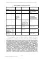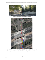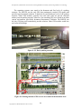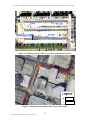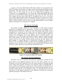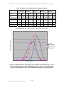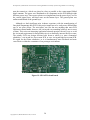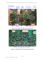
1
California AHMCT Program
University of California at Davis
California Department of Transportation
DEVELOPMENT OF VEHICULAR AND PERSONAL
UNIVERSAL LONGITUDINAL TRAVEL DIARY SYSTEMS
USING GPS AND NEW TECHNOLOGY*
Kin S. Yen1, Stephen M. Donecker1, Kimball Yan1,
Travis Swanston1, Ayalew Adamu2, Leo Gallagher2,
Mohammad Assadi2, Bahram Ravani1, &
Ty A. Lasky1, Principal Investigator
AHMCT Research Report
UCD-ARR-06-12-31-01
Final Report of Contract RTA65A0189
December 31, 2006
Affiliations:
1. AHMCT Research Center, Department of Mechanical & Aeronautical Engineering, University of California, Davis, CA 95616
2. Caltrans Division of Transportation System Information, 1120 N Street, MS-38, Sacramento, CA 95814
*
This report has been prepared in cooperation with the State of California, Business and
Transportation Agency, Department of Transportation and is based on work supported by
Contract Number RTA 65A0189 through the Advanced Highway Maintenance and
Construction Technology Research Center at the University of California at Davis.
Copyright 2011, AHMCT Research Center, UC Davis
i
Copyright 2011, AHMCT Research Center, UC Davis
Technical Documentation Page
1. Report No.
2. Government Accession No.
3. Recipient’s Catalog No.
F/CA/IR200645
5. Report Date
4. Title and Subtitle
GPS and New Technologies to Improve Longitudinal Travel
Surveys
December 31, 2006
6. Performing Organization Code
7. Author(s): Kin S. Yen, Stephen M. Donecker, Kimball Yan, Travis Swanston, Ayalew Adamu,
Leo Gallagher, Mohammad Assadi, Bahram Ravani, & Ty A. Lasky
8. Performing Organization Report No.
9. Performing Organization Name and Address
10. Work Unit No. (TRAIS)
AHMCT Research Center
UCD Dept of Mechanical & Aeronautical Engineering
Davis, California 95616-5294
11. Contract or Grant
12. Sponsoring Agency Name and Address
13. Type of Report and Period Covered
California Department of Transportation
Division of Research and Innovation
P.O. Box 942873, MS#83
Sacramento, CA 94273-0001
Final Report
January 2005 - December 2006
UCD-ARR-06-12-31-01
RTA 65A0189
14. Sponsoring Agency Code
Caltrans
15. Supplementary Notes
16. Abstract
This report provides an overview of travel surveys, including literature review and background, as well as the motivation for the
research and development of the Global Positioning System Automated Travel Diary (GPS-ATD). The system requirements and
specifications for the device development are presented and discussed. In addition, the detailed architecture, hardware, software,
and user interface design are included. Vehicular and personal GPS-ATD systems were developed to support comprehensive
traveler behavior studies. The GPS-ATD provides an intuitive user interface to capture trip activity information (trip purpose,
travel mode, etc.), with minimal user input and burden during travel surveys. Each survey participant interacts with their own
personal GPS-ATD, and information is automatically coordinated between personal and vehicular GPS-ATD units via ZigBee
wireless. The system captures and logs data from the High-Sensitivity GPS (HSGPS) receiver, allowing subsequent identification
of corridors, route lengths, and regional and inter-regional trips. The primary sensor is the HSGPS receiver. For the vehicular
GPS-ATD, inertial sensing (MEMS gyro and accelerometers) is also provided to fill in the gaps during GPS outages and cold
starts. To obtain vehicle sensor information, the GPS-ATD uses ZigBee wireless communications to the car computer On-Board
Diagnostics connector (OBD-II). Following the design discussion, complete system testing, results, and user feedback are
discussed. The report concludes with recommendations for future work related to the GPS-ATD and its use in the 2010 California
Statewide Household Travel Survey.
17. Key Words
18. Distribution Statement
Longitudinal travel surveys, GPS, MEMS, IMU,
human-machine interface, HMI, highway
maintenance
No restrictions. This document is available to the
public through the National Technical Information
Service, Springfield, Virginia 22161.
20. Security Classif. (of this report)
20. Security Classif. (of this page)
21. No. of Pages
Unclassified
Unclassified
148
Form DOT F 1700.7 (8-72)
(PF V2.1, 6/30/92)
Copyright 2011, AHMCT Research Center, UC Davis
Reproduction of completed page authorized
i
22. Price
Copyright 2011, AHMCT Research Center, UC Davis
Development of Vehicular & Personal Universal Longitudinal Travel Diary Systems using GPS & New Technology
ABSTRACT
This report provides an overview of travel surveys, including literature review and
background, as well as the motivation for the research and development of the Global
Positioning System Automated Travel Diary (GPS-ATD). The system requirements and
specifications for the device development are presented and discussed. In addition, the
detailed architecture, hardware, software, and user interface design are included.
Vehicular and personal GPS-ATD systems were developed to support comprehensive
traveler behavior studies. The GPS-ATD provides an intuitive user interface to capture
trip activity information (trip purpose, travel mode, etc.), with minimal user input and
burden during travel surveys. Each survey participant interacts with their own personal
GPS-ATD, and information is automatically coordinated between personal and vehicular
GPS-ATD units via ZigBee wireless. The system captures and logs data from the HighSensitivity GPS (HSGPS) receiver, allowing subsequent identification of corridors, route
lengths, and regional and inter-regional trips. The primary sensor is the HSGPS receiver.
For the vehicular GPS-ATD, inertial sensing (MEMS gyro and accelerometers) is also
provided to fill in the gaps during GPS outages and cold starts. To obtain vehicle sensor
information, the GPS-ATD uses ZigBee wireless communications to the car computer
On-Board Diagnostics connector (OBD-II). Following the design discussion, complete
system testing, results, and user feedback are discussed. The report concludes with
recommendations for future work related to the GPS-ATD and its use in the 2010
California Statewide Household Travel Survey.
Copyright 2011, AHMCT Research Center, UC Davis
iii
Copyright 2011, AHMCT Research Center, UC Davis
Development of Vehicular & Personal Universal Longitudinal Travel Diary Systems using GPS & New Technology
EXECUTIVE SUMMARY
This report provides a basic background and brief summary of longitudinal travel
surveys, the use of the Global Positioning System (GPS) in previous surveys, and new
technological developments that can improve surveys by increasing GPS availability and
reducing the cost of conducting a survey. It is fundamentally important that surveys can
be carried on for a long duration while maintaining the survey data accuracy and
integrity, and yet minimizing the burden on survey respondents. Therefore, a new method
is needed for comprehensive, highly automated and efficient data collection for
individual travelers. The survey data are crucial for modeling trip generation, predicting
the effects of transportation policy changes, and supporting the decision making process
at the Federal, State, county and city level. In this project, a new solution was developed
to address known deficiencies of previous approaches.
The mismatch between existing methods and the stated needs of travel surveyors
drove the Global Positioning System Automated Travel Diary (GPS-ATD) system
specifications and developments. Previously, typical travel survey duration was one or
two days; however, researchers have shown benefits if the duration is extended to beyond
one or two weeks. Therefore, the GPS-ATD was designed with storage to handle four
weeks of data. For prior attempts at applying GPS receivers for travel surveys, long GPS
startup time and signal blockage in urban canyons were major obstacles—thus MicroElectro-Mechanical Systems (MEMS) inertial sensors were used for dead-reckoning to
calculate position solutions when GPS is not available. The report documents the wellbalanced GPS-ATD system design, which meets data, storage, and cost constraints while
minimizing the survey respondents’ burden. Readers are strongly encouraged to read the
references cited herein along with a sampling of the papers cited in these references to
gain a deeper understanding of longitudinal travel surveys and the benefit provided by
the GPS-ATD system.
This report provides an overview of travel surveys, including literature review and
background, as well as the motivation for the research and development of the GPSATD. The system requirements and specifications for the device development are
presented and discussed. In addition, the detailed architecture, hardware, software, and
user interface design are included. Vehicular and personal GPS-ATD systems were
developed to support comprehensive traveler behavior studies. The GPS-ATD provides
an intuitive user interface to capture trip activity information (trip purpose, travel mode,
etc.), with minimal user input and burden during travel surveys. Each survey participant
interacts with their own personal GPS-ATD, and information is automatically
coordinated between personal and vehicular GPS-ATD units via ZigBee wireless. The
system captures and logs data from the High-Sensitivity GPS (HSGPS) receiver,
allowing subsequent identification of corridors, route lengths, and regional and interregional trips. The HSGPS receiver is the primary sensor. For the vehicular GPS-ATD,
inertial sensing (MEMS gyro and accelerometers) is also provided to fill in the gaps
during GPS outages and cold starts. To obtain vehicle sensor information, the GPS-ATD
uses ZigBee wireless communications to the car computer On-Board Diagnostics
connector (OBD-II). Following the design discussion, complete system testing, results,
and user feedback are discussed. The report concludes with recommendations for future
Copyright 2011, AHMCT Research Center, UC Davis
v
Development of Vehicular & Personal Universal Longitudinal Travel Diary Systems using GPS & New Technology
work related to the GPS-ATD and its use in the 2010 California Statewide Household
Travel Survey.
Copyright 2011, AHMCT Research Center, UC Davis
vi
Development of Vehicular & Personal Universal Longitudinal Travel Diary Systems using GPS & New Technology
TABLE OF CONTENTS
Abstract........................................................................................................................ iii
Executive summary .......................................................................................................v
Table of Contents ....................................................................................................... vii
List of Figures ............................................................................................................. ix
List of Tables ............................................................................................................... xi
Disclaimer/Disclosure............................................................................................... xiii
List of Acronyms and Abbreviations ..........................................................................xv
Acknowledgments .................................................................................................... xvii
Chapter 1: Introduction and Background ................................................................ 19
Longitudinal Traveler Survey and Demand Forecast / Modeling ............................... 19
Previous Travel Surveys .................................................................................................. 20
Chapter 2: Recent Emergence of Supporting Technologies .................................... 27
Current Global Positioning System (GPS) Status ......................................................... 27
Free Nationwide Differential GPS (DGPS) Services ..................................................... 28
GPS Vulnerability ............................................................................................................ 30
GPS Sensors ...................................................................................................................... 30
Low-Cost Inertial Sensors for Dead Reckoning ............................................................ 32
Other New Technologies to Improve Travel Surveys.................................................... 33
Vehicle On-Board Diagnostic (OBD) Interface .......................................................................... 33
Wireless Technology Developments ........................................................................................... 33
Chapter 3: System Overview of the GPS-Automated Travel Diary.......................... 35
Recommended GPS-Aided Electronic Travel Diaries Systems .................................... 35
System Implementation.................................................................................................... 38
Design Tradeoffs ............................................................................................................... 41
Chapter 4: Component Testing and Evaluation ....................................................... 43
GPS Sensor Test Results .................................................................................................. 43
GPS Antenna Test Results ............................................................................................... 48
GPS Antenna Placement Simulations............................................................................. 48
Chapter 5: Hardware Design and Implementation .................................................. 51
Circuit Board Design........................................................................................................ 56
GPS-ATD Manufacturing................................................................................................ 60
Circuit Board Assembly Process ................................................................................................. 60
Chapter 6: GPS-ATD Firmware................................................................................ 63
User Interface.................................................................................................................... 64
Copyright 2011, AHMCT Research Center, UC Davis
vii
Development of Vehicular & Personal Universal Longitudinal Travel Diary Systems using GPS & New Technology
Chapter 7: GPS-ATD Testing and Evaluation ......................................................... 67
Chapter 8: Conclusions and Future Work ............................................................... 71
Recommendation for Future Research........................................................................... 71
References .................................................................................................................. 73
APPENDIX A: GPS-ATD MENU Tables................................................................. 77
VEHICLE.......................................................................................................................... 86
TRIP ACTIVITY.............................................................................................................. 88
TRIP PURPOSE ............................................................................................................... 90
APPENDIX B: GPS-ATD Menu Flowchart............................................................. 93
APPENDIX C: GPS-ATD User Guide...................................................................... 95
APPENDIX D: Detailed Deliverables Provided by Caltrans TSI ............................ 97
Copyright 2011, AHMCT Research Center, UC Davis
viii
Development of Vehicular & Personal Universal Longitudinal Travel Diary Systems using GPS & New Technology
LIST OF FIGURES
Figure 1: WAAS geostationary satellites coverage map (http://gps faa.gov/CapHill/geosat htm)...... 29
Figure 2: WAAS GPS vertical accuracy map (http://www nstb.tc faa.gov/vpl html) .......................... 29
Figure 3: Example commercial GPS receivers ........................................................................................ 31
Figure 4: Analog Devices MEMS gyro and accelerometer chips ........................................................... 32
Figure 5: System architecture including data collection and post-processing phases.......................... 35
Figure 6: GPS test setup ............................................................................................................................ 44
Figure 7: Residential streets with tree blockage ...................................................................................... 45
Figure 8 Bridge test results for SiRF II, SiRF III and Sony GPS receivers (number on symbol
indicates number of satellites used for position calculation)......................................................... 45
Figure 9: UC Davis parking structure...................................................................................................... 46
Figure 10: Parking structure GPS receiver test results in the basement level...................................... 46
Figure 11: Parking structure GPS receiver test results in the first level............................................... 47
Figure 12: Downtown Sacramento GPS receiver test results................................................................. 47
Figure 13: Sarantel GeoHelix GPS antenna ............................................................................................ 48
Figure 14: Simulated effect of placing the GPS antenna on the dashboard vs. on the roof (No
blockage line represents GPS antenna on the vehicle roof, and the others represent GPS
antenna on the vehicle dashboard traveling in various directions).............................................. 49
Figure 15: GPS-ATD system block diagram............................................................................................ 52
Figure 16: GPS-ATD membrane switch user keypad............................................................................. 55
Figure 17: All layers and layer 3 of the GPS-ATD circuit board........................................................... 56
Figure 18: Layer 4 and layer 5 of the GPS-ATD circuit board.............................................................. 56
Figure 19: GPS-ATD circuit board........................................................................................................... 58
Figure 20: Assembled GPS-ATD circuit board (top side) ...................................................................... 59
Figure 21: Assembled GPS-ATD circuit board (bottom side)................................................................ 59
Figure 22: GPS-ATD circuit board bottom and top stencil.................................................................... 61
Figure 23: GPS-ATD circuit board fixture for applying RoHS solder paste........................................ 61
Figure 24: Fully-assembled GPS-ATD bottom-side circuit boards (qty 10 shown) ............................. 62
Figure 25: Fully-assembled GPS-ATD unit internals ............................................................................. 62
Figure 26: GPS-ATD firmware architecture ........................................................................................... 63
Figure 27: GPS-ATD user interface ......................................................................................................... 65
Figure 28: Personal GPS-ATD .................................................................................................................. 67
Figure 29: Personal GPS-ATD with optional patch antenna ................................................................. 67
Figure 30: GPS-ATD battery charging curve.......................................................................................... 68
Figure 31: GPS-ATD battery discharging curve ..................................................................................... 68
Figure 32: GPS-ATD on a bicycle mount................................................................................................. 69
Figure 33: Trip information displayed in Google Earth (two individual trips with same origin and
destination using different route) .................................................................................................... 70
Figure 34: Trip information displayed in Google Earth (example short trips often not reported) ... 70
Copyright 2011, AHMCT Research Center, UC Davis
ix
Copyright 2011, AHMCT Research Center, UC Davis
Development of Vehicular & Personal Universal Longitudinal Travel Diary Systems using GPS & New Technology
LIST OF TABLES
Table 1: Fixed (static) information collected in a travel survey............................................................. 21
Table 2: Dynamic travel diary information collected for given trip(s).................................................. 21
Table 3: Summary of previous travel surveys ......................................................................................... 22
Table 4: Summary of previous GPS-aided travel survey diary hardware............................................ 23
Table 5: System features............................................................................................................................ 36
Table 6: Comparison of vehicular and personal versions of GPS-ATD................................................ 38
Table 7: GPS-ATD system hardware ....................................................................................................... 39
Table 8: Data elements and update rates ................................................................................................. 40
Table 9: Feature cost-benefit tradeoff analysis........................................................................................ 42
Table 10: Number of available satellite summary statistics ................................................................... 49
Table 11: GPS-ATD system hardware ..................................................................................................... 54
Copyright 2011, AHMCT Research Center, UC Davis
xi
Copyright 2011, AHMCT Research Center, UC Davis
Development of Vehicular & Personal Universal Longitudinal Travel Diary Systems using GPS & New Technology
DISCLAIMER/DISCLOSURE
The research reported herein was performed as part of the Advanced Highway
Maintenance and Construction Technology (AHMCT) Research Center, within the
Department of Mechanical and Aeronautical Engineering at the University of California
– Davis, and the Division of Research and Innovation at the California Department of
Transportation. It is evolutionary and voluntary. It is a cooperative venture of local, State
and Federal governments and universities.
The contents of this report reflect the views of the authors who are responsible for the
facts and the accuracy of the data presented herein. The contents do not necessarily
reflect the official views or policies of the State of California, the Federal Highway
Administration, or the University of California. This report does not constitute a
standard, specification, or regulation.
Copyright 2011, AHMCT Research Center, UC Davis
xiii
Copyright 2011, AHMCT Research Center, UC Davis
Development of Vehicular & Personal Universal Longitudinal Travel Diary Systems using GPS & New Technology
LIST OF ACRONYMS AND ABBREVIATIONS
Acronym
Definition
ABS
ACMS
AHMCT
AOR-W
ASCII
BGA
Caltrans
CASI
CATI
CDMA
CNC
COTS
CPU
DAC
DGPS
DOD
DOP
DOT
DR
DRI
DSL
EL
EMI
ESR
ETD
FAA
FBGA
FHWA
FM
GB
GIS
GPS
GPS-ATD
GSM
HDOP
HMI
HSGPS
HTML
I 2C
IC
IGEB
IMU
ITS
ITSA
IV
LCD
Li-ion
LNA
MB
MEMS
Acrylonitrile Butadiene Styrene
Advanced Construction and Maintenance Systems
Advanced Highway Maintenance and Construction Technology
Atlantic Ocean Region-West
American Standard Code for Information Interchange
Ball-Grid Array
California State Department of Transportation
Computer-Assisted Self-Interview
Computer-Assisted Telephone Interview
Code-Division Multiple Access
Computer Numerical Control
Commercial-Off-the-Shelf
Central Processing Unit
Digital-to-Analog Converter
Differential Global Positioning System
Department of Defense
Dilution-of-Precision
Department of Transportation
Dead Reckoning
Division of Research and Innovation
Digital Subscriber Line
Electroluminescent
Electromagnetic Interference
Equivalent Series Resistance
Electronic Travel Diary
Federal Aviation Administration
Fine Ball-Grid Array
Federal Highway Administration
Frequency Modulation
Gigabyte
Geographic Information System
Global Positioning System
GPS-Automated Travel Diary
Global System for Mobile communications
Horizontal Dilution of Precision
Human-Machine Interface
High-Sensitivity GPS
HyperText Markup Language
Inter-Integrated Circuit
Integrated Circuit
Interagency GPS Executive Board
Inertial Measurement Unit
Intelligent Transportation Systems
Intelligent Transportation Society of America
Intelligent Vehicle
Liquid Crystal Display
Lithium-ion
Low-Noise Amplifier
Megabyte
Micro-Electro-Mechanical Systems
Copyright 2011, AHMCT Research Center, UC Davis
xv
Development of Vehicular & Personal Universal Longitudinal Travel Diary Systems using GPS & New Technology
Acronym
Definition
MF
MP
MPO
NDGPS
NiMH
NMEA
OBD
OS
OSS
PAPI
PCB
PDA
PDF
PLAN
POR
RAM
RF
RFI
RoHS
RTOS
SA
SBC
SDRAM
TMC
TSI
TSOP
TUCF
UART
UCD
UI
USB
USDOT
USNO
UTC
VDOP
VMT
WAAS
WGS
YAFFS2
ZIF
Medium Frequency
Milepost
Metropolitan Planning Organization
Nationwide Differential GPS
Nickel-Metal-Hydride
National Marine Electronics Association
On-Board Diagnostics
Operating System
Open-Source Software
Paper and Pencil Interview
Printed Circuit Board
Personal Digital Assistant
Portable Document Format
Position Location and Navigation
Pacific Ocean Region
Random Access Memory
Radio Frequency
Radio Frequency Interference
Restriction of Hazardous Substances
Real-Time Operating System
Selective Availability
Single Board Computer
Synchronous Dynamic Random Access Memory
Transportation Management Center
Transportation System Information
Thin Small Outline Package
Trip Underreporting Correction Factor
Universal Asynchronous Receiver / Transmitter
University of California-Davis
User Interface
Universal Serial Bus
United States Department of Transportation
United States Naval Observatory
Coordinated Universal Time
Vertical Dilution of Precision
Vehicle Miles Traveled
Wide Area Augmentation System
World Geodetic System
Yet Another Flash File System (version 2)
Zero-Insertion-Force
Copyright 2011, AHMCT Research Center, UC Davis
xvi
Development of Vehicular & Personal Universal Longitudinal Travel Diary Systems using GPS & New Technology
ACKNOWLEDGMENTS
The authors thank the California State Department of Transportation for their
support; in particular, the guidance and review provided by Dr. Ayalew Adamu, Chief of
the Statewide Analysis Branch of the Office of Travel Forecasting and Analysis in the
Division of Transportation System Information (TSI) of the California Department of
Transportation (Caltrans), and the staff members of the Statewide Travel Analysis
Branch and the Statewide Modeling Branch Staffs within TSI. He and his research staff
created the idea and wrote specifications for the creation of the Global Positioning
System Automated Travel Diary (GPS-ATD). The authors gratefully acknowledge the
Division of Research and Innovation of Caltrans which has supported this work through
the AHMCT Research Center at the University of California-Davis, under contract
RTA65A0189. The authors also thank the GPS-ATD development team in the AHMCT
Research Center: Stephen M. Donecker, Kimball Yan, and Travis Swanston. Finally, the
authors thank the Caltrans Division of TSI team members: Coco Briseno – the current
Division Chief of TSI, Robert Copp - the former Division Chief of TSI, David Saia - the
former Chief of the Office of Travel Forecasting and Analysis, Frank Law - Chief of the
Statewide Modeling Branch, Leo Gallagher, Mohammad Assadi, Azita Fatemi, Gregory
Miyata, Soheila Khoii, and Diana Portillo.
Copyright 2011, AHMCT Research Center, UC Davis
xvii
Copyright 2011, AHMCT Research Center, UC Davis
Development of Vehicular & Personal Universal Longitudinal Travel Diary Systems using GPS & New Technology
CHAPTER 1:
INTRODUCTION AND BACKGROUND
This chapter provides a brief introduction to objective longitudinal traveler surveys,
including previous methods of conducting surveys and their findings. The objectives are
to:
•
Summarize travel survey goals and define the data needed for travel demand
forecasting.
•
Identify the challenges inherent in longitudinal travel surveys and pitfalls
encountered in previous GPS-aided longitudinal travel surveys.
•
Summarize previous major travel surveys.
•
Highlight the reference research and literature.
In addition, details of GPS and other relevant new technological developments are
provided. The authors recommend review of all the cited references to gain a deeper
understanding. The aim is to illuminate the key findings of the past research to foster
ongoing discussion and understanding of the context and need for the GPS-Automated
Travel Diary (GPS-ATD).
Longitudinal Traveler Survey and Demand Forecast / Modeling
There is a need for finer-grained understanding of traveler behavior than current data
collection techniques allow. Traditional cross-sectional survey methods are somewhat
coarse and seek to provide traffic measurements for a single point of a road or
intersection, thus providing traffic loading at a specific location over time. While this
may support conclusions regarding the capacity of a particular location, it does not
provide needed information on traveler behaviors such as trip purpose, trip frequency and
schedule, route selection, and speeds used throughout the entire route. Many factors can
contribute to a driver’s reasons for choosing a particular route. A system which can
monitor current traveler location, time, speed, and current and next tasks is required.
Longitudinal surveys directly measure traveler behavioral change at the level of the
individual traveler, and provide information that can lead to a better understanding of the
factors that influence and direct personal travel behavior. These data are critical in:
•
developing travel demand models and forecasting future demand,
•
predicting the number of trips generated by households as a function of
demographics, socioeconomics, and location relative to employment and
commercial centers [31],
•
estimating travel mode choice and traffic volumes on various roads,
•
measuring and understanding trends in population behavior,
Copyright 2011, AHMCT Research Center, UC Davis
19
Development of Vehicular & Personal Universal Longitudinal Travel Diary Systems using GPS & New Technology
•
assessing the impact of changes in transportation policy or the transportation
system [7,23,30],
•
predicting emissions from motor vehicles and input for air quality
analysis [31],
•
and calibrating regional models.
Previous Travel Surveys
Household-level travel surveys collect three categories of data: household
information, household member personal information, and travel activity information for
a particular day or range of days (see Table 1 and Table 2). Travel diaries are the
standard method used to capture participating household travel activity information.
Travel diaries have progressed over the last few decades due to improved understanding
of trip generation, as shown in Table 3. The most recent trend in travel surveys is the use
of the “place-based” survey instead of a trip-based or activity-based survey [31]. “Placebased” surveys focus on respondent movements from one place to another during the
survey period [31]. Survey methods evolved from the mail-out / mail-back Paper and
Pencil Interview (PAPI) in the 1960’s, through the Computer-Assisted Telephone
Interview (CATI) in 1980’s, to the Electronic Travel Diary (with or without GPS) of
today [31]. Computer-Assisted Self-Interview (CASI) methods, in which respondents
input their travel information directly into a computer, have become widely used [17].
However, respondents are required to have access to a computer and the Internet. Each
method improved upon the previous approaches by better capturing incidental trips,
reducing underreporting, improving data accuracy, and minimizing respondent burden
and fatigue. Nevertheless, gathering complete information from travelers has been
problematic. Drawbacks of self-administered paper-based survey designs are wellknown, and this approach is not suited for long-term mobility pattern observations.
Moreover, multi-day personal surveys often suffer the ill-effects of survey fatigue and
low response rates typical in longer survey durations [23]. It is common for respondents
to underreport or to provide incorrect data due to poor memory, misunderstanding
instructions, or carelessness. Short or infrequent trips that occur during the day are the
most often not reported [23].
Copyright 2011, AHMCT Research Center, UC Davis
20
Development of Vehicular & Personal Universal Longitudinal Travel Diary Systems using GPS & New Technology
Table 1: Fixed (static) information collected in a travel survey
Information Categories
Specific information
Household Information
Physical address location
Housing unit type
Length of residence
Number of vehicle
Vehicle details (vehicle type, fuel type,
ownership, etc)
Household size
Total household income
Relationship to other household member
Gender
Ethnicity
Age
Employment status
Occupation
Weekly work schedule
Transportation taken to work
Education level
Household Member
Personal Information
Table 2: Dynamic travel diary information collected for given trip(s)
Category
Data Element / Sub Element
Activity
Type of activity
Start time
End time
Origin location
Destination
Switching travel mode
Reason of mode choice
Personal Vehicle
Vehicle used
Driver or passenger
Vehicle occupancy
Parking cost
Other toll costs
Distance
OBD-II data
Transit
Transit fare
Location of access
Location of egress
Wait time
Number of transfers
Walk
Distance
Use of bicycle lanes
Bicycle
Distance
Means of securing bicycle at destination
Travel Mode
Copyright 2011, AHMCT Research Center, UC Davis
21
Development of Vehicular & Personal Universal Longitudinal Travel Diary Systems using GPS & New Technology
Table 3: Summary of previous travel surveys
Location
Year
Duration
Sample Size
Survey Methods
Uppsala,
Sweden
Lexington, KY
1971
35 days
149 individuals
1996
1 week
100 households
California
20002001
Oct 2000 and Dec
2001, one 24 hr.
weekday, one 48
hr. weekend. 20
weeks with
passive GPS
logger
58 counties and 17,040
households
Atlanta, Georgia
2000
5 days
Mobidrive,
Germany
Spring &
Fall
1999
June
2000 to
March
2002
6 weeks
250 households with
Electronic Travel Diary
(ETD) & GPS, 50
households with ETD,
GPS, & OBD-II, 250
households with passive
GPS
362 persons in 162
households
Paper and Pencil
Interview (PAPI)
Vehicle-only GPS / PDA
with 2-3 sec sampling
period
Computer Assisted
Telephone Interview
(CATI) on all respondent
and passive GPS
monitoring on 292
households. Used GPS to
determine underreporting
factor.
All methods were
used [33]
~ 80 weeks
186 vehicle, and 49,667
vehicle days
Passive GPS with vehicle
engine on/off sensing
July &
Nov.
1999
48 hrs
6,000 households
Paper and Pencil
Interview (PAPI)
Swedish
Intelligent Speed
Adaptation,
Borlange, Lund,
and Lidkoping
Puget Sound
Household
Travel Survey
Paper and Pencil
Interview (PAPI)
Previous longitudinal surveys have shown that there are day-to-day and seasonal
variations in travel behavior that can only be captured by a multi-week longitudinal
survey. Furthermore, multi-day travel survey data have been found to be more efficient
and accurate estimators of trip generations. Pendyala [23] provided a detailed literature
review on day-to-day variability in travel behavior. He noted there are two sources of
day-to-day travel behavior variability: people’s needs and desires vary from day to day,
and behavior varies because of feedback from the transportation system. In supporting his
hypothesis, he cited the research work of Hanson and Huff [9-11] using the 1971 Uppsala
(Sweden) household survey data (35 days long, 149 individuals using self-administered
travel diaries); Pas and Koppelman’s [14,19-22] analysis of both 1973 Reading, England
and 1989 Seattle, Washington travel survey data; and Kitamura and Van der Hoorn’s [13]
examination of Dutch National Mobility panel data. Previous research suggests that there
is substantial day-to-day variability in travel behavior. Furthermore, Richardson
suggested that the number of sample households may be reduced if the study duration
increases [25]. In order to accurately capture the full spectrum of travel behavior, it is
Copyright 2011, AHMCT Research Center, UC Davis
22
Development of Vehicular & Personal Universal Longitudinal Travel Diary Systems using GPS & New Technology
fundamentally important that surveys can be carried on for a long duration while
maintaining the survey data accuracy and minimizing the burden on the respondents.
Table 4: Summary of previous GPS-aided travel survey diary hardware
Researcher
Survey
Year
Description
Lexington, KY
Fall 1996
Sony MagicLink PIC-2000 with interface software
that controlled the recording of GPS data and allowed
respondents to enter trip information (2 MB storage)
Transport
Research Centre
(AVV),
Netherlands
Winter
1998 –
Spring
1999
ETD with handheld data logging devices equipped
with a combined GPS / DGPS receiver and battery
pack
Austin, Texas
1997-1998
Passive in-vehicle GPS-system
Quebec city,
Canada
Dec. 1998March
1999
In-vehicle GPS only
Georgia Institute
of Technology
2000
ETD and comprehensive in-vehicle data collection
system with both GPS technology and an enginemonitoring device, >100 lbs [34]
Georgia Institute
of Technology
Handheld Travel
Diary
1999
Psion WORKABOUT handheld, 16 MB storage,
240x100 pixel display with key input, 11.46 ounces,
2 AA batteries [8]
Stopher’s pilot
experiment
1999
Vehicle passive logging with Garmin GPS III, max
1900 point [29]
GeoStats Logger
McNally, UC
Irvine, CA
Passive logger using Garmin 35 GPS sensor with
4 MB max storage, 1.0 or 0.2 Hz logging rate, 1 lbs
2002
Copyright 2011, AHMCT Research Center, UC Davis
X86 133 MHz CPU running embedded Linux with
16 MB for 28 hours data logging, GPS & CDPD
modem. Estimated cost, size & power: $1,200 $1,400, 7”x9”x4”, ~4 watt. Limited to Vehicular use
only. Used in a survey of 25 Orange County
households in which all homes are newly built in a
new residential development [17].
23
Development of Vehicular & Personal Universal Longitudinal Travel Diary Systems using GPS & New Technology
Previous longitudinal surveys utilizing GPS (refer to Table 4) have shown great
potential [1,3,7,23,33]. GPS-based surveys are more accurate and minimize the
respondent burden. In addition, GPS digital data can be readily imported into computer
analysis programs. This approach captures route choice, path, and speed profile
information, items not feasible with traditional paper surveys [7,23]. These data may be
used to measure the level of congestion of a particular highway [2,27]. GPS travel diaries
used in the past may be classified into two types: interactive and passive [6,28]. An
interactive electronic travel diary requires the respondent to interact with the hand-held
computer to input survey information such as marking trip start and end, trip purpose,
cost of trip, and travel mode. A passive travel diary requires essentially no interaction
with the respondent—respondents only need to carry and turn on the device whenever
they travel. Other essential trip information is collected through paper survey or followup phone call, or is estimated by computer-aided software based on the GPS data. Passive
travel data loggers have been used to determine a Trip Underreporting Correction Factor
(TUCF) which was used to adjust the statistical results of a larger-sample paper
survey [3,35]. Some methodical GPS data post-processing approaches have been
developed to successfully extract temporal trip start and end, trip purpose, and travel
mode from the passive GPS data collected [3,6,28,32,35]. Determining the cost of a given
trip from GPS data was not done in previous research. However, toll and parking costs
could be extracted based on the vehicle route and stop duration, if detailed toll and
parking fee structures in the traveled area are known. Nevertheless, the number of
passengers, vehicle type, fuel type, and identity of the driver cannot be determined
without the input of the respondents or an image of the vehicle interior.
Replacing traditional self-administered paper travel diaries with interactive GPSaided travel diaries has shown significant reduction in the resulting respondent burden.
Battelle reports that 75% of respondents took less than one minute to enter all required
trip information into an interactive electronic travel diary [1]. On the other hand,
respondents would generally spend 10 minutes on a paper diary or 20-25 minutes on a
follow-up phone call. Therefore, a GPS-aided interactive travel diary could save both
surveyors and respondents time and money.
Previously, all GPS-aided travel surveys were performed on a relatively small scale
(sample size < 300). Moreover, all GPS-aided electronic travel diary devices were
developed by loosely integrating commercial off-the-shelf items. Typically, a GPS
receiver was connected to a data logger or a Personal Digital Assistant (PDA) hand-held
computer [1,3,6-8,29,32]. Data were entered using touch screen or keypad interfaces.
Each device had its own power source. These GPS travel diary data loggers used in
previous surveys have their drawbacks. A high percentage of the units failed to achieve
full data collection capability due to:
•
Hardware failure:
o Broken cable connection between the GPS and the data logger or
PDA [1,32];
o Respondent failure to provide power [3];
Copyright 2011, AHMCT Research Center, UC Davis
24
Development of Vehicular & Personal Universal Longitudinal Travel Diary Systems using GPS & New Technology
•
Respondents not carrying the unit due to:
o Weight and size [8];
o Difficult to carry when bicycling [1];
•
Software bugs [1];
•
Inability to differentiate vehicle stop at the end of a trip vs. a stop caused by
congestion or pedestrian crossing [3,29];
•
Loss of GPS signal due to urban canyons, improper GPS antenna orientation
on the respondent body, and signal blockage inside vehicles such as
buses [1,6];
•
and loss of GPS data during GPS receiver cold-start period [6,7].
Nevertheless, the GPS-aided electronic travel diary has the strongest potential to fully
capture all travel behavior exactly for accurate modeling. The drawbacks of previous
GPS-aided travel diaries and loggers have been overcome in the current project’s GPSATD system by tight component integration, additional sensors, longer lasting backup
batteries, and increased onboard processing power and intelligence.
Copyright 2011, AHMCT Research Center, UC Davis
25
Copyright 2011, AHMCT Research Center, UC Davis
Development of Vehicular & Personal Universal Longitudinal Travel Diary Systems using GPS & New Technology
CHAPTER 2:
RECENT EMERGENCE OF SUPPORTING TECHNOLOGIES
Recent technological developments and improvements in the Global Positioning
System (GPS), low-cost small Micro-Electro-Mechanical Systems (MEMS) inertial
sensors, low-power embedded computers, high-capacity storage devices, wireless
communications, and high-speed Internet have converged to make a portable and lowcost data collection system a feasible reality. Each of these technical areas will be
discussed in detail in this chapter.
Current Global Positioning System (GPS) Status
The Global Positioning System (GPS) is a space-based radio-navigation system
consisting of a constellation of satellites and a network of ground stations used for
monitoring and control. A minimum of 24 GPS satellites orbit the Earth at an altitude of
approximately 11,000 miles, providing land, sea, and airborne users with accurate
information on position, velocity, and time anywhere in the world and in all weather
conditions, with precision and accuracy far better than other radio-navigation systems
available today or in the foreseeable future (see http://gps.faa.gov). Currently, there are
30 operational GPS satellites in orbits. They circle the Earth twice per day. The space and
ground control GPS segments are operated and maintained by the Department of Defense
(DOD). In 1996, a Presidential Decision Directive, later passed into law, transferred
“ownership” from DOD to an Interagency GPS Executive Board (IGEB), co-chaired by
senior officials of the Departments of Transportation and Defense to provide
management oversight to assure that GPS meets both civil and military user
requirements.
GPS receivers collect signals from the satellites in view (a.k.a line-of-sight). They
provide the user's position, velocity, and time, and some receivers give additional data,
such as distance and bearing to selected waypoints or digital charts after further
processing of the positional and time solutions. Without going into full detail, each
satellite transmits an accurate position and time signal. The user's receiver measures the
time delay for the signal to reach the receiver, which provides a direct measure of the
apparent range (called a “pseudorange”) to the satellite. Measurements collected
simultaneously from a minimum four satellites are processed to solve for the three
dimensions of position (latitude, longitude, and altitude) and precise time. Position
measurements are in the World Geodetic System WGS-84 geodetic reference system, and
time is with respect to a worldwide common U.S. Naval Observatory (USNO) time
reference. For more information, see Hoffmann-Wellenhof, et al [12].
Until recently, Selective Availability (SA) was used to protect the security interests of
the United States and its allies by globally denying the full accuracy of the civil system to
potential adversaries. SA was turned off at midnight on May 1, 2000, and it is not the
intent of the U.S. to use SA ever again. Currently, with removal of SA, accurate position
(< 25 m), time, and speed can be obtained throughout the country using small and lowcost GPS receivers.
Copyright 2011, AHMCT Research Center, UC Davis
27
Development of Vehicular & Personal Universal Longitudinal Travel Diary Systems using GPS & New Technology
GPS is continuously being modernized with additional radio frequency and
transmission power resulting in more reliable and accurate positional and time solution.
However, civilian users will not benefit from the effects of in-progress and planned GPS
modernization until 2008.
Free Nationwide Differential GPS (DGPS) Services
GPS accuracy can be improved by additional information provided by fixed ground
GPS monitoring stations. The Wide Area Augmentation System (WAAS) and the
Nationwide Differential GPS (NDGPS) are two free differential GPS services available
in the United States. Both systems provide improved GPS accuracy and integrity
monitoring services.
NDGPS is a land-based GPS augmentation that typically provides 1- to 3-meter
positioning accuracy to receivers capable of receiving the differential correction via a
Medium Frequency (MF) signal transmitted by a ground station. It is an expansion of the
U.S. Coast Guard's Maritime DGPS network. NDGPS is now providing single-station
coverage over about 80% of the landmass of the continental U.S. and is expected to be
fully operational with dual-station coverage throughout the continental U.S. in the near
future. To ensure accuracy, integrity and continuity, NDGPS is managed and monitored
24 hours a day, 7 days a week from the Coast Guard’s Navigation Center in Alexandria,
Virginia. NDGPS also provides GPS integrity monitoring capability; it gives an alarm to
users within 6 seconds of detecting a fault with the signal from any GPS satellite in view.
NDGPS receivers are generally much bigger and consume more power because of the
extra MF (150 - 175 kHz) radio modem.
The Federal Aviation Administration (FAA) Wide Area Augmentation Service
(WAAS) GPS differential correction signals enable even higher positional accuracy
(1-3 m), without the need for an additional FM radio. WAAS broadcasts correction
signals by geostationary satellites, and uses a system of ground stations to provide
necessary augmentations to the GPS navigation signal. A network of approximately 25
precisely surveyed ground reference stations are strategically positioned across the
country–including Alaska, Hawaii, and Puerto Rico–to collect GPS satellite data. The
system is then able to estimate the amount of signal delay and error that is the result of
the ionospheric and/or solar activity. This information is then passed on to the user as a
part of the WAAS navigation message to correct GPS signal errors. These correction
messages are then broadcast through communication satellites to GPS receivers using the
same frequency (L1, 1575.42 MHz) as GPS. WAAS is designed to provide the additional
accuracy, availability, and integrity necessary to enable users to rely on GPS within the
territory of the United States. The FAA commissioned the Wide Area Augmentation
System at 12:01am on July 10, 2003. At present there are two geo-stationary satellites
(Inmarsat IIIs) serving the WAAS Pacific Ocean Region (POR) and Atlantic Ocean
Region-West (AOR-W). The FAA is pursuing dual geo-satellite coverage throughout the
U.S. to eliminate a possible single point-of-failure and increase system reliability. The
West Coast currently has dual-satellite coverage, as can be seen in Figure 1. Although
WAAS was originally designed for aviation use, it provides benefits beyond aviation to
all modes of transportation, including maritime, highway, and rail. Small low-power
WAAS-enabled GPS receivers are more widely available than NDGPS-enabled GPS
Copyright 2011, AHMCT Research Center, UC Davis
28
Development of Vehicular & Personal Universal Longitudinal Travel Diary Systems using GPS & New Technology
receivers. WAAS vertical accuracy over the United States is illustrated in Figure 2—
horizontal accuracy (of most interest for travel surveys) is approximately three times
better than vertical, due to geometric configuration. As with coverage, the West Coast
has excellent WAAS accuracy.
Figure 1: WAAS geostationary satellites coverage map
(http://gps.faa.gov/CapHill/geosat.htm)
Figure 2: WAAS GPS vertical accuracy map (http://www.nstb.tc.faa.gov/vpl.html)
Copyright 2011, AHMCT Research Center, UC Davis
29
Development of Vehicular & Personal Universal Longitudinal Travel Diary Systems using GPS & New Technology
GPS Vulnerability
Many factors can degrade GPS performance. GPS receivers require a direct line-ofsight to the satellites in order to obtain a signal representative of the true distance from
the satellite to the receiver. Therefore, any object in the path of the fairly weak GPS
signal has the potential to interfere with its reception. Objects which can block a weak
GPS signal include tree canopies, buildings, and terrain features. Similarly, the WAAS
geostationary satellite signal can also be blocked. Furthermore, reflective surfaces can
cause the GPS signals to bounce before arriving at a receiver, thus causing an error in the
distance calculation. This problem, known as multipath, can be caused by a variety of
materials, including water, glass, and metal. Even the water contained in the leaves of
vegetation can produce multipath error. In some instances, operating under heavy and
wet forest canopy can degrade the ability of a GPS receiver to track satellites. Typically,
lower-elevation GPS satellites’ signals are most likely to be blocked. In this situation,
GPS receivers track only the highest satellites in the sky, as opposed to those satellites
which provide the best Dilution-of-Precision (DOP)—a measure of the satellite geometry
error sensitivity. Thus, the positional accuracy decreases. Unfortunately, there will be
locations where the minimum required four GPS satellite signals simply are not available
due to obstruction such as urban canyon—in these cases, no general GPS solution can be
obtained.
GPS Sensors
There are many GPS receiver manufacturers—some options and form factors are
shown in Figure 3. Each manufacturer may have its own signal tracking, positional
solution, and filtering algorithms. Receivers may perform differently during startup,
reacquisition of signal, and in various terrains such as urban canyons and under tree
canopies. Nevertheless, most GPS receivers output the position and time solution in
ASCII text standard National Marine Electronics Association (NMEA) 0183 format via
an RS232 serial port. NMEA output sentences contains Coordinated Universal Time
(UTC) date and time, latitude, longitude, and altitude in the WGS-84 coordinate system,
geoidal separation, number of visible satellites, speed, heading, horizontal DOP (HDOP),
and solution status. Some GPS receivers give additional information such as estimated
positional accuracy. Moreover, most receivers can also communicate solution data using
proprietary binary communication protocols at a higher baud rate, allowing more data or
more frequent updates.
Most GPS users would still not know where they are given their position in latitude,
longitude, and altitude—with this raw data, most users can at best tell whether they are in
the northern or southern hemisphere. A digital map or a Geographic Information System
(GIS) database is required to determine the user’s state, city, and street location. Some
receivers have incorporated mapping functions and GIS database. They have more
memory, Flash storage, and powerful processors. However, most handheld units can only
store a coarse state map or a detailed city map. Digital maps and GIS databases vary in
size depending on the number of detailed entries. For example, Microsoft MapPoint
software has a 1 Gigabyte (GB) GIS database map for all of North America.
Copyright 2011, AHMCT Research Center, UC Davis
30
Development of Vehicular & Personal Universal Longitudinal Travel Diary Systems using GPS & New Technology
Each GPS receiver has its own power-on sequence where it downloads almanac data
(such as GPS satellite orbital information) before establishing a position and time fix.
This start-up time is referred as cold-start time (typically between 45 sec to 5 min). Some
receivers have a “sleep” mode in which the receiver keeps all the almanac data in
memory using a low-power consumption mode. Thus, the long start time may be
eliminated. Furthermore, keeping the receiver on may eliminate the cold-start time. In
addition, the reacquisition time—the time to reacquire the satellite signal lock when the
signal was temporarily blocked—varies from 1 to 3 seconds for different manufacturers.
Moreover, GPS receivers perform differently in GPS-challenged areas like urban canyons
or heavily wooded areas. Their size and power consumption varies as well. These factors
were closely examined in the project’s GPS receiver testing and evaluation phase
discussed in Chapter 4.
Figure 3: Example commercial GPS receivers
Some GPS receivers can track weaker GPS signals better than other models. A
newly-developed class of GPS receiver, the High-Sensitivity GPS (HSGPS), can operate
in urban canyons with weak GPS signals, supporting traveler behavior data collection in
areas previously thought ill-suited for GPS [18,26]. Experiments conducted by the PLAN
(Position Location and Navigation) Group of the University of Calgary show that a highsensitivity GPS receiver achieved 100% positional solution availability, while a
traditional high-performance dual-frequency survey-type GPS receiver could only
provide 30% availability in the same downtown Calgary urban canyon [18]. However, by
their very nature, HSGPS errors are typically larger (100 ~ 200 m) in hostile GPS signal
environments [18]. Nevertheless, these large positional errors can be eliminated by mapmatching and/or use of inertial sensors such as a rate gyro [4,15,24].
GPS receiver performance varies for different models and manufacturers. They all
have different internal proprietary positional solution routines and Kalman filtering for
invalid GPS positional solutions [18]. Therefore, intensive testing on different GPS
receivers must be performed to determine the model best-suited for the traveler behavior
survey data collection application. Commercially available GPS receivers and
components were evaluated on their:
•
size, power consumption, and weight,
•
cold-start acquisition and re-acquisition time in open sky as well as in harsh
GPS signal environments,
Copyright 2011, AHMCT Research Center, UC Davis
31
Development of Vehicular & Personal Universal Longitudinal Travel Diary Systems using GPS & New Technology
•
and availability and accuracy in various indoor situations such as metal and
concrete buildings, concrete parking structures, household garages, as well as
outdoors in urban canyons, heavy tree cover, and open sky.
In addition, various GPS antennas were tested for performance in different
conditions, particularly for signal loss at various orientations, and the effects of human
tissue in changing the antenna signal gain pattern [16]. Size and weight were also
compared.
Low-Cost Inertial Sensors for Dead Reckoning
Dead reckoning (DR) is a navigation method used in ships, aircraft, and, more
recently, mobile robots. Essentially it is used to estimate an object's position based on the
distance traveled in the current direction from its previous position. A simple dead
reckoning system measures acceleration and angular rates and estimates heading and
speed, then integrates to obtain position. For a vehicle, heading could be measured by
compass and/or gyro, and the speed may be obtained through accelerometer or wheel
rotational speed. DR will provide position information if GPS is not available for a short
period of time. Since DR relies on integration of sensor measurements, error increases as
usage duration increases—this is referred to as drift. The error can be corrected with a
positional update from the GPS receiver. Traditionally, DR is used to estimate current
position based on previous position in time. However, a non-causal technique can be
used to back-calculate to obtain a previous position based on the current position given
by the GPS receiver. Thus, during post-processing, the user position can be determined
during the long GPS cold start-up time if the system logs inertial data.
Small and low-cost MEMS gyro and accelerometer chips (see e.g. Figure 4) available
today make low-cost DR possible. In addition, MEMS gyros and accelerometers can
measure vehicle acceleration, detect lane changes, and provide dead-reckoning to
increase GPS availability in a complementary fashion. Combining these technologies, a
system can collect positional and temporal data automatically and accurately with high
availability. Furthermore, in some cases acceleration and speed profiles and other driving
characteristics could be used to determine driver identity.
Figure 4: Analog Devices MEMS gyro and accelerometer chips
Copyright 2011, AHMCT Research Center, UC Davis
32
Development of Vehicular & Personal Universal Longitudinal Travel Diary Systems using GPS & New Technology
Other New Technologies to Improve Travel Surveys
Vehicle On-Board Diagnostic (OBD) Interface
All 1996 and later vehicles are equipped with a standard On-Board Diagnostic (OBD)
version II data bus, including an OBD-II Diagnostic Link Connector which enables a
diagnostic scan tool to communicate with OBD-II compliant control units via protocol
ISO9141-2, J1850-PWM or J1850-VPW, depending on the make of the vehicle.
According to the 2000-2001 California Statewide Travel Survey, 62.7% of the vehicles
are less than 10 years old, implying that approximately 62.7% of vehicle currently on the
road have an OBD-II interface. This percentage will increase over time, and can be
expected to be higher when the next Statewide travel survey is conducted. OBD-II
provides real-time vehicle operating parameters such as engine coolant temperature,
calculated load, fuel trim, fuel pressure, engine RPM, vehicle speed, intake air
temperature, throttle position, oxygen sensor output, and vehicle identification [5]. These
data may be useful in estimating vehicle emissions. In addition, vehicle speed could be
input to a Kalman filter to improve dead-reckoning and provide an estimate of vehicle
miles traveled (VMT) when the GPS signal is not available.
Wireless Technology Developments
Coarse data may be transmitted automatically in real-time via CDMA (Code-Division
Multiple Access) or GSM (Global System for Mobile communications), and highresolution sampled data may be stored for subsequent automatic transfer without any user
input via a high-speed wireless network (Bluetooth or WiFi—802.11) and high-speed
Internet connection (Digital Subscriber Line (DSL) or cable modem) once the vehicle is
parked at the end of the trip. Data may also be stored in internal solid-state Flash memory
for later retrieval if a data-link is not available. Real-time vehicle data transfer allows the
vehicle to act as a probe for traffic congestion [2,17]. These data would be valuable to a
Transportation Management Center, although this was not addressed in the current
research.
These technological advancements have increased the system’s robustness and
availability, and reduce survey costs and needed user interaction. The result is a
physically small, low-cost, embedded system which is easily installed and which creates
minimum impact or burden on the respondent while providing the maximum accurate and
complete data collection.
Copyright 2011, AHMCT Research Center, UC Davis
33
Copyright 2011, AHMCT Research Center, UC Davis
Development of Vehicular & Personal Universal Longitudinal Travel Diary Systems using GPS & New Technology
CHAPTER 3:
SYSTEM OVERVIEW OF THE GPS-AUTOMATED TRAVEL DIARY
Automation is the key to reduced respondent burden and increased accuracy and data
integrity. To lower the cost, weight, complexity, and power consumption of the GPSAutomated Travel Diary (GPS-ATD), its required tasks should be minimized. Therefore,
longitudinal travel surveys should be divided into two phases, as shown in Figure 5: data
collection and data post-processing. The GPS-ATD should collect all necessary raw data,
leaving further processing for the subsequent data post-processing and analysis phase.
Researchers and analysts may then process and re-process the raw data with various
criteria, methods, and GIS information updates in the post-processing phase.
Phase I: Data Collection
Phase II: Post-Processing
T1
GPS-ATD
Vehicular
Units
Data Visualization
T2
T3
XML, DBF,
TXT, etc.
TN
Data
Analysis
Results
Data
Format
Conversion
T1
GPS-ATD
Personal
Units
T2
T3
TM
Figure 5: System architecture including data collection and post-processing phases
Recommended GPS-Aided Electronic Travel Diaries Systems
The current project focuses on development of the data collection units, i.e. on the
Phase I portion of the architecture. Vehicular and personal GPS-Automated Travel Diary
(GPS-ATD) systems have been developed to address the need for comprehensive travel
behavior study data collection. The devices support interactive, passive, and hybrid
operating modes (hybrid implies any of a variety of modes between interactive and
passive). Ideally, the system would capture all pertinent data over the entire survey
period without zero burden on the user in question; clearly this is never the case, and we
seek to approach a reasonable set of criteria. These features are summarized below in
Table 5, and are based on user responses in exit surveys and analysis conducted in prior
research referenced in this report. The objective was to provide internal and external
Copyright 2011, AHMCT Research Center, UC Davis
35
Development of Vehicular & Personal Universal Longitudinal Travel Diary Systems using GPS & New Technology
decision makers and stakeholders with current, accurate, reliable, and spatially dense
traveler behavior data at a significantly reduced cost.
Table 5: System features
Travel
Diary
Display
GPS
Gyro/Acce
l
Vehicle
Interface
Wireless
Long or quick trip data collection
4-week data capture
Internal data Flash
Intuitive user interface
Reduced user burden
Lightweight (~12 oz)
Low-power, operational time > 3 days
Wireless interface
Upgradeable (firmware)
Easy installation
Suitable for vehicular, walking, or biking use
Little or no cabling
Compact for security
LCD Graphic display, 160x240 resolution
Backlit
Automatic contrast control
High Sensitivity
Integrated
Easy-mount GPS antenna
Dead reckoning for GPS startup and low signal
availability
User position for GPS startup
User position for GPS low signal availability
OBD-II vehicle telemetry
Unit-to-unit communication
The travel diary contains all of the necessary sensors and interfaces to reliably collect
the needed information with low user burden over the specified survey period. Based on
previous research, the minimum survey period should be approximately four weeks in
length. This allows capturing the various patterns of the average traveler. Intra-week
surveys tend to only capture quick and short-term travel patterns, and fail to fully sample
long-term long trip travel patterns. Additionally, to account for seasonal travel pattern
variations, this four-week survey should be repeated quarterly. These requirements
suggest a compact data collection device which is easily deployable and installed by the
end-user, i.e. the survey participant.
In general there will be two diary units: one for the vehicle, and one portable unit for
each user. These two units share common features and functionality. Both vehicular and
wearable personal versions are based on a shared modular system architecture.
Furthermore, both vehicular and personal GPS-ATD units can operate in passive,
interactive, or hybrid mode. Moreover, they are simple to use, robust, compact, lowpower, light-weight, simple to install, esthetically pleasing, rugged, and low-cost for easy
Copyright 2011, AHMCT Research Center, UC Davis
36
Development of Vehicular & Personal Universal Longitudinal Travel Diary Systems using GPS & New Technology
implementation in a wide array of vehicles, or travel modes for the portable units. The
units are entirely self-contained with all of the sensors integrated into a single package.
The sensor outputs—positional and temporal data—are collected automatically by an
onboard embedded processor and stored in solid-state memory.
Human-machine interfaces (HMI) that are overly complicated or tedious are viewed
negatively, and can impact the data collection and the survey results. The HMI can
address biases of potential language barriers, literacy, or technology illiteracy. Use of
customizable icons and menus has been successful in the past. Previous electronic travel
diary HMI approaches were used as a reference and baseline guide. The user interface is
based on a Liquid Crystal Display (LCD) and application-specific buttons. The user
make menu choices with the application specific keypad. This interface will be intuitive,
fast, and result in reduced user burden. In interactive mode, an automatic sequence of
requests for data could be made after the car is started in the case of the vehicle unit, or
by simply pressing a start button in the case of the wearable personal unit.
The wearable personal GPS-ATD captures all modes of transportation. In addition, it
is light-weight and has rechargeable batteries that can be recharged from either the home
station or an auto-charger. Its GPS receiver antenna is less sensitive to orientation.
Several mounting and carrying options for the personal GPS-ATD are provided to let the
respondents use the unit in many situations (walking, biking, and motorcycling) with
ease.
The vehicular GPS-ATD has additional sensors, OBD-II interface and backup
batteries which are rechargeable from vehicle power. The heart of the system uses a
HSGPS receiver for positional data collection. When a GPS system initially starts up or
suffers intermittent satellite signal loss, dead reckoning can be used to supplement the
positional data. This data is calculated from MEMS inertial sensor (gyroscope and
accelerometers) measurements during a loss of positional fix by the GPS receiver. As
shown in Table 8, the sample rate of these sensors will be increased during the GPS
blackout interval. Larger backup batteries can power the GPS receivers for extended
periods and reduce the likelihood that loss of GPS data occurs at the beginning of a trip
due to potentially long GPS cold-start time. Moreover, the MEMS inertial sensor data is
also collected and stored in solid-state memory. The vehicular GPS-ATD can determine
the starting and shutting off of the vehicle by monitoring the power input voltage, and via
other means. Typically, a vehicle’s “12-Volt” source will have a voltage greater than
13 Volts when the engine is started. Thus, the vehicle stopping at the beginning and end
of a trip can be easily separated from traffic jam stops or stops at rail and pedestrian
crossing. Finally the vehicle system contains an interface to the OBD-II port on all new
vehicles (1996 and later). The OBD-II interface provides access to vehicle telemetry and
diagnostics to determine vehicle speed, engine characteristics, and dynamic emissions.
The features of the two GPS-ATD versions are compared in Table 6.
Copyright 2011, AHMCT Research Center, UC Davis
37
Development of Vehicular & Personal Universal Longitudinal Travel Diary Systems using GPS & New Technology
Table 6: Comparison of vehicular and personal versions of GPS-ATD
Data
Personal Identity
Trip Purpose
Travel Begin Time
Travel End Time
Route Choice & Speed Profile by GPS
Trip Distance by GPS
Cost of Trip (fees, parking, toll, etc.)
Mode of Transportation
Switching Mode of Travel
Reason of Mode Choice
Number of Passengers
OBD-II Interface Data
Acceleration
Yaw Rate
Temperature
Vehicular Ver.
√
√
√
√
√
√
√
√
√
√
√
√
Personal Ver.
√
√
√
√
√
√
√
√
√
√
√
By automating the collection of accurate and objective data, GPS-ATD units may
eliminate traditional paper diaries altogether. Furthermore, previous research has shown
that given appropriate GIS information, trip purpose, travel mode, travel duration, travel
mode switch, speed, acceleration, deceleration, trip origin and destination, trip cost
(parking and toll), regional or interregional travel, vehicle miles traveled, trip start and
end time may all be determined by either post-processing of the data or by respondent
input. The GPS-ATD satisfies the needs of the modern longitudinal travel survey.
System Implementation
Table 7 shows the hardware requirements to implement the features in Table 8. The
Central Processing Unit (CPU) is a 32-bit 266 MHz ARM chip with the program Flash
layered on top of the CPU die for a smaller package. This chip runs the embedded Linux
operating system (OS). At boot-up, the program stored in the on-chip Flash will be
loaded into the 32 Megabyte (MB) Synchronous Dynamic Random Access Memory
(SDRAM) for execution. The internal 256 MB non-volatile Flash stores the data shown
in Table 8. In general, the GPS data is sampled once per second (1 Hz), parsed, and the
pertinent data stored in an efficient binary format in Flash. The other sensors are
adaptively sampled as required with the resultant data also stored in binary format for
maximum memory utilization. The wireless interface is based on the familiar ZigBee
technology and is used for unit-to-unit communication. The user interface is based
primarily on a 160x240 resolution LCD graphic display with backlighting and automatic
contrast control to ease user burden. The main input is by application-specific custom
buttons. In the case of the portable device, the system will be powered by Lithium-ion
battery and will include a built-in charger. The system will be connected to a power
supply, similar to cell phones, for recharging. Power calculations and lab tests suggest
that the portable system should be able to run for three days during business hours, i.e.
Copyright 2011, AHMCT Research Center, UC Davis
38
Development of Vehicular & Personal Universal Longitudinal Travel Diary Systems using GPS & New Technology
approximately 8 hours per day. Longer operational periods could be achieved by
powering down in certain scenarios, e.g. when the user/device is at rest, or is riding in a
car with a vehicle system already gathering data.
Table 7: GPS-ATD system hardware
CPU
RAM
Flash
Wireless
Interface
GPS
Vehicle
Interface
Accelerometer
Gyroscope
User Interface
Power
266 MHz 32-bit
32 MB SDRAM
256 MB
ZigBee
DGPS
OBD-II
2 G max with 5 mG resolution
75 deg/sec max
160x240 backlit automatic contrast
control
Application-specific buttons
Lithium-ion battery
Switching supply, 95% efficiency
Built-in charger
The data budget shown in Table 8 provides the various data and related sampling
rates. The duty-cycle represents the percent time that the sensors in question are sampled.
These are realistic sampling rates which assume a maximum of 8 hours of usage per day
resulting in approximately 30 days of storage utilizing 128 MB of internal Flash. It is
important to note that the user and/or trip information is taken only once, while the bulk
of the data gathered is GPS-based. To ensure high positional data confidence, the
gyroscope and accelerometer are adaptively sampled (i.e. at varying rate depending on
conditions) to complement the GPS data. The vehicle data will also be sampled
adaptively. It is important to always keep in mind that one of the major goals of this work
is to reduce the user burden and maintain the data quality. One way this can be achieved
is to drastically reduce the amount and difficulty of end-user data input, which can be
achieved by deriving as much information as possible in post-processing. This goal was
always in the forefront when analyzing the various systems suitable for this development.
Copyright 2011, AHMCT Research Center, UC Davis
39
Development of Vehicular & Personal Universal Longitudinal Travel Diary Systems using GPS & New Technology
Table 8: Data elements and update rates
GPS
OBD-II
Temp
Gyro
Accel
Identity
Trip
date
time
latitude
longitude
altitude
number_satellites
velocity
heading
HDOP
quality
speed
intake_temperature
coolant temperature
oxygen_sensor_1
oxygen_sensor_2
oxygen sensor 3
oxygen sensor 4
throttle_position
RPM
temperature
horizontal
accel_lateral
accel_longitudinal
name
mode_travel
mode_reason
mode_switch
number passengers
purpose
Link trip / drop off
Copyright 2011, AHMCT Research Center, UC Davis
bytes
freq (Hz)
byte/sec
duty cycle
2
2
4
4
4
4
4
4
2
2
4
4
4
4
4
4
4
4
4
2
4
4
4
2
2
2
2
2
2
2
0.001
1
1
1
1
1
1
1
1
1
10
1
1
10
10
10
10
10
10
1
20
20
20
0.001
0.001
0.001
0.001
0.001
0.001
0.001
0.002
2
4
4
4
4
4
4
2
2
40
4
4
40
40
40
40
40
40
2
80
80
80
0.002
0.002
0.002
0.002
0.002
0.002
0.002
1
1
1
1
1
1
1
1
1
1
0.1
1
1
0.1
0.1
0.1
0.1
1
1
1
0.1
0.1
0.1
1
1
1
1
1
1
1
total
bytes/sec
40
adjusted
bytes/sec
0.002
2
4
4
4
4
4
4
2
2
4
4
4
4
4
4
4
40
40
2
8
8
8
0.002
0.002
0.002
0.002
0.002
0.002
0.002
164.01
duty cycle
storage
size (MB)
0.3
128
maximum
days
31.57
Development of Vehicular & Personal Universal Longitudinal Travel Diary Systems using GPS & New Technology
Design Tradeoffs
Table 9 represents the relationships between the system features and their influence
on weight, size, cost, user burden, data quality, battery duration and survey duration. The
system features are the row headings and the major constraints are the column headings.
The colors and numbers represent the effects of including or increasing one of the
features, with red, or -3, representing a very negative (bad) effect, and blue, or +3,
representing a very positive (good) effect. As an example, by increasing the display size
feature, we see that the weight would be slightly increased (negative), the size would be
more increased (more negatively impacted), and the cost would be greatly increased
(very negatively impacted). We see that by increasing the display size the user burden is
somewhat reduced (positively effected). The battery duration is negatively effected as
larger screens use more power. However this negative effect can be somewhat offset by
the fact that the display is powered down in the portable version to conserve power when
not in use. At the bottom of Table 9 we see an “importance” table which is a weighting
for the various system constraints. The above constraint matrix is multiplied by the
weighting vector resulting in the total weighted sum on the right of the table. A more
positive number represents a more efficient feature, and a more negative number
represents a less efficient feature. The highlighted weighted sums represent features
which are most highly recommended in Table 9.
Copyright 2011, AHMCT Research Center, UC Davis
41
Development of Vehicular & Personal Universal Longitudinal Travel Diary Systems using GPS & New Technology
Effect
Display Size
Backlit
Human
Interface
Graphics
Menu Content
Interface
Method
Features
Data
Storage
Data
Collection
Method
Onboard Flash
Removable
Flash
Serviceman
Download
Flash Card
Pickup
Flash Card
Mail
Remote Batch
Transfer
Real-time
Transfer
Unit-to-Unit
Transfer
GPS
Sampled
Data
OBD-II
Accelerometer
Gyro
Temperature
Battery Size
Power
Battery Type
Rechargability
Weight
Size
Cost
User
Burden
Data
Quality
Battery
Duration
Survey
Duration
Total
-1
0
0
0
-2
0
0
0
-3
-2
-2
0
2
3
2
3
0
1
2
3
-2
-1
0
0
0
0
0
0
-10
8
12
27
-1
-1
-2
-1
-2
-1
3
2
2
0
0
-2
0
3
13
6
-1
-1
-2
1
0
-2
3
-1
-1
-1
-3
-2
0
0
-2
-25
0
0
-3
-1
0
0
-2
-19
0
0
-1
-3
-2
0
-2
-31
-1
-1
-2
2
1
-1
2
8
-1
-1
-3
2
3
-2
3
15
-1
-1
-1
-1
-1
-1
-3
1
-1
-1
-2
-1
-1
-1
-1
-1
0
-1
-1
-3
-1
-1
-3
-1
-1
-3
-1
2
3
2
2
2
0
0
0
2
1
3
3
3
3
1
0
0
0
-1
-1
-1
-1
-1
-1
3
3
0
1
0
0
0
0
0
3
3
0
8
12
15
15
9
-3
11
10
3
-3
-2
-1
0
1
2
3
Worse
Same
Better
Importance (1-5)
Weight
Size
Cost
User
Burden
Data
Quality
Battery
Duration
Survey
Duration
1
1
3
4
5
3
3
Table 9: Feature cost-benefit tradeoff analysis
Copyright 2011, AHMCT Research Center, UC Davis
42
Development of Vehicular & Personal Universal Longitudinal Travel Diary Systems using GPS & New Technology
CHAPTER 4:
COMPONENT TESTING AND EVALUATION
GPS Sensor Test Results
The GPS receiver is the most critical sensor on the GPS-ATD. A newly-developed
class of GPS receiver, the High-Sensitivity GPS (HSGPS), can track weaker GPS signals
better than previous GPS receivers and provide positional solution in challenging GPS
environments such as urban canyons, some indoor areas, and parking structures. It can
support traveler behavior data collection in areas previously thought ill-suited for
GPS [18,26] such as inside a bus or train. Experiments conducted by the PLAN (Position,
Location and Navigation) Group of the University of Calgary show that a high-sensitivity
GPS receiver achieved 100% positional solution availability, while a traditional highperformance dual-frequency survey-type GPS receiver could only provide 30%
availability in the same downtown Calgary urban canyon [18]. However, by their very
nature, HSGPS errors are typically larger (100 ~ 200 m) in hostile GPS signal
environments [18]. Nevertheless, these large positional errors can be eliminated by mapmatching and/or use of inertial sensors such as a rate gyro [4,15,24]. These recent
developments will greatly improve Longitudinal Travel Behavior surveys.
Intensive testing on different GPS receivers was performed to determine the model
best-suited for the traveler behavior survey data collection application. Commercially
available GPS receivers and components were evaluated on their:
•
•
•
size, power consumption, and weight,
cold-start acquisition and re-acquisition time,
and positional solution availability in various GPS challenge conditions such as
inside buildings, concrete parking structures, household garages, in urban
canyons, and under heavy tree cover.
GPS World magazine provides a comprehensive list of existing GPS equipment
makers in its annual survey—this served as a basis for the selection process. The GPSATD requires the use of a small and low-power GPS module to keep the size and weight
down while providing long run-time using battery power. Therefore, any GPS sensors
bigger than 2 sq. inches or consuming more than 200 mW were eliminated. Following
GPS World’s GPS hardware list, each manufacturer’s product line was examined in
detail to identify likely candidates. In addition, web searches were carried out to find
other GPS modules makers not on the GPS World annual survey. Due to the rapid change
in technology and roll-out of new GPS chipsets, most printed GPS test results are quickly
out of date and obsolete. On the other hand, GPS enthusiast websites, such as
http://www.gpspassion.com, provide current GPS news and test results for popular GPS
receivers, as well as industry trends.
The GPS industry is very much like the computer industry. Even though there are
many computer makers, there are only a few CPU makers. Similarly, there are relatively
few GPS chipset makers (the chipset is the processing engine of the GPS receiver). GPS
receivers using the same GPS chipset tend to perform very similarly. Since GPS receiver
modules are usually more difficult to obtain, COTS (commercial off-the-shelf) GPS
Copyright 2011, AHMCT Research Center, UC Davis
43
Development of Vehicular & Personal Universal Longitudinal Travel Diary Systems using GPS & New Technology
receivers were used in the initial testing. The main objective of the initial test was to
determine which GPS chipset performance best under various conditions. The major
embedded GPS chipset makers are (as of 2007) Garmin, SiRF, Sony, NemeriX, Tyco,
Trimble, and Atmel/u-blox. Note that throughout this report, trademarks and copyrights
are property of their respective owners, and are omitted for conciseness.
To reduce testing time, the GPS chipset selection process was conducted on an
elimination basis, with the goal to find the most suitable GPS chipset for GPS-ATD use,
rather than fully characterize the performance of each GPS chipset under any conceivable
conditions. GPS chipset performances were directly compared. If a GPS chipset
performed poorly vs. the other GPS chipsets in one test, it was immediately dropped from
further testing. Since the handheld personal GPS-ATD with be used in particularly
challenging GPS environments, availability of the solution is far more important than
accuracy.
The final GPS test candidates were: Garmin 18 GPS, Holux GR212 (SiRF II Xtrac),
iTrek BT (NemeriX 1st-generation chipset), Sony GXV5005 GPS module, San Jose
Navigation FV-25 (ATMEL/u-blox ANTARIS chip), and Holux GPSlim236 (SiRF III
GPS chipset). Generally, all the tested GPS performances achieved similar performance
under relatively open sky such as on highways and suburban residential streets. The
effect of trees on residential streets was comparatively small vs. previous generations of
GPS. All GPS test candidates were able to provide good positional solutions under heavy
tree cover. The SiRF III chipset GPS was able to maintain lock to all GPS satellites in
view while other chipset GPS could lose lock on some GPS satellites in view.
Figure 6: GPS test setup
On the other hand, performance varied significantly under GPS challenge conditions
such as urban canyon, inside parking structure, under a bridge, and indoors. Firstly, the
Garmin 18 and Atmel ANTARIS GPS chipset GPS lost track of GPS satellites when
placed under any large structure such as a bridge. The Atmel ANTARIS GPS stopped
providing solution when it lost track of GPS satellites. However, the Garmin 18 provided
a (typically poor) “extrapolated” solution based on previous speed and heading for
several seconds. Based on these results, these receivers were eliminated from further
testing.
Copyright 2011, AHMCT Research Center, UC Davis
44
Development of Vehicular & Personal Universal Longitudinal Travel Diary Systems using GPS & New Technology
Figure 7: Residential streets with tree blockage
SiRF III
SiRF II
Lost satellite track under bridge
Sony
Lost solution after several
seconds
Figure 8 Bridge test results for SiRF II, SiRF III and Sony GPS receivers (number
on symbol indicates number of satellites used for position calculation)
Copyright 2011, AHMCT Research Center, UC Davis
45
Development of Vehicular & Personal Universal Longitudinal Travel Diary Systems using GPS & New Technology
The remaining systems were tested in the basement and first levels of a parking
structure. The SiRF III was the only GPS that continuously tracked GPS signals and
provided good positional solutions in both the first and basement levels of the parking
structure. Other GPS modules generally lost track and could not provide solutions
midway into the parking structure. Moreover, the remaining GPS were tested in an urban
canyon environment, specifically downtown Sacramento, California. The SiRF III was
the only GPS that could continuously provide solutions. Other GPS modules would lose
track near tall buildings.
Figure 9: UC Davis parking structure
SiRF II
Sony
SiRF III
Figure 10: Parking structure GPS receiver test results in the basement level
Copyright 2011, AHMCT Research Center, UC Davis
46
Development of Vehicular & Personal Universal Longitudinal Travel Diary Systems using GPS & New Technology
Figure 11: Parking structure GPS receiver test results in the first level
SiRF III
Sony GPS
Figure 12: Downtown Sacramento GPS receiver test results
Copyright 2011, AHMCT Research Center, UC Davis
47
Development of Vehicular & Personal Universal Longitudinal Travel Diary Systems using GPS & New Technology
As such, we selected a SiRF III-based GPS chipset module to be incorporated in the
GPS-ATD design, based mainly on its urban canyon and underground parking structure
performance. Note that several new GPS receiver chipsets became available twelve
months after our GPS testing, but too late in the GPS-ATD development cycle.
According to www.gpspassion.com, users found that MTK chipset-based GPS units
perform as well as the SiRF III chipset, and in some cases better. The MTK GPS chipset
also consumes 50% less power than SiRF III. In addition, there is now a low-power
version of the SiRF III chipset which consumes half the power of the previous version.
Thus, the GPS-ATD battery run-time may be further extended using the new low-power
MTK or SiRF III modules. However, these new generation modules were not available
until the current project’s development was complete.
GPS Antenna Test Results
The Sarantel GeoHelix antenna is a new generation of GPS antenna designed
specifically for handheld device applications. It offers several advantages over a
traditional patch GPS antenna: compact size, omni-directionality, light weight, and less
susceptibility to interference by the human body and hand [16]. Both the Sarantel
GeoHelix and a patch antenna were connected to an identical SiRF III module to
compare their performance on the open highway and in a parking structure. The
performance of the SiRF III GPS with Sarantel GeoHelix antenna is slightly less than
with a patch antenna. The GPS signal received is about 3 db less with the GeoHelix
antenna. However, the GeoHelix antenna should out-perform the patch antenna if the
patch antenna is oriented sideways or upside-down, according to manufacturer’s
literature. Thus, the Sarantel GeoHelix is better-suited for handheld applications, where
orientation varies. Therefore, it was selected for the personal GPS-ATD. Based on the
same tests, a patch antenna was selected for the vehicular GPS-ATD.
Figure 13: Sarantel GeoHelix GPS antenna
GPS Antenna Placement Simulations
Simulations were run to determine the performance degradation of placing the GPS
patch antenna on the dashboard instead of the roof. The vehicle metallic roof was
simulated as a perfect GPS signal block. The effect of the metallic roof blockage depends
on the vehicle travel direction. The effect is less when the vehicle is traveling south, as
shown in Table 10 and Figure 14. Generally, the vehicle metallic roof will block one to
two satellites. However, the GPS antenna still receives more than four satellites to give a
positional solution. Based on the simulation results, we concluded that the ease and
convenience of GPS antenna installation on the dashboard outweighs the performance
gained by placing the GPS antenna on the roof.
Copyright 2011, AHMCT Research Center, UC Davis
48
Development of Vehicular & Personal Universal Longitudinal Travel Diary Systems using GPS & New Technology
Table 10: Number of available satellite summary statistics
No Blockage
STD
Mean Dev
Southern
Blockage
STD
Mean Dev
Northern
Blockage
STD
Mean Dev
Eastern
Blockage
STD
Mean Dev
10.61
0.05
8.83
0.06
9.33
0.05
8.12
Fresno, CA
San
Francisco, CA
Sacramento,
CA
10.54
0.05
N/A
N/A
N/A
N/A
9.50
0.05
N/A
N/A
N/A
9.50
0.05
N/A
N/A
Redding, CA
9.48
0.05
8.71
0.06
City
Los Angles,
CA
Western
Blockage
Mean
STD
Dev
0.06
8.16
0.06
N/A
N/A
N/A
N/A
N/A
N/A
N/A
N/A
N/A
N/A
N/A
N/A
N/A
N/A
N/A
9.28
0.05
7.82
0.07
8.12
0.05
Available GPS Satellites at Los Angles, CA under various Signal Blockage Conditions
220
200
180
Freqency (5 min interval, 2 Days Duration
160
140
No Blockage
120
Southern Blockage
Northern Blockage
Eastern Blockage
100
Western Blockage
80
60
40
20
0
1
2
3
4
5
6
7
8
9
10
11
12
13
14
Number of Satellite
Figure 14: Simulated effect of placing the GPS antenna on the dashboard vs. on the
roof (No blockage line represents GPS antenna on the vehicle roof, and the others
represent GPS antenna on the vehicle dashboard traveling in various directions)
Copyright 2011, AHMCT Research Center, UC Davis
49
Copyright 2011, AHMCT Research Center, UC Davis
Development of Vehicular & Personal Universal Longitudinal Travel Diary Systems using GPS & New Technology
CHAPTER 5:
HARDWARE DESIGN AND IMPLEMENTATION
The system design, shown in Figure 15, was driven by the design requirements.
Hardware design focused on portability, light-weight, small size, and low power
consumption. Once the actual system architecture was developed, appropriate
components to implement the system functions could be selected. The GPS-ATD is
composed of following major components: ABS plastic case, LCD display panel with
built-in backlight, custom membrane switch user interface, 1800 mAh Lithium-ion
battery, and the main circuit board with all the electronics. The LCD panel and battery
are assembled into the GPS-ATD unit with little modification. The battery capacity was
limited by the size of the GPS-ATD case. Other components are custom design or COTS
with major modifications. Component selection principles were based on availability,
package size, power consumption, technical specification and cost. No single criterion is
necessarily more important than any other. In order to extend the battery run-time as long
as possible, each component’s power usage must be scrutinized carefully. The GPS
receiver module, SDRAM (synchronous dynamic RAM), and CPU were the major
power-consuming devices on-board. In addition to selecting inherently low-power
components, one must also select components that allow lower voltage supply levels.
Components that quickly change binary states, such as the CPU, use power based upon
the voltage supply and the digital communication data bus voltage to other components.
Therefore, SDRAM and 32-bit ARM processor based on a 1.8 V memory bus were
selected, with the CPU core requiring a 1.5 V rail. The processor data bus connected to
the 256 MB NAND Flash device was also 1.8 V; therefore the optimal design used a
1.8 V NAND Flash device.
Part availability in both small and large quantity is a major issue, especially if the part
is new or being used in popular devices such as PDA, portable GPS navigation devices,
and MP3 players. A new part may not be up to full production for months after the
manufacturer’s announcement of availability. The resulting short supply is often sold
before manufacture, and often the minimum order is 10,000 units or more. Larger
customers are given preferential treatment and higher shipment priority on available
stocks. In some cases, large customers may have exclusivity with the component
manufacturer. For example, the proliferation of pocket electronics has put an enormous
load on the NAND Flash industry, so that it is virtually impossible for prototype
developers to obtain any current-generation Samsung Flash devices. Despite Samsung’s
superior Flash specification, the only option left is to design using previous-generation
parts at higher cost, larger package size, higher power requirements, and more associated
“glue” circuitry. Availability changes with market conditions and industry trends, which
led to design changes throughout the project for certain major components.
Finally the selected components must be compatible with available manufacturing
technologies. Small package components usually have finer pitch and smaller electrical
contacts for soldering onto the main printed circuit board (PCB). The finer the
component’s pitch, the more costly it will be to place onto a PCB by pick-and-place
machines. Even though new low-power components may cost less because of smaller die
and package, resulting increased manufacturing difficulty may negate any cost savings.
Copyright 2011, AHMCT Research Center, UC Davis
51
Development of Vehicular & Personal Universal Longitudinal Travel Diary Systems using GPS & New Technology
Thus, component selection is an iterative process whereby the designer must balance
power, cost, size, manufacturability, and availability.
+
Figure 15: GPS-ATD system block diagram
Once major components are selected, schematic design may start. However, the detail
design is carried out simultaneously with the component selection process because of
interdependences: component selection affects schematic detail, and conversely. Once
the system-level functional design is defined, the system level blocks can then be
synthesized into a component-level design. Since the CPU connects to most components,
the CPU system block design is initiated first. This block contains a 266 MHz Freescale
i.MX21 32-bit ARM processor in a 256-pin Fine Ball-Grid Array (FBGA) package
configured to operate at 1.5 V with memory buses running at 1.8 V, and all other
interfaces running at 3.3 V. This design provided the lowest operational power
requirements for this system block. Further reductions in the system power consumption
can be attained by further throttling the software-configurable operating frequency from
the initial clock frequency of 133 MHz—we opted to run the chip at half-speed for power
Copyright 2011, AHMCT Research Center, UC Davis
52
Development of Vehicular & Personal Universal Longitudinal Travel Diary Systems using GPS & New Technology
savings. The remaining CPU dependencies are clock crystals, SDRAM, NAND Flash
storage, and necessary power rails and sequencing requirements. Clock crystals are
available from several manufacturers and suppliers in a variety of sizes, generally at low
cost. Based on initial software run-time memory requirement estimate, 32 MB of RAM
was selected using two 1.8 V Micron SDRAM 128 Mbit x 16-bit wide bus in a 54-ball
FBGA chip package. These were widely available through several distributors.
Choosing the NAND Flash was much more complicated. The CPU can operate all
memory interfaces at 1.8 V or 3.3 V. The only available 256 MB NAND Flash
components used a 3.3 V interface, not the desired 1.8 V interface. The CPU memory bus
can be configured to operate at 3.3 V to work with more power-consuming 3.3 V
SDRAM and 3.3 V Flash. Alternatively, the CPU can be configured to interface with
1.8 V SDRAM and 3.3 V NAND Flash through a 1.8 V to 3.3 V transceiver. The latter
design increases part count by about 30, and raises cost and complexity, but has lower
power consumption than the first alternative, and was the option selected for the GPSATD. A Micron 3.3 V 256 MB NAND Flash memory with 48-pin TSOP (Thin Small
Outline Package) Type 1 package was selected. The last major dependency of the CPU is
the power supply rails and the sequencing of these rails during system power-up and
down. The CPU has a specific requirement of turning on higher voltages before lower
voltages, so that reverse biases are not exceeded during startup and conversely during
power down. Therefore, the power supply sequencing circuitry must meet the CPU
power sequencing requirements.
Furthermore, all power supplies were designed as high-efficiency step-down
switching regulators to maximize battery life. These power-switching supplies, along
with other digital switching circuitry, add noise to the system. Mitigation of this noise
depends on proper design of the various switching power supplies as well as the selection
of bypass capacitors at device operating frequencies. Substantial analysis and simulation
of the system components were needed to determine the optimum set of bypass
capacitors, with the goal to select low ESR (equivalent series resistance) capacitors that
are resonant at the noise frequency in question, thus shorting that frequency to ground.
These bypass capacitors were then populated throughout the PCB and placed as close as
possible to the supply pins of the various integrated circuit chips. As the noise frequency
being bypassed increases, the distance between the bypass capacitors and supply pin
must decrease. At 266 MHz the bypass capacitors must be within 10 mm of the supply
pin. However, at 33 MHz the bypass capacitors may be moved up to 100 mm away from
the supply pins. Since the PCB is smaller than 100 mm in any dimension, the bypass
capacitor can be placed anywhere on the board for any frequency below 33 MHz. Proper
noise control is not only important for digital circuitry but extremely important for analog
circuitry. Power supply noise in most analog circuits is modulated into the analog signal.
In the case of low-noise amplifiers (LNA) used in the front end of low sensitivity GPS
receivers, the power noise would directly affect the signal to noise ratio of the received
GPS signal and reduce the sensitivity of the receiver. Therefore, adequate attention must
be applied to the design and isolation of the various RF circuits from the rest of the
system components. Noise may come in from of conducted noise through the power
supply rails and ground planes as well as radiated noise through coupling of adjacent
circuit traces. The supply rails must be adequately filtered so that existing noise does not
modulate into the signal path and so that RF energy doesn’t travel to the supply rails.
Copyright 2011, AHMCT Research Center, UC Davis
53
Development of Vehicular & Personal Universal Longitudinal Travel Diary Systems using GPS & New Technology
This may be accomplished by inductive components and traces supplying the voltage to
the LNAs. In the GPS-ATD design, a two-stage LNA was created and placed in front of
the SiRF III based GPS receiver module. Our front-end used good RF design techniques
to match to the Sarantel antenna and GPS receiver while maximizing gain and
minimizing noise figure. Currently, the GPS module power supply is isolated from the
main system power supply using a bypass capacitor. A better design would include a
series inductor to the GPS module power supply input.
A ZigBee transceiver was implemented to enable wireless communication between
personal and vehicular GPS-ATD, and the ZigBee OBD-II reader. Initially, a fullyintegrated single-chip Chipcon ZigBee CPU+transceiver design was selected. However,
availability forced redesign using the previous generation Chipcon transceiver, resulting
in a two-chip design with a Silicon Labs CPU interfacing to a Chipcon transceiver. A
minimal radio frequency (RF) circuit and dipole antenna was designed following
Chipcon application notes. Consequently, PCB block area usage, power consumption,
and cost doubled for the ZigBee block design.
Table 11: GPS-ATD system hardware
CPU
RAM
NAND Flash
Wireless
GPS
Vehicle
Interface
PC Interface
Accelerometer
Gyroscope
User Interface
Power
Weight
Size
32-bit ARM Freescale i.MX21
32 MB SDRAM
256 MB
ZigBee
SiRF III
OBD-II via ZigBee
USB 2.0
2 G max with 5 mG resolution
75 deg/sec max
Microtips 160x240 grayscale with EL backlight
4 application-specific buttons
1800 mA-h Li-Ion polymer battery
4 Switching supplies
Built-in charger and battery protection
4.5 oz (Vehicular GPS-ATD)
5 oz (Personal GPS-ATD)
2.62”x4.4”x0.83”
Remaining major components are summarized here, and the main hardware
components selected are listed in Table 11. A USB 2.0 data interface was implemented to
support high-speed data download. An 1800 mAh Li-ion (Lithium-ion) polymer
rechargeable battery was selected because of its high power-density compared to other
rechargeable batteries, as well as form-factor allowing a better fit inside a COTS plastic
case. A grayscale 160x240 resolution LCD was selected rather than color due to better
readability in all lighting conditions, particularly under bright sunlight. A four-button
membrane custom keypad was designed by the AHMCT team and fabricated by a custom
keypad maker. The system can be charged by a power supply via a mini-USB connector
commonly found in digital cameras and mobile phones.
Copyright 2011, AHMCT Research Center, UC Davis
54
Development of Vehicular & Personal Universal Longitudinal Travel Diary Systems using GPS & New Technology
To maintain low unit cost, a COTS ABS plastic case (part #: 1593TBK) made by
Hammond Manufacturing was selected. The case is composed of three pieces. Each case
top cover requires CNC machining to create the LCD display window opening, keypad
connection opening, and recess for the LCD display. Two different case front panels were
CNC machined for the vehicular and personal version of GPS-ATD. In the case of the
personal GPS-ATD, openings for the mini-USB connector and GPS antenna are required.
For the vehicular GPS-ATD, openings for the mini-USB connector and GPS antenna
MCX connector were machined into the front panel. A custom fixture was designed and
fabricated to speed up the CNC machine process. All the mount posts in the case interior
(top and bottom cover) are removed to allow room for the circuit board, battery, and LCD
display. Details of the 1593TBK modifications are available in a supplement.
A custom membrane switch was found to be the most cost effective and esthetically
pleasing way to add a custom user interface; hence a custom membrane switch was
designed and manufactured for the GPS-ATD. It has four application-specific spherical
embossed buttons with 12 mm diameter, 340 g force stainless steel dome custom made
by Intermountain Technologies, Inc according to AHMCT design specification. These
switches are connected to the built-in keyboard interface of the iMX21 ARM processor.
In addition, it has an adhesive back that is used to fasten onto the top cover recess area of
the GPS-ATD plastic case. A window opening for the LCD display was designed into the
membrane cover. Furthermore, the keypad has a three-inch built-in ribbon cable with a
1 mm pitch zero–insertion-force (ZIF) connection at the end. The ribbon cable is passed
through an opening in the top cover and connected to the main circuit board during
assembly. Details of the custom membrane switch are available in a supplement
Figure 16: GPS-ATD membrane switch user keypad
A monochrome 8-bit grayscale LCD with 240x160 resolution and built-in
electroluminescent (EL) backlight was selected due general readability in all light
conditions. A color LCD display would require much brighter backlight under bright
sunlight conditions, and thus would decrease battery life. The high-resolution displays
text clearly for the user. A touch screen interface was not employed because it tends to
Copyright 2011, AHMCT Research Center, UC Davis
55
Development of Vehicular & Personal Universal Longitudinal Travel Diary Systems using GPS & New Technology
add glare and adversely affects the readability. The LCD panel is directly connected to
the iMX21 LCD interface via an 18-pin 1 mm pitch ZIF socket. The detailed electrical
circuit design is provided in a supplement.
Circuit Board Design
Because of the overall size constraints, a custom 6-layer main circuit, shown in
Figures 16 to 20, was designed to connect all the electronic components. Furthermore,
the circuit board has components on both sides, totaling 130 components and 470 parts.
The bottom side of the circuit board, shown in Figure 21, contains five power supplies,
battery charging and protection circuits, and connectors to LCD and custom keypad. The
top side of the circuit board houses the CPU, RAM, NAND, and GPS module.
Figure 17: All layers and layer 3 of the GPS-ATD circuit board
Figure 18: Layer 4 and layer 5 of the GPS-ATD circuit board
When capturing the design to schematics, each component must be defined as a part
for Mentor Graphics’ DxDesigner. We have developed an extensive in-house database
containing all of our desired parts, part specifications, cost, size, power, availability,
RoHS (Restriction of Hazardous Substances) status, and inventory. This database
interfaces directly with the Library Manager of DxDesigner, which uses the part
attributes from the database, and then associates the part to a specific DxDesigner
symbol. Although these schematic symbols can be created manually in DxDesigner, our
automated process using software developed in-house improved productivity and reduced
human errors. This software uses Microsoft Excel as the base application due to its
excellent ability to manage information in a row-column format, and implements custom
operations in Visual Basic for Applications code. First, tabular or grid data from the
component PDF or HTML datasheet is copied and pasted into a blank Excel spreadsheet.
Copyright 2011, AHMCT Research Center, UC Davis
56
Development of Vehicular & Personal Universal Longitudinal Travel Diary Systems using GPS & New Technology
After that, the user assigns symbolic pin locations and arrangements to the various pin
names and numbers. The pin list is then consolidated. Finally the symbol is written to file
and imported to the Mentor Graphics Library Manager. The Library Manager associates
this symbol and the part attributes, and provides the part data to DxDesigner for
placement. This process and workflow reduces human error in data entry.
After the entire system is captured to schematic attributes such as trace timing,
crosstalk, trace width, and minimum spacing, these parameters are then exported to the
layout tool, Mentor Graphics Expedition. Expedition uses these parameters to control
characteristics of the final PCB, such as signal timing and noise. In Expedition the board
outline is drawn, and parts can be initially placed on the top and bottom layers. For the
GPS-ATD, primarily, all functional IC’s were placed on the top layer and all power
supplies, bypass capacitors, pull-up resistors, and simple control circuitry were placed on
the bottom layer. The main placement constraints were the location of the GPS RF
circuitry which had to be in the upper left corner based on the case design, and the
ZigBee IC’s and antenna, which had to be placed at the other end. Naturally the CPU was
placed in the middle of the PCB since it connects to almost everything, and, based on
timing/noise constraints, the SDRAM was placed as close as possible to the CPU. Also
the level transceiver and the NAND Flash were placed relatively close to the CPU. Other
system IC’s were placed as space permitted with the pull-up resistors and capacitors
spread around the PCB following the rule for maximum distance between bypass
capacitors and supply pins described above. Our typical trace/space (trace width and
trace spacing) was 0.1 mm for all signal lines. This value was not arbitrarily chosen;
rather it was a result of layout dependencies of the 14x14 mm 0.65 mm pitch CPU BallGrid Array (BGA) and the PCB layer count.
Since we sought to keep the PCB layer count low for cost considerations, we chose a
6-layer 0.062”-thick PCB stack-up. Primarily, the PCB stack-up would be made of the
top and bottom component layers, a power layer, a ground layer, a vertical signal layer,
and a horizontal signal layer. With the CPU package having a pitch of 0.65 mm, we
chose via holes to be 0.2 mm in 0.35 mm pads with 0.55 mm anti-pads based on
manufacturing tolerances. However this setup did not allow avoidance of all necessary
pins using standard via locations; hence, we used via-in-pad for the CPU. This presented
some manufacturing challenges for the PCB fabricator, both in cost and time. It turns out
that caps on the in-pad vias (used so that the BGA sees a flat circular pad) can pop up
during reflow process if any gases are trapped during the via fill-and-cap process. This
choice allowed us to continue with the 6-layer design and escape the majority of pins in
the two signal layers, with some less critical pins escaped on the top and bottom layers.
Since the Flash level transceiver was an 0.65 mm pitch BGA, via-in-pad was again
required for pin escape. Since the via process worked well, it was also used for the larger
0.80 mm pitch SDRAM BGA which allowed for much easier pin escape.
All routing between the CPU and memory devices was constrained, routed,
simulated, and met timing and noise requirements. The SDRAM was designed to operate
at 133 MHz and the NAND Flash at 66 MHz. The design was simulated on Agilent ADS
software and laid out accordingly on the PCB. The two-stage LNA (Low-Noise
Amplifier) was placed as close as possible to the PCB-mount antenna and the LNA
output was as close as possible to the GPS module input. The ZigBee CPU was placed
Copyright 2011, AHMCT Research Center, UC Davis
57
Development of Vehicular & Personal Universal Longitudinal Travel Diary Systems using GPS & New Technology
near the transceiver, which was placed as close as possible to the center-tapped folded
dipole antenna. The power was distributed to all components on the PCB through eight
different power nets. Three power planes were implemented on the power layer, two on
the vertical signal layer, and three more on the bottom layer. The ground plane was
uniform and limited to the ground layer.
Although we had significant prior in-house experience with the manufacturing of
fine-pitch components onto PCB’s, this project turned out to be vastly more difficult than
any of our prior efforts. The trace/space was fine but not anything that most PCB
fabricators cannot handle; however, the via-in-pad was something relatively new to most
of them. This raises an interesting application-oriented question: the only way to avoid
the via-in-pad requirement for fine-pitch devices is to drastically increase the layer count.
The primary PCB cost design decision boils down to which is a more economical
alternative: a via-in-pad low layer-count PCB, or a no via-in-pad high layer-count PCB.
We opted for the former alternative, as it is simultaneously more advanced and more
cost-effective within the constraints of our prototype environment.
6
Figure 19: GPS-ATD circuit board
Copyright 2011, AHMCT Research Center, UC Davis
58
Development of Vehicular & Personal Universal Longitudinal Travel Diary Systems using GPS & New Technology
8-layer board
130 components
470 parts
USB
GPS RF
Amplifier
SDRAM
GPS
Module
CPU
Gyro and
Accelerometers
ZigBee
Wireless
256MB NAND Flash
Figure 20: Assembled GPS-ATD circuit board (top side)
Four DC/DC Switching Power Supplies
Figure 21: Assembled GPS-ATD circuit board (bottom side)
Copyright 2011, AHMCT Research Center, UC Davis
59
Development of Vehicular & Personal Universal Longitudinal Travel Diary Systems using GPS & New Technology
GPS-ATD Manufacturing
Due to the small volume of GPS-ATD fabrication, the main GPS-ATD boards were
assembled in AHMCT’s Sensing and Communications Lab. This was a significant
manufacturing challenge due to small component package size, system complexity, high
number of parts, and, mainly, the new Restriction of Hazardous Substances (RoHS)
soldering process required by the new semiconductor packages. The small component
package size and large part count increased the assembly time (approximately 4 to 6
hours per side). Most significantly, the RoHS soldering process caused low yield and
decreased reliability. RoHS soldering processes are much less robust compared to
traditional lead-based soldering processes. New solder paste must be used, and this paste
is very sensitive to temperature variation and has a much shorter shelf-life. All
semiconductor parts are subjected to higher solder temperature profile. Months were
spent to refine and improve the RoHS soldering process to an acceptable yield and
reliability.
Since all of the parts were RoHS-compliant, previous lead-based solder paste and
reflow procedures could not be employed. The first test boards were soldered using these
procedures, and the resulting assembled boards were very unreliable, with many marginal
or bad solder joints. Through six months of experimentation and trial and error, a new
lead-free soldering process was refined and improved to provide acceptable yield and
reliability. We determined that it is critical to use very freshly-made lead-free paste and
follow a strict optimal reflow profile to avoid BGA pin disconnects. Through repeated
tests using a thermocouple on the circuit board to verify the reflow temperature profile,
the oven temperature profile was carefully adjusted. Lead-free solder paste is much more
sensitive to temperature variation on the circuit board during the reflow process. In
addition, it is vital that an appropriate amount of lead-free solder paste is applied,
preferably using a laser-cut mask as shown in Figure 22.
Circuit Board Assembly Process
The bottom side of the GPS-ATD circuit board is assembled first, in part because the
components and assembly are less sensitive to the second reflow for the top side. After
testing and validation of the power supplies of the fully-assembled bottom circuit, the top
side is then assembled. The assembly process for both board sides is very similar. First,
the proper amount of lead-free solder paste is applied to the soldering area of the circuit
board, with time and labor significantly reduced using the laser-cut stencil, shown in
Figure 22. A CNC (computer numerical control) machined fixture, shown in Figure 23,
was used to hold the circuit board in a fixed position relative to the stencil. After the
board is placed into the fixture, the stainless steel stencil is placed on top. Solder paste is
then spread across the stencil surface. Next, the stencil is carefully lifted, and the circuit
board is removed from the fixture. Each part is then hand-placed onto the circuit board.
Finally, the fully-populated board is baked inside a reflow oven following a precise
temperature profile. This process is repeated for the top side of the circuit board.
Each fully-assembled board, shown in Figure 24 and 25, then goes through a board
validation process. The GPS antenna and GPS module are then hand-soldered. The
complete GPS-ATD is then assembled, with the board, LCD, and battery placed into the
Copyright 2011, AHMCT Research Center, UC Davis
60
Development of Vehicular & Personal Universal Longitudinal Travel Diary Systems using GPS & New Technology
plastic case as shown in Figures 24. Finally, another series of full-system validation tests
are performed on the complete GPS-ATD unit.
In large volume production, a pick-and-place machine would dramatically speed up
the assembly process. However, it would require an extensive one-time machine
programming and physical machine setup. The time and cost of board assembly largely
depends of the number of parts on the board.
Figure 22: GPS-ATD circuit board bottom and top stencil
Figure 23: GPS-ATD circuit board fixture for applying RoHS solder paste
Copyright 2011, AHMCT Research Center, UC Davis
61
Development of Vehicular & Personal Universal Longitudinal Travel Diary Systems using GPS & New Technology
Figure 24: Fully-assembled GPS-ATD bottom-side circuit boards (qty 10 shown)
Figure 25: Fully-assembled GPS-ATD unit internals
Copyright 2011, AHMCT Research Center, UC Davis
62
Development of Vehicular & Personal Universal Longitudinal Travel Diary Systems using GPS & New Technology
CHAPTER 6:
GPS-ATD FIRMWARE
The GPS-ATD firmware consists of the Linux 2.6 kernel, custom GPS-ATD
applications, Trolltech Qtopia Core 4, uClibc 0.9.29 libraries, and in-house developed
device drivers including: bootloader, NAND Flash storage, keyboard, I2C (interintegrated circuit), USB interface, and LCD. Figure 26 shows the GPS-ATD software
layers. Since all software components are either Open-Source license or were developed
in-house, the complete firmware could be made available under an Open-Source license,
avoiding additional software licensing cost in mass production.
Figure 26: GPS-ATD firmware architecture
The device’s firmware image consists of a three-stage bootloader and a runtime
environment. The main task of the bootloader is to initialize the CPU, memory system,
and other hardware, and to load and boot the kernel from NAND Flash. It also supports
various administrative functions via the serial port, such as test and debug routines, and
flashing new firmware images. The runtime environment is based on a Linux 2.6 kernel
and a minimal GNU/Linux OS. Drivers and patches were developed against Linux 2.6 to
support the following functionality: i.MX21 CPU, Microtips LCD, GPS-ATD keypad,
Micron NAND Flash (MT29F2G08AABWP and MT29F2G08AACWP), I2C bus, serial
UART, custom digital control lines, YAFFS2 file system, and Universal Serial Bus
(USB). The I2C bus connected to Analog Devices A/D converter (AD7994), battery
monitor, temperature sensor (TCN75A), and Maxim IC audio DAC control interface
(MAX9850). The serial UARTs are linked to the Globalsat ET-301 SiRF III GPS
module, the ZigBee CPU controller, and the debug console. The custom digital control
lines allow the power management software to enable and disable power to LCD display,
LCD backlight, GPS module, audio devices, MEMS inertial sensors, and ZigBee
wireless.
The two most significant libraries on the system are uClibc and Qtopia Core 4. uClibc
is a C library that has been optimized for embedded systems and was chosen for its small
Copyright 2011, AHMCT Research Center, UC Davis
63
Development of Vehicular & Personal Universal Longitudinal Travel Diary Systems using GPS & New Technology
memory footprint, stability, and large user-base and hence better support community.
Trolltech’s Qtopia Core is a heavily-used cross-platform application framework that is
well-suited to embedded Linux devices. We developed Qtopia Core 4 patches to support
our custom GPS-ATD LCD display driver. The data is stored in files on a dedicated
YAFFS2 (Yet Another Flash File System, version 2) file system, specifically designed
for NAND Flash, on the GPS-ATD 256 MB NAND Flash. The data files are in a custom
log format that is interpreted by post-processing tools after they are downloaded from the
device.
The primary function of the GPS-ATD survey application is to collect and record data
from the onboard sensors along with information obtained interactively from the user.
The interactive user interface behavior is governed by state machines, each of which was
designed by the Caltrans TSI group to collect the desired information for a particular
mode of operation. The behavior of the application and its menus can be switched among
various modes, each of which can be described by a text file, and the device could
support other data collection activities with appropriate application and interface
development.
User Interface
The GPS-ATD user interface is shown in Figure 27. The LCD display is divided into
three areas: the GPS-ATD status area located at the top; the travel survey question area
located in the middle within a rectangle graphic; and the survey answer menu selection
area located on the bottom of the display. The user-selected item is highlighted. User
(survey respondent) inputs are provided though four application-specific keys located to
the right of the LCD display. The user can move the desired selection item by pressing
the “Up” ▲ or “Down” ▼ key. The user can cancel the selection and go back to the
previous menu by pressing the “Back/Cancel” × key, and can pick the selected menu
item by pressing the “OK/Select” 3 key. In a typical trip, there are two sets of questions
to be answered. The first set should be answered right before the beginning of a trip. The
second set of questions is to be answered at the end of the each leg of a trip. At the
beginning of each trip, the user should select “Begin a new trip” by pressing 3. After
that, the user will enter the mode of travel and/or the trip activities/purpose. The user
should follow the menu and answer each question. The number of questions varies from
three to seven, depending on selected answers and options. Detailed GPS-ATD operation
is provided in the GPS-ATD user guide, which can be found in the appendix, along with
the GPS-ATD menu structure.
Copyright 2011, AHMCT Research Center, UC Davis
64
Development of Vehicular & Personal Universal Longitudinal Travel Diary Systems using GPS & New Technology
GPS-ATD
Status Area
Battery
Status
GPS
Status
Date
Time
“Up”
Key
“OK/Select”
Key
GPS
Antenna
Question
Area
USB /
Power
Menu Selection Area
(Selection is highlighted)
LCD
Display
“Back/Cancel” Key
Figure 27: GPS-ATD user interface
Copyright 2011, AHMCT Research Center, UC Davis
65
“Down”
Key
Copyright 2011, AHMCT Research Center, UC Davis
Development of Vehicular & Personal Universal Longitudinal Travel Diary Systems using GPS & New Technology
CHAPTER 7:
GPS-ATD TESTING AND EVALUATION
The prototype boards performed as designed with respect to timing. All high-speed
circuitry worked flawlessly. However the system power noise was higher than predicted
based on the manufacturer’s power supply design and simulation software. The noise
impact on the GPS signal LNA circuitry was higher than anticipated, which degraded
GPS receiver performance significantly. Although the GPS-ATD units do vary slightly
with respect to noise performance, the major contribution to noise is believed to be a
function of design choices, rather than manufacturing and component tolerance variation.
Figure 28: Personal GPS-ATD
Figure 29: Personal GPS-ATD with optional patch antenna
A typical fully-charged battery provides twelve hours of continuous GPS-ATD
operation, significantly exceeding the initial design requirement of eight hours.
Continuous run-time may be further extended by adding power management software.
The user can recharge the battery at any time by plugging the AC adapter into the GPSATD mini-USB port on the side of the unit next to the GPS antenna. Charging takes
approximately four hours for a completely discharged internal battery. The GPS-ATD
battery management circuitry prevents over-charging or discharging of the internal
Lithium-ion battery. Figure 30 shows a typical battery voltage charging curve. The
battery charging circuit charges a fully discharged Li-ion battery from 3.5 V to a fully
charge voltage of 4.15 V. At 4.15 V, the battery charging circuit automatically
disconnects the battery from the power source, and hence prevents any over-charging of
the Li-ion battery. Figure 31 shows a typical battery voltage discharging curve. The
Copyright 2011, AHMCT Research Center, UC Davis
67
Development of Vehicular & Personal Universal Longitudinal Travel Diary Systems using GPS & New Technology
battery discharges from a fully-charged state of 4.15 V to a fully-discharged state of
3.5 V. At 3.5 V, the battery protection circuit automatically disconnects the battery from
the load, and hence prevents any over-discharging of the Li-ion battery.
GPS-ATD Battery Charging Voltage Profle
4.2
4.1
Battery Voltage (Volt)
4
3.9
3.8
3.7
3.6
3.5
0
20
40
60
80
100
120
140
160
180
200
220
240
260
Time (min)
Figure 30: GPS-ATD battery charging curve
Operational GPS-ATD Battery Discharge Profile
4.2
4.1
Battery Voltage (Volt)
4
3.9
3.8
3.7
3.6
3.5
0
40
80
120
160
200
240
280
320
360
400
440
480
520
560
600
Time (min)
Figure 31: GPS-ATD battery discharging curve
Copyright 2011, AHMCT Research Center, UC Davis
68
640
680
Development of Vehicular & Personal Universal Longitudinal Travel Diary Systems using GPS & New Technology
Initial pilot testing by the Caltrans TSI team found that the units are very portable and
easy to use. It generally takes the user one to two minutes to answer all trip-related
questions. AHMCT is now conducting on-going prototype field-testing with Caltrans,
and early field-testing feedback is positive. A COTS PDA-holder may be used hold and
mount the personal GPS-ATD in a vehicle, or on a bicycle (shown in Figure 32) or
motorcycle. The personal GPS-ATD also fits well in shirt and jacket pockets as well as
hand bags. Thus, survey respondents may carry it in all modes of transportation.
Moreover, the initial GPS-ATD menu requires fine-tuning to improve ease-of-use. For
example, the initial menu structure does not allow for respondents to change their mind
regarding their destination and trip activity type in the middle of the trip.
Figure 32: GPS-ATD on a bicycle mount
Copyright 2011, AHMCT Research Center, UC Davis
69
Development of Vehicular & Personal Universal Longitudinal Travel Diary Systems using GPS & New Technology
Figure 33: Trip information displayed in Google Earth
(two individual trips with same origin and destination using different route)
Figure 34: Trip information displayed in Google Earth
(example short trips often not reported)
Copyright 2011, AHMCT Research Center, UC Davis
70
Development of Vehicular & Personal Universal Longitudinal Travel Diary Systems using GPS & New Technology
CHAPTER 8:
CONCLUSIONS AND FUTURE WORK
The goal of this development was to create an information gathering system which, in
the end, will provide the highest quality data for purposes of analysis and model creation.
This report provides background and technical tradeoff information, functional
requirements and specifications, and a design and prototype development that best
supports future travel behavior surveys. The GPS-ATD is a highly-integrated and
custom-designed system with HSGPS as its core component technology. Two GPS-ATD
versions (vehicular and personal) have been developed to capture the complete spectrum
of traveler behavior. The versions share most components, differing only with respect to
inertial sensors and GPS antenna selection. The GPS-ATD provides an intuitive user
interface to capture trip activity information (trip purpose, travel mode, etc.), with
minimal user input—a key design goal for the system. Each survey participant interacts
with their own personal GPS-ATD, and information is automatically coordinated
between personal and vehicular GPS-ATD units via ZigBee wireless. The system
captures and logs data from the GPS receiver, allowing subsequent identification of
corridors, route lengths, and regional and inter-regional trips. Because of the advanced
and highly-integrated design, the GPS-ATD can provide many enhancements beyond
previous travel survey methods:
•
reduce the user burden by automating data collection and reducing data entry;
•
provide activity-time-space relationships;
•
minimize under-reported trips;
•
capture all modes of transportation and mode connectivity changes;
•
provide vehicle position during GPS outages using inertial sensors (vehicular
GPS-ATD);
•
provide second-by-second detailed vehicle position, speed, acceleration, and
emissions information;
•
provide wireless synchronization; and allow survey duration up to 30 days.
The prototype was designed to be mass produced and deployable for future full-scale
household survey. The resulting improved surveys will provide decision makers with
current, accurate, and reliable traveler behavior data.
Recommendation for Future Research
The current GPS-ATD is a first-generation proof-of-concept prototype, and several
improvements are required before mass production and final deployment. Future
improvements would affect the cost, size, and technical performance of the overall
system. The first subsystem to be improved would be the NAND Flash. Currently the
256 MB Flash is implemented as a 3.3 Volt TSOP Flash, necessitating a level translator
Copyright 2011, AHMCT Research Center, UC Davis
71
Development of Vehicular & Personal Universal Longitudinal Travel Diary Systems using GPS & New Technology
to 1.8 Volt signaling and “glue” logic. Future revisions should use recently-available
NAND Flash with 1.8 V and a new smaller BGA package; consequently, the size
requirements in the PCB area would reduce, and the total part count and associated
assembly cost would be reduced by eliminating the level translator and glue logic. The
new Flash chip would likely be cheaper than the older one due to obsolescence.
Furthermore, Freescale has recently released a lower-cost i.MX27 CPU which is exactly
like the i.MX21 CPU, except for support for some peripherals that are not used in GPSATD. Although they are pin-compatible, some board design and software changes may
be required to use the new i.MX27 CPU.
The personal unit’s GPS performance is sub-optimal. The GPS signal amplification
sub-sections, primarily the LNA, are subject to interference from other on-board
components. Future revisions must provide better isolation from noise radiated by other
on-board circuitry through proper physical shielding of both the GPS signal LNA and the
GPS module. Furthermore, future revision must better mitigate any conducted power
noise to both the GPS signal LNA and the GPS receiver module through better power
filtering and ground-plane isolation; this can be achieved by connecting the RF groundplane to the digital ground-plane through narrow traces that act inductively. In addition,
any new design should employ newly available lower-power GPS receiver modules using
SiRF III LP or MTK chipsets.
Due to time limitations, some software and hardware features, such as ZigBee OBDII reader, a more efficient data storage format, ZigBee communication software, audio
prompting software, and power management software, were not implemented. These
features would enhance the GPS-ATD capability considerably.
Of most importance, for the full-scale use of the GPS-ATD in a real-world travel
behavior survey, such as the pending 2010 California Statewide Household Travel
Survey, the Phase II post-processing and automation will be essential. A Stage II research
effort would develop data analysis automation tools suited for a longitudinal travel
behavior survey that uses the GPS-ATD units. While it is clear that the GPS-ATD
prototypes have achieved the goals of the Stage I study and provide substantial data
collection benefits and reduced user burden, a survey using these units will produce large
and complex sets of spatiotemporal data. Analysis of this data will require development
of appropriate techniques and tools to support and facilitate extraction and reporting of
useful survey data. These tools will enable planners to effectively search and query the
large set of data to generate general statistics. The final results of this Stage II effort will
be the needed analysis tools to support data extraction and reporting of survey results, as
well as a much larger set of enhanced prototype GPS-ATD units, all ready for transition
to deployment and/or commercialization, and for use in the Caltrans 2010 Longitudinal
Travel Behavior Survey.
Copyright 2011, AHMCT Research Center, UC Davis
72
Development of Vehicular & Personal Universal Longitudinal Travel Diary Systems using GPS & New Technology
REFERENCES
1.
2.
3.
4.
5.
6.
7.
8.
9.
10.
11.
12.
13.
14.
15.
16.
17.
18.
Battelle Transportation Division, “Personal Travel Unit (PTU) Development and
Initial Testing,” Federal Highway Administration, 2000.
P. Bullock, P.R. Stopher, G. Pointor, and Q. Jiang, “GPS Measurement of Travel
Times, Driving Cycles, and Congestion,” Institute of Transport Studies,
University of Sydney Rept. # ITS-WP-03-07, Sydney, Australia, 2003.
J. Casas, “2000-2001 California Statewide Household Travel Survey Final
Report,” California Department of Transportation, 2002.
J. Collin, O. Mezentsev, and G. Lachapelle, “Indoor Positioning System Using
Accelerometry and High Accuracy Heading Sensors,” in Institute of Navigation
GPS Conference, Portland, OR, September 9-12, 2003.
P. David, OBD II Diagnostic Secrets Revealed, Kotzig Publishing, Boca Raton,
FL, 2002.
R. de Jong and W. Mensonides, “Wearable GPS Devices as a Data Collection
Method for Travel Research,” Institute of Transport Studies, University of
Sydney Rept. # ITS-WP-03-02, Sydney, Australia, 2003.
G. Draijer, N. Kalfs, and J. Perdok, “GPS as a Data Collection Method for Travel
Research,” in 79th Annual Meeting of the Transportation Research Board,
Washington, D.C., January, 2000.
R. Guensler and J. Wolf, “Development of a Handheld Electronic Travel Diary
for Monitoring Individual Tripmaking Behavior,” in 78th Annual Meeting of the
Transportation Research Board, Washington, D.C., January, 1999.
S. Hanson and J.O. Huff, “Assessing Day-to-Day Variability in Complex Travel
Patterns,” Transportation Research Record, 891: pp. 18-24, 1982.
S. Hanson and J.O. Huff, “Classification Issues in the Analysis of Complex
Travel Behavior,” Transportation, 13: pp. 271-293, 1986.
S. Hanson and J.O. Huff, “Systematic Variability in Repetitious Travel,”
Transportation, 15: pp. 111-135, 1988.
B. Hofmann-Wellenhof, H. Lichtenegger, and J. Collins, Global Positioning
System: Theory and Practice, Springer-Verlag, New York, 2001.
R. Kitamura and T. van der Hoorn, “Regularity and Irreversibility of Weekly
Travel Behavior,” Transportation, 14: pp. 227-251, 1987.
F.S. Koppelman and E.I. Pas, “Estimation of Disaggregate Regression Models of
Person Trip Generation with Multiday Data,” in Proceedings of the Ninth
International Symposium on Transportation and Traffic Theory, Utrecht, The
Netherlands, pp. 513-529, 1984.
G. Lachapelle, H. Kuusniemi, D.T. Dao, G. MacGougan, and M.E. Cannon,
“HSGPS Signal Analysis and Performance under Various Indoor Conditions,” in
Institute of Navigation GPS Conference, Portland, OR, September 9-12, 2003.
O.P. Leisten and A.P. Wingfield, “Commitment to Design for a Safety-Critical
Function Reliable GPS Antenna Technology for E-911 in Handsets,” in Institute
of Navigation GPS Conference, Portland, OR, September 9-12, 2003.
M.G. McNally, J.E. Marca, C.R. Rindt, and A.M. Koos, “GPS/GIS Technologies
for Traffic Surveillance and Management: A Testbed Implementation Study,”
California PATH Rept. # UCB-ITS-PWP-2002-7, 2002.
O. Mezentsev, Y. Lu, G. Lachapelle, and R. Klukas, “Vehicular Navigation in
Urban Canyons Using a High Sensitivity GPS Receiver Augmented with Low
Copyright 2011, AHMCT Research Center, UC Davis
73
Development of Vehicular & Personal Universal Longitudinal Travel Diary Systems using GPS & New Technology
19.
20.
21.
22.
23.
24.
25.
26.
27.
28.
29.
30.
31.
32.
33.
Cost Rate Gyro,” in Institute of Navigation GPS Conference, Portland, OR,
September 24-27, 2002.
E.I. Pas, “Multiday Samples, Parameter Estimation Precision, and Data Collection
Costs for Least Squares Regression Trip-Generation Models,” Environment and
Planning, A18: pp. 73-87, 1986.
E.I. Pas, “Intra-Personal Variability and Model Goodness-of-Fit,” Transportation
Research, 21A: pp. 431-438, 1987.
E.I. Pas, “Weekly Travel-Activity Behavior.,” Transportation, 15: pp. 89-109,
1988.
E.I. Pas and F.S. Koppelman, “An Examination of the Determinants of Day-toDay Variability in Individuals' Urban Travel Behavior,” Transportation, 14: pp.
3-20, 1987.
R.M. Pendyala, “Measuring Day-to-Day Variability in Travel Using GPS-Based
Data Set,” Federal Highway Administration Rept. # DTFH61-99-P-00266,
Tampa, FL, 1999.
M. Petovello, O. Mezentsev, G. Lachapelle, and M.E. Cannon, “High Sensitivity
GPS Velocity Updates for Personal Indoor Navigation Using Inertial Navigation
Systems,” in Institute of Navigation GPS Conference, Portland, OR, September 912, 2003.
A.J. Richardson, R.K. Seethaler, and P.L. Harbutt, “Design Issues for before and
after Surveys of Travel Behaviour Change,” in 26th Australasian Transport
Research Forum, Wellington, New Zealand, October 1-3, 2003, 2003.
J.L. Shewfelt, R. Nishikawa, C. Norman, and G.F. Cox, “Enhanced Sensitivity for
Acquisition in Weak Signal Environments through the Use of Extended Dwell
Times,” in Institute of Navigation GPS/GNSS Conference, Salt Lake City, UT,
September 9-12, 2001.
P.R. Stopher, P. Bullock, and F. Horst, “Exploring the Use of Passive GPS
Devices to Measure Travel,” Institute of Transport Studies, University of Sydney
Rept. # ITS-WP-02-06, Sydney, Australia, 2002.
P.R. Stopher, P. Bullock, and Q. Jiang, “GPS, GIS and Personal Travel Surveys:
An Exercise in Visualisation,” in Australian Transport Research Forum,
Canberra, October 2-4, 2002.
P.R. Stopher and C.G. Wilmot, “Some New Approaches to Designing Household
Travel Surveys – Time-Use Diaries and GPS,” in 79th Annual Meeting of the
Transportation Research Board, Washington, D.C., January, 2000.
R. Tourangeau, M. Zimowski, and R. Ghadialy, “An Introduction to Panel
Surveys in Transportation Studies,” Federal Highway Administration, 1997.
J. Wolf, Using GPS Data Loggers to Replace Travel Diaries in the Collection of
Travel Data, Ph.D., Dept. of Civil Engineering, Georgia Institute of Technology,
2000.
J. Wolf, R. Guensler, and W. Bachman, “Elimination of the Travel Diary: An
Experiment to Derive Trip Purpose from GPS Travel Data,” in 80th Annual
Meeting of the Transportation Research Board, Washington, D.C., January, 2001.
J. Wolf, R. Guensler, L. Frank, and J. Ogle, “The Use of Electronic Travel Diaries
and Vehicle Instrumentation Packages in the Year 2000 Atlanta Regional
Household Travel Survey: Test Result, Package Configurations and Deployment
Copyright 2011, AHMCT Research Center, UC Davis
74
Development of Vehicular & Personal Universal Longitudinal Travel Diary Systems using GPS & New Technology
34.
35.
Plans,” in 9th International Association of Travel Behaviour Research
Conference, Queensland, Australia, July, 2000.
J. Wolf, R. Guensler, S. Washington, W. Sarasua, C. Grant, S. Hallmark, M.
Oliveira, M. Koutsak, R. Thittai, R. Funk, and J. Hsu, “Development of a
Comprehensive Vehicle Instrumentation Package for Monitoring Individual
Tripmaking Behavior: Final Report,” Georgia Tech Rept. # GTI–R–99005, 1999.
J. Zmud and J. Wolf, “Identifying the Correlates of Trip Misreporting – Results
from the California Statewide Household Travel Survey GPS Study,” in 10th
International Conference on Travel Behaviour Research, Lucerne, August 10-15,
2003.
Copyright 2011, AHMCT Research Center, UC Davis
75
Copyright 2011, AHMCT Research Center, UC Davis
Development of Vehicular & Personal Universal Longitudinal Travel Diary Systems using GPS & New Technology
APPENDIX A: GPS-ATD MENU TABLES
(as provided by Caltrans Division of Transportation System Information)
Copyright 2011, AHMCT Research Center, UC Davis
77
Copyright 2011, AHMCT Research Center, UC Davis
Development of Vehicular & Personal Universal Longitudinal Travel Diary Systems using GPS & New Technology
HOUSEHOLD INFORMATION
Table 1
(Pre Entered Data)
Code
Specific Information
Household Region
1
2
3
TBD
TBD
Etc.
Household Address
Street address, or nearest intersection if street address not available (do not enter a
P.O. Box address)
City
County (Pre entered menu option, i.e. 1=Alameda, 2=Alpine etc.)
State
Zip code
Type of Dwelling Unit
1
2
3
4
5
6
7
99
Unattached single family home
Duplex
Apartment
Condominium or townhouse
Mobile home or trailer
Group quarters (dorms, barracks, etc.)
Other
Don't Know / Refused
Owner/Renter Status
1
2
7
99
Own
Rent
Other
Don't Know / Refused
Number of Persons in Household
1-98
99
Ordinal Variable
Don't Know / Refused
1-98
99
Ordinal Variable
Don't Know / Refused
Number of Vehicles in Household
79
Strikethrough are confidential fields
Copyright 2011, AHMCT Research Center, UC Davis
Development of Vehicular & Personal Universal Longitudinal Travel Diary Systems using GPS & New Technology
Repeat for each household's vehicles
HOUSEHOLD INFORMATION
Table 1 (continued)
(Pre Entered Data)
Code
Vehicle ID
Number
Veh 1
Vehicle ID Number
(1, 2,…n)
Code
Vehicle Model Year
Text
4 Digit #
98
Vehicle Make and Model (Honda, Accord, etc.)
Model Year
Don't Know
Vehicle X -Body Type
1
2
3
4
5
6
7
97
98
Automobile
Van
RV
Sport utility vehicle (SUV)
Pick-up truck
Other truck
Motorcycle/Moped
Other, specify
Don't Know
1
2
3
4
97
98
Gasoline
Diesel
Electricity
Hybrid
Other
Don't Know
1
2
3
4
98
Owned by a household member
Owned by a person not in your household
Leased by a member of your household
Rented by a member of your household
Don't Know
Vehicle X-Fuel type
Owned or Leased
80
Strikethrough are confidential fields
Copyright 2011, AHMCT Research Center, UC Davis
Development of Vehicular & Personal Universal Longitudinal Travel Diary Systems using GPS & New Technology
HOUSEHOLD INFORMATION
Table 1 (continued)
(Pre Entered Data)
Code
Specific Information
5
To be close to a family member or friend receiving medical care in a medical
facility.
Looking for permanent housing.
Other
6
7
Annual Household Income (Wages, salary, commissions,
bonuses or tips from all jobs. Report amount before deductions
for taxes, bonds, dues or other items.)
1
2
3
4
5
6
7
8
9
99
<$10,000
$15,000-$24,999
$25,000-$34,999
$35,000-$49,999
$50,000-$74,999
$75,000-$99,999
$100,000-$149,999
$150,000-$199,999
$200,000+
Don't Know / Refused
1
2
3
4
5
6
9
English
Spanish
Tagalog
Chinese
Japanese
Vietnamese
Other
Language(s) Spoken in the Home (up to 3 languages)
81
Strikethrough are confidential fields
Copyright 2011, AHMCT Research Center, UC Davis
Development of Vehicular & Personal Universal Longitudinal Travel Diary Systems using GPS & New Technology
PERSON INFORMATION
Table 2
(Pre Entered Data)
Code
Specific Information
Person X - Name
First Name
Middle Initial
Last Name
Person X - Sex
1
2
99
Male
Female
Refused
1-97
98
99
Actual Age (If less than one year of age, enter 1)
Age 98+
Don't Know / Refused
Person X - Age (Ordinal Variable)
Annual Person Income (Wages, salary, commissions, bonuses or
tips from all jobs. Report amount before deductions for taxes,
bonds, dues or other items.)
1
2
3
4
5
6
7
8
9
99
<$10,000
$15,000 $24,999
$25,000 $34,999
$35,000 $49,999
$50,000 $74,999
$75,000 $99,999
$100,000 $149,999
$150,000 $199,999
$200,000+
Don't Know / Refused
Person X – Relation to the Head of Household
1
2
3
4
5
6
99
Self
Spouse/Partner
Son/Daughter (includes Stepchildren)
Mother/Father/Mother-in-Law/Father-in-Law
Other relative
Not related
Don't Know / Refused
Residence During the Year (How many months a year do
members of this household stay at this address?)
0
1-12
Less than one month
One or more months (Ordinal Variable)
Reason for Residence (What is the main reason members of this
household stay at the address given for the household?)
1
2
3
4
This is their permanent address.
This is their seasonal or vacation address.
To be close to work.
To attend school or college.
82
Strikethrough are confidential fields
Copyright 2011, AHMCT Research Center, UC Davis
Development of Vehicular & Personal Universal Longitudinal Travel Diary Systems using GPS & New Technology
PERSON INFORMATION
Table 2 (continued)
(Pre Entered Data)
Code
Specific Information
Person X-Race (Indicate all that this person
considers himself/herself to be.)
1
2
3
4
5
6
7
98
99
White alone, but not Hispanic
Hispanic
Black or African American alone
Asian alone (Asian Indian, Chinese, Filipino, Japanese, Korean,
Vietnamese, Other Asian)
Native Hawaiian or other Pacific Islander alone
American Indian or Alaska Native alone
Other race alone (specify during interview)
Combination of two or more of the above categories
Don't Know / Refused
Person X – Education (Highest level of education
completed.)
1
2
3
4
7
8
10
11
12
13
14
99
No schooling completed
Nursery school/Preschool
Kindergarten
Actual Grade 1 to Grade 12
High school graduate
Some college, no degree
Undergraduate/Bachelors degree
Some graduate school/no degree
Master's degree
Professional degree
Doctorate or higher degree
Don't Know / Refused
Person X – Education (What grade or level is this
person attending?)
1
2
3
6
7
8
9
10
11
99
Nursery school/Preschool
Kindergarten
Actual Grade 1 to Grade 12
College undergraduate years (freshman to senior)
Graduate or professional school (e.g., medical, dental or law school)
Trade/Vocational
Post graduate
Military (Advanced training)
Other, specify
Don't Know / Refused
1
Street Address, or nearest intersection if street address not available
(Do not accept a P.O. Box number)
City
County
State
Zip code
Person X – Work Address
2
3
4
5
83
Strikethrough are confidential fields
Copyright 2011, AHMCT Research Center, UC Davis
Development of Vehicular & Personal Universal Longitudinal Travel Diary Systems using GPS & New Technology
84
Strikethrough are confidential fields
Copyright 2011, AHMCT Research Center, UC Davis
Development of Vehicular & Personal Universal Longitudinal Travel Diary Systems using GPS & New Technology
PERSON INFORMATION
Table 2 (continued)
(Pre Entered Data)
Code
1
2
3
4
5
6
7
8
9
10
11
12
13
14
Person X – Industry of Employment (Industry of
primary job.)
Agriculture, Forestry, Fishing and Hunting, and Mining
Construction
Manufacturing
Military
Wholesale Trade
Retail Trade
Transportation and Warehousing, and Utilities
Information
Finance, Insurance, Real Estate, and Rental and Leasing
Professional, Scientific, Management, Administrative, and Waste
Management Services
Educational, Health, and Social Services
Arts, Entertainment, Recreation, Accommodation, and Food
Services
Other Services (except Public Administration)
Public Administration / Government
Person X – Occupation (Occupation of primary job)
(Employed civilian population 16 years and over.)
1
2
3
4
5
6
Management, Professional, and Related Occupations
Service Occupations
Sales and Office Occupations
Farming, Fishing, and Forestry Occupations
Construction, Extraction, and Maintenance Occupations
Production, Transportation, and Material moving occupations
Person X – Class of Worker (Class of worker of
primary job.)
1
2
3
4
Private wage and salary workers
Government worker
Self-employed workers in own not incorporated business
Unpaid family workers
85
Strikethrough are confidential fields
Copyright 2011, AHMCT Research Center, UC Davis
Development of Vehicular & Personal Universal Longitudinal Travel Diary Systems using GPS & New Technology
VEHICLE
Table 3 (User Input)
Code
Vehicle ID Number
Ordinal Variable
98
Vehicle ID Number (from Table 1)
Don't Know
86
Strikethrough are confidential fields
Copyright 2011, AHMCT Research Center, UC Davis
Development of Vehicular & Personal Universal Longitudinal Travel Diary Systems using GPS & New Technology
MODE OF TRANSPORTATION
Table 4
(User Input)
Code
Mode
Auto/Truck/Van
1
2
Driver
Passenger in car/truck/van
3
4
5
6
7
8
9
10
11
12
13
14
15
16
Local bus
Express bus / Commuter Bus
Light rail/Street car/Trolley
Cable car
Coaster
Ferry
Metro Blue Line
Metro Green Line
Metro Red Line
BART
Metro Link
Heavy Rail (CALTRAIN, Amtrak)
Dial-A-Ride/Para transit
School Bus/Chartered bus for school activities
17
18
19
20
21
22
23
97
99
Walk
Bicycle
Motorcycle/moped
Taxi/shuttle bus/limousine
Greyhound / Trailways (Intercity bus)
Airplane-commercial
Airplane-private
Other
Don't Know / Refused
Transit
Other Modes
Will you use more than one
mode of transportation for this
trip?
No
Yes
87
Strikethrough are confidential fields
Copyright 2011, AHMCT Research Center, UC Davis
Development of Vehicular & Personal Universal Longitudinal Travel Diary Systems using GPS & New Technology
TRIP ACTIVITY
Table 5A (Active Mode)
(User Input)
88
Strikethrough are confidential fields
Copyright 2011, AHMCT Research Center, UC Davis
Development of Vehicular & Personal Universal Longitudinal Travel Diary Systems using GPS & New Technology
Code
Trip Activity
Home
1
2
3
Working at home (related to primary or second job)
Shopping at home (ordering by telephone or internet from TV/Internet promotions)
Other at home
3
4
5
6
Get on vehicle/ Wait for a ride
Leave/Park a vehicle
Boarding airplane, rail, intercity bus
Deboarding airplane, rail, intercity bus
7
8
Pick up someone or get picked up (# of person)
Drop off someone or get dropped off (# of person)
9
10
Work (include regular scheduled and volunteer work)
Work related (sales calls, business meeting, errand, travel, etc.)
11
12
13
School (preschool, K-12th grade)
School (post secondary – college, vocational)
Childcare, day care, before/after school care
14
15
Eat out (restaurant, etc.)
Drive-through
16
Medical appointment /surgery/treatment/pick up prescription
Travel
Pick-up/Drop-off
Work
Education/Childcare
Dining
Medical
Recreation/Entertainment
17
18
19
Fitness activities (gym, health club, playing sports)
Recreational (vacation, sightseeing tour, camping, picnic etc.)
Entertainment (movies, dance club, spectator sports, bar, etc.)
20
21
22
23
Visit friends/relatives
Community meetings, political/civic event, public hearing, voting, etc.
Occasional volunteer work
Church, temple, religious meeting
24
25
26
27
28
29
Buy fuel for vehicle (gasoline/diesel station)
Incidental shopping (groceries, house wares, over counter drugs. etc.)
Incidental eating/drinking (i.e. coffee)
Major shopping (house, furniture, clothes, purchase a vehicle, etc.)
ATM, banking, post office, utilities.
Other
30
31
32
Home-Airport, Airport-Home
Hotel-Airport, Airport-Hotel
Business-Airport, Airport- Business
33
With another person at their activity
Social/Civic/Religious
Personal
Ground Access to Airport
Other Out of Home
89
Strikethrough are confidential fields
Copyright 2011, AHMCT Research Center, UC Davis
Development of Vehicular & Personal Universal Longitudinal Travel Diary Systems using GPS & New Technology
TRIP PURPOSE
Table 5B (Hybrid Mode)
(User Input)
Pick-up/Drop-off
1
2
Pick up someone or get picked up (# of person)
Drop off someone or get dropped off (# of person)
TRIP PURPOSE
What is the purpose of this Trip?
From
1
2
3
4
5
6
7
8
Home
Work place
Work related
Social or entertainment
Recreation (national parks, theme park, etc.)
Shop
School
Other (use other for anything not shown above)
90
Strikethrough are confidential fields
Copyright 2011, AHMCT Research Center, UC Davis
To
1
2
3
4
5
6
7
8
Development of Vehicular & Personal Universal Longitudinal Travel Diary Systems using GPS & New Technology
TRIP
Table 6
(User Input)
91
Strikethrough are confidential fields
Copyright 2011, AHMCT Research Center, UC Davis
Development of Vehicular & Personal Universal Longitudinal Travel Diary Systems using GPS & New Technology
Code
Trip
Vehicle Occupancy
Number
99
How many total people were in the vehicle at the start of your trip (including
yourself)?
Don't Know / Refused
Personal Vehicle Parking Cost
$#, ##0.00
Parking Cost Unit (in dollar amount)
How Do You Pay for Parking?
1
2
3
4
5
6
7
8
9
Hourly
Daily
Weekly
Monthly
Quarterly
Annually
None
Subsidized
Other
Personal Vehicle Daily Cost of Tolls (bridge tolls/toll roads)
$#, ##0.00
Toll Cost (in dollar amount)
Toll Pay Method
1
2
3
4
9
Cash
Fastrak
None
Subsidized
Other
Transit Cost
Ordinal Variable
1
2
3
4
5
6
7
8
9
Transit Fare
Single Fare
Daily
Weekly
Monthly
Quarterly
Annually
None
Subsidized
Other
Transit Information
Text
Text
Ordinal Variable
Station of access (How long does it take you in minutes to walk to this station?)
Station of egress (How long does it take you in minutes to walk to your final
destination?)
Wait time at the station
Number of transfers
92
Strikethrough are confidential fields
Copyright 2011, AHMCT Research Center, UC Davis
Development of Vehicular & Personal Universal Longitudinal Travel Diary Systems using GPS & New Technology
APPENDIX B: GPS-ATD MENU FLOWCHART
Copyright 2011, AHMCT Research Center, UC Davis
93
Development of Vehicular & Personal Universal Longitudinal Travel Diary Systems using GPS & New Technology
Copyright 2011, AHMCT Research Center, UC Davis
94
GPS Automated Travel Diary User Guide
6
8
Number of passengers
(including yourself)?
1
2
3
4
5
6
7
8
9
10 or more
28
Is there a change of
drivers?
No
Yes
1
3
Driver
Passenger
Begin a new trip
4
Select transit type
2
Local bus
Express / commuter bus
Light rail / street car/
trolley
Cable car
Coaster
Ferry
Metro Blue Line
Metro Green Line
Metro Red Line
BART
Metro Link
Heavy Rail (Caltrain,
Amtrak)
Dial-a-ride / Para transit
School-related bus
Select mode of travel
Auto/truck/van
Public transit
Other
If answer is “No” and previous
mode is “Auto/truck/van”.
27
ok
26
If final destination
answer is “yes”.
Are you changing your
model of travel?
9
Working at home
Shopping at home
Other at home
Did you pay a toll on
your trip?
Get on vehicle / Wait for a ride
Leave/Park a vehicle
Boarding airplane, rail, intercity
bus
Un-boarding airplane, rail, intercity
bus
18
What is your trip
activity?
11
Home
Travel
Pick-up / Drop-off
Work
Education / childcare
Dining
Recreation / entertainment
Social / civic / religious
Personal
Ground Access to Airport
Medical
Other out of home ac ivity
1
2
3
4
5
6
7
8
9
10 or more
On foot
Bicycle
Motorcycle / moped
Taxi / shuttle bus / limo
Intercity bus (Greyhound, etc)
Airplane (commerical)
Airplane (private)
O her
Don’t know / refuse
17
Continue traveling
Stop traveling
24
Were there any parking
cost on your trip?
12
Please select a trip
activity sub-category?
Education / childcare:
No
Yes, prepaid
Yes, less than $1.00
Yes, $1.00 - $1.99
Yes, $2.00 - $2.99
Yes, $3.00 - $3.99
Yes, $4.00 - $4.99
Yes, $5.00 - $9.99
Yes, $10.00 - $14 99
Yes, $15.00 - $24 99
Yes, $25.00 - $29 99
Yes, more than $30.00
School (preschool, K-12 grade)
School (college or vocational)
Childcare, day care, before/after
school care
Please select a trip
activity sub-category?
Dining:
Please select a trip activity
sub-category?
Social/Civic/Religious:
Visit friends/rela ives
Community mee ings, public
event, etc.
Occasional volunteer work
Religious gathering
Select type
Thank you. Have a safe
trip!
th
Eat out (restaurant, etc)
Drive Through
15
19
Please select a trip
activity sub-category?
Work:
Work (include scheduled and
volunteer work)
Work related (meeting, errand,
etc.)
13
No
Yes, prepaid
Yes, less han $1.00
Yes, $1.00 - $1.99
Yes, $2.00 - $2.99
Yes, $3.00 - $3.99
Yes, $4.00 - $4.99
Yes, more than $5.00
Number of person(s)
Pick-up / Drop-off
Pick-up someone
Drop off someone
Get picked up
Get dropped off
7
Please select a trip activity
sub-category?
Ground Access to Airport:
Home-Airport, Airport-Home
Hotel-Airport, Airport-Hotel
Business-Airport, Airport-Business
If answer is “No” and previous mode is not “Auto/truck/van”.
If final destina ion
answer is “no”.
25
Copyright 2011, AHMCT Research Center, UC Davis
23
Please select a trip
activity sub-category?
Travel:
10
5
If answer
is “yes”.
No
Yes
Please select a trip
activity sub-category?
Home:
Pick-up / Drop-off
Are you the driver or a
passenger
Welcome to the
Automated Travel Diary
Your trip is finished. Thank
you for your cooperation
If mode selection is
“Auto/truck/van”,
“Motorcycle”, or “Other”
21
14
Please select a trip activity
sub-category?
Recreation/Entertainment:
Fitness ac ivities (gym, sports)
Vaca ion, sightseeing, camping, etc.
Movies, dancing, spectator sports,
etc.
Have you stopped?
No
Yes – I’m making a stop
Yes – This is my final destination
16
25
Please select a trip activity
sub-category? Personal:
Fueling vehicle
Incidental shopping
Incidental eating/drinking (coffee)
Major shopping
ATM, banking, post office
other
Did you pay fare on this
trip?
If mode selection is “Public
Transit”, “Taxi/shuttle/
limo”, or “Intercity bus”
No
Yes, prepaid
Yes, less than $5.00
Yes, $5.00 - $9.99
Yes, $10.00 - $14 99
Yes, $15.00 - $19 99
Yes, $20.00 - $24 99
Yes, $25.00 - $29 99
Yes, more than $30.00
GPS Automated Travel Diary User Guide
If mode selection is
“Auto/truck/van”,
“Motorcycle”, or “Other”
3
Are you the driver or a
passenger
4
Select transit type
1
Local bus
Express / commuter bus
Light rail / street car/
trolley
Cable car
Coaster
Ferry
Metro Blue Line
Metro Green Line
Metro Red Line
BART
Metro Link
Heavy Rail (Caltrain,
Amtrak)
Dial-a-ride / Para transit
School-related bus
2
Welcome to the
Automated Travel Diary
Select mode of travel
Begin a new trip
Auto/truck/van
Public transit
Other
If answer is “No” and
previous mode is
“Auto/truck/van”.
If answer
is “yes”.
26
Your trip is finished. Thank
you for your cooperation
ok
No
Yes
If final destination
answer is “no”.
If final destination
answer is “yes”.
7
What is the purpose of
your trip? From:
Home
Work place
Work related
Social or entertainment
Recreational (parks, etc)
Shop
School
Other
No
Yes, prepaid
Yes, less than $1.00
Yes, $1.00 - $1.99
Yes, $2.00 - $2.99
Yes, $3.00 - $3.99
Yes, $4.00 - $4.99
Yes, more than $5.00
Continue traveling
Stop traveling
On foot
Bicycle
Motorcycle / moped
Taxi / shuttle bus / limo
Intercity bus (Greyhound, etc)
Airplane (commerical)
Airplane (private)
Other
Don’t know / refuse
If answer is “No” and previous mode is not “Auto/truck/van”.
Were there any parking
cost on your trip?
Are you picking-up or
Dropping-off person(s)?
No
Pick-up someone
Drop off someone
Get picked up
Get dropped off
No
Yes, prepaid
Yes, less than $1.00
Yes, $1.00 - $1.99
Yes, $2.00 - $2.99
Yes, $3.00 - $3.99
Yes, $4.00 - $4.99
Yes, $5.00 - $9.99
Yes, $10.00 - $14.99
Yes, $15.00 - $24.99
Yes, $25.00 - $29.99
Yes, more than $30.00
21
Have you stopped?
No
Yes – I’m making a stop
Yes – This is my final destination
18
Number of person(s)
Pick-up / Drop-off
1
2
3
4
5
6
7
8
9
10 or more
26
Copyright 2011, AHMCT Research Center, UC Davis
Thank you. Have a safe
trip!
10
Select type
Are you changing your
model of travel?
Did you pay a toll on
your trip?
24
5
27
23
19
Home
Work place
Work related
Social or entertainment
Recreational (parks, etc)
Shop
School
Other
1
2
3
4
5
6
7
8
9
10 or more
Is there a change of
drivers?
No
Yes
What is the purpose of
your trip? To:
Number of passengers
(including yourself)?
Driver
Passenger
28
8
6
25
If mode selection is “Public
Transit”, “Taxi/shuttle/
limo”, or “Intercity bus”
Did you pay fare on this
trip?
No
Yes, prepaid
Yes, less than $5.00
Yes, $5.00 - $9.99
Yes, $10.00 - $14.99
Yes, $15.00 - $19.99
Yes, $20.00 - $24.99
Yes, $25.00 - $29.99
Yes, more than $30.00
GPS Automated Travel Diary User Guide
19
Thank you. Have a safe
trip!
Continue traveling
Stop traveling
1
21
Welcome to the
Automated Travel Diary
Have you stopped?
Begin a new trip
No
Yes – I’m making a stop
Yes – This is my final destination
27
Your trip is finished. Thank
you for your cooperation
ok
27
Copyright 2011, AHMCT Research Center, UC Davis
Copyright 2011, AHMCT Research Center, UC Davis
Development of Vehicular & Personal Universal Longitudinal Travel Diary Systems using GPS & New Technology
APPENDIX C: GPS-ATD USER GUIDE
Copyright 2011, AHMCT Research Center, UC Davis
95
Development of Vehicular & Personal Universal Longitudinal Travel Diary Systems using GPS & New Technology
Copyright 2011, AHMCT Research Center, UC Davis
96
California AHMCT Program
University of California at Davis
California Department of Transportation
GPS Automated Travel Diary
User Guide for Caltrans*
(Firmware Version 0.1.0)
Kin S. Yen, Stephen M. Donecker,
Kimball Yan, Travis Swanston, Bahram Ravani, &
Ty A. Lasky, Principal Investigator
AHMCT Research Report
UCD-ARR-06-12-31-01 Appendix C
December 29, 2006
Affiliations:
The authors are with the AHMCT Research Center, Department of Mechanical &
Aeronautical Engineering, University of California, Davis, CA 95616-5294
*
This report has been prepared in cooperation with the State of California, Business and
Transportation Agency, Department of Transportation and is based on work supported by
Contract Number RTA 65A0189 through the Advanced Highway Maintenance and
Construction Technology Research Center at the University of California at Davis.
Copyright 2011, AHMCT Research Center, UC Davis
Copyright 2011, AHMCT Research Center, UC Davis
GPS Automated Travel Diary User Guide
USAGE WARNING
Do not interact with the GPS-ATD while driving a vehicle! Please enter the answer
the survey before driving or after you have stopped your vehicle.
SAFETY PRECAUTIONS
This manual contains safety instructions that must be observed in order to avoid
potential hazards that could result in personal injuries, damage to the GPS-ATD, or loss
of data.
Warning
•
If you notice any abnormal conditions, such as odor, smoke, or overheating,
disconnect the AC or Auto charger adapter. Continued use of the GPS-ATD
may result in fire, electronic shock or burn, and serious injury.
•
If water or other liquid gets inside the GPS-ATD, immediately disconnect the
AC or Auto charger adapter. Please return the GPS-ATD for service as soon
as possible. Continued use of the GPS-ATD may result in fire, electronic
shock or burn, and serious injury.
•
If you drop or damage the GPS-ATD, please return the GPS-ATD for service
as soon as possible. Continued use of the GPS-ATD may result in fire,
electronic shock or burn, and serious injury.
•
Do not disassemble, modify, or repair the GPS-ATD unit. Any modification
may result in fire, electronic shock or burn, and serious injury.
•
Do not allow any foreign objects, such as water, metal, or liquids, to enter or
drop into the GPS-ATD connector ports or other openings or gaps. Such
objects may result in fire electronic shock or burn, possibly in serious injury.
•
Do not use the GPS-ATD on an airplane or near medical equipment, or in any
other location where use of personal electronics is expressly limited.
•
Do not use the GPS-ATD in a place that is exposed to water.
•
Do not use the GPS-ATD in a bathtub or shower.
•
Do not interact with the GPS-ATD while walking, driving a vehicle, riding a
motorcycle, or riding a bicycle. You may fall or cause a traffic accident,
possibly resulting in serious injury.
•
If you notice leaking fluid or odor from the GPS-ATD, immediately move the
GPS-ATD away from any source of fire. The fluid from the GPS-ATD is
leaking from the built-in battery. In the event of battery leakage, the fluid may
ignite and cause an explosion, possibly resulting in serious injury.
Copyright 2011, AHMCT Research Center, UC Davis
iii
GPS Automated Travel Diary User Guide
•
If you discover leakage from the GPS-ATD, do not touch the fluid. The
leakage from the GPS-ATD is fluid from the built-in battery. Battery fluid
contacting the eye or the skin can result in serious eye injury or skin damage.
If battery fluid enters your eye, rinse your eye thoroughly with clean water,
and seek immediate medical attention. If battery fluid should contact your
skin or clothes, immediately rinse it away with clean water, and seek
immediate medical attention.
•
Do not charge or discharge the GPS-ATD near fire or under the hot sun. The
built-in battery may leak, causing fire or explosion, possibly resulting in
serious injury.
•
Do not place the GPS-ATD in a hot location. Placing the GPS-ATD under
direct sunlight, near a stove, etc., can result in heat generation or fire, possibly
resulting in serious injury.
•
Do not subject the GPS-ATD to impact. Impact may result in a damaged
display, broken glass, or leaking fluid, possibly resulting in serious injury.
•
Store and operate the GPS-ATD out of reach of small children.
•
Do not cover the GPS-ATD with a cloth, paper, or cushion.
•
Do not use the supplied AC adapter with any device other than GPS-ATD.
•
Use only the supplied AC adapter or Auto charger to charge the GPS-ATD.
•
Insert the AC adapter power plug firmly into the power outlet.
•
When removing the power plug from the power outlet, do not pull directly on
the cable. Always hold the plug to remove it.
•
Do not connect or disconnect the power plug with a wet hand.
•
Connect the power plug of the AC adapter only to a 120 Volt AC source.
Connecting the power plug of the AC adapter to a power outlet power source
other than 120 VAC may result in fire or electric shock, possibly resulting in
serious injury.
•
Do not attempt to disassemble, modify, or repair AC adapter. Any
modification may result in fire, electronic shock or burn, and serious injury.
•
Do not cover the AC adapter with cloth, paper, or cushion, or place it near a
heater or on carpet when the adapter is conducting current.
•
Do not subject the AC adapter power cable to any of the following:
o Scratching, extending, or otherwise modifying
Copyright 2011, AHMCT Research Center, UC Davis
iv
GPS Automated Travel Diary User Guide
o Heating
o Pulling, placing below a heavy object, or pinching
o Bending with force, twisting, or bundling.
Copyright 2011, AHMCT Research Center, UC Davis
v
Copyright 2011, AHMCT Research Center, UC Davis
GPS Automated Travel Diary User Guide
TABLE OF CONTENTS
USAGE Warning......................................................................................................... iii
Safety precautions ....................................................................................................... iii
Warning.............................................................................................................................. iii
Table of Contents ....................................................................................................... vii
List of Figures ............................................................................................................. ix
List of Tables ............................................................................................................... xi
Disclaimer/Disclosure............................................................................................... xiii
List of Acronyms and Abbreviations ..........................................................................xv
Section 1: Welcome & Introduction............................................................................ 1
About the GPS-ATD........................................................................................................... 2
Section 2: Part diagram ............................................................................................... 3
Section 3: SetUp ........................................................................................................... 7
Section 4: Basic operation for users ......................................................................... 11
Section 5: Downloading Data.................................................................................... 17
Travel Survey Respondents ............................................................................................. 17
Authorize GPS-ATD Administrator ............................................................................... 17
Section 6: Frequently Asked questions ..................................................................... 19
Section 7: Specifications............................................................................................ 21
APPENDIX A: ATD MENUS Flowchart ................................................................. 23
Copyright 2011, AHMCT Research Center, UC Davis
vii
Copyright 2011, AHMCT Research Center, UC Davis
GPS Automated Travel Diary User Guide
LIST OF FIGURES
Figure 1: GPS-ATD Usage Diagram .......................................................................................................... 3
Figure 2: GPS-ATD Side View.................................................................................................................... 4
Figure 3: Charging GPS-ATD..................................................................................................................... 5
Copyright 2011, AHMCT Research Center, UC Davis
ix
Copyright 2011, AHMCT Research Center, UC Davis
GPS Automated Travel Diary User Guide
LIST OF TABLES
Table 1: Features Synthesized with the Following Hardware................................................................ 21
Table 2: Comparison of Vehicular and Personal Versions of GPS-ATD.............................................. 22
Copyright 2011, AHMCT Research Center, UC Davis
xi
Copyright 2011, AHMCT Research Center, UC Davis
GPS Automated Travel Diary User Guide
DISCLAIMER/DISCLOSURE
The research reported herein was performed as part of the Advanced Highway
Maintenance and Construction Technology (AHMCT) Research Center, within the
Department of Mechanical and Aeronautical Engineering at the University of California
– Davis, and the Division of Research and Innovation at the California Department of
Transportation. It is evolutionary and voluntary. It is a cooperative venture of local, State
and Federal governments and universities.
The contents of this report reflect the views of the authors who are responsible for the
facts and the accuracy of the data presented herein. The contents do not necessarily
reflect the official views or policies of the State of California, the Federal Highway
Administration, or the University of California. This report does not constitute a
standard, specification, or regulation.
Copyright 2011, AHMCT Research Center, UC Davis
xiii
Copyright 2011, AHMCT Research Center, UC Davis
GPS Automated Travel Diary User Guide
LIST OF ACRONYMS AND ABBREVIATIONS
Acronym
Definition
AHMCT
Caltrans
CATI
CPU
DGPS
DOT
ETD
GPS
GPS-ATD
LCD
NDGPS
NMEA
OBD
OS
SDRAM
TSI
UCD
UTC
VMT
WAAS
WGS
Advanced Highway Maintenance and Construction Technology
California State Department of Transportation
Computer-Assisted Telephone Interview
Central Processing Unit
Differential Global Positioning System
Department of Transportation
Electronic Travel Diary
Global Positioning System
GPS-Automated Travel Diary
Liquid Crystal Display
Nationwide Differential GPS
National Marine Electronics Association
On-Board Diagnostics
Operating System
Synchronous Dynamic Random Access Memory
Transportation System Information
University of California-Davis
Coordinated Universal Time
Vehicle Miles Traveled
Wide Area Augmentation System
World Geodetic System
Copyright 2011, AHMCT Research Center, UC Davis
xv
GPS Automated Travel Diary User Guide
SECTION 1:
WELCOME & INTRODUCTION
Included accessories:
•
AC adapter
•
Auto charger adapter
•
USB cable with mini-B USB connector (only included for Authorized
Administrators)
Copyright 2011, AHMCT Research Center, UC Davis
1
GPS Automated Travel Diary User Guide
•
GPS-ATD
•
GPS-ATD user manual (this document)
About the GPS-ATD
The GPS-ATD is specially-designed to conduct a travel survey and reduce users’
burden. It prompts the user (travel survey respondent) with questions and allows the user
to select the appropriate answer from a list. It has a built-in GPS to automatically log the
user’s travel path. All data are stored internally in flash memory. The data are vigorously
protected again any unauthorized downloading.
Copyright 2011, AHMCT Research Center, UC Davis
2
GPS Automated Travel Diary User Guide
SECTION 2:
PART DIAGRAM
GPS
Antenna
Battery
Status
GPS
Status
“Up”
Key
Time
“OK/Select”
Key
Date
GPS-ATD
Status Area
Question
Area
Menu Selection Area
(Selection is highlighted)
LCD Display
“Back/Cancel”
Key
Figure 1: GPS-ATD Usage Diagram
Copyright 2011, AHMCT Research Center, UC Davis
3
“Down”
Key
GPS Automated Travel Diary User Guide
Power Charging /
USB Data Port
Figure 2: GPS-ATD Side View
The GPS-ATD has an LCD display which is divided into three areas:
•
GPS-ATD status area located at the very top,
•
“Question” area located in the middle within a rectangle, and
•
“Menu Selection” area located on the bottom of the display. Please note that
the selected item is highlighted.
The GPS-ATD has four keys located next to the LCD display:
•
The user moves the desired selection item by pressing the “Up” or “Down”
key,
•
the User may cancel the selection and go back to the previous menu by
pressing the “Back/Cancel” key, and
•
the user picks the selected menu item by pressing the “OK/Select” key.
Do not forcibly press in the buttons on the front surface. The user should hear and
feel a “click” when the button is activated.
Do not place the GPS-ATD in a trouser pocket. When you sit down, the GPS-ATD
could receive a strong impact and be damaged.
A typical fully-charged battery will allow for eight hours of continuous GPS-ATD
operation. The user can recharge the battery at any time by plugging the AC adapter to
Copyright 2011, AHMCT Research Center, UC Davis
4
GPS Automated Travel Diary User Guide
the GPS-ATD power charging port located on the side of the unit next to the GPS
antenna, shown in Figure 2 and 3. The user should then plug the AC adapter to the AC
wall outlet. The unit may also be charged with an Auto charger adapter using any 12
VDC vehicle power outlet. It takes approximately four hours to fully charge a completely
discharged internal battery. The GPS-ATD has battery management circuitry to prevent
over-charging or discharging of the internal Lithium-Ion Battery. The user can charge the
battery at anytime. The GPS-ATD has no “off” switch. It turns itself off when the battery
is low.
Figure 3: Charging the GPS-ATD
Copyright 2011, AHMCT Research Center, UC Davis
5
Copyright 2011, AHMCT Research Center, UC Davis
GPS Automated Travel Diary User Guide
SECTION 3:
SETUP
Setup should only be performed by trained authorized personnel. Data can be lost
permanently if setup is performed incorrectly. The very first screen menu will show
“Begin a new trip” or “Test / config menu” as shown below. The “Test / config” menu
will not appear in the final version of the firmware of the GPS-ATD as sent to the end
users. The “Test / config menu” is made available to allow easy change between
“Active”, “Hybrid”, and “Passive” modes (refer to the main project report for discussion
of modes) by Caltrans TSI personnel during the evaluation process.
After selecting the “Test / config menu”, the administrator will see the menu shown
in the following figure. The administrator can test the GPS, delete data logs, change diary
mode (active, hybrid, and passive), or display the firmware version as shown in the figure
below.
Copyright 2011, AHMCT Research Center, UC Davis
7
GPS Automated Travel Diary User Guide
Under the “GPS test” sub-menu, the GPS-ATD will display the current user position,
time, and number of satellites used as shown above.
Under the “Logging” sub-menu, the administrator can enable or disable GPS logging
and erase all previous logs (used when the internal flash storage is full) as shown above.
Copyright 2011, AHMCT Research Center, UC Davis
8
GPS Automated Travel Diary User Guide
Under the “Change diary mode” sub-menu, the administrator can switch the GPSATD into “Active”, “Hybrid”, or “Passive” mode as shown above.
Under the “Firmware version” sub-menu, the unit displays the current firmware
version. Each GPS-ATD also has a serial number located on the bottom of the device.
Other menu selections may be available to support diagnostics by AHMCT
personnel. These should not be used except by AHMCT.
Copyright 2011, AHMCT Research Center, UC Davis
9
Copyright 2011, AHMCT Research Center, UC Davis
GPS Automated Travel Diary User Guide
SECTION 4:
BASIC OPERATION FOR USERS
In a typical trip, there are two sets of questions to be answered. The first set of questions
should be answered right at or before the beginning of a trip. The second set of questions
is to be answered at the end of the each leg of a trip. At the beginning of each trip, the
user (survey respondent) should select “Begin a new trip” by pressing the “OK/Select”
button. After that, the user will enter the mode of travel and/or the trip activities/purpose.
User should follow the menu and answer each question displayed. The number of
questions varies from 3 to 7 depending on the selected answers and options.
Below figures shows a typical trip menu flow:
Copyright 2011, AHMCT Research Center, UC Davis
11
GPS Automated Travel Diary User Guide
Copyright 2011, AHMCT Research Center, UC Davis
12
GPS Automated Travel Diary User Guide
The following display marks the end of the first set of questions to be answered at the
beginning of the trip. The user should not answer this question until the end of this leg of
the trip. This “menu” structure is designed to trap any accidental button pressing when
the user is traveling. When the user finishes the current leg of the trip, they should press
the “down” button and then the “OK/Select” button to select the “Stop traveling” menu.
Copyright 2011, AHMCT Research Center, UC Davis
13
GPS Automated Travel Diary User Guide
After that, the user has to confirm whether they have arrived at the end of this leg of
the trip by selecting either “Yes – I am making a stop” or “Yes – This is my final
destination”. If the user selects “Yes – I am making a stop”, the menu loops back and
asks the user information about the next leg of the trip. If the user selects “No”, the menu
will loop back to the previous menu. This is designed to trap accidental key presses. If
the user selects “Yes – This is my final destination” then the user is asked the “post-trip”
questions as discussed below.
Next, the user will be asked to answer a set of “post-trip” questions related to cost of
travel, such as fare cost, parking cost, or toll cost.
Copyright 2011, AHMCT Research Center, UC Davis
14
GPS Automated Travel Diary User Guide
If the user has selected “Yes – This is my final destination” in previous menu, the
following question / figure will be shown to the user. Once the user selects “OK” by
pressing the “OK/Select” button, the user has completed the travel survey for this trip.
The complete menu flowcharts of all three modes are located in the appendix.
Copyright 2011, AHMCT Research Center, UC Davis
15
Copyright 2011, AHMCT Research Center, UC Davis
GPS Automated Travel Diary User Guide
SECTION 5:
DOWNLOADING DATA
Travel Survey Respondents
GPS-ATD logged data are vigorously protected and may not be downloaded by end
users or any unauthorized person.
Authorize GPS-ATD Administrator
GPS-ATD logged data are vigorously protected and may only be downloaded by an
authorized administrator using special software and password through the USB port. See
data download software instructions for further detail.
Copyright 2011, AHMCT Research Center, UC Davis
17
Copyright 2011, AHMCT Research Center, UC Davis
GPS Automated Travel Diary User Guide
SECTION 6:
FREQUENTLY ASKED QUESTIONS
(TBD)
Copyright 2011, AHMCT Research Center, UC Davis
19
Copyright 2011, AHMCT Research Center, UC Davis
GPS Automated Travel Diary User Guide
SECTION 7:
SPECIFICATIONS
Table 1 shows the hardware specification. The Central Processing Unit (CPU) is a
32-bit 200 MHz ARM chip. This chip runs the embedded Linux operating system (OS).
At boot-up, the program stored in the on-chip flash will be loaded into the 32 Megabyte
(MB) Synchronous Dynamic Random Access Memory (SDRAM) for execution. The
internal 256 MB non-volatile flash stores the survey data (GPS, menu choices, and
related). In general, the GPS data sampled and parsed once per second (1 Hz), with the
pertinent data stored in an efficient binary format in flash. The other sensors are
adaptively sampled as required with the resultant data also stored in binary format for
optimal memory use. The wireless interface is based on the familiar ZigBee technology
and is used for data transfer and unit-to-unit communication. The user interface is based
primarily on a 160x240 resolution LCD graphic display, with backlighting and automatic
contrast control to ease user burden. In the case of the portable device, the system is
powered by a Lithium-Ion polymer battery and has a built-in charger. The system can be
charged by a power supply in a manner similar to cell phones. Preliminary tests suggest
that the portable system should be able to run for eight hours continuously when the
user/device is at rest, or is riding in a car with a vehicle system already gathering data.
Table 1: GPS-ATD System Hardware
CPU
RAM
Flash
Wireless
Interface
GPS
Vehicle
Interface
Accelerometer
Gyroscope
User Interface
Power
Copyright 2011, AHMCT Research Center, UC Davis
200 MHz 32-bit ARM
32 MB SDRAM
256 MB
ZigBee
Sirf III
OBD-II
2 G max with 5 mG resolution
75 deg/sec max
160x240 backlit automatic contrast
control
4 application-specific buttons
Li-Ion polymer battery
Switching supply
Built-in charger and battery protection
21
GPS Automated Travel Diary User Guide
Table 2: Comparison of Vehicular and Personal Versions of the GPS-ATD
Data
Personal Identity
Trip Purpose
Travel Begin Time
Travel End Time
Route Choice & Speed Profile by GPS
Trip Distance by GPS
Cost of Trip (Fees, Parking, Toll, etc.)
Mode of Transportation
Switching Mode of Travel
Reason for Mode Choice
Number of Passengers
OBD-II Interface Data
Acceleration
Yaw Rate
Temperature
Copyright 2011, AHMCT Research Center, UC Davis
Vehicular Ver.
√
√
√
√
√
√
√
√
√
√
√
√
22
Personal Ver.
√
√
√
√
√
√
√
√
√
√
√
GPS Automated Travel Diary User Guide
APPENDIX A: ATD MENUS FLOWCHART
Copyright 2011, AHMCT Research Center, UC Davis
23
Copyright 2011, AHMCT Research Center, UC Davis
GPS Automated Travel Diary User Guide
6
8
Number of passengers
(including yourself)?
1
2
3
4
5
6
7
8
9
10 or more
28
Is there a change of
drivers?
No
Yes
1
3
Driver
Passenger
Begin a new trip
4
Select transit type
2
Local bus
Express / commuter bus
Light rail / street car/
trolley
Cable car
Coaster
Ferry
Metro Blue Line
Metro Green Line
Metro Red Line
BART
Metro Link
Heavy Rail (Caltrain,
Amtrak)
Dial-a-ride / Para transit
School-related bus
Select mode of travel
Auto/truck/van
Public transit
Other
If answer is “No” and previous
mode is “Auto/truck/van”.
27
ok
26
If final destination
answer is “yes”.
Are you changing your
model of travel?
9
Working at home
Shopping at home
Other at home
Did you pay a toll on
your trip?
Get on vehicle / Wait for a ride
Leave/Park a vehicle
Boarding airplane, rail, intercity
bus
Un-boarding airplane, rail, intercity
bus
18
What is your trip
activity?
11
Home
Travel
Pick-up / Drop-off
Work
Education / childcare
Dining
Recreation / entertainment
Social / civic / religious
Personal
Ground Access to Airport
Medical
Other out of home ac ivity
1
2
3
4
5
6
7
8
9
10 or more
On foot
Bicycle
Motorcycle / moped
Taxi / shuttle bus / limo
Intercity bus (Greyhound, etc)
Airplane (commerical)
Airplane (private)
O her
Don’t know / refuse
17
Continue traveling
Stop traveling
24
Were there any parking
cost on your trip?
12
Please select a trip
activity sub-category?
Education / childcare:
No
Yes, prepaid
Yes, less than $1.00
Yes, $1.00 - $1.99
Yes, $2.00 - $2.99
Yes, $3.00 - $3.99
Yes, $4.00 - $4.99
Yes, $5.00 - $9.99
Yes, $10.00 - $14 99
Yes, $15.00 - $24 99
Yes, $25.00 - $29 99
Yes, more than $30.00
School (preschool, K-12 grade)
School (college or vocational)
Childcare, day care, before/after
school care
Please select a trip
activity sub-category?
Dining:
Please select a trip activity
sub-category?
Social/Civic/Religious:
Visit friends/rela ives
Community mee ings, public
event, etc.
Occasional volunteer work
Religious gathering
Select type
Thank you. Have a safe
trip!
th
Eat out (restaurant, etc)
Drive Through
15
19
Please select a trip
activity sub-category?
Work:
Work (include scheduled and
volunteer work)
Work related (meeting, errand,
etc.)
13
No
Yes, prepaid
Yes, less han $1.00
Yes, $1.00 - $1.99
Yes, $2.00 - $2.99
Yes, $3.00 - $3.99
Yes, $4.00 - $4.99
Yes, more than $5.00
Number of person(s)
Pick-up / Drop-off
Pick-up someone
Drop off someone
Get picked up
Get dropped off
7
Please select a trip activity
sub-category?
Ground Access to Airport:
Home-Airport, Airport-Home
Hotel-Airport, Airport-Hotel
Business-Airport, Airport-Business
If answer is “No” and previous mode is not “Auto/truck/van”.
If final destina ion
answer is “no”.
25
Copyright 2011, AHMCT Research Center, UC Davis
23
Please select a trip
activity sub-category?
Travel:
10
5
If answer
is “yes”.
No
Yes
Please select a trip
activity sub-category?
Home:
Pick-up / Drop-off
Are you the driver or a
passenger
Welcome to the
Automated Travel Diary
Your trip is finished. Thank
you for your cooperation
If mode selection is
“Auto/truck/van”,
“Motorcycle”, or “Other”
21
14
Please select a trip activity
sub-category?
Recreation/Entertainment:
Fitness ac ivities (gym, sports)
Vaca ion, sightseeing, camping, etc.
Movies, dancing, spectator sports,
etc.
Have you stopped?
No
Yes – I’m making a stop
Yes – This is my final destination
16
25
Please select a trip activity
sub-category? Personal:
Fueling vehicle
Incidental shopping
Incidental eating/drinking (coffee)
Major shopping
ATM, banking, post office
other
Did you pay fare on this
trip?
If mode selection is “Public
Transit”, “Taxi/shuttle/
limo”, or “Intercity bus”
No
Yes, prepaid
Yes, less than $5.00
Yes, $5.00 - $9.99
Yes, $10.00 - $14 99
Yes, $15.00 - $19 99
Yes, $20.00 - $24 99
Yes, $25.00 - $29 99
Yes, more than $30.00
GPS Automated Travel Diary User Guide
If mode selection is
“Auto/truck/van”,
“Motorcycle”, or “Other”
3
Are you the driver or a
passenger
4
Select transit type
1
Local bus
Express / commuter bus
Light rail / street car/
trolley
Cable car
Coaster
Ferry
Metro Blue Line
Metro Green Line
Metro Red Line
BART
Metro Link
Heavy Rail (Caltrain,
Amtrak)
Dial-a-ride / Para transit
School-related bus
2
Welcome to the
Automated Travel Diary
Select mode of travel
Begin a new trip
Auto/truck/van
Public transit
Other
If answer is “No” and
previous mode is
“Auto/truck/van”.
If answer
is “yes”.
26
Your trip is finished. Thank
you for your cooperation
ok
No
Yes
If final destination
answer is “no”.
If final destination
answer is “yes”.
7
What is the purpose of
your trip? From:
Home
Work place
Work related
Social or entertainment
Recreational (parks, etc)
Shop
School
Other
No
Yes, prepaid
Yes, less than $1.00
Yes, $1.00 - $1.99
Yes, $2.00 - $2.99
Yes, $3.00 - $3.99
Yes, $4.00 - $4.99
Yes, more than $5.00
Continue traveling
Stop traveling
On foot
Bicycle
Motorcycle / moped
Taxi / shuttle bus / limo
Intercity bus (Greyhound, etc)
Airplane (commerical)
Airplane (private)
Other
Don’t know / refuse
If answer is “No” and previous mode is not “Auto/truck/van”.
Were there any parking
cost on your trip?
Are you picking-up or
Dropping-off person(s)?
No
Pick-up someone
Drop off someone
Get picked up
Get dropped off
No
Yes, prepaid
Yes, less than $1.00
Yes, $1.00 - $1.99
Yes, $2.00 - $2.99
Yes, $3.00 - $3.99
Yes, $4.00 - $4.99
Yes, $5.00 - $9.99
Yes, $10.00 - $14.99
Yes, $15.00 - $24.99
Yes, $25.00 - $29.99
Yes, more than $30.00
21
Have you stopped?
No
Yes – I’m making a stop
Yes – This is my final destination
18
Number of person(s)
Pick-up / Drop-off
1
2
3
4
5
6
7
8
9
10 or more
26
Copyright 2011, AHMCT Research Center, UC Davis
Thank you. Have a safe
trip!
10
Select type
Are you changing your
model of travel?
Did you pay a toll on
your trip?
24
5
27
23
19
Home
Work place
Work related
Social or entertainment
Recreational (parks, etc)
Shop
School
Other
1
2
3
4
5
6
7
8
9
10 or more
Is there a change of
drivers?
No
Yes
What is the purpose of
your trip? To:
Number of passengers
(including yourself)?
Driver
Passenger
28
8
6
25
If mode selection is “Public
Transit”, “Taxi/shuttle/
limo”, or “Intercity bus”
Did you pay fare on this
trip?
No
Yes, prepaid
Yes, less than $5.00
Yes, $5.00 - $9.99
Yes, $10.00 - $14.99
Yes, $15.00 - $19.99
Yes, $20.00 - $24.99
Yes, $25.00 - $29.99
Yes, more than $30.00
GPS Automated Travel Diary User Guide
19
Thank you. Have a safe
trip!
Continue traveling
Stop traveling
1
21
Welcome to the
Automated Travel Diary
Have you stopped?
Begin a new trip
No
Yes – I’m making a stop
Yes – This is my final destination
27
Your trip is finished. Thank
you for your cooperation
ok
27
Copyright 2011, AHMCT Research Center, UC Davis
Development of Vehicular & Personal Universal Longitudinal Travel Diary Systems using GPS & New Technology
APPENDIX D: DETAILED DELIVERABLES PROVIDED BY
CALTRANS TSI
Copyright 2011, AHMCT Research Center, UC Davis
97
Development of Vehicular & Personal Universal Longitudinal Travel Diary Systems using GPS & New Technology
Copyright 2011, AHMCT Research Center, UC Davis
98
DELIVERABLES
The contractor shall, at a minimum, accomplish the following deliverables to meet the
objectives of this contract:
1. Review literature and products on:
a - Human / Computer interaction - Identify types of household travel survey
respondents who are representative of the target population by age group,
language, ethnicity and technological skills for the use of GPS device. Classify
survey participants by their capabilities and limitations to understand and use
either the simple or more sophisticated GPS device. Rank the GPS devices, from
high to low, according to the literacy and technological skills required to operate
these GPS devices within the parameters of the survey. For highly skilled
respondent a more sophisticated GPS device may be needed. For participants
with the lesser technological skills, a totally automated GPS device, which
requires minimum respondent interaction, may be appropriate.
In summary prepare a report on GPS selection criteria and recommended GPS
application by various household types.
b – Develop protocols for collection and analyses of multi-modal trip data for multiday longitudinal household travel survey:
1. Develop methodologies for downloading and processing trip data.
2. Provide GPS data output that is readable by GIS software.
3. Identify multi-modal trips and develop a method on how to combine
all legs of the multi-modal trip information.
4. Develop Methodology on how to identify linked trips (e.g., change
travel mode, drop off or pick up passenger).
c – Identify Trip Route from GPS data.
d – Develop guidelines to collect long distance trips for the statewide modeling by
trip purpose (commute to work, business and recreation) and various trip modes
[(i.e., Local bus, Express bus, Light rail/Street car/Trolley (San Francisco, San
Diego, San Jose, Sacramento), Metro Blue Line, Metro Green Line, Metro Red
Line, BART, Heavy Rail (Metrolink, CALTRAIN, Amtrak), School Bus,
Passenger in car/truck/van, Motorcycle/moped, Driver, Taxi/shuttle
bus/limousine, Greyhound (intercity bus), Airplane-commercial, Airplaneprivate].
e – Prepare summary report of findings – Evaluate various systems and recommend
best alternatives for items a through d.
2. Develop data collection and system requirements
a – Trip information includes:
1. Mode of travel.
2. Trip activity
Copyright
2011, Statement
AHMCT Research
UC Davis
Problem
# PS Center,
05 – Collecting
Traveler Behavior
1
3. Trip purpose (Home-Other, Other-Other, Work-Other, Home- Work,
Home-Shop, Business, Recreational).
4. Time of trip start and end
5. Route Identification
6. Trip duration
7. Date of travel and total trips made during survey period
8. Trip distance
9. Is this a linked trip (e.g., change travel mode, drop off or pick up
passenger)? For linked trip definition, see page 296 of the 2000-2001
California Statewide Travel Survey.
10. Public transit trip duration
11.
Vehicle Mile Travel (VMT)
12.
Speed
13.
Origin and destination locations of each trip
14.
Regional vs. interregional trips
15. Record crossing jurisdictional boundaries (e.g., city, county or region)
and Traffic Analysis Zone (TAZ)
16. Vehicle type
17.
Vehicle occupancy (number of people in vehicle)
18.
Driver or passenger
19.
Trip cost (out-of –pocket cost for instance parking and toll paid)
20.
Delay factor (e.g., congestion, accident and railroad crossing)
21.
Types of fuel
3. System architecture for both vehicular and personal Universal Longitudinal
Travel Diary.
4. Component technology test results
5. Ten vehicular UnLTD units
6. Ten personal UnLTD
7. Final prototype test results and performance limitations
8. Develop GPS User Guideline for both vehicular and personal GPS device
9. Provide forty (40) copies of final reports in CD format and ten (10) printed
copies including analysis and documentation
Copyright
2011, Statement
AHMCT Research
UC Davis
Problem
# PS Center,
05 – Collecting
Traveler Behavior
2