1
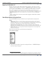
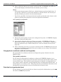
INTREPID User Manual
Library | Help | Top
INTREPID’s supported datums and projections (R09)
1
| Back |
INTREPID’s supported datums and projections (R09)
Top
INTREPID supports a wide variety of datums and projections. Each supported
datum or projection has a parameter file located in the directory install_path/
proj (where install_path is the location of your INTREPID installation). When
you specify a datum or projection, you select it from the list of these files.
The datum and projection parameter files are ASCII (text) files with the standard
INTREPID Begin – End block syntax (See "INTREPID Auxiliary files" in
INTREPID database, file and data structures (R05) for a description of the syntax).
You can use the predefined files as templates to create your own datum / projection
variations. Datum parameter files have the extension .datum. Projection parameter
files have the extension .proj.
If you are converting a dataset from one datum to another, the current datum
parameter file must contain conversion specifications for the new datum. INTREPID
already has the most common specifications, such as conversions to and from WGS84,
in the appropriate datum parameter files. This appendix explains how to obtain this
information for transformations not detailed in INTREPID.
You can also define local projections (local grids) based on known reference points but
allowing for displaced origins and different orientation of coordinate axes.
This appendix assumes that you are familiar with the concept of datums and
projections. For an introduction to the topic, we recommend Geodesy for the
Layman1, published by the organisation now known as the USA National Imagery
and Mapping Agency. You can read it on the World wide Web at the following
address:http://www.nima.mil/geospatial/products/GandG/geolay/
toc.htm
Some confusion exists in the area of datum and projection conversion. Jones (1997)2
details some of the current potential sources of error due to ignorance or confusion
about such matters as feet to metres conversion and rotation of axes. This appendix
mentions a specific problem with rotations in the Helmert 7 parameter datum
transformation method (See Bursa-Wolf vs Coordinate Frame Rotation methods). If
you wish to use parameters not supplied with INTREPID and you follow preliminary
testing procedures as advised, the problems are unlikely to affect you. The
INTREPID Cookbook contains instructions for testing a set of transformation
parameters. This method uses a point with known coordinates with respect to each
datum.
1. Geodesy for the Layman, Defence Mapping Agency Technical Report 80–003, Defence
Mapping Agency, Washington DC, 1984.
2. Jones, M. A. B., (1997), Do You Really Know Where You Are?, GIM International, 11 2,
6–9
Library | Help | Top
© 2012 Intrepid Geophysics
| Back |
INTREPID User Manual
Library | Help | Top
INTREPID’s supported datums and projections (R09)
2
| Back |
Note for INTREPID 3.7
Datums, Projections, POSC, SEG standards have changed . This time the unique
coordinate system number is to be the key. INTREPID supports this latest version
and can map to older ERMapper, Arcview, MapInfo and other formats as required.
The .cs files supplement the current system by providing an alternative way of
specifying a coordinate system. There are two ways of specifying a coordinate system:
- Datum/Projection. This is the traditional way, inherited from the ERMapper
system.
- Using .cs files. This is used for systems which suppport a POSC-like coordinate
system, eg, geotiff.
Specifying datums and projections
Several INTREPID tools have facilities for you to specify datum and projection.
Notes:
•
Import tool: When you specify datum and projection (geolocate the dataset)
using the Import tool, you are only identifying the existing datum and projection
for the data. The Import tool cannot change datum and projection.
•
Projection Conversion tool: If you wish to transform a dataset from one
projection and / or datum to another you must use the Projection Conversion tool.
•
Subsection tool: You can specify the datum and projection of a rectangle that
defines the subsection.
This section describes how to specify datums and projections.
>> To specify a datum
1
Choose the menu option or button for setting the Datum. INTREPID displays
the Select Datum dialog box1.
1. Some of the files listed in this dialog box refer to ellipsoids only, not datums. They are
included so that you can use them as templates for creating new datum parameter files.
Library | Help | Top
© 2012 Intrepid Geophysics
| Back |
INTREPID User Manual
Library | Help | Top
2
INTREPID’s supported datums and projections (R09)
3
| Back |
Select (click) the datum you require and choose OK. INTREPID will select the
datum and display its details in the tool window you are using.
Notes:
•
Some projection parameter files have a default datum associated with them. If
you specify a datum for a projection which has a default datum, the datum you
specify will take precedence over the default datum.
•
If you have specified a local projection (local grid), specify the same datum as the
reference (fixed) point projection in the local projection definition.
>> To specify a projection
1
Choose the menu option or button for setting the Projection. INTREPID displays
the Select Projection dialog box.
2
Open (double click) the Projection Type you require. INTREPID will list the
projections available for the selected Projection Type. For latitudes / longitudes,
select the Spherical type. NOTE: Intrepid v3.7 does not display the Projection
Type list.
3
Select (click) the projection you require and choose OK. INTREPID will select the
projection and display its details in the tool window you are using. For latitudes /
longitudes, select Geodetic.
Geographical coordinates (latitude and longitude)
For geographical coordinates (latitude and longitude) specify Geodetic from the
Spherical type.
The 'geodetic' projection
If your data has geographical coordinates, whenever INTREPID displays it on a
screen or prints it, it must project the data from its datum onto the flat surface of the
screen or hard copy. This 'geodetic' projection projects latitude and longitude lines
onto a plane surface with the vertical longitude lines and horizontal latitude lines. It
retains degrees as a distance unit. This projection does not minimise distortion and is
intended for processing and on-screen visualisation of datasets only.
Data that is not geolocated (RAW)
If your dataset is not geolocated (has no datum or projection information), specify RAW
for datum and RAW for projection.
Library | Help | Top
© 2012 Intrepid Geophysics
| Back |
INTREPID User Manual
Library | Help | Top
INTREPID’s supported datums and projections (R09)
4
| Back |
Spherical datums
For projections from a spherical datum, whose ellipsoid has major and minor axes of
the same length (e.g., SPHERE.datum), INTREPID will automatically use a special
spherical projection formula. This occurs particularly with the Transverse Mercator
projection.
INTREPID Datum specifications
A datum consists of the dimensions and position of an ellipsoid. The position is fixed
by an origin point.
All geolocated data imported into INTREPID has a known datum. INTREPID
records the name of the datum when the dataset is created, and can display it with
other dataset summary information.
INTREPID does not require origin points of datums for any of its operations. It does,
however, need to be able to transform datasets between datums. Therefore,
INTREPID only defines the positions of ellipsoids relative to other ellipsoids.
INTREPID datum parameter files consist of
•
The name of the datum,
•
The dimensions of the associated ellipsoid, given as the radii on the semi-major
and semi-minor axes in metres1,
•
Sets of parameters for transforming datasets from one datum to another datum.
Because of the large number of datums, many of which are specific to certain
regions, it is of little value to include parameters for all possible transformations.
Therefore we calculate and include only the sets of transformation parameters
likely to be used by INTREPID users (e.g., WGS84 to AGD84). See Obtaining
datum transformation parameters for advice about sets of parameters not
included with INTREPID.
Structure of datum parameter files
INTREPID datum parameter files reside in the install_path/proj directory
(where install_path is the location of the INTREPID installation) and consist of a
Datum Begin – Datum End block with lines of text.
The first line contains the INTREPID name of the datum (the same as the file name),
in the form
DatumName=datum_name
1.This differs from the conventional method of expressing ellipsoid dimensions as the
radius on the semi-major axis and the flattening. You can easily derive one from the
other.
Where
a = semi-major axis radiusb = semi-minor axis radius1/f = inverse flattening
f = a / ( a – b ) and
b=a (1–1/f)
Library | Help | Top
© 2012 Intrepid Geophysics
| Back |
INTREPID User Manual
Library | Help | Top
INTREPID’s supported datums and projections (R09)
5
| Back |
The next two lines specify the major and minor axes for the ellipsoid. The lines have
the format
Major=constant_value
Minor=constant_value
The file may then include a number of datum transformation parameter blocks.
These have the format shown in the following example.
DatumChange Begin
ToDatum=AGD84
DX=
116.000000
DY=
50.470000
DZ=
-141.690000
OMEGA=
0.230000
PHI=
0.390000
KAPPA=
0.344000
SCALEDIFF= -0.098300
DatumChange End
Where
ToDatum is the name of the target datum for the transformation,DX, DY, DZ
specify differences in origin positions for the ellipsoid(s)
OMEGA, PHI, KAPPA specify rotational differences between the ellipsoid(s) of the
datums. These parameters are often called Rx, Ry, Rz respectively.
SCALEDIF specifies a scale difference between the datums.
(See Specifying datum transformation parameters for further details.)
___
The name of the datum parameter file is the same as the datum name, with a .datum
extension. For example, the datums in the following examples would have file names
INDIAN60.datum and BELG50.datum.
Library | Help | Top
© 2012 Intrepid Geophysics
| Back |
INTREPID User Manual
Library | Help | Top
INTREPID’s supported datums and projections (R09)
6
| Back |
Examples of datum parameter files
Datum Begin
DatumName=INDIAN60
Minor=6356075.413
Major=6377276.345
DatumChange Begin
ToDatum=WGS84
DX= 298.960000
DY= 750.020000
DZ= 249.840000
OMEGA=
0.00000
PHI=
0.00000
KAPPA=
0.00000
SCALEDIFF= 0.00000
DatumChange End
Datum End
Datum Begin
DatumName=BELG50
Minor=6356911.946
Major=6378388.0
Datum End
Creating your own datum specification
If your dataset has a datum that is not included in INTREPID, you can create your
own datum specification as follows.
Library | Help | Top
1
Use a text editor to create a text file with the format described in Structure of
datum parameter files, including the axis radii and the datum name. You can use
the files provided with INTREPID as templates for your own specifications. If you
will be transforming the dataset to other datums, include appropriate datum
transformation parameter blocks. Save the datum parameter file with a unique
filename into install_path/proj (where install_path is the location of your
INTREPID installation). Datum parameter files must have the extension
.datum.
2
If you will be transforming other datasets to this datum, edit the datum
parameter files for the other datasets and insert datum transformation parameter
blocks for transforming datasets to your datum.
3
Add the new datum definition to the datums database file, install_path/
proj/datum.csv. (Note: earlier versions of INTREPID stored the datum
listings in an ASCII file called datumDB).
© 2012 Intrepid Geophysics
| Back |
INTREPID User Manual
Library | Help | Top
INTREPID’s supported datums and projections (R09)
7
| Back |
For example, if your datum is called ABC97, you will create a datum parameter file
called ABC97.datum. If you will be transforming this data to the WGS84 datum, you
will include a datum transformation parameter block as follows.
DatumChange Begin
ToDatum=WGS84
...
DatumChange End
If you will be transforming data from WGS84 to ABC97, you will edit the
WGS84.datum file and insert a datum transformation parameter block as follows.
DatumChange Begin
ToDatum=ABC97
...
DatumChange End
The datums database file
The datums database file, install_path/proj/datum.csv (where install_path
is the location of your INTREPID installation), is an ASCII file containing one line of
text for each datum. In order for INTREPID to recognise a datum, it must be
included in the datums database file.
•
Library | Help | Top
A projection listing consists of the POSC_CODE, POSC_NAME, ERM_NAME,
MAP_INFO. The ERM_NAME is the name of the datum, and must be the same as
the datum file name (excluding the .datum). It is not necessary to define the
POSC fields - if you don’t know them you can enter UNKNOWN.
© 2012 Intrepid Geophysics
| Back |
INTREPID User Manual
Library | Help | Top
INTREPID’s supported datums and projections (R09)
8
| Back |
Ellipsoids used by INTREPID datums
At the time of writing INTREPID has over 170 datum parameter files. Most of these
datum specifications use one of about 30 internationally recognised ellipsoids. The
following table contains a list of the common ellipsoids used by INTREPID, the
dimensions of the ellipsoid and either the ellipsoid 'template' file name or an example
of an INTREPID datum parameter file which uses the ellipsoid.
Ellipsoid
Semimajor
Axis (a)
Inverse
Flattening (1/f)
Semiminor Axis
(b
Template /
Example
Airy 1830 OSGB
6377563.396
299.324964700
6356256.909
AIRY
Airy 1830 Mod
6377340.189
299.324964700
6356034.448
AIRYMOD
Australian National
6378160.000
298.250000000
6356774.719
ANS
Bessel 1841
6377397.155
299.152800000
6356078.962
BESS1841
Bessel 1841 Norge
6377492.018
299.152812800
6356173.509
BESSMOD
Clarke 1858
6377293.645
294.260000000
6355621.336
CLA58MTR
Clarke 1866
6378206.400
294.978698200
6356583.800
CLA66MTR
Clarke 1880
6378249.145
293.465000000
6356514.870
CLA80MOD
Clarke 1880 IGN
6378249.200
293.466020800
6356515.000
CLA80IGN
Clarke 1880 Palestine
6378300.790
293.466307656
6356566.435
PALEST23
Clarke 1880 RSA
6378249.145
293.466300000
6356514.966
CLA80RSA
Clarke 1880 Mod
6378249.145
293.466300000
6356514.966
CLA80RSA
Everest 1830
6377276.345
300.801700000
6356075.413
EVERST1830
Everest 1830 Pakistan
6377301.243
300.801700000
6356100.228
KALIANPR
Everest 1948 Malaya
6377304.063
300.801700000
6356103.039
KERTAU
Everest 1967 Borneo
6377298.556
300.801700000
6356097.550
EVERST67
Fischer 1960 Mercury
6378166.000
298.300000000
6356784.284
FISCHER1960
Fischer 1960 South Asia
6378155.000
298.300000000
6356773.320
FISCHER60SA
Fischer 1968 Mercury
6378150.000
298.300000000
6356768.337
FISCHER1968
GRS 67
6378160.000
298.247167427
6356774.516
GRS67
GRS 80
6378137.000
298.257222101
6356752.314
GRS80
Hayford 1909
6378388.000
296.959262536
6356909.000
HAYF1910
Helmert 1906
6378200.000
298.300000000
6356818.170
HELM1906
Hough 1960
6378270.000
297.000000000
6356794.343
HOUGH
Indonesian National
6378160.000
298.247000000
6356774.504
IND74
International 1924
6378388.000
297.000000000
6356911.946
INT24
Krassovsky 1940
6378245.000
298.300000000
6356863.019
KRAS1940
Library | Help | Top
© 2012 Intrepid Geophysics
| Back |
INTREPID User Manual
Library | Help | Top
INTREPID’s supported datums and projections (R09)
9
| Back |
Ellipsoid
Semimajor
Axis (a)
Inverse
Flattening (1/f)
Semiminor Axis
(b
Template /
Example
South American 1969
6378160.000
298.250000000
6356774.719
SAD69
WGS60
6378165.000
298.300000000
6356783.287
WGS60
WGS66
6378145.000
298.250000000
6356759.769
MWL9D
WGS72
6378135.000
298.260000000
6356750.520
WGS72BE
WGS84
6378137.000
298.257223563
6356752.314
WGS84
Specifying datum transformation parameters
INTREPID uses the Helmert 3-Dimensional Similarity Transformation method for
transforming between datums1.
For the purposes of transformations, the X, Y and Z directions are parallel to the axes
of the system described here:
For an earth centred reference system,
•
The origin is the earth's centre of mass.
•
The positive arm of the Z axis passes through the instantaneous axis of rotation of
the Earth, towards the Northern hemisphere.
•
The positive arm of the X axis passes through Greenwich meridian and is at right
angles to the Z axis.
•
The positive arm of the Y axis is at right angles to both the Z and X axes so that
they form a right handed system.
The Helmert 3-Dimensional Similarity Transformation method uses seven
parameters, describing changes in position of the origin, rotations of the axes and the
difference in radii of the two ellipsoids.
dX, dY, dZ are the changes of origin along the X, Y and Z axes respectively in metres.
These parameters correspond to DX, DY, and DZ in INTREPID datum
transformation parameter blocks.
Rx, Ry, Rz are the rotations of the X, Y and Z axes respectively in radians. These
parameters correspond respectively to OMEGA, PHI, and KAPPA in INTREPID
datum transformation parameter blocks.
Scale Difference is a factor representing the change in scale from the original
datum and the new datum. This parameter corresponds to SCALEDIFF in
INTREPID datum transformation parameter blocks. This is normally defined in
parts per million.
1. For a description of transformation methods, see the corresponding web page at the
Australian Land Information Group (AUSLIG)'s website. The page address is
http://www.auslig.gov.au/geodesy/transf.htm
Library | Help | Top
© 2012 Intrepid Geophysics
| Back |
INTREPID User Manual
Library | Help | Top
INTREPID’s supported datums and projections (R09)
10
| Back |
Bursa-Wolf vs Coordinate Frame Rotation methods
There are two different rotation conventions.
•
Using the Bursa-Wolf method (said to be normally used in Europe) positions are
rotated around the axes.
•
Using the Coordinate Frame Rotation method (said to be normally used in
Australia and North America), the axes are rotated.
The practical difference between these conventions is opposite signs in the rotation
parameters.
Currently there is some confusion in the world about the method to which certain
parameter sets belong. We have verified that INTREPID correctly performs
transformations with the parameters we have supplied. Different respectable sources
we have studied give the same sets of parameters for both Bursa-Wolf and the
Coordinate Frame Rotation methods.
Until this confusion is resolved, we strongly recommend the following. If you are
creating your own datum transformation parameter block from parameters you have
acquired outside INTREPID, test the transformation with a known point. This will
ensure that you have the correct sign for the rotations.
The INTREPID Cookbook has detailed instructions for performing a datum
transformation test.
Are the rotation and scale parameters really necessary?
The dX, dY and dZ parameters are readily available, whereas you may have to take
some trouble to obtain the rotation and scale parameters. If maximising positional
accuracy is not vital, you can set the rotational and scale parameters to 0.
INTREPID will still transform your data with a positional accuracy suitable, say, for
a 1:50000 map.
Assuming that you obtain them from a reliable source, using the rotational and scale
parameters will produce more accurate transformations.
Example of a datum transformation parameter block
This block belongs to the WGS84 datum parameter file and specifies the
transformation to AGD84.
DatumChange Begin
ToDatum=AGD84
DX=
116.000000
DY=
50.470000
DZ=
-141.690000
OMEGA=
0.230000
PHI=
0.390000
KAPPA=
0.344000
SCALEDIFF= -0.098300
DatumChange End
Library | Help | Top
© 2012 Intrepid Geophysics
| Back |
INTREPID User Manual
Library | Help | Top
INTREPID’s supported datums and projections (R09)
11
| Back |
Obtaining datum transformation parameters
The dX, dY and dZ parameter values are readily available for transforming between
WGS84 and other datums. The most comprehensive source is DMA Technical Report
8350.2—World Geodetic System 84, 2nd Edition, Defence Mapping Agency, Fairfax,
Virginia, 1991. At the time of writing, a new edition of this report is about to be
released. You can obtain further information from the Agency, now known as the
National Imagery and Mapping Agency (NIMA). It has a website at http://
www.nima.mil.
The rotation and scale parameters are more difficult to obtain. We include these for
the most common transformations, as listed in the corresponding .datum files
(especially wgs84.datum). If you wish to obtain these parameters for a less common
datum, try requesting them from the mapping authorities in the countries concerned.
INTREPID Projection Specifications
A projection is a method for transposing points from the surface of an ellipsoid to a
plane (e.g., a piece of paper or a computer screen).
If geolocated data imported into INTREPID is projected, INTREPID will record the
name of the projection when the dataset is created. If the data is not projected,
INTREPID records the projection as geodetic.
INTREPID projection parameter files consist of
•
The projection type,
•
The names and values of constants required for the projection,
•
The names and values of optional constants,
•
The name of a default associated datum (optional).
Structure of projection parameter files
INTREPID projection parameter files consist of a Projection Begin –
Projection End block containing a number of lines of text.
The first line contains the INTREPID name of the projection associated with the file,
in the form
ProjectionType=projection type
Subsequent lines specify values associated with this specification. The lines have the
format
constant_name=constant_value
In standard (non-local) projection specifications, you can also specif y an associated
datum. The datum line has the format
Datum=datum_name
Local projection (local grid) definitions have a different format from standard
projection specifications. See Local projections (local grids) for further information.
Library | Help | Top
© 2012 Intrepid Geophysics
| Back |
INTREPID User Manual
Library | Help | Top
INTREPID’s supported datums and projections (R09)
12
| Back |
Example of standard projection parameter file
Projection Begin
ProjectionType = LambertConicConformal
CentralMeridian = 135
StdLat1 = –36
StdLat2 = –28
Datum = AGD66
Projection End
See Local projections (local grids) below for examples of local projection (local grid)
definitions.
Projection types
The projection types appear in the Supported Projections tables at the end of this
appendix. These tables also contain the required and optional constants for the
projection.
Constant names
The constant names used by INTREPID are as follows
Constant
INTREPID constant name
Australian Mapping Grid Zone
AMGZone
Central Meridian
CentralMeridian
Standard Latitude
StdLat
Standard Latitude 1
StdLat1
Standard Latitude 2
StdLat2
Middle Latitude
MiddleLatitude
Longitude True Scale East
LongitudeTrueScaleEast
False Easting
FalseEasting
False Northing
FalseNorthing
Scale Factor
ScaleFactor
Latitude Origin
LatOrigin
See the corresponding section below for information about the datum.
Default datums specified in projection parameter files
The datum specified in a projection parameter file is the default datum for the
projection. You can specify a different datum for a dataset when you assign the
datum and projection using the Projection Conversion or Import tool. A datum you
specify in this way will take precedence over the default datum in the projection.
Library | Help | Top
© 2012 Intrepid Geophysics
| Back |
INTREPID User Manual
Library | Help | Top
INTREPID’s supported datums and projections (R09)
13
| Back |
Creating your own projection specifications
You can create your own projection specification as follows:
1
Use a text editor to create a text file with the format described in Structure of
projection parameter files. You can use the files provided with INTREPID as
templates for your own specifications. Save the projection parameter file with a
unique filename into install_path/proj (where install_path is the location
of your INTREPID installation). Projection parameter files must have the
extension .proj.
2
Adding the new projection definition to the projections database file,
install_path/proj/proj.csv. (Note: earlier versions of INTREPID stored
the projection listings in an ASCII file called projectionDB).
The projections database file
The projections database file, install_path/proj/proj.csv (where
install_path is the location of your INTREPID installation), is an ASCII file
containing one line of text for each projection. In order for INTREPID to recognise a
projection, it must be included in the projections database file.
•
A projection listing consists of the POSC_CODE, POSC_TYPE, POSC_NAME,
ERM_TYPE, ERM_NAME. The ERM_NAME is the name of the projection, and
must be the same as the projection file name (excluding the .proj). It is not
necessary to define the POSC fields - if you don’t know them you can enter
UNKNOWN.
•
Some projection types shown in the projections database are abbreviations of the
full projection type names. See the comprehensive table in Supported Projections
for details of projection names and database abbreviations.
•
You should list all projections of the same type together.
•
The projections database file controls the listing of projections in the Select
Projection dialog box. See Specifying datums and projections for an illustration.
•
Here is an abbreviated listing of the projections database file supplied with
INTREPID.
Unknown,Unknown,Unknown,AzimuthalEquidistant,AEAFRICA
Unknown,Unknown,Unknown,AzimuthalEquidistant,AERUSS
10101,Transverse Mercator,Alabama CS27 East
zone,TransverseMercator,ALABAMA_CS27_EAST_ZONE
10102,Transverse Mercator,Alabama CS27 West
zone,TransverseMercator,ALABAMA_CS27_WEST_ZONE
10131,Transverse Mercator,Alabama CS83 East
zone,TransverseMercator,ALABAMA_CS83_EAST_ZONE
10132,Transverse Mercator,Alabama CS83 West
zone,TransverseMercator,ALABAMA_CS83_WEST_ZONE
Unknown,Unknown,Unknown,AlbersEqualArea,ALALASK2
Unknown,Unknown,Unknown,AlbersEqualArea,ALALASK3
Unknown,Unknown,Unknown,AlbersEqualArea,ALALASKA
15010,Lambert Conic Conformal (2SP),Alaska CS27 zone
10,LambertConicConformal,ALASKA_CS27_ZONE_10
Library | Help | Top
© 2012 Intrepid Geophysics
| Back |
INTREPID User Manual
Library | Help | Top
INTREPID’s supported datums and projections (R09)
14
| Back |
Local projections (local grids)
It may not be convenient for you to convert certain datasets to an existing projection.
For example, ground based surveys (e.g, ground magnetics) may be made using a
local grid1 with a local origin and axis perpendicular to the strike of the predominant
geology.
You can define a local projection (local grid) for such a dataset. Local projections are
essentially transformations from existing projections. They use a known reference
point in an existing projection, and can incorporate an offset for the local origin from
the reference point, a different angle for the dataset's 'North', and different distance
units.
Local projection definition files consist of a Projection Begin – End block. Here
is an example of a user-defined Local Projection file:
Projection Begin
ProjectionType = Local
LocalZone = 1
Comment = "Derived from Z346"
FixedPointX = 498029.00
FixedPointY = 6395731.00
FPProjection = TMAMG53
FPXoffset = 934.80
FPYoffset = 1565.00
FPAngle = 45:0:4.59289944
LocalScale = 1
Projection End
1. Note: Such a survey would first yield an INTREPID line or point dataset with accurate
location data, not a grid dataset.
Library | Help | Top
© 2012 Intrepid Geophysics
| Back |
INTREPID User Manual
Library | Help | Top
INTREPID’s supported datums and projections (R09)
15
| Back |
These are the rules for defining a Local Projection file:
•
The local projection definition file must begin with the word Local and end with
an integer eg: Local1.prj
•
The LocalZone statement in the file must be LocalZone=1
•
The rotation angle (FPAngle) in Local1.proj should be positive and in degrees
minutes seconds ie; ddd:mm:ss.sss. Decimal degrees do not work.
•
The file must be copied to the Intrepid /proj directory.
•
The following line needs to be added into the proj.csv file in the Intrepid /proj
directory: Unknown,Unknown,Unknown,Local,LOCAL1
Keyword
Purpose
LocalZone
Use this keyword to assign a unique identification number to the zone
described by the projection.
FixedPointX
World coordinates of the reference (fixed) point using the reference point's
projection.
FixedPointY
FPProjection
Projection of the reference point.
FPXoffset
Offset of dataset origin from reference point. This has the same distance units
as the projection of the fixed point (normally metres).
FPYoffset
FPAngle
Angle in degrees of local North relative to the reference point projection's
North. A positive angle corresponds to an anticlockwise rotation.
LocalScale
Scale of distance in the dataset (number of metres in one dataset distance
unit).
If you use a local projection, the local origin (i.e., X = 0, Y = 0) will be the point defined
by FixedPointX, FixedPointY adjusted by FPXoffset, FPYoffset.
INTREPID will determine the actual location of the dataset origin using the
projection defined by FPProjection and its corresponding datum.
Library | Help | Top
© 2012 Intrepid Geophysics
| Back |
INTREPID User Manual
Library | Help | Top
INTREPID’s supported datums and projections (R09)
16
| Back |
Supported Projections
The following pages contain tables of projections that INTREPID supports. The
columns of the table contain the following information.
Column
Information
1
The normal name of the projection type,The projection type as listed in projection
definition files,(The abbreviated projection type as listed in the projections database file—
if different from the projection type).
2
A list of the projection definition files of this type supplied with INTREPID (unless they
are too numerous to list).
3
A list of the constant values that must be declared in projection definitions for this
projection type,The name of any obligatory datum for the projection.
4
Optional parameters for the projection type.
5
Default values for the optional parameters.
6
Distance units for the projection.
The table includes all projection types but does not individually list each projection.
For a complete list, examine the list in the Select Projection dialog box and the
corresponding projection parameter file (.proj) files in the install_path\proj
directory (where install_path is the location of your INTREPID installation). The
INTREPID projections are comprehensive. For example, TMOMAN.proj is
specifically set up for Oman.
Projection and
INTREPID Projection
Name
(Projections database
abbreviation if different)
Projection
files provided
with
INTREPID
Required
Constants
Optional
Parameters:
Name
Geographical (unprojected)
GEODETIC
none
none
CentralMeridi
an
FalseEasting
Default
Unit
°
Geographic
Local
Local
Reference
projection
assigned in
definition
Albers Equal Area
AlbersEqualArea
AL*
(AlbersEArea)
GALB
StdLat1
StdLat2
Library | Help | Top
© 2012 Intrepid Geophysics
10
m
FalseNorthing
ScaleFactor
LatOrigin
| Back |
INTREPID User Manual
Library | Help | Top
INTREPID’s supported datums and projections (R09)
17
| Back |
Projection and
INTREPID Projection
Name
(Projections database
abbreviation if different)
Projection
files provided
with
INTREPID
Required
Constants
Optional
Parameters:
Name
Default
Unit
Australia Mapping Grid
TMAMG49
AMGZone
FalseEasting
5e5
m
AMG
TMAMG50
Default Datum
AGD66
FalseNorthing
1e7
ScaleFactor
.9996
LatOrigin
0
FalseEasting
10
m
10
m
10
m
TMAMG51
TMAMG52
TMAMG53
TMAMG54
Note:
You can use
WGS84 or
AGD84 instead.
TMAMG55
TMAMG56
TMAMG57
Azimuth Equal Area
LE*
CentralMeridi
an
AzimuthEqualArea
StdLat
(AzimuthEArea)
FalseNorthing
ScaleFactor
LatOrigin
Azimuth Equidistant
AEAFRICA
AzimuthEquidistant
AERUSS
CentralMeridi
an
StdLat
(AzimuthEDist)
FalseEasting
FalseNorthing
ScaleFactor
LatOrigin
Goode International
Homalographic
GOOD
CentralMeridi
an
GoodeIntHomalographi
c
LatOrigin
Bipolar Oblique Conic
Conformal
BCNAMER
BipolarObliqueConicC
onformal
BCSPHERE
Lallemand Modified
Polyconic
ModifiedPolyconic
(ModPolyconic)
Library | Help | Top
FalseNorthing
ScaleFactor
(GoodeIntHomal)
(BipolarObConConf)
FalseEasting
none
none
CentralMeridi
an
‡FalseEasting
m
BCSAMER
BOCC
MPCALIF
MPOL
MPOLAUS
StdLat1
StdLat2
© 2012 Intrepid Geophysics
FalseNorthing
-77770
010
m
ScaleFactor
LatOrigin
| Back |
INTREPID User Manual
Library | Help | Top
INTREPID’s supported datums and projections (R09)
18
| Back |
Projection and
INTREPID Projection
Name
(Projections database
abbreviation if different)
Projection
files provided
with
INTREPID
Required
Constants
Optional
Parameters:
Name
Default
Unit
Lambert Conformal Conic
†
LAM*
CentralMeridi
an
False Easting
10
m
LambertConicConforma
l
LCCTEST
10
m
10
m
LM*
StdLat1
StdLat2
(LambertConConf)
Regular Polyconic
RPMON
Polyconic
RPNAM
CentralMeridi
an
False Northing
Scale Factor
LatOrigin
False Easting
False Northing
RPSIB
Scale Factor
RPUSSR
LatOrigin
POLAUS
POLTEST
Simple Conic
CE*
SimpleConic
GEOSIM
CentralMeridi
an
StdLat1
RUSSIA
StdLat2
SIM*
Interrupted Sinusoidal
False Easting
False Northing
Scale Factor
LatOrigin
SIN
none
none
°
Sinusoidal
SNSPHERE
none
none
°
Sinusoidal
LAVINIA
none
none
°
False Easting
InterruptedSinusoida
l
(InterruptedSinus)
VENRAD*
Spherical
GEODETIC
Spherical
STDGEO
Polar Stereographic
STEREO_EQU
ATORIAL
CentralLatitu
de
STEREO_OBL
IQUE
CentralMeridi
an
STEREO_POL
AR
StdLat
PolarStereographic
(PolarStereo)
10
m
False Northing
Scale Factor
LatOrigin
POLAR_STER
EO
Library | Help | Top
© 2012 Intrepid Geophysics
| Back |
INTREPID User Manual
Library | Help | Top
INTREPID’s supported datums and projections (R09)
19
| Back |
Projection and
INTREPID Projection
Name
(Projections database
abbreviation if different)
Projection
files provided
with
INTREPID
Required
Constants
Optional
Parameters:
Name
Default
Unit
Stereographic
OS*
Scale Factor
1e-07
m
Stereographic
PS*
CentralLatitu
de
10
m
10
m
10
m
False Easting
5e5
m
False Northing
0
(Nth Hemisph)
1e7
(Sth Hemisph)
.9996
Scale Factor
0
CentralMeridi
an
LatOrigin
Convergence
StdLat
Mercator†
MER*
Mercator
MR*
CentralMeridi
an
False Easting
False Northing
Scale Factor
LatOrigin
Transverse Mercator†
STM*
TransverseMercator
TM*
(TM)
(except
Scale Factor
TMAMG*
LatOrigin
CentralMeridi
an
False Easting
False Northing
TMS)
Spherical Transverse
Mercator
TMS
CentralMeridi
an
TransverseMercatorSp
here
False Easting
False Northing
Scale Factor
LatOrigin
(TMSphere)
Universal Transverse
Mercator †
NUTM*
UniversalTransverseM
ercator
UTM*
CentralMeridi
an
SUTM*
Datum
(UTM)
LatOrigin
Van der Grinten
VANDG_AUS
VanDerGrinten
VANDG_RUSS
IA
(VDGrinten)
CentralMeridi
an
VG*
Library | Help | Top
False Easting
10
°
False Northing
Scale Factor
LatOrigin
© 2012 Intrepid Geophysics
| Back |
INTREPID User Manual
Library | Help | Top
INTREPID’s supported datums and projections (R09)
20
| Back |
'*' Wild card indicating numerous projection parameter files. For example VG* refers
to VG120E, VG120W, ... . For a full list, refer to the projections database
install_path/proj/projectionDB (where install_path is the location of your
INTREPID installation).
‡ LongitudeTrueScaleEast, Default value is -7777
† Uses the formula for the sphere if major axis = minor axis
Projection Conventions for Antarctica
These conventions appear in full in the revised standing resolutions of the SCAR
Working Group on Geodesy and Cartography submitted to XVI SCAR October 1980.
Use the World Geodetic System 1972 (WGS72) as the datum.
At scales smaller than 1:1 000 000 use the polar stereographic projection with the
standard parallel (StdLat) at 71°
At scales of 1:1 000 000 use the ICAO specifications for projections at that scale and
the common ICAO–IMW sheet lines along parallels, with optional meridian limits.
At scales greater than 1:1 000 000 use a conformal projection and sheet lines which
subdivide ICAO–IMW 1:1 000 000 sheet lines.
Frequently asked questions
Q : How do I create a new projection or alter an existing projection in
INTREPID?
INTREPID's projection attributes can be changed simply by editing the existing files
or creating new files in the install_path/proj subdirectory. If new projections or
datums are created then remember to add them to the proj.csv or datum.csv
spreadsheets so that Intrepid knows about them. If you don't know the POSC code for
the projection or datum, you can enter Unknown as a keyword. Note that for a datum
to datum change, INTREPID requires the transformation parameters to be present
in the *.datum file.
If the projection suite is modified then make a copy of the install_path/proj
directory because a re-installation or upgrade would overwrite the changes. If you
supply us with new projections or modifications to existing ones, we can include them
in our distribution.
Library | Help | Top
© 2012 Intrepid Geophysics
| Back |