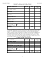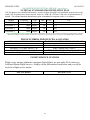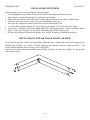
1
INFLIGHT GUIDE 20 JUN 2013 OPERATIONAL MISSION INFLIGHT GUIDE NATIONAL EMERGENCY SERVICES ACADEMY MISSION AIRCREW SCHOOL INFLIGHT GUIDE 20 JUN 2013 LOG OF WRITE-IN CHANGES CHANGE INCORPORATED Change 3 Change 4 Change 5 Change 6 Change 7 Change 8 Change 9 Change 10 Through Change 11 DATE 1 Nov 2006 1 May 2007 14 July 2007 1 Jan 2008 25 July 2008 06 July 2009 30 April 2010 04 April 2011 20 June 2013 SUMMARY OF CHANGES Change 1: 1 APR 2006 - Page numbering fixed in leading pages - p27 changed spelling to “emergency” - p78 fixed maximum signal diagram - p78 spatial disorientation, mark position, 2 instrument rated pilots - p7 widened text box - p13 stretched flight plan - p44 removed FOUO information, added document labeling - p47 added High Bird information to communications - p76, p92, p98 spacing Change 4: 1 MAY 2007 - p97 Added SAR / Drug Dog information based on dog O-flights - p97 Moved relocation information (paragraph) to page 96 Change 5: Release 07-1: 14 Jul 2007 - Fixed cell grid information; added Alaskan Numbered Grid Change 6: Release 08-01: Draft Date 1 Jan 2008 - p110 Removed “Seconds to Decimal Degrees” Table (extraneous) Change 7: p13.Fixed flight plan Page reference. p107 Added G1000 reference & updated ARNAV 5000 / GX55. p43 Updated Flight Service Station information Change 2: 1 SEP 2006 - Updated all prowords to comply with current guidance - Changed references to “relocation” wherever applicable - p69 fixed frequency - p44 added all FSS phone numbers, added AFRCC Tyndall #, removed hijack squawk - p13 added reference to p44, FSS phone numbers - p19 fixed “high” above the horizon - p66 fixed reference line direction - p45 “zulu” spelling - p43 changed communications example - p73 added general rules of thumb for antennas above/below the wings - p8 changed generic weight & balance worksheet to include C182s Change 8: p136-137 added Scanner Photographer worksheets. Change 9: 30 APR 2010 - Various punctuation, grammar and spelling throughout. - Updated to NHQ release format. - p27 changed format on page and added two lines. - References to CPF and CAP FLIGHT changed to CAP. - p3&27 Updated 60-1 shoulder harness requirements in several locations. - p2 added GPS database, Fire EX and corrosion control exp dates - p4&5 Updated 60-1 minimum altitude requirements. - p12&13 Updated ORM to match the NHQ AIF - p14 Updated FAA Form 7233-1 Change 3: 1 NOV 06 - Fixed & improved visual signal tables - Rearranging allowed to shorten by 1 page and eliminate 1 blank page - New Creeping Line Search diagram Change 10: 04 April 2011 - p41 Changed language to incorporate new FAA taxi procedures, IAW FAA Order JO 7110.65, Air Traffic Control, Paragraph 3-7-2, as amended -p42 Added use of “RESCUE” prefix for actual SAR per US supplement p82 Updated definitions & eliminated redundancy p87 Changed mathematical constant so the result is in NM, not feet Desired changes: Add On Scene Commander Checklist Insert index—alphabetized quick reference Put in current ICS forms when available Change 11: 20 June 2013 - p41 Changed language to incorporate new ii INFLIGHT GUIDE 20 JUN 2013 SECTION I: TABLE OF CONTENTS LOG OF WRITE-IN CHANGES ............................................................................................................................................................. ii SUMMARY OF CHANGES ..................................................................................................................................................................... ii SECTION I: TABLE OF CONTENTS ..............................................................................................................iii SECTION II: PREFLIGHT PLANNING........................................................................................................... 2 MISSION CHECKLIST .............................................................................................................................................................................2 GENERAL PREFLIGHT ACTIONS .......................................................................................................................................................6 DOCUMENTS AND MINIMUM EQUIPMENT ....................................................................................................................................7 CROSSWIND COMPONENT DATA .......................................................................................................................................................8 WEIGHT AND BALANCE PLANNING .................................................................................................................................................9 AIRCREW OPERATIONAL RISK MANAGEMENT MATRIX .......................................................................................................12 FAA FLIGHT PLAN ................................................................................................................................................................................14 AIRCRAFT EQUIPMENT SUFFIXES ..................................................................................................................................................14 BASIC VFR WEATHER MINIMA ........................................................................................................................................................15 MARSHALLING SIGNALS ....................................................................................................................................................................16 MISSION AND GENERAL BRIEFING GUIDE: BRIEFING STANDARDS ...................................................................................18 GENERAL PASSENGER BRIEFING ...................................................................................................................................................27 AIRCREW FUNCTIONAL AREA CHECKLISTS: MISSION PILOT .............................................................................................28 AIRCREW FUNCTIONAL AREA CHECKLISTS: OBSERVER/SCANNER .................................................................................29 SECTION III: EMERGENCY PROCEDURES .............................................................................................. 30 EMERGENCY COMMUNICATONS ....................................................................................................................................................30 GENERAL RADIO FAILURE PROCEDURES ...................................................................................................................................30 STANDARD LIGHTGUN SIGNALS .....................................................................................................................................................30 LOST PROCEDURES ..............................................................................................................................................................................30 STUCK MICROPHONE ..........................................................................................................................................................................31 EMERGENCY GROUND EGRESS .......................................................................................................................................................31 STRUCTURAL DAMAGE / CONTROLLABILITY CHECK ............................................................................................................32 AIRCREW SURVIVAL BASICS ............................................................................................................................................................34 FIRST AID / URGENT CARE ................................................................................................................................................................35 PERSONAL SURVIVAL KIT SUGGESTIONS ...................................................................................................................................37 COMPLETE SUGGESTED SURVIVAL KIT ITEMS.........................................................................................................................38 INTERCEPT PROCEDURES .................................................................................................................................................................40 COMMUNICATIONS USAGE CHECKLIST ......................................................................................................................................41 BASIC PHRASEOLOGY EXAMPLES .................................................................................................................................................41 CALLSIGNS ..............................................................................................................................................................................................42 NATIONAL STANDARD CHANNELIZATION PLAN ......................................................................................................................43 PHONE NUMBERS, FREQUENCIES, & SQUAWKS ........................................................................................................................43 FLIGHT SERVICE STATIONS .............................................................................................................................................................43 PHONETIC FIGURES (NUMBERS) .....................................................................................................................................................44 PHONETIC ALPHABET .........................................................................................................................................................................44 COMM PROWORD DEFINITIONS ......................................................................................................................................................45 CODE WORDS .........................................................................................................................................................................................46 HIGHBIRD RELAY INFORMATION ..................................................................................................................................................47 PMA7000MS AUDIO PANEL .................................................................................................................................................................47 NAT NPX-138 VHF FM Radio ................................................................................................................................................................49 TDFM-136 DIGITAL/ANALOG VHF FM RADIO ..............................................................................................................................50 AIRCRAFT CLOCK POSITONS ...........................................................................................................................................................51 AIR TO GROUND COORDINATION ...................................................................................................................................................52 AIR TO GROUND 2-WAY RADIO COMMUNICATION FAILURE IS RECOGNIZED ..............................................................52 KEEPING UP WITH THE GROUND TEAM .......................................................................................................................................53 TURNING THE GROUND TEAM AROUND ......................................................................................................................................53 TURN THE GROUND TEAM ................................................................................................................................................................54 STOP OR DISMOUNT.............................................................................................................................................................................54 OBJECTIVE IS HERE .............................................................................................................................................................................55 AIR TO GROUND COORDINATION (VEHICLE ESCORT) LESSONS LEARNED....................................................................55 KEEPING UP WITH THE GROUND TEAM: ALTERNATE METHOD ........................................................................................56 iii INFLIGHT GUIDE 20 JUN 2013 AIR TO GROUND VISUAL SIGNALS .................................................................................................................................................57 SURFACE TO AIR VISUAL SIGNALS ................................................................................................................................................58 SURFACE TO AIR VISUAL BODY SIGNALS ....................................................................................................................................59 PANEL / PAULIN SIGNALS .................................................................................................................................................................60 AIRDROP (MESSAGE DROP) ...............................................................................................................................................................61 SECTION V: ELECTRONIC SEARCH .......................................................................................................... 62 L-TRONICS AIR DF SINGLE METER MODELS ..............................................................................................................................62 L-TRONICS AIR DF DUAL METER MODELS ..................................................................................................................................63 SIX STEPS TO ELT / EPIRB LOCATION ...........................................................................................................................................64 AIRBORNE DIRECTION FINDERS FOR ELT SEARCH .................................................................................................................65 BECKER SAR-DF 517 OPERATION ....................................................................................................................................................68 BECKER SAR-DF 517 BEARING ON MORE THAN ONE TRANSMITTER ................................................................................69 ELT RECEPTION DISTANCE GRAPH & TABLE ............................................................................................................................70 OTHER METHODS OF LOCATING AN ELT ....................................................................................................................................71 WING NULL / WING SHADOWING METHOD OF ELT LOCATION ..........................................................................................71 WING NULL METHOD VISUALIZED ................................................................................................................................................72 WING NULL DIRECTION MATRIX ....................................................................................................................................................72 ANTENNAS BELOW THE WINGS .......................................................................................................................................................73 ANTENNAS ABOVE THE WINGS........................................................................................................................................................73 AURAL SEARCH METHOD ..................................................................................................................................................................74 METERED SEARCH (BUILD AND FADE) METHOD ......................................................................................................................76 NIGHT AND IFR ELECTRONIC SEARCH .........................................................................................................................................78 COLLAPSING BOX ELECTRONIC SEARCH ...................................................................................................................................79 BASIC GROUND ELT SEARCH FOR AIRCREWS ...........................................................................................................................80 6 STEPS TO ELT LOCATION ON THE GROUND: ...........................................................................................................................80 AFRCC REQUIRED ELT INFORMATION .........................................................................................................................................81 AIRCREW ON-THE-GROUND LEGAL ISSUES................................................................................................................................81 SECTION VI: VISUAL SEARCHES ............................................................................................................... 82 SEARCH PLANNING AND COVERAGE ............................................................................................................................................82 POSSIBILITY, PROBABILITY, AND POSSIBILITY VS. PROBABILITY ....................................................................................83 CAP GRID SYSTEMS ..............................................................................................................................................................................84 VISUAL SEARCH PATTERNS ..............................................................................................................................................................85 ROUTE (TRACK LINE OR TRACK CRAWL) SEARCH .................................................................................................................85 PARALLEL LINE (GRID) SEARCH .....................................................................................................................................................86 SEARCH TURN RADIUS ........................................................................................................................................................................87 CREEPING LINE SEARCH ...................................................................................................................................................................88 EXPANDING SQUARE SEARCH .........................................................................................................................................................88 SECTOR SEARCH ...................................................................................................................................................................................89 CONTOUR SEARCH ...............................................................................................................................................................................89 OBJECT VISIBILITY ..............................................................................................................................................................................90 VISUAL SEARCHING CLUES ..............................................................................................................................................................90 AMPLIFIED VISUAL SEARCHING CLUES ......................................................................................................................................90 WRECKAGE PATTERNS (ACCIDENT SIGNS) ................................................................................................................................92 SCANNING: REDUCING THE EFFECTS OF FATIGUE .................................................................................................................93 VISUAL SCANNING VISUALIZED ......................................................................................................................................................93 PROBABILITY OF DETECTION: MISSION AND CUMULATIVE POD ......................................................................................94 SECTION VII: ADDITIONAL CAP MISSIONS ............................................................................................ 96 DISASTER RELIEF .................................................................................................................................................................................96 DAMAGE ASSESSMENT .......................................................................................................................................................................96 RELOCATION MISSION .......................................................................................................................................................................97 CANINES: SAR DOG / COUNTERDRUG DOG TEAM RELOCATION ........................................................................................98 PHOTO MISSION (SSTV, TAKE-HOME, OR VIDEO) .....................................................................................................................99 SDIS PHOTO MISSION (SATELLITE DIGITAL IMAGING SYSTEM) ......................................................................................101 HIGH BIRD TASKING ..........................................................................................................................................................................102 LOW LEVEL ROUTE SURVEY ..........................................................................................................................................................102 CHEMICAL, BIOLOGICAL, RADIOLOGICAL, OR NUCLEAR EVENTS ................................................................................102 CAP / ROTC CADET ORIENTATION FLIGHT ...............................................................................................................................102 SECTION VIII: GPS OPERATIONS ............................................................................................................. 104 KNOWING YOUR GPS .........................................................................................................................................................................104 iv INFLIGHT GUIDE 20 JUN 2013 USING THE KLN 89B FOR SAR .........................................................................................................................................................105 GARMIN G1000 ......................................................................................................................................................................................108 ARNAV STAR 5000 GPS .......................................................................................................................................................................108 APOLLO GX55 GPS ..............................................................................................................................................................................108 LATITUDE-LONGITUDE DECIMAL CONVERSION CHART ....................................................................................................111 SECTION IX: CREW RESOURCE MANAGEMENT ................................................................................ 112 PREVENTATIVE FATIGUE COUNTERMEASURES .....................................................................................................................112 OPERATIONAL FATIGUE COUNTERMEASURES .......................................................................................................................112 CREW RESOURCE MANAGEMENT ................................................................................................................................................113 T.E.A.M.S. ................................................................................................................................................................................................113 SECTION X: ADMINISTRATION ................................................................................................................ 114 AIRCREW GUIDE RELEASE NOTES ...............................................................................................................................................114 BIBLIOGRAPHY ...................................................................................................................................................................................115 APPENDIX A: BRIEFING GUIDE ................................................................................................................ 116 APPENDIX B: AIRCREW FORMS ............................................................................................................... 126 MISSION INFORMATION SHEET.....................................................................................................................................................126 MISSION PILOT SEARCH AREA WORKSHEET ...........................................................................................................................127 HIGH BIRD WORKSHEET ..................................................................................................................................................................127 HIGH BIRD TRANSMISSION LOG ...................................................................................................................................................129 COMM FLIMSY .....................................................................................................................................................................................130 GRID COORDINATE S (A – B – C – D) ..............................................................................................................................................131 QUARTER GRID COORDINATES A .................................................................................................................................................132 QUARTER GRID COORDINATES B .................................................................................................................................................133 QUARTER GRID COORDINATES C .................................................................................................................................................134 QUARTER GRID COORDINATES D .................................................................................................................................................135 ROUTE COORDINATES ......................................................................................................................................................................136 CREEPING LINE COORDINATES ....................................................................................................................................................137 EXPANDING SQUARE COORDINATES ..........................................................................................................................................138 OBSERVER LOG ...................................................................................................................................................................................138 SCANNER SEARCH AREA WORKSHEET ......................................................................................................................................140 OBSERVER / SCANNER SEARCH AREA WORKSHEET ....................................................................... 142 AERIAL PHOTOGRAPHY DATA SHEET ........................................................................................................................................143 ELT INFORMATION REQUIRED BY AFRCC ................................................................................................................................144 v INFLIGHT GUIDE 20 JUN 2013 This page intentionally left blank vi INFLIGHT GUIDE 20 JUN 2013 SECTION II: PREFLIGHT PLANNING MISSION CHECKLIST 1. Leaving Home for Mission Base A. Proper uniforms (CAPM 39-1) and credentials 1) CAP Membership 2) CAP Motor Vehicle Operator 3) ROA 4) 101/101T/SQTR (note experience and tasks to be accomplished) 5) Pilot currency (including a Photo ID) B. Check personal equipment 1) Clothing sufficient and suitable for the entire trip 2) Personal supplies (civilian clothing, headset, charts, maps, plotter, log, checklists, fluids and snacks) 3) Personal survival equipment (in addition to the aircraft kit) suitable for the entire trip 4) Sufficient money for the trip (credit cards, some cash or traveler's checks, and coin) 5) Cell phone (including spare battery and charger) C. Check aircraft equipment 1) Current aeronautical charts for the entire trip, and gridded charts for the mission area 2) Maps for the mission area (e.g., road atlas, county maps, topo maps), plus clipboard and markers 3) Tie-downs, chocks, Pitot tube cover and engine plugs, fuel tester, sick sacks, and cleaning gear 4) Survival kit (fits trip and mission area terrain), headsets, flashlight, binoculars and multi-tool D. Review the Aircraft Logs 1) Note the date and the starting Tach and Hobbs times to ensure you won't exceed: a) Mid-cycle oil change (40-60 hours, not to exceed four months) b) 100-hour/Annual c) 24-month checks (Transponder, Pitot-Static system, Altimeter and ELT/battery replacement date d) 30-day VOR check for IFR flight, GPS database date and AD compliance list. e) Fire Extinguisher and Corrosion control expiration dates. 2) Check the status of the Carbon Monoxide Detector and Fire Extinguisher 3) Review the Discrepancy Log and make sure the aircraft is airworthy and mission ready E. FAA Weather Briefing and Flight Release 1) Perform Weight & Balance (reflecting weights for the crew, special equipment and baggage) a) Include fuel assumptions (fuel burn, winds, power setting, distance, and fuel stop) b) Ensure fuel reserve (land with one hour's fuel, computed at normal cruise) 2) Verify within flight time and duty limitations (CAPR 60-1, Chapter 2) 3) Obtain FAA briefing (ask for FDC and Local NOTAMs and SUA status) and file FAA Flight Plan a) Enter 'CAP XXXX' in the Aircraft Identification section b) Put the 'N' number in the Remarks section 4) Fill out "Inbound" CAPF 104 or 84 (leave copy for FRO) 5) Brief the crew on your fuel management plan (assumptions, refueling stops and reserve), FDC and Local NOTAMs, and Special Use Airspaces 6) Review "I.M.S.A.F.E." and obtain Flight Release 7) Request Flight Following F. Preflight 1) Ensure proper entries in the Flight Log (e.g., mission number & symbol, crew & FRO names) 2) Check starting Tach and Hobbs times to ensure you won't exceed limits (e.g., oil change) 3) Review the Discrepancy Log and make sure the aircraft is airworthy and mission ready 4) While pre-flighting, verify any outstanding discrepancies. If new discrepancies discovered, log them and ensure the aircraft is still airworthy and mission ready. [Be extra thorough on unfamiliar aircraft.] 5) Verify load is per your Weight & Balance (baggage, survival kit, extra equipment and luggage) 6) Double-check aeronautical charts, maps and gridded charts (also clipboard and markers) 7) Ensure required aids onboard (Flight Guide, distress and air-to-ground signals, fuel tester, tools) 8) Windshield and windows clean, and chocks, tie-downs, Pitot tube covers and engine plugs stowed 9) Right Window holding screw removed (video imaging mission) and stored 10) Check and test special equipment (cameras, camcorder, slow-scan, repeater), including spare batteries 11) Parking area clear of obstacles (arrange for a wing-walker if one will be needed to clear obstacles) 12) Perform passenger briefing and review emergency egress procedure 2 INFLIGHT GUIDE 20 JUN 2013 13) Review taxi plan/diagram and brief crew assignments for taxi, takeoff and departure 14) Remind crew that most midair collisions occur in or near the traffic pattern 15) Enter settings into GPS (e.g., destination or flight plan, entry points and waypoints) 16) Organize the cockpit G. Startup and Taxi 1) Brief checklist method to be used (e.g., challenge-response) 2) Seat belts at all times; shoulder harness at all times (if available) unless interfering with crew member duties. 3) Double-check Intercom, Audio Panel and Comm Radio settings 4) Rotating Beacon Switch ON and signal marshaller before starting engine; lean for taxi 5) Ensure DF and FM Radio are operable and set properly (FM radio check if first flight) 6) Select initial VOR radial(s) and GPS setting 7) Obtain ATIS and Clearance (read back all clearances and hold-short instructions) 8) Compute crosswind and verify within Crosswind Limitation 9) Verify 3 statute miles visibility (VFR in Class G - unless PIC is current IFR) 10) If IFR, verify weather at or above landing minimums and date of last VOR check 11) Begin sterile cockpit 12) Signal marshaller before taxiing; check brakes at beginning of roll 13) Taxi no faster than a slow walk when within 10 feet of obstacles a) Maintain at least 50' behind light single-engine aircraft b) Maintain at least 100' behind small multi-engine and jet aircraft c) Maintain at least 500' behind heavies and taxiing helicopters H. Takeoff, Climb and Departure 1) Double-check assigned departure heading and altitude 2) Lean engine for full power (> 3000' DA) (follow your POH or AFM) 3) Look for landing traffic before taking the active runway 4) Keep lights on within 10 miles of the airport and when birds reported nearby 5) Begin Observer Log with takeoff (time and Hobbs) and report "Wheels Up" 6) Use shallow S-turns and lift your wing before turns during climbing to check for traffic 7) Keep shoulder harnesses buckled (if available) unless such wear interferes with pilot or crew member duties. 8) Keep crew apprised of conflicting aircraft and obstacle positions 9) Keep checklists close at hand and open to Emergency Procedures I Enroute 1) Maintain situational awareness 2) Lean engine for economy cruise 3) Update fuel assumptions and set altimeter to closest source at least hourly J Approach, Descent and Landing 1) Plan approach and descent (remember fuel mixture and cooling) 2) Double-check radio and navigational settings 3) Obtain ATIS/AWOS and contact approach control 4) Review taxi plan/diagram and brief crew assignments for approach, landing and taxi 5) Remind crew that most midair collisions occur in or near the traffic pattern, especially on final 6) Begin sterile cockpit 7) Turn lights on within 10 miles of the airport 8) Double-check assigned approach heading and altitude 9) Use shallow S-turns and lift your wing before turns during descent to check for traffic 10) Read back all clearances and hold-short instructions 11) Log (time and Hobbs) and report "Wheels Down" 2. Arrival at Mission Base: A. Park and Secure Aircraft 1) Look for marshallers, follow taxi plan, and signal marshaller that ignition is OFF 2) Double-check Master Switch OFF 3) Fuel Selector Switch to Right or Left (refueling) 4) Avionics/control Lock and Pitot tube covers/engine plugs installed 5) Complete the Flight Log and enter squawks in Discrepancy Log 6) Chocks and Tie-downs installed and Parking Brake OFF 7) Remove trash and personal supplies/equipment 8) Lock the windows, doors and baggage compartment 9) Check oil and arrange for refueling 10) Clean leading edges, windshield, and windows 11) Replenish cleaning kit 3 INFLIGHT GUIDE B. C. D. E. F. G. H. 20 JUN 2013 Check in with Flight Line Supervisor and Safety Officer Close FAA Flight Plan, call FRO Sign personnel and aircraft into the mission (Administration) Complete and submit 'Inbound 104' (keep a copy) Report any special equipment to Logistics (cameras, camcorder, slow-scan, repeater) Inquire about fuel billing, lodging, transportation and meals Note time to report for duty and ask for sortie assignment (get briefing packet) 3. General Briefing A. B. C. D. E. F. Mandatory attendance Normally at beginning of each operational period, updated via status boards and announcements Summary of situation and objectives Mission base orientation (status boards, logistics, supply, facilities) Current and forecast weather Plans (safety, communications, flight line and taxi) and time hack 4. Aircrew Assignment / Briefing A. Detailed briefing prior to each sortie; pay attention and ask questions B. Include entire aircrew, if space allows C. Ensure you get enough information to fill out the left front of the CAPF 104 1) Objectives and Search Area/Route 2) Terrain/Ground cover 3) Direction of tracks, track spacing, search altitude and airspeed 4) Hazards to flight and military routes (local and search area) 5) Aircraft separation 6) Weather (local and search area) 7) Communications call signs, frequencies and procedures 8) Actions to be taken if target sighted 9) Estimated time of departure and time enroute 10) Inbound and Outbound headings and altitudes 11) Whether using Local (preferred) or Zulu time 12) Type and location of ground assets, and how to contact them and when D. Ensure you have the (operable) equipment to accomplish the objective E. Briefing kit 1) CAPF 104 and current CAPR 60-1 2) Airport diagram, taxi plan/procedures, emergency-landing areas 3) Current and Gridded sectionals (if gridded sectionals are not current, mark "Not for Navigation") 4) Maps (road atlas, county maps, topo maps, Gazetteer) 5) Checklists F. Aircrew Plans the Sortie: Observer assists the Pilot while the Scanner listens (may be briefed later) 1) Consider Inbound/Outbound headings and altitudes 2) Once you have planned the route and have a time estimate, add some time to drop down and verify sightings (normally 15 minutes to descend to 500' AGL, circle, and return to 1000' AGL) 3) If flying grids and no aircraft will be in the adjacent grids, plan your turns outside the grid for breaks 4) Once you have your estimated time enroute, add in your fuel reserve (CAPR 60-1) and determine if you'll need a refueling stop G. Complete the CAP Flight Plan (CAPF 104) 1) Ensure your 'Route of Flight' clearly describes your intentions; include any fuel or rest stops 2) Double-check your estimated time enroute, fuel reserve and estimated fuel burn 3) Write your CAP call sign on the front of the CAPF 104 (aids air operations) 4) Review your planning aids (marked-up charts and notes) for accuracy and legibility 5) After reviewing the plan with the crew, the pilot signs the form 5. Check in with Briefing Officer A. Include entire aircrew, if space allows. Show completed CAPF 104 and discuss. B. Obtain briefing officer's signature 6. Check in with Air Operations A. B. C. D. Mission pilot is informed of any changes, chief or director reviews and signs the form and releases your flight Normally you leave the original with air ops and make a copy to take with you Aircraft and Mission commanders give final briefings and checks personal equipment and supplies Final restroom visit 4 INFLIGHT GUIDE 20 JUN 2013 7. Flight line A. B. C. D. Show the CAPF 104 to the Flight line Supervisor (final release) Preflight the aircraft per applicable steps of #1.F Startup and taxi per #1.G Takeoff, climb and departure per #1.H 8. Fly Sortie A. Transit to the Search Area 1) Relax sterile cockpit rules 2) Maintain situational awareness 3) Double-check navigational settings to be used in the search area 4) Review search area terrain and obstacles 5) Update in-flight weather and file PIREP 6) Review methods to reduce fatigue or combat high altitude effects during the search B. Approaching the Search Area 1) Exterior lights on (maximize your visibility so others can "see and avoid") 2) Review search objectives 3) Double-check radio, audio panel and navigational settings 4) Check navigational equipment against each other (detect abnormalities or failures) 5) Stabilize at search heading, altitude and airspeed (not < Vx) at least two miles out C. In the Search Area 1) Log (time and Hobbs) and report "In the Search Area" 2) Enter deviations from assigned search parameters in Observer Log 3) Hourly Updates - Altimeter setting (closest source) and fuel assumptions 4) Report "Operations Normal" at assigned intervals 5) Maintain at least 1000' AGL during daytime 6) Maintain at least 2000' AGL during nighttime 7) Limit time spent below 1000' AGL (no lower than 500' AGL) 8) Monitor for crew fatigue and high altitude effects 9) If you sight the objective, notify mission base at once 10) Log all "negative result" sightings D. Departing the Search Area 1) Log (time and Hobbs) and report "Out of the Search Area" 2) Double-check heading and altitude assigned for transit to next search area or return to base 9. Return to Base A. Approach, descent, and landing per #1J B. When parked, complete appropriate steps per #2A 10. Debrief A. Take a short break and then meet to complete the CAPF 104 1) Fill in 'ATD' and 'Actual Landing Time' on the front of the form 2) "Time of Day" section means the time you were in the search area 3) "Crew Comments about Effectiveness" involves a quantitative assessment (excellent, good, fair, or poor) of how well you accomplished the mission 4) "Crew Remarks of SAR Effectiveness" gives the crew a chance to comment on the effectiveness of the sortie in general 5) The "Note" section is for drawings, sketches and other supporting information or additional comments. If you are attaching a drawing write, "drawing attached" (label the attachment so it can be related to the CAPF 104 if it becomes separated) 6) Make sure the 'Enroute' and 'Search Time' entries equal the 'Total' (Hobbs) hours entry 7) Make sure all entries and sketches/drawings are clear and legible B. Check in with Debriefing Officer 1) Tell how you did your job and what you saw 2) Usually starts with a review of the information you entered on the reverse of the CAPF 104 3) Answer all questions as best you can, and be very honest about conditions and your actions 4) If you are scheduled for another sortie, find someplace to rest. Close your eyes; you may even want to take a nap if there is time and a place to do so. Also, take in some refreshment to give you sufficient energy for the next sortie. 11. Next Sortie: Repeat steps 4 through 10 (check flight time and duty limitations) 5 INFLIGHT GUIDE 20 JUN 2013 12. Return Home (check flight time and duty limitations) A. Turn in any issued equipment and settle bills (hotel, meals and fuel; retain copies) B. Complete 'Outbound' CAPF 104 and get a flight release (record the phone number of the mission base person you will call to close the CAP flight plan and report your Hobbs time) C. Ensure you have copies (front and back) of all CAPF 104s accomplished during the mission D. Sign out of mission base E. Preflight the aircraft per #1.F F. Startup and taxi per #1.G G. Takeoff, climb and departure per #1.H H. Enroute per #1.I I. Approach, descent, and landing per #1.J 13. Arriving Back Home: A. When parked, complete appropriate steps per #2A. Make sure you return or stow any borrowed equipment. B. Remember that the mission isn't over until all crewmembers have arrived at their own homes safely! Normally, the pilot is responsible for calling mission base with the time (Hobbs) from the outbound CAPF 104; this should not be done until he or she knows that everyone is home safely. C. Complete and mail the CAPF 108 as soon as possible. D. You should brief your squadron on the lessons learned from the mission at the next opportunity. This provides valuable information to your fellow aircrew members and is an excellent opportunity to get in some quality "hangar talk." GENERAL PREFLIGHT ACTIONS 1. 2. 3. 4. Weather, Wind, and NOTAMs—PROCURE FAA Flight Plan—FILE (required for all CAP flights outside local area) Navigation Charts and Tools—ENSURE IN POSESSION Aircrew Items— MEDICAL PILOT CERTIFICATE PHOTO ID CAP Form 5 CAP Form 101 CAP Form 101CN 5. “I. M. S.A.F.E.” Pilot Free Of— I. — ILLNESS M. — MEDICATION S. — STRESS A. — ALCOHOL F. — FATIGUE E. — EMOTION / EAT FOOD 6. Ensure Aircraft Has Proper Documentation A. Airworthiness Certificate R. Registration (Radio Station License is no longer required unless operating outside the USA) O. Operating Manual (Pilot’s Operating Handbook “POH”, or Approved Flight Manual “AFM”) W. Weight and Balance Data (airframe specific) 6 INFLIGHT GUIDE 20 JUN 2013 DOCUMENTS AND MINIMUM EQUIPMENT Federal Aviation Regulations Part 91 Subpart C, 91.203 & .205 Certificates and Documents Airworthiness certificate Registration certificate Operating limitations (placards and instrument markings) PIC checks all passengers' credentials before obtaining a flight release Minimum operable equipment, VFR Day: Airspeed indicator Altimeter Magnetic direction indicator Tachometer Oil pressure gauge Oil temperature gauge Manifold pressure gauge Fuel gauge for each fuel tank Landing gear position indicator Aviation red or white anti-collision light system (aircraft certificated after March 11, 1996) Safety belt for each occupant Shoulder harness for each front seat (aircraft certificated after July 18, 1978) Shoulder harness for each seat (aircraft certificated after December 12, 1986) ELT Minimum operable equipment, VFR Night: All required for VFR Day Position lights (i.e., red, green and white steady-burning lights) Aviation red or white anti-collision light system (e.g., flashing or rotating lights) An adequate source of electrical energy for all installed electrical and radio equipment One spare set of fuses, or three separate fuses of each kind required, that are accessible to the pilot in flight. Minimum operable equipment, IFR: All required for VFR Day and/or Night, as applicable 2-way radio comm system and navigational equipment appropriate to the ground facilities to be used. Sensitive altimeter adjustable for barometric pressure Clock displaying hours, minutes and seconds with a sweep-second pointer or digital presentation. Generator or alternator of adequate capacity Slip-skid indicator Gyroscopic rate-of-turn indicator Gyroscopic pitch and bank indicator (artificial horizon) Gyroscopic direction indicator (directional gyro or equivalent) [In order to determine whether you can take off with inoperative instruments or equipment, refer to FAR 91.213.] 7 INFLIGHT GUIDE 20 JUN 2013 CROSSWIND COMPONENT DATA 15 KNOT CROSSWIND COMPONENT IS THE MAXIMUM INDICATED NOTE: The maximum demonstrated crosswind component for a Cessna 172 is 15 knots. CAP Regulation 60-1 limits CAP aircraft to the maximum demonstrated crosswind velocity or 15 knots, whichever is greater. WIND DEGREES OFF RUNWAY SPEED HEADING (Kts) 10 20 30 40 50 60 70 80 8 1 3 4 5 6 7 8 8 9 2 3 4 6 7 8 8 9 10 2 3 5 6 8 9 9 10 11 2 4 5 7 8 10 10 11 12 2 4 6 8 9 10 11 12 13 2 4 6 8 10 11 12 13 14 2 5 7 9 11 12 13 14 15 3 5 7 10 11 13 14 15 16 3 5 8 10 12 14 15 17 3 6 8 11 13 15 18 3 6 9 12 14 19 3 6 9 12 15 20 3 7 10 13 15 21 4 7 10 13 22 4 8 11 14 23 4 8 11 15 24 4 8 12 15 25 4 9 12 26 5 9 13 8 90 8 9 10 11 12 13 14 15 INFLIGHT GUIDE 20 JUN 2013 WEIGHT AND BALANCE PLANNING GENERIC AIRCRAFT WEIGHT × ARM = MOMENT /1000 Basic Empty Weight Front Seats Rear Seats Baggage Area A or 1 Baggage Area B or 2 Baggage Area C Fuel (Gallons × 6 GAL pounds per Gallon) TOTALS CG Directions: Multiply each WEIGHT by the ARM to get a MOMENT (A calculator is highly recommended). Many people will divide this number by 1000 to simplify the addition of the moments. The ARM for each station can be found in your Pilot’s Operating Handbook (POH). Add all the weights and moments to get TOTALS. Divide the TOTAL MOMENT by the TOTAL WEIGHT to find an ARM--this is your center of gravity (CG). If you divided moments by 1000 (as in the sample below) you must then multiply your answer by 1000 to get the CG. Ensure your CG is within the published range from your POH. Ensure you do not exceed the maximum gross weight as published in your POH. SAMPLE WEIGHT AND BALANCE C-172 SAMPLE WEIGHT Basic Empty Weight Front Seats Rear Seats Baggage Area 1 (C-172 max 120#) Baggage Area 2 (C-172 max 50#) Fuel (Gallons × 6 GAL 35 pounds per Gallon) TOTALS 9 × ARM = MOMENT /1000 1685 39.59 66.70 430 37.00 15.91 160 73.00 11.68 65 95.00 6.18 0 123.00 0.00 210 48.00 10.08 2550 43.36 CG 110.56 INFLIGHT GUIDE 20 JUN 2013 C-172 180HP WEIGHT & BALANCE Basic Empty Weight WEIGHT Front Seats × ARM 37.0 Rear Seats 73.0 Baggage Area 1 (C-172 max 120#) 95.0 Baggage Area 2 (C-172 max 50#) 123.0 (The maximum allowable combined weight capacity for baggage areas 1 and 2 is 120 lbs) Fuel (Gallons × 6.0 GAL pounds per Gallon) TOTALS 48.0 CG (2550# Max) 10 = MOMENT /1000 INFLIGHT GUIDE 20 JUN 2013 C-182 WEIGHT & BALANCE Basic Empty Weight WEIGHT Front Seats × ARM 37.0 Rear Seats 74.0 Baggage Area A (C-182 max 200#) 97.0 (The maximum allowable combined weight capacity for baggage in areas A, B, and C is 200 lbs) Baggage Area B (C-182 max 80#) 116.0 Baggage Area C (C-182 max 80#) 129.0 (The maximum allowable combined weight capacity for baggage in areas B and C is 80 lbs) Fuel (Gallons × 6.0 GAL pounds per Gallon) TOTALS 46.5 CG (Maximum landing weight for a C-182 is 2950#) 11 (3100# Max) = MOMENT /1000 INFLIGHT GUIDE 20 JUN 2013 AIRCREW OPERATIONAL RISK MANAGEMENT MATRIX Pilot Name: ______________ Date: _______ Mission #: ______ A/C #: ______ Sortie: H AZARD LOW R ISK PTS. MODERATE RISK H U M A N B S U G G E S T E D Experience / Training Pilot Currency Health / Crew Rest ≥ 1,000 hours PIC ≥ 50 hours mission time ≥ 10 hours within last 30 days Good health and proper crew rest 0 0 0 ≥ 250 < 1,000 hours PIC ≥ 25 < 50 hours mission time ≥ 5 < 10 hours within last 30 days Fair health and /or some signs of fatigue PTS. Fully Functional > 2,500' < 7,000' AGL search altitude Good comms and/or high bird available 0 0 0 Partially Non-Functional ≥ 7,000' AGL search altitude Some blind spots or faulty comms and/or no high bird M I S S I O N B S U G G E S T E D Operations Tempo Search Complexity 1 - 2 total search aircraft Simple tasks, no new technology 0 0 3 - 4 total search aircraft Complex tasks, no new technology PTS. V ALUE V A L U E S 10 10 10 M A C H I N E B S U G G E S T E D Maintenance Factors Performance Factors A/A & A/G Comms H IGH R ISK * ____ < 250 hours PIC 20 < 25 hours mission time < 5 hours 20 within last 30 days Poor health and / No Go or serious fatigue V A L U E S 15 10 10 Fully Non-Functional < 2,500' AGL search altitude Poor comms and no high bird No Go 25 15 V A L U E S 10 10 > 4 total search aircraft Complex tasks, new technology 20 20 E N V I R O N M E N T B S U G G E S T E D V A L U E S Weather (current & forecast, including winds aloft) Icing: none Ceiling: none Hazards: none Winds: ≤ 5 kts. Visibility: ≥ 6 mi. 0 0 0 0 0 Icing: none Ceiling: ≤ 1,500' Hazards: lite.-mod. Winds: > 5 ≤ 15 kts. Visibility: > 3 < 6 mi. 0 20 10 5 10 Icing: ≥ light Ceiling: < 500' Hazards: mod.-sev. Winds: > 15 kts. Visibility: < 3 mi. No Go Terrain Low, flat 0 Foothills / featureless 25 Mountainous 50 VFR 25 IFR 75 Unfamiliar 25 Night Ops Airfield Familiar ADDITIONAL CAPF 5 & 91 0 CIRCUMSTANCES B SUGGESTED No forced landings or simulated engine cuts Overwater CD Overwater TOTAL OVERALL Low Risk = 0 - 75 No Go Forced landings and/or simulated engine cuts Within gliding distance of land With immersion suit Water temp < 60° F CALCULATED RISK RISK 50 75 † VALUES Outside gliding 100 distance of land Without immersion suit No Go Water temp < 60° F ASSESSMENT: FRO / MC / IC † 50 100 50 ASSESSMENT † Moderate Risk = 76 - 150 High Risk = > 151 0 75 No Go Squadron DO / DOS / CC Wing DO / DOS /CC Mission can be rejected by any direct participant at any level Initials Date / Time / / / / Notes: * Implement suitable controls for any item in the high range. † Approvals are granted in ascending order of command and only with PIC concurrence. All approvals are optional, based upon local procedures and established Wing policies. CAP AIF ― ORM REV 00 ― AUG 09 LOCAL REPRODUCTION AUTHORIZED 12 © CIVIL AIR PATROL 2009. ALL RIGHTS RESERVED. INFLIGHT GUIDE 20 JUN 2013 INSTRUCTIONS: Assign a value to each of the stated risk factors, and place in the appropriate box on the right-hand side of the page. When all categories have a risk value assigned, calculate total and place in the box labeled “Total Calculated Risk Assessment”. Based upon your judgment and the values stated in the table labeled “Overall Risk Assessment”, take whatever steps necessary to either fly, correct the unsafe conditions within your control, or cancel the flight, as appropriate. RISK LEVELS: Low ― Moderate High ― 0 - 75 ― 76 - 150 151 + MAN — SUGGESTED RISK VALUES: Experience / Training: High time pilots are statistically less likely to have accidents. Pilot Currency: Recency of pilot experience also lowers possibility of accidents. Health / Crew Rest: Fatigue or health problems can and will degrade a pilot’s skills. MACHINE — SUGGESTED RISK VALUES: Maintenance Factors: Awareness of mechanical flaws vital to safety of mission. Performance Factors: Lowest search altitudes increase chance of hitting tall objects; Highest introduces chance of hypoxia; Intermediate altitudes statistically the safest. Communications: Spotty comms or blind spots distract crew, prevent them from watching for traffic and add to pilot workload. MISSION — SUGGESTED RISK VALUES: Operations Tempo: Search Complexity: The more aircraft involved, the greater the chance for collision. High workload caused by unfamiliar tasks can add to distractions. ENVIRONMENT — SUGGESTED RISK VALUES: Weather: Terrain: Night Ops: Airfield: Icing - Even the possibility of light icing in the forecast is a no-go. Ceiling - Marginal VFR adds to risk; Hard IFR increases risk substantially. Hazards - Turbulence, thunderstorms all require careful pilot judgment. Winds - Winds greater than 15 kts increase the risk of landing accidents. Visibility - Low visibilities add to risk of collision, disorientation or IFR. The higher the land, the greater the possibility of controlled flight into terrain. Night VFR is higher risk than day; Night IFR is statistically the riskiest of all. More incidents occur at airfields unfamiliar to the pilot than at the home field. ADDITIONAL CIRCUMSTANCES — SUGGESTED RISK VALUES: CAPF 5 & 91: Overwater: CD Overwater: Forced landing simulations or engine cuts add greatly to checkride risk. Being further than gliding distance increases the hazard of the mission. Lack of an immersion suit makes long overwater trips a no-go in cold water. — Use Values Assigned As Maximums — Assign Lower As Appropriate — CAP AIF ― ORM_INST REV 01 ― AUG 09 LOCAL REPRODUCTION AUTHORIZED 13 © CIVIL AIR PATROL 2009. ALL RIGHTS RESERVED. INFLIGHT GUIDE 20 JUN 2013 FAA FLIGHT PLAN In numerical order for use via telephone or in-flight. 9. Destination (name airport and city) 10. Estimated Time Enroute (hours/min) 11. Remarks: N-number 12. Fuel On Board (hour/min) 13. Alternate Airport(s) 14. Pilot’s name, address, tel #, a/c home base 15. Number Aboard 16. Color of Aircraft 17. Close Flight Plan w/ ____ FSS 1. Type (VFR, IFR, DVFR) 2. Aircraft Identification: CAP _ _ _ _ 3. A/C Type and Equipment 4. True Airspeed 5. Departure Point 6. Proposed Departure Time (Z) 7. Cruising Altitude 8. Route of Flight U.S. DEPARTMENT OF TRANSPORTATION FEDERAL AVIATION ADMINISTRATION (FAA USE ONLY) FLIGHT PLAN 1. TYPE VFR 2. AIRCRAFT IDENTIFICATION 3. AIRCRAFT TYPE/ SPECIAL EQUIPMENT q PILOT BRIEFING q STOPOVER 4. TRUE AIRSPEED VNR q 5. DEPARTURE POINT TIME STARTED 6. DEPARTURE TIME PROPOSED (Z) ACTUAL (Z) SPECIALIST INITIALS 7. CRUISING ALTITUDE IFR KTS DVFR 8 ROUTE OF FLIGHT 9. DESTINATION (Name of airport and city) 12. FUEL ON BOARD HOURS 10. EST. TIME ENROUTE HOURS 11. REMARKS MINUTES 13. ALTERNATE AIRPORT(S) 14. PILOT’S NAME, ADDRESS & TELEPHONE NUMBER & AIRCRAFT HOME BASE MINUTES 15. NUMBER ABOARD 17. DESTINATION CONTACT/TELEPHONE (OPTIONAL) 16. COLOR OF AIRCRAFT CIVIL AIRCRAFT PILOTS. FAR Part 91 requires you to file an IFR flight plan to operate under instrument flight rules in controlled airspace. Failure to file could result in a civil penalty not to exceed $1,000 for each violation (Section 901 of the Federal Aviation Act of 1958, as amended). Filing of a VFR flight plan is recommended as good operating practice. See also Part 99 for requirements concerning DVFR flight plans. FAA Form 7233-1 (8-82) CLOSE VFR FLIGHT PLAN WITH ______________ FSS ON ARRIVAL AIRCRAFT EQUIPMENT SUFFIXES /X No DME, No transponder /B DME, Transponder with no Mode C /T No DME, Transponder with no Mode C /A DME, Transponder with Mode C /U No DME, Transponder with Mode C /G Global Positioning System (GPS)/Global Navigation Satellite System (GNSS) equipped aircraft with en route and terminal capability /D DME, No transponder 14 INFLIGHT GUIDE BASIC VFR WEATHER MINIMA Airspace Flight Visibility Class A Class B Class C Not Applicable 3 statute miles 3 statute miles Class D 3 statute miles Class E Less than 10,000 feet MSL 3 statute miles At or above 10,000 feet MSL 5 statute miles Class G 1,200 feet or less above the surface (regardless of MSL altitude). Day, except as provided in section 91.155(b) Night, except as provided in section 91.155(b) 1 statute mile (3 statute miles CAP) 3 statute miles More than 1,200 feet above the surface but less than 10,000 feet MSL. Day 1 statute mile (3 statute miles CAP) Night 3 statute miles More than 1,200 feet above the 5 statute miles surface and at or above 10,000 feet MSL. 15 20 JUN 2013 Distance from Clouds Not Applicable Clear of Clouds 500 feet below 1,000 feet above 2,000 feet horizontal 500 feet below 1,000 feet above 2,000 feet horizontal 500 feet below 1,000 feet above 2,000 feet horizontal 1,000 feet below 1,000 feet above 1 statute mile horizontal Clear of clouds 500 feet below 1,000 feet above 2,000 feet horizontal 500 feet below 1,000 feet above 2,000 feet horizontal 500 feet below 1,000 feet above 2,000 feet horizontal 1,000 feet below 1,000 feet above 1 statute mile horizontal INFLIGHT GUIDE 20 JUN 2013 MARSHALLING SIGNALS Outward motion with thumbs: PULL CHOCKS Circular motion of right hand at head level with left arm pointing to engine: START ENGINE Raise arm, with fist clenched, horizontally in front of body, and then extend fingers. RELEASE BRAKE Arms above head in vertical position with palms facing inward: THIS MARSHALLER Thumb Up: OK OR YES Thumb Down: NOT OK or NO Arms a little aside, palms facing backwards and repeatedly moved upward and backward from shoulder height: MOVE AHEAD Arms down with palms toward ground, then moved up and down several times: SLOW DOWN Arms extended with forearm perpendicular to ground. Palms facing body. HOT BRAKES Arms extended with forearm perpendicular to ground. Palms facing body. Gesture indicates right side. HOT BRAKES - RIGHT Arms extended with forearm perpendicular to ground. Palms facing body. Gesture indicates left side. HOT BRAKES - LEFT Waving arms overhead: EMERGENCY STOP 16 INFLIGHT GUIDE 20 JUN 2013 Right or left arm down, other arm moved across the body and extended to indicate direction of next marshaller: PROCEED TO NEXT MARSHALLER Point right arm downward, left arm repeatedly moved upward-backward. Speed of arm movement indicating rate of turn. TURN TO THE LEFT Point left arm downward, right arm repeatedly moved upward-backward. Speed of arm movement indicating rate of turn. TURN TO THE RIGHT Arms crossed above the head, palms facing forward STOP Make a chopping motion with one hand slicing into the flat and open palm of the other hand. Number of fingers extended on left hand indicates affected engine: FEATHER / FUEL SHUTOFF Either arm and hand level with shoulder, hand moving across throat, palm downward: CUT ENGINES Make rapid horizontal figureeight motion at waist level with either arm, pointing at source of fire with the other. FIRE ONBOARD Raise arm and hand, with fingers extended horizontally in front of the body, then clench fist. ENGAGE BRAKE Inward motion with thumbs. INSERT CHOCKS Right arm raised with elbow at shoulder height with palm facing forward. MARSHALLER FINISHED 17 INFLIGHT GUIDE 20 JUN 2013 MISSION AND GENERAL BRIEFING GUIDE: BRIEFING STANDARDS The mission pilot is responsible for briefing each crewmember (and/or passenger) prior to flight. The passenger briefing follows these standards. Each crewmember, however, should be familiar with these standards. The items listed here include and amplify those required by CAP regulations. For each mission, brief the plan according to safety and other requirements. If an item is asterisked (*) and is not applicable to your mission, simply omit it. This briefing guide can be an aid to mission planning and is a key to safety and crew resource management. This guide will put the entire crew on a common foundation will help ensure no details have been omitted. It will be conducted with the entire crew present and should take under 10 minutes from start to finish. The Briefing Standards provide an amplification of the basic guide and shows how individual elements should be briefed. If all actions have been briefed with the crew on an earlier sortie, the briefing should still include a review of safety and emergency procedures. The briefing standards (printed in italics) amplify the basic guidance in the briefing guide. If you have previously briefed specific duties you can say “As previously briefed.” If the item complies exactly with the standard, you may say, “standard.” If the profile is non-standard then restate it. The briefing guide was developed from a number of sources including USAF UH-1, T-41, C-130, C-150, T-37, US Navy, and CAP Operational Mission Checklists. If you are not ready to brief the mission from start to finish, then you are not ready to fly the mission. 1. Personal Preflight Actions a. “I.M.S.A.F.E.” (Ensure you are free of Illness, Medication, Stress, Alcohol, Fatigue, and Emotion) b. FAA Personal Documents (Certificate, Medical, Photo ID, Currency) c. CAP Personal Documents (Membership, Form 5, 91, ROA, 101) d. Operation Risk Management (Use the ORM worksheet in the aircrew guide) 2. Crew Preflight Actions a. Uniforms and dressed to egress (If you cannot walk from the terminal building to the end of the runway without discomfort, you are not dressed to egress.) b. Documents c. Crew Positions and Experience (introductions if necessary) d. Time Hack and Time Management (A time hack ensures all crewmembers watches are synchronized. Crews need to be aware of takeoff times and manage mission planning accordingly. When the mission is assigned, the crew should begin planning and stay together for the rest of the mission. Crews should avoid distractions and attempt to get to the aircraft as early as possible.) e. Crew Rest, Nutrition, and Duty Day Remaining (Eating properly and staying hydrated reduce fatigue, reduce the chances of airsickness, and increase safety. Avoid caffeine and hydrate with water and juice.) 3. General Flight Planning Considerations for aircraft assigned (W.A.N.T.S. checklist) a. Weather and Crosswinds b. Current Charts and Publications c. FAA Flight Plan (If Required) d. NOTAMs and Special Local Procedures e. Takeoff and Landing Data f. Wake Turbulence (If applicable) 18 INFLIGHT GUIDE 20 JUN 2013 g. Fuel Requirements h. Weight and Balance (Factor in weight or personal equipment, survival equipment, and any loose equipment in the aircraft) 4. Crew Resource Management a. “Knock it off” or “This is stupid” and responses (A crewmember can use these catch phrases to signal that a situation has developed and it has exceeded the crewmember’s comfort level. The pilot will initiate a wings level climb when a crewmember states either of these phrases. When in level flight, the crew will then decide whether to terminate the sortie or not.) b. Two challenge rule (When flying with two pilots, and the pilot flying begins a serious deviation, the other pilot will make a verbal challenge. If no attempt at correction in made, a second challenge will be made. If no attempt at correction is made, the pilot non-flying takes the controls and initiates a climb. This is to prevent an aircraft accident from occurring due to situational disorientation, heart attack, stroke, etc. It is intended to prevent the pilot flying from flying a perfectly good aircraft into the ground!) c. Positive aircraft control (There should be no question of who is in control of the aircraft. To transfer control the pilot flying will state “You have the controls” and the pilot non-flying will state “I have the controls”. This phraseology is based on Navy procedures to ensure “I have the aircraft” is not confused as a traffic call. ) d. “Go Around” and response (If any crew member states “Go Around” while in the process of landing, the pilot will initiate a go around and then determine why the go around was directed. This is based on both USAF and airline standard.) e. Traffic calls based on clock position (Explain, if necessary, to aircrew how aircraft are located using the clock method, “12 O’clock” is directly ahead of the aircraft. “3 O’clock” is off the right wingtip in relation to the aircraft. If the aircraft is above the horizon it is “high”, on the horizon is “level”, and below the horizon is “low.” “Cross left to right” or “passing on the right side” can also be added. The Observer and Scanner should understand their clearing responsibilities, and should realize that a traffic call takes precedence over radio communications and non-safety related activity. The observer will continue to watch the traffic, and talk the pilots eyes to the conflict, if necessary. The pilot will acknowledge with “Traffic in sight” and may consider a wing rock to make their aircraft more visible to the conflicting traffic. Observers should recognize that over 70% of midair collisions occur at uncontrolled airports in clear weather conditions.) f. Everyone has a voice, PIC is final authority (In a safety situation, each crewmember should be able to give inputs, but the pilot makes the ultimate decision. It is not intended to be a debate. If the crewmember feels an unsafe situation is developing call “knock it off” and terminate the sortie. If the pilot is getting too much information at any specific time, tell the crew to “Stand by” and get the input later. If the information is safety of flight related, consider implementing the “two challenge rule” or “knock it off” as appropriate.) g. Sterile Cockpit altitudes and phases of flight (Sterile cockpit requires the crew to limit conversation to mission and safety related topics while in critical phases of flight. Sterile cockpit is typically enforced during traffic pattern operations, below 800 feet, and while the crew is executing a high workload task.) h. Crew assignments and avionic usage (Consider using a challenge and response method for checklists if the observer is qualified. Determine which avionics the pilot will operate, which avionics the observer will operate, and discuss communication panel settings and changes.) i. Who reminds pilot to close flight plan (Assign the Scanner or Observer the responsibility to remind the pilot to close any flight plans.) j. Pilot will fly the aircraft and will avoid target fixation (It is the pilot’s responsibility to provide a stable search platform, not to search. While maneuvering the aircraft over a target the 19 INFLIGHT GUIDE 20 JUN 2013 pilot should be flying the aircraft and clearing for traffic at the scanner or observer’s direction. If the pilot begins watching the target, it is possible for the aircraft to descend into terrain.) k. Remove scarves, rings, and jewelry (Rings and jewelry have the potential of snagging on the aircraft during egress and could peel back the skin on fingers when this happens. Scarves can melt or burn if exposed to a flash fire during egress.) l. Night, IMC, Reduced Visibility, and Spatial Disorientation (If there is an increased risk for spatial disorientation, discuss the symptoms and ways to counteract its effects.) m. Analyze threats along route 1. Bird strike hazard 2. Military Training Routes/Victor Airways 3. Minimum Safe Altitudes/High Terrain 4. Towers, Airports, and Instrument Approach Corridors 5. Determine emergency divert fields 5. Observer Considerations Briefing a. Seat belt operations b. Seat Belts on at all times c. No Smoking d. Crash Position for Observer and Scanner e. Survival Equipment (Inventory equipment, do you have water?) f. ELT Operation (Ensure Observer and Scanner are familiar with ELT location) 6. Emergency Procedures (The emergency procedures portion of the briefing guide is more thorough than other sections, and should be briefed in greater detail on the first flight with a new crew. For later flights review important procedures like ground egress, engine fire during start, and engine failure upon takeoff. Some pilots give an engine fire during start briefing just prior to starting the engine along with the engine failure briefing just prior takeoff.) a. Crew responsibilities 1. Pilot flies 2. Observer runs checklists (If the Observer is unfamiliar with the checklist, the Pilot can locate the page and have the Observer read it.) 3. Scanner Clears for hazards b. General Actions (This is the basic USAF model for handling emergencies. When discussing emergency procedures begin by reciting these steps. Then continue by saying “I will maintain aircraft control by climbing away from the ground at 75 knots and…” Then describe the event and problems associated with it. Finally, discuss the action you will take and how the landing will occur.) 1. Maintain Aircraft Control 2. Analyze the Situation and take the proper action 3. Land as Soon as Conditions Permit 4. All Emergencies – Climb if possible (Climbing is the best option for bird strike, engine roughness, etc. but this may not always be practical. If in the low level environment attempt to climb if at all possible. Remember, controlled or uncontrolled flight into terrain will almost always kill you!) 5. Critical Emergencies – Land 6. Non Critical Emergencies – Climb and work through it c. Emergency Ground Egress 1. Pilot commands “EGRESS, EGRESS, EGRESS!” and shuts down aircraft 2. Crew removes headsets (You can use the headset in the door hinge to block it open.) 3. Pilot opens left door allowing scanner to exit (out left side) 20 INFLIGHT GUIDE 20 JUN 2013 4. Observer retrieves fire extinguisher (if required) 5. Observer opens right door and pilot follows observer out right side of aircraft 6. Crew proceeds to wingtip to avoid propeller and proceed to a spot 300 feet off the nose of the aircraft upwind of any smoke 7. All crewmembers should be wary of responding crash fire rescue & EMS vehicles. (At night try to make yourself visible to the fire trucks and emergency vehicles. After clearing the aircraft, ensure all crewmembers have made it out.) d. Engine Fire on Start 1. Brief POH emergency actions 2. Brief who will contact ground and request fire support prior to shutting off master switch 3. Egress Procedures e. Takeoff Emergencies (Apply the POH procedures for these emergencies if procedures exist.) 1. Door open in flight: Climb to Traffic Pattern Altitude, then secure or land (Remember to maintain aircraft to control! An open door will not kill you, but losing aircraft control will!) 2. Recite Engine failure on take off procedure 3. Bird strike into cockpit, ensure aircraft is climbing or climb together on controls (A bird strike can come through the windscreen at traffic pattern airspeeds if the bird is large enough. If it shatters the windshield, and the Observer is qualified, both crewmembers should come on the controls and a gentle climb should be established. When the Observer determines the pilot is not dazed or unconscious the pilot can continue to fly the aircraft.) 4. Bird strike/structural damage, climb and controllability check (If a bird causes a large dent on a wing or control surface and the crew experiences control problems or vibrations, consider a controllability check. The check is performed by climbing 30005000 AGL or as high as possible. Then, the aircraft is slowed in 5 knot increments toward approach speed. Avoid changing aircraft configuration, like flaps, unless required for landing. Extend the gear and determine aircraft controllability. The purpose is to determine if the aircraft will fly at normal approach and landing airspeeds. If the aircraft becomes difficult to control, begins to stall, or you begin nearing full-scale deflection note the airspeed. Use this speed to determine approach and landing speeds. While actuating the controls determine the limits of travel and effectiveness by slowly moving the surfaces. Do not abruptly jerk the controls through their full range of motion.) f. En Route Emergencies 1. Recite Engine Failure at Altitude POH procedures 2. Brief crews to unlatch doors prior to touchdown (Follow POH guidance, but be aware that EMS personnel will be unable to unlatch most Cessna aircraft externally if they are latched from inside.) 3. Physiological Incident (Have medical personnel—EMS—standing by) (Physiological incidents will typically involve sinus clearing problems. Climb until the pair goes away and attempt to clear and hydrate then begin a shallow decent until the pair returns. Continue to attempt to valsalva. If you have a nasal vasoconstrictor available “Afrin” then apply several blasts and descend. Have EMS waiting at the airport Limit the use of vasoconstrictors, because they are physiologically addictive and repeated use will require greater doses for the same results until tissue removal becomes necessary.) 4. Ditching 5. Controllability Check 21 INFLIGHT GUIDE 20 JUN 2013 6. Night Electrical Failure (If flying at night, be aware of the following complications. You will not have outside lighting, so other aircraft will not see you. You will not have interior lighting, but you can direct the Observer to illuminate the airspeed or altimeter with their flashlight. You will also not have landing lights, radios to actuate pilot controlled lighting, or electrically driven flaps.) g. Emergency Procedure of the Day (Brief your actions, from memory, for the even corresponding to the current day of the month) (This is designed to make the pilot think about an emergency procedure prior to flying. If there are more important EPs, brief those instead! Use the USAF formula beginning with “I will maintain aircraft control…” If you have already briefed today’s EP, then select a different EP for later flights.) 1. Abort (Rejected Takeoff) 2. Engine Failure After Takeoff 3. Fire During Start 4. Oil System Failure 5. Electrical Fire During Flight 6. Structural Icing in Flight 7. Elevator Failure 8. Precautionary Landing with Power 9. Forced Landing 10. Complete Electrical Failure (Day) 11. Loss of Communications 12. Airspeed Failure 13. Inadvertent Spin Recovery 14. Severe Porpoise on Landing 15. Landing with Flat or Blown Tire 16. 17. 18. 19. 20. 21. 22. 23. 24. 25. 26. 27. 28. 29. 30. 31. Lost Procedures Departing a Prepared Surface Inadvertent IMC Flaps Fail to Extend Partial Loss of Engine Power in Flight Engine Fire During Flight Fuel Leak Throttle Failure Ditching High Ammeter Complete Electrical Failure (Night) Asymmetrical Flap Configuration Pitot/Static Failure Traffic Pattern Stall Brake Failure Ear Blockage / Physiological Incident 22 INFLIGHT GUIDE 20 JUN 2013 7. Mission Communications a. Communications plan and communications flimsy complete b. Frequencies c. Call signs d. Recall codeword e. Check in times (backed up with a timer) (Typically, mission base will want a radio check in the chocks, a wheels off call, arrived on station call, ops normal call at pre-coordinated times, a returning to base call, and a wheels on call. Often, Observers use a timer to ensure the ops normal calls do not become overlooked.) f. Takeoff / on station / landing calls g. DO NOT TRANSMIT FIND UNTIL CREW CONSULTATION IS COMPLETE (Discuss what you see on the ground and decide what you are going to transmit. This prevents you from transmitting a message that you may not want the world to hear, “We just sighted the crash, Stan and Dave are dead and it looks like there’s about a quarter of a million dollars blowing around at coordinates . . . ” h. Local law enforcement notification (This is especially important if conducting electronic searches without Ground Team support. If you are 100 miles from home, at night, and have located an ELT from the air you can often get local law enforcement to drive you to those coordinate and assist you in shutting it down.) i. Ensure radio check after engine start (Make this with base and the ground team to ensure the radios work and everyone is one the correct frequency. If you do it on the ground you can get it fixed or change the communications plan. If you are in the air it could greatly reduce mission effectiveness.) 8. General Mission Data (Available on the Form 104) a. Mission flow consulted (See Mission Flow page 5) b. Mission number/sortie length c. Intended search profile and type (select one from below) 9. *Grid Search a. Review target information b. Search area c. Ingress/egress altitudes (This is important because you may not be aware that other aircraft have been assigned to intermediate grids. If you fail to maintain your proper altitudes you can inadvertently fly through other search grids and risk mid air collision.) d. Search altitudes in AGL/MSL e. Minimum Safe Altitude/Emergency Safe Altitude (Frequently, pilot’s use the altitude of the highest altitude depicted within the quadrant on the sectional. That altitude may give you as little as 101 feet of clearance. It is calculated by rounding the highest altitude to the nearest hundred feet and then adding a hundred feet Minimum altitudes are calculated differently on Instrument charts and approaches.) f. Search airspeed/flap settings (Some crews prefer to add 10 degrees of flaps to help lower the nose and improve forward visibility.) g. Track Spacing/Search Area Diagram with Lat/Long (Determine if turns will be made to keep you within the designated grid or outside the designated grid. Considerations include giving the crew a break on each pass versus deconfliction with other assigned grids.) h. Time to area/on station/return vs. fuel available i. Proceed to air-to-ground portion if using ground support j. Any additional information (AFRCC input/NTAP) 23 INFLIGHT GUIDE 20 JUN 2013 10. *Electronic Search a. SARSAT hits b. Plot Lat/Longs independently and compare c. Conduct DF Unit Preflight d. Set 121.5 on VHF with squelch off e. Discuss wing shadowing if necessary f. Discuss Low visibility / IMC procedures 1. File wedge off Navigational Aids 2. Determine maximum/minimum DME limits 3. Fly cardinal headings using collapsing box 11. *Air-to-Ground Coordination (Ensure aircrew and ground team have copies of each other’s maps, or at least the same type like sectionals or state highway maps, if possible. The aircrew must make an effort to cover the following information with the ground team in the brief.) a. Call sign and frequency of ground team b. Rendezvous location and arrival window (If a running rendezvous is being made, the aircraft can proceed to a set of coordinates and radio them to the ground team. Aircrews must be given a window to meet the ground team. Typically, this is a half hour. Aircrews should also consider the fact that most ground teams can only average 45-50 mph on the highway. Even one wrong turn can make it difficult to meet a window less than 30 minutes long. If the aircraft is going to proceed with the ground team it can use a race track pattern over the vehicle or can fly a creeping line profile paralleling the vehicle, crossing, and then paralleling again.) c. Vehicle description d. Back up communications over LITTLE L-PER (Bring this up with the Ground Team, because many Ground Team Members are unaware of this capability. Decide what frequency will be used.) e. Communication Failure Day (Comm failure procedures can be modified and simplified as necessary. The simplest procedure is to say, “If you have communication failure, call base and get instructions through them.” When Air-To-Ground Two-Way Radio Communication Failure (Between Aircrew & Ground Team) is recognized, proceed with the following: 2-WAY AIR TO GROUND COMMUNICATION FAILURE DURING DAYTIME: 1. Aircraft begins to circle over a point for as long as it takes the ground team to stop. Generally starting out in a position ahead of the ground team will help get their attention. 2. The ground team vehicle stops. 3. The Aircraft can attempt 1-way communication with the ground team using its Little LPer as a radio receiver. Using an aviation communications radio, transmit on 121.775, 121.6, 122.9, 123.1 MHz, or whatever has been briefed. Avoid using 121.5 MHz. If the ground team is listening for the ELT on a particular frequency, you can (but should avoid) transmit ‘over’ it to get the ground team’s attention. 4. Ground team waves and flashes headlights repeatedly when the message has been received 5. If the message has not been received, keep trying or proceed with no-radio air to ground coordination as described in this section below. 24 INFLIGHT GUIDE 20 JUN 2013 2-WAY AIR TO GROUND COMMUNICATION FAILURE AT NIGHT: 1. Aircraft circles as in the day 2. Ground team will stop and shut off headlights. 3. Aircrew will attempt to contact over Little L-Per as described above. 4. Ground team flashes headlights repeatedly when the message has been received. 5. If the message has not been received, keep trying or proceed with no-radio air to ground coordination as described in this section below. If none of these procedures is effective and the action is necessary to save a life, an aircrew can consider executing a message drop (airdrop). Follow the direction of the aircraft turns at intersections. Circling aircraft is directing ground team to proceed to that location. Ground team can be directed to proceed independently if comm fails. 12. *Airdrop Procedures (Only to prevent loss of life) (This procedure is spelled out in the flimsy, because it is not normally trained. This spells out the procedure and safety concerns and can be followed like a checklist in the aircraft. The major goal of this is not to accurately drop a survival kit in a survivor’s arms. It is to avoid flying into terrain, damaging the aircraft, or experiencing a stall spin while executing the maneuver.) a. Prep airdrop kit or message drop b. Fly 800 foot traffic pattern over target (complete rectangle) c. Analyze hazards (towers, birds, terrain) d. Configure aircraft (80 knots or faster, NEVER slower than approach speed for configuration) e. Descend to 500 feet or safe altitude f. Fly second rectangular pattern with a 3 mile final g. Observer opens window h. Observer steers aircraft to place drop zone (DZ) under right wheel 1. Use “Left turn, Stop turn, Right turn, etc.” 2. Anyone May Call “NO DROP” to abort that run in i. Pilot flies aircraft in 1 G level, stable flight j. Observer releases the drop container directly over the DZ k. Observer secures window and pilot initiates a climb l. Fly another rectangular pattern at 800 feet to determine success m. Safety Considerations 1. Do not call “Green light” or “Bombs Away” (This could cause the pilot to pull up or maneuver) 2. Pilot should not be concerned with the timing of the release 3. Pilot should not look over shoulder to determine accuracy 4. Pilot should not climb or descend during the drop, this can cause the dropped object to strike the aircraft tail 13. *Low Level and Disaster Relief Flight (This procedure provides general guidelines, additional details will be mission specific.) a. Plot legs and locate highest obstacle within 5 miles b. Determine minimum leg altitude by adding 100 feet to the highest obstacle c. Brief crew on expected visual cues d. If possible fly the route at high altitude in one direction to check for hazards and then fly the other direction at lower altitude 25 INFLIGHT GUIDE 20 JUN 2013 14. *Proficiency Flight Profile a. Review desired profile from CAPR 60-1 b. Discuss mission objectives c. Sequence of events d. Discuss simulated emergencies e. Safety limits 1. Minimum simulated engine out altitude 2. Go around criteria 15. *Orientation Flight (Review differences when flying ROTC orientation flights.) a. Ensure all cadets have complete uniforms and IDs b. All CAP cadets under age 18 c. Review night and weather prohibitions d. Brief emergencies and ground egress e. Discuss airsickness and airsickness management 1. Visual dominance 2. Eyes on horizon (If the cadet is airsick have them pick a spot on the horizon to focus on.) 3. Hands on controls (Sometimes putting a finger on the yoke can make the cadet feel like they are flying the aircraft and can eliminate airsickness.) 4. Fly aircraft if not in a critical phase of flight (Allowing the cadet to operate the controls will typically eliminate most airsickness.) 26 INFLIGHT GUIDE 20 JUN 2013 GENERAL PASSENGER BRIEFING 1. Items to be discussed PRIOR TO MOVING out to aircraft. a. Please don’t enter the flight operations area or come near the aircraft until invited by the line personnel or pilot. b. Always stay well clear of the propeller, even if the engine is not running. It can be dangerous. c. Please don’t touch the controls. d. During today’s flight, you will hear a variety of noises, most of which are normal. Please ask me about anything you consider unusual. e. Smoking is not permitted on or near this aircraft at any time. 2. Items to be discussed at the aircraft PRIOR TO STARTING the aircraft. a. Please fasten your seatbelt. Do you need help fastening your seat belt? All occupants need to wear shoulder harnesses (if available) unless it’s interfering with your crew duties. Do you need help fastening your shoulder harness? You are required to keep your seatbelt on until we have stopped taxiing and I have stopped the engine. b. Please make sure your seat is locked in place and adjusted to suit you. There is a lever and two cranks at the front of your seat to allow you to adjust the seat forward as well as the angle of the back and the height of the seat. c. Please make sure your door is closed and latched. If you wish, you may keep your window open until we prepare to takeoff. If a door comes open in flight, to include the baggage door, just leave it alone. We’ll land the airplane to handle the problem. d. Make sure all of your loose items are securely stowed. Loose objects in the cockpit can create a hazard. e. Do you need assistance with Entry/Exit door operations? 3. EMERGENCY items to be discussed at the aircraft PRIOR TO STARTING the aircraft. a. The Fire Extinguisher is located _______________ and the additional on board emergency equipment is located _______________. Do you need assistance with Fire Extinguisher operations? b. If we have to exit the aircraft quickly on the ground, I will say, “EGRESS EGRESS EGRESS!” The people in the rear seats will exit first, then the front seat passenger, then the pilot. Make sure you do not get entangled in seat belts or headset cords. (C172 / C182 example.) c. Should an emergency landing be required, we will unlatch the doors prior to touchdown. 4. SAFETY items to be discussed at the aircraft PRIOR TO STARTING the aircraft. a. Please let me know right away if: i. you see another aircraft ii. something looks physically wrong with the aircraft, such as something loose or hanging down iii. you hear a strange new noise iv. you feel sick or develop a medical problem v. you are uncomfortable with or just don't like the way things are going b. During takeoff and landing, please limit conversations to essential communications only. The pilot needs to concentrate on operating the aircraft safely and may not have time to talk. We call this “sterile cockpit.” The pilot may wave their hand at any time if they need you to be quiet. 5. ASK ALL CREW AND PASSENGERS - Do you have any questions? 27 INFLIGHT GUIDE 20 JUN 2013 AIRCREW FUNCTIONAL AREA CHECKLISTS: MISSION PILOT Extract from CAPR 55-1, Attachment 3, Change 2, 5 Oct 1999 (out of print). Note: the text remains here exactly as it was written in CAPR 55-1 regardless of possible additional requirements or changes as laid out in other CAP guidance. MISSION PILOT Equipment needed for the mission Appropriate dress for the mission (gloves, sunglasses, uniform appropriate for climate and terrain). All credentials current and carried (pilot certificate, medical certificate, CAP membership card, CAPF 101, CAPF 76). Complete mission kit (gridded charts, CAPFs 104 & 108, CAPRs 55-1 & 60-1, plotter, flight computer, local road maps, current IFR/VFR charts, flashlights, survival equipment, gasoline credit cards, etc.). File FAA flight plan to mission base. Complete sign in and reporting procedures upon arrival at mission base. Determine observers/scanners that will be assigned to crew. Complete CAPF 104 for inbound flight to mission base. Complete as many items as possible on CAPF 104 for initial assignment and report to the Air Branch for assignment and briefing. Complete planning for mission with entire crew. Brief observers/scanners on mission and aircraft. Accomplish a thorough pre-flight using the checklist provided in the Pilot’s Operating Handbook as a minimum. Calculate the aircraft weight and balance. Check additional mission essential equipment (CAP radios, direction finding units, video imaging units, etc.) to ensure items are operating properly. Fly the mission as briefed and planned. Advise mission base of any problems, delays, etc., per procedures indicated in briefing. Return to mission base on time. Report as a crew to the Air Branch for debriefing immediately upon return to mission base. Applicable portions on reverse of CAPF 104 should be completed when reporting fro debriefing. Report availability for additional assignments. Complete refueling and prepare aircraft for next assignment. On completion of day’s mission assignments, return borrowed or assigned equipment. Report any hazards or unsafe practices to the safety officer for follow-up action and hazard abatement. File FAA or CAP flight plan for return to home base upon completion of mission activities. Service aircraft immediately upon return to home base. Complete CAPF 108 and submit to wing headquarters. 28 INFLIGHT GUIDE 20 JUN 2013 AIRCREW FUNCTIONAL AREA CHECKLISTS: OBSERVER/SCANNER Extract from CAPR 55-1, Attachment 3, Change 2, 5 Oct 1999 (out of print). Note: the text remains here exactly as it was written in CAPR 55-1 regardless of possible additional requirements or changes as laid out in other CAP guidance. MISSION OBSERVER / SCANNER Appropriate dress for the mission (gloves, sunglasses, uniform appropriate for climate and terrain). Equipment needed for the mission (binoculars, camera, clipboard, sunglasses, survival equipment, overnight kit, etc.). All credentials current and carried (CAP membership card, CAPF 101, CAPF 76). Complete mission kit (gridded charts, plotter, light, computer, local road maps, etc.). Complete sign in and reporting procedures upon arrival at mission base. Obtain crew assignment. Report with mission pilot for briefing. Assist mission pilot with planning for the mission. Maintain an accurate flight log of all observations on your sortie. Record all sightings to include the time and geographical location. Include such things as other aircraft, ground parties, descriptive information concerning your search area, weather conditions (sun position, clouds, etc.), old wreckage, possible sightings, etc. Conduct the mission as briefed and planned Advise mission base of any problems, delays, etc., per procedures indicated in briefing. Return to mission base on time. Report with the mission pilot for debriefing immediately upon return to mission base. Applicable portions on reverse of CAPF 104 should be completed when reporting for debriefing. Report availability for additional assignments. Report and hazards or unsafe practices to the safety officer for follow-up action and hazard abatement. On completion of day’s mission assignments, return borrowed or assigned equipment. 29 INFLIGHT GUIDE 20 JUN 2013 SECTION III: EMERGENCY PROCEDURES This section is supplemental to the pilot’s operating handbook and current aircraft checklist. Where conflicts exist, utilize the manufacturer’s recommended procedures over those listed here. Of course, sound pilot judgment will always apply. EMERGENCY COMMUNICATONS 1. Transmit MAYDAY (3 times) on 121.5 MHz or current facility frequency. 2. Squawk 7700. 3. Notify controlling agency of intentions. When time and conditions permit, relay the following information: 1. Call Sign/Aircraft Type/Tail Number 2. Position 3. Nature of Emergency 4. Fuel on Board (in minutes) 5. Souls on Board 6. Intentions/Assistance Requested GENERAL RADIO FAILURE PROCEDURES Check all radio equipment: volume, connections, circuit breakers, stuck mike, other radios. Attempt contact on 121.5 MHz. Listen for possible response on voice-capable VOR. Try a handheld transceiver. Remain VMC if able, else follow AVE F/MEA procedures. If IFR, squawk 7600 unless another emergency exists, in which case squawk appropriate code (7700). When making a NORDO landing at a controlled field, look at the control tower for a green light and clear diligently. In most cases, land unless you observe a red light, flares, or see a conflict. STANDARD LIGHTGUN SIGNALS LIGHT COLOR ON GROUND IN FLIGHT Steady GREEN Cleared for Takeoff Flashing GREEN Cleared to Taxi Steady RED Stop Cleared to Land Return For Landing (to be followed by steady green at proper time) Give Way to Other Aircraft and Continue Circling AIRPORT UNSAFE DO NOT LAND Flashing RED Flashing WHITE Alternating RED and GREEN Taxi Clear of Landing Area/Runway in Use Return to Starting Point on Airport EXERCISE EXTREME CAUTION LOST PROCEDURES 30 Not Used EXERCISE EXTREME CAUTION INFLIGHT GUIDE 20 JUN 2013 CLIMB: to an altitude above all obstructions. This will allow better NAVAID reception and communication with ATC facilities. Utilize any received NAVAIDs. CONSERVE: slow the aircraft to maximum endurance airspeed, generally the same as Vx, to allow for the greatest possible use of the available fuel on board. COMMUNICATE: with ATC or the local FSS, or broadcast you situation on 121.5 CONFESS: your situation to the nearest ATC facility, or FSS. If radar is available, they will likely give you an appropriate squawk code and vectors once radar contact has been established. A DF-steer may be possible from some Flight Service Stations, but this service is being phased out. COMPLY: with ATC instructions STUCK MICROPHONE Occasionally, the transmit button on aircraft radio microphone gets stuck in the transmit position, resulting in a condition commonly referred to as a “stuck mike.” This allows comments and conversation to be unintentionally broadcast. Worse yet, it also has the effect of blocking all other transmissions on that frequency, effectively making the frequency useless for communication by anyone within range of the offending radio. You may suspect a stuck mike when, for no apparent reason, you do not receive replies to your transmissions, especially when more than one frequency has been involved. Also, with experience you may notice a different sound quality to the background "silence" of the intercom versus the "silence" heard when the microphone is keyed but no one is talking. Most radios have a light or symbol (such as a “T”) when the radio is transmitting. Often the problem can be corrected by momentarily re-keying the microphone. If receiver operation is restored, a sticking microphone button is quite likely the problem. If unable to correct, turn off or isolate the offending radio. You may still be able to use the other radio(s). You may need to use the hand microphone. Use caution for the problem to recur. The potential of a stuck mike is a good reason to monitor guard (121.5 MHz) on the second radio, but can be especially embarrassing—and interfering—if you have a stuck mike on that frequency. EMERGENCY GROUND EGRESS 1. 2. 3. 4. 5. 6. Pilot commands “EGRESS, EGRESS, EGRESS!” and shuts down aircraft Crewmembers remove headsets Pilot opens left door allowing the scanner to exit (out left side) Observer retrieves fire extinguisher (if required) Observer opens right door and pilot follows the observer out right side of aircraft Crew proceeds to wingtip to avoid propeller and meets at a spot 300 feet off the nose of the aircraft upwind of any smoke 7. All crewmembers should be wary of responding Crash Fire Rescue (CFR) & Emergency Medical Services (EMS) vehicles. 31 “EGRESS, EGRESS, EGRESS” WARNING! DURING OVERWATER EGRESS, <DO NOT> DEPLOY INFLIGHT GUIDE FLOTATION DEVICES UNTIL CLEAR OF AIRCRAFT. PERSONAL 20 JUN 2013 • PILOT ADJUSTS SEAT ALL THE WAY FORWARD & OPENS LEFT DOOR • OBSERVER ADJUSTS SEAT ALL THE WAY TO THE REAR & RETRIEVES FIRE EXTINGUISHER • SCANNER SECURES SURVIVAL EQUIPMENT/RAFT FROM BAGGAGE COMPARTMENT • PILOT AND OBSERVER EXIT THROUGH RIGHT DOOR (PILOT EXITS FRONT LEFT DOOR IN MT-7 MAULE) • SCANNER EXITS THROUGH LEFT DOOR (REAR RIGHT DOOR IN MT-7 MAULE) <<DEPLOYS RAFT IF OVERWATER>> • CREW CREW PROCEEDS TO WINGTIP TO AVOID PROPELLER • CREW THEN MEETS AT A SPOT 300 FEET OFF THE NOSE OF THE AIRCRAFT UPWIND OF ANY SMOKE (OR ON RAFT IF OVERWATER) STRUCTURAL DAMAGE / CONTROLLABILITY CHECK 32 INFLIGHT GUIDE 20 JUN 2013 CAUTION: DO NOT RESET THE FLAPS IF SIGNIFICANT STRUCTURAL DAMAGE IS LOCATED IN THE WINGS The procedure below is for general information ONLY. Always follow the aircraft’s Pilot Operating Handbook, or Approved flight manual. 1. Climb to at least 3000-5000’ above the terrain, if practical, at a controllable airspeed. Climb as high as reasonably possible. 2. Simulate a landing approach and determine the airspeed at which the aircraft becomes difficult to control (approaching control limits) or approaches a stall, you have reached the minimum controllable airspeed. Many pilots consider one-half control deflection as the limit of controllability. Slow the aircraft in a controlled manner—5 knot increments. There is no need to slow below normal approach speed. Once minimum controllable airspeed is determined do not change aircraft configuration (such as flaps). While actuating the controls determine the limits of travel and effectiveness by slowly moving the surfaces. Do not abruptly jerk the controls through their full range of motion. 3. Plan to fly a straight-in approach. Fly the normal final approach airspeed for your flap setting, or 5 to 10 knots above minimum controllable airspeed, whichever is higher. 4. Plan to touch down at no less than minimum controllable airspeed. Do not begin to reduce below final approach airspeed until the aircraft is very close to the runway. 33 INFLIGHT GUIDE 20 JUN 2013 AIRCREW SURVIVAL BASICS 1. PRE-FLIGHT • UNDERSTAND SURVIVAL BASICS Review military manuals FM21-76, AFP 36-2246 (formerly AFP 64-5) literature & obtain local area training (shelter building, fire starting, compass training, etc.) • WEAR APPROPRIATE CLOTHING (DRESS to EGRESS) Don’t leave gloves, hats, & coats behind, know weather forecast. Consider weather conditions a day or two ahead High-topped boots (such as combat type) minimize ankle and lower leg injuries both in a crash and when traveling on foot can not be avoided. • CHECK AIRCRAFT and PERSONAL SURVIVAL SUPPLIES BEFORE LEAVING • HAVE A FLIGHT PLAN SO SOMEONE WILL KNOW IF YOU DO NOT RETURN ON TIME. MAKE SURE COURSE AND DESTINATION IS KNOWN. 2. IN-FLIGHT EMERGENCY • ATTEMPT TO MAKE RADIO CONTACT Begin radio transmissions at highest possible elevation VHF range: 5nm@gnd, 40nm@1000’AGL, 125nm@10,000’AGL If no answer on ATC channel, use 121.5 Transmit MAYDAY (distress) or PAN-PAN (urgency) if appropriate. Know your location - check GPS Set Transponder to: 7700 (Emergency), 7600 (Lost Communications), or 7500 (Hijack) Use CAP VHF radio on channel 5 (will key all repeaters) Cell phones will also work but are better at lower elevations. • PREPARE FOR HARD/CRASH LANDING - DON’T PANIC Seat belts & shoulder harness secure Doors unlatched and slightly open Secure any loose items that may become airborne Know where emergency equipment is located If visibility permits, evaluate the landing area while airborne 1. any clearings 2. nearby fresh water or lake 3. any civilization or roads nearby Be prepared to exit quickly if fire or the potential for fire exists 3. AFTER LANDING • DON’T PANIC, REMAIN CALM Size up the situation. Proper mental attitude will keep you alive. • TREAT ANY SERIOUS MEDICAL PROBLEMS • MAKE SURE ELT IS OPERATING Repair antennas if necessary (24” antenna or wire for 121.5 MHz) Check Aircraft Radios and Cell phones. Minimize battery use. • INVENTORY ALL ASSETS Survival Kits, fuel, radios, food, paper, a/c parts etc. EVERYTHING! • PREPARE A PLAN - THINK LOGICALLY Review Survival Manuals Stay with aircraft, especially if ELT and radios are working. Travel only if survival chances are much better elsewhere. Much greater energy will be expended traveling (more food & water) 34 INFLIGHT GUIDE Set up Shelter (aircraft body, under wings, caves, etc.) Set up a Signal plan (fire, smoke, flares, signal panels, etc.) Set up a Communication plan. Such as how often to use radio, batteries, etc. Look for additional sources of water (much more important than food) Don’t try to travel at night Work and stay as a team • FOLLOW PLAN AND WAIT FOR HELP TO ARRIVE Never give up hope! Do not think negatively Do things to improve the situation: Help is on the way! 20 JUN 2013 FIRST AID / URGENT CARE If you are prepared to help others, you will be better able to care for yourself in case of injury. Even if your condition is so bad that you are unable to care for yourself, you can direct others in the correct procedures. Here’s the first, most important measures to take in the event of an accident: • Remove the person from hazardous location (i.e., from fire, from water, smoke or noxious fumes.) • Ensure the victim has an open airway and give mouth-to-mouth artificial respiration if necessary. • Control severe bleeding • The following procedures provide additional directions once emergency measures have been taken to ensure victim's safety. • Do not move the victim unless it is necessary for safety. • Do not let the victim get up and walk around. • Protect the victim from unnecessary manipulation and disturbance. • Avoid or overcome chilling by using blankets or covers. • Determine injuries. • Administer required first aid. • Apply emergency dressings, bandages and splints as necessary. • Plan action according to the nature of injury, the needs of situation and the availability of human and material resources. • Remain in charge until the victim can be turned over to qualified persons. • Do not discuss the victim’s condition with bystanders or reporters. Know the limits of your capabilities and make every effort to avoid further injury to the victim in your attempt to provide the best possible emergency care. 35 INFLIGHT GUIDE 20 JUN 2013 FIRST AID ESSENTIALS The following steps are general guidelines for First Aid. Depending upon the situation, particularly a Survival Situation, some of the steps will need to be modified. Use your judgment to your level of training. First aid is not an exact science. It is the immediate care following any kind of medical emergency. If you believe the illness/injury is life-threatening, IMMEDIATELY call 911. You must not delay in seeking advanced life support. When you have to support the victim until help arrives, follow these basic rules: POSITION OF THE VICTIM - If there is a suspected head, neck, or back injury and there is a clear, open airway, do not move the victim unnecessarily. If the victim is breathing and unconscious or if you are alone and must seek help, place the victim on his/her side, maintaining in-line stabilization. Rotate the victim to the other side after 30 minutes. AIRWAY - If a person stops breathing for whatever reason, he/she must get oxygen into the lungs within four minutes to avoid permanent brain damage. If the person has not had a trauma, such as a fall or a car accident, begin by opening the airway by lifting the chin and tilting the head back. Give two full rescue breaths, according to the size of the victim. Use a breathing barrier such as a face shield or a resuscitation mask whenever possible. Do not delay if a barrier is not available. If the victim is a child between the ages of 1 and 8, give two smaller breaths. If the victim is an infant, give one puff of air. If the person has had a trauma, do not tilt the chin; move the lower jaw forward and give breaths. For an adult, give 1 breath every 5 seconds, for children under eight years old and for infants, give 1 breath every 3 seconds. The normal rate of breathing is 12 to 20 per minute for the adult, and 20 per minute for the child or infant. CHOKING - If the victim cannot cough, speak, or breathe and is still conscious, ask permission to help, wrap your arms around the victim’s waist from the back, place your hand, thumb side in to the victim above the navel and below the ribs, place your other hand over the first and give abdominal thrusts inward and upward until the victim can breathe. If the victim is unconscious, attempt to ventilate two times. If air does not go in, re-tilt the airway and attempt to ventilate again. If air still does not go in, begin CPR if you know it. (The rate is 15 compressions to 2 breaths for the adult and 5:1 for children ages 1-8 and 5:1 for infants.) Each time you give rescue breaths, look for an object in the victim’s mouth and remove it if you see it, then give the breaths. Repeat sequence until help arrives. CARDIAC ARREST - If the victim has no pulse and you know CPR (cardio-pulmonary resuscitation), call 911 right away. The rate for an adult is 15:2, for a child and infant, the rate is 5:1. If you do not know CPR, breathe for the victim until help arrives. BLEEDING - Put on latex gloves. Do the following in this order: 1. Put pressure on the wound with the cleanest material available (sterile gauze pads are best.) 2. If bleeding slows down but does not stop, apply more dressings on top. 3. If bleeding still does not stop, elevate the limb. 4. If bleeding still does not stop, ably a pressure dressing, tying the dressing down tightly but not enough to cut off the circulation. Keep the limb elevated. 5. If bleeding still does not stop, put pressure on the brachial artery in the upper arm or the femoral artery in the groin. NEVER APPLY A TOURNIQUET (unless absolutely essential to save a life). If the wound is minor, after the bleeding has stopped, wash the area and apply an adhesive bandage or sterile dressing. Try not to touch any wound directly to avoid infection. SHOCK - Shock can be life-threatening, even if the injury is minor. Call 911 right away. Symptoms are: cool, clammy skin, shallow breathing, nausea, restlessness. Lay victim on his back and elevate his feet 12 to 18”. Cover to maintain body heat. Give fluids if the victim is conscious and able to swallow. Breathe for the victim if needed. POISIONING - If the victim has swallowed a poison, maintain airway and breathing and treat for shock. Call 911 right away. Do not give fluids, induce vomiting, or give an antidote without specific instructions from a doctor. If it was an inhaled poison, get the victim fresh air immediately. Call 911. Maintain airway and breathing. Keep the victim warm and quiet. Save the container to give the paramedics. BURNS - General: burns can be life-threatening. Your first priority is keeping the airway open and air flowing in. Treat victim for shock. Call for advanced medical help right away if these conditions exist. Thermal burns of skin: flush right away with cool running water (not icy) for fifteen minutes. If burn is first degree (red) or second degree (blisters) and less than 5% of the body, cover with a dry, sterile dressing. If burn is third degree (charred) or is over 5% of the body, treat victim for shock and send to hospital. Chemical burns of skin: flush immediately with copious amounts of cool water for at least 15 minutes. Cover with sterile dressing and send victim for medical care. Do not use any ointments or any medications. Burns of the eye: irrigate the eyes for at least 15 minutes with cool running water. Patch the eye with the eyelid shut and send victim immediately to medical care. Electrical burns: Make sure the scene is safe. Turn off electrical current before giving care. Care for life-threatening emergencies and call 911. Look for entrance and exit wounds. You may need to start CPR if there is no pulse, or give rescue breaths. 36 INFLIGHT GUIDE 20 JUN 2013 FRACTURES, SPRAINS, DISLOCATIONS - Symptoms: pain or swelling in injury area, deformities of the bone, significant swelling, discoloration of the skin due to internal bleeding. If you suspect neck or spine trauma, DO NOT MOVE victim unless he is in immediate danger. Hold hands on each side of head and do not let go until medical help arrives. Upper extremity injuries: Control bleeding, if any. Splint arm in position found using available materials. Use a sling and cravats (long, skinny ties) to limit motion. Seek medical attention. Ice may slow bleeding and swelling. Lower extremity injuries: These can cause serious internal bleeding and there can be external bleeding, too. Call for medical help. Control bleeding and treat for shock. Splint the limb with available materials without moving the limb. Do not allow victim to bear weight on limb as there may be a fracture. HEAT EXHAUSTION AND HEAT STROKE - Heat Exhaustion: skin is normal temperature, skin is moist and pale. Victim may have a headache, be nauseated and exhausted. Cool person immediately. Give small amounts of fluids. Get the person to medical help. Heat Stroke: this is a life-threatening emergency. Call 911 at once. Skin is hot and dry. Body temperature may be as hot as 106 degrees. Maintain airway and breathing. Cool victim as rapidly as possible using cool, wet towels or sheets. COLD EXPOSURE (HYPOTHERMIA) - Symptoms: shivering, numbness of fingers and toes, decreasing level of consciousness, poor coordination, slurred speech. Treatment: remove any wet clothing. Handle victim very gently as moving can cause a heart rate irregularity. Cover victim with warm blankets. Do not rub hands or feet to avoid tissue damage. SEIZURES - If the victim has a seizure, do not restrain the victim or put anything into the mouth. Protect the victim’s head and extremities from banging into things with soft objects such as pillows. Turn the victim on to side after seizure to avoid choking. Call 911 for assistance. DIABETES - Diabetes is an illness where the body does not produce enough insulin. In a diabetic incident, there is a lowering of consciousness, rapid breathing and pulse, and a feeling of being ill. The victim may be wearing a medic alert tag. If the victim is conscious and can swallow, give the victim sugar in the form of fruit juice, candy, or nondiet soft drinks. If the victim is unconscious, do not give anything by mouth and call 911. PERSONAL SURVIVAL KIT SUGGESTIONS Each crew member should maintain a basic personal survival kit. Here are some items to consider in addition to the items contained in the aircraft’s permanent kit: • Flashlight & spare batteries • Aircrew Survival Knife (5” blade) • Water (minimum 12 oz.) • High energy food bars • Portable Aircraft radio • Hand held GPS Receiver • Cell Phone & spare battery • Aspirin, Band-Aids, etc. • Air Sickness bags 37 INFLIGHT GUIDE 20 JUN 2013 COMPLETE SUGGESTED SURVIVAL KIT ITEMS SURVIVAL KIT, AIRCRAFT, 1-4 PERSON (WT. 12.4 LB.) DEVELOPED BY ESTERN NEW YORK GROUP, CAP 1 EA 3 EA 1 EA 1 EA 1 EA 50 FT 1 EA 1 EA 3 EA 2 EA 50 FT 1 CS 3 EA 2 EA 3 EA 1 EA 1 EA 1 EA 2 EA 12 EA 9 EA 4 EA 8 OZ 4 EA 8 EA 20 EA 2 EA 1 EA 1 EA 3 PK 2 EA 2 EA 1 EA 1 EA 1 EA 2 EA 8 EA 2 EA 20 EA 10 EA 10 EA 10 EA 10 EA 1 EA 1 EA 2 EA 2 EA 4 EA 4 EA 2 EA 1 EA 1 EA 12 EA 5 EA 6 EA 8 EA CASE, RIGID, ORANGE, 13” x 8” x 9” use as container for fuel or water, burn to produce black smoke BLANKET, SURVIVAL, ORANGE/SILVER, 96” X 56” use silver side to body, orange to signal MANUAL, USAF, AIRCREW SURVIVAL, 64-5 COMPASS, USAF, AIR CREW SURVIVAL use as an aircraft compass or for movement or location at crash site KNIFE, POCKET, USAF, 4 BLADE PARACHUTE CORD, 550# use to secure shelter, as lanyards for knives & other items WHISTLE, W/ LANYARD use as ground signal MIRROR, 3”X5”, USAF SIGNAL follow directions on mirror FLARES, AERIAL, USCG, RED follow directions on package, best to use when rescue team is in area LIGHTSTICK, GREEN, CYALUME, 12HR use to provide low level light source TAPE, MARKING, RED cut in strips to mark trails, etc. MATCHCASE, WATERPROOF W/ 20 MATCHES always keep dry FUEL BAR, TRIOXANE follow directions, use to cook or start fire. FLARES, RED, 15 MIN. use as ground to air signal when rescue aircraft is visible CANDLES, 10 HR use to provide light and heat PANEL, ORANGE, 36” x 36” use to signal or cut in strips to mark ground movements WATER PURIFICATION TABLETS, 50’s use as directed, one tablet per quart BAG, WATER, SURVIVAL, 5 QT. use for water storage once a water supply is found BAG, ZIPLOCK, 1 GAL.& 1 QT. use for food and water storage WATER, SURVIVAL, 4.33 OZ. follow directions on containers FOOD BAR, HIGH ENERGY, SURVIVAL follow directions on package SOUP PACKS use to flavor treated water or for hot drink CANDY, HARD, SURVIVAL, 44 pcs TEA BAGS use to flavor treated water or as a hot drink SUGAR use for flavoring GUM, CHEWING SNARE LINE, WIRE, 25’ use for snaring per manual, for wire, replacement antenna, etc. KIT, FISHING, USAF read manual in kit, also use for sewing and other repairs with needles and safety pins FOIL, ALUMINUM, HD, 16” x 36” use to make pots and for food storage TISSUE / TOILET PAPER GLOVES, LATEX, DISPOSABLE for protection with medical treatments LIPSTICK, ANTICHAP use as a sunburn lotion or for cold weather protection KIT, SNAKE BITE follow directions, scalpel, suction, antiseptic & tourniquet are in kit INSECT REPELLENT, 1 oz. use as necessary, directions on container EYE PROTECTIVE CUP use to protect eye if a foreign object can not be removed POVIDONE-IODINE, 10%, 1 oz. use as antiseptic, rub on skin for insect bites APPLICATORS, COTTON TIP use to apply iodine, clean wounds AMMONIA INHALANTS, 0.5ml use to revive persons passed out ASPIRIN, TABLET, 325 mg. for general pain relief, 1 or 2 every 4-6 hours TYLENOL, CAPSULE, 500 mg. for general pain relief, 1 every 4-6 hours COUGH, COLD & FLU TABLETS follow directions for use TOWELETTES, BENZAIKONIUM antiseptic, used for wound cleaning TOWELETTES, ALCOHOL use as antiseptic, for cleaning or fire starting TAPE, SURGICAL, 1” x 180” for securing bandages & general purpose PAD, PEN, MATCHES, RAZOR BLADE BANDAGE, TRIANGULAR w/ 2 SAFETY PINS use as sling, to wrap bandages, etc BANDAGE, CONFORMING GAUZE, 4” x 5 yd. for wrapping large wounds GAUZE SPONGE, 4” x 4” sterile, for cleaning and padding GAUZE PADS, 4” x 4” sterile, place over wound NON-ADHEAR PADS, 2” x 3” sterile, will not stick to wound DRESSING, TRAUMA, 10” x 30” use for large head and body wounds, cut for smaller bandages, splint padding DRESSING, COMBINE, 8” X 7 1/2” bandage for large wound, splint padding, etc. BAND AIDS, ADHEASIVE, ASSORTED for small cuts and abrasions BUTTERFLY CLOSURE, MEDIUM use as a substitute for sutures SKIN CLOSURES, 1/2” x 4” same as above but larger wound TONGUE DEPRESSORS, WOOD, use as finger splints, eating utensils, kindling to start fire, etc. 38 INFLIGHT GUIDE 20 JUN 2013 This page intentionally left blank 39 INFLIGHT GUIDE 20 JUN 2013 SECTION IV: COMMUNICATIONS INTERCEPT PROCEDURES Intercepting aircraft signal Meaning Rocks wings. After acknowledgement initiates a slow level turn, normally to the left, onto desired heading. (At night, the pilot will also flash the navigational lights at irregular intervals.) You have been intercepted. Follow me. Performs an abrupt breakaway maneuver consisting of a climbing 90º turn without crossing the intercepted aircraft's flight path. You may proceed. Circles airport, lowers landing gear, and over-flies runway in the direction of landing. (At night, the pilot will also put the landing lights on.) Land at this airport. Intercepted aircraft response Meaning Rocks wings and follows. (At night, the I understand pilot will also flash the navigational lights and will at irregular intervals.) comply. Rocks wings. I understand and will comply. Lowers landing gear, follows the I understand intercepting aircraft and lands if the runway and will is considered safe. (At night, the pilot will comply. also put the landing lights on.) If the intercepted aircraft is requested to go Raises landing gear while flying over runway between 1,000' This airport is to an alternate airport, the intercepting Understood, and 2,000', and continues to circle the airport. inadequate. aircraft raises its landing gear and uses the follow me. intercept procedures (listed above). To release the intercepted aircraft, the intercepting aircraft will perform the breakaway maneuver listed above. Understood, you may proceed. Cannot comply. Performs the breakaway maneuver listed above. Understood. In distress. Performs the breakaway maneuver listed above. Understood. (At night, the pilot of the intercepted aircraft will also flash landing lights while passing over the runway.) The pilot switches on and off all available lights at regular intervals. The pilot switches on and off all available lights at irregular intervals. 40 INFLIGHT GUIDE 20 JUN 2013 COMMUNICATIONS USAGE CHECKLIST 1. Set Radios a. ATC b. CAP 2. CAP Radio Check (Check-in) 3. ATC A.T.I.S. 4. ATC Taxi Clearance 5. ATC Takeoff Clearance 6. CAP Wheels Up 7. ATC (In-Flight) a. Before entering Class Delta b. Before entering Class Charlie c. Before entering Class Bravo--Clearance REQUIRED!!! 8. CAP (In-Flight) a. Ops Normal (30 minute intervals) 9. CAP (Mission) a. Entering the grid b. Exiting the grid c. Mission specific 10. ATC (Return To Base) a. A.T.I.S. b. Approach instructions c. Landing instructions d. Taxi instructions 11. CAP (After Landing) a. Wheels down b. Shut down BASIC PHRASEOLOGY EXAMPLES Taxi and Ground Movement Operations Acft: "Columbus Ground, CAP fourteen eighty-eight, ramp, taxi VFR South." ATC: "CAP fourteen eighty-eight, Columbus Ground, taxi via Delta, Alpha, hold short runway three-two, wind two four zero at seven, altimeter two niner niner five" Read back: "Taxi via Delta, Alpha, hold short runway three-two, CAP fourteen eighty-eight. Meaning: CAP 1488 is cleared to taxi to the intersection of taxiway alpha and runway 32. CAP 1488 must not cross or enter any runway. The read back of all hold short instructions is mandatory. Ready For Take-Off Acft: "Columbus Tower, CAP fourteen eighty-eight, holding short runway two-three, ready for departure, northeast" ATC: "CAP fourteen eighty-eight, Columbus Tower, northeast departure approved, runway two three, cleared for takeoff” Meaning: CAP 1488 can enter RWY 23, takeoff and depart the Class D airspace to the northeast. 41 INFLIGHT GUIDE 20 JUN 2013 Inbound For Landing Acft: "Columbus Tower, CAP fourteen eighty-eight, one zero miles northeast for landing" ATC: "CAP fourteen eighty-eight, Columbus Tower, wind calm, altimeter three zero zero two, make straight in runway two three, report two mile final" Read back: "Straight in runway two three, report two miles, CAP fourteen eighty-eight" Meaning: CAP 1488 is cleared to make a straight in approach to RWY23 At Two Miles Acft: "CAP fourteen eighty-eight, two miles" ATC: "CAP fourteen eighty-eight, wind two three zero at one zero, cleared to land" Read back: "Cleared to land, CAP fourteen eighty-eight" Meaning: CAP 1488 may land on RWY 23. After Landing Tower will instruct CAP 1488 to contact ground control. They may say "CAP four eighty-eight, contact ground point six leaving the runway" (Many ground control frequencies are one two one point something, in this case the correct frequency is 121.6) or they may say "CAP fourteen eighty-eight, taxi to parking, monitor ground" CAP FM Radio Calls Initial Contact: Aircraft: "Columbus Mission Base, CAP Fourteen Twenty Two, over" Mission Base: "CAP Fourteen Twenty Two, Columbus Mission Base, go ahead, over" Aircraft: "CAP Fourteen Twenty Two, wheels up at one three four eight zulu, over" Mission Base: "CAP Fourteen twenty two, roger. Mission Base out" CALLSIGNS Per CAP Directives and an agreement with the FAA, CAP Aircraft are to utilize the call sign “CAP XX YY.” The first two digits indicate the particular CAP Wing’s number of alphabetical order and formerly corresponded to the first two digits of that Wing’s charter number. The second two digits are assigned within each wing and will be used for a particular aircraft. CAP aircraft are to use these call signs when using a radio to communicate, whether it is with Air Traffic Control or another CAP unit. When filing flight plans with Flight Service Stations, use “CAP XX YY” in the Call sign section and put the actual tail number in the remarks section. Per the Aeronautical Information Manual (AIM), flight callsigns should use grouping. Example: CAP 4032 should be pronounced “CAP forty-thirty-two, NOT CAP four-zero-three-two. The United States National Search and Rescue Supplement (NSS) to the International Aeronautical and Maritime Search and Rescue (IAMSAR) Manual, provides guidance on implementation of the National SAR Plan, and information in addition to the contents of the IAMSAR Manual, especially where it applies specifically to the U.S. The IAMSAR Manual and NSS together are the primary references regarding implementation of the NSP. The NSS does not contain policies, procedures, etc., specific to a single federal agency.” The IAMSAR Manual Defines Rescue as: “An operation to retrieve persons in distress, provide for their initial medical or other needs, and deliver them to a place of safety.” During actual search and rescue missions it is recommended that the following prefix call signs be used before the ordinary radio call sign or as a specific mission call sign: ‘‘RESCUE’’ for all airborne units involved in a rescue Mission. The recommended CAP call sign in actual SAR activities would be “RESCUE CAP xxxx” 42 INFLIGHT GUIDE 20 JUN 2013 UNCLASSIFIED//FOR OFFICIAL USE ONLY (when filled in) NATIONAL STANDARD CHANNELIZATION PLAN CAP Frequencies are controlled information. In order to allow this guide to be published in open sources, the actual CAP frequencies have been removed. Refer to CAPR 100-1 Volume 1 and write-in the information if desired. The national standard channelization plan, as mandated in corporate radios, is as follows: Channel Frequency Type Tone Code Use CHANNEL 1 MHz Simplex Hz CC 1 CHANNEL 2 MHz Simplex Hz CC 2 CHANNEL 3 MHz Simplex Hz Air 1 CHANNEL 4 MHz Simplex Hz Air 2 UNCLASSIFIED//FOR OFFICIAL USE ONLY Frequency information contained in this document is designated by the Department of Defense (DoD) as For Official Use Only (FOUO) and may not be released to anyone without the prior permission of the NHQ DOK and CAP-USAF PHONE NUMBERS, FREQUENCIES, & SQUAWKS ACTUAL SAR AVIATION BAND123.1 MHz PRACTICE SAR AVIATION BAND 122.9 MHz AFRCC Missions Only: (800) 851-3051 Emergency: 121.5 MHz, Squawk 7700 Radio INOP (NORDO) Squawk 7600 General Flight Service: 122.2 MHz NATIONAL CAP HQ ES/CD/DDR: (334) 953-4220 CAP Operations Fax Back: (334) 953-2599 AFRCC Tyndall FL: (877) 430-0781 AFRCC Admin: (804) 764-8117 TIME HACK: (202) 762-1401, (303) 499-7111 In-flight Weather (Flightwatch) 122.0 MHz FLIGHT SERVICE STATIONS Flight service stations within the contiguous United States are now under FAA contract to Lockheed-Martin Flight Services. Simply call the 800-number listed below and you will be routed to a flight service station. 800-WX-BRIEF 800-992-7433 43 INFLIGHT GUIDE 20 JUN 2013 PHONETIC FIGURES (NUMBERS) Number 0 1 2 3 4 5 6 7 8 Spoken As: ZERO WUN TOO THU REE FO WER FI YIV SIX SEVEN ATE Number 9 10 11 33 136 500 1478 2100 128.1 Spoken As: NINE ER WUN ZERO WUN WUN THU REE THU REE WUN THU REE SIX FI YIV HUN DRED WUN FO WER SEVEN ATE TOO WUN ZERO ZERO WUN TOO EIGHT POINT ONE Numbers are usually transmitted digit-by-digit, but there are some exceptions to that rule. For example, 10,000 is often transmitted as TEN THOUSAND, instead of ONE ZERO THOUSAND and radio frequencies are usually expressed like ONE TWENTY-EIGHT POINT ONE, instead of ONE TWO EIGHT POINT ONE. PHONETIC ALPHABET Ltr A B C D E F G H I J K L M N O P Q R Morse •-••• -•-• -•• • ••-• --• •••• •• •---••-•• --• --•--• - -• •-• Phonetic ALFA BRAVO CHARLIE DELTA ECHO FOXTROT GOLF HOTEL INDIA JULIET KILO LIMA MIKE NOVEMBER OSCAR PAPA QUEBEC ROMEO Said AL-FAH BRAH-VOH CHAR-LEE DELL-TAH ECK-OH FOKS-TROT GOLF HOH-TEL IN-DEE-AH JEW-LEE-ETT KEY-LOH LEE-MAH MIKE NO-VEM-BER OSS-CAH PAH-PAH KEH-BECK ROW-ME-OH Ltr Morse S T U V W X Y Z 0 1 2 3 4 5 6 7 8 9 Phonetic ••• ••••••--••-•---•• ----•---••--•••-••••••••• -•••• --••• ---•• ----• SIERRA TANGO UNIFORM VICTOR WHISKEY X-RAY YANKEE ZULU ZERO ONE TWO THREE FOUR FIVE SIX SEVEN EIGHT NINER Said SEE-AIR-AH TANG-GO YOU-NEE-FORM VIK-TAH WISS-KEY ECKS-RAY YANG-KEY ZOO-LOO ZEE-RO WUN TOO TREE FOW-ER FIFE SIX SEV-EN AIT NIN-ER Like numbers, the letters of the alphabet carry distinctive traits of pronunciation. When it becomes necessary to spell difficult words, groups of words, or to identify any letter of the alphabet, the standard phonetic alphabet is used. The word to be spelled will be preceded by the words “I spell.” If the operator can pronounce the word to be spelled, do so before and after spelling the word. 44 INFLIGHT GUIDE 20 JUN 2013 COMM PROWORD DEFINITIONS Proword AFFIRMATIVE ALL AFTER ALL BEFORE Explanation You are correct, OR, what you have transmitted is correct. Yes. The portion of the message to which I have reference is that portion which follows ______ The portion of the message to which I have reference is that portion which precedes _____. ANSWER AFTER The station called is to answer after call sign when answering. ASSUME CONTROL You will assume control of this net until further notice. BREAK I hereby indicate the separation of the text from all other portions of this message. CLOSE DOWN Stations are to close down when indicated. Acknowledgements are required CORRECT You are correct. That is correct. CORRECTION An error has been made in this transmission. Transmission will continue with the last word correctly transmitted. DISREGARD THIS This transmission is in error. Disregard it. (This proword will not be used to cancel a TRANSMISSION, message that has been transmitted and receipted for by the receiving station.) OUT DO NOT ANSWER Stations called are not to answer this call, receipt for this message or otherwise transmit in connection with this transmission. The proword OUT will end the transmission DO NOT TRANSMIT, Stations called will not answer this call, receipt for this message, or otherwise OUT transmit regarding this transmission. (When this proword is used, the transmission will always end with the proword “OUT”.) EXEMPT The addressees immediately following are exempted from the collective call. The addressees following are exempt from receiving this message. FIGURES A group of one or more characters, the first of which is a numeral, follows. FLASH This message has a precedence of FLASH. FROM The originator of the message immediately follows. GROUPS The test of this message contains _____ groups or words. (Normally not used in CAP originated messages) IMMEDIATE This message has a precedence of IMMEDIATE. INFO The addressees immediately following are addressed for information only. No action is required of them. INITIAL(S) A group of one or more letters, the first of which is a letter, follows. I READ BACK The following is in response to your request to read back. I SAY AGAIN I am repeating the transmission, or the portion you need repeated. I SPELL I will spell the next word phonetically. I VERIFY That which follows has been verified per your request (to be used only as a reply to a VERIFY request). MESSAGE A message that requires recording is about to follow. (transmitted immediately after the call). It is intended for use on tactical nets. MORE TO FOLLOW I have more messages, traffic, or information for you. NEGATIVE Not received. No. NO PLAY During Exercises the words No Play are used to distinguish real activity from the exercise activity. NOTHING HEARD To be used when no reply is received from a call. NUMBER This station message number, in numerals, follows OUT This is the end of my transmission to you and no answer or reply is required or expected. OVER This is the end of my transmission to you and an answer is required or expected. PRIORITY This message has a precedence of PRIORITY. READ BACK Repeat this transmission back to me exactly as received. 45 INFLIGHT GUIDE 20 JUN 2013 Proword RELAY (TO) RELAY THROUGH ROUTINE SAY AGAIN SEND YOUR SPEAK SLOWER THIS IS THIS IS A DIRECTED NET THIS IS A FREE NET Explanation Transmit this message to all addressees immediately following this proword. Relay your message through _____. This message has a precedence of ROUTINE. Repeat the portions of your last transmission I am indicating. I am ready to receive your message, report, etc. (Used only in reply on a tactical net.) Your transmission is too fast. Reduce speed. This transmission is from the station whose call sign immediately follows. Used by the Net Control Station (NCS) to establish the type of net being operated as a directed net. Used by the Net Control Station (NCS) to establish the type of net being operated as a free net. Check ins are accepted but are not solicited THROUGH ME Relay your message through me. TIME The figures that follow are the Date/Time Group (DTG) of this message. TO The addressee(s) who are to take action, and to whom this message is to be delivered are as follows. UNKNOWN STATION The identity of the station I am trying to contact is unknown (used in place of that station’s call sign). USE ABBREVIATED As conditions are normal, all stations are to use abbreviated procedure until further PROCEDURE notice. USE FULL As conditions are not normal all stations are to use full procedures PROCEDURE VERIFY Verify entire message (or portion indicated) with the originator and send the verified version (used by receiving station). WAIT I must pause for a few seconds. Standby. Do not transmit. Wait for me to continue with my transmission (the proword OUT is not used). WAIT OUT I must pause for more than a few seconds. This contact is terminated until I call you again. The net can continue. WILCO I have received, and understood, and will comply. (Note: Since the meaning of the proword ROGER is included; the two prowords are not used together.) WORD AFTER The word to which I have reference is that which follows ______. WORD BEFORE The word to which I have reference is that which precedes ______. WRONG Your last transmission was incorrect. The correct version is ______. You should express your call sign phonetically when calling, entering, reentering, joining, or rejoining a net, and when difficult operating conditions may result in confusion or mistaken identity. At all other times, phonetic expression of call signs is not required. CODE WORDS Because the frequencies CAP normally uses are not secure, code words and phrases are sometimes used to prevent unauthorized parties from obtaining the information and possibly compromising mission integrity. The incident commander (IC, formerly the Mission Coordinator) may assign code words and phrases for mission members to use when transmitting important mission information, such as the sighting of the target aircraft, its location, and whether there are survivors. ICs should ensure the codes provided to mission members are exact and complete enough to relay vital information. However, the observer must be sure all the following information is relayed, even when code words are being used: • The fact that a sighting has been made. • Location or position of the target in accordance with the grid, map, or chart that is standard to the mission. • Any survivor information that is available. Code words and phrases vary according to wing, mission and Mission Commander In most cases, code words are not necessary and are not used. Code words should be listed on the ICS Form 205, Incident Radio 46 INFLIGHT GUIDE 20 JUN 2013 Communications Plan. You should be able to find this form as part of the incident action plan (IAP). If secure communications are necessary but code words have not been briefed, a telephone is often the best means. HIGHBIRD RELAY INFORMATION Acting As A High Bird. If you are tasked specifically to act as a High Bird (communications relay station) reference Section VII of this in-flight guide, HIGH BIRD TASKING. To use a High Bird, or another aircraft that is in radio communication with the party you need to contact (such as mission base), simply contact the High Bird (or the non-tasked aircraft) and ask for a relay. PMA7000MS AUDIO PANEL NOTE: COORDINATE RADIO AND INSTRUMENT OPERATION WITH PIC BEFORE FLIGHT VOLUME-PUSH ON/OFF (CHECK FOR AT LEAST 1 LED, UNLESS IN COM3 MODE) HIGH/LOW/TEST SWITCH-TEST (CHECK FOR ILLUMINATION OF .O. M . I . INDICATORS) ADJUST SENSITIVITY IF AUDIO IN USE ISO/ALL/CREW TOGGLE SW – SET AS REQUIRED (INTERCOM MODE) INTERCOM MODES MODE ISO ALL CREW PILOT HEARS OBSERVER HEARS SCANNER HEARS A/C RADIOS PILOT SIDETONE PILOT OBSERVER SCANNER A/C RADIO OBSERVER & SCANNER INTERCOM OBSERVER PILOT SCANNER A/C RADIO OBSERVER & SCANNER INTERCOM SCANNER PILOT OBSERVER A/C RADIO PILOT OBSERVER A/C RADIO OBSERVER PILOT A/C RADIO SCANNER(S) COMMENTS ISOLATES PILOT ALL HEAR RADIOS AND CAN COMMUNICATE ON THE INTERCOM ISOLATES SCANNER(S) COM SWAP SW- SWAP PILOT AND OBSERVER RADIOS LOCATED ON INSTRUMENT PANEL (SWAP INDICATOR ILLUMINATES) AUDIO SELECTOR SWITCHES-SET AS REQUIRED (SEE BELOW) COM1- VHF1 COM2-VHF2 47 SPLIT MODES INFLIGHT GUIDE NAV1-VOR1 RADIO NAV2-VOR2 RADIO MKR-MARKER BEACON ICS-ACTIVATES INTERCOM IN SPLIT MODES ADF-ADF RADIO (MAY NOT BE AVAILABLE IN ALL AIRCRAFT) COM3-CAP RADIO DME-DISTANCE MEASURING EQUIPMENT (DME) SPR-CABIN SPEAKER (NOT INSTALLED ON ALL CAP AIRCRAFT) 20 JUN 2013 TRANSMITTER COMBINATIONS MIC SELECT Com 1 Com 2 Com 3 Com 1/2 * Com 1/3 * Com 2/3 * . . NORMAL PILOT OBSERVER Com 1 Com 1 Com 2 Com 2 Com 3 Com 3 Com 1 Com 2 Com 1 Com 3 Com 2 Com 3 PILOT Com 2 Com 1 No Swap Com 2 Com 3 Com 3 SWAP OBSERVER Com 2 Com 1 No Swap Com 1 Com 1 Com 2 *SPLIT MODES MAY RESULT IN AUDIO ‘BLEED OVER’ BETWEEN FREQUENCIES MISSION SETTING –Com 1/3 NOTE: ENSURE TRANSMITTER SETTING IS AS REQUIRED BEFORE USING RADIO. TRANSMIT INDICATOR-ILLUMINATES WHEN TRAMSMITTING ON RADIO SWAP-ILLUMINATES WHEN SWAP SWITCH IS ACTIVATED 48 INFLIGHT GUIDE 20 JUN 2013 NAT NPX-138 VHF FM Radio WARNING! DO NOT OPERATE DURING IFR FLIGHT NOTE: VHF TRANSMISSIONS ON CAP FREQUENCIES MAY INTERFERE WITH SLOW- SCAN DOWNLINK POWER -UP MN KNOB – ON (SELF TEST) NEXT SW- TOGGLE LEFT/RIGHT EDIT SW-CENTERED DISP- ID MODE (DISPLAYS CH NUMBER & TEST LABEL) SCAN/NORM/GD- SWITCH TO NORM GD1/GD2 SW - GD2 (LESS TRAFFIC) CHAN SELECT- AS REQUIRED MN KNOB- ADJUST VOLUME SQ/HELP - PRESS TO CHECK SQUELCH GD- MINIMUM GUARD CHANNEL OPERATION SCAN/NORM/GD - GD GD1 – CAP CHANNEL 1 (DEFAULT SETTING) GD2 - AIR TO GROUND (DEFAULT SETTING) GD- MINIMUM MN- MINIMUM 49 INFLIGHT GUIDE 20 JUN 2013 TDFM-136 DIGITAL/ANALOG VHF FM RADIO NORMAL OPERATION OFF/MAIN - MAIN (controls receive volume) GUARD - Volume adjust (receive only) SQUELCH - Pushbutton MN/GD - GD (Guard) G1/G2 - G1 - Air-to-Ground G2 is Primary HI/LO - HI (10 watts; LO is 1 watt) 4 - Back (Scroll memory down; wraps around) 6 - Forward (Scroll memory up; wraps around) 2 - Display brighter 8 - Display dimmer 5 - Scan (Scan lists, if enabled, set by comm officer) If receive a message over Guard, take MN/GD toggle to GD, reply, and then back to MN to continue using the main frequency. 50 INFLIGHT GUIDE 20 JUN 2013 AIRCRAFT CLOCK POSITONS 11 12 1 2 10 9 3 4 8 7 6 5 Use to communicate positions relative to the aircraft. Example: “pilot, traffic, right 2 o’clock, low, no factor” The pilot or other crewmembers would respond when they have visual sight (“contact”) with the traffic or target, as required. 51 INFLIGHT GUIDE 20 JUN 2013 AIR TO GROUND COORDINATION GENERAL: These signals are designed to be used if two-way radio communication cannot be established or maintained between the aircrew and ground team. This may be due to frequency management problems (i.e. too many magpies talking on the frequency or confusion over which frequency/channel to use), dead batteries, or radio failure. However, they may be used as a standard to be followed in addition to two-way radio communication for additional clarity and practice. Aircrews should remember that the ground team will not have your perspective (that is why you, the aircrew, are there!). Allow plenty of room for your maneuvers or you may confuse the ground team. Do not rush your signals. Consider dropping flaps to reduce your groundspeed and overtake on the ground team. The best way to make these procedures work is to practice them frequently. Often the most difficult portion of Air to Ground Coordination is getting the aircraft and Ground Team together. This can be facilitated by prearranging a rendezvous point or by transmission of lat-long coordinates over the radio (a running rendezvous). A Running Rendezvous is probably best done with the ground team transmitting their lat-long coordinates to the aircrew, and the aircrew flying to that point by means of their GPS. Of course you can always “search” for the ground team, but that will take a great deal of time. At a minimum you should prearrange the call sign and frequency to be used by both you and the ground team. You should also get a description of the vehicle—if it has distinguishing characteristics such as numbers or an arrow on the roof, so much the better. You should also attempt to work off of the same exact map—the ground team will likely not have a Sectional Chart and you will likely not carry a State Highway map. Get on the same sheet of music before you depart. State Topographic Atlases are usually good for this purpose. If you are using a predetermined rendezvous location, it is a good idea to set up a window of time that the ground team should be in place. This prevents assets from being wasted sitting in a parking lot. Typically this window is plus or minus half an hour, but aircrews should also consider the fact that most ground teams can only average 45-50 mph on the highway. Even one wrong turn can make it difficult to meet a window. If the aircraft is going to proceed with the ground team it can use a race track pattern over the vehicle (daisy chain) or it can fly a creeping line profile paralleling the vehicle, crossing, and then paralleling again. AIR TO GROUND 2-WAY RADIO COMMUNICATION FAILURE IS RECOGNIZED When Air-To-Ground Two-Way Radio Communication Failure (Between Aircrew & Ground Team) is recognized, proceed with the following: 2-WAY AIR TO GROUND COMMUNICATION FAILURE DURING DAYTIME: 1. Aircraft begins to circle over a point for as long as it takes the ground team to stop. Generally starting out in a position ahead of the ground team will help get their attention. 2. The ground team vehicle stops 3. The Aircraft can attempt 1-way communication with the ground team using its Little L-Per as a radio receiver. Using an aviation communications radio, transmit on 121.775, 121.6, 122.9, 123.1 MHz, or whatever has been briefed. Avoid using 121.5 MHz. If the ground team is listening for the ELT on a particular frequency, you can (but should avoid) transmit ‘over’ it to get the ground team’s attention. 4. Ground team waves and flashes headlights repeatedly when the message has been received 5. If the message has not been received, keep trying or proceed with no-radio air to ground coordination as described in this section below. 52 INFLIGHT GUIDE 20 JUN 2013 2-WAY AIR TO GROUND COMMUNICATION FAILURE AT NIGHT: 1. Aircraft circles as in the day 2. Ground team will stop and shut off headlights 3. Aircrew will attempt to contact over Little L-Per as described above 4. Ground team flashes headlights repeatedly when the message has been received 5. If the message has not been received, keep trying or proceed with no-radio air to ground coordination as described in this section below. If none of these procedures is effective and the action is necessary to save a life, an aircrew can consider executing a message drop (airdrop). KEEPING UP WITH THE GROUND TEAM SAR AIRCRAFT ACTION: Aircraft approaches the vehicle from the rear and turns in a normal manner right (or left) to re-approach the vehicle from the rear. Circle back as necessary using oval patterns and flying over the team from behind, indicating that they should continue. The majority of the flight path should be behind the ground team as though the aircraft were “pushing” it. This process of circling back and pushing may be referred to as a “Daisy Chain.” Daisy Chain over the ground team as long as necessary. DESIRED TEAM ACTION: Continue driving in indicated direction along this road. TURNING THE GROUND TEAM AROUND SAR AIRCRAFT ACTION: Aircraft approaches the vehicle from the rear and then turns sharply right (or left) in front of the vehicle while in motion. Then flies directly at (over) the ground vehicle. Circle back or repeat as necessary flying against the team’s direction of travel, then take up the ‘keeping up’ procedure outlined above. DESIRED TEAM ACTION: Turn vehicle around and proceed in direction indicated. 53 INFLIGHT GUIDE 20 JUN 2013 TURN THE GROUND TEAM SAR AIRCRAFT ACTION: Aircraft approaches the vehicle from the rear and then turns sharply right (or left) in front of the vehicle while in motion. Circle back as necessary using oval patterns and flying over the team from behind, indicating that they should continue. DESIRED TEAM ACTION: Turn vehicle to left (or right) at the same spot the aircraft did and then continue in that direction until further signals are received. SAR STOP OR DISMOUNT AIRCRAFT ACTION :Aircraft approaches the vehicle low and head-on while the vehicle is moving. This is not to be confused with ‘turn around’ because aircraft does not perform a 180° turn in front of vehicle. DESIRED TEAM ACTION: STOP the vehicle and await further instructions AIRCRAFT ACTION: Aircraft makes two (or more) passes in same direction over a stopped ground team DESIRED TEAM ACTION: DISMOUNT (get out of) the vehicle, then follow the aircraft and obey further signals (proceed on foot) 54 INFLIGHT GUIDE 20 JUN 2013 OBJECTIVE IS HERE R SA AIRCRAFT ACTION : Aircraft circles one geographic place (and continues to circle using turns-about-a-point type procedures) DESIRED TEAM ACTION: Proceed to the location where the low wing of the aircraft is pointing; that is the location of the target. AIR TO GROUND COORDINATION (VEHICLE ESCORT) LESSONS LEARNED Aircrews face a number of challenges while escorting ground team vehicles. These challenges include the great difference in airspeed between the aircraft and vehicle which is complicated by the possibility of losing communications. When tasked to escort a ground team vehicle, the first reaction of many crewmembers is to add flaps and slow the aircraft to 65 or 70 knots. A more desirable method is to use off course maneuvering to maintain position behind the ground team vehicle. Methods can include a creeping line maneuver or a series of racetrack patterns called the daisy chain. Another method is the sawtooth. This pattern is flown by when the aircraft establishes itself at the ground team vehicles 6 O’Clock position. The aircraft then makes a 60 degree turn away from the ground team vehicles heading, typically to the right so the pilot can watch the vehicle to his left. The pilot will normally fly this for approximately a minute, and then execute a 60 degree turn back toward the road. If it appears the aircraft will intercept the road ahead of the vehicle, the pilot can adjust but turning farther aft of the ground team vehicle. The crew can prevent passing the vehicle by flying the outbound leg farther on the next attempt. This will increase the length of the inbound leg, allowing the ground team to get farther down track before the aircraft reaches the road. If the vehicle stops the aircraft will establish a racetrack shaped pattern aft of the vehicle. The timing triangles should be adjusted for terrain, obstacles, and winding roads. 55 • INFLIGHT GUIDE KEEPING UP AIRCRAFT ACTION: Aircraft performs alternating turns to remain behind the ground team vehicle as much as possible. Effectively matches the groundspeed of the vehicle and WITH THE GROUND TEAM: ALTERNATE aircraft. If vehicle is getting away, shorten timing. • SAR Advantages: helps keep vehicle in sight. Allows aircraft to fly higher airspeed to allow better maneuvering for terrain. Helps also avoid stall considerations. Disadvantage: may be confusing to ground team if radio communications are lost. SAR the Ground Team: Overshooting Increase Leg Timing 56 20 JUN 2013 METHOD INFLIGHT GUIDE 20 JUN 2013 AIR TO GROUND VISUAL SIGNALS Will Drop Message: GUN MOTOR THREE TIMES (USFS) 57 SS INFLIGHT GUIDE 20 JUN 2013 SURFACE TO AIR VISUAL SIGNALS V E RI FI E D V × N Y á All Well or Personnel OK We Have Found Only Some Missing Personnel ++ Require Map & Compass We are not able to continue; Returning to base. ×× Require Signal Lamp I I Nothing found. Will continue to search NN Will Attempt Takeoff I> Require Firearm & Ammunition V V Have divided into two groups. Each proceeding in direction indicated I II F K Information received that aircraft is in this direction Need Repairs or Require Engineer (old) Require Assistance Require Medical Assistance or Unable to Proceed (old) No or Negative Yes or Affirmative Proceeding In This Direction Require Doctor Serious Injuries Require Medical Supplies Require Food & Water Indicate Direction to Proceed Operation Completed We Have Found All Missing Personnel Require Fuel & Oil or Jumper OK (USFS) Not Understood International Symbol of Distress Able to Ride Horse Fire Adequately Staffed Need Stretcher Crew Cargo Drop Target (USFS) Helicopter Landing Spot Need Cross-Cut Saw J T H S Broken Leg Broken Arm Broken Back Head Injury Need Power Saw Need Climbers Need Drinking Water Need Radio with Batteries àà W Probably Safe To Land Here Aircraft Seriously Damaged Change Jump Spot (USFS) LLL LL LL L Puncture Wound O U R Unable to Diagnose Need Power Pump Outfit Need Batteries for Radio 58 SOS 2 3 4 5 6 + 8 9 PP RR INFLIGHT GUIDE 20 JUN 2013 SURFACE TO AIR VISUAL BODY SIGNALS CAN PROCEED SHORTLY NEED MEDICAL ASSISTANCE ALL OK URGENT USED ONLY WHEN LIFE IS DO NOT AT STAKE WAIT LIE SUPINE WAIT IF PRACTICAL WAVE ONE ARM OVERHEAD ONE ARM HORIZONTAL LAND HERE DO NOT NEED MECHANICAL ATTEMPT HELP OR PARTS TO LAND LONG DELAY BOTH ARMS HORIZONTAL HERE BOTH ARMS WAVE ACROSS FACE BOTH ARMS FORWARD HORIZONTAL LY SQUATTING AND POINTING IN DIRECTION OF LANDING NEGATIVE ( NO ) USE MESSAGE DROP MAKE THROWING MOTION OUR RECEIVER IS OPERATING CUP HANDS OVERHEAD CLOTH WAVED HORIZONTALLY PICK US UP AFFIRMATIVE PLANE ABANDONED ( YES ) BOTH ARMS VERTICAL CLOTH WAVED VERTICALLY 59 INFLIGHT GUIDE 20 JUN 2013 PANEL / PAULIN SIGNALS NOTE: Survivors use life raft sails to convey signals but any square piece of cloth or canvas with each side of contrasting colors can be used. COLOR KEY WHITE YELLOW ON LAND: WALKING IN THIS DIRECTION AT SEA: DRIFTING ON LAND: NEED QUININE OR ATABRINE AT SEA: NEED SUN COVER ON LAND: NEED WARM ON LAND & AT SEA: PLANE FLYABLE, NEED TOOLS ON LAND & AT SEA: NEED FOOD AND WATER ON LAND: NEED GAS AND OIL, PLANE IS FLYABLE ON LAND & AT SEA: NEED MEDICAL ATTENTION ON LAND & AT SEA: NEED FIRST AID SUPPLIES ON LAND & AT SEA: NEED EQUIPMENT AS INDICATED SIGNALS FOLLOW ON LAND: INDICATE DIRECTION OF NEAREST CIVILIZATION AT SEA: INDICATE DIRECTION OF RESCUE CRAFT ON LAND & AT SEA: O.K. TO LAND. ARROW SHOWS LANDING DIRECTION ON LAND & AT SEA: DO NOT ATTEMPT LANDING BLUE AT SEA: N/A 60 CLOTHING AT SEA: NEED EXPOSURE SUIT OR CLOTHING INDICATED ON LAND: SHOULD WE WAIT FOR RESCUE PLANE? AT SEA: NOTIFY RESCUE AGENCY OF MY POSITION INFLIGHT GUIDE 20 JUN 2013 AIRDROP (MESSAGE DROP) NOTICE: CAPR 60-1, CAP Flight Management, says "Prohibited uses of CAP aircraft. The following uses of CAP aircraft are prohibited . . . Dropping of objects unless such action is to prevent loss of life." Furthermore, Federal Aviation Regulation Part §91.15 states, "No pilot in command of a civil aircraft may allow any object to be dropped from that aircraft in flight that creates a hazard to persons or property. However, this section does not prohibit the dropping of any object if reasonable precautions are taken to avoid injury or damage to persons or property." You should consider dropping needed supplies (such as medical or survival supplies) to either survivors or to a ground team. If you need to establish communications with survivors or a ground team, you can drop a message or even a low-cost aviation band receiver radio. An airdrop requires preparation, however. When preparing to make the airdrop, take into consideration your run-in axis. For example, if one were dropping a critical first aid item to a ground team parked next to a road, consider flying down the road and dropping. You will also want to make a couple of practice runs at a higher altitude to look out for obstacles and get a good idea of where the target is located. This will keep your aircraft safe. 1) OBSERVER: PREPARE THE DROP CONTAINER a. Keep the container LIGHTWEIGHT; include in it the message or needed supplies b. Ensure a drag device such as a streamer is attached to the container c. WRAP the streamer AROUND the container to prevent the streamer from fouling on the aircraft tail 2) MISSION PILOT: FLY DIRECTLY OVER THE TARGET a. Observer: open the window and hold the container in your right hand. Place your entire arm outside of and trailing the aircraft b. Hold the container as low on the aircraft as possible c. Ensure that the streamer is rolled up around the container, otherwise you stand a good chance of hitting the streamer on the tailplane after the object is released. The idea is you want the container to initially fall quickly until it is clear of the horizontal stabilizer. 3) RELEASE WHEN DIRECTLY OVER THE TARGET It is a common misconception that the object, when dropped, will move considerably forward along the path of the aircraft but practical experience shows us that the object will slow down to a dead fall very quickly. As a general aiming guide in Cessna aircraft, release the object when the target crosses the landing gear strut of the aircraft. (see included figure). If you follow this method, your greatest errors will occur in early or late releases that will result in your container hitting short or long of the target. Your distance to the left or right of centerline will be minimal, even in considerable crosswind. Important Notes: 1) Keep the object to be dropped LIGHT--this way if it inadvertently hits something of value, even the tail of your own aircraft, it will cause little or no damage. 2) Use radio coordination with personnel on the ground whenever it is possible to ensure you can make a drop in the safest manner possible. 61 INFLIGHT GUIDE 20 JUN 2013 SECTION V: ELECTRONIC SEARCH L-TRONICS AIR DF SINGLE METER MODELS 243 121.775 m SENS REC ALARM AUX ®VOL DF 121.6 VHF-DF 121.5 OFF L-Tronics 1) 2) 3) 4) 5) 6) 7) 8) 9) 10) 11) 12) 13) 14) 15) 16) 17) L-TRONICS DF PREFLIGHT FUNCTIONAL CHECK: SINGLE METER MODELS Select 121.5 Receive Mode Turn Sensitivity to Maximum (Full Clockwise) Turn Avionics Master On (Aircraft Power to Unit) Turn Volume Up Until Hissing Sound Is Heard (Check Annunciator Panel) Strength Meter Should Read About 1/3 Scale Turn Dial Light On to Ensure Operation Turn Sensitivity to Minimum (Full Counterclockwise) Sound Should Decrease Strength Meter Should Move to Left Edge Turn Unit to DF Mode Needle Should Center Turn Sensitivity to Maximum Again DF Needle Should Wander Slightly Turn to Alarm Mode Alarm Light Should Flash Light then Goes Out and Audio Ceases SETTINGS FOR FLIGHT: SINGLE METER MODELS MISSIONS 1) Select 121.5 (or 121.775 for training missions) 2) Select DF Mode 3) Turn Sensitivity to Maximum (Full Clockwise) 4) Turn Volume to About Mid-Scale 5) DF Needle Will Move Slightly Left and Right NON-MISSION FLIGHTS 1) Select 121.5 2) Select Alarm Mode 3) Turn Sensitivity To Maximum NEVER FLY A MISSION WITH THE DF IN THE ALARM MODE! 62 INFLIGHT GUIDE L-TRONICS AIR DF DUAL METER MODELS DF 243 121.775 ALARM STRENGTH m SENS 20 JUN 2013 ®VOL AUX 121.6 VHF DF 121.5 OFF L-Tronics L-TRONICS DF PREFLIGHT FUNCTIONAL CHECK: DUAL METER MODELS 1) 2) 3) 4) 5) 6) 7) 8) 9) 10) 11) 12) 13) 14) 15) 16) 17) Select 121.5 Alarm Toggle Off Sensitivity Maximum (Full Clockwise) Turn Avionics Master On (Aircraft Power to Unit) Turn Volume Up Until Hissing Sound Is Heard (Check Annunciator Panel) Strength Meter Should Read About 1/3 Scale DF Meter Centers Turn Dial Light On to Ensure Operation Turn Sensitivity to Minimum (Full Counterclockwise) Sound Should Decrease Strength Meter Should Move to Left Edge Needle Should Center Turn Sensitivity to Maximum Again DF Needle Should Wander Slightly Alarm Toggle On Alarm Light Should Flash Light then Goes Out and Audio Ceases SETTINGS FOR FLIGHT: DUAL METER MODELS MISSIONS 1) Select 121.5 (or 121.775 for training missions) 2) Ensure Alarm Toggle Off 3) Turn Sensitivity to Maximum (Full Clockwise) 4) Turn Volume to About Mid-Scale 5) DF Should Stay About Centered 6) Strength Meter Will Move Up-Scale to Right NON-MISSION FLIGHTS 1) Select 121.5 2) Turn Alarm Toggle On 3) Turn Sensitivity To Maximum NEVER FLY A MISSION WITH THE DF IN THE ALARM MODE! 63 INFLIGHT GUIDE 20 JUN 2013 SIX STEPS TO ELT / EPIRB LOCATION RECeive • Once you have started to receive the ELT or EPIRB signal on the proper frequency... • If you have a single-meter unit, turn the mode selector to RECeive and turn the volume to a comfortable level. If you have a dual meter unit, refer to the STRENGTH window (no need to change modes) HALF • Now that the unit is in RECeive mode and you have a good signal, turn the Sensitivity Knob to HALF SCALE. This is in the center of the window. • If you are flying with a dual-meter unit, turn the Sensitivity Knob so the needle reads HALF SCALE in the STRENGTH window • A half-scale strength reading will prevent too much signal (over sense) from entering the unit and will provide you with a good starting point • It is also the optimum for the DF homing antennas DF • For signal meter units, turn the mode selector know to DF (it really stands for “Direction Finding”) • In DF mode, you can think of the needle as always pointing Direct to the Follow the target • For dual meter models, simply refer to the DF window (no need to change modes) TURN • Turn at least one FULL circle, noting where the DF needle centers • Under ideal conditions, the needle will center twice – When facing directly at the source of the signal – When facing 180º away from the target • You will solve this problem (called ambiguity) in the next step CHECK • Use Turn to Tell • Remembering that in DF mode the needle always points Direct to the Follow the target • When you have the needle centered, turn left or right – If you turn left and the needle goes left, the ELT is 180º from your present heading – If you turn left and the needle turns right, the ELT is dead ahead SHOOT • Use your DG to determine a bearing to the target & follow that heading • You may need to fly through a zone of signal dropout • Be watchful for signs of signal passage; If you get signal passage, consider using the “pinpointing the target” techniques • Frequently repeat the full six steps to ensure you are heading in the right direction and that you didn’t inadvertently over fly the ELT 64 WARNING! USE OF HIGH-POWER TRANSMITTERS CLOSE TO THE DF ANTENNAE CAN DAMAGE THE UNIT. DAMAGE CAN OCCUR FROM A 50-WATT INFLIGHT GUIDE TRANSMITTER IF IT IS WITHIN 12 FEET OF THE ANTENNAE (3 FEET FOR 5W; 4 1/2 FEET FOR 10W; 15 FEET FOR 80W). ELT TESTER SHOULD BE KEPT AT REC AIRBORNE DIRECTION FINDERS ALARM LEAST 50FOR FEETELT AWAY FROM THE ANTENNAE WHEN USING TO TEST FOR SEARCH OPERABILITY OF THE DF VHF-DF A Pocket Guide by LtCol Tim Juhl 243 121.775 AUX 20 JUN 2013 m SENS ®VOL DF 121.6 121.5 OFF L-Tronics This represents a typical L-Tronics aircraft DF installation. *Newer models have the same basic layout except that there are two meters, one for the DF function (left-right needle) and one for setting sensitivity (REC.) The model pictured above requires that you switch back and forth between DF and REC. OPERATION Alarm Mode: When in alarm mode, the unit is active, but the audio circuits are suppressed. Sensitivity should be at maximum (full clockwise) and frequency should be set to 121.5. If a ELT signal is received, the light will flash and the audio circuit will be enabled. If the DF is tied into the audio panel (and selected,) the ELT will be heard. To track the ELT follow the instructions listed under "Normal Mode." Note: the DF is not as sensitive in "Alarm Mode" as in "Normal Mode." When trying to detect weak signals, listen in "Normal Mode”. Normal Mode: [A] If a signal is detected, switch to "REC" and adjust the sensitivity until the needle is centered between the vertical lines on the meter (as in picture above.) [B] Switch to "DF" mode. Using a shallow bank, turn the aircraft in the direction the needle is pointing until the needle centers. Fly a heading that keeps the needle centered. [C] As you approach the target, the signal strength will increase. If the signal is too strong, it will disturb the accuracy of the DF indications. For that reason, frequently switch back to "REC" mode and turn the sensitivity down to keep the needle in the center. After checking the gain, switch back to "DF" mode. [D] Over the target, it will be almost impossible to keep the needle centered, somewhat like the behavior over a VOR. Fly a cloverleaf type pattern over the target area to confirm that you are indeed over the ELT transmitter (see Fig.2.) 65 INFLIGHT GUIDE 20 JUN 2013 PINPOINTING THE TARGET As you pass over what appears to be the location of the ELT signal, the DF meter will deflect strongly. To confirm the location, make a wide circle and intercept your previous course at a right angle. Note where the ground tracks intersect. This procedure may be repeated several times if necessary to pinpoint the location. If the DF does not carry you back over the same point, fly a few miles away and try tracking it again. Sometimes "false" targets will appear. Hints 1. If you are sent to an area where the satellite says there is a target and you hear nothing, climb to a higher altitude. The higher you are, the farther away you can hear a signal. Sometimes a single signal can result in one or more "ghosts" being seen by the satellite that appear to be many miles away from the true signal source. 2. If you think you have the ELT located, make a low pass over the site (stay legal) to see if you lose the signal. If you lose the signal, it's somewhere else. If you suspect an airport, a low pass down the active runway is a quick way of confirming that it is on or near the airport. If you hear it at low level, congratulations! 3. If you get confusing indications on your DF, move away from the area of confusion and try again. Signals that appear to be getting stronger and then suddenly disappear are probably reflections. 4. ELT signals with no or nonstandard tones will not set off the unit's alarm but can be tracked. 5. If the aircraft is pointed 180° away from the ELT, the meter will center. If you suspect that to be the case, turn left or right and watch the needle. If you turn left and the needle points left, continue to follow the needle around until it centers on the true bearing. 6. If there is a crosswind, the aircraft will follow a curved course to the target, similar to what happens if you track inbound to an NDB without adding in wind correction. (first figure) 7. You may also wish to utilize the Collapsing Box electronic search pattern (described in pages below) 66 INFLIGHT GUIDE 20 JUN 2013 DIRECTION-FINDING NEEDLE WILL POINT TO THE ELT “TURN TO TELL” RULE OF THUMB: IF UNSURE WHETHER ELT IS IN FRONT OF OR BEHIND ACFT, TURN LEFT OR RIGHT. • IF NEEDLE MOVES OPPOSITE OF TURN, ELT IS IN FRONT OF ACFT. • IF NEEDLE MOVES IN DIRECTION OF TURN, ELT IS BEHIND ACFT. - RESOLVING DF AMBIGUITY ARE YOU FLYING TOWARD OR AWAY FROM AN ELT? NEEDLE MOVES NEEDLE MOVES LEFT RIGHT ACFT TURNS ELT TO FRONT ELT TO REAR RIGHT FOLLOW NEEDLE! TURN 180° ACFT TURNS ELT TO FRONT ELT TO REAR LEFT TURN 180° FOLLOW NEEDLE! “CONE OF SILENCE”: AUDIO SIGNAL MAY DISPPEAR OR WEAKEN WHEN ACFT IS DIRECTLY OVER ELT 67 INFLIGHT GUIDE 20 JUN 2013 BECKER SAR-DF 517 OPERATION 1) POWER Press the ON/OFF button—unit should power up and illuminate 2) MODE Using the PAGE knob, select EMERGENCY for an actual SAR or TRAINING for a training mission (this can only be changed on power up) 3) PAGE PAUSE for the EMERGENCY or TRAINING mode to take effect, then use the PAGE knob to cycle to desired page. Page 1 gives an easy to read ADF-style display, while Page 3 is most easily read by the entire crew. 4) TUNE The lower-right +/- knob adjusts the frequency. You will probably want 121,500 for an actual SAR or 121,775 for training. You can alternately use 243,000 or 243,550 respectively. You will only be able to select training frequencies while in the training mode, and actual SAR frequencies in the emergency mode. The 156,800 and 406,025 are for Marine Channel 16 EPIRBs and 406 MHz ELTs and are not typically used by CAP. 5) SQUELCH Adjust the squelch knob on the upper left of the unit, so that, on the left of the display, the small triangle arrow is pointing barely above the solid bar. The squelch knob may be marked SQL or DIM. The solid bar represents static. You will want to listen and make sure that the “static” is not actually a signal, though. Turn the lower left knob to adjust the volume as necessary. 6) DF Follow the relative bearings to the ELT. Remember that these are RELATIVE bearings with the nose of the aircraft being 360°/ 000°. If you are showing a >006> that means turn right 6°. If the unit shows <354<, then turn left 6°. This is similar to a fixed-card ADF. If you remember the old rhyme, “Rub The Tub,” you know that Relative Bearing + True Heading = True Bearing, or RB + TH = TB. This is also true if we replace magnetic bearing and heading instead of the trues. Therefore if the Becker DF indicates >010> and you are flying a 270° heading, the magnetic bearing of the ELT is 280°. Add right, subtract left. 7) LOCATE After flying over the ELT, you should get a “station passage” indication. Turn around and re-DF to locate the target. Notes on operating the Becker SAR-DF 517: - The Becker unit does not seem to be as sensitive as the L-Tronics DF. - Because it uses averaging functions, it will not instantaneously point to an ELT like the L-Tronics unit will. - The displays on the Becker lead you to believe that it is a pseudo RMI or ADF type pointer. This is not the case. Even when the complete circle (page 1) is displayed, the arrow only indicates left or right, NOT how much (such as an ADF). The same is true for the “pie” display, page 2. If you look at the black circle, or “marble,” it does always point to the ELT. The clear marbles display the limit of where the unit first and last receives the signal, the black marble is the overall average. - You can narrow down a search area by doing a turn around a point. If the unit continuously displays >090> in a right turn or <270< in a left turn, then the point you are flying around contains the ELT! - If you do not have an operable training beacon to practice with, pick your favorite AWOS, ASOS, or other continuously-transmitting source. If you tune it in (see manual, training mode only) you can DF it. A caution with this method, however, is that an AWOS transmits at least 250 times the power level of an ELT. This makes DFing an AWOS much easier than an ELT. - Note that the frequencies displayed use a comma instead of a decimal point. This is because the unit is European. Be careful with the unit as it costs roughly $10,000 U.S., but it is fairly hardy. MAKE SURE THE UNIT IS OFF 68 INFLIGHT GUIDE - 20 JUN 2013 DURING ENGINE START/SHUTDOWN. Some installations have the DF independent of the avionics master and the unit is sensitive to surges from start/shutdown. Advanced tasks, such as changing training frequencies or the brightness level of the illumination, see the SAR-DF 517 manual, which is available for download at http://www.beckerusa.com Becker SAR-DF 517 Frequencies Emergency Mode Training Mode Range (not adjustable) (user adjustable, CAP preferred indicated) 156.800 156.000 – 157.975, no CAP training freq. 121.500 118.000 – 123.975, 121.775 243.000 240.000 – 245.975, no official freq, 243.550 will work close range 406.025 400.000 – 409.975, no CAP training freq BECKER SAR-DF 517 BEARING ON MORE THAN ONE TRANSMITTER - If bearing in from a long distance on two transmitters, the DF will be pointing at the middle of the two. Exactly in the middle between two transmitters, the DF will display and unusable bearing value. Exactly over one transmitter the DF will be pointing to another (garbling cone) Flight Tactic if Two Transmitters are Suspected: Don’t fly the approach exactly following the indicated averaged bearing-value, but about 20 degrees to the left or right. 69 INFLIGHT GUIDE 20 JUN 2013 ELT RECEPTION DISTANCE ALTITUDE, Feet AGL 40000 35000 30000 25000 20000 15000 10000 5000 DISTANCE, Nautical Miles - ALTITUDE DISTANCE FT AGL NM 1500 16 2000 18 3000 26 4000 30 5000 32 6000 34 7000 44 8000 56 9000 63 10000 69 ALTITUDE DISTANCE FT AGL NM 12000 82 14000 95 16000 108 18000 121 20000 133 22000 147 26000 174 30000 200 35000 232 40000 265 ELT RECEPTION DISTANCE GRAPH & TABLE 70 265 200 147 121 95 69 56 34 30 18 0 0 INFLIGHT GUIDE 20 JUN 2013 OTHER METHODS OF LOCATING AN ELT All pilots know that machines fail. When equipment fails to work properly, the mission is not necessarily lost. If you use some or all of the procedures below you can still competently locate an ELT. These procedures are often described as being more of an art than of science, but in truth they require practice to make them science. The best ELT-hunters locate them not only using the DF method that is listed in the previous pages, but they also simultaneously integrate the other methods. If you are turning the aircraft in response to another aircraft (traffic) and get an unexpected null in the ELT’s audio, what caused it? The ELT strength increased for a while, but is now decreasing. It peaked at about that road back there. Why? The inquisitive mind will search out the answers to these questions and find the ELT most quickly. WING NULL / WING SHADOWING METHOD OF ELT LOCATION To properly use the Wing Shadowing method, you MUST know where the antenna for the radio you are using is installed & located on the aircraft. Communications radio antennas are usually, but not always, located above the wings. To DF by Wing Shadowing: Fly a constant bank angle 360° turn. The bank angle you use should depend on how far and high above the ELT you are. The audio will “null,” or get significantly quieter, when your wing blocks the antenna’s reception of the ELT signal. For Antennas located above the Wings, using a right turn, you will hear the null when the ELT is 90º to your LEFT, so SUBTRACT 90º from your heading (or read it from the 90° index on the DG card). For Antennas BELOW the Wings in a right turn, you will hear the null when the ELT is 90º to your RIGHT, so ADD 90º to your heading. Utilize the diagrams and matrix below to help visualize what is correct for your aircraft. If the DF portion of your L-Tronics direction finder is inoperative (no reliable deflection in DF mode, or in the DF window), but you can still hear an ELT sweep coming from the unit, you can use the Wing Null method with the DF unit, (instead of a comm radio, if you desire). The strength (RECeive) meter will help in giving a visual indication of audio null. Once again, you must know the location of the antennas. The preferred mounting location for L-Tronics antennas is on the bottom (beneath) the aircraft. In MOST CAP Cessna Aircraft the COMM antennas will be on TOP of the aircraft and the DF antennas will be on the BOTTOM of the aircraft. Find out what yours has before you fly. 71 INFLIGHT GUIDE 20 JUN 2013 WING NULL METHOD VISUALIZED Low Wing Null Signal Heard High Wing Null Null vector from first turn High Wing Null Path of Aircraft Low Wing Null High Wing Null High Wing Null Low Wing Null Low Wing Null High Wing Null Null Vector from second turn No nulls detected at low altitude Low Wing Null WING NULL DIRECTION MATRIX ANTENNAS ABOVE THE WINGS ANTENNAS BELOW THE WINGS RIGHT TURN: At the Null, the ELT is 90° to your LEFT SUBTRACT 90° from aircraft heading LEFT TURN: At the Null, the ELT is 90° to your RIGHT ADD 90° to your aircraft heading GENERAL RULE OF THUMB: FOR ANTENNAS ABOVE THE WINGS, LEFT TURN: At the Null, the ELT is 90° to your LEFT SUBTRACT 90° to your aircraft heading RIGHT TURN: At the Null, the ELT is 90° to your RIGHT ADD 90° from aircraft heading GENERAL RULE OF THUMB: FOR ANTENNAS BELOW THE WINGS, HIGH WING POINTS TO ELT LOW WING POINTS TO ELT Note: Instead of adding or subtracting 90° as listed above, you can simply read the heading from the 90° index line on your DG in the proper direction (i.e., left index line for 90° to your left, subtract 90°) 72 INFLIGHT GUIDE 20 JUN 2013 ANTENNAS BELOW THE WINGS ANTENNAS ABOVE THE WINGS 73 INFLIGHT GUIDE 20 JUN 2013 AURAL SEARCH METHOD Equal signal strength circle: barely audible signal in aircraft receiver at search altitude com m altitu ence lo w de p atter n d ELT SIGNAL FADES esce ndin g SIGNAL HEARD d1 rd cho r ch o SIGNAL HEARD 3 chord 2 SIGNAL FADES SIGNAL HEARD This is based on the assumption that the area of equal beacon signal strength is circular: do NOT adjust volume during this search; you will need it to determine equal levels of signal. • Begin by plotting your position as soon as you receive the ELT signal • Fly that course for a short distance, then turn 90º left or right and proceed until the signal fades • Turn around (180º) and mark where the signal fades on the other side of the circle • Plot chord lines similar to that of the diagram • Bisect the chord lines at a perpendicular • Plot a course to the location where the perpendicular lines intersect: this should be the location of the target! The aural (or ‘hearing’) search technique is based on an assumption that an ELT's area of apparent equal signal strength is circular. Throughout this procedure the observer must not adjust the receiver volume. A constant volume helps assure that "signal heard" and "signal fade" positions will remain consistent. Also, once you begin the procedure, make all turns in the same direction as the first turn if terrain permits. The observer begins the 74 INFLIGHT GUIDE 20 JUN 2013 aural search by plotting the search plane’s position when the ELT tone is first heard. The pilot continues flying in the same direction for a short distance, then turns 90° left or right and proceeds until the tone volume fades. The observer charts the aircraft position where the tone volume fades. The pilot then reverses aircraft direction, and the observer again marks on the map the positions where the signal is heard again and where it fades. If the radio volume has not been adjusted, the "signal fades" and "signal heard" positions should be approximately equidistant from the ELT. To determine the approximate location of the ELT, the observer draws lines to connect each set of “signal heard” and “signal fade” positions. At the midpoint of each of these new lines, or chord lines, the observer constructs a bisector, a perpendicular line that points toward the center of the search area. The point where these bisectors intersect is the approximate location of the ELT. Figure 10-6 illustrates the connection of the signal heard and signal fade positions with the chord lines, the perpendicular bisectors' converging toward the center of the search area, and the intersection over the probable location of the ELT. Once the observer establishes the approximate location of the missing aircraft, the pilot flies to that location and the crew begins a low-altitude visual search. The crew must remember that locating the ELT in this fashion is not precise. The determination is approximate because the area of equal signal strength on which this procedure is based is seldom, if ever, perfectly circular. The perpendicular bisectors rarely intersect directly over the objective. However, a low-altitude visual search of the general area can help compensate for lack of precise location. This pattern is based on the assumption that the area of equal beacon signal strength is circular. When using this procedure, which does not require a special antenna, the search aircraft is flown in a "boxing in" pattern. The observer begins the aural search method by plotting the search aircraft's position as soon as the ELT signal is heard. The pilot continues on the same course for a short distance, then turns 90 degrees either to the left or right and proceeds until the signal fades. Next the observer charts the positions where the signal fades. The pilot turns the aircraft 180 degrees and once again the observer marks on the map the positions where the signal is heard and where it fades. During this procedure the observer should not adjust the receiver volume. A standard volume ensures that the "signal heard" and "signal fade" positions will remain constant. To establish the approximate position of the ELT unit, the observer draws chord lines between each set of "signal heard" and "signal fade" positions. Then the observer draws perpendicular bisectors on each chord. The bisectors are drawn from the mid-point of each chord toward the center of the search area. The point where the perpendicular bisectors meet, or intersect, is the approximate location of the ELT unit. After the observer establishes the approximate location where the missing aircraft may be found, the pilot flies to that location and begins a low-altitude visual search pattern. The observer should remember that the calculations on pinpointing the location of the ELT unit are approximate, not exact. The calculations are called approximate because the area of equal signal strength on which this procedure is based is seldom, if ever, circular. Thus the perpendicular bisectors seldom intersect directly over the target. However, low-altitude visual searches over the general area, pinpointed with the aural search method, compensate for the lack of exact target location. 75 INFLIGHT GUIDE METERED SEARCH (BUILD AND FADE) METHOD 20 JUN 2013 3 2 FADE 6 4 ELT 7 8 2 MAXIMUM SIGNAL 6 THEN DROP 9 MAXIMUM 8 7 4 6 SIGNA L 5 4 5 2 4 1 FIRST SIGNAL 2 This search requires a signal strength meter, like that on the L-Tronics DF units. Even if the DF portion of the unit is inoperative you can still use this type of search as long as RECeive is ok. DO NOT CHANGE the Sensitivity when performing this search or you will have to begin the procedure all over again. 1) 2) 3) 4) 5) 6) Note the signal strength when beginning the search Fly a straight line until the signal gets higher, then decreases to your original level Turn 180º and return to the highest level of signal, then turn 90º left or right You should now be headed directly towards or away from the transmitter If the signal increases in strength, you are headed directly at the ELT If the signal decreases in strength, turn 180º 76 INFLIGHT GUIDE 20 JUN 2013 This procedure may require several repetitions to get close to the ELT. To employ the metered search method, the observer uses a signal strength meter to monitor the ELT signal. Once the aircraft enters the search area, the observer plots two positions of equal meter strength. For the example diagram above, the numbers plotted along the search track are signal meter readings with the lower numbers representing the weaker signals and the higher numbers indicating the stronger signals. 1) As the aircraft enters the search area, lets assume the signal strength measures 2, or about two-tenths of the meter as measured from the left (Circle 1 on the diagram). The observer records the signal strength and notes the search aircraft's position. As the search aircraft continues, the signal strength increases and then begins to diminish, or weaken. 2) When the signal registers 2 again on the meter (Circle 3 on the diagram), the observer plots the midpoint between these two points. 3) The pilot makes a 180 degree turn and flies toward the midpoint (Circle 2 on the diagram). 4) Upon reaching the midpoint, the pilot makes a 90 degree turn to the right or left (Circle 4 on the diagram). 5) If the signal strength begins to fade, the search aircraft is heading in the wrong direction. The pilot corrects the direction by making a 180 degree turn (Circle 5 on the diagram). 6) This change in heading now carries the search aircraft toward the ELT signal (Circle 6 on the diagram). As the aircraft is flying on a heading toward the ELT signal, the observer plots several high points meter reading. After the signal decreases, the pilot makes a 180 degree turn and descends to the area that emitted the strongest signal. Optionally, the entire process can be repeated to narrow down the search, or another search method can be used. Upon reaching the area of strong signal, the search crew begins a visual search at an appropriate altitude. When search crews properly use this method they can quickly locate the ELT unit and downed aircraft. 77 INFLIGHT GUIDE 30 DME 350º NIGHT AND IFR ELECTRONIC SEARCH RADIAL 20 JUN 2013 Each of the preceding electronic search methods has certain limitations that affect its SEARCH usefulness during darkness or in instrument AREA conditions. In this discussion, “instrument conditions” means weather conditions that compel the pilot and crew to operate and navigate the aircraft by referencing onboard instruments and 320º navigational radios. Darkness and poor weather reduces your RADIAL ability to precisely determine your position, and that 15 DME impacts the effectiveness of all electronic search procedures. The accuracy of the null vectors, "signal heard" and "signal fade" points, and points of equal meter signal strength all depend on your ability to accurately fix your position over the ground. Even when you’ve successfully homed to an ELT, unless VOR/DME you can accurately determine your position, you’ve STATION only succeeded in narrowing the general area for ground search efforts that follow. LORAN, VOR, and GPS equipment can help regain some of this lost capability. Other considerations relate to safety and qualifications. The FAA requires that, for flight in instrument conditions, both pilot and airplane must have special certification. Instrument flight imposes a higher workload on the crew and demands a higher level of training, especially for the pilot. As discussed earlier, the ability to fly steep-banked turns and other maneuvers without losing altitude is demanding for even the most proficient pilot. Trying to conduct these maneuvers in darkness or while flying solely by referencing the flight instruments is not wise. The pilot can easily get spatial disorientation and lose effective control of the aircraft. If the search is conducted at night or in instrument conditions, use DF homing and accurate navigational aids to avoid the vertigo-inducing maneuvers required by other techniques. Two instrument-rated pilots may be required for this type of search. See all Wing, Region, and National regulations for the most current information. Two instrument-rated mission pilots can lend an increased measure of redundancy and safety. One must also consider the way you wish to file an IFR flight plan for such a search. If you are under radar control, you can be cleared back to your aerodrome via radar vectors or own navigation. A better way would be to file for an area bounded by 2 VOR radials and 2 DMEs off of the same navaid, as in the diagram. If nothing else, you can request to be cleared where you think you’ll need to fly. A good suggestion is to draw a diagram in the aircraft to ensure you stay in your allotted airspace. Approval for a block altitude of 1,000 feet or more may also help you get your mission accomplished. It is wise to practice such searches in VFR conditions so you can get used to the necessary procedures. An IFR certified and current GPS may also be of high utility in such situations, provided the user is very familiar with operation of that particular model of GPS. G1000 equipped aircraft would be particularly well-suited to conducting an IFR ELT search. Ensure you are familiar with the “mark position” feature on your GPS. Once you locate your target, you will need this to relay 78 INFLIGHT GUIDE 20 JUN 2013 COLLAPSING BOX ELECTRONIC SEARCH ELT The collapsing box, simply put, is flying a continually smaller rectangular pattern with the DF needle pointed to the left or right. It allows for rapidly narrowing search area once the general locality of the ELT has been found. The collapsing box can be flown for at least three applications: 1) To verify the location of an ELT after its suspected location has been identified. 2) An alternate direction finding pattern if initial electronic search patterns fail 3) For use in adverse weather in conjunction with IFR search procedures or at night. Fly a rectangular or boxed shaped pattern around suspected ELT location. If the DF needle stays pointing to the inside of the turn, the ELT is within the “box” you have just flown, and the transmitter’s position is verified. If the needle swings outside the turn, the ELT is outside of your box and not at the originally suspected location. This is the basic principle of the collapsing box. As you get closer to the ELT’s location, fly a smalls box or perhaps even a turn around a point focusing on a specific building or geographic reference to pinpoint and confirm the exact location. Crews may use the collapsing box as a search pattern when initial electronic search procedures fail, when equipment is degraded, or when a methodical search pattern is needed to maintain situational awareness. The collapsing box method can be used in conjunction with aural and/or metered search methods. Typically, aircrews will use standard electronic search procedures. If target coordinates are identified, but an aircraft or crash site is not visually sighted, the aircraft will verify the ELT’s location by flying a square pattern on cardinal headings (N, S, E, W) to effectively confine the ELT. While flying the box pattern around the suspected coordinates the crew must verify that the needle continues to point to the inside of the turn. The aircrew can use this in conjunction with a descent to help pinpoint the ELT’s exact location. While flying in adverse weather or night the collapsing box becomes a more valuable tool. The aircraft can be flown on cardinal headings at the observer’s direction while the pilot can concentrate on staying within defined search airspace. The collapsing box can be used in conjunction with all other DF methods and electronic search patterns. It is another tool in your arsenal. 79 INFLIGHT GUIDE 20 JUN 2013 BASIC GROUND ELT SEARCH FOR AIRCREWS An aircrew may be able to get to the source of an ELT quicker than an associated ground team if the ELT is located on an airport. Many aircraft accidents occur within close proximity to the airport, and frequently in the takeoff or landing phases. When an ELT is found to be on or very near an airport, one might think of the aircrew as an “Airmobile DF Team.” Aircrews should therefore be familiar with the use of ground portable DF gear (the venerable Little LPer). The good news is that the theory and operation is the same, only you must turn your body instead of the aircraft once you set up the L-Per. You will find that operation is almost identical to that of a single meter aircraft DF unit. Of course, you have to have a Little L-Per with you for this to work. That’s something to think about when you pack the aircraft for the mission. Additionally, you should advise mission base of your intentions to DF the signal after landing. You should attempt to do this prior to descent as you will likely be out of radio contact once you land. 6 STEPS TO ELT LOCATION ON THE GROUND: These should look very familiar as they are essentially the same as the 6 steps for locating an ELT from the air. RECeive: Set the proper frequency and turn the mode selector to RECeive and adjust the volume to a comfortable level. HALF: Now that the unit is in RECeive mode and you have a good signal, turn the Sensitivity Knob to HALF SCALE: This is in the center of the window. A half-scale strength reading will prevent too much signal (over sense) from entering the unit and will provide you with a good starting point. It is also the optimum for the DF homing antennas. DF: Turn the mode selector know to DF (it really stands for “Direction Finding”). You can think of the needle as always pointing Direct to Follow target. TURN: Turn at least one FULL circle, noting where the DF needle centers. Under ideal conditions, the needle will center twice. Once when facing directly at the source of the signal, and once when facing 180º away from the target. You will solve this problem (called ambiguity) in the next step. CHECK: Use Turn to Tell. Remembering that in DF mode the needle always points Direct to the Follow target. When you have the needle centered, turn left or right. If you turn left and the needle goes left, the ELT is 180º from your present heading. If you turn left and the needle turns right, the ELT is dead ahead. SHOOT: Use a and compass to determine the direction to the ELT. You should be within walking distance of the ELT if you located it from the aircraft, so consider walking towards it but also frequently repeat the full six steps to ensure you are heading in the right direction and that you didn’t inadvertently pass. Multiple readings will also help you triangulate the location of the ELT. Another type of direction finding on the ground is called body shielding. This is essentially the same as the wing null method except you are using your body to shield the radio signal instead of your airplane’s wing. Hold an aviation band receiver upside down in front of you so your body blocks the antenna. Turn a complete circle. When you hear the audio get quieter, the ELT will be directly to your back. Regardless of the methods and equipment used, you may have trouble locating and ELT once you get very close. ELTs are sometimes notoriously difficult to find when you have several aircraft within a row or several hangars. You can discuss techniques for this type of search with your local ground team or simply wait for them to arrive since you have absolutely determined that the ELT is non-distress and no loss of life is at stake. 80 INFLIGHT GUIDE 20 JUN 2013 AFRCC REQUIRED ELT INFORMATION Once an ELT has been located, certain information needs to be collected. Contact the Incident Commander with this information. He or she will also relay to you the appropriate action for silencing the ELT. Also see the form in Appendix B of this guide. 1. The time (Zulu) that the ELT/EPIRB was first heard. 2. The time (Zulu) that the objective/ELT/EPIRB was located. 3. The time (Zulu) that the ELT/EPIRB was silenced. 4. The street address where the ELT/EPIRB was located. 5. The Latitude/Longitude (in degrees and minutes) where the objective/ELT/EPIRB was located. 6. The type of airplane or boat that contained the ELT/EPIRB. 7. The "N" number or hull number of the airplane or boat. 8. *The ELT's manufacturer. 9. *The model number of the ELT/EPIRB 10. *The serial number of the ELT/EPIRB 11. *The battery expiration date of the ELT/EPIRB 12. *The name, address, and phone number for the owner of the ELT/EPIRB. 13. *The cause of activation (mishandling, damaged unit, broken switch, hard landing, etc.) * If information can be safely obtained. AIRCREW ON-THE-GROUND LEGAL ISSUES CAP members must not enter private property (except to save a life) and should not do anything that could cause harm or damage to the distress beacon or aircraft/boat. If entry is required the owner/operator or local law enforcement officials will make it. [In some cases, especially at an airport, FBO personnel have permission to enter aircraft on the premises and can assist you.] Law enforcement authorities such as local police, the county sheriff's office or game wardens may be contacted for assistance. [If they are not familiar with CAP and your responsibilities, a simple explanation often suffices. If this doesn't work, try calling AFRCC and have them explain the situation. If, for whatever reason, you cannot gain access -- call your IC.] NOTE: A crashed aircraft is under the authority of the National Transportation Safety Board (NTSB) and no one else. Federal law permits the NTSB to request assistance from federal, state and local agencies (including CAP) to secure a crash site. Although not your responsibility, owners may ask you whether or not they can fly with a deactivated or inoperative ELT; the rules are found in FAR 91.207. An aircraft with an inoperable ELT can be ferried from a place where repairs or replacements cannot be made to a place where they can be made [91.207(3)(2)]. An aircraft whose ELT has been temporarily removed for repair can be flown if aircraft records contain an entry concerning the removal, a placard is placed in view of the pilot showing "ELT not installed," and the aircraft is not operated more than 90 days after the ELT was removed [91.207(f)(10)]. 81 INFLIGHT GUIDE 20 JUN 2013 SECTION VI: VISUAL SEARCHES SEARCH PLANNING AND COVERAGE Maximum Area of Possibility or simply Possibility area - This normally circular area is centered at the missing airplane’s or search objective's last known position (LKP), corrected for the effect of wind. The circle's radius represents the maximum distance a missing aircraft might have flown based on estimated fuel endurance time and corrected for the effects of the wind over that same amount of time. The radius may also represent the maximum distance survivors might have traveled on foot, corrected for environmental or topographical conditions, such as snow, wind, mountains, and rivers. Many factors are considered before establishing a possibility area, but it is the largest geographic area in which the aircraft might be found. Probability Area - This is a smaller area within the maximum possibility area, where, in the judgment of the mission coordinator or planners, there is an increased likelihood of locating the objective aircraft or survivor. Distress signals, sightings, radar track data, intended destination, and the flight plan are typical factors that help define the probability area's boundaries. The geographic area within which a missing aircraft is most likely to be. Search Altitude - This is the altitude that the search aircraft flies above the ground. Track Spacing (S) - The distance between adjacent ground tracks. This distance is abbreviated in diagrams as “S” between adjacent visual or electronic search flight legs. The idea here is for each search track to either touch or slightly overlap the previous one. It is the pilot's task to navigate so that the aircraft's ground track develops proper track spacing. Probability of Detection - The likelihood, expressed in a percent, that a search airplane may locate the objective. Probability of detection (POD) can be affected by weather, terrain, vegetation, skill of the search crew, and numerous other factors. When planning search missions, it is obviously more economical and most beneficial to survivors if you select a search altitude and track spacing that increases POD to the maximum, consistent with the flight conditions, team member experience levels, time available, and safety. Meteorological visibility - The maximum range at which large objects, such as a mountain, can be seen. Search visibility - The distance at which an object the size of an automobile on the ground can be seen and recognized from an aircraft in flight. Search visibility is always less than meteorological visibility. Scanning range – Is the lateral distance from a scanner's search aircraft to an imaginary line on the ground, parallel to the search aircraft's ground track. Within the area formed by the ground track and scanning range, the scanner is expected to have a good chance at spotting the search objective. Ground track - An imaginary line on the ground which is made by an aircraft's flight path over the ground. Search track - An imaginary swath across the surface, or ground. Its dimensions are formed by the scanning range and the length of the aircraft's ground track. 82 INFLIGHT GUIDE 20 JUN 2013 POSSIBILITY, PROBABILITY, AND POSSIBILITY VS. PROBABILITY MAXIMUM POSSIBILITY AREA PROBABILITY AREAS LKP d win tor vec Maximum Possibility Distance MAXIMUM POSSIBILITY AREA POSSIBILITY VERSUS PROBABILITY LKP 83 INFLIGHT GUIDE 20 JUN 2013 CAP GRID SYSTEMS A C A C A B C D B A A D C B A C D C CONVENTIONAL GRID SYSTEM (also called the “old” grid system) In the continental United States, There are two grid systems in use. The Conventional System is still most often used in SAR, and is well understood by AFRCC. This “old” system involves subdividing a sectional chart into 15 minute by 15 minute “grids,” then numbering them from left to right and then down (Northwest corner Eastward, South one grid, then beginning again on the West border), just as your would read a book. You generally will need a gridded sectional or other map determine the location of a particular numbered grid. Grids are further subdivided into 7.5’ x 7.5’ sections using the left-right A-B, C-D as pictured here. This subdivision is critical to the “new” CAP grid system. Example of old grid system: MEM 353 is grid #353 on the Memphis (Tennessee) sectional. It is bordered by 32º45’N & 33ºNorth latitude, and by 90º45’ & 91º West longitude. B B D B D D LOWER RIGHT (SOUTHEAST) CORNER IN LAT-LONG CELL GRID SYSTEM (also called “new” or “standardized” grid) The new grid system is considerably simpler and requires considerably less preparation than the old system. It is used more often by CN personnel than in SAR. First, a 1º by 1º block is described by giving the latitude and longitude (in degrees only) of the South East (lower right) corner of the block. The block is subdivided into four 30’ by 30’ blocks, lettered A-B, C-D similar to the conventional system. This 30x30 is again subdivided into four more blocks, also lettered in the same fashion. For example, the upper left hand (Northwest) corner of the 1ºx1º block would be xxxxxAA (the Xs indicate latitude and longitude in degrees). Example: grid MEM 353 from the old system would be 32090AA. The lower right corner is 32ºN 090ºW. The first letter indicates the Northwest (upper left) corner of the big blocks, the second indicates the Northwest corner of that subdivided block. If someone wanted to further divide the grid into 7.5’ by 7.5’ rectangles, you would simply add a third letter and keep the same A-B, C-D system. ALASKAN NUMBERED GRID SYSTEM The Alaskan numbered grid system is similar to the conventional grid system, but is based on historical WAC charts. Each of the fifteen major areas is labeled with a roman numeral and overlayed with a grid specified at 30 minutes of latitude and 60 minutes (one degree) of longitude. This makes up a manageable search grid or "block" in Alaska vernacular. Each numbered block is broken down into four smaller quadrants containing 15 minutes of latitude by 30 minutes of longitude. These quadrants are labeled in direct correlation to the subdivision systems used in the Conventional and Cell Grids as used in the lower 48, A-B, C-D. 84 INFLIGHT GUIDE 20 JUN 2013 VISUAL SEARCH PATTERNS When planning a visual search, consider the following factors: • The Controlling Obstacle Within the Search Area (tallest man-made obstruction or terrain) • Ingress-Egress Coordinated Altitudes (to avoid other search traffic) • Plan to Place the Scanner on the side of the Aircraft Opposite the Sun for best Chance of Reflections • Utilize the Lat-Long Numbers on the GPS to fly North-South Search Lines • Keep the Same Longitude Number on the GPS to Fly the North-South Track • To Correct the Longitude Number, Fly West to Increase Longitude; Fly North to Increase Latitude • At 90 Knots, a Turn Rate Just Under Standard Rate Will Yield approximately ¼ Mile Turn Radius Which Makes ½ Mile Track Spacing. See the Search Turn Radius page in this inflight guide. • Be Especially Diligent to Search on the Border of the Grid to Avoid this Commonly-Missed Area ROUTE (TRACK LINE OR TRACK CRAWL) SEARCH Used when the objective aircraft is missing without additional clues. Assumes the aircraft went down near its intended route of flight. It is effective at night, especially when aided by survivor signals or an ELT. This search can help determine radar coverage for use with NTAPs Can be flown at a track spacing S around the route of flight, or directly over the route of flight. It is an excellent first-response search. B ½S A ½S ½S ½S 85 C INFLIGHT GUIDE 20 JUN 2013 PARALLEL LINE (GRID) SEARCH Normally used when the search area is large and fairly level, uniform coverage is desired, and only the S approximate location of the target is known. Begin at one corner of search area and fly at assigned altitude. Fly first leg at ½ desired spacing (S) from border. GPS is strongly desired for accurate coverage; refer to GPS Operations Section for more information. Legs can be East-West or North-South; consult your IC or Air Ops Director for desired method(s). A common technique is to initially fly across the grid from corner to corner to survey the area for hazards. Turns can be either inside or outside of the grid. Outside of the grid is preferred to allow for frequent short crew breaks and to allow for uniform search coverage. Considering that if there are aircraft searching the adjacent grid(s), turns inside the grid should be a last resort. SEARCH AREA (GRID) ½S S 86 INFLIGHT GUIDE 20 JUN 2013 SEARCH TURN RADIUS Visual search operations require frequent 180° turns. For practicality and ease of navigation, North-South searches are often flown on even minutes of longitude. In this case we approximate track spacing S as 1 NM, but in truth it is smaller than that. The further North in the we go these longitude lines are closer and closer together. Flying East to West legs on the minute lines are always 1 NM apart, resulting in a turn radius of ½ NM (last table). The following tables were developed using the equations below. D is the distance in Nautical Miles between minute lines of longitude, R is the turn radius to fly from one minute (of longitude) line to another, V is velocity as true airspeed (TAS) in knots, and θ (theta) is the bank angle that corresponds to the turn radius. The table below does not account for wind. Additionally, it does not account for the time it would take to roll in and out of the desired angle of bank. You may need to interpolate between tables. Example: a C-172 is flying a North-South grid search at approximately 90 KTAS and 45° Latitude. The distance between minute lines of longitude is 0.71 NM, so the turn radius is 0.35 NM which equates to a bank angle of 19° to turn no-wind from on leg to another. Latitude: Radius: NM / Dia. TAS 80 90 100 110 120 130 140 35° Latitude: Radius: NM / Dia. TAS 80 90 100 110 120 130 140 43° 0.41 0.82 BANK 13° 16° 20° 23° 27° 31° 35° 0.37 0.73 BANK 14° 18° 22° 26° 30° 34° 38° Latitude: Radius: NM / Dia. TAS 80 90 100 110 120 130 140 37° Latitude: Radius: NM / Dia. TAS 80 90 100 110 120 130 140 45° 0.40 0.80 BANK 13° 17° 20° 24° 28° 32° 36° 0.35 0.71 BANK 15° 19° 22° 27° 31° 35° 39° 87 Latitude: Radius: NM / Dia. TAS 80 90 100 110 120 130 140 39° Latitude: Radius: NM / Dia. TAS 80 90 100 110 120 130 140 47° 0.39 0.78 BANK 14° 17° 21° 24° 28° 32° 36° 0.34 0.68 BANK 15° 19° 23° 27° 32° 36° 40° Latitude: Radius: NM / Dia. TAS 80 90 100 110 120 130 140 41° Latitude: Radius: E-W Leg TAS 80 90 100 110 120 130 140 ALL 0.38 0.75 BANK 14° 17° 21° 25° 29° 33° 37° 0.50 1.00 BANK 11° 13° 16° 19° 23° 26° 30° SEARCH AREA INFLIGHT GUIDE 20 JUN 2013 CREEPING LINE SEARCH MAJOR AXIS Used when the search area is narrow, long, and fairly level, the probable location of the target is thought to be on either side of the track within two points, and immediate coverage of the most probable area followed by rapid advancement of successive search legs along the track that is desired. Fly the creeping line similar to the S search but make the search legs back and forth across the major axis (subject’s intended route of flight). parallel S EXPANDING SQUARE SEARCH Used when the approximate position of the downed aircraft and/or survivors is known. Very precise pattern; requires excellent navigation. If a second pattern is flown, fly at a 45 degree angle to first pattern. Timing can be used to replace distance (S) for less-accurate quick searches. Example: fly 1 minute for legs of 1S, 2 minutes for 2S, etc. The most accurate use of this pattern requires GPS. 3S 5S 1S 2S 4S 88 INFLIGHT GUIDE 20 JUN 2013 SECTOR SEARCH S max S mean The sector search is another visual search pattern that can be used after the approximate location of the target is known. This pattern should be planned on the ground because it involves multiple headings and precise leg lengths. The pilot will fly over the suspected location and out far enough to make a turn. Fly a leg that is equal to the maximum track spacing, then turn back to fly over the point again. This pattern continues until the point has been crossed from all the angles as shown above. The sector search has several advantages: • it provides concentrated coverage near the center of the search area • it is easier to fly than the expanding square pattern • it provides the opportunity to view the suspected area from many angles, so terrain and lighting problems can be minimized CONTOUR SEARCH This search allows mountain slopes and valleys to be searched thoroughly. Used when sharp changes in elevation make other search patterns impracticable. Work high to low--fly down canyons and elevation, not up! Perform a thorough survey prior to flying: box canyons eat airplanes! Mountain Search Flying requires a great deal of specialized training. This search pattern is for qualified aircrews only. 89 INFLIGHT GUIDE 20 JUN 2013 OBJECT VISIBILITY A table of average visibility limitations as applied to specific objects is as follows: Person in Life Jacket Person in Small Life Raft Crash in Wooded Area Crash on Desert or Open Plain Person on Desert or Open Plain ½ Mile ¾ Mile ½ Mile 2 Miles 1 Mile or Less VISUAL SEARCHING CLUES Looking for the following things can help you locate and identify a missing aircraft. • Light colored objects or sunlight reflections on metal, “trash pile” appearance--don’t expect to find anything that resembles an aircraft • Discolored snow, “Horsetails” (caused by wind blowing loose snow over an obstruction such as an aircraft’s empennage), or deep furrows in snow • People • Broken or disturbed trees, branches, underbrush, or crops • Fresh or bare earth, landslide, or unexplained break in terrain contour • Tracks or movement patterns in snow, grass, sand, etc. • Oil slicks, discoloration, floating debris or rafts, excessive bubbles on or in water • Smoke and/or fire, blackened or burned areas • Presence of scavenger animals or birds • Any other abnormalities in the environment AMPLIFIED VISUAL SEARCHING CLUES Anything which appears to be out of the ordinary should be considered a clue to the location of the search objective. In addition to this piece of advice, the following are specific clues for which scanners should be looking: Light colored or shiny objects - Virtually all aircraft have white or other light colors as part of their paint schemes. Some aircraft have polished aluminum surfaces which provide contrast with the usual ground surface features. Also, bright sunlight will "flash" from aluminum surfaces. Aircraft windshields and windows, like aluminum, have a reflective quality about them. If the angle of the sun is just right, you will pick up momentary flashes with either your central or peripheral vision. A flash from any angle deserves further investigation. Smoke and fire - Sometimes aircraft catch fire when they crash. If conditions are right, the burning airplane may cause forest or grass fires. Survivors of a crash may build a fire to warm themselves or to signal search aircraft. Campers, hunters, and fishermen build fires for their purposes, but no matter what the origin or purpose of smoke and fire, each case should be investigated. Blackened areas - Fire causes blackened areas. You may have to check many such areas, but finding the search objective will make the effort worthwhile. Broken tree branches - If an airplane goes down in a heavily wooded area, it will break tree branches and perhaps trees. The extent of this breakage will depend on the angle at which the trees were struck. The primary clue for the scanner, however, will be color. As you no doubt realize, the interior of a tree trunk or branch and the undersides of many types of leaves are light in color. This contrast between the light color and the darker foliage serves as a good clue. Local discoloration of foliage - Here we are talking about dead or dying leaves and needles of evergreen trees. A crash that is several days old may have discolored a small area in the forest canopy. This discoloration could be the result of either a small fire or broken tree branches. 90 INFLIGHT GUIDE 20 JUN 2013 Fresh bare earth - An aircraft striking the ground at any angle will disturb or "plow" the earth to some degree. An overflight within a day or so of the event should provide a clue for scanners. Because of its moisture content, fresh bare earth has a different color and texture than the surrounding, undisturbed earth. Breaks in cultivated field patterns - Crop farmlands always display a pattern of some type, especially during the growing season. Any disruption of such a pattern should be investigated. A crop such as corn could mask the presence of small aircraft wreckage. Yet the pattern made by the crashing airplane will stand out as a break in uniformity. Water and snow - Water and snow are not visual clues, but they often contain such clues. For example, when an aircraft goes down in water its fuel and probably some oil will rise to the water's surface making an "oil slick" discoloration. Other material in the aircraft may also discolor the water or float as debris. If the aircraft hasn't been under the water very long, air bubbles will disturb the surface. Snow readily shows clues. Any discoloration caused by fire, fuel or debris will be very evident. On the other hand, do not expect easy-to-see clues if snow has fallen since the aircraft was reported missing. Tracks and signals - Any line of apparent human tracks through snow, grass, or sand should be regarded as possibly those of survivors. Such tracks may belong to hunters, but it pays to follow them until the individual is found or you are satisfied with their termination-at a road, for example. If you do find the originator of such tracks and the person is a survivor, no doubt he will try to signal. More than likely this signal will be a frantic waving of arms. Birds and animals - Scavenger birds (such as vultures and crows), wolves, and bears may gather at or near a crash site. Vultures (or Buzzards) sense the critical condition of an injured person and gather nearby to await the person's death. If you see these birds or animals in a group, search the area thoroughly. False clues - In addition to the false clues of camp fires and other purposely set fires, there are others of which you should be aware; oil slicks may have been caused by spillage from ships. All aircraft parts may not have been removed from other crash sites. Some of the aircraft parts may have been marked (with a yellow "X"), but you may not be able to see the mark until near the site because the paint has faded or worn off with age. In certain parts of the country, you will encounter many false clues where you would not ordinarily expect to see them. These false clues are discarded refrigerators, stoves, vehicles and pieces of other metal, such as tin roofing. What makes these false clues unique is that they are in areas far from towns and cities. Survivors and Signals - If there are survivors and if they are capable of doing so, they will attempt to signal you. The type of signal the survivors use will depend on how much they know about the process and what type signaling devices are available to them. Here are some signaling techniques that survivors might use: • A fire - Most people carry some means of starting a fire. And a fire probably will be the survivor's first attempt at signaling. The smoke and or flames of a fire are easily seen from the air, as we pointed out earlier. • A group of three fires. Three fires forming a triangle is an international distress signal. • Red, white, or orange colored smoke. Colored smoke is discharged by some types of signaling devices such as flares. Other flares are rocket types; some send up a small parachute to which a magnesium flare is attached. • Signal mirrors - If the sun is shining, a signal may be used. A special survival signal mirror includes instructions to the survivor on how to aim the signal at the search aircraft. Pocket mirrors will also work but aiming them may not be as easy. • Panels on the ground - This type signal can be formed with white panels or with colored panels especially designed for the purpose. Survivors may be able to arrange aircraft parts as a signal. Messages - There are a number of methods and materials which survivors can use to construct messages. In snow, sand, and grassy areas, survivors may use their feet to stamp out simple messages, such as HELP or SOS. More than likely such messages will be formed with rocks, trenches, tree branches, driftwood, or any other similar materials. Such materials may also be used to construct standard ground-to-air signals. These signals are familiar to military and professional civilian pilots, including CAP pilots. Ground-to-air signals are illustrated in the Communications section of this aircrew guide, and you are encouraged to learn to identify those signals which survivors might use. Nighttime signals - For various reasons, nighttime searches are infrequent. Flights will be at 3,000 AGL or higher. Light signals of some type will be the only clue to the search objective location. A fire or perhaps a flashlight will be the survivor's means of signaling. On the other hand, a light signal need not be very bright; one survivor used the flint spark of his cigarette lighter as a signal. His signal was seen and he was rescued. 91 INFLIGHT GUIDE 20 JUN 2013 WRECKAGE PATTERNS (ACCIDENT SIGNS) Frequently, there are signs near a crash sight that the aircrew can use to locate the actual wreckage. The environment plays a major role in sighting the signs from the search aircraft. In crashes at sea, searchers may be unable to locate the crash site as rough seas can scatter wreckage or signs quickly. On land, the wreckage may be in dense foliage which can obscure it in a matter of days. By knowing signs to look for, the scanner can improve the effectiveness of each sortie. In general, don't expect to find anything that resembles an aircraft; most wrecks look like hastily discarded trash. However, certain patterns do result from the manner in which the accident occurred. These patterns are described as: Hole in the ground - Caused from steep dives into the ground or from flying straight into steep hillsides or canyon walls. Wreckage is confined to a small circular area around a deep, high-walled, narrow crater. The structure may be completely demolished with parts of the wings and empennage near the edge of the crater. Vertical dives into heavily wooded terrain will sometimes cause very little damage to the surrounding foliage and sometimes only a day or two is needed for the foliage to repair itself. Cork screw or auger - Caused from uncontrolled spins. Wreckage is considerably broken in a small area. There are curved ground scars around a shallow crater. One wing is more heavily damaged and the fuselage is broken in several places with the tail forward in the direction of the spin. In wooded areas, damage to branches and foliage is considerable, but is confined to a small area. Creaming or smear - Caused from low-level "buzzing", or "flat hatting" from instrument flight, or attempted crash landing. The wreckage distribution is long and narrow with heavier components farthest away from the initial point of impact. The tail and wings remain fairly intact and sheared off close to the point of impact. With power on or a wind milling propeller, there is a short series of prop bites in the ground. Ground looping sometimes terminates the wreckage pattern with a sharp hook and may reverse the position of some wreckage components. Skipping is also quite common in open, flat terrain. In wooded areas, damage to the trees is considerable at the point of impact, but the wreckage travels among the trees beneath the foliage for a greater distance and may not be visible from the air. The Four Winds - Caused from mid-air collisions, explosion, or in-flight break up. Wreckage components are broken up and scattered over a wide area along the flight path. The impact areas are small but chances of sighting them are increased by the large number of them. Extensive ground search is required to locate all components. Hedge-trimming - Caused from an aircraft striking a high mountain ridge, or obstruction, and continuing on for a considerable distance before crashing. Trees or the obstruction are slightly damaged or the ground on the crest is lightly scarred. Some wreckage components may be dislodged; usually landing gear, external fuel tanks, cockpit canopy, or control surfaces. The direction of flight from the hedge-trimming will aid in further search for the main scene. Splash - Where an aircraft has gone down into water, oil slicks, foam, and small bits of floating debris are apparent for a few hours after the impact. With time, the foam dissipates, the oil slicks spread and streak, and the debris become widely separated due to action of wind and currents. Sometimes emergency life rafts are ejected but, unless manned by survivors, will drift very rapidly with the wind. Oil slicks appear as smooth, slightly discolored areas on the surface and are in evidence for several hours after a splash; however, they are also caused by ships pumping their bilges and by off-shore oil wells or natural oil seepage. Most aircraft sink fairly rapidly after ditching. 92 INFLIGHT GUIDE 20 JUN 2013 SCANNING: REDUCING THE EFFECTS OF FATIGUE The art of scanning is more physically demanding and requires greater concentration than mere sight seeing. In order to maintain the effectiveness of all scanning crewmembers, an observer must be aware of his own fatigue level, and that of the scanner or scanners. The following tips can help the observer direct appropriate actions and maintain scanning effectiveness: • Change scanning positions at 30- to 60-minute intervals, if aircraft size permits. • Rotate scanners from one side of the aircraft to the other, if two or more scanners are present. • Find a comfortable position, and move around to stretch when necessary. • Clean aircraft windshields and windows. Dirty windows accelerate onset of eye fatigue, and can reduce visibility by up to 50 percent. • Scan through open hatches or windows whenever practical. • At night, use red lights and keep them dimmed to reduce reflection and glare. • Use binoculars to check sightings made first by the naked eye. • Focus on a close object (like the wing tip) on a regular basis. The muscles of the eye get tired when you focus far away for and extended period of time. • Focus on a distant object on or near the horizon when beginning scanning, then follow through with your scanning technique. This will ensure your eyes are focused at an appropriate distance to recognize a search objective (prevents “cockpit myopia”). VISUAL SCANNING VISUALIZED Direction of Flight Fixation Area Scanning Range Fixation Point or Fixation Point First Fixation Area Nearest Airplane fixation pattern scanner’s depiction Coverage 93 INFLIGHT GUIDE 20 JUN 2013 PROBABILITY OF DETECTION: MISSION AND CUMULATIVE POD MISSION POD CHART OPEN, FLAT TERRAIN Srch Alt. (AGL) Search Visibility Track Spacing 1 mi 2 mi 3 mi 500 ft 0.5 mi 1.0 1.5 2.0 4 mi MODERATE TREE COVER/HILLY Srch Alt. (AGL) Search Visibility Track Spacing 1 mi 2 mi 3 mi 4 mi 35% 60% 75% 75% 20 35 50 50 15 25 35 40 10 20 30 30 500 ft 0.5 mi 1.0 1.5 2.0 700 ft 0.5 mi 1.0 1.5 2.0 40% 60% 75% 80% 20 35 50 55 15 25 40 40 10 20 30 35 700 ft 0.5 mi 1.0 1.5 2.0 1000 ft 0.5 mi 1.0 1.5 2.0 40% 65% 80% 58% 20 40 55 60 15 30 40 45 15 20 30 35 1000 ft 0.5 mi 1.0 1.5 2.0 Previous, or 15 20 30 40 50 60 70 80 85 5-10% 50% 30 20 15 500 ft 0.5 mi 1.0 1.5 2.0 10% 20% 30% 5 10 15 5 5 10 5 5 10 30% 15 15 10 20% 35% 50% 10 20 30 10 15 20 5 10 15 55% 35 25 20 700 ft 0.5 mi 1.0 1.5 2.0 10% 30% 30% 5 10 15 5 5 10 5 5 10 35% 20 15 10 25% 40% 55% 15 20 30 10 15 20 5 10 15 60% 35 25 20 1000 ft 0.5 mi 1.0 1.5 2.0 40% 60% 75% 5 10 15 5 10 10 5 5 10 80% 20 15 10 20% 35% 50% 10 20 30 5 15 20 5 10 15 CUMULATIVE POD CHART Cumulative POD 5-10% 11-20% 21-30% 31-40% 41-50% 51-60% 61-70% 71-80% 80% + HEAVY TREE COVER/VERY HILLY Srch Alt. (AGL) Search Visibility Track Spacing 1 mi 2 mi 3 mi 4 mi 25 35 45 55 65 70 80 85 45 50 60 65 75 80 90 60 65 70 80 85 90 70 75 80 85 90 80 85 90 95 90 90 95 95 95 95+ 11-20% 21-30% 31-40% 41-50% 51-60% 61-70% 71-80% 80% + - -POD THIS SEARCH - - 94 INFLIGHT GUIDE 20 JUN 2013 This page intentionally left blank 95 INFLIGHT GUIDE 20 JUN 2013 SECTION VII: ADDITIONAL CAP MISSIONS DISASTER RELIEF This will often be very mission specific, depending upon the Disaster Relief tasking. Whether your job is a photo mission (below) or aerial damage assessment, you may be asked to try something which you’ve never done before—exactly. Here are some general guidelines when flying this type of mission. • Plot legs and locate highest obstacle within 5 miles • Determine minimum leg altitude by adding 100 feet to the highest obstacle • Brief crew on expected visual cues • If possible fly the route at high altitude in one direction to check for hazards and then fly the other direction at lower altitude DAMAGE ASSESSMENT Flying assessment sorties is not much different than flying search patterns. The big difference between a search for a downed aircraft and damage assessment is what you look for in the disaster area. The best way to discuss this is to look at the kinds of questions you be asking yourselves during your sortie. Most often you will be given specific tasking for each sortie. However, you must always be observant and flexible. Just because you have been sent to determine the condition of a levy doesn't mean you ignore everything else you see on the way to and from the levy. Different types of emergencies or disasters will prompt different assessment needs, as will the nature of the operations undertaken. Examples of questions you should be asking are (but are certainly not limited to): • What is the geographical extent of the affected area? • What is the severity of the damage? • Is the damage spreading? If so, how far and how fast? It is particularly important to report the direction and speed of plumes (e.g., smoke or chemical). • How has access to or egress from important areas been affected? For example, you may see that the southern road leading to a hospital has been blocked, but emergency vehicles can get to the hospital using an easterly approach. • What are the primary active hazards in the area? Are there secondary hazards? For example, in a flood the water is the primary hazard; if the water is flowing through an industrial zone then chemical spills and fumes may be secondary hazards. • Is the disaster spreading toward emergency or disaster operating bases, or indirectly threatening these areas? For example, is the only road leading to an isolated aid station about to be flooded? • Have utilities been affected by the emergency or disaster? Look for effects on power transmission lines, power generating stations or substations, and water or sewage treatment facilities. • Can you see alternatives to problems? Examples are alternate roads, alternate areas to construct aid stations, alternate landing zones, and locations of areas and facilities unaffected by the emergency or disaster. • While it is difficult to assess many types of damage from the air, CAP is well suited for preliminary damage assessment of large areas. Generally, you will be looking to find areas or structures with serious damage in order to direct emergency resources to these locations. • It is very important to have local maps on which you can indicate damaged areas, as it is difficult to record the boundaries of large areas using lat/long coordinates. • CAP can quickly provide vital information on the status of: 96 INFLIGHT GUIDE 20 JUN 2013 • Transportation routes (road and rail). • Critical facilities/structures such as power stations, hospitals, fire stations, airports, water supplies, dams and bridges. • Levees and other flood control structures. • The type and location of areas that have been damaged or isolated. • Concentrations of survivors (people and animals). • As discussed above, there are many things to look for during your sortie. Some specific things to look for are: • Breaks in pavement, railways, bridges, dams, levees, pipelines, runways, and structures. • Roads/streets blocked by water, debris or landslide. Same for helipads and runways. • Downed power lines. • Ruptured water lines (this may have a major impact on firefighting capabilities). • Motorists in distress or major accidents. • Alternate routes for emergency vehicles or evacuation. • Distress signals from survivors. NOTE: Local units should become proficient in identifying their neighborhoods, major facilities, and roads/streets from the air. At each site, besides sketching or highlighting the extent of the damage on local maps and identifying access/egress routes, you should record: • Lat/long. • Description. • Type and extent of damage. • Photo number or time reference for videotape. • Status (e.g., the fire is out, the fire is spreading to the northeast, or the floodwaters are receding). • After the sortie, remember to replenish your supplies and recharge batteries. RELOCATION MISSION If applicable, conduct a thorough passenger briefing in accordance with CAPR 60-1. The passenger briefing guide in this publication will cover most concerns. Plan your flight as thoroughly as possible to ensure your precious cargo arrives safely. These missions may vary greatly based upon cargo, passengers, and all other surrounding circumstances. 97 INFLIGHT GUIDE 20 JUN 2013 CANINES: SAR DOG / COUNTERDRUG DOG TEAM RELOCATION When transporting canines, there are several factors to consider that may not be inherently obvious. The best training for both the dogs and aircrews is to go out and practice this type of mission. This minimizes apprehension both for the dog, the handler, and the aircrew. Besides, K-9 O-Rides are fun for everybody. Some pilots worry about the dog making a mess in the aircraft. Generally, most SAR and Narcotic dogs are highly trained and this will not be a problem. Dogs can’t control their shedding, however, and it is advisable to use an old army blanket—or better yet, a blanket the dog is already familiar with—to cover the rear seat of the aircraft. Dogs may shed hair dramatically when they are apprehensive. As always, the best person to discuss your concerns with is the dog’s handler. He or she will be intimately familiar with the dog’s previous behavior. Some aircrews worry that the dog may become irritated in flight and cause a hazard by jumping around or even biting (it HAS happened). Again, if this is a concern discuss it with the handler. Some handlers will muzzle their dogs, but this is rare. The dog may be equipped to be strapped into the aircraft’s seat belt system—this can allay some fears for all. A good way to do this is strapping the dog in through the front loop of the dog’s harness. If you cut a slit in the old army blanket, you can feed the seatbelt through it, then through the harness, back through the slit, and finally to the buckle. The dog can thus be strapped in securely but not uncomfortably. A leash can be similarly routed from the dog’s collar between the rear seat back and the bench portion of the seat. Restraining the dog with a leash in this fashion can restrict the dog’s mobility such that she can move around but not reach the front seat occupants. Some pilots may desire the dog to be placed in a travel crate (kennel). The bottom line is that the level of the dog’s restraint relies on the comfort level of the pilot in command. Remember that the handler is probably not familiar with operating out of aircraft, especially fixed-wing aircraft like CAP flies. Discuss safety issues with the handler, to include ramp safety and how the dog will enter and exit the aircraft. The handler may want to enter the aircraft first and have the dog lifted up to him/her. The handler should know her dog’s weight for balance computations. This may be important if you wish both dog and handler to ride in the back seat. Use caution, you may need another front seat occupant to remain within CG limits. If the dog is not restrained inside the aircraft, ensure that the pilot or handler prevents the animal from jumping out after the doors are opened. A dog may be used to exiting the vehicle as soon as the door is opened for him, and he may be especially eager after an unfamiliar airplane experience. Aircraft have several factors that may affect dogs. Low-frequency vibration can be extremely distracting to dogs and cause them to become fearful, but this is more of a factor in helicopters. Remember that the noise will likely be new to dogs, as will the unusual sensations of acceleration and turbulence. Altitude changes may also be new. Note that aviation fuel can be harmful to the noses of dogs, so keep the fuel that you tested away from them (yet another reason for EPA approved procedures). Ensure you don’t have any type of hydraulic fluid around the aircraft—this can irritate dogs’ paws. For an actual mission, know that the dog may need several hours “rest” to clear his nose of aircraft scents, such as oil, exhaust, and gasoline. Dog’s noses are much more sensitive than a human’s and will take longer to reacclimatize. 98 INFLIGHT GUIDE 20 JUN 2013 PHOTO MISSION (SSTV, TAKE-HOME, OR VIDEO) Regardless of the type of video imaging mission, there are some basics that everyone involved in the mission need to know to ensure success. The following presents the extra essentials needed for a video mission briefing: • Make sure each crewmember knows what the target is and what types of images are needed. For example, a sortie may require a digital still shot of the target area for orientation, followed by a recorded video to detail egress points. • Ensure the target location is identified so that you can find it. • Thoroughly brief the route to and from the target, and the flight patterns within the target area. Mark them on the appropriate sectional chart and maps (e.g., road or topographical). • Ensure minimum altitudes are established, both for the routes to and from the target and in the target area. • Ensure all communications frequencies are well understood. This is particularly important for Slow Scan sorties. • Define the duties of the PIC and the photographer when in the target area. The photographer will actually be in command of the mission and will give directions to the pilot, but the PIC retains responsibility for the safe operation of the aircraft. • Ensure video equipment batteries are fully charged and that extra batteries are available. • Clean the aircraft windows. If the video will be shot from the front right seat (normal), remove the window latch screw and put it in a safe place. For Slow Scan sorties, make sure the equipment is secured and properly connected. Make a test transmission before you leave the ramp. The customer sometimes defines video imaging flight profiles, but a typical profile is shown and discussed below. As the aircraft approaches the target the photographer should alert the pilot and prepare to begin photographing the target. You may need to over-fly the target first for positive identification. Assume the photographer is in the right front seat. The first step is to take an identification photo, usually one mile south of the target from an altitude of 1000' AGL. The photographer will begin shooting as soon as the aircraft is established on this easterly route. If another pass is needed, the pilot will circle around to repeat the route. Next the pilot will turn toward the target, descend to 500' AGL and establish a 1/2 nm circuit around the target. The photographer will be taking shots at the cardinal points of the circle, or continuously if using video. • 99 INFLIGHT GUIDE 20 JUN 2013 This circuit may be enlarged to fit the target area or if it is important to identify entrance and egress routes near the disaster area. During Slow Scan sorties it may be necessary to climb to a higher altitude to transmit each image. NOTE: Never hesitate to make another pass or move to a better position if necessary to ensure the success of the sortie. Film (especially digital) is cheap and flight time is expensive; it is better to make another pass or reposition the aircraft at the scene than it is to send another aircraft back to repeat the mission. 100 INFLIGHT GUIDE 20 JUN 2013 SDIS PHOTO MISSION (SATELLITE DIGITAL IMAGING SYSTEM) Refer to the photographic section for taking photographs. Follow the checklist below for SDIS transmission. SORTIE GROUND CHECKLIST 1. Install Satellite Phone Black Box in aircraft—Connect wiring 2. Connect USB cable from Tablet PC to Satphone (right USB port—labeled “P”) 3. Connect Tablet to Auxiliary Power (if available and necessary) 4. Power up Tablet 5. SDIS Windows—Delete. 6. RECOMMEND: Run AT check ??? 7. Camera Test 8. Clear Camera Storage 9. Take Test picture (Remember to enter the coordinates of each picture you take) 10. Shut off Camera 11. Attach Camera via cable to Left USB port of Table PC 12. Turn on camera 13. Download Photo (s) 14. Edit/crop image 15. Send test message (from the aircraft on the ground) 16. Confirm receipt of message from test e-mail address 17. Clear test photos from Camera 18. Turn off Camera 19. Disconnect Camera Cable 20. Shutdown Computer 21. Ready for Flight SORTIE FLIGHT CHECKLIST 1. Power Up Tablet (if not already on) 2. Take Pictures 3. Shut off camera 4. Attach camera to Tablet via cable to Left USB Port 5. Turn on Camera 6. Download photos to Tablet PC 7. Edit and save images as needed 8. Touch envelope on Nikon Viewer 9. Enter proper attachment image 10. Enter subject in email 11. Enter any message necessary 12. Enter e-mail addresses 13. Send email 14. Verify email sent 15. Turn off camera 16. Disconnect camera cable 17. See “green” satellite icon 18. Secure equipment. 19. Record satellite information SDIS Status Window: Connect to Satellite Phone 1. Mission Number Setup 2. Send Trial Phone Message 3. Nikon Cameras 4. Take Photos with Nikon Cameras 5. Shut off camera 6. Connect 101 INFLIGHT GUIDE 20 JUN 2013 HIGH BIRD TASKING Acting As A High Bird. If you are tasked specifically to act as a High Bird (communications relay station) you will want to have a scanner or observer who is highly proficient in radio communications. Acting as a full-time High Bird requires detailed messages and logs. High Bird forms are located in Appendix B. To act as a communications relay, simply take a message from the interested party and relay it to the other party. It is generally a good idea to write down details, but not required. If tasked as a high bird, the radio operator should record a log of all communications. If the High Bird aircraft is carrying a temporary airborne (air-mobile) repeater, Per CAPR 100-1, Volume 1, a qualified control operator will be present in the aircraft to monitor the repeater’s operation. LOW LEVEL ROUTE SURVEY Refer to local requirements when flying this sort of mission. Typically, though, military units that maintain low lever routes (military training routes, or MTRs) will ask you to fly the route to survey for new obstructions (towers) and/or airfields. Useful information may also include airfields on or nearby the route that have been closed. When towers are removed, they often are not reported to proper authorities and should also be surveyed. GPS is essential for accurate navigation and reporting of new obstructions. The best accuracy possible should be used when reporting a new tower. Use your best judgment when estimating a tower’s height. This is also essential information. The military agency requesting the survey may also ask for photographs (digital or conventional) of certain points along the route. The best way to accomplish this is to have a military member who is familiar with flying the route fly with you as you survey it. CHEMICAL, BIOLOGICAL, RADIOLOGICAL, OR NUCLEAR EVENTS These types of missions are Wing-Specific. Pocket guides covering these events may be obtained on the VA website (http://www.cqp.med.va.gov/cpq/cpg.htm) or from the DOD site (http://www.cs.amedd.army.mil/qmo). CAP / ROTC CADET ORIENTATION FLIGHT Orientation flights should be a good time for all. Proper planning helps this occur. Reference all appropriate publications and the current ride syllabus. Additionally, there are multi-page thorough guides for orientation flights. In short, however, here are just a few notes to consider: 1. Ensure all cadets have complete uniforms and ID (or application stamped by National HQ) 2. All CAP cadets under age 18 3. Review night and weather prohibitions 4. Brief emergencies and ground egress 5. Discuss airsickness and airsickness management a. Visual dominance b. Eyes on horizon (If the cadet is airsick have them pick a spot on the horizon to focus on.) c. Hands on controls (Sometimes putting a finger on the yoke can make the cadet feel like they are flying the aircraft and can eliminate airsickness.) d. Fly aircraft if not in a critical phase of flight (Allowing the cadet to operate the controls may eliminate or alleviate airsickness.) 102 INFLIGHT GUIDE 20 JUN 2013 This page intentionally left blank 103 INFLIGHT GUIDE 20 JUN 2013 SECTION VIII: GPS OPERATIONS KNOWING YOUR GPS Methods of building flight plans, identifying points, and entering and retrieving information vary by model and manufacturer, and this discussion will be limited to the most general features. The operating handbook for each specific LORAN or GPS should be studied thoroughly for similarities to and differences from the discussion to follow. Here’s some basic terminology. Cross track - This is the number of nautical miles left or right of a course programmed into the LORAN or GPS. Some manufacturers call this track error. Distance to go - The number of miles remaining to the next turn point in the programmed sequence. Waypoints - Designations for the departure point, destination, and all intermediate or turn points for a given route when storing them in LORAN or GPS memory. Imagine you are assigned to fly the track crawl from Point A to Point B in Figure 11-1, to look for an airplane presumed lost on the same route. The mission planner has selected 2-mile track spacing for the search. You can store the two points’ lat/long coordinates as waypoints #1 and #2 in the LORAN or GPS database. If you select a course of “1-to-2,” the LORAN or GPS will show the direct course from Point A to Point B, and also show how many nautical miles the aircraft is left or right of course. If you’re on course, you can turn slightly right, away from the course, until the LORAN or GPS shows one mile right and then return to the planned heading (no wind), deliberately but accurately flying the leg one mile "off course.” (Remember, on the track crawl the first pass is at one-half the track spacing of passes that will follow). If another pass is needed on the opposite side of the objective’s suspected track, reverse the waypoint order, so that the LORAN or GPS will display data for the return course from waypoint 2 to waypoint 1. You can then fly one mile "off course" on the opposite side while going in the opposite direction. If a third leg is necessary, reverse the points again, and add two miles to the deliberate "off-course" distance. The next leg is then three miles right of the direct LORAN/GPS course. It will be the pilot’s job to maintain the desired “off-course” distance. Just like when keeping the DF or VOR needles centered, he will make only very slight course corrections to keep the aircraft at the desired “off course” spacing. If the search has been narrowed, the crew may be assigned to search an area using a parallel track pattern. You can sketch the search area on your sectional, and then draw two points along one edge at either end of the box. If you determine the lat/long coordinates of the two points and store them as waypoints in the LORAN or GPS, you will be able to accurately fly the first leg along the edge of the area. When the distance remaining reaches zero, the aircraft is at the end of the box. Confirm this by reading the chart and reverse or re-sequence the waypoints while turning around. Again, deliberately navigate "off course" at the briefed track spacing back to the opposite end of the box. Continue this exercise across the full width of the search box. This or similar techniques can be adapted to the creeping line and expanding square patterns as well. Again, LORAN and GPS features vary by design and manufacturer. What works effectively with one system may not in another. Before trying any technique, be sure you are thoroughly familiar with the LORAN or GPS operation. If you devote an excessive amount of time “inside” with programming and switching during the search, you might miss an important visual contact or clue “outside.” Systems with the most basic features can be a tremendous help, but you must never become so dependent upon them that you forget to visually navigate using the chart. When conducting visual searches, LORAN and GPS exist solely to confirm what the aircrew determines visually. 104 INFLIGHT GUIDE 20 JUN 2013 USING THE KLN 89B FOR SAR Find Nearest Airport Press NRST then ENTer. That’s it. Create a Waypoint at a known Lat-Long Select USR, press CRSR, and name the waypoint (up to 5 letters / Numbers). Select USR L/L and hit ENTer. Enter the Latitude and Longitude, beginning with N for North Latitude. The format is XX XX.XX’. Hit ENTer when completed with the first line, then complete the second beginning with W for West Longitude. Display Present Lat-Long Position. Select the NAV page. Use the small knob to get to the 2nd sub page (it should say NAV 2 in the lower left of the display). If it is not already displayed, press CRSR (cursor), CLR (clear), and CRSR again. Store a Waypoint at Present Position Go to the NAV 2 page as above. Hit ENTer. Select a name using the knobs or simply press ENTer again to accept the supplied name. If you do that, you will want to make a log of the name and the significance of that point. Proceeding Direct to a Waypoint Press the D with an Arrow through it (marked DTO on the picture above) and select the desired waypoint using the large and small knobs. When the desired waypoint is displayed, press ENTer. 105 INFLIGHT GUIDE 20 JUN 2013 106 INFLIGHT GUIDE 20 JUN 2013 107 INFLIGHT GUIDE 20 JUN 2013 GARMIN G1000 The Garmin G1000 avionics suite can be used very effectively for SAR and/or other CAP operations. The G1000 can include a SAR package, but still is highly effective without this package. See individual G1000 SAR supplements for such operations. ARNAV STAR 5000 GPS This GPS is still in use in some CAP aircraft. Use present-position latitude longitude for SAR operations. See page 6-5 of the manual to add a waypoint. APOLLO GX55 GPS The GX55 has several useful SAR functions built into it. These can be learned through use of the owner’s manual. The quick reference below should also be helpful. The manual and a simulator are available online. These items are highly recommended for learning the GPS. Operation of similar models (e.g., the GX60) is very much the same. 108 INFLIGHT GUIDE 20 JUN 2013 109 INFLIGHT GUIDE 20 JUN 2013 110 INFLIGHT GUIDE 20 JUN 2013 LATITUDE-LONGITUDE DECIMAL CONVERSION CHART When coordinating between GPS (or LORAN) units to maps or to different equipment (other GPS receivers, for example) you may have to convert from a whole number format to a decimal format, or vice-versa. This chart simplifies the math for conversion between formats. MOST GPS units (and AFRCC SARSAT hits) use whole degrees with decimal minutes, NOT seconds! The format looks like this: DD MM.mmm. Here is a chart of possible formats: LATITUDE-LONGITUDE FORMATS (all of these represent the same point on the Earth) DECIMAL MINUTES 44º 59.34'N Min 01' 02' 03' 04' 05' 06' 07' 08' 09' 10' 11' 12' 13' 14' 15' 92º 44.82'W DECIMAL DEGREES 44.989º N 92.747º W DEG-MIN-SEC 44º 59' 20.4''N 092º 44' 49.2''W NEGATIVE DECIMAL 44.989º -92.747º MINUTES TO DECIMAL DEGREES or SECONDS TO DECIMAL MINUTES Dec Min Dec Min Dec Min Dec 0.017 16' 0.267 31' 0.517 46' 0.767 To convert whole minutes to 0.033 17' 0.283 32' 0.533 47' 0.783 decimal degrees, add the decimal 0.050 18' 0.300 33' 0.550 48' 0.800 value of the minute (from chart) 0.067 19' 0.317 34' 0.567 49' 0.817 to the decimal number of degrees. Example: 0.083 20' 0.333 35' 0.583 50' 0.833 98º 49’ = 98 + 0.817 0.100 21' 0.350 36' 0.600 51' 0.850 =98.817º 0.117 22' 0.367 37' 0.617 52' 0.867 0.133 23' 0.383 38' 0.633 53' 0.883 You can also use the same numbers 0.150 24' 0.400 39' 0.650 54' 0.900 to convert SECONDS to 0.167 25' 0.417 40' 0.667 55' 0.917 DECIMAL MINUTES. This will 0.183 26' 0.433 41' 0.683 56' 0.933 likely be the most common 0.200 27' 0.450 42' 0.700 57' 0.950 conversion you will need to make. 0.217 28' 0.467 43' 0.717 58' 0.967 Example: 0.233 29' 0.483 44' 0.733 59' 0.983 40º 11’ 17”= 40º 11 + 0.283 =40º 11.283’ 0.250 30' 0.500 45' 0.750 60' 1.000 111 INFLIGHT GUIDE 20 JUN 2013 SECTION IX: CREW RESOURCE MANAGEMENT PREVENTATIVE FATIGUE COUNTERMEASURES The following items are meant to be used before duty and during rest periods. They are designed to minimize sleep loss and reduce the disruption to circadian cycles. These will help prevent fatigue. Minimize Sleep Loss – The effect of sleep loss is cumulative and reduction of this loss is critical to safe and efficient operation. Loss of sleep is referred to as sleep deprivation, or sleep debt. • Working days – attempt to get normal amounts of sleep as practical (minimize sleep debt). • Utilize rest periods effectively to catch up on sleep (eliminate sleep debt). • If normal sleep cannot be attained, utilize more than one sleep period to attain normal hours of sleep (naps). Effective Use of Naps – Naps can actually improve alertness. The length of the nap is dictated be external and personal conditions. Use the following guidelines: • Short Nap (30-45 minutes or less) – should be used just before duty or during breaks. This minimizes the chances of entering a deep sleep. Interruption during deep sleep is counterproductive and may increase the onset of fatigue. • Long Nap (2 hours or more) – Allows completion of one full sleep cycle that includes deep sleep. This can be beneficial before a period of night duty or when sleep debt is high. Good Sleep Habits – The best way to combat fatigue is to utilize good sleep habits. Eating a big meal before bed, utilizing caffeine, alcohol and nicotine plus adverse environmental conditions all interfere with good sleep patterns. Rest periods must be given a priority and should be kept free from other commitments and activities. Attaining normal hours of regular sleep is crucial to avoiding the onset of fatigue. OPERATIONAL FATIGUE COUNTERMEASURES The following items are meant to enhance alertness and performance. They are designed to combat fatigue and are effective for only a short time. • Inform other crewmember(s) you are fatigued for heightened awareness and increased vigilance. • Physical activity – do stretching and isometric exercises. • Chew gum or mints. • Write down pertinent operational information to help keep your mind alert. • Engage in conversation (as appropriate). Conversation must be in an active mode. • Utilize brighter lighting (as appropriate and relevant to current safety issues). • Reduce or increase temperature and use directed airflow across face and upper body. • Strategic caffeine use – generally takes effect 15-45 minutes after ingestion. CAUTION: caffeine is also a diuretic and dehydration can lead to other problems. Anxiety, irritability and insomnia are also side effects of caffeine use. There is no single solution to counteracting the onset of fatigue. These countermeasures and good Crew Resource Management (CRM) skills can help to minimize errors and enhance safety under all reduced human performance conditions. Adhering to the Preventive Countermeasures is the best way to combat fatigue long term. 112 INFLIGHT GUIDE 20 JUN 2013 CREW RESOURCE MANAGEMENT T.E.A.M.S. Teamwork • • Introduction Synergy Equipment • • Emergency Procedures Abnormalities (inoperative items, etc.) • • • Communication Time En route Support and Encouragement Attitude Meteorology • • En route, Destination Delays Security • • Sterile Cockpit Additional Mission Issues Build a better TEAM - Think CRM CREW RESOURCE MANAGEMENT (USAF Supplement) CRM SKILL Mission Planning Brief Situational Awareness Crew Coordination and Flight Integrity Communication Task Management Risk Management and Decision Making Debrief POSITIVE FACTORS Organized; clearly assesses and defines mission, environment, aircraft and situation, covers contingencies Anticipates, monitors, prevents loss, recognizes own/other’s loss, regains Leads, identifies roles and expectations, sets tone, respects, encourages, assertive Clear, concise, listens, interprets, efficient, gets or gives feedback Prioritizes, assigns tasks, creates time, plans, delegates, checklist discipline Identifies and assesses problems, explores solutions, makes appropriate decisions Objective through feedback, non-threatening, recaps key points, solicits inputs, provides corrective action 113 NEGATIVE FACTORS Neglects, rushed, incomplete, vague, lectures, ignores Disoriented, confused, lost, fixated Judges, ridicules, overreacts, ignores, imposes, accepts error Interrupts, withholds, discounts, ambiguous, mumbles Rushed, overloaded, complacent, mis-prioritizes Avoids, delays, vacillates, argues, fails to consider consequence of decision Rushed, incomplete, vague, lectures, blames, ignores INFLIGHT GUIDE 20 JUN 2013 SECTION X: ADMINISTRATION AIRCREW GUIDE RELEASE NOTES Visit the CAP ES Resources Website™ (www.CAP-ES.net) for amplified instructions on how to print your own inflight guide. Card stock is the preferred medium, but paper inserted into sheet protectors also works very well. The guide is best preserved if you construct a plastic cover for it. Plastic folders work well for material; simply cut to shape and punch holes. Alternately, you may want to laminate the cover of this guide. Many types of lamination work; you but clear contact paper tends to work best because it will not have a harsh glare that many other lamination products have. You may also be able to write on a contact paper cover with a ballpoint pen for notes or changes—this is not possible with other lamination methods. You may wish to laminate the standard forms pages in this document as well. That way you can write on the page with a wet-erase (overhead projector type) marker and be able to erase it cleanly at the end of a mission. Make a photocopy of the form before you erase it, though, for mission records (they are legal documents!). It is suggested that you also laminate the facing page or else the marker may rub off on the unprotected page. You may also wish to insert tabs on the dividing section pages to help you locate important items more quickly. 114 INFLIGHT GUIDE 20 JUN 2013 BIBLIOGRAPHY The items listed below consist of a bibliography for the creation of this Aircrew Guide. Those items not originating from other sources (to include graphics) are solely that of the authors, all rights reserved. The content which is not otherwise claimed is Copyright 25 July 2008 and earlier (first edition January 2000) by Scott E. Lanis and Michael R. Moyer. All rights reserved. No copyright is claimed upon the work of others, but in all cases the formatting and the work as a whole remains the copyright of the authors. Please see the Emergency Services Resources website, http://www.CAP-ES.net for additional license, use, and copying information. This guide is not instructional or regulatory in nature. Aircrews should be familiar enough with the various items within this guide to use it primarily for in flight reference. All efforts were made to contact the sources for permission. For corrections and comments please email Scott E. Lanis at [email protected] or Michael R. Moyer at [email protected] . 1. 2. 3. 4. 5. 6. 7. 8. 9. 10. 11. 12. 13. 14. 15. 16. 17. 18. 19. 20. 21. 22. 23. 24. 25. 26. 27. 28. 29. 30. 31. 32. 33. 34. 35. 36. 37. 38. 39. 40. 41. CAP Pamphlet 2, 15 Oct 1991, “Electronic Search” CAP Regulation 60-1 CAP Manual 50-15, Emergency Services, 15 April 1983 (out of print) CAP Observer Manual, 8 August 1975 (out of print) CAP Guide for Air Crews in Search and Rescue, CAP National HQ, November 1968 (out of print) FAA Aeronautical Information Manual Federal Aviation Regulations Airborne Direction Finders for ELT Search by LtCol Tim Juhl, MI WG Alternate Chief Check Pilot Cessna 150 (AC-150M) Checklist, Aircrew Guide, Dash 1, & Upgrade Training materials furnished by the 94th Flying Training Squadron, United States Air Force Academy (USAFA) CO T-41C/D Emergency Procedures Supplement, 557th FTS, USAFA, CO Flight Operations Operational Risk Management, Great Lakes Liaison Region Emergency Locator Transmitter Direction Finding for Aircrews: use of equipment commonly found in C.A.P. aircraft, PowerPoint Classroom Presentation Grand Forks Composite Squadron, ND Cessna 172 N61876 Checklist by Captain David Soderman, CAP Basic ELT Location Course by Lou Dartanner & L-Tronics, www.ltronics.com LA-Series Aircraft Direction Finders Operating & Maintenance Manual, L-Tronics LH-Series Portable (ground) Direction Finders Operating & Maintenance Manual, L-Tronics Transmitter Hunting: Radio Direction Finding Simplified book by Joe Moell and Thomas Curlee. Materials & graphics by Mike McDonald, Colorado Wing ECI Scanner, Observer, and Emergency Services Course Texts (now obsolete) CAP Forms by Maj. (Dr.) Chuck Kowalewski, Mississippi Wing Mission Briefing Guide by Maj Earl W. Burress, Jr., of Texas Wing California Wing’s Mountain Fury Mission Pilot Course Presentation Aircraft Survival Kits as submitted by Bob Hull, New York Wing Southwest Region Aircrew Handbook CAP National Emergency Services Academy Mission Aircrew School (CAP NESA MAS) Textbook (written, compiled, and edited by Maj Rich Simerson), Training Materials (PowerPoint slides), & Forms South Carolina Wing’s Lexington Composite Sq & Wing DO Grid Search Aid AFRCC Required ELT Information courtesy of Florida Wing, CAP CRM & Briefing Topics provided by Maj Michael R. Moyer, CAP, NESA MAS. GPS Quick Reference information from Tennessee Wing Texas Wing’s Aerial Photo Guide Mississippi Wing SSTV Guide (which was based on Louisiana’s guide, which was based on Arkansas’ Guide) USAF CRM Supplement BECKER SAR DF-517 information and additional graphics provided by Manuel A. Alfaro, Florida Wing BECKER SAR DF-517 installation and user’s manual, www.beckerusa.com Collapsing Box information provided by Maj Earl W. Burress Jr., CAP SDIS Checklist by Col Gary Hewett, South Dakota Wing Search Turn Radius by Col Gary Hewett and Maj Scott E. Lanis, CAP. Incident Response Pocket Guide, National Wildfire Coordinating Group, January 2006 Carol Boche and Sandy Vernlund of the South Dakota SAR Dog Association, www.SDSARDA.org FAA Order JO 7110.65, Air Traffic Control Michael Bailey, communications corrections, redundancy elimination, and Hawaii search considerations 115 INFLIGHT GUIDE 20 JUN 2013 APPENDIX A: BRIEFING GUIDE 1. Personal Preflight Actions a. “I.M.S.A.F.E.” b. FAA Personal Documents c. CAP Personal Documents d. Operation Risk Management 2. Crew Preflight Actions a. Uniforms and dressed to egress b. Documents c. Crew Positions and Experience d. Time Hack and Time Management e. Crew Rest, Nutrition, and Duty Day Remaining 3. General Flight Planning Considerations for aircraft assigned a. Weather and Crosswinds b. Current Charts and Publications c. FAA Flight Plan d. NOTAMs and Special Local Procedures e. Takeoff and Landing Data f. Wake Turbulence g. Fuel Requirements h. Weight and Balance 116 INFLIGHT GUIDE 20 JUN 2013 4. Crew Resource Management a. “Knock it off” or “This is stupid” and responses b. Two challenge rule c. Positive aircraft control d. “Go Around” and response e. Traffic calls based on clock position f. Everyone has a voice, PIC is final authority g. Sterile Cockpit altitudes and phases of flight h. Crew assignments and avionic usage i. Who reminds pilot to close flight plan j. Pilot will fly the aircraft and will avoid target fixation k. Remove scarves, rings, and jewelry l. Night, IMC, Reduced Visibility, and Spatial Disorientation m. Analyze threats along route 1. Bird strike hazard 2. Military Training Routes/Victor Airways 3. Minimum Safe Altitudes/High Terrain 4. Towers, Airports, and Instrument Approach Corridors 5. Determine emergency divert fields 5. Observer Considerations Briefing a. Seat belt operations b. Seat Belts on at all times c. No Smoking d. Crash Position for Observer and Scanner e. Survival Equipment f. ELT Operation 117 INFLIGHT GUIDE 20 JUN 2013 6. Emergency Procedures a. Crew responsibilities 1. Pilot flies 2. Observer runs checklists 3. Scanner Clears for hazards b. General Actions 1. Maintain Aircraft Control 2. Analyze the Situation and take the proper action 3. Land as Soon as Conditions Permit 4. All Emergencies – Climb if possible 5. Critical Emergencies – Land 6. Non Critical Emergencies – Climb and work through it c. Emergency Ground Egress 1. Pilot commands “EGRESS, EGRESS, EGRESS!” and shuts down aircraft 2. Crew removes headsets 3. Pilot opens left door allowing scanner to exit 4. Observer retrieves fire extinguisher 5. Observer opens right door and pilot follows observer out right side of aircraft 6. Crew proceeds to wingtip to avoid propeller and proceed to a spot 300 feet off the nose of the aircraft upwind of any smoke 7. All crewmembers should be wary of responding crash fire rescue & EMS vehicles. d. Engine Fire on Start 1. Brief POH emergency actions 2. Brief who will contact ground and request fire support prior to shutting off master switch 3. Egress Procedures 118 INFLIGHT GUIDE 20 JUN 2013 e. Takeoff Emergencies 1. Door open in flight: Climb to Traffic Pattern Altitude, then secure or land 2. Recite Engine failure on take off procedure 3. Bird strike into cockpit, ensure aircraft is climbing or climb together on controls 4. Bird strike/structural damage, climb and controllability check f. En Route Emergencies 1. Recite Engine Failure at Altitude POH procedures 2. Brief crews to unlatch doors prior to touchdown 3. Physiological Incident (Have medical personnel— EMS—standing by) 4. Ditching 5. Controllability Check 6. Night Electrical Failure g. Emergency Procedure of the Day (Brief your actions, from memory, for the even corresponding to the current day of the month) 1. Abort (Rejected Takeoff) 2. Engine Failure After Takeoff 3. Fire During Start 4. Oil System Failure Flight 5. Electrical Fire During Flight 6. Structural Icing in Flight 7. Elevator Failure 8. Precautionary Landing with Power 9. Forced Landing 10. Complete Electrical Failure (Day) 11. Loss of Communications 17. 18. 19. 20. 12. Airspeed Failure 28. Pitot/Static Failure 119 Departing a Prepared Surface Inadvertent IMC Flaps Fail to Extend Partial Loss of Engine Power in 21. Engine Fire During Flight 22. Fuel Leak 23. Throttle Failure 24. Ditching 25. High Ammeter 26. Complete Electrical Failure (Night) 27. Asymmetrical Flap Configuration INFLIGHT GUIDE 20 JUN 2013 13. Inadvertent Spin Recovery 14. Severe Porpoise on Landing 15. Landing with Tire Blown or Flat Incident 16. Lost Procedures 29. Traffic Pattern Stall 30. Brake Failure 31.Ear_Blockage/Physiological 7. Mission Communications a. Communications plan and communications flimsy complete b. Frequencies c. Call signs d. Recall codeword e. Check in times (backed up with a timer) f. Takeoff / on station / landing calls g. DO NOT TRANSMIT FIND UNTIL CREW CONSULTATION IS COMPLETE h. Local law enforcement notification i. Ensure radio check after engine start 8. General Mission Data a. Mission flow consulted (See Mission Flow page 5) b. Mission number/sortie length c. Intended search profile and type (select one from below) 9. *Grid Search a. Review target information b. Search area c. Ingress/egress altitudes d. Search altitudes in AGL/MSL e. Minimum Safe Altitude/Emergency Safe Altitude f. Search airspeed/flap settings g. Track Spacing/Search Area Diagram with Lat/Long h. Time to area/on station/return vs. fuel available i. Proceed to air-to-ground portion if using ground support j. Any additional information (AFRCC input/NTAP) 120 INFLIGHT GUIDE 20 JUN 2013 k. 10. * Electronic Search a. SARSAT hits b. Plot Lat/Longs independently and compare c. Conduct DF Unit Preflight d. Set 121.5 on VHF with squelch off e. Discuss wing shadowing if necessary f. Discuss Low visibility / IMC procedures 7. File wedge off Navigational Aids 8. Determine maximum/minimum DME limits 9. Fly cardinal headings using collapsing box 11. *Air-to-Ground Coordination a. Call sign and frequency of ground team b. Rendezvous location and arrival window c. Vehicle description d. Back up communications over LITTLE L-PER e. Communication Failure Day 2-WAY AIR TO GROUND COMMUNICATION FAILURE DURING DAYTIME: 1. Aircraft begins to circle over a point for as long as it takes the ground team to stop. Generally starting out in a position ahead of the ground team will help get their attention. 2. The ground team vehicle stops. 3. The Aircraft can attempt 1-way communication with the ground team using its Little L-Per as a radio receiver. Using an aviation communications radio, transmit on 121.775, 121.6, 122.9, 123.1 MHz, or whatever has been briefed. Avoid using 121.5 MHz. If the ground team is listening for the ELT on a particular frequency, you can (but should avoid) transmit ‘over’ it to get the ground team’s attention. 121 INFLIGHT GUIDE 20 JUN 2013 4. Ground team waves and flashes headlights repeatedly when the message has been received 5. If the message has not been received, keep trying or proceed with no-radio air to ground coordination as described in this section below. 2-WAY AIR TO GROUND COMMUNICATION FAILURE AT NIGHT: 1. Aircraft circles as in the day 2. Ground team will stop and shut off headlights. 3. Aircrew will attempt to contact over Little L-Per as described above. 4. Ground team flashes headlights repeatedly when the message has been received. 5. If the message has not been received, keep trying or proceed with no-radio air to ground coordination as described in this section below. If none of these procedures is effective and the action is necessary to save a life, an aircrew can consider executing a message drop (airdrop). Follow the direction of the aircraft turns at intersections. Circling aircraft is directing ground team to proceed to that location. Ground team can be directed to proceed independently if comm fails. 12. *Airdrop Procedures (Only to prevent loss of life) a. Prep airdrop kit or message drop b. Fly 800 foot traffic pattern over target (complete rectangle) c. Analyze hazards (towers, birds, terrain) d. Configure aircraft (80 knots or faster, NEVER slower than approach speed for configuration) e. Descend to 500 feet or safe altitude f. Fly second rectangular pattern with a 3 mile final 122 INFLIGHT GUIDE 20 JUN 2013 g. Observer opens window h. Observer steers aircraft to place drop zone (DZ) under right wheel 3. Use “Left turn, Stop turn, Right turn, etc.” 4. Anyone May Call “NO DROP” to abort that run in i. Pilot flies aircraft in 1 G level, stable flight j. Observer releases the drop container directly over the DZ k. Observer secures window and after the object is clear the pilot initiates a climb l. Fly another rectangular pattern at 800 feet to determine success m. Safety Considerations 1. Do not call “Green light” or “Bombs Away” (This could cause the pilot to pull up or maneuver) 2. Pilot should not be concerned with the timing of the release 3. Pilot should not look over shoulder to determine accuracy 4. Pilot should not climb or descend during the drop, this can cause the dropped object to strike the aircraft tail 13. *Low Level and Disaster Relief Flight a. Plot legs and locate highest obstacle within 5 miles b. Determine minimum leg altitude by adding 100 feet to the highest obstacle c. Brief crew on expected visual cues d. If possible fly the route at high altitude in one direction to check for hazards and then fly the other direction at lower altitude 14. *Proficiency Flight Profile a. Review desired profile from CAPR 60-1 b. Discuss mission objectives 123 INFLIGHT GUIDE 20 JUN 2013 c. Sequence of events d. Discuss simulated emergencies e. Safety limits 1. Minimum simulated engine out altitude 2. Go around criteria 15. *Orientation Flight a. Ensure all cadets have complete uniforms and IDs b. All CAP cadets under age 18 c. Review night and weather prohibitions d. Brief emergencies and ground egress e. Discuss airsickness and airsickness management 1. Visual dominance 2. Eyes on horizon 3. Hands on controls 4. Fly aircraft if not in a critical phase of flight 124 INFLIGHT GUIDE 20 JUN 2013 This page intentionally left blank 125 INFLIGHT GUIDE 20 JUN 2013 APPENDIX B: AIRCREW FORMS MISSION INFORMATION SHEET Mission #__________________________ Name Total Hobbs Time: ________ Phone number Safety Officer __________________________ ____________________ Admin __________________________ ____________________ Air Ops Officer __________________________ ____________________ Briefing Officer __________________________ ____________________ Debriefing __________________________ ____________________ Local FRO __________________________ ____________________ Object of Search Details:____________________________________________________________ __________________________________________________________________ __________________________________________________________________ __________________________________________________________________ Results Details:____________________________________________________________ __________________________________________________________________ __________________________________________________________________ Signed: _________________________________ CAP-MAS 126 INFLIGHT GUIDE 20 JUN 2013 MISSION PILOT SEARCH AREA WORKSHEET Date ___/___/___ MISSION # _______________ A/C # _______________ SORTIE # _______________ MSN PILOT: _______________ SECTIONAL: _______________ PILOT/OBS: _______________ GRID # ________A B C D OBS/SCN: _______________ CAP # OBS/SCN: _______________ FREQUENCY _______________ _______________ AIRPORT NAME: _______________ CLEARANCE DEL: _____________ CITY: _______________ APPROACH: _______________ IDENTIFIER: _______________ TOWER: _______________ AIRSPACE: _______________ GROUND: _______________ ELEVATION: ____________MSL DEPARTURE: _______________ UNICOM FREQ: _______________ FSS: __________FREQ: _________ ATIS/AWOS/ASOS:_____________ CTR: :__________FREQ:_________ HOBBS TACH: IN: _______________ OUT: _______________ TOTAL: IN: _______________ OUT: _______________ _______________ TOTAL: _______________ CAP-MAS HIGH BIRD WORKSHEET 127 INFLIGHT GUIDE 20 JUN 2013 DATE _____/_____/_____ MISSION #: ____________________ A/C#: _______________ SORTIE#: _____________________ MSN PILOT: ________________ SECTIONAL: __________________ PILOT: ________________ GRID#: _______________________ OBSERVER: ________________ CAP #: ________________ SCANNER: ________________ FREQUENCY: _________________ Safety Officer Name __________________________ Phone number ____________________ Admin Officer __________________________ ____________________ Air Ops Officer __________________________ ____________________ Briefing Officer __________________________ ____________________ Debriefing __________________________ ____________________ Local FRO __________________________ ____________________ Ground Teams Ground Team Coordinator Call Sign: ____________________________ CALL SIGN CALL SIGN ALPHA GOLF BRAVO HOTEL CHARLIE INDIA DELTA JULIET ECHO KILO FOXTROT LIMA MASF 12 128 DE INFLIGHT GUIDE 20 JUN 2013 HIGH BIRD TRANSMISSION LOG FROM TO MESSAGE MASF 13 129 INFLIGHT GUIDE 20 JUN 2013 COMM FLIMSY Fill Out As Much Information As Necessary & Possible to Help You Accomplish the Mission & Have Needed Data Readily Available. This Checklist Should Help You Remember to Gather Important Information. AIRCRAFT TAIL NUMBER: AIRCRAFT CALLSIGN: MISSION BASE CALLSIGN: MISSION BASE TELEPHONE NUMBER: MISSION BASE FREQUENCIES: GROUND TEAM FREQUENCIES: GROUND TEAM CALLSIGN: GROUND TEAM VEHICLE DESCRIPTION: GROUND TEAM RENDEZVOUS LOCATION: GT RENDEZVOUS WINDOW OPENS: GT RENDEZVOUS WINDOW CLOSES: CODE WORD CODE WORD WING HEADQUARTERS PHONE NUMBER: TIME HACK TELEPHONE NUMBERS: (202) 762-1401, (303) 499-7111, DSN 762-1401 AFRCC (800) 851-3051 NOTES: C: R: A: F: T: 130 INFLIGHT GUIDE 20 JUN 2013 GRID COORDINATE S (A – B – C – D) 131 INFLIGHT GUIDE 20 JUN 2013 QUARTER GRID COORDINATES A 132 INFLIGHT GUIDE 20 JUN 2013 QUARTER GRID COORDINATES B 133 INFLIGHT GUIDE 20 JUN 2013 QUARTER GRID COORDINATES C 134 INFLIGHT GUIDE 20 JUN 2013 QUARTER GRID COORDINATES D 135 INFLIGHT GUIDE 20 JUN 2013 ROUTE COORDINATES 136 INFLIGHT GUIDE 20 JUN 2013 CREEPING LINE COORDINATES 137 INFLIGHT GUIDE 20 JUN 2013 EXPANDING SQUARE COORDINATES OBSERVER LOG 138 INFLIGHT GUIDE 20 JUN 2013 139 Call Out: Direction _______________ INFLIGHT GUIDE Distance _______________ SCANNER SEARCH AREA WORKSHEET Description Date ___/___/___ _______________ Direction 11 12 1 2 10 9 3 4 8 7 6 5 MISSION # _______________ SORTIE # _______________ Engine START TIME ________ z Engine STOP TIME ________ z Wheels UP TIME ________ z Wheels DOWN TIME ________ z Object Distances at Search Altitude Starting Hobbs ________ Ending Hobbs ALT (AGL) Total 140 1000 Hobbs 1000 1000 1000 Angle ________ Distance 53 ¼ Mile 69 ________ ½ Mile 80 1 Mile Heading 84 2 Miles 20 JUN 2013 INFLIGHT GUIDE 20 JUN 2013 SCANNER SEARCH AREA WORKSHEET Date ___/___/___ MISSION # Time _______________ Aircraft Altitude Heading (AGL) Picture Heading SORTIE # Distance (Miles) 141 Num of Pictures _______________ Description of Object INFLIGHT GUIDE 20 JUN 2013 OBSERVER / SCANNER SEARCH AREA WORKSHEET Date ___/___/___ MISSION # _______________ A/C # _______________ SORTIE # _______________ MSN PILOT: _______________ SECTIONAL: _______________ PILOT/OBS: _______________ GRID # ________A B C D OBS/SCN: _______________ CAP # OBS/SCN: _______________ FREQUENCY SEARCH NUMBER _______________ _______________ 1 2 3 4 TIME ________ ________ ________ ________ HOBBS ________ ________ ________ ________ ________ ________ ________ ________ HOBBS ________ ________ ________ ________ TIME ________ ________ ________ ________ HOBBS ________ ________ ________ ________ OUT OF TIME ________ ________ ________ ________ AREA HOBBS ________ ________ ________ ________ LAND TIME ________ ________ ________ ________ HOBBS ________ ________ ________ ________ SHUT TIME ________ ________ ________ ________ DOWN HOBBS ________ ________ ________ ________ START TAKEOFF TIME IN AREA 142 INFLIGHT GUIDE 20 JUN 2013 AERIAL PHOTOGRAPHY DATA SHEET AIRCRAFT:___________________________________ DATE:. ______/______/________ PHOTO NUMBER DESCRIPTION TIME..: COORDINATES: 24HR L Z AM PM LAT-LONG ° ' NORTH:____________ __________________ DIRECTION OF AIRCRAFT TRAVEL: N NE E SE S SW W NW ALTITUDE AGL MSL REMARKS: PHOTO NUMBER DESCRIPTION ° TIME..: COORDINATES: ' WEST:____________ __________________ DIRECTION OF PHOTO HEADING: N NE E SE S SW W NW DISTANCE TO SITE NM MI KM 24HR L Z AM PM LAT-LONG ° ' NORTH:____________ __________________ DIRECTION OF AIRCRAFT TRAVEL: N NE E SE S SW W NW ALTITUDE AGL MSL REMARKS: PHOTO NUMBER DESCRIPTION ° TIME..: COORDINATES: ' WEST:____________ __________________ DIRECTION OF PHOTO HEADING: N NE E SE S SW W NW DISTANCE TO SITE NM MI KM 24HR L Z AM PM LAT-LONG ° ' NORTH:____________ __________________ DIRECTION OF AIRCRAFT TRAVEL: N NE E SE S SW W NW ALTITUDE AGL MSL REMARKS: ° ' WEST:____________ __________________ DIRECTION OF PHOTO HEADING: N NE E SE S SW W NW DISTANCE TO SITE NM MI KM CAP-MAS FORM 143 INFLIGHT GUIDE 20 JUN 2013 ELT INFORMATION REQUIRED BY AFRCC Once an ELT has been located, certain information needs to be collected. Contact the Incident Commander with any of this information that you can gather. He or she will also relay to you the appropriate action for silencing the ELT. Date and time (Zulu) that you left on the sortie Date and time the ELT/EPIRB was first heard Number of aircraft [IC] Number of sorties [IC] The time in the search area (hours and tenths) The time enroute (hours and tenths) Total flight hours (Hobbs) Number of CAP personnel [IC] Area(s) searched Actual location of the ELT/EPIRB, including lat/long Date and time the ELT/EPIRB was located Date and time the ELT/EPIRB was silenced ELT/EPIRB model, manufacturer, serial number, and expiration date Position of ELT/EPIRB switch: ON, ARMED or OFF Other useful information: 1. The type of airplane or boat that contained the ELT/EPIRB. 2. The 'N' number or hull number of the airplane or boat. 3. Names of law enforcement officers and other personnel that assisted you (add to your list for future missions). 4. The name, address, and phone number for the owner of the ELT/EPIRB. * 5. The cause of activation (e.g., mishandling, damaged unit, broken switch, or hard landing) * * If information can be easily obtained. 144