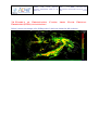
1
Product User Manual for “Precipitation products from Cloud Physical Properties” (PPh-PGE14: PCPh v1.0 & CRPh v1.0) Code: SAF/NWC/CDOP2/INM/PUM/14 Issue: 1.0.1 Date: 4 December 2014 File: SAF-NWC-CDOP2-INM-SCI-PUM-14_v1.0.1 Page: 1/29 Product User Manual for “Precipitation products from Cloud Physical Properties” (PPh-PGE14: PCPh v1.0 & CRPh v1.0) SAF/NWC/CDOP2/INM/PUM/14, Issue 1, Rev. 0.1 4 December 2014 Applicable to SAFNWC/MSG version 2013 Prepared by AEMET Product User Manual for “Precipitation products from Cloud Physical Properties” (PPh-PGE14: PCPh v1.0 & CRPh v1.0) Code: SAF/NWC/CDOP2/INM/PUM/14 Issue: 1.0.1 Date: 4 December 2014 File: SAF-NWC-CDOP2-INM-SCI-PUM-14_v1.0.1 Page: 2/29 REPORT SIGNATURE TABLE Function Prepared by Reviewed by Authorised by Name Cecilia Marcos (AEMET) Antonio Rodríguez (AEMET) Marcelino Manso (AEMET) Pilar Fernández SAFNWC Project Manager Signature Date 4 December 2014 4 December 2014 4 December 2014 Product User Manual for “Precipitation products from Cloud Physical Properties” (PPh-PGE14: PCPh v1.0 & CRPh v1.0) Code: SAF/NWC/CDOP2/INM/PUM/14 Issue: 1.0.1 Date: 4 December 2014 File: SAF-NWC-CDOP2-INM-SCI-PUM-14_v1.0.1 Page: 3/29 DOCUMENT CHANGE RECORD Version 1.0 1.0.1 Date 15 July 2013 4 December 2014 Pages 29 Initial version Indications and NWC SAF SW been included. 29 Update of the needed for the algorithms. CHANGE(S) recommendations given by the Package MSG 2013 DRR have information about NWP data running of PCPh and CRPh Product User Manual for “Precipitation products from Cloud Physical Properties” (PPh-PGE14: PCPh v1.0 & CRPh v1.0) Code: SAF/NWC/CDOP2/INM/PUM/14 Issue: 1.0.1 Date: 4 December 2014 File: SAF-NWC-CDOP2-INM-SCI-PUM-14_v1.0.1 Page: 4/29 Table of contents 1. INTRODUCTION ................................................................................................................... 6 1.1 1.2 1.3 1.4 1.5 1.5.1 1.5.2 SCOPE OF THE DOCUMENT ....................................................................................................... 6 SCOPE OF OTHER DOCUMENTS ................................................................................................. 6 SOFTWARE VERSION IDENTIFICATION ...................................................................................... 6 DEFINITIONS, ACRONYMS AND ABBREVIATIONS ..................................................................... 6 REFERENCES ........................................................................................................................... 7 Applicable Documents ............................................................................................................................................ 7 Reference Documents ............................................................................................................................................. 8 2. PRECIPITATING CLOUDS FROM CLOUD PHYSICAL PROPERTIES (PCPH) PRODUCT ....................................................................................................................................... 9 2.1 DESCRIPTION OF PRECIPITATION CLOUDS FROM CLOUD PHYSICAL PROPERTIES (PCPH) ........ 9 2.1.1 2.1.2 2.1.3 Goal of Precipitating Clouds from Cloud Physical Properties (PCPh) .................................................................... 9 Outline of Precipitating Clouds from Cloud Physical Properties (PCPh) ................................................................ 9 Description of Precipitating Clouds from Cloud Physical Properties (PCPh) outputs........................................... 10 2.2 IMPLEMENTATION OF PRECIPITATION CLOUDS FROM CLOUD PHYSICAL PROPERTIES (PCPH)11 2.2.1 Installation of Precipitating Clouds from Cloud Physical Properties (PCPh) ........................................................ 11 2.2.2 Preparation of Precipitating Clouds from Cloud Physical Properties (PCPh) ....................................................... 12 2.2.3 Execution of Precipitating Clouds from Cloud Physical Properties (PCPh).......................................................... 12 2.3 INPUTS AND CONFIGURABLE PARAMETERS FOR PRECIPITATION CLOUDS FROM CLOUD PHYSICAL PROPERTIES (PCPH) ......................................................................................................... 12 2.3.1 List of inputs for Precipitating Clouds from Cloud Physical Properties (PCPh) ................................................... 12 2.3.2 Configurable parameters for Precipitating Clouds from Cloud Physical Properties (PCPh) ................................. 13 2.4 SUMMARY OF PRECIPITATING CLOUDS FROM CLOUD PHYSICAL PROPERTIES (PCPH) VALIDATION RESULTS ....................................................................................................................... 14 2.5 TYPICAL KNOWN PROBLEMS AND RECOMMENDATION FOR USE ............................................. 15 2.6 EXAMPLE OF PRECIPITATING CLOUDS FROM CLOUD PHYSICAL PROPERTIES (PCPH) VISUALIZATION ................................................................................................................................. 16 3. CONVECTIVE RAINFALL RATE FROM CLOUD PHYSICAL PROPERTIES (CRPH) PRODUCT ...................................................................................................................... 17 3.1 3.1.1 3.1.2 3.1.3 DESCRIPTION OF CONVECTIVE RAINFALL RATE FROM CLOUD PHYSICAL PROPERTIES (CRPH)17 Goal of Convective Rainfall Rate from Cloud Physical Properties (CRPh) .......................................................... 17 Outline of Convective Rainfall Rate from Cloud Physical Properties (CRPh)...................................................... 17 Description of Convective Rainfall Rate from Cloud Physical Properties (CRPh) outputs................................... 19 IMPLEMENTATION OF CONVECTIVE RAINFALL RATE FROM CLOUD PHYSICAL PROPERTIES 3.2 (CRPH)............................................................................................................................................. 21 3.2.1 3.2.2 3.2.3 Installation of Convective Rainfall Rate from Cloud Physical Properties (CRPh) ................................................ 22 Preparation of Convective Rainfall Rate from Cloud Physical Properties (CRPh) ............................................... 22 Execution of Convective Rainfall Rate from Cloud Physical Properties (CRPh).................................................. 22 3.3 INPUTS AND CONFIGURABLE PARAMETERS FOR CONVECTIVE RAINFALL RATE FROM CLOUD PHYSICAL PROPERTIES (CRPH) ........................................................................................................ 23 3.3.1 List of inputs for Convective Rainfall Rate from Cloud Physical Properties (CRPh) ........................................... 23 3.3.2 Configurable parameters for Convective Rainfall Rate from Cloud Physical Properties (CRPh) ......................... 24 3.4 SUMMARY OF CONVECTIVE RAINFALL RATE FROM CLOUD PHYSICAL PROPERTIES (CRPH) VALIDATION RESULTS ....................................................................................................................... 26 3.4.1 Instantaneous rates ................................................................................................................................................ 26 3.4.2 Hourly accumulations ........................................................................................................................................... 27 3.5 TYPICAL KNOWN PROBLEMS AND RECOMMENDATION FOR USE ............................................. 27 3.6 EXAMPLE OF CONVECTIVE RAINFALL RATE FROM CLOUD PHYSICAL PROPERTIES (CRPH) VISUALIZATION ................................................................................................................................. 28 Product User Manual for “Precipitation products from Cloud Physical Properties” (PPh-PGE14: PCPh v1.0 & CRPh v1.0) Code: SAF/NWC/CDOP2/INM/PUM/14 Issue: 1.0.1 Date: 4 December 2014 File: SAF-NWC-CDOP2-INM-SCI-PUM-14_v1.0.1 Page: 5/29 List of Tables and Figures Table 1: List of Applicable Documents.............................................................................................8 Table 2: List of Referenced Documents ............................................................................................8 Table 3: Model configuration file keywords table applicable to PCPh product .............................14 Table 4: False alarm ratio obtained for each PCPh probability of precipitation interval. ...............15 Table 5: Categorical scores for PCPh algorithm taking as rainy pixels those with probability of precipitation higher than a threshold .......................................................................................15 Table 6: Model configuration file keywords table applicable to CRPh product .............................25 Table 7: Accuracy measurements for instantaneous rates. Comparison among CRPh product using different CRPh_IQF thresholds. ..............................................................................................26 Table 8: Categorical scores for instantaneous rates. Comparison among CRPh product using different CRPh_IQF thresholds. ..............................................................................................27 Table 9: Accuracy measurements for hourly accumulations. Comparison among CRPh product using different CRPh_IQF thresholds. ....................................................................................27 Table 10: Categorical scores for hourly accumulations. Comparison among CRPh product using different CRPh_IQF thresholds. ..............................................................................................27 Figure 1: Function that connects Probability of Precipitation with CWP .........................................9 Figure 2: PCPh_PC palette ..............................................................................................................10 Figure 3: PCPh probability of precipitation for 11th February 2013 at 11:30 UTC over Europe ....16 Figure 4: Function that connects Rain Rates with CWP .................................................................18 Figure 5: CRPh_CRR palette ..........................................................................................................19 Figure 6: CRR_IQF palette .............................................................................................................20 Figure 7: CRPh instantaneous rain rates for 25th May 2009 at 14:00 UTC over Europe ...............28 Figure 8: CRPh hourly accumulations for 25th May 2009 at 14:00 UTC over Europe ..................29 Product User Manual for “Precipitation products from Cloud Physical Properties” (PPh-PGE14: PCPh v1.0 & CRPh v1.0) Code: SAF/NWC/CDOP2/INM/PUM/14 Issue: 1.0.1 Date: 4 December 2014 File: SAF-NWC-CDOP2-INM-SCI-PUM-14_v1.0.1 Page: 6/29 1. INTRODUCTION The EUMETSAT “Satellite Application Facilities” (SAF) are dedicated centres of excellence for processing satellite data, and form an integral part of the distributed EUMETSAT Application Ground Segment (http://www.eumetsat.int). This documentation is provided by the SAF on Support to Nowcasting and Very Short Range Forecasting, NWC SAF. The main objective of NWC SAF is to provide, further develop and maintain software packages to be used for Nowcasting applications of operational meteorological satellite data by National Meteorological Services. More information can be found at the NWC SAF webpage, http://www.nwcsaf.org. This document is applicable to the NWC SAF processing package for Meteosat satellites, SAFNWC/MSG. 1.1 SCOPE OF THE DOCUMENT This document is the Product User Manual (PUM) for the PPh-PGE14 (Precipitation products from Cloud Physical Properties) belonging to the SAFNWC/MSG software. PGE14 generates two different products: Precipitating Clouds from Cloud Physical Properties (PCPh) and Convective Rainfall rate from Cloud Physical Properties (CRPh). PUM document contains practical information on the characteristics of the products, including the input data and the outputs of the products. It also gives information about the algorithm’s implementation and configuration. 1.2 SCOPE OF OTHER DOCUMENTS The Algorithm Theoretical Basis Document contains information about the product objectives, the algorithm scientific description, the needed input data and the output product [AD 1]. The Validation Report version v1.0 of the PGE14 document [AD 2], showing the validation results for PGE14 v1.0 that gives information about the extended validation performed over Spain for a complete year. The Interface Control Documents ICD/3 [AD 3] defines the format of the output products generated by the SAFNWC/MSG software. The Interface Control Documents ICD/1 [AD 4] describes the External and Internal Interfaces of the SAFNWC/MSG software. 1.3 SOFTWARE VERSION IDENTIFICATION This document contains practical information on the characteristics of the PPh algorithm implemented in the delivery 2013 of the SAFNWC/MSG package. This delivery corresponds to PPh-PGE14: version 1.0 of PCPh and version 1.0 of CRPh. 1.4 DEFINITIONS, ACRONYMS AND ABBREVIATIONS AEMET ATBD Agencia Estatal de Meteorología Algorithm Theoretical Basis Document COT Cloud Optical Thickness CRPh Convective Rainfall Rate from Cloud Physical Properties CSI Critical Success Index Product User Manual for “Precipitation products from Cloud Physical Properties” (PPh-PGE14: PCPh v1.0 & CRPh v1.0) Code: SAF/NWC/CDOP2/INM/PUM/14 Issue: 1.0.1 Date: 4 December 2014 File: SAF-NWC-CDOP2-INM-SCI-PUM-14_v1.0.1 Page: 7/29 CT Cloud Type CWP Cloud Water Path EUMETSAT European Organisation for the Exploitation of Meteorological Satellites FAR False Alarm Ratio ICD Interface Control Document ICP Illumination Conditions Parameter IQF Illumination Quality Flag IR Infrared MAE Mean Absolute Error ME Mean Error MSG Meteosat Second Generation NWC SAF Satellite Application Facility for Nowcasting PC Percentage of Corrects PCPh Precipitating Clouds from Cloud Physical Properties PGE Product Generation Element POD Probability of Detection PoP Probability of Precipitation PPh Precipitation from Cloud Physical Properties Reff Effective Radius RMSE Root Mean Square Error RR Rain Rate SAF Satellite Application Facility SEVIRI Spinning Enhanced Visible and Infrared Imager SW Software 1.5 REFERENCES 1.5.1 Applicable Documents For dated references, subsequent amendments to, or revisions of, any of these publications do not apply. For undated references, the current edition of the document referred applies. Reference Code Vers Date [AD 1] Algorithm Theoretical Basis Document for “Precipitation products from Cloud Physical Properties” (PPh-PGE14: PCPh v1.0 & CRPh v1.0) Title SAF/NWC/CDOP2/INM/SCI/ATB D/14 1.0 15/07/13 [AD 2] Validation Report for “Precipitation products from Cloud Physical Properties” (PPh-PGE14: PCPh v1.0 & CRPh v1.0) SAF/NWC/CDOP2/INM/SCI/VR/1 5 1.0 15/07/13 Product User Manual for “Precipitation products from Cloud Physical Properties” (PPh-PGE14: PCPh v1.0 & CRPh v1.0) Reference Title Code: SAF/NWC/CDOP2/INM/PUM/14 Issue: 1.0.1 Date: 4 December 2014 File: SAF-NWC-CDOP2-INM-SCI-PUM-14_v1.0.1 Page: 8/29 Code Vers Date [AD 3] SAFNWC/MSG Definition Format SAF/NWC/CDOP2/INM/SW/ICD/ 3 7.0 15/07/13 [AD 4] Interface Control Document for the External and Internal Interfaces of the SAFNWC/MSG SAF/NWC/CDOP2/INM/SW/ICD/ 1 7.0 15/07/13 [AD 5] NWC SAF Product Requirements Document NWC/CDOP2/SAF/AEMET//MGT 1.2 15/07/13 Output Products /PRD Table 1: List of Applicable Documents 1.5.2 Reference Documents Reference [RD.1] Title Daniel Rosenfeld, William L. Woodley, Amit Lerner, Guy Kelman, Daniel T. Lindsey, 2008. Satellite detection of severe convective storms by their retrieved vertical profiles of cloud particle effective radius and thermodynamic phase. J. Geophys. Res. D4, 113. [RD.2] Table 2: List of Referenced Documents Product User Manual for “Precipitation products from Cloud Physical Properties” (PPh-PGE14: PCPh v1.0 & CRPh v1.0) 2. PRECIPITATING CLOUDS PROPERTIES (PCPH) PRODUCT Code: SAF/NWC/CDOP2/INM/PUM/14 Issue: 1.0.1 Date: 4 December 2014 File: SAF-NWC-CDOP2-INM-SCI-PUM-14_v1.0.1 Page: 9/29 FROM CLOUD PHYSICAL 2.1 DESCRIPTION OF PRECIPITATION CLOUDS FROM CLOUD PHYSICAL PROPERTIES (PCPH) 2.1.1 Goal of Precipitating Clouds from Cloud Physical Properties (PCPh) Precipitating Clouds from Cloud Physical Properties (PCPh) product, developed within the NWC SAF context, is a Nowcasting tool that provides estimation on the probability of precipitation (PoP) occurrence. In this context, PoP is defined as the instantaneous probability that a rain rate greater than or equal to 0.2 mm/h occurs at the pixel level. This product can be obtained for every SEVIRI slot that is every 15 minutes in the normal mode. It is also prepared to run in the Rapid Scan mode with a temporal resolution of 5 minutes. 2.1.2 Outline of Precipitating Clouds from Cloud Physical Properties (PCPh) The PoP estimation is done using information on the cloud physical properties, Effective Radius (Reff) and Cloud Optical Thickness (COT). Using these two parameters the Cloud Water Path (CWP) is computed. The following step connects CWP with PoP for each pixel, through the following relationship: PoP = 43 .7 * Ln (CWP ) − 198 .1 Where PoP is the Probability of Precipitation occurrence (%) and CWP is the Cloud Water Path (gm-2). The graph of this function can be observed in Figure 1. Probability of Precipitation Ocurrence (%) 100 90 80 70 60 50 40 30 20 10 0 0 200 400 600 800 1000 2 CWP (g/m ) Figure 1: Function that connects Probability of Precipitation with CWP Product User Manual for “Precipitation products from Cloud Physical Properties” (PPh-PGE14: PCPh v1.0 & CRPh v1.0) Code: SAF/NWC/CDOP2/INM/PUM/14 Issue: 1.0.1 Date: 4 December 2014 File: SAF-NWC-CDOP2-INM-SCI-PUM-14_v1.0.1 Page: 10/29 2.1.3 Description of Precipitating Clouds from Cloud Physical Properties (PCPh) outputs PCPh product is coded in HDF5 format. The available outputs are the following: PCPh PC: The PCPh_PC output provides an estimation of the probability of precipitation from 0% to 100% of probability. The probability of precipitation is given as an integer value that takes values from 0 to 100. The colour scale delivered with the product is divided into five PoP intervals as can be observed in Figure 2. Figure 2: PCPh_PC palette PCPh_QUALITY: 2 bits mask indicating if parallax correction has been applied for each pixel: 1 bit for parallax correction: 0: No correction 1: Corrected by parallax 1 bit for the filled holes after parallax correction 0: No hole due to the parallax correction 1: Hole due to the parallax correction filled by a median filter Product User Manual for “Precipitation products from Cloud Physical Properties” (PPh-PGE14: PCPh v1.0 & CRPh v1.0) Code: SAF/NWC/CDOP2/INM/PUM/14 Issue: 1.0.1 Date: 4 December 2014 File: SAF-NWC-CDOP2-INM-SCI-PUM-14_v1.0.1 Page: 11/29 PCPh_DATAFLAG: 5 bits mask indicating the processing status of each pixel: 1 bit for cloud optical thickness, effective radius or phase data missing 0: Cloud optical thickness, effective radius and phase data are available 1: Cloud optical thickness, effective radius or phase data are missing 1 bit for cloud optical thickness or effective radius no computed (out of the cloud, night time or undefined phase) 0: cloud optical thickness and effective radius computed 1: cloud optical thickness or effective radius no computed 1 bit to indicate if phase data have been computed 0: Phase is water or ice 1: Phase not computed or undefined 1 bit for IR10.8 data missing: 0: IR10.8 data available 1: IR10.8 data missing 1 bit to identify mathematical errors 0: No mathematical error 1: A mathematical error has occurred The HDF-5 output files are stored in $SAFNWC/export/PGE14. Detailed information on the HDF-5 format file can be found in [AD 3]. 2.2 IMPLEMENTATION OF PRECIPITATION CLOUDS FROM CLOUD PHYSICAL PROPERTIES (PCPH) Previous condition and licences The right to use, copy or modify this software is in accordance with EUMETSAT Policy for the SAFNWC/MSG software package. 2.2.1 Installation of Precipitating Clouds from Cloud Physical Properties (PCPh) The software installation procedure does not require special resources. It is restricted to decompress the distribution file (a gz-compressed tar file) and to successfully build the executable PGE14 file to be stored into the $SAFNWC/bin directory. Once the PGE14 of the SAFNWC/MSG is installed and configured in the system, its operational use requires the definition of some Configuration files in order to select the regions to be processed and some needed configurable parameters. The automatic set of pre-defined time scheduling (of the preparation step) is in Programmed Task Definition Files. Product User Manual for “Precipitation products from Cloud Physical Properties” (PPh-PGE14: PCPh v1.0 & CRPh v1.0) Code: SAF/NWC/CDOP2/INM/PUM/14 Issue: 1.0.1 Date: 4 December 2014 File: SAF-NWC-CDOP2-INM-SCI-PUM-14_v1.0.1 Page: 12/29 2.2.2 Preparation of Precipitating Clouds from Cloud Physical Properties (PCPh) The configuration file in charge of the region where the product is going to be run has an optional name and “.cfg” extension. This file contains the region centre location and the size image. When the application is installed, some region configuration files appear in $SAFNWC/config. Each of them corresponds to a different region; nevertheless users can create their own region configuration file. The configuration file in charge of the product settings is the PGE14 model configuration file that has an optional name and “.cfm” extension. Through this file the user can configure the way the product is going to be run by choosing options such as the parallax correction to be used. In order to apply parallax correction, NWP data (List of inputs for Precipitating Clouds from Cloud Physical Properties (PCPh)) have to be available in $SAFNWC/import/NWP_data directory. 2.2.3 Execution of Precipitating Clouds from Cloud Physical Properties (PCPh) The execution step is the real-time process of the PPh images over the region. This process consists of the launch of the command PGE14 along with the required parameters: slot, region file name and model configuration file. PCPh requires mainly five steps: • First step consists of an initialisation, which performs the environment settings for a given region. Check the existence of the required PGE02 files. • Second step is intended to read the external PGE02 files. • Third step is the computation of CWP. • Fourth step computes PCPh_DATAFLAG. • Fifth step applies Parallax correction if chosen. PCPh_QUALITY is updated. • Last step writes the product outputs in NWC SAF format. PoP from CWP as well as PCPh_QUALITY and 2.3 INPUTS AND CONFIGURABLE PARAMETERS FOR PRECIPITATION CLOUDS FROM CLOUD PHYSICAL PROPERTIES (PCPH) 2.3.1 List of inputs for Precipitating Clouds from Cloud Physical Properties (PCPh) PGE02 Cloud type (CT) physical properties: CT-PGE02 Phase, COT and Reff parameters are mandatory inputs to PCPh. The Phase will be read from $SAFNWC/export/PGE02 directory. PGE02 CT HDF-5 which must be located in COT and Reff parameters will be read from temporary files generated by PGE02 located in $SAFNWC/tmp directory. Satellite imagery: IR10.8 SEVIRI brightness temperature at full IR spatial resolution is a mandatory input to compute Parallax Correction. It must be placed by the user in HRIT format in the $SAFNWC/import/SEVIRI_data directory. Then it will be extracted on the desired region by SAFNWC software package. Product User Manual for “Precipitation products from Cloud Physical Properties” (PPh-PGE14: PCPh v1.0 & CRPh v1.0) Code: SAF/NWC/CDOP2/INM/PUM/14 Issue: 1.0.1 Date: 4 December 2014 File: SAF-NWC-CDOP2-INM-SCI-PUM-14_v1.0.1 Page: 13/29 Numerical model: The NWP files must be located in $SAFNWC/import/NWP_data directory. In real time operational mode, the NWC SAF package has predefined tools (coordinated by the NWC SAF Task Manager daemon) which check every minute for new NWP data making automatically the spatial remapping to the predetermined regions to process on to $SAFNWC/tmp directory. This avoids spending time in every call to PGE to make the remapping process. In off-line operational mode, the “AllMapping” script allows to do the spatial remapping. This information is used by default for parallax correction. In case of lack of NWP parameters parallax correction will be run using a climatological profile. There are no studies on the impact of NWP data horizontal and temporal resolutions on the corrected position of the rainy pixels throughout parallax correction at this time. Some studies are expected to be done in this line in the future. NWP vertical resolution required by parallax correction is the following: Temperature at 1000, 925, 850, 700, 500, 400, 300, 250 and 200 hPa Geopotential at 1000, 925, 850, 700, 500, 400, 300, 250 and 200 hPa Ancillary data sets: Climatological profile is necessary as a back up for Parallax correction in case NWP is not available. This information is included in the software package and is located in the $SAFNWC/import/Aux_data directory. Model configuration file for PGE14 (safnwc_pge14.cfm): PGE14 model configuration file contains configurable system parameters in the generation process of both PCPh and CRPh products. This file is placed in the $SAFNWC/config directory. The PCPh product related parameters refers to ancillary datasets, numerical model data and parallax correction. The complete list of these parameters and the explanation of the most useful ones is available on List of configuration parameters of this manual. Region configuration file (region.cfg): This file set the dimensions and positions where PGE14 products will be obtained and is located in $SAFNWC/config directory. 2.3.2 Configurable parameters for Precipitating Clouds from Cloud Physical Properties (PCPh) Model configuration file contains configurable items in the product generation process such as corrections to be run, NWP parameters to be used by the PGE, etc. The PPh model configuration file needed for the execution of PGE14 must be placed at the $SAFNWC/config directory. The only constraint in the use of any name is the key used to specify the parameters to be used from NWP models: NWP_PARAM. The use of this keyname is mandatory, and will be used by a pre-processing task in charge of remapping NWP incoming files (in GRIB format). 2.3.2.1 Keywords table for Precipitating Clouds from Cloud Physical Properties (PCPh) The PGE14 model configuration file contains the following information applicable to PCPh product: Product User Manual for “Precipitation products from Cloud Physical Properties” (PPh-PGE14: PCPh v1.0 & CRPh v1.0) Code: SAF/NWC/CDOP2/INM/PUM/14 Issue: 1.0.1 Date: 4 December 2014 File: SAF-NWC-CDOP2-INM-SCI-PUM-14_v1.0.1 Page: 14/29 Keyword Description Type PGE_ID Identifier of the PGE Chain of characters PGE14 SEV_BANDS SEVIRI channels to be used by PGE14 Chain of characters IR108 APPLY_PARALLAX_CORR Indicator whether the Parallax correction should be applied or not (1 yes: 0 no) OUTPUT_PRODUCT Products to be generated: ALL : Both CRPh and PCPh hdf5 products are generated Default Value(s) Integer Chain of characters 1 ALL CRPh : Only CRPh hdf5 product is generated PCPh : Only PCPh hdf5 product is generated NWP_PARAM01 Parameter : Temperature (K) sampling rate : (=segment size) NWP_PT Chain of characters interpolation method. NWP_PARAM02 1 BILIN 2 -2 Parameter : Geopotential (m s ) sampling rate : (=segment size) NWP_GEOP Chain of characters interpolation method. 1 BILIN Table 3: Model configuration file keywords table applicable to PCPh product 2.3.2.2 Keywords description for Precipitating Clouds from Cloud Physical Properties (PCPh) Below there is a description of the most useful keywords defined in PGE14 model configuration file and applicable to PCPh product in order to make easier the user exploitation: • APPLY_PARALLAX_CORR: To decide whether the Parallax correction should be applied or not (1 yes: 0 no) • OUTPUT_PRODUCT: To decide which products are to be generated: ALL : Both CRPh and PCPh hdf5 products are generated CRPh : Only CRPh hdf5 product is generated PCPh : Only PCPh hdf5 product is generated 2.4 SUMMARY OF PRECIPITATING CLOUDS PROPERTIES (PCPH) VALIDATION RESULTS FROM CLOUD PHYSICAL The following tables summarize the validation results of PCPh product. More details can be obtained from the “Validation Report for “Precipitation products from Cloud Physical Properties” (PPh-PGE14: PCPh v1.0 & CRPh v1.0)” [AD 2]. Probability of precipitation intervals validation: It should bear in mind that a region with the probability of precipitation interval (A-B] should have 100-B ≤ FAR < 100-A. Product User Manual for “Precipitation products from Cloud Physical Properties” (PPh-PGE14: PCPh v1.0 & CRPh v1.0) Probability interval (%) N Code: SAF/NWC/CDOP2/INM/PUM/14 Issue: 1.0.1 Date: 4 December 2014 File: SAF-NWC-CDOP2-INM-SCI-PUM-14_v1.0.1 Page: 15/29 FAR (%) 0-20 900985 90,4 20-40 470407 76,6 40-60 352631 57,5 60-80 226405 34,9 80-100 117761 18,1 Table 4: False alarm ratio obtained for each PCPh probability of precipitation interval. Probability of precipitation thresholds validation: Green colour values in the following table mean that FAR or POD values obtained in this validation fulfill the FAR and POD target values defined in the NWC SAF Product Requirements document [AD 5]. PoP threshold N FAR (%) POD (%) CSI (%) PC (%) 20% 3072175 56,8 82,8 39,6 75,0 30% 3072175 50,5 74,6 42,3 79,7 40% 3072175 43,5 64,7 43,2 83,1 60% 3072175 29,2 40,1 34,4 84,9 80% 3072175 18,1 15,8 15,3 82,6 Table 5: Categorical scores for PCPh algorithm taking as rainy pixels those with probability of precipitation higher than a threshold 2.5 TYPICAL KNOWN PROBLEMS AND RECOMMENDATION FOR USE This algorithm can be run only over daytime. For undefined phase pixels, Reff and COT values are not computed by PGE02, so a 0% probability of precipitation is assigned in these cases by the algorithm. As the main inputs of the product are computed by PGE02, there exists the need to run PGE02 previous to run PGE14. It has been observed that pixels located in the surroundings of snow according to PGE02 take sometimes high values of CWP, so a probability of precipitation higher than 0% is assigned erroneously. It is highly recommended to apply parallax correction for a better location of precipitation areas with respect to the ground below. This product obtains the best results for convective events. Product User Manual for “Precipitation products from Cloud Physical Properties” (PPh-PGE14: PCPh v1.0 & CRPh v1.0) 2.6 EXAMPLE OF PRECIPITATING PROPERTIES (PCPH) VISUALIZATION CLOUDS Code: SAF/NWC/CDOP2/INM/PUM/14 Issue: 1.0.1 Date: 4 December 2014 File: SAF-NWC-CDOP2-INM-SCI-PUM-14_v1.0.1 Page: 16/29 FROM CLOUD PHYSICAL Below is shown an example of the PCPh product. It has been obtained at full resolution. Figure 3: PCPh probability of precipitation for 11th February 2013 at 11:30 UTC over Europe Product User Manual for “Precipitation products from Cloud Physical Properties” (PPh-PGE14: PCPh v1.0 & CRPh v1.0) Code: SAF/NWC/CDOP2/INM/PUM/14 Issue: 1.0.1 Date: 4 December 2014 File: SAF-NWC-CDOP2-INM-SCI-PUM-14_v1.0.1 Page: 17/29 3. CONVECTIVE RAINFALL RATE FROM CLOUD PHYSICAL PROPERTIES (CRPH) PRODUCT 3.1 DESCRIPTION OF CONVECTIVE RAINFALL RATE FROM CLOUD PHYSICAL PROPERTIES (CRPH) 3.1.1 Goal of Convective Rainfall Rate from Cloud Physical Properties (CRPh) Convective Rainfall Rate from Cloud Physical Properties (CRPh) product, developed within the NWC SAF context, is a Nowcasting tool that provides information on convective, and stratiform associated to convection, instantaneous rain rates and hourly accumulations. This product can be obtained for every SEVIRI slot that is every 15 minutes in the normal mode. It is also prepared to run in the Rapid Scan mode with a temporal resolution of 5 minutes. 3.1.2 Outline of Convective Rainfall Rate from Cloud Physical Properties (CRPh) The convective rainfall rate estimation is done using information on the cloud physical properties, Effective Radius (Reff) and Cloud Optical Thickness (COT). Using these two parameters the Cloud Water Path (CWP) is computed. Depending on some Reff and CWP thresholds, the precipitation area is enclosed. Only in those pixels belonging to the precipitation area, the rain rate is computed. To assign an instantaneous rain rate to each pixel, the following relationship between CWP and precipitation intensity is applied: 2 CWP − 155 RR = 50 * 1 − exp − 0.5 * 1700 Where RR is the Rainfall Rate (mmh-1) and CWP is the Cloud Water Path (gm-2). The graph of this function can be observed in Figure 4. Product User Manual for “Precipitation products from Cloud Physical Properties” (PPh-PGE14: PCPh v1.0 & CRPh v1.0) Code: SAF/NWC/CDOP2/INM/PUM/14 Issue: 1.0.1 Date: 4 December 2014 File: SAF-NWC-CDOP2-INM-SCI-PUM-14_v1.0.1 Page: 18/29 CTMP function 60 Rain rates (mm/h) 50 40 30 20 10 0 0 1000 2000 3000 4000 5000 6000 2 CWP (g/m ) Figure 4: Function that connects Rain Rates with CWP Rain rates estimation from geostationary satellite data can not be very accurate so trying to estimate rain rates higher than 50 mm/h using this type of data is not realistic. For this reason a maximum limit of 50 mm/h has been established. It has been seen that, under some conditions, rain rates assigned by this product are erroneously high. In order to provide the user with information about the reliability of the estimated rain rates an illumination quality flag (CRPh_IQF) has been developed. CRR_IQF (%) is included as an output of the product and it must be understood as an indicator of the confidence that a forecaster can have on the rain rates estimated by the product. For a better convective precipitation area location the parallax correction can be applied to this product. This option is chosen by the user through the product model configuration file and it is applied by default. As lightning activity can provide valuable information about convection, a lightning algorithm can be applied to derive a precipitation pattern that will be combined with the CRR one computed in the previous step in order to complement it. At the end of the process the final values of the CRR rainfall rates in mm/h are used in order to obtain hourly accumulations and five different outputs as described in section 3.1.3 are completed. Product User Manual for “Precipitation products from Cloud Physical Properties” (PPh-PGE14: PCPh v1.0 & CRPh v1.0) Code: SAF/NWC/CDOP2/INM/PUM/14 Issue: 1.0.1 Date: 4 December 2014 File: SAF-NWC-CDOP2-INM-SCI-PUM-14_v1.0.1 Page: 19/29 3.1.3 Description of Convective Rainfall Rate from Cloud Physical Properties (CRPh) outputs CRPh product is coded in HDF5 format. The available outputs are the following: CRPh_CRR: This output provides rainfall rates from 0.0 to 51.0 mm/h with a step of 0.2 mm/h and includes the following palette: Figure 5: CRPh_CRR palette CRPh_ACCUM: The hourly accumulations have been computed using the rainfall rates from the images in the last hour. This output provides precipitation accumulations from 0.0 to 51.0 mm with a step of 0.2 mm and includes a palette that uses the same thresholds and colours as the intensities output palette. CRPh_IQF: CRR_IQF is a flag that provides information on the confidence that a user can have on the estimated rain rates according to the illumination conditions and viewing angles. The colour scale provided with the product is divided into five intervals as can be observed in Figure 6. Product User Manual for “Precipitation products from Cloud Physical Properties” (PPh-PGE14: PCPh v1.0 & CRPh v1.0) Code: SAF/NWC/CDOP2/INM/PUM/14 Issue: 1.0.1 Date: 4 December 2014 File: SAF-NWC-CDOP2-INM-SCI-PUM-14_v1.0.1 Page: 20/29 Figure 6: CRR_IQF palette CRPh _QUALITY: 3 bits mask indicating if parallax correction and lighting information has been applied for each pixel: 1 bit for parallax correction 0: No correction 1: Corrected by parallax 1 bit for the filled holes after parallax correction 0: No hole due to the parallax correction 1: Hole due to the parallax correction filled by a median filter 1 bit for lightning information used 0: No lightning information used 1: Lightning information used Product User Manual for “Precipitation products from Cloud Physical Properties” (PPh-PGE14: PCPh v1.0 & CRPh v1.0) Code: SAF/NWC/CDOP2/INM/PUM/14 Issue: 1.0.1 Date: 4 December 2014 File: SAF-NWC-CDOP2-INM-SCI-PUM-14_v1.0.1 Page: 21/29 CRPh_DATAFLAG: 8 bits mask indicating the processing status of each pixel: 1 bit for cloud optical thickness, effective radius or phase data missing 0: Cloud optical thickness, effective radius and phase data are available 1: Cloud optical thickness, effective radius or phase data are missing 1 bit for cloud optical thickness or effective radius no computed (out of the cloud, night time or undefined phase) 0: cloud optical thickness and effective radius computed 1: cloud optical thickness or effective radius no computed 1 bit to indicate if phase data have been computed 0: Phase is water or ice 1: Phase not computed or undefined 1 bit for IR10.8 data missing 0: IR10.8 data available 1: IR10.8 data missing 1 bit to identify mathematical errors 0: No mathematical error 1: A mathematical error has occurred 2 bits for the hourly accumulation CRR output status 0: All required scenes were available 1: One previous CRR scene is missing 2: At least two previous CRR scenes are missing (no consecutive) 3: At least two previous CRR scenes are missing (some are consecutive) 1 bit for the status of the CRR pixels used to compute the hourly accumulation 0: All the pixels used in the computing of the hourly accumulation have their CRR_DATAFLAG bits set to 0 1: At least one of the pixels used in the computing of the hourly accumulation has at least one of its CRR_DATAFLAG bits set to 1 The HDF-5 output files are stored in $SAFNWC/export/PGE14. Detailed information on the HDF-5 format file can be found in [AD 3]. 3.2 IMPLEMENTATION OF CONVECTIVE RAINFALL RATE FROM CLOUD PHYSICAL PROPERTIES (CRPH) Previous condition and licences The right to use, copy or modify this software is in accordance with EUMETSAT Policy for the SAFNWC/MSG software package. Product User Manual for “Precipitation products from Cloud Physical Properties” (PPh-PGE14: PCPh v1.0 & CRPh v1.0) Code: SAF/NWC/CDOP2/INM/PUM/14 Issue: 1.0.1 Date: 4 December 2014 File: SAF-NWC-CDOP2-INM-SCI-PUM-14_v1.0.1 Page: 22/29 3.2.1 Installation of Convective Rainfall Rate from Cloud Physical Properties (CRPh) The software installation procedure does not require special resources. It is restricted to decompress the distribution file (a gz-compressed tar file) and to successfully build the executable PGE14 file to be stored into the $SAFNWC/bin directory. Once the PGE14 of the SAFNWC/MSG is installed and configured in the system, its operational use requires the definition of some Configuration files in order to select the regions to be processed and some needed configurable parameters. The automatic set of pre-defined time scheduling (of the preparation step) is in Programmed Task Definition Files. 3.2.2 Preparation of Convective Rainfall Rate from Cloud Physical Properties (CRPh) The configuration file in charge of the region where the product is going to be run has an optional name and “.cfg” extension. This file contains the region centre location and the size image. When the application is installed, some region configuration files appear in $SAFNWC/config. Each of them corresponds to a different region; nevertheless users can create their own region configuration file. The configuration file in charge of the product settings is the PGE14 model configuration file that has an optional name and “.cfm” extension. Through this file the user can configure the way the product is going to be run choosing options such as parallax correction to be applied or lightning information to be used. In order to apply parallax correction, NWP data (List of inputs for Convective Rainfall Rate from Cloud Physical Properties (CRPh)) have to be available in $SAFNWC/import/NWP_data directory. In order to use the lightning information, the “Lightning information file for PGE14” (List of inputs for Convective Rainfall Rate from Cloud Physical Properties (CRPh)) have to be available in $SAFNWC/import/Obs data directory. 3.2.3 Execution of Convective Rainfall Rate from Cloud Physical Properties (CRPh) The execution step is the real-time process of the PPh images over the region. This process consists of the launch of the command PGE14 along with the required parameters: slot, region file name and model configuration file. CRPh requires mainly five steps: • First step consists of an initialisation, which performs the environment settings for a given region. Check the existence of the required PGE02 files. • Second step is intended to read the external PGE02 files. • Third step is the computation of CWP. • Fourth step computes the precipitation area and the rain rates within the computed precipitation area as well as CRPh_QUALITY , CRPh_DATAFLAG, and CRPh_IQF. • Fifth step applies Parallax correction if chosen. CRPh _QUALITY is updated. • Sixth step computes rain rates from lightning information if this option has been chosen. This data are combined with the output data from the previous step. CRPh mm/h values, CRPh_QUALITY and CRPh_DATAFLAG are updated. Product User Manual for “Precipitation products from Cloud Physical Properties” (PPh-PGE14: PCPh v1.0 & CRPh v1.0) • Code: SAF/NWC/CDOP2/INM/PUM/14 Issue: 1.0.1 Date: 4 December 2014 File: SAF-NWC-CDOP2-INM-SCI-PUM-14_v1.0.1 Page: 23/29 Last step computes the hourly accumulation, updates CRR_DATAFLAG and writes the product outputs in NWC SAF format. 3.3 INPUTS AND CONFIGURABLE PARAMETERS FOR CONVECTIVE RAINFALL RATE FROM CLOUD PHYSICAL PROPERTIES (CRPH) 3.3.1 List of inputs for Convective Rainfall Rate from Cloud Physical Properties (CRPh) PGE02 Cloud type (CT) physical properties: CT-PGE02 Phase, COT and Reff parameters are mandatory inputs to CRPh. The Phase will be read from $SAFNWC/export/PGE02 directory. PGE02 CT HDF-5 which must be located in COT and Reff parameters will be read from temporary files generated by PGE02 located in $SAFNWC/tmp directory. Satellite imagery: IR10.8 SEVIRI brightness temperature at full IR spatial resolution is a mandatory input to compute Parallax Correction. It must be placed by the user in HRIT format in the $SAFNWC/import/SEVIRI_data directory. Then it will be extracted on the desired region by SAFNWC software package. Numerical model: The NWP files must be located in $SAFNWC/import/NWP_data directory. In real time operational mode, the NWC SAF package has predefined tools (coordinated by the NWC SAF Task Manager daemon) which check every minute for new NWP data making automatically the spatial remapping to the predetermined regions to process on to $SAFNWC/tmp directory. This avoids spending time in every call to PGE to make the remapping process. In off-line operational mode, the “AllMapping” script allows to do the spatial remapping. This information is used by default for parallax correction. In case of lack of NWP parameters parallax correction will be run using a climatological profile. There are no studies on the impact of NWP data horizontal and temporal resolutions on the corrected position of the rainy pixels throughout parallax correction at this time. Some studies are expected to be done in this line in the future. NWP vertical resolution required by parallax correction is the following: Temperature at 1000, 925, 850, 700, 500, 400, 300, 250 and 200 hPa Geopotential at 1000, 925, 850, 700, 500, 400, 300, 250 and 200 hPa Ancillary data sets: Climatological profile is necessary as a back up for Parallax correction in case NWP is not available. This information is included in the software package and is located in the $SAFNWC/import/Aux_data/PGE14 directory. Lightning information file for CRPh product: A file with information on every lightning stroke occurred in a time interval is mandatory to choose the option of adjusting the CRPh precipitation pattern with the lightning information provided by ground based lightning detection networks. Information about the “Lightning information file for CRPh product” structure can be found in the Interface Control Document [AD 4]. This file must be located in $SAFNWC/import/Obs_data. Product User Manual for “Precipitation products from Cloud Physical Properties” (PPh-PGE14: PCPh v1.0 & CRPh v1.0) Code: SAF/NWC/CDOP2/INM/PUM/14 Issue: 1.0.1 Date: 4 December 2014 File: SAF-NWC-CDOP2-INM-SCI-PUM-14_v1.0.1 Page: 24/29 The CRR lightning algorithm and the coefficients applied have been derived for Spain using the lightning information from the AEMET lightning detection network. Ground based lightning detection networks provide information with different performances in detection efficiency and location accuracy. For this reason, the keyword APPLY_LIGHTNING in the model configuration file is set to 0 and by default the lightning information is not used. Before to use the lightning algorithm it is highly recommended to the user to adapt the lightning coefficients to the specific performances of the used lightning detection network through the appropriate keywords in the model configuration file. Model configuration file for PGE14 (safnwc_pge14.cfm): PGE14 model configuration file contains configurable system parameters in the generation process of both PCPh and CRPh products. This file is placed in the $SAFNWC/config directory. The CRPh product related parameters refers to ancillary datasets, numerical model data, lightning algorithm and parallax correction. The complete list of these parameters and the explanation of the most useful ones is available on List of configuration parameters of this manual. Region configuration file (region.cfg): This file set the dimensions and positions where PGE14 products will be obtained and is located in $SAFNWC/config directory. 3.3.2 Configurable parameters for Convective Rainfall Rate from Cloud Physical Properties (CRPh) Model configuration file contains configurable items in the product generation process such as corrections to be run, NWP parameters to be used by the PGE, coefficients, etc. The PPh model configuration file needed for the execution of PGE14 must be placed at the $SAFNWC/config directory. The only constraint in the use of any name is the key used to specify the parameters to be used from NWP models: NWP_PARAM. The use of this keyname is mandatory, and will be used by a pre-processing task in charge of remapping NWP incoming files (in GRIB format). 3.3.2.1 Keywords table for Convective Rainfall Rate from Cloud Physical Properties (CRPh) The PGE14 model configuration file contains the following information applicable to CRPh product: Keyword Description PGE_ID Identifier of the PGE Chain of characters PGE14 SEV_BANDS SEVIRI channels to be used by PGE14 Chain of characters IR108 APPLY_PARALLAX_CORR Indicator whether the Parallax correction should be applied or not (1 yes: 0 no) OUTPUT_PRODUCT Products to be generated: ALL : Both CRPh and PCPh hdf5 products are generated CRPh : Only CRPh hdf5 product is generated PCPh : Only PCPh hdf5 product is generated Type Integer Chain of characters Default Value(s) 1 ALL Product User Manual for “Precipitation products from Cloud Physical Properties” (PPh-PGE14: PCPh v1.0 & CRPh v1.0) Code: SAF/NWC/CDOP2/INM/PUM/14 Issue: 1.0.1 Date: 4 December 2014 File: SAF-NWC-CDOP2-INM-SCI-PUM-14_v1.0.1 Page: 25/29 APPLY_LIGHTNING Indicator whether the Lightning information should be used or not (1 yes: 0 no) Integer 0 LIGHTNING_DELTA_TIME Time interval to consider lightning data files Integer 15 RAIN_LIGHTNING_RATE_1 Rain rate parameter 1 linked to observed lightning Real 2.3 RAIN_LIGHTNING_RATE_2 Rain rate parameter 2 linked to observed lightning Real 0.75 RAIN_LIGHTNING_RATE_3 Rain rate parameter 3 linked to observed lightning Real 0.25 RAIN_LIGHTNING_RATE_4 Rain rate parameter 4 linked to observed lightning Real 0.1 COEFF_N_LIGHTNING_A Coefficient “a” to be applied lightning adjustment function during the Real 0.45 COEFF_N_LIGHTNING_B Coefficient “b” to be applied during the lightning adjustment function Real 0.7 NWP_PARAM01 Parameter : Temperature (K) sampling rate : (=segment size) NWP_PT Chain of characters interpolation method. NWP_PARAM02 1 BILIN 2 -2 Parameter : Geopotential (m s ) sampling rate : (=segment size) NWP_GEOP Chain of characters interpolation method. 1 BILIN Table 6: Model configuration file keywords table applicable to CRPh product 3.3.2.2 Keywords description for Convective Rainfall Rate from Cloud Physical Properties (CRPh) Below there is a description of the most useful keywords defined in PGE14 model configuration file applicable to CRPh product in order to make easier the user exploitation: • APPLY_PARALLAX_CORR: To decide whether the Parallax correction should be applied or not (1 yes: 0 no) • OUTPUT_PRODUCT: To decide which products are to be generated: ALL : Both CRPh and PCPh hdf5 products are generated CRPh : Only CRPh hdf5 product is generated PCPh : Only PCPh hdf5 product is generated • APPLY_LIGHTNING: To decide whether the lightning information will be used (keyword set to 1) or not (keyword set to 0) to combine the CRR precipitation pattern. By default this keyword is set to 0. • LIGHTNING_DELTA_TIME: Time interval before the scanning time of the processing region centre, where the lightning occurrences will be taken into account by the lightning algorithm. (Default value: 15 min). • RAIN_LIGHTNING_RATE_1: Rain amount assigned to the pixels corresponding to the Z1 area according to the lightning algorithm. A detailed description of the lightning algorithm can be found in the Algorithm Theoretical Basis Document for PGE14 [AD 1]. (Default value: 2,30 mm). • RAIN_LIGHTNING_RATE_2: Rain amount assigned to the pixels corresponding to the Z2 area according to the lightning algorithm. A detailed description of the lightning Product User Manual for “Precipitation products from Cloud Physical Properties” (PPh-PGE14: PCPh v1.0 & CRPh v1.0) Code: SAF/NWC/CDOP2/INM/PUM/14 Issue: 1.0.1 Date: 4 December 2014 File: SAF-NWC-CDOP2-INM-SCI-PUM-14_v1.0.1 Page: 26/29 algorithm can be found in the Algorithm Theoretical Basis Document for PGE14 [AD 1]. (Default value: 0,75 mm). • RAIN_LIGHTNING_RATE_3: Rain amount assigned to the pixels corresponding to the Z3 area according to the lightning algorithm. A detailed description of the lightning algorithm can be found in the Algorithm Theoretical Basis Document for PGE14 [AD 1]. (Default value: 0,25 mm). • RAIN_LIGHTNING_RATE_4: Rain amount assigned to the pixels corresponding to the Z4 area according to the lightning algorithm. A detailed description of the lightning algorithm can be found in the Algorithm Theoretical Basis Document for PGE14 [AD 1]. (Default value: 0,10 mm). • COEFF_N_LIGHTNING_A: Coefficient “a” of the equation that modifies the rain rate according to the density of lightning around each pixel in the lightning algorithm. (Default value: 0,45). • COEFF_N_LIGHTNING_B: Coefficient “b” of the equation that modifies the rain rate according to the density of lightning around each pixel in the lightning algorithm. (Default value: 0,7). 3.4 SUMMARY OF CONVECTIVE RAINFALL RATE FROM CLOUD PHYSICAL PROPERTIES (CRPH) VALIDATION RESULTS The following tables summarize the validation results of CRPh algorithm. More details can be obtained from the Validation Report for “Precipitation products from Cloud Physical Properties” (PPh-PGE14: PCPh v1.0 & CRPh v1.0) [AD 2]. Green colour values in tables mean that FAR or POD values obtained in this validation fulfill the FAR and POD target values defined in the NWCSAF Product Requirement document [AD 5]. 3.4.1 Instantaneous rates Accuracy statistics: Algorithm N Mean ME MAE RMSE (mm/h) (mm/h) (mm/h) (mm/h) CRPh_IQF ≥ 0 % 579705 0,62 0,85 1,38 4,10 CRPh_IQF ≥ 20 % 579670 0,62 0,85 1,38 4,10 CRPh_IQF ≥ 40 % 563371 0,62 0,81 1,33 3,97 CRPh_IQF ≥ 60 % 367610 0,61 0,40 0,94 2,76 CRPh_IQF ≥ 80 % 170182 0,58 0,16 0,70 1,89 Table 7: Accuracy measurements for instantaneous rates. Comparison among CRPh product using different CRPh_IQF thresholds. Product User Manual for “Precipitation products from Cloud Physical Properties” (PPh-PGE14: PCPh v1.0 & CRPh v1.0) Code: SAF/NWC/CDOP2/INM/PUM/14 Issue: 1.0.1 Date: 4 December 2014 File: SAF-NWC-CDOP2-INM-SCI-PUM-14_v1.0.1 Page: 27/29 Categorical scores: Algorithm FAR (%) POD (%) CSI (%) PC (%) CRPh_IQF ≥ 0 % 27,4 84,2 63,9 73,9 CRPh_IQF ≥ 20 % 27,4 84,2 63,9 73,9 CRPh_IQF ≥ 40 % 27,2 84,2 64,1 74,1 CRPh_IQF ≥ 60 % 26,4 84,5 64,8 74,9 CRPh_IQF ≥ 80 % 25,4 84,9 65,9 76,0 Table 8: Categorical scores for instantaneous rates. Comparison among CRPh product using different CRPh_IQF thresholds. 3.4.2 Hourly accumulations Accuracy statistics: Algorithm N Mean ME MAE RMSE (mm/h) (mm/h) (mm/h) (mm/h) CRPh_IQF ≥ 0 % 297809 0,43 0,68 0,94 2,55 CRPh_IQF ≥ 20 % 297794 0,43 0,68 0,94 2,55 CRPh_IQF ≥ 40 % 270484 0,42 0,59 0,85 2,35 CRPh_IQF ≥ 60 % 180351 0,40 0,40 0,67 1,84 CRPh_IQF ≥ 80 % 83630 0,39 0,24 0,51 1,35 Table 9: Accuracy measurements for hourly accumulations. Comparison among CRPh product using different CRPh_IQF thresholds. Categorical scores: Algorithm FAR (%) POD (%) CSI (%) PC (%) CRPh_IQF ≥ 0 % 47,2 91,0 50,2 65,6 CRPh_IQF ≥ 20 % 47,2 91,0 50,2 65,6 CRPh_IQF ≥ 40 % 47,4 90,8 50,0 65,6 CRPh_IQF ≥ 60 % 47,3 90,9 50,1 66,3 CRPh_IQF ≥ 80 % 47,0 91,8 50,6 66,8 Table 10: Categorical scores for hourly accumulations. Comparison among CRPh product using different CRPh_IQF thresholds. 3.5 TYPICAL KNOWN PROBLEMS AND RECOMMENDATION FOR USE This algorithm can be run only over daytime. Product User Manual for “Precipitation products from Cloud Physical Properties” (PPh-PGE14: PCPh v1.0 & CRPh v1.0) Code: SAF/NWC/CDOP2/INM/PUM/14 Issue: 1.0.1 Date: 4 December 2014 File: SAF-NWC-CDOP2-INM-SCI-PUM-14_v1.0.1 Page: 28/29 For undefined phase pixels, Reff and COT values are not computed by PGE02, so a 0 mm/h rain rate is assigned in these cases by the algorithm. As the main inputs of the product are computed by PGE02, there exists the need to run PGE02 previous to run PGE14. It has been observed that pixels located in the surroundings of snow according to PGE02 take high values of CWP, so a rain rate higher than 0 mm/h is assigned erroneously. It is highly recommended to apply parallax correction for a better location of precipitation areas with respect to the ground below. There exists a high dependence on illumination conditions for this product. It must be borne in mind that these kind of cloud top based precipitation indirect methods necessarily have uncertainties. Although not found during the calibration and validation processes, according to the literature it is possible to find small ice particles in high-level strong updrafts of deep convective clouds [RD.1]. This could cause erroneous rain rate estimations. 3.6 EXAMPLE OF CONVECTIVE RAINFALL RATE FROM CLOUD PHYSICAL PROPERTIES (CRPH) VISUALIZATION Below is shown an image of the instantaneous rain rates CRPh product. It has been obtained at full resolution Figure 7: CRPh instantaneous rain rates for 25th May 2009 at 14:00 UTC over Europe Below is shown an image of the hourly accumulation CRPh product. It has been obtained at full resolution. Product User Manual for “Precipitation products from Cloud Physical Properties” (PPh-PGE14: PCPh v1.0 & CRPh v1.0) Code: SAF/NWC/CDOP2/INM/PUM/14 Issue: 1.0.1 Date: 4 December 2014 File: SAF-NWC-CDOP2-INM-SCI-PUM-14_v1.0.1 Page: 29/29 Figure 8: CRPh hourly accumulations for 25th May 2009 at 14:00 UTC over Europe