1
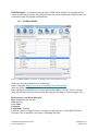
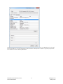
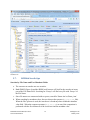
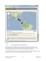
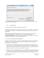
Michigan Tech HAZHub
Natural Hazards Archive – User Manual
1. Background
The vision for the Michigan Tech Natural Hazards Archive is to provide web access to data files
that are of interest to the research community. Natural Hazards Archive (HAZHub) was
developed as the Data Archive Plan of the NSF project, "Remote Sensing for Hazard Mitigation
and Resource Protection in Pacific Latin America". This project was sponsored by the National
Science Foundation's Office of International Science and Engineering (OISE). The initial
archived data was directly related to the research performed by grad students and faculty
involved in the project, but the archive is a pro-active archive system that will continue to
maintain archives of data sets from current and future geologic hazards and resources research
performed at Michigan Tech and other collaborating institutions. Geologic hazards and resources
include research in the areas of geohydrology, volcanology, and seismology. The Michigan Tech
data collection consists of many types of datasets which cover a wide range of geographic and
geologic areas.
The backbone of the database is the open-source integrated Rule-Oriented Data System
(iRODS), developed by the Data Intensive Cyber Environments Center (DICE Center) at the
University of North Carolina at Chapel Hill. Development of the core iRODS system has been
funded by the National Science Foundation and the National Archives and Records
Administration.
Current Michigan Tech PIRE datasets include satellite images, ArcGIS maps, seismic data,
thermal imaging, technical papers, video, measured and processed data, and other databases
related to specific topics and research areas. The types of data to be cataloged are not limited to
this list. iRODS will allow new data types to be added to the system as needed. These datasets
may be stored anywhere; they need not all reside on the same server.
The data catalog will store descriptive information about each dataset in a mySQL database. This
will include searchable fields such as location coordinates, data type, and descriptive keywords.
The database will also hold detailed descriptions, usage restrictions, and reference citations.
“iRODS” is the name of the online tool used to catalog the data, but Michigan Tech’s instance
of the iRODS database is called “HAZHub.” Sometimes these terms are used interchangeably,
but they both refer to the underlying database system.
Michigan Tech’s data archive is connected to 700GB of storage space, which has the potential
for expansion as needed. Files have been grouped together in tar and gzip formats, and the
targeted size for any one file stored in the system is 1-2 GB. To date, 400 GB of data have been
uploaded into the repository. The uploaded data is mostly volcano-related datasets from
Guatemala and El Salvador, but students are in the process of uploading more volcano, seismic,
and geohydrology data.
HAZHub Natural Hazards Archive
User Documentation
1
Michigan Tech
January 2014
2. Contents
1.
Background ............................................................................................................................. 1
2.
Contents .................................................................................................................................. 2
3.
User Documentation ............................................................................................................... 3
3.1.
Online Access to the HAZHub Natural Hazards Archive................................................ 3
3.2.
Request UserID and Password ......................................................................................... 4
3.3.
Access to HAZHub .......................................................................................................... 4
3.3.1.
HAZHub iDROP ....................................................................................................... 5
3.3.2.
HAZHub Online........................................................................................................ 6
3.4.
HAZHub Data Content..................................................................................................... 7
3.5.
Directory (Collection) Structure and Naming Conventions ............................................. 8
3.6.
Metadata ......................................................................................................................... 10
3.7.
HAZHub Search tips ...................................................................................................... 12
3.8.
Uploading and Downloading Files ................................................................................. 16
3.9.
Delete Files ..................................................................................................................... 17
4.
Criteria to include data in HAZHub: .................................................................................... 17
5.
Procedures for Contributing Data to HAZHub ..................................................................... 18
6.
Developments still in progress .............................................................................................. 19
HAZHub Natural Hazards Archive
User Documentation
2
Michigan Tech
January 2014
3. User Documentation
3.1.
Online Access to the HAZHub Natural Hazards Archive
HAZHub Natural Hazards Archive online documentation
URL: http://www.mtu.edu/geo/research/hazard-data/
Access the archive through the Geological & Mining Engineering & Sciences
(http://www.mtu.edu/geo/) web page. Under RESEARCH, select HAZHub Natural Hazards
Archive.
This website documents the use and expectations of the repository. Userid/password requests are
initiated here, and this site provides links to two user interface methods of accessing the data in
the archive, HAZHub iDROP and the HAZHub Online web browser.
Figure 1. The HAZHub: Natural Hazards Archive web page, is located under the Geological & Mining Engineering
& Sciences web site, under RESEARCH.
HAZHub Natural Hazards Archive
User Documentation
3
Michigan Tech
January 2014
3.2.
Request UserID and Password
Userids and passwords are required to access the data archive, and permissions will be set
according to the user’s level of use. The root directory of the HAZHub archive is
\hazhub\home\. Data is then divided into "\PublicAccess\", "\PrivateAccess\", and "\Users\"
directories.
\PublicAccess\ contains datasets that are accessible by the general public. Data should still be
sited correctly when referenced in publications and presentations, but it is freely accessible and
usable for research and publication. All users will be given access to view and download data in
this directory.
\PrivateAccess\ contains proprietary data that is only accessible by Michigan Tech researchers
and students, and is limited in use by copyright and licensing restrictions. General public users
will be able to see directory and file names, but will not have permissions to view or download
data.
\Users\ contains a subdirectory for each user with access to the HAZHub archive. This
directory is used when Michigan Tech researchers and collaborators need to upload new data
into the archive. The archive administrators will review the data and make sure the file &
directory names are in compliance with the HAZHub naming conventions, and will also verify
that a complete and accurate set of metadata has been provided for each file before transferring
data sets to the correct public or private access directory.
To request a userid/password, please email Carol Asiala ([email protected]) or use the Online
Request form. Please include an Email address and Preferred UserID. If you are requesting
access to the \PrivateAccess\ directory, please provide Michigan Tech advisor/referral name and
email address.
Your password can be changed through the iDROP interface. The same UserID and password
will work when logging in with either access method, HAZHub iDROP or HAZHub Online.
3.3.
Access to HAZHub
iRODS (www.irods.org) is the open-source software installed on Michigan Tech's server that
manages the data archive. HAZHub iDROP and the HAZHub Online are two web-based user
interface programs that allow users to view and access the iRODS-managed database. Both
interfaces access the same data, but they each provide unique features that will be helpful to
users, depending on their use of the Natural Hazards Archive.
HAZHub iDROP - is a Java Web Start application that can be run directly from a web browser.
It is the most current interface being developed by the iRODS organization. It is a working
version available for use, but new developments are still in the process of being added.
HAZHub Natural Hazards Archive
User Documentation
4
Michigan Tech
January 2014
HAZHub Online - is a tradition web page built on PHP and JavaScript. It is an older interface
written in PHP and Javascript. It has search features not yet developed in the iDROP system, but
is limited to single file uploads and downloads.
3.3.1. HAZHub iDROP
Figure 2. HAZHub iDROP user interface to Michigan Tech's Natural Hazards Archive.
Works best from the Mozilla Firefox web browser.
Link to idrop.jnlp: http://iren-web.renci.org/idrop-release/idrop.jnlp
Allow the iDrop Java program to run
Note: (running from other browsers will be checked into further. Currently, Firefox will run
idrop.jnlp, but other browsers download the idrop.jnlp file and then are missing support files)
Please log in to your iDrop data grid
Host: hazard-data.geo.mtu.edu
Zone: hazhub
User Name:
Password:
Login Mode: Standard
Check the 'Advanced Login Settings' to change your password or to verify that the Default
Resource is set to 'demoResc' (necessary if uploading data files).
HAZHub Natural Hazards Archive
User Documentation
5
Michigan Tech
January 2014
HAZHub iDROP Features
a. The directory structure is similar to the Mac environment
b. Multiple files may be uploaded or downloaded at once
c. Searches can be done on file names, but the metadata searches are still under
development
d. Text searches are case sensitive
e. Clicking on a file in the Search results box, shows the selected file in the directory
structure
f. Files can be renamed if needed
g. Metadata can be Copied to the clipboard to paste in other applications (Select all
metadata values, or use CTL-click to select specific items)
h. Metadata can be added and deleted, but values cannot be modified.
3.3.2. HAZHub Online
From any web browser, enter the url: hazard-data.geo.mtu.edu
Sign on to iRODS
Host/IP: localhost
Port: 1247
Username:
Password:
Zone: hazhub
HAZHub Online Features:
a.
b.
c.
d.
e.
f.
g.
h.
The directory structure is similar to the Windows environment
Only one file at a time may be uploaded or downloaded
Searches can be done on file names and on metadata values such as Keywords and
Latitude/Longitude values.
Text searches are case sensitive
Files cannot be renamed. (use HAZHub iDROP for this)
Metadata can only be copied/pasted one value at a time
Metadata can be added, deleted, and modified
Includes a Map feature for locating datasets and searching by Latitude and Longitude
HAZHub Natural Hazards Archive
User Documentation
6
Michigan Tech
January 2014
Figure 3. HAZHub Online interface to Michigan Tech's Natural Hazards Archive.
3.4.
HAZHub Data Content
The Natural Hazards Archive is a collection of all types of data collected, generated, and
processed by faculty and students in support of their research in the fields of volcanology,
seismology, and hydrology. The data includes, but is not limited to, remote sensing, GIS, thermal
infrared imaging, and seismic data, along with video and photograph recordings of events.
1. Basic data or raw information used for a project, which otherwise is not easily accessible,
and which we have permission to put in the repository either for the general public to have
access to it, or for only a restricted group of people. Proprietary data will only be accessible
by those who have permissions to use it, such as ASTER data downloaded under Michigan
Tech’s account. Michigan Tech does not have permissions to redistribute ASTER data to the
general public, but it is available for use by Michigan Tech researchers. Imagery data such
as Landsat and MODIS will not be included in the repository since it is available for free on
the Internet. Typical datasets uploaded to the repository include:
HAZHub Natural Hazards Archive
User Documentation
7
Michigan Tech
January 2014
a. Satellite remote sensing datasets in GIS raster format (e. g. geotiff, .img, etc. files).
b. GIS datasets acquired for the research purpose (e. g. shapefiles, raster datasets, etc.).
c. Instrumental and measurement datasets directly collected during field work, including
geophysical (e. g. seismic, acoustic, thermal (FLIR), VLF, 2D_ER, differential GPS, etc),
geochemical (volcanic SO2, water chemistry, etc.), structural rock-mechanics (Schmidt
hammer, joint orientation, etc.) and geo-hydrological (e. g. flow rate, well level, etc.)
datasets.
d. Visual (photos and video), and traditional field (notebook, hand-held GPS, etc.) recorded
datasets.
e. Analytical and laboratory results from the analysis of samples collected in the field,
including geochemical (e. g. rock composition, thin section photographs, etc.).
f. Interviews, surveys, and other human subject research datasets, restricted by Institutional
Review Board (IRB) constraints).
2. Diverse products generated from the different research projects (e. g. thesis). This should
include information in a variety of formats. The most condensed level will be the documents
(thesis and papers) describing and presenting the research results, but a variety of other
datasets are also expected. Such datasets include:
a. Datasets and tables in spreadsheet or other general purpose database format (e. g.
excel, Dbase, etc.).
b. GIS files (raster files, shapefiles, .mxd ArcGis document files) and associated
metadata files, including final maps and GIS layers.
c. Datasets in specific electronic file formats associated to each discipline (e. g. outputs
form seismic source modeling, corrected SO2 maps/images from the UV camera,
etc.).
d. Computer code and programming outputs (e. g. Matlab SO2 software analysis, other
code written for specific data processing routines, etc.).
e. Documents published in conferences and congresses, including abstracts, posters,
presentations, etc.
f. Papers published in peer reviewed journals, congress memoirs, etc.
g. Other presentations given at workshops, internal (GMES) activities, etc.
h. Thesis and report documents.
3.5.
Directory (Collection) Structure and Naming Conventions
Directories in the repository are referred to as Collections. The archived data has been divided
into 2 main collections, "PublicAccess" and "PrivateAccess". The PrivateAccess collection
contains proprietary data with use restricted to Michigan Tech researchers and collaborators,
under the guidelines of the data's use policies. The PublicAccess collection will be made
available to all archive users, with the request that data be sited correctly in any published
documents and presentations.
HAZHub Natural Hazards Archive
User Documentation
8
Michigan Tech
January 2014
Directory structure for the PublicAccess and PrivateAccess directories:
/hazhub/home/PublicAccess/
/Country/
/Geologic Feature/
/Data type/
File names
example: FLIR data from the Sanitaguito volcano in Guatemala will be found under:
/hazhub/home/PublicAccess/Guatemala/Santiaguito/FLIR/
File naming conventions
The file naming conventions were planned to assist users in searches of the data, either by using
the search features or just by browsing the collections of data. Many data sets are a combination
of multiple files and directories that have been tar'd and zipped. To keep individual file sizes
between 1 and 2 GB, some data sets consist of multiple tar.gz files that end with a set number to
indicate multiple files for the same data set.
1. Basic filename format: TTTTTT_Volcano_yyyy-mm-dd_description_Set#.tar.gz
a. Example: FLIR-SEQ_Pacaya_2009-01_BuenaVista_Set01.tar.gz
b. TTTTTT: general type of data (FLIR, FLIR-SEQ, DOAS, ASTER, TIMELAPSE, etc.)
c. Geologic_Hazard: name of volcano or other specific geologic hazard location if
data is not volcano-related
d. yyyy-mm-dd: date of data, drop dd and mm if unknown
e. description: extra description to help identify data
f. Set#: if data is a set of related files, they will be tar’d and zipped in groups of files
1-2 GBs in size. Some data sets will be a set of tar.gz files.
If there are 10 or more sets, they should be numbered with 2 digits for directory
sorting. Drop the Set portion of the name if there is only one file.
2. Filename for thesis: ThesisMSorPhD_Volcano_PublYear_LastName.pdf
ThesisMS_Santa_Ana_2008_Colvin.pdf
3. Filename for data directly supporting a thesis:
ThesisMSorPhD_Volcano_PublYear_LastName_DataType_DateOfData_Set1.tar.gz
ThesisMS_Santa_Ana_2008_Colvin_modis_aqua_2005_Set1.tar.gz
4. Other Filename conventions:
Do not leave blank spaces in file names. use “-” inside dates. Use “_” for other items,
even volcano names, Santa_Ana
HAZHub Natural Hazards Archive
User Documentation
9
Michigan Tech
January 2014
3.6.
Metadata
Metadata will be stored for each file in the archive system (Figures 4 and 5). Users will be able
to find data by searching on the metadata fields, and will also be able to get a quick review of the
data file contents before downloading. Metadata fields will contain:
1. Contributor Name: Person contributing the data to the archive. This is usually the faculty
member responsible for the data.
2. Contributor Organization
3. Country: country of data location
4. Data Use Permissions: description of how data can be used and distributed
5. DataID: Identification number from the database. This will identify individual files in the
repository, and will also be included in the Reference Citation field.
6. Description: only populated when more detailed information than the keywords has been
given
7. Field of Study: Volcanology, Hydrology, etc.
8. Geologic Feature Name: If the data pertains to a volcano, this will be the volcano
name. Otherwise it will be the name of the feature or location the data pertains to, such as
the Quito Aquifer System.
9. Interest Level: (Technical, General Public). If a data set is labeled “General Public”, it will
contain photos or video footage that would be of interest to the general population as well as
researchers. If it is labeled “Technical”, then it is a set of data, mostly of interest to
researchers.
10. Keywords: list of keywords to assist in searching, includes, location, geologic feature, type
of data, etc.
11. Latitude (-n.nnn): decimal format, positive values for N, negative values for S
12. Longitude (-n.nnn): decimal format, positive values for E, negative values for W
13. Reference Citation: citation to be used when referencing this data in publications
14. zLatitude (x1000): Latitude times 1000
15. zLongitude (x1000): Latitude times 1000
These metadata values will be automatically created/updated by a script. They were added to
the system because of a database issue discovered in iRODS where numeric comparisons of
decimal metadata gave inaccurate results. With this fix, searches will be accurate for
Lat/Long values with precision to 3 digits.
HAZHub Natural Hazards Archive
User Documentation
10
Michigan Tech
January 2014
Figure 4. Click the “Info” icon in iDROP to display file information, and then select the Metadata tab. The whole
block of metadata can be copied and pasted to other documents. The Reference Citation is especially useful when
users need to cite sources in their publications.
HAZHub Natural Hazards Archive
User Documentation
11
Michigan Tech
January 2014
Figure 5. In the HAZHub Online browser, view metadata by double clicking on a file name, and selecting the
metadata tab.
3.7.
HAZHub Search tips
Searches by File Name and Text Metadata Fields:
a. The current text searches are case sensitive.
b. Both iDROP (Figure 6) and the iRODS web browser will look for the search text in any
part of the File Name field. Searching for ‘Pacaya’ will find every file with ‘Pacaya’ in
the File Name.
c. Since file names are constructed with no spaces, search for 'Santa Ana' as 'Santa_Ana'.
d. When searching by metadata values, the user chooses the operator (=, <, <=, >, >=, like).
When the 'like' operator is used, the search text is found anywhere within the metadata
value field. When the compare operators (=, <, <=, >, >=) are used, the comparison is
performed with the first characters of the search text and the metadata value.
HAZHub Natural Hazards Archive
User Documentation
12
Michigan Tech
January 2014
Example:
Keywords like FLIR will find all files with 'FLIR' listed anywhere in the Keywords field
Keywords = FLIR will only find the files where 'FLIR' is the only value listed in
Keywords
Keywords > FLIR will only find files where the 1st Keyword follows 'FLIR' in the
alphabet
Figure 6. Search results in iDROP when searching for part of a file name.
HAZHub Natural Hazards Archive
User Documentation
13
Michigan Tech
January 2014
Search by Latitude/Longitude – Advanced Search:
a. Latitude and Longitude are metadata fields, and can only be searched in the HAZHub
Online interface (hazard-data.geo.mtu.edu, Figures 7 and 8). The metadata search
feature in iDROP is currently under development.
Figure 7. Search dialog for iRODS web browser interface. Open the search box by clicking on the dropdown arrow
next to the search icon on the upper right corner of the screen.
HAZHub Natural Hazards Archive
User Documentation
14
Michigan Tech
January 2014
Figure 8. Search results list for the HAZHub Online interface. Each item in the list can be double-clicked to
download or view the metadata.
Search by Latitude/Longitude – chosen on location map:
a. From HAZHub Online, click on toolbar icon, Map
b. A new window, HAZHub Online – Location/Search Map opens with all
Latitude/Longitude data locations marked on the map.
c. A double-click on an icon will show the feature name and country of the data.
d. Select the "Draw a Rectangle" box to draw a search area.
e. Click on "Search". This opens the "Advanced Search" dialog in the HAZHub Online
web page. The lat/long search range will be populated with the SE and NW corners of
the user-drawn rectangle.
f. Click Search to view the list of data files within the lat/long range.
g. To limit the search to just the /PublicAccess/ Files, select the
/hazhub/home/PublicAccess/ directory, and then do the search. Check the “Under
Current Collection” checkbox in the Advance Search dialog box before clicking on
Search.
HAZHub Natural Hazards Archive
User Documentation
15
Michigan Tech
January 2014
Figure 9. HAZHub Online location map. Users can select an area to search for files within the rectangle
boundaries.
3.8.
Uploading and Downloading Files
When using iDROP, multiple files can be uploaded or downloaded in one operation. To
download, the user selects the files to download, and clicks the “Download” icon. The user
selects the destination directory in his local drive from the dialog box (Figure 9).
In the HAZHub Online web browser, download individual files by double-clicking the file, and
selecting “Force Download”. Files can be uploaded with the “Upload” tab.
HAZHub Natural Hazards Archive
User Documentation
16
Michigan Tech
January 2014
Figure 10. iDROP interface for downloading files to a local directory. The files listed here are the files that were
selected by the user in the data archive.
3.9.
Delete Files
Users can only delete if they have read and write permissions.
When deleting files in iDROP, they automatically get moved to the Trash folder. Even if the file
being deleted is in Trash, a new Trash folder is created under the current folder and the file is
moved there.
When Deleting files in the HAZHub Online web browser, the user has the option of either
permanently deleting the file, or moving it to Trash. Under the “Delete” menu, if
“Force/Permenant Delete” is checked, the deleted file will not be saved under Trash. If this is
unchecked, any deleted file will be moved to the Trash folder.
4. Criteria to include data in HAZHub:
The purpose of the data repository is to archive valuable and usable project data created within
the PIRE project. For files to be considered valuable and usable the students will apply the
following criteria to uploaded data:
1. The files have to be a finished product of some sorts, such that someone interested in the
topic covered in the study will find it useful. Intermediate products (e. g. GIS layers used to
clip data), unsuccessful trial runs, and "dead end street" tests (e. g. calculations that were not
finished or lead to non-conclusive results) should not be included.
2. The files have to be either self-explanatory (e. g. self-contained power point presentations or
text documents for a technical but somewhat general audience), or should have some kind of
metadata to provide further explanation. This could include an index of content for a set of
HAZHub Natural Hazards Archive
User Documentation
17
Michigan Tech
January 2014
files in specific folders, self-explanatory file names, standard file format and names for
known file products (e. g. satellite imagery), further documentation in the Keywords and/or
Description metadata fields, etc. Files which have some direct relation to a thesis, paper or
other document that we can either include in the database (e. g. thesis) or formally cite (e. g.
paper) could be included, as long as it can be clearly linked to such a document and the
content of the file is clearly described.
3. Redundant information should be avoided; only the final and (hopefully) definitive version
should be included in cases where there are several versions of a document or dataset,
corresponding to different stages in the development of the document or dataset.
4. Data will be classified as available for use and distribution by the general public, or available
only to Michigan Tech researchers. All project results were intended to be made available to
the general public, but some supporting data associated with a project may include purchased
and copyrighted material for which Michigan Tech does not have permissions to make
available in a public database. Examples of this type of data are:
a. ASTER imagery which is free, but can only be distributed within the organization that
has an authorized download account
b. Purchased data sets that cannot be shared
c. Photographs and videos taken by organizations that have shared these images solely for
Michigan Tech research.
5. Procedures for Contributing Data to HAZHub
Contributions to the Natural Hazards Archive are encouraged, especially from current and
former grad students involved in the PIRE project, "Remote Sensing for Hazard Mitigation and
Resource Protection in Pacific Latin America".
1. Data Review
Check with Carol Asiala ([email protected]) or John Gierke ([email protected]) before
uploading data. We would like to know what type of data is being added to the archive
and make sure contributors follow the archive guidelines we have set up.
2. Upload to your user directory
Once you have received a userid and password, a directory under
/hazhub/home/Users/<your userid>/ will be set up for you. This is the only place you
will have permissions to upload data to the archive.
3. Combining datasets
Please combine files that belong together using tar and zip. (ex. files & directories
needed for an ArcInfo Map project)
4. Keep file sizes under 2 GB
Files over 2 GB may be difficult for some users to download. If a combined dataset will
be over 2 GB, then create several files with the same naming convention, but add
"Set01", Set02", etc. to the end of the file names. Users will know the data files belong
together, and will download them together.
HAZHub Natural Hazards Archive
User Documentation
18
Michigan Tech
January 2014
5. Project Files, layers, and links
If you are uploading a project that contains links to layer files, please include all of the
files needed to open and view your project.
6. Metadata
When you upload a file in your Users directory, a set of blank metadata will be generated.
Please fill in this data (access through HAZHub Online), including Latitude and
Longitude values. If your data is focused on a particular volcano, use the lat/long
coordinates from the Smithsonian Institution Global Volcanism Program database.
7. Private or Public Access
Please indicate the type of data you are submitting. If it can be freely accessible by the
general public, it will be moved it to /hazhub/home/PublicAccess/. If the data is
proprietary and should only be used by Michigan Tech Researchers, then we will move it
to /hazhub/home/PrivateAccess/.
8. Notify Carol Asiala ([email protected]) when your upload is complete, and after
reviewing, we will move it to the correct directory.
6. Developments still in progress
1. Currently in the process of connecting the iRODS database at the University at Buffalo with
Michigan Tech’s iRODS database. The iRODS Federation feature will allow Michigan Tech
and the University at Buffalo to administrate their own iRODS archive systems, but will
allow users of both systems to access the data on both systems. This feature currently being
tested and coordinated with the University at Buffalo.
2. Assess the iDROP Transfer Manager to check its usefulness in monitoring the
upload/download activity of the data repository through iDROP.
3. Continue uploading project data, and proofread the uploaded files and directories to make
sure they follow the outlined naming conventions and metadata structures.
HAZHub Natural Hazards Archive
User Documentation
19
Michigan Tech
January 2014