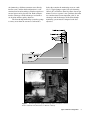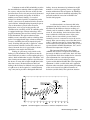
1
Guidelines and Standard Procedures for Continuous
Water-Quality Monitors: Site Selection, Field
Operation, Calibration, Record Computation,
and Reporting
By Richard J. Wagner, Harold C. Mattraw, George F. Ritz, and Brett A. Smith
ABSTRACT
The U.S. Geological Survey uses
continuous water-quality monitors to assess
variations in the quality of the Nation’s surface
water. A common system configuration for data
collection is the four-parameter water-quality
monitoring system, which collects temperature,
specific conductance, dissolved oxygen, and pH
data, although systems can be configured to
measure other properties such as turbidity or
chlorophyll. The sensors that are used to measure
these water properties require careful field
observation, cleaning, and calibration procedures,
as well as thorough procedures for the
computation and publication of final records.
Data from sensors can be used in
conjunction with collected samples and chemical
analyses to estimate chemical loads. This report
provides guidelines for site-selection
considerations, sensor test methods, field
procedures, error correction, data computation,
and review and publication processes. These
procedures have evolved over the past three
decades, and the process continues to evolve with
newer technologies.
quality adequately. When the time interval between
repeated measurements is sufficiently small, the
resulting record of water quality can be considered
continuous. A device that automatically measures
water quality in this way is called a continuous waterquality monitor. These monitors have sensors and
recording systems to measure physical and chemical
water-quality properties at discrete time intervals at
point locations. Operation of a water-quality
monitoring station provides a nearly continuous record
of water quality that can be processed and published or
distributed directly by telemetry or on the World Wide
Web. The water-quality record provides a nearly
complete record of changes in water quality as well as
a basis for computation of constituent loads at a station.
Data from the sensors also can be used as surrogates for
the measurement of other constituents by using
regression analyses to provide estimates of
instantaneous chemical loads. Emerging sensor
technology is broadening the variety of measurable
chemical constituents and is reducing limits of
detection. As it has become possible to make near realtime water-quality monitoring data available on the
World Wide Web, continual progress is being made to
improve applications and refine quality-control
procedures.
Purpose and Scope
INTRODUCTION
Water quality changes over time, necessitating
repeated measurements to characterize variations in
This report provides basic guidelines and
procedures for U.S. Geological Survey (USGS) site
selection and operation of continuous water-quality
monitors, field data evaluation, and subsequent record
Abstract
1
computations. The basic guidelines are minimal
requirements that may need to be modified to meet
local environmental conditions. This report provides
examples of the application of scientific judgment in
the evaluation of data records. Field training with the
monitoring equipment and first-hand knowledge of the
watershed form the core of the data-evaluation process.
Record-computation procedures provide a uniform set
of minimum requirements for computing records.
Adoption of these water-quality record procedures will
ensure that published data are properly documented.
Representative illustrations of the application of
scientific judgment are, by necessity, site specific.
Other specific examples are used to demonstrate the
range of environmental conditions that affect the
evaluation process. The final evaluation to determine
portions of the record that are published requires
careful review and verification of the data, but much is
left to the professional judgment and observations of
the hydrographer operating the station. A set of
considerations that represent a sound basis for the
operation of a water-quality station, data evaluation,
and publication criteria is presented in this report.
Acknowledgments
The authors wish to acknowledge the support,
technical contributions, and advice of USGS
colleagues in the preparation of this document. Gary L.
Pederson and the Southeastern Region provided
technical support for production of this report. Walton
H. Low, G. Douglas Glysson, and Janice R. Ward
reviewed and provided important critiques of several
versions of this report. Special thanks to Trudy J.
Bennett and Andrew C. Ziegler for contributions to
sections of the report that address turbidity and to Ann
Vanderpool for input on the use of draft guidelines in
the field. Kirk P. Smith provided the provisional field
form used in this report, and Douglas O. Cushman
assembled the Columbia River review forms.
Internal (unpublished) continuous water-quality
monitoring procedures documented by the Colorado,
Maine, Michigan, North Carolina, Ohio, Oregon,
Texas, and Washington Districts significantly
contributed to the development of these guidelines as
well as previously published guidelines. Special thanks
go to Brett A. Smith who co-authored an earlier version
of this report and provided valuable insights to the
record computation process. The encouragement of
Brett, Rebecca Deckard, and Gary Pederson is
gratefully acknowledged.
2
WATER-QUALITY MONITORING SITE
OPERATION
Physical and chemical measurements in streams
can be made at discrete intervals to provide a nearly
continuous record of stream water quality. Major
factors in the operation of a continuous water-quality
site include selection of sensors and types of monitors,
the type of monitor configuration, site selection,
location of the sensors in the stream cross section, the
use and calibration of field meters, and the actual
operation of the continuous water-quality monitors.
Sensor and site selection are guided by the purpose of
monitoring and the data objectives. The main objective
in the placement of the sensors is the selection of a
stable, secure location that is representative of the
stream.
Monitor Selection
The selection of a water-quality monitor
involves four major interrelated elements—(1) the
purpose of the data collection, (2) the type of
installation, (3) the type of sensor deployed at the
installation, and (4) the specific sensors needed to
satisfy the accuracy and precision requirements of the
data-quality objectives.
The most widely used water-quality sensors in
monitoring installations are temperature, specific
conductance, dissolved oxygen (DO), pH, and
turbidity. Sensors also are available to measure
oxidation-reduction potential, water level, depth,
salinity, ammonia, nitrate, chloride, and chlorophyll;
but the focus of this report is on temperature, specific
conductance, DO, pH, and turbidity. The sensors
needed to measure these properties are available as
single instruments or in various combinations. For
clarity in this report, a sensor is referred to as a
particular lone sensor or a sensor that is detachable
from a combination. A group of sensors configured
together commonly is referred to as a sonde, which
typically has a single recording unit or electronic data
logger to record the output from the multiple sensors.
Types of Monitor Configuration
In general, three types of configurations are used
for water-quality monitors. The flow-through
monitoring system generally has a pump that delivers
water to the sensor(s) mounted in a shelter; the second
configuration is one in which the sensors are placed in
Guidelines and Standard Procedures for Continuous Water-Quality Monitors
situ (immersing a field measurement sensor directly
into the water); and the third configuration is a selfcontained sensor and recording system that requires no
external power and is placed in situ. Each configuration has advantages and disadvantages in relation to
site location and data-quality objectives.
The flow-through monitoring system has a pump
to convey water from the stream to a tank inside a
shelter that contains the monitoring sensor or sonde
(fig. 1). Typical pumps require 120-volt alternating
current (AC) and deliver about 10 gallons of water per
minute. If access to power is not a problem, then other
site considerations become important (table 1); the
advantages and disadvantages of the flow-through
monitoring system must be compared to the data
objectives.
Figure 1. Flow-through water-quality monitoring station. (PHOTOGRAPH: RAMAPO
RIVER AT POMPTON LAKES, NEW JERSEY, BY MICHAEL J. DELUCA)
Types of Monitor Configuration
3
Table 1. Principal advantages and disadvantages of flowthrough monitoring systems
Advantages
Disadvantages
Unit can be coupled with
chlorinators to reduce
membrane fouling.
Expensive sensor systems
can be secured in
vandal-proof shelters.
Calibration can be performed in the shelter.
120-volt AC power source is needed.
Higher installation costs are incurred.
Pumps tend to clog in streams with
algal fouling or high sediment
loads.
Electrical shock protection is
required.
Pumps may be damaged by corrosive
waters.
Pump maintenance is required.
Pumping may cause changes in water
quality.
The sensors in the in-situ monitoring system are
placed at the measuring point in the stream cross section
(fig. 2). Cables run from the sensors to the recording
equipment that is housed in a shelter. The primary
advantage of this configuration is that no power is
needed to pump water (table 2). Direct current, 12-volt
batteries easily meet the power requirements of the
sensors and recording equipment. In-situ water-quality
monitoring systems can be installed at remote locations
where AC power is not available, but the advantages
and disadvantages of the in-situ monitoring system also
must be considered.
Table 2. Principal advantages and disadvantages of in-situ
monitoring systems.
Advantages
No power is needed to
pump water.
Remote locations are
possible.
Smaller shelters can be
used.
Disadvantages
Sensors are susceptible to vandalism.
The water flow cannot be treated to
reduce fouling.
In shallow bank installations, the
proper location of sensors in the
cross section is difficult.
Pumping maintenance is
Servicing sensors during flooding
not required.
can be difficult.
Freeze protection is
Sensors are susceptible to debris or
provided to the sensors.
high flow.
Electrical hazards are
Shifting channels may cause
reduced.
movement of the equipment.
4
Figure 2.
In-situ water-quality monitoring station.
(PHOTOGRAPH: SPRING BROOK CREEK AT ORILLIA, WASHINGTON, BY
DAVID K. MULLIS)
Guidelines and Standard Procedures for Continuous Water-Quality Monitors
The third water-quality monitoring system is a
combined sensor and recording sonde that is self
contained, requires no external power, and reduces
exposure to vandalism. Power is supplied by conventional batteries located in a sealed compartment, and
sensor data are stored within the sonde on nonvolatile,
flash-memory, recording devices (fig. 3). The advantages and disadvantages of the self-contained sensor
and recording system must be considered (table 3).
Table 3. Principal advantages and disadvantages of the
self-contained monitoring system.
Advantages
Location options are
flexible.
The monitor is protected
from vandalism.
Electrical hazards are
nonexistent.
Disadvantages
Data are available only during site
visits.
Equipment status checks are
required.
Servicing sensors and recovering
data can be difficult.
Sensors are susceptible to debris or
high flow.
Shifting channels may cause
movement of the equipment.
Status of the equipment can be
checked only while servicing.
If batteries die, data are lost.
Types of Sensors
Sensors are available for continuous
measurement of many physical properties and chemical
constituents, but five of the most commonly used
sensors are for the measurement of temperature,
specific conductance, DO, pH, and turbidity.
Temperature
Temperature has an important influence on the
density of water, the solubility of constituents in water,
pH, specific conductance, the rate of chemical
reactions, and biological activity in water (Radtke,
Kurklin, and Wilde, 1998). The preferred watertemperature scale for most scientific work is the Celsius
scale. Continuous water-quality sensors usually
measure temperature with a thermistor, which is a
semiconductor with resistance that changes with
temperature. Thermistors are reliable, accurate, and
durable sensors that require little maintenance and are
relatively inexpensive. Modern thermistors can easily
measure temperature to plus or minus (+) 0.1 degree
Figure 3. Self-contained water-quality monitoring sensor and
recording system. (PHOTOGRAPH: DELAWARE AND RARITAN CANAL
FEEDER AT RAVEN ROCK, NEW JERSEY, BY BONNIE GRAY)
Types of Monitor Configuration
5
Celsius (°C), but the user must verify the accuracy
claimed by the manufacturer for the range of
application. Typically, temperatures are reported to the
nearest 0.5 °C because the thermistor is located at one
point, which may not be representative of the entire
body of water being measured.
Specific Conductance
Specific conductance is a measure of the
capacity of water to conduct an electrical current and is
a function of the types and quantities of dissolved
substances in water (Radtke, Davis, and Wilde, 1998).
As concentrations of dissolved ions increase, specific
conductance of the water increases. Specific
conductance measurements are a good indication of
total dissolved solids and total ion concentrations, but
there is no universal linear relation between total
dissolved solids and specific conductance. A
continuous record of specific conductance can be used
in conjunction with chemical analyses and continuous
discharge records to estimate constituent loads (Clifton
and Gilliom, 1989; Hill and Gilliom, 1993; Christensen
and others, 2000). The USGS measures specific
conductance at or compensated to 25 °C and reports
specific conductance in microsiemens per centimeter at
25 °C (µS/cm at 25 °C).
Specific conductance sensors are one of two
types—contact sensors with electrodes and sensors
without electrodes. Continuous water-quality sensors
generally have electrodes that require the user to
choose a cell constant for the expected range of
specific conductance. Multiparameter monitoring
systems usually contain automatic temperature
compensation circuits; thus, specific conductance
usually is compensated to 25 °C, but this should be
verified by checking the manufacturer’s instruction
manual. All modern monitoring systems are designed
for medium-strength specific conductance waters
(100 to 2,000 µS/cm at 25 °C) or higher. In general,
specific conductance electrodes are reliable, accurate,
and durable but are susceptible to fouling from aquatic
organisms and sediment.
Dissolved Oxygen
The DO concentration in surface water is related
primarily to atmospheric reaeration and photosynthetic
activity of aquatic plants (Radtke, White, and others,
1998). The range of observed DO in surface waters
typically is from 2 to 10 milligrams per liter (mg/L) at
6
20 °C. The value for 100-percent saturation of DO
decreases with increased temperature and increases
with increased atmospheric pressure. Occasions of
excess oxygen (supersaturation) often are related to
extreme photosynthetic production of oxygen by
aquatic plants as a result of nutrient (nitrogen and
phosphorus) enrichment, sunlight, and low-flow
conditions. Occasions of saturated oxygen commonly
are related to cascading flow conditions, both natural
and artificial. DO may be depleted by inorganic
oxidation reactions or by biological and chemical
processes that consume dissolved, suspended, or
precipitated organic matter (Hem, 1989). DO is a
significant factor in chemical reactions in water and the
survival of aquatic organisms.
The most commonly used technique for
measuring DO concentrations with continuous waterquality sensors is the amperometric method, which
measures DO with a temperature-compensated polarographic membrane-type sensor. While polarographic
membrane-type sensors generally provide accurate
results, they commonly are sensitive to temperature
and water velocity and are prone to fouling. Because
the permeability of the membrane and solubility of
oxygen in water change as functions of temperature, it
is critical that the DO sensors be temperature
compensated.
The measuring process consumes DO; therefore,
water flow past the sensor is critical. If water velocity
at the point of measurement is less than 1 foot per
second (ft/s), an automatic or manual stirring
mechanism or a different measurement technique is
required. DO sensors are prone to inaccuracies from
algal fouling, sedimentation, low velocity, and very
high velocities. A complete discussion of DO
calibration, measurement, and limitations can be found
in Radtke, White, and others (1998).
pH
The pH of an aqueous solution is controlled by
interrelated chemical reactions that produce or
consume hydrogen ions (Hem, 1989). The pH of a
solution is a measure of the effective hydrogen-ion
concentration (activity; Radtke, Busenberg, and others,
1998). More specifically, pH is a measure that
represents the negative base-10 logarithm of hydrogenion activity of a solution, in moles per liter. Solutions
having a pH below 7 are described as acidic; solutions
with a pH greater than 7 are described as basic or
Guidelines and Standard Procedures for Continuous Water-Quality Monitors
alkaline. Dissolved gases, such as carbon dioxide,
hydrogen sulfide, and ammonia, appreciably affect pH.
Degasification (for example, loss of carbon dioxide) or
precipitation of a solid phase (for example, calcium
carbonate) and other chemical, physical, and biological
reactions may cause the pH of a water sample to change
appreciably soon after sample collection (Radtke,
Busenberg, and others, 1998).
The electrometric pH measurement method,
using a hydrogen-ion electrode, commonly is used for
continuous water-quality pH sensors. Sensors used in
submersible monitors typically are combination
electrodes in which a proton (H+)-selective glass-bulb
reservoir is filled with an approximate pH-7 buffer. A
silver wire coated with silver chloride is immersed in
the internal reference electrode buffer reservoir.
Protons on both sides of the glass pH electrode (media
and buffer reservoir) selectively interact with the glass,
setting up an external potential gradient across the
outer glass membrane. Because the hydrogen-ion
concentration in the internal buffer solution is constant,
this external potential difference across the outer glass
membrane, which is determined relative to the internal
silver/silver-chloride reference electrode, is
proportional to the pH of the medium. A correctly
calibrated pH sensor can accurately measure pH to
+ 0.2 pH unit; however, the sensor can be scratched,
broken, or fouled easily. Detailed instructions for the
calibration and measurement of pH are described by
Radtke, Busenberg, and others (1998) or by the
instrument manufacturer.
Turbidity
Turbidity sensors operate differently from those
for temperature, specific conductance, DO, and pH,
which convert electrical potentials into the measurement of the constituent of interest. A turbidity sensor
operates by directing a light beam from a light-emitting
diode into the water sample and measuring the light
that scatters off the suspended particles present in the
water. The nephelometric measurement method is used
in most commercially available sensors with a sensor
range of 0–1,000 nephelometric turbidity units (NTU)
and an accuracy of + 5 percent or 2 NTU, whichever is
greater. However, some sensors can report values
reliably up to about 1,500 NTU.
Turbidity readings are affected by suspendedsediment particle size, entrained air bubbles, floating
debris, and other particles in the water that may collect
on or near the optic sensor during data collection. The
effect of temperature on turbidity sensors is minimal,
and the software for modern sensors provides
temperature compensation. Calibration and
measurement of turbidity by using a submersible
sensor are discussed by Wilde and Gibs (1998), but
manufacturer’s instructions and recommendations
must be followed. Sensors that are maintained and
calibrated routinely will be relatively error free and will
provide valid data at all times.
Instrument Acceptance Criteria
Independent testing to ensure accuracy and
reliability is an important part of any quality-assurance
program for hydrologic field instrumentation. As stated
in the Water-Resources Division (WRD) Hydrologic
Field Instrumentation and Equipment Policy and
Guidelines (U.S. Geological Survey WRD
Memorandum 95-35, 1995), any USGS District,
program, or project that procures an instrument is
responsible for ensuring that adequate testing is carried
out and that the documented results fully characterize
the performance and capabilities of the instrument. One
of the primary responsibilities of the USGS Hydrologic
Instrumentation Facility (HIF) is the testing,
evaluation, and documentation of instrument
performance. Districts are encouraged to purchase
instruments through the HIF when possible or perform
the necessary steps of independent testing to ensure
accuracy and reliability as stated by the instrument
manufacturer. District personnel are encouraged to
work with the HIF to evaluate new instrumentation and
actively participate in the web-based instrument
quality-assurance data base managed by the HIF by
entering, reviewing, and overseeing District data in the
data base and by taking corrective actions when
necessary.
Site Selection
The location of a water-quality monitoring site is
directly related to the purpose of monitoring and the
data-quality objectives. Stream characteristics,
location of the site, and other data-quality objectives
determine whether a data sonde will be placed in situ or
whether a flow-through receptacle with a pumping
sampler will be a better choice. More site-specific
considerations in monitor placement include sitedesign considerations, monitor installation, physical
constraints, and service requirements (table 4).
Site Selection
7
Table 4. Factors for consideration in the placement and
installation of continuous water-quality monitoring systems
Site-design considerations
Representative of cross-sectional variability
Constraints of channel configuration
Range of streamflow (from low flow to flood)
Velocity of streamflow
Turbulence
Avoidance of high-water debris damage
Range of values for water-quality physical properties
Protection from vandalism
Safety hazards
Monitor installation
Permits for installation
Type of installation
Difficulty and cost of installation
Ability to install monitor in representative location
Logistics (service requirements)
Accessibility of site
Frequency of service interval to meet data-quality objectives
Rate of fouling
Proximity to cross-section measuring location
Event related (for example, flooding event)
Proximity to electrical power or telephone service
Need for real-time reporting
Balancing the numerous site considerations for
placement of a continuous water-quality monitoring
system is difficult. The optimum site consideration for
achieving the data-quality objectives is placing the
pump intake, sensor package, or sonde in a location that
best represents the section of the water body being
measured. Lateral mixing in large rivers, however,
often is not complete for tens of miles downstream from
a tributary or outfall. A location near the streambank
may be more representative of local runoff or affected
by point-source discharges upstream, whereas a
location in center channel may be more representative
of areas farther upstream in the drainage basin.
Turbulent streamflow may aid in mixing, but turbulence
can create problems for some monitored parameters
such as DO or turbidity. For a medium to small stream
with alternating pools and riffles, the best flow and
mixing occurs in the riffle portion of the stream;
however, flooding may change the locations of shoals
upstream from the monitoring site, and the
measurement point may no longer represent the overall
water-quality characteristics of the water body.
8
Sufficient cross-section measurements must be
made at the site to determine if a prospective site is
sufficiently well mixed and to ensure that the site will
not be subject to significant difference in a cross
section. If significant horizontal or vertical variability is
determined, consideration must be given to choosing
another site or using a different approach to meet the
data-quality objectives (see Placement of Sensors in the
Cross Section).
Large streams and rivers may be monitored best
from the downstream side of bridge abutments,
assuming that safety hazards and other difficulties can
be reduced or overcome. The measurement point in the
vertical dimension for larger flow systems also needs to
be appropriate for the primary purpose of the
monitoring installation. The vertical measurement point
can be chosen for low-, medium-, or high-flow
conditions.
Selection of a water-quality monitoring site is
determined by the data-quality objectives, and the best
location for a site is often one that is best for measuring
surface-water discharge. Although hydraulic factors in
site location must be considered, it is more important to
consider factors that affect the water-quality data. It is
important to select a site that is representative of the
stream, and the cross-section characteristics of specific
conductance, turbidity, or pH may be helpful in
selecting the best sites. Assessment of a site may be
dependent on fouling potential, high-tension power
lines, or radio towers that may interfere with data
collection or telemetry. The same hydraulic factors that
are used in selecting a specific site for gaging discharge
in a channel also can be used in selecting a waterquality monitoring location. Both purposes seek a
representative site that approaches uniform conditions
across the entire width of the stream. Rantz and others
(1982) identified nine hydraulic conditions of the ideal
gage site, and these also must be considered in site
selection for water-quality sites (table 5).
The location of water-quality monitoring
sensors in cold regions requires additional considerations in order to obtain data during periods of ice
formation. White (1999) discusses environmental
factors in the site selection of an automated waterquality station in British Columbia, Canada, but also
generalizes morphological stream factors and the
importance of selecting a site that has a minimal
chance of damage or destruction from natural forces
and a minimal source of bubbles. White also
Guidelines and Standard Procedures for Continuous Water-Quality Monitors
Table 5.
1.
2.
3.
4.
5.
6.
7.
8.
9.
10.
Hydraulic conditions of the ideal gage site (after Rantz and others, 1982)
The general course of the stream is straight for about 300 feet upstream and downstream from the gage site.
The total flow is confined to one channel at all stages, and no flow bypasses the site as subsurface flow.
The streambed is not subject to scour and fill and is free of aquatic growth.
Banks are permanent, high enough to contain floods, and free of brush.
Unchanging natural controls are present in the form of a bedrock outcrop or other stable riffle for low flow and a
channel constriction for high flow, or a falls or cascade that is unsubmerged at all stages.
A pool is present upstream from the control at extremely low stages to ensure a recording stage at extremely low
flow, and to avoid high velocities at the streamward end of gaging-station intakes during periods of high flow.
The gaging station is far enough upstream from a confluence with another stream or from tidal effect to avoid any
variable influence from the other stream or tide on the stage at the gage site.
A satisfactory reach for measuring discharge at all stages is available within reasonable proximity of the gage site.
(It is not necessary that low and high flows be measured at the same stream cross section.)
The site is readily accessible for ease of installation and operation of the gaging station.
The site is not susceptible to manmade disturbances, nearby tributaries, or point-source discharges.
emphasizes that a site should (1) meet minimum
stream-depth requirements for instruments, (2) be safe
and accessible under all conditions, and (3) be located
to avoid the danger of vandalism.
Placement of Sensors in the Cross
Section
The location of a water-quality monitoring site is
dependent on the purpose of monitoring and the dataquality objectives. In some cases, such as the location
of a monitoring site in a lake, bay, or estuary, the
data-quality objectives may require only point
measurements; whereas, data-quality objectives for the
measurement of load or flux in a large river generally
require placement of a water-quality monitoring site at
the most representative measurement point in the cross
section of the stream.
Determinations of cross-sectional variability are
required before a monitoring site is installed to
properly locate the most representative measurement
point in the stream cross section and to determine if a
cross-section correction is necessary. A minimum of
two cross-section measurements per year is required to
verify that no significant changes have occurred in the
distribution of constituents across the stream.
Documentation of vertical mixing is required at least
annually at a minimum of two depths for all crosssection measurements. For monitoring sites that are
operated more than 1 year, a minimum of six crosssection measurements representing different flow
conditions is required to determine if discharge or
seasonal changes are affecting significantly the
distribution of constituent values in the cross section.
By choosing a monitoring site with well-mixed
streamflow, cross-section corrections may not be
needed.
Standard USGS procedure is to use either
discharge- or area-weighted methods for selecting
locations of the most representative measurement
points in a cross section to ensure that chemical loads
can be calculated correctly (Wilde and Radtke, 1998).
The measurement point in a cross section is established
by using either method to obtain data by using
calibrated field instruments. Generally, a minimum of
five increments across a large stream or river is
sufficient to provide a discharge-weighted mean and
establish the horizontal cross-sectional variability of
the measured physical property. Alternatively, an areaweighted value can be determined by measuring the
centroid of equal-width increments with calibrated
field instruments. Generally, a minimum of 10 and a
maximum of 20 measurement points across a large
stream or river is sufficient to establish the horizontal
cross-sectional variability of a physical property.
Computations of mean physical property values for a
large number of cells will produce a cross-section
correction for any measurement location with good
flow; however, as the number of cells exceed 40 or
more, the computational precision exceeds the
measuring precision. Examples of both area- and
discharge-weighted field measurements are
demonstrated by Wilde and Radtke (1998).
Placement of Sensors in the Cross Section
9
The number of vertical measurements needed for
deeper flow regimes is dependent on the degree of
vertical mixing. If physical or chemical stratification is
observed, the number of vertical measurements may
need to be increased from mid-depth to two measurements (0.2 and 0.8 depth) or more. The vertical
stratification may be sharply defined, which requires
the measurements across the transition zone to be more
closely spaced to represent the position and degree of
stratification adequately.
The most efficient means of obtaining physical
property multiparameter measurements is with a
multisensor monitor that can measure more than one
physical property at each measurement point. For
locations with higher stream velocities, point sampling
with a heavy sampler may be necessary. Measurements
of discrete samples from the cross section should be
made quickly before measurable changes occur in
some physical properties. Discrete samples should not
be composited for measurement of cross-section
corrections.
In the case of pH, a median value is used for
determining the measuring-point correction.
Alternatively, pH values can be converted to hydrogenion concentrations (antilogarithms of negative pH) for
computational purposes (see Appendix 1). Computed
mean pH values tend to be more acidic than median
values; for large flow systems with 40 or more pH
measurements, the median and the properly computed
mean pH values should be very close.
Specific information about a field site (station) is
summarized in a station description (see Appendix 2).
The station description, which contains specific
information about a field site location, history, and
operation, should be placed in an appropriate field
folder and carried into the field. Cross-section
measurements and extreme values must be updated
annually in the station analysis (see Appendix 3) as part
of the data-evaluation process. For many stations with
critical data-quality objectives, service intervals may
be a week or less. The service interval must be included
in the station description as well as in the report
manuscript station description, as described by Novak
(1985).
Field Meter Calibration
Measurements that compare field meter physical
property values with the continuous monitor readings
should be made before, during, and after servicing the
10
monitor to document any environmental changes
during the service interval. Measurements are made at
the monitoring site by using calibrated field
instruments as close to the sensor as possible and
within 5-minute intervals. Before site visits, all support
field meters should be checked for operation and
accuracy. Minimum calibration frequency is detailed
by Wilde and Radtke (1998) for each type of meter, and
all calibrations are recorded in the corresponding
instrument log books. All information related to preand post-trip, National Field Quality Assurance, and
other periodic calibrations is recorded in the instrument
log books.
Temperature
The proper calibration and documentation for
thermometers and thermistor thermometers are
detailed by Radtke, Kurklin, and Wilde (1998). The
USGS procedures specify that thermometers be
calibrated or checked against a National Institute of
Standards and Technology (NIST)-certified
thermometer, and thermistors should be accurate
within + 0.2 °C. For both thermistors and liquid-inglass thermometers, an annual 5-point calibration over
the temperature range of 0–40 °C is required. The
annual 5-point check requires laboratory equipment. In
addition, 2-point calibration checks over the maximum
and minimum expected annual temperature range
should be made three or more times per year for
thermistors and two or more times per year for liquidin-glass thermometers. Calibrated thermometers and
thermistors must be marked with the date of
calibration.
Specific Conductance
The proper calibration and documentation for
specific conductance meters are detailed by Radtke,
Davis, and Wilde (1998). Standards bracketing the
expected full range of anticipated values are used to
calibrate the specific conductance meter to the
appropriate units for particular field conditions.
Calibration is performed at the field site with standards
that have been allowed to equilibrate to the temperature
of the water being monitored. The accuracy of the
meter should be within 5 percent for specific
conductance values less than or equal to 100 µS/cm, or
within 3 percent for specific conductance values more
than 100 µS/cm. Specific conductance standards are
Guidelines and Standard Procedures for Continuous Water-Quality Monitors
available from the USGS Ocala Quality Water Service
Unit (QWSU). Standards must be discarded after use.
Dissolved Oxygen
The proper calibration and documentation for
DO meters are detailed by Radtke, White, and others
(1998). DO sensors measure the partial pressure of DO
by the flow of oxygen through a porous membrane and
oxygen consumption at a cathode. The calibrated
accuracy of DO meters should be within the lesser of
5 percent or + 0.3 mg/L. The accuracy of a DO meter
at 0.0 mg/L is verified by measuring the DO of a
sodium sulfite solution, as described by Radtke, White,
and others (1998). Calibration of a DO meter at 100percent oxygen saturation is made by adjusting the
meter reading for air saturated with water vapor to a
value obtained from a solubility table generated from
the equations of Weiss (1970) and listed in Radtke,
White, and others (1998). The 100-percent saturation
value is based on the water temperature and the
uncorrected barometric pressure. A reliable pocket
altimeter can be used to measure uncorrected (true)
atmospheric pressure to the nearest 1 millimeter (mm)
of mercury. An additional correction for salinity, based
on temperature and specific conductance, should be
calculated for waters that have specific conductance
values greater than 2,000 µS/cm. Calibration and
operation procedures differ among instrument types
and makes, and manufacturer’s instructions must be
followed closely. All calibration information must be
recorded in the instrument log book.
pH
A detailed 10-step description of the calibration
of pH meters and that covers a wide range of available
equipment is described by Radtke, Busenberg, and
others (1998). Calibration and adjustments for
multiparameter sensor systems are found in the
manufacturer’s service manuals. Accuracy of field pH
meters should be at least + 0.1 pH unit. Two standard
buffers bracketing the expected range of environmental
values are used to calibrate a pH electrode, and a third
is used as a check for linearity. The pH-7 buffer is used
to establish the null point, and a pH-4 or pH-10 buffer
is used to establish the slope of the calibration line at
the temperature of the solution. The slope of a pH
electrode is temperature sensitive, but modern sensors
can adjust the pH slope to the observed temperatures
through manual or automatic temperature
compensation. It is important, however, that the
temperatures of the buffers be as close as possible to
the samples being measured. Immersing the pH buffer
bottles in the surface water for about 15 minutes allows
the stream or river temperature and the buffer
temperature to equilibrate. Standard buffers of pH 4, 7,
and 10 are readily available from the QWSU. All
calibration information is to be recorded in the instrument log and on the field notes. Proper calibration of
pH sensors for low specific conductance waters, less
than 100 µS/cm, is described by Busenberg and
Plummer (1987) and by Radtke, Busenberg, and others
(1998).
Turbidity
The proper calibration and documentation for
turbidity meters are described by Wilde and Gibs
(1998). Calibration of a turbidity instrument by using
Formazin or another primary standard usually is done
in the laboratory, with instrument checks being
performed in the field. Most sensor manufacturers
recommend either Formazin or other approved primary
standards, such as styrene divinylbenzene (SDVB)
polymer standards, for calibrating turbidity sensors.
Formazin-based standards can be diluted by using a
dilution formula; however, errors may be introduced
during the dilution process, thus reducing the accuracy
of the standard solution. Formazin-based standards
also are temperature dependent, and accurate readings
may be difficult to obtain during field conditions.
Wilde and Gibs (1998) suggest that the effect of
thermal fluctuations can be minimized by calibrating
the instrument at room temperature in an office
laboratory using a Formazin-based standard and
secondary standard. Instrument calibration can then be
checked at the field site by using a secondary standard.
Turbidity standards for various ranges are available
commercially. Before placing the sensor in a standard,
the sensor must be cleaned, rinsed three times with
turbidity-free water, and carefully dried. Turbidity-free
water is prepared as described by Wilde and Gibs
(1998).
Monitor Operation
The operation of a water-quality monitoring
station is intended to produce the greatest amount of
correctable field record that can be verified. The
general operational categories include maintenance of
Monitor Operation
11
the station and equipment; inspection and recording of
sensor readings; cleaning, calibration, and troubleshooting of sensors and recording equipment; crosssection measurements; and accurate record keeping.
Maintenance
Maintenance frequency generally is governed by
the fouling rate of the sensors, and this rate varies by
sensor type, hydrologic environment, and season. The
performance of temperature and specific conductance
sensors tends to be less affected by fouling, whereas the
dissolved oxygen, pH, and turbidity sensors are more
prone to fouling. The use of wiper or shutter
mechanisms on modern turbidity instruments has
decreased the fouling problem significantly. For
stations with critical data-quality objectives, service
intervals may be weekly or more often. Monitoring
sites with nutrient-enriched waters and moderate to
high temperatures may require service intervals as
frequently as every third day. In cases of severe
environmental fouling or remote locations, the use of
an observer for servicing the water-quality monitor
should be considered. In addition to fouling problems,
physical disruptions (such as pump failure, recording
equipment malfunction, sedimentation, electrical
disruption, debris, ice, or vandalism) also may require
additional site visits. The service needs of waterquality monitoring stations equipped with telemetry
can be recognized quickly, and the use of satellite
telemetry to verify proper equipment operation is
recommended.
The general maintenance functions at a waterquality monitoring station include:
• Daily review of sensor function for sites
equipped with telemetry
• Inspection of the site for signs of physical
disruption
• Inspection of sensor(s) for fouling, corrosion,
or damage
• Battery (or power) check
• Time check
• Routine sensor cleaning and servicing
• Calibration (if needed)
• Downloading of data
The specific maintenance requirements depend
on the site configuration and equipment. A useful
discussion of the maintenance requirements for the
flow-through and USGS minimonitor installations can
12
be found in Gordon and Katzenbach (1983), but nearly
all operational requirements are fulfilled by the
completion of a water-quality continuous monitor
field-inspection form (Appendix 4). The
manufacturer’s instructions must be followed for other
types of equipment.
Sensor Inspection
The purposes of the sensor inspection are to
provide an ending point for the interval of waterquality record since the last service visit, a beginning
point for the next interval of water-quality record, and
verification that the sensor is working properly. This is
accomplished by recording the initial sensor readings,
servicing the sensors, recording the cleaned sensor
readings, performing a calibration check of sensors by
using appropriate standards, and if the readings of the
monitoring sensor are outside the range of acceptable
differences (see next section, Monitor Calibration
Criteria), recalibrating the sensor. A final
environmental sensor reading is required after the
calibration check or after recalibration. The difference
between the initial sensor reading and the cleaned
sensor reading is the sensor error as a result of fouling;
the difference between the calibration-check reading
and calibrated-sensor reading, if necessary, is a result
of drift. All information related to the sensor inspection
must be recorded on a field form or in a field notebook.
The sensor readings in the field notes become the basis
for corrections (shifts) during the record-processing
stage; thus, a complete and thorough documentation of
the sensor inspection is important.
The initial sensor readings (before cleaning) of
the monitoring equipment are compared to a calibrated
field meter before removing the monitor sonde for
servicing. The comparison ideally is made at the
measuring point in the stream. This initial sensor
reading becomes the ending point of the data record
since the last servicing, and the field meter reading
provides a sense of the reasonableness of the monitor
readings and an indication of potential drift and
fouling. However, except for temperature sensors, the
field meter readings are not used directly in record
computation. The field meter is used as a tool to assess
cross-sectional variability and environmental changes
that may occur while the monitor is being serviced.
Upon removal from the water, the monitoring
sensors are inspected for signs of chemical precipitates,
stains, siltation, or aquatic growth. These observations
are recorded in the field notes before cleaning, and the
Guidelines and Standard Procedures for Continuous Water-Quality Monitors
individual sensors must be cleaned according to the
manufacturer’s specifications. The cleaned sonde or
sensor is then returned to the stream and checked
against the field meter. Both instrument readings are
recorded in the field notes. The observed difference
between the initial sensor reading and the cleaned
sensor reading is a result of fouling (chemical
precipitates, stains, siltation, or aquatic growth).
Monitor Calibration Criteria
The concept of not calibrating sensors for small
changes from a standardized value was defined by
Gordon and Katzenbach (1983). This idea recognizes
limits in recording electronic data under field
conditions that are close to the operating accuracy of
the equipment. Adjustments within these acceptable
limits may not improve the overall data accuracy. With
improvements in sensor technology, this acceptablelimit concept has been refined to calibration criteria for
recording field sensors based on the stabilization
criteria defined by Wilde and Radtke (1998) and also
takes into consideration the lesser accuracy of some
continuous water-quality sensors. A calibration check
using known standards is performed on cleaned
monitoring sensors; if the monitor sensors are outside
the range of acceptable differences, the sensor must be
recalibrated. If the calibration-check sensor readings
for the monitor are within the calibration criteria
(table 6), the monitoring sensors are considered
checked and no further adjustments are required.
Table 6. Calibration criteria for continuous water-quality
monitors
[+, plus or minus value shown; ºC, degree Celsius; µS/cm, microsiemens
per centimeter at 25 ºC; mg/L, milligram per liter; pH unit, standard pH
unit; NTU, nephelometric turbidity unit]
Measured physical
property
Temperature
Specific conductance
Dissolved oxygen
pH
Turbidity
Calibration criteria for measurements
(variability should be within
the value shown)
+ 0.2 ºC
The greater of + 5 µS/cm or + 3 percent
of the measured value
+ 0.3 mg/L
+ 0.2 pH unit
The greater of + 2 NTU or + 5 percent
of the measured value
All sensor readings are recorded in the field
notes, and all calibration information is recorded in the
monitor instrument log. The calibrated monitoring
sensor is returned to the stream and allowed to
equilibrate to the stream temperature. The observed
difference between the cleaned sensor calibrationcheck reading and the calibrated sensor reading (if
necessary) is a result of drift. The calibrated sensor
stream reading is the beginning observation of the new
water-quality record interval. If the calibrated
monitoring sensor fails to agree with the calibrated
field meter within the calibration criteria, the faulty
sensor must be repaired or replaced after verifying that
the readings of the field meter are not in error (see
Troubleshooting Procedures). The alternative is to
replace the monitoring sonde or sensor with a
calibrated backup unit and repair the malfunctioning
monitor in the laboratory or return it to the
manufacturer for repair.
Field Cleaning of Sensors
Most commercially available temperature
sensors can be cleaned with a detergent solution and a
soft-bristle brush. Film on the sensor that resists
removal usually can be removed by soaking the sensor
in a detergent and water solution (Ficken and Scott,
1989), but the manufacturer’s recommended cleaning
procedures should be followed carefully for
multiparameter sensor systems.
Radtke, Davis, and Wilde (1998) recommend
cleaning the specific conductance sensors thoroughly
with de-ionized water before and after making a
measurement. Oily residue or other chemical residues
(salts) can be removed by using a detergent solution.
Specific conductance sensors can soak in detergent
solution for many hours without damage. Oil or
other residues can be removed by dipping the sensor
in a solvent or diluted hydrochloric acid solution
(5 percent), but the manufacturer’s recommendations
should be checked before using acid solution or
solvents on sensors. The sensor should never be in
contact with acid solution for more than a few minutes.
Carbon and stainless steel sensors can be cleaned with
a soft brush, but platinum-coated sensors should never
be cleaned with a brush.
Routine cleaning of DO sensors includes the use
of a soft-bristle brush to remove silt from the outside of
the sensor, wiping the membrane with a damp towel,
and then rinsing with de-ionized water. The sensor
usually is covered with a permeable membrane and
filled with a potassium chloride solution. The
membrane is easily fouled and will need to be replaced
at least every 30 days, or as needed. When the
membrane is replaced, the potassium chloride solution
Monitor Operation
13
should be rinsed out of the sensor with de-ionized
water, followed by several rinses with potassium
chloride solution before the sensor is refilled. The
membrane must be replaced with care so that the
surface of the membrane is not damaged or
contaminated with grease and no bubbles are trapped
beneath the membrane. The surface of the membrane
should be smooth, and the membrane should be
secured tightly with the retaining ring. The sensor
should be stored in water overnight to relax the
membrane before installation and calibration. This
procedure normally requires either replacing the DO
sensor or revisiting the site for calibration at a later
date.
Inspection of the DO sensor must be noted in
detail on the field sheet. The gold cathode of the DO
sensor can be fouled with silver over an extended
period of time, and a special abrasive tool usually is
required to recondition the sensor. A fouled anode,
usually indicated by the white silver electrode turning
grey or black, can prevent successful calibration. As
with the cathode, the sensor usually can be
reconditioned as directed by the manufacturer.
Following reconditioning, the sensor cup must be
refilled with potassium chloride solution and a new
membrane installed.
The pH electrode must be kept clean and the
liquid junction (if applicable) free flowing in order to
produce accurate pH values (Radtke, Busenberg, and
others, 1998). The body of the electrode should be
thoroughly rinsed with de-ionized water before and
after use. In general, this is the only routine cleaning
needed for pH electrodes; however, for specific cases
of fouling or contamination, the manufacturer’s
cleaning instructions must be followed. All cleaning
and maintenance on the pH sensor are recorded in the
instrument log book.
Optical sensors are extremely sensitive to
fouling; thus, frequent maintenance trips may be
necessary to prevent fouling of the turbidity sensor in
an aquatic environment high in sediment build up,
algae accumulation, larvae growth, or other biological
or chemical debris. Mechanical cleaning devices or
shutters that remove or prevent this build up are
available for modern sensors. If the turbidity sensor is
not equipped with a mechanical cleaning device that
removes solids accumulation or a shutter that prevents
build up on the lens before readings are recorded,
reliable data collection will be more difficult.
14
Field Calibration of Sensors
A water-quality monitoring sensor or sonde
should be calibrated in the laboratory before
installation at a field location. Calibration in the
laboratory or the field is done only by using standards
of known quality. Field calibration is performed if the
cleaned sensor readings obtained during the calibration
check differ by more than the calibration criteria
(table 6). Spare monitoring sondes or sensors are used
to replace water-quality monitors that fail calibration
after troubleshooting steps have been applied (see
Troubleshooting Procedures). All calibration
equipment must be kept clean, stored in protective
cases during transportation, and protected from
extreme temperatures.
Temperature Sensors
Modern water-quality temperature sensors are
quite sturdy and accurate, and the manufacturers
commonly make no provisions for field calibration of
the temperature sensor. Monitoring temperature
sensors generally are not calibrated, but comparisons of
temperature readings are made by using Districtcertified thermometers or thermistors as described by
Radtke, Kurklin, and Wilde (1998). Temperature
accuracy is especially important because of the effect
of temperature on the performance of other sensors.
Before the field trip, the “District Certification” labels
on thermometers or thermistors must be checked for
the last date of certification and whether the
instruments are appropriate for use in extreme field
conditions.
The water-quality monitoring temperature
sensor and the calibrated field thermistor are placed
adjacent to one another, preferably in flowing water. If
a liquid-in-glass thermometer is used, it must be the
total-immersion type. Sufficient time for temperature
equilibration must elapse before a reading is made. The
two temperature sensors must be read and the
temperatures recorded within 2 minutes. If the
monitoring temperature sensor fails to agree within
+0.2 °C, troubleshooting steps must be taken; if
calibration fails, the sensor should be replaced. The
faulty sensor or sonde should be returned to the
manufacturer for proper calibration or repair.
Specific Conductance Sensors
If sensor inspection and cleaning processes fail
to bring a specific conductance sensor within the
Guidelines and Standard Procedures for Continuous Water-Quality Monitors
calibration criteria (table 6), the sensor must be
calibrated. Field calibration differs among the types of
available instruments but generally relies on calibration
with two standard solutions, bracketing the expected
range of environmental conditions, and a third standard
solution near the ambient specific conductance value of
the water. All calibration information is recorded on the
field sheet and in the monitoring instrument log.
Sensor inspection and field cleaning procedures
must be followed to confirm that the monitor
thermistor and the field thermistor or thermometer
agree within +0.2 °C. Expiration dates for the standard
solutions should be checked, and the standard solution
bottles must be allowed to equilibrate with the stream
temperature (by soaking 15 to 30 minutes). The sensor,
thermistor or thermometer, and measuring container
are rinsed three times with a standard solution that
approximates ambient conditions. Fresh standard
solution is poured into the measurement container; the
temperature setting is adjusted if necessary; the
specific conductance, the standard values, and the
temperature are read and recorded in the field notes and
the monitoring instrument log; and the monitor reading
is adjusted to the standard solution value. A
temperature correction may be necessary if the monitor
does not have automatic temperature correction
(Radtke, Davis, and Wilde, 1998).
The used standard solution is discarded into a
waste container, and the procedure is repeated using
the second and third standard solutions. The monitor
readings for the standards are read and recorded in
the field notes and the instrument log. If the monitor
sensor readings differ from the standards by more
than 5 µS/cm or 3 percent, whichever is greater, the
calibration sequence must be repeated. If the second
calibration sequence still differs by more than the
calibration criteria, troubleshooting techniques will
need to be attempted (see Troubleshooting Procedures).
If these steps fail, the sonde or monitoring sensor must
be replaced and the backup instrument calibrated.
Dissolved Oxygen Sensors
Dissolved oxygen in water is related to water
temperature, atmospheric pressure, and salinity.
Radtke, White, and others (1998) provide detailed
calibration steps for four different procedures: (1) aircalibration chamber in water, (2) air-saturated water,
(3) air-calibration chamber in air, and (4) iodometric
(Winkler) titration. The first three procedures
determine DO by an amperometric method that
depends on diffusion of oxygen through a Teflon
membrane. The iodometric titration measures DO
directly by a dye color change upon reduction of
available oxygen. The appropriate procedure depends
on the type of monitoring equipment. Manufacturer’s
calibration procedures should be followed closely to
achieve a calibrated accuracy of + 0.3 mg/L DO. In
general, calibration of DO sensors involves measuring
DO at 100-percent saturation and measuring a zero-DO
solution. For measured temperature and atmospheric
pressure, the saturated DO is obtained from a table
developed by Weiss (1970) and reproduced in Radtke,
White, and others (1998). Ambient atmospheric
pressure should be determined with a calibrated pocket
barometer to the nearest 1 mm of mercury.
In sea water or brackish water, a salinitycorrection factor must be applied to the measured DO
concentration. Manufacturer’s instructions should be
referred to before applying a correction for saline
waters (waters with specific conductance values
greater than 2,000 µS/cm or chloride concentrations
greater than 1,000 mg/L); but generally, specific
conductance values less than 8,000 µS/cm have
correction factors less than the calibration criteria of
the monitoring sensor for DO. For specific
conductance values greater than 8,000 µS/cm, refer to
salinity correction tables developed by Weiss (1970)
and reproduced in Radtke, White, and others (1998).
A fresh zero-DO standard solution should be
prepared before each field trip, as described by Radtke,
White, and others (1998). Calibration at 100-percent
saturation in the field presents a problem because
replacement of the Teflon membrane frequently is
required, and the replaced membrane must be allowed
to “relax” in water for 24 hours before calibration. One
solution to this problem is to carry clean and serviced
spare DO sensors, stored in water, to the field. The
replacement DO sensors can then be calibrated in the
field, and an interruption in the record and a next-day
return site visit can be avoided. Direct measurement of
ambient DO with the iodometric procedure requires
preventing exposure of the sample to atmospheric
oxygen, and this often makes accurate and precise field
determinations difficult. The accuracy of this
procedure also depends on the experience and
technique of the data collector (Radtke, White, and
others, 1998).
Monitor Operation
15
pH Sensors
Field calibration of pH sensors is often a timeconsuming process that requires patience. Before going
to the field, the field meter pH response and thermistor
should be checked, as described by Radtke, Busenberg,
and others (1998). Expiration dates for the pH 4, 7, and
10 buffers should be checked, and spare monitoring pH
sensors or backup sondes will need to be prepared in
case replacement of field sensors is required.
Upon arrival at the field site, the tightly capped
buffer solutions are placed in the stream to allow time
for temperature equilibration, usually 15 to 30 minutes.
The pH sensor is checked for physical damage and
replaced if necessary. Sensor inspection and fieldcleaning procedures are followed as described by the
manufacturer or Radtke, Busenberg, and others (1998).
If the pH monitoring sensor reading exceeds the
calibration criteria (table 6), the monitoring sensor
should be calibrated as described by the manufacturer’s
instructions.
Temperature effects on pH buffer solutions vary
with individual solutions, and the temperaturecorrection factor should be checked with the
manufacturer. See Appendix 5 for examples of
common pH buffer solution variances with
temperature. The pH sensor reading should be
standardized to the temperature-corrected pH value.
The pH sensor, thermistor or thermometer, and
measurement container are rinsed with pH-7 buffer
solution, which is then discarded along with all
subsequent rinsates in a waste container. Fresh pH-7
buffer solution is poured into the rinsed measurement
container, and the instruments are allowed to
equilibrate for 1 minute before the buffer solution is
discarded and fresh pH-7 buffer solution is poured into
the measurement container. The solution is slowly
stirred with the pH sensor or sonde. The temperature,
pH, and associated millivolt reading are measured and
recorded. This standardization process is repeated with
fresh pH-7 buffer solutions until two successive values
of the temperature-adjusted pH-7 readings are
obtained.
The pH sensor, thermistor or thermometer, and
measurement container are rinsed with de-ionized
water, and the standardization process is repeated with
a pH-4 or pH-10 buffer solution to establish the
response slope of the pH sensor by choosing the buffer
that brackets the expected range of pH values. The
second temperature-corrected pH value, temperature,
and millivolt readings are recorded, and the pH sensor,
16
thermistor or thermometer, and measurement container
are rinsed with de-ionized water. The pH-7 buffer
solution is then used to rinse, fill, and check the pH-7
calibration measurement. If the pH sensor reading is
7 + 0.1 pH units, the slope adjustment has not affected
the calibration. If the accuracy standard is not met, the
calibration and slope adjustment steps must be
repeated. If the repeated calibration and troubleshooting steps fail, the pH sensor or monitoring sonde
must be replaced.
Once the slope adjustment step is completed
satisfactorily, the third buffer solution can be used as a
calibration range and linearity check. The temperature
and pH values are read and recorded, but the + 0.1
accuracy should not be expected to be achieved over
the full range from pH 4 to pH 10 for a monitoring
sensor.
Waters with specific conductance values less
than 100 µS/cm require special low-ionic strength
buffers and pH sensors. The extra preparations,
precautions, and troubleshooting steps for measuring
low-ionic strength waters are described by Busenberg
and Plummer (1987).
Turbidity Sensors
Field inspection or calibration of the turbidity
sensor is made by using Formazin or other approved
primary standards and following the manufacturer’s
calibration instructions as described by Wilde and Gibs
(1998). Turbidity standards with various ranges are
commercially available, and most sensor
manufacturers recommend either Formazin or SDVB
polymer standards for calibrating turbidity sensors.
Formazin-based standards can be diluted by using a
dilution formula; however, errors may be introduced
during the dilution process, thus reducing the accuracy
of the standard solution. Turbidity-free water, used in
the preparation of standards, dilution, and rinsing, is
prepared as described by Wilde and Gibs (1998).
Sensors should first be inspected for damage,
ensuring that the optical surfaces of the probe are in
good condition. Before placing the turbidity sensor in
standards, the sensor should be cleaned, rinsed three
times with turbidity-free water, and carefully dried. If
the readings are unusually high or erratic during the
sensor inspection, entrained air bubbles may be present
on the optic sensor and need to be removed. If the
sensor readings exceed the calibration criteria (the
greater of + 5 percent or 2 NTU) during the inspection
process, the sensor must be calibrated by following the
Guidelines and Standard Procedures for Continuous Water-Quality Monitors
manufacturer’s instructions. A three-point calibration
process is recommended, covering the expected range
of values, although some instruments may be limited to
calibration with only one or two standards. If the
instrument allows only a two-step process, then two
primary standards covering the expected range should
be used for calibration and a third mid-point standard
used to check for linearity. Similarly, if the instrument
requires calibration only with turbidity-free water and
one standard, another mid-point standard should be
used to check for linearity.
Cross-Section Measurements
The data objectives for most continuous waterquality monitoring sites require that the sensors be
installed in locations that are most representative of
stream cross sections. A minimum of two cross-section
measurements per year is required to verify that no
significant changes in the distribution of physical
properties have occurred. Variability in some streams
may require more frequent measurements. For sites
that are operated more than 1 year, a minimum of six
cross-section measurements representing different
seasons and flow conditions is required to determine if
discharge or seasonal changes have significantly
affected the distribution of constituent values in the
cross section (see Placement of Sensors in the Cross
Section for details).
Troubleshooting Procedures
When a parameter cannot be calibrated with
standard solutions, the hydrographer must determine if
the problem resides with the monitoring sensor or with
the monitor itself and make necessary corrections to
ensure that the monitor is operational. The
hydrographer should carry spare sensors and sondes so
that troubleshooting, if necessary, can be accomplished
at the time of the service visit. Troubleshooting in the
field can prevent the need for extra trips and greatly
reduce lost record and the amount of time spent in
processing the records in the office later. A successful
service trip results in a properly calibrated and
operating monitor. Some of the more common
problems that are likely to be encountered in the field
when servicing monitors are listed in Appendix 6 to
assist in the troubleshooting process.
Field Notes and Instrument Logs
Field notes and instrument logs are the basis for
the accurate and verifiable computation of waterquality monitoring records. Minimum requirements in
the field notes for water-quality monitors include the
following items:
•
•
•
•
•
•
•
•
•
•
•
•
•
Station number and name
Name(s) of data collector(s)
Date and times of each set of measurements
Field meter and monitor serial or “W” numbers
Purpose of the site visit
Horizontal and vertical locations of sensors in
the cross section (if applicable)
Recorded monitor values and corresponding
field values (initial, after cleaning, and
final instream readings)
Cross-section measurement data (locations of
verticals, constituent values, and
measurement time)
Cross-section measurement summaries and
corrections
Pertinent gage-height data
Remarks that describe channel conditions,
condition of the sensors, and so forth
Battery voltage of monitor at arrival and
departure (replaced?)
Were sensors changed or replaced? (other
remarks or observations that may aid
in further processing of the record)
Forms including these items encourage consistency
and help to avoid the costly omission of critical information. A field form that constitutes a comprehensive
checklist for data collection at many water-quality
monitoring sites is shown in Appendix 4. Alternative
forms should be approved by the USGS District waterquality specialist.
Each field meter and water-quality monitor has
an instrument log book, and all pertinent information
regarding the monitor is recorded in the instrument log
book. One of the most significant pieces of recorded
information is the instrument calibration—both field
and laboratory. Calibration information can be
recorded initially on field forms or field notebooks, but
the information then must be copied into the instrument
log book. The instrument log book should contain a
complete record of all maintenance in the field, the
laboratory, or by the manufacturer. Permanent
instrument logs contain critical calibration and
Monitor Operation
17
maintenance information that document instrument
performance throughout the useful service life of the
instrument. Calibration log information that is
important from a record-processing standpoint
includes:
•
•
•
•
Calibration dates, times, and temperatures
Calibration standard values and lot numbers
Initial and final monitor calibration data
Field meter calibration values
Field notes and calibration log information should be
clearly written, and all notations should be self explanatory. The goal is to have sufficient information for
another individual to complete the record processing
steps, if necessary. Clear notes simplify the record
check and review processes.
RECORD COMPUTATIONS
The record-computation process is
accomplished to verify the data and document its
quality. Accurate field notes and calibration logs are
essential in processing the record. The hydrographer
who services the water-quality monitoring installation
typically computes the water-quality data record;
writes the manuscript that describes the data; updates
the station description and station analysis; and
prepares the data record review package.
The primary steps in processing the record are an
initial data evaluation, application of corrections and
shifts, application of cross-section corrections, and a
final data evaluation. The initial data evaluation should
begin immediately upon completion of the field trip to
ensure that all necessary information is available and to
check for possible instrument malfunctions that may
not have been observed in the field. Record checks and
review of the record confirm that the data are accurate
and ready for publication.
Data-Processing Procedures
The processing of water-quality monitoring
records should be completed in a timely manner
according to water-quality-assurance plan policies.
Complete and accurate field notes are an important part
of the data processing and reduce the amount of time
required to process the data. Corrections to data should
not be made unless the causes of errors can be validated
or explained by information or observations in the field
18
notes or by comparison to information from adjacent
stations (Ritz and others, U.S. Geological Survey,
written commun., 1998). Ritz and others summarize
data processing as a process that can be classified
in six major categories: (1) initial data evaluation,
(2) application of corrections and shifts, (3) application
and evaluation of cross-section corrections, (4) final
data evaluation, (5) record checking, and (6) record
review. The first four categories are discussed in this
section, and the latter two categories are combined in
the section Preparation of the Review Package.
Initial Data Evaluation
The initial data evaluation checks the success of
the transfer of raw field data (instrument readings) to
the office data base and provides the opportunity for
initial checks to evaluate and correct erroneous data
(daily, if telemetry is available). Raw field data may be
stored in a variety of formats, depending on the
recording equipment and the means of downloading
data from the recording equipment. The conversion of
raw data from a variety of recording devices into a
standard entry format to the District data base, or
Automated Data-Processing System (ADAPS),
generally is accomplished with the use of an on-line
computer program, or Device Conversion and Delivery
System (DECODES). After entry of data into ADAPS,
primary data tables and plots can be produced for
review. See Appendix 7 for an example of a primary
data table.
Sensors, recorders, transmitters, receivers,
relays, transmission systems, or unforeseen events can,
at times, produce unexplainable data. Data should be
reviewed daily, if possible, to edit obviously erroneous
data caused by data transmission problems. Data
should be processed immediately after the service visit
and viewed graphically. In addition to confirming the
accurate transfer of data, this may aid in detecting
instrument or sensor errors. Data that are missing (for
example, because of instrument or transmission
problems) should not be estimated, but missing data
should be documented and no statistics should be
calculated that involve missing data. An example in
figure 4 of data record for a continuous specific
conductance monitor shows truncated record at the
default maximum setting of the data logger.
Exceedance of the default maximum was not noticed
during routine site visits, and because the record was
not computed and viewed graphically after service
visits, the truncated maximum values were not
Guidelines and Standard Procedures for Continuous Water-Quality Monitors
Figure 4. Specific conductance at Duwamish River at Tukwila, Washington,
September 5–10, 1998.
observed until the end of the year. Only minimum
values were published for the period of record with
truncated values, and the manuscript station description
noted that maximum values may have been exceeded
during periods of missing record (see Data Qualification
Statements for details).
Great emphasis has been placed on the relation
between variations of the five water-quality properties
(temperature, specific conductance, DO, pH, and
turbidity) and discharge variations, but other eventrelated changes are equally important and can be
factored into the relation only through field experience
and first-hand observation at a site. Some examples
include changes in air temperature, periods of sustained
cloud cover, chemical spills, increased photosynthesis
(influenced by a variety of factors), increased wind
conditions, combined sewer overflows, forest fires in
the watershed, road construction, and ice formation.
As mentioned previously, temperature, specific
conductance, DO, pH, and turbidity have complex
interdependencies. Understanding these relations is a
necessary component for accurate water-quality record
computation. Periodically visiting the upstream
portions of the drainage basin and keeping field notes
on evidence of changes in land-use activities are helpful
in explaining observed changes in water quality.
Application of Corrections and Shifts
The application of corrections and shifts allows
data to be adjusted to compensate for errors that
occurred during the service interval as a result of
environmental or instrumentation effects. Three types
of measurement-error corrections are described
here—fouling, drift, and cross-section correction.
Corrections only should be made to measurements
when the type and degree of correction is known.
Because of the complex interdependencies of
temperature and the other measured physical
properties, a malfunctioning thermistor can invalidate
some or all of the other measured physical properties.
The permeability of a DO membrane, for example,
changes the DO concentration 3 percent for each
temperature change of 1 °C (Wilde and Radtke, 1998).
Specific conductance also can vary as much as
3 percent per 1 °C.
The sequence for determining the type and
degree of measurement error in the field and the
application of corrections in ADAPS generally is
fouling, drift, and cross-section correction. If the
deviation between actual value and sensor reading
exceed the criterion for water-quality data shifts
(table 7), a correction is required. The correction is a
linear interpolation over the time between sensor
inspections.
Data-Processing Procedures
19
Fouling
Table 7. Criteria for water-quality data shifts
[+, plus or minus value shown; ºC, degree Celsius; µS/cm, microsiemens
per centimeter at 25 ºC; mg/L, milligram per liter; pH unit, standard pH
unit; NTU, nephelometric turbidity unit]
Measured physical
property
Temperature (may
affect the other
physical properties)
Specific conductance
Dissolved oxygen
pH
Turbidity
Shift criteria
(apply shift when deviation exceeds this
value)
+ 0.2 ºC
The greater of + 5 µS/cm or + 3 percent
of the measured value
+ 0.3 mg/L
+ 0.2 pH unit
The greater of + 2 NTU or + 5 percent
of the measured value
The same measurement criteria used to determine
the need for calibration (table 6) are used to determine
the need for water-quality data shifts. In general, shifts
are required when the deviation between actual and
recorded data exceed the shift criteria listed in table 7.
The allowable limits shown in table 7 are
minimal requirements. More stringent requirements
may be required to meet the data objectives of the
project or particular hydrologic and chemical
environments and are determined at the discretion of
the project chief or District water-quality specialist.
The example of graphic corrections in Appendix
8 shows two standards that exceed the shift criteria.
Deviation from the value of the third standard does not
exceed the shift criteria, but the shifted values also are
shown if shifts were made for the third standard. The
quality of data is excellent whether or not the shift is
made (see Publication Criteria section); thus, shifting the
data does not improve the data. Decisions for data shifts
and corrections must be resolved by the hydrographer
and members of the review team.
Decisions about the costs of more frequent
service visits compared to the decrease in accuracy and
precision in the record must be considered carefully for
every water-quality monitoring site for various seasons
and flows. It generally is understood that the more
publishable record there is for a site, the more
consistently the data objectives can be met for accuracy
and precision. So it follows that it may take some time
to finalize the appropriate service intervals at new
installations.
20
Fouling may result from several sources and also
may be event-related. Identification of electronic drift
or loss of sensor sensitivity should be distinguished
from fouling drift, if at all possible. The degree of
fouling is determined from the difference between
sensor measurements before and after the sensors are
cleaned.
Modern temperature sensors are sturdy,
dependable, and resistant to fouling. Fouling has the
least effect on temperature sensors, which is fortunate
because modern sensor packages use internal thermistors to provide continuous temperature corrections to
specific conductance, DO, pH, and turbidity values, all
of which are temperature dependent.
Specific conductance sensors can be affected by
fouling problems when mineralization, severe
sedimentation (for example, during the recession period
of a flood), or aquatic growth occurs. In general, the
sensors are sturdy, easy to clean, and the calibrated field
meters are reliable. The specific conductance correction
for fouling generally is a datum correction.
Dissolved oxygen sensors are susceptible to
fouling of the Teflon membrane, loss of elasticity of the
membrane, and chemical alteration of the cathode–
anode measuring electrodes. Fouling of the membrane
can include coating from organic or oily substances,
siltation, attachment of aquatic organisms (for example,
barnacles in estuarine locations), growth of algae, or
deposition of other materials. Replacement of the
sensor membrane is simple but requires calibration and
eliminates the ability to distinguish drift from fouling.
The reconstruction of reliable record ranges from
straight forward (for example, onset of a flood) to
complex (for example, gradual growth of an algal
coating). The DO error correction for the appropriate
part of the service interval generally is by use of a
datum correction in ADAPS.
Chemical alteration of the DO electrodes can be
caused by either a strong oxidizing or reducing
chemical agent, such as in a spill situation, a metal-rich
drainage basin, or organic-rich waters, such as a
wetland. A more common alteration is sulfide
poisoning over a longer period of time. Poisoning
would be corroborated by chronically low dissolvedoxygen readings, even after sensor membrane replacement. For many investigations, sulfide poisoning
usually is evident as a grey or black color on the silver
anode.
Guidelines and Standard Procedures for Continuous Water-Quality Monitors
Continuous records of DO and turbidity are often
the most difficult to maintain within acceptable limits
for accuracy and precision. Because of this, the time
period between service visits may need to be shortened
to maintain the quantity and quality of the DO or
turbidity record. Sensor fouling, as a result of
biological or chemical particles accumulating on the
sensors, can occur on any monitor left in the stream for
a period of time. Although fouling frequently begins as
soon as the monitor is placed in the stream for
deployment, a rise in gage height generally will
contribute more to fouling overall. If a turbidity probe
is equipped with wiper or shutter technology and is
properly maintained, the need for a fouling correction
will be minimized. The optic mechanism on the
turbidity sensor is extremely sensitive to build up; if the
probe is not equipped with wiper or shutter technology,
accuracy of turbidity data will be impaired significantly. A fouling shift generally is applied as a datum
correction from either the last time the sensor was
cleaned, from the last rise in gage height, or from a
significant event noted in the field notes.
Fouling of a pH sensor can be similar to the
fouling of a DO membrane. The pH sensor must be
cleaned delicately in order to avoid scratching the glass
surface, which would render it useless. The before- and
after-cleaning measurements of pH are critical because
the chance of sensor drift is higher for pH than for the
other four sensors. Distinction between drift and
fouling in the field may be difficult; since replacement
of a pH sensor is often required as a troubleshooting
step, it may not be possible to distinguish drift from
Figure 5.
fouling. Accurate instrument log information on pH
monitors is vital in recognizing sensor as opposed to
monitor malfunctions.The consequence in ADAPS is a
single datum correction for both drift and fouling. The
preferred method of correction in ADAPS is the
variable shift program.
Drift
A calibration drift is an electronic drift in the
equipment from the last time it was calibrated and is
determined by the difference between readings of a
cleaned sensor in standards or buffers and a calibrated
sensor. If, after checking, the deviation from calibrations is within the calibration criteria of the sensor
(table 6), then no sensor drift is present. Drift is
assumed to occur at a constant rate across the service
interval. If the sensor readings exceed the shift criteria
(table 7), then the correction is a linear interpolation
over the time between calibration checks. This is called
a prorated shift in ADAPS (Bartholoma, 1997) and is
illustrated for temperature in figure 5.
The Automated Data-Processing System
(ADAPS) does not have an option for recording the
percentage of shift by recorded value, but it does have
a provision that allows three standards to be entered as
value adjustments for a measured parameter.
Corrections to the record can thus be applied as a
3-point variable shift in ADAPS. This value-dependent
adjustment is called a variable shift and is applied in
situations where standards at the beginning and ending
of the service interval have different amounts of
deviation (variable shifts). The equivalent situation
Generalized graph of corrections to continuous temperature record.
Data-Processing Procedures
21
for computation of streamflow in ADAPS is called a
V-shift (Bartholoma, 1997). A graphic representation
of a variable shift for specific conductance is shown in
Appendix 8.Variable shifts can be accomplished for
any parameter, and this is the recommended technique
for corrections related to instrument drift. Because
three standards frequently are used for monitor
calibration, the variable shift is the preferred method of
correction for drift (see Appendix 8).
The treatment for suspected sensitivity loss is
sensor reconditioning or replacement. The pH sensors
are particularly prone to sensitivity loss (Busenberg
and Plummer, 1987). Sensitivity loss in the pH sensor
may result from a partially clogged reference electrode
junction or a change in the concentration of the
potassium chloride filling solution. Distinguishing
between pH sensor drift and electronic drift is possible
by determining the sensor slope; however, the
correction is the same. Improvements in electronic
devices in the past two decades have greatly reduced
the amount of true electronic drift.
Evaluation and Application of Cross-Section
Corrections
The purpose of cross-section corrections is to
adjust the measurements of the monitoring equipment
to reflect conditions more accurately in the entire
stream cross section, from bank to bank and surface to
bottom. The principal value of such adjusted
measurements is realized when concurrent discharge
measurements permit the computations of constituent
loads transported past the station. Primary tables and
plots from ADAPS that represent drift and fouling
corrections should be made before the application of
corrections to the cross section. The application of
cross-section corrections is intended to improve the
accuracy and representativeness of monitoring
measurements; however, cross-section corrections
should be made only if the variability in the cross
section exceeds the shift criteria.
Corrections to the cross section are based on
field measurements taken both horizontally and
vertically in the stream cross section. Shared
characteristics of the specific corrections for
temperature, specific conductance, DO, pH, and
turbidity are that they may differ from each other at
each site, and they all are site dependent and may be
discharge and seasonally dependent as well. Several
considerations govern the use of corrections. Crosssection measurements must be made under a variety of
22
flow conditions (minimum of six), all seasonal
conditions, and at least twice annually to confirm that
the correction being applied to the water-quality
measurements truly represents the median or mean
cross-section values. Corrections should not be applied
to water-quality measurements beyond the range of
discharge measurements nor during periods of
unsteady flow. If the correction for a measured physical
property is consistent across a range of discharges and
seasons, then correction of the measurement values by
simple adjustment is warranted. Seasonal changes in
water quality may be representative of the hydrologic
system, but they also may be a result of local
conditions.
Often, an increase in specific conductance may
accompany low-flow conditions in basins where
ground water has higher specific conductance than
surface water. It is important to consider, however, that
during summer low-flow conditions, extremes in
temperature, pH, and DO may be representative of
local biological activity rather than seasonal or
discharge-related cross-sectional variability. Professional judgment and observations in the field logs will
assist in evaluating the need for the application of
cross-section corrections. Continuous water-quality
monitoring has great value in recognizing the
interdependence of water-quality physical properties
under varying flow regimes. Understanding these
relations is essential in the appropriate application of
discharge-dependent corrections.
Final Data Evaluation
Final data evaluation consists of reviewing the
data record, checking shifts, and making any needed
final corrections. When completed, the data are
verified for publication and then rated for quality. Data
that cannot be verified or are rated as unacceptable are
retained for record-checking and review purposes but
are not published or stored in ADAPS. Unacceptable or
unverified data, however, should be archived following
established District policies.
Maximum Allowable Limits for Reporting
Continuous Data
Systematic adoption of a standardized final dataevaluation process, including maximum allowable
limits and publication criteria, are important
components in finalizing District water-quality
records. Many USGS District offices have established
quality-control limits for shifting data. These
Guidelines and Standard Procedures for Continuous Water-Quality Monitors
commonly are referred to as “maximum allowable
limits.” The concept is simple—if the recorded values
differ from the field-measured values by more than the
maximum allowable limits, the data are not published.
For the purpose of consistency within the USGS and to
inform data users of the maximum allowable limits, the
limits are established at 10 times the calibration
criteria, except for more stringent requirements for DO
and turbidity, for all standard continuous-monitoring,
data-gathering activities (table 8).
Table 8. Maximum allowable limits for continuous waterquality monitoring sensors
[+, plus or minus value shown; ºC, degree Celsius; mg/L, milligram per
liter; pH unit, standard pH unit]
Measured physical
property
Temperature
Specific conductance
Dissolved oxygen
pH
Turbidity
Maximum allowable limits for water-quality
sensor values
+ 2.0 °C
+ 30 percent
The greater of + 2.0 mg/L or 20 percent
+ 2 pH units
+ 30 percent
The maximum allowable limits shown in table 8
are considered minimum standards for quality, and
Districts are encouraged to establish stricter
requirements. Even with the establishment of
maximum allowable limits, professional judgment by
the hydrographer still is needed in record processing.
For example, a decision must be made regarding at
what point in the data-collection interval the physical
property values exceeded the maximum allowable
limit. In the cases of instrument drift, gradual fouling,
or event-related fouling, reasonable judgment can be
Table 9.
made as to the time in the record interval when the
maximum allowable limits were exceeded. The
hydrographer computing the record and the record
reviewer must agree on this determination and note the
time when the maximum allowable limits were
exceeded on the station analysis sheet.
Publication Criteria
An assessment of accuracy is required for the
publication of all continuous water-quality records.
After the record has been evaluated for maximum
allowable limits, one of four accuracy classifications is
applied to each measured physical property on a scale
ranging from poor to excellent. The accuracy rating is
based on data values recorded before any shifts or
corrections are made (table 9).
Additional consideration must be given to the
amount of publishable record and to the amount of data
that have been corrected or shifted. Missing data or
data that do not meet the criteria for maximum
allowable limits can have much to little or no effect on
the accuracy of the published data, depending on the
situation; the decision to publish the data is left to the
professional judgment of the hydrographer. However,
to publish a daily value for any physical property, the
following minimum requirements apply:
1. On days when less than 100 percent of the data
collected at a discrete fixed or varying time interval
(unit values) are available, in order to publish a daily
mean value, both the expected daily maximum and
daily minimum values must be present.
Rating continuous water-quality records
[<, less than or equal to; +, plus or minus value shown; °C, degree Celsius; >, greater than; %, percent; mg/L, milligram per liter;
pH unit, standard pH unit]
Measured physical
property
Water temperature
Specific conductance
Dissolved oxygen
pH
Turbidity
Ratings
Excellent
< + 0.2 °C
< + 3%
< + 0.3 mg/L
< + 0.2 unit
< + 5%
Good
> + 0.2 to 0.5 °C
> + 3 to 10%
> + 0.3 to 0.5 mg/L
> + 0.2 to 0.5 unit
> + 5 to 10%
Fair
Poor
> + 0.5 to 0.8 °C
> + 10 to 15%
> + 0.5 to 0.8 mg/L
> + 0.5 to 0.8 unit
> + 10 to 15%
> + 0.8 °C
> + 15 %
> + 0.8 mg/L
> + 0.8 unit
> + 15 %
Data-Processing Procedures
23
2. Daily maximum and minimum values may be
published independently if they occur during the
expected times and when the following criteria are met:
Water temperature—A minimum of 25 percent of
the unit values is present, and flow is gradually changing or
at a steady state.
Specific conductance—A minimum of 50 percent of
the unit values is present, and flow is gradually changing or
at a steady state. Consider the relation of specific
conductance to streamflow.
Dissolved oxygen—A minimum of 25 percent of the
unit values is present, and flow is gradually changing or at a
steady state. Consider the temperature and pH relation.
pH—A minimum of 25 percent of the unit values is
present, and flow is gradually changing or at a steady state.
Turbidity—A minimum of 50 percent of the unit
values is present, and flow is gradually changing or at a
steady state. Consider specific conductance/turbidity
correlation. Reporting daily mean values when less than
100 percent of the unit values is available is a judgment
decision and generally determined by data trends. If more
than 50 percent of the recorded data is missing, then the
mean value should be reported as estimated.
The current station description format for the
USGS annual data report requires a description of the
specific service interval ratings (Novak, 1985). The
record-rating system described in this report must be
systematically applied to all continuous water-quality
monitoring data published in USGS reports. Accuracy
ratings are listed in the REMARKS section of the station
description for USGS annual reports. The appropriate
rating and accuracy of each water-quality monitoring
record also must be included in the station analysis
form (see Preparation of the Review Package).
The calculation of daily mean pH values in
ADAPS should be discontinued in District waterquality data-collection programs and replaced by the
calculation of median daily pH values or a more
accurate computational approach for the calculation
of mean pH values.The correct calculation involves the
conversion of pH units to hydrogen-ion concentrations,
calculation of a mean concentration value, and
conversion back into pH units (as shown in
Appendix 1). This additional step is mathematically
correct but tends to bias the results toward lower pH
values than the simpler median value.
24
Preparation of the Review Package
Typically, the same individual who services the
water-quality monitoring site also computes the waterquality monitoring record, writes the water-quality
station analysis that describes annual operation of the
site, makes necessary changes to the station
description, and prepares a package of auxiliary
information to aid in the review of the record.
Record Checking
All data used in producing the final water-quality
record should be checked thoroughly for completeness
and accuracy before final review and publication. The
hydrographer who is responsible for computation of
the water-quality record should review the record,
followed by a second check for completeness and
accuracy by an experienced hydrographer before final
inspection by the USGS District water-quality
specialist or District-designated reviewer. All field data
should be verified for accuracy of transcription from
field sheets; all shifts should be checked to assure that
the correct values were used for a shift; and all dates
and numbers in the station manuscript should be
checked for accuracy.
Station Description
All stations are required to have a station
description that identifies the location, history, and
operation of the station. A complete description is
prepared for each new station and is revised only upon
changes in location or operation. The contents of a
continuous water-quality station description vary, but
in addition to the minimum requirements of location,
history, and operation of the station, the station
description includes information on instrumentation
and the location and placement of water-quality sensors
(see Appendix 2).
Station Analysis
An individual station analysis is required
annually and includes an analysis of each constituent
monitored at a site. The purpose of the station analysis
is to compile information annually from the field notes,
instrument log, and station description that bear
directly on the accuracy and completeness of the
record. At a minimum, the station analysis must
include the instrumentation, period of record, sampling
procedures, special conditions, and any variations from
Guidelines and Standard Procedures for Continuous Water-Quality Monitors
normal procedure (see Appendix 3). In addition, the
station analysis includes information relating to the
accuracy of the instrumentation and the record
produced for the year, dates that probes were changed
or replaced, procedures and methods used in the
calibration process, a statement of how corrections or
shifts were applied to the data, and any unusual events
that may have affected the record. Reasons are given
for how data were validated or why anomalous record
was removed or retained. Details are recorded relating
to how and when cross-section measurements were
made and variations throughout the cross section.
Contents of the Review Package
The record review package includes the
following figures, forms, or tables (examples of the
figures, forms, or tables are included in the Appendix
section of this report):
1. Station description form (Appendix 2)
2. Station analysis form (Appendix 3)
3. USGS Water-Quality Monitor Field-Inspection
Form (Appendix 4)
4. Primary computations table from ADAPS
(Appendix 7)
5. Annual data report draft manuscript
(Appendix 9)
6. Annual field measurement summary form
(Appendix 10)
7. Water-quality variable shift correction tables
from ADAPS (Appendix 11)
8. Datum correction value table from ADAPS
(Appendix 12)
9. Computed (type 3) daily-values tables
(Appendix 13)
10. Discharge hydrograph (Appendix 14)
11. Graph of individual water-quality physical
property for review (Appendix 15)
Documentation
The methods for collecting, correcting, and
processing continuous water-quality monitoring data
are defined and publication standards are established.
Systematic application of monitoring site operation,
the record rating system, and a standard record-review
process are part of the necessary quality assurance in
producing and documenting complete and accurate
water-quality monitoring records. The use of
DECODES for data conversion and ADAPS for data
processing ensures national consistency and a valid
data trail. Additionally, participation in the National
Field Quality-Assurance Program (Stanley and others,
1998) ensures the proficiency of the analyst and the
instruments used in making measurements.
Level of Review Required
Another individual (a senior colleague or section
supervisor) examines the record-review package for
completeness and accuracy. If areas of interpretation
exist (for example, when to start or terminate a shift), a
discussion between these two individuals is held. When
all issues are resolved, the decisions are documented on
the appropriate form. The completed record-review
package is then inspected by the District water-quality
specialist or District-designated reviewer for
completeness and accuracy.
PUBLICATION
It is the policy of the USGS that, with only a few
exceptions, all data collected by the USGS are
published or made publicly available. Although paper
reports are the traditional means of publication, data
currently (2000) are being made available in other
electronic formats, such as computer disks, compact
disks-read only to memory (CD-ROMs), or the World
Wide Web. The same requirements for checking for
completeness and accuracy of the record apply to all
formats of publication.
Data Reports
All nonproprietary water-quality data collected
during the water year are published in the USGS annual
data report, “Water Resources Data, [State name],
Water Year ___,” or in individual project data reports.
Approval of hydrologic data reports is in accordance
with applicable USGS policies (Alt and Iseri, 1986).
USGS policy (U.S. Department of the Interior, 1992)
states that data and information are to be published;
however, publication is not limited to paper media
(U.S. Geological Survey, 1990; U.S. Department of the
Interior, 1993). Electronic formats for public
distribution include computer storage media, such as
CD-ROM and the World Wide Web.
Publication
25
Data Qualification Statements
The accuracy of published water-quality
monitoring records is described by the rating of the
record and in the Publication Criteria section
(table 9), and the accuracy attributed to the waterquality records is indicated in the REMARKS paragraph
of the manuscript station description (Appendix 9).
Different accuracies may be attributed
to different parts of a given record.
ARCHIVING OF RECORDS
According to USGS policy, all original data that
are published or support published scientific analyses
are to be archived (Hubbard, 1992; U.S. Geological
Survey, 1992). Original data—from automated datacollection sites, laboratories, outside sources, and
nonautomated field observations—are unmodified data
as collected or received and in conventional units
(engineering units, generally with a decimal). Original
data should be preserved in this form, no matter how
they may be modified later (Hubbard, 1992). Recent
USGS policy (U.S. Geological Survey, 1999) reaffirms
the requirement of preserving original unaltered field
data, and further requires that the data be preserved in
computer-readable (electronic) digital format. In
addition, paper copies of digital field-recorded timeseries data are no longer required. All personnel
responsible for the collection, analysis, manipulation,
and storage of water-quality monitoring data should
ensure that the specified requirements of archiving
original electronic data are implemented.
In addition to electronic field data, original
water-quality monitoring data on paper may include
field notes, field measurements, calibration notes,
analytical service requests, and water-quality analytical
printouts. These data are archived when the project is
completed or terminated, or if data are more than 7
years old. It is the responsibility of the District Chief to
ensure that project files are entered into the District
archive and are organized and complete. The District
archive is well documented and maintained by
specified personnel in the District.
SUMMARY
Recording systems that measure physical and
chemical water-quality properties at discrete time
26
intervals provide a nearly continuous record of water
quality. A common configuration is the four-property
water-quality monitoring system that collects
temperature, specific conductance, dissolved oxygen,
and pH data, although systems can be configured to
measure other properties such as turbidity or
chlorophyll. The sensors that are used to measure these
water properties require careful field observation,
cleaning, and calibration. Producing an accurate final
record requires thorough procedures for the
computation, publication, and archiving of the data.
This report provides guidelines for U.S.
Geological Survey site-selection considerations, sensor
test methods, field procedures, error correction, data
computation, and review and publication processes.
Emerging sensor technology is broadening the variety
of measurable chemical constituents and will continue
to lower the limits of detection. Recent improvements
have been made in our ability to make near real-time
water-quality monitoring data available through the
World Wide Web. This progress will improve
applications and allow quality-control procedures to be
refined.
SELECTED REFERENCES
Alt, D.F., and Iseri, K.T., 1986, Water Resources Division
publications guide, v. 1, Publications policy and text
preparation: U.S. Geological Survey, Water Resources
Division, 1986 ed., 429 p.
Bartholoma, S.D., comp., 1997, User’s manual for the
National Water Information System of the U.S.
Geological Survey, chap. 3., Automated data
processing system: U.S. Geological Survey Open-File
Report 97-635, 219 p.
Busenberg, Eurybiades, and Plummer, L.N., 1987, pH
measurement of low-conductivity waters: U.S.
Geological Survey Water-Resources Investigations
Report 87-4060, 22 p.
Christensen, V.G., Jian, X., and Ziegler, A.C., 2000,
Regression analysis and real-time water-quality
monitoring to estimate constituent concentrations,
loads, and yields in the Little Arkansas River, SouthCentral Kansas, 1995–99: U.S. Geological Survey
Water-Resources Investigations Report 00-4126,
36 p.
Clifton, D.G., and Gilliom, R.J., 1989, Sources and
concentrations of dissolved solids and selenium in the
San Joaquin River and its tributaries, California,
October 1985 to March 1987: U.S. Geological Survey
Water-Resources Investigations Report 88-4217, 33 p.
Guidelines and Standard Procedures for Continuous Water-Quality Monitors
Ficken, J.H., and Scott, C.T., 1989, Operating manual for
the U.S. Geological Survey minimonitor—Analogvoltage model: U.S. Geological Survey Open-File
Report 89-403, 55 p.
Gordon, A.B., and Katzenbach, Max, 1983, Guidelines for
use of water-quality monitors: U.S. Geological Survey
Open-File Report 83-681, 94 p.
Hem, J.D., 1989, Study and interpretation of the chemical
characteristics of natural water: U.S. Geological Survey
Water-Supply Paper 2254, 264 p.
Hill, B.R., and Gilliom, R.J., 1993, Streamflow, dissolved
solids, suspended sediment, and trace elements, San
Joaquin River, California, June 1985–September 1988:
U.S. Geological Survey Water-Resources
Investigations Report 93-4085, 21 p.
Hubbard, E.F., 1992, Policy recommendations for
management and retention of hydrologic data of the
U.S. Geological Survey: U.S. Geological Survey OpenFile Report 92-56, 32 p.
Novak, C.E., 1985, WRD data reports preparation guide:
U.S. Geological Survey, Water Resources Division,
1985 ed., 289 p.
Radtke, D.B., Busenberg, Eurybiades, Wilde, F.D., and
Kurklin, J.K., 1998, pH, in Wilde, F.D., and Radtke,
D.B., eds., 1998, Field measurements, in National field
manual for the collection of water-quality data: U.S.
Geological Survey Techniques of Water-Resources
Investigations, book 9, chap. A6.4, 27 p.
Radtke, D.B., Davis, J.V., and Wilde, F.D., 1998, Specific
electrical conductance, in Wilde, F.D., and Radtke,
D.B., eds., 1998, Field measurements, in National field
manual for the collection of water-quality data: U.S.
Geological Survey Techniques of Water-Resources
Investigations, book 9, chap. A6.3, 22 p.
Radtke, D.B., Kurklin, J.K., and Wilde, F.D., 1998,
Temperature, in Wilde, F.D., and Radtke, D.B., eds.,
1998, Field measurements, in National field manual for
the collection of water-quality data: U.S. Geological
Survey Techniques of Water-Resources Investigations,
book 9, chap. A6.1, 15 p.
Radtke, D.B., White, A.F., Davis, J.V., and Wilde, F.D.,
1998, Dissolved oxygen, in Wilde, F.D., and Radtke,
D.B., eds., 1998, Field measurements, in National field
manual for the collection of water-quality data: U.S.
Geological Survey Techniques of Water-Resources
Investigations, book 9, chap. A6.2, 38 p.
Rantz, S.E., and others, 1982, Measurement and
computation of streamflow: Volume 1. Measurement of
stage and discharge: U.S. Geological Survey WaterSupply Paper 2175, 284 p.
Stanley, D.L., Boozer, T.M., and Schroder, L.J., 1998,
Summary of the U.S. Geological Survey National Field
Quality-Assurance Program from 1979 through 1997:
U.S. Geological Survey Open-File Report 98-392, 11 p.
U.S. Department of the Interior, 1992, Department of the
Interior Geological Survey Manual, v. 3, 500.14.1, 3 p.
———1993, Department of the Interior Geological Survey
Manual, v. 3, 500.24.1, 4 p.
U.S. Geological Survey, 1990, Policy for release of digital
data: Water Resources Division Memorandum No.
90.30 [deleted], accessed August 14, 2000, at URL
http://wwwoper.er.usgs.gov/memos/delete/
wrd90.030Delete.txt.
———1992, Policy for management and retention of
hydrologic data of the U.S. Geological Survey: Water
Resources Division Memorandum No. 92.59, accessed
August 11, 2000, at URL http://water.usgs.gov/admin/
memo/WRD/wrd92.059.html.
———1995, Transmittal of an instrumentation plan for the
Water Resources Division and the Water Resources
Division hydrologic field instrumentation and
equipment policy and guidelines: Water Resources
Division Memorandum No. 95-35, accessed August 8,
2000, at URL http://water.usgs.gov/public/admin/
memo/WRD/wrdpolicy95.035.html.
———1999, Preservation of original digital field-recorded
time-series data: Water Resources Division
Memorandum No. 99.33, accessed August 11, 2000,
at URL http://water.usgs.gov/admin/memo/WRD/
wrd99.33.html.
Weiss, R.F., 1970, The solubility of nitrogen, oxygen, and
argon in water and seawater: Deep Sea Research, v. 17,
no. 4, p. 721–735.
White, E.T., comp., 1999, Automated water quality
monitoring field manual: British Columbia, Canada,
Ministry of the Environment Lands and Parks, Water
Management Branch for the Aquatic Inventory Task
Force Resources Inventory Committee, Version 1.0
[June 8, 1999], 61 p.
Wilde, F.D., and Radtke, D.B., eds., 1998, Field
measurements, in National field manual for the
collection of water-quality data: U.S. Geological
Survey Techniques of Water-Resources Investigations,
book 9, chap. A6 [variously paged].
Wilde, R.F., and Gibs, Jacob, 1998, Turbidity, in Wilde, F.D.,
and Radtke, D.B., eds., 1998, Field measurements, in
National field manual for the collection of water-quality
data: U.S. Geological Survey Techniques of WaterResources Investigations, book 9, chap. A6.7, 30 p.
Selected References
27