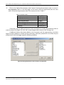
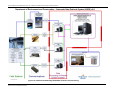
1
Protocols Manual for Real-Time Water Quality Monitoring in NL Calibration and Maintenance Guide for Industry Partners April 2014 Government of Newfoundland & Labrador Department of Environment and Conservation Water Resources Management Division Protocols Manual for RTWQ Monitoring in NL – Calibration and Maintenance Guide for Industry Partners LIST OF APPENDICES ....................................................................................................................................... 2 ABBREVIATIONS AND ACRONYMS .................................................................................................................. 2 1. INTRODUCTION .......................................................................................................................................... 3 1.1 PURPOSE AND SCOPE ....................................................................................................................................................... 4 2. QUALITY ASSURANCE, CONTROL AND ASSESSMENT ................................................................................... 4 2.1 QUALITY ASSURANCE...................................................................................................................................................... 4 2.2 QUALITY CONTROL ......................................................................................................................................................... 5 2.3 QUALITY ASSESSMENT .................................................................................................................................................... 5 3. RTWQ MONITORING INSTRUMENTS .......................................................................................................... 6 3.1 HYDROLAB DS5(X) AND MS5 ........................................................................................................................................ 6 3.2 HANDLING AND STORAGE................................................................................................................................................ 6 3.3 HYDROLAB DS5 AND DS5X SENSOR AND PARAMETER DESCRIPTIONS .......................................................................... 8 Temperature .................................................................................................................................................................... 8 pH ..................................................................................................................................................................................... 9 Specific Conductivity ........................................................................................................................................................ 9 Dissolved Oxygen........................................................................................................................................................... 10 Total Dissolved Solids (TDS) .......................................................................................................................................... 11 Turbidity ......................................................................................................................................................................... 11 4. COMMUNICATIONS AND VIEWING IN SITU DATA ..................................................................................... 13 4.1 CABLES .......................................................................................................................................................................... 13 4.1.1 Calibration Cable.................................................................................................................................................. 13 4.1.2 Field Cable ............................................................................................................................................................ 14 4.1.3 Interface Cable ...................................................................................................................................................... 15 4.2 HANDHELD DISPLAY UNITS ........................................................................................................................................... 16 4.3 COMMUNICATION SOFTWARE ........................................................................................................................................ 17 5. LABORATORY, FIELD, AND OFFICE PROCEDURES ....................................................................................... 18 5.1 LABORATORY PROCEDURES: CALIBRATION AND MAINTENANCE .................................................................................. 19 5.1.1 Step by Step: Cleaning, Maintenance, Calibration ............................................................................................... 20 5.2 FIELD PROCEDURES ....................................................................................................................................................... 41 5.2.1 Field Logistics ....................................................................................................................................................... 41 5.2.2 Field Sheet............................................................................................................................................................. 41 5.2.3 Step by Step: Deployment Site Visit ...................................................................................................................... 42 If an instrument is deployed, refer to Section 5.2.4 for the removal procedure. If no instrument is deployed or the instrument has been removed then proceed with this section......................................................................................... 42 5.2.4 Step by Step: Removal Site Visit ............................................................................................................................ 49 5.3 OFFICE PROCEDURES ..................................................................................................................................................... 53 7. DATA MANAGEMENT AND REPORTING .................................................................................................... 56 7.1 AUTOMATIC DATA RETRIEVAL SYSTEM ........................................................................................................................ 57 7.2 RAW DATA DISPLAY...................................................................................................................................................... 57 7.3 QAQC DATA VALIDATION ............................................................................................................................................ 59 7.4 FIELD SHEET .................................................................................................................................................................. 60 7.5 DEPLOYMENT SPREADSHEET ......................................................................................................................................... 60 7.6 DEPLOYMENT REPORT ................................................................................................................................................... 60 7.7 RTWQ WEBPAGE .......................................................................................................................................................... 61 8. ADDITIONAL RESOURCES .......................................................................................................................... 62 9. REFERENCES ............................................................................................................................................. 63 10. APPENDICES ........................................................................................................................................... 63 Water Resources Management Division Newfoundland and Labrador Department of Environment and Conservation ‐ 1 ‐ Protocols Manual for RTWQ Monitoring in NL – Calibration and Maintenance Guide for Industry Partners A B C D E F G H LABORATORY CALIBRATION FORM ................................................................................................................ 63 FIELD VISIT CHECKLIST ...................................................................................................................................... 63 FIELD SHEET .......................................................................................................................................................... 63 GRAB SAMPLE FIELD SHEET .............................................................................................................................. 63 GRAB SAMPLE CHAIN OF CUSTODY................................................................................................................. 63 DATA VARIANCE FORM ...................................................................................................................................... 63 DEPLOYMENT SPREADSHEET ........................................................................................................................... 63 SUMMARY FLOWCHART ..................................................................................................................................... 63 APPENDIX A ................................................................................................................................................. 64 NL RTWQ LABORATORY CALIBRATION FORM ....................................................................................................... 64 APPENDIX B ................................................................................................................................................. 66 NL RTWQ FIELD VISIT CHECKLIST ............................................................................................................................. 66 APPENDIX C ................................................................................................................................................. 68 NL RTWQ FIELD SHEET ................................................................................................................................................. 68 APPENDIX D ................................................................................................................................................. 71 NL RTWQ GRAB SAMPLE FIELD SHEET ..................................................................................................................... 71 APPENDIX E .................................................................................................................................................. 73 NL RTWQ GRAB SAMPLE CHAIN OF CUSTODY ....................................................................................................... 73 APPENDIX F .................................................................................................................................................. 75 NL RTWQ DATA VARIANCE FORM ............................................................................................................................. 75 APPENDIX G ................................................................................................................................................. 77 NL RTWQ DEPLOYMENT SPREADSHEET .................................................................................................................. 77 APPENDIX H ................................................................................................................................................. 86 NL RTWQ SUMMARY FLOWCHART ............................................................................................................................ 86 List of Appendices A: LABORATORY CALIBRATION FORM ................................................................................................................................ 64 B: FIELD VISIT CHECKLIST .................................................................................................................................................... 66 C: FIELD SHEET .................................................................................................................................................................... 68 D: GRAB SAMPLE FIELD SHEET ............................................................................................................................................ 71 E: GRAB SAMPLE CHAIN OF CUSTODY ................................................................................................................................ 73 F: DATA VARIANCE FORM ................................................................................................................................................... 75 G: DEPLOYMENT SPREADSHEET ......................................................................................................................................... 77 H: SUMMARY FLOWCHART ................................................................................................................................................ 86 Abbreviations and Acronyms ADRS ATV BOD °C COD Automatic Data Retrieval System All Terrain Vehicle Biochemical Oxygen Demand Degree Celsius Chemical Oxygen Demand Water Resources Management Division Newfoundland and Labrador Department of Environment and Conservation ‐ 2‐ Protocols Manual for RTWQ Monitoring in NL – Calibration and Maintenance Guide for Industry Partners CSC DS EC GOES KCl kg LDO LED mg/L mmHg MS mS/cm NESDIS NIST NL NOAA NTU ORP QA QAQC QC RS RTWQ SDI TDS TSS μS/cm WRMD Campbell Scientific Canada Data Sonde Environment Canada Geostationary Operational Environmental Satellite Potassium Chloride Kilograms Luminescent Dissolved Oxygen Light Emitting Diode Milligrams per Liter millimeters of mercury Mini Sonde MilliSeimens per Centimeter National Environmental Satellite, Data, and Information Service National Institute of Standards and Technology Newfoundland and Labrador National Oceanic and Atmospheric Administration Nephelometric Turbidity Unit Oxygen Reduction Potential Quality Assurance Quality Assurance and Quality Control Quality Control Radio Sector Real Time Water Quality Serial Digital Interface Total Dissolved Solids Total Suspended Solids MicroSiemens per Centimeter Water Resources Management Division 1. Introduction The natural environment is constantly changing and water quality can fluctuate quickly and dramatically with potentially adverse effects to aquatic life, their habitats and the surrounding environment. With the introduction of real time water quality (RTWQ) instrumentation, in situ sensors can measure water quality data continuously. This information is transmitted through communication systems and made available to the end user in near real time. This allows the end user to identify, understand, follow and potentially mitigate harmful water quality events should they occur in a water body. RTWQ monitoring can be a useful tool in many aspects of water resource management. Even a short deployment period of RTWQ instrumentation can collect valuable information and help determine key stressors on a water body. Newfoundland and Labrador has found this component of RTWQ extremely useful in urban impacted streams as well as water bodies under pressure from nearby industrial developments. As development expands in NL, with respect to construction and natural resource exploration, it is important to find a balance between economic development and environmental protection. It is paramount that data being viewed is of the highest quality. When working in the natural environment it, is important to standardize protocols and procedures to reduce the likelihood of errors and inconsistencies, hence providing accurate, precise and reliable data. Water Resources Management Division Newfoundland and Labrador Department of Environment and Conservation ‐ 3‐ Protocols Manual for RTWQ Monitoring in NL – Calibration and Maintenance Guide for Industry Partners The NL Water Resources Management Division (WRMD) recognizes the commitment and dedication of its industry partners to the RTWQ program. The WRMD is fully committed to working with its industry partners to ensure the protection and quality of water resources within the province. If, at any time more information is required, please do not hesitate to contact your regional office. 1.1 Purpose and Scope This document gives detailed instructions and tips for cleaning, maintaining and calibrating RTWQ instrumentation, specifically the Hydrolab DS5 series instruments which are used in the majority of NL RTWQ monitoring stations. This document also features detailed processes to be followed in the field during instrument deployment and removal. Finally, this document suggests and provides directions regarding the minimal but essential paperwork to record network function, improving data quality. A successful RTWQ network is the combination of field work, laboratory work, and data management (Figure 1). This document highlights the steps for industry partners who are responsible for field and laboratory components. The WRMD is responsible for data management, analysis and reporting. Figure 1: Important components of an RTWQ Network 2. Quality Assurance, Control and Assessment To ensure the effectiveness and reliability of the RTWQ monitoring program, quality assurance (QA), quality control (QC) and quality assessment procedures have been implemented. Proper procedures outlined in this manual and its attachments should be adhered to consistently. Anything outside the procedure should be documented to explain reasoning. It is essential that all RTWQ personnel ensure that their responsibilities and tasks are completed in reference to this manual. All RTWQ personnel have the responsibility and authority to manage, perform and verify that their work follows QA, QC and quality assessment protocols. Specific components of QA, QC and quality assessment in RTWQ monitoring are summarized below. Specific procedures relating to QA, QC and quality assessment are explained within their respective sections throughout the manual. 2.1 Quality Assurance QA includes all high‐level activities, structures and mechanisms used to ensure and document the accuracy, precision, completeness, effectiveness and representativeness of the RTWQ monitoring program. QA ensures the overall integrity of the program design and consists of two separate but interrelated activities: QC and quality assessment. QA program elements include: Annual proficiency testing and evaluations of instrument function Water Resources Management Division Newfoundland and Labrador Department of Environment and Conservation ‐ 4‐ Protocols Manual for RTWQ Monitoring in NL – Calibration and Maintenance Guide for Industry Partners Personnel qualifications and training Technical procedures for sampling and conducting field and analytical work Troubleshooting of instruments, recording equipment, installations, transmission of data and corrective action plans Record keeping including field sheet and chain of custody for grab samples, deployment field sheet, logbooks and instrument calibration records Implementation of QAQC procedures including data verification, validation and variance forms Preparation of analytical reports, data packages and RTWQ web page Auditing adherence to program requirements and following internal procedures Peer review of RTWQ program design, QAQC procedures and data analysis Investigation of emerging RTWQ technology, QAQC procedures, and analysis techniques First‐hand knowledge of each RTWQ station watershed through observation and field visits 2.2 Quality Control QC refers to the use of technical activities which ensure that the data collected are adequate for quality assessment purposes. This includes feedback systems to ensure activities are occurring as planned and intended, and to verify that procedures are being carried out satisfactorily. QC program elements include: Monthly maintenance and calibration of the probe and its sensors Inspection and maintenance of RTWQ station installation Field readings taken at the time of removal and redeployment of the probe using a field QAQC instrument In situ validation of field and QAQC instrument readings according to comparison table and troubleshoot to determine cause if significant discrepancies occur Collection of a water quality grab sample at the time of redeployment of the probe to be sent to an accredited laboratory for analysis Updating spreadsheet with grab sample results once laboratory analysis is complete 2.3 Quality Assessment Quality assessment activities are implemented to quantify the effectiveness of the quality control procedures. Quality assessment program elements include: Calculate long‐term and monthly period summary statistics Produce time series graphs for each parameter and evaluate for gaps, data errors, and guideline exceedances for pH, dissolved oxygen and turbidity Publishing near‐real time updates of RTWQ data on the WRMD web page for public review Produce a report for each station corresponding to deployment periods, including any problems with maintenance, calibration and QAQC procedures; any data issues; time series graphs and summary statistics for each parameter; brief explanations for observed results; and data qualification statements Archiving of RTWQ monitoring data records Identify any issues with the parameter order, sensor failure or missing data transmissions in a data variance report Regular updates to the calibration schedule on the web page Water Resources Management Division Newfoundland and Labrador Department of Environment and Conservation ‐ 5‐ Protocols Manual for RTWQ Monitoring in NL – Calibration and Maintenance Guide for Industry Partners 3. RTWQ Monitoring Instruments There are many different types of RTWQ monitoring instruments. Please refer to section 3 of the Protocols Manual for RTWQ Monitoring in NL for more information on equipment selection. 3.1 Hydrolab DS5(X) and MS5 This multi‐parameter instrument has several different sensors, depending on the size, that measure a variety of parameters. Depending on the instrument and station set‐up, data can be recorded internally or transmitted via satellite, telephone or cellular communication. The Hydrolab DS5(X) instrument is most commonly used throughout the NL RTWQ network and deployed at month long intervals at surface water stations. Using a series of electrochemical and optical sensors connected to the same instrument, multiple parameters can be assessed simultaneously (Table 1). All RTWQ sites in NL report general chemistry parameters including temperature, pH, specific conductivity, dissolved oxygen and turbidity. These five measured parameters can be used to further extrapolate additional parameters such as total dissolved solids and percent saturation as they are a function of two or more of the parameters directly measured by the sensors. The Hydrolab DS5(X) offers multiple ports for sensors and can usually be designed specifically for the parameters of interest. The Hydrolab MS5 is a slimmer version of the DS5(X) instrument. This more portable version of the instrument is used to collect QAQC measurements. It functions the same way as the full size model and features the same connection port and sensors. The two instruments are calibrated in a similar way. The MS5 is typically not deployed for long periods of time. The steps outlined in the rest of the manual are for stations using the DS5(X) and MS5 series instruments. General procedures are outlined; however, it is advised that the partner also familiarize themselves with the manufacturer manual, in this case, the Hydrolab DS5x, DS5 and MS5 Water Quality Multiprobes User Manual. Table 1: Commonly measured water quality parameters Parameters Available for Hydrolab® DS5(X) and MS5 Dissolved Oxygen Turbidity Blue‐Green Algae Conductivity Depth Ammonia pH Rhodamine WT Chlorophyll α Photosynthetically Available Radiation Nitrate Temperature Chloride Oxidation/Reduction Potential Total Dissolved Gas 3.2 Handling and Storage Extracted from “Hydrolab DS5X, DS5 and MS5 Water Quality Multiprobes User Manual” Campbell Scientific, February 2006, Edition 3 DS5, DS5X Multiprobe The DS5 and DS5X are designed for in‐situ and flow‐through applications, and can measure up to 15 parameters simultaneously. The DS5 and DS5X have seven configurable ports that can include up to ten of the following sensors: ambient light, Water Resources Management Division Newfoundland and Labrador Department of Environment and Conservation ‐ 6‐ Protocols Manual for RTWQ Monitoring in NL – Calibration and Maintenance Guide for Industry Partners ammonia, chloride, chlorophyll a, rhodamine WT, conductivity, depth, dissolved oxygen, nitrate, ORP, pH, temperature, total dissolved gas, turbidity, and blue‐green algae. Figure 2: DS5X User Manual, diagram showing Hydrolab DS series model and parts (Extracted from Hydrolab DS5X, DS5 and MS5 Water Quality Multiprobes User Manual, Campbell Scientific, February 2006, Edition 3). Unpacking the Instrument Remove the multiprobe from its shipping carton and inspect it for any visible damage. Note: It is normal for a small amount of solution to be in the cup. Table 2: Instrument Specifics (Extracted from Hydrolab DS5X, DS5 and MS5 Water Quality Mulitprobes User Manual, Campbell Scientific, February 2006, Edition 3). DS5 and DS5X Transmitter Outer Diameter Length Weight (typical configuration) Maximum Depth Operating Temperature Battery Supply (optional) Computer Interface Memory (optional) 8.9cm 58.4cm 3.35kg 225m ‐5°C to 50°C 8 C Batteries RS232, SDI‐12, RS485 120000 measurements Mulitprobe and Sensor Storage • Fill the DS storage cup or MS cup with one inch of clean tap water and screw the cup on the multiprobe. To prevent sensors from freezing, store the multiprobe where freezing will not occur. • Remove batteries for long‐term storage. (8 size C alkaline batteries for the DS5 or DS5X or 8 size AA alkaline batteries for the MS5). Do not remove the lithium battery which powers the mulitprobe internal clock. • Store equipment in a carrying case (Cat. No. 011780) or a large plastic container with a circular piece of foam rubber for shock protection. Water Resources Management Division Newfoundland and Labrador Department of Environment and Conservation ‐ 7‐ Protocols Manual for RTWQ Monitoring in NL – Calibration and Maintenance Guide for Industry Partners • Lay the cable in coils of at least 15 cm (6 in.) diameter at the bottom of the plastic container. Electrical Cable Care • Protect all non‐waterproof cables (i.e., all cables except the waterproof underwater cable) from any water source during operation in the field. Keep connectors dry at all times. • Properly lubricate the sealing surface of all underwater connectors using silicone grease. • Use protective plugs when the connectors (for underwater and calibration cables) are not connected to any instrument. • Keep all cables clean, dry, and stored (neatly coiled), in a large plastic container. • Do not coil cables any tighter than 6 inches in diameter or cable will be damaged. • Do not knot the cables or use clips to mark a certain depth. • Do not place the instrument where the cable might be severed or damaged by boat propellers or other moving parts. • Protect all cables from abrasion, unnecessary tension, repetitive flexure, or bending over sharp radii (e.g., the side of a boat or of a bridge). Do not bend or run the cable over the sheave or pulleys with less than a 6‐inch diameter. • If cables are long, use a battery‐powered or hand‐cranked reel with electrical slip‐ rings to lower and raise the instrument. Also, a lighter reel without slip‐rings for shorter cables can be used. A last option, is to mount the reel horizontally with the instrument and battery installed in the hub. • Use the V‐shaped support bail to lift and lower the multiprobe. • Do not apply more than 5 kilograms (10 lb) of sinking weight to the multiprobe. This can increase the possibility of cable breakage due to stress on the attachment points. If more weight is needed, use a wire line to support the instrument by its bail. 3.3 Hydrolab DS5 and DS5X Sensor and Parameter Descriptions Text extracted from “Hydrolab Advanced Maintenance Workshop Manual”, Campbell Scientific, January 2007 Photo credits: G. de Beer (2011) Temperature Temperature is defined as a measure of the amount of heat present in water. Temperature measurement is essential to the measurement of dissolved oxygen, specific conductivity, salinity, pH, alkalinity, and most other water quality parameters. Temperature controls the metabolism of aquatic plants and animals and is largely Figure 3: Temperature sensor circled in red on DS5X model. Water Resources Management Division Newfoundland and Labrador Department of Environment and Conservation ‐ 8‐ Protocols Manual for RTWQ Monitoring in NL – Calibration and Maintenance Guide for Industry Partners responsible for biochemical reactions and many other processes. Water temperature governs most processes and dynamics of Limnology in both standing and flowing water. High temperatures can be caused by high ambient air temperatures and by industrial discharge of cooling water from high temperature processes (thermal power, smelting, and refineries) and can cause fish kills and excessive macrophyte growth leading to eutrophication. Typically, this sensor will have a range of –5 to 50 °C, an accuracy of ± 0.10°C and a resolution of 0.01°C. Exposing the multiprobe to temperatures outside this range may result in mechanical damage or faulty electronic performance. To prevent sensors from freezing, store the multiprobe where freezing will not occur. To prevent the sensors from dehydrating, fill the DS storage cup or MS cup with one inch of clean tap water. pH pH is the measure of hydrogen ion activity of a system. pH is a major factor affecting the availability of nutrients to plants and animals. It partially controls the concentration of many biochemically active substances dissolved in water, and affects the efficiency of hemoglobin in the blood of vertebrates, as well as the toxicity of pollutants. It is measured by the amount of hydrogen ions passed through the permeable glass electrode and referenced to a known source. The greater the hydrogen ion concentration, the lower the pH on a scale of 0 to 14 units. The purer the water, the more neutral the pH (7). Rainwater is usually slightly acidic (pH 6.5) while seawater is usually slightly basic (pH 8.5). Low pH (0 to 5 units) can be caused by acidic industrial effluents and fallout from the burning of high sulfur fuels. High pH (9 to 14 units) can be caused by caustic industrial effluents and return irrigation flows from saline Figure 4: pH sensors circled in agricultural areas. pH will cycle in the presence of large red on DS5X model. quantities of algae and macrophytes due to the photosynthetic cycling of CO2. The sensor has a range of 0 to 14 pH units, an accuracy of ± 0.2 units and a resolution of 0.01 units. Specific Conductivity Conductivity is a measure of the ability of water to pass an electrical current. Compensation of this measurement to 25 °C constitutes specific conductivity. Specific Conductivity indicates the amount of dissolved substances (salts). The ionic strength of water may regulate the toxicity of many substances. Specific conductivity is the inverse of electrical resistivity, corrected to 25 °C. Specific Conductivity sensors Water Resources Management Division Figure 5: Specific conductivity Newfoundland and Labrador Department of Environment and Conservation ‐ 9‐ sensor circled in red on DS5X model. Protocols Manual for RTWQ Monitoring in NL – Calibration and Maintenance Guide for Industry Partners measure the resistance of a small electrical current passed between the five pins of the sensor. Typically, the purer the water the lower the specific conductivity. Rainwater is usually very low >0.01 mS/cm while seawater is usually < 10 mS/cm. Rainwater’s low conductivity can have the affect of lowering conductivity values during or after rainfall events. Low Specific Conductivity (0 to 200 μS/cm) is an indicator of pristine or background conditions but in the presence of low pH can indicate the removal of most salts. Mid range conductivity (200 to 1000 μS/cm) is the normal background for most major rivers in western Canada. High conductivity (1000 to 10000 μS/cm) is an indicator of saline conditions caused by high evaporation, saline irrigation returns or runoff and caustic or alkaline industrial processes. The sensor has a range of 0 to 100 mS/cm, accuracy of ± 0.5% of the range and up to a 4‐digit resolution. Dissolved Oxygen Dissolved Oxygen is a measure of the amount of oxygen (O2) dissolved in water. The concentration of dissolved oxygen is controlled by consumption by aerobic organisms, consumption by plants during darkness, production by plants during daylight, exposure (or lack of) by natural reaeration (waterfalls and riffles) and water temperature, flow and depth. The luminescent dissolved oxygen sensor is an in‐ situ optical probe that determines the dissolved oxygen concentration in a given water sample. The sensor cap is coated with a luminescent material. Blue light from a LED is transmitted to the sensor surface. The blue light excites the luminescent material. As the luminescent Figure 6: Dissolved oxygen material relaxes it emits red light. The time from when sensor circled in red on the blue light was sent and the red light is emitted is DS5X model. measured. The more oxygen that is present, the shorter the time it takes for the red light to be emitted. This time is measured and correlated to the oxygen concentration. Between the flashes of blue light a red LED is flashed on the sensor and used as an internal reference to help validate each measurement. The instrument can display the oxygen either as a concentration from 0–20mg/L or as a percent saturation with either air saturated water or water‐saturated air serving as the 100% reference point. Low dissolved oxygen level (0 to 8 mg/L) is an indicator of high oxygen demand on the water caused by either high biological or chemical oxygen demand (BOD or COD). High BOD is caused by the decomposition of organic material in industrial and municipal effluents (pulp and paper plants and sewage treatment facilities) and can result in fish kills. Any inorganic chemical that consumes oxygen as it degrades causes high COD. High dissolved oxygen levels (12 to 20 mg/L) can be caused by excessive algal and macrophyte growth and are usually due to the Water Resources Management Division Newfoundland and Labrador Department of Environment and Conservation ‐ 10‐ Protocols Manual for RTWQ Monitoring in NL – Calibration and Maintenance Guide for Industry Partners photosyntheic cycling. Mid range dissolved oxygen values (8 to 12 mg/L) are usually an indicator of a healthy system. Total Dissolved Solids (TDS) A measure of alkaline salts dissolved in water or in fine suspension. TDS is an indication of the potential buffering capacity of water and water hardness. It can also affect the buoyancy of fish eggs and other organisms. TDS is calculated using a standard algorithm equation from the conductivity and temperature of the sample. Turbidity Turbidity is a measure of the translucence of water and the amount of suspended material in water at any one particular time. In most equipment, turbidity is measured by emitting infrared light from a known source and measuring the amount of backscatter from suspended particles. The greater the backscatter, the higher the turbidity, measured in NTU’s (nephelometric turbidity units). Calibration is usually done using a formazin standard diluted to a representative background or expected concentration to a maximum of 1000 NTU’s. High levels of turbidity can change the diversity of aquatic systems and can shade out aquatic plants and other fauna. Increased turbidity can also affect water temperature and distribution of heat through the Figure 7: Self‐cleaning turbidity water column. Surface water can become warmer and sensor circled in red on DS5X subsurface water may become cooler due to the model. shading action. The sensor has a range of 0 to 3000 NTU and an accuracy of 1% up to 100NTU, 3% from 100‐400NTU, or 5% from 400‐3000NTU. The resolution is 0.1 NTU from 0‐ 400NTU and 1NTU for >400NTU. Table 3: Summary of Sensor ranges, accuracies and resolutions (Extracted from Hydrolab Advanced Maintenance Workshop Manual, Campbell Scientific, January 2007) Parameter Temperature Range ‐5 to 50°C Specific Conductivity 0 to 100 mS/cm pH 0 to 14 units Dissolved Oxygen Turbidity 0 to 20mg/L 0‐3000NTU Accuracy ±0.10°C ±0.5% of reading ±0.001mS/cm ±0.2 units ±0.1mg/L <8mg/L ±02mg/L >8mg/L ±1% up to 100NTU ±3% from 100‐400NTU ±5% from 400‐3000NTU Resolution 0.01°C 4 digits 0.01 units 0.01mg/L 0.1NTU @ <400NTU 1NTU @ <400NTU Water Resources Management Division Newfoundland and Labrador Department of Environment and Conservation ‐ 11‐ Protocols Manual for RTWQ Monitoring in NL – Calibration and Maintenance Guide for Industry Partners Water Resources Management Division Newfoundland and Labrador Department of Environment and Conservation ‐ 12‐ Protocols Manual for RTWQ Monitoring in NL – Calibration and Maintenance Guide for Industry Partners 4. Communications and Viewing In Situ Data 4.1 Cables There are a number of different cables available and required to perform various communications functions. 4.1.1 Calibration Cable The calibration cable has three connection ports (Figure 8). The first 9 pin connector fits into a computer or handheld device (archer/surveyor). The second port is a 6 pin round connector port that fits on the instrument. The third port is for a power source (wall outlet). The calibration cable may come in two parts, the first part being the portion of the cable with a 9 pin computer connection port and a 6 pin instrument connection port (orange cable in Figure 8). The second part of the cable will be the portion of the cable with the universal power source adapter (green cable in Figure 8). This cable is used to connect the instrument to the computer to maintain a stable power supply to the instrument during calibration. This cable is to be used in the laboratory for calibrations only. Only one calibration cable is needed for all instruments in the inventory. Figure 8: Calibration process set‐up with computer, calibration cable and instrument. Water Resources Management Division Newfoundland and Labrador Department of Environment and Conservation ‐ 13‐ Protocols Manual for RTWQ Monitoring in NL – Calibration and Maintenance Guide for Industry Partners 4.1.2 Field Cable There are different lengths of the field cable available. Typically, the short field cable (<10m) is used to connect the QAQC instrument (6 pin connector) to the computer or handheld display (9‐pin connector) (Figure 9). This cable is necessary to quickly deploy the QAQC instrument and obtain an in situ reading. The power required for this connection comes from the computer/handheld display unit or the instrument’s internal battery pack. Only one of these short field cables is required for the network. This cable travels with the QAQC instrument to each station. Figure 9: QAQC instrument set‐up with field cable (short). A long field cable is permanently located at the RTWQ station, therefore one of these cables is required at each station (Figure 10). The length of the long field cable will depend on how far the station shelter is located from the shoreline and how far the instrument is deployed in the water body. Long field cables are generally between 20‐200m in length. The long field cable is generally protected by liquid tight conduit when it runs outside the station shelter. This protects the cable from being cut or damaged by animals or vandals. In certain cases, it may be beneficial to bury the conduit housing the long field cable. There are two connection ports on the long field cable (green cable in Figure 10): the first is the 6‐pin connection port for the instrument that is deployed in the water (field instrument); the second port is the 9‐pin connection port which can be used to connect to a computer or handheld device. In this case however, the 9‐pin connection port is used to connect to the interface cable (red cable in Figure 10) which is connected to the data logger where information from the instrument is stored and transmitted throughout the deployment period. Water Resources Management Division Newfoundland and Labrador Department of Environment and Conservation ‐ 14‐ Protocols Manual for RTWQ Monitoring in NL – Calibration and Maintenance Guide for Industry Partners Figure 10: Interface cable and field cable set‐up at station connecting the instrument to the data logger in the hut. 4.1.3 Interface Cable The interface cable is the cable which connects the field instrument to the data logger (Figure 10). The interface cable has three ports (Figure 11). The first is a bare wire connection to the data logger (3 wires). These wires remain connected to the data logger at all times therefore one interface cable per station is required. There are three wires colored red, orange and brown and represent the connections depicted in the figure below. Figure 11: Interface cable components and connection ports. Water Resources Management Division Newfoundland and Labrador Department of Environment and Conservation ‐ 15‐ Protocols Manual for RTWQ Monitoring in NL – Calibration and Maintenance Guide for Industry Partners The second port connects to the field cable (long) (9‐pin). This connection is made when the instrument is deployed. This connection should only be disconnected when there is no instrument deployed or when removing or deploying an instrument at the end of the conduit (for safety purposes this connection is broken when working with the instrument in the water to prevent electricity being supplied to the instrument). When the connection is broken for an extended period of time (after you have left the site) secure with electrical tape to prevent moisture from entering the cables. The third port on the interface cable connects to the computer or handheld device (9‐pin). This allows the user to connect to the instrument without having to disconnect from the datalogger. This port will only be used when the user is on site and wishes to connect to the instrument and read in situ measurements. When this connection is broken (most of the time), secure the port with electrical tape to prevent moisture from entering the cable. 4.2 Handheld Display Units Field display units are usually sold in conjunction with the instrument. These handheld computer devices allow the user to view the current data from the instrument quickly and easily while standing on shore or it allows the user connect to an instrument from the hut (Figure 12). In order to read the data from the instrument selected, the instrument will need to be connected to a handheld display unit or a field computer of some type. There are different models available depending on the instrument and manufacturer chosen. Handheld display units are useful in the field setting and connect to the instrument via a short (~5‐10m) field cable. Current water quality data can be displayed on the screen and is especially important for comparing live field readings with QAQC measurements. Figure 12: (left) Archer handheld computer device; (right) Surveyor 4a handheld computer device. Water Resources Management Division Newfoundland and Labrador Department of Environment and Conservation ‐ 16‐ Protocols Manual for RTWQ Monitoring in NL – Calibration and Maintenance Guide for Industry Partners 4.3 Communication Software ‘Hydras’ is the name of the software program used to communicate with the Hydrolab instruments. Hydras can be used in several ways which will be described throughout the calibration procedure (Section 5.1). Hydras allows the user to communicate with the instrument and perform tasks such as viewing live readings, changing settings, calibrating the instrument, setting internal logging files and updating firmware.. There are several versions of Hydras software available. Hydras 3 LT is the simplest of the software series and is all that is required for the tasks outlined in this manual. The handheld device may feature a different but similar version of the software called Hydras 3 Pocket. For more information about Hydras beyond the tasks described in section 5.1, please refer to the Hydras 3 LT Quick Start Software Manual or the Hydras 3 Pocket for Hydrolab User Manual. Water Resources Management Division Newfoundland and Labrador Department of Environment and Conservation ‐ 17‐ Protocols Manual for RTWQ Monitoring in NL – Calibration and Maintenance Guide for Industry Partners 5. Laboratory, Field, and Office Procedures This section identifies and outlines the steps to prepare for instrument deployment and/or removal. These components of the program can be the responsibility of the industry partner. The laboratory component covers the maintenance and the calibration of the instrument while the field components are the deployment and removal of the instrument. Data management and analysis are the responsibility of the WRMD, however, a small amount of paperwork and office procedures are required by the industry partner in order for the WRMD to accurately report on the RTWQ data collected. Figure 13: Flowchart for laboratory, field, and office procedures Water Resources Management Division Newfoundland and Labrador Department of Environment and Conservation ‐ 18‐ Protocols Manual for RTWQ Monitoring in NL – Calibration and Maintenance Guide for Industry Partners 5.1 Laboratory Procedures: Calibration and Maintenance Maintenance and calibration of the instruments is essential in order to maintain data integrity. The following procedures outlining the regular maintenance and calibration steps should become very familiar to the staff responsible for performing these tasks. The reliability of the data collected is dependent upon the frequency and quality of the maintenance and calibrations. The more frequently the instruments are maintained and calibrated, the higher the quality of data will be. Documentation during maintenance and calibration is important for the tracking of instrument and/or identifying specific instrument issues. The laboratory calibration form was created to summarize maintenance and track calibration for each instrument (Appendix A). In order to consistently record this information, the laboratory calibration form should be filled out during the procedure. The laboratory calibration form acts as a checklist during monthly maintenance and calibration. The information is documented to assist in recording the use of an instrument. The laboratory calibration form summarizes the before and after values for each sensor reading during calibration. Field and QAQC instruments must be calibrated against factory NIST solutions in a temperature controlled setting (e.g. laboratory, office, etc.). Water Resources Management Division Newfoundland and Labrador Department of Environment and Conservation ‐ 19‐ Protocols Manual for RTWQ Monitoring in NL – Calibration and Maintenance Guide for Industry Partners 5.1.1 Step by Step: Cleaning, Maintenance, Calibration 1. Fill in the laboratory calibration form throughout this process (Appendix A) (Figure 14). The calibration form will act as a guide throughout the calibration and maintenance process. This documentation is important in tracking instrument performance as many technical difficulties can be identified during calibration. 2. Use organic cleaning agent to remove any bio‐foul build up such as mild dish soap (Figure 15). Harsh and powerful cleaners should not be used as they may cause damage to the instrument. Use toothbrush and/or cotton swabs to clean the instrument. Be sure to practice safe lab procedures and treat each piece of equipment carefully. If you suspect bacterial contamination you must disinfect this equipment first. Use diluted bleach or other disinfection solution. Figure 14: Laboratory calibration form to be filled out during every calibration. Figure 15: (left) example of bio‐fouling growth on an instrument after being deployed in an urban stream; (right) cleaning supplies required to gently and thoroughly clean the instrument after deployment. Water Resources Management Division Newfoundland and Labrador Department of Environment and Conservation ‐ 20‐ Protocols Manual for RTWQ Monitoring in NL – Calibration and Maintenance Guide for Industry Partners 3. Use tap or distilled water to rinse off any residue (Figure 16). Dry instrument thoroughly. Figure 16: (left) Rinse the instrument thoroughly with tap or distilled water; (right) Dry the instrument and sensors completely. 4. Check O‐rings for any wear spots, tears or deterioration and replace as required (Figure 17). Thoroughly clean and lightly grease the O‐rings with silicone grease. Figure 17: (left) O rings located inside the battery casing and around the bulkhead connector; (right) O rings located at the top and bottom of the calibration cup. 5. Connect the instrument to the computer using the calibration cable (power source, computer, and instrument) (Figure 8 & 18). Figure 18: Calibration cable required to connect instrument for calibration processes (see also Figure 8). Water Resources Management Division Newfoundland and Labrador Department of Environment and Conservation ‐ 21‐ Protocols Manual for RTWQ Monitoring in NL – Calibration and Maintenance Guide for Industry Partners 6. Start Hydras 3LT (Refer to Hydras 3LT Quick Start Software Manual for installation instructions). The software will automatically scan for instruments. Log files from previous deployment periods will be displayed on the first window. Select any of these files you wish to download and press ‘Download Log File’ (Figure 20). Once files are successfully downloaded, click ‘Operate Instrument’. Figure 19: (left) Connect the instrument to a power source with the calibration cable; (right) Connect the instrument to the computer with the calibration cable. *If a log file is open and actively logging, it may not appear in the list when Hydras 3LT is first opened. The log file must be stopped before it can be downloaded. Click ‘Operate Instrument’ and go to the ‘Log Files’ tab. Select the name of the log file you wish to stop and download from the drop down box. Press ‘Disable’ at the bottom of the window. Then press ‘Download’. File will download to specified folder. Delete the file after a successful download by pressing ‘Delete’. Figure 20: Screen shot of Hydras 3LT showing initial connection at start up. Water Resources Management Division Newfoundland and Labrador Department of Environment and Conservation ‐ 22‐ Protocols Manual for RTWQ Monitoring in NL – Calibration and Maintenance Guide for Industry Partners 7. On the ‘System’ tab, verify date and time on the instrument (Figure 21). ‘Set clock to PC time’ or ‘Set clock manually’ if necessary to match correct time. Figure 21: Screen shot of Hydras 3LT showing systems tab, setting date and time. 8. On the ‘Settings’ tab, verify the baud rate (1:19200), SDI is enabled with a check mark, and the SDI address is 0 (Figure 22, Table 4). For DS5 and DS5X model, the SDI delay should be set to 30 seconds. ‘Enable Continuous Mode’ should be turned off (no checkmark). If any changes are made to the settings, it is very important that changes be saved by clicking the ‘Save Settings’ button. Table 4: Instrument Settings Baudrate MODBUS Address SDI Enabled SDI Address SDI Delay Enable Continuous Mode DS5 or DS5X 1:19200 1 on (checkmark) 0 30 off (no checkmark) Figure 22: Screen shot of Hydras 3LT showing settings tab, verifying various different settings. Water Resources Management Division Newfoundland and Labrador Department of Environment and Conservation ‐ 23‐ Protocols Manual for RTWQ Monitoring in NL – Calibration and Maintenance Guide for Industry Partners 9. Click on the ‘Define SDI Parameter order’ button. Ensuring the parameter order is correct is very important (Table 5). The data logger at the station must be programmed with the same order. Verify that the parameter order is the same as the list in Table 5. Table 5: Parameter Order Temperature pH Specific Conductivity Total Dissolved Solids Dissolved Oxygen Percent Saturation Dissolved Oxygen Concentration Turbidity Temp[C°] pH[Units] SpCond[μS/cm] TDS[g/l] LDO%[Sat] LDO[mg/l] Turbidity[NTU] If necessary, use the ‘Add’ and ‘Remove’ and arrow buttons to modify the parameter order to match the above list (Figure 23). Click ‘OK’ to save changes and/or return to the ‘Settings’ tab. If additional sensors have been added to the instrument and the programming in the data logger has been updated to include the new parameters, add these parameters in the order they are programmed in the data logger (typically following turbidity). Figure 23: Setting the parameter order correctly is very important. Water Resources Management Division Newfoundland and Labrador Department of Environment and Conservation ‐ 24‐ Protocols Manual for RTWQ Monitoring in NL – Calibration and Maintenance Guide for Industry Partners 10. Navigate to the ‘Log Files’ tab to create a log file for a new deployment period. Creating a log file for the instrument for each deployment period is very important. If for some reason satellite or cellular communication fails at the station, the water quality data is recorded internally by the instrument and is not lost indefinitely. The data can be retrieved when the instrument is retrieved at the end of the deployment period. Click on the ‘Create’ button and enter a name for the log file (Figure 24, left). The title can be alphanumeric (Figure 24, right). Useful information to have in the title of the log file includes station name and deployment date. By default, the instrument serial number is included in the file when it is downloaded so this information does not need to be included in the title. Click ‘OK’. 11. Set the ‘Start logging’ and ‘Stop logging’ dates and time. If the instrument is to be deployed for 30 days, it is suggested to set the log file to stop logging after 60 days in case something prevents instrument retrieval. The log file can be stopped early at retrieval but it cannot be extended once the instrument is deployed. Logging interval should be set at 1 hour for standard deployment periods. For DS5 of DS5X models, sensor warm up should be set to 30 seconds and circulator warm up is 0 seconds. Turn audio off (no check mark). Figure 24: Screen shot of Hydras 3LT showing the log files tab, click on ‘create’ to name a new log file. Table 6: Log File settings Log File Setting Start Logging Stop Logging Logging Interval Sensor Warm‐up Audio DS5 or DS5X Expected deployment date/time 30 days after expected retrieval date 1 hour 30 seconds Off (no checkmark) Water Resources Management Division Newfoundland and Labrador Department of Environment and Conservation ‐ 25‐ Protocols Manual for RTWQ Monitoring in NL – Calibration and Maintenance Guide for Industry Partners The following parameters from the ‘Parameters in Instrument’ list should be added to the ‘Parameters in Log File’ list (Table 7) Table 7: Log File parameters Temperature pH Specific Conductivity Total Dissolved Solids Dissolved Oxygen Percent Saturation Dissolved Oxygen Concentration Turbidity Temp[C°] pH[Units] SpCond[μS/cm] TDS[g/l] LDO%[Sat] LDO[mg/l] Turbidity[NTU] Click ‘Save Settings’ button (near the top) when complete. IMPORTANT: Click the ‘Enable’ button at the bottom of the screen once the settings have been saved (Figure 25). If the log file is not enabled, it will not start and no data will be recorded. Figure 25: (left) Screen shot of Hydras 3LT showing the log files tab – indicate date and time for start and finish and frequency of measurement, and parameters; (right) Do not forget to click ‘Enable’. Water Resources Management Division Newfoundland and Labrador Department of Environment and Conservation ‐ 26‐ Protocols Manual for RTWQ Monitoring in NL – Calibration and Maintenance Guide for Industry Partners 12. Remove turbidity wiper and brush (Figure 26). Using the small Allen key provided with the instrument, loosen the set of screws holding the wiper and brush on the motor shaft. Do not manually rotate the wiper arm. Clean dirt and debris from the wiper and brush. Replace if necessary. Wipe the lens of the turbidity sensor with a dust free wipe. Be careful not to scratch the lens surface. Figure 26: (left) Self cleaning turbidity brush and wiper on the sensor; (right) self cleaning turbidity brush and wiper removed from the sensor with the Allen key. 13. The sensor that measures pH is comprised of 2 parts: the standard reference electrode (sensor with Teflon junction with red o‐ring) and the pH sensor (glass bulb) (Figure 27, left). Change the reference solution inside the standard reference electrode. Gently pull the sleeve straight out and away from the instrument (Figure 27, middle). Discard the old electrolyte solution. Drop in 2 KCl salt tablets into the sleeve and refill with KCl solution to about ¼ inch from the top (Figure 28). With the instrument pointing down, push the sleeve back on to the sensor mount. Turn the instrument to point upwards and work the sleeve on completely. KCl solution will bubble out the top through the Teflon junction. In the event the sensor sleeve is difficult to replace and KCl solution is unable to bubble out the top of the sensor, it is likely that the Teflon junction is clogged and needs to be replaced. Remove the Teflon junction by unscrewing the top of the sleeve just above the red o‐ring and replace with a new one (Figure 27, right). Soak the old Teflon junction in distilled water to unclog the porous junction. Clean the pH sensor glass bulb with a cotton swab and KCl solution. Figure 27: (left) pH standard reference electrode with Teflon junction; (middle) Standard electrode pulls off the instrument; (right) Teflon junction unscrews from reference electrode casing. Water Resources Management Division Newfoundland and Labrador Department of Environment and Conservation ‐ 27‐ Protocols Manual for RTWQ Monitoring in NL – Calibration and Maintenance Guide for Industry Partners Figure 28: pH standard electrode, salt tabs and pH reference solution (KCl solution). 14. Rinse the instrument three times with deionized or tap water and dry thoroughly. Ensure each sensor is free from contaminants that might alter the calibration standard. 15. Use a cotton swab to remove any residue from inside the specific conductivity sensor (Figure 29). Ensure the inside of the sensor is completely dry. Figure 29: Clean the inside of the conductivity sensor with a cotton swab. Water Resources Management Division Newfoundland and Labrador Department of Environment and Conservation ‐ 28‐ Protocols Manual for RTWQ Monitoring in NL – Calibration and Maintenance Guide for Industry Partners 16. The specific conductivity sensor requires a 2 point calibration. First, when the sensor is dry and exposed to air, calibrate the conductivity sensor to 0 μS/cm (Figure 30, left). Record before and after values on the laboratory calibration form. A ‘Calibration successful!’ message will appear (Figure 30, right). Figure 30: (left) Screen shot of Hydras 3LT showing the Specific Conductivity sub‐tab under the calibration tab; (right) Notice indicating successful calibration; NOTE: If at any time a ‘Calibration failed!’ message appears, repeat the calibration for that sensor. Water Resources Management Division Newfoundland and Labrador Department of Environment and Conservation ‐ 29‐ Protocols Manual for RTWQ Monitoring in NL – Calibration and Maintenance Guide for Industry Partners 17. For the second point calibration, rinse once with conductivity standard. Select a calibration standard that is near the anticipated field sample value. Fill calibration cup with conductivity standard to nearly the top of the calibration cup. Calibrate conductivity sensor to standard (Figure 31, left). Record before and after values on the laboratory calibration form. A ‘Calibration successful!’ message will appear (Figure 31, right). Figure 31: (left) Screen shot of Hydras 3LT showing the Specific Conductivity sub‐tab under the calibration tab; (right) Notice indicating successful calibration. Water Resources Management Division Newfoundland and Labrador Department of Environment and Conservation ‐ 30‐ Protocols Manual for RTWQ Monitoring in NL – Calibration and Maintenance Guide for Industry Partners 18. Calibrate dissolved oxygen percent saturation using the conductivity solution already in the calibration cup. Any liquid at room temperature may also be used. Seal the calibration cup and shake vigorously for at least 40 seconds to saturate the water with air (Figure 32, left). Invert the instrument and place it in the calibration stand. Loosen the calibration cap up and invert it, resting it on top of the calibration cup (Figure 32, right). Calibrate to 100% saturation using current barometric pressure (760 mmHg at sea level). Record before and after values on the laboratory calibration form. A ‘Calibration successful!’ message will appear. Figure 32: (left) WRMD employee calibrating for percent saturation by shaking the instrument vigorously to introduce air in to the solution; (right) Loosen and invert the calibration cup cap after shaking for 40 seconds to release pressure inside. If necessary, the cap on the LDO sensor may be removed by unscrewing the sensor cap (Figure 33). Dry any water droplets inside the cap with a dust free wipe or cotton swab. Replace cap and ensure o‐ring is securely compressed to prohibit water from entering the sensor. Figure 33: (left) Screen shot of Hydras 3LT showing the LDO% Sat sub‐tab under the calibration tab; (right, above) LDO sensor with cap removed, this may be necessary to clean any small drops of water; (right, above, inset) LDO sensor cap unscrewed from sensor; (right, below) Notice indicating successful calibration. Water Resources Management Division Newfoundland and Labrador Department of Environment and Conservation ‐ 31‐ Protocols Manual for RTWQ Monitoring in NL – Calibration and Maintenance Guide for Industry Partners 19. Rinse the instrument three times with deionized or tap water and once with pH 7 standard. Ensure each sensor is free from contaminants that might alter the calibration standard. 20. Fill Calibration cup with pH 7 standard to fully submerge the standard electrode and the pH sensor (Figure 34). Calibrate to pH 7 after values have stabilized (Figure 35, left). Record before and after values on the laboratory calibration form. A ‘Calibration successful!’ message will appear (Figure 35, right). Figure 34: Calibration cup filled with pH 7 solution. Figure 35: (left) Screen shot of Hydras 3LT showing the pH sub‐tab under the calibration tab; (right) Notice indicating successful calibration. Water Resources Management Division Newfoundland and Labrador Department of Environment and Conservation ‐ 32‐ Protocols Manual for RTWQ Monitoring in NL – Calibration and Maintenance Guide for Industry Partners 21. Rinse the instrument three times with deionized or tap water and once with pH 4 or 10 standard. Ensure each sensor is free from contaminants that might alter the calibration standard. 22. Fill Calibration cup with pH 4 or 10 standard to fully submerge the standard electrode and the pH sensor (Figure 36). Calibrate to pH 4 or 10 after values have stabilized (Figure 37, left). Record before and after values on the laboratory calibration form. A ‘Calibration successful!’ message will appear (Figure 37, right). Figure 36: Calibration cup filled with pH 4 solution. Figure 37: (left) Screen shot of Hydras 3LT showing the pH sub‐tab under the calibration tab; (right) Notice indicating successful calibration. Water Resources Management Division Newfoundland and Labrador Department of Environment and Conservation ‐ 33‐ Protocols Manual for RTWQ Monitoring in NL – Calibration and Maintenance Guide for Industry Partners 23. Compare and record temperatures measured by a NIST‐traceable thermometer and the instrument thermistor (Figure 38). Use room temperature solution in the calibration cup to compare the two readings. NOTE: Temperature cannot be calibrated. These values are just for general comparison. Record thermometer and thermistor measurements on the laboratory calibration form. Figure 39: Screen shot of Hydras 3LT showing Figure 38: (left) Lab grade thermometer used to compare temperature sensor readings; (right) Temperature sensor (thermistor) on the DS5 series model. the pH sub‐tab under the calibration tab. Temperature readings can be found at any of the calibration sub tabs. Water Resources Management Division Newfoundland and Labrador Department of Environment and Conservation ‐ 34‐ Protocols Manual for RTWQ Monitoring in NL – Calibration and Maintenance Guide for Industry Partners 24. Rinse the instrument three times with deionized or tap water and once with distilled water. Ensure each sensor is free from contaminants that might alter the calibration standard. 25. Replace turbidity wiper and brush. Place the wiper on the shaft with the set screw aligned with the lower flat on the motor shaft (Figure 40). Slide a clean wiper and brush on to the extension arm. The brush will be slightly angled. Place the central wiper unit on the shaft with the set screw aligned with the upper flat on the wiping shaft. Tighten the set screws. Test the rotation of the wiper and brush by forcing 2 revolutions from the ‘Turbidity [Rev]’ tab (sometimes labeled ‘Self‐ Cleaning [Rev]’) (Figure 41, left). A ‘Calibration successful!’ message will appear (Figure 41, right). Figure 40: Self cleaning turbidity brush and wiper correctly installed on the sensor. Figure 41: (left) Screen shot of Hydras 3LT showing the Turbidity Revolutions sub‐tab under the calibration tab (sometimes labeled ‘Self‐Cleaning [Rev]’); (right) Notice indicating successful Water Resources Management Division Newfoundland and Labrador Department of Environment and Conservation ‐ 35‐ Protocols Manual for RTWQ Monitoring in NL – Calibration and Maintenance Guide for Industry Partners 26. The turbidity sensor requires a 2 point calibration. Turbidity first must be calibrated to 0NTU. Carefully invert instrument into a container of distilled water (0NTU) so that turbidity sensor is submerged but not touching the bottom (Figure 42). Make sure the instrument is secure in the calibration stand before letting go. Figure 42: Instrument inverted in a container of distilled water (0 NTU solution). 27. While the sensor is submerged, force 2 revolutions of the turbidity wiper to clear away any bubbles that may be on the lens (Figure 41, left). Bubbles can impede the calibration process by causing false and irregular readings. A ‘Calibration successful!’ message will appear (Figure 41, right). 28. Once values have stabilized after the 2 revolutions of the wiper, calibrate the first point (1) to 0NTU (Figure 43, left). Record before and after values on the laboratory calibration form. A ‘Calibration successful!’ message will appear (Figure 43, right). Figure 43: (left) Screen shot of Hydras 3LT showing the Turbidity NTU sub‐tab under the calibration tab; (right) Notice indicating successful calibration. Water Resources Management Division Newfoundland and Labrador Department of Environment and Conservation ‐ 36‐ Protocols Manual for RTWQ Monitoring in NL – Calibration and Maintenance Guide for Industry Partners 29. Remove instrument from distilled water and dry thoroughly with paper towel or a dust free wipe. 30. Carefully, invert instrument into a container of known turbidity standard (i.e. 100NTU) so that turbidity sensor is submerged but not touching the bottom (Figure 44). NOTE: the turbidity standard used should be that which is recommended by the manufacturer. 31. While the sensor is submerged, force 2 revolutions of the turbidity wiper to clear away any bubbles that may be on the lens (Figure 41, left). Bubbles can impede the calibration process by causing false and irregular readings. A ‘Calibration Figure 44: Instrument inverted in a successful!’ message will appear (Figure 41, right). container of turbidity standard (100 NTU solution). 32. Once values have stabilized after the 2 revolutions of the wiper, calibrate the second point (2) to the value of the turbidity standard (i.e. 100NTU) (Figure 45, left). Record before and after values on the laboratory calibration form. A ‘Calibration successful!’ message will appear (Figure 45, right). Figure 45: (left) Screen shot of Hydras 3LT showing the Turbidity NTU sub‐tab under the calibration tab; (right) Notice indicating successful calibration. Water Resources Management Division Newfoundland and Labrador Department of Environment and Conservation ‐ 37‐ Protocols Manual for RTWQ Monitoring in NL – Calibration and Maintenance Guide for Industry Partners 33. Remove instrument from turbidity solution and rinse lightly with deionized or tap water. 34. Store the instrument in ~100 ml of pH 4 or 10 solution (Figure 47). This prevents the sensors from drying out as well as preventing the reference solution in the standard reference electrode from being drawn out in a neutral environment. Figure 47: Store calibrated instrument with a small amount of pH 4 or 10 solution inside the calibration cup. 35. Using the ‘Online Monitoring’ tab, verify that sensors are working correctly and record internal battery power (Figure 48). Figure 48: Screen shot of Hydras 3LT showing the Online Monitoring tab. Water Resources Management Division Newfoundland and Labrador Department of Environment and Conservation ‐ 38‐ Protocols Manual for RTWQ Monitoring in NL – Calibration and Maintenance Guide for Industry Partners 36. Prior to each deployment period, change batteries in the internal battery. Loosen the battery cap thumbscrew and pull the cap out of the housing (Figure 49). Use caution if the cap is hard to remove as pressure may have built up inside the housing. Discard the old batteries and replace with new ones following the polarity markings on the inside label. Replace the cap and tighten the thumbscrew. Figure 49: 8 C‐cell batteries can power the DS5 series model. 37. After having completed full maintenance and calibration, double check the laboratory calibration form to ensure all tasks are completed. 38. If the environment where the instrument is to be deployed is prone to bio‐foul growth, it may be helpful to wrap the exterior of the instrument with duct tape. At the end of the deployment, the tape can be removed and will help significantly in clean‐up of bio‐foul growth. Tape the outside of the instrument starting at the O‐rings with the duct tape to help to keep sediment and debris out of the O‐rings and make clean‐up much easier. Do not tape the storage cup as it will need to be removed and replaced with the sensor guard during deployment. Additional Maintenance 39. All instruments should undergo performance and evaluation testing on an annual basis. This testing will be organized by the WRMD. Water Resources Management Division Newfoundland and Labrador Department of Environment and Conservation ‐ 39‐ Protocols Manual for RTWQ Monitoring in NL – Calibration and Maintenance Guide for Industry Partners Maintenance and Calibration Flowchart Figure 50: Flowchart summarizing step by step calibration and maintenance procedures for DS5 series model. Water Resources Management Division Newfoundland and Labrador Department of Environment and Conservation ‐ 40 ‐ Protocols Manual for RTWQ Monitoring in NL – Calibration and Maintenance Guide for Industry Partners 5.2 Field Procedures The length of a deployment period is ideally 30 days for a Hydrolab DS5(X) instrument. The deployment period length may vary for a variety of reasons (e.g. adverse stream conditions, inclement weather, and unavailability of transportation). Depending on the specific instrument deployed, the manufacturer specifications may suggest a longer or shorter deployment period. It is important to consider the length of deployment when selecting the instrument and specific parameters that are to be measured. Generally, multi‐parameter instruments, confounding data errors from calibration drift and bio‐fouling drift increase a great deal after a 30 day deployment. It is important to maintain the integrity and accuracy of the data by regularly tending to the station and the instrument. Subsequent site visits may be necessary (if possible) to tend to data transmission errors or potential instrument errors. Every employee should strive to visit the station on a monthly basis. In most cases, this instrument will be returned to the laboratory immediately to be cleaned and calibrated before being returned to the same site the following day for deployment. In the case where there are two instruments for one site, the second instrument is deployed immediately after the first instrument is removed during the same site visit. This is a useful planning technique especially at remote sites where the cost of one helicopter trip nearly offsets the cost of a second instrument. 5.2.1 Field Logistics Planning and preparation is extremely important before site visits. When preparing for a site visit, there are a number of items, personal gear and equipment necessary to complete tasks at the station safely and efficiently. Items required for site visits will change depending on the type and amount of work that needs to be completed on site. Seasonal and weather conditions will also dictate the type of emergency and safety apparel taken. A checklist for a general RTWQ site visit has been included in Appendix B. Transportation availability should be organized prior to each site visit (i.e. 4x4 vehicle, ATV, snowmobile, helicopter etc.). The mode of transportation to the site is generally decided in the initial planning stages. The RTWQ site visit checklist does not include specific items related to policies for transportation in boat, ATV, snowmobile, helicopter etc. These policies may include items in addition to the basic safety apparel included in the checklist. 5.2.2 Field Sheet RTWQ staff must ensure that all information collected during the monthly site visit is accurate. Field notes are the foundation to ensure the water quality data is reliable. WRMD has created the field sheet that outlines the necessary information required to ensure accurate and efficient record processing (Appendix C). The field sheet summarizes the side by side readings from the deployed field instrument and the QAQC instrument at the beginning of the deployment and at the end of the deployment period during removal. These values are used to calculate comparison rankings. The field sheet also includes weather and aquatic conditions, and a place for any additional information that may be useful to explain changes in water quality. The field sheet is to be used at every deployment and removal; it should be completed clearly and thoroughly. Newfoundland and Labrador Department of Environment and Conservation ‐ 41 – Water Resources Management Division Protocols Manual for RTWQ Monitoring in NL – Calibration and Maintenance Guide for Industry Partners 5.2.3 Step by Step: Deployment Site Visit If an instrument is deployed, refer to Section 5.2.4 for the removal procedure. If no instrument is deployed or the instrument has been removed then proceed with this section. 1. Upon arrival at the site, quickly scan the area for any noticeable changes (natural damage, vandalism, etc.). On the field sheet, record the names of the staff on site, current weather conditions as well as the past 24 hour conditions, aquatic observations and any additional information regarding the site (Appendix C) (Figure 51). 2. Prepare the QAQC instrument for temporary deployment in the water body (Figure 52). Connect the QAQC instrument to the handheld computer display unit using the field cable (short). Place the QAQC instrument in the water near to where the field instrument will be deployed. Allow readings to stabilize during the next steps. Figure 51: The RTWQ field sheet is designed to streamline information collection in the field. Figure 52: Preparing the QAQC instrument for temporary deployment Water Resources Management Division Newfoundland and Labrador Department of Environment and Conservation ‐ 42 ‐ Protocols Manual for RTWQ Monitoring in NL – Calibration and Maintenance Guide for Industry Partners 3. While the QAQC instrument is stabilizing, prepare the field instrument for deployment. Remove any duct tape and plastic bag from the end of the conduit that houses the long field cable. Make sure the connection port is free of water. If there is water inside the connection port, use a Kimwipe to remove moisture. Do not blow into the connection port in an attempt to clear moisture. 4. Connect the instrument to the long field cable (Figure 53, left). Apply a small amount of silicone grease over the threaded connection. Secure the connection by twisting the connector over the threaded portion of the instrument (Figure 53, right). Figure 53: Threaded connection on the Hydrolab; (right) Twist the connector over the threaded connector 5. Remove the calibration cup from the instrument and place the sensor guard on the instrument (Figure 54). Figure 54: (left) Remove the calibration cup; (right) Place the sensor guard on the instrument Water Resources Management Division Newfoundland and Labrador Department of Environment and Conservation ‐ 43 ‐ Protocols Manual for RTWQ Monitoring in NL – Calibration and Maintenance Guide for Industry Partners 6. Place the instrument in the protective metal/plastic housing (Figure 55) and secure with the bolt and cotter pin (Figure 56, left). Make sure both the instrument and the aircraft cable are attached to the housing. If the instrument is equipped with a support bail, ensure the field cable is not being pinched under the bolt in the protective casing (Figure 56, right). Deploy the instrument in the water body (Figure 57) and allow the readings time to stabilize. Figure 55: Put the instrument in its protective metal/plastic casing Figure 56: (left) Secure the protective casing with a cotter pin; (right) Ensure the field cable is not pinched under the support bail Figure 57: (right & left) Carefully deploy the instrument in the water Water Resources Management Division Newfoundland and Labrador Department of Environment and Conservation ‐ 44 ‐ Protocols Manual for RTWQ Monitoring in NL – Calibration and Maintenance Guide for Industry Partners 7. In the station shelter, the interface cable is connected to the datalogger (Figure 60, A). Make a connection between the interface cable and the field laptop (or hand held device) (Figure 60, B). Finally, connect the long field cable to the interface cable (Figure 60, C). Record current field instrument values on the field sheet under “Deployment – Field Instrument” (Figure 61). A: Connection between data logger and three way interface cable. This can remain connected at all times. B: Connection to computer to read live data from instrument or data logger. Only required when onsite. When connection is not in use, seal with electrical tape to prevent moisture from entering cable. C: Connection between the data logger (and computer if available) to the instrument. This connection must be made when instrument is deployed (when you leave the site). This connection is only broken when you are working with the instrument in the water (during removal and deployment) as it supplies power to the instrument. If no instrument is deployed, this connection should be broken and both ends secured with electrical tape (e.g. over night, during winter months). D: Connection between the instrument and the data logger (and computer if available) via the long field cable. When no instrument is deployed, the end of the cable should be secured with a plug and electrical tape. Figure 60: Connection diagram for an RTWQ station Water Resources Management Division Newfoundland and Labrador Department of Environment and Conservation ‐ 45 ‐ Protocols Manual for RTWQ Monitoring in NL – Calibration and Maintenance Guide for Industry Partners Figure 61: Excerpt from the RTWQ Field Sheet used to systematically record consistent information at each field visit 8. Allow readings on the QAQC instrument to stabilize before recording current stream values on the field sheet under “Deployment – QAQC Instrument”. Compare readings from the field instrument and the QAQC instrument using the QAQC Comparison Chart (Table 8). The chart provides a quick method of pinpointing any problems or issues with the field instrument and identifies any errors with the data. a. The comparison chart was developed statistically to provide a range that water parameters and water data can be evaluated against to indicate the accuracy of the readings. This gives reassurance to the quality of the data that will be recorded in the upcoming 30 day period. b. The data will be categorized as ‘excellent’, ‘good’, ‘fair’, ‘marginal’ or ‘poor’ based on the difference between the field and QAQC instrument readings. ‘Excellent’ and ‘good’ readings identify that there is confidence in the integrity of the data. Readings that are identified as ‘fair’, ‘marginal’ and ‘poor’ may indicate a problem with the instrument. It is at the judgment of the WRMD staff to remove and recalibrate the field instrument or continue with deployment of instrument. c. This table is to only be used as a guide, it should be noted that when comparing between a QAQC instrument and field instrument, there may be data discrepancies within the QAQC instrument. Stabilization time for some sensors (especially pH) can take a long time. Knowing the average values for each of the parameters for each station is useful to determine whether or not there is an issue with a sensor or instrument accuracy. d. On a remote site visit (or if a second QAQC instrument is available), if values for dissolved oxygen and pH are ranked within the ‘marginal’ or ‘poor’ categories, use a second back up QAQC instrument to record readings for a third comparison. When comparing the values from the second QAQC instrument to the field instrument rank, if they rank within the ‘excellent’ to ‘fair’ categories, the field instrument may remain in the water for the deployment period. If the second comparison yields a ‘marginal’ to ‘poor’ ranking with the field instrument but ‘excellent’ to ‘fair’ rankings with the first QAQC instrument, remove the field instrument and Water Resources Management Division Newfoundland and Labrador Department of Environment and Conservation ‐ 46 ‐ Protocols Manual for RTWQ Monitoring in NL – Calibration and Maintenance Guide for Industry Partners deploy the QAQC instrument as the field instrument for this deployment period. Be sure to mark the changes on the field sheet and record the serial number of the deployed instrument. e. Finally, if none of the instrument readings match within acceptable rankings, deploy the original instrument and make comments on the field sheet about the attempt to quantify rankings with two QAQC instruments. Table 8: QAQC Comparison Chart Parameter Temperature °C pH (units) Excellent ± 0.2 ± 0.2 >35 μS/cm ± 3 Specific Conductivity <35 μS/cm ± 3% Dissolved Oxygen (mg/L) ± 0.3 <40 NTU ± 2 Turbidity >40 NTU ± 5% Good ± 0.2‐0.5 ± 0.2‐0.5 ± 3‐10 ± 3%‐10% ± 0.3‐0.5 ± 2‐5 ± 5‐10% Rank Fair ± 0.5‐0.8 ± 0.5‐0.8 ± 10‐15 ± 10%‐15% ± 0.5‐0.8 ± 5‐8 ± 10‐15% Marginal ± 0.8‐1.0 ± 0.8‐1.0 ± 15‐20 ± 15%‐20% ± 0.8‐1.0 ± 8‐10 ± 15‐20% Poor ± 1.0 ± 1.0 ± 20 ± 20% ± 1.0 ± 10 ± 20% 9. Disconnect the laptop from the interface cable in the station shelter and secure open connections with electrical tape (Figure 60, B). Leave the field cable (long) connected to the interface cable (Figure 60, C). 10. Retrieve the QAQC instrument and disconnect from handheld display unit. 11. Take a QAQC grab sample upstream of the probes or in an undisturbed area (Figure 62). Documentation corresponding with the grab samples must be completed. Maintain sample integrity by following protocols suggested by the laboratory performing analysis (i.e. keep below 10°C, prevent from freezing, deliver to laboratory within 5 days of collection etc.). Figure 62: (L) Example of grab sample bottles from an accredited laboratory; (R) WRMD staff take a RTWQ QAQC grab sample from a hole in the ice Water Resources Management Division Newfoundland and Labrador Department of Environment and Conservation ‐ 47 ‐ Protocols Manual for RTWQ Monitoring in NL – Calibration and Maintenance Guide for Industry Partners Deployment Field Visit Flowchart Figure 63: Flowchart summarizing step by step procedures and protocols for deployment field visit. Newfoundland and Labrador Department of Environment and Conservation Water Resources Management Division ‐ 48 – Protocols Manual for RTWQ Monitoring in NL – Calibration and Maintenance Guide for Industry Partners 5.2.4 Step by Step: Removal Site Visit If there is no instrument deployed then see the previous section on “Deployment Site Visit” in section 5.2.3. 1. Upon arrival at the site, quickly scan the area for any noticeable changes (natural damage, vandalism, etc.). On the field sheet, record the names of the staff on site, current weather conditions as well as the past 24 hour conditions, aquatic observations and any additional information regarding the site (Figure 64). Figure 64: Field sheets are pre‐printed to ensure all data is collected during the station visit 2. Prepare the QAQC instrument for temporary deployment in the water body (Figure 52). Connect the QAQC instrument to the handheld computer display unit using the short field cable. Place the QAQC instrument in the water near to where the field instrument is deployed. Allow readings to stabilize before recording current stream values on the field sheet under “Removal – QAQC Instrument” (Figure 65). Figure 65: Excerpt from RTWQ field sheet for removal site visit Newfoundland and Labrador Department of Environment and Conservation ‐ 49 – Water Resources Management Division Protocols Manual for RTWQ Monitoring in NL – Calibration and Maintenance Guide for Industry Partners 3. In the station shelter, the interface cable is connected to the data logger (Figure 66, A). This can remain connected at all times. There are 2 additional connection ports on the interface cable. One of these connection ports will be open and can be connected to the field laptop upon arrival at the site (Figure 66, B). The third and final connection to the interface cable will be to the long field cable (Figure 66, C). Also refer to Figure 60 for schematic diagram of connection in the station shelter. Take a reading from the deployed field instrument using the field laptop. Record current field instrument values on the field sheet under “Removal Field Instrument”. A: Connection between data logger and three way interface cable. This can remain connected at all times. B: Connection to computer to read live data from instrument or data logger. Only required when onsite. When connection is not in use, seal with electrical tape to prevent moisture from entering cable. C: Connection between the data logger (and computer if available) to the instrument. This connection must be made when instrument is deployed (when you leave the site). This connection is only broken when you are working with the instrument in the water (during removal and deployment) as it supplies power to the instrument. If no instrument is deployed, this connection should be broken and both ends secured with electrical tape (e.g. over night, during winter months). Figure 66: Cable connections at an RTWQ station Water Resources Management Division Newfoundland and Labrador Department of Environment and Conservation ‐ 50 ‐ Protocols Manual for RTWQ Monitoring in NL – Calibration and Maintenance Guide for Industry Partners 4. Disconnect the laptop from the interface cable in the station shelter (Figure 66, B) and secure open connector with electrical tape. Disconnect the long field cable from the interface cable (Figure 66, C) so no power is running to the instrument. Secure all free connectors with electrical tape. Secure the station shelter. 5. Retrieve the field instrument from the water body and remove it from the protective metal casing. Gently clean any biofilm or residue from the instrument while it is still wet (Figure 67). 6. Disconnect the instrument from the field cable (Figure 60, D). Secure the end of the instrument and long field cable with a plug and/or electrical tape. Figure 67: Biofouling growth on the casing and the instrument should be washed as soon as possible. 7. If no instrument is being immediately deployed, secure the end of the conduit with a plastic bag and duct tape (Figure 68), tucking the end of the long field cable inside the conduit. Bring the conduit onto the shore next to the station shelter and secure; especially if the station is to be left dormant for an extended period of time. 8. At local sites, this would be the end of the visit. The instrumentation is returned to the lab for cleaning and calibration (Section 5.1.1). At remote sites where two instruments are available for site use, deployment Figure 68: Duct tape and plastic covering the cable follows removal during the same visit (Section 5.2.3). connection from the elements Water Resources Management Division Newfoundland and Labrador Department of Environment and Conservation ‐ 51 ‐ Protocols Manual for RTWQ Monitoring in NL – Calibration and Maintenance Guide for Industry Partners Removal Field Visit Flowchart Figure 69: Flowchart summarizing step by step procedures and protocols for removal field visit. Newfoundland and Labrador Department of Environment and Conservation ‐ 52 – Water Resources Management Division Protocols Manual for RTWQ Monitoring in NL – Calibration and Maintenance Guide for Industry Partners 5.3 Office Procedures 1. If prearranged, send samples directly to the WRMD regional office. Label the sample bags (containing all 5 bottles) so that the regional staff can identify the sample source, date, and time and water temperature. 2. If the sample is going to be sent directly to the laboratory (i.e. not to the WRMD regional office) fill out grab sample field sheet (Appendix D) (Figure 70). Make sure to complete the fields highlighted below on the field sheet. You will have been given a range of sample numbers to use consecutively throughout the deployment season. This is the ‘sample number’ or ‘NNNN’. Figure 70: Highlighted areas on the RTWQ Grab Sample Field Sheet need to be filled in by the sampler Newfoundland and Labrador Department of Environment and Conservation ‐ 53 – Water Resources Management Division Protocols Manual for RTWQ Monitoring in NL – Calibration and Maintenance Guide for Industry Partners 3. Fill out labels for the all of the sample bottles (6). The labels are in the following format: Samp# yyyy -NNNN- 00 - SI - SP WS#: WS-S-0000 Date: yyyy - mm - dd Desc: Station name Example: Samp# 2013- 6401- 00 - SI - SP WS#: WS-S-0000 Date: 2013 - 04 - 27 Desc: Camp Pond Brook below Camp Pond 4. Fill out the chain of custody form to be sent to the lab with the samples (Appendix E) (Figure 71). a. Fill out the complete sample number (14 characters, YYYY‐NNNN‐ 00‐SI‐SP) where the first four digits are the year, the next four digits are the sample number, and the last six digits are always ‘00‐SI‐SP’. b. Fill in the sample date and time, check ‘inorganic sample’. c. Indicate the addition of a TSS analysis in the ‘other’ column. d. Indicate ‘Early Results’ in the ‘other’ column. e. Send the white copy in a Ziploc bag with the samples in the cooler, maintain the pink copy for your records and send the yellow copy to the WRMD regional office. Figure 71: Example of the completed chain of custody. Water Resources Management Division Newfoundland and Labrador Department of Environment and Conservation ‐ 54 ‐ Protocols Manual for RTWQ Monitoring in NL – Calibration and Maintenance Guide for Industry Partners 5. Record the grab sample number on the deployment field sheet (Figure 72). Figure 72: Excerpt from the RTWQ field sheet 6. Send copies of the following documents and files to your WRMD regional office: a. Laboratory Calibration Form for all instruments (including QAQC instrument) b. Log Files (downloaded from the instruments with data from the previous deployment) c. RTWQ Field Sheet (deployment and removal) d. Grab Sample Field Sheets e. Chain of Custody (yellow) Water Resources Management Division Newfoundland and Labrador Department of Environment and Conservation ‐ 55 ‐ Protocols Manual for RTWQ Monitoring in NL – Calibration and Maintenance Guide for Industry Partners 7. Data Management and Reporting A successful RTWQ network requires a well‐established data management system to handle the extensive amount of real time data values generated and retrieved from the stations. The easiest way to view and understand the data quickly on a real time basis is to have a graphing package where the incoming data is graphed immediately. This visual representation is helpful to identify daily and seasonal trends as well as can aid in identifying sensor drift or extraneous data points without having to perform complicated statistical calculations. Providing water quality data online in near real time to the public increases the transparency of the network and project. If the user is satisfied with the quality of raw data, being that sufficient field visits are made to ensure data integrity, the raw data should be an accurate representation of the water quality. Water quality data is viewed frequently by the WRMD and users. Data is reported on at least a quarterly basis. It is beneficial to also report the data annually to detect changes over the longer time period. These reports will present the water quality data in graphical form, with summary statistics, QAQC values and comparison rankings, summaries of any field maintenance or calibration visits, and descriptions of any water quality trends and events recorded at each of the stations. It is essential to incorporate any available hydrological or climate data to better explain changes in water quality parameters. Data management and reporting is an essential component of the process that will convert the significant amounts of water quality data into information and then knowledge on which management decisions can be based. There are several steps to the QAQC and data reporting processes which are summarized in Figure 73. The following sections briefly describe the steps involved beginning with the data received by the automatic data retrieval system (ADRS), through to Figure 73: Flowchart summarizing data management and reporting steps. Water Resources Management Division Newfoundland and Labrador Department of Environment and Conservation ‐ 56 ‐ Protocols Manual for RTWQ Monitoring in NL – Calibration and Maintenance Guide for Industry Partners displaying and reporting the data. 7.1 Automatic Data Retrieval System The Automatic Data Retrieval System (ADRS) was developed by the WRMD. It is a series of programs which automatically collects, processes and distributes the RTWQ data, hydrometric data and climate data. The ADRS is used to store and collect all the raw data collected in the NL RTWQ network. ADRS collects data from four different pathways (Figure 74). In the NL RTWQ network, data is most often collected and transmitted by way of GOES satellite. However, the very first stations worked through a dial up modem. This remains a valid method of data collection still being used in NL. IP and Satellite modems are also used throughout the NL RTWQ network and are functional with the ADRS system. ADRS is an investigative tool that provides an efficient method of access to all data for the lifespan of the RTWQ monitoring station. NL RTWQ stations are recording large amounts of data, from fifteen minute intervals to hourly intervals occurring throughout the day. The ADRS allows raw data to be exported and downloaded to be utilized at the user’s discretion. The ADRS allows for individual parameter data to be graphed independently of others, identify a trend over specific time periods and provides a method for tracking any disturbances or changes in water characteristics. The system populates RTWQ graphs for every parameter at every RTWQ station on‐line (30 day rolling graphs); this allows for a visual representation of the parameters. These graphs are available for the public to view online and are updated approximately every two hours. For most of the stations in the NL RTWQ network, parameter data is logged by the data logger at the RTWQ monitoring site then transmitted via high data rate transmission (every hour) to the GOES. It is immediately transmitted to the National Environmental Satellite Data Information System (NESDIS) that is operated by NOAA in Maryland, USA. At regular intervals, the data is received from Maryland via the ADRS which processes and populates an internal Oracle database. This information is then distributed to the government’s web site and internal windows and web applications where the data is then reviewed by WRMD employees 7.2 Raw Data Display In an effort to enhance transparency and accountability to the public, stakeholders and partners, WRMD has placed the RTWQ data online. The raw data is transmitted directly to the departmental webpage in near real‐time and is available for public viewing (Figure 75). In an effort to increase the confidence in the raw data that is collected, the WRMD trialed a pilot project in 2010. The pilot project involved identifying the amount of drift experienced by the various sensors during the scheduled deployment period. The drift was used to calculate and correct the raw data. The result of the study indicated that neither biofouling drift nor calibration drift changed or influenced the raw data significantly as was originally assumed. The study determined that resources are best directed at ensuring the 30 day deployment schedule is maintained. A report documenting this pilot project is available on the departmental webpage. Biofouling is likely the largest factor causing data drift. In the summer of 2009, a short term bio‐fouling study was conducted and it was found that biofouling on sensors was significant only after (approximately) 60 continuous days of deployment. Even then, biofouling was most evident in the hallow urban streams that have a tendency to warm up quickly and remain warm for longer periods. Water Resources Management Division Newfoundland and Labrador Department of Environment and Conservation ‐ 57 ‐ Protocols Manual for RTWQ Monitoring in NL – Calibration and Maintenance Guide for Industry Partners Figure 74: Flowchart summarizing ADRS data collection and processing Newfoundland and Labrador Department of Environment and Conservation ‐ 58 – Water Resources Management Division Protocols Manual for RTWQ Monitoring in NL – Calibration and Maintenance Guide for Industry Partners The findings from the bio‐fouling study did indicate that some sensors are more sensitive to biofouling while others are more influenced by calibration drift. The cooler water temperatures in NL generally prevent significant bio‐fouling growth in the summer months. Additionally, for those sensors that are more sensitive to calibration drift, the WRMD’s standard 30 day deployment period ensures that the data is being monitored before calibration drift becomes a concern. A report documenting the bio‐fouling study is available on the departmental webpage. The findings from both the pilot project and the bio‐fouling study lead to the conclusion that WRMD will continue to display the raw data onto the webpage. There was not enough of a significant difference between the corrected data (after drift was removed) and the raw data to warrant following the intensive procedures to calculate drift. The pilot project and the bio‐fouling study provided confidence in the near real time data and answered the questions WRMD had regarding variables and influences on raw data. Figure 75: Screenshot of the NL RTWQ webpage displaying raw data graphs. 7.3 QAQC Data Validation Although biofouling and calibration drift are not significant enough to warrant corrected data, there are still a number of instances when raw data is not reliable due to noise, erratic data, missed data transmissions or invalid data from sensor failure. These issues are addressed during preparation of the deployment report. If the issue is long term (i.e. a sensor fails mid deployment) a note is placed on the online 30 day rolling graph of raw data indicating that the values being reported are inaccurate. At the end of the deployment period, all data values are downloaded from the ADRS windows application available internally to WRMD employees. Data is reviewed for missed transmissions, repeat transmissions, and any data that is inaccurate or questionable. The difference between noise and an actual water quality event is usually easily detectable with water quality events happening over multiple hours or days with distinct patterns (e.g. sharp increase followed by recovery period over multiple hours/days). In the event a transmission error occurred during the deployment period Newfoundland and Labrador Department of Environment and Conservation ‐ 59 – Water Resources Management Division Protocols Manual for RTWQ Monitoring in NL – Calibration and Maintenance Guide for Industry Partners resulting in significant gaps in data, log file data directly downloaded from the instrument can be used to supplement the data available from ADRS. For data that is flagged, a data variance form is completed (Appendix F). This form summarizes all data that is inaccurate and should be removed or used with caution. It is the employee’s choice whether or not to include this data in the deployment report for illustrative purposes but the final data set should have any necessary values removed. The data variance forms assist future users of the QAQC’ed data with understanding why values are missing or explain any questionable data. Data variance forms should be provided with the final data set. 7.4 Field Sheet In the previous sections, the field sheet has been shown to systematically record information concerning RTWQ deployment, calibration, and removal (Appendix C). The RTWQ staff must ensure that all information collected during the monthly site visit is accurate. Field notes are the foundation to ensure the water quality data is reliable. WRMD has created the field sheet that outlines the necessary information required to ensure accurate and efficient record processing. The field sheet summarizes the side by side readings from the deployed field instrument and the QAQC instrument at the beginning of the deployment and at the end of the deployment period during removal. These values are used to calculate comparison rankings. The field sheet also includes weather and aquatic conditions, and a place for any additional information that may be useful to explain changes in water quality. The field sheet is to be used at every deployment and removal; it should be completed clearly and thoroughly. 7.5 Deployment Spreadsheet The deployment spreadsheet is a Microsoft Excel formulated document that allows the recorded data to be reviewed and graphed (Appendix G). There are several components to describing and reporting on data. This spreadsheet streamlines procedures and minimizes repetitive data entry to efficiently produce useful products to be used in the deployment reports. Data collected on the field sheet during removal and deployment is entered into the spreadsheet. QAQC’ed data originally downloaded from ADRS is copied into the spreadsheet. The spreadsheet has been populated with formulae to automatically rank the deployment and removal against the QAQC data, graph the monthly data and produce simple statistics about the data set. 7.6 Deployment Report At the end of each deployment period WRMD staff are responsible for completing a deployment report on the station conditions and the data collected during deployment. For industry owned stations, an annual deployment report is written to summarize yearly data trends and events. One deployment report can include more than one RTWQ station which is often the case for local networked stations (i.e. multiple stations in one area or river). A monthly report is a brief document describing water quality events and circumstances at each site, including any variation in the water parameters. Reports generally cover field visit summaries, QAQC rankings, and brief discussions for each parameter including summary statistics, general trends and any water quality events observed. Many times, changes in water quality can be related to weather events. Precipitation and temperature data recorded by EC, available through the Water Resources Management Division Newfoundland and Labrador Department of Environment and Conservation ‐ 60 ‐ Protocols Manual for RTWQ Monitoring in NL – Calibration and Maintenance Guide for Industry Partners National Climate Data and Information Archive, are also included in the deployment reports and used to describe changes in water quality when applicable. Deployment reports are posted on the departmental webpage and are readily available to the public. Industry partners are directly provided with the completed deployment reports. 7.7 RTWQ Webpage The webpage is continuously updated with all available raw data from deployed stations, deployment reports, station information, special projects and research findings. The RTWQ data is categorized in a table by network, partner, station name, and installation date (Figure 76). All graphs are linked to the station name; therefore clicking on this link will open the graphs for that station. This tool will display the most recent data for that RTWQ monitoring station that WRMD can provide. The individual parameter graphs display 30 day continuous rolling data for the RTWQ Station, which is updated every 2 or 3 hours. The graphs also include water quantity data collected by EC, which consists of stream flow and stage level. Figure 76: Screenshot of the NL RTWQ webpage showing station names, partners, installation date etc. Water Resources Management Division Newfoundland and Labrador Department of Environment and Conservation ‐ 61 ‐ Protocols Manual for RTWQ Monitoring in NL – Calibration and Maintenance Guide for Industry Partners 8. Additional Resources Protocols Manual for Real Time Water Quality Monitoring in NL November 2013 Water Resources Management Division, NL ENVC Hydras 3 LT Quick Start Software Manual December 2005, Edition 2 HACH Company Hydras 3 Pocket for Hydrolab User Manual September 2006, Edition 1 HACH Company Hydrolab Advanced Maintenance Workshop Manual September 2007 Campbell Scientific Canada Corp. Hydrolab DS5X, DS5 and MS5 Water Quality Multiprobes User Manual Febnruary 2006, Edition 3 HACH Company Instruction Sheet HACH LDO Sensor February 2006, Edition 4 HACH Company Instruction Sheet Self‐cleaning Turbidity Sensor February 2005, Edition 4 HACH Company Real Time Water Quality Monitoring Program http://www.env.gov.nl.ca/env/waterres/rti/rtwq/index.html NL Department of Environment and Conservation, 2013 Water Resources Management Division Newfoundland and Labrador Department of Environment and Conservation ‐ 62 ‐ Protocols Manual for RTWQ Monitoring in NL – Calibration and Maintenance Guide for Industry Partners 9. References CSC 2007, Hydrolab Advanced Maintenance Workshop Manual, Campbell Scientific Canada Corporation, http://www.campbellsci.ca/Catalogue/Hydrolab_Advanced_Workshop.pdf Accessed July 18, 2012 CSC 2012, Campbell Scientific Canada Corporation, Products, http://www.campbellsci.ca/Products.html Accessed March 27, 2012 10. Appendices A LABORATORY CALIBRATION FORM B FIELD VISIT CHECKLIST C FIELD SHEET D GRAB SAMPLE FIELD SHEET E GRAB SAMPLE CHAIN OF CUSTODY F DATA VARIANCE FORM G H DEPLOYMENT SPREADSHEET SUMMARY FLOWCHART Water Resources Management Division Newfoundland and Labrador Department of Environment and Conservation ‐ 63 ‐ Protocols Manual for RTWQ Monitoring in NL – Calibration and Maintenance Guide for Industry Partners APPENDIX A NL RTWQ LABORATORY CALIBRATION FORM Water Resources Management Division Newfoundland and Labrador Department of Environment and Conservation ‐ 64 ‐ Government of Newfoundland and Labrador Department of Environment and Conservation Water Resources Management Division Laboratory Calibration Form Type of Sonde (Hydrolab, YSI, etc.) Serial Number Software Used Location of Sonde/Instrument ID Number Date Calibrated Calibrated By Parameters Before After Sp. Conductivity 0 µS/cm Sp. Conductivity ___ µS/cm (L)DO% (% Sat) pH 7 (yellow) pH 4 (red) Turbidity 0 NTU (0.7 NTU) Turbidity ___NTU Temperature (ºC) Thermometer: Sonde: Downloaded Log File: _______________ Set Clock Created Log File: __________________ Log File Enabled Checked settings (SDI enabled, address, delay, etc.) Checked Parameter Order Changed KCl on pH probe Checked Turbidity brush and wiper Internal Battery Power (% or V): _________ Checked Circulator (DS4 only) Comments: Changed Batteries within Sonde Clark Cell (DS4 only) (Changed DO electrolyte solution/membrane) Protocols Manual for RTWQ Monitoring in NL – Calibration and Maintenance Guide for Industry Partners APPENDIX B NL RTWQ FIELD VISIT CHECKLIST Water Resources Management Division Newfoundland and Labrador Department of Environment and Conservation ‐ 66 ‐ RTWQ Site Visit Checklist Travel and Personnel Logistics □ Transportation arrangements (boat, helicopter, truck, ATV, snowmobile) □ Appropriate transportation safety gear (see specific polices for transportation by ATV, snowmobile, etc.) □ Accommodations □ Field assistant arrangements □ Industry partners notified □ Outlook Calendar marked for sampling period □ _______________________________________________ □ _______________________________________________ □ _______________________________________________ Document Preparation □ Deployment Field Sheet □ Grab Sample Field Sheet □ Grab Sample Numbers & Labels □ Grab Sample Chain of Custody □ Shipping account information □ GPS coordinates, location instructions □ RTWQ Manual □ Industry Contact List □ Waterproof pen/marker □ _______________________________________________ Instrument Removal/Deployment □ Field computer (with charged battery) □ Hand held display unit □ QAQC instrument with guard □ Field instrument with guard (for deployment) □ Field cable (short, for QAQC instrument) □ Silicone grease □ Electrical tape □ Grab samples bottle sets (6 with TSS bottle) □ Cooler with ice packs □ _______________________________________________ Other □ Batteries (all types) □ GPS (programmed with location coordinates) □ Satellite phone (with phone number) □ Cell phone (vehicle and outlet charger) □ SPOT tracker □ Zip‐ties □ Duct tape □ Plastic bags □ Camera (with charged battery) □ Station key □ Plumbers putty □ Desicant packs for data logger/camera □ Toothbrush/toilet brush/cloths for cleaning □ Ice auger (seasonal) □ Flagging tape □ Utilty knife (box cutter) □ Lock de‐icer □ 30m Measuring tape Personal Gear & Safety □ Hip or Chest waders □ PFD (CCG approved) with whistle □ Hard hat □ Safety Glasses □ Reflective safety vest □ Complete change of clothes □ Long waterproof gloves □ Rubber boots □ Rainwear □ Sunscreen/hat □ Bug repellant/bug jacket □ Warm hat and gloves □ Bear spray and/or bear bangers □ First aid kit □ Throw bag/rope □ Rescue kit □ Hatchet/axe □ Waterproof matches or fire starter □ Waterproof bag □ Emergency food and water for 24 hours □ Towel □ Sleeping bag □ Emergency flares □ Heat packs □ Ice picks (seasonal) □ _______________________________________________ Tools □ Pocket Knife/Multi Tool □ Adjustable wrench/wrench set □ Pruning shears □ Ratchet set □ Screwdriver set or multi‐head screwdriver □ Fine work screwdriver set □ Hack saw □ Cable cutters □ Hammer □ Vice grips (small and large) □ Cordless drill with drill bits and spare battery □ Hole saw (sized to fit conduit diameter) □ Spare parts (screws, muffler clamps, hose clamp, U‐bolts, quick links etc.) □ Fish tape □ Allan key set (metric and imperial) □ Wire cutters □ Digital multi‐meter □ _______________________________________________ □ _______________________________________________ □ _______________________________________________ □ _______________________________________________ Name: _____________________________________________ Trip Date: __________________________________________ Trip Destination: ____________________________________ Protocols Manual for RTWQ Monitoring in NL – Calibration and Maintenance Guide for Industry Partners APPENDIX C NL RTWQ FIELD SHEET Water Resources Management Division Newfoundland and Labrador Department of Environment and Conservation ‐ 68 ‐ Real-Time Water Quality Network Deployment Field Sheet Deployment Date: Time Zone: NST/NDT/AST/ADT (yyyy - mm - dd hh:mm) Field Sonde QAQC Sonde Location Staff on site Weather Observations Aquatic Conditions Additional Observations Parameter S/n: S/n: Temperature (oC) pH Specific Conductivity (µS/cm) TDS (g/l) DO %-Sat DO mg/l Turbidity (NTU) QAQC Grab Sample Grab Sample ID Grab Sample Results Parameter pH Specific Conductivity (µS/cm) Turbidity (NTU) Value Removal Date: Time Zone: NST/NDT/AST/ADT (yyyy - mm - dd hh:mm) Field Sonde QAQC Sonde Location Staff on site Weather Observations Aquatic Conditions Additional Observations Parameter S/n: S/n: Temperature (oC) pH Specific Conductivity (µS/cm) TDS (g/l) DO %-Sat DO mg/l Turbidity (NTU) Deployment Notes Rev: 2013/01/10 Protocols Manual for RTWQ Monitoring in NL – Calibration and Maintenance Guide for Industry Partners APPENDIX D NL RTWQ GRAB SAMPLE FIELD SHEET Water Resources Management Division Newfoundland and Labrador Department of Environment and Conservation ‐ 71 ‐ Department of Environment & Conservation Water Resources Management Division Sample Serial Number: 2013- ___________ Drinking Water Quality Sampling Field Record Community #: Water Supply #: WS-S-0000 Serviced Area #: Population Serviced: Community Name: Water Supply Name: Serviced Area Name: Chlorination/Treatment: Sample Site -00 Temperature ________________º C -00-SI -RE -SP -RS Time ______________________ (24 Hr) Remarks_________________________________________________________________________________ _________________________________________________________________________________ Sample Site - 01 02 03 04 -TI -RE -SP -RS Free Chlorine ___________ mg/L -TH -RE -SP -RS Temperature ________________ º C HA -RE -SP -RS Time ______________________ (24 Hr) Total Chlorine ___________ mg/L Other ( _________ ) ______________ Location _________________________________________________________________________________ _________________________________________________________________________________ Remarks_________________________________________________________________________________ _________________________________________________________________________________ Sample Site - 01 02 03 04 -TI -RE -SP -RS Free Chlorine ___________ mg/L -TH -RE -SP -RS Temperature________________ º C HA -RE -SP -RS Time ______________________ (24 Hr) Total Chlorine ___________ mg/L Other ( _________ ) ______________ Location _________________________________________________________________________________ _________________________________________________________________________________ Remarks_________________________________________________________________________________ _________________________________________________________________________________ Sample Collected By: Date Sampled (YYYY-MM-DD): Protocols Manual for RTWQ Monitoring in NL – Calibration and Maintenance Guide for Industry Partners APPENDIX E NL RTWQ GRAB SAMPLE CHAIN OF CUSTODY Water Resources Management Division Newfoundland and Labrador Department of Environment and Conservation ‐ 73 ‐ Protocols Manual for RTWQ Monitoring in NL – Calibration and Maintenance Guide for Industry Partners APPENDIX F NL RTWQ DATA VARIANCE FORM Water Resources Management Division Newfoundland and Labrador Department of Environment and Conservation ‐ 75 ‐ Data Variance Report Type of Sonde (Hydrolab, YSI, etc.) Serial Number Station Name Station Number Date Personnel Affected Parameter Tick Applicable box Temperature pH Sp. Conductivity TDS LDO% (% Sat) DO (mg/L) Turbidity Affected Time Series Date/Time Period Start Period End Comments: Corrective Action Required: Protocols Manual for RTWQ Monitoring in NL – Calibration and Maintenance Guide for Industry Partners APPENDIX G NL RTWQ DEPLOYMENT SPREADSHEET Water Resources Management Division Newfoundland and Labrador Department of Environment and Conservation ‐ 77 ‐ Protocols Manual for RTWQ Monitoring in NL – Calibration and Maintenance Guide for Industry Partners APPENDIX H NL RTWQ SUMMARY FLOWCHART Water Resources Management Division Newfoundland and Labrador Department of Environment and Conservation ‐ 86 ‐ NOTES NOTES