1
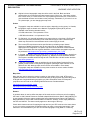
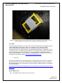
e3 Plus: FRAMEWORK FOR RESPONSIBLE
EXPLORATION
EXCELLENCE in HEALTH AND SAFETY
KNOWING YOUR LOCATION
Table of Contents
7.0 Knowing Your Location
7.1 Risks and Hazards
7.2 Topographic Maps and Map Grids
7.3 Air Photographs and Satellite Images
7.4 Compasses
7.5 Global Positioning Systems (GPS)
7.6 Emergency Locator Devices (ELTs, PLBs)
7.7 Batteries
7.8 Resources
HS-FI-v1.0
Page 1 of 15
e3 Plus: FRAMEWORK FOR RESPONSIBLE
EXPLORATION
EXCELLENCE in HEALTH AND SAFETY
KNOWING YOUR LOCATION
7.0 Knowing Your Location
Introduction
Every employee who traverses or works in the field away from the immediate project site should
know how to use a compass and develop good topographic map reading skills to help navigate
and keep track of their location. Reliance on global positioning system (GPS) technology should
not be the only method used to determine location, as GPS instruments can fail electronically and
because the batteries they require can go flat.
In addition to knowing your location, it is very important to follow safety guidelines before heading
out to work each day.
1. Tracking system: There should be a tracking system in place to record planned travel routes
and off site work locations on a centrally located map. Record all routes, whether they are
traverses on foot or trips using vehicles, snowmobiles, all-terrain vehicles, aircraft, or boats.
Indicate the destination, planned route, drop off point, pick up point, estimated time of arrival
and return etc. Leave grid coordinates whenever possible. Refer to Chapter 6. Safe
Traversing Practices.
2. Check-in system: There should be a communication system in place to keep in contact with
employees. Field employees should check in at prearranged time intervals and notify the
appropriate person whenever they change plans. Check-in schedules should include all
employees who work off site, including those who work from a hotel or are travelling in other
countries. Refer to Chapters 6. Safe Traversing Practices, 12. Travel Safety and Security,
and 19. Communications.
3. Emergency response plans (ERPs): Each project should develop site specific ERPs that
addresses local risks and hazards. Each employee should be familiar with the ERPs and
carry contact numbers and/or radio frequencies to use if an emergency situation develops.
Refer to Chapter 3. Emergency Response.
Acronyms
ELT – Emergency Locator Transmitter
ERP – Emergency Response Plan
GPS – Global Positioning System
NAD – North American Datum
NTS – National Topographic System
PLB – Personal Location Beacon
USGS – United States Geological Survey
UTM – Universal Transverse Mercator
WGS – World Geodetic System
HS-FI-v1.0
Page 2 of 15
e3 Plus: FRAMEWORK FOR RESPONSIBLE
EXPLORATION
EXCELLENCE in HEALTH AND SAFETY
KNOWING YOUR LOCATION
7.1 Risks and Hazards
Injuries and death may result from various risks and hazards associated with keeping track of
your location:
Disorientation and getting lost may be caused by:
Lack of training to use navigational aids correctly
Programming the wrong datum into the GPS unit
Loss of battery power and/or electronic failure for navigational aids and communication
equipment
Inadvertently traversing beyond the map area
Inadvertently entering dangerous terrain
Panic leading to bad decisions after initial disorientation
Being caught out after dark or overnight may be caused by:
Inadequate planning of traverse routes (e.g., terrain, route, time allocation, access,
required equipment)
Transportation breakdown
Unnecessary survival situation may be caused by:
Not knowing the location of emergency supplies or existing shelter in the field area
(emergency cache, cabin)
Getting separated from your day pack
Not keeping essential survival kit components on your person
Panic leading to bad decisions
Endangering others who conduct a search may be caused by:
Not following SOPs regarding check-in routines
Not stopping after initial disorientation, panic
7.2 Topographic Maps and Map Grids
Topographic Maps
Topographic maps are essential tools for field employees who work outside the confines of a
camp or a well defined project work site. Topographic maps accurately show the user various
features on the ground such as relief, water bodies, wooded and clear areas, roads, railways and
infrastructure such as power lines. Always use up-to-date map sheets. People who develop good
map reading skills seldom get lost.
Mark on all maps the location of critical features such as camp location, helicopter drop
off and pick up points, emergency cache drops, and predetermined meeting points if you
become separated from your partner.
Field workers should develop skills to read and interpret topographic maps so they can
judge the type of terrain they are likely to encounter.
HS-FI-v1.0
Page 3 of 15
e3 Plus: FRAMEWORK FOR RESPONSIBLE
EXPLORATION
EXCELLENCE in HEALTH AND SAFETY
KNOWING YOUR LOCATION
Original coloured topographic maps should be used in the field. Black and white
reproductions do not easily discriminate between types of lines (e.g., lake shore outlines
from contour lines). If a small section of a map is photocopied for field use, make sure the
grid coordinate numbers are included on the photocopy. Remember, if you zoom in or out
on a photocopier, you are changing the map scale.
Scales
Topographic maps are available in various scales, depending on the country. In Canada,
topographic maps are based on the National Topographic System (NTS) and are
available in the following standard scales:
1:50 000 scale where 1 cm represents 0.5 km
1:250 000 scale where 1 cm represents 2.5 km
For field work, it is generally advisable to use map scales at or less than 1:50 000 scale
as these maps show considerably more detail than the larger scale 1:250 000 maps,
which may work well for reconnaissance work or when flying in aircraft.
The correct NTS map sheet must be specified when purchasing maps. Natural
Resources Canada provides an easy to use index map on its website where the
appropriate NTS designation of a specific map area can be identified at both standard
scales. The website also lists regional distribution centres where topographic maps can
be purchased. http://maps.nrcan.gc.ca/topo_metadata/topo_click_e.php
In Canada, topographic maps and other types of maps can be downloaded in digital form
compatible with computer mapping systems (e.g., Mapinfo) from the GeoBase website.
The maps are available without charge at both 1:250 000 and 1:50 000 scales. Website:
http://www.geobase.ca/
In the USA, topographic maps are published by the United States Geological Survey
(USGS), which include Primary Series topographic quadrangle maps at scales of 1:24
000 and 1:63 360, although maps at other scales are available in some states.
Topographic maps are available for many other countries in various scales. Website:
http://topomaps.usgs.gov/index.html
Map Grids
Map grids are used to determine precise locations on the surface of the earth. NTS maps in
Canada are based on the Universal Transverse Mercator (UTM) projection and show two grids, a
UTM grid and a longitude/latitude geographic grid. More information about NTS maps and
projections can be found on the following Natural Resources Canada websites:
http://maps.nrcan.gc.ca/index_e.php
http://maps.nrcan.gc.ca/topo101/index_e.php
Datums
A geodetic datum is used to define the shape of the earth and as a reference point for mapping
the earth. In 1990, Natural Resources Canada adopted North American Datum 1983 (NAD 83) as
its new geodetic reference system replacing the former North American Datum 1927 (NAD 27).
Maps published or revised after 1990 are based on NAD 83. Similarly, newer maps published in
the USA use NAD 83. The datum usually appears on the margin of the map.
Check which datum was used for making the map and set your GPS receiver to the same datum
so you can use the map with the GPS without having to make a conversion (see below). If the
datums do not match between your GPS unit and the topographic map (NAD 27 or NAD 83),
HS-FI-v1.0
Page 4 of 15
e3 Plus: FRAMEWORK FOR RESPONSIBLE
EXPLORATION
EXCELLENCE in HEALTH AND SAFETY
KNOWING YOUR LOCATION
there will be an error in every GPS position placed on the map, which may vary from a few to
hundreds of metres.
Natural Resources Canada, Geodetic Survey Division supplies a downloadable software package
called the National Transformation Version 2 (NTv2) for converting coordinates between the NAD
27 and NAD 83 reference systems. To download the software, go to the following website:
http://www.geod.nrcan.gc.ca/online_data_e.php
Some countries use unique datums that may not exist in most GPS instruments (e.g., Jamaica).
In these cases, a mathematical conversion formula may be required or use latitude and longitude.
Learning to use maps and map grids
Employers should make sure that anyone working in the field understands the basics of map
navigation or is accompanied by a qualified field worker. Field workers should also be familiar
with map grid references and how to specify location using both UTM and the geographic grid
(longitude and latitude). It is particularly important to make sure that young or new employees are
mentored in basic map skills. Field employees should be able to:
Understand map legends, colour codes, and contour lines and intervals
Understand map scales – which scales are appropriate for the specific tasks of traversing
on foot and/or air reconnaissance.
Know and understand how to use both UTM and geographic latitude and longitude map
grids.
Know how to locate a position on a map and specify the grid reference.
Develop skills using contour lines and contour intervals to interpret topography. This will
help determine where to expect steep slopes, ridges, cliff areas, rivers, rapids, swamps,
glaciers and other topographic areas that may be difficult to traverse.
Know how to plan traverses and field work using topographic maps.
Know how to use a map in conjunction with a compass. This is very important so you do
not have to rely only on a GPS unit. Do not begin a traverse or get out of a helicopter
without being able to place your position accurately on a map.
Knowledgeable users can estimate the difficulty of a traverse that crosses rugged
topography with many changes in altitude by estimating the total incremental elevation
change from the start of a traverse to the finish.
Knowledgeable users can estimate the time it will take to complete a traverse with some
degree of accuracy.
It is advisable to use maps with a protective plastic coating for field work to prevent paper
maps from disintegrating in wet weather.
Topographic maps cannot provide precise information at all times.
Terrain features will not show if the elevation difference is less than the contour interval.
The colour and contour density on the map may not accurately indicate the difficulty of
traversing the terrain.
Recent changes in the map area will not be evident, such as new roads. However, the
latest release of a map should always be used in the field.
HS-FI-v1.0
Page 5 of 15
e3 Plus: FRAMEWORK FOR RESPONSIBLE
EXPLORATION
EXCELLENCE in HEALTH AND SAFETY
KNOWING YOUR LOCATION
7.3 Air Photographs and Satellite Images
Air photographs are useful in addition to topographic maps for traversing and mapping and can
aid in determining your location. Although some physical features and landforms are more easily
identified on air photographs than maps, it is always advisable to use air photographs in
conjunction with topographic maps. Keep both in a plastic protective coating or laminate to
minimize damage from the elements.
Because of the way air photographs are taken, they may be distorted near the edges; they must
be orthorectified to make the scale uniform. Air photographs can be printed at various scales. Air
photos, when used as a stereo-pair, have the added benefit of allowing the user to view the
terrain in three dimensions (3-D).
In areas of poor map coverage, satellite images available from various sources are proving to be
useful tools in mineral exploration not only for location mapping, but also for exploration (e.g.,
mapping lithologies or alteration patterns).
Information about air photos, their use and purchase is available from the following websites:
http://airphotos.nrcan.gc.ca/photos101/index_e.php
http://airphotos.nrcan.gc.ca/photos101/photos101_info_e.php
http://airphotos.nrcan.gc.ca/prod_e.php
Satellite Images
Satellite images are replacing air photos to some degree. They have the following advantages:
They are much cheaper to acquire due to the cost of aircraft for air photos; archived
satellite images can be much cheaper than air photos.
True colour images can be produced.
The resolution of some satellite images is almost as good as air photos.
Satellite images can be cheaply orthorectified.
Using a computer it is easy to merge satellite images with a digital topographic base to
produce the equivalent of an air photo with topographic contours. They can be easily
printed.
Various satellite images are available for download at no cost on the Canadian GeoBase
website: http://www.geobase.ca/.
7.4 Compasses
A compass is an essential piece of equipment for keeping track of your location while traversing
or carrying out field work. Various types of compasses are available and the choice of compass is
a matter of preference – but minimum features should include a rotating housing marked in
degrees that is mounted on a transparent plastic base. Geologists normally prefer to use a
compass with liquid dampening, a built in dip needle indicator and a mirror; the latter is useful in
taking bearings or backsightings. The mirror can also double as a signalling device during
emergencies, if necessary. Field staff should also be familiar with their pace so that they can use
pace and compass orienteering in conjunction with a topographic map.
HS-FI-v1.0
Page 6 of 15
e3 Plus: FRAMEWORK FOR RESPONSIBLE
EXPLORATION
EXCELLENCE in HEALTH AND SAFETY
KNOWING YOUR LOCATION
Although all field employees should be familiar with using a compass, many tend to rely on a
GPS for location, which can create problems if they malfunction or the batteries die. Field
employees should not rely solely on a GPS unit (see section 7.5).
Compasses are unreliable in areas of iron formations or areas where there are other strong
magnetic attractions (e.g., magnetic polarity reversals). When working in regions with these
challenges it may be advisable to learn to use a sun compass/chart in the event that your GPS
unit fails.
You can generate a sun chart by accessing the following website and entering the co-ordinates
where you work (anywhere in the world):
http://www.usno.navy.mil/USNO/astronomical-applications/data-services/rs-one-year
In addition, Transport Canada sells a publication for $12 entitled “TP 784 Finding the Sun’s True
Bearing – Precomputed Tables – Printed Publication”. This book may be useful in the field and
may be ordered from the following website:
http://shop.tc.gc.ca/TChtml/ibeCCtpItmDspRte.jsp?JServSessionIdrootncras147=qlpiro6kd1.pAb
MmlaLb3qIr6aInQaImQ4UtxCLbx0Ta0--&item=40663
Declination
Declination is the difference between true north and magnetic north. In Canada the declination
can range from a westerly declination in eastern Canada to an easterly declination in western
Canada. As a compass needle always points to magnetic north and a map is normally oriented
with true north at the top, it is very important to accurately set the declination for the map area
where you work.
Topographic maps show the declination for the map area in the legend; use this with
caution as declination changes over time.
Topographic maps also indicate the annual rate of change in declination. The present
day declination must be calculated based on the number of years since the map was
published and the annual rate of change.
Natural Resources Canada provides a web based declination calculator that allows the
calculation of current declination anywhere in the world by specifying latitude and
longitude. It is available at the following website: http://geomag.nrcan.gc.ca/apps/mdcaleng.php
If you are working at several sites across Canada, set the declination on your compass
each time you change location.
Be cautious when using a compass at high latitudes because compasses rely on the
horizontal component of the earth’s magnetic field to work properly. As the magnetic
fields become increasingly steep closer to the magnetic pole, compass performance
becomes erratic and unreliable. This is especially true in northern Canada near the actual
location of the magnetic north pole.
HS-FI-v1.0
Page 7 of 15
e3 Plus: FRAMEWORK FOR RESPONSIBLE
EXPLORATION
EXCELLENCE in HEALTH AND SAFETY
KNOWING YOUR LOCATION
Training
Companies should make sure that their employees – especially new ones without field
experience – become proficient using a compass in conjunction with topographic maps. It may be
advisable for employees to take an orienteering course to become proficient. As a minimum,
everyone who does field work should be able to:
Take bearings and be able to follow a bearing on the ground.
Check a bearing by taking a backsighting.
Recognize and avoid potential deflection due to nearby metal objects or possibly by
magnetic rocks (e.g., magnetite- or pyrrhotite-bearing rocks).
Use a compass in relation to a baseline.
Set a compass to compensate for declination in the field area.
Find their location on a map using triangulation.
7.5 Global Positioning Systems (GPS)
Handheld GPS units have become quite inexpensive and are useful for determining or recording
relatively precise locations when traversing or sampling etc. GPS receivers utilize signals from a
network of orbiting satellites to establish the location of the receiver.
A GPS receiver should never be considered as a substitute for a map and compass.
Read the manufacturer’s user manual and be familiar with the features of the GPS unit.
Digital maps can be uploaded onto some of the newer GPS units, but the larger colour
displays on these units generally result in increased battery drain and reduced battery
life.
Differential and Real Time Kinematic (RTK) receivers can achieve levels of accuracy
required for detailed land surveys.
Always carry an adequate supply of spare batteries for your GPS unit. Use either alkaline
or lithium batteries for longer performance or in cold weather.
Datums
Many GPS receivers are referenced to the World Geodetic System WGS 84 datum, which will be
valid until 2010. GPS units use the WGS 84 and NAD 83 as default datums in North America.
When using a map with a GPS unit, check which datum was used for making the map and set
your GPS receiver to the same datum so you can use a topographic map directly. If the datums
do not match between the GPS unit and the topographic map (NAD 27 or NAD 83), there will be
an error in every GPS position placed on the map, which may vary from a few to hundreds of
metres.
Information about conversions between NAD 27 and NAD 83 is given in 7.2 Topographic Maps
and Map Grids.
Advantages of using GPS units include:
Determining location either in latitude and longitude or UTM grid coordinates – this can
be helpful if your location on the map is in doubt.
HS-FI-v1.0
Page 8 of 15
e3 Plus: FRAMEWORK FOR RESPONSIBLE
EXPLORATION
EXCELLENCE in HEALTH AND SAFETY
KNOWING YOUR LOCATION
Determining distance to the next waypoint or your destination
Determining travel speed – this helps to determine your progress on a traverse
Determining the return route
Generally high accuracy in pinpointing grid location
Not affected by magnetic anomalies such as iron formation or magnetic reversals (areas
of high magnetic flux)
Storage of critical waypoints such as (1) camp location, (2) helicopter drop off and pick up
locations, (3) emergency cache locations etc.
It is advisable to upgrade GPS units periodically to take advantage of improved
technology.
Limitations of using GPS units include:
Batteries: GPS receivers rely on battery power – always carry spare or freshly recharged
batteries on your person (i.e., in breast shirt pocket) to keep them warm so they will retain
their charge when not in use. For reliability, use very high quality/powerful batteries (e.g.,
lithium) rather than cheap poor quality ones. In addition, make sure batteries are firmly in
place within the case or the GPS unit may not function well.
Temperature: Cold weather can cause batteries to drain rapidly so they last a much
shorter time. LCD (liquid crystal display) screens on GPS units may not work well in subzero temperatures.
Signal reception: A GPS should be positioned to maximize visibility to open sky as it
normally requires the reception of clear signals from a minimum of three (preferably four)
satellites – and signal reception requires a clear line of sight between the satellite and the
receiver. Poor GPS signal reception may occur under various conditions.
o
Satellite signals will not penetrate water, metal, concrete, rock or soil.
o
Satellite signals are degraded by tree canopy or very dense vegetation. Newer
receivers have overcome this degradation to a large extent and are better for
work under the canopy.
o
Steep terrain can affect GPS performance if the terrain blocks the signals of
some of the satellites used for triangulation.
o
Metal roofs and chain link fencing (near open holes and shafts) can affect
performance of GPS units.
o
For maximum efficiency, use an external antenna when doing road work in a
vehicle with a GPS.
Satellite configuration geometry can affect the accuracy of a GPS. If the receiver is
picking up signals from closely spaced satellites, the accuracy of the triangulation will be
less precise than if the signals are coming from more widely positioned satellites. Your
receiver will indicate the accuracy of the position.
Datum reference: Using an incorrect GPS datum setting can affect the accuracy when
determining your location. GPSs must use the same datum and coordinate system as the
topographic map. Check the legend on the map for the datum.
Entering erroneous data: It is very important to enter the correct numbers. If working in
UTM, and one digit is off you may be 1, 10, or 100 km out in your location. This error
HS-FI-v1.0
Page 9 of 15
e3 Plus: FRAMEWORK FOR RESPONSIBLE
EXPLORATION
EXCELLENCE in HEALTH AND SAFETY
KNOWING YOUR LOCATION
happens more frequently to field employees who do not read maps well. Transfer all data
digitally to/from the GPS unit. This avoids the errors as described above.
Overconfidence: When using a GPS you may know exactly where you are but if you do
not have communication no one else will know where you are. Good communication is
essential so carry what is appropriate for the field area. This may be a portable satellite
phone in a remote area or an appropriate radio. Refer to Chapter 19. Communications.
General tips when using a GPS unit
You need to lock onto the signals from at least three satellites – preferably four – for your
GPS unit to determine the location.
If you are in a canyon or steep valley and having reception trouble, move toward the
centre or climb out of it.
Search for a clearing to find your location when traversing through heavy foliage.
Your body can block satellite signals. Hold the unit away from your body and turn your
body to find more signals.
For greater accuracy, take the reading of a position more than once at different times of
the day. Use the “averaging” feature found on most handheld GPS units for greater
accuracy; average them for five minutes before selecting the save button.
Carry a good map and compass at all times and be able to use them.
7.6 Emergency Locator Devices (ELTs, PLBs)
There are various emergency distress radio beacons available but only those designed for use
with the Cospas-Sarsat international system allow the signals to trigger emergency response
search and rescue.
Three types of emergency beacons are currently in use with the Cospas-Sarsat system.
Emergency Locator Transmitters (ELTs) for aircraft
Personal Locator Beacons (PLBs) for individual use
Emergency Position Indicating Radio Beacons (EPIRB) for maritime use
Emergency Locator Transmitters (ELTs)
ELTs are specifically for use in aircraft and are designed to activate automatically upon impact;
they can also be activated manually. The newer digital ELTs operate at 406MHz and only signals
at this frequency are processed by the Cospas-Sarsat system (effective February 1, 2009).
Frequencies of 121.5 and 243 MHz no longer alert search and rescue.
Pilots of charter aircraft should indicate the location of the ELT and describe how to
manually activate the unit in the event of emergency. Refer to section 16.10.2 Regular
Pre-Flight Safety Briefings.
HS-FI-v1.0
Page 10 of 15
e3 Plus: FRAMEWORK FOR RESPONSIBLE
EXPLORATION
EXCELLENCE in HEALTH AND SAFETY
KNOWING YOUR LOCATION
Personal Locator Beacons (PLBs)
PLBs are small radio frequency transmitters that are designed to be carried by an individual in
remote areas away from normal emergency services. They are intended for emergency use, not
as navigational tools.
In an emergency the PLB is activated manually and transmits on 406 MHz, the
frequency of the receiving Cospas-Sarsat international search and rescue satellite.
406 MHz PLB units provide global coverage but need to be coded according to the
specific country where they will be used. This code should be included in the
planning documentation for any remote foreign trip. Take the unit to an authorized
dealer to be recoded.
PLBs are now available with GPS units that transmit a more accurate position fix.
Older analogue PLB units that operate exclusively on the 121.5 MHz frequency
should not be used because the Cospas-Sarsat international satellite system for
search and rescue only processes signals from the newer 406 MHz emergency
beacons.
Be familiar with the operator’s manual for your PLB. Use the correct batteries and
make sure they are up-to-date before departing on a long trip.
A PLB must only be activated in a distress emergency situation where there is
serious danger to human life and only in areas where mobile/cell phone coverage or
other communication methods are not available (two-way radio or satellite phone).
Most field employees should have other means of notifying their project or camp of
an emergency. Refer to Chapter 3. Emergency Response.
PLBs should be registered with the appropriate authorities in the country where it
may be used. In Canada, you can register the PLB directly with Cospas-Sarsat or
online at:
http://www.canadianbeaconregistry.forces.gc.ca/Logon.asp
https://www.406registration.com/
HS-FI-v1.0
Page 11 of 15
e3 Plus: FRAMEWORK FOR RESPONSIBLE
EXPLORATION
EXCELLENCE in HEALTH AND SAFETY
KNOWING YOUR LOCATION
Figure 7.1: 406 MHz Emergency Locator Transmitter (ELT) mounted in a helicopter. Know the location and how to
manually activate the ELT whenever you fly in charter aircraft. © Great Slave Helicopters
The “SPOT”
The “Spot Satellite Messenger” is a new device, a type of PLB that can send a message to check
in with a designated receiver (office, family), or an emergency “911” signal to a GEOS
International Emergency Response Centre. The Centre then notifies the contacts of the
emergency situation. It is rugged and has a long lasting battery but there are drawbacks. There is
no way for the user to tell if the signal has been sent or received successfully. While it works well
in most of North America, it does not function in the Arctic, Antarctic or central and southern
Africa. It is not intended as – nor is it usable as – a navigational tool. Information about the “Spot”
is available on the following website: http://international.findmespot.com/
7.7 Batteries
Various kinds of batteries are used at project sites, including in GPS receivers, ELTs, and PLBs.
Most handheld GPS units use AA or AAA batteries; rechargeable NiMH or Lithium ion batteries
are recommended by some manufacturers. General information regarding batteries is available at
the following website:
http://www1.servicecanada.gc.ca/eng/labour/fire_protection/policies_standards/guidelines/safe_st
orage.shtml
General Battery Tips
Cheap batteries are a false economy in the field.
HS-FI-v1.0
Page 12 of 15
e3 Plus: FRAMEWORK FOR RESPONSIBLE
EXPLORATION
EXCELLENCE in HEALTH AND SAFETY
KNOWING YOUR LOCATION
Start each day with fully charged batteries and carry sufficient fully charged spare
batteries for your navigation and communication equipment.
Follow instructions and install batteries correctly.
Do not mix batteries: Use the same brand and chemical type. All batteries should be the
same age – replace them all at the same time.
Remove depleted or damaged batteries. Do not leave them in equipment as they may
corrode or leak and cause damage.
Do not leave equipment switched on when the batteries are depleted.
If you carry battery powered equipment in very cold weather, keep the items inside
several layers of clothing to preserve the charge. Take them out briefly to use them and
replace in your clothing as soon as possible.
Pay attention to the expiry date on batteries used for PLBs and ELTs. Batteries should be
replaced before expiry date. Good batteries in ELTs should provide continuous
transmission for 48 hours.
Battery Recharging Tips
Follow the manufacturer’s directions when using battery rechargers and rechargeable
batteries. Match the charger with the battery. Some batteries should be almost, but not
totally depleted before recharging.
Charge batteries at room temperature whenever possible – not at temperatures below
0°C or above 40°C.
Battery Storage Tips
Store batteries in cool, dry, well ventilated areas. Keep them away from any heat source,
including direct sunlight.
Never store batteries with flammable or explosive materials or with food.
Store batteries of like chemistry together – not mixed with other types of batteries.
Safe Battery Disposal
Follow the jurisdictional regulations for disposing of batteries safely. Recycle them when
possible.
Nickel cadmium and lead acetate batteries can contaminate the environment and cause
health problems for people. Make every effort to recycle or dispose of these batteries
according to regulations.
Do not throw batteries into a fire as they may explode and injure people and contaminate
the environment.
HS-FI-v1.0
Page 13 of 15
e3 Plus: FRAMEWORK FOR RESPONSIBLE
EXPLORATION
EXCELLENCE in HEALTH AND SAFETY
KNOWING YOUR LOCATION
7.8 Resources
Books
rd
Fleming, June. (2001) Staying Found: The Complete Map & Compass Handbook. 3 ed. The
Mountaineers.
Helms, Russell. (2006) GPS Outdoors: A Practical Guide for Outdoor Enthusiasts. Menasha
Ridge Press.
Touche, Fred. (2004) Wilderness Navigation Handbook. Touche Publishing.
Internet Resources
GeoBase. http://www.geobase.ca/. Accessed November 7, 2009.
Human Resources and Social Development Canada. Guidelines – Safe Storage, Use and
Disposal of Batteries.
http://www1.servicecanada.gc.ca/eng/labour/fire_protection/policies_standards/guidelines/safe_st
orage.shtml. Accessed November 7, 2009.
International Satellite System Search and Rescue. International 406MHz Beacon Registration
Database. https://www.406registration.com/. Accessed November 7, 2009.
National Search and Rescue Secretariat. Beacon Registration.
http://www.canadianbeaconregistry.forces.gc.ca/Logon.asp. Accessed November 7, 2009.
Natural Resources Canada. Canadian Spatial Reference System. Online Database (CSRS
Online Database). http://www.geod.nrcan.gc.ca/online_data_e.php. Accessed November 7, 2009.
Natural Resources Canada. National Air Photo Library. Air Photos 101 – Principles of Aerial
Photography. http://airphotos.nrcan.gc.ca/photos101/index_e.php. Accessed November 7, 2009.
Natural Resources Canada. Geomagnetism: Magnetic declination calculator.
http://geomag.nrcan.gc.ca/apps/mdcal-eng.php. Accessed November 7, 2009.
Natural Resources Canada. Mapping Services. Centre for Topographic Information.
http://maps.nrcan.gc.ca/index_e.php. Accessed November 7, 2009.
Natural Resources Canada. Mapping Services. Find an NTS Map Sheet.
http://maps.nrcan.gc.ca/topo_metadata/topo_click_e.php. Accessed November 7, 2009.
Natural Resources Canada. Mapping Services. Topo 101 – Topographic Maps, The Basics.
http://maps.nrcan.gc.ca/topo101/index_e.php. Accessed November 7, 2009.
Naval Oceanography Portal. Sun or Moon Rise/Set Table for One Year.
http://www.usno.navy.mil/USNO/astronomical-applications/data-services/rs-one-year. Accessed
February 6, 2009.
SPOT International. http://international.findmespot.com/. Accessed November 7, 2009.
HS-FI-v1.0
Page 14 of 15
e3 Plus: FRAMEWORK FOR RESPONSIBLE
EXPLORATION
EXCELLENCE in HEALTH AND SAFETY
KNOWING YOUR LOCATION
U.S. Geological Survey. USGS Topographic Maps. http://topomaps.usgs.gov/index.html.
Accessed November 7, 2009.
HS-FI-v1.0
Page 15 of 15