1
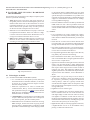
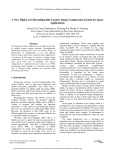
MIT International Journal of Electronics and Communication Engineering, Vol. 5, No. 1, January 2015, pp. 23–26
ISSN 2230-7672 © MIT Publications
23
Remote Location Monitoring of Dam and Risk
Warning System for Flood using GSM Technology
Simrat Singh Gill
Amit Sharma
Assistant Professor
E&CEngg.Department,
MIT,Moradabad,UttarPradesh,India
[email protected]
Assistant Professor
E&CEngg.Department,
MIT,Moradabad,UttarPradesh,India
[email protected]
Pradeep Kumar Gupta
Pushpendra Kumar Singh
Assistant Professor
E&CEngg.Department,
MIT,Moradabad,UttarPradesh,India
[email protected]
Assistant Professor
E&CEngg.Department,
MIT,Moradabad,UttarPradesh,India
[email protected]
ABSTRACT
GSM is the most popular technology used in mobile communication.GSM based control system can act as an embedded system
that can control and monitor appliances and other devices. There is an automation process by using GSM technology which
provides water level indication in various applications like dam, water reservoirs, groundwater monitoring etc. The system
allows the user to effectively monitor the water level via mobile by sending commands in the form of SMS and receiving water
level status. The type operation to be performed depends on the nature of the SMS sent. The main part includes the development
of the system that is capable to detect water level using microcontroller. The sent SMS is stored and polled from the receiver
mobile station and then the required control signal is generated and sent to the intermediate hardware that we have designed
according to the command received in form of the sent message. The microcontroller is used for processing the network protocols.
The system can process the data that has been collected based on the water level. Though this technology is initially meant for
dam monitoring, it can be easily adapted to other fields.
I. INTRODUCTION
the implementation of this project, it will reduce the number
Atleast49,000existinglargedamsarefragmentingnearlyhalf of workers involved during a work in progress. The use of this
oftheworld’srivers.Adamhaslargecapacity,anditisusually toolisnotlimitedtodam,butitcanbeappliedtootherfields.
kept partially full. So, when it rains heavily or there is a big snow
melt-off, a large amount of water can be captured in the dam and
releasedslowlydownstream.Ifthedamhadn’tbeenthere,ahuge
amountofwatercouldhaverusheddowntheriversandflooded
downstream. Dams can stabilize the water levels of inland lakes
and seas. When water increases to a dangerous level and is not
monitored by the authorities, and then dam failure can cause
potentialcatastrophicdamagetolifeandproperty.However,this
condition can be prevented if the authorities always know the
current status of the water level. Therefore a technology needs
to be developed to tackle this problem and making the system
more organized. Therefore, designing of water level indicator is
one of the technological advancement to transmit data and send
it to authority for controlling. The systems also give an alert to
authority to take immediate action if water level increases to
dangerous level. The system can be applied at the river-banks,
low-lying areas, dam and the village far from town and also can
be used for industrial sector. It is an effective method to transmit,
analyze, manage and give a feedback. The authorized person will
take an immediate action to monitor the water level[1].With
Fig. 1:BlockDiagramofWaterLevelIndicatorBasedOnGSM
MIT International Journal of Electronics and Communication Engineering, Vol. 5, No. 1, January 2015, pp. 23–26
ISSN 2230-7672 © MIT Publications
II. FA C TO R S I N F L U E N C I N G H A R D WA R E
DEVELOPMENT
Variousfactorsplayanimportantroletoadaptacompletesystem
based on a particular technology.
• Time: When water rises above safe region then this is
thegoldenperiodtostartthefloodmitigationplans.The
duration taken from alert till the information is send to
responsible authorities is very important and should be
done in shortest time possible. Every second is precious
for the rescue team to help and save the victims.
24
tothemobilephones.GSMmodemscanbeaquick
andefficientwaytosendandreceiveSMS,becausea
specialsubscriptiontoanSMSserviceproviderisnot
required.Toperformthesetasks,aGSMmodemmust
supportan“extendedATcommandset”forsending/
receivingSMSmessages[3].
• Themaindifferencebetweenthedial-upmodemand
GSMmodem is that a dial-upmodem sendsand
receivesdatathroughafixedtelephonelinewhilea
wireless modem sends and receives data through radio
waves.
• Cost: Device cost and maintenance cost plays crucial role
(b) ZIGBEE:
to implement the hardware. If the cost of device is high,
• Itisaspecificationforasuiteofhighlevelcommuitwillberestrictedtolimitedareas.Maintenancecostis nication protocols using small and low power digital
a long term investment until the device is in use.
radiosbasedonIEEE802standardforpersonalarea
• Plan: During calamity the authorities have to make wise
network.
decisions to save victims. The authorities have to plan
• Thesedevicesareoftenusedinmeshnetworkform
according to time and resources available to them.
to transmit data over long distances and passing data
through intermediate devices to reach large distance.
• This allows ZigBee networks to be formed ad-hoc,
with no centralized control or high-power transmitter/
receiver able to reach all of the devices.
• Itistargetedatapplicationsthatrequirealowdatarate,
long battery life, and secure networking.
• Ithasadefinedrateof250kbit/s,bestsuitedforperiodic or intermittent data or a single signal transmission
from a sensor or input device.
• Applicationsincludewirelesslightswitches,electrical
meterswithin-home-displays, trafficmanagement
systems, and other consumer and industrial equipment
that requires short-range wireless transfer of data at
relatively low rates. The technology defined by the
ZigBeespecificationisintendedtobesimplerandless
expensive than other WPANs, such as Bluetooth or
Wi-Fi.
• ZigBeenodes can go from sleep to active mode in
30msorless,thelatencycanbelowanddevicescan
be responsive, particularly comparedto Bluetooth
wake-up delays, which are typically around three
seconds.BecauseZigBeenodescansleepmostofthe
time, average power consumption can be low, resulting
in long battery life.
Fig. 2: Important Factors
2.1 Technologies Available
(A). GLOBALSYSTEMFORMOBILE(GSM):
• It is a standardset developedby ETSI(European
Telecommunication StandardInstitute)to describe
protocols for second generation digital cellular
networks used by mobile.
• GSM was expanded o ver time to include d ata
communications, first by circuit switched transport, then packet data transport via GPRS(GeneralPacket
RadioServices)andEDGE(EnhancedDataratesfor
GSMEvolutionorEGPRS).
• A GSM modem is a specialized type of modem which
acceptsaSIMcard,andoperatesoverasubscription
to a mobile operator, just like a mobile phone.
• GSMmodemsareacosteffectivesolutionforreceiving
SMSmessages,becausethesenderispayingforthe messagedelivery.GSMmodemispreferabletoGSM
phone due to the disadvantage of the charging related
• ZigBeedevicesareofthreetypes:
• ZigBeeCo-ordinator(ZC):Themostcapabledevice,
the Co-ordinator forms the root of the network tree
and might bridge to other networks. There is exactly
oneZigBeeCo-ordinatorineachnetworksinceitis
the device that started the network originally .It stores
information about the network, including acting as the
TrustCentre&repositoryforsecuritykeys.
• ZigBeeRouter(ZR):Inarunningapplicationfunction,
a ZigBee Router can act as an intermediate router,
passing on data from other devices.
MIT International Journal of Electronics and Communication Engineering, Vol. 5, No. 1, January 2015, pp. 23–26
ISSN 2230-7672 © MIT Publications
25
• ZigBeeEndDevice(ZED):ZEDcontainsjustenough
functionality to communicate to the parent node and
cannot relay data from other devices. Hence this
relationshipallowsthenodetobeasleepasignificant
amount of the time thereby giving long battery life.
A ZEDrequiresthe least amount of memoryand
therefore can be less expensive to manufacture than a
ZRorZC.
Fig. 4: Level Distribution
Factors
Fig. 3:FlowDiagramofWaterLevelIndicatorUsingGSM
III. DESIGN AND IMPLEMENTATION
The first stage of designing involves a water level sensor
that is made for sensing water level accurately. If water level
is at moderate or high level then sensors sends message
to the microcontroller otherwise it senses the water level
again.Microcontrolleris usedto control the overall system
automatically that reduces the design and control complexity.
Microcontrollertakesinputfromthesensorunitandsendsthe
signaltotheGSMmodemafterprocessingdata.GSMmodem
thensendsthemessagetotheuser’sphone.Theuserthentakes
appropriate action and performs other controlled operations.
Conventional
system
GSMbased
system
Reception of water
level alerts
No
Automatic
Display warning
signs
No
Automatic
Cost of installation
Daily basis
Low cost
IV. CONCLUSION
Failure of dams can be devastating to life and property. Therefore
asolutionforthisproblemispresentedinthispaper.Byusing
a mobile phone one can monitor the water level in dams so that
water level above high risk level can be alerted immediately by
MIT International Journal of Electronics and Communication Engineering, Vol. 5, No. 1, January 2015, pp. 23–26
ISSN 2230-7672 © MIT Publications
the use of remote measurements. This makes it convenient for
the user and helps in reducing danger caused by dam failures.
This paper can be used as a reference for realizing other projects 1.
such as weather forecasting, temperature updates, device
synchronization,etc[5].Henceitjustifiesthatanydevicecanbe
controlled remotely. This system can be linked to relays which
2.
can automatically control the switching of gates by allowing
3.
excesswatertoflow.
V. FUTURE WORKS
Sensors are important elements in the system. Further studies
on wireless sensor technology will be best to replace the current
sensors. Precise and accurate detection of water level will
improve the data collection system for the monitoring station.
Thefloodalertinformation’scanbedisplayedondisplayboards
for road users and for safety reasons could be placed at strategic
locations. A possible means of power supply for the centralized
control unit can be solar cells. The use of solar energy will be
cheaper.TheGSMtechnologycanbereplacedbyZIGBEE.
26
REFERENCES
“Microcontroller B
ased Water Level Indicator UsingGSM
Mode m : De si gn a nd Appl i c a t i on” Me l at y A m i rruddi n,
NurhakimahM.Mukhtar,HanaA.Halim,NurS.NoorpiSchool
of Electrical Systems Engineering
UniversityMalaysiaPerlis(UniMAP)Perlis,Malaysia.
“Floodlevel indicatorandrisk warni ngsyst em forremote
locationmoni tori ngu si ngflood obse rvat ory s yst em” Siva
KumarSubramaniam1,VigneswaraRaoGannapathy2,Sivarao
Subramonian3andAbdulHamidHamidon.
4.
ATCommandsInterfaceGuide,Wavecom,2002,pp.2-13.
5.
“Microcontroller BasedAutomatedWaterLevelSensingand
Controlling:DesignandImplementationIssue”S.M.KhalidReza,
ShahAhsanuzzamanMd.Tariq,andS.M.MohsinReza.
6.
“GSMbased controlsystem”http://chipscity.com/downloads/
projects/gsm%20based%20control%20system.pdf.
7.
Zelio Logic 2 Smart Relay User’s Manual, Schneider Electric
Com.,2002,pp.17-38.
8.
SitiYuhaniz,TanyaVladimirovaandScottGleason,AnIntelligent
Decision-Making SystemforFloodMonitoring fromSpace,
ECSISSymposiumon Bio-inspired, Learningand Intelligent
SystemsforSecurity,pp.65-71.