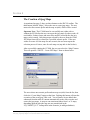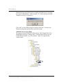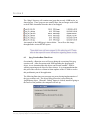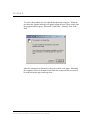
1
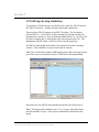
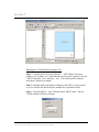
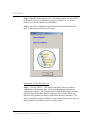
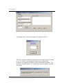
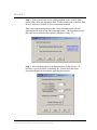
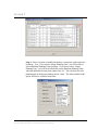
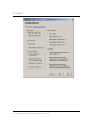
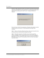
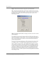
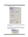
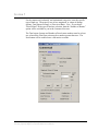
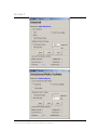
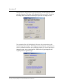
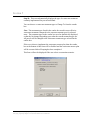
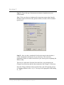
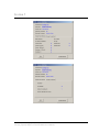
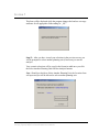
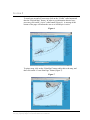
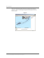
FLORIDA KEYS
CARRYING CAPACITY STUDY
Carrying Capacity/Impact Assessment Model
and Routine Planning Tool - User's Manual
March 2003
This report was prepared by URS Corporation (formerly Dames & Moore, Inc.), for the U.S. Army Corps of
Engineers and the Florida Department of Community Affairs. Funds for this study were provided under U.S. Army
Corps of Engineers Contract No. DACW17-99-D-0058, Delivery Order 12, Test CCAM.
Table of Contents
1.0
2.0
3.0
4.0
5.0
6.0
7.0
8.0
9.0
10.0
PURPOSE AND ORGANIZATION OF THIS MANUAL ......................................... 1
INTRODUCTION TO THE FLORIDA KEYS CARRYING CAPACITY STUDY .. 2
OVERVIEW OF THE CARRYING CAPACITY/IMPACT ASSESSMENT
MODEL (CCIAM)........................................................................................................ 3
OVERVIEW OF THE ROUTINE PLANNING TOOL (RPT).................................... 4
CCIAM STEP-BY-STEP GUIDELINES..................................................................... 5
THE CREATION OF JPEG MAPS ........................................................................... 28
6.1
Jpeg Creation Run-Time Error........................................................................ 30
GUI RULES AND NOTES: ....................................................................................... 32
7.1
Result Reporting ............................................................................................. 34
RPT STEP BY STEP GUIDELINES ......................................................................... 36
FREQUENTLY ASKED QUESTIONS..................................................................... 40
LIST OF SUPPORTING DOCUMENTATION ........................................................ 43
Florida Keys Carrying Capacity Study
Carrying Capacity/Impact Assessment Model Users Manual
i
Section 1
Purpose and Organization of this Manual
This manual provides the users of the Carrying Capacity/Impact Assessment
Model (CCIAM) with guidelines on the operation of the model. It is assumed
that a trained GIS analyst will execute the CCIAM with guidance from the
Local Planning Workgroup regarding the definition of scenarios to run
through the model. This document includes the following sections:
·
Introduction to the Florida Keys Carrying Capacity Study
·
Overview of the Carrying Capacity/Impact Assessment Model
·
Overview of the Routine Planning Tool
·
CCIAM and RPT Step-by-Step Instructions
·
Frequently Asked Questions
·
List of Supporting Documentation
Florida Keys Carrying Capacity Study
Carrying Capacity/Impact Assessment Model Users Manual
1
Section 2
Introduction to the Florida Keys Carrying Capacity
Study
In 1986, a new comprehensive plan and corresponding land development
regulations were approved for Monroe County. They were developed in
response to the Area of Critical State Concern designation, as well as to
comply with State of Florida regulations and to maintain a high quality of life
in the region. In 1991, the Monroe County Board of Commissioners ratified
the Monroe County Year 2010 Comprehensive Plan (the Plan).
The Plan was revised in 1993 following several legal challenges initiated by
the DCA and other private organizations. Ongoing legal proceedings
prompted a 1995 Final Order and Recommendation by the Hearing Officer,
which resulted in further revisions and final adoption of the Plan in 1996.
During final revisions of the Plan, a “carrying capacity approach” to growth
management was adopted. The goal of the Florida Keys Carrying Capacity
Study (FKCCS), excerpted from FAC Rule 28-20.100, reads as follows:
“The carrying capacity analysis shall be designed to determine the
ability of the Florida Keys ecosystem, and the various segments
thereof, to withstand all impacts of additional land development
activities.”
The Carrying Capacity/Impact Assessment Model (CCIAM) and Routine
Planning Tool (RPT) were created as part of the FKCCS. This manual
provides guidance on the use of these two applications.
Florida Keys Carrying Capacity Study
Carrying Capacity/Impact Assessment Model Users Manual
2
Section 3
Overview of the Carrying Capacity/Impact Assessment
Model (CCIAM)
The CCIAM is a spatial model, built using ArcGIS 8.1 and automated with
VBA, which evaluates the end-state effects of land use scenarios on the
natural and social systems of the Florida Keys. The CCIAM analysis is
triggered by changes in the land use GIS layer. The user defines these
changes, as alternative land use scenarios, through the Graphical User
Interface (GUI) to modify land use patterns and specify stormwater and
wastewater treatment types. Users of this model include planners from
Monroe County, the South Florida Regional Planning Council, and the Florida
Department of Community Affairs as well as other stakeholders involved with
the county’s comprehensive planning process.
The CCIAM is expected to be run during reviews of the Monroe County
comprehensive plan, which may occur annually or less frequently. Outputs
from the CCIAM include geodatabase feature classes, Arc Info coverages, and
Arc Info grids and tables. These outputs are summarized into two HTML
reports. First, the Scenario Report is a compilation of carrying capacity
indicators and other information that can be interpreted to derive an
assessment of the user-defined scenario. The Scenario Report is the primary
reporting mechanism for the CCIAM. It is intended to be a stand-alone
document that can provide the planner with the information needed to
evaluate a scenario. Explanatory text is included in the Scenario Report to
assist the planner in interpreting the results produced by the CCIAM. Second,
the Model Output Listing is a report that compiles all of the outputs generated
by the CCIAM. The Model Output Listing accompanies the Scenario Report
to provide supporting information resulting from the CCIAM. It is organized
by CCIAM modules and has limited explanatory text.
Florida Keys Carrying Capacity Study
Carrying Capacity/Impact Assessment Model Users Manual
3
Section 4
Overview of the Routine Planning Tool (RPT)
The Routine Planning Tool (RPT) is an ArcIMS application that is
intended for more frequent use by planners and the public. It provides
wide access to the pertinent information compiled during the FKCCS and
the various scenarios run through the CCIAM. The RPT functions with
ArcIMS, a Java servlet connector, and Microsoft’s web server (MS IIS)
and serves an HTML viewer using an image service. It is a light-weight
application served over the Internet and is not intended to serve as the
model itself. However, data resulting from the CCIAM can be provided to
the planners and the public through this application. If warranted,
additional data layers can easily be added to this application. The RPT is
a by-product of the overall FKCCS effort; therefore, minimal
customizations were made to the ArcIMS default application.
Florida Keys Carrying Capacity Study
Carrying Capacity/Impact Assessment Model Users Manual
4
Section 5
CCIAM Step-by-Step Guidelines
To invoke the CCIAM, the user can double-click on the file, FKCCS.mxd, in
the \FKCCS directory. ArcMap will start and load the application.
There are three FKCCS buttons on the FKCCS toolbar. The first button
(labeled FKCCS – GUI) will be used for running the CCIAM with the GUI
(graphical user interface). The second button (labeled FKCCS – No GUI) will
be used for running the CCIAM portion only, thus bypassing the GUI. The
third button (labeled “Maps”) will be used to create the jpeg maps.
The FKCCS.mxd should look similar to the image below before running a
scenario. There should be no layers in the table of contents.
Note: Due to limitations with the ESRI JpegExporter object, the map creation
part of the code was separated from the CCIAM and is run independently.
In layout mode, the FKCCS.mxd should look similar to the image below.
Note: The layout will be defined as an 8-1/2 x 11 page, with a data frame,
neat line and FKCCS logo. These objects should not be deleted from the
layout.
Florida Keys Carrying Capacity Study
Carrying Capacity/Impact Assessment Model Users Manual
5
Section 5
Running the CCIAM Without Using the GUI
Step 1: Copy the parcels coverage from the “…\FKCCS\data” directory,
rename it xx_lu (where “xx” represents the scenario prefix), and place it in the
“\FKCCS\Scenario_Covs” directory. Note: The scenario prefix cannot be
more than 3 characters in length.
Step 2: Manually make your land use changes to the NEW coverage named
xx_lu (be careful, this should only be attempted by experienced users).
Step 3: Click the FKCCS – No GUI button on the FKCCS.mxd. The run
CCIAM without GUI form will open.
Florida Keys Carrying Capacity Study
Carrying Capacity/Impact Assessment Model Users Manual
6
Section 5
Step 4: Enter the scenario prefix (Note: The scenario prefix you enter MUST
be the same prefix you used in the coverage you created, e.g. xx_lu has a
prefix of xx) and click the Run CCIAM button.
Step 5: Once the CCIAM has completed, the Finished CCIAM form will
open. Close the form and check your results.
Running the CCIAM With the GUI
Step 1: Click the FKCCS – GUI button on the FKCCS.mxd to open the
Administrative Information form. Fill in the administration information
regarding the scenario. The Scenario Name and the Scenario Prefix are both
required, whereas the other entries are optional. The Scenario Prefix is a
character string (numbers or letters), with a three character maximum. The
Show Used Prefixes button will display a form listing all the scenario prefixes
which cannot be used (because they are already in use).
Florida Keys Carrying Capacity Study
Carrying Capacity/Impact Assessment Model Users Manual
7
Section 5
Clicking the Show Used Prefixes button will display this form.
This form is displayed while the original parcels coverage is copied, renamed
to “xx_lu” (where xx represents the scenario prefix), placed in the
Scenario_Covs directory and added as a layer to the table of contents. The 3
base layers, Planning Units, U.S. 1 and Roads will also be added to the table
of contents.
Florida Keys Carrying Capacity Study
Carrying Capacity/Impact Assessment Model Users Manual
8
Section 5
Step 2: If the scenario calls for the implementation of one or more of the
master plans, check the appropriate box. If either master plan is checked, then
the user will not be allowed to select a restoration scenario.
Note: Selecting implementation of the wastewater master plan will add
approximately 8 hours of run time to the application. The wastewater master
plan code is executed after the looping is complete, in Step 12.
Step 3: Select the hurricane evacuation parameters for the scenario. If
necessary, review the Miller Consulting, Inc., Florida Keys Hurricane
Evacuation Report for more details regarding this analysis.
Florida Keys Carrying Capacity Study
Carrying Capacity/Impact Assessment Model Users Manual
9
Section 5
Step 4: Select a location to modify the land use, stormwater, and wastewater
treatment. Note: If you choose “Single Planning Unit,” you will be able to
select additional Planning Units (looping). If you do not select “Single
Planning Unit,” you will not be allowed to select additional Planning Units
when the additional location form opens (Step 13). The selections for each
planning unit are made one planning unit at a time. The Other (rubber band)
option will not be available at this time.
Florida Keys Carrying Capacity Study
Carrying Capacity/Impact Assessment Model Users Manual
10
Section 5
Step 5: Select the type of land use change that will be made for this location.
If the user selects the “Restoration” option, the change to forms and the
treatment methods form will be bypassed and the restoration form will be
opened directly after the change from form. If the user selects the “Retrofit
Stormwater and Wastewater” option, then the change to forms will be
bypassed and the treatment methods form will be opened directly after the
change from form.
Note: If the restoration option is selected, the entire scenario becomes a
restoration scenario. The user will not be allowed to select restoration with
new development or redevelopment in the same scenario.
Step 6: Select the category of land to change for this location. For a “New
Land Development” land use change, the vacant option is available. For all
other types of change (Restoration, Redevelopment, and Retrofitting) the
Residential, Commercial, Industrial, and Institutional options are available.
The example below shows how the form would look if the user selects new
land development (only the Vacant option is available).
Florida Keys Carrying Capacity Study
Carrying Capacity/Impact Assessment Model Users Manual
11
Section 5
Step 7: Choose the criteria that will determine the type of land you want to
change. There is one screen for each type of land: Vacant, Residential
Commercial, Industrial, and Institutional. The appropriate form will be
displayed depending upon which category of land you chose in the previous
screen. The reset button will reset all selections back to the default settings.
Note: Selecting Land Characteristics, Parcel Location and Floodplains will
often result in spatial queries, which require additional processing time
compared to attribute queries.
Florida Keys Carrying Capacity Study
Carrying Capacity/Impact Assessment Model Users Manual
12
Section 5
Florida Keys Carrying Capacity Study
Carrying Capacity/Impact Assessment Model Users Manual
13
Section 5
Florida Keys Carrying Capacity Study
Carrying Capacity/Impact Assessment Model Users Manual
14
Section 5
Florida Keys Carrying Capacity Study
Carrying Capacity/Impact Assessment Model Users Manual
15
Section 5
Florida Keys Carrying Capacity Study
Carrying Capacity/Impact Assessment Model Users Manual
16
Section 5
This form will be displayed when the user clicks the next button on the change
from form and informs the user the application is performing the attribute and
spatial queries to select parcels in the “xx_lu” coverage in the table of
contents.
If no parcels get selected, this message box will appear informing the user that
zero parcels have been selected. Click OK and redo the change from
selections.
Note 1: The user will not be allowed to advance to the next form until at least
one parcel has been selected from the change from forms.
Note 2: The number of parcels selected does not necessarily equal the
number of polygons selected. One parcel may have more than one polygon
(each parcel will have a unique RE2 number, however, there may be duplicate
RE2 numbers for one parcel, meaning the parcel has more than one polygon
associated with it).
Florida Keys Carrying Capacity Study
Carrying Capacity/Impact Assessment Model Users Manual
17
Section 5
Step 8: Choose the new land use category for your selected land.
Note: The Recreation/Open Space option is only available if the user selects
Vacant land in the change from category. If the user does not select Vacant in
the change from category, then the Recreation/Open Space option will be
disabled (grayed out).
Step 9: Depending upon the land use category you choose, one of five screens
will be displayed.
For residential, either enter the density at which to build the dwelling units or
enter the total number of units to build. If you are entering the total number of
units, you must either specify a density or use the density allowed under the
current zoning regulations.
The Land Use From Selection Statistics will be displayed at the bottom of all
five change to forms. The Suitable Parcels number must be at least one in
order to advance to the next form. If the Suitable Parcels number is equal to
zero, then the user will have to check the Do NOT Use Suitability check box
in order to proceed to the next form, otherwise, go back and change the from
selection set. When the user checks the Do NOT Use Suitability check box,
the Land Use From Selection Statistics will be recalculated (this may take a
few minutes if there are 1,000’s of parcels selected) and updated at the bottom
of the change to form.
Florida Keys Carrying Capacity Study
Carrying Capacity/Impact Assessment Model Users Manual
18
Section 5
Note: The user must enter a density number between 1 and 20 and a dwelling
unit number greater than zero.
If the user clicks the Next button when the number of Suitable Parcels equals
zero, then this message box will open informing the user that zero parcels are
suitable for change.
The user should check the Do NOT Use Suitability check box in order to
proceed. This means the suitability ranking of parcels will not be considered
during the changing of attribute’s, therefore, parcels that are not suitable for
development will still be developed.
Florida Keys Carrying Capacity Study
Carrying Capacity/Impact Assessment Model Users Manual
19
Section 5
For the commercial, industrial, and institutional categories, enter the specific
type of land use. Then specify one of two magnitude, or extent of change,
options: Total Square Footage, or Floor Area Ratio. Note: If you choose
“Hotel/ Motel” in the type of land use selection, then the “Number of Rooms”
option will be available to you in the Commercial screen.
The Total square footage and Number of hotel rooms number must be at least
one, whereas the Floor area ratio must be a number greater than zero. The
Next button will be enabled once valid entries are made.
Florida Keys Carrying Capacity Study
Carrying Capacity/Impact Assessment Model Users Manual
20
Section 5
Florida Keys Carrying Capacity Study
Carrying Capacity/Impact Assessment Model Users Manual
21
Section 5
For Open Space and Recreation, all selected parcels will be changed to open
space & recreation. This form will be displayed if the user selects Vacant on
the change from form and Recreation/Open Space on the change to form.
The restoration form will be displayed if the user selects restoration on the
Scenario Type form (Step 5). The change to forms will not be used if the user
selects a restoration scenario. In a restoration scenario, all selected parcels get
changed to open space restored and the ADID code will get changed to the
original primitive vegetation type.
Florida Keys Carrying Capacity Study
Carrying Capacity/Impact Assessment Model Users Manual
22
Section 5
Step 10: This screen dynamically displays the type of wastewater treatment
currently implemented on your selected land.
You can choose a wastewater treatment type to Change To from the combo
box.
Note: The treatment types listed in the combo box result in more effective
wastewater treatment compared to the current treatment types for selected
areas. The treatment types in the combo box are also dynamically displayed,
so that the list changes depending upon what the current treatment types are.
All parcels will be changed to the wastewater treatment type selected in the
combo box.
If the user selects to implement the wastewater master plan, then the combo
box at the bottom of this form will be disabled and the wastewater master plan
will be executed after all looping has been completed.
This form will not be displayed if the user selects a restoration scenario.
Florida Keys Carrying Capacity Study
Carrying Capacity/Impact Assessment Model Users Manual
23
Section 5
Step 11: Choose the type of stormwater treatment to implement on your
selected lands.
Note: If the user selects to implement the stormwater master plan, then the
Retention option will be the only option available, all others will be disabled
(grayed out).
Step 12: Once you have completed all of the selections for this location, a
screen is displayed to inform you of your selections. This is the last
opportunity you have to make corrections to your choices prior to updating the
land use map.
There are two tabs on the Scenario Selections form, one summarizes the
Change From Selections and the other summarizes the Change To Selections.
Once the Change Attributes button is pushed, the code will begin the process
of changing attributes in the “xx_lu” coverage for all appropriate fields ending
in “_NS”.
Florida Keys Carrying Capacity Study
Carrying Capacity/Impact Assessment Model Users Manual
24
Section 5
Florida Keys Carrying Capacity Study
Carrying Capacity/Impact Assessment Model Users Manual
25
Section 5
This form will be displayed while the program changes the land use coverage
attributes for all appropriate fields ending in “_NS”.
Step 13: After you have viewed your selections in the previous screen, you
will be prompted to select another planning unit (if necessary) or run the
analysis.
Your scenario selections will be saved in the Scenarios.mdb once you click
the Select Another Planning Unit OR Run Analysis buttons.
Note: Should you decide to Select Another Planning Unit, the Location form
will open and you will be allowed to select another planning unit.
Florida Keys Carrying Capacity Study
Carrying Capacity/Impact Assessment Model Users Manual
26
Section 5
If you choose the Run Analysis button, then the Running CCIAM Modules
form will open to inform the user that the CCAIM is running. This may take
anywhere from 8 to 20 hours to complete, depending upon whether or not the
wastewater master plan is being implemented and the speed of the computer.
Step 14: After the CCIAM has successfully executed, this form will be
displayed.
If this form is not displayed, then the application was not completed.
Note: If the application does not run through to completion (i.e. the
application stops, for whatever reason, part way through implementation), it
means that only some of the results could have been created. Therefore, the
user will have to repeat the scenario from the beginning using a different
Scenario Prefix. If the user wishes to repeat the scenario using the same
Scenario Prefix, then all results with this scenario prefix will have to be
deleted.
Florida Keys Carrying Capacity Study
Carrying Capacity/Impact Assessment Model Users Manual
27
Section 6
The Creation of Jpeg Maps
As mentioned on page 5, there are three buttons on the FKCCS toolbar. The
third button, labeled “Maps,” allows the user to create jpeg maps. The user
must select the scenario prefix and the map set (title) which will be created.
Important Note: The CCIAM must be successfully run (either with or
without the GUI) before the user can create the jpeg maps. In other words, all
result tables, feature classes and raster files must be created before the jpeg
maps can be created. Only those maps selected by the user from the Create
JPG Maps form will be created for a specified scenario prefix. If the user
wishes to create ALL the maps for one scenario, the user must repeat the
selection process 41 times, once for each map set (map title in the list box).
After successfully running the CCIAM, the user can select the “Maps” button.
This will open the “FKCCS – Create JPG Maps” form as shown below.
The user selects one scenario prefix and one map set (title) from the list, then
clicks the “Create Maps” button on the form. Pushing this button will start the
execution of the create jpeg VBA code. You will notice layers added, then
subtracted from the table of contents automatically as the code executes and
creates the jpeg maps. A map set can contain anywhere from 1 to 31 maps,
depending upon the title (the map sets are summarized in the
“R_LYRLIST_LUT” lookup table in the Scenario_lu.mdb geodatabase).
Florida Keys Carrying Capacity Study
Carrying Capacity/Impact Assessment Model Users Manual
28
Section 6
When all the jpeg maps have been successfully created in the set, a message
box opens as shown below. In this example, “t3” is the scenario prefix and
“Mangrove Cuckoo” is the map set.
Click “OK” to close and message box and close the form. You have now
finished creating the map set for the specified scenario.
Additional Notes on Jpeg Maps:
The maps are located in the FKCCS\Results\xxx_Web_Report\Web_Files\
Images\Maps directory, as shown below. Each scenario will have its own
results directory named “xxx_Web_Report,” where xxx represents the
scenario prefix.
Florida Keys Carrying Capacity Study
Carrying Capacity/Impact Assessment Model Users Manual
29
Section 6
The “Maps” directory will contain some jpegs that are only 16KB in size, as
shown below. These jpegs are not actually maps, but are images used to link
to the HTML documents when the data is not mapped.
An example of the 16KB jpeg is shown below. You will see this image
throughout the various HTML reports
6.1
Jpeg Creation Run-Time Error
Occasionally, a Run-time error will occur during the execution of the jpeg
creation code. After discussions with ESRI regarding the JpegExporter
object, it was determined that this object can become unstable. ESRI is
working on an improved object for later releases. It is recommendation that
this part of the code be re-written in future updates of the CCIAM to resolve
this problematic part of the application.
The following Run-time error message may occur during implementation of
the jpeg creation code. The object being referred to is most likely the
JpegExporter object. When the “Debug” button is clicked, instead of going to
the source of the problem, the computer will lock up.
Florida Keys Carrying Capacity Study
Carrying Capacity/Impact Assessment Model Users Manual
30
Section 6
To resolve this problem, the user should shut down the computer. When the
user does this, another message will appear asking the user if they wish to end
the program (End Program - Microsoft Visual Basic - Normal), click “End
Now.”
After the computer has rebooted, try the map creation code again. Rebooting
the computer will clear all memory and allow the computers full resources to
be dedicated to the map creation process.
Florida Keys Carrying Capacity Study
Carrying Capacity/Impact Assessment Model Users Manual
31
Section 7
GUI Rules and Notes:
1)
If the user selects to implement either the wastewater OR the
stormwater master plans, then the “Restoration” option will not
be available.
2)
If the user selects “Restoration” during the first run and decides
to loop by selecting other planning units, then only the
“Restoration” option will be available for all subsequent planning
units.
3)
Only “Vacant” land can be changed to “open space &
recreation.” Therefore, if the user selects a redevelopment
scenario, with Residential as the change from land use, then the
option button “Recreation/Open Space” will be disabled on the
“Change To” form.
4)
Many forms will have the “Next” button disabled upon opening.
The “Next” button will only be enabled once the user enters valid
entries into all the required boxes. For example, if the user enters
a text character or a negative number into the density box, then
the “Next” button will not be enabled.
5)
If zero records are selected after the change from, then a message
box will appear informing the user that zero parcels were
selected. The user will not be able to advance to the next form
until at least 1 parcel has been selected in the change from forms.
6)
With the change to forms, the user will not be able to advance to
the next form if suitability is to be used (the default) and there are
zero parcels suitable for development. A message box will
inform the user “zero parcels are suitable for change.” To bypass
using suitability, the user must check the “Do NOT use
suitability” check box.
7)
Each time the user checks the “Do NOT use suitability” check
box, the “Land Use From Selection Statistics” at the bottom of
the change to forms gets updated. If the selection set is large
(1,000’s of parcels), this may take a few minutes to complete.
8)
If the density option is selected on the change to residential form,
the user must enter a density number between 1 and 20 in order
for the “Next” button to be enabled.
9)
If the floor area ratio option is selected on the change to forms,
the user must enter a “Floor area ratio:” value greater than 0 in
order for the “Next” button to be enabled.
Florida Keys Carrying Capacity Study
Carrying Capacity/Impact Assessment Model Users Manual
32
Section 7
10) If the total square footage option is selected on the change to
forms, the user must enter a “Total square footage:” value greater
or equal to 1 in order for the “Next” button to be enabled.
11) If the user selects the “Restoration” option on the scenario type
form, the change to forms and the treatment methods form will be
bypassed and the restoration form will be opened directly after
the change from form.
12) If the user selects the “Retrofit Stormwater and Wastewater”
option on the scenario type form, then the change to forms will
be bypassed and the treatment methods form will be opened
directly after the change from form.
13) If the user decides to “Select Another Planning Unit” on the
additional location form, the location form will open with all
options disabled except for the “Single planning unit” option.
14) If the GUI should fail during execution, close entire mxd project,
then reopen and try again. The reason for this is as follows:
During code execution, the edit environment is turned on so that
the attributes in the parcels coverage can be changed. If the code
stops before this task is completed, then the edit environment is
still on. If the user tries to re-run the scenario without closing the
mxd project, then a “Run-time error” will occur because the code
will try to start a second edit environment. This is not allowed.
15) The Scenario Prefix can be any string up to three characters in
length. This prefix will be the unique identifier for the scenario.
Therefore, all feature classes, tables, jpegs and other output
reports will have this scenario prefix.
16) The time required to run the GUI portion of the application varies
widely, anywhere from a few minutes to hours, depending upon
how many parcels selected, the complexity of queries, the
number of iterations, the speed of the computer, etc.
17) Remember, the purpose of the GUI is to automate the process of
changing the original land use (parcels) coverage, in preparation
for running the main CCIAM analysis. Before the GUI was
completed, the coverage changes were completed manually using
the command line at the Arc/Info prompt.
Florida Keys Carrying Capacity Study
Carrying Capacity/Impact Assessment Model Users Manual
33
Section 7
7.1
Result Reporting
CCIAM results include maps, tables, and charts. The result reporting VBA
code and SQL queries build these outputs dynamically for each scenario
(Figure 1).
Figure 1
GUI
ANALYSIS
COPY
TEMPLATE
HTML
DIRECTORY
LOAD
LAYER
FILES
INTO
DATA
FRAME
CHANGE
LAYER
FILE
SOURCE
CHANGE
MAP
TITLE &
LEGEND
CONVERT
MAP TO
JPG
EXECUTE SQL TO
GENERATE TABLES
AS XML FILES
Upon completion of the analysis portion of the CCIAM, a blank HTML
directory template is copied to the FKCCS\results directory and renamed to
the scenario identification number (Figure 2).
Figure 2
Florida Keys Carrying Capacity Study
Carrying Capacity/Impact Assessment Model Users Manual
34
Section 7
Two HTML documents (Scenario Report and Model Output Listing) are
located at \webreport. They have been built using HTML, JavaScript, and
XML Stylesheets that point to the JPGs and XML files located in the
appropriate sub-directories. These two HTML documents and their
supporting subdirectories of data constitute the reports generated for each
scenario. Each report can be printed. It is suggested that the Scenario Report
be provided to the planners in both hardcopy and digital format. The Model
Output Listing can be printed; however, it is envisioned this report and all of
its components be written to CD-ROM and simply accompany the Scenario
Report.
Florida Keys Carrying Capacity Study
Carrying Capacity/Impact Assessment Model Users Manual
35
Section 8
RPT Step by Step Guidelines
To access the RPT, the user must enter the URL of the application into an
Internet browser. The FKCCS RPT homepage will be displayed (Figure 3)
From this page, the user can browse the sponsoring agencies’ web sites or
invoke the Internet mapping application by clicking on the FKCCS logo at the
bottom of the web page.
Figure 3
Once the user invokes the RPT application, a map of the Florida Keys is
displayed with a series of tools to view, query, and print the map (Figure 4).
Florida Keys Carrying Capacity Study
Carrying Capacity/Impact Assessment Model Users Manual
36
Section 8
Figure 4
Each button is self-explanatory and the user can hold the cursor over the
button to get its pop-up description (Figure 5). This manual will explain how
to make layers visible and active and how to print a map created in this
application.
Figure 5
Florida Keys Carrying Capacity Study
Carrying Capacity/Impact Assessment Model Users Manual
37
Section 8
To turn layers on and off, users may click on the “Visible” radio button and
then the “Refresh Map” button. In order to get information about a layer,
users may click on the “Active” radio button (Figure 6). A message at the
bottom of the page will inform the user as to which layer is active.
Figure 6
To print a map, click on the “Print Map” button, add a title to the map, and
then click on the “Create Print Page” button (Figure 7).
Figure 7
Florida Keys Carrying Capacity Study
Carrying Capacity/Impact Assessment Model Users Manual
38
Section 8
This action will launch another web browser with the print ready map
(Figure 8). The user can then print using the File/Print option in the web
browser toolbar.
Figure 8
Florida Keys Carrying Capacity Study
Carrying Capacity/Impact Assessment Model Users Manual
39
Section 9
Frequently Asked Questions
u
How long does it take the model to run?
The analysis and generation of results takes approximately 8 to 20 hours
depending upon the speed of your computer and whether or not the
wastewater master plan has been implemented.
u
How much space does the CCIAM require?
Each scenario run requires about three gigabytes of storage. It is
recommended that you have at least five gigabytes available while the model
is running. The CCIAM, with the seven scenarios already run, requires about
20 gigabytes of storage.
u
What software do I need to run the CCIAM?
The CCIAM functions using a desktop personal computer that is networked to
a GIS data server and has access to ArcInfo 8.1 and Spatial Analyst licenses.
ESRI recommends the following system requirements for a desktop computer
using ArcInfo 8.1
(http://arconline.esri.com/arconline/sysreqs.cfm?R=many&PID=1):
Platform:
Intel based PC, 400MHz minimum, 650MHz
recommended.
OS:
Windows 2000 (fully supported), SP1 and SP2
optional.
Memory/RAM:
128 minimum, 256 recommended.
Hard Drive Space:
ArcInfo Desktop 8.1: 540MB NTFS, 754MB
FAT.
ArcInfo Workstation 8.1:
695MB NTFS.
Disk space does not include the 50MB of system drive space needed for
installation. (Typically C:\Winnt\System32).
Networking:
Simple TCP/IP, Network Card or Microsoft
Loopback Adapter.
Florida Keys Carrying Capacity Study
Carrying Capacity/Impact Assessment Model Users Manual
40
Section 9
However, the CCIAM was developed using the following computing
infrastructure, and the contractor recommends at least this level of computing
power:
Desktop Personal Computer
Platform:
HP P4, 1.7 GHZ.
OS:
Windows 2000.
Memory/RAM:
512 MB RAM BUS.
Hard Drive Space:
20 GB.
Networking:
100BT, access to ArcInfo 8.1 and Spatial
Analyst licenses.
GIS Data Server
Platform:
HP LC 2000 Dual P3/866 Mhz, RAID 5.
OS:
Windows 2000.
Memory/RAM:
1,512 MB DRAM.
Hard Drive Space:
80 GB.
Networking:
Fiber optic networking capabilities.
Other:
Tape backup system or an equivalent backup
plan.
u
I cannot create the scenario I want to model using the GUI; can I
get around it?
Yes, however, you will have to modify the land use map yourself. In addition,
you may have to edit the VBA code or lookup table to calculate the impact of
interest. The CCIAM has been developed to allow for this type of
modification, but the user assumes all responsibility for the results that are
produced from a modification to the model.
Florida Keys Carrying Capacity Study
Carrying Capacity/Impact Assessment Model Users Manual
41
Section 9
u
Where are the results of the model run?
The \FKCCS\Results directory is comprised of 5 sub-directories and 5
geodatabases:
·
Cond_Results
·
mol_layer_files
·
report_layer_files
·
Report_Template
·
Terrestrial_GRIDS
·
Scenario_lu.mdb (geodatabase)
·
Scenarios.mdb (geodatabase)
·
SIF.mdb (geodatabase)
·
Terrestrial.mdb (geodatabase)
·
Water.mdb (geodatabase)
The Run_Template directory contains the HTML, XML, XSL, and images
required for the two result reports. At the conclusion of the analysis VBA
code, the first action of the result reporting code is to copy this entire directory
and rename it xx_Web_Report (where xx represents the scenario prefix).
u
Is there a report produced for each scenario?
Yes, there are two reports. See Section 5 of this manual for more information.
Florida Keys Carrying Capacity Study
Carrying Capacity/Impact Assessment Model Users Manual
42
Section 10
List of Supporting Documentation (Refer to USACE
FKCCS Website)
·
FKCCS Final Report
·
CCIAM Maintenance Guide
·
Each of the Delivery Order reports
·
Florida Keys Hurricane Evacuation Study, Miller Consulting,
Inc.
·
ArcGIS Users Manuals
Florida Keys Carrying Capacity Study
Carrying Capacity/Impact Assessment Model Users Manual
43