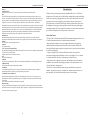
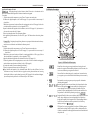
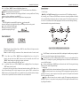
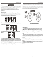
1
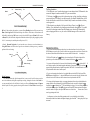
POLARIS USER MANUAL
Model: Xr-5DC
The prime meridian runs from the north to south pole through Greenwich, England.
Magnetic North
Represent the direction of the north magnetic pole from the observer's position. The direction a
compass points.
Navigation
The act of determining the course or heading of movement which will lead to the user's destination.
Navigation Pointer
A quadrant with a arrow kept pointing to the direction of destination.
Position Fix
The GPS receiver's computed position coordinates.
Prime Meridian
The zero meridian, used as a reference line from which longitude east and west is measured. It
passes through Greenwich, England.
Time To First Fix (TTFF)
If user has not used this GPS unit for several months, the almanac data for the satellites may be out
of date. The unit is capable of recollecting this information on its own, but the process can take
several minutes. Time to First Fix (TTFF) is the time it takes a GPS receiver to find satellites after
the user first turns it on (when the GPS receiver has lost memory or has been moved over 300 miles
from its last location).
Vertical Line
The short line which is silk-screened vertically on the LCD panel symbolizing user's heading.
Warm Start
Power-on sequence when a receiver already has valid almanac data, but must download ephemeris
data for each of the satellites used to establish a position fix.
Waypoints
Waypoints are locations saved in user's GPS unit. These are locations user may later want to return
to or review.
24
Instruction Manual
POLARIS USER MANUAL
WARNING
* Since the device is designed only as part of aid or reference for general outdoor activity, not for the
condition requiring extremely high liability, such as life conservation. It is user's responsibility to
judge the navigational capability of the system if the product is used for such purpose.
* Although the unit is meant to be waterproof, user should not try to immerse it into water or use it in
rainy environment.
* Do not try to make any modification to either the mechanics or the circuitry without any permission
from our distributor.
* User is recommended to read this manual before any use of this unit. Remember to keep this
manual in a proper place for future reference.
* Information in this document is subject to change without notice. Superb Sound Products Ltd
reserve the right to change or improve or modify its products and make changes to the content
without obligation to notify any person or organization of such changes.
CAUTION
Because of long period of shipping, the three accompanying AAA batteries, which are barely charged
for testing before shipping out, and may discharge to empty when arrived, are not guaranteed to
power on the unit successfully after being installed. If this case does happen, you are recommended
to use the accompanying adaptor to charge the batteries before any use. In rare case you are
suggested to press the RESET button if such act of charging fails to turn on the unit.
Table of content
Introduction
M ain Features
O verview
L CD Display Description
B utton Function
Operating Polaris
Battery Installation
T he First Use of Polaris
I n-Depth Use of Polaris
F amiliar With Polaris
T hree-Point and Operation
G PS Navigation Pointer and Digital Compass
D istance
S peed
L ocal Time and GMT
B attery Status
Temperature Display
Application
Specification
Accessories
Glossary
2
3
3
4
5
7
8
8
11
11
11
11
12
17
18
18
19
19
20
21
21
22
POLARIS USER MANUAL
Differential GPS (DGPS)
An extension of the GPS system that uses land-based radio beacons to transmit position
corrections to GPS receivers. DGPS reduces the effect of selective availability, propagation delay,
etc. and can improve position accuracy to better than 10 meters.
Dilution Of Precision (DOP)
A measure of the GPS receiver/satellite geometry. A low DOP value indicates better relative
geometry and higher corresponding accuracy. The DOP indicators are GDOP (geometric DOP),
PDOP (position DOP), HDOP (horizontal DOP), VDOP (vertical DOP), and TDOP (time clock
offset).
Distance
The length between two waypoints or from your current position to a destination waypoint. This
length is measured in great-circle (over the earth) terms.
Elevation
The distance above or below mean sea level.
Ephemeris Data
Current satellite position and timing information transmitted as part of the satellite data message.
A set of ephemeris data is valid for several hours.
Greenwich Mean Time (GMT)
The mean solar time for Greenwich, England, which is located on the Prime Meridian (zero
longitude). Based on the rotation of the earth, GMT is used as the basis for calculating standard
time throughout most of the world.
Heading
The direction in which user is facing or traveling.
Home 0
The starting location which user marks as the first waypoint when undertakes a navigating travel.
Home Point
Previous location which user marks as a certain waypoint when navigating.
Hot Start
The power-on sequence when a GSP receiver has valid almanac and ephemeris data.
Latitude
A position's distance north or south of the equator, measured by degrees from zero to 90. One
minute of latitude equals one nautical mile.
Longitude
The distance east or west of the prime meridian (measured in degrees).
23
POLARIS USER MANUAL
Glossary
Acquisition Time
The time it take a GPS receiver to acquire satellite signal and calculate the initial position.
GPS
The Global Positioning System (GPS) is a satellite-based navigation system made up of a network of 24
satellites. GPS satellites circle the earth twice a day in a very precise orbit and transmit signal information to
the earth. GPS receivers take this information and compares the time a signal was transmitted by a satellite
with the time it was received. The time difference indicate how far away the satellite is. With distance
measurements from a few more satellites, the receiver can determine the user's position. GPS receiver must be
locked on to the signal of at least three satellites to calculate a 2D position (latitude and longitude) and track
movement. With four or more satellites in view, the receiver can determine the user's 3D position (latitude,
longitude and altitude). Once the user's position has been determined, the GPS unit can calculate other
information, such as speed, bearing, track, trip distance, distance to destination.
Almanac Date
Information transmitted by each satellite on the orbits and state (health) of every satellite in the GPS
constellation. Almanac data allows the GPS receiver to rapidly acquire satellites shortly after it is turned on.
Altitude
The elevation of a certain geographic location.
Azimuth
See compass bearing.
C/A Code (Coarse/Acquisition Code)
The standard positioning signal the GPS satellite transmits to the civilian user. It contains the information the
GPS receiver uses to fix its position
And time, and is accurate to 100 meters or better
CEP
Circular Error Probability,
Cold Start
The power-on sequence where the GPS receiver downloads almanac data before establishing a position fix.
Compass Bearing
The direction to the magnetic north of digital compass.
Coordinates
A set of numbers that describes your location on or above the earth. Coordinates are typically based on
latitude/longitude lines of reference or a global/regional grid projection.
Coordinated Universal Time (UTC)
Replaced Greenwich Mean Time (GMT) as the world standard for time in 1986. UTC uses atomic clock
measurements to add or omit leap seconds each year to compensate for changes in the rotation of the earth
Current Point
User's current location which will be marked as a waypoint
Deviation Angle
A signed value which depict the degrees user's traveling off desired course when navigating. If user departs
from the desired course to its right side, a negative angle will appear; if user departs from the desired course to
its left side, a positive angle will appear.
22
POLARIS USER MANUAL
Introduction
Thank you for choosing this unique and exquisite handheld GPS receiver. The Polaris is
designed as an aid for outdoor activities like hunting, camping, hiking or other undertakings
which involve positioning. Equipped with it on travel, you are informed with your current
geographic position, direction leading to your destination, compass, distance passed,
speed, temperature, local and GMT time. Before clutching it in hand when you can't resist
the temptation of ousting, please go through the user manual, and you can go through the
world without getting lost. The user manual will introduce you to the functions and features
of the Polaris, and acquaint you with the procedures of how to use it.
Polaris Main Features
- The Polaris has 12 channels and a built-in GPS patch antenna, making it possible to track
12 satellites simultaneously and offer reliable positioning information.
- Integrated into this compact device is also a magneto-impedance censor, replacing
traditional mechanical compass while allowing the system to combine GPS data with
bearing of the digital compass to guide user in proper direction, either toward his destination
or back to his starting point.
- A large vivid graphic LCD, divided into different data fields, conveys detailed
environmental and geographic information to user on a single glimpse. Five user-buttons
are located on both side respectively, enabling owner to operate with ease.
- A temperature sensor is applied to provide extra and immediate source of information.
In addition, a microcontroller-based charging technique is also employed here to secure
a fast and safe battery recharge process.
- The Polaris is a very mechanically compact design, which makes it waterproof and,
thanks to inner suspensory structure, shockproof too. Another considerate feature is its
multi-portability, user can hold in hand, hang from neck or hook to clothes.
3
POLARIS USER MANUAL
POLARIS USER MANUAL
Specifications
Overview
Acquisition Time:
L1 band (1575.42MHz),
C/A code, 12-channel
Hot start: <10sec
Warm start: < 40sec
Cold start: <120sec
Update Rate:
1 Hz, continuous
Accuracy:
Position : 10m CEP S/A off
Velocity : 0.1/sec S/A off
Time :
1ms
Built-in patch
131.4mm (H), 61.8mm (W)
28mm (D),
Three 1.5V AAA Batteries
16 hours
-15 0C to + 70 0C
GPS Receiver:
Antenna:
Physical Size:
Power:
Battery Duration:
Temperature Range:
Figure 1: Outer Case Description of Polaris
Figure 2: Inner Body Description of Polaris
4
21
POLARIS USER MANUAL
Application Example of Polaris
Example one Navigating through a short distance (about 180 meter) to a destination with a
difference in latitude and longitude of 0.1minute from the starting point.
Procedure:
1. Take the unit outside in an open area, press "Power" button to turn on the unit;
2.Calibrate the digital compass (refer to OP8 at page 15), a process which is not necessary if
done before;
3. Mark down your current location as Home 0 or starting point (refer to OP1 at page 9) when the
unit obtain the first position fix. (refer to Appendix TTFF);
4.Input the latitude and longitude of the destination (refer to OP5 at page 10): just increase or
decrease the current value by 0.1minute.
5.Move in pointing direction of the Navigation Pointer.
6.On approaching the destination (10 meter CEP), press "OK" button when the arriving alarm
sounds.
POLARIS USER MANUAL
LCD Display Description
1
2
3
4
17
5
16
6
15
7
8
9
Example Two Navigating through a long distance to a purported destination and on the way
mark down several location and calculate the distance passed.
Procedure:
1.Take the unit outside in an open area, press "Power" button to turn on the unit;
2.Calibrate the digital compass (refer to OP8 at page 15), a process which is not necessary if
done before;
3.Mark down your current location as Home 0 or starting point(Refer to OP1 at page 9) when
the unit obtain the first position fix. (refer to Appendix TTFF);
4.Input the latitude and longitude of the destination (refer to OP5 at page 10);
5.Under the guidance of the navigation pointer, move as far as 50 meters from the starting point
and mark down current location as Home 1(refer to OP2 at page 9);
6.Continue for another 50 meters and mark down Home 2;
7.Show the just passed distance (refer to OP8 at page 15)
Note: latitude and longitude of the destination must differ from that of Home 0 at least
0.02minute or it may cause the Polaris to trigger the arriving alarm without user's moving
which result in failure to stop the alarm by pressing "OK" button. If such condition do happen,
just walk way from the point as far as 15meter and press "OK" Button.
14
13
11
12
Figure 3: LCD Data Field Description
‡@
‡A
‡B
‡C
‡D
‡E
20
10
Home Point Icon, acting as a waypoint indicator, showing the total
number of waypoints. When installing the battery for the first time, it is
in zero state, indicating no waypoint saved before.
Current Point Icon, functioning as key to mark user's current location
as a waypoint, a process which will make the Home point icon count by
1.
Destination Icon, using as a gateway to input a specific destination
(latitude and longitude).
Latitude Data field, after a successful start (the first position has been
fixed or GPS signal icon
become stable), always display user's
current latitude; before that it keep display the latitude of the last
position fix.When installing batteries for the first time and before the
first position fix,this field keep showing zero degree.
Longitude Data field, after a successful start (the first position has been
fixed), always display user's current longitude; before that it keep
display the longitude of the last position fix. When installing batteries
for the first time and before the first position fix, this field keep
showing zero degree
.
GPS signal icon, acting as a position fix indicator. If blinking, means
that the unit is tracking the GPS signal, yet fails to obtain position fix;
if stable, means that the unit has pinpoint current location and obtained
the position fix.
5
POLARIS USER MANUAL
‡F
‡G
‡H&‡M
‡I
‡J
Navigation pointer, If a specific destination has been input, the arrow of
the pointer will keep pointing in the direction leading to the destination.
When installing batteries for the first time and failing to input a
destination, navigation pointer remains inactive, a state in which the
arrow disappears and the four axes stay right and stable while centered
data field shows the user's orientation.
Compass icon-after calibration, the arrow keeps pointing to the
geomagnetic north. When installing batteries for the first time and
failing to calibrate, it remains fixed in NW, a character centering in the
ring of navigation pointer.
Thermometer Icon, performing as atmosphere temperature indicator,
with the left one showing temperature from -10 to 24 degree in Celsius
or 14 to 76 degree in Fahrenheit, the right one showing from 25 to 60
degree in Celsius or 77 to 140 degree in Fahrenheit.
Distance data field, working as an odometer and straight line distance
calculator. When installing batteries for the time and failing to input a
destination before, it will not record the distance user travel and remain
showing zero. Only when a certain destination is input does the
odometer start recording the distance
that user travel, and at
the same time calculate straight line distance between starting waypoint
to destination
, and also straight line distance between starting
waypoint to user current position
.
Local time clock, acting as the type in common use, hour, minute and
second of which can be set or calibrated according to GMT. When
installing batteries for the first time, it runs from zero.
POLARIS USER MANUAL
Of 15 degrees of longitude centered upon a central meridian. This central meridian for a zone is
defined in terms of its position relative to a universal reference, the GMT (Greenwich Prime
Meridian). In other words, the central median of each zone has a longitude divisible by 15 degrees.
The number of hours that must be added or subtracted from local civil time in the zone to
Greenwich time depending on East longitude and West longitude.
Battery Status Icon
Just below the altitude data field locates the battery status icon. Capacity of batteries in use is
divided into four scales, with icon
Signifying full,
empty. However it's not necessary for
user to recharge the batteries when batteries status icon is empty. The Polaris incorporates lowbattery shutdown technology in its hardware, at the moment when remaining power can not
sustain the whole system, the unit will automatically turn off and save all data.
Since Polaris can be power-sourced both from rechargeable type of batteries, such as NiMH/
NiCd and Non-rechargeable type as Alkaline, it's recommended to pay enough notice to the type
of battery. Remember to push the charging switch to lower side when installing non-rechargeable
battery.
To charge, user should make sure rechargeable batteries are in use and charging switch in the
upper side. When batteries is charged to full, Icon.
Will keep blinking, system will
automatically reduce charging current to a very low value so that no damages will be caused when
user fail to remove the charging plug from the charging port.
Note: When in use or because of low battery shutdown, removing batteries
from the unit for a shot time will not cause losses of geographic information,
navigational and timing data,however force the local time clock to stop running
and therefore cause a delay of time slot when reinstalling batteries to the unit.
‡K
‡L
‡N
‡P
Greenwich Mean Time, after a successful start (the first position has
been fixed), synchronize the time retrieved from GPS satellite
transmitted data which is in accordance with the universal time
coordinate. If GPS signal fails to reach the unit (or GPS signal icon
start blinking), it stop running and keep showing the time, until having
tracked the GPS signal again.
Speed data field, functioning as speedometer, displaying the instant
speed of the unit after a successful start.If GPS signal fails to reach the
unit (or GPS signal icon
start blinking), the value of it will fail to
reflect the real speed of the unit until having tracked the GPS signal
again.
Satellite Icon, after a successful, the number of it indicates how many
satellites are being tracked. As soon as GPS signal is obstructed from
reaching the unit, all the icon will disappear from the display.
Battery icon, performances as remaining battery power indicator with
icon
signifying full power,
empty power.
Altitude data field, after a successful start (the first position has been
fixed), always display user's current altitude; before that it keep display
the altitude of the last position fix. When installing batteries for the first
time and before the first position fix, this field keeps showing zero.
6
Figure 13: charging process
Figure 14: Thermometer
Thermometer
Figure 14 illustrates the Polaris's thermometer which is divided into two graded bars with
different range of temperature joined at 24 Celsius degree. The left signifies the celsiur scale from
ten below zero to 24 degrees above zero while right signifies from 25 to 60 degree above zero.
19
POLARIS USER MANUAL
OP9---Use "Up" or "DOWN" button to highlight the distance icon
(refer to S4 in figure4), press and release "SET" button, distance icon will shifted to
, while the distance will correspond to it.
___ cumulative distance between starting point Home 0 to current point Home N. During
navigation, to show such distance just act like OP9.
Note : Inaccurate distance will result if GPS signal is lost during navigation.
Speed
With GPS signal being acquired (GPS signal icon
become stable
Instead of blinking) the speed data field displays the instant speed relative to the ground.
Note: the value of speed will Remain
unchanged at the moment of losing GPS
signal until reacquiring GPS sigal.
Figure 10: Speed Data Field
POLARIS USER MANUAL
Buttons Function
1. Mono Keying
,
'Up' and 'DOWN' button: In busy state (certain icon of LCD is blinking, waiting for
key-entering) press 'UP' button or 'DOWN' button to increase or decrease digit number. In standby
state (no icon blinking or no keying for at least 3 seconds), presses 'UP' or 'Down' button to select
one of the five icons showed in the following diagram. Selected icon will be blinking, indicating
that this data field is being activated for data input.
Timer 1 and Timer 2
Figure 11:Timer1
Figure12: Timer 2
Timer 2 displays Greenwich Mean Time or GMT, The value of Timer 2 will stop to run at the
moment of losing GPS signal.
Timer 1 is similar to the type in common use. Hour, minute and seconds of it can be set and
reset.
Op10 ---To set Time 1, press "UP" or " DOWN" button to highlight Timer1 icon (refer to S5 in
figure4), then press and release "SET" button to enter into data field, then us "UP" and
"DOWN" button to change the digits of hour, minute and seconds.
Timer 1 can also be calibrated with GMT from Time 2.
Op11 ---to calibrate Time 1, press "UP" or " DOWN" button to highlight Timer 1 icon, then press
"SET" button for three seconds.
Such process will correct the value of minute and second according to GMT. Hour of it is
derived from offsetting GMT with the longitude of current position. GMT is collected from
NMEA sentence retrieved from the GPS receiver module. Since the world is divided into 24 major
civil time zones of equal width. Each zone would have an east-west dimension
18
Figure 4: A Cycle of High Lighted Icon in Busy State
-- The SET button is used to activate a data field for a data input. In standby state, pressing the
button for 3 seconds will commence digital compass calibration.
-- The OK button is to confirm a data input and quit. Also it can cycle you through data field in
normal state. ( In standby state, pressing and holding the button will start the Courser function in
case of no MIIC included. )
-- Pressing and holding the POWER button will turn the unit On/Off. Pressing and releasing
will also ignite or darken display backlight.
2. Dual keying
+ Press and hold the two buttons simultaneously for two second to shift measurement unit.
+ Press the two buttons for two seconds to toggle GPS navigation pointer pointing function:
pointing to Point (n-1) (previous point of current point, position of this point has been marked
before) or pointing to Destination.
+
Press the two buttons for two seconds to toggle GPS navigation pointing function:
pointing to Point (n+1) (next point of current point, position of this point has been marked before)
or pointing to Destination.
7
POLARIS USER MANUAL
Operating Polaris
The Polaris unit operates on three AAA batteries , which are located on the back of the
inner body of the unit. Alkaline, rechargeable NiCad and NiMH can all be used. Three
AAA NiMH batteries are accompanying the unit together with a adaptor.
If batteries have been installed when arrived, please remove the plastic currentinsulating flake.
POLARIS USER MANUAL
The difference between the two pictures in Figure9 is: the left one depicts the an inactive
Navigation Pointer with the centered characters denoting user's heading (or compass azimuth),
while the right one depicts an active Navigation Pointer with the centered signed digits calculating
the angle between user's heading and the direction leading to destination.
Battery Installation
1. Hold the upper side of the unit with one hand. While pressing the two flank buttons
with thumb and index finger of another hand, pull and separate the unit into two parts,
the upper part which is fastened with inner body, and the lower part;
2. Use a coin and screw off the metal cover on the back of the inner body, and then insert
the batteries observing proper polarity;
Figure 9: Digital Compass Description
6
5
4
3. Screw on the metal cover, slide the inner body into the outer case until the buckles being
firmly stuck;
9
8
The first battery installation powers on the unit without pressing any button as the
screen display some graphic icon, either static or dynamic. Since the batteries are barely
charged to activate the device, energy stored in them is not enough for long use. You are
recommended to charge the battery for outdoor use.
However you should press and hold POWER button to turn off the unit before the charge
in order to speed charge process and not to discharge wastefully.
8
Compass Calibration:
Op8 Hold the unit on horizontal level, press "SET" button for three seconds, the Latitude
Icon , Longitude Icon
and Altitude Icon
Will start blinking for as long as 15 seconds.
During this process, turn with the unit at an angle of 360 degrees, then press and release "SET"
button and turn in the opposite rotation for another 360 degrees, then press SET button once to
finish..
Such calibration is a must when using the unit for the first time. It is necessary to calibrate the
compass after traveling a long distance or being surrounded by a different environment. It's also
recommended under circumstances when unexpected factors cause compass failure.
Distance
The Polaris offers three types of distance:
___ Straight distance between starting point Home 0 to destination. As soon as Starting
Navigation (refer to Basic Navigation), distance between the two waypoints will be calculated
and displayed in the data field just below the icon.
17
POLARIS USER MANUAL
N-1
Pointer bearing
N+1
Home 0
N
Destination
Case 3: Forward-Tracking
Note 4: In the tracking forward state, system will stop Marking function. When user arrives at
Home N, Arriving Icon will blink and arriving alert will start. At this time, all other button will
be disabled, until pressing 'OK' button to stop it. Once the 'OK' is pressed, Home N will increase
to Home(N+1) and the latitude, longitude and altitude windows display the geographic position
of (N+1) as current point, and the pointer will point to (N+2).
Case 4__ Renewed Navigation:. In previous three cases, whenever a new destination is set,
Navigation Pointer will be forced to target the new destination, allowing user to go under the
guidance of the new bearing.
N+1
N-1
Home 0
N
Destination
Pointer bearing
New Destination
POLARIS USER MANUAL
To Charge batteries:
1. Pull the plastic cover from the charging port, insert adaptor's mini-USB terminal, then
connect the adaptor's another terminal to AC power main socket
2. The battery icon
pop up with its three rating signs cycling, signifying a charging
process underway. If the battery icon fails to appear, you should examine battery select
switch which locates on the left side of the inner body to make sure that the switch stay
on the upper side.
3. When batteries are charged to full, a period of about 5 hours, icon
will start
blinking. User should remove the charging terminal from the charging port. If user fails
to remove the charging terminal from the charging port, the unit will automatically
reduce charging current to a very low value so that no damages will be caused to the
battery.
The First Use of Polaris
1. Take the unit outside in an open area where there is no obstruction from a clear view of sky, press
POWER button to turn on the unit. You will see all the icons pop up on the screen for three seconds. After
the shown-all, then all data field will enter into zero state and the local time clock ‡J is running on.
2. With the GPS signal icon ‡E
blinking, the unit is tracking the GPS signal to obtain the first
position fix, a process which will take a bout 2 to 3 minutes before the icon
to stabilize.
3. As soon as the first position fix is been made, which is hinted by stable icon
, the data field ‡C , ‡D
and ‡P display respectively the latitude, longitude and altitude of your present standing. Several icons
appear, denoting the total number of satellite being tracked; GMT clock ‡K is wakened from the zero state
and synchronized with the time of satellite system.
Case 4: Renewed Navigation
Digital Compass:
User should calibrate the digital compass before it start to work for the first time to use the
unit. After calibration, the digital compass keeps working, bearing the direction of the North. As
you turn around slowly with the Polaris in hand, you will see the Bearing Arrow of Compass
and the Symbol N moving together, showing the direction of the True North as shown in figure
9.
4. To give a real meaning to local time clock, you should calibrate it with the GMT clock: press UP or
DOWN button to highlight icon ‡J , then press SET button for three seconds. After this, local time clock
reflects the hour in user's local area, with its minute and second synchronized with GMT.
5. To activate the digital compass and give you proper explanation of the north, you should calibrate the
compass: Hold the unit on horizontal level, press 'SET' button for three seconds, the Latitude Icon
,
Longitude Icon
and Altitude Icon
will start blinking for as long as 15 seconds. During this process,
turn with the unit at an angle of 360 degrees, then press and release 'SET' button and turn in the opposite
rotation for another 360 degrees, then press 'SET' button once to finish. Icon
become active, with its
arrow kept pointing to the North.
At this moment, you have done all the preparation work. As you walk with the device holding
horizontally in hand and see latitude and longitude changing, speed data field ‡L showing the speed of your
movement.
16
9
POLARIS USER MANUAL
POLARIS USER MANUAL
So far, however, the unit fails to record the distance your walk covered, and can't mark
down waypoints during this walk. In order to enable it to do the jobs, you should first
establish a track, which requires two points: the starting point or Home 0, an d a
destination.
Case 2__ Backtracking : In case 1, when user arrive at a certain waypoint Home N, as shown in
the following diagram, circumstance require him to go back to waypoint Home (N-1). Wanting
unit to guide back to that point, he should act in this way:
Op6--- press and hold 'DOWN' and 'SET' button for two seconds
Such dual keying will make the Navigation Pointer point to Home (N-1) from current
location (Point N). Icon
will disappear while icon centered on the display will appear, as
shown in the right picture of Figure 8.
In-Depth
Use of Polaris
To mark your current position as Home 0:
Press UP or DOWN button once to highlight the home point icon
, then press
and hold 'SET' button for 3 seconds, the latitude, longitude and altitude of your current
position will be stored.
A destination may be specifically picked out from a map or randomly caught in mind.
If you have no specific destination, you are suggested to input a destination with one
minute difference in latitude and longitude from the starting point, say:
N-1
Pointer bearing
N+1
Home 0
N
Destination
Case 2: Backtracking
(Starting Point)
(Destination)
To establish a track without specific destination:
Press UP three times to highlight the Destination Icon
, then press the SET
button once to highlight latitude icon
, then press OK button to enter data field. With
starting latitude remaining on display and figure N or W blinking, press OK four times
to highlight the forth digit (the single minute), press UP button to increase the value by
one minute. Press OK button four times to highlight longitude icon , likewise up
change the longitude by one minute.
To establish a track with specific destination:
Press UP three times to highlight the Destination Icon
, then press the SET
button once to highlight latitude icon , then press OK button to enter data field. Using
UP or DOWN button to change the value you want and confirm by pressing OK button.
Finish the entire input likewise digit by digit.
Note: In this trailing back state, system will stop marking waypoint. When user arrives at
Home (n-1), arriving icon will blink and arriving alarm will be generated. At this time, all other
button will be disabled, until pressing'OK' button to stop it. Once the 'OK' is pressed, Home (N-1)
will decrease to Home (N-2) and the latitude, longitude and altitude windows display the
geographic position of Home (N-1) as current point, and the pointer will point to Home (N-2). So
occurs the same step until, when arriving at Home 0 or in case 3 when forward-tracking has been
triggered.
Case 3___Forward-Tracking: in case 2, when user arrived at waypoint Home (N-1),
Circumstance require the user go back to Home N again. In order to use the unit to guide him back
to Home N, he should act in this way:
Op7 --- press and hold 'UP' and 'SET' button for two seconds. Such dual keying will force the
Navigation Pointer point to Home N from current location Home (N-1).Icon
will
disappear while icon Centered on the display will appear, as shown in the left picture of
Figure 8.
After a destination has been input, the navigation pointer‡F is activated with its arrow
pointing to it, signifying that user following this direction will arrive at the destination
ultimately. The straight distance between Home 0 and the destination
also
appears in the distance data field ‡I .
Now you can use the device to mark down waypoints if you talk a walk from the Home 0,
and the unit will measure distance the walk cover symbolized with icon
or
.
To mark your current standing location as a waypoint
Press UP button twice to highlight the Current Point icon
, then press and
release SET button.
Such operation will causes the home point icon
to increase by one
10
.
15
POLARIS USER MANUAL
POLARIS USER MANUAL
To see the distance you walked from the starting point to current position
Use UP button four times to highlight icon
, press SET button once, distance
icon will change to
with the data below it showing the straight line distance;
press SET button twice, distance icon
will change to , with data below it
showing distance of zigzag course.
Familiar with
Figure 8: Navigation Pointer function
Navigation Operation
In light of the two function of the Navigation Pointer, four specific cases are discussed here:
Case 1___Basic Navigation: After marking Home 0 (OP1) and entering a destination (OP5), a
process called Starting Navigation, Navigation Pointer will be triggered and keep pointing in
the direction leading to the destination. Icon
centered on the screen will appear too, as showed
in left picture of figure 8.
Three Waypoints and their Operations
When using Polaris to mark down certain location, we call this location as a waypoint,
geographic position of which is saved and reviewable for future reference.
Polaris features three waypoints on top of its LCD as illustrated by Figure 5: Home Point,
Current Point and Destination. Just immediate below the three waypoint icons are the Latitude,
Longitude and Altitude data field which always display the geographic position of user's current
location, except when reviewing the waypoints saved before.
In order to mark and save current location as a waypoint, first user must use the Home Point icon to
mark down current location as Home 0 or starting point, then enters a proposed destination
through Destination icon, thereafter using Current point icon to mark every location in passing and
save as Home N.
Current Point
Pointer bearing
Destination
Figure 5: Three Points Date Field
Case 1: Basic Navigation
Note: in this exploration state, system will automatically or manually mark down the
geographic position you passed, with Home (N) counting the waypoints. When user arrives at
Destination, the Arriving Icon will blink and Arriving alarm will be generated, until press 'OK'
button to stop it.
14
Home Point ( Home 0 to Home 999 ):
Total 2000 waypoints can be marked here.
Is starting point or Home 0.
To
is waypoint of the second to 1000 th; while
to
is the 1001st to 2000th waypoint you
marked down before.
OP1---Mark Home 0: Highlight the "Home point icon"
(refer to S1 in Figure4) and then
press and hold "SET" button for 3 seconds, the latitude, longitude and altitude of your current
position will be stored and displayed.
NOTE : Marking Home 0 confirms that a new start will be made and all the data saved before
will be deleted completely. So occurs the following procedure:
11
POLARIS USER MANUAL
Current Point:
OP2--- T o mark your current location as a waypoint,use ' UP' or 'DOWN' button to highlight the
Current Point icon
(refer to S2 in figure4), press and release 'SET' button. Such operation
will function only after destination has been entered, a state defined as navigation, and causes the
Home N to count by one Home N+1 , say:
POLARIS USER MANUAL
Working theory about Navigation Pointer:
There are three ways of marking a waypoint:
_Auto-marking: the unit will automatically mark user's current location as waypoint according
to set marking interval, minimum of one minute;
_Manual-marking: the operation OP2 is the manual-marking;
_Combined-marking: such setting will enable both the Auto-marking and Manual-marking to
function simultaneously.
Op3---to set the way of marking location, use 'UP' or 'DOWN' button to highlight the Current
Point icon
(refer to S2 in figure1), press and holds 'SET' button for 3 seconds, then you will
enter into the setting mode of marking current location. The following figure shows the relevant
procedure.
Figure 7: Navigation Pointer Description
Figure 6: Setting Marking Mode
OP4---To review a certain waypoint marked down and saved before: Highlight Home Point
icon
(refer to S1 in Figure4), press and release 'SET' button, then the three digit number
will be blinking, using 'UP' and 'DOWN' button to select the waypoint number you want and the
latitude,longitude,altitude and GMT data field correspond to the waypoint simultaneously. When
using 'OK' button to leave, the lat/long/alt data field show the current location again.
Destined Point: The latitude, longitude and altitude of proposed destination is to be input here.
OP5---T
sing'UP' or 'DOWN' button to highlight the Destination Icon
(refer to S3 in figure 4), press the 'SET' button once to go to the latitude icon
, then press
'OK' button to input data. Remember that every input must be confirmed by pressing 'OK' button.
After the input of latitude and longitude is completed, the Navigation Pointer centered in the
LCD screen will point to the proposed destination at the direction you should be heading. And also
the distance between starting point and destination will be displayed in the Distance data field.
When using the Navigation function, the Polaris required you to hold it rightly before you,
with the Vertical Line in alignment with the direction you face or head. Otherwise it may guide
you to a wrong destination. On the top of the above diagram there is the Vertical Line which
symbolizes the direction you are heading. If a Destination is just input, the Navigation Pointer
will keep pointing to it. Only if you are heading rightly toward the destination, the Navigation
Pointer will point straight up and the arrow will align with the Vertical Line. If only you deviate
from the direction to your destination, a Deviation Angle will occur and be shown in the center of
the ring. A specific circumstance is depicted by the left picture of the
following diagram in which the Destination is targeted. The right picture illustrates another
circumstance in which Home (n-1) (previous waypoint) is targeted and user is going back.
Centered in the ring is the Deviation Angle.
GPS Navigation Pointer and Digital Compass
When a proposed Destination is input, The Polaris can guide you to that point. Also it can guide
you back to your starting point. To navigate to a destination simply follow the Navigation Pointer.
The Navigation Pointer will always point directly to the Destination, no matter what your
current location might be.
12
13