1
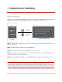
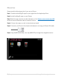
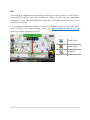
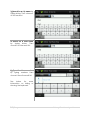
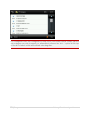
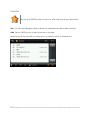
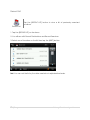
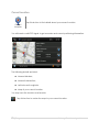
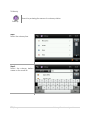
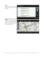
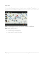
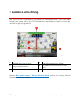
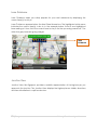
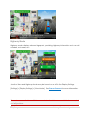
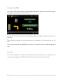
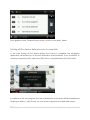
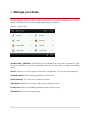
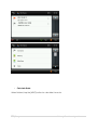
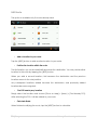
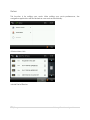
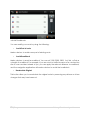
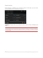
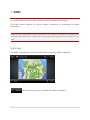
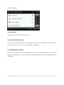
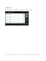
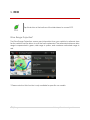
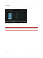
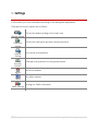
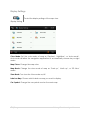
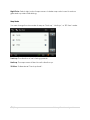
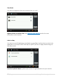
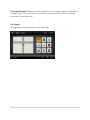
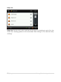
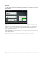
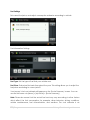
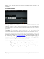
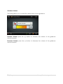
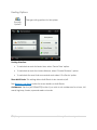
EnGIS Technologies, Inc. Navigation BringGo Korea User Manual Version 1.5.2 CONTENTS 1. Connecting your Smartphone .................................................................................. 4 How BringGo Works ....................................................................................................... 4 iPhone User ..................................................................................................................... 5 Android Smartphone User ............................................................................................ 6 2. Getting Started ........................................................................................................... 7 Navigation Application................................................................................................. 7 Caution Screen .............................................................................................................. 7 Finding your location with GPS .................................................................................... 8 Map screen features – Driving Guidance Mode .................................................... 10 Multi-Route .................................................................................................................... 11 3. 4. Menu ......................................................................................................................... 12 Plan a Route.............................................................................................................. 13 Address .......................................................................................................................... 13 How to find Cross Streets / Intersections .......오류! 책갈피가 정의되어 있지 않습니다. All search options ......................................................................................................... 16 Single Line Address ..........................................오류! 책갈피가 정의되어 있지 않습니다. POI .................................................................................................................................. 18 Favorites ........................................................................................................................ 20 Recent List ..................................................................................................................... 21 Home / Office .............................................................................................................. 25 Current Location .......................................................................................................... 26 Coordinates .................................................................................................................. 26 Map view ...................................................................................................................... 27 5. Guidance while Driving ........................................................................................... 28 Lane Guidance ............................................................................................................ 29 Junction View ............................................................................................................... 29 Turn by Turn (TBT) .......................................................................................................... 30 Turn List........................................................................................................................... 31 Turning off the device before journey is complete................................................. 32 2|Page BringGo Navigation 6. Manage your Route ................................................................................................. 33 Create Route ................................................................................................................ 34 Edit Route ...................................................................................................................... 35 Detour ............................................................................................................................ 36 Route Summary ............................................................................................................ 37 7. Traffic ........................................................................................................................400 Traffic Map .................................................................................................................... 40 Traffic Settings ............................................................................................................... 42 8. ECO ........................................................................................................................... 43 Drive Range Projection* .............................................................................................. 44 Fuel Status* .................................................................................................................... 44 9. Settings ...................................................................................................................... 45 Display Settings ............................................................................................................. 46 Guidance Settings ....................................................................................................... 51 Vehicle Setting ............................................................................................................. 57 Routing Options............................................................................................................ 58 Home and Office ......................................................................................................... 59 Traffic Settings ............................................................................................................... 59 Exit navigation .............................................................................................................. 59 10. User information and precautions .......................................................................... 60 11. Copyright .................................................................................................................. 62 12. Contact ..................................................................................................................... 63 3|Page BringGo Navigation 1. Connecting your Smartphone How BringGo Works BringGo is a connected navigation solution. Connected navigation means that your smartphone must be connected to the MyLink infotainment unit to work. 1. Install App 2. Download Maps 3. Install maps For iPhone connection For Android connection Smartphone 1. Connect the smartphone to MyLink 2. Tap ‘Smart Link’ then ‘BringGo’ 3. BringGo Service starts MyLink infotainment unit Step 1: Download the BringGo app for your region from the Apple App Store or an Android app store. Step 2: Install the BringGo app on your smartphone. Step 3: Download and install the maps that you wish to use. Step 4: Connect your smartphone to the MyLink infotainment unit using Bluetooth for Android smartphone or USB for iPhone. Step 5: Tap [SMARTPHONE LINK], then tap [BRINGGO] to begin the navigation service. Please try to avoid using other apps on the smartphone while the BringGo app is running. Using other apps on the smartphone while the BringGo app is running may cause connectivity issues between the smartphone and the MyLink infotainment unit. 4|Page BringGo Navigation iPhone User Please read the following section if you use an iPhone. Step 1: Download the BringGo app for your region from the Apple App Store. Step 2: Install the BringGo app on your iPhone. Step 3: Start the app and turn Location Services on. See FINDING YOUR LOCATION WITH GPS section for more information about Location Services. Step 4: Choose the maps you wish to download and install. Step 5: Connect your iPhone to the MyLink infotainment unit using an iPhone USB cable. Step 6: Tap [SMARTPHONE LINK], then tap [BRINGGO] to begin the navigation service. 5|Page BringGo Navigation Android Smartphone User Please read the following section if you use an Android smartphone. Step 1: Download the BringGo app for your region from an Android app store. Step 2: Install the BringGo app on your Android smartphone. Step 3: Start the app and turn Location Services on. See FINDING YOUR LOCATION WITH GPS section for more information about Location Services. Step 4: Choose the maps you wish to download and install. Step 5: Turn on Bluetooth on your smartphone. Step 6: On the MyLink infotainment unit, go to [SETTINGS] > [CONNECTION SETTINGS] > [BLUETOOTH SETTINGS] > [PAIR DEVICE] > [SEARCH BLUETOOTH DEVICE]. Step 7: After a few moments, your Android smartphone should appear in the list. Tap the smartphone name and then accept the pairing requests to enable the connection. Step 8: On the MyLink infotainment unit, tap the [SMARTPHONE LINK] on the main menu, then tap [BRINGGO] to begin the navigation service. If the MyLink infotainment unit cannot find the Bluetooth-enabled phone, please check that discoverable mode is turned on in the Bluetooth Settings of your phone. 6|Page BringGo Navigation 2. Getting Started Navigation Application To start navigation, simply tap the [BRINGGO] navigation icon on your MyLink infotainment unit. Caution Screen After navigation starts, you will see the caution screen as shown above. You must agree to the safety terms and conditions in order to use the navigation application. If you tick the ‘Auto OK’ box, the next time you launch the navigation application the caution screen will disappear after a few seconds. 7|Page BringGo Navigation Finding your location with GPS Location Services You need to allow BringGo to use your phone’s Location Services for the navigation application to work. To access and enable the Location Services on your phone: • iPhone: [SETTINGS] > [GENERAL] > [LOCATION SERVICES] = ON • Android smartphone: [SETTINGS] > [LOCATION SERVICES] > [USE GPS SATELLITES] = ON 8|Page BringGo Navigation GPS The navigation application automatically locates your current position on the map by receiving GPS signals from your smartphone. When you first start the navigation application, it may take several minutes to find your GPS position and show your current location on the map. If the navigation application doesn’t receive GPS signals properly, it could take some time to locate your current position. Please see USER INFORMATION AND PRECAUTIONS section for further information on GPS. Good Signal Weak Signal No Signal 9|Page BringGo Navigation Map screen features – Driving Guidance Mode 1 Back button. 2 Compass: Tap this icon to change the map display mode to Track up, 9 North up or 3D view. Estimated Time of Arrival (ETA) and Time To Go. 3 Voice Guidance On / Off. 10 First Turn-by-Turn instruction: Indicates the next turn direction. 4 Zoom In (+) / Zoom out (-). 11 Second Turn-by-Turn instruction: Indicates the next turn direction. 5 Map Scale. 12 The name of the next street to turn onto. 6 Menu button. 13 Lane guidance. 7 Distance To Go and Total Distance. 8 Current street name / Destination. * Please note that this function is only available for specific car models. 10 | P a g e BringGo Navigation Multi-Route When enabled, the Multi-Route screen will appear each time you set a new destination. The Multi-Route screen can be turned on or off in SETTINGS: [MENU] > [SETTINGS] > [GUIDANCE SETTING] > [SHOW MULTI-ROUTE]. 1 Destination address. 5 When the route type has been selected, tap the [NEXT] button to begin guidance using this route type. 2 Color coded map of route types. 6 Nearest Gas Station POI list. 3 Avoidance options. 7 Fuel Indicator for route type* (Green = Sufficient fuel). 4 Estimated drive range* 8 Fuel Indicator for route type* (Red = Insufficient fuel). * Please note that this function is only available for specific car models. Route Type: Allows you to choose from several route types: Faster Time, Shorter Distance, or Eco Route. Please note that the ETA and distances are an approximation only, and may be incorrect. 11 | P a g e BringGo Navigation 3. Menu The main menu can be accessed by tapping the [MENU] button on the map screen. The main menu allows access to all search options as well as route management, traffic information, ECO and Settings. 12 | P a g e BringGo Navigation 4. Plan a Route Address Tap the [ADDRESS] button on Main Menu to plan a route by entering an address. Address 1. Select ‘Address’ on Menu screen. 2. Select Province. The default province is based on your current location. For subsequent searches, the last used province name and city name are shown. If you would like to change state/province, tap the “State Name” button. For province search, you can search by the full name. 13 | P a g e BringGo Navigation 3. Search for a city name by typing letters. Then choose it on the result list. 4. Search for a town name by typing letters. Then choose it on the result list. 5. Type the House number by typing numbers then choose it from the result list. See below for more information on hiding or showing the keyboard. 14 | P a g e BringGo Navigation 6. Confirm the province, city, town and house number choices on the top of the screen and refer to map of the location. Tap [Go] if you wish to route to this location directly. The keyboard may be hidden or shown at any time during address entry. You may wish to hide the keyboard to see all items in the result list. Simply tap the keyboard icon on the top-right of the screen, or tap anywhere in the visible area of the result list area. 15 | P a g e BringGo Navigation All search options 오류! 참조 Search by entering a POI Name. 원본을 찾을 수 없습니다. Search by entering an address in steps: City > Town > House number. ADDRESS View a list of previously searched locations. RECENT LIST Tap this button to access or manage your favorite locations. FAVORITES Search for a POI Category, such as a restaurant or hotel. POI Go to your Home or Office address. HOME / OFFICE CURRENT LOCATION 오류! 참조 View details on your current location (needs a valid GPS signal). Search by entering the name of a subway station. 원본을 찾을 수 없습니다. 16 | P a g e BringGo Navigation POI Name Search by entering a POI name. POI Name The previously searched state/province name and city name are initially selected. If you want to change state/province or city, tap the State or City button. Type the POI Name you wish to search for then tap the [NEXT] button. It will list POI names corresponding to the letters you’ve typed. Select one of the POI names that you are searching for then you will see a list POIs. Choose one, and then tap [NEXT] button. Once you have entered the POI name, simply select the relevant entry from the result list. If you choose to use the Google search option, please be aware that you will be connecting to the internet and data communication fees may be incurred. 17 | P a g e BringGo Navigation POI Category POI Category Tap the [POI Category] icon on the Main Menu to search by POI(Point of Interest) Category You may search for a POI using a variety of different POI categories. Search by Category: You can search for POIs near your current location using the POI category search. First, simply select the category you wish to use; for example ‘Medical’, then select a POI from the result list. The distance and direction to the POI is displayed on the left. You may sort the results by distance or in alphabetical order. 18 | P a g e BringGo Navigation POI categories have sub categories to help focus your search better. Simply tap the sub category you wish to search, or, alternatively choose the ‘ALL…’ option at the top of the list to search within all the listed subcategories. 19 | P a g e BringGo Navigation Favorites Tap the [FAVORITES] button to select or add a Favorite as your destination. Favorites Sort: You can sort existing favorites by distance, alphabetical order or date created Add: Tap the [ADD] button to add a favorite to the app. When saving a new favorite, you may give it a name by which to remember it. 20 | P a g e BringGo Navigation Recent List Tap the [RECENT LIST] button to view a list of previously searched locations. Recent List 1. Tap the [RECENT LIST] on the Menu. 2. You will see a list Recent Destinations and Recent Searches. 3. Select one of locations on the list then tap the [NEXT] button. Sort: You can sort the list by the date created or in alphabetical order. 21 | P a g e BringGo Navigation Home / Office To set an address for your Home and/or Office, go to the SETTINGS screen. The setting menu is available on the bottom tab of the Main menu. Settings When the addresses have been programmed, you can then plan a route to your home or office simply by tapping the respective icon on the main menu. Go to your office address Go Office Go to your Home address Go Home 22 | P a g e BringGo Navigation Current Location Tap this button to find details about your current location. Current Location You will need a valid GPS signal to get accurate and current positioning information. The following details are listed: Nearest Address; Nearest Intersection; Latitude and Longitude; Map of your current location. You may save this location as a favorite. Tap this button to center the map to your current location. 23 | P a g e BringGo Navigation Tap this button to go to emergency POIs such as a hospital or police station. Select the relevant emergency POI category. The navigation will then calculate a route directly to the nearest emergency POI. 24 | P a g e BringGo Navigation Subway Search by entering the name of a subway station. Subway Step 1 Select the subway line. Step 2 Select the subway station name on the result list. 25 | P a g e BringGo Navigation Step 3 Select the exit number of the subway station you wish to travel to. Step 4 Confirm the station name with exit number and refer to map of the location. Tap [Go] if you wish to route to this location directly. 26 | P a g e BringGo Navigation Map view Tap a point on the map to choose a location as your destination. The address of the point you choose is displayed in a grey information box directly above the point you chose. Route: Choose to add the location as a Start point, Waypoint, or destination. More: Tap the [MORE] button to: Save the location as a Favorite, or Search for a POI nearby this location. 27 | P a g e BringGo Navigation 5. Guidance while Driving After you have set a destination, the system will calculate a route. Once you begin moving, the system will use the GPS information to update your position on the map and start to give you guidance. ㅡ 1 Highlighted route to follow. 3 Indicates the next turn to take. 2 Your current location. 4 The name of the next street to turn onto. See the MAP SCREEN FEATURES – DRIVING GUIDANCE MODE section for a more detailed description of all map objects. 28 | P a g e BringGo Navigation Lane Guidance Lane Guidance helps you safely prepare for your next maneuver by displaying the correct lane(s) to stay in. Lane Guidance appears below the Next Street Name box. The highlighted white arrow indicates the correct lane(s) to be in. In the example below, there is one highlighted lane making a U-turn; this is the correct lane to stay in for the upcoming maneuver. The other four grey lanes are going straight. Lane Guidance Junction View Junction View, like Signposts, provides a realistic representation of the highway as you approach the junction. The Junction View displays the highway lanes, shields, directions, and lane information in a split mode view. 29 | P a g e BringGo Navigation Highway Mode Highway mode displays relevant signposts, providing highway information such as exit numbers, rest areas, etc. Junction View and Highway Mode may be turned on or off in the Display Settings. [Settings] > [Display Settings] > [View Mode]. See DISPLAY SETTINGS for more information. Please be aware that Lane Guidance and Junction View are available for some, but not all junctions. 30 | P a g e BringGo Navigation Turn by Turn (TBT) The Turn by Turn screen offers a more simplified guidance mode. To access this screen, tap [Menu] > [My Route] > [Turn by Turn]. The Turn By Turn screen presents an enlarged maneuver image and text to indicate the next turn. The distance remaining to the next maneuver is indicated by the distance bar on the left. The second maneuver is displayed at the top of the screen with a smaller image and text. Turn List The Turn List presents a full list of all maneuvers for the journey. This screen may be accessed by tapping the [LIST] button in the Turn by Turn screen (see above). 31 | P a g e BringGo Navigation Each graphic shows ‘Distance from position’ and the ‘next street’ name. Turning off the device before journey is complete. In the case turning off the device before the journey is complete, the navigation application will remind you of the last destination when restarted. If you would like to restore your previous route, select the [YES] button, otherwise select the [NO] button. In addition to this, any waypoint that was unreached in the journey will be remembered. By going to [Menu] > [My Route], you can check waypoints and destination points. 32 | P a g e BringGo Navigation 6. Manage your Route Routing Options may be used to create a new route or to edit an existing route. Create Route / Edit Route buttons will change depending on situation. [Menu] > [My Route] Create Route / Edit Route: [Create Route] is available if a route has not been set. [Edit Route] is available if a route has already been set. Use this option to edit your existing route. Detour: Allows you to avoid part of the route, a roadblock, or to set a travel waypoint. Simulation Mode: Starts a driving simulation of the route. Route Summary: Go to the route summary screen. View Route: Displays an overview map of your complete route. Turn by Turn: Displays a simplified guidance mode with no map. Clear Route: Deletes the current route. 33 | P a g e BringGo Navigation Create Route This option is available if no route has been set. • Add a Location to your route Tap the [ADD] button to add a location to your route. For short routes, you may add up to 5 waypoints. • Position the location within the route The first location you set automatically becomes the destination. You may add another location to this route by tapping the [ADD] button. When you add a second location, this becomes the destination and the previous location moves to the start position. Any subsequent locations added become the destination, and previously added locations become waypoints. 34 | P a g e BringGo Navigation • Calculate Route When finished, tap the [NEXT] button to calculate the route. 35 | P a g e BringGo Navigation Edit Route This option is available only if a route already exists. • Add a Location to your route Tap the [ADD] button to add another location to your route. • Position the location within the route The first location you set automatically becomes the destination. You may add another location to this route by tapping the [ADD] button. When you add a second location, this becomes the destination and the previous location moves to the start position. Any subsequent locations added become the destination, and previously added locations become waypoints. • Find POI nearby any location Simply select the location and choose [Show on Map] > [More] > [Find Nearby POI]. After selecting the POI, it will be added to your route. • Calculate Route When finished modifying the route, tap the [NEXT] button to calculate. 36 | P a g e BringGo Navigation Detour This function is for editing your route. After editing your route preferences, the navigation application will recalculate a new route automatically. <Detour Menu List> <Avoid Part of Route> 37 | P a g e BringGo Navigation <Avoid Roadblock> You can modify your route by using the following: • Avoid Part of route Make a detour to avoid some part of existing route. • Avoid Roadblock Make a detour to avoid a roadblock. You can set 100ft, 300ft, 500ft, 1mi, 2mi, or 3mi as a length of roadblock. For example, if you are stuck in traffic because of a construction site or a car accident ahead of you, you can apply the relevant distance to roadblock, and the navigation application will make a detour to avoid that roadblock. • Recalculate Original This button allow you to recalculate the original route by removing any detours or others changes that may have been set. 38 | P a g e BringGo Navigation Route Summary Route Summary is available on the ‘My Route’ screen. In this screen, you can check route information such as total distance, time, etc. Avoidances: Reroute with road avoidance options such as U-Turns, Toll Roads, and others. <Fuel cost> represents an estimated cost for your trip. Fuel prices and fuel consumption for your vehicle may be adjusted by going to [Menu] > [Settings] > [Guidance Settings] > [Fuel Settings] 39 | P a g e BringGo Navigation 7. Traffic Live traffic will provide up-to-date, real-time traffic information to BringGo. The traffic service requires an active internet connection to download the traffic information. BringGo is not responsible for the accuracy of the traffic information. The application receives traffic data from a traffic service provider and displays this information on the app. Traffic Map The traffic map displays a map with traffic flow on specific roads or highways. Tap the refresh button to update the traffic information. 40 | P a g e BringGo Navigation Traffic Settings Use Traffic Data Select to turn the traffic service on or off. Use Traffic Data while routing Select to turn the traffic service for routing on or off. If this setting is on, the calculated route will take in to account the current traffic conditions. Use Automatic Recalculation Select to turn the automatic recalculation on or off. If this setting is on, the route will may be recalculated if current traffic conditions mean that a more optimal route is available. 41 | P a g e BringGo Navigation Update Interval Select how often you would like to have traffic information updated. 42 | P a g e BringGo Navigation 8. ECO Tap this button at the bottom of the Main Menu to access ECO ECO Drive Range Projection* The Drive Range Projection screen uses information from your vehicle to estimate how far the vehicle can be driven to until the fuel is exhausted. The estimated minimum drive range is represented in green, mid-range in yellow, and maximum estimated range in red. * Please note that this function is only available for specific car models. 43 | P a g e BringGo Navigation Fuel Status* The fuel status screen shows information about your vehicle’s current fuel status. Nearest Gas Station: Provides a list of the nearest fuel POIs. * Please note that this function is only available for specific car models. Drive Range Projection and ECO Driving Profile are an approximation only, and may be incorrect. 44 | P a g e BringGo Navigation 9. Settings In this screen, you can customize the settings of the Navigation application. Descriptions of each option are as follows: Control the display settings of the map view. Display Setting Guidance Setting Vehicle Setting Control the settings for guidance announcements. Set vehicle characteristics. Change routing options for the general system. Routing Options Home Office Set home address. Set office address. Settings for Traffic information. Traffic Settings 45 | P a g e BringGo Navigation Display Settings Control the display settings of the map view. Display Setting Color Mode: Set the color mode of map as ‘Daytime’, ‘Nighttime’, or ‘Auto mode’. Auto mode will allow the navigation application to automatically choose day or night mode. Map Colors: Change the map color. Map Mode: Change the view mode of map as ‘Track up’, ‘North up’, or ‘3D View’ mode. View Mode: Turn Junction View mode on/off. Label on Map: Choose which labels on map you want to display. Car Symbol: Change the car symbol used on the main map. 46 | P a g e BringGo Navigation Color Mode Change the color mode of map as ‘Daytime’, ‘Nighttime’, or ‘Auto’ mode. Daytime: Daytime color mode. Nighttime: Nighttime color mode. Auto: Automatically change the map color. Map Colors You can change the map color.By touching the map images, change day or night color of map screen according to your preference. Then tap the [APPLY] button. Day Color: Select day color of map screen. 47 | P a g e BringGo Navigation Night Color: Select night color of map screen. A darker map color is used to reduce glare and eye strain while driving. Map Mode You can change the view mode of map as ‘Track up’, ‘North up’, or ‘3D View’ mode. Track up: The direction of car is facing upwards. North up: The map screen is fixed to north direction up. 3D View: 3-dimensional ‘Track up Mode’. 48 | P a g e BringGo Navigation View Mode You can turn Highway View and Junction View on or off. Highway Mode & Junction View: See GUIDANCE WHILE DRIVING section for more information on this feature. Label on Map You can turn on/off displaying some labels on map.Select options that you wish to be displayed on the map screen, then tap the [APPLY] button to apply these settings on the map screen. Favorites Symbol & Name: symbols and names of registered place as your favorite. 49 | P a g e BringGo Navigation POI Symbol & Name: Tapping this button will allow you to hide or display POIs based on category type. You can choose to only display your favorite POI types, for example restaurants, fuel stations, etc. Car Symbol Change the car symbol shown on the main map. 50 | P a g e BringGo Navigation Guidance Settings Guidance Setting Control the settings for guidance information. Safety Info: Set which safety warnings will be given. Auto Zoom: You can set the automatic zooming at intersection or on speed. Fuel Settings: Set fuel type, pricing, and vehicle fuel consumption. Guidance Volume: Control the volume of voice guidance instructions. Toll Fee: Set the vehicle type for the calculation of toll fees. 51 | P a g e BringGo Navigation Safety Info: Safety Info: Decide which safety warnings will be given by checking on and off on the check box. Warning guidance will be provided whilst driving for the selected safety warnings. 52 | P a g e BringGo Navigation Auto Zoom You can turn on/off automatic zooming at the intersection and automatic zooming on speed options. On Speed: Automatically adjust map scale level according to the speed of car. The map zooms out to a small scale map when you increase speed; e.g. driving fast on highway. The map zooms in to a large scale map when you decrease speed; e.g. when approaching a junction. At the Intersection: Automatically zoom in/out to a certain map scale level at the next maneuver intersection. Levels: Choose the map scale level you would like to map to auto zoom to. 53 | P a g e BringGo Navigation Fuel Settings Set current fuel price, and adjust consumption estimates according to vehicle. Fuel Information Settings Fuel Type: Set the type of fuel that your vehicle uses. Fuel Price: Fuel prices fluctuate throughout the year. This setting allows you to adjust the fuel prices according to current prices. Your journey’s fuel cost estimate will appear on the ‘Route Summary’ screen. You can access this screen via [Menu] > [My Route] > [Route Summary]. Note: Please be aware that the actual fuel cost may vary according to other factors which affect the fuel consumption; for example, driver behavior, driving conditions, vehicle maintenance, fuel characteristics, and weather. The cost estimate is an 54 | P a g e BringGo Navigation estimate of fuel costs only. Other costs, such as Toll charges are not included in the calculation. Fuel Consumption Settings Fuel Range Reserve: In the Multi-Route screen, there is a fuel icon next to each route type which estimates if there is sufficient fuel available for the trip. You may also set a fuel range reserve, so that you can ensure you arrive at your destination with a sufficient fuel reserve. Consumption: The consumption section allows you to set your vehicle’s fuel consumption. This fuel consumption will then be used in the cost estimate for your trip. Most modern vehicles include a fuel economy label which describes the vehicle’s fuel economy ratings. Alternatively, to find out your vehicle’s fuel consumption, please see the ‘Fuel Economy Guide’ at www.fueleconomy.gov. This guide is published by the U.S. Environmental Protection Agency (EPA) and U.S. Department of Energy (DOE). It contains an extensive listing of most vehicle makes and models. Vehicle consumption is typically expressed as two fuel economy estimates: • City: represents urban driving and driving in stop and-go rush hour traffic. City driving typically consumes more fuel than highway driving. • Highway: represents driving on a mixture of rural and interstate highway driving, typical of longer trips in free-flowing traffic. 55 | P a g e BringGo Navigation Guidance Volume This setting allows you to control the volume level of voice guidance. Increase Volume: press the [+] button to increase the volume of the guidance announcements. Decrease Volume: press the [-] button to decrease the volume of the guidance announcements. 56 | P a g e BringGo Navigation Vehicle Setting Vehicle Setting Set the vehicle characteristics of your vehicle for eco driving efficiency. Vehicle Type: Choose from Coupe/Sedan, Hatchback/Wagon, or Truck/SUV. Vehicle Size: Choose from Small, Midsize or Large Vehicle Wheel Type: Choose from Front Wheel Drive, Rear Wheel Drive, or All Wheel Drive. This setting is used to help define the eco-driving efficiency characteristics for your vehicle. See ECO section for more information. 57 | P a g e BringGo Navigation Routing Options Change routing options for the system. Routing Options Routing Selection: To calculate a route for faster time, select ‘Faster Time’ option. To calculate a route for shorter distance, select ‘Shorter Distance’ option. To calculate the most fuel economical route select ‘Eco Route’ option. Show Multi-Route: This setting allows Multi-Route to be turned on/off. See MANAGE YOUR ROUTE section for more details on Multi-Route. Avoidances: Tap the [AVOIDANCES] button if you wish to set avoidances for u-turns, toll roads, highway, ferries, unpaved roads or tunnels. 58 | P a g e BringGo Navigation Home and Office Set an address for your Home and/or Office. Set your office address Office Set your Home address Home When the addresses have been programmed, you can then plan a route to your home or office simply by tapping the respective icon on the main menu. Traffic Settings Settings for Traffic information. Traffic Setting See 59 | P a g e BringGo Navigation Traffic section for more information. Exit navigation Exit the navigation application. Exit Tap the [Exit] button to completely close the navigation application. 60 | P a g e BringGo Navigation 10. User information and precautions 1. EnGIS is not responsible for any accident that occurs while operating our software. 2. The suggested route and guidance may be different with actual traffic and road conditions. Please drive safely and obey traffic rules. 3. Map screen images and user interface information printed on this manual may not correspond with actual device due to additional features or any modifications. Display colors printed on this manual may appear different with the actual screen color of device in result of manufacture process and printing ink. EnGIS does not warrant that this document is error-free. 4. To prevent GPS signal disturbance, please make sure that you are outside and the GPS antenna has good visibility of the open sky. 5. If you are in the downtown area where buildings are densely crowded, it may cause GPS signal reception disturbance. It is not possible to receive GPS signals in a tunnel, underground parking lot, or enclosed space. 6. Do not place any object near GPS antenna that will cause GPS signal reception disturbance. 7. Some specially coated windshields, such as heat-reflecting windshields, may block the GPS signal reception. 8. Do not install electronic equipment with strongly emitting electromagnetic waves such as a radio wave transmitter near the GPS antenna. 9. The rate of GPS signal reception may be low due to the weather and atmospheric conditions. 10. Do not operate your device while driving. Please drive safely and pay attention to the surrounding traffic and pedestrians. Always observe safe driving practices. 11. This product is designed in aid of safer driving. You may receive speed alerts to help you monitor your speed. EnGIS accepts no liability whatsoever for you receiving any speeding fines or points on your license through using this software. EnGIS does not guarantee the accuracy of the data contained within this database either expressed or implied. 12. Information in this document is subject to change without notice. EnGIS Technologies, Inc. reserves the right to make changes to the navigation application or 61 | P a g e BringGo Navigation make amendments to the content of this document without obligation to inform any organization or user of such changes. 62 | P a g e BringGo Navigation 11. Copyright 1. Copyright and intellectual property rights of all documents written by EnGIS Technologies, Inc. are the property of EnGIS Technologies, Inc. 2. EnGIS Technologies, Inc. has copyright and intellectual property rights of our software and documents including this manual, and the use of product follows license agreement. Product warranty and liability limit are included in license, and more specific subjects can be arranged by a discussion with a staff member in charge. 3. “BringGo“ is EnGIS Technologies, Inc. own brand and is a registered trademark. 4. All names are trademarks or registered trademarks of their respective owners. You cannot infringe ownership without permission. 5. The following contents stated on (A) are EnGIS Technologies, Inc. own technology and property. You cannot use or let a third party use all or any parts of this technology or property for any commercial purpose in any way copying, transmitting, publishing, saving on recovery system, translating into other languages (publishing), distributing, or broadcasting without the express written permission from EnGIS Technologies, Inc. (A) 1. Our navigation software 2. Manual contents 3. All symbols and icons related our Navigation 4. All designs (screen composition, screen arrangement, screen color, screen design) related to our Navigation. Navigation Software © 2012 EnGIS Technologies, Inc. Visit www.engistech.com for the official web site. (B) Data sources © 2012 NAVTEQ. All rights reserved. 63 | P a g e BringGo Navigation Traffic Information Total Traffic Network Data Distribution Services. Total Traffic Network is a mark (or registered mark) of Clear Channel in the United States and other countries and hereby used under license. Text-To-Speech (TTS) Copyright © DIOTEK, SVOX TTS Data Sources and Software Components Data sources and Software components are listed in the ‘About ‘screen of the navigation application. Go to Menu > Settings > About. 12. Contact If you have any issues or any difficulties with our software, please refer to the FAQ section on our website. We will provide support as soon as possible. Website: www.bringgo.com Email: [email protected] 64 | P a g e BringGo Navigation