1
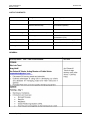
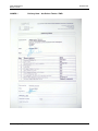
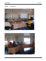
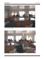
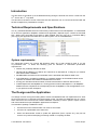
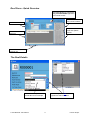
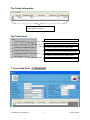
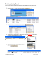
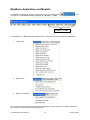
PACIFIC HYCOS MISSION TO TUVALU
27 June – 11 July 2008
The QuickBird 60cm resolution pan sharpened image backdrop with tile showing Funafuti and surveyed roofs in red.
Data captured by onscreen digitising from the image backdrop
Edwin Liava’a
HYCOS Project – Database / GIS Specialist
SOPAC Trip Report 446
November 2009
Pacific HYCOS Project
Mission to Tuvalu
November 2009
DISCLAIMER
This document has been produced with the financial assistance of the European Union. The
views expressed herein can in no way be taken to reflect the official opinion of the European
Union.
SOPAC Trip Report 446 – Liava’a
2
Pacific HYCOS Project
Mission to Tuvalu
November 2009
ACRONYMS
DB
Database
EU
European Union
GIS
Geographic Information System
GPS
Global Positioning System
ICT
Information and Communication Technologies
MIS
Management Information System
MS
Microsoft
ODBC
Open Database Connectivity
PDF
Portable Document Format
RDBMS
Relational Database Management System
SOPAC
Pacific Islands Applied Geoscience Commission
MBX
MapBasic Application (Executable File)
MLS
Ministry of Lands and Survey
MNRE
Ministry of Natural Resources and Environment
PWD
Public Works Department
TDE
Tuvalu Department of Energy
TEC
Tuvalu Electric Corporation
TTC
Tuvalu Telecommunication Commission
SOPAC Trip Report 446 – Liava’a
3
Pacific HYCOS Project
Mission to Tuvalu
November 2009
CONTENTS
EXECUTIVE SUMMARY .................................................................................................................5
INTRODUCTION..............................................................................................................................5
OBJECTIVE…..................................................................................................................................5
LIST OF CONTACTS.......................................................................................................................6
GENERAL….. ..................................................................................................................................6
CONCLUSION(S) ............................................................................................................................9
RECOMMENDATION(S) .................................................................................................................9
LIST OF ANNEXES
1
Delivery Note – Am Pelosa Tehulu/ PWD ...................................................................10
2
SOPAC letter – Am Pelosa Tehulu/ PWD ...................................................................11
3
Training Schedule........................................................................................................12
4
List of Trainees ............................................................................................................14
5
Photographs ................................................................................................................15
6
TV_CatchRain MIS-GIS User's Guide Manual ............................................................17
SOPAC Trip Report 446 – Liava’a
4
Pacific HYCOS Project
Mission to Tuvalu
November 2009
EXECUTIVE SUMMARY
It was observed from the HYCOS site mission in March that the use of GIS to assist in the
distribution of rainwater tanks was well received and further progress on developing this system
was recommended.
As a result a comprehensive data integrity check of existing datasets was conducted whereby
inconsistencies were discovered and corrected with records that required double checking
especially tank size measurements needed double checking onsite, during the site visit.
Furthermore, changes to the design of the existing framework of the database were implemented,
especially the application, relationships and the user interface.
The most crucial change in the design was moving the existing data to a back-end database that
can be implemented in a client server environment of a corporate local area network (LAN). The
back-end database sits on a server while clients have the front-end user interface database
consisting of forms, queries, reports, macros and code modules.
The benefits of splitting a database include:
• All users across the network share one common set of data.
• All users can update data at the same time.
• When the administrator needs to update the application (forms, reports etc.), they will not
need to worry about interrupting processing of data or corrupting the data.
There was also a need to provide some training to understand the benefits of a GIS and to
demonstrate how to develop and maintain such a system. Above all was to understand GIS as an
asset management tool and as an analysis tool of current data for forecasting trends that will assist
designing existing and future infrastructure development.
The training lasted for 10 days from the June 30 to July 11 Monday to Friday, whereby 13
participants were involved from the Ministry of Lands and Survey, Department of Energy, Public
Works Department, Tuvalu Electricity Corporation, Tuvalu Telecommunications Commission and
Funafuti Kaupule.
The site visit also provided the opportunity to deliver level and quality sampling equipment to the
Public Works Department of Tuvalu as part of the HYCOS initiative for capacity building and
development.
INTRODUCTION
The mission was a follow-up to the rainwater harvesting survey and Pacific HYCOS mission in
March 08. Focus was to assist the delivery of tanks through implementing the use of Geographical
Information System (GIS) in the assistance of planned water projects on Tuvalu under EDF9 BEnvelope and the ongoing water quality assessment associated with Pacific HYCOS.
OBJECTIVE
•
•
•
•
To refine and correct existing data within the GIS catch rain database.
To conduct training on the analysis, designing, development, implementation and
maintenance of a GIS system.
To split the MIS/GIS database into a server/client environment.
To deploy level and quality sampling equipment within the Public Works Department (PWD)
of Tuvalu.
SOPAC Trip Report 446 – Liava’a
5
Pacific HYCOS Project
Mission to Tuvalu
November 2009
LIST OF CONTACTS
Name
Designation
Ministry / Department
Mrs Loia Tausi
Lands Officer
Ministry of Lands and Survey (MLS)
Mr Uale Taleni
Secretary of Lands and Survey –
SOPAC National Rep
Ministry of Natural Resources and
Environment (MNRE)
Mr Am Pelosa M Tehulu
Acting Director of Works – PUI
PWD
Mr Faatasi Malologa
Director Lands and Survey
MLS
Mrs Noia Simona
IT Manager
Mr Molipi Tausi
Energy Planner
Tuvalu Telecommunication
Commission (TTC)
Tuvalu Department of Energy (TDE)
Mr Polu Tanei
Electrical Supervisor
Tuvalu Electric Corporation (TEC)
Mr Greg Wolff
Water and Sanitation
PWD
GENERAL
SOPAC Trip Report 446 – Liava’a
6
Pacific HYCOS Project
Mission to Tuvalu
SOPAC Trip Report 446 – Liava’a
November 2009
7
Pacific HYCOS Project
Mission to Tuvalu
SOPAC Trip Report 446 – Liava’a
November 2009
8
Pacific HYCOS Project
Mission to Tuvalu
November 2009
CONCLUSION(S)
The Training conducted on GIS was well received at a competence level whereby trainees
understand the benefits of a GIS; understand how to develop and to maintain such a system. Most
importantly, they know how to be self-taught; how to use the help facilities; where to find help; and
to share common solutions to common problems.
Coherently, since the government officers recognise the benefits a GIS and the applications that
will benefit Tuvalu, the Water Monitoring Committee during their meeting on the 22 July, 2008
proposed to incorporate the water monitoring programme in the TV_CatchRain MIS/GIS.
RECOMMENDATION(S)
It is a great idea to incorporate the water monitoring programme in the TV_CatchRain MIS/GIS. But
the author would propose that Public Health Department for the time being use an Excel
Spreadsheet for inputting the monitoring data and report on weekly basis to PWD, a copy of the
Spreadsheet to be imported into the TV_CatchRain MIS/GIS.
There is a Water Quality Database (WQM) currently under development and will be deployed soon,
it would be wise not to duplicate work but for Public Health Department to start populating the excel
spreadsheet for now until the WQM Database is fully functional. The existing data will then be
moved to the new WQM Database, which can be link to the TV_CatchRain MIS/GIS.
Although, the author has confidence that the trainees could maintain the current system, such a
transition between two separate systems was not covered during the training. Therefore, I would
recommend a 3-day site visit to assist with the setup of the excel spreadsheet for transition to the
new WQM database and the linking to the GIS.
SOPAC Trip Report 446 – Liava’a
9
Pacific HYCOS Project
Mission to Tuvalu
ANNEX 1
November 2009
Delivery Note – Am Pelosa Tehulu / PWD
SOPAC Trip Report 446 – Liava’a
10
Pacific HYCOS Project
Mission to Tuvalu
ANNEX 2
November 2009
SOPAC Letter – Am Pelosa Tehulu / PWD
SOPAC Trip Report 446 – Liava’a
11
Pacific HYCOS Project
Mission to Tuvalu
ANNEX 3
November 2009
Training Schedule – Week 1
WEEK 1 DAY 1: Mon 30 June 2008
o
GIS Introduction and overview
• Microsoft Access
• MapInfo
• MapBasic
• Global Positioning System (GPS)
• How they all work together as the framework of a GIS
02:00pm – 04:00pm
WEEK 1 DAY 2: Tue 01 July 2008
o
Microsoft Access
• Analysing a problem, designing and developing a solution
• Morning Tea Break
•
Tables (entities), Records (rows), Attributes (columns)
• Lunch Break
• Access menu, Relationships and data types
• Afternoon Tea Break
• Designing data entry forms
09:00am – 10:15am
10:15am – 10:45am
10:45am – 12:00pm
12:00pm – 01:00pm
01:00pm – 02:15pm
02:15pm – 02:45pm
02:45pm – 04:00pm
WEEK 1 DAY 3: Wed 02 July 2008
o
Microsoft Access
• Designing ad hoc queries
• Morning Tea Break
• Designing make table queries
• Lunch Break
• Designing reports
• Afternoon Tea Break
• Designing Macros and Modules
09:00am – 10:15am
10:15am – 10:45am
10:45am – 12:00pm
12:00pm – 01:00pm
01:00pm – 02:15pm
02:15pm – 02:45pm
02:45pm – 04:00pm
WEEK 1 DAY 4: Thu 02 July 2008
o
MapInfo
• Cartographic Concepts
• Morning Tea Break
• MapInfo menu, preferences and directories
• Lunch Break
• Tables, Linking Access and MapInfo
• Afternoon Tea Break
• Layer Control, Snap and Geocoding
09:00am – 10:15am
10:15am – 10:45am
10:45am – 12:00pm
12:00pm – 01:00pm
01:00pm – 02:15pm
02:15pm – 02:45pm
02:45pm – 04:00pm
WEEK 1 DAY 5: Fri 03 July 2008
o
GPS (Global Positioning System)
• Pathfinder Office and Data Dictionary
• Morning Tea Break
• Microsoft ActiveSync and Data download and transfer
• Lunch Break
• Trimble TerraSync and GeoXM data logger
• Afternoon Tea Break
• Export from Pathfinder Office and Import to MapInfo
SOPAC Trip Report 446 – Liava’a
09:00am – 10:15am
10:15am – 10:45am
10:45am – 12:00pm
12:00pm – 01:00pm
01:00pm – 02:15pm
02:15pm – 02:45pm
02:45pm – 04:00pm
12
Pacific HYCOS Project
Mission to Tuvalu
November 2009
Training Schedule – Week 2
WEEK 2 DAY 1: Mon 07 July 2008
o
MapBasic
• Introduction to programming
• Morning Tea Break
• Header files and MapBasic Source files .MB
• Lunch Break
• Function Main () and Variables
• Afternoon Tea Break
• Selection and Repetition Structures
09:00am – 10:15am
10:15am – 10:45am
10:45am – 12:00pm
12:00pm – 01:00pm
01:00pm – 02:15pm
02:15pm – 02:45pm
02:45pm – 04:00pm
WEEK 2 DAY 2: Tue 08 July 2008
o
MapBasic
• Modularity and Function Calls
• Morning Tea Break
• MapBasic Project File .MBP
• Lunch Break
• MapBasic Application .MBX
• Afternoon Tea Break
• MapBasic Object File .MBO
09:00am – 10:15am
10:15am – 10:45am
10:45am – 12:00pm
12:00pm – 01:00pm
01:00pm – 02:15pm
02:15pm – 02:45pm
02:45pm – 04:00pm
WEEK 2 DAY 3: Wed 09 July 2008
o
MapBasic and MapInfo
• Creating Menus and the MapBasic Window in MapInfo
• Morning Tea Break
• Opening and Registering tables from Access
• Lunch Break
• SQL and Select queries to link tables
• Afternoon Tea Break
• Using MapBasic to create Thematic maps
09:00am – 10:15am
10:15am – 10:45am
10:45am – 12:00pm
12:00pm – 01:00pm
01:00pm – 02:15pm
02:15pm – 02:45pm
02:45pm – 04:00pm
WEEK 1 DAY 4: Thu 10 July 2008
o
Revision – Putting it all together
• Ms-Access
• Morning Tea Break
• MapInfo
• Lunch Break
• MapBasic
• Afternoon Tea Break
• MapBasic
09:00am – 10:15am
10:15am – 10:45am
10:45am – 12:00pm
12:00pm – 01:00pm
01:00pm – 02:15pm
02:15pm – 02:45pm
02:45pm – 04:00pm
WEEK 1 DAY 5: Fri 03 July 2008
o
The TV_CatchRain.MDB database and GIS
• Microsoft Access database Splitting
• Forms, Queries, Reports and Links to MapInfo
• Ground truthing of peculiarity in Residential tanks data
• Lunch Break and Check-in
SOPAC Trip Report 446 – Liava’a
09:00am – 10:15am
10:15am – 10:45am
10:45am – 12:00pm
12:00pm – 01:00pm
13
Pacific HYCOS Project
Mission to Tuvalu
ANNEX 4
November 2009
List of Trainees
Name
Designation
Ministry / Department
Mrs Loia Tausi
Lands Officer
MLS
Mrs Noia Simona
IT Manager
TTC
Mrs Meelina Ailesi
Technician Network
TTC
Mrs Peitata Sente
Community Worker
Funafuti Kaupule (FK)
Mr Collin Namoliki
Draughtsman
MLS
Mr Vakafa Lupe
Draughtsman
MLS
Mr Ane Talia
Survey Assistance
MLS
Mr Greg Wolff
Water and Sanitation
PWD
Mr Kiritome Irata
Quality Surveyor
PWD
Mr ‘Elekana Tofinga
Housing Officer
PWD
Mr Pisi Afaaso
Water & Sanitation Supervisor
PWD
Mr Molipi Tausi
Energy Planner
TDE
Mr Polu Tanei
Electrical Supervisor
TEC
SOPAC Trip Report 446 – Liava’a
14
Pacific HYCOS Project
Mission to Tuvalu
ANNEX 5
November 2009
Photographs
Fig 1. Training Room – Front.
Fig 2 Training Room – Left
SOPAC Trip Report 446 – Liava’a
15
Pacific HYCOS Project
Mission to Tuvalu
November 2009
Fig 3. Training Room – Middle.
Fig 4. Training Room – Right.
SOPAC Trip Report 446 – Liava’a
16
Pacific HYCOS Project
Mission to Tuvalu
ANNEX 6
November 2009
TV_CatchRain MIS-GIS User's Guide Manual
SOPAC Trip Report 446 – Liava’a
17
Establishment of a
Geographical Information System
for Rain Water Catchment in Tuvalu
TV_CatchRain MIS/GIS User Manual
The QuickBird 60cm resolution pan sharpened image backdrop with tile showing Funafuti and surveyed roofs in
red.
Data captured by onscreen digitising from the image backdrop
Document Version 1.02 - Draft
30 July 2008
HYCOS Project – Database / GIS Specialist
Edwin Liava’a
Tuvalu MIS/GIS: User Manual
HYCOS Project
Acronyms
DB
Database
EU
European Union
GIS
Geographic Information System
GPS
Global Positioning System
ICT
Information and Communication Technologies
MBX
MapBasic Application (Executable File)
MIS
Management Information System
MS
Microsoft
ODBC
Open Database Connectivity
PDF
Portable Document Format
RDBMS
Relational Database Management System
SOPAC
South Pacific Applied Geoscience Commission
Tuvalu MIS/GIS: User Manual
HYCOS Project
Contents
Introduction............................................................................................................... 1
Technical Requirements and Specifications.......................................................... 1
System requirements:
1
The Design and the Application .............................................................................. 1
The Login Form
2
The Roof Form
2
Roof Form - Quick Overview
3
The Roof Details
3
The Tanks Information
4
The Tasks Panel
4
1. Create New Roof
4
2. Create New Tank
7
3. Create New Gutter
7
4. View Reports
8
The Setup Panel
8
To Edit any Existing Record
9
MapBasic Application and MapInfo ...................................................................... 10
Tuvalu MIS/GIS: User Manual
HYCOS Project
Introduction
This document is the follow up of the MIS/GIS training during the HYCOS site visit to Tuvalu from the
th
th
27 June to the 11 July 2008.
This document consists of screen shots with text that describes how to use the Ms-Access MIS and
the link to MapInfo for presentations of maps.
Technical Requirements and Specifications
The TV_CatchRain MIS/GIS has been built entirely in Microsoft Access and MapBasic. It is distributed
as an Access application, MapBasic modules and application, MapInfo layers, a batch file and data
files. Where users have MS Access 2002 or 2003 installed, then they can run TV_CatchRain DB by
just copying the application and data files onto their system onto C:\TVCRDatabase:
System requirements:
Any reasonably modern PC running MS Windows 2000, XP or later should be able to run the
TV_CatchRain DB.
In detail, the following gives an indication of reasonable specification
requirements:
• Pentium PC, preferably 800 MHz or faster
• Windows 98 (2nd Edition), NT, 2000 or XP. It will not run on Windows 95. If using NT, you must be
have Service Pack 6 installed.
• 256 MB RAM is the minimum recommended; more is beneficial with Windows 2000 or XP.
• A CD-ROM drive is needed for installation. In a network situation, the CD-ROM contents can be
copied to the network and installed to individual PCs from there.
• If using your own Microsoft Access 2002, it needs to be at least on Office XP Service Pack 1.
• At least MapInfo 9.0 and MapBasic 9.0. If using previous versions like MapInfo 7.0, all MapBasic
Modules must be compiled in the corresponding version of MapBasic 7.0 for the application to run
in your previous version of MapInfo.
The Design and the Application
The design involves moving the existing data to a back-end database that can implemented in a client
server environment in a corporate local area network (LAN). The back-end database sits on a server
while clients have the front-end user interface database consisting of forms, queries, reports, macros
and code modules that opens MapBasic applications for MapInfo.
The benefits of splitting a database include:
•
All users across the network share one common set of data
•
All users can update data at the same time
•
When the administrator needs to update the application (forms, reports etc.), they will not
need to worry about interrupting processing of data or corrupting the data.
Tuvalu MIS/GIS: User Manual
1
HYCOS Project
The Login Form
The user needs to have a username and password for authentication. Username and passwords can
only be issued by the Database Administrator.
Step 1: Select your username from the drop-down combo box
Step 2: Type your password in the password text box
Step 3: Click Login command button to Logon
The Roof Form
After login, the Roof form will appear as the main switchboard that will enable the user to access all
the other functionalities of the TV_CatchRain database.
Tuvalu MIS/GIS: User Manual
2
HYCOS Project
Roof Form - Quick Overview
Command Button to execute the
TV_CatchRain.MBX Application
from inside Access
Tasks Panel, New
Roof, Tanks, Gutters
The Roof Details
Setup Panel, Create
Table and Update
Queries
Tanks Information
Sub Form
Record Selectors, Next,
Previous, etc
The Roof Details
Roof Material Drop- down
Combo Box as an example
Tuvalu MIS/GIS: User Manual
Click on any of the Edit
hyperlink to edit the Tables
3
HYCOS Project
The Tanks Information
A summary of the Tanks connected
to this particular Roof_ID
The Tasks Panel
1. Create a new record in the Roofs table
2. Look through the Tanks table
3. Create a new record in the Tanks table
4. Look through the records of the Gutters table
5. Create a new record in the Gutters table
6. Open and View Reports Form
1. Create New Roof
Tuvalu MIS/GIS: User Manual
4
HYCOS Project
Once the
button in clicked, you will notice that the Roof_ID will be blank,
indicating that this will be a new roof record:
Steps:
1. Input a new Roof_ID, can find out the last Roof_ID by clicking e.g.
2. Input House Owner
3. Ignore the Roof Size, it will be generated automatically by
4. Select Roof Material
5. Select Roof Condition
6. Select Roof Slope
7. Select % Tree Cover
8. Select Catchment Type
9. Select Roof Colour
10. Input the number of People
11. Select Surveyed
12. Select number of tanks connected
13. Ignore Storage per Person, it will be generated automatically by
NB: Remember that you will have to manually digitize onscreen a new Roof in MapInfo with the same
ROOF_ID
Steps:
1. Click the
button to launch MapInfo
2. Run Asset Items - > Display Roofs connected
3. Make Layer Roof_MI editable in Layer
Control
4. Check the pencil check box
5. Click
6. If the Drawing Toolbar is not loaded, click Options
> Toolbars
7. Check Load and Float check-boxes
8. Now, Select the Region Style and click OK
9. Select the region digitizing polygon
backdrop.
Tuvalu MIS/GIS: User Manual
and start on screen digitizing on top of the image
5
HYCOS Project
10. When you’re done digitizing, double click on the roof polygon you’ve just digitised to get the
X and Y coordinates and the area in square meters, the click OK
11. Choose Window > New Browser Window > Roof_MI.
12. Then go to the last record and update Roof_ID, Area then X and Y Coordinates.
Roof_ID = R000946
Area = 385
X = 179.1999
Y = -8.51844
NB: Make sure the Map > Options is:
13. The next Step is to Save table Roof_MI, then goto Access and click on
to update the ROOF_Main table in access.
14. Finish
Tuvalu MIS/GIS: User Manual
6
HYCOS Project
2. Create New Tank
NB: The Create new Tank is pretty straight forward and you don’t have to do any digitising in MapInfo,
once you know how to add a new roof in access, it’s the same procedure, but remember, to get the
last ID, you have to got to the last record.
3. Create New Gutter
NB: The Create new Gutter is pretty straight forward and you don’t have to do any digitising in
MapInfo, once you know how to add a new roof in access, it’s the same procedure, but remember, to
get the last ID, you have to got to the last record.
Tuvalu MIS/GIS: User Manual
7
HYCOS Project
4. View Reports
NB: The View Reports pretty straight forward, all you need to do is just select the report then click
to view report, or click
to edit the report list.
The Setup Panel
The Setup panel allows to user to run Make Table and Update Queries designed and hidden in the
database window.
Creates table TMP_RoofTank for MapInfo
Creates table TMP_CountTanks for MapInfo
Creates table TMP_TankSize for MapInfo
Creates table TMP_StoragePerPerson for MapInfo
Creates table TMP_Gutter for MapInfo
Creates table TMP_RoofDetails for MapInfo
Creates table TMP_GutterDetails for MapInfo
Updates the ROOF_Main table X, Y cordinates
Updates Tanks Capacity from Gallons into Litres
Updates ROOF_Main Storage per person
Updates ROOF_Main number of Tanks connected
Change your Company Information
NB: It is important to run these Setup Queries whenever there have been changes to your ROOF,
TANKS and GUTTERS tables.
Tuvalu MIS/GIS: User Manual
8
HYCOS Project
To Edit any Existing Record
To edit any of the existing records, whether its Roofs, Tanks or Gutters, just simply open the form:
Steps:
1. Right-Mouse-Click on any of the forms and select
Datasheet View of the Roof’s Table
2. Right-Mouse-Click on the Datasheet View and Select
3. For example if you are searching for a Houseowner, click on the right corner of the column to
see a drop down list of all household owners
4. Select the Houseowner, then Right-Mouse-Click and
Select
5. Edit
Tuvalu MIS/GIS: User Manual
9
HYCOS Project
MapBasic Application and MapInfo
The MapBasic Application can be launched from inside TV_CatchRain DB
be found in C:\TVCRDatabase\MB_Programs as RainWater_TV.MBX
or can
RainWater_TV.MBX
The RainWater_TV.MBX application adds another 3 extra menu items to the MapInfo Main Menu:
1.
Asset Items
2. Water Catch
3. Water Consumption
The 3 extra menu items pretty much speaks for themselves, all you need to do is follow instructions
then give them a click and see what they produce.
Tuvalu MIS/GIS: User Manual
10
HYCOS Project