1
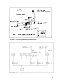
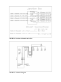
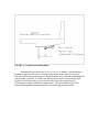
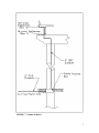
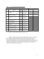
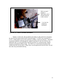
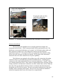
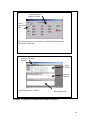
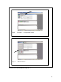
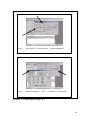
UDOT Report No. UT-01.12
STRONG MOTION INSTRUMENTATION
OF I-15 BRIDGE C-846
FINAL REPORT
Submitted To:
The Utah Department of Transportation
Research and Development Division
Submitted By:
Utah State University
Department of Civil and Environmental Engineering
December 2001
UDOT RESEARCH & DEVELOPMENT REPORT ABSTRACT
2. Government Accession No.
UT – 01-12.
1. Report No.
4. Title and Subtitle
December 2001
5. Report Date
STRONG MOTION INSTRUMENTATION
OF I-15 BRIDGE C-846
3. Recipients Catalog No.
6. Performing Organization Code
7. Author(s)
8. Performing Organization Report No.
Halling, Marvin W., Ph.D., P.E.
Petty, Timothy
9. Performing Organization Name and Address
10. Work Unit No.
Utah State University
Department of Civil and Environmental Engineering
Logan, UT 84322
11. Contract No.
12. Sponsoring Agency Name and Address
02-9075
13. Type of Report and Period Covered
Final Report, July 2000 – August 2001
Utah Department of Transportation
4501 South 2700 West
Salt Lake City, UT 84119-5998
14. Sponsoring Agency Code
15. Supplementary Notes
Paul A. Mooney, FHWA, Utah Division, Marketing and Technology Implementation Specialist
William R Gedris, FHWA, Utah Division, Structural/Environmental Engineer
Samuel E. Sherman, UDOT Research Division, Project Manager
16. Abstract
Several spans of bridge C-846 (at 21st S and I-15) were instrumented using strong motion accelerometers. Also instrumented was a
3-channel free field site adjacent to the bridge at Andy Avenue, S. Salt Lake City. `This instrumentation is intended to provide long
term information for vibration studies by researchers at Utah State University, as well as being set to trigger during any earthquake
which triggers the sensors. In addition, the three free field channels and three selected structural channels will be continuously
monitored by the U of U Seismograph Stations as part of the Advanced National Seismic System (ANSS). Data is available through
their Strong Ground Motion Monitoring Network.
17. Key Words
18. Distribution Statement
Accelerometers, strong motion instruments, bridge
instrumentation
No Restrictions. Available from:
Utah Department of Transportation
Research Division
Box 148410,
Salt Lake City, Utah 84114-8410
Utah State University
Department of Civil and Environmental Engineering
4110 Old Main Hill
Logan, Utah 84322-4110
19. Security Classification
(For this report)
None
20. Security Classification
(For this page)
None
21. No. of Pages
24
i
22. Price
THIS PAGE LEFT BLANK INTENTIONALLY
ii
STRONG MOTION INSTRUMENTATION
OF I-15 BRIDGE C-846
A Research Report Submitted to the
Utah Department of Transportation
UT-01.12
By
Marvin W. Halling
Timothy Petty
Department: Civil and Environmental Engineering
Utah State University
Logan, UT
iii
THIS PAGE LEFT BLANK INTENTIONALLY
iv
TABLE OF CONTENTS
UDOT RESEARCH & DEVELOPMENT REPORT ABSTRACT.................................... i
EXECUTIVE SUMMARY ................................................................................................ 1
SITE SELECTION ............................................................................................................. 2
SYSTEM DESCRIPTION.................................................................................................. 2
INSTRUMENT LAYOUT ................................................................................................. 3
INSTALLATION PROCEDURES .................................................................................... 9
Cable & Conduit ............................................................................................................. 9
Instrument Installation .................................................................................................. 12
Free-field Site................................................................................................................ 14
Data Collection ............................................................................................................. 15
Communication Software ............................................................................................. 15
CONCLUSION................................................................................................................. 21
ACKNOWLEDGEMENT ................................................................................................ 21
v
LIST OF FIGURES
FIGURE 1 Site Plan.......................................................................................................... 3
FIGURE 2 Layout of permanent instrumentation ............................................................ 4
FIGURE 3 Locations of protective boxes......................................................................... 4
FIGURE 4 BREAKOUT OF CHANNELS AND CABLES............................................ 5
FIGURE 5 Schematic Diagram ........................................................................................ 5
FIGURE 6. Underdeck mounting detail ........................................................................... 6
FIGURE 7 Column at Bent 9............................................................................................ 7
FIGURE 8 Box mounted on bottom of deck .................................................................... 9
FIGURE 9 Conduit and cable installation ...................................................................... 10
FIGURE 10 Nema 12 enclosure installation ................................................................ 11
FIGURE 11 Trenching in instrumentation cable from Bent 9 to free-field site ............. 12
FIGURE 12
EpiSensor connections.............................................................................. 13
FIGURE 13 Junction Box............................................................................................... 14
FIGURE 14
Free-field site............................................................................................ 15
FIGURE 15 QuickTalk communication setup and interface.......................................... 18
FIGURE 16
Edit Parameters steps 1 & 2...................................................................... 19
FIGURE 17
Edit Parameters steps 3 & 4...................................................................... 20
vi
EXECUTIVE SUMMARY
A strong motion station was located, designed, installed, and tested. This station
consists of 18 channels located on the deck and bents of bridge number C-846 and three
(3) channels located at a free-field site located about 400 feet away from the bridge. This
bridge is the first bridge instrumented with strong motion instrumentation within the state
of Utah. This report details the site selection, instrument description, layout, and
installation, which were performed by researchers at Utah State University for the Utah
Department of Transportation (UDOT).
This permanent instrumentation will fill the multiple purposes of long term
monitoring of the bridge by researchers at Utah State University, real time data flow to
the University of Utah Seismograph Stations as part of a national system, and recording
of the bridge response due to a local earthquake in the Salt Lake City area.
1
SITE SELECTION
The selection of an appropriate site was based on several factors. Some of these
factors are the type and dimensions of the structure, the importance of the structure, the
location of the structure with respect to other strong motions sites, geological conditions,
and geotechnical conditions. The selected site is located on very deep soft sediments
which are ideal for future studies in wave propogation and soil structure interaction.
Other considerations included the availability of power and communication (phone), and
UDOT ownership of the site suitable for the free-field location.
This site was selected, in part, because of its central location in the overall I-15
transportation system through the Wasatch Front area. Additional bridge monitoring will
undoubtedly be installed in the future, but this station represents a central location for this
initial bridge strong motion instrumentation.
SYSTEM DESCRIPTION
The strong motion system consists of 18 structural channels connected to two
Altus Kinemetrics K2 Recorders at an adjacent free field site. One of the K2s contains an
additional internal tri-axial accelerometer. Therefore the total system as configured
contains 21 data channels. All instruments are Kinemetrics EpiSensors.
The EpiSensor is a forced balance accelerometer available in uni-axial, bi-axial,
and tri-axial configurations, all of which were incorporated in the installation. The fullscale range and output voltage levels were user-selected and factory set as ±2g and
±2.5V, respectively. The accelerometers have a bandwidth of DC to 200 Hz. The
instruments are powered with + & -12V DC supplied by the K2 Recorders, which are in
turn powered through a 110 V AC outlet, or through an internal backup battery. The
EpiSensor has an anodized-aluminum waterproof casing.
The Altus K2, referred to in this paper as simply K2, is a self-contained
multiplexing digital recorder. The recorder is capable of powering and recording up to
twelve EpiSensor channels at sample rates of 50, 100, 200, or 250 sps. The recorder
receives power from a standard 110 V AC outlet through a customized DC power
converter, or from an internal backup battery. The backup battery provides
approximately thirty hours of operation.
Because of the limited number of channels available only the spans from Bent 6
to Bent 9 of structure C-846 were instrumented. These spans comprise the majority of
the center “straight” section of the bridge. The eighteen structural channels are made up
of a total of nine structural instruments; one tri-axial ES-T (three channels), seven biaxial ES-Bs (fourteen channels), and one uni-axial ES-U (one channel).
2
INSTRUMENT LAYOUT
The instrument layout was designed qualitatively to capture the dynamic response
of the bridge. Instruments were placed in three orthogonal directions; transverse,
longitudinal and vertical. The instrumented section of the bridge was determined to have
an azimuth of 340˚. The longitudinal and transverse structural channels were therefore
oriented at 340˚ and 70˚ respectively; these orientations represent the positive direction of
motion for both the permanent and temporary instrument arrays.
Several channels were located on and around Bent 7, where an expansion joint is
located. A tri-axial instrument was placed on Bent 7, and bi-axial instruments with
transverse and longitudinal channels were placed on either side of the expansion above it.
The 78.89 m span between bents 6 & 7 contains three bi-axial instruments with vertical
and transverse channels. Two of these were placed at midspan, one on each side of the
deck. The other was placed at quarter span measuring from Bent 7. A bi-axial
instrument was placed on the deck above Bent 6, containing transverse and longitudinal
channels. Instrumentation at Bent 9 included a bi-axial instrument with a transverse and
vertical channel on the bent, and a uni-axial instrument with a vertical channel directly
above it. Figures 1 & 2 detail the locations and orientation of all structural channels.
Figures 3 through 7 show details of instrumentation system and where they are located.
Figures 8 through 14 are photographs of installations and construction. Table 1 presents
similar information in a tabular form.
FIGURE 1 Site Plan
3
FIGURE 2 Layout of permanent instrumentation
FIGURE 3 Locations of protective boxes
4
FIGURE 4 Breakout of channels and cables
FIGURE 5 Schematic Diagram
FIGURE 6. Underdeck mounting detail
All instruments are enclosed in 12 in. x 12 in. x 6 in. Nema 12 rated enclosures.
Instruments placed on the deck are located on the bottom of the deck. (See Figure 6).
One affect of having the accelerometers mounted upside down is that the longitudinal and
vertical signal is inverted. It would seem that the leads from the accelerometer could
simply be wired backwards to correct for this, but because the output from the
accelerometer is single ended this would not work. This means that the sign of all
vertical and longitudinal channels must be reversed through post-processing.
FIGURE 7 Column at Bent 9
7
Table 1.
Box and channel locations and description
Instrument
Box
#
Location
Channel
Type
1
On Bent 9
ES-B
2
On deck above Bent 9
ES-U
3
On Bent 7
ES-T
4
5
6
7
8
On deck above Bent 7 on north
side of expansion
On deck above Bent 7 on south
side of expansion
On deck at ¼ span from Bent 7
to Bent 6
On deck at midspan between
Bents 6 & 7 (west side)
On deck above Bent 6
ES-B
ES-B
ES-B
ES-B
ES-B
Connection
Information
Connected
directly to K2
with cable #1
Junctioned at
Instrument 1
Connected
directly to K2
with cable #2
Junctioned at
Junction Box*
Junctioned at
Junction Box *
Junctioned at
Junction Box*
Junctioned at
Junction Box*
Junctioned at
Junction Box*
Junctioned at
Junction Box*
On deck at midspan between
ES-B
Bents 6 & 7 (east side)
* Junction Box is located on Bent 7
** First number in channel number indicates the recorder number
9
Number**
Orientation
1-4
Transverse
1-5
Vertical
1-6
Vertical
2-1
2-2
2-3
2-4
2-5
2-6
2-7
1-7
1-8
1-9
1-10
2-8
2-9
1-11
1-12
Longitudinal
Transverse
Vertical
Longitudinal
Vertical
Longitudinal
Vertical
Transverse
Vertical
Transverse
Vertical
Longitudinal
Transverse
Transverse
Vertical
Belden 9774 cable was used for structural instrumentation. This is an 18 AWG, 6
pair, individually shielded instrumentation cable. Cable was run through 2 in. & 1 in.
GRC conduit on the bottom of the deck. The casing of the EpiSensor is isolated,
therefore the instruments were never grounded to or through the conduit or concrete. The
grounding of each channel was carried to the permanent station where all instrumentation
and power was grounded into a copper rod driven into the ground. This effectively
isolates the instrumentation from the bridge.
8
INSTALLATION PROCEDURES
Cable & Conduit
The first step in the permanent instrumentation installation was the placement of
the cable and conduit. This was done by a crew of Utah State researchers including Dr.
Marvin Halling, Mr. Ken Jewkes, graduate students, and undergraduate students.
The length and number of cables did not allow the cable to be pulled through the
conduit after it was installed; they therefore had to be installed simultaneously.
Installation was begun at Bent 9, where the conduit comes down the column to the
ground. Initially only forty feet of conduit was installed under the deck. The cable
required to reach from Bent 9 to Bent 7, where a junction box was located, was then
pulled through the installed conduit. From this point individual ten-foot sticks of conduit
were threaded onto the cable and installed in either direction both to Bent 7, and down
Bent 9 to the ground. The conduit was hung using clevis hangers and 3/8 in. x 5 in.
wedge anchors spaced at approximately 2 meters (6.6 ft). This method ensured that the
cable could be placed and was the best way to protect the cable during the installation
process.
FIGURE 8 Box mounted on bottom of deck
9
Installing Conduit & Cable
FIGURE 9 Conduit and cable installation
Nema 12 rated enclosures were placed at each instrument location. An 8 in. x 8
in. square was cut from the bottom panel of the box so that the instrument could be
mounted directly to the concrete. After the box was mounted three of the edges were
caulked between the box and concrete to prevent moisture from entering through the hole
cut for the sensor. The bottom edge was left unsealed to allow for venting. Epoxy coated
steel boxes were used but a fiberglass style box would be much easier to prepare; in
addition to cutting a hole out of the bottom for the instrument, a hole had to be cut in the
side for conduit access. Flexible conduit was used to connect the boxes to the rigid
conduit so the boxes could be placed accurately over the instrument locations. A ¼ in.
hole was drilled at each instrument location in preparation for the actual placement,
which was completed later.
10
Hole cut out of
bottom so
EpiSensor can be
mounted directly
to the concrete
¼ in. hole for
anchoring
EpiSensor
FIGURE 10 Nema 12 enclosure installation
With the conduit and cable installed on the bridge it still needed to be brought to
the free-field site approximately 400 ft from the bridge. A UDOT crew trenched in a 3
in. PVC conduit from an access box at the base of Bent 9 to the free field site. Utah State
researchers pulled the cable through the conduit from Bent 9 to the free-field site. An
additional cable was also pulled that would be used later for synchronization with the
temporary instruments during testing. The UDOT crew also trenched and placed the
conduit and cable for the power. Phone lines were brought into the shed to allow for real
time data relay and modem dial-up.
11
UDOT crew trenching from
bridge to free-field site
Keeping the cable out of the
mud while pulling from
Bent 9 to free-field site
Access box at the base of
Bent 9
FIGURE 11 Trenching in instrumentation cable from Bent 9 to free-field site
Instrument Installation
The next step in the installation was to actually install and configure the
instruments and recorders. UDOT contracted with USGS to perform this work. The
EpiSensors were mounted with the use of a central ¼ in. 20-thread wedge anchor and
three perimeter-leveling screws. The underside of the deck was beveled at an
approximate angle of 8˚. The majority of this was compensated for with the leveling
screws, but some electronic leveling was required. The 2g range of the instruments
allowed for this to be done without a loss of system capability.
The EpiSensors are equipped with a military type cable connection, the mating
connector to these are included when purchased from Kinemetrics. Soldering these
connectors to the cable in the field is however extremely impractical. “Pig-tail” cables
were instead prepared by USGS. These cables are approximately three feet long with the
mating connector to the EpiSensor soldered to one end, with the other end bare. Both the
bare end of the pig-tail and the instrument cable were tinned in the field and spliced
through the use of a DIN rail system. The rail was mounted inside the box to the holes
normally used for attaching a back panel. This proved to be an efficient installation
method, an important factor since road closures were unpredictable.
12
The DIN rail system included a stainless steel rail cut to the desired length and
terminal blocks. Any number of terminal blocks could be connected to each other by
simply snapping them together. These blocks slid into the rail and were secured in place
using clamping blocks. Each terminal block connected a pair of wires by clamping the
tinned wire end into either side of the block with a brass-capped screw.
DIN rail system
Soldering end of “pig-tail”
and instrumentation cable
Instrumentation
Cable
Military
Connector
DIN rail system
“Pig-tail” matched to
instrumentation cable
FIGURE 12 EpiSensor connections
13
A junction box was installed on Bent 7. Cables from Boxes 4 through 9 were
brought to this box where they were connected to the appropriate recorder. Boxes 4, 5,
and 8 were connected to Recorder 2 through cables 5 and 6. Boxes 6, 7, and 9 were
connected to Recorder 1 through cables 3 and 4. The DIN rail system was used for these
splices. Bent 7 is the location for the major junction box.
Junction Box
DIN rails used to
splice cables
FIGURE 13 Junction Box
Free-field Site
The free-field site is located approximately 450 ft from the structure and is housed
in a 4’ x 5’ shed placed on a concrete pad prepared by Utah Seismograph Station. The
K2 with the internal tri-axial instrument was placed with the longitudinal channel
oriented to true north and leveled. The cables from the bridge were brought into junction
boxes mounted on the inside wall of the shed. Similar pig-tail cables to those used at the
EpiSensor end were prepared to connect the instrumentation cable to the recorders. Each
cable was identified by connecting a twisted pair at the bridge end and then tested for
continuity at the shed. This was also the procedure used for identifying cables beyond
the junction box. After the cables were identified the channels were connected to the
appropriate recorder according to the assigned order shown in Table 1. The instruments
were left unconnected at the EpiSensor end until the recorders were connected and
powered up; this was to protect them from damage due to improper wiring. This allowed
each channel to be connected and tested individually as it was powered up. A function
test was run on each channel to confirm proper functioning.
14
Junction Boxes
Recorder 1
Recorder 2
FIGURE 14 Free-field site
Data Collection
The K2 recorder contains two PCMCIA card slots, capable of accepting both
Type І & П cards. The K2 stores data in binary A/D counts, ± 8,388,608, as .EVT files.
Additional 96 MB cards were purchased to replace the 16 MB cards that came with the
K2s. The 96 MB card represents approximately 200 minutes of data for 12 channels at
200 sps. The data can be accessed by downloading from the K2 through the use of a RS232 cable or through a modem dial-up. The cards can also be removed from the K2 and
downloaded directly with a computer containing a PCMCIA slot. Removing the cards
proved to be the easiest and quickest method of accessing data while testing, although it
works best to format the cards and delete old files with the card in the K2.
Communication Software
QuickTalk is the support software supplied by Kinemetrics to access the K2. This
is done through either the use of a custom RS-232 cable, or through a modem dial-up.
The RS-232 cable uses a standard RS-232 format, connecting to the serial port of the
computer, but it has a military type connector at the K2 end.
The QuickTalk interface consists of four individual windows. Three of the four
are launched automatically when QuickTalk is opened. The other, the Terminal Window,
15
is opened manually on the toolbar. Figures 15, 16 and 17 illustrate these windows. The
Status and Message windows are not interactive in that they give information but are not
used as a means of input. The Directory window is used to access the data collected on
the PC cards in drive A and B of the K2. The Terminal window, also known as the
Monitor window, can be used to initiate most functions.
When connecting to the K2, it is essential to match the baud rate of the computer
to that of the K2. The baud rate of the computer can be set through the control panel, and
the K2 baud rate is selected to match this at the time that QuickTalk is launched.
QuickTalk can be used to set recorder parameters, trigger the recorder, and to retrieve
data from the PC cards. The User Manual for QuickTalk can be downloaded from
Kinemetrics web page, but some of the most commonly used procedures will be
explained here. Examples of the QuickTalk interface are included at the end of this
section.
When setting parameters on the K2, the recorder is designed so that the
interruption of data collection is minimized. Therefore, the parameters are not changed
directly on the recorder as they are set by the QuickTalk user. Instead the user
downloads the parameters from the K2 without interrupting data collection, modifies
them, and then sends them back to the K2. Acquisition is only interrupted while the new
parameters are sent back to the recorder from the computer, which takes only a few
seconds. This is convenient because the downloaded parameters can be saved as files
(.par files) on disk. This allows the permanent parameters to be saved undisturbed on
disk while parameters are changed for testing purposes. When testing is completed the
permanent parameter file is loaded back to the recorder and the risk of having an errant
setting in the parameters is minimized.
The parameters are accessed through the Recorder heading on the toolbar, the
Acquisition Control key is chosen, which brings up a window with Stop Acquisition,
Keyboard Trigger, Function Test, and Edit Parameters as options. After clicking on the
Edit Parameters key, another window is brought up with the option of retrieving files
either from disk or from the recorder. If it is only desired to change the parameters of a
file on disk it is not necessary to be connected to a K2. After modifying the parameters,
which include the various time settings, sampling rate, filter types, and channel controls,
the parameters can either be saved on a disk or sent back to the recorder. If the
parameters are sent back to the recorder, the acquisition is turned off while the
parameters are transferred.
The permanent parameters include a sample rate of 200 sps, a pre-event time of
10 seconds, post-event time of 30 seconds, a minimum run time of 40 seconds, and a
non-casual anti-alias final filter. The testing parameters were changed to a pre-event,
post-event, and minimum event time of 1 sec. This was because all triggering and
detriggering was done manually while testing. Other parameter changes made for testing
include having channels 10 and 11 turned on in Recorder 2; 2-10 & 2-11 respectively.
Channel 2-10 was the machine channel, and Channel 2-11 was the synchronization
channel.
16
It is important to note that data recording and data acquisition are two separate
things. The K2 is continuously monitoring the EpiSensors, and in this way is always
acquiring data, unless acquisition is manually turned off or parameters are being
transferred to the recorder. Recording on the other hand only occurs when the recorder is
triggered.
Triggering of the recorder can be accomplished through a channel, the keyboard,
or externally through the auxiliary port. The most common type of triggering option is
threshold triggering. Within the parameters each channel is assigned a trigger threshold
and trigger weight. The trigger threshold is expressed as a percent of full scale, typically
1% of the 2g full scale range for structural channels. When this threshold is exceeded the
channel is triggered, but not necessarily the recorder. Recording is only triggered when
the required trigger weight for the entire recorder is met. Each trigger source, including
channels, keyboard and external, are assigned a weight and when the sum of these
weights exceeds the trigger weight of the recorder the K2 is triggered and recording
begins. Each source can be given the entire weight needed to trigger the recorder or only
a portion; this allows the sensitivity of the system to be controlled. When an event is
triggered a header will be written, and a file created in the TMP directory of the available
drive; the A:\ drive is written to by default unless full or without a disk. This file will be
transferred to the EVT directory of the same drive when the event is closed after
detriggering. All of this will be shown in the Message window as it occurs. The
Directory window will need to be refreshed to show the new file. Detriggering, when
triggered by an instrument, works with the same threshold and weight system.
Another method of triggering the recorder is the keyboard trigger. Keyboard
triggering, as mentioned above, is an option within Acquisition Control under the
Recorder heading on the toolbar. All parameters apply to keyboard triggered events,
including pre-event, post-event, and minimum run time. Keyboard triggering was used
for testing.
External triggering is one of the functions that can be accomplished through the
auxiliary port on the K2. When the two K2s are connected through this port and one
recorder is triggered, than the external trigger of the other recorder will also be triggered.
17
Select baud rate to
match computer
Select
appropriate
port
The communication setup window is automatically opened when
QuickTalk is launched
Launches Terminal
Window
Status
Window
Directory
Window
QuickTalk interface windows
Message Window
FIGURE 15 QuickTalk communication setup and interface
18
Step1.
‘Recorder’ → ‘Acquisition Control’
Step 2.
‘Edit Parameters’
FIGURE 16 Edit Parameters steps 1 & 2
19
Step 3.
‘From Disk’ or ‘From Recorder’ → Select parameters
Step 4.
Modify Parameters → ‘OK’ → ‘To Disk’ or ‘To Recorder’
FIGURE 17 Edit Parameters steps 3 & 4
20
CONCLUSION
This report is documentation of the permanent strong motion instrumentation that
was purchased and installed by researchers at Utah State University in cooperation with
the University of Utah Seismographic Stations (UUSS) and the United States Geological
Survey (USGS). The project was funded by the Federal Highway Administration
(FHWA) and the Utah Department of Transportation (UDOT). By agreement with the
groups above, the site is designated as an Advanced National Seismic System (ANSS)
site and as such, data will be available through the UUSS. Access to the site will be
available to Utah State University researchers for purposes of long term bridge
monitoring and ongoing studies.
ACKNOWLEDGEMENT
The authors would like to express appreciation to the FHWA and UDOT for there
support of this instrumentation project. Special thanks to Mr. Sam Sherman, UDOT
Research Division for his efforts in moving this project to completion and for his
cooperation in all the required coordination to carry out the installation and testing.
Also, the authors acknowledge the support and work of Ms. Sue Nava (UUSS),
Dr. Ron Porcella, Mr. Walt Yungblut, and Mr. Marion Salsman of the USGS who made
this project possible.
The authors particularly acknowledge the many hours of work of the graduate and
undergraduate students who performed the labor for this project.
21