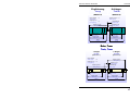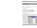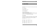
1
USER MANUAL
VISSIM 3.70
Stumpfstraße 1
D-76131 Karlsruhe
Tel: ++49/721/9651-0
Fax: ++49/721/9651-299
E-mail: [email protected]
DISCLOSURE
DISCLOSURE
Copyright
1991-2003
© PTV Planung Transport Verkehr AG
January 2003
All rights reserved.
PTV AG
Stumpfstraße 1
D-76131 Karlsruhe
Germany
Distributors:
North America
Innovative Transportation Concepts, Inc.
1128 NE Second Street, Suite 204
Corvallis, Oregon 97330
phone: (541) 754-6836, fax (541) 754-6837
[email protected]
Latin America Agosta, Campana & Asociados, phone: +54 11-4394-441,
(Span. speak.) fax: +54 11-4322-6067, a&[email protected]
Arabic speak. TrafX, phone: +961/323 2648, fax: +961/137 11 38,
countries
[email protected]
Asia, Australia
Scott Wilson (Malaysia), phone: +60/3/254-1008,
fax: +60/3/254-5871, [email protected]
Belgium
Tritel N.V., phone: +32 2-205-0100, fax +32 2-205-0109,
[email protected]
Brazil
VETEC Engenharia s/C LTDA, phone: +55 11-3078-6799,
fax: +55 11-3167-3452, [email protected]
China
Dr. Brenner + Münnich (Mr Li), phone: +49 7361-5707-34,
fax: +49 7361-5707-77, k.li@brenner–muennich.de
Czech
City Plan Ltd., phone: +420 2-24915-324, fax: +420 2-294939,
VISSIM User Manual - Version 3.70
DISCLOSURE
Republic
[email protected]
Italy
Transport Planning Service, phone: +39 075-5058823,
fax: +39 075-500990, [email protected]
Korea
TERI, phone: +82 2-2254-2564, fax: +82 2-2254-2565
[email protected]
Netherlands
VIALIS, phone: +31 23-5189-137, fax: 31 23-5189-111,
[email protected]
Philippines
SMDI Consultants, Inc., phone: +63 2-634-6973, fax: 63 2-6311617,
[email protected]
Poland
BIT, phone: +48 618-351973, fax +48 618-320044,
[email protected]
Scandinavia
PTV Scandinavia AB, phone: +46 31-743 7575,
fax: +46 31-701 7320, [email protected]
Slovakia
IR Data, phone: +421 903-415035, fax: 421 7-62859698,
[email protected]
South Africa
Africon Engineering Intern., phone: +27 12-427 2726,
fax: +27 12-427 2750, [email protected]
Spain
BB & J Consult S.A., phone: +34 91-504-6326,
fax: +34 91-504-4986, [email protected]
Switzerland
PTV Swiss AG, phone: +41 31-3592-464, fax +41 31-3592-455,
[email protected]
United
Kingdom
Oscar Faber Group Ltd., +44 131-313-7600,
fax: +44 131-313-7699, [email protected]
Yugoslavia
CEP, phone: +381 11-413122, fax: +381 11-422562
[email protected]
VISSIM User Manual - Version 3.70
DISCLOSURE
Copy and Use
Restrictions
Although you are encouraged to make a backup copy of VISSIM
for your own use, you are not allowed to make unlimited copies.
The Software may be used only on a single computer owned,
leased or controlled by you at any one time. The Software is
protected by the copyright laws that pertain to computer Software.
It is illegal to give copies to another person, or to duplicate the
Software by any other means including electronic transmission.
The Software contains trade secrets, and in order to protect them
you may not decompile, reverse engineer, disassemble, or
otherwise reduce the Software to human-perceivable form. You
may not modify, adapt, translate, rent, lease, or create derivative
work based upon the Software or any part thereof.
Disk Warranty
PTV respectively the agent distributing VISSIM warrants that the
original disks are free from defects in material and workmanship,
assuming normal use, for a period of ninety (90) days from date of
purchase. If a defect occurs during this period, you may return
your faulty disk to Innovative Transportation Concepts, along with
a dated proof of purchase; Innovative Transportation Concepts will
replace it free of charge.
EXCEPT FOR THE EXPRESS WARRANTY OF THE ORIGINAL DISKS
SET FORTH ABOVE, NEITHER PTV AG NOR INNOVATIVE
TRANSPORTATION CONCEPTS GRANT ANY OTHER WARRANTIES,
EXPRESS OR IMPLIED, BY STATUTE OR OTHERWISE, REGARDING
THE DISKS OR RELATED MATERIALS, THEIR FITNESS FOR ANY
PURPOSE, THEIR QUALITY, THEIR MERCHANTABILITY, OR
OTHERWISE. THE LIABILITY OF INNOVATIVE TRANSPORTATION
CONCEPTS UNDER THE WARRANTY SET FORTH ABOVE SHALL BE
LIMITED TO THE AMOUNT PAID BY THE CUSTOMER FOR THE
PRODUCT. IN NO EVENT SHALL INNOVATIVE TRANSPORTATION
CONCEPTS, LLC BE LIABLE FOR ANY SPECIAL, CONSEQUENTIAL,
OR OTHER DAMAGES FOR BREACH OF WARRANT.
VISSIM User Manual - Version 3.70
DISCLOSURE
VISSIM User Manual - Version 3.70
TABLE OF CONTENTS
TABLE OF CONTENTS
VISSIM Quick Start Checklist: ................................................................................ ix
Important NOTICE TO Users of Previous VISSIM Versions .................................. x
Important Notice to Users of versions Previous to VISSIM 3.60.......................... xi
Important Notice to Users of versions Previous to VISSIM 3.50......................... xii
1
Introduction ..................................................................................................... 1-1
1.1
What is VISSIM? ............................................................................................. 1-2
1.2
Traffic Simulation Model.................................................................................. 1-4
2
Installation ....................................................................................................... 2-1
2.1
System Requirements ..................................................................................... 2-2
2.2
Installation with Windows 95, 98, 2000, ME and NT ....................................... 2-3
2.3
Distributable VISSIM viewer............................................................................ 2-4
3
Program Handling ........................................................................................... 3-1
3.1 VISSIM Desktop.............................................................................................. 3-2
3.1.1
Tool bars.................................................................................................... 3-3
3.1.2
Status bar .................................................................................................. 3-7
3.2 Selection of Network Elements ....................................................................... 3-8
3.2.1 Standard- (Single-)select mode ..................................................................... 3-8
3.2.2 Multi-select mode........................................................................................... 3-9
3.3
Keyboard and Mouse Operation ................................................................... 3-11
VISSIM User Manual - Version 3.70
i
TABLE OF CONTENTS
3.3.1
3.3.2
General behavior ..................................................................................... 3-11
Shortcuts (Hotkeys) ................................................................................. 3-11
3.4
Command Line Operation ............................................................................. 3-13
3.5
Printing.......................................................................................................... 3-14
3.6 Network Import.............................................................................................. 3-15
3.6.1
Read Network Additionally ....................................................................... 3-15
3.6.2
TEAPAC and SYNCHRO Import (optional module) ................................. 3-17
3.7
4
4.1
Network Export.............................................................................................. 3-19
Traffic/Transit Network ................................................................................... 4-1
Overview ......................................................................................................... 4-2
4.2 Network Coding............................................................................................... 4-4
4.2.1
Background Maps and Drawings ............................................................... 4-4
4.2.1.1
Scanning Images ................................................................................. 4-5
4.2.1.2
Exporting Images from AutoCAD® ....................................................... 4-6
4.2.2
Links .......................................................................................................... 4-7
4.2.2.1
Graphical Editing.................................................................................. 4-7
4.2.2.2
Link properties and options (Link Data dialog) ..................................... 4-9
4.2.3
Link Types ............................................................................................... 4-12
4.2.4
Connectors .............................................................................................. 4-13
4.2.4.1
Graphical Editing................................................................................ 4-13
4.2.4.2
Connector properties and options (Link Connector dialog) ................ 4-15
4.2.5
Rotate and Translate Network ................................................................. 4-17
4.2.6
Pavement Markers................................................................................... 4-19
4.3 Automobile Traffic ......................................................................................... 4-20
4.3.1
Distributions ............................................................................................. 4-20
4.3.1.1
Desired Speed Distribution................................................................. 4-20
4.3.1.2
Model Year Distribution ...................................................................... 4-21
4.3.1.3
Mileage Distribution............................................................................ 4-21
4.3.1.4
Weight Distribution ............................................................................. 4-21
4.3.1.5
Power Distribution .............................................................................. 4-21
4.3.1.6
Dwell Time Distribution....................................................................... 4-22
4.3.1.7
Color Distribution................................................................................ 4-22
4.3.1.8
Vehicle Model Distribution.................................................................. 4-23
4.3.2
Vehicle Acceleration and Deceleration functions ..................................... 4-26
4.3.3
Vehicle Type, Class and Category........................................................... 4-27
4.3.3.1
Vehicle Types..................................................................................... 4-28
4.3.3.2
Vehicle Classes.................................................................................. 4-30
4.3.4
Traffic Composition.................................................................................. 4-31
4.3.5
Vehicle Inputs (Traffic Volume)................................................................ 4-32
ii
VISSIM User Manual - Version 3.70
TABLE OF CONTENTS
4.3.6
Desired Speed Changes.......................................................................... 4-34
4.3.6.1
Reduced Speed Areas ....................................................................... 4-34
4.3.6.2
Desired Speed Decisions ................................................................... 4-37
4.4 Automobile Routing / Turning Movements .................................................... 4-40
4.4.1
Routing Decisions .................................................................................... 4-40
4.4.2
Direction Decisions .................................................................................. 4-47
4.4.3
Routing Decisions versus Direction Decisions ......................................... 4-50
4.5 Transit (Public Transport).............................................................................. 4-51
4.5.1
Transit Stops............................................................................................ 4-51
4.5.2
Transit Lines (Bus/Tram lines) ................................................................. 4-53
4.5.2.1
Definition of a transit line .................................................................... 4-54
4.5.2.2
Transit Line data ................................................................................ 4-55
4.5.2.3
Transit Stops on the Route & Modifying the Route Alignment............ 4-56
4.5.2.4
Transit Vehicle Dwell Time Determination.......................................... 4-58
4.5.2.5
Modeling a Variation of Arrival Times................................................. 4-59
4.6 Non-Signalized Intersections......................................................................... 4-61
4.6.1
Priority Rules (Right-of-way Designation) ................................................ 4-61
4.6.2
Stop Sign Control..................................................................................... 4-72
4.6.3
Merging and Weaving Sections ............................................................... 4-73
4.7 Signalized Intersections ................................................................................ 4-75
4.7.1
Signal Groups and Signal Heads (Indicators) .......................................... 4-75
4.7.2
Detectors ................................................................................................. 4-76
4.7.3
Signal Controller ...................................................................................... 4-79
4.7.3.1
Fixed Time Signal Control .................................................................. 4-80
4.7.3.2
Vehicle Actuated Signal Control (optional module VAP) .................... 4-80
4.7.3.3
NEMA Standard SC Emulator (optional module NEMA) .................... 4-80
4.7.4
Switch of Signal Control Type .................................................................. 4-81
4.7.5
Signal Control Communication ................................................................ 4-81
4.7.6
Railroad Block Signals ............................................................................. 4-82
5
5.1
Global Settings................................................................................................ 5-1
Simulation Parameters.................................................................................... 5-2
5.2 Driving Behavior.............................................................................................. 5-4
5.2.1
Lane Change ............................................................................................. 5-6
5.2.2
Necessary Lane Change (Route)............................................................... 5-7
5.2.3
Vehicle Following Behavior ........................................................................ 5-8
5.2.4
Lateral Behavior......................................................................................... 5-9
5.2.5
Reaction to Amber Signal ........................................................................ 5-10
5.2.6
Changing the Saturation Flow Rate ......................................................... 5-10
5.2.7
External vehicle course files .................................................................... 5-11
VISSIM User Manual - Version 3.70
iii
TABLE OF CONTENTS
5.3 Graphical Display .......................................................................................... 5-13
5.3.1
Alternative Display ................................................................................... 5-17
5.3.2
3D Graphics Mode................................................................................... 5-18
5.3.2.1
Navigation .......................................................................................... 5-18
5.3.2.2
3D vehicles......................................................................................... 5-20
5.3.2.3
Static 3D objects ................................................................................ 5-20
5.4
6
Selection of Units .......................................................................................... 5-22
Simulation and Test ........................................................................................ 6-1
6.1
Simulation ....................................................................................................... 6-2
6.2
Multiple Run Utility .......................................................................................... 6-3
6.3
Animation ........................................................................................................ 6-5
6.4 Recording 3D Video files................................................................................. 6-7
6.4.1
Recording Options ..................................................................................... 6-7
6.4.2
Keyframes.................................................................................................. 6-7
6.4.2.1
Defining Keyframes .............................................................................. 6-7
6.4.2.2
Keyframe Properties ............................................................................ 6-8
6.4.2.3
Keyframe List Functions....................................................................... 6-9
6.4.2.4
How Keyframes come into action ....................................................... 6-10
6.4.3
Starting the Recording ............................................................................. 6-10
6.5 Test of Signal Control without Traffic Simulation........................................... 6-12
6.5.1
Interactive Placement of Detector Calls ................................................... 6-12
6.5.2
Using Macros for Test Runs .................................................................... 6-13
6.5.3
Using Batch Mode Operation for Test Runs ............................................ 6-14
6.5.3.1
Red Time Distribution......................................................................... 6-16
6.5.3.2
Green Time Statistics......................................................................... 6-16
6.5.3.3
Time-Time Diagram ........................................................................... 6-17
7
Results ............................................................................................................. 7-1
7.1 Enabling Evaluations....................................................................................... 7-2
7.1.1
Windows Output ........................................................................................ 7-2
7.1.2
File Output ................................................................................................. 7-4
7.1.3
Database Output........................................................................................ 7-4
7.1.3.1
System Requirements .......................................................................... 7-5
7.1.3.2
Database Connection........................................................................... 7-5
7.1.3.3
Database Output Data ......................................................................... 7-6
7.2 Runtime Errors ................................................................................................ 7-7
7.2.1
Assertion Error Messages.......................................................................... 7-7
7.2.2
Program Warnings (*.ERR file) ................................................................. 7-7
iv
VISSIM User Manual - Version 3.70
TABLE OF CONTENTS
8
Evaluation Types............................................................................................. 8-1
8.1 Travel Times ................................................................................................... 8-2
8.1.1
Definition.................................................................................................... 8-2
8.1.2
Configuration ............................................................................................. 8-4
8.1.3
Results....................................................................................................... 8-4
8.2 Delay Times .................................................................................................... 8-5
8.2.1
Definition.................................................................................................... 8-5
8.2.2
Configuration ............................................................................................. 8-5
8.2.3
Results....................................................................................................... 8-6
8.3 Data Collection................................................................................................ 8-8
8.3.1
Definition.................................................................................................... 8-8
8.3.2
Configuration ............................................................................................. 8-8
8.3.3
Results..................................................................................................... 8-10
8.4 Queue Counters............................................................................................ 8-11
8.4.1
Definition.................................................................................................. 8-11
8.4.2
Configuration ........................................................................................... 8-12
8.4.3
Results..................................................................................................... 8-12
8.5 Green Time Distribution ................................................................................ 8-14
8.5.1
Definition.................................................................................................. 8-14
8.5.2
Configuration ........................................................................................... 8-14
8.5.3
Results..................................................................................................... 8-14
8.6 Vehicle Information ....................................................................................... 8-16
8.6.1
Definition.................................................................................................. 8-16
8.6.2
Configuration ........................................................................................... 8-16
8.6.3
Results..................................................................................................... 8-17
8.7 Vehicle Record.............................................................................................. 8-18
8.7.1
Definition.................................................................................................. 8-18
8.7.2
Configuration and Filter............................................................................ 8-18
8.7.3
Results..................................................................................................... 8-20
8.7.4
Available Parameters............................................................................... 8-21
8.8 Dynamic Signal Timing Plan ......................................................................... 8-26
8.8.1
Definition.................................................................................................. 8-26
8.8.2
Configuration ........................................................................................... 8-26
8.8.3
Results..................................................................................................... 8-27
8.9
Signal Control Detector Record..................................................................... 8-29
VISSIM User Manual - Version 3.70
v
TABLE OF CONTENTS
8.9.1
8.9.2
8.9.3
Definition.................................................................................................. 8-29
Configuration ........................................................................................... 8-29
Results..................................................................................................... 8-31
8.10 Signal Changes............................................................................................. 8-32
8.10.1 Definition.................................................................................................. 8-32
8.10.2 Configuration ........................................................................................... 8-32
8.10.3 Results..................................................................................................... 8-32
8.11 Link Evaluation.............................................................................................. 8-34
8.11.1 Definition.................................................................................................. 8-34
8.11.2 Configuration ........................................................................................... 8-34
8.11.3 Results..................................................................................................... 8-35
8.11.4 Available Parameters............................................................................... 8-36
8.12 Node Evaluation............................................................................................ 8-38
8.12.1 Definition.................................................................................................. 8-38
8.12.2 Configuration ........................................................................................... 8-38
8.12.3 Results..................................................................................................... 8-39
8.13 Network Performance Evaluation .................................................................. 8-41
8.13.1 Definition.................................................................................................. 8-41
8.13.2 Configuration ........................................................................................... 8-41
8.13.3 Results..................................................................................................... 8-41
8.14 Observer ....................................................................................................... 8-42
8.15 Lane Changes............................................................................................... 8-43
8.15.1 Definition.................................................................................................. 8-43
8.15.2 Configuration ........................................................................................... 8-43
8.15.3 Results..................................................................................................... 8-43
8.16 Bus/Tram Waiting Time................................................................................. 8-44
8.16.1 Definition.................................................................................................. 8-44
8.16.2 Configuration ........................................................................................... 8-44
8.16.3 Results..................................................................................................... 8-44
8.17 Vehicle Input ................................................................................................. 8-45
8.17.1 Definition.................................................................................................. 8-45
8.17.2 Configuration ........................................................................................... 8-45
8.17.3 Results..................................................................................................... 8-45
8.18 Time-Space Diagram (x-t-Diagram) .............................................................. 8-46
8.18.1 Definition.................................................................................................. 8-46
8.18.2 Configuration ........................................................................................... 8-46
8.18.3 Results..................................................................................................... 8-46
vi
VISSIM User Manual - Version 3.70
TABLE OF CONTENTS
8.19 Speed-Distance Diagram (x-v-Diagram) ....................................................... 8-48
8.19.1 Definition.................................................................................................. 8-48
8.19.2 Configuration ........................................................................................... 8-48
8.19.3 Results..................................................................................................... 8-49
8.20 Acceleration Statistics ................................................................................... 8-50
8.20.1 Definition.................................................................................................. 8-50
8.20.2 Configuration ........................................................................................... 8-50
8.20.3 Results..................................................................................................... 8-50
8.21 Acceleration/Speed Integral Evaluation......................................................... 8-51
8.22 Emission Statistics ........................................................................................ 8-52
8.23 Export .......................................................................................................... 8-53
8.24 Special Evaluations....................................................................................... 8-54
8.24.1 Definition.................................................................................................. 8-54
8.24.2 Configuration ........................................................................................... 8-54
8.24.3 Results..................................................................................................... 8-54
8.25 Paths .......................................................................................................... 8-56
8.25.1 Definition.................................................................................................. 8-56
8.25.2 Configuration ........................................................................................... 8-56
8.25.3 Results..................................................................................................... 8-57
8.26 Convergence Evaluation ............................................................................... 8-58
8.26.1 Definition.................................................................................................. 8-58
8.26.2 Configuration ........................................................................................... 8-58
8.26.3 Results..................................................................................................... 8-59
9
Dynamic Assignment...................................................................................... 9-1
9.1
Introduction ..................................................................................................... 9-2
9.2
Principle .......................................................................................................... 9-3
9.3 Building an Abstract Network .......................................................................... 9-6
9.3.1
Parking Lots and Zones ............................................................................. 9-6
9.3.2
Nodes ........................................................................................................ 9-8
9.3.3
Edges ........................................................................................................ 9-9
9.4 Traffic Demand.............................................................................................. 9-12
9.4.1
Origin-Destination Matrices...................................................................... 9-12
9.4.2
Trip Chain Files........................................................................................ 9-14
9.5 Simulated Travel Time and General Cost ..................................................... 9-16
9.5.1
Simulation Period and Evaluation Interval ............................................... 9-16
VISSIM User Manual - Version 3.70
vii
TABLE OF CONTENTS
9.5.2
9.5.3
Simulated Travel Times ........................................................................... 9-16
General Cost............................................................................................ 9-17
9.6 Route Search and Route Choice................................................................... 9-19
9.6.1
Routes and their Cost .............................................................................. 9-19
9.6.2
Route Choice ........................................................................................... 9-19
9.6.3
Route Search........................................................................................... 9-21
9.6.4
Route Visualization .................................................................................. 9-22
9.7 Optional Enhancements of the Model ........................................................... 9-23
9.7.1
Multi-class Assignment ............................................................................ 9-23
9.7.2
Parking Lot Choice .................................................................................. 9-24
9.7.3
Detour Detection...................................................................................... 9-26
9.7.4
Correction of Overlapping Paths .............................................................. 9-26
9.7.5
Dynamic Routing Decisions ..................................................................... 9-28
9.7.6
Route Guidance....................................................................................... 9-29
9.8 Assignment Control....................................................................................... 9-30
9.8.1
Path Evaluation File ................................................................................. 9-30
9.8.2
Iteration Control ....................................................................................... 9-30
9.8.3
Convergence Control ............................................................................... 9-31
9.8.4
Route Search Control and Local Calibration ............................................ 9-32
9.8.5
Generation of Static Routing.................................................................... 9-35
9.8.6
Summary of the Dynamic Assignment Parameters.................................. 9-35
10 Glossary of Files associated with VISSIM .................................................. 10-1
10.1 Simulation Output Files ................................................................................. 10-2
10.2 Test Mode Files............................................................................................. 10-5
10.3 Dynamic Assignment Files ............................................................................ 10-6
10.4 Other Data Files ............................................................................................ 10-7
11 Support .......................................................................................................... 11-1
viii
VISSIM User Manual - Version 3.70
VISSIM QUICK START CHECKLIST:
VISSIM QUICK START CHECKLIST:
For those users who are constructing their first network this is a checklist intended to
assist in building the network in the most efficient order.
1.
Open VISSIM and create a new file
2.
Check/edit vehicle type characteristics (see section 4.3.3.1)
3.
Create/edit speed profiles (see section 4.3.1.1)
4.
Create traffic compositions (see section 4.3.4)
5.
Create BMP format background image (see section 4.2.1)
6.
Open, scale and save a scaled background image. Note: scaling the
background map accurately is extremely important (see section 4.2.1.1)
7.
Draw links and connectors for roadways tracks and crosswalks (see section
4.2.2)
8.
Enter traffic volumes at network endpoints and pedestrian volumes on
crosswalks (see section 4.3.5)
9.
Enter routing decision points and associated routes (see section 4.4.1)
10.
Enter speed changes (see sections 4.3.6.1 and 4.3.6.2)
11.
Enter priority rules for non-signalized intersections (see section 4.6.1)
12.
Enter stop signs for non-signalized intersections (see section 4.6.2)
13.
Create Signal Controls with signal groups, enter timing for fixed time or choose
a different controller for vehicle actuated signals (e.g. VAP or NEMA, see
section 4.7)
14.
Enter signal heads in network (see section 4.7.1)
15.
Enter detectors for intersections controlled by traffic actuated signal control (see
section 4.7.2)
16.
Enter stop signs for right turns on red (see section 4.6.2)
17.
Enter priority rules for permissive lefts, right turns on red, pedestrian crosswalks
(see section 4.6.1)
18.
Create dwell time distributions and place transit stops in network (see sections
4.3.1.6 and 4.5.1)
19.
Create transit lines (see section 4.5.2)
20.
Setup for output files, e.g. travel time segments, delay segments, queue
counters, data collection points (see chapter 8).
VISSIM User Manual - Version 3.70
ix
IMPORTANT NOTICE TO USERS OF PREVIOUS
VISSIM VERSIONS
The 3D model and color assignment for a vehicle type is done through distributions
(see sections 4.3.1.7 and 4.3.1.8 for details). Thus definition of vehicle model
appearance is to be done in the distribution rather than in the Vehicle Type dialog
box.
New two column toolbar: All toolbar options are now shown at all times (no more
secondary toolbars).
The three network editor modes "Create links", "Edit links" and "Connectors" are
combined into one mode "Links and Connectors". Thus some link and connector
handling commands have slightly changed (see sections 4.2.2 and 4.2.4 for details).
Partial routes now affect transit routes (lines) as well. A rerouting of transit vehicles
can be avoided by restricting the vehicle classes of the routing decision (see section
4.4.1 for details).
More hotkeys: The range of keyboard shortcuts (hotkeys) has been greatly expanded
(see section 3.3.2. for details).
As the car following and lane change models have been improved (especially for
merging areas) the simulation results may be different when comparing with an
earlier version.
Due to new program features a network file saved with version 3.70 cannot be read in
any older version of VISSIM.
Dynamic Assignment: Parking lots cannot be assigned to more than one zone any
more. A parking lot from an old VISSIM network file that is assigned to more than one
zone is converted to several parking lots assigned to one zone each.
North American licenses: Optional module “NEMA” available which includes an
interface to the standard NEMA controller type (see section 4.7.3.3). Optional
TEAPAC and SYNCHRO import module available (see section 3.6.2).
x
VISSIM User Manual - Version 3.70
IMPORTANT NOTICE TO USERS OF VERSIONS PREVIOUS TO VISSIM 3.60
IMPORTANT NOTICE TO USERS OF VERSIONS
PREVIOUS TO VISSIM 3.60
For users of Dynamic Assignment: The file format and interpretation of the time in
matrix files (*.FMA) has been changed in order to make it fully compatible with
VISUM:
•
A time value of 1.50 is now interpreted as 1 hour 50 mins rather than 1 hour 30
mins (1.5 hrs).
•
The time stated in the matrix is now the absolute time of day (not relative to the
simulation start). For more information please refer to chapter 9.4.
•
The matrix scaling factor is now used in VISSIM.
With the introduction of link types, network files from versions prior to VISSIM 3.60
will be transformed to replicate the existing driving behavior and link features using
link types. On rare occasions where a single vehicles mix contains cycles and
pedestrians the link type might not be identified correctly by VISSIM. Thus traffic on
those links might appear different as from versions prior to 3.60.
VISSIM User Manual - Version 3.70
xi
IMPORTANT NOTICE TO USERS OF VERSIONS
PREVIOUS TO VISSIM 3.50
VISSIM from version 3.5 incorporates a single model to handle vehicle data for both
2D and 3D representation. As 3D elements have a static length the use of length
distributions is impossible and thus is not supported any more. If network files of older
VISSIM versions are to be loaded in the current version, each vehicle type will be
assigned a length that is computed as the average of the previous length distribution
that has been assigned to it. In order to reflect the behavior of length distributions a
vehicle model distribution may be used.
Furthermore the format of the 3D vehicle models has been improved in order to
minimize loading times. Thus the V3D format is now used for all 3D objects. There is
a selection of vehicles in V3D format that is included with the installation of VISSIM at least one for each standard vehicle type. Any existing 3DS files can be converted
and adapted using the optional module “V3DM” (VISSIM 3D Modeler) which is
available from PTV AG.
In order to make VISSIM use any 3D vehicles during a simulation run when using a
network file of an older version, a vehicle model distribution needs to be selected for
each vehicle type. The new 3D models are not assigned to existing vehicle types
automatically as it would automatically overrule the dimensions of any 2D models and
thus would result in great differences compared to version 3.0. Instead, vehicle
“blocks” that use exactly the dimensions of the 2D-model will be created and shown
during a 3D animation.
If a 3D model is assigned to a vehicle type, the dimensions (e.g. length) of the vehicle
type will be adapted according to the 3D model and thus changes the 2D
representation also.
As the file format for animation files (*.ANI) has changed, animation files generated
with earlier versions of VISSIM can not be loaded in VISSIM version 3.50 or higher.
xii
VISSIM User Manual - Version 3.70
INTRODUCTION
1 INTRODUCTION
VISSIM User Manual - Version 3.70
1-1
INTRODUCTION
1.1
What is VISSIM?
What is VISSIM?
VISSIM is a microscopic, time step and behavior based simulation model developed
to model urban traffic and public transit operations. The program can analyze traffic
and transit operations under constraints such as lane configuration, traffic
composition, traffic signals, transit stops, etc., thus making it a useful tool for the
evaluation of various alternatives based on transportation engineering and planning
measures of effectiveness.
VISSIM can be applied as a useful tool in a variety of transportation problem settings.
The following list gives a selective overview of previous applications of VISSIM:
•
Development, evaluation and fine-tuning of transit signal priority logic.
•
VISSIM can use various types of signal control logic. In addition to the built-in
fixed-time functionality there are several vehicle actuated signal controls identical
to signal control software packages installed in the field. In VISSIM some of them
are built-in, some can be docked using add-ons and others can be simulated
through the external signal state generator (VAP) that allows the design of userdefined signal control logic. Thus virtually every signal control (incl. SCATS,
SCOOT) can be modeled and simulated within VISSIM if either the controller
details are available or there is a direct VISSIM interface available (e.g. VS-PLUS,
TEAPAC).
•
VISSIM has been used to evaluate and optimize (interface to Signal97/TEAPAC)
traffic operations in a combined network of coordinated and actuated traffic
signals.
•
VISSIM has been used to evaluate the feasibility and impact of integrating light
rail into urban street networks.
•
VISSIM has been applied to the analysis of slow speed weaving and merging
areas.
•
VISSIM allows for an easy comparison of design alternatives including signalized
and stop sign controlled intersections, roundabouts and grade separated
interchanges.
•
Capacity and operations analyses of complex station layouts for light rail and bus
systems have been analyzed with VISSIM.
•
Preferential treatment solutions for buses (e.g. queue jumps, curb extensions,
bus-only lanes) have been evaluated with VISSIM.
1-2
VISSIM User Manual - Version 3.70
What is VISSIM?
•
INTRODUCTION
With its built-in Dynamic Assignment model, VISSIM can answer route choice
dependent questions such as the impacts of variable message signs or the
potential for traffic diversion into neighborhoods for networks up to the size of
medium sized cities.
VISSIM User Manual - Version 3.70
1-3
INTRODUCTION
1.2
Traffic Simulation Model
Traffic Simulation Model
The simulation package VISSIM consists internally of two different programs,
exchanging detector calls and signal status through an interface. The simulation
generates an online animation of traffic operations and offline the generation of
output files gathering statistical data such as travel times and queue lengths.
The traffic simulator is a microscopic traffic flow simulation model including car
following and lane change logic. The signal state generator is a signal control
software polling detector information from the traffic simulator on a discrete time step
basis (as small as one tenth of a second). It then determines the signal status for the
following second and returns this information to the traffic simulator.
Communication between traffic simulator and signal state generator
1-4
VISSIM User Manual - Version 3.70
Traffic Simulation Model
INTRODUCTION
Car following logic (Wiedemann 1974)
Essential to the accuracy of a traffic simulation model is the quality of the actual
modeling of vehicles; e.g. the methodology of moving vehicles through the network.
In contrast to less complex models using constant speeds and deterministic car
following logic, VISSIM uses the psycho-physical driver behavior model developed by
WIEDEMANN (1974). The basic concept of this model is that the driver of a faster
moving vehicle starts to decelerate as he reaches his individual perception threshold
to a slower moving vehicle. Since he cannot exactly determine the speed of that
vehicle, his speed will fall below that vehicle’s speed until he starts to slightly
accelerate again after reaching another perception threshold. This results in an
iterative process of acceleration and deceleration.
Stochastic distributions of speed and spacing thresholds replicate individual driver
behavior characteristics. The model has been calibrated through multiple field
measurements at the Technical University of Karlsruhe, Germany. Periodical field
measurements and their resulting updates of model parameters ensure that changes
in driver behavior and vehicle improvements are accounted for.
VISSIM’s traffic simulator not only allows drivers on multiple lane roadways to yield
for two preceding vehicles, but also two neighboring vehicles on the adjacent travel
lanes. Furthermore, approaching a traffic signal results in a higher alertness for
drivers at a distance of 100 meters in front of the stop line.
VISSIM User Manual - Version 3.70
1-5
INTRODUCTION
Traffic Simulation Model
VISSIM simulates traffic flow by moving “driver-vehicle-units” through a network.
Every driver with his specific behavior characteristics is assigned to a specific vehicle.
As a consequence, the driver behavior corresponds to the technical capabilities of his
vehicle. Attributes characterizing each driver-vehicle-unit can be discriminated into
three categories:
1. Technical specifications of the vehicle
• Length
• Maximum speed
• Potential acceleration
• Actual position within the network
• Actual speed and acceleration
2.
Behavior of driver-vehicle-unit
•
•
•
3.
Psycho-physical sensitivity thresholds of the driver (ability to estimate,
aggressiveness)
Memory of driver
Acceleration based on current speed and driver’s desired speed
Interdependence of driver-vehicle-units
•
•
•
1-6
Reference to leading and following vehicles on own and adjacent travel lanes
Reference to current link and next intersection
Reference to next traffic signal
VISSIM User Manual - Version 3.70
INSTALLATION
2 INSTALLATION
VISSIM User Manual - Version 3.70
2-1
INSTALLATION
2.1
System Requirements
System Requirements
As a 32-bit application VISSIM runs under Windows 95/98/2000/ME/NT 4.0 (or later).
The performance of a VISSIM simulation is mainly dependent on the number of
vehicles simultaneously contained in the network and on the number and type of
signal controlled junctions included. Thus using identical VISSIM input files, a faster
computer will always lead to a faster simulation. For very large applications (like a
network of at least half a city with more than 50 signal controlled junctions) at least
1 GB of RAM is recommended.
To provide an optimal desktop layout when multiple windows are displayed
simultaneously it is beneficial to use the highest resolution supported by the hardware
configuration. At a minimum, a resolution of 1024x768 pixel should be used.
However, we recommend a resolution of 1280x1024 (or 1280x960) pixel on a 17’’
and 1600x1200 pixel on a 21’’ monitor for convenience. In 3D mode, simulation
speed may be significantly lower by using higher screen resolutions. In order to
increase 3D animation speed it may be useful to reduce the screen resolution
temporarily.
For 3D animation of a simulation VISSIM uses Open-GL™ routines. Thus a graphics
adapter with Open-GL™-support takes a lot of the workload and significantly
increases animation speed. We recommend graphics adapters with Nvidia chipsets.
It is strongly recommended that the latest driver update of your graphics adapter be
used since simply updating the driver can solve most problems that occur with the 3D
animation. For most graphics adapters a driver update can be obtained via download
from the Internet.
2-2
VISSIM User Manual - Version 3.70
Installation with Windows 95, 98, 2000, ME and NT
2.2
INSTALLATION
Installation with Windows 95, 98, 2000, ME and NT
To install VISSIM, insert the CD in your CD-ROM drive. If the installation procedure
does not start automatically use START - RUN... or the Windows explorer to start the
installation program setup.exe. Then follow the instructions given by the installation
program.
*
If you are installing VISSIM with Windows NT or 2000 you must be
logged in with administrator rights.
VISSIM User Manual - Version 3.70
2-3
INSTALLATION
2.3
Distributable VISSIM viewer
Distributable VISSIM viewer
Contained on the VISSIM installation CD there is also a restricted VISSIM version (=
VISSIM Demo version without demo examples) that can be used to be given to
clients along with VISSIM project data. The main restrictions of this version are
•
Network files cannot be saved
•
No evaluation files can be generated
•
Simulation runs are possible only for the first 900s. This period cannot be
extended in order to show longer simulation runs. If it is necessary to show
vehicle animation beyond the first 900s, animation files (*.ani) can be used. For
animation files there is no time limit.
For instructions on how to create a CD that contains the distributable VISSIM version
along with project data please refer to the file readme.txt that is contained in the
directory DEMO directly on the VISSIM installation CD.
2-4
VISSIM User Manual - Version 3.70
PROGRAM HANDLING
3 PROGRAM HANDLING
VISSIM User Manual - Version 3.70
3-1
PROGRAM HANDLING
3.1
VISSIM Desktop
VISSIM Desktop
The desktop of VISSIM is divided into the following areas:
Menu
Header
Tool bars
Scroll bars
Status bar
Header
Shows program title, version and input file name
Menu
Access by mouse click or hotkey
4 Indicates following sub-menu
“...“ Indicates following dialog box
3-2
VISSIM User Manual - Version 3.70
VISSIM Desktop
PROGRAM HANDLING
The last four network files accessed by VISSIM are listed in the
File menu (“most recently used files”). Selecting any one of these
files opens it.
Tool bars
Control network editor and simulation functions (see separate
section below)
Status bar
Shows editing instructions and simulation status (see separate
section below)
Scroll bars
Horizontal and vertical scrolling of network viewing area
Logo
Depending on the location of the sale of the software license a
logo will appear in the upper right hand corner of the VISSIM
network.
The user can insert a custom logo in the lower right corner by
naming it custom.bmp and placing it in the same directory as
vissim.exe.
3.1.1
Tool bars
On the left side of the VISSIM window several tool bars are located. Depending on
the current edit and graphics mode, not all of the buttons might be available. The
disabled buttons are shown colorless.
1. View toolbar
Description
Shortcut
DYNAMIC ZOOM (left click), PREVIOUS VIEW (right click)
PAGE UP,
PAGE DOWN
ZOOM BY FACTOR
SHOW ENTIRE NETWORK
ROTATE NETWORK (3D only)
MOVE NETWORK (3D only, shortcuts also in 2D)
Ç,È,Å,Æ
FLY THROUGH NETWORK (3D ONLY)
VISSIM User Manual - Version 3.70
3-3
PROGRAM HANDLING
VISSIM Desktop
2. Simulation toolbar
In the section above the buttons the current simulation mode is shown:
SIMULATION, ANIMATION or TEST. To change to a different mode the respective
command needs to be selected in the main menu.
Description
Shortcut
Continuous simulation, animation or test
F5
Single step simulation, animation or test
F6
Stop simulation, animation or test
ESC
Continuous backwards (animation only)
Single step backwards (animation only)
3. Selection toolbar
Description
Shortcut
Standard selection mode
Multi-select mode (see description in the section below)
Label mode. Any labels of network elements (e.g signal head names) can
be relocated if at the same time the edit mode of that network element is
active.
If several links/connectors are located at the mouse click
position this button can be used to browse through all
these links/connectors.
3-4
VISSIM User Manual - Version 3.70
TAB
VISSIM Desktop
PROGRAM HANDLING
4. Network elements toolbar
While one of the following buttons is pressed, new elements of the corresponding
type can be created or existing ones edited.
For details on each element please refer to chapter 4.
Basic roadwork
Links and connectors
Vehicle flow
Vehicle inputs
Direction decisions (historical only, usage not recommended)
Static routes (to direct traffic within the network)
Vehicle speeds
Desired speed decisions
Reduced speed areas
Priority control
Priority rules (e.g. for non-signalized intersections)
Stop signs
Signal heads
Signal detectors
Public transport
Public transport stops
VISSIM User Manual - Version 3.70
3-5
PROGRAM HANDLING
VISSIM Desktop
Public transport lines
Evaluations
Cross section measurements
Travel time and delay measurements
Queue counters
Graphics
Pavement Markers
Dynamic Assignment (optional module)
Parking lots / zone connectors
Nodes (some VISSIM licenses also
independently of Dynamic Assignment)
3-6
allow for
VISSIM User Manual - Version 3.70
node
evaluation
VISSIM Desktop
3.1.2
PROGRAM HANDLING
Status bar
The status bar is divided into three sections. Depending on the current program mode
each sections displays different data:
First section
2D Graphics: Current cursor position (x,y coordinates in meters,
“world coordinates”)
3D Graphics: Current position (x,y,z coordinates in meters) of
that part of the network, that is displayed at the center of the
VISSIM window.
Second section
Network editing: Number of selected link/connector and position
within selected link/connector
Simulation: Current simulation time and local cycle time
3D Graphics (Fly mode): Current observer position (x,y,z
coordinates in meters)
Third section
Network editing: Editing instructions
Network editing (3D-Zoom, Rotate, Pan): Current observer
position (d,A,C):
- d = distance (in meters) to that part of the network, that is
displayed at the center of the VISSIM window
- A: angle between XZ-plane and observer
- C: angle between XY-plane and observer
Simulation:
- Number of vehicles currently in the network
- Actual simulation speed (compared to real time)
- Number of vehicles that could be simulated at real time
(displayed only if simulation speed is set to maximum)
VISSIM User Manual - Version 3.70
3-7
PROGRAM HANDLING
3.2
3.2.1
Selection of Network Elements
Selection of Network Elements
Standard- (Single-)select mode
All VISSIM network elements have numbers and each element can be selected using
its type and number. To select a network element and access its data the
corresponding edit mode needs to be active. Except for links and nodes all network
elements need to be placed on a link or connector. To place such an element
• select the corresponding edit mode
• select the desired link or connector by single left click
• follow the instructions to create a new element of that type
To select an element by number, the edit mode of that element type needs to be
active (e.g. to see a list of all links in a network by number, the link mode needs to be
active). To open the list of all network elements either
• right click outside the VISSIM network (not clicking on a link or connector)
• or select NETWORK EDITOR – SELECTION – <ELEMENT TYPE>
The element type is displayed in the box title (the
example shows a list of all Links).
From that list the properties of each network
element are available (DATA...) and also the
location can be found (ZOOM). In a large network
it might be helpful to use the ZOOM FACTOR
command after pressing the ZOOM button to see
the surrounding area of the selected network
element.
3-8
VISSIM User Manual - Version 3.70
Selection of Network Elements
3.2.2
PROGRAM HANDLING
Multi-select mode
Currently multi-select mode is available for certain properties of links and connectors
only. See below for details.
Nodes (only applicable when using additional module “Dynamic Assignment”) that are
completely located within the selection box are also moved along with the
links/connectors.
•
Links, connectors and nodes can be added to or removed from the selection
(toggled) either
− by spanning a rectangle around them (using left mouse button) or
− by clicking on a link/connector (left mouse button)
•
Links/connectors can be added to the selection (independent of their previous
status) by holding down the SHIFT key while drawing the selection box.
•
Links/connectors can be removed from the selection (independent of their
previous status) by holding down the <CTRL> key while drawing the selection box.
*
Only those links/connectors/nodes that are entirely located within the
selection rectangle are affected by the selection.
Exception: When moving a multi-selection all connectors between links
that are contained in the multi-selection are moved as well.
•
The entire selection can be cancelled by clicking outside the selection while
holding down the CTRL key.
•
All links/connectors in the selection can be moved by clicking inside the selection.
Connectors that connect two selected links are moved together with the
corresponding links - even if they are not included in the selection.
If intermediate points of a connector should not be moved (along with the start
and end points) such a connector needs to be deselected and the CTRL key must
be pressed while moving the selection.
•
The properties of all selected links/connectors can be accessed by right mouse
click. The following properties can be changed (for details please refer to the
sections “links” and “connectors” in chapter 4):
VISSIM User Manual - Version 3.70
3-9
PROGRAM HANDLING
−
link Type,
−
Animation,
−
Label,
−
Gradient,
−
Segment Evaluation
−
Segment length
−
COST
−
LANE CLOSURE
Selection of Network Elements
Specifically for connectors the
following properties can be changed in
a multi-selection:
−
Emergency stop position
−
Lane Change position
−
Vehicle class closure (for Dynamic
Assignment only)
−
Direction:
If two or more connectors within
the selection have different
Direction values then the default
is set to “keep value”. This means that all connectors remain unchanged. To
change all connectors to the same value, simply select the desired Direction.
A field shown in brackets () indicates that the original values are not identical for
all selected links. This state can be restored for check boxes by clicking three
times, but not for edit fields. Drop-down list boxes have an additional entry "Keep
Values" if the original values are not identical. If this entry is selected, the old
values are kept for all links.
3-10
VISSIM User Manual - Version 3.70
Keyboard and Mouse Operation
3.3
Keyboard and Mouse Operation
3.3.1
General behavior
PROGRAM HANDLING
The following information applies to the general philosophy that is widely used for the
VISSIM network editor (as far as not overruled by standard Windows behavior).
Right mouse click
A click outside the network opens a list of all defined elements
of the current edit mode.
A click (or click and drag) on a link inserts a new element.
Left mouse click
Single click selects an existing element.
Double click opens associated properties data box.
RETURN
Corresponds to a mouse click on the highlighted button (usually
the OK button).
ESC
Corresponds to a mouse click on the CANCEL button.
DEL
Deletes a selected network element
3.3.2
Shortcuts (Hotkeys)
The following keyboard shortcuts are available, if the focus is on the main VISSIM
window :
CTRL - A
Toggles between Center Line and Normal link display mode.
If previously display mode Invisible was active then it toggles between
Center Line and Invisible display mode.
CTRL - B
Toggles the display of a loaded background bitmap
CTRL - D
Toggles the display between 2D edit mode and 3D display mode
CTRL - N
Toggles the display of network elements/labels
VISSIM User Manual - Version 3.70
3-11
PROGRAM HANDLING
Keyboard and Mouse Operation
CTRL - Q
Controls the animation mode (3 states: normal vehicle animation,
alternative link display (if defined), no animation)
CTRL - T
Toggles link color (either link type specific or global)
CTRL - U
Toggles the type of display of the simulation time within the status bar
(either seconds or time of day)
CTRL - V
Toggles the extended vehicle display (see section 5.3)
CTRL - Z
Dynamic Assignment only (while in “Parking Lot” mode): Shows the
centroids of all parking lots that belong to the same zone. See section
9.7.2 for details
TAB
Moves to next link or connector layer (when clicking at a position with
at least two links/connectors)
F5
Simulation Continuous: Starts/continues continuous simulation
F6
Simulation Step: Executes next simulation time step
ESC
Simulation Stop: Ends the simulation
ENTER
(during a simulation run only:) Switch to continuous simulation
SPACE
(during a simulation run only:) Executes next simulation time step
+
Increase simulation speed (depending on computer performance)
-
Decrease simulation speed
*
Maximum simulation speed (depending on computer performance)
/
(if maximum speed is active:) Back to last speed value
1
Simulation speed real time (1.0s)
HOME
PAGE UP
Display entire network
Zoom in
PAGE DOWN Zoom out
BACKSPACE
Back to previous view
Ç,È,Å,Æ
Scrolls the screen size by 1/20 in the selected direction. Holding down
the SHIFT key increases the scroll portion to ½ of the screen size.
3-12
VISSIM User Manual - Version 3.70
Command Line Operation
3.4
PROGRAM HANDLING
Command Line Operation
VISSIM can be run from a command line prompt. In order to get results from an input
file run in batch mode the desired evaluations must be specified in the vissim.ini file
used by the VISSIM executable. The VISSIM executable uses the vissim.ini file in
the directory where it is called from. Therefore the vissim.ini file you use must
reside in the same directory as the batch file.
The following table shows the optional arguments and what they do:
<input-filename> Loads the input file
-b<ini-filename>
Loads a background bitmap and zooms in according to the
information contained in the *.ini file (only works in conjunction
with an input filename). An *.ini file can be saved using
OPTIONS – SAVE AS... in the main menu.
Example: VISSIM.exe lux567.inp -blux567.ini opens
VISSIM with the network file lux567.inp and the options file
lux567.ini.
-s<n>
Starts and runs the simulation <n> times. Any non-critical runtime
errors will not display a message box.
See section 6.2 for another method of running multiple simulation
runs with VISSIM.
-l<language>
The language flag allows VISSIM to select a different (not the
default) program language. Both VISSIM370<language>.DLL
(e.g. VISSIM370E.DLL) and SelectVehic_<language>.DLL (e.g.
SelectVehic_E.DLL) will be started with the desired language.
-v<%volume>
The volume flag is only used with Dynamic Assignment (optional
module) and the number following is the percentage of the total
volume that should be added to the percentage specified in the
Dynamic Assignment dialog box as Reduced Volume [%]. If
VISSIM is run in batch mode the volume will increase by this
percentage every run until it reaches 100%.
Sample line from a batch file:
c:\VISSIM370\exe\vissim.exe C:\vissim370\example\King.inp -s1
VISSIM User Manual - Version 3.70
3-13
PROGRAM HANDLING
3.5
Printing
Printing
Output text files can be viewed and printed with standard Windows applications such
as Notepad. Furthermore, most output files are created with semicolon delineation for
easy importing into spreadsheet applications (e.g. Excel, Quattro Pro). Graphical
output such as animation screen shots can be printed using the Print function and the
Page Setup dialog box (see below). Printouts consist of the current screen area and
a data field at the bottom with text fields for project and scenario as well as the
simulation time, file name, VISSIM version and the simulation comment. It is
recommended to use landscape orientation when printing. If the Fit to page box is
checked then any unused area on the page will be filled with the corresponding
screen area.
Dynamic signal timing windows and any other real time displays can be imported into
graphic applications (e.g. Paintbrush, PaintShop Pro, Corel PhotoPaint) or word
processors (e.g. Word, WordPerfect) using Windows’ print screen function (ALT –
PRINT SCREEN) and the clipboard. The best results will be achieved with the
highest available monitor resolution.
3-14
VISSIM User Manual - Version 3.70
Network Import
PROGRAM HANDLING
3.6
Network Import
3.6.1
Read Network Additionally
VISSIM allows for any previously defined VISSIM network to be added to the current
network. Any numbering conflicts of network elements or other data blocks are
resolved. Furthermore the user can select to read certain network elements only.
To read a VISSIM network file additionally:
1. Go to FILE - READ ADDITIONALLY... (available only if the current network was saved
at least once).
2. Select the filename of the file to read
3. Choose the Network Elements and Insert Position options and confirm with OK.
(For illustration and details see section below. The default settings read the entire
network additionally.)
4. If the network is floating, defloat it at the desired location by clicking the left
mouse button.
VISSIM User Manual - Version 3.70
3-15
PROGRAM HANDLING
Network Import
Insert Position
•
Select position with left mouse button:
Inserts the additional network as floating selection which can be moved with the
mouse prior to its definite placement. Left click defloats the additional network.
•
Keep original world coordinates:
The additional network is placed exactly at the same location (“world coordinates”)
as in the original file. This method is recommended e.g. to combine several partial
networks that were created based on a global coordinate system.
In both options the additionally read network portion remains multi-selected.
3-16
VISSIM User Manual - Version 3.70
Network Import
PROGRAM HANDLING
Network Elements
Each network element type can be activated or deactivated for the import. However, if
a network element type is selected, all network element types that it refers to are
selected automatically as well. If a network element type is deselected, all network
element types referring to it are deselected automatically.
For each network element type of the imported network the numbering scheme can
be specified:
•
New Numbers: Each element will get a new number that is higher than the
highest previously existing number of such a network element (in both networks),
by adding a sufficiently high round number to the old number of the imported
network element. (If this procedure would cause numbers higher than
2147483648 (231), the reading process is canceled with an error message.)
•
If New Numbers is not checked, each imported network element keeps its
number if this one doesn't yet exist in the old network, in which case it is changed
as above.
•
Keep duplicates: For each network element without a geometrical position (e.g.
distributions) the user can select if exact duplicates of existing network elements
are to be kept (with new numbers) or not.
Example: If the vehicle types 1..6 are defined identically in both networks then
Keep duplicates changes the numbers of the vehicle types of the imported
network to 11..16 (usually this is not desirable).
If Keep duplicates is not checked, the respective network elements of both the
existing and the imported files are compared by all their properties except for
numbers. If two network elements are identical (no matter what number they
have) then all references from the imported network are changed to that network
element of the existing file.
3.6.2
TEAPAC and SYNCHRO Import (optional module)
Complete VISSIM networks including signals and signal timing can be imported from
the signal optimization software packages TEAPAC and SYNCHRO if this module is
part of your VISSIM license.
To use this feature go to FILE – IMPORT… - TEAPAC resp. SYNCHRO. The TEAPAC
Import dialog box opens.
VISSIM User Manual - Version 3.70
3-17
PROGRAM HANDLING
Network Import
They receive the necessary
information for converting the
existing networks into the
VISSIM format.
Networks created through this
process will not match an
existing background map or
aerial photo in the same way as
a network built by hand does.
But they are as accurate as the
input data provided and require
a minimum of adjustment.
3-18
VISSIM User Manual - Version 3.70
Network Export
3.7
PROGRAM HANDLING
Network Export
This option is available only for networks that use Dynamic Assignment.
Using FILE - EXPORT... - VISUM the abstract network graph (nodes and edges) is
written to a VISUM network file (*.net) and the paths and volumes (from the last
simulation run where a path file (*.weg) was written) to several VISUM route files
(one per Dynamic Assignment evaluation interval). These files can be read by
VISUM, e.g. to create a volume diagram or to calculate a matrice correction with
VStromFuzzy.
VISSIM User Manual - Version 3.70
3-19
TRAFFIC/TRANSIT NETWORK
4 TRAFFIC/TRANSIT NETWORK
VISSIM User Manual - Version 3.70
4-1
TRAFFIC/TRANSIT NETWORK
4.1
Overview
Overview
The basic element of a VISSIM traffic/transit network is a link representing a single or
multiple lane roadway segment that has one specified direction of flow. A network can
be built by connecting links with connectors. Only connected links allow for continuing
traffic. Links that simply overlap (without a connector) have no interaction with each
other.
Network elements can be defined at any location within the traffic and transit network.
See below for a simple example network.
Simple network in normal display
Simple network in center line display
The roadwork is displayed in dark gray
showing an intersection with three legs
and two pedestrian crossings.
The same roadwork is displayed as the
center lines of the links (blue) and
connectors (purple).
The junction is signal controlled with signal heads
some movements are secured by priority rules
elements may vary due to user-defined settings.)
and detectors
. Additionally
. (The colors of the network
The VISSIM network consists of static data remaining unchanged during the
simulation and dynamic data containing all information about the simulated traffic.
Static data represents the roadway infrastructure. This data is required for both
simulation and testing of a traffic actuated signal control logic. Static data include:
4-2
VISSIM User Manual - Version 3.70
Overview
TRAFFIC/TRANSIT NETWORK
•
Links with start and end points as well as optional intermediate points;
Links are directional roadway segments with a specified number of lanes
•
Connectors between links e.g. to model turning possibilities, lane drops and lane
gains
•
Location and length of transit stops
•
Position of signal heads/stop lines including a reference to the associated signal
group
•
Position and length of detectors
•
Location of transit call points
Dynamic data is only to be specified for traffic simulation applications. It includes the
following information:
•
Traffic volumes including vehicle mix (e.g. truck percentage) for all links entering
the network
•
Location of route decision points with routes (link sequences to be followed)
differentiated by time and vehicle classification
•
Priority rules (right-of-way) to model unsignalized intersections, permissive turns
at signalized junctions and yellow boxes (keep-clear-areas).
•
Location of stop signs
•
Public transport routing, departure times and dwell times
For measures of effectiveness (MOE) the following elements can be coded (among
others):
•
Data collection points (local measurements, user-definable, e.g. traffic volume,
acceleration and speed discriminated by vehicle classes)
•
Travel time measurement sections and delay data collection
•
Queue counters for queue length statistics
VISSIM User Manual - Version 3.70
4-3
TRAFFIC/TRANSIT NETWORK
4.2
Network Coding
Network Coding
The level of detail required for replicating the modeled roadway infrastructure
depends on the purpose of a VISSIM application. While a rough outline of the
analyzed intersection is sufficient for testing a traffic actuated signal logic, a more
detailed model is required for simulation analyses. With VISSIM it is possible to
model any kind of intersection (or sequence/network of intersections) with a precision
down to one millimeter!
In the event of using VISSIM to test traffic actuated controls through interactive,
manual detector activation, it is recommended to create a rough model of the
analyzed intersection including all approaches. However, it is not necessary to place
the stop lines and detector loops at the exact positions.
For the purpose of simulating traffic and transit operations, it is necessary to replicate
the modeled infrastructure network to scale. To achieve this, base maps or drawings
can be imported and used to exactly trace a network in VISSIM. Furthermore VISSIM
provides the option to import existing VISSIM network files and to create a VISSIM
network from the signal control optimization software packages TEAPAC and
SYNCHRO (see chapter 3.6).
4.2.1
Background Maps and Drawings
To start building an accurate VISSIM model it is necessary to use at least one map
as a base. To make it available to VISSIM the map needs to be in bitmap (BMP)
format (for more information on how to get a bitmap file see 4.2.1.1 and 4.2.1.2). This
allows for example to use aerial photographs as a background in VISSIM.
Note: VISSIM cannot import vector graphics such as CAD files in DXF format.
However, most CAD programs offer the possibility to convert drawing files into the
Bitmap (BMP) format.
The following steps show how to convert bitmap files to VISSIM background maps (it
is best to start with a bitmap showing the entire study area):
1. The bitmap files do not have to be stored in the same directory as the data file
(*.INP) in order to import them into VISSIM (OPTIONS - BACKGROUND - OPEN).
4-4
VISSIM User Manual - Version 3.70
Network Coding
TRAFFIC/TRANSIT NETWORK
However, for clarity reasons it is recommended to store them either in the project
directory itself or in a subdirectory thereof.
2. Import a bitmap file into VISSIM using OPTIONS - BACKGROUND - OPEN.
3. To scale the bitmap to a background map select OPTIONS - BACKGROUND - SCALE.
the mouse pointer changes into a ruler with the left top corner being the “hot
spot”. Then click the left mouse button and drag the mouse the length of a scaled
feature on the map. This can either be a normal map scale or any other line were
the original length is known. Finally, after releasing the left mouse button, enter
the real distance [m] of the scale line.
4. The background map can now be moved using OPTIONS – BACKGROUND – ORIGIN.
A hand with its thumbnail as “hot pot” appears as the mouse pointer. Keep the left
mouse button pressed to drag the background map to its new location. Normally
this is not necessary for the first bitmap as long as it does not have to fit an
existing VISSIM network.
5. In order to permanently store the scaling and origin information of the background
map it is necessary to select OPTIONS - BACKGROUND - PARAMETERS - SAVE. This
command creates a parameter file <bitmap-file>.HGR.
6. Once a background map has been loaded it can be toggled on and off in 2D
mode by pressing Ctrl-B.
After the “overview” bitmap has been converted into a background map a coarse
VISSIM network should be created. Also it might be helpful to place VISSIM links
temporarily on building positions. Thus all the other bitmaps (showing smaller areas
in high detail) can be placed correctly.
4.2.1.1 Scanning Images
The following steps outline the recommended procedure for scanning maps and
plans:
1. Maps and plans to be scanned should include a north arrow and a scale. It is
recommended to create one overview map that shows all intersections to be
modeled and individual signal plans for each intersection showing stop lines and
detector locations (if applicable).
2. It is important that the scanned plans show a strong contrast (either black/white or
color).
3. Plans and maps should be oriented to north. The rectangular layout of monitors
may warrant West orientation in the case of modeling a North-South corridor.
4. Use a copy machine to reduce plans in case they do not fit the available scanner.
5. An A4 sized map should be scanned with about 300 dpi. Depending on the speed
of the computer also higher resolutions can be useful. Generally speaking, the
higher the resolution the bigger the bitmap file size and the longer it takes VISSIM
to load and move the bitmap.
VISSIM User Manual - Version 3.70
4-5
TRAFFIC/TRANSIT NETWORK
Network Coding
6. Save the scanned file to bitmap format (*.BMP file, Windows RGB or Windows
RLE type, not OS/2).
4.2.1.2 Exporting Images from AutoCAD®
®
The following hints relate to the export of bitmaps from AutoCAD :
1. Change color of all entities to white. If all entities are drawn so their color is
“bylayer”, change the color of all layers to white (color 7).
2. The background color of the drawing area needs to be white to produce a black
on white bitmap. AutoCAD, Release 14: PREFERENCES - DISPLAY - COLORS GRAPHICS WINDOW BACKGROUND.
3. Turn off or freeze all layers that are not needed in the bitmap image. Entities such
as center lines, survey points and data, hatching, dimensioning and utilities are
generally not needed in the bitmap. Extraneous entities just add confusion.
4. Add a graphical scale. The scale will be used in VISSIM to scale the bitmap so it
needs to be a physical representation of a distance. A larger represented distance
will result in more accurate scaling of the bitmap. Just a line along an edge of the
drawing with its length called out will suffice.
5. One intersection can usually be exported in one bitmap to achieve the necessary
resolution. A larger area requires exporting multiple bitmaps and piecing them
back together in raster image editing software such as Adobe® PhotoShop®, Corel
®
®
®
®
PHOTO-PAINT™, LView Pro , PaintShop Pro or Microsoft Paintbrush .
AutoCAD® seems to export bitmaps with the BMPOUT command based on
monitor output so if a lot of detail is visible on the monitor at the time of export
there should be enough detail on the exported bitmap.
6. Modeling multiple intersections usually requires exporting multiple bitmaps to
acquire the necessary resolution to see enough detail to place links in VISSIM. All
of the bitmaps need to be exported at the same size so that it isn’t necessary to
scale the bitmaps in the raster image editing software before they can be pieced
together. Make sure the amount you are zoomed into the drawing is the same for
each bitmap you export. Draw a line or point at the edges of each view that are
adjacent to another view. Overlap the views so this entity can be used to align the
bitmaps when they are joined. Name the views so it is easy to restore each view
and export another set of bitmaps. Often, the first set has something missing,
extraneous information or inappropriate colors so layers have to be manipulated
and another set of bitmaps has to be exported.
7. Any empty space on the screen will be captured in the bitmap. This should be
cropped in raster image editing software to make the bitmap as small as possible.
Objects that are not visible on the screen at the time of export will not be visible in
the bitmap even if you choose “all” entities to export.
8. In addition to the BMPOUT command, AutoCAD® R14 is capable of exporting
bitmaps using a printer driver. Configure a printer with the PREFERENCES
command using the driver “Raster file export ADI 4.3 - by Autodesk, Inc.” Select:
4-6
VISSIM User Manual - Version 3.70
Network Coding
TRAFFIC/TRANSIT NETWORK
11. User-defined - 8,000 (width) - 4000~5000 (height). At this point you have a
choice: If you have a copy of Adobe® PhotoShop® create a bitmap with
®
®
TrueVision TGA Format (TGA24). Then open it in Adobe PhotoShop and create
®
®
a bitmap. If you do not have a copy of Adobe PhotoShop use this: 1. Microsoft
Windows Device-independent Bitmap (*.BMP) - 1. Monochrome. Print the area of
the drawing needed as a bitmap to a file using this printer.
4.2.2
Links
After scaled background maps have been created, the next step in coding a VISSIM
network is to trace links. Therefore look for all of the approaches to an intersection
and determine the number of lanes both on the approach and within the intersection
where each lane of the approach is. Each approach and section will be represented
by one link. Start with the major roadways.
A link cannot have multiple sections with a different number of lanes. Thus multiple
links need to be created for each section. If for any reason the number of lanes needs
to be changed once a link has been created, the split command can be used. EDIT SPLIT LINK (or F8) can be used to split the link at any position.
Modeling techniques:
•
Create a link for one direction first, model its curvature and then use Opposite
Direction to create a similar shaped link in the opposite direction.
•
Connectors (rather than links) should be used to model turning movements
•
Links should not turn corners at an intersection but should be extended to almost
the center of the junction (if different number of lanes do not allow for a “through
link”).
4.2.2.1 Graphical Editing
For all subsequent actions the “Links and Connectors” mode
needs to be active.
Desired action
How to do...
Create
1. With the right mouse button click at the desired start position
of the link, drag the mouse in the direction of flow to the
destination position and release the mouse button.
2. Edit the link data (for details see below).
Select
Left click on the link.
If multiple links/connectors overlap each other at the click
VISSIM User Manual - Version 3.70
4-7
TRAFFIC/TRANSIT NETWORK
Network Coding
position the button
(or shortcut TAB) may be used to browse
through all links and connectors at the mouse click position in
order to select the desired one.
Move
1. Select link.
2. While holding down the SHIFT key left click on the link and
drag it to the desired location.
Split
1. Press F8 (or choose EDIT SPLIT LINK)
2. Left click on the split
position.
3. Specifiy data:
−
−
Choose whether a
connector should be
created automatically or
not.
Optionally the exact
split position and the
number of the new link
can be specified.
4. Confirm with Ok.
Edit link data
Double click on the link.
Edit curvature
Select link. Choose the desired action for intermediate points:
•
Create: Right click on the desired location within the link.
•
Create spline: While holding down the ALT key click left in
the section (between two points) were you would like to start
the spline, drag the mouse to the destination section of the
spline and release the button there.
Then select the number of intermediate points (including the
start and end point of each section) and choose, if the
existing points should be kept.
4-8
VISSIM User Manual - Version 3.70
Network Coding
TRAFFIC/TRANSIT NETWORK
The spline is drawn according to the direction of the first and
the last section of the link portion.
•
Move: Select (left click) and drag it to the desired location.
The link length is automatically adjusted and displayed in the
middle section of the status bar.
•
Delete: Move it onto another intermediate point. To delete a
section of points drag the last one of that section to the first
one. All points between the two will be deleted.
•
Define different height value: While holding down the ALT
key double click on the point to enter the height.
4.2.2.2 Link properties and options (Link Data dialog)
The following attributes can be
defined for a link:
•
Number: Unique identifier
of the link (can only be
edited on link creation)
•
Name: Any label or
comment
•
Type selects the link type
that controls characteristics
such as color and driving
behavior (see section 4.2.3
for details).
•
Number of Lanes
•
LANE WIDTHS (for each lane
separately): Relevant only
for graphics and to
determine, if a vehicle can
pass another vehicle within
the same lane (if driving
behavior parameters allow for it). The Lane Width does not influence vehicle
speeds.
VISSIM User Manual - Version 3.70
4-9
TRAFFIC/TRANSIT NETWORK
Network Coding
•
The Gradient (positive values define an incline) changes acceleration and
deceleration capabilities of all vehicles: For each percent of positive gradient the
acceleration decreases by -0.1 m/s² and for every negative gradient it increases
by 0.1 m/s². A gradient has no visual effect in 3D graphics mode.
•
Height: Defines the z-coordinate of the start and the end point of the link to be
visible in 3D graphics mode. The Height has no effect on any driving behavior (it
is independent of the gradient).
•
; Recalculate Spline Point Height causes the intermediate (spline) points of the
link to always reflect a straight “height line” between the two end points (see the
“Graphical Editing - Edit curvature” section on how to change the height of an
individual spline point).
•
; Opposite Direction creates a new link with the same curvature and the edited
No. of Lanes but the opposite direction as the existing link as soon as the dialog
box is closed by pressing OK. Any new Opposite Direction link is not linked with
the original link.
•
; Animation: When turned off, no vehicles are shown on that link during the
simulation. This option can be used e.g. to model tunnels and underpasses in 2D
graphics. In 3D graphics it’s better to use the Height fields instead to show a
realistic picture.
•
; Label: When showing link labels (to be switched on in OPTIONS - GRAPHICS Network Elements OPTIONS...) this option allows to individually switch off the label
of that link.
Buttons to the right of the dialog box
•
CHANGE DIRECT. inverts the direction of traffic flow on that link.
•
(relevant
for
Dynamic
COST...
Assignment only): Opens a dialog box
where the cost and surcharges of the
link can be set. These numbers are
used by the Dynamic Assignment to
evaluate the link cost of vehicles
traveling on that link.
•
EVALUATION... (relevant for Link Display, option
Alternative, and for Link Evaluation):
Enables/Disables Segment Evaluation of that link
and defines the Segment Length. These
properties can also be set for several links at the
same time by using the multi-select option (see
section 3.2.2).
4-10
VISSIM User Manual - Version 3.70
Network Coding
•
TRAFFIC/TRANSIT NETWORK
With LANE CLOSURE... one or more lanes of the link
can be closed to any vehicle class. A LANE CLOSURE
affects the vehicle behavior as follow:
Vehicles of classes to which the lane is closed...
− will never move onto that lane (even if they had to!
– e.g. according to a routing decision)
−
will not enter that lane (from a vehicle input)
except when all lanes are closed to that class.
If all lanes of a link are closed to a vehicle class,
vehicles of that class will still travel on that link but will
not change lanes.
*
•
To delete a selection within the list of vehicle classes hold
down the CTRL key while clicking with the left mouse button.
•
To prevent vehicles from changing lanes on a multi-lane
link/connector (e.g. when using a two-lane link with staggered
stop lines) all lanes should be closed to all vehicle classes.
Caution: This modeling trick can lead to a deadlock: Allow
enough time and space for vehicles that must change lanes
according to a route.
Tips and Tricks
•
Free lane change only occurs on multiple lane roadway sections, but not
between adjacent links; thus multiple lane links have to be used whenever
vehicles should be able to pass each other.
•
With certain driving behavior settings it is possible that vehicles can overtake
other vehicles within the same lane if it is wide enough (e.g. vehicles can
overtake bikes on a single lane link). See “Lateral Behavior” in section 5.2 for
more information on the required driving parameters.
VISSIM User Manual - Version 3.70
4-11
TRAFFIC/TRANSIT NETWORK
4.2.3
Network Coding
Link Types
VISSIM supports an abstract
level of addressing more than
one link in terms of driving
behavior and color. These
attributes are contained in a
link’s
type.
Connectors
implicitly have the same link
type as the link where they
originate from.
In VISSIM several predefined
link types are available. They
can be edited at NETWORK
EDITOR - LINK TYPES...
A Link Type defines a link’s
color and the driving behavior
of the vehicles that travel
across it. Within the type
different vehicle classes can
have different driving behaviors. These can be selected
from the driving behavior list.
Driving behaviors are defined
in SIMULATION – DRIVING
BEHAVIOR... (see section 5.2).
The link Color is displayed only during 2D edit mode and 3D mode and if Use Link
Type Colors is active in the global display options (OPTIONS - GRAPHICS [COLORS]).
Using the option Invisible a link will not be drawn during the simulation or animation
but vehicles traveling on that link will still be visible. Currently the drawing sequence
of links cannot be changed by the user.
*
4-12
•
Certain small VISSIM licenses (U.S. level 1 and 2) are restricted to
the maximum of two link types per network file.
VISSIM User Manual - Version 3.70
Network Coding
4.2.4
TRAFFIC/TRANSIT NETWORK
Connectors
In order to create a road network links need to be connected to other links. It is not
sufficient to place one link on top of another link in order for vehicles to continue on
the other link. Instead a connector needs to be created to connect the two links.
Furthermore connectors are used to model turnings of junctions.
*
•
Wherever possible the overlapping parts of a link and connector
should be minimized in order to avoid modeling errors.
•
Connectors implicitly do have the same link type as the link where
they originate from.
4.2.4.1 Graphical Editing
For all subsequent actions the “Links and Connectors” mode
needs to be active.
Desired action
How to do...
Create
1. With the right mouse button click at the desired start position
inside a link, drag the mouse in the direction of flow to the
position inside the destination link and release the mouse
button.
2. Edit the connector data (for details see below).
Select
Left click on the connector.
If multiple links/connectors overlap each other at the click
(or shortcut TAB) may be used to browse
position the button
through all links and connectors at the mouse click position in
order to select the desired one.
VISSIM User Manual - Version 3.70
4-13
TRAFFIC/TRANSIT NETWORK
Move
Network Coding
•
In total a connector can only be moved along with its start
and destination link while being in Multi-Select-Mode (see
chapter 3 for details).
•
To change the connector position within the start or
destination link:
1. Select the connector
2. Click on the desired start/end point and drag it with the
mouse to the desired location within the link.
Caution: Only that half of the start/end point that is
located inside the connector is available for mouse click.
Split
Not possible for connectors.
Edit data
Double click on the connector.
Edit curvature
Select connector. Choose the desired action for intermediate
points:
•
Create: Right click on the desired location within the link.
•
Create automatic full spline: Double click on the connector
and activate the Spline option. All intermediate points are
automatically relocated to form a Bezier curve.
•
Create automatic partial spline: While holding down the
ALT key click left in the section (between two points) were
you would like to start the spline, drag the mouse to the
destination section of the spline and release the button
there.
Then select the number of intermediate points (including the
start and end point of each section) and choose, if the
existing points should be kept.
The spline is drawn according to the direction of the first and
the last section of the connector portion.
4-14
•
Move: Select (left click) and drag it to the desired location.
The connector length is automatically adjusted and
displayed in the middle section of the status bar.
•
Delete: Move it onto another intermediate point. To delete a
VISSIM User Manual - Version 3.70
Network Coding
TRAFFIC/TRANSIT NETWORK
section of points drag the last one of that section to the first
one. All points between the two will be deleted.
•
Define different height value: While holding down the ALT
key double click on the point to enter the height.
4.2.4.2 Connector properties and options (Link Connector dialog)
The following attributes can be defined for
a connector:
•
Name: Any label or comment
•
; Label: When showing connector
labels (to be switched on in OPTIONS GRAPHICS
Network
Elements
OPTIONS...) this option allows to
individually switch off the label of that
connector.
•
; Animation: When turned off, no
vehicles are shown on that connector
the simulation. This option can be used
e.g. to model tunnels and underpasses
in 2D graphics. In 3D graphics it’s better
to use the Height fields of the
surrounding links instead to show a
realistic picture. Otherwise vehicles will
just disappear rather than going on
different levels.
•
From Link/To Link: Defines the
assignment of travel lane(s) of the
connector with the lanes of both the
start and the destination link. Lane 1
represents the rightmost lane. Multiple
lanes can be selected by holding down
the <SHIFT> key. Note: The number of
lanes selected from both lists must be
the same. The assignment can still be
edited once the connector has been
created.
VISSIM User Manual - Version 3.70
4-15
TRAFFIC/TRANSIT NETWORK
Network Coding
•
The Emergency Stop and Lane change parameters are used to model lane
change behavior in order for cars to follow their route.
Lane change defines the distance at which vehicles will begin to attempt to
change lanes.
Emergency Stop defines the last possible position for a vehicle to change lanes.
Example: If a vehicle could not change lanes due to high traffic flows but needs to
change in order to stay on its route, it will stop at this position to wait for an
opportunity to change lanes.
•
The Gradient (positive values define an incline) changes acceleration and
deceleration capabilities of all vehicles: For each percent of positive gradient the
acceleration decreases by -0.1 m/s² and for every negative gradient it increases
by 0.1 m/s². A gradient has no visual effect in 3D graphics mode.
•
The Direction attribute is of no effect when vehicles are travelling on routes. Only
when using Direction Decisions (not recommended) it needs to be set to a value
different than All. Vehicles without any routing and direction information will
always follow those connectors which are assigned to direction All. If no such
connector exists, those vehicles will leave the network without warning.
•
Closed to (applicable only when using Dynamic Assignment): Allows for
modeling multi-modal networks for the use with Dynamic Assignment. By
selecting one or more vehicle classes the connector is not available for route
choice of the selected classes. Holding down <CTRL> while clicking with the left
mouse button adds or removes an item from the current selection.
•
; Spline: Checking the Spline option will result in VISSIM drawing an automatic
arc (Bezier curve) between the start and the end point of the connector with the
specified number of intermediate points. This can be done repeatedly in order to
reflect changes in the placement of an adjacent link.
The number of intermediate points of a connector determines the accuracy of the
arc. 2 points are sufficient for a straight connection. 5 to 15 intermediate points
are recommended for curves depending on the length and shape of the
connector.
•
; Recalculate Spline Point Height (3D mode only): Causes the intermediate
(spline) points of the connector to always reflect a straight “height line” between
the two end points (see the “Graphical Editing - Edit curvature” section on how to
change the height of an individual spline point).
4-16
VISSIM User Manual - Version 3.70
Network Coding
TRAFFIC/TRANSIT NETWORK
Buttons on the bottom of the dialog box
•
(relevant
for
Dynamic
COST...
Assignment only): Opens a dialog
box where the cost and surcharges of
the connector can be set. These
numbers are used by the Dynamic
Assignment to evaluate the cost of
vehicles traveling on that connector.
•
EVALUATION... (relevant for Link Display, option
Alternative, and for Link Evaluation):
Enables/Disables Segment Evaluation of that
connector and defines the Segment Length.
These properties can also be set for several
connectors at the same time by using the multiselect option (see section 3.2.2).
•
With LANE CLOSURE... one or more lanes of the
connector can be closed to any vehicle class. A LANE
CLOSURE affects the vehicle behavior as follow:
Vehicles of classes to which the lane is closed will
never move onto that lane (even if they had to! – e.g.
according to a routing decision). If all lanes of a
connector are closed to a vehicle class, vehicles of
that class will still travel on that connector but will not
change lanes.
4.2.5
Rotate and Translate Network
In the VISSIM workspace it is possible to move and rotate the entire network. If only
part of the network should be moved then the move option of the multi-select-mode
can be used (see 3.2.2).
VISSIM User Manual - Version 3.70
4-17
TRAFFIC/TRANSIT NETWORK
Network Coding
NETWORK EDITOR – ROTATE NETWORK rotates the
network counterclockwise by the Angle entered.
NETWORK EDITOR – TRANSLATE NETWORK moves the
network by the X and Y Distance entered.
*
4-18
•
A background bitmap will not be affected by rotating or translating
the network.
VISSIM User Manual - Version 3.70
Network Coding
4.2.6
TRAFFIC/TRANSIT NETWORK
Pavement Markers
The edit mode “Pavement Markers” (button
) allows for placing markers on lanes
showing the turning movements or direction of that lane or a high occupancy vehicle
diamond.
1. To insert a marker in “Pavement Marker” mode, select a link or connector.
2. Then right click on the start position of
the marker. The dialog box Create
pavement marker opens.
3. In the dialog box type of the marker,
the exact position and the Direction
can be defined. It is possible to
choose any combination of Direction.
Display of all of the Pavement Markers is
controlled in OPTIONS – GRAPHICS using
the button NETWORK ELEMENTS (see
section 5.3).
VISSIM User Manual - Version 3.70
4-19
TRAFFIC/TRANSIT NETWORK
4.3
Automobile Traffic
Automobile Traffic
VISSIM provides an interface to model different vehicle types and classes. A vehicle
class can contain one or more vehicle types. There is a standard implementation of
the common vehicle types and classes (Car, HGV(Truck), Bus, Tram, Bike and
Pedestrian). These can easily be modified or new classes and types can be created.
Many parameters of a vehicle type are defined using distributions. This chapter
describes the different types of distributions.
4.3.1
Distributions
A range of parameters in VISSIM is defined as a distribution rather than a fixed value.
Thus the stochastic nature of traffic situations can be reflected realistically. Most of
the distributions are handled similarly and it is possible to use any kind of empirical or
stochastic data for definition. All distributions can be accessed by NETWORK EDITOR DISTRIBUTIONS.
4.3.1.1 Desired Speed Distribution
For any vehicle type the speed
distribution is an important parameter that
has a significant influence on roadway
capacity and achievable travel speeds. If
not hindered by other vehicles, a driver
will travel at his desired speed (with a
small
stochastic
variation
called
oscillation). The more vehicles differ in
their desired speed, the more platoons
are created. Any vehicle with a higher
desired speed than its current travel
speed is checking for the opportunity to
pass without endangering other vehicles.
Stochastic distributions of desired speeds are defined for each vehicle type within
each traffic composition. The dialog box Desired Speed Distribution can be accessed
via NETWORK EDITOR – DISTRIBUTIONS - DESIRED SPEED.... A desired speed distribution
4-20
VISSIM User Manual - Version 3.70
Automobile Traffic
TRAFFIC/TRANSIT NETWORK
can then be selected (single mouse click), edited (single mouse click and EDIT or
double click) or created (NEW). Creating or editing a desired speed distribution opens
the dialog box shown above.
The minimum and maximum values for the desired speed distribution are to be
entered into the two fields above the graph (the left number must always be smaller
than the right number). Intermediate points are displayed as red dots. They can be
created with a single right button mouse click and moved by dragging with the left
mouse button. Merging two intermediate points deletes the first one of them.
The horizontal axis depicts the desired speed while the vertical axis depicts the
cumulative percentage from 0.0 and 1.0. Two intermediate points are generally
adequate to define an s-shaped distribution thus concentrated around the median
value.
4.3.1.2 Model Year Distribution
The model year of vehicles entering the network can be defined by a model year
distribution that is similar to the speed distribution described above.
The dialog box Model Year Distribution can be accessed via the menu item NETWORK
EDITOR –DISTRIBUTIONS – MODEL YEAR. This dialog box allows the user to select, edit
or create a model year distribution.
4.3.1.3 Mileage Distribution
The mileage of vehicles entering the network can be defined by a mileage distribution
that is similar to the speed distribution described above.
The dialog box Mileage Distribution can be accessed via the menu item NETWORK
EDITOR –DISTRIBUTIONS – MILEAGE. This dialog box allows the user to select, edit or
create a mileage distribution.
4.3.1.4 Weight Distribution
The weight of vehicles entering the network can be defined by a weight distribution
that is similar to the speed distribution described above.
The dialog box Weight Distribution can be accessed via the menu item NETWORK
EDITOR –DISTRIBUTIONS – WEIGHT. This dialog box allows the user to select, edit or
create a weight distribution.
A weight distribution is only used for vehicles of category HGV. Along with the power
distribution it affects the driving behavior on slopes.
4.3.1.5 Power Distribution
The power of vehicles entering the network can be defined by a power distribution
that is similar to the speed distribution described above.
VISSIM User Manual - Version 3.70
4-21
TRAFFIC/TRANSIT NETWORK
Automobile Traffic
The dialog box Power Distribution can be accessed via the menu ITEM NETWORK
EDITOR –DISTRIBUTIONS – POWER. This dialog box allows the user to select, edit or
create a power distribution.
A power distribution is only used for vehicles of category HGV. Along with the weight
distribution it affects the driving behavior on slopes.
4.3.1.6 Dwell Time Distribution
The dwell time distribution is used by VISSIM for dwell times at stop signs and transit
stops. For transit vehicles (e.g. buses, trams) it defines the amount of time they stop
at a passenger pick up area.
A dwell time distribution is defined by NETWORK
EDITOR - DISTRIBUTIONS - DWELL TIME. There is a
choice of two types:
• Normal distribution: A normal distribution is
defined by the mean value and standard
deviation (in seconds). Defining the
standard deviation as 0s creates a constant
dwell time. If a negative dwell time results
from the normal distribution it is
automatically cut to 0s.
• Empirical distribution: An empirical distribution is defined by providing a minimum
and a maximum value and any number of intermediate points to build a graph of
various shapes (similar to the definition of speed distributions). Thus any type of
distribution can be defined.
For the application of time distributions see chapter 4.5.1 (Transit Stops) and 4.6.2
(Stop Signs).
4.3.1.7 Color Distribution
This distribution is only necessary for graphics - it has no
effect on simulation results.
The color distribution is used instead of a single color for a
vehicle type. Even when only one color should be used for
a vehicle type still a distribution needs to be defined (with
one color only).
Up to ten colors are possible for each distribution and
each one needs to have a relative percentage (Share).
The absolute percentage is automatically computed by
VISSIM as the proportion of an individual Share compared
to the sum of all Shares.
4-22
VISSIM User Manual - Version 3.70
Automobile Traffic
TRAFFIC/TRANSIT NETWORK
4.3.1.8 Vehicle Model Distribution
This distribution defines the variety of
vehicle dimensions within a vehicle type.
It is necessary for graphics and has an
effect on simulation results (e.g. due to
vehicle length and width).
The vehicle model distribution is used
instead of a single vehicle model for a
vehicle type. Even when a type should
only be represented by one model still a
distribution needs to be defined (with one
model only).
Up to ten vehicle models are possible for
each distribution and each one needs to
have a relative percentage (Share). The
absolute percentage is automatically
computed by VISSIM as the proportion of
an individual Share compared to the sum
of all Shares.
Each model can be defined either by 2D Model data or by selecting a 3D Model file:
•
2D Model...:
Opens the dialog box
Vehicle
Element
that
contains the number of
elements
the
vehicle
consists of. Each element
can be defined individually.
All defined elements are
listed on the left and can be
selected and edited by
single left click. The unit of
each parameter depends on the global settings of units – see section 5.4.
Below follows an illustration of all the parameters to be defined.
VISSIM User Manual - Version 3.70
4-23
TRAFFIC/TRANSIT NETWORK
Automobile Traffic
Zugfahrzeug
Lorry
Anhänger
Trailer
(Element 1)
(Element 2)
Deichsellänge
=0
Shaft length
Kupplung hinten
=0
Rear gearing
Kupplung vorn
=0
Front gearing
Deichsellänge
Shaft length
Kupplung hinten
Rear gearing
Kupplung vorn
Front gearing
Achse vorn
Front axle
Achse vorn
Front axle
Achse hinten
Rear axle
Achse hinten
Rear axle
Länge
Length
Länge
Length
Bahn, Tram
Train, Tram
1. Wagen
1st Car
(Element 1)
Deichsellänge
=0
Shaft length
Kupplung hinten
Rear gearing
Kupplung vorn
=0
Front gearing
Kupplung vorn
Front gearing
Kupplung hinten
Rear gearing
Achse vorn
Front axle
4-24
2. Wagen
2nd Car
(Element 2)
Deichsellänge
Shaft length
Achse vorn
Front axle
Achse hinten
Rear axle
Achse hinten
Rear axle
Länge
Length
Länge
Length
VISSIM User Manual - Version 3.70
Automobile Traffic
•
TRAFFIC/TRANSIT NETWORK
3D MODEL... opens the 3D Vehicle Elements dialog which allows to select the
vehicle model that will represent the type when in 3D mode. All available 3D files
can be preview and selected.
−
The ADD button adds the current file selection to the Selected Vehicle
Elements section.
−
Vehicles that consist of more than one element (e.g. trams) can be composed
using the ADD button multiple times to add the desired vehicle elements.
−
Using the MULTIPLE button the same selected elements will be added multiple
times.
−
In the Selected Vehicle Elements section a selected element can be moved
using the << and >> buttons, and deleted using the DELETE button (or DELETE
ALL for all contained elements).
As soon as the 3D Vehicle Elements dialog box is closed, the length of the vehicle
is computed as the sum of the 3D elements.
•
If no 3D vehicle is selected for the vehicle type, the vehicle will be displayed in 3D
mode as a colored box.
VISSIM User Manual - Version 3.70
4-25
TRAFFIC/TRANSIT NETWORK
*
Automobile Traffic
•
Due to the fact that 3D vehicle elements have a static length a
length distribution can be defined by choosing different vehicle
models with different lengths into the same distribution.
•
Every modification within the Vehicle Element 2D dialog box
delete the link to the selected 3D model and a change within
3D Vehicle Element dialog will modify the parameters of the
vehicle. If the link to the 3D model for the vehicle type is lost
vehicle will be displayed in 3D mode as a colored box.
will
the
2D
the
Tips and Tricks
•
The color as chosen in the distribution, or for a class or transit line will be used
to fill all “designated surfaces” within the 3D vehicle model. These surfaces may
be specified in the optional VISSIM module “V3DM” (VISSIM 3D Modeler).
•
During the simulation VISSIM uses a vehicle path algorithm to determine the
location of subsequent elements within the network. Thus the turning behavior
of segmented vehicles will look more natural the higher the number of time
steps per simulation second is set.
•
New VISSIM files have a default model distribution defined. It contains six
different car types with different percentages (26%, 18%, 18%, 18%, 16%, 2%).
These types are assigned to predefined 3D vehicle models named CAR1.v3d ..
CAR6.v3d. To change a default vehicle model rename the desired V3D vehicle
file to one of these file names.
4.3.2
Vehicle Acceleration and Deceleration functions
For each vehicle type there are two acceleration and two deceleration functions,
represented as graphs: Maximum acceleration, desired acceleration, maximum
deceleration and desired deceleration. These are predefined for each of the default
vehicle types in VISSIM. They can be edited or new graphs being created by
selecting NETWORK EDITOR – FUNCTIONS... When one of the four acceleration types is
selected a dialog box will open to allow for editing of the existing acceleration graphs.
To reflect the stochastic distribution of acceleration and deceleration values, each
graph consists of three different curves showing the minimum, mean and maximum
values that can be edited individually.
The vertical axis depicts the acceleration and the horizontal axis depicts the
corresponding speed. The visible range of both axes can be set using the
corresponding fields. Pressing the button BEST FIT will use the current graph to
determine the minimum and maximum values to be shown on both axes.
4-26
VISSIM User Manual - Version 3.70
Automobile Traffic
TRAFFIC/TRANSIT NETWORK
Within one graph each curve can be edited separately by clicking on that part of the
curve to be modified and move the mouse while keeping the left mouse button
pressed.
4.3.3
Vehicle Type, Class and Category
VISSIM uses a hierarchical concept to define and provide vehicle information at
different levels throughout the application. This table shows the individual levels:
Vehicle
type
Group of vehicles with similar technical characteristics and physical driving
behavior. Typically the following are vehicle types: car, LGV, HGV, bus,
articulated Bus, Tram, Bike, Pedestrian.
Vehicle
class
One or more vehicle types are combined in one vehicle class. Speeds,
evaluations, route choice behavior and certain other network elements
refer to vehicle classes. By default one vehicle class refers to one
vehicle type with the same name. More than one vehicle type is to be
included in a vehicle class if they incorporate a similar general driving
behavior but have different vehicle characteristics (e.g. acceleration
values). If only the shape and length of a vehicle is different they can
be placed in the same type using the vehicle model and color
distributions.
Example 1: The models “Car1” to “Car6” refer to different models with
different colors yet similar driving behavior. Therefore they can be
VISSIM User Manual - Version 3.70
4-27
TRAFFIC/TRANSIT NETWORK
Automobile Traffic
placed into one vehicle type using a model distribution with the six
different models.
Example 2: Standard and articulated busses only differ in length thus
they can be placed into one type with a distribution of two models.
Vehicle
category
Preset, static categories of vehicles that incorporate similar vehicle
interaction. E.g. the vehicle category “tram” does not allow for lane
changes on multi-lane links and does not oscillate around its desired
speed. Every vehicle type is to be assigned to a vehicle category.
4.3.3.1 Vehicle Types
In addition to the default vehicles types (Car, HGV, Bus, Tram, Bike and Pedestrian)
new vehicle types can be created or existing types modified by selecting NETWORK
EDITOR – VEHICLE TYPES. As one of the EDIT, NEW or COPY buttons is pressed, the
dialog box Vehicle Type will appear.
Vehicle types contain the following parameters:
•
No.: Unique vehicle type identification
•
Name: any name or comment
•
Vehicle Model: Defines the shape and length (distribution) of the vehicle type by
selection of one of the defined model distributions. New models cannot be defined
directly within the vehicle type data but in the vehicle model distribution (see
4.3.1.8).
•
Length: Shows the range of vehicle lengths (min. and max.) according to the
selected model distribution.
•
Equipment (relevant only for Dynamic Assignment): defines if the vehicle has
any route guidance system or similar equipment installed.
4-28
VISSIM User Manual - Version 3.70
Automobile Traffic
TRAFFIC/TRANSIT NETWORK
•
Width: Defines the displayed width of a 2D vehicle in VISSIM. This parameter is
relevant also if overtaking within the same lane is possible (see 5.2.4 “lateral
behavior” in the driving behavior parameter set).
•
Occupancy: Defines the number of persons (including the driver) contained in that
vehicle.
•
Color determines the color distribution that the current vehicle type will have.
When displaying the vehicle in 3D all VISSIM specific objects of that model (to be
defined in the optional add-on “VISSIM 3D Modeler”) will be filled with that color.
For color distributions see section 4.3.1.7.
The color information may be overruled by the color of the vehicle class where
this vehicle type is assigned to or the route color of a transit vehicle.
•
External Driver Model (not available in all VISSIM licenses): Indicates that this
vehicle class is not subject to VISSIM driving behavior but ruled by an external
driver model.
•
External Emission Model (not available in all VISSIM licenses): Indicates that this
vehicle type is subject to an external emission model.
•
Category defines the vehicle category.
•
Acceleration and Deceleration curves: Define the acceleration and deceleration
behavior of that vehicle type. For more information see section 4.3.2.
•
The Weight and Power distributions are active only for vehicle types of Category
HGV and if an external model is selected. For further details see sections 4.3.1.4
and 4.3.1.5.
•
COST COEFFICIENTS (relevant for Dynamic Assignment only): Opens the dialog
box Cost Coefficients. For further details please refer to section 9.5.
•
PT PARAMETERS (only applicable for public transport vehicles): Opens the dialog
box Vehicle Type: PT parameters to define the parameters for dwell time
calculation (see 4.5.2, option B)
•
The EMISSION CALCULATION settings will only be effective if an emission model
(optional VISSIM module) is activated. For details please refer to separate
documentation.
VISSIM User Manual - Version 3.70
4-29
TRAFFIC/TRANSIT NETWORK
•
Automobile Traffic
PARKING
LOT
SELECTION
(relevant
for
Dynamic
Assignment only): The data
within the Parking Lot Search
Dialog is used when a vehicle
is being routed using Dynamic
Assignment. The parameters
are used to determine the
desired destination in the
Decision Situation described in
the list box at the top. All
parameters are weights added
to the values attributed to
parking lots in the situation.
For example if the Parking Cost variable is weighted heavily, than cheaper
parking lots will have an advantage over closer parking lots.
4.3.3.2 Vehicle Classes
A vehicle class represents a logical container for one or more previously defined
vehicle types. A vehicle type can also be part of several vehicle classes thus
“overlapping” classes are possible.
Vehicle classes can be created and edited
by selecting NETWORK EDITOR – VEHICLE
CLASSES. The Vehicle Classes dialog box
contains a list of all classes defined. Using
the control buttons to the right the list can
be edited.
To define a Vehicle Class all of the vehicle
types that are to be included must be
highlighted in the list of Vehicle Types. A multiselection is done by holding down <CTRL> and
clicking on the desired vehicle type(s).
Furthermore the following parameters may be
defined:
•
No.: Unique identification of the class
4-30
VISSIM User Manual - Version 3.70
Automobile Traffic
TRAFFIC/TRANSIT NETWORK
•
Name: Label of the class
•
COLOR (only active if the option No Color is not checked): Defines the vehicle
color for all vehicle types contained in that class. This overrides all color
information of the vehicle types and can be used to identify vehicles of a certain
class by color.
•
No Color: If checked (default), the vehicle color is determined by each vehicle
type (or transit route).
Tips and Tricks
•
A new class can be used to collect data specific to certain vehicle types or to
distinguish those vehicles by color during a simulation.
4.3.4
Traffic Composition
A traffic composition defines the vehicle mix of each input flow to be defined for the
VISSIM network. Please note that vehicles of transit routes must not be included here
but will be defined separately (see chapter 4.5). A traffic composition is part of any
vehicle input in VISSIM and thus needs to be defined prior to the actual vehicle input
flow. Also pedestrian flows are to be defined as a traffic composition. Traffic
compositions can be accessed by NETWORK EDITOR – TRAFFIC COMPOSITIONS...
A traffic composition
consists of a list of one
or more vehicle types
with each one having a
relative
flow
percentage and speed
distribution assigned.
The list can be edited
using the buttons EDIT,
NEW and DELETE. The
following parameters
are to be defined:
VISSIM User Manual - Version 3.70
4-31
TRAFFIC/TRANSIT NETWORK
Automobile Traffic
•
Vehicle Type: Defines for which vehicle type
the following data is defined.
•
Relative Flow: The relative percentage
(proportion) of this vehicle type. After a
composition has been completed VISSIM
internally adds up all Relative Flow values and
calculates the absolute percentages to be
used for each vehicle type of this composition.
Therefore it is not necessary to enter values
strictly between 0.0 and 1.0 but it is also
possible to enter vehicle flows instead of
percentages.
•
Desired Speed: The speed distribution to be
used for the specified vehicle type when
entering the VISSIM network.
Additional parameters such as Catalytic Converter Temperature Distribution and
Cooling Water Temperature Distribution are available only in conjunction with the
optional VISSIM emission module.
4.3.5
Vehicle Inputs (Traffic Volume)
The user can define time variable traffic volumes to enter the network. Traffic
volumes are entered for a specific link and time period in vehicles per hour even if
the time period is different from one hour. Within this time period vehicles enter the
link based on a Poisson distribution. If the defined traffic volume exceeds the link
capacity the vehicles are ‘stacked’ outside the network until space is available again.
If any ‘stacked’ vehicles cannot enter the network within the defined time interval, a
message is written to a log file (same name as input file with extension *.ERR) and
the user is notified at the end of the simulation.
Input flows do not need to be defined when Dynamic Assignment is used as then the
flow information is contained in the OD matrices.
Defining Vehicle Inputs
Prior to defining vehicle inputs at least one traffic composition needs to be defined
(see section 4.3.4). Follow the steps below to define a vehicle input:
1. Select the “Vehicle Inputs” mode (button
)
2. Select the link where a vehicle input should be defined.
4-32
VISSIM User Manual - Version 3.70
Automobile Traffic
TRAFFIC/TRANSIT NETWORK
3. Double-click the left mouse button
on that link to open the Vehicle
Inputs dialog box. Any existing
inputs on that link will be shown
also. To create a new vehicle
input, press the NEW button; to edit
an existing one double-click on it.
The dialog box Edit vehicle input
appears.
4. Define the input properties (as
shown in the next section) and
confirm with Ok.
5. If applicable define additional flows
at other time intervals in the same
way.
Vehicle Input properties
The vehicle input properties can be accessed by left double-click anywhere on the
corresponding link.
•
Number: Unique identification
of the vehicle input
•
Name: Label or comment
•
Composition: Vehicle mix to
be
selected
from
the
previously defined set of
traffic compositions.
•
Volume:
Traffic
volume,
always as vehicles per hour
(no matter what time interval
will be defined!).
Caution: This is usually a
different value than pcu!
•
From/Until: The time interval
(in simulation seconds) when
this input is to be active. When defining more than one time interval for the same
entry link take care that time intervals do not overlap.
•
Generate exact number of vehicles (default): Creates exactly the edited number
of vehicles to enter the network as opposed to a distribution.
•
Label: When showing vehicle input labels (to be switched on in OPTIONS GRAPHICS - Network Elements OPTIONS...) this option allows to individually switch
off the label of that vehicle input.
VISSIM User Manual - Version 3.70
4-33
TRAFFIC/TRANSIT NETWORK
Automobile Traffic
Tips and Tricks
•
As with other VISSIM edit modes a single right click outside the VISSIM network
opens a list of all vehicle inputs defined in the network. Alternatively the list can
be accessed by NETWORK EDITOR - SELECTION - VEHICLE INPUTS... if the “vehicle
input” mode is active.
4.3.6
Desired Speed Changes
If vehicles are supposed to change their desired speed on a link within the network, a
speed distribution change has to be defined. In VISSIM there are two ways of
defining speed distribution changes:
•
Temporary speed changes (e.g. for bends or turns) using Reduced Speed Areas
•
Permanent speed changes using Desired Speed Decisions
The main difference between the two is that with reduced speed areas a vehicle
automatically decelerates prior to the start of the reduced speed area to get the
speed defined for that reduced speed area right at the start of it. After the reduced
speed area ends the vehicle automatically accelerates to the desired speed that its
previously was assigned to it. A desired speed decision in contrast only affects the
vehicle when it passes the decision cross section.
Each vehicle gets a fixed fractile value for speed distributions assigned when entering
the network. For example, if the fractile is 40%, the vehicle will always get the 40%
percentile of the desired speed distribution at desired speed changes. If the fractile is
100%, the vehicle will always get the maximum speed value of the distribution.
Tips and Tricks
•
A list of all speed decisions or reduced speed areas can be accessed by single
right click outside the VISSIM network while the corresponding edit mode is
active. Alternatively the list can be accessed by NETWORK EDITOR - SELECTION REDUCED SPEED AREA... or DESIRED SPEED DECISION... respectively.
•
Reduced speed areas and desired speed decisions can be labeled with the
numbers of the assigned speed distributions also. If there is only one
distribution, the lower and upper limit of the distribution is displayed as well. This
can be done in OPTIONS - GRAPHICS - Network Elements OPTIONS...
4.3.6.1 Reduced Speed Areas
When modeling short sections of slow speed characteristics (e.g. curves or bends),
the use of reduced speed areas is advantageous over the use of desired speed
decisions. Upon arriving at a reduced speed area, each vehicle is assigned a new
4-34
VISSIM User Manual - Version 3.70
Automobile Traffic
TRAFFIC/TRANSIT NETWORK
desired speed from within the speed distribution assigned. After leaving the reduced
speed area, the vehicle automatically gets its previous desired speed again.
When approaching a reduced speed area, a vehicle reduces its speed in order to
reach its new (slower) speed at the beginning of the reduced speed area. The
deceleration process is initiated according to the deceleration value defined. The
acceleration at the end of the reduced speed area is determined by the
characteristics of the driver-vehicle-unit as well as the original desired speed.
Defining a Reduced Speed Area
Prior to defining a reduced speed area at least one desired speed distribution needs
to be defined (see section 4.3.1.1).
1. Select the “Reduced speed areas” mode (button
).
2. Select the link or connector where the reduced speed area should be placed on.
A reduced speed area cannot span over more than one link/connector.
3. Create the reduced speed area by right clicking at its start position (inside the
link/connector) and dragging the mouse along the link/connector while the right
button is held down. Thus the length of the reduced speed area is defined.
4. Release the mouse button. The Create reduced speed area dialog box appears.
5. For each vehicle class passing that link/connector define the appropriate speed
and acceleration value (see below).
6. Confirm with Ok.
For multi-lane links reduced speed areas need to be defined for each lane
separately. Thus different characteristics can be defined for each lane.
VISSIM User Manual - Version 3.70
4-35
TRAFFIC/TRANSIT NETWORK
Automobile Traffic
Reduced Speed Area properties
The properties of a reduced speed area can be accessed by selecting the
corresponding link/connector and double-clicking with the left mouse button on the
reduced speed area.
•
Number: Unique identification of the reduced
speed area.
•
Name: Label or comment
•
; Label: When showing
labels (names) of all
reduced speed areas (to
be
switched
on
in
OPTIONS - GRAPHICS Network
Elements
OPTIONS...) this option
allows to individually
switch off the label of that
reduced speed area.
•
At: Start position (link/
connector coordinate)
•
Length: Length of reduced speed area.
•
Time (From/Until): Defines the time interval for which the reduced speed area is
active.
•
Vehicle Class - Speed - acceleration combination: For each relevant vehicle class
one data line needs to be defined. It includes the desired speed distribution to be
used by vehicles of that class while they travel in the reduced speed area and a
deceleration value that defines the maximum deceleration used to slow down prior
to the reduced speed area. The lower the value, the further away a vehicle starts
to slow down. Use the buttons EDIT, NEW and DELETE to edit, create or delete a
data line.
*
4-36
•
In order for a reduced speed area to become effective vehicles
need to pass its start position.
•
Reduced speed areas can only be used for speeds reductions, not
to let vehicles drive faster.
•
A reduced speed area cannot reach across multiple links.
However, multiple areas (one for each link) can be created and
placed sequentially.
VISSIM User Manual - Version 3.70
Automobile Traffic
TRAFFIC/TRANSIT NETWORK
Tips and Tricks
•
Reduced speed areas are typically used for curves (e.g. turning movements).
Thus they are normally placed on connectors rather than links.
•
If two reduced speed areas with the same properties are placed close to each
other then the vehicles affected by them will continue with the reduced speed
even between the two areas.
•
The combination of vehicle classes, speed distribution and acceleration value of
the last reduced speed area that has been edited is used as a default when
placing a new reduced speed area.
4.3.6.2 Desired Speed Decisions
A desired speed decision is to be placed at a location where a permanent speed
change should become effective (i.e. change of desired speed). Each vehicles gets a
new speed from the relevant speed distribution as it crosses over the desired speed
decision. Only then it reacts to the new speed - either by acceleration or deceleration
according to its desired acceleration/deceleration function.
The typical application is the location of a speed sign in reality. Other applications
include entries or exits of urban areas or narrow lane widths (average speed drops).
Defining a Desired Speed Decision
Prior to defining a desired speed decision at least one desired speed distribution
needs to be defined (see section 4.3.1.1).
1. Select the “Desired speed decisions” mode (button
).
2. Select the link/connector where the desired speed decision should occur.
3. Right click at the location of the speed decision on the selected link (decision
point). The Create desired speed decision dialog opens.
4. For each vehicle class passing that link/connector define the appropriate speed
distribution (see below).
5. Confirm with Ok.
For multi-lane links desired speed decisions need to be defined for each lane
separately. Thus different characteristics can be defined for each lane.
VISSIM User Manual - Version 3.70
4-37
TRAFFIC/TRANSIT NETWORK
Automobile Traffic
Desired Speed Decision properties
The properties of a desired speed decision can be accessed by selecting the
corresponding link/connector and double-clicking with the left mouse button on the
desired speed decision.
•
Number: Unique identification of
the desired speed decision.
•
Name: Label or comment
•
; Label: When showing labels
(names) of all desired speed
decisions (to be switched on in
OPTIONS - GRAPHICS - Network
Elements OPTIONS...) this option
allows to individually switch off
the label of that desired speed
decision.
•
Lane: Lane number
•
At: Link/connector coordinate.
•
Length: Length
speed decision.
•
Time (From/Until): Defines the
time interval for which the
desired speed decision is active.
•
Vehicle Class - Desired Speed Distribution combination: For each relevant vehicle
class one data line needs to be defined. It includes the desired speed distribution
to be assigned to vehicles of that class as they cross over the desired speed
decision. Use the buttons EDIT, NEW and DELETE to edit, create or delete a data
line.
*
4-38
of
desired
•
The desired speed decision defines where vehicles start to
change the desired speed (not where they reached it already).
Thus acceleration or deceleration occurs after the vehicle has
passed this decision point. Depending on the current speed, the
vehicle reaches its new desired speed at some point downstream.
•
Vehicles of classes that are not part of the data lines of a desired
speed decision remain unaffected.
VISSIM User Manual - Version 3.70
Automobile Traffic
TRAFFIC/TRANSIT NETWORK
Tips and Tricks
•
If the desired speed decision is defined to model only a short stretch of a low
speed area (e.g. bend or curve), a second desired speed decision has to be
defined at the end to change the desired speed back to its original value. In that
as explained above.
case it is more appropriate to use reduced speed areas
•
Desired speed decisions are effective for all vehicles of a selected category; a
selection only effective for turning vehicles is not possible but can be modeled
by placing a Reduced Speed Area in the turning connector only.
•
The combination of vehicle classes and speed distribution of the last desired
speed decision that has been edited is used as a default when placing a new
desired speed decision.
VISSIM User Manual - Version 3.70
4-39
TRAFFIC/TRANSIT NETWORK
4.4
Automobile Routing / Turning Movements
Automobile Routing / Turning Movements
In VISSIM there are basically two methods to model automobile routing information:
- Static routes using routing or direction decisions
- Dynamic Assignment of routes using OD-matrices (available only with optional
VISSIM module “Dynamic Assignment”)
The path of vehicles traveling through the VISSIM network can be statically
determined by either routing decisions (section 4.4.1) or direction decisions (section
4.4.2). However, it is strongly recommended to use routing decisions since they are
much easier to handle and the vehicle flows can be defined more precisely.
This chapter deals with static routes. For dynamic routing decisions please refer to
section 9.7.5.
4.4.1
Routing Decisions
A route is a fixed sequence of links and connectors from the routing decision point
(red cross section) to a destination point (green cross section). Each routing
decision point can have multiple destinations resembling a tree with multiple
branches. A route can have any length - from a turning movement at a single junction
to a route that stretches throughout the entire VISSIM network.
A routing decision affects only vehicles of a class that is contained in the routing
decision and vehicles that do not have any routing information. If a vehicle already
has a route assigned to it then it first has to pass its destination point (green bar) prior
to be able to receive new routing information. The only exception of this rule is when
using partial routes (see below).
Defining a Routing Decision and an associated Route
Route definition is a four step process. To initialize the process click on the “Routing
. The next required action is shown in the status bar. To
Decision” mode button
get back one step, left click outside the VISSIM network.
Step 1: Select the link/connector for the start of the route.
Step 2: Right click on the location for the routing decision point (red bar) on the
selected link. The dialog box Create Routing Decision appears. Define the
routing decision properties (as shown below) and confirm with Ok.
4-40
VISSIM User Manual - Version 3.70
Automobile Routing / Turning Movements
TRAFFIC/TRANSIT NETWORK
Step 3: Select the link/connector for the route destination.
Step 4: Right click on the location for the route destination point (green bar). If there
is a valid connection between the red bar and the click position the link
sequence is shown as a yellow band and the Route dialog box appears.
Define the route properties (as shown below) and confirm with Ok.
If there is no consecutive sequence of links and connectors possible, VISSIM
cannot suggest a route and thus neither the yellow band nor the Route dialog
box appears. In that case either the destination link or destination location
must be changed or any missing connectors be created.
To define more destinations (multiple routes) from the same routing decision point
(red bar) click twice outside the VISSIM network to go back two steps and continue
with steps 3 and 4 for each additional route.
To define a new routing decision click on the “Routing Decision” mode button
repeat steps 1 to 4.
and
Routing Decision properties
Upon selection of the Routing Decision mode all defined routing decisions are shown
in dark red and additionally the destination cross sections of all routing decisions are
shown in dark green. As soon as a routing decision is selected only the
corresponding destination cross sections remain visible.
The properties of a routing decision can be accessed by the following sequence
1. Click on the “Routing Decision” mode button
(to make sure to be in step 1 so
that no routing decision is shown in highlighted red)
2. Select the corresponding link/connector
3. Double-click with the left mouse button on the routing decision (the routing
decision must be shown in highlighted red)
VISSIM User Manual - Version 3.70
4-41
TRAFFIC/TRANSIT NETWORK
Automobile Routing / Turning Movements
•
Number: Unique identification of the routing
decision.
•
Name: Label or comment
•
; Label: When showing
labels (names) of all
routing decisions (to be
switched on in OPTIONS GRAPHICS - Network Elements OPTIONS...) this
option allows to individually switch off the label of
that routing decision.
•
At: Link/connector coordinate.
•
Vehicle Classes: Define
the vehicle classes to be
affected by this routing
decision (transit routes are
defined separately in the
"Bus/Tram Lines" mode see chapter 4.5).
•
Route
type
(Static,
Partial Route, Dynamic,
Closure):
−
Static routes: Route vehicles from a start point (red) to any of the defined
destinations (green) using a static percentage for each destination.
−
Partial Route: Defines a section of one or more static routes where vehicles
should be re-distributed according to the routes and percentages defined by
the partial routes. After leaving the partial route vehicles continue to travel on
their original route.
Example: Partial routes can be used to model route diversion caused by
variable message signs (VMS) without the need to change each individual
route that passes the section where the VMS is active. Instead simply one
partial routing decision with two routes (if there are two alternative routes
possible) and the desired proportions of traffic assigned to these partial routes
needs to be defined.
*
4-42
•
Partial routes also affect transit lines. In order to prevent
transit lines to be rerouted restrict the Vehicle Classes
accordingly.
VISSIM User Manual - Version 3.70
Automobile Routing / Turning Movements
TRAFFIC/TRANSIT NETWORK
−
Dynamic (relevant for Dynamic Assignment only): Defines a decision point
where traffic is re-routed according to a user-definable condition and strategy.
For more information please refer to chapter 9.7.5.
−
Closure (relevant for Dynamic Assignment only): Defines a route as a link
sequence to be excluded from the set of edges available for Dynamic
Assignment. For more information please refer to chapter 9.8.4.
•
SC (relevant for signals with TEAPAC control only):
•
Time Intervals: Define the time intervals
for which the routing decision should be
active. VISSIM allows for different route
proportions for each time interval. The
time intervals must not overlap. Use the
buttons NEW, EDIT and DELETE to create,
edit or delete a time interval.
When multiple routes are defined for a
routing decision all Relative Flows for
each time interval are listed in the Time
Interval dialog box and can be edited here
as well.
For the last time interval it is
recommended to leave the default value
of 99999s.
Relative Flows
•
Instead of absolute vehicle flows VISSIM uses relative flows to determine the
proportions among all route destinations of one routing decision. This
characteristic allows that either real flow volumes or percentages can be
entered. Internally VISSIM adds up all these relative flows and computes the
absolute percentage for each flow automatically.
•
No vehicles will be taken out of or added to the network automatically in order to
match the relative flows of a route with the absolute flows (e. g. counted turning
proportions of subsequent junctions in most cases do not match). The user is
responsible for consistent flow data in order to replicate real conditions.
Route properties
The properties of a route can be accessed by one of the following actions:
VISSIM User Manual - Version 3.70
4-43
TRAFFIC/TRANSIT NETWORK
Automobile Routing / Turning Movements
•
Open the list of all Routes (right-click
outside the VISSIM network), choose
the desired route and click on DATA.
•
While the corresponding routing
decision is active (highlighted red),
select the link/connector where the
desired route destination (green bar)
is situated and double-click with the
left mouse button on the green bar.
•
Route: Unique identification of the route.
•
At: Link/connector coordinate
destination (green bar).
•
Time: Rel. Flow: A list that contains all
time intervals defined for that route and
the corresponding flow value.
•
REL. FLOW (or double-click on the time
interval in the list): Edit the relative flow
value for that route and time interval.
of
the
Modifying the route alignment
The alignment of a route can be accessed by
•
opening the list of all Routes (right-click outside the VISSIM network) and
selecting the desired route. After the Routes list is closed the route alignment
(yellow band) remains active and can be edited as below.
•
selecting the routing decision (red bar, it is then shown in highlighted red). Then
all the destinations of that routing decision are shown in dark green. A route is
then shown if the destination link/connector is selected and the route destination
(green bar) is clicked.
The yellow band represents the current route alignment (link/connector sequence). It
can be changed by using intermediate points to drag part of the route on a different
link/connector. In contrast to intermediate points of links and connectors, for routes
these are temporary only.
A single right mouse button click on the yellow band creates a temporary intermediate
point. This point can then be dragged onto another link using the left mouse button.
VISSIM then calculates a new link sequence via the new intermediate point and any
4-44
VISSIM User Manual - Version 3.70
Automobile Routing / Turning Movements
TRAFFIC/TRANSIT NETWORK
existing intermediate points. Intermediate points can be removed by dragging them
onto another point. This also causes VISSIM to recalculate the link sequence.
A single left click outside the yellow band accepts the currently shown link sequence,
thus completing the modification of the route alignment.
*
•
Intermediate points of a route are not saved with the route - they
disappear as soon as the yellow band disappears.
In order to not modify a previously adapted route by accident it is
necessary to use two more intermediate points as “pins” (similar
to pins in a rubber band) which enclose the area to be modified.
Thus when dragging an intermediate point between the “pins” only
the part between the “pins” will be recalculated.
Deleting Routes
To delete one route either...
•
open the list of all Routes (right-click outside the VISSIM network), selecting the
route to be deleted and press the DELETE button or
•
drag the route destination point (green bar) out of its link.
To delete all routes of a routing decision...
•
Click on the “Routing Decision” mode button
(to make sure that no routing
decision is shown in highlighted red), select the link/connector of the routing
decision and drag the routing decision point (red bar) out of its link/connector.
How Routing Decisions come into Action
During the simulation each vehicle that passes a routing decision point is assigned a
specific route unless it already has a route assigned to it. The stochastic distribution
onto multiple routes at a single routing decision point is based on a Monte Carlo
methodology; in other words the percentage of vehicles on each route corresponds
directly to the routes’ designated relative flow volume. A vehicle that has been
assigned to a specific route chooses its travel lane on multiple lane roadways
independently so that it can reach the next connector along its route. As soon as it
reaches a certain range defined as LANE CHANGE parameter of the next downstream
connector that is included in its route it tries to change to a lane that leads to this
connector. From this point the vehicle will not change to a lane not leading to the
VISSIM User Manual - Version 3.70
4-45
TRAFFIC/TRANSIT NETWORK
Automobile Routing / Turning Movements
connector for the purpose of passing a slower vehicle except when it approaches a
transit vehicle that stops .
A lane change is indicated in 2D graphics with a short red bar at the front of the
vehicle (‘indicator’) or as a flashing indicator in the 3D model (if it has been
defined within the 3D model). With urban driving behavior vehicles on the destination
travel lane of the indicating vehicle will then cooperate in allowing the vehicle to
change lanes.
Note: Vehicles assigned to a specific route and waiting for a gap to merge will be
removed from the network after a waiting period of 60 seconds1 to avoid unrealistic
backups. The assumption is that in reality those vehicles would have forced their way
into the flow.
*
As with any decision point the routing decision affects a vehicle only
the time step after it has crossed the decision point. Therefore, the
distance between a routing decision point and the first connector
should be, at a minimum, equal to the distance a vehicle travels with
the highest desired speed within one time step.
Tips and Tricks
•
If VISSIM cannot find a connection between the routing decision point (red bar)
and the destination point (green bar) usually a connector is missing. In this case
double-check the desired link sequence using the center line viewing mode
(Ctrl-A or OPTIONS – GRAPHICS – CENTER LINE).
•
When using routes on multi-lane links a routing decision needs to be placed
“well in advance” of the point where the routes divide into different directions.
This is to avoid unrealistic queues due to the fact that at a routing decision all
vehicles will get routing information and thus more weaving might appear in the
simulation than in reality. As a rule-of-thumb the routing decision should be
placed further upstream than the longest queue expected on that link.
•
When a series of routing decisions are used (e.g. modeling turning movements
for each junction separately) it is important to remember that a vehicle will
disregard any routing decisions while it still travels on a previous one. For a
vehicle to successfully move from one route to another the start of the second
route must be placed downstream of the previous one.
An easy way to accomplish this is to place all green sections of a route on the
first connector (or similar position on a link) after the last decision point for that
route. Placing all red sections (routing decisions) always on a link after the
junction (after all connectors ended) it is ensured that all previous routes ended
prior to the start of the next one (see illustration below).
1
The default value of 60 seconds can be changed in the driving behavior parameter set (see
section 5.2)
4-46
VISSIM User Manual - Version 3.70
Automobile Routing / Turning Movements
4.4.2
TRAFFIC/TRANSIT NETWORK
Direction Decisions
As stated above, direction decisions should be used only when routing decisions
cannot be used. Direction decisions remain from VISSIM when routing decisions did
not exist.
To define a direction decision, take the following steps:
1. Select the “Direction Decision” mode (button
).
2. Select a link with a single left button mouse click.
VISSIM User Manual - Version 3.70
4-47
TRAFFIC/TRANSIT NETWORK
Automobile Routing / Turning Movements
3. Select
the
desired
location for the direction
decision point on the
selected link with a single
right button mouse click.
The dialog box Create
direction decision appears.
4. Select the desired direction of this decision point
(Desired Direction).
5. Select the class(es) of vehicle to be affected by the direction decision (Vehicle
Classes).
6. Define the percentage of vehicles to be affected by the direction decision (Rate).
Example: An input of 1.000 results in all vehicles of the selected type being
affected by the direction decision, while an input of 0.100 only affects 10% of the
vehicles.
7. In addition, a time period can be specified for which the direction decision is to be
effective.
8. Having completed the parameter settings, click on OK. The location of the
direction decision point will be indicated on the link. The appearance of the
direction decision will be one of the following:
Ì
Ì
(blue)
Direction decision to the right or left (effective at the next
connector specified as ‘right’ or ‘left’)
(green)
Direction decision to change lanes.
—
—
(green)
Direction decision to stay in the current lane
(blue)
Annihilation of all effective direction decisions
Example:
Direction Decision Left at 600 m Rate 30 %;
Direction Decision Right at 601 m Rate 20 %.
As a result of these two direction decisions, 20% of the vehicles will turn right at the
next intersection, 24% will turn left and 56% will continue through the intersection.
This is because 30% have been originally assigned with a left turn decision, then 20%
4-48
VISSIM User Manual - Version 3.70
Automobile Routing / Turning Movements
TRAFFIC/TRANSIT NETWORK
of all vehicles (including those which have already a routing decision!) are affected by
the second direction decision and thus the percentage of left-turn vehicles will be
reduced by 20%.
Tips and Tricks
•
A direction decision becomes effective the time step after the vehicle has
passed the decision point; thus the distance between decision point and the
next following connector should be sufficient. The minimum distance depends
on the speed of the fastest vehicles. If the fastest vehicle is traveling with a
speed of 20 meters per second, the minimum distance between direction
decision point and connector is 20 meters if the model is running at one time
step per simulation second.
•
On a multiple lane section vehicles with an assigned direction decision ‘left’ will
use the leftmost lane while vehicles with an assigned direction decision ‘right’
will move to the far right lane.
•
A direction decision can affect all vehicles that have not been assigned to a
route. If a vehicle with an assigned direction decision passes another direction
decision point and gets a new direction decision assigned to, then the new
decision overwrites the previous one (see example above).
•
A vehicle’s direction decision is only reset when passing a connector with the
appropriate direction setting. Otherwise it keeps the direction decision until it
leaves the network, gets a new direction assignment or passes a direction
decision with the ‘none’ criteria.
•
Setting the desired direction to “none” resets the direction decision for vehicles
affected by that decision point.
VISSIM User Manual - Version 3.70
4-49
TRAFFIC/TRANSIT NETWORK
4.4.3
Automobile Routing / Turning Movements
Routing Decisions versus Direction Decisions
Routes do have several advantages compared to direction decisions:
-
While direction decisions only affect a single lane, routes capture traffic on all
lanes, thus reducing coding effort.
-
Routes do not require the cumbersome calculation of turning percentages when
the traffic flow is distributed between more than two directions.
-
Modeling traffic flow with routing decisions guaranties an accurate replication of
merge situations. In contrast to turning decisions, routing decisions force vehicles
to follow predefined link sequences, even if that means waiting at a connector for
a gap to merge. Vehicles that have been assigned a direction decision would just
continue if they cannot find a gap to merge, requiring the use of special “tricks” for
realistic modeling.
-
Routes allow for accurate modeling of traffic flow through multiple intersections
and turning decisions. This is in contrast to modeling with turning decisions where
the origin of vehicles is forgotten after each turning movement. As a
consequence, modeling with routing decisions is required, for example, when
simulating a double-diamond freeway interchange where weaving between
multiple traffic streams occurs between the two signalized intersections.
-
The modeling of roundabouts also requires routing decisions. With direction
decisions there always would be some vehicles circulating within the roundabout.
4-50
VISSIM User Manual - Version 3.70
Transit (Public Transport)
4.5
TRAFFIC/TRANSIT NETWORK
Transit (Public Transport)
Transit vehicles can operate in mixed traffic as well as on dedicated roads or tracks.
They are defined separately from all other traffic.
Data input for transit occurs in two steps:
Step 1: Definition of transit stops.
Step 2: Definition of routes including served transit stops and schedules.
4.5.1
Transit Stops
Transit stops can be created on or adjacent to an existing link. There are two types of
stops:
•
On Street stop (curbside stop): A transit vehicle stops on a user defined travel
lane of the selected link
•
Bus Lay-by (turnout): A transit vehicle stops on a special link next to the slow lane
of the selected link.
Vehicles approaching a transit vehicle that stops for passenger interchange will
attempt to pass it on a multiple lane link, but will wait behind the transit vehicle on a
single-lane link. By default, a bus leaving a lay-by will have the right-of-way
(appropriate priority rules forcing following vehicles to yield for the transit vehicle are
coded automatically). Deleting the priority rule for the bus priority changes this
behavior.
Defining a Transit Stop
Prior to defining a transit stop at least one dwell time distribution needs to be defined
(see section 4.3.1.6) except when dwell time calculation is used (see 4.5.2.1 for
details).
1. Select the “Bus/tram stops” mode (button
).
2. Select the link/connector on (or adjacent to) which the transit stop should be
placed (a lay-by stop can only be placed on a link, not a connector).
3. Create the stop by right clicking at its start position (inside the link/connector) and
dragging the mouse along the link/connector while the right button is held down.
VISSIM User Manual - Version 3.70
4-51
TRAFFIC/TRANSIT NETWORK
Transit (Public Transport)
Thus the length of the stop is defined (it is displayed in the middle section of the
status bar).
4. Release the mouse button. The Create bus/tram stop dialog box appears.
5. Define the stop properties (as shown in the next section) and confirm with Ok.
Transit Stop properties
The transit stop properties can be accessed by selecting the corresponding
link/connector and double-clicking with the left mouse button on the stop.
•
Number: Unique identification of the
stop.
•
Name: Label or comment
•
; Label: When showing labels
(names) of all transit stops (to be
switched on in OPTIONS - GRAPHICS Network Elements OPTIONS...) this
option allows to individually switch
off the label of that stop.
•
Lane: Lane position of transit stop
•
At: Start position (link/connector
coordinate)
•
Length: Length of transit stop
•
Type: Defines the placement of the stop:
− Street (= curbside stop): Directly on the selected link and lane
− Lay-by (= bus turnout): Adjacent to the slow lane of the selected link. For this
purpose a new link with two connectors is created automatically and the stop
is placed on the new link. Furthermore two pairs of priority rules are created in
order to model the right-of-way for the transit vehicle to turn back on the main
road.
•
PASSENGERS...(only for use with
dwell time calculation): Opens the
dialog box Boarding Passengers
which allows for definition of
passenger flow profile to wait for
transit vehicles (see 4.5.2.4 for
details). Use the buttons EDIT, NEW
and DELETE to edit, create or delete
a profile.
4-52
VISSIM User Manual - Version 3.70
Transit (Public Transport)
A passenger
properties:
TRAFFIC/TRANSIT NETWORK
profile
has
the
following
−
Volume: Passenger flow as persons per
hour (independent of the time interval
defined)
−
From/Until: Time interval
passengers are generated
−
Used Bus/Tram Lines: Select all lines which
passengers of this profile can use. Multiple
lines can be selected using the <CTRL> key
while clicking.
for
which
An existing curbside bus stop can be moved as follows:
1. Select the link with the left mouse button.
2. Select the transit stop with the left mouse button and keep the button pressed.
3. Drag the transit stop to its new location within the same link.
Bus turnouts cannot be moved graphically. To delete a bus turnout mark it in the
mode (create/move links) and then press the DEL button. All connectors and priority
rules are removed at the same time. Existing curbside transit stops can be deleted by
dragging them off of the link they are placed on.
Tips and Tricks
•
It is possible to create a stop where more than one transit vehicle can have
passenger interchange at the same time. In order to do so the stop must be
large enough to accommodate the total length of all vehicles plus sufficient
headway ahead of, between and behind each vehicle.
On a multi-lane link it is possible for transit vehicles to turn out behind another
stopping vehicle or to turn into a stop ahead of another vehicle if there is
enough space left to accommodate it completely. If the stop is placed on a
single lane link (e.g. a lay-by) a following vehicle cannot leave before the
preceding vehicle.
4.5.2
Transit Lines (Bus/Tram lines)
A transit line consists of buses or light rail vehicles/trams serving a fixed sequence of
transit stops according to a time table. The stop times are determined by dwell time
distributions or calculations of passenger service times. If a real-world transit line
VISSIM User Manual - Version 3.70
4-53
TRAFFIC/TRANSIT NETWORK
Transit (Public Transport)
should operate on different routes, it has to be coded as separate routes in the
VISSIM network.
Transit lines are coded similarly as static routes except that transit lines do not
distribute arriving vehicles but generate vehicles.
*
•
Transit vehicles follow the transit line route and remain in the
VISSIM network even after the route finishes. Thus it is important
to model transit lines as such as they end on an exiting link.
Otherwise transit vehicles remain in the network and travel on
undefined routes.
4.5.2.1 Definition of a transit line
Before defining a transit line all bus/tram stop should be created.
Tips and Tricks
•
It is recommended to start every transit line on a separate link that is dedicated
to that line. Thus a “dummy stop” can be created to model a variation of arrival
times (see 4.5.2.5) and the sequence of vehicle arrivals of different transit lines
can be modeled.
Transit line definition is a five step process. To initialize the process click on the “Line
definition” mode button
. The next required action is shown in the status bar. To
get back one step, left click outside the VISSIM network.
Step 1: Select the link for the start of the transit line.
Step 2: Right click anywhere inside the selected link to create the line start (a bar in
highlighted red appears at the start of that link).
Step 3: Select the link/connector for the transit line destination.
Step 4: Right click on the location for the route destination point (green bar). If there
is a valid connection between the red bar and the click position the link
sequence is shown as a yellow band and the Bus/tram line dialog box
appears. Define the transit line data (see 4.5.2.2) and confirm with Ok.
If there is no consecutive sequence of links and connectors possible, VISSIM
cannot suggest a route and thus neither the yellow band nor the Bus/tram line
dialog box appears. In that case either the destination link or destination
location must be changed or any missing connectors be created.
If the yellow band shows a route different from the desired one it can be
modified (see 4.5.2.3)
Step 5: Include/exclude stops in the transit route as required and define their
properties (see 4.5.2.3).
4-54
VISSIM User Manual - Version 3.70
Transit (Public Transport)
TRAFFIC/TRANSIT NETWORK
To define another transit line click on the “ Line definition ” mode button
repeat steps 1 to 5.
and
4.5.2.2 Transit Line data
The properties of a transit line can be accessed by opening the list of all Bus/Tram
Lines (right-click outside the VISSIM network), selecting the desired line and clicking
on DATA.
•
Number: Unique identification
of the transit line
•
Name: Label or comment
•
Vehicle Type: Vehicle type to
be used for transit vehicle.
•
Desired Speed Distribution:
Initial speed of the transit
vehicle.
•
Time Offset: The time offset
defines the amount of time
transit vehicles enter the
VISSIM network before their scheduled departure time at the first transit stop. In
other words, the network entry time is defined as departure time at the first stop
minus time offset. If the START TIMES reflect the departure times of the first stop in
the VISSIM network, the time offset should cover the travel time to the first stop
as well as the vehicle’s dwell time there. Then the transit vehicle can leave the
first stop according to schedule.
•
Slack Time Fraction: The waiting time after passenger service as a fraction of the
remaining time until scheduled departure (only relevant for those stop which have
a departure time assigned).
•
Color: Color of the transit vehicle
•
PT TELEGR (relevant only for use of transit signal
calling points): Opens the PT Telegram Data
dialog box for definition of data to be transmitted to
traffic signal controllers at transit signal calling
points. The telegrams are only sent if the option
Sending PT Telegrams is checked. Every time a
PT calling point is actuated a telegram is sent
using the data as defined within the dialog box
(Line, Route, Priority, Tram Length, Manual
Direction).
VISSIM User Manual - Version 3.70
4-55
TRAFFIC/TRANSIT NETWORK
Transit (Public Transport)
•
START TIMES opens the Starting times dialog box.
The list can be edited using the buttons NEW,
EDIT, DELETE or SERVICE RATE. Start times can be
entered as individual runs (EDIT) as well as a
SERVICE RATE. Both options can be mixed also.
Using a service rate VISSIM creates multiple
individual runs automatically. Besides each
starting time the corresponding course number
and occupancy is displayed also.
•
Definition of a service rate:
− Starting Time: A Service
Rate creates multiple starting
times for the time interval
Begin - End. The frequency
is defined by Rate.
−
Course: Optionally a course
information can be defined. A
course identifies each
starting time with a unique number and can be used e.g. for p.t. telegrams. To
create course numbers define the First course number and the Step value by
which the course number for each starting time should be increased.
−
Occupancy: Number of passengers that are in the transit vehicle when
entering the VISSIM network.
The course numbers and Occupancy are displayed in the Starting Times
[Courses, Occupancy] dialog box.
4.5.2.3 Transit Stops on the Route & Modifying the Route Alignment
The route alignment of a transit line can be visualized by opening the list of all
Bus/Tram Lines (right-click outside the VISSIM network), selecting the desired line,
clicking on ZOOM and closing the list.
VISSIM initially activates all transit on-street stops that are included within the
highlighted route (displayed in bright red). Bus lay-bys are not automatically part of a
new transit line. To include it in a transit route, while the yellow band is shown create
an intermediate point by right clicking on the yellow band and drag that point onto the
bus lay-by. In the same way other route modifications can be done.
4-56
VISSIM User Manual - Version 3.70
Transit (Public Transport)
*
•
TRAFFIC/TRANSIT NETWORK
In order to not modify accidentally a previously adapted alignment it
is necessary to use two more intermediate points as “pins” which
enclose the area to be modified. Thus when dragging an
intermediate point only that part of the route which is enclosed by
the “pins” will be recalculated.
Any stop of either type that is added after a line has been created will be inactive on
all lines that pass it (the stop is shown in green).
If a transit line should not service a specific stop it can be deactivated for that line
(see Line specific stop data).
Line specific stop data
The line specific stop data (Bus/tram Stop Data) can be accessed by double-clicking
the left mouse button on a stop while the yellow band of a transit line is shown.
•
Departure: Determines when a transit vehicle is
scheduled to depart from this transit stop (as
time offset after departing from the first transit
stop). If such a schedule based operation is not
desired, the Departure time should be set to 0.
•
Dwell Time:
If Distribution is active the selected dwell time
distribution will be used to determine the stop
time. Note: In order to select this option at least
one dwell time distribution must have been
defined (see 4.3.1.6).
If Calculation is selected the stop time is
determined using the number of boarding and
deboarding passengers (according to the
calculation method - see 4.5.2.4). Deboarding
defines the percentage of passengers that alight
at that stop.
•
; Active: Allows to activate or deactivate a transit stop (for the current line only).
A deactivated (= not served) transit stop is displayed as green.
•
; Skipping possible: When activated a transit stop is skipped if there are no
passengers wanting to board or deboard as the vehicle is within a distance of
50m in front of the stop (when using dwell time calculation) or if the random dwell
time results in a value of less than 0.1 sec (when using dwell time distributions).
VISSIM User Manual - Version 3.70
4-57
TRAFFIC/TRANSIT NETWORK
Transit (Public Transport)
A lay-by is skipped completely only if it is composed of a single link which
connects directly back to the link from which it originated. In case the network
topology is more complex or the transit vehicle has already reached the lay-by link
when passing the 50m threshold, it passes the stop without stopping.
Skipped stops are logged in the vehicle protocol file with ID and dwell time 0.
4.5.2.4 Transit Vehicle Dwell Time Determination
As mentioned in the Line specific stop data there are two methods to model transit
vehicle dwell times in VISSIM:
•
Option A: Dwell time distributions
•
Option B: Dwell time calculation using advanced passenger model
Option A is quicker to define than option B but option B provides a means to model
more accurate stopping behavior, e.g. possible clustering of vehicles of the same line
due to lateness.
Option A: Dwell time distributions
To use option A all dwell time distributions that can occur in the VISSIM network need
to be defined beforehand (see 4.3.1.6). Then for each stop (specific to each transit
line) one of these dwell time distributions is to be assigned.
Option B: Dwell time calculation using advanced passenger model
To use the calculation of dwell times according to the advanced passenger model the
following data needs to be defined:
•
PT PARAMETERS... in the transit vehicle type (NETWORK EDITOR - VEHICLE TYPES):
−
Deboarding time: The average time it
takes for one passenger to get off that
vehicle (considering the number of
doors, i.e. if one passenger needs 6s
to deboard and there are 3 doors, the
deboarding time to be entered is 2s.)
−
Boarding time: The time it takes for
one passenger to board (considering
the number of doors - see above).
−
The Total Dwell Time may be
calculated by using either the Additive
or Maximum method. If there are
exclusive (one-directional) doors then
only the maximum out of the total
passenger boarding and deboarding time should be used, otherwise the sum
of both.
4-58
VISSIM User Manual - Version 3.70
Transit (Public Transport)
−
−
TRAFFIC/TRANSIT NETWORK
Clearance time: The time needed for the vehicle to stop and to open/close the
doors.
Capacity: The number of passengers the bus or tram can hold. If capacity is
reached no more passengers can get on the vehicle.
•
Initial occupancy of the transit vehicles (see
Start Times in Bus/Tram Line dialog, section
4.5.2.2)
•
Passenger flows for each transit stop (see
Transit Stop Properties in section 4.5.1)
•
Deboarding percentage and Skipping possible
option in Bus/Tram Stop Data (see illustration
and section 4.5.2.3).
Once all this data has been provided VISSIM calculates the dwell time of a transit
vehicle at a stop as follows:
1. Determine the number of deboarding passengers (defined by the percentage of
passengers on board that are getting off).
2. Determine the number of boarding passengers (all waiting passengers whose list
of acceptable lines include the line of this transit vehicle and taking into account
its maximum capacity).
3. Determine the time required for deboarding (computed as the number of
passengers deboarding multiplied by the average deboarding time).
4. Determine the time required for boarding (computed as the number of passengers
boarding multiplied by average boarding time).
5. Determine the total passenger service time (computed as the sum of clearance
time plus deboarding time plus boarding time).
6. If a departure time is defined for that stop, the transit vehicle remains at the stop
(after completion of passenger service) for that portion of the remaining time until
scheduled departure, which is defined by the slack time fraction.
4.5.2.5 Modeling a Variation of Arrival Times
In reality, transit vehicles do not enter the simulated network section exactly
according to schedule. Their network entry is randomly distributed around their
VISSIM User Manual - Version 3.70
4-59
TRAFFIC/TRANSIT NETWORK
Transit (Public Transport)
scheduled time (e.g. ±1 min). In order to model this random arrival in VISSIM, follow
the instructions below:
1. Create a dummy transit stop at the beginning of the transit route (typically on the
dedicated link). Make sure the end of the stop is far enough away (50-100m
depending on the speed) from the start of the link so that the transit vehicle can
securely stop.
2. Include the dummy stop in the transit line.
3. Assign a dwell time distribution to the dummy stop. For example, a mean value of
60 seconds and a standard deviation of 20 seconds could be chosen. The actual
departure time at the dummy stop would then be normally distributed between 0
and 2 minutes (99% value).
4. Consider the dwell delay at the dummy transit stop (average dwell time of 60 sec)
for all other scheduled departure times.
4-60
VISSIM User Manual - Version 3.70
Non-Signalized Intersections
TRAFFIC/TRANSIT NETWORK
4.6
Non-Signalized Intersections
4.6.1
Priority Rules (Right-of-way Designation)
VISSIM designates the right-of-way for conflicting movements with the use of priority
rules. A priority rule consists of one stop line and one or more conflict markers that
are associated with the stop line. Depending on the current conditions at the conflict
marker(s) the stop line allows vehicles to cross or not. The two main conditions to
check at the conflict marker(s) are
•
minimum headway (distance)
•
minimum gap time
As a rule of thumb, for free flow traffic on the main road the min. gap time is the
relevant condition. For slow moving or queuing traffic on the main road the min.
headway becomes the most relevant condition.
conflict marker
VISSIM User Manual - Version 3.70
conflict area
relevant gap for min. gap time
The current gap time (during the simulation) is
determined every time step by the time an
approaching vehicle will require to reach the conflict
marker (green bar) - provided it continues travelling
at its current speed. A vehicle located on the green
bar is not considered by the current gap time. If the
current gap time is less than the minimum gap time
(defined for the conflict marker) the corresponding
stop line (red bar) stops any approaching vehicle
(similar as a red signal).
connector
stop line
headway
The minimum headway is typically defined as the
length of the conflict area. During the simulation the
current headway is determined by the distance
between the conflict marker (green bar) and the first
vehicle approaching it. If any part of a vehicle is
located on the green bar the resulting headway is
0m. Whenever the current headway is less than the
minimum headway, the corresponding stop line (red
bar) stops any approaching vehicle (similar as a red
signal).
4-61
TRAFFIC/TRANSIT NETWORK
Non-Signalized Intersections
Example:
conflict marker
(headway = 10m)
(gap time = 3.0s)
stop line
10m
stop line
conflict marker
10m
10m
stop line
conflict marker
28m
49m
conflict area
conflict area
conflict area
50 km/h
(~ 14 m/s)
The blue vehicle travelling
on the main road at
50km/h (i.e. ~14m/s) is
49m upstream of the
conflict
marker.
The
current gap time is 49m /
14m/s = 3.5s. Thus the
yellow vehicle (on the
minor road) can still pass,
because the min. gap time
is set to 3.0s.
The blue vehicle is now
only 28m away from the
conflict
marker.
The
current gap time is 28m /
14 m/s = 2s. Because the
min. gap time is set to
3.0s the yellow vehicle
must stop.
The blue vehicle has just
passed
the
conflict
marker. The current gap
time is 0s because the
vehicle front has already
passed
the
conflict
marker. But because the
min. headway is set to
10m the yellow vehicle still
needs to wait until the
conflict area is cleared
completely.
In order for a vehicle not to stop at the stop line the conditions of all corresponding
conflict markers need to be fulfilled (logical “AND” condition).
Both the stop line and the conflict marker(s) can be defined for certain vehicle classes
only. In addition, a maximum speed can be defined for vehicles on the major road:
Then only vehicles that approach the conflict marker at a speed below the max.
speed will be considered by the headway of the priority rule.
4-62
VISSIM User Manual - Version 3.70
Non-Signalized Intersections
TRAFFIC/TRANSIT NETWORK
Tips and Tricks
•
VISSIM supports multiple conflict markers (green bars) for each stop line (red
bar). Thus multiple rules can be applied to the same stop line (red bar).
•
Conflict markers and stop lines can either be lane- or link-specific. Thus
modeling can be simplified. However, if different parameters for each lane or if
different stop line positions are needed, lane-specific markers and stop lines
need to be defined.
*
•
The conflict marker (green bar) recognizes vehicles on all
connectors that enter the link before the position where the conflict
marker is located. This behavior causes problems if the waiting
vehicle is also recognized by the conflict marker, for example, if the
waiting vehicle is within the headway range of the conflict marker.
To avoid this problem a conflict marker on a link should always be
placed at a position prior to the position where any relevant
connectors enter that link.
•
If at a set of priority rules one or more vehicles wait for themselves
or one another (gridlock situation) then VISSIM recognizes the
gridlock and dissolves it: Then the vehicle that is still moving at the
highest speed comes first.
If vehicles appear to be ignoring priority rules this could be the
reason.
Defining a Priority Rule
A priority rule always consists at least of a pair of cross sections: The stop line (red
bar) and one or more conflict markers (green bars). Thus the definition process is
somewhat similar to static routes.
The definition of a priority rule is a four step process. To initialize the process click on
the “Priority Rules” mode button
. The next required action is shown in the status
bar. To get back one step, left click outside the VISSIM network.
Step 1: Select the link/connector where the stop line should be placed on.
Step 2: Right click on the location for the stop line (red bar) on the selected link.
Step 3: Select the link/connector where the conflict marker should be placed on.
Step 4: Right click on the location for the conflict marker (green bar). Typically it is
located within the last two meters of the conflict area. The Priority rules dialog
box appears. Define the properties (as shown below) and confirm with Ok.
To define more conflict markers that belong to the same stop line (red bar) click twice
outside the VISSIM network to go back two steps and continue with steps 3 and 4 for
each additional conflict marker.
VISSIM User Manual - Version 3.70
4-63
TRAFFIC/TRANSIT NETWORK
Non-Signalized Intersections
To define a new priority rule click on the “Priority Rules” mode button
steps 1 to 4.
and repeat
Routing Decision properties
The properties of a priority rule can be accessed by the following sequence:
1. Click on the “Priority Rules” mode button
no priority rule is shown in highlighted red)
(to make sure to be in step 1 so that
2. Select the corresponding link/connector
3. Double-click with the left mouse button on the stop line or conflict marker (the
corresponding pair of conflict marker and stop line is shown in highlighted colors).
When selecting the stop line, only the corresponding conflict markers will be
shown (in dark green).
Alternatively the properties can be accessed by opening the list of all Priority Rules
(right-click outside the VISSIM network), selecting the desired priority rule and
pressing the DATA button.
•
Number:
identification
priority rule.
•
Name:
Label
comment
•
; Label:
When
showing
labels
(names) of all priority
rules (to be switched
on in OPTIONS GRAPHICS - Network
Elements OPTIONS...)
this option allows to
individually switch off
the label of that
priority rule.
Unique
of the
or
The following properties
are available for both
markers (stop line and
conflict marker) separately:
•
; All Lanes: Defines the marker to stretch over all lanes of that link (in contrast to
be placed on a single lane).
•
Lane: Defines the lane number where the marker is placed.
•
At: Link/connector coordinate of the marker.
4-64
VISSIM User Manual - Version 3.70
Non-Signalized Intersections
•
TRAFFIC/TRANSIT NETWORK
Vehicle Classes: Define the vehicle classes to be affected by the marker. A multi
selection is done by pressing the <CTRL> key while clicking the left mouse button.
The following properties affect the stop line:
•
EXTENDED: Opens the Priority Rule - Condition dialog box to link the priority rule
with the current state of a signal group. This option is useful when vehicles should
not yield to vehicles queuing behind red signals.
−
; Stop only if: Activates the
−
If the selected Signal Group of
the
selected
SC
(Signal
controller) has the selected
Signal State then the stop line is
active and looks for the other
conditions (min. headway, min.
gap time etc.).
condition so that the stop line is
only active when the following
condition is true.
The following properties affect each conflict marker:
•
Min. Gap Time: Minimum gap time (in s) between the conflict marker and the next
approaching vehicle.
•
Min. Headway: Minimum headway (distance) between conflict marker and next
vehicle upstream.
•
Max. Speed: Any vehicle approaching the conflict marker will only be taken into
account for the headway condition if its speed is the same or lower as the
Maximum Speed.
Deleting Priority Rules
To delete one conflict marker either...
•
open the list of all Priority Rules (right-click outside the VISSIM network), selecting
the priority rule to be deleted and press the DELETE button or
•
drag the conflict marker (green bar) out of its link.
To delete a priority rule completely...
•
Click on the “Priority Rules” mode button
(to make sure that no priority rule is
shown in highlighted red), select the link/connector of the stop line of the priority
rule to be deleted and drag the stop line out of its link/connector.
The following examples illustrate the use of priority rules:
Example 1: Driveway Exit
VISSIM User Manual - Version 3.70
4-65
TRAFFIC/TRANSIT NETWORK
Non-Signalized Intersections
Modeling a driveway exit (or similar situation) is very simple:
1. Place the stop line (red bar) at the position
where yielding vehicles need to stop.
conflict marker
connector
3. Accept the standard parameters in the dialog
box shown (headway = 5m, gap time = 3s).
The green bar is placed before (upstream of) the
location where the minor road connector enters the
major road so that vehicles of the minor road will not
yield to themselves.
conflict area
relevant gap for min. gap time
stop line
headway
2. Place the conflict marker (green bar) on the
major road link (not on the connector that leads
onto that link) about 1m before the end of the
conflict area (before the connector enters the link
of the major road).
Example 2: Modeling “Keep Clear areas” and “Yellow Boxes”
1. Place the stop line on the stop
position before the intersection.
2. Place the associated green bar on
the same (or consecutive) link using
the length of at least one vehicle as
the distance away from the
intersection. If there is a vehicle mix
of HGV and cars the distance
could be 20m for example. However, this distance should be chosen considering
the driver’s behavior in real life for that situation.
3. To prevent the intersection from being blocked during congested traffic conditions
the maximum speed option is used. Depending on the level of driver’s acceptance
of the “keep clear area” the maximum speed is typically between 10 and 20 km/h.
The gap time is set to 0 sec. and the vehicle headway to slightly less than the
distance between the two sections.
Both the location of the green section (and thus the headway) and the speed can be
used to calibrate the acceptance of the “keep clear area”.
4-66
VISSIM User Manual - Version 3.70
Non-Signalized Intersections
TRAFFIC/TRANSIT NETWORK
Example 3: Dual-lane roundabout with dual-lane entry
To model an entry of a roundabout several priority rules are necessary, each of them
serving different tasks. According to their difference in acceleration capability and
vehicle length cars and HGV/trucks/busses are dealt with differently.
The following four illustrations visualize all the priority rules according to their task.
For easy reference the rules are numbered. The numbers refer to small boxes within
the illustration where the corresponding parameters can be found. The values used
for min. gap time, min. headway and max. speed have been determined through
research. Thus for most applications these serve as a realistic base.
Priority rules should be placed according to the following criteria (as to be seen in the
illustrations):
•
Stop lines represent the typical waiting position. If more than one green bar refers
to the same stop line it is important to model them as multiple green bars to the
same red bar (not as separate priority rule pairs) as long as the conditions for the
red bar are the same. E.g. it is not possible to combine two red bars into one if
they have different vehicle classes assigned.
•
Conflict markers used for headways are to be placed shortly before the position
where the connector enters the roundabout link (if they would be placed after the
entry of the connector it could result in a situation where a vehicle would wait for
itself and thus drastically reduce capacity of the roundabout).
•
A green bar used for minimum gap time only should be placed around the same
distance away from the conflict area as the associated stop line.
VISSIM User Manual - Version 3.70
4-67
TRAFFIC/TRANSIT NETWORK
Non-Signalized Intersections
Querverkehrsstörungen
für einen zweistreifigen Kreisverkehr
mit zweistreifiger Zufahrt
Priority rules
1
for a two-lane roundabout
with a two-lane entry
t=0s
x=5m
v = 14 km/h
1
3
t = 1.8 s
x=0m
v = 180 km/h
2
3
Spur 1
(lane 1)
1-5
Spur 2
(lane 2)
2
t = 2.6 s
x=0m
v = 180 km/h
Legende (legend)
t: Zeitlücke
(min. gap time)
x: Weglücke
(min. headway)
v: max. Geschwindigkeit
(max. speed)
gestörter Querschnitt
(stop line)
störender Querschnitt
(conflict marker)
At first priority rules for vehicles entering the roundabout from lane 1 will be defined.
There are different positions each for time gap and headway to model a more realistic
vehicle flow. Thus a vehicle within the roundabout driving faster than 14 km/h will not
be detected by the headway but only by the time gap condition. Therefore a vehicle
wanting to enter the roundabout can start to enter even if the one within the
roundabout has not left the conflict area completely. Priority rules 1 and 2 model this
behavior - these are valid for all vehicle classes: No. 1 secures the conflict area
during slow moving traffic and congestion within the roundabout; No. 2 contains the
conditions for normal traffic conditions (time gap).
Because traffic from the inner lane of the roundabout also affects entering vehicles of
lane 1 an additional priority rule is required (No. 3). This one only needs a small gap
time condition, which again is valid for all vehicle classes.
4-68
VISSIM User Manual - Version 3.70
Non-Signalized Intersections
TRAFFIC/TRANSIT NETWORK
Querverkehrsstörungen
4
t=0s
x=5m
v = 180 km/h
für einen zweistreifigen Kreisverkehr
mit zweistreifiger Zufahrt
grün = Lkw/Bus
green = HGV/Bus
5
t = 3.6 s
x=0m
v = 180 km/h
Priority rules
for a two-lane roundabout
with a two-lane entry
rot = Lkw/Bus
red = HGV/Bus
4
1-5
5
Spur 1
(lane 1)
Spur 2
(lane 2)
Legende (legend)
t: Zeitlücke
(min. gap time)
x: Weglücke
(min. headway)
v: max. Geschwindigkeit
(max. speed)
gestörter Querschnitt
(stop line)
störender Querschnitt
(conflict marker)
The previously entered priority rules (Nos.1-3) are valid for all vehicle classes. In the
case where a long vehicle within the roundabout passes the conflict area, the
minimum speed condition (No. 1) is not sufficient. It could happen that vehicles
entering the roundabout crash into an HGV/truck. To avoid this, another priority rule
needs to be added (No.4). It needs to be placed at the same position as No.1 and is
valid only for long vehicles approaching the green bar (in this case HGVs and
Busses).
To finish off the priority rules related to lane 1 another one is needed to consider
entering vehicles having a lower acceleration capability than cars. For this purpose
priority rule No.5 is used. It is placed exactly as No.2 but needs different parameter
settings: As vehicle classes of the conflict marker only HGV and Bus needs to be
selected and the gap time set to 3.6s.
VISSIM User Manual - Version 3.70
4-69
TRAFFIC/TRANSIT NETWORK
Non-Signalized Intersections
Querverkehrsstörungen
für einen zweistreifigen Kreisverkehr
mit zweistreifiger Zufahrt
Priority rules
6
t=0s
x=5m
v = 14 km/h
8
t=0s
x=5m
v = 14 km/h
9
for a two-lane roundabout
with a two-lane entry
Spur 1
(lane 1)
8
t = 2.7 s
x=0m
v = 180 km/h
6
9
6-12
Spur 2
(lane 2)
7
7
t = 2.6 s
x=0m
v = 180 km/h
Legende (legend)
t: Zeitlücke
(min. gap time)
x: Weglücke
(min. headway)
v: max. Geschwindigkeit
(max. speed)
gestörter Querschnitt
(stop line)
störender Querschnitt
(conflict marker)
Now the priority rules for lane 2 of the entering traffic will be defined:
As with lane 1 the first few priority rules deal with all vehicle classes and in principal
work the same way. The difference for traffic from lane 2 is that both of the
roundabout lanes need to be taken into account. Thus 4 priority rules are needed
(instead of 3 for lane 1): Nos. 6 and 7 for the outer and Nos. 8 and 9 for the inner
roundabout lane.
Please note that because of the greater distance to the conflict area the minimum
time gap for the inner roundabout lane (No. 9) is slightly higher than for the outer one.
4-70
VISSIM User Manual - Version 3.70
Non-Signalized Intersections
TRAFFIC/TRANSIT NETWORK
10
t=0s
x=5m
v = 180 km/h
grün = Lkw/Bus
green = HGV/Bus
Querverkehrsstörungen
für einen zweistreifigen Kreisverkehr
mit zweistreifiger Zufahrt
Priority rules
for a two-lane roundabout
with a two-lane entry
Spur 1
(lane 1)
10
6-12
Spur 2
(lane 2)
11
12
12
t = 3.7 s
x=0m
v = 180 km/h
rot = Lkw/Bus
red = HGV/Bus
Legende (legend)
11
t = 3.6 s
x=0m
v = 180 km/h
rot = Lkw/Bus
red = HGV/Bus
t: Zeitlücke
(min. gap time)
x: Weglücke
(min. headway)
v: max. Geschwindigkeit
(max. speed)
gestörter Querschnitt
(stop line)
störender Querschnitt
(conflict marker)
Finally the priority rules for lane 2 dealing with specific vehicle classes need to be
entered. Same as with lane 1, long vehicles need to be secured (No. 10) and entering
HGVs and busses to be provided with higher gap times (Nos. 11 and 12). Same as
with lane 1 there is a slightly higher value for the time gap of the inner roundabout
lane.
VISSIM User Manual - Version 3.70
4-71
TRAFFIC/TRANSIT NETWORK
4.6.2
Non-Signalized Intersections
Stop Sign Control
Intersection approaches controlled by STOP signs are modeled in VISSIM as a
combination of priority rule and STOP sign. A STOP sign forces vehicles to stop
regardless of the presence of conflicting traffic while the priority rule deals with
conflicting traffic, looking for minimum gap time and headway etc.
STOP signs are coded as outlined below:
1. Select the “Define / edit stop
signs” mode (button
).
2. Select the link on which
vehicles will have to stop.
3. With a right click, define the
location on the selected link
where vehicles should stop
(stop line).
4. The dialog box Edit Stop
Sign appears in which the
actual position of the stop
sign can be edited as well
as
the
dwell
Time
Distribution. If no time
distribution is selected, the
dwell time will be one time
step. To create a distribution, see section 4.3.1.6.
5. When using a distribution a
new entry to the list of
vehicle
class
specific
distributions
must
be
created for each vehicle
class. This is being done by
clicking the NEW... button and the
Vehicle Class dialog box appears.
Here a vehicle class and the
distribution that it will use must be
selected. If a vehicle class is not represented in the list it will not recognize the
stop sign.
4-72
VISSIM User Manual - Version 3.70
Non-Signalized Intersections
TRAFFIC/TRANSIT NETWORK
Right Turn on Red
STOP signs are also used to model right-turn-on-red movements using the option
Only on Red. In that case the STOP sign is active only if the associated signal
controller phase displays red.
There are two scenarios where right turn on
red can be modeled:
1. An exclusive right turn lane:
A stop sign (where ONLY ON RED IS toggled)
needs to be placed on that lane. It might be
advisable to additionally place a signal
head in this lane and select a vehicle type
like Tram or Pedestrian so that the vehicles
on the lane will not be affected by it but the
state of the signal will be visible.
2. A combination of through and right turn
lane:
A stop sign (where ONLY ON RED IS toggled)
needs to be placed on the right-turn
connector only. That way turning vehicles
only will see the stop sign. The signal head is placed in the same location but on
the link rather than the connector. The signal head will control the through
movements.
In the picture shown above the lighter bars are signal heads and the darker are stop
signs. The bottom approach is a combination turn lane and the left approach is an
exclusive turn lane.
4.6.3
Merging and Weaving Sections
In order to get the best vehicle behavior it is important to implement Merging and
Weaving sections in VISSIM properly. Here are the important things to remember:
•
The merge section (weaving section) should be one link with the number of lanes
equal to the number of lanes on the main freeway plus the number of lanes
merging onto the freeway.
•
There should be only one connector after the merge link (weaving section) to the
main freeway. For graphical reasons an additional dummy link (not a connector)
can be added at the end of the merging lane(s) to smoothen the lane reduction.
•
The through movement needs to follow a route in order to prevent it from using
the acceleration lane(s). This route must end no sooner than on the main link
after the merge link. Additionally the Lane Change distance for the connector
downstream from the merge link (weaving section) must be larger than the length
VISSIM User Manual - Version 3.70
4-73
TRAFFIC/TRANSIT NETWORK
Non-Signalized Intersections
of the merge link itself. If this is not the case, a vehicle from a through lane may
change to the acceleration lane (merging lane) and then needs to get back to the
main link thus producing unrealistic lane changes.
•
The routes of the merging traffic must also extend past the merge link (weaving
section). If not, vehicles on the merge link will not know that they need to change
lanes in order to get on to the main link prior to the end of the merging lane(s).
See below for an illustration of a one-lane merge into a three-lane freeway both in
normal and middle-of-link display.
4-74
VISSIM User Manual - Version 3.70
Signalized Intersections
4.7
TRAFFIC/TRANSIT NETWORK
Signalized Intersections
Signalized intersections can be modeled in VISSIM either using the built-in fixed-time
control or an optional external signal state generator (e.g. optional module VAP, see
Appendix A for a user manual). The standard VISSIM license does not contain any
traffic actuated signal controllers.
VISSIM is also available with other signal control logic add-ons such as VS-PLUS,
TRENDS, VOS and Type 2070 VS-PLUS controller software. VISSIM can also be
controlled externally through a serial interface to a NEMA TS/2 controller.
Note: Modeling right turn on red is discussed in section 4.6.2
4.7.1
Signal Groups and Signal Heads (Indicators)
In VISSIM every signal controller (SC) is represented by its individual SC number and
signal groups (also referred to as signal phase) as its smallest control unit.
Depending on the selected control logic, VISSIM can simulate up to 125 signal
groups per signal controller. VISSIM also discriminates between signal groups and
signal heads.
A signal head is the actual device showing the picture of the associated signal group.
Signal heads are coded in VISSIM for each travel lane individually at the location of
the signal stop line. Vehicles wait approximately 0.5m behind a signal head/stop line
that displays red. Vehicles approaching an amber signal will proceed through the
intersection if they cannot come to a safe stop in front of the stop line. Optionally an
advanced calculation method can be used for VISSIM to calculate a probability for
whether the vehicle should continue through amber or not using three values of the
Driving Behavior Parameters (see section 5.2).
Signal indications are updated at the end of each simulation second (not each
simulation time step).
Signal head coding allows for the exact modeling of any kind of situation. This
includes the ability to model different signal groups for different vehicle types on the
same travel lane. For example, modeling a bus traveling in mixed traffic but yielding
to its own separate signal phase is possible with VISSIM by selecting the appropriate
vehicle classes for each signal head.
VISSIM User Manual - Version 3.70
4-75
TRAFFIC/TRANSIT NETWORK
*
Signalized Intersections
With any SC, all conflicting movements that can run at the same time
need to be secured using priority rules (see section 4.6.1)
Overlaps can be modeled with
VISSIM by defining a primary
signal group as well as a
secondary signal group as OR SIG.
GR.. The signal head will then turn
green if either the primary or the
secondary signal group is green. If
the normal signal group has red,
the signal head displays the signal
of the OR SIG. GR. (even if it is
amber or red/amber). If one of the
two signal groups has amber and
the other one red/amber, the
signal head displays green.
Otherwise the signal head displays green, if the OR SIG. GR. has green, else the
signal of the normal signal group .To display the signal status of the individual signal
groups create a short dummy link next to the intersection with a signal head for each
signal group.
4.7.2
Detectors
Real life vehicle/pedestrian detection is achieved using various methodologies
including induction loops, video cameras, push buttons, track circuits etc. VISSIM
models each detector type in the same way, as a network element of user-definable
length. A message impulse is transmitted to the signal controller as soon as a vehicle
reaches this element with its front and another one when it leaves it with its tail. This
information is then interpreted by the signal control logic.
To define a new detector on a link follow the steps outlined below:
1. Select the “Define/edit detectors” mode (button
).
2. Select the link the detector is to be placed on.
3. Click with the right mouse button on the location within the link where the detector
should start. The new detector will be shown with a default length of 5 m and the
dialog box Detector appears.
4. The following detector parameters can be defined:
•
•
4-76
Number defines the physical channel number that the signal control program
uses. Multiple detectors of the same controller can have the same channel
number, causing the controller to treat them as one detector. This allows
VISSIM to model detectors reaching over multiple lanes by defining one
detector per lane coded with the same number.
Name: Any text. It can be displayed within the network (see Label).
VISSIM User Manual - Version 3.70
Signalized Intersections
•
•
•
•
•
•
•
•
•
TRAFFIC/TRANSIT NETWORK
At contains the detector’s link coordinate
Dist. to Stop contains the detector’s distance to the next signal stop line
(available only if the stop line is located on the same link).
Length
defines
the
length of the detector. A
value of 0 is permitted
(e.g. for push buttons,
the detector is then
displayed as a thin line).
; Visible (Screen): The
detector will never be
displayed if this option
is turned off.
; Label: If ticked, a
detector label (name or
number)
may
be
displayed by enabling
Detectors
within
OPTIONS – GRAPHICS NETWORK ELEMENTS.
Smoothing
factors
define the exponential
smoothing of detector
occupancy rates used
by certain signal control
programs.
Increase defines the
weight
of
a
new
occupancy rate in the
new
exponentially
smoothed average if the
new rate is higher than the previous average; Decrease defines the weight of
a new rate smaller than the previous average.
; Departure Signal: If checked the detector will detect a vehicle only if
- the vehicle stands in the selected PT stop and the dwell time will be finished
after the given time (x s before Departure) or the total dwell time is shorter
than the given time)
- the vehicle has already decided to skip that PT stop (in which case the
detector call is sent to the controller as soon as the vehicle reaches the
detector).
PT Lines select the PT lines that this detector is active for.
SOUND: A wave file (*.WAV) can be assigned to a detector. If a sound card
and driver is installed it is being played every time a vehicle is detected. The
wave file needs to be located in the same directory as the network data file
(*.INP).
VISSIM User Manual - Version 3.70
4-77
TRAFFIC/TRANSIT NETWORK
Signalized Intersections
•
PT Calling Pt. defines the detector as a public transport calling point. That is it
only detects transit vehicles that send out PT telegrams (see Transit Routes).
• Vehicle Classes: The detector will only recognize vehicles that are contained
in at least one of the selected classes. Selecting a line number in the selection
box below dedicates the detector for a certain transit line only.
If a detector is needed for some but not all routes, a separate detector has to
be defined for each line. These detectors may be coded with the same
number.
The parameters of an existing detector can be accessed by double-click while the
“Define/edit detectors” mode is active. It can be moved within its link or deleted
(moving outside its link) by dragging it.
Tips and Tricks
Exponential smoothing is a way of leveling out the occupancy rate of a detector.
This is necessary because detectors are either occupied or not and because of that
they do not provide enough information to make signal control decisions.
Exponential smoothing allows for calculation of an occupancy rate using the last t
seconds. Here is the equation it uses:
s(t) = alpha * x + (1 - alpha) * s(t-1)
Where:
s(t) is the new exponential smoothed value,
s(t-1) is the old exponential smoothed value (1 second before),
x is the new detected value,
alpha is the smoothing factor (0..1).
So the new exponentially smoothed value is a weighted average of the new
(detected) value and the exponential smoothed value after the last simulation
second. The new detected occupancy rate has a weight of alpha and the old
smoothed value a weight of (1 - alpha). In VISSIM the user can enter two different
values for alpha, one for increasing x values (used if x is bigger than s(t-1)) and one
for decreasing x values (used if x is smaller than s(t-1)).
This means that the exponential smoothed occupancy rate is a kind of a floating
average of the detected values from all time steps before, with the most current
ones having the highest weight. A general rule is that with a smoothing factor of 1/n
most of the result comes from the last 2*n values, e.g. with alpha = 0.25 the last 8
detected values account for most of the smoothed value. If you do not want your
values to be smoothed you can set alpha to 1 and the equation will give you only
the newly detected value x.
4-78
VISSIM User Manual - Version 3.70
Signalized Intersections
4.7.3
TRAFFIC/TRANSIT NETWORK
Signal Controller
In order to define a new signal
controller, access the dialog
box Signal Controller by SIGNAL
CONTROL – EDIT CONTROLLERS.
Pressing the NEW or COPY
button (with a SC selected)
opens the dialog box Signal
Controller. If COPY is selected,
the values in the box will be the
same as of the copied SC but
no signal heads will be defined.
For each Signal Controller the
following parameters need to
be defined:
•
Number: Unique ID of the signal controller
•
Cycle Time: Fixed cycle length in seconds or VARIABLE
•
Offset: Defines a value that delays the first (and therefore all subsequent) cycle by
<value> seconds.
•
Type: Defines the type and control strategy
•
MORE: Defines additional control parameters (see
description of the different types of signal
controller).
•
SIGNAL GROUPS: Opens a dialog box to DEFINE,
EDIT and DELETE signal groups (in some countries
also referred to as “phases”). Depending on the
selected Type of control, various parameters need
to be defined for each signal group.
•
SIGTIMTBL.CFG. opens the Signal Time Table
Configuration dialog box to configure the online
signal plan and detector activation display. For
more information please refer to section 8.8.
•
SC/DET.REC. opens the SC/Detector Record dialog box. This option is available
only if the selected type of control offers this feature. For more information please
refer to section 8.9.
•
IMPORT is available only for few signal control types and provides an interface to
any additional information needed by the signal control.
VISSIM User Manual - Version 3.70
4-79
TRAFFIC/TRANSIT NETWORK
4.7.3.1 Fixed Time
Control
Signalized Intersections
Signal
For fixed time signal controls only
red and green end times need to be
defined along with timings for red
and red/amber (used in Europe
when switching from red to green).
Both, Amber as well as Red/Amber
times can be set to 0 in order to
switch them off.
Also with fixed time control signal
groups can be switched to green
twice during one cycle. This is
being done simply by entering a second pair of switch times in the Red End 2 and
Green End 2 fields.
Note: VISSIM starts a signal cycle at second 1 and ends with second cycle length.
4.7.3.2 Vehicle Actuated Signal Control (optional module VAP)
VISSIM can model actuated signal control in conjunction with an external signal state
generator if the optional VAP module is installed. This signal state generator allows
users to define their own signal control logic including any type of special features
(e.g. transit priority, railroad preemption, emergency vehicle preemption etc.). The
use of the external signal state generator and its VAP programming language is
explained in Appendix A. VisVAP (the optional graphical desktop to model logics as
flow charts) is explained in Appendix B.
*
If a Signal Controlled Junction is to be controlled using VAP care
needs to be taken when using an Offset since values within VAP need
to be adapted by this offset also in order to prevent malfunction of the
time conditions.
4.7.3.3 NEMA Standard SC Emulator (optional module NEMA)
This controller is available in North American releases of VISSIM and emulates
common signal controllers used there. With this controller VISSIM can simulate fully
actuated signal control as well as coordinated and semi-actuated coordinated signal
control. The interface to the controller is accessed through VISSIM but saves its
settings to an external data file with the extension (*.NSE). To use the NEMA
standard emulator select NEMA in the Type box of the Signal Controller dialog. See
appendix C for information on settings.
4-80
VISSIM User Manual - Version 3.70
Signalized Intersections
4.7.4
TRAFFIC/TRANSIT NETWORK
Switch of Signal Control Type
The type of signal control can be switched from fixed time to actuated control or vice
versa after the initial setup. However, some of the required input parameters such as
Red End, Green End etc. may be missing depending on the new and previous control
type. These parameters can be defined via the Signal Groups editing dialog box.
Parameters that are no longer used with the new control type are lost and need to be
re-entered in case the control is switched back.
4.7.5
Signal Control Communication
Any two Signal Controllers can be
linked (comparable with a wire
between the two SC) using SIGNAL
CONTROL - CONTROLLER COMMUNICATION. Connections can be created,
edited and deleted by using the
buttons to the right.
Each connection is directed from an output channel
number of one SC to an input channel number of
another SC. Data written by the control program to an
output channel is transmitted in the simulation
second to the connected input channel and can be
read from its control program.
Example (using SC type VAP):
After definition of the SC communication from SC 1, channel 7 to SC 3, channel 5 the
following commands can be used to send and receive data:
Within the control logic of SC 1 the command
Marker_Put( 7, 1 )
sets the output value of channel 7 to 1.
One simulation second later the control logic of SC 3 can read this value using the
command
VISSIM User Manual - Version 3.70
4-81
TRAFFIC/TRANSIT NETWORK
Signalized Intersections
Value := Marker_Get( 5 )
to read this value through channel 5. The user-defined variable “Value” will then be
set to 1 and can be used for subsequent program commands.
4.7.6
Railroad Block Signals
Railroad block signals can be input only directly in the *.INP data file. A signal head
that is defined as a block signal ("Blocksicherung") does not belong to a signal group
or signal controller but is switched according to the state of the next two signal groups
downstream.
Every block signal determines once per time step the status of the next two adjacent
blocks downstream (a block is defined as the area between two block signals). The
signal will display
•
RED in case of a vehicle occupying the next immediate block downstream,
•
AMBER in case of the next block being unoccupied and the following block
occupied by a vehicle
•
GREEN if both downstream blocks are empty.
All vehicles passing a block signal displaying AMBER receive the associated
maximum speed until they approach a block signal displaying GREEN.
Railroad block signals count normal signal heads as block delimiters but do not
influence the states of those signals.
The definition of a railroad block signal will look like the line below:
SIGNAL_HEAD 912 NAME "" LABEL 0.00 0.00
BLOCK_SIGNAL DESIRED_SPEED 25.00
POSITION LINK 1 LANE 1 AT 558.020
VEHICLE_CLASSES ALL
The speed 25.00 (km/h) refers to the maximum speed at an amber signal; the
position 558.020 (meters) refers to the position along link 1 where the signal head is
located. The link and signal head numbers refer to the link and signal head defined in
the model.
4-82
VISSIM User Manual - Version 3.70
GLOBAL SETTINGS
5 GLOBAL SETTINGS
VISSIM User Manual - Version 3.70
5-1
GLOBAL SETTINGS
5.1
Simulation Parameters
Simulation Parameters
Global simulation and signal control test parameters can be set within the Simulation
Parameters dialog box that is accessible by SIMULATION – PARAMETER. The following
parameters can be defined:
•
Comment: Text to
identify the simulation
run. The comment line
is saved to the input
file and included both
in printouts of the
network and in output
files.
•
Period: The period of
time to be simulated.
Any pre-running times
to fill up the network
must be included here.
•
Start Time: The time
shown on the clock at
the beginning of the
simulation. In order for
it to be displayed the Time option needs to be selected in the OPTIONS – GRAPHICS
dialog box (see section 5.3).
•
Simulation Speed: The number of simulation seconds to a real time second. If
maximum is selected the simulation will run as fast as possible.
Note: The actual achieved simulation speed depends on the size of network to be
simulated and the computer hardware used.
•
Simulation Resolution: The number of times the vehicle’s position will be
calculated within one simulated second (range 1 to 10). The input of 1 will result in
the vehicles moving once per simulation second. An input of 10 result in the
vehicles’ position being calculated 10 times per simulation second thus making
vehicles move more smoothly. For obvious reasons the change of simulation
speed is inversely proportional to the number of time steps.
5-2
VISSIM User Manual - Version 3.70
Simulation Parameters
GLOBAL SETTINGS
Note: The interaction between vehicles is subject to change when changing the
time steps value especially at priority rules. Thus it is not recommended to change
this parameter during a simulation.
•
Random Seed: This parameter initializes the random number generator.
Simulation runs with identical input files and random seeds generate identical
results. Using a different random seed changes the profile of the traffic arriving
(stochastic variation of input flow arrival times) and therefore results may change
also.
*
When using multiple simulation runs with different random seeds
the option Generate exact number of vehicles is to be switched on
for all input flows in the network.
•
Break at: After reaching the time entered here, VISSIM automatically switches
into the Single Step mode. This option can be used to view traffic conditions at a
certain time during the simulation without having to watch the simulation all the
time before.
•
Right-side Traffic/Left-side Traffic: This toggle is used to specify the standard
driving side choice (e.g. Britain and Hong Kong use Left-side). It affects the
placement of the opposite direction of a link, the placement of bus lay-bys and the
driving behavior on motorways (overtaking in the fast lane).
VISSIM User Manual - Version 3.70
5-3
GLOBAL SETTINGS
5.2
Driving Behavior
Driving Behavior
Both the car following and lane change models in VISSIM use an extensive range of
parameters. Some of these may be adapted by the experienced user to change basic
driving behavior.
*
As these parameters directly affect the vehicle interaction and thus
can cause substantial differences in simulation results only
experienced users should eventually modify any of the parameters
described in this section.
Where in earlier versions of VISSIM an external parameter file (*.PAR) was required,
these and some more parameters
can now be edited directly in the
Driving Behavior Parameters
dialog box which is accessible by
SIMULATION – DRIVING BEHAVIOR.
This information will be saved
together with the network to the
network file (*.INP).
As a link type is always
associated with a driving behavior
set, multiple driving behavior sets
may be defined. By default a
selection of 5 different parameter
sets is defined and can be accessed in the Driving Behavior Parameter Sets dialog
box.
The Wiedemann Traffic Model in VISSIM
The traffic flow model in VISSIM is a discrete, stochastic, time step based
microscopic model with driver-vehicle-units as single entities. The model contains a
psycho-physical car following model for longitudinal vehicle movement and a rule-
5-4
VISSIM User Manual - Version 3.70
Driving Behavior
GLOBAL SETTINGS
based algorithm for lateral movements. The model is based on the continued work of
Wiedemann 2 3.
The basic idea of the Wiedemann model is the assumption that a driver can be in one
of four driving modes (see also illustration in section 1.2):
•
Free driving, i.e. no influence of preceding vehicles observable. In this mode the
driver seeks to reach and maintain a certain speed, his individually desired speed.
In reality, the speed in free driving cannot be kept constant, but oscillates around
the desired speed due to imperfect throttle control.
•
Approaching, i.e. the process of adapting the driver’s own speed to the lower
speed of a preceding vehicle. While approaching, a driver applies a deceleration
so that the speed difference of the two vehicles is zero in the moment he reaches
his desired safety distance.
•
Following, i.e. the driver follows the preceding car without any conscious
acceleration or deceleration. He keeps the safety distance more or less constant,
but again due to imperfect throttle control and imperfect estimation the speed
difference oscillates around zero.
•
Braking, i.e. the application of medium to high deceleration rates if the distance
falls below the desired safety distance. This can happen if the preceding car
changes speed abruptly, of if a third car changes lanes in front of the observed
driver.
For each mode, the acceleration is described as a result of speed, speed difference,
distance and the individual characteristics of driver and vehicle. The driver switches
from one mode to another as soon as he reaches a certain threshold that can be
expressed as a combination of speed difference and distance. For example, a small
speed difference can only be realized in small distances, whereas large speed
differences force approaching drivers to react much earlier. The ability to perceive
speed differences and to estimate distances varies among the driver population, as
well as the desired speeds and safety distances. Because of the combination of
psychological aspects and physiological restrictions of the driver’s perception, the
model is called a psycho-physical car-following model.
For each driving behavior parameter set the following parameters can be defined:
2
Wiedemann, R. (1974). Simulation des Straßenverkehrsflusses. Schriftenreihe des Instituts für
Verkehrswesen der Universität Karlsruhe, Heft 8.
3
Wiedemann, R. (1991). Modelling of RTI-Elements on multi-lane roads. In: Advanced
Telematics in Road Transport edited by the Comission of the European Community, DG XIII,
Brussels.
VISSIM User Manual - Version 3.70
5-5
GLOBAL SETTINGS
Driving Behavior
See the following sections for a brief description of the parameters.
5.2.1
•
Lane Change
Lane Change Behavior: Use to select way of overtaking (former link attribute
“right side/left side rule”):
5-6
VISSIM User Manual - Version 3.70
Driving Behavior
GLOBAL SETTINGS
Free Lane Selection: Vehicles are allowed to overtake in any lane
Right Side Rule resp. Left Side Rule allows overtaking in the fast lane only
•
Waiting time before diffusion defines the maximum amount of time a vehicle can
wait at the emergency stop position waiting for a gap to change lanes in order to
stay on its route. When this time is reached the vehicle is taken out of the network
(diffusion) and a warning message will be written to the error file denoting the time
and location of the removal.
•
Min. Headway (front/rear) defines the minimum distance to the vehicle in front
that must be available for a lane change in standstill condition.
•
The value for To slower lane if collision time is used only if Lane Change Behavior
is set to Right Side Rule resp. Left Side Rule. It describes the minimum time
headway towards the next vehicle on the slow lane so that a vehicle on the fast
lane changes to the slower lane
5.2.2
Necessary Lane Change (Route)
For lane changes that result from routes, the decelerations can be defined that the
lane changing driver accepts for himself (Own) as well as for the vehicle he is moving
ahead of (Trailing). The range of these decelerations is being defined by the
Maximum and minimum (Accepted) Deceleration. In addition a reduction rate (as
meters per 1 m/s²) is used to reduce the Maximum Deceleration with increasing
distance to the emergency stop position.
Example: The following parameters result in the graph shown below
[m/s2]
-3.50
-3.00
-2.00
-1.00
-0.25
‚lane changer‘ (Own)
Trailing vehicle
-1000m
-500m
Emerg. stop
VISSIM User Manual - Version 3.70
5-7
GLOBAL SETTINGS
5.2.3
Driving Behavior
Vehicle Following Behavior
•
Car Following Model selects the basic model for the vehicle following behavior.
Depending on the selected model the parameters accessible by MODEL
PARAMETERS change.
Wiedemann 74: Model suitable for urban traffic
Wiedemann 99: Model suitable for interurban (motorway) traffic
No Interaction: Vehicles do not recognize any other vehicles (used in earlier
version of VISSIM to model pedestrian walkways).
•
The Number of Observed Vehicles affects how well vehicles in the network can
predict other vehicles movements and react accordingly. As some of the network
elements are internally modeled as vehicles it might be useful to increase this
value if there are several cross sections of network elements within a short
distance. However, the simulation will run slower with higher values.
The Look Ahead Distance defines the distance that a vehicle can see forward in
order to react to other vehicles either in front or to the side of it (within the same
link). This parameter is in addition to the Number of Observed Vehicles.
The max. value is the maximum distance allowed for looking ahead. It needs to
be extended only in rare occasions (e.g. for modeling railways).
Example: If modeling cyclists that are allowed to overtake each within the same
lane, the min. Look Ahead Distance should be set to a value greater than 0 in
order to prevent vehicles passing through one another because there might be
more than two cycles on the same link coordinate at the same time and thus the
parameter Number of Observed Vehicles is not sufficient.
•
The check box Diamond Shape is used to allow for staggered queues (e.g. for
cyclists) according to the realistic shape of vehicles.
•
MODEL PARAMETERS: Depending on the selected Car Following Model a different
number of MODEL PARAMETERS is available:
Wiedemann 74
This model is an adapted version of Wiedemann’s 1974 car following model. The
following parameters can be modified:
−
Average Standstill Distance defines the average desired distance between
stopped cars. It has a fixed variation of ± 1m.
−
Additive Part of Desired Safety Distance and Multiplic. Part of Desired Safety
Distance affect the computation of the safety distance. Their use is explained
in section (5.2.6).
Wiedemann 99
This model is based on Wiedemann’s 1999 car following model. These
parameters can be modified:
−
5-8
CC0 defines the average desired distance between stopped cars. It has a no
variation.
VISSIM User Manual - Version 3.70
Driving Behavior
−
GLOBAL SETTINGS
CC1 is the headway time (in s) that a driver wants to keep at a certain speed.
The higher the value, the more cautious the driver is. Thus, at a given speed
v, the mean safety distance is computed to:
dx_safe = CC0 + CC1 * v [m/s].
The safety distance is defined in the model as the minimal distance a driver
will keep while following other cars. In case of high volumes this distance
becomes the value with the strongest influence on capacity.
−
CC2 restricts the longitudinal oscillation or how much more distance than the
desired safety distance a driver allows before he intentionally moves closer to
the car in front. If this value is set to e.g. 10m, the following process results in
distances between dx_safe and dx_safe + 10m. The default value is 4.0m,
which results in a quite stable following process.
−
CC3 controls the start of the deceleration process, i.e. when a driver
recognizes a preceding slower vehicle. In other words, it defines how many
seconds before reaching the safety distance the driver starts to decelerate.
−
CC4 and CC5 control the speed differences during the ‘following’ state.
Smaller values result in a more sensitive reaction of drivers to accelerations or
decelerations of the preceding car, i.e. the vehicles are more tightly coupled.
Both parameters should be of the same absolute value in normal situations
(one is for negative and one for positive speed differences) and the default
value of 0.35 is a fairly tight restriction of the following process.
−
CC6: Influence of distance on speed oscillation while in following process. If
set to 0 the speed oscillation is independent of the distance to the preceding
vehicle. Larger values lead to a greater speed oscillation with increasing
distance.
−
CC7: Actual acceleration during the oscillation process.
−
CC8: Desired acceleration when starting from standstill (limited by maximum
acceleration defined within the acceleration curves)
−
CC9: Desired acceleration at 80 km/h (limited by maximum acceleration
defined within the acceleration curves).
5.2.4
Lateral Behavior
If a lane is wide enough vehicles can travel at different lateral positions within the
same lane. Vehicles may also be allowed to overtake other vehicles within the same
lane.
•
Desired Position at Free Flow represents the desired lateral position of a vehicle
within the lane while it is in free flow. The options are: Middle of Lane, Any or
Right resp. Left.
VISSIM User Manual - Version 3.70
5-9
GLOBAL SETTINGS
Driving Behavior
•
If Observe vehicles on next lane(s) is active vehicles also consider the lateral
position of other vehicles that are traveling on adjacent lanes.
•
OVERTAKE ON SAME LANE opens a dialog box where all vehicle classes may be
selected that are allowed to overtake any other vehicle on either side (Right and
Left within the same lane).
•
MIN. LATERAL DISTANCE opens a dialog box where minimum distances for vehicles
passing each other within the same lane can be defined. For each vehicle class
both the min. distance for Standing vehicles as well as for vehicles traveling at 50
km/h may be defined. For those vehicle classes where no values are defined, the
default definition applies.
5.2.5
•
Reaction to Amber Signal
Amber Behavior Model:
−
Continuous: Vehicles assume that the amber light stays amber for 2 seconds
and continuously decides whether to proceed at each time step thereafter until
passing the signal head.
−
One Decision: Three parameters are used to calculate the probability of the
driver stopping at amber light. The formula is:
1
p=
1+e
(-α - β1·v - β2·dx)
The option One Decision will produce the most accurate results if the number of
Observed Vehicles is increased accordingly (see Vehicle Following Behavior above).
This is due to the fact that a signal head internally is modeled as a vehicle and only
recognized if there are no more other vehicles and network elements in front of the
signal head than the number of Observed Vehicles minus 1.
5.2.6
Changing the Saturation Flow Rate
The two parameters Additive Part of Desired Safety Distance (BX_ADD) and
Multiplic. Part of Desired Safety Distance (BX_MULT) contained within the
Wiedemann 74 Car Following Model (see section 5.2.3) determine the saturation flow
rate for VISSIM. The saturation flow rate defines the number of vehicles that can free
flow through a VISSIM model during one hour. An explanation of how these variables
affect the saturation flow rate is included below showing the measured saturation flow
in four different situations:
5-10
VISSIM User Manual - Version 3.70
Driving Behavior
GLOBAL SETTINGS
VISSIM saturation flow rate as a function of parameter settings
Basics:
- Average saturation flow rate of all vehicles
passing the stop line (except first vehicle of each
lane each cycle) on two lanes over 60 minutes
Additional information for turning vehicles:
- Reduced speed area 5m behind stop lane with a
length of 5m
- 2.5% truck/HGV percentage (lengths: 8-18m)
- with desired speed for cars = 20-25 km/h
- Desired speed = 45-55 km/h
- with desired speed for trucks = 15-20 km/h
- One timestep per simulation second
- Fixed time signal control
(90s cycle, no red-amber, 3s amber)
Flow rate
[veh/h]
Throughs,
15s green
Flow rate
[veh/h]
bx_mult
1.0
2.0
2.5
3.0
3.5
Turns,
15s green
3.7
1.5 2057 2034 2028 2000 1946
2.0
2000 1946 1846 1800 1756
2.5
1800 1714 1636
Flow rate
[veh/h]
Throughs,
25s green
bx_add
2.5
3.0
3.5
3.7
2.0
2.5
3.0
1.5 1827 1818 1800 1756 1714
2.0
1756 1714 1636 1600 1565
2.5
1600 1532 1500
3.5
Turns,
25s green
3.7
1.0 2182
bx_add
2.0
Flow rate
[veh/h]
bx_mult
1.0
1.0
1.0 1846
1.0 2081
bx_add
bx_mult
bx_mult
1.0
2.0
2.5
3.0
3.5
3.7
1.0 1946
1.5 2118 2087 2057 2028 2000
2.0
2057 2000 1946 1895 1846
2.5
1895 1800 1756
bx_add
1.5 1895 1870 1846 1800 1756
2.0
1846 1800 1714 1674 1636
2.5
1674 1600 1565
not measured
1846
5.2.7
standard value using VISSIM default parameter settings
External vehicle course files
This option allows for graphical representation of external vehicle course information
thus not using any driving behavior of VISSIM. External vehicle course files need to
be selected within the External Vehicle Course Files dialog box which can be
accessed by SIMULATION - EXTERNAL VEHICLE COURSE FILES...
Every file defines the journey of one vehicle using the following ASCII-text format:
VISSIM User Manual - Version 3.70
5-11
GLOBAL SETTINGS
Driving Behavior
•
1st row contains 5 values, separated by one or more blanks:
− vehicle type number
− no. of starting link
− no. of starting lane
− coordinate within starting link [m]
− starting time [s]
•
Every further row contains one value:
− Speed [m/s] at the end of simulation time step
Every time step of the simulation the next speed information for each vehicle will be
read out of the file and assigned to that vehicle. As soon as the end of the file is
reached, the vehicle will be taken out of the network.
5-12
VISSIM User Manual - Version 3.70
Graphical Display
5.3
GLOBAL SETTINGS
Graphical Display
The display options of VISSIM can be accessed by OPTIONS – GRAPHICS.... which
opens the Graphical Display dialog box shown below. These settings are available:
•
Link Display: Options for displaying the link network:
−
Normal shows links in
their full width.
−
Center Line displays only
the link centerlines using
these colors:
Blue: normal links
Green: links without
animation (e.g. tunnel or
underpass)
Pink: connectors
Red: transit stops
−
Invisible: Links are not
displayed at all but will be
highlighted if clicked on.
This option can be used to
animate the simulation on
a background map.
−
Alternative: Vehicles will
not be displayed at all but
instead
colored boxes
representing some data
value for each segment of
a link (or lane) will be
displayed. The segment
length can be set for each
link and connector individually (for details see section 5.3.1).
Tips and Tricks
•
Ctrl - A toggles the network between the last selected display (of either
normal or invisible mode) and centerline display.
VISSIM User Manual - Version 3.70
5-13
GLOBAL SETTINGS
•
•
Graphical Display
In 3D mode when displaying a background during the simulation, VISSIM
automatically refreshes the background every time the vehicles move. This
allows the user to switch off the link display (option invisible) and show the
vehicles traveling on the actual roads on the background map.
Colors:
−
−
−
When any of the three buttons SKY, LAND or LINKS is pressed a Color selection
box appears and a color for that area of the model can be selected.
DEFAULT COLORS resets the colors to the program default.
Use Link Type Color: If checked the links are colored according to their link
types (except in 2D mode during a simulation run). Otherwise all have the
same general link color as defined with the LINKS button.
*
•
The color chosen with the LINKS button is always used for
simulation and animation in 2D graphics. Additionally it is used for
all other display modes if Use Link Type Color is not checked.
•
The Sky color is visible only in 3D graphics mode.
•
Bitmap Display: Changes the appearance of a background bitmap image in 2D
display. The options are Black on White (emphasis on black pixels), White on
Black (emphasis on white pixels) or Color on Color (calculating average colors).
•
Other Options:
•
−
Animation: During the simulation VISSIM displays vehicles, signal heads and
detectors:
vehicles as thick, colored, rounded boxes (in 2D graphics mode, color
determined by vehicle type, class or transit route),
signal heads as cross bars at the position of the signal stop line using the
color of the actual signal state and
detectors as thin rectangles or cross bars in black.
The animation of traffic requires a substantial amount of computing time.
Turning off the animation may increases the simulation speed by a factor of
1.5 to 4 (depending on the number of signal controls and vehicles). Another
option to increase the simulation speed is to increase the interval of frame
updates for the animation (Interval). The default value is 1 and corresponds to
a frame update every simulation step.
−
Total Redraw: VISSIM completely redraws the displayed network every
animation interval. This is helpful when displaying a background graphic in a
2D-simulation using single-step mode, since otherwise moving vehicles would
erase parts of the background graphic.
−
3D: switches to 3D graphics mode. For details see section 5.3.2.
Lane Marking (Width) defines the pixel width used to display the lane markings on
multiple lane links.
5-14
VISSIM User Manual - Version 3.70
Graphical Display
GLOBAL SETTINGS
•
Min. Lane Width defines the minimum width that a lane will be displayed at.
(Effective only during simulation using the Alternative display mode and during
route or transit line editing.)
•
Status Bar: Select the representation of the simulation time within the status bar
either as straight Simulation Seconds or as a Time using the format
hour:minute:second. The initial time can be set in the simulation parameters.
•
NETWORK ELEMENTS: Offers the choice to display more than one network element
at a time and furthermore to show any labels of network elements (e.g. detector
no.). Checking the Display box (or using Ctrl - T) allows to toggle the display of
the selected network elements on or off. This is convenient when a large number
of elements are display simultaneously.
Clicking the OPTIONS... button activates the Display of Network Elements dialog
box.
−
Checking an Element turns on the display of that element permanently.
−
The Color option determines the color that the element will be displayed in.
−
Checking the fill option creates a solid display as opposed to the default
outline (only if corresponding edit mode is not active).
−
The Label list box contains the options for text displays associated with the
element. A label may be switched on independently of the element display.
−
The Color option following the Label list box determines the text color of the
label and the Size option determines the text size of the label.
The text on the network elements is initially placed at the center of the associated
element. It can be moved (using the mouse) when the editing mode of the
corresponding network element is active and additionally the text editing mode
is selected.
VISSIM User Manual - Version 3.70
5-15
GLOBAL SETTINGS
Graphical Display
Tips and Tricks
For extended information on vehicle movements the extended vehicle display
can be toggled using Ctrl - V whenever the VISSIM network window is active.
If the extended display mode is active vehicles are not displayed using the color
as defined in vehicle type (or class/transit line) but will be displayed using the
following colors:
−
−
−
−
−
−
Dark blue:
light blue:
dark purple:
light purple:
light red:
yellow:
− white:
5-16
standard
waiting at the emergency stop position for more than 6s
2
braking between -1.0 to -3.0 m/s
2
braking below -3.0 m/s
braking for lane change
braking as cooperation to allow lane change of a
neighboring vehicle
vehicle is in queue condition
VISSIM User Manual - Version 3.70
Graphical Display
5.3.1
GLOBAL SETTINGS
Alternative Display
While in Alternative Display mode vehicles will not be displayed but instead a color
scale signifying some data value for each segment of each link (or lane, see
illustration). The segment length can either be set for each link and connector
individually or for a range of links and connectors using the multi select mode
(see section 3.2.2).
Within the Graphical Display dialog box
(accessible by OPTIONS – GRAPHICS...) one
of the display options available is the
alternative display of links. Clicking on the
CONFIGURATION button opens the dialog
box Configuration - Alternative Link
Display where all display options can be
set:
•
Value
describes
the
parameter to be displayed.
•
CUMULATIVE: If checked, data being
collected during the current interval is
added to the previous value and the
result is shown.
evaluation
VISSIM User Manual - Version 3.70
5-17
GLOBAL SETTINGS
Graphical Display
•
LINK EVALUATION... displays the link evaluation configuration box (see 8.11.) to
select the evaluation parameters. The selected values will be displayed within the
Value drop down list box after the dialog has been closed.
•
Classes: Defines the range of the evaluation parameter and the associated
colors. Each range of values is represented by the color shown to its right.
Clicking on DEFAULT CLASSES restores the default range and colors.
5.3.2
3D Graphics Mode
If the 3D box is checked the VISSIM model will be shown in three dimensions. Each
of the vehicles will have depth and height and the viewing position within the network
can be freely chosen.
The 3D graphics mode is only intended to display vehicles traveling on a network
during a simulation or animation. For network editing the standard (2D) graphics
mode needs to be active.
*
•
If a bitmap is loaded when changing into 3D mode for the first time
(with that bitmap visible) it may take a moment for VISSIM to
convert the bitmap into 3D.
•
Ctrl-D also toggles between 2D and 3D graphics mode
5.3.2.1 Navigation
In 3D mode additional toolbar buttons become active. The following commands are
available:
Description
Shortcut
DYNAMIC ZOOM (left click), PREVIOUS VIEW (right click)
PAGE UP,
PAGE DOWN
ZOOM BY FACTOR
SHOW ENTIRE NETWORK
ROTATE NETWORK (3D only)
MOVE NETWORK (3D only, shortcuts also in 2D)
FLY THROUGH NETWORK (3D ONLY)
5-18
VISSIM User Manual - Version 3.70
Ç,È,Å,Æ
Graphical Display
GLOBAL SETTINGS
•
DYNAMIC ZOOM: In contrast to the ZOOM command in 2D which uses a window to
select the new viewing area DYNAMIC ZOOM in 3D moves the network closer
dynamically by dragging the mouse from left to right and moves the network
further away by dragging the mouse from right to left.
A right click restores the previous view.
•
ZOOM
in.
•
SHOW ENTIRE NETWORK: Displays the entire network.
•
ROTATE NETWORK changes the location from which the VISSIM network is viewed
(“camera position”). When 3D is switched on initially, the network is viewed from
directly overhead, similar to the standard 2D view. When ROTATE NETWORK is
selected and the mouse is dragged on the screen, the camera position changes:
BY
FACTOR: Zooms by a specified zoom factor: Values less than 1.0 zoom
−
dragging up and down allows the viewer to get an oblique view (change the
viewpoint height)
−
dragging left and right rotates the point of view around the network.
•
MOVE NETWORK allows the user to drag the 3D network in any direction without
changing the height of the camera position. This command will move the network
always within the network plain. Thus if the camera position is very low only a
small movement of the mouse can result in a large movement of the network.
•
FLY THROUGH THE NETWORK: In this mode the camera is moved continuously
forward through the network while the left mouse button is pressed (right button:
backwards movement).
−
Movement of the mouse changes the direction of the flight.
−
The speed of the flight can be increased using the left <SHIFT> key and
decreased using the left <CTRL> key.
−
If the <ALT> key is pressed during the flight, the mouse pointer is not fixed to
the click location any more but stays where it is moved, indicating the direction
and strength of a continuous rotation.
−
The camera can be rotated without movement using the right <SHIFT> key.
Tips and Tricks
The 3D viewing modes ROTATE NETWORK, MOVE NETWORK and FLY THROUGH THE
NETWORK remains active as long as no other mode is selected. To end one of
these modes either another viewing mode or the single select mode
may be
selected.
Another 3D viewing option is to “sit in the drivers seat”. This can be done in single
step mode by double-clicking with the left mouse button on the 2D projection of the
vehicle (To do so it might be helpful to switch temporarily back to 2D graphics,
VISSIM User Manual - Version 3.70
5-19
GLOBAL SETTINGS
Graphical Display
double-click on the vehicle there, and switch back to 3D graphics). To leave the
vehicle, close the corresponding vehicle information window. The view from of the
drivers seat is also possible to be used as a camera position for a keyframe (in order
to record an AVI file).
VISSIM is also capable of interfacing with an alternative display manipulation device
called a Cyberpuck. The Cyberpuck is a 3D mouse that is capable of moving within
all three dimensions at the same time and thus allows navigation within the VISSIM
network with one touch. Additionally the mouse is still available for selecting vehicles
or changing display options. For information on how to purchase a Cyberpuck please
contact your VISSIM distributor.
5.3.2.2 3D vehicles
3D vehicles in VISSIM are assigned for each vehicle type using model and color
distributions (see sections 4.3.1.7 and 4.3.1.8 for details).
5.3.2.3 Static 3D objects
In 3D mode static objects like trees, buildings or any other user defined 3D objects
can be placed at any position within the VISSIM network and edited using the
following mouse operations:
Mouse click
Additional key
Action
Right
-
Inserts a 3D object by opening the 3D Vehicle
Elements dialog box in order to select a 3D file in
order to be placed as static object. The procedure
is similar to selecting a 3D vehicle file (see
section 4.3.1.8).
Left
-
Deletes the 3D object
Left
Shift
Moves the 3D object within network plane
Left
Ctrl
Rotates the 3D object
Left
Ctrl + Shift
Scales the 3D object (smaller: mouse move left,
larger: mouse move right)
*
5-20
If complex 3D objects are used then changing into 3D mode may take
a moment for VISSIM to initialize.
VISSIM User Manual - Version 3.70
Graphical Display
GLOBAL SETTINGS
Tips and Tricks
Static 3D objects (such as buildings etc.) can be converted from 3D-StudioMax file
format *.3DS into the VISSIM 3D file format *.V3D using the optional module V3DM
(VISSIM 3D Modeler). Furthermore simple 3D models can be modeled directly in
V3DM and textures used to give them a realistic appearance.
VISSIM User Manual - Version 3.70
5-21
GLOBAL SETTINGS
5.4
Selection of Units
Selection of Units
To change the units displayed in VISSIM
select OPTIONS-UNITS... and select the
desired units from the drop down lists in the
dialog box Units.
The units selected in this box will be
displayed in all the dialog boxes in VISSIM
as well as in all of the output from VISSIM.
It is also possible to change the units for
data entry and then change them back for
display and output at any time.
5-22
VISSIM User Manual - Version 3.70
SIMULATION AND TEST
6 SIMULATION AND TEST
VISSIM User Manual - Version 3.70
6-1
SIMULATION AND TEST
6.1
Simulation
Simulation
A simulation run is started using the menu command SIMULATION – CONTINUOUS or
SIMULATION – SINGLE STEP. In the latter case, the user has to manually activate each
simulation step by pressing the
button (or F6). This also allows for switching from
Continuous mode to Single Step mode. Switching to Continuous mode is possible by
pressing the
button (or F5). The
button (or ESC) terminates the current run.
Alternatively the same commands can be executed using the buttons on the toolbar
directly. As these buttons are used also for starting an Animation or Test run the
current active mode is shown above these buttons.
Using the Break At option within the Simulation Parameters dialog box makes
VISSIM automatically switch from continuous simulation into single step mode at a
certain simulation second.
6-2
VISSIM User Manual - Version 3.70
Multiple Run Utility
6.2
SIMULATION AND TEST
Multiple Run Utility
The MULTI.EXE utility file is used in conjunction with VISSIM to make multiple runs of
VISSIM with a series of different input files and random seeds.
How to use MULTI.EXE:
1. Open VISSIM.
2. Open each input file and
−
Select OPTIONS – EVALUATIONS – FILES... (see section 7.1) to select the desired
output files and configure them. Although you can produce every output file
inside VISSIM, MULTI only supports those files identified in the table at the
bottom of this chapter.
−
Once the output files have been configured for each input file, save each input
file.
−
From the top menu, select FILE and NEW.
3. Open MULTI.EXE. The dialog VISSIM MultiRun Control should appear. (Note: VISSIM
must be open in order for MULTI to open.)
−
−
−
−
−
−
Enter the number of different VISSIM
input files to run during this session. For
example,
if
ampeakhr.inp
and
pmpeakhr.inp are to be run, enter 2 for
these two input files.
Define the simulation length in seconds
(e.g. 3600).
Enter the number of runs (e.g. 10).
Enter the initial random seed (e.g. 1).
Enter the seed increment (e.g. 5). MULTI
will add this increment to the previous
random seed for each run. For example,
nd
using 1 as the initial random seed, the random seed for the 2 run would be
rd
6, the 3 run it would be 11 etc.
Open the files desired for multiple runs. A separate dialog box will appear for
each input file asking the user to specify that particular input file.
VISSIM User Manual - Version 3.70
6-3
SIMULATION AND TEST
−
−
Multiple Run Utility
Go to VISSIM and select OPTIONS – EVALUATIONS – FILES...(see section 7.1).
Make sure the desired output files are selected. Although the output files can
be selected, they cannot be configured at this point.
Select Run to launch the multiple runs. The runs will automatically start in
VISSIM.
4. Output Files:
Output file names are identified with three separate strings:
− Input file name
− Random seed is appended to the end of the input file name
− File extension identifies the output file type
Example: delay for random seed 42 and input file ampeakhr.inp would be
ampeakhr42.vlz.
MULTI can produce the following output files.
Output Data Type
Output File
Extension
Output Data Type
Output File
Extension
Delays
*.vlz
Green Time
Distribution
*.lzv
Travel Times
Compiled
*.rsz
Errors
*.err
Travel Times Raw
(individual vehicles)
*.rsr
Bus/Tram Wait. Time
*.ovw
Queue Lengths
*.stz
Route File
*.rou
Special Evaluations
(e.g., emissions)
*.emi
Configuration Settings
for *.fzp Files
*.fzk
Data Collection
Compiled
*.mes
Vehicle Record
*.fzp
Data Collection Raw
*.mer
SC/Detector Record
*.ldp
Node Evaluation
*.kna
6-4
VISSIM User Manual - Version 3.70
Animation
6.3
SIMULATION AND TEST
Animation
For the purpose of reviewing simulation runs and ease of presenting those runs
VISSIM offers the option of recording simulation sessions and saving them as
animation files (*.ANI). These files can be recorded at any time interval during the
simulation and played back from any point within the VISSIM network and at any
speed supported by VISSIM. Unlike simulations animation files can be run in forward
and reverse allowing presenters and analysts to replay a selected sequence easily.
Animation files do not support the runtime analysis tools that can be used during and
after a simulation. These are separate files generated during the simulation.
Animation files do support the recording of the Alternative Link Display. To get
Alternative Link Display output during an animation VISSIM must show alternative
display graphics during the simulation already (see section 5.3.1). The best way to
verify that you will get Alternative Link Display output in the Animation file is to make
sure that you can view it during the simulation.
Since an animation file only replays the graphics the animation runs are much faster
than the actual simulation.
To record an animation follow the steps
outlined below:
1. Select ANIMATION – PARAMETERS. The
dialog box Animation Parameters appears.
2. Select the button NEW… next to the Time
Intervals box and define an interval to be
recorded. There may be multiple intervals
being recorded during a simulation run but
they may not overlap.
3. Select the button NEW… next to the Areas
box. The main VISSIM window then
becomes active. Draw one or more boxes
by moving the mouse while holding down
the left mouse button. Only vehicles
simulated within at least one of these boxes
will be included in the animation file.
4. If only Alternative Link Display output is
desired uncheck the Save Vehicle Positions
VISSIM User Manual - Version 3.70
6-5
SIMULATION AND TEST
Animation
checkbox and the animation file will not save vehicle display information and will
be much smaller. If Save Vehicle Positions is active during the recording of an
Alternative Link Display, vehicle positions will be saved to the animation file in
addition to the Alternative Link Display. Thus vehicle movements can be shown
alternatively during the animation.
5. Before beginning the simulation the RECORDING option (in the ANIMATION menu)
must be ticked. A check mark confirms the enabled option. Once this has been
done the selected interval(s) and area(s) will be written to the animation file during
the next simulation run. After the simulation run the RECORDING option will be
deactivated automatically.
6-6
VISSIM User Manual - Version 3.70
Recording 3D Video files
6.4
SIMULATION AND TEST
Recording 3D Video files
VISSIM can record a video of a 3D simulation run using the AVI format. To set up
VISSIM to record an AVI file follow the steps outlined below.
6.4.1
Recording Options
VISSIM records AVI files that will be played at a constant rate of 20 frames (pictures)
per second. As each simulation time step results in one picture the actual playback
speed of the AVI file results from the number of time steps per simulation second
during the recording: When 10 time steps are chosen (recommended value), the
playback speed is twice as fast as real time. When using only 1 time step then the
resulting playback speed will be 20 times faster as real time.
There are two optional features that are associated with AVI-file recording:
•
SIMULATION - ANTI-ALIASING: Special algorithm to reduce “jaggies” (i.e. pixel edges
caused by the screen resolution). When this option is enabled AVI recording is
much slower but produces a video file of higher quality.
•
SIMULATION - STEREO (2 AVIS): Produces two AVI files, the second one with a
slightly different camera location. This feature allows for production of a
stereoscopic movie (special equipment needed for viewing).
6.4.2
Keyframes
In order to use different viewing locations within an AVI file, a predefined set of
camera locations may be used. These locations are called keyframes. In order to use
them for recording an AVI file, the keyframes need to be defined prior to the
recording.
Keyframes are saved in the VISSIM network file (*.inp).
6.4.2.1 Defining Keyframes
In order to define keyframes the 3D graphics mode needs to be active.
1. Position the 3D view as desired for the keyframe.
VISSIM User Manual - Version 3.70
6-7
SIMULATION AND TEST
Recording 3D Video files
2. Select SIMULATION – EDIT KEYFRAMES... The Keyframe dialog box appears
containing a list of all keyframes currently defined.
3. Press NEW to create a new keyframe entry in the list. Define the keyframe
parameters (see below) and confirm with Ok.
4. The 3D view may be changed even while the Keyframe dialog box remains open.
Doing so allow to create a series of keyframes. Simply repeat steps 1 and 3 for
every keyframe to be added.
5. After all keyframes have been created close the list of Keyframes with Ok.
6.4.2.2 Keyframe Properties
The properties of a keyframe can be accessed by selecting SIMULATION - EDIT
KEYFRAMES..., selecting the desired item from the list and pressing EDIT.
•
Name: Label or comment
•
Starting: Start time of this keyframe (in
simulation seconds).
•
Dwell Time: The time the simulation will be
viewed from the position defined by this
keyframe (in simulation seconds).
Using the Start and Dwell Time VISSIM
performs a check if the current keyframe fits
into the existing keyframe sequence. If not, the
data cannot be changed.
•
Movement defines the type of movement
between the camera positions of this and
the next keyframe.
−
A linear movement results in a change
of position at constant speed
−
A sinusoidal movement uses slower speeds closer to the keyframe positions
and accelerates between them thus making the movement smoother.
−
A linear-sinus movement starts with a constant speed and slows down
towards the next keyframe.
−
A sinus-linear movement starts with an increasing speed and continues with a
constant speed towards the next keyframe.
The latter two options can be used to define intermediate keyframe positions
with no dwell time to specify the path from one keyframe to another while
retaining a smooth movement.
Example: If keyframe 2 is an intermediate keyframe with 0s dwell time then
the movements could be defined as:
6-8
VISSIM User Manual - Version 3.70
Recording 3D Video files
SIMULATION AND TEST
Keyframe 1: sinus-linear
Keyframe 2: linear
Keyframe 3: linear-sinus
•
Delay later keyframes: When inserting a new keyframe between two existing ones
this option shifts all subsequent keyframes by the dwell time define in the inserted
keyframe.
6.4.2.3 Keyframe List Functions
The keyframe list can be accessed by selecting SIMULATION - EDIT KEYFRAMES...
While the list is visible, only a selection of all VISSIM functions, commands and
hotkeys is available. Among them are the view and simulation commands so that the
viewing position can be changed and the simulation started while the keyframe list is
visible. A click on a keyframe in the list changes the camera position in the network
window.
•
NEW: Creates a
new keyframe
with the current
3D view.
•
EDIT: Access of
the properties of
an existing
keyframe.
•
UPDATE POSITION:
Changes the
camera position
associated with
the selected
keyframe to the
current 3D view.
•
PREVIEW: Displays
the camera movement through the
selected keyframes in the list (or all keyframes, if less than two are selected). This
simulates the movement during recording of an AVI file. The preview can be
canceled by pressing <ESC>.
•
DELETE: Deletes the selected keyframe(s).
The Movement time between two keyframes is computed automatically by taking into
account the start and dwell time of the current keyframe and the start time of the
following one. It is not possible to insert a keyframe into the list that overlaps with an
existing one.
VISSIM User Manual - Version 3.70
6-9
SIMULATION AND TEST
Recording 3D Video files
The type of movement is shown right behind the movement time, indicating the
starting letter(s) of the corresponding type.
Tips and Tricks
All changes made in the list of keyframes are only permanent if the Keyframe dialog
box is closed with the Ok button. Thus any changes to the list can be undone by
leaving the dialog box with CANCEL.
6.4.2.4 How Keyframes come into action
Basically there are two applications for keyframes:
•
“Storybook” for the recording of AVI files
•
Provide a means to view the 3D simulation from predefined perspectives
Keyframes as “Storybook” for the recording of AVI files
During the recording of an AVI file the keyframes will be run through in the order in
which they are listed (sorted by start time), starting from that time when SIMULATION RECORDING has been activated. As soon as RECORDING is switched on, the view will
change to the first keyframe. If no keyframes have been created VISSIM will record
the current view of the 3D model. In other words, if the users changes the view during
the simulation that change will be recorded.
Using keyframes without recording an AVI file
The list of keyframes is available also during a simulation run in order to provide a
means to view the 3D simulation from predefined perspectives. As a keyframe is
selected in the list, the view changes to its camera position. Note: While the
Keyframe dialog box is visible not all VISSIM functions, commands and hotkeys are
available.
6.4.3
Starting the Recording
1. If not enabled already, switch to 3D graphics mode.
2. Select SIMULATION – RECORDING. The enabled option is confirmed with a check
mark.
3. As the simulation is started the user will be prompted for a filename of the
associated AVI file. Select the filename and confirm with Ok.
*
6-10
The AVI file needs to be saved to the same directory as the VISSIM
network file (*.inp).
VISSIM User Manual - Version 3.70
Recording 3D Video files
SIMULATION AND TEST
4. Then the Video Compression dialog
box pops up to select the video
compression mode. It is highly
recommended
to
use
video
compression as AVI files become
very large without compression. The
compression
modes
available
depend
on
the
Windows
installation. Some compression
modes offer additional configuration
which can be done within the same
dialog box.
Confirm the data with Ok.
5. The AVI file is now recorded while the simulation is active.
*
•
Recording an AVI file can take substantially longer than a normal
3D simulation, especially if the Anti-Aliasing option is activated.
•
The video compression used for the AVI recording must be
installed also on every computer where the AVI file is to be shown.
Tips and Tricks
As video compression codecs are dependent of the Windows installation it is
recommended to use a codec that is widely used in standard installations. Among
these is “Microsoft Video 1”. Another one with better compression options is
“Microsoft MPEG-4 Video Codec V2”.
VISSIM User Manual - Version 3.70
6-11
SIMULATION AND TEST
Test of Signal Control without Traffic Simulation
6.5 Test of Signal Control without Traffic Simulation
VISSIM offers the Test function to analyze a signal control logic’s behavior with
various detector call scenarios without actually modeling traffic flows. Detector calls
are generated through interactive mouse clicks or pre-recorded macros. The Test
function is helpful when debugging a newly developed control logic especially if it
contains only sporadically used functions such as railroad preemption, transit signal
priority or queue “flush-out”. VISSIM discriminates between the following detector
actuations:
Single Actuation:
Increasing impulse (vehicle front) and decreasing impulse
(vehicle end) within one second
Repeated Actuation:
Increasing and decreasing impulse during every second;
equivalent to a single actuation each second
Continuous Actuation:
Single impulse increase; impulse decrease only after
explicit termination of actuation
6.5.1
Interactive Placement of Detector Calls
To place detector calls (actuations) follow the steps outlined below:
1. Activate ANIMATION in OPTIONS – GRAPHICS and the display of DETECTORS (pressing
the button NETWOKR ELEMENTS).
2. If the creation of a Signal/Detector-Protocol (see section 8.9) is desired, toggle
the appropriate options in OPTIONS – EVALUATIONS – DATA (file output) and/or –
WINDOWS (screen output).
3. If the sequence of detector actuations is to be stored for later testing of other
control strategies, activate the macro function using TEST – RECORDING.
4. Start the test function with TEST – CONTINUOUS or TEST – SINGLE Step.
5. Activate individual detector calls by clicking:
•
•
6-12
Left mouse button: Switch between no actuation (black) to single actuation
(blue) to repeated actuation (cyan) and back to no actuation.
Right mouse button: Place (as well as terminate) a continuous actuation
(purple)
VISSIM User Manual - Version 3.70
Test of Signal Control without Traffic Simulation
6.5.2
SIMULATION AND TEST
Using Macros for Test Runs
Instead of interactively placing every single detector call in every test run, a macro file
can be used that contains all desired detector calls. The use of macro files is
recommended if
•
a test run with a fixed set of detector calls is to be evaluated under different
control strategies or
•
different, but similar test runs are to be evaluated.
A macro for a test run can be created by
•
interactive placement of detector calls with the option RECORDING activated or
•
using the macro editor.
In case of creating a macro file for a fixed test run for multiple control scenarios
follow the steps outlined below:
1. Select the menu item TEST and mark the item RECORDING with a single left mouse
button click. (When reopening the menu item TEST, a check mark appears in front
of the RECORDING menu item.)
2. Interactively place the desired detector actuations with TEST – CONTINUOUS or
TEST – SINGLE STEP as outlined in Section 6.5.1.
3. Terminate the test run with STOP. Because of the activated recording function, a
macro file with the extension *.M_I will be created.
4. Modify the parameters of the control logic and repeat the same set of detector
calls with TEST – MACRO – RUN.
To evaluate a control logic with different, but similar test runs, use the macro editor
as described below:
1. Create a macro data file
through interactive placement of detector calls as
outlined above.
2. Create similar test macros
using the macro editor
(TEST – MACRO – EDIT).
The Macro Editor dialog
box appears.
3. Delete existing actuations
by highlighting the appropriate line and select the
DELETE button.
4. Insert
an
additional
actuation by first defining
signal controller (SC),
VISSIM User Manual - Version 3.70
6-13
SIMULATION AND TEST
Test of Signal Control without Traffic Simulation
detector number (DET.), time interval (FROM, UNTIL resp. IN) and type (SINGLE,
CONTIN., REPEAT.) of the actuation. Since single actuations only last one second,
only one time is to be defined. Pressing the INSERT button inserts the new
actuation before the currently highlighted detector call. VISSIM will not
automatically sort the detector call listing.
5. For editing previously defined actuations (e.g. change time interval), delete the
existing actuation and create a new actuation.
6. The test macro can be saved with a different name using the SAVE AS command.
7. If public transit call points are supported by the selected control strategy, call
telegrams can also be included in the macro as special actuations for detector
type ‘PT Tel.’.
6.5.3
Using Batch Mode Operation for Test Runs
In addition to manually defined detector actuations, VISSIM can also analyze a series
of special test cases. This feature is especially helpful to answer questions like:
•
How does the tested logic react to exceptional situations such as repeated
demand for all signal phases with a transit preemption event at a certain time?
•
What happens if the preemption event occurs one second later or two seconds
earlier, etc.?
The batch mode operation discriminates between signal groups (phases) with specific
detector actuations (test phases) and signal groups (phases) with constant demand
or recall operation (recall phases).
VISSIM logs all signal changes that occurred during the test run in an output file
(*.SLO). It uses this output file to prepare the following analyses:
Red Time Distribution:
Waiting times for test phase vehicles depending on the
cycle second in which the preemption call occurred
Green Time Statistics:
Green time average and distribution for all signal groups
(phases) depending on preemption time point, required
green time and volume to capacity ratio
Diagram showing green time of up to four signal groups
(phases) against the time of preemption
VISSIM requires a configuration file (*.SLF) as input. This file has to be created with
a text editor outside of VISSIM according to the example shown below. Note that
VISSIM ignores the comments (text preceded by two dashes ‘--‘). The presence and
sequence of the key commands at the beginning of each line is important.
Time-Time-Diagram:
The following example analyzes the impact of a light rail preemption event between
simulation second 1 and 10 on the signal operation. Light rail trains place their
preemption call via detector #901 and checkout via detector #902. The average
queue length at the stop line defines the number of vehicles usually queued at the
6-14
VISSIM User Manual - Version 3.70
Test of Signal Control without Traffic Simulation
SIMULATION AND TEST
beginning of the green interval. It is assumed that the transit vehicle is in the middle
of the queue and gets an additional delay of 2 seconds per vehicle in front of it.
Detector actuations for the recall phases can be set to “repeated” (ALF/LFD) or
“continuous” (AST/STE). Multiple detectors including call sequence and time gap can
be defined for call and checkout using the following syntax:
call :
ANF <#> {NACH <sec.> DET <#>}*
checkout: ABM <#> {NACH <sec.> DET <#>}*
-- Configuration File for VISSIM/Test/Loop
-- 185p98s4.SLF
LSA
1 -- controller number
VLZ 120 -- startup time (before preemption event)
NLZ 240 -- recover time (after preemption event)
BUM
5 -- number of analyzed cycles (if applicable - otherwise delete this line)
ASL
1 -- number of nested loops
AST
7 -- total number of detectors with repeated demand (recall)
LFD
1 2 3 4 5 6 8 -- detector numbers with repeated demand (recall)
-SLF
1 -- Loop 1:
VON
1 -- start of analysis time window
BIS 10 -- end of analysis time window
ANF 901 -- preemption call detector (actuated)
ABM 902 -- checkout detector
SGP 204 -- preemption (actuated) signal phase
FZ1 53 -- travel time from call detector to stop line
FZ2
3 -- travel time from stop line to checkout detector
MRL
0 -- average queue length at stop line in vehicles
Nesting of analysis loops is an option to analyze multiple combinations of events.
However, this type of analysis requires a substantial amount of computing time.
VISSIM User Manual - Version 3.70
6-15
SIMULATION AND TEST
Test of Signal Control without Traffic Simulation
6.5.3.1 Red Time Distribution
The red time distribution is a graphical representation of the waiting time for each
signal group (phase).
To get a red time distribution follow the steps outlined below:
1. Create a loop output file (*.SLO) via LOOP – RUN.
2. Create the red time distribution file via LOOP – ANALYZE – WAITING TIMES
DISTRIBUTION. VISSIM creates a file with the extension *.AWZ and the following
content:
1
2
3
4
5
6
7
8
9
10
1 *
1 *
1 *
1 *
1 *
1 *
1 *
1 *
1 *
1 *
1.0
The first column contains the time of preemption call and the second column
shows the resulting waiting time for test phase vehicles. The number of stars to
the right represents the waiting time graphically. The average waiting time is
shown at the bottom. This example shows that preempting light rail vehicles
experience one second of delay for every analyzed preemption time.
6.5.3.2 Green Time Statistics
VISSIM generates a green time distribution with and without preemption event for all
signal groups (phases) specified in the demand file (*.BEL). VISSIM also calculates
green time requirement and volume to capacity ratio for all signal groups (phases)
according to the specified volume demand.
To get the green time statistics follow the steps outlined below:
1. Use an external text editor (e.g. Notepad) to create a demand file according to the
example shown below:
-- Intersection Demand File for VISSIM/Test/Loop
-- 185p98s4.BEL
LSA
1 -- controller #
ASL
1 -- # of nested loops
BELASTUNG
12 -- preempting vehicles per hour
-- signal phase #/ demand [veh/h] / base green time [sec]:
SGP 1 BELASTUNG 100 SAETTIGUNG 1770 BASISGRUEN 8
6-16
VISSIM User Manual - Version 3.70
Test of Signal Control without Traffic Simulation
SGP
SGP
SGP
SGP
SGP
SGP
2
3
4
5
6
8
BELASTUNG 1390
BELASTUNG 185
BELASTUNG 915
BELASTUNG 170
BELASTUNG 1125
BELASTUNG 845
SIMULATION AND TEST
SAETTIGUNG
SAETTIGUNG
SAETTIGUNG
SAETTIGUNG
SAETTIGUNG
SAETTIGUNG
3725
1770
5471
1770
3725
3686
BASISGRUEN
BASISGRUEN
BASISGRUEN
BASISGRUEN
BASISGRUEN
BASISGRUEN
55
15
25
16
49
42
2. Generate the green time statistics file with the extension .AGZ via LOOP – ANALYZE
– GREEN TIME STATISTICS. Use the previously generated loop output file (*.SLO). It
will have the following content:
Signal group 1:
Average green time:
- without modification
=
- modified by public transport =
- weighted average
=
Capacity:
- saturation flow
- public transport modifications
- flow
- capacity
- degree of saturation
Required green time = 6.8 s
8.0 s (100.0%)
14.5 s (181.2%)
10.6 s (132.5%)
= 1770 veh/h
=
12 veh/h
= 100 veh/h
= 156 veh/h
=
0.64
Distribution of green times:
13
1 *
14
7 *******
15
0
16
0
17
2 **
6.5.3.3 Time-Time Diagram
The time-time diagram shows green time against the time of preemption call for up to
4 signal groups (phases). VISSIM creates a separate diagram for each nested loop in
relationship to the call time point of the first loop.
To get a time-time diagram follow the steps outlined below:
1. Use an external text editor to create a demand configuration file (*.ZZD) that
contains up to 4 signal groups (phases) using the following syntax:
-- Configuration File for Time-Time Diagram for VISSIM/Test/Loop
-- 185p98s4.ZZD
LSA 1 -- controller #
-- analyzed signal groups (phases):
SGP 2 5 204
VISSIM User Manual - Version 3.70
6-17
SIMULATION AND TEST
Test of Signal Control without Traffic Simulation
2. Generate the time-time diagram file with the extension .AZZ via LOOP – ANALYZE –
TIME-TIME-DIAGRAM. Use the previously generated loop output file (*.SLO). It will
have the following content:
A = 2
B = 5
C = 2 + 5
D = 204
E = 2 + 204
F = 5 + 204
G = 2 + 5 + 204
10
20
30
40
50
60
1
BBBBBBBBBBBBB
DDDEAAAAAAAAAA
2
BBBBBBBBBBBBBB
DDDEAAAAAAAAA
3
BBBBBBBBBBBBBCC
DDDEAAAAAAAA
4
BBBBBBBBBBBBBCCC
DDDEAAAAAAA
5
BBBBBBBBBBBBBCCCA
DDDEAAAAAA
6
BBBBBBBBBBBBBCCCAA
DDDEAAAAA
7
BBBBBBBBBBBBBCCCAAA
DDDEAAAA
8
BBBBBBBBBBBBBCCCAAAA
DDDEAAA
9
BBBBBBBBBBBBBCCCAAAAA
DDDEAA
10
BBBBBBBBBBBBBCCCAAAAAA
DDDEA
The first column shows the time of preemption call of the test phase, the heading
line depicts the cycle time of the resulting timing plan as illustrated to the right of
each time of preemption using a letter coding scheme. Each letter represents a
combination of one or more signal groups (phases) that show green. The legend
at the top of the file shows the relation of letters and signal groups (phases).
6-18
VISSIM User Manual - Version 3.70
RESULTS
7 RESULTS
VISSIM offers a wide range of evaluations that result in data being displayed during a
simulation/test run and/or in data being stored in text files. The definition and
configuration process along with sample results is described in chapter 8 according to
each evaluation type. This chapter provides information about enabling evaluations
and possible runtime errors. A complete list of all file types that are associated with
VISSIM is contained in chapter 10.
VISSIM User Manual - Version 3.70
7-1
RESULTS
7.1
Enabling Evaluations
Enabling Evaluations
Apart from definition and configuration (which is described in chapter 8) evaluations
need to be enabled in order to produce output files or display evaluation data online
during a simulation/test run.
7.1.1
Windows Output
Window output is enabled in the Analysis Online (Screen)
dialog box which can be accessed by OPTIONS –
EVALUATIONS – WINDOWS. Pressing the appropriate button
opens the associated property dialog box.
•
SC/DET.RECORD... controls the display of the
Signal Control Detector Record window for
each controller individually. Inside these
windows both Detectors and Signal Groups
can either be labeled with their Name or
Number.
For further information
Records see section 8.9.
7-2
on
SC/Detector
VISSIM User Manual - Version 3.70
Enabling Evaluations
•
RESULTS
SIGNAL TIMES TABLE controls the display of the
Signal Times Table window for each
controller individually. Inside these windows
both Detectors and Signal Groups can either
be labeled with their Name or Number.
For further information on Signal Times
Tables see section 8.8.
•
VEHICLE INFO... allows for configuration of the
vehicle information data that will be displayed
when double-clicking on a vehicle during a
simulation run.
For details on vehicle information see section
8.6.
•
; Signal Changes: Displays a chronological
list of all phase changes of all signal
controllers.
For further information see section 8.10.
•
; Travel Times: Displays the exponentially smoothed travel times for each
defined Travel Time Measurement.
For further information on Travel Times see section 8.1.
VISSIM User Manual - Version 3.70
7-3
RESULTS
7.1.2
Enabling Evaluations
File Output
File output is enabled by the
Offline Analysis (File) dialog
box which can be accessed by
OPTIONS – EVALUATIONS –
FILES. For every evaluation
type that has been activated
(by ticking the box adjacent to
it) output files are generated
during
a
simulation
run
according to the definition and
configuration specific to each
evaluation type (for more
information please refer to
chapter 8).
The filename of the corresponding output file is composed by the name of the input
file and the evaluation type
specific extension.
See section 10.1 for a
complete list of all output files.
*
7.1.3
Existing output files of previous simulation runs of the same input file
will be overwritten without warning. In order to save the existing files it
is recommended to move them into another directory immediately after
the end of the simulation run.
Database Output
VISSIM also allows to output some data in a database format. Currently database
output is possible for
•
•
•
Vehicle record
Link evaluation
Paths (Dynamic Assignment)
7-4
VISSIM User Manual - Version 3.70
Enabling Evaluations
RESULTS
7.1.3.1 System Requirements
In order to enable the database output functionality the “Microsoft Data Access
Components” (MDAC) need to be installed on the computer. We recommend to use
the newest version of MDAC (currently 2.7). If you’re not sure if these components
are installed on your computer, the latest version can be downloaded from the
internet from the Microsoft homepage (http://www.microsoft.com). Simply search for
“MDAC” and follow the instructions on the download page.
For a successful installation the user must be logged in with administrator rights.
The VISSIM database output has been tested for Microsoft Access and Oracle
database systems.
7.1.3.2 Database Connection
The database connection is configured in the Evaluations (Database) dialog box
which is accessed by OPTIONS – EVALUATIONS – DATABASE… These properties are
saved to the VISSIM network file (*.inp).
•
Create New Access Database
(necessary only when using a new
Microsoft Access database file):
Provides a shortcut to create a
new Microsoft Access database
file (*.mdb). It is also possible to
select an existing database file.
This file will then be overwritten in
order to be used for VISSIM.
Depending on the installed version
of Microsoft Access either the
button
ACCESS 97
or
ACCESS 2000/XP is to be used.
The ACCESS 2000/XP button is available only if the “Jet 4.0 OLE DB Provider” is
present on the computer.
For ACCESS 97 at least the “Jet 3.51 OLE DB Provider” must be present on the
computer.
•
Database connection: Using the DATABASE LINK ATTRIBUTES (see below for
details), a database “connection string” is generated that will be used to create a
database connection prior to the start of the simulation. A connection can only be
established to an existing database. For Oracle systems also a user ID needs to
be provided.
•
; Confirm Overwrite Table: If active, VISSIM prompts the user to confirm
overwriting an existing database.
VISSIM User Manual - Version 3.70
7-5
RESULTS
Enabling Evaluations
Data Link Properties
The Data Link Properties can be accessed by pressing the button DATA LINK
PROPERTIES in the Evaluations (Database) dialog box.
•
Provider: List of all database
providers on the computer.
Select the desired provider (“Jet”
or “Oracle” providers have been
tested with VISSIM).
•
Connection: The connection
properties depend on the
provider selected. Only selected
properties are listed below:
Access (Jet provider):
− Database name: Name of
the database file (*.mdb) for
the VISSIM output.
− User name: Unless a specific
user name is needed use the
default value.
Oracle:
− Server Name: Provides the
connection to the Oracle
server.
− User name: An existing user
name must be entered.
− Password Note: The password provided here will be saved in the VISSIM
network file as plain text (not encrypted).
− Allow Saving Password needs to be active.
•
Advanced & All: Further properties dependent on the provider selected. Typically
these properties can be left at their default values.
7.1.3.3 Database Output Data
The database output (what information is to be stored in the database) is configured
directly in the configuration dialog box of each evaluation type. By default all
evaluations are stored in an ASCII text file, not in a database. For data configuration
and activation of the database output please refer to the following sections:
•
Vehicle record: see section 8.7.2.
•
Link evaluation: see section 8.11.2.
•
Paths (Dynamic Assignment only): see section 8.25.2.
7-6
VISSIM User Manual - Version 3.70
Runtime Errors
RESULTS
7.2
Runtime Errors
7.2.1
Assertion Error Messages
Any error message that contains the text “Assertion failed...” reports an unexpected
program state. The information of these messages are very important for PTV in
order to fix the problem. In case you encounter an assertion error please send an
e-mail to [email protected] stating the following information:
•
The complete text of the error message including the file name, line number and
possible expression (e.g. screenshot)
•
The immediate action that has lead to the error
•
Information about the reproduction possibility of the error, i.e. if you were able to
reproduce the same error again.
•
Depending on the error it might be helpful to send the VISSIM data also
7.2.2
Program Warnings (*.ERR file)
If any non-fatal errors or warnings occur during a VISSIM simulation run, the
corresponding messages are written to a file with the same name as the input file and
the extension *.ERR. After the simulation run a message box appears notifying the
user of the newly created error file.
Among others VISSIM reports the following problems:
•
An entry link that did not generate all vehicles as defined by the coded input flow
because of capacity problems resulting in a queue outside the network at the end
of the defined time interval.
•
A vehicle that has been removed from the network because it had reached the
maximum lane change waiting time (default = 60 seconds).
•
A distance too short between the beginning of a routing decision and the first
connector causing a vehicle to leave its route because it has not enough time to
stop beforehand.
•
The passage of more than 5 connectors at the same time by a single vehicle
resulting in a virtual shortening of the vehicle in the animation.
VISSIM User Manual - Version 3.70
7-7
RESULTS
•
Runtime Errors
For signal controllers that use information on intergreen and minimum green
times: Each violation of one of the times defined in VISSIM will be reported if it
occurs during a simulation run
7-8
VISSIM User Manual - Version 3.70
EVALUATION TYPES
8 EVALUATION TYPES
This chapter provides all information of how to define and configure the individual
evaluation types and what the results look like. In order to generate output data, the
corresponding option needs to be enabled (see section 7.1). Some evaluations may
result in an online window representation (e.g. signal times table), others may be
written to a text file. Some evaluation types support both options. As the text files use
semicolons as delimiters they can easily be imported in spreadsheet applications (like
Microsoft Excel) in order to use them for further calculations or graphical
representation.
VISSIM User Manual - Version 3.70
8-1
EVALUATION TYPES
8.1
Travel Times
Travel Times
VISSIM can evaluate average travel times if travel time sections have been defined in
the network. Each section consists of a start and a destination cross section. The
average travel time (including waiting or dwell times) is determined as the time a
vehicle crosses the first cross section to crossing the second cross section.
8.1.1
Definition
To define a travel time section follow the steps outlined below:
1. Select the mode “Define/Edit Travel Time Measurements” (button
).
2. With a single left mouse click select the link for the travel time section to start.
3. Select the desired location for the travel time section start on the selected link by
clicking the right mouse button. The start cross section will be shown as a red bar
with link number and coordinate being displayed in the status bar.
*
Just like other network elements, the start of a
must be placed ‘well ahead’ of the end of the
placed on. ‘Well ahead’ is at least the distance
the fastest desired speed covers within one
simulation.
travel time section
link/connector it is
that a vehicle with
time step of the
4. If necessary, modify the screen view using the zoom commands or scroll bars in
order to place the destination cross section.
5. With a single left mouse click select the link for the destination cross section.
6. Select the desired location for the destination of the travel time section within the
selected link by clicking the right mouse button. The destination cross section will
be displayed as a green bar and the dialog box Travel Time Measurement
appears.
7. Within the dialog box the following properties can be set:
8-2
VISSIM User Manual - Version 3.70
Travel Times
EVALUATION TYPES
−
Number: A unique number to
reference this travel time
section. It is recommended to
use a numbering scheme that
has been implemented to the
whole VISSIM network in
order to easily reference the
evaluations.
−
Name: Label or comment of
the travel time segment.
−
Smooth. Factor (applies only
to the window representation
of the travel times, not to the
file): Exponential factor as
how a new travel time will be
weighted before added to the
existing average travel time.
−
Vehicle Classes: Only vehicles of the selected class(es) will be measured.
−
Distance between the start and end cross section as determined by VISSIM
(using the route with a minimum of connectors). If this field is blank, VISSIM
could not determine a continuous link sequence between both cross sections.
The cause may be that a connector is missing or that one of the cross sections
was placed on the wrong link (e.g. opposite direction).
*
−
−
−
If Dynamic Assignment (optional module) has been activated, the
shortest distance (in contrast to the distance with the minimum
no. of links) will be used as the distance. However, it can only be
computed if both travel time cross sections are located either
between two nodes or within a node.
; Visible (Screen): If toggled the travel time cross sections are visible during
the simulation (if travel times have been enabled in the global display settings).
; Label: If toggled the label of the travel time section (as enabled in the global
display settings) is shown.
; Write (to File): If toggled the travel time values for this section will appear in
the output file.
While in travel time edit mode, a list of all defined travel time measurements can be
accessed by right clicking outside the VISSIM network or by the menu command
NETWORK EDITOR – SELECTION – TRAVEL TIME MEASUREMENT...
VISSIM User Manual - Version 3.70
8-3
EVALUATION TYPES
8.1.2
Travel Times
Configuration
In order to get the desired output format additional information is needed. This is to be
provided within the Travel Time Measurement Configuration dialog which can be
accessed by pressing the CONFIGURATION button in OPTIONS – EVALUATIONS – FILES…
once the option Travel Time has been ticked. The following configuration data can be
defined:
•
Active Travel Times: Only data for
the selected travel time sections will
be collected.
•
Time: The starting and finishing
time and the time interval of the
evaluation (defined as simulation
seconds).
•
Output defines the output format of
the text file: Compiled Data
generates a file (*.RSZ) according
to the times, vehicle classes etc. as
defined in this dialog box, Raw Data
generates a file (*.RSR) where
simply every completed
travel time measurement event will be logged in chronological order.
8.1.3
Results
Travel times can be output to a window (see 7.1.1) and/or to a file (see 7.1.2). The
following extract shows an example of a compiled output text file (*.RSZ). The title of
the file is followed by the simulation comment (as set in the global parameters) and
the list of all travel time sections that have been evaluated. The last block contains a
table with the travel times and the no. of vehicles measured for each section and time
interval.
Table of Travel Times
SimulationComment
No.
No.
No.
No.
11:
12:
21:
22:
from
from
from
from
link 1 at
link 2 at
link 22 at
link 2 at
Time; Trav;#Veh;
VehC;
All;
No.:;
11; 11;
900; 132.6; 49;
1800; 134.6; 61;
2700; 141.6; 53;
3600; 146.0; 53;
8-4
47.5
57.0
45.2
57.4
m
m
m
m
to
to
to
to
link 37 at 132.7
link 2 at 1642.7
link 37 at 133.3
link 2 at 1643.0
Trav;#Veh; Trav;#Veh;
;
All;
;
All;
12; 12;
21; 21;
142.0; 219;
0.0;
0;
140.4; 249; 297.5;
1;
143.3; 275;
0.0;
0;
148.8; 272; 312.9;
1;
m,
m,
m,
m,
Trav;#Veh;
;
All;
22; 22;
219.8;
2;
229.9;
2;
282.1;
1;
286.9;
1;
Distance
Distance
Distance
Distance
;
VISSIM User Manual - Version 3.70
1583.3
1585.7
1584.7
1585.6
m
m
m
m
Delay Times
8.2
EVALUATION TYPES
Delay Times
Based on travel time sections VISSIM can generate delay data for networks. A delay
segment is based on one or more travel time sections. All vehicles that pass these
travel time sections are captured by the delay segment, independently of the vehicle
classes selected in these travel time sections.
*
8.2.1
If a vehicle is detected by more than one of these travel time sections
then it will be counted multiple times in the delay segment.
Definition
As delay segments are based on travel times no additional definitions need to be
done. For definition of travel time measurements please refer to section 8.1.1.
8.2.2
Configuration
In order to get the desired output format additional information is needed. This is to be
provided within the Delay Segments dialog box which ca be accessed by pressing the
CONFIGURATION button in OPTIONS – EVALUATIONS – FILES… once the option Delay has
been ticked. The following configuration data can be defined:
VISSIM User Manual - Version 3.70
8-5
EVALUATION TYPES
Delay Times
•
No. (Travel Times): Shows all defined delay
segments. Each delay segment is to be
based on one or more travel time
measurements (shown in brackets). A new
delay segment can be created using the
NEW button; an exiting by pressing EDIT.
Then a dialog box displays all travel times
available. Multiple travel time measurements
can then be selected using the mouse while
holding down the <CTRL> key.
•
Time: The starting and finishing time and the
time interval of the evaluation (defined as
simulation seconds).
•
Output defines the output format of the text
file:
Compiled Data generates a file (*.VLZ)
according to the times and numbers as
defined in this dialog box,
Raw Data generates a file (*.VLR) where every completed delay measurement
event will be logged in chronological order.
8.2.3
Results
The following extract shows an example of a compiled output text file (*.VLZ). The
title of the file is followed by the simulation comment (as set in the global parameters)
and the list of all delay segments that have been evaluated.
The last block contains a table with the delay data measured for each section and
time interval. It contains the following information:
1. Delay: Average total delay per vehicle (in seconds). The total delay is computed
for every vehicle completing the travel time section by subtracting the theoretical
(ideal) travel time from the real travel time.
The theoretical travel time is the time that would be reached if there were no other
vehicles and no signal controls or other stops in the network (reduced speed areas
are taken into account).
The delay time does not include passenger stop times at transit stops.
However, the loss time caused by acceleration or deceleration because of such a
stop remains part of the delay time.
2. Stopd: Average standstill time per vehicle (in seconds), not including passenger
stop times at transit stops.
3. Stops: Average number of stops per vehicle, not including passenger stop times at
transit stops.
4. #Veh: Vehicle throughput
8-6
VISSIM User Manual - Version 3.70
Delay Times
EVALUATION TYPES
5. Pers: Average total delay per person (in seconds) , not including passenger stop
times a transit stops.
6. #Pers: Person throughput
Example output file:
Table of Delay
SimulationComment
No. 1: Travel time section(s): 11, 12
Time; Delay; Stopd; Stops; #Veh; Pers.; #Pers;
VehC;
All;;;;;;
No.:;
1;
1;
1;
1;
1;
1;
900; 102.6; 49.9; 1.10; 268; 102.6;
268;
1800; 114.2; 41.0; 1.33; 310; 114.2;
310;
2700; 121.3; 42.0; 0.72; 328; 121.3;
328;
3600; 126.0; 43.7; 0.60; 335; 126.0;
335;
VISSIM User Manual - Version 3.70
8-7
EVALUATION TYPES
8.3
Data Collection
Data Collection
Rather than collecting data for a section or segment, data collection offers the
collection of data on single cross sections.
8.3.1
Definition
To define data collection points follow the steps outlined below:
1. Select the mode “Data collection points” (button
).
2. With a single left mouse click select the link for the data collection to be placed.
3. Define the data collection point with the right mouse button.
4. Enter a number in the appearing dialog box and choose OK.
8.3.2
Configuration
In order to get the desired output data and format additional information is needed.
This is to be provided within the Data Collection dialog which can be accessed by
pressing the CONFIGURATION button in OPTIONS – EVALUATIONS – FILES… once the
option Data Collection has been ticked. The following data can be defined:
•
Measurem.# (Pts.):
Shows all defined data
collection
measurements
and
the
collection points they
are composed of.
A new measurement
can be created using
the NEW button; an
exiting by pressing
EDIT. Then a dialog box
displays all available
data collection points.
Multiple points can then
be selected using the
8-8
VISSIM User Manual - Version 3.70
Data Collection
EVALUATION TYPES
mouse while holding down the CTRL key.
Alternatively one of the buttons AUTO (ALL) or AUTO (GROUP) may be used to define
data collection measurements:
−
−
AUTO (ALL) generates one measurement for each individual data collection
point (even if it has been included in another data collection measurement
already).
AUTO (GROUP) automatically combines data collection points which are situated
within 3m on the same link/connector into one data collection measurement.
This option is useful when data on multi-lane links should be collected for the
complete link and not for individual lanes.
If there are no multi-lane links contained in the network, the result is identical to
that of AUTO (ALL).
•
Time: The starting and finishing time and the time interval of the evaluation
(defined as simulation seconds).
•
Output defines the output format of the text file: Compiled Data generates a file
(*.MES) according to the times and numbers as defined in this dialog box, Raw
Data generates a file (*.MER) where simply every data collection event will be
logged in chronological order.
•
CONFIGURATION... opens the Data Collection - Configuration dialog box that allows
to select the data and output format of the data collection measurements.
The selected data is displayed within the list box to the left (Layout of Columns).
Using the UP and DOWN buttons allow to change the sequence of the selected
data as it will appear within the compiled output file. The contents of the list box
can be changed using REMOVE and INSERT buttons.
Depending on the Parameter, the Function and Class Bounds fields may offer
additional specification for the chosen parameter.
Finally the data collection can be restricted to certain Vehicle Classes.
The configuration will be saved to an external file (*.QMK).
VISSIM User Manual - Version 3.70
8-9
EVALUATION TYPES
Data Collection
While in data collection points edit mode, a list of all defined data collection points can
be accessed by right clicking outside the VISSIM network or by the menu command
NETWORK EDITOR – SELECTION – DATA COLLECTION POINT...
8.3.3
Results
The following extract shows an example of a compiled output text file (*.MES). The
title of the file is followed by the simulation comment (as set in the global parameters)
and the list of all cross section measurements that have been evaluated. Next there is
a brief description of the evaluated data.
The last block contains a table with the actual data. The output format is as defined
within the Data Collection - Configuration dialog box.
Data Collection (Compiled Data)
Luxembourg with SC 5,6,7 for VISSIM size B
Measurement
Measurement
Measurement
413: Data Collection Point(s) 4131
431: Data Collection Point(s) 4311
519: Data Collection Point(s) 5191, 5192
Measur.: Data Collection Number
from: Start time of the Aggregation interval
to: End time of the Aggregation interval
Number Veh: Number of Vehicles
Speed: Speed [km/h]
Measur.;from;to;Number Veh;Number Veh;Number Veh;Number Veh;Number
Veh;Speed;Speed;
;
; ;Sum;Sum;Sum;Sum;Sum;Mean;Mean;
;
; ;Tram;Bus;HGV;Car;all vehicle types;HGV;Car;
413;
0; 900; 0; 0; 2; 104; 106; 45.5; 49.9;
431;
0; 900; 0; 3; 0; 23; 26; 0.0; 47.7;
519;
0; 900; 0; 0; 6; 257; 263; 43.7; 47.4;
413; 900;1800; 0; 0; 2; 110; 112; 47.2; 49.9;
431; 900;1800; 0; 2; 0; 19; 21; 0.0; 46.8;
519; 900;1800; 0; 0; 5; 271; 276; 46.6; 48.1;
413;1800;2700; 0; 0; 4; 126; 130; 50.1; 49.8;
431;1800;2700; 0; 3; 0; 31; 34; 0.0; 45.4;
519;1800;2700; 0; 0; 8; 305; 313; 45.3; 47.4;
413;2700;3600; 0; 0; 3; 151; 154; 50.0; 49.4;
431;2700;3600; 0; 2; 0; 26; 28; 0.0; 46.8;
519;2700;3600; 0; 0; 4; 273; 277; 44.9; 47.7;
413;3600;4500; 0; 0; 5; 186; 191; 48.1; 49.9;
431;3600;4500; 0; 3; 0; 33; 36; 0.0; 48.2;
519;3600;4500; 0; 0; 5; 323; 328; 47.9; 48.0;
8-10
VISSIM User Manual - Version 3.70
Queue Counters
8.4
EVALUATION TYPES
Queue Counters
The queue counter feature in VISSIM provides as output the average queue length,
maximum queue length and number of vehicle stops within the queue. Queues are
counted from the location of the queue counter on the link or connector upstream to
the final vehicle that is in queue condition (see section 8.4.2). If the queue backs up
onto multiple different approaches the queue counter will record information for all of
them and report the longest as the maximum queue length. The back of the queue is
monitored until there are no more vehicles on the approach that meet the queue
condition. Queue length is output in units of length not in number of cars.
*
8.4.1
The calculation of queue lengths has been changed in VISSIM version
3.50: The queue is still monitored as long as there is a “queue
remainder” - even if the first vehicles directly upstream of the queue
counter are not in queue condition any more. Thus the results of
queue evaluations may be different compared to earlier versions of
VISSIM.
Definition
Queue counters can be placed at any position within a link/connector. The most
suitable position is at the stop lines of a signalized intersection.
To define queue counters follow the steps outlined below:
1. Select the mode “queue counters” (button
).
2. With a single left mouse click select on the link the location of the queue counter.
3. Define the location of the queue counter within the link by clicking the right mouse
button at the desired location. Queues will be measured upstream from this
location.
4. Enter a number in the appearing dialog box and choose OK.
VISSIM User Manual - Version 3.70
8-11
EVALUATION TYPES
8.4.2
Queue Counters
Configuration
In order to get the desired output data additional
information is needed. This is to be provided
within the Queue Counter Configuration dialog
box (see below) which is accessible by pressing
the CONFIGURATION button in OPTIONS –
EVALUATIONS – FILES… once the option Queue
Length has been ticked. The following data can
be defined:
•
Queue Definition defines the queue
condition: A vehicle is in queue condition
when its speed decreased below the Begin
speed and has not exceeded the End speed
yet. Additionally the Max. Headway defines
the maximum distance between two vehicles
so that the queue is not disrupted
•
Time: The starting and finishing time and the
time Interval of the evaluation (defined as simulation seconds).
To see a list of all queue counter in the network select queue counter edit mode from
the left side tool bar then either right click off of a link or select NETWORK EDITOR –
SELECTION – QUEUE COUNTERS... and a dialog box with all of the queue counters in the
network will appear.
8.4.3
Results
The following extract shows an example of an output text file (*.STZ). The title of the
file is followed by the simulation comment (as set in the global parameters) and the list
of all delay queue counters that have been evaluated.
The last block contains a table with the queue data measured for each counter and
time interval. It contains the following information for each queue counter and each
time interval:
•
Average queue length.
Calculation method: The current queue length is measured every time step. From
these values the arithmetical average is computed for every time interval.
•
Maximum queue length.
Calculation method: The current queue length is measured every time step. From
these values the maximum value is taken for every time interval.
•
Number of stops within queue: Total number of events when a vehicle enters the
queue condition.
8-12
VISSIM User Manual - Version 3.70
Queue Counters
EVALUATION TYPES
Queue Length Record
Luxembourg with SC 5,6,7 for VISSIM size B
Queue
Queue
Queue
Queue
Counter
Counter
Counter
Counter
520:
531:
532:
534:
Link
Link
Link
Link
247
241
243
242
At
At
At
At
66.200
18.600
18.795
46.900
m
m
m
m
Avg.: average queue length [m] within time interval
Max.: maximum queue length [m] within time interval
Stop: number of stops within queue
Time; Avg.;Max.;Stop; Avg.;Max.;Stop; Avg.;Max.;Stop; Avg.;Max.;Stop;
No.:; 520; 520; 520; 531; 531; 531; 532; 532; 532; 534; 534; 534;
600;
12; 32; 15;
10; 73; 72;
12; 73; 51;
2; 13;
6;
1200;
12; 52; 19;
5; 37; 58;
7; 49; 34;
2; 20;
7;
1800;
17; 45; 12;
4; 36; 43;
7; 73; 36;
1;
7;
2;
VISSIM User Manual - Version 3.70
8-13
EVALUATION TYPES
8.5
Green Time Distribution
Green Time Distribution
VISSIM records the cumulative number of green and red durations as well as the
mean and average green and red time for each signal group (phase). This information
is useful for evaluations of vehicle actuated signal controls.
8.5.1
Definition
No additional definition required.
8.5.2
Configuration
No additional configuration required.
8.5.3
Results
The following example shows extracts of an output text file (*.LZV). The title of the file
is followed by the simulation comment (as set in the global parameters) and the
duration of the evaluation.
For every signal control then follows a separate block for the Average Green Times
and the Green and Red Times, both as numbers and as text graphs.
The columns within the green and red time tables represent the individual signal
groups (phases) j, while the rows represent the green and red time durations (up to
120 seconds) i. Every table entry ij indicates how often the signal group (phase) j had
a green (red) time of i seconds. Also included in this output file is a text graph of the
distribution of green and red times for each individual signal group (phase).
8-14
VISSIM User Manual - Version 3.70
Green Time Distribution
EVALUATION TYPES
Distribution of Signal Times
Luxembourg with SC 5,6,7 for VISSIM size B
Duration of Simulation: 3600
SC 1, Average Green Times:
Signal group;
t;
1;
13.7;
2;
48.4;
3;
14.2;
4;
21.5;
5;
12.9;
6;
48.1;
8;
40.0;
SC 1, Green Times:
t|SG;
1;
2;
...
11;
0;
0;
12;
0;
0;
13;
0;
0;
14;
0;
0;
...
SC 1, Red Times:
t|SG;
1;
2;
...
61;
0;
17;
62;
0;
1;
63;
0;
1;
64;
0;
0;
...
3;
4;
5;
6;
8;
0;
1;
4;
1;
0;
0;
0;
0;
1;
2;
3;
19;
0;
0;
0;
0;
0;
0;
0;
0;
3;
4;
5;
6;
8;
0;
0;
0;
0;
0;
0;
0;
0;
0;
1;
0;
0;
0;
0;
1;
1;
1;
1;
0;
0;
SC 1, Signal group 1, Green Times:
7
3 ***
8 20 ********************
27 10 **********
SC 1, Signal group 1, Red Times:
21
1 *
28
1 *
37
1 *
38
1 *
45
1 *
48
5 *****
52
1 *
86
1 *
89
1 *
90
1 *
91
1 *
106
1 *
108 11 ***********
...
(Mean:
(Mean:
13.7)
88.8)
VISSIM User Manual - Version 3.70
8-15
EVALUATION TYPES
8.6
Vehicle Information
Vehicle Information
During a simulation run vehicle information is available in a vehicle window by doubleclicking on any vehicle. The information shown can be configured by the user.
Vehicle information can also be saved to an output file using the Vehicle Record (see
section 8.7).
8.6.1
Definition
No additional definition required.
8.6.2
Configuration
In order to display the desired vehicle information additional configuration is needed.
This is to be provided within the Vehicle Information Configuration dialog box (see
below) which is accessible by pressing the VEHICLE INFO... button in OPTIONS –
EVALUATIONS – WINDOWS…
The selected parameters are displayed within the list box to the left (Layout of Lines).
Using the UP and DOWN buttons allow to change the sequence of the selected data as
8-16
VISSIM User Manual - Version 3.70
Vehicle Information
EVALUATION TYPES
it will appear within the window. Additional parameters can be INSERTed and REMOVEd
by clicking the corresponding buttons. The configuration will be saved to an external
file (*.FZI).
8.6.3
Results
When double-clicking on a vehicle during a
simulation run the vehicle contains a red bar
confirming that it has been selected and the
vehicle information window is displayed (see
example illustration).
Additionally, if display mode is set to 3D the
viewing position will be changed as from the
drivers position.
VISSIM User Manual - Version 3.70
8-17
EVALUATION TYPES
8.7
Vehicle Record
Vehicle Record
Similar to the display of vehicle information in a window any combination of vehicle
parameters can be saved to an output file.
8.7.1
Definition
No additional definition required.
8.7.2
Configuration and Filter
In order to get the desired output data additional information is needed. This is to be
provided within the Vehicle Record - Configuration and Vehicle Record Filter dialog
boxes. These can be accessed by pressing the CONFIGURATION or FILTER buttons in
OPTIONS – EVALUATIONS – FILES… once the option Vehicle Record has been ticked.
The Configuration box allows for definition of any combination of the vehicle
parameters. If Database output is not active each layout line results in a column within
the output file (*.FZP).
The configuration settings will be saved to an external file (*.FZK).
8-18
VISSIM User Manual - Version 3.70
Vehicle Record
•
EVALUATION TYPES
The selected parameters are displayed within the list box to the left (Selected
Parameters). Using the UP and DOWN buttons allow to change the sequence of the
selected data as it will appear within the output. Additional parameters can be
INSERTed and REMOVEd by clicking the corresponding buttons. For a list of all
parameters available see section 8.7.4.
*
Please note that some parameters will only report correct results if
the corresponding optional module (such as Dynamic Assignment,
Emission etc.) has been installed.
•
; Including Parked Vehicles (Dynamic Assignment only): Includes vehicles that
are contained in a parking lot in the evaluation output as well.
•
; Database: When active, evaluation output is directed to a database to the
specified Table Name (rather than to an ASCII text file). The table name must not
be used for any other VISSIM database evaluations. In order to use the database
output the database connection needs to be configured (see section 7.1.3).
Once the Vehicle Record variables have been selected a filter may be set to capture
specific vehicles within the simulation only. This can be done in the Vehicle Record
Filter dialog box.
VISSIM User Manual - Version 3.70
8-19
EVALUATION TYPES
Vehicle Record
In
addition
to
the
selection
of
certain
vehicle classes also a
certain time interval for
the evaluation can be
defined. If the evaluation
should only be done for
certain
individual
vehicles, their numbers
can be directly edited
using
the
option
Individual Vehicle.
The filter information is
stored
in
a
filter
configuration
file
(*.FIL).
8.7.3
Results
As an example the following extract shows the vehicle record of one specific vehicle:
Evaluation table
Luxembourg with SC 5,6,7 for VISSIM size B
t: Simulation Time [s]
a: Acceleration [m/s²] during the simulation step
abx: Desired headway [m] during the simulation step
vDesKmh: Desired Speed [km/h]
vKmh: Speed [km/h] at the end of the simulation step
t;
34.4;
34.6;
34.8;
35.0;
35.2;
35.4;
35.6;
35.8;
36.0;
36.2;
36.4;
36.6;
36.8;
37.0;
37.2;
37.4;
37.6;
37.8;
38.0;
38.2;
38.4;
38.6;
8-20
a;
-3.09;
-3.09;
-3.10;
-2.61;
-1.96;
-1.39;
-1.13;
-0.62;
-0.60;
0.63;
1.36;
1.79;
2.02;
2.13;
2.18;
2.06;
1.82;
1.53;
1.24;
0.74;
0.45;
0.39;
abx; vDesKmh;
2.8;
48.88;
2.8;
48.88;
2.8;
48.88;
2.8;
48.88;
2.8;
48.88;
2.8;
48.88;
2.8;
48.88;
2.8;
48.88;
2.8;
48.88;
2.3;
48.88;
2.3;
48.88;
2.3;
48.88;
2.3;
48.88;
2.3;
48.88;
2.3;
48.88;
2.3;
48.88;
2.3;
48.88;
2.3;
48.88;
2.3;
48.88;
2.3;
48.88;
2.3;
15.02;
2.3;
15.02;
vKmh;
11.43;
9.20;
6.97;
5.09;
3.67;
2.67;
1.86;
1.42;
0.98;
1.44;
2.42;
3.70;
5.16;
6.69;
8.26;
9.74;
11.06;
12.16;
13.05;
13.59;
13.91;
14.19;
VISSIM User Manual - Version 3.70
Vehicle Record
38.8;
39.0;
39.2;
39.4;
EVALUATION TYPES
0.33;
0.26;
0.20;
0.15;
*
2.3;
2.3;
2.3;
2.3;
15.02;
15.02;
15.02;
15.02;
14.42;
14.61;
14.76;
14.87;
To calculate the total values for evaluations like Delay and Travel Time
for the network it is possible to collect data for all vehicles and filter it
to get the maximum values before the vehicle leaves the network. It is
also necessary to collect the values from the vehicles remaining in the
network at the end of the simulation.
There is one evaluation called Total Time that returns the total time the
vehicle spent in the network. This value is written to the file only at the
last second before the vehicle leaves the network. This is also the time
step that the delay time for that vehicle should be collected.
For the vehicles still in the network at the end of the simulation their
total time in the network must be calculated using their start times.
8.7.4
Available Parameters
The Vehicle Record file can contain any of the parameters listed below. The table also
includes the abbreviations that will be used within the vehicle record file. Please note
that some parameters will only report correct results if the corresponding optional
module (such as Dynamic Assignment, Emission etc.) has been installed.
Label in Dialog Box
Definition
Column Header
Acceleration
Acceleration [m/s²] during the
simulation step
A
Benzene Emissions
Benzene emissions in the current
simulation step
Bnzn
CO Emissions
Carbon Monoxide emissions in
current simulation step
CO
CO2 Emissions
Carbon Dioxide emissions in the
current simulation step
CO2
Desired headway
Desired headway [m] during the
simulation step
abx
Desired Lane
Desired Lane (by Direction decision)
DesLn
Desired Speed [km/h]
Desired Speed [km/h]
VdesKmh
Desired Speed [m/s]
Desired Speed [m/s]
Vdes
VISSIM User Manual - Version 3.70
8-21
EVALUATION TYPES
Vehicle Record
Label in Dialog Box
Definition
Column Header
Destination Lane
Destination lane number of current
lane change
DLn
Destination Parking
Lot
Number of the Destination Parking
Lot
DPL
Dwell Time
Dwell Time [s] (For Stop Sign or
Transit Stop)
DwlTm
Emissions
(Evaporation) HC
Emissions (Evaporation)
Hydrocarbon in the current
simulation step
HC_evap
Following Distance
Following distance to the next car
[m] for the simulation step
Dx
Fuel Consumption
Fuel consumption [mg/s] in the
current simulation step
Fuel
Fuel Consumption
[l/100km]
Fuel consumption [l/100 km] in the
current simulation step
Fuel
Gear
Current Gear
Gear
HC Emissions
Hydrocarbon emissions in current
simulation step
HC
Interaction State
Description/Number of the
interaction procedure
IntacP
Lane Change
Direction of current lane change
LCh
Lane Number
Number of the Active Lane
Ln
Lateral Position
Lateral position relative to middle of
lane (0.5) at the end of the
simulation time step
Y
Length
Length [m]
Length
Link Coordinate
Link Coordinate [m] at the end of the
simulation step
X
Link Cost
Cumulated Cost
Cost
Link Number
Number of the Active Link
Lk
Mileage
Mileage [km]
Mileage
Model Year
Model Year
Model
NMHC Emissions
Non-methane Hydrocarbon
Emissions in the current simulation
step
NMHC
NMOG Emissions
Non-methane organic gas emissions
in the current simulation step
NMOG
8-22
VISSIM User Manual - Version 3.70
Vehicle Record
EVALUATION TYPES
Label in Dialog Box
Definition
Column Header
NOx Emissions
Nitrogen Oxide emissions in current
simulation step
NOx
Number of Stops
Total Number of Stops
Stops
Origin Parking Lot
Number of the Origin Parking Lot
OPL
Particulate Emissions
Particulate Emissions in current
simulation step
Particulate
Power
Power [kW]
Power
Preceding Vehicle
Number of the relevant preceding
vehicle
LVeh
PT: Alighting
Passenger
Number of passengers alighting at
current stop
StpAlt
PT: Average Wait
Time
Average Wait Time [s] for a boarder
at the current stop
StpWaT
PT: Boarding
Passenger
Number of boarding passengers at
current stop
StpBd
PT: Course Number
Number of the course
Course
PT: Current Dwell
Time
Dwell Time [s] at current stop (incl.
slack time)
StpDwl
PT: Lateness
Lateness [s] at the exit from the
current stop (>0 = late)
StpLtns
PT: Line Number
Number of the line
Line
PT: Passenger
Service Time
Passenger Service Time [s] at
current stop
StpSvcT
PT: Total Dwell Time
The sum of all the transit stops dwell
times [s]
SStpsDwlT
PT: Transit stop
number
Number of the current transit stop
Stp
PT: Waiting
Passengers
Number of passengers waiting at
current stop
StpWP
Queue Encounters
Total number of Queue Encounters
QEnc
Queue Time
Total Queue Time Thus Far [s]
SVZ
Queueflag
Flag: is Vehicle in Queue? + = yes, = no
Queue
Required Power
Current Required Power [kW]
ReqPow
Revolutions
Current revolution speed (rpm)
Revolutions
Simulation Time
Simulation Time [s]
t
VISSIM User Manual - Version 3.70
8-23
EVALUATION TYPES
Label in Dialog Box
Vehicle Record
Definition
Column Header
Slope
Slope [%] of the current link
Slope
SO2 Emissions
Sulfur Dioxide Emissions in the
current simulation step
SO2
Soot Emissions
Soot emissions in current simulation
step
Soot
Speed [km/h]
Speed [km/h] at the end of the
simulation step
VKmh
Speed [m/s]
Speed [m/s] at the end of the
simulation step
V
Speed Difference
[km/h]
Speed relative to the proceeding car
[km/h] for the simulation step (>0 =
faster)
DvKmh
Speed Difference
[m/s]
Speed relative to the proceeding car
[m/s] for the simulation step (>0 =
faster)
Dv
Start Time
Start Time [Simulation Second]
STim
Target Link
Target Link (Next Link on the Route)
TLnk
Theoretical Speed
[km/h]
Theoretical Speed [km/h] Without
Obstructions
vTheoKmh
Theoretical Speed
[m/s]
Theoretical Speed [m/s] Without
Obstructions
vTheo
Total Delay Time
Difference from optimal drive time [s]
TQDelay
Total Path Distance
Total Elapsed Distance on the
Route[m]
DistX
Total Time in Network
Total Time in Network [s]
TTot
Vehicle Number
Number of Vehicle
VehNr
Vehicle Type
Number of Vehicle Type
Type
Vehicle Type Name
Name of the Vehicle Type
VehTypeName
Weight
Weight [mt]
Weight
World Coordinate X
World Coordinate x (Vehicle leading
edge at the end of the simulation
step)
WorldX
8-24
VISSIM User Manual - Version 3.70
Vehicle Record
EVALUATION TYPES
Label in Dialog Box
Definition
Column Header
World Coordinate Y
World Coordinate y (Vehicle leading
edge at the end of the simulation
step)
WorldY
World Coordinate Z
World Coordinate z (Vehicle leading
edge at the end of the simulation
step)
WorldZ
VISSIM User Manual - Version 3.70
8-25
EVALUATION TYPES
8.8
Dynamic Signal Timing Plan
Dynamic Signal Timing Plan
The Dynamic signal timing plan (signal times table) offers a graphical display of the
actual signal setting and detector occupancy. It displays green, amber and red times
graphically with a horizontal time axis.
8.8.1
Definition
No additional definition required.
8.8.2
Configuration
In order to display the desired signal control information additional configuration is
needed. To create or edit a configuration follow the steps outlined below:
1. Select SIGNAL CONTROL - EDIT CONTROLLERS...
2. A dialog box with a list of all coded signal controllers appears. Select the controller
to create a new signal times table configuration and press EDIT.
3. Within the upcoming dialog
box Signal Controller press
the SIGTIMTBLCFG... button.
The dialog box Signal
Times Table Configuration
appears.
4. The configuration allows for
inserting
and
deleting
individual lines. To insert a
new line select from the list
on the left side (Layout of
Lines) the line before the
new line. Select the desired
Type to be inserted from
the middle list box. If the
selected type requires the
definition of a specific
8-26
VISSIM User Manual - Version 3.70
Dynamic Signal Timing Plan
EVALUATION TYPES
number such as detector number or signal group (phase) number, it needs to be
selected from the list to the right.
Selecting all as an option of the right list results in the creation of one line for each
element of the specified Type (e.g. state DET) into the Layout of Lines as soon as
the INSERT LINE button is hit.
Caution: Do not use the all option in conjunction with the Type “Status Stage” as
VISSIM will enter a line for all possible stages (999!) into the Layout of Lines.
5. Pressing the INSERT LINE button (or double-clicking on the selected type/number)
inserts the information as a new line into the Layout of Lines.
6. To delete a line select that line from the Layout of Lines list and press the DELETE
LINE button.
7. The column layout is automatically saved with the file name shown for
CONFIGURATION FILE when leaving the Signal Times Table Configuration dialog box
with OK. It can then be reused for other signal controls or different projects.
With external signal control programs, the dynamic signal timing plan can also be
used to display other information such as the status of stages etc. Please refer to the
documentation of the individual control program for details on the display of this
additional data.
Tips and Tricks
In order to use an existing configuration file press the CONFIGURATION FILE button
and select an existing file. When prompted if configuration should be read from the
file, choose YES.
Caution: The previous configuration will be overwritten with the new layout
configuration.
8.8.3
Results
The signal times table of all Signal controls
can be activated during a simulation run.
See the illustration for an example.
The following colors depict the different
detector occupancy conditions:
•
Change from empty (black line) to light
blue: A vehicle passes the detector
within one time step resulting in an
impulse increase and decrease within
one simulation second.
•
Change from dark blue to light blue: A
vehicle leaves the detector and a new
VISSIM User Manual - Version 3.70
8-27
EVALUATION TYPES
Dynamic Signal Timing Plan
vehicle is detected within the same time step resulting in an impulse decrease and
increase within the same simulation second.
•
Multiple seconds of light blue: multiple events similar to the color change black to
light blue.
•
Dark blue: A vehicle is detected at the end of the time step. Therefore, a change
from empty (black) to dark blue represents an arriving vehicle that does not leave
the detector within the same simulation second; a longer dark blue bar represents
a vehicle waiting on top of the detector. This corresponds to the ‘|’ symbol in the
Signal/Detector record.
Measurement of Time Spans
VISSIM provides a ruler to measure the span between two times (e.g. the time
between a particular detector call and the start of the corresponding green phase).
While in single step mode, click with the left mouse button within the window, keep
the button pressed and move the mouse. VISSIM then displays the time span
between the current mouse position and position where the left button has been
pressed (46s in the example above).
8-28
VISSIM User Manual - Version 3.70
Signal Control Detector Record
8.9
EVALUATION TYPES
Signal Control Detector Record
The signal control detector record is user-definable record of signal status, detector
actuations and internal parameters and variables for every signal controller with
external control logic. This record can be generated for simulation as well as test runs
and provides a platform to contain all important parameter and variable values. The
Signal/Detector record can be displayed in a window on the desktop and/or stored in
an output data file (*.LDP).
8.9.1
Definition
No additional definition required.
8.9.2
Configuration
In order to display the desired signal control information additional configuration is
needed. The record should be configured for a selection of important variables and
parameters only, since the number of columns can rapidly increase over 100 if every
variable for each detector and signal group is logged. Various configurations can be
saved using different data file names.
To create or edit a configuration of the SC/Detector Record follow the steps outlined
below:
1. Select SIGNAL CONTROL - EDIT CONTROLLERS...
2. The dialog box Signal Controllers (SC) with a list of all coded signal controllers
appears. Select the controller from which to create a new signal/detector record
configuration and press EDIT.
3. In the dialog box SC Parameters press the SC/DET.REC…. button. The
SC/Detector Record dialog box appears.
VISSIM User Manual - Version 3.70
8-29
EVALUATION TYPES
Signal Control Detector Record
4. The configuration allows for
inserting
and
deleting
individual columns. To insert a
new column select from the
list on the left side (Layout of
Columns) the column above
the location where the new
column should be inserted.
Select the desired Type of
column to be inserted from
the middle list. If the selected
variable type requires the
definition of a specific number
such as detector number or
signal group (phase) number,
it needs to be selected from
the list to the right.
Selecting All as an option of
the right list results in the creation of one column for each element of the specified
Type (e.g. state DET) into the Layout of Columns as soon as the INSERT LINE
button is hit.
Caution: Do not use the All option in conjunction with the Type “Status Stage” as
VISSIM will enter a column for all possible stages (999!) into the Layout of
Columns.
5. Pressing the INSERT COLUMN button (or double-clicking on the selected
type/number) inserts the information into the column layout.
6. To delete a column select it from the list to the left and press the DELETE COLUMN
button.
7. Individual column headers as they are to appear in the record can be defined
using the COLUMN HEADER… button (a star behind that column in the Layout of
Columns box indicates that an individual column header has been defined).
8. To save space within the header (especially for window output) tick the Short Title
option. Then for default headers abbreviated column headers are used.
9. The column layout is automatically saved with the file name shown for
CONFIGURATION FILE when leaving the SC/Detector Record dialog box with OK. It
can then be reused for other signal controls or different projects.
10. If activated, the name of the output file of a signal/detector record can be defined
by pressing the RECORDING FILE button.
8-30
VISSIM User Manual - Version 3.70
Signal Control Detector Record
EVALUATION TYPES
Tips and Tricks
In order to use an existing configuration file press the CONFIGURATION FILE button
and select an existing file. When prompted if configuration should be read from the
file, choose YES.
Caution: The previous configuration will be overwritten with the new layout
configuration.
8.9.3
Results
The SC/Detector Record may be viewed in a window during a simulation/test run
and/or written to an output file (*.LDP) (see sections 7.1.1 and 7.1.2 respectively).
The data types that can be logged in the SC/Detector record depends on the signal
control program used and is documented in that particular user manual. The
SC/Detector record has a tabular layout with a row for each simulation second and a
column for each traced parameter or variable. An extract from an output file and an
example window configuration is shown below:
SC/Detector record
[02/12/07 16:09:02]
SC 1; Program file: vap214.exe; Import
files: 185p498s.vap,
185th-2.pua; Program No. 1; Simulation run
SSSSSSSiiiiiiii
iiiiiiigggggggg
ggggggg........
.......DDDDDDDD
DDDDDDDiiiiiiii SSSS
C iiiiiiissssssss tttt
y ssssssspppppppp aaaa
c pppppppllllllll tttt
l lllllllaaaaaaaa eeee
e aaaaaaayyyyyyyy
yyyyyyy
DDDD
s
SSSSSSSS EEEE
e SSSSSSSGGGGGGGG TTTT
c GGGGGGG
o
11112222 9999
n
00000000 0101
d 123456824682468 1122
1 |I...I......=.=.|....
2 |I...I......=.=.|....
3 |I...I......I.I.|....
4 |I...I......I.I.|....
5 |I...I......I.I.|....
6 |I...I......I.I.|....
7 |I...I......I.I.|....
8 |/.../......I.I.|....
9 |/.../......I.I.|....
10 |/.../......I.I.|....
11 |/.../......I.I.|....
12 |...........I.I.|....
13 |.I...I.I.I.I.I.|....
14 |.I...I.I.I.I.I.|....
15 |.I...I.I.I.I.I.|....
VISSIM User Manual - Version 3.70
8-31
EVALUATION TYPES
8.10
Signal Changes
Signal Changes
This evaluation provides a chronological list of all signal group (phase) changes of all
signal controllers.
8.10.1 Definition
No additional definition required.
8.10.2 Configuration
No additional configuration required.
In order to display the desired signal control information select OPTIONS – EVALUATIONS
– WINDOWS… and tick the option Signal Changes.
In order to save the signal change data to an output file (*.LSA) select OPTIONS –
EVALUATIONS – FILES… and tick the option Signal Changes.
8.10.3 Results
The header of the file consists of file title, simulation comment and a complete list of
all signal groups. The data section contains one line for each signal change event of
each signal group. The following data shows an extract of a sample file:
Signal Changes Protocol
Luxembourg with SC 5,6,7 for VISSIM size B
SCJ
SCJ
SCJ
SCJ
SCJ
SCJ
SCJ
SCJ
SCJ
SCJ
SCJ
SCJ
5
5
5
5
5
5
5
5
5
5
5
5
8-32
SGroup
SGroup
SGroup
SGroup
SGroup
SGroup
SGroup
SGroup
SGroup
SGroup
SGroup
SGroup
1
2
3
3
4
5
21
21
22
22
23
23
Link
Link
Link
Link
Link
Link
Link
Link
Link
Link
Link
Link
247
243
241
241
242
231
288
289
294
295
292
293
Lane
Lane
Lane
Lane
Lane
Lane
Lane
Lane
Lane
Lane
Lane
Lane
1
1
2
1
1
1
1
1
1
1
1
1
At
At
At
At
At
At
At
At
At
At
At
At
66.0
18.3
18.4
18.3
46.8
29.2
15.1
1.8
2.2
1.5
2.6
1.8
VISSIM User Manual - Version 3.70
Signal Changes
SCJ
SCJ
SCJ
SCJ
SCJ
SCJ
...
5
5
5
5
5
5
...
34.0
34.0
34.0
35.0
35.0
36.0
36.0
37.0
37.0
37.0
37.0
37.0
37.0
37.0
38.0
39.0
39.0
39.0
40.0
41.0
41.0
42.0
43.0
44.0
44.0
44.0
46.0
47.0
47.0
47.0
47.0
47.0
...
SGroup
SGroup
SGroup
SGroup
SGroup
SGroup
34.0
34.0
34.0
35.0
35.0
36.0
36.0
37.0
37.0
37.0
37.0
37.0
37.0
37.0
38.0
39.0
39.0
39.0
40.0
41.0
41.0
42.0
43.0
44.0
44.0
44.0
46.0
47.0
47.0
47.0
47.0
47.0
EVALUATION TYPES
24
24
25
25
51
52
Link
Link
Link
Link
Link
Link
5
5
5
6
6
5
5
5
5
5
5
5
7
6
7
5
6
6
7
5
7
5
7
6
6
6
6
5
5
5
7
6
290
291
289
288
106
110
Lane
Lane
Lane
Lane
Lane
Lane
4
3
2
6
5
52
51
52
51
4
3
2
1
4
23
23
24
23
1
24
21
21
25
24
23
4
1
52
51
23
2
4
1
1
1
1
1
1
At
At
At
At
At
At
amber
amber
amber
red
red
red/amber
red/amber
green
green
red
red
red
amber
green
red
green
green
green
red
green
green
green
red
red
red
amber
amber
amber
amber
red
green
red
5.5
1.7
10.7
5.8
84.0
352.1
33.0
33.0
33.0
3.0
3.0
36.0
36.0
1.0
1.0
3.0
3.0
3.0
8.0
37.0
29.0
39.0
39.0
39.0
3.0
41.0
16.0
42.0
34.0
5.0
5.0
7.0
29.0
10.0
10.0
8.0
39.0
3.0
VISSIM User Manual - Version 3.70
VAP
VAP
VAP
VAP
VAP
VAP
VAP
VAP
VAP
VAP
VAP
VAP
VAP
VAP
VAP
VAP
VAP
VAP
VAP
VAP
VAP
VAP
VAP
VAP
VAP
VAP
VAP
VAP
VAP
VAP
VAP
VAP
0
0
0
0
0
0
0
0
0
0
0
0
0
0
0
0
0
0
0
0
0
0
0
0
0
0
0
0
0
0
0
0
8-33
EVALUATION TYPES
8.11
Link Evaluation
Link Evaluation
The link evaluation feature allows the user to gather simulation results based on an
area of a link rather than based on individual vehicles. Each link is broken down into
lane segments of link-specific length. Data is collected about vehicles that pass over
that lane segment for a user defined time interval.
8.11.1 Definition
For all links and connectors to be included in the link evaluation, the property Segment
Evaluation needs to be active and the segment length defined (see sections 4.2.2.2
and 4.2.4.2 for details). In order to set these properties for multiple links/connectors at
the same time the multi-select mode can be used (see section 3.2.2 for details).
8.11.2 Configuration
In order to get the desired output data additional information is needed. This is to be
provided within the Link Evaluation Configuration dialog box that is accessible by
pressing the CONFIGURATION button in OPTIONS – EVALUATIONS – FILES… once the
option Link Evaluations has been ticked. The dialog box allows for definition of any
combination of parameters. If Database output is not active each layout line results in
a column within the output file *.STR.
The configuration settings will be saved to an external file (*.SAK).
8-34
VISSIM User Manual - Version 3.70
Link Evaluation
•
EVALUATION TYPES
The selected parameters are displayed within the list box to the left (Selected
Parameters). Additional parameters can be inserted and removed by using the
INSERT and DELETE COLUMN buttons considering the choice of Vehicle Class for
certain parameters. Furthermore a time period for the evaluation and the
aggregation interval needs to be defined. For a list of all parameters available see
section 8.11.4.
*
Please note that some parameters will only report correct results if
the corresponding optional module (such as Dynamic Assignment,
Emission etc.) has been installed.
•
; Per Lane: If active data will be evaluated individually for every lane of multi-lane
links. Otherwise the data will be aggregated for all lanes.
•
; Database: When active, evaluation output is directed to a database to the
specified Table Name (rather than to an ASCII text file). The table name must not
be used for any other VISSIM database evaluations. In order to use the database
output the database connection needs to be configured (see section 7.1.3).
8.11.3 Results
The following example shows an extract of the link evaluation record:
VISSIM User Manual - Version 3.70
8-35
EVALUATION TYPES
Link Evaluation
Evaluation table
Luxembourg with SC 5,6,7 for VISSIM size B
Vehicle
Vehicle
Vehicle
Vehicle
Vehicle
Vehicle
Vehicle
Class:
Class:
Class:
Class:
Class:
Class:
Class:
0
1
2
3
4
5
6
=
=
=
=
=
=
=
All Vehicle Types
Car
HGV
Bus
Tram
Pedestrian
Bike
Lane: Lane number
Link: Link number
Density: Vehicle density [veh/km] (Vehicle Class 0)
Lane;
1;
1;
1;
1;
1;
1;
1;
1;
2;
1;
1;
1;
1;
Link; Density(0);
10413;
3.40;
10413;
1.02;
10412;
0.64;
10412;
0.63;
10287;
8.44;
10286;
0.00;
10285;
16.37;
10284;
8.70;
10284;
8.09;
10283;
30.02;
10283;
29.84;
10283;
19.13;
10283;
17.95;
8.11.4 Available Parameters
Listed below is the complete set of parameters available including the abbreviations
that will be used within the Link Evaluation output file. Please note that some
parameters will only report correct results if the corresponding optional module (such
as Dynamic Assignment, Emission etc.) has been installed.
Label in Dialog Box
Definition
Column Header
Density
Vehicle density [veh/km]
Density
Emissions
(Evaporation) HC
Emissions (Evaporation)
Hydrocarbon in the current
interval
HC_evap
Emissions Benzene
Emissions Benzene during
current interval
Bnzn
Emissions CO
Emissions CO during current
interval
CO
Emissions CO2
Emissions Carbondioxid during
current interval
CO2
Emissions HC
Emissions HC during current
interval
HC
8-36
VISSIM User Manual - Version 3.70
Link Evaluation
EVALUATION TYPES
Label in Dialog Box
Definition
Column Header
Emissions NMHC
Emissions HC without Methane
during current interval
NMHC
Emissions NMOG
Emissions Nonmethan Organic
Gasses during current interval
NMOG
Emissions NOx
Emissions NOx during current
interval
Nox
Emissions
Particulates
Emissions Particulates during
current interval
Part
Emissions SO2
Emissions Sulfurdioxide during
current interval
SO2
Emissions Soot
Emissions Soot during current
interval
Soot
Fuel consumption
Fuel consumption during current
interval
Gas
Lane number
Lane number
Lane
Link number
Link number
Link
Lost time
Delay portion of a vehicle’s total
travel time on the segment
LostT
Segment start
coordinate
Segment start link coordinate [m]
SegStC
Segment end
coordinate
Segment end link coordinate [m]
SegEndC
Segment end x
Segment end (cartesian
coordinate x)
SegEndX
Segment end y
Segment end (cartesian
coordinate y)
SegEndY
Segment start x
Segment start (cartesian
coordinate x)
SegStX
Segment start y
Segment start (cartesian
coordinate y)
SegStY
Segment length
Segment length [m]/[ft]
SegLen
Simulation time
Simulation time [sec]
T
Speed
Average speed [km/h]
V
Volume
Volume [veh/h]
Volume
VISSIM User Manual - Version 3.70
8-37
EVALUATION TYPES
8.12
Node Evaluation
Node Evaluation
Node Evaluation is a way of collecting data for a user defined area within a VISSIM
network. The evaluations are automatically collected using the node boundaries as
the evaluation segment definitions. The Node Evaluation is designed especially for
gathering intersection specific data without the need to manually define all the data
collection cross-sections.
8.12.1 Definition
For each junction to be evaluated a node polygon needs to be drawn. See the chapter
“Dynamic Assignment” for more information on defining nodes.
8.12.2 Configuration
The evaluation can be switched on/off separately for each node within the node
attributes or using the list of Active Nodes in the Node Evaluation – Filter dialog.
Furthermore the upstream Start position for delay measurements are to be defined
along with the time period (From - Until) and the time Interval of the evaluation.
8-38
VISSIM User Manual - Version 3.70
Node Evaluation
EVALUATION TYPES
The Node Evaluation – Configuration dialog box contains lists for the Selected
Parameters, all available parameters (Parameter Selection) and Vehicle Class
(enabled only for some parameters). The selected parameters will be saved to a
configuration file with the extension *.KNK.
8.12.3 Results
The results from a Node Evaluation are formatted as turning movements an saved to
a file with the extension *.KNA. Each turning relation is named using the approximate
compass directions (N / NE / E / SE / S / SW / W / NW) of its first and last link (at the
node boundary) with “North” direction facing to the top of the VISSIM network. E.g.
"NE-S" is a movement entering from the North-East and leaving to the South.
The two link numbers can be written to the evaluation file as well to avoid ambiguity
(two "parallel" turning relations with identical first and last links do look identical). All
results are aggregated over a user defined time period for time intervals with a user
defined length.
The evaluation file contains a header with a list of all active named nodes and all
parameters selected (column headers). The data section contains for every time
interval one row per turning relation of each active node and an additional row for the
node total (turning relation "All"). There is one additional line per time interval with
node number 0 containing the system total.
The volume, average delay and standing time values as well as the number of stops
are determined by a delay segment created automatically as a combination of new
travel time measurements from all possible upstream starting points (distance user
defined, but not extending across an upstream node boundary) to the node exit point
VISSIM User Manual - Version 3.70
8-39
EVALUATION TYPES
Node Evaluation
of the respective turning relation. Also available is the number of passengers and
person delay by vehicle class.
The queue length values are collected by a queue counter created automatically and
placed at the first signal head or priority rule stop line on the link sequence of the
turning relation. If there is no such cross section, the queue counter is placed at the
node entry point. The node evaluation places a queue counter on every edge (movement) found inside the node. It is placed at the position of the signal head or priority
rule stop line that is the closest one upstream to the node boundary on the respective
edge.
Caution: If there is more than one edge with the same from link and to link then only
one queue length is recorded.
The automatically created network elements (travel time sections, delay segments,
queue counters) are not available for user modifications because they exist only
during the simulation run. The time periods and interval lengths for delay segments
and queue counters are set to the values defined for the node evaluation (overwriting
all others) as soon as the user leaves the OPTIONS – EVALUATIONS - FILES... dialog box
with the node evaluation activated (a warning message appears if the respective
evaluation was also activated).
8-40
VISSIM User Manual - Version 3.70
Network Performance Evaluation
8.13
EVALUATION TYPES
Network Performance Evaluation
Network Performance Evaluation evaluates several parameters that are aggregated
for the whole simulation run and the whole network to an *.NPE file
8.13.1 Definition
No additional definition required.
8.13.2 Configuration
No configuration required.
8.13.3 Results
The following parameters are evaluated (taking into account only those vehicles that
have left the network or reached their destination parking lot):
•
•
•
•
•
Total number of vehicles
Total distance traveled
Total travel time
Average network speed
Total network delay
Example:
Evaluation table
Example: RiLSA 1992, Anhang D.2.1, 30 min low flow, 30 min high flow
Network Performance
Tue Jan 21 17:25:27 2003
*****************************************
Number of Vehicles:
Total Distance Traveled:
Total Travel Time:
Average Network Speed:
Total Network Delay:
209
35.963
1.461
24.618
0.671
km
h
km/h
h
*****************************************
VISSIM User Manual - Version 3.70
8-41
EVALUATION TYPES
8.14
Observer
Observer
The observer evaluation creates a binary file (*.BEO) to contain all vehicle information
for every vehicle and every time step. Thus this evaluation creates extremely large
files within a short simulation period.
An observer file is necessary only as input for some specific evaluations like TimeSpace diagrams etc.
Using the option SIMULATION - BEO->BTX an existing observer file may be converted
to an observer text file (*.BTX).
8-42
VISSIM User Manual - Version 3.70
Lane Changes
8.15
EVALUATION TYPES
Lane Changes
This evaluation provides data according to when and where lane changes of vehicles
happened.
8.15.1 Definition
No additional definition required.
8.15.2 Configuration
In order to get the desired output data additional information is needed. This is to be
provided within the Vehicle Record Filter dialog box which is accessible by pressing
the FILTER button in OPTIONS – EVALUATIONS – FILES… once the option Lane Change
has been ticked. For further information on the filter definition see section 8.7.2
8.15.3 Results
For every vehicle captured by the filter definitions every lane change event will be
logged into a lane change file (*.SPW). The data that will be logged includes:
•
•
•
Simulation second
Vehicle number
Speed [m/s]
and for both the old and new preceding vehicle:
•
•
•
•
Vehicle number (0 if not existing)
Speed [m/s]
Speed Difference [m/s]
Distance [m]
VISSIM User Manual - Version 3.70
8-43
EVALUATION TYPES
8.16
Bus/Tram Waiting Time
Bus/Tram Waiting Time
This evaluation provides a log file (*.OVW) of all events when a public transport
vehicle stopped (excluding passenger interchange stops and stops at stop signs).
8.16.1 Definition
No additional definition required.
8.16.2 Configuration
No additional definition required.
8.16.3 Results
The header of the file consists of file title and simulation comment. The data section
contains one line for each event when a public transport vehicle stopped other than for
passenger interchange. The following data shows an extract of a sample file:
Table of bus/tram waiting times
Luxembourg with SC 5,6,7 for VISSIM size B
Time VehNo Line Link
122
1
218
106
160
54
206
106
227
55 1114
247
8-44
At Time
81.72
25
81.67
5
57.95
117
VISSIM User Manual - Version 3.70
Vehicle Input
8.17
EVALUATION TYPES
Vehicle Input
This evaluation provides a log file (*.FHZ) of all vehicle input events (i.e. when a
vehicle enters the VISSIM network).
8.17.1 Definition
No additional definition required.
8.17.2 Configuration
No additional definition required.
8.17.3 Results
The header of the file consists of file title and simulation comment. The data section
contains one line for each event when a vehicle entered the VISSIM network. The
following data shows an extract of a sample file:
Table of vehicles entered
Demo
Time Link
Lane VehNo TypeNo
0.2
2008 1
1
41
0.2
1001 1
2
41
1.2
279 1
3
1
2.6
273 1
4
1
3.6
279 1
5
1
7.1
274 1
6
1
9.2
275 1
7
1
9.7
279 1
8
1
10.0
272 1
10
1
10.4
365 1
11
1
Line DesSpeed
218
48.9
101
48.9
0
46.1
0
45.3
0
48.1
0
50.7
0
48.0
0
52.8
0
52.6
0
54.6
VISSIM User Manual - Version 3.70
8-45
EVALUATION TYPES
8.18
*
Time-Space Diagram (x-t-Diagram)
Time-Space Diagram (x-t-Diagram)
The option to create HPGL-based time-space-diagrams is contained in
VISSIM only for compatibility with older versions. Since only a few
applications and printers support this format we recommend to use
data out of the vehicle record and the use of an external spreadsheet
application (e.g. Microsoft Excel) instead in order to get a time-spacediagram.
A time-space diagram depicts the movement of all (or selected) vehicles as well as
the red times of traffic signals along a selected sequence of links. Therefore an
observer file as well as a configuration file is needed. It then creates a plot file (*.PLT)
in HPGL format that can either be printed directly (to a printer that supports the HPGL
printer language) or be imported into graphics programs (e.g. Corel Draw).
8.18.1 Definition
In order to produce a time-space diagram an observer data file (*.BEO) needs to be
generated first (tick the option Observer in OPTIONS – EVALUATIONS – FILES…). If red
times are also to be displayed in the time-space diagram, a protocol of signal changes
(*.LSA) needs to be generated as well (tick the option Signal Changes in OPTIONS –
EVALUATIONS – FILES…).
8.18.2 Configuration
The desired link sequence, time interval, vehicle classes and other display options are
to be defined in a configuration file (*.B2H) that has to be edited with an external text
editor. See demo_b2h.b2h as an example.
8.18.3 Results
Use the menu command SIMULATION – X-T-DIAGRAM… to generate an output file. See
an example plot below.
8-46
VISSIM User Manual - Version 3.70
Time-Space Diagram (x-t-Diagram)
EVALUATION TYPES
x-t-diagram
Aurora Avenue North AM Peak Existing
Space[m]
1450
1400
1350
1300
1250
1200
1150
1100
1050
1000
1200
1250
1300
1350
1400
1450
VISSIM User Manual - Version 3.70
1500
1550
Time[s]
8-47
EVALUATION TYPES
8.19
*
Speed-Distance Diagram (x-v-Diagram)
Speed-Distance Diagram (x-v-Diagram)
The option to create HPGL-based speed-distance-diagrams is
contained in VISSIM only for compatibility with older versions. Since
only a few applications and printers support this format we recommend
to use data out of the vehicle record and the use of an external
spreadsheet application (e.g. Microsoft Excel) instead, in order to get a
speed-distance-diagram.
A speed-distance diagram depicts the speed of all (or selected) vehicles along a
selected route for a specified time interval. A plot file (*.PLT) in HPGL format is
generated that can either be printed directly (to a printer that supports the HPGL
printer language) or be imported into graphics applications (e.g. Corel Draw).
8.19.1 Definition
In order to produce a time-space diagram an observer data file (*.BEO) needs to be
generated first (tick the option Observer in OPTIONS – EVALUATIONS – FILES…). At the
same time VISSIM automatically generates a route file (*.ROU).
8.19.2 Configuration
Choose the menu item SIMULATION – X-VDIAGRAM… The desired route and time
interval is to be defined in the x-v-Diagram
dialog box. Routing decisions for transit
routes bear numbers higher than 10,000.
In addition, the maximum value for the
vertical speed axis is to be defined. VISSIM
allows for a selection of individual vehicles
to be included in the chart with the default
setting to include all vehicles within the
selected time interval.
8-48
VISSIM User Manual - Version 3.70
Speed-Distance Diagram (x-v-Diagram)
EVALUATION TYPES
8.19.3 Results
Use the menu command SIMULATION – X-V-DIAGRAM… to generate an output file. See
an example plot below.
x-v-Diagram
Aurora Avenue North AM Peak Existing
Speed[km/h]
60
50
40
30
20
10
0
0
100
200
300
400
500
VISSIM User Manual - Version 3.70
600
700
Distance[m]
8-49
EVALUATION TYPES
8.20
Acceleration Statistics
Acceleration Statistics
Using the menu command SIMULATION – V-DV-EVALUATION… VISSIM can be used to
generate an acceleration statistics file logging all acceleration events along all routes
discriminated by vehicle class, initial speed and final speed difference and userdefinable time interval.
The beginning of an acceleration event is defined as the change from deceleration to
acceleration, while the end of an acceleration event is defined as the change from
acceleration to deceleration. The initial speed is defined as the speed of the vehicle at
the beginning of an acceleration event, while the final speed difference refers to the
difference between the speed at the end of the acceleration event and the initial
speed. Each acceleration event is logged at the time interval in which it ends.
8.20.1 Definition
To create a *.VDV file both an observer (*.BEO) and a route data file needs to be
available (see section 8.19 on how to create these files).
8.20.2 Configuration
Additionally the length of the time intervals (‘ZEITINTERVALL’, in seconds) as well as
the limits for the classes of initial speed (‘VKLASSEN’, in km/h) and speed difference
(‘DVKLASSEN’, in km/h) have to be defined in a configuration file with extension
*.VVK. As an example see DEMO_VVK.VVK which contains the following data:
ZEITINTERVALL
VKLASSEN
DVKLASSEN
300
10 20 30 40 50 60 100
5 10 20 30 40 50 60 100
8.20.3 Results
Example:
Time from; to; Decis.; Route;VehType;vMin; dv5; dv10; dv20; ...
1;
300;
1;
1;
Car; 10;
0;
0;
0; ...
1;
300;
1;
1;
Car; 20;
0;
0;
0; ...
[...]
1;
300;
1;
1;
Car; 100; 12;
10;
0; ...
8-50
VISSIM User Manual - Version 3.70
Acceleration/Speed Integral Evaluation
8.21
EVALUATION TYPES
Acceleration/Speed Integral Evaluation
Using the menu command SIMULATION – V*A-EVALUATION… VISSIM can be used to
generate an output file (*.IVB) containing for all vehicles on all routes the cumulative
sum over the simulation period of speed multiplied by acceleration. This file can be
used for air quality and other environmental post processing (Unit m2/s3).
To create a *.IVB file both an observer (*.BEO) and a route data file needs to be
available (see section 8.19 on how to create these files).
VISSIM User Manual - Version 3.70
8-51
EVALUATION TYPES
8.22
Emission Statistics
Emission Statistics
The emissions statistics are based on a simple emission estimation according to U.S.
guidelines (this is not the optional VISSIM Emissions module). As a result global
emission values for the whole VISSIM network will be evaluated.
*
The results of the emission statistics do not relate to any of the
emission parameters that are based on the optional emissions module
(e.g. parameters of Vehicle Record or Link Evaluations)
In order to get an emissions statistics output file (*.EMI) there must be an entry in the
input file and a data file must be created. The data file must contain emissions data for
the vehicles running in the simulation. The file Emiss.DAT is an example of the data
file needed to get emissions statistics. Shown below is the addition that must be made
to the input file in order to get an emissions statistics output file.
-- Auswertungen: -------------------Auswertung Typ Emissionen Datei "emiss.dat"
Zeit von 0.0 bis 3600.0
dt 900.0
The header (‘Auswertungen:‘) will be in the input file already (near the end) but the
data below it needs to be entered manually. The name in quotes ("emiss.dat") is the
file name of the data file that will be referenced by VISSIM. The number following ‘dt’
is the cycle time for the data collection. The last two numbers are the total time the
data will be collected during the simulation. In order to get an *.emi file the option
SPECIAL EVALUATIONS in OPTIONS – EVALUATIONS – FILES… must be checked.
Tips and Tricks
The data required for the vehicle data file can be obtained through the freeware
program Mobile 5A. However, in order to make it usable for VISSIM it needs to be
parsed beforehand.
8-52
VISSIM User Manual - Version 3.70
Export
8.23
EVALUATION TYPES
Export
The menu item OPTIONS – EVALUATIONS – FILES
accesses the Export Configuration dialog box. It
allows to enables the output of dedicated output files
for external visualization packages.
The GAIA file format is an export from VISSIM to be
displayed in another visualization too.
VISSIM User Manual - Version 3.70
8-53
EVALUATION TYPES
8.24
Special Evaluations
Special Evaluations
The option Special Evaluations contained in the Offline Analysis (File) dialog box
(OPTIONS – EVALUATIONS – FILES…) enables any evaluations that have to be entered
within the input file directly. In this section the evaluation of the discharge rate (which
is the reciprocal of the saturation flow) is explained. For definitions of other special
evaluations please refer to the external document syntax.doc.
Evaluation of the Discharge rate
A discharge in most cases will be measured at a stop line of a signal control. In order
to get reasonable values for the discharge rate the flows that are measured need to
be saturated (i.e. at least as many vehicles queuing as can pass at green time).
8.24.1 Definition
For every discharge rate evaluation a signal head and a data collection point at the
position of the signal head needs to be defined.
The discharge rate evaluation is then being defined directly in the *.inp file (using a
text editor) like this:
EVALUATION
TYPE DISCHARGE SCJ 1 SIGNAL_GROUP 2
TIME FROM 0.0 UNTIL 99999.0
COLLECTION_POINT 1
In this example the evaluation refers to the green times of signal group 2 of SC 1, and
the times are measured at data collection point 1 which needs to be located at the
corresponding stop line. The time interval is usually set to a value at least as large as
the simulation period.
8.24.2 Configuration
No additional configuration required.
8.24.3 Results
The result for each discharge rate evaluation will be written to a separate file (with
ascending extensions starting with *.A00 then *.A01, *.A02, etc.).
8-54
VISSIM User Manual - Version 3.70
Special Evaluations
EVALUATION TYPES
An evaluation file will look similar to the following:
Evaluation table
_
Discharge at SCJ 1, signal group 2 (measurement 1)
31
0.85
91
0.97
...
1651
1.02
----1
----0.95
----28
[496: 1.74]
2.58
2.42
1.61
2.21
1.61
1.92
1.59
1.71
... 1.48
... 1.31
(16: 1.77)
(16: 1.73)
2.33
2
2.43
28
1.86
3
2.02
28
1.87
4
1.85
28
1.71
5
1.73
28
...
...
17
... 1.64
...
27
18
1.80
25
19
1.65
16
1.57
2.01
20
1.87
6
1.54
1.64
21
1.04
2
Here are some explanations to the evaluation file format:
•
Each line refers to one green time (one cycle).
•
The first column contains the simulation time of the start of the green time.
•
The second column is the elapsed time between the start of the green time and
the arrival of the first vehicle at the data collection point.
•
The third column is the time gap between both the front ends of vehicle #1 (vehicle
st
at 1 position in the queue) and vehicle #2. Thus it is the time vehicle #2 needs to
clear its queue position which is the Discharge Rate of vehicle #2.
•
The following columns contain all subsequent Discharge Rates according to the
vehicle positions.
•
Numbers in parenthesis show the number of vehicles passed during that green
time and their average Discharge Rate (both not including the Discharge Rate of
vehicle #1 because that time depends on the location of the data collection point).
•
Values after parenthesis are the Discharge Rates of vehicles crossing the stop line
after the green time (during amber or even red).
•
The 4 line from the bottom contains the index of the vehicle’s position in the
queue for each signal cycle.
•
The 3rd line from the bottom contains the average Discharge Rates for the
corresponding vehicle position.
•
The 2nd line from the bottom contains the number of all vehicles measured for that
position (higher indices might have smaller numbers if the flow is not saturated at
all times).
•
The bottom line shows the total number of vehicles and total Discharge Rate for
the whole evaluation period.
th
VISSIM User Manual - Version 3.70
8-55
EVALUATION TYPES
8.25
Paths
Paths
The Paths Evaluation file (*.WGA) can be used with the Dynamic Assignment module
only. It is intended to produce results for a Dynamic Assignment procedure in a userdefinable format.
8.25.1 Definition
No additional definition required.
8.25.2 Configuration
In order to get the path information additional configuration is needed. This is to be
provided in the Path Evaluation - Configuration dialog box which can be accessed by
selecting Paths (Dynamic Ass.) in the Offline Analysis (File) dialog box (OPTIONS –
EVALUATIONS – FILES...)
The selected parameters are displayed within the list box to the left (Layout of
Columns). Additional parameters can be selected by pressing the DELETE COLUMN and
INSERT COLUMN buttons. The configuration will be saved to an external file (*.WGK).
8-56
VISSIM User Manual - Version 3.70
Paths
EVALUATION TYPES
Additionally the filter information needs to be configured. This is done in the Path
Evaluation - Filter dialog box which is accessible by selecting Paths (Dynamic Ass.) in
the Offline Analysis (File) dialog box (OPTIONS – EVALUATIONS – FILES...)
The Filter allows for
evaluation of selected
paths only and for a user
defined time interval
(From ... Until).
It can be used either
with Parking Lots or
Zones. Whenever one of
the two options is
selected the settings of
the non-selected option
are
irrelevant.
Path
evaluation is done only
for
the
selected
relations.
The
filter
configuration is saved to
a file with extension
*.WGF.
8.25.3 Results
As the output format is user-definable there are no default results. One possible
output format is shown below:
Evaluation table
TimeFrom: Time intervall start
TimeTo: Time interval end
OrigZ: Origin zone number
DestZ: Destination zone number
PathNo: Path number (see legend)
Dist: Distance [m]
TravTimeDiff: Percentage difference to travel time from previous iteration
TotCost: Total Cost (using the vehicle type's coefficients) (Vehicle Type 1)
Volume: Number of vehicles started on the path (Vehicle Type 1)
Path 1, from zone 1, to zone 2, through node(s): 2 3
TimeFrom;
0.0;
600.0;
1200.0;
1800.0;
2400.0;
3000.0;
TimeTo; OrigZ; DestZ; PathNo;
Dist;TravTimeDiff; TotCost(1); Volume(1);
600.0;
1;
2;
1; 339.24;
-0.65;
22.00;
79;
1200.0;
1;
2;
1; 339.24;
0.27;
21.58;
85;
1800.0;
1;
2;
1; 339.24;
0.52;
21.53;
97;
2400.0;
1;
2;
1; 339.24;
0.19;
21.44;
75;
3000.0;
1;
2;
1; 339.24;
-0.06;
21.68;
88;
3600.0;
1;
2;
1; 339.24;
0.40;
21.51;
76;
VISSIM User Manual - Version 3.70
8-57
EVALUATION TYPES
8.26
Convergence Evaluation
Convergence Evaluation
The Convergence Evaluation file (*.CVA) can be used with the Dynamic Assignment
module only. It contains for every time interval the distribution of change in volume
and travel times of all edges and paths. Therefore volume changes are divided into 9
volume classes and travel time changes into 12 travel time classes. For every class
the number of paths/edges are shown that have changed in terms of volume and
travel time. This data can be used to determine whether or not the Dynamic
Assignment process has converged. For more information please refer to “Dynamic
Assignment” in chapter 8.26.
If a sequence of simulation runs is executed in batch mode (command line parameter
-s<n>) the simulation run number (1..n) will be included in the *.CVA file name.
8.26.1 Definition
No additional definition required.
8.26.2 Configuration
This is to be provided within the Convergence Configuration dialog box which ca be
accessed by pressing the CONFIGURATION button in OPTIONS – EVALUATIONS – FILES…
once the option Convergence has been ticked. Here the minimum edge length (in
meters) for edges to be considered for the calculation of travel time differences can be
defined. Shorter edges won't be included in the convergence evaluation and
convergence detection.
8-58
VISSIM User Manual - Version 3.70
Convergence Evaluation
EVALUATION TYPES
8.26.3 Results
The results from the Convergence Evaluation are displayed in a table that compares
the volumes and travel times on all of the edges and paths (longer than defined in the
configuration) for each iteration.
The table is divided into two blocks: volume difference and travel time difference.
Each data line of the evaluation blocks refers to one time interval (e.g. 300.0; 600.0;
means from simulation second 300 to 600) and shows for each column the number of
edges resp. paths that are contained in the corresponding class. The class boundaries
are found in the header of each block (Class from, Class to) with the value of
(Class to) being inclusive.
E.g. (Class from) 2 to 5 for volume difference on edges means: All edges that
changed volume by more than 2 up to 5% are contained here (in the example below
the value is 7 for time interval 0 to 300).
Example:
TimeFrom; TimeTo; Volume Difference;
(Class from)
0;
2;
5; 10;
(Class to)
2;
5; 10; 25;
Edges:
0.0;
300.0; 12;
7;
4;
0;
300.0;
600.0;
0;
0;
7; 14;
Paths:
0.0;
300.0; 12;
0;
0;
0;
300.0;
600.0;
7;
2;
1;
2;
25; 50; 100; 250; 500;
50; 100; 250; 500;
~;
0;
2;
0;
0;
0;
0;
0;
0;
0;
0;
0;
0;
0;
0;
0;
0;
0;
0;
0;
0;
TimeFrom; TimeTo; Travel Time Difference
(Class from)
0%; 10%; 20%; 30%; 40%; 50%; 60%; 70%; 80%; 90%;100%;200%;
(Class to)
10%; 20%; 30%; 40%; 50%; 60%; 70%; 80%; 90%;100%;200%;
~;
Edges:
0.0;
300.0; 20;
2;
1;
0;
0;
0;
0;
0;
0;
0;
0;
0;
300.0;
600.0; 21;
2;
0;
0;
0;
0;
0;
0;
0;
0;
0;
0;
Paths:
0.0;
300.0; 12;
0;
0;
0;
0;
0;
0;
0;
0;
0;
0;
0;
300.0;
600.0; 12;
0;
0;
0;
0;
0;
0;
0;
0;
0;
0;
0;
VISSIM User Manual - Version 3.70
8-59
DYNAMIC ASSIGNMENT
9 DYNAMIC ASSIGNMENT
Without the Dynamic Assignment module, routes for the simulated vehicles are
supplied manually using the network editor. The Dynamic Assignment module,
however, is designed to model the route choice behavior of drivers, thus allowing to
model networks without static routes and instead using the specification of origindestination matrices as flow input. In VISSIM the assignment is done dynamically over
time by an iterated application of the microscopic traffic flow simulation.
The following terminology is used when referred to Dynamic Assignment in this
Chapter:
•
path and route are used as synonyms.
•
cost in its exact meaning denotes financial cost, i.e. the component of the general
cost that is not travel time and not distance. But cost is often used instead of
general cost if the context allows for it.
•
general cost is the weighted sum of travel time, distance and cost. The general
cost is what is used in the route choice model as the utility of the routes to choose
from.
•
travel time of a route or an edge is the average time the vehicles need to travel
from the beginning to the end of the route resp. edge in the current simulation.
•
smoothed travel time is computed by exponential smoothing of the travel times
measured in the course of iterations. The smoothed travel time is the one that is
used in the general cost function.
•
expected travel time is used if we want to express the difference between the
travel time that is used in the route choice model at trip begin (that is the expected
travel time) and the travel time that actually can be measured after the trip is
completed.
VISSIM User Manual - Version 3.70
9-1
DYNAMIC ASSIGNMENT
9.1
Introduction
Introduction
In the preceding chapters, the simulated vehicles followed routes through the network
that were manually defined by the user, i.e. the drivers in the simulation had no choice
which way to go from their origin to their destination. For a lot of applications that is a
feasible way of modeling road traffic.
However, if the road network to be simulated becomes larger it will normally provide
several options to go from one point in the network to another and the vehicles must
be distributed among these alternative routes. This problem of computing the
distribution of the traffic in the road network for a given demand of trips from origins to
destinations is called traffic assignment and is one of the basic steps in the transport
planning process.
Traffic assignment is essentially a model of the route choice of the drivers or transport
users in general. For such a model it is necessary first to find a set of possible routes
to choose from, then to assess the alternatives in some way and finally to describe
how drivers decide based on that assessment. The modeling of this decision is a
special case of what is called discreet choice modeling, and a lot of theory behind
traffic assignment models originates from the discrete choice theory.
The standard procedure in transportation planning is the so called Static Assignment.
Static here means that the travel demand (how many vehicles want to make trips in
the network) as well as the road network itself is constant in time. However, in reality
travel demand changes significantly during the day, and even the road network may
have time dependent characteristics, e.g. signal control may vary during the day. To
consider these time dependencies, Dynamic Assignment procedures are required.
The motivation to include route choice in a simulation model like VISSIM is twofold:
•
With growing network size it becomes more and more impossible to supply the
routes from all origins to all destinations manually, even if no alternatives are
considered.
•
On the other hand the simulation of the actual route choice behavior is of interest
because the impact of control measures or changes in the road network on route
choice are to be assessed.
The small example Routing.inp which can be used as an introduction to Dynamic
Assignment is enclosed with the VISSIM installation and located in the directory
<VISSIM_Dir>\Example\Training\DynamicAssignment\.
This example has also been used as a base for the screen shots in chapter.
9-2
VISSIM User Manual - Version 3.70
Principle
9.2
DYNAMIC ASSIGNMENT
Principle
The Dynamic Assignment procedure in VISSIM is based on the idea of iterated
simulation. That means a modeled network is simulated not only once but repetitively
and the drivers choose their routes through the network based on the travel cost they
have experienced during the preceding simulations. To model that kind of “learning
process”, several tasks are to be addressed:
•
Routes from origins to destinations must be found. VISSIM assumes that not
everybody uses the best route but that less attractive routes are used as well,
although by a minor part of the drivers. That means not only the best routes must
be known for each origin-destination relation but a set of routes. Ideally we would
have the set of the k best routes but there are no efficient methods to compute this
set of routes directly - at least not in a way that makes sense for traffic
assignment. The solution adopted in VISSIM is to compute best paths in each
repetition of the simulation and thus to find more than one route because traffic
conditions change during the iteration. During the iterated simulations VISSIM
builds a growing archive of routes from which the drivers choose. See section 9.6
for a detailed description of how routes are computed.
•
The routes must have some kind of assessment on which the drivers base their
choice. In VISSIM for all routes the so called generalized costs are computed, i.e.
a combination of distance, travel time and “other” costs (e.g. tolls). Distance and
costs are defined directly in the network model but travel time is a result of the
simulation. Therefore VISSIM measures travel times on all edges in the network
during one simulation so that the route choice decision model in the next
simulation can use these values.
•
The choice of one route out of a set of possible routes is a special case of the
more general problem called “discreet choice modeling”. Given a set of routes and
their generalized costs, the percentages of the drivers that choose each route is
computed. By far the most frequently used mathematical function to model that
kind of choice among alternatives is the Logit-model. VISSIM uses a variant of the
Logit model to handle route choice. See section 9.6.2 for a detailed description.
The VISSIM road network model is very detailed in order to allow an exact
reproduction of the traffic flow in a high resolution in time and space. All of the three
tasks above do not require such a detailed model of the network, e.g. the choice
which route to take from one side of the city to the other does not consider how the
intersections actually look like or on which lane the vehicles travel.
VISSIM User Manual - Version 3.70
9-3
DYNAMIC ASSIGNMENT
Principle
Assignment related problems always refer to a more abstract idea of the road network
where the intersections are the nodes and the roads between the intersections are the
edges of an abstract graph. The assignment procedures can operate much more
efficiently on this type of graph and this level of abstraction is more appropriate even
for the human understanding of the problem.
Example: If we describe to our neighbor the way from its home to a restaurant, we
tell him a series of intersections, and whether he must turn left or right there, but
no more details.
In VISSIM an abstract network representation is built for Dynamic Assignment and the
user defines the parts of the network model that are to be considered as nodes.
Normally the user will define as nodes what corresponds to the real-world
intersections. The process of building the abstract network and working with it is
described in section 9.3.
The iteration of the simulation runs is continued until a stable situation is reached.
Stable here means that the volumes and travel times on the edges of the network do
not change significantly from one iteration to the next. In VISSIM this situation is called
convergence and the criteria for convergence can be defined by the user.
The following flow chart illustrates the principle of the Dynamic Assignment as
explained above.
9-4
VISSIM User Manual - Version 3.70
Principle
DYNAMIC ASSIGNMENT
Principle of Dynamic Assignment:
Input
•
•
•
•
Load trip matrix for all OD
Build node-edge-graph
Convergence criterion
Max number of iterations N
n=0
For all edges: set expected travel time = distance
n=n+1
Route
Search
For all OD: Search route with minimum cost
Add new route to the set of routes
Route
Choice
For all OD: Split demand onto all routes
Simulation
& Travel
Times
For all OD and all vehicles (simultaneously):
Perform microscopic simulation
Query
n >= N
For all edges: Calculate travel time and cost
OR
Convergence criterion fulfilled
NO
YES
End of assignment
VISSIM User Manual - Version 3.70
9-5
DYNAMIC ASSIGNMENT
Building an Abstract Network
9.3
Building an Abstract Network
9.3.1
Parking Lots and Zones
When using Dynamic Assignment travel demand is not specified by using vehicle
inputs on selected links with a given volume but in the form of an origin-destination
matrix. To define travel demand using a origin-destination matrix, the area to be
simulated is divided in sub-areas called zones and the matrix contains the number of
trips that are made from all zones to all zones for a given time interval. Thus the
dimension of the matrix is: (number of zones) x (number of zones).
To model the points where the vehicles actually appear or leave the road network, a
network element „parking lot“ has been created. A parking lot belongs to a certain
planning zone, i.e. trips originating from this zone or ending in this zone can start or
end at this parking lot. A zone can have more than one parking lot. In that case the
coming or going traffic can use any of the parking lots belonging to a certain zone.
The total originating traffic of a zone is distributed to its parking lots according to user
defined relative flows. One parking lot can belong to one zone only.
The distribution of destination traffic to the parking lots is computed by a choice model
explained in section 9.7.2.
Traffic starting at a parking lot is similar to traffic generated by vehicle inputs, but the
composition of the traffic is not explicitly specified for the parking lot. Instead the traffic
composition is defined with the OD-Matrix that generates the vehicles entering at the
parking lot. However, the desired speed for the vehicles leaving the parking lot is not
taken from the distribution defined in the traffic composition with the matrix, but it is
taken from desired speed distributions defined locally at the parking lot. It is possible
to define desired speed distributions for different vehicle classes at the parking lot,
and there is always a default distribution that covers all vehicles that are not included
in one of these classes. The reason for the local definition of desired speeds at the
parking lot in contrast to define it globally for the matrix is to provide a way to model
the correct speed limit on each road where traffic is originating from.
Two types of parking lots are offered, resulting in different driving behavior of the
vehicles entering the parking lot:
•
Real Parking Lot: On approach of a parking lot vehicles slow down until they come
to a stop in the middle of the parking lot. Then the vehicle is removed from the
network (parked) and the next one can enter the parking lot. This type of parking
lot should be used if the road network model is detailed enough to represent actual
9-6
VISSIM User Manual - Version 3.70
Building an Abstract Network
DYNAMIC ASSIGNMENT
parking lots. The implicit entry capacity can cope with up to 700 vehicles per hour
and per lane due to detailed modeling of the stopping process.
•
Abstract Zone Connector: Entering vehicles do not slow down and are just
removed from the network (parked) as they reach the middle of the parking lot.
Thus the entry capacity is not restricted. This type should be used to model origin
and destination points where traffic enters or exits the network without using real
parking. Typically this is the situation at the borders of the modeled network.
To define a parking lot follow the steps outlined below:
1. Select the “Parking lots” mode (button
).
2. Select a link.
3. Mark the parking lot by dragging the mouse within the selected link while holding
down the right mouse button. The Create Parking Lot dialog box appears for data
input. This dialog box can be accessed for editing with a left button double-click on
an existing parking lot on a selected link.
4. Set the parameters as explained above.
VISSIM User Manual - Version 3.70
9-7
DYNAMIC ASSIGNMENT
*
Building an Abstract Network
•
Parking lots must be placed between two nodes. They can also be
placed within an internal node (a node that is not situated at the
border of the network).
•
No more than one parking lot must be placed between any two
nodes or within a node.
•
If a parking lot (for destination traffic only) is placed on an outgoing
link of the network, i.e. a link from which no other parking lots can
be reached, then the relative flow of the parking lot must be set to
zero. Make sure that there is at least one node on both sides of the
parking lot.
•
A parking lot blocks the road in terms of path search: There are no
paths that include a link that leads through a parking lot (i.e. where
the parking lot would be ignored).
•
The cost for each edge where a parking lot is placed on is
determined as the average cost of all vehicles traveling into and
out of the parking lot.
Tips and Tricks
•
When modeling parking lots at the borders of a network, a single
node on the border can be used for correctly placing both the origin
and the destination parking lot (see illustration).
•
Right clicking outside the VISSIM network in parking lot mode
opens a dialog box with a list of all parking lots in the network.
Then the data of the parking lot can be accessed by pressing the
EDIT button. Pressing the ZOOM button moves the view position to
show the selected parking lot in the network.
9.3.2
Nodes
The road network model in VISSIM is very detailed with respect to geometry. For
route choice decisions this level of detail is not required since it does not matter to a
driver what a certain junction looks like as long as he is allowed to perform the turning
movements needed to follow his desired route. In order to reduce the complexity of
the network and thus to reduce computing time and storage for paths it is sensible to
define some parts of the VISSIM network as nodes, i.e. those parts of a network
where paths could diverge. In general these nodes will be equivalent to what is
normally described in the real world as a “junction”. Nodes also need to be defined at
the ends of the links at the border of the network.
9-8
VISSIM User Manual - Version 3.70
Building an Abstract Network
DYNAMIC ASSIGNMENT
To define nodes follow the steps outlined below:
1. Select the “Define/edit nodes” mode (button
).
2. Start to draw a polygon around the area to be defined as a node by dragging the
mouse while holding down the right mouse button. Subsequent points to shape a
node can be created by clicking the right mouse button. Double-clicking finishes
the polygon.
3. The Node dialog box opens for data input.
*
•
Overlapping nodes are not permitted. If an input file containing
overlapping nodes is opened an error message appears and the
numbers of the overlapping nodes are listed in the error file.
Tips and Tricks
To move a node left click anywhere within the node and drag it to the new desired
location. Copying a node is done in the same way only with the <CTRL> key held
down.
9.3.3
Edges
From the information given by the user’s definition of nodes, VISSIM builds an
abstract network graph as soon as the Dynamic Assignment is started. The graph
consists of what we will call “edges” to distinguish them from the “links” the basic
VISSIM network is built from.
There are two types of edges:
•
edges inside nodes (intra-node edges)
VISSIM User Manual - Version 3.70
9-9
DYNAMIC ASSIGNMENT
•
Building an Abstract Network
edges between nodes
The semantics of the graph that is built from the nodes is slightly different to
conventional travel model network graphs (e.g. in software products like VISUM or
Emme2):
•
There can be more than one edge between two nodes
•
The intra-node edges represent the turning movements but they have a real length
in VISSIM
The edges are the basic building blocks of the routes in route search, i.e. a route is a
sequence of edges. For all the edges travel times and costs are computed from the
simulation providing the information needed for the route choice model.
The edges automatically constructed by VISSIM can be visualized in the following
way:
1. Select NETWORK EDITOR – EDGE SELECTION while the node creation mode is active.
The dialog box Edge Selection appears.
2. In the dialog box choose a pair of nodes by selecting the numbers from the From
Node and To Node lists.
3. Then in the list at the top of the dialog box all available edges are listed along with
their number, Vehicle Type specific cost and the total(!) flow for the selected Time
Interval.
4. From the top list choose an edge to show its graphical representation in the
VISSIM network (shown as a yellow or red band).
*
9-10
•
An edge can be completely banned from being used with Dynamic
Assignment by selecting the option Edge Closed while the
respective edge is selected. The edge is then shown in red.
VISSIM User Manual - Version 3.70
Building an Abstract Network
VISSIM User Manual - Version 3.70
DYNAMIC ASSIGNMENT
9-11
DYNAMIC ASSIGNMENT
9.4
Traffic Demand
Traffic Demand
In Dynamic Assignment traffic demand is typically modeled using origin-destination
matrices (OD-matrices). Beyond that it is also possible to define the demand in a trip
chain file. It is also possible to mix both options.
Furthermore both options can be combined with traffic defined by vehicle inputs and
static routes (e.g. for pedestrian flows). However, this kind of traffic is not affected by
the Dynamic Assignment.
9.4.1
Origin-Destination Matrices
The volume of traffic to be simulated in the network is specified as origin-destination
matrices. Such an OD-matrix contains the number of trips for every pair of planning
zones for a given time interval. For a simulation using Dynamic Assignment, a number
of matrices can be defined, each containing demand information for a certain traffic
composition for a certain time interval. Time intervals of different matrices may overlap
arbitrarily; the generated traffic for every moment comprises the vehicles from all the
matrices that include that moment in their time interval.
OD-matrices are specified in the Dynamic Assignment dialog box that can be
accessed by selecting SIMULATION - DYNAMIC ASSIGNMENT...
By checking the option Matrices the associated list box becomes active. Use the EDIT,
NEW and DELETE buttons to define or edit entries of the list box.
9-12
VISSIM User Manual - Version 3.70
Traffic Demand
DYNAMIC ASSIGNMENT
A matrix is linked to a given traffic composition, i.e. the trips of that matrix are
performed by vehicles randomly generated from the associated traffic composition. As
explained in the section “parking lots” the desired speed distribution for the generated
vehicles is not taken from the composition defined with the matrix but is overruled by
the desired speed distribution defined with the parking lot where the vehicle starts its
trip.
The matrices cannot be edited directly using the VISSIM user interface but are stored
in text files and can be edited with standard text editors. The format of the matrices is
one of the formats used by the transport-planning tool VISUM so matrices can be
exchanged easily between VISSIM and VISUM. However, these files can also be
created manually or converted from other transport planning systems.
Matrix file format
OD-matrix files have a simple format. All lines starting with an asterisk (*) are treated
as a comment.
•
The first non-comment line contains two floating-point numbers indicating the time
interval of the matrix in hours and minutes. Examples:
1.3 reads as 1 hour 3 minutes (and not as 1 hour 30 minutes)
1.30 reads as 1 hour 30 minutes
1.50 reads as 1 hour 50 minutes (and not as 1 hour 30 minutes)
In the example below the matrix is defined from 0:00 hrs to 1:30 hrs.
*
•
Other than in VISSIM prior to version 3.60 the time information
in the matrix is the absolute time of day (not a relative time
related to the simulation start). Therefore in the VISSIM
Simulation Parameters a start time may be defined.
In order to use it similar to a relative time the start time in
VISSIM needs to be set to 00:00:00.
•
Next value is the scaling factor. This factor can be used to scale the matrix
globally.
•
The next data line contains the number of zones (in the example: 8).
•
Then the numbers of all zones used in the matrix are defined (in the example: 10
20 30 40 50 60 70 80).
•
Finally the actual matrix data follows. The data is interpreted as total number of
vehicles per time interval defined in the header (not necessarily no. of vehicles per
hour). The first line contains all trips from the first zone to all other zones in the
order given with the definition of the zone numbers (in the example: 0 180 200
...). The next line contains all the trips from the second zone to all others (170 0
190 ...) and so on.
In the example below from zone 20 to zone 30 190 trips are defined for the period
of 1½ hours (from 0:00 to 1:30).
VISSIM User Manual - Version 3.70
9-13
DYNAMIC ASSIGNMENT
Traffic Demand
Example of an OD-matrix:
* time interval in hours
0.00 1.30
* scaling factor
1.0
* number of zones:
8
* zones:
10
20
30
40
50
60
* number of trips between zones
0 180 200 170
60 120
170
0 190 140 110 160
190 250
0
90 130 170
200 200 180
0 140 110
150 100 120 130
0
30
20 180 260 100
10
0
140 190 120 100 180 130
190 170
90 140 150 160
9.4.2
70
80
150
120
130
110
190
140
0
110
200
180
100
150
160
170
120
0
Trip Chain Files
With Dynamic Assignment it is also possible to supply traffic demand of a simulation
with trip chains. In contrast to OD-matrices a trip chain file allows to supply the
simulation with more detailed travel plans for individual vehicles; however, the coding
effort is much higher.
VISSIM internally works with trip chains only. If OD-matrices are used, a preprocessing algorithm generates trip chains from these matrices. Thus it is possible to
mix traffic demand by OD-matrices and trip chains in the same simulation.
To provide traffic demand with
trip chains, in the Dynamic
Assignment dialog box check the
option associated with the button
TRIP CHAIN FILE. Then press TRIP
CHAIN FILE and select a single
file with the extension *.FKT.
A trip chain file contains a set of individual-vehicle travel definitions (trip chain), each
one composed of one or more trips.
A trip chain is associated with a vehicle and identified by three numbers:
•
•
•
Vehicle number
Vehicle type
Origin zone number
After this “header” one or more trips follow. A trip is defined by a group of four
numbers:
•
Departure time
9-14
VISSIM User Manual - Version 3.70
Traffic Demand
•
•
•
DYNAMIC ASSIGNMENT
Destination zone number
Activity number
Minimum stay time
The departure time of the next trip depends on the arrival time in that zone and on the
minimum stay period for this activity. The specified departure time for the next trip will
be taken in account only if the minimum stay time is guaranteed: If a vehicle arrives
too late the departure time is corrected to the sum of the actual arrival time plus the
minimum stay time.
Format Description of Trip Chain File (*.FKT)
The trip chain file is line oriented, i.e. each line specifies a trip chain (a sequence of
trips for an individual vehicle). The actual trips of a trip chain are formatted on groups
of four columns with the exception of the first three columns which specify the vehicle
and origin zone. Each column must be separated by semicolons.
The format description follows in BNF (Backus-Naur-Form):
<trip chain file> ::= <version> {<trip chain>}
<version> ::= <real> <nl>
<trip chain> ::= <vehicle> <vehicle type> <origin> {<trip>} <nl>
<trip> ::= <departure> <destination> <activity> <minimal stay time>
<vehicle> ::= <cardinal> <semicolon>
<vehicle type> ::= <cardinal> <semicolon>
<origin> ::= <cardinal> <semicolon>
<departure> ::= <cardinal> <semicolon>
<destination> ::= <cardinal> <semicolon>
<activity> ::= <cardinal> <semicolon>
<minimal stay time> ::= <cardinal> <semicolon>
<nl> ::= new line
<semicolon> ::= semicolon (;)
<cardinal> ::= positive integer (for example: 23)
<real> ::= floating point number (for example: 3.14)
Example file (with 12 trip chains)
1.1
1;
2;
3;
4;
5;
6;
7;
8;
9;
10;
11;
12;
1;
1;
1;
1;
1;
1;
1;
1;
1;
1;
1;
1;
10;
10;
10;
10;
10;
10;
10;
10;
10;
10;
10;
10;
1;
4;
8;
12;
16;
20;
25;
29;
31;
35;
40;
44;
20;
20;
20;
20;
20;
20;
20;
20;
20;
20;
20;
20;
101;
101;
101;
101;
101;
101;
101;
101;
101;
101;
101;
101;
117;
255;
202;
216;
164;
295;
248;
169;
138;
296;
270;
189;
211;
334;
395;
703;
601;
529;
262;
322;
543;
205;
622;
151;
30;
30;
30;
30;
30;
30;
30;
30;
30;
30;
30;
30;
101;
101;
101;
101;
101;
101;
101;
101;
101;
101;
101;
101;
169;
147;
178;
162;
251;
133;
256;
164;
212;
160;
244;
185;
VISSIM User Manual - Version 3.70
732;
815;
832;
533;
1134;
846;
987;
463;
405;
802;
604;
419;
20;
20;
20;
20;
20;
20;
20;
20;
20;
20;
20;
20;
101;
101;
101;
101;
101;
101;
101;
101;
101;
101;
101;
101;
171;
124;
175;
208;
159;
114;
117;
141;
252;
221;
175;
227;
9-15
DYNAMIC ASSIGNMENT
Simulated Travel Time and General Cost
9.5
Simulated Travel Time and General Cost
9.5.1
Simulation Period and Evaluation Interval
The microscopic simulation of the traffic flow is used during the Dynamic Assignment
to determine travel times in the network. This travel time measurement is performed
per edge and per evaluation interval.
In Dynamic Assignment, as opposed to static assignment, travel demand and network
infrastructure are not assumed to be constant in time. Therefore the traffic situation
and as a result the travel times will change during the assignment time period. To
cover these changes the total simulation period is divided in smaller evaluation
intervals in which travel times are observed separately. The appropriate size of the
evaluation interval depends on the dynamics of the travel demand. The evaluation
interval should be smaller than the interval in which the demand changes.
Example: If you have OD-matrices intervals of an hour, the evaluation interval
should not be longer than half an hour.
As a rule of thumb, evaluation should have at least the double temporal resolution of
the demand changes.
On the other side, an evaluation interval below five minutes does not make sense
because the fluctuation of the values will increase with smaller intervals. Especially
when signal controls are used the evaluation interval must be significantly larger than
the cycle times used.
In most cases, evaluation intervals ranging from 5 to 30 minutes will be appropriate.
9.5.2
Simulated Travel Times
During a simulation, travel times are measured for each edge in the network. All
vehicles that leave the edge report the time they have spent on the edge. All travel
times during one evaluation interval are averaged and thus form the resulting travel
time for that edge. There is a special treatment of vehicles that spend more than one
evaluation period on an edge, e.g. during congestion. They report their dwell time as
well although they have not left the edge. That is necessary to get information about
heavily congested links even if there is - because of congestion - no vehicle able to
leave.
9-16
VISSIM User Manual - Version 3.70
Simulated Travel Time and General Cost
DYNAMIC ASSIGNMENT
The travel time measured in the current iteration n is actually not used directly for
route search and route choice in the same iteration. Instead it influences next
iterations. This behavior is sensible since we normally do not want the travel times
during 8 a.m. and 9 a.m. on Tuesday to influence route choice for the time from 9 a.m.
to 10.a.m. the same day but rather to influence the same period, i.e. 8 to 9 on the next
day.
To model a growing experience of travel times the times not only from the immediately
preceding iteration should be considered but from all preceding iterations. However,
we want the more recent measurements to have more influence, and the appropriate
mathematical method for that is exponential smoothing:
If we get a new set of measured values, we compute the smoothed travel time as the
weighted sum of the old smoothed value and the newly measured value. That
smoothed value represents the travel time that we expect in the next iteration.
Formally:
Tan,κ = (1 − α ) ⋅ Tan −1,κ + α ⋅ TOan,κ
where .. is the
K
index of the evaluation interval within the simulation period
n
index of the assignment iteration
a
TO
index of the edge
n ,κ
a
measured (observed) travel time on edge a for period k in iteration n
Tan ,κ
expected travel time on edge a for period k in iteration n
α
smoothing factor
Please note that this kind of smoothed average of travel times includes the information
of all preceding iterations but the “older” an iteration is, the less it influences the
measurements of the current iteration. In VISSIM we use a smoothing factor of 0.5
which means that the last iteration n has a weight of 50%, iteration (n-1) 25%, iteration
(n-2) 12.5% and so on.
After an iteration of the simulation the expected travel times for the next iteration are
stored in the VISSIM cost file (extension *.BEW) in order to provide a base for the
route choice in the next iteration.
9.5.3
General Cost
Travel Time is not the only factor to influence route choice. There are at least two
other major influences: travel distance and financial cost (e.g. tolls). In contrast to
travel times these factors are not depending on the traffic situation and thus have not
to be determined by simulation. To cover all three major influences on route choice,
for all edges in the network the so called general cost is computed as a weighted sum:
VISSIM User Manual - Version 3.70
9-17
DYNAMIC ASSIGNMENT
Simulated Travel Time and General Cost
general cost = α * travel time + β* travel distance + γ* financial cost + Σ supplement 2
The weights α, β and γ can be defined by the user. In VISSIM the weights are specific
to vehicle types and allow the modeling of driver groups with different route choice
behavior.
The travel distances are determined by the geometry of the links. The financial cost of
an edge is the sum of the costs of all links that are contained in that edge. The
individual cost of a link is computed by multiplying the traveled distance on that link by
the cost specified as a link attribute plus adding the supplements.
9-18
VISSIM User Manual - Version 3.70
Route Search and Route Choice
DYNAMIC ASSIGNMENT
9.6
Route Search and Route Choice
9.6.1
Routes and their Cost
A route is a sequence of edges that describes a path through the network. Routes in
VISSIM’s Dynamic Assignment start and end at parking lots. Since normally more
than one route exists between an origin and a destination parking lot in the network
VISSIM has to model the driver’s decision which route to take. For the beginning let’s
assume that the set of available routes is known for a certain origin-destination pair.
As stated in the introduction the route choice is a special case of the discrete choice
problem. For a given set of discrete alternatives the probabilities for the alternatives to
be chosen must be determined. For traffic assignment we need to define a utility
function to assess each route in the set and a decision function based on this
assessment.
As discussed in the previous section we know for all edges their general costs which
are computed from expected travel times, travel distances and financial costs. The
general cost for a route is then simply defined as the sum of the general costs of all its
edges:
CR =
∑C
a
a∈R
where .. is the
C
general cost
R
is the route
a
is an edge belonging to R
9.6.2
Route Choice
In Dynamic Assignment the drivers have to choose a route when they start their trip at
the origin parking lot. In this section let’s assume that the destination parking lot is
known and a set of possible routes is already known. The problem of how to find
routes and choosing the destination parking lot is covered in separate sections.
One basic assumption in VISSIM’s route choice model is that not all drivers use the
best route but all routes available can be used. Of course more traffic should be
VISSIM User Manual - Version 3.70
9-19
DYNAMIC ASSIGNMENT
Route Search and Route Choice
assigned to “better” routes than to “worse” routes. To assess how “good” a route is,
we use the general cost of the route as explained in the section above. The general
cost is obviously the inverse of what is called a utility value in discrete choice
modeling. So we use as an utility function the reciprocal of the general cost:
1
Cj
Uj =
where .. is the
Uj
utility of route j
Cj
general cost of route j
The most widely used and thus theoretically best analyzed function to model discrete
choice behavior is the Logit function:
p(R j ) =
e
µU
∑e
j
µU
i
i
where .. is the
Uj
utility of route j
p(Rj)
probability of route j to be chosen
µ
sensitivity factor of the model (>0)
The sensitivity factor determines how much the distribution reacts to differences in the
utilities. A very low factor would lead to a rather equal distribution with nearly no
regard of utility, and a very high factor would force all drivers to choose the best route.
If we use the Logit function with an utility function defined as above, we end up with
the situation that the model considers the difference between 5 and 10 minutes of
travel time to be the same as the difference between 105 and 110 minutes of travel
time, since the Logit function is invariant against translation and considers only the
absolute difference of the utilities. Obviously that is not appropriate for deciding route
choice, since in the real world two routes having travel times of 105 and 110 minutes
would be considered nearly the same, whereas 5 and 10 minutes are much of a
difference. The solution adopted in VISSIM is to use the so called Kirchhoff
distribution formula:
p(R j ) =
U kj
∑U
k
i
i
where .. is the
9-20
VISSIM User Manual - Version 3.70
Route Search and Route Choice
DYNAMIC ASSIGNMENT
Uj
Utility of route j
p(Rj)
probability of route j to be chosen
k
sensitivity of the model
Again the sensitivity k in the exponent determines how much influence the differences
in utility have. In this formula, the relative difference in utility determines the
distribution, so that we will see only a small difference between the 105 and 110
minute routes, whereas the 5 minute route will receive much more volume than the 10
minute route.
Actually the Kirchhoff distribution formula can be expressed as a Logit function, if the
utility function is transformed to be logarithmic:
p(R j ) =
U kj
∑U
i
k
i
=
e
k ⋅ log U
∑e
i
j
k ⋅ log U
i
=
e
−k ⋅logC
∑e
j
− k log C
i
i
where Cj is the general cost of route j.
9.6.3
Route Search
In VISSIM we assume that the drivers do not use only the best routes from one
parking lot to another, but that the traffic volume is distributed among a set of
available routes. Obviously, one would like to know the set of the n best routes for
each origin-destination-pair. Unfortunately there is no efficient algorithm to simply
compute the n best routes but there are algorithms to find the single best one. To
solve this problem we search for the best route for each O-D-pair in each iteration of
the Dynamic Assignment. Since the traffic situation and thus travel times change from
iteration to iteration (as long as convergence is not reached) we will find different
“best” routes in the iterations. All routes found (i.e. all routes that have qualified at
least once as a best route) are collected in an archive of routes and are known in all
later iterations. These routes are all stored in the path file (extension *.WEG).
The criterion for the “best” route is the general cost. That implies that for different
vehicle types different best routes can be found, because the parameters of the
general cost function are type-specific. Route search is done at the beginning of each
evaluation interval and is based on the expected general cost for this interval
computed from the preceding iterations.
Since in the very first iteration no travel time information from preceding simulation
runs is available the cost is evaluated by replacing the travel time with the distance (in
m). Thus for the initial route search also link/connector costs are taken into account.
For every subsequent iteration the edges in the network that have not been traveled
by any vehicle have a default travel time of only 0.1 second. This way it attracts the
VISSIM User Manual - Version 3.70
9-21
DYNAMIC ASSIGNMENT
Route Search and Route Choice
route search to build routes including unused edges. This method might result in some
useless routes being found initially but by encouraging vehicles to try new paths the
process of finding new routes is speeded up. You might want to control the courage of
the vehicles to discover new routes by adding some weight to the distance in the
general cost function so that they do not try obvious detours. However, it is generally
good to find as many routes as possible. If a route proves bad during the following
iterations it may be discarded (depending on the Extended path settings) and thus
does not harm.
9.6.4
Route Visualization
The routes found during the iterations of the Dynamic Assignment can be visualized in
the network editor by NETWORK EDITOR – AUTO ROUTING SELECTION (While the “Parking
) is switched on).
Lot” mode (button
In the dialog box Paths all known routes for the selected origin-destination-pair are
listed with their general Cost value and length (Distance). Furthermore it displays the
number of vehicles (Volume) that have used a path in the last simulation run where a
path file (*.weg) was written. Since costs are type specific and time dependent a
vehicle type and an evaluation interval needs to be selected. If a route is selected in
the list box, it is highlighted in the network display as a yellow band. If automatic
detour detection is used the list of routes is separated in the set of “normal” routes and
detour routes. ; Show detours selects which set is listed.
9-22
VISSIM User Manual - Version 3.70
Optional Enhancements of the Model
9.7
Optional Enhancements of the Model
9.7.1
Multi-class Assignment
DYNAMIC ASSIGNMENT
Multi class assignment is the simultaneous assignment of different interacting road
user classes on the same network. The road user classes in general have different
route choice behavior and they can access different subsets of the road network.
Examples of user classes are commuters, business travelers, local drivers, foreign
drivers etc.
To model different route choice behavior the
parameters α, β and γ of the general cost function can
be defined separately for each vehicle type. Thus it is
possible to model e.g. drivers that are willing to pay
tolls to gain time, and other drivers that do not want to
pay and accept longer distances or travel times. The
parameters can be set in the Cost Coefficients dialog
box that can be reached from the vehicle type dialog by
pressing the button COST COEFFICIENTS. When defining the coefficients it is important
to take into account the units of cost components to get the right scale of the result:
Travel time is in seconds and distance is in meters, Link Cost has no implicit unit. So if
e.g. link cost is given in Dollar per kilometer and shall have a significant influence, the
coefficient must be large enough to bring the whole term to the same order of
magnitude as the travel times in seconds.
The second aspect of multi class assignment is the selective accessibility of the road
network, that means that not all different vehicle types are allowed in all parts of the
network. This feature could be used e.g. to model local drivers with full knowledge of
the network and foreign drivers who know only the major roads. In VISSIM access to
parts of the network is controlled by the connectors. A connector can be closed for
selected vehicle classes. The route search will then build no routes containing that
connector while building routes for that vehicle type. See section 4.2.4 for an
explanation how to use connectors.
VISSIM User Manual - Version 3.70
9-23
DYNAMIC ASSIGNMENT
9.7.2
Optional Enhancements of the Model
Parking Lot Choice
The travel demand given in the OD-matrix refers to zones for destinations. Zones are
represented in the VISSIM network by one or more parking lots. If a zone is
represented by more than one parking lot, the driver has to choose one of them before
he chooses the route.
Parking lot choice is another example of a discrete choice problem, so we have to
define the set of alternatives, the utility function and the decision function. To support
the choice model, parking lots have a number of attributes as shown in the following
dialog box. The dialog can be activated by pressing the Button SEL. PARAMETERS in
the parking lot attribute dialog.
•
Open hours is the time that the parking lot is available, i.e. the time when vehicles
are allowed to enter.
•
Maximum parking time is the maximum amount of time a vehicle can stay. At the
moment the VISSIM model does not store how long vehicles want to stay in a
parking lot. This parameter is for further extension of the model.
•
Flat parking fee is a single fee for parking in the lot.
•
Parking fee per hour is a time based fee. As with the parking time, that is for
further extension of the model. For the time being, for all vehicles a parking time of
1 hour is assumed.
•
The Attraction value can be used to take account of additional benefits of a
parking lot. It has no unit and must be defined with regard to the parameters in the
parking lot choice function.
Parking lot choice can take place in the following situations:
•
when a vehicle starts a trip at its origin parking lot
•
when a vehicle is forced to review its decision by a dynamic routing decision
•
when a vehicle is forced to review its decision by the route guidance system
In all of these three situations, the set of valid alternatives and the parameters of the
utility function may be different. The set of available parking lots for a choice decision
at departure is simply the set of all parking lots that belong to the destination zone and
are open at the time of departure. For parking lot decisions made because of route
9-24
VISSIM User Manual - Version 3.70
Optional Enhancements of the Model
DYNAMIC ASSIGNMENT
guidance or dynamic routing decisions, the set of valid parking lots depends on the
strategy chosen. See the description of these features in their separate sections.
The utility function of a parking lot is defined as:
Uk,s
=
+
+
+
+
αk,s
ßk,s
γk,s
δk,s
εk,s
*
*
*
*
*
parking cost
attraction
distance to destination zone
distance from vehicle position
availability of free places
where .. is the
k
index of the vehicle type
s
is the index of the decision situation (departure, routing decision...)
The availability of free places is computed as the ratio of the free places in the parking
lot in question to the maximum number of free places in all parking lots in the choice
set.
The value “distance to the destination zone” might look strange at the first glance,
since parking lots belong to a zone and zones are not explicitly defined as network
elements. How can they then have a position? The answer to the first question is that
in some situations parking lots in other zones than the destination zone are
considered, e.g. if all parking lots there are full. Then of course drivers are looking for
near other parking lots. The position of a zone is computed from the positions of all
parking lots as the average of the coordinates. (You can see the computed zone
centroids by pressing Ctrl-Z while in parking lot mode in the network editor.)
The coefficients of the utility function
can be defined for each vehicle type in
the Parking Lot Selection dialog box.
The box is reached by pressing the
button PARKING LOT SELECTION in the
Vehicle Type dialog box.
Once the utility for all valid parking lots
in the choice set is determined, the
choice probabilities are computed by a
Logit function. The sensitivity factor of
the parking lot Logit model can be set in
the Dynamic Assignment Dialog Box in
the field labeled LOGIT SCALING FACTOR. There is also a field labeled LOGIT LOWER
LIMIT, where a threshold can be defined, so that parking lots with a lower utility than
the threshold are not chosen at all.
VISSIM User Manual - Version 3.70
9-25
DYNAMIC ASSIGNMENT
9.7.3
Optional Enhancements of the Model
Detour Detection
As described above in the section about route search, the vehicles are encouraged to
find new routes by trying links that are not yet traveled. This may lead to useless
routes in the route collection. A route is considered useless if it is an obvious detour,
and we define an obvious detour as a route that can be generated out of an other
known route by replacing a sequence of links by a much longer sequence (in terms of
distance). How much longer the replacing link sequence must be to qualify as a detour
can be defined by the user in the Dynamic Assignment dialog box. E.g. if there is a
detour factor of 2 defined then all routes are checked whether they are just copies of
other routes with a subroute replaced by another partial route that is at least double as
long.
If detour detection is active you can choose in the path visualization dialog whether
you want to see the detected detours or the non-detour routes.
9.7.4
Correction of Overlapping Paths
For every OD-pair the whole demand will be distributed on all available routes. The
distribution considers the general cost values as defined by the decision parameters
of the route choice model. A route is assembled by a sequence of edges. Two routes
are different if their sequence of edges is not exactly the same. Therefore two routes
may be considered different if they differ only by a small section. In this case both
routes have about the same weight within the distribution, but the overall distribution is
biased. This is a general problem of dynamic assignment and know as the blue/red
bus paradox. The following figures illustrate the problem:
9-26
VISSIM User Manual - Version 3.70
Optional Enhancements of the Model
DYNAMIC ASSIGNMENT
case 1:
Two routes with identical cost.
The trips are split 50:50, no
problem.
1/2
A
B
1/2
case 2:
Three routes with identical costs.
Each route receives one third of the
demand from A to B, still no
problem.
1/3
A
B
1/3
1/3
case 3:
Problem: Actually there are only two
distinct routes, but because of the
slight variations at the end, the route
search
finds
3
routes.
Result: distribution on 3 routes, but
the overlapping part of the two
similar paths contains too much
traffic.
2/3
1/3
1/3
A
B
1/3
case 4:
Opposite problem of case 3:
Actually there are 3 routes but two
have a short part in common. As in
case 3 all three routes will get about
one third of the demand, which is
much more realistic than in case 3.
1/3
A
2/3
1/3
B
1/3
VISSIM offers an optional extension of the route choice model to correct the biased
distribution in case of overlapping routes. It is based on the idea of the computation of
a so called commonality factor of the routes. The commonality factor expresses how
VISSIM User Manual - Version 3.70
9-27
DYNAMIC ASSIGNMENT
Optional Enhancements of the Model
much of a route is shared with other routes. A high commonality factor indicates that a
route has many edges in common with other routes, and a low commonality factor
indicates that a route is quite independent of others. The commonality factor is then
taken into account in the route choice model in way that a high commonality factor
reduces the probability of the route to be chosen.
However, the use of the overlapping correction tends to assign more traffic to longer
routes in certain network situations. Although in general path overlapping correction
will improve the assignment quality, we recommend to use the feature only in
combination with restricting the differences in cost of the allowed routes.
9.7.5
Dynamic Routing Decisions
When Dynamic Assignment is being
used the vehicles in the network from
origin-destination matrices are on their
assigned routes and will ignore any
standard routing decisions they come
across. Dynamic routing decisions are
used to direct those vehicles that for
some reason must be rerouted. The
idea behind is that a vehicle coming
across a dynamic routing decision
checks whether a certain condition is
fulfilled at that moment, e.g. its
destination parking lot is full. If the
condition is true for the vehicle a new
parking lot choice or a new route
choice is computed according to a
certain strategy. The strategy chosen
defines which parking lots are in the
choice set.
Within the dialog box Create (resp.
Edit) routing decision the condition and
strategy as well as the additional
parameters for the conditions can be
set.
Routing is based on the same general costs of the edges as the route choice of the
Dynamic Assignment in the current evaluation interval. Much like the Dynamic
Assignment paths the dynamic routing paths can be viewed in the Paths dialog box.
The only difference between this box and the Dynamic Assignment box is that From
Zone is replaced by From Routing Dec. To view this box, select the route definition
mode and choose NETWORK EDITOR – AUTO ROUTING SELECTION.
9-28
VISSIM User Manual - Version 3.70
Optional Enhancements of the Model
9.7.6
DYNAMIC ASSIGNMENT
Route Guidance
With Dynamic Assignment the vehicles choose their routes to their destinations at
departure time based on the general cost information collected in the preceding
iterations of the simulation. However, VISSIM offers additionally the possibility to reroute vehicles during their trips based on the current traffic situation in the current
simulation iteration. This method can be used to model vehicle route guidance
systems.
Other than dynamic routing decisions the rerouting caused by the route guidance
system is not restricted to fixed positions in the road network. Instead, the equipped
vehicles are rerouted in fixed time intervals. At the current state of the implementation,
the action triggered by the system is always to search the best route from the current
vehicle position to the destination parking lot. The criteria for the route search is
general cost with travel times measured in the current simulation. The travel times
taken into account for the re-routing are not necessarily the most recent travel times
but travel times measured some time ago (offset). This offset is introduced to model
the processing time of typical route guidance systems, i.e. the time from measurement
on the road until the data is available to the route guidance equipment in the vehicles.
Two
independent
route
guidance systems are offered
for simulation with identical
functionality.
Whether
a
vehicle type is equipped with
one or both route guidance
systems can be selected in
the vehicle type dialog box.
The parameters for the route
guidance system are defined
in the Route Guidance dialog
box. It can be accessed by the
button ROUTE GUIDANCE in the
Dynamic Assignment dialog
box.
VISSIM User Manual - Version 3.70
9-29
DYNAMIC ASSIGNMENT
Assignment Control
9.8
Assignment Control
9.8.1
Path Evaluation File
To analyze the results of the Dynamic Assignment, the most important information is
to know the paths found, their cost and how it is computed, and how much of the
traffic volume was assigned to them. This kind of information is offered for output in
the path evaluation file. See section 8.25 for a detailed description of the file format
and how to configure the evaluation.
9.8.2
Iteration Control
The Dynamic Assignment is computed by running the simulation for the same model
repetitively. During the iterations, information about routes in the network and about
travel times on the edges of the road network is collected. This information is stored in
two files, the cost file (*.BEW) and the path file (*.WEG). These files represent the
current state of the assignment. The names of these files are not generated
automatically like most of the evaluation files but can be set by the user in the
Dynamic Assignment dialog. That way different sets of assignment states can be
stored.
Writing of the cost and path files during simulation can be disabled in the Dynamic
Assignment dialog by deactivating the options Store Costs and Calculate and Store
Paths. This is appropriate for example if the assignment has converged and the route
choice shall not be changed during the following simulations. To prevent accidental
overwriting, VISSIM automatically unchecks these two options whenever a network file
is opened which is linked to existing cost and path files. If VISSIM is run from the
command line in batch mode with a number of runs specified, VISSIM will create
and/or overwrite these files automatically.
The number of routes available increases during the iterations. In the first iterations,
only few routes are known for each origin-destination-pair. This may lead to unrealistic
congestion on these routes because the volume cannot be distributed on enough
different roads. This congestion will disappear in later iterations when more routes are
found but convergence is slowed down because of the exponential smoothing of the
measured travel times. To avoid these start-up congestions it is recommended to load
the network with less than the full travel demand during the first iterations. The
9-30
VISSIM User Manual - Version 3.70
Assignment Control
DYNAMIC ASSIGNMENT
demand can then gradually be increased over the first few iterations until the full
volume is reached. In order to conveniently control this process it is possible to scale
all OD-matrices globally with a factor for the current simulation. That factor can be set
with the option Reduced Volume [%] in the Dynamic Assignment dialog.
Since Dynamic Assignment normally requires many simulation iterations it is possible
to start VISSIM in batch mode and compute several subsequent iterations without
stopping. Therefore VISSIM can be called from the command line with the –s<n>
parameter. The number n denotes the number of iterations to be computed. For
example
vissim.exe test.inp –s20
would compute 20 iterations of the network file test.inp. This feature can be
combined with the congestion-avoiding scaling of travel demand by using the
command line option –v<p>. The number p denotes the percentage points by which
the scaling factor in the input file is increased in each iteration until 100% is reached.
For example
vissim.exe test.inp –s20 –v5
would compute 20 iterations of the network file test.inp and increase the traffic
demand by 5% each iteration. E.g. if in test.inp a reduced volume factor of 20% is
defined then in the first iteration the travel demand would be scaled down to 20%, in
the second iteration increased by 5% from there (so there will be 25% of the full traffic
demand), then 30% and so on, and from the 16th iteration onwards the total travel
demand would be assigned.
9.8.3
Convergence Control
The process of iterated simulation runs to compute the result of the Dynamic
Assignment can be stopped if eventually a stable traffic situation is reached. This is
the case when travel times and volumes do not change significantly from one iteration
to the next. The stability of travel times and volumes must be reached for all
evaluation intervals from one iteration to the next, not necessarily within one
simulation period where traffic conditions may change from one evaluation interval to
the next.
The Convergence dialog box for the configuration of the convergence test can be
accessed by the CONVERGENCE button in the Dynamic Assignment dialog.
VISSIM offers an automated test for
convergence. Three different criteria
for convergence can be selected and
the respective tolerance values set:
VISSIM User Manual - Version 3.70
9-31
DYNAMIC ASSIGNMENT
Assignment Control
•
; Travel Time on Paths computes the change of the travel time on every path
compared to its travel time in the previous run. If this change for all paths is lower
than the user-defined factor, convergence for this criterion is detected.
•
For ; Travel Time on Edges the old and new travel times on edges are compared
in the same way as described for paths above.
•
For the option ; Volume on Edges the absolute difference of old and new volume
on every edge is determined and compared with the user-defined number of
vehicles.
This test for convergence is done at the end of each evaluation interval. If all selected
convergence conditions are fulfilled for all evaluation intervals a message box shows
up at the end of the simulation run. In the case of a batch run a different message box
shows up offering the option to terminate the batch run.
Another way to observe and control convergence during the iteration process is
offered by the convergence evaluation output file. VISSIM writes to this file a statistic
evaluation of the differences in travel times and volumes for all edges and paths from
the preceding to the current iteration. See section 8.26 for a description of the file
format.
The non converging paths in the last iteration can be displayed within the Paths dialog
(NETWORK EDITOR - AUTO ROUTING SELECTION). A path doesn't converge in a time
interval if the travel time percentage difference between the previous and the last
iteration is bigger than the percentage defined in the convergence dialog. The Paths
dialog displays the previous and the last travel time for each time interval where a
path is not converging.
9.8.4
Route Search Control and Local Calibration
The Dynamic Assignment process can be controlled by the user in several ways.
Control becomes necessary if the assignment result differs from real world
observation although the road network and infrastructure are modeled correctly. That
may happen because for obvious reasons the decision model in VISSIM cannot cover
the complete range of factors to influence of the real drivers decision behavior.
Thus VISSIM offers several means to control the use of certain parts of the network
during Dynamic Assignment route choice.
Surcharges
One method to model the behavior that some parts of the road network attract more or
less traffic than expected, the cost of VISSIM links and connectors can be increased
or decreased using surcharges. Surcharges are added to the total cost once per visit
of a link/connector (i.e. not per km).There are two kinds of surcharges:
• Surcharge 1 is sensitive to the weight for financial cost in the vehicle type cost
parameters
9-32
VISSIM User Manual - Version 3.70
Assignment Control
•
DYNAMIC ASSIGNMENT
Surcharge 2 is simply added to the general cost and can not be influenced by the
weight parameters.
The surcharge can be defined in the
Parameters for Dynamic Assignment dialog
box that can be accessed within the link or
connector attributes box by pressing the COST
button.
Edge Closure
A more rigid method of avoiding traffic on certain road sections is to ban certain edges
for the use in the Dynamic Assignment routing. Edges can be closed in the Edge
Selection dialog by selecting an edge and activating the option Edge Closed. All
closed edges will be shown in red color rather than yellow.
Restricting the Number of Routes
The number of routes found during the iterations in principle is not restricted.
Therefore, as long as no special action is done, all routes that have been found are
stored in the route archive and are used for traffic distribution. As a result, to some
rather expensive routes some vehicles will still be assigned even if in later iterations
much better routes are found. To avoid this effect, the number of routes that is used
for each OD-pair can be restricted. There are two ways of restricting the number of
routes:
VISSIM User Manual - Version 3.70
9-33
DYNAMIC ASSIGNMENT
Assignment Control
•
Defining an upper limit for the number of routes
•
Defining a maximum of cost difference between the best and the worst route
Defining an upper limit may not be appropriate in networks where for some ODrelations many alternative routes exist (and shall be used) and for other relations only
few routes exist. Then the maximum of cost difference between the cheapest and the
most expensive route may be defined. This method is intended to discard unwanted
expensive routes that once have been the cheapest because some or all edges had
no real cost evaluations yet (i.e. they were initialized with cost value 0.1). The low
initialization values encourage the route choice model to assign traffic to routes where
no vehicles have been traveled yet. Those routes which are found to be much more
expensive (compared to existing routes) after some vehicles have traveled on them
for the first time can be discarded from the route archive using this method.
The following action is performed every time the data from a path file is loaded
(generally speaking at every start of a new iteration):
For each OD-relation separately, out of the set of all available routes VISSIM finds
the cheapest and the most expensive route. Then every route is discarded for
which the excess cost (compared with the cheapest route) divided by the cost of
the cheapest route is higher than the defined threshold factor for all evaluation
intervals.
Both the threshold factor and the
upper limit can be defined in the
Path Search dialog box. It is
reached by pressing the button
EXTENDED
in
the
Dynamic
Assignment dialog box.
; Search paths for O-D pairs with
zero volume: If this option is
selected, new paths for "empty parking lot relations" are also searched. A parking lot
relation is empty if no volume is required in any of the involved O-D matrices for the
zone pair. It is recommended to leave this option unselected (default), saving
considerable amounts of memory in case of sparse traffic demand matrices.
Route closure
Another method to influence the routing in Dynamic Assignment is to manually close
subroutes (a sequence of links and connectors) in the network. The subroute to be
closed is defined in the same way as a static route is defined, i.e. they have a starting
point and an destination point. The route search of Dynamic Assignment will not find
any route that includes the closed subroute except if it is the only possible route.
9-34
VISSIM User Manual - Version 3.70
Assignment Control
DYNAMIC ASSIGNMENT
Route closures can be created
and edited using the Routing
Decisions mode by selecting
Closure in the Create routing
decision dialog box. For more
information on Routing Decisions
please refer to section 4.4.1.
9.8.5
Generation of Static Routing
VISSIM offers the possibility to convert the current state of the Dynamic Assignment
(the routes found and their volumes) into a VISSIM model with static routes. It is then
possible to use the simulation without the Dynamic Assignment module; in other
words: the assignment is frozen.
Vehicle inputs and routing decisions are created from the current data of the Dynamic
Assignment files (*.WEG, *.BEW, *.FMA). At least one vehicle input per time interval
is created for each origin parking lot (parking lot with relative flow > 0) with the volume
determined from the total zone volume from *.FMA and/or *.FKT files and the
stochastic distribution of these vehicles among the origin parking lots (according to
their relative flows).
One static routing decision is created for each origin parking lot per vehicle type group
(set of vehicle types with identical cost coefficients, connector closures, destination
parking lot selection parameters and constant ratios in traffic compositions used for
matrices). The relative flow of each route to a destination parking lot is determined
from the total zone volume (as above), the stochastic distribution of these vehicles
among the origin parking lots, the destination parking lot selection parameters of the
vehicle type group and the path costs read from the cost file *.BEW.
The identifier of any vehicle input automatically created is 1000 times the parking lot
number plus the index of the time interval. The identifier of any routing decision
automatically created is 1000 times the parking lot number plus the index of the
vehicle type group. If these numbers exceed the valid range or if a vehicle input or
routing decision with the same number already exists, the creation of static routing is
terminated and an error message displayed.
The conversion to static routes is done using the button CREATE STATIC ROUTING in the
Dynamic Assignment dialog box.
9.8.6
Summary of the Dynamic Assignment Parameters
The Dynamic Assignment dialog box can be accessed by SIMULATION – DYNAMIC
ASSIGNMENT. In this section only a short summary of the available options is shown. A
VISSIM User Manual - Version 3.70
9-35
DYNAMIC ASSIGNMENT
Assignment Control
more detailed description of most of the parameters is contained in the relevant
sections above.
•
; TRIP CHAIN FILE: Provides a link to use a VISEM trip chain file.
•
; Matrices: Contains a link to one or more matrix files each related to a vehicle
composition
•
Cost File: The file that contains the estimated travel times for the edges of the
abstract network graph.
•
Path File: The file that contains the route archive of the network
•
Check Edges: When active, VISSIM checks the consistency of the cost resp. path
file in terms of network changes. It is strongly recommended to leave this option
enabled since otherwise results of the Dynamic Assignment may be inconsistent.
For large networks the Check Edges process may take some time. In this case it
may be switched off if it is assured that no changes have been done to the network
structure.
•
The Evaluation Interval is the interval at which the cost is calculated and new
routes are searched
•
; Store Costs: If checked, VISSIM writes a new cost file
•
EXTENDED: Access to the smoothing factor for cost calculation
•
; Calculate and Store Paths: If checked VISSIM calculates new shortest paths
through the network and stores them in the paths file.
If VISSIM is run in batch mode with a specified number of runs VISSIM creates or
overwrites the cost and path files automatically.
•
EXTENDED: Further options to limit the number of routes being found
•
The Kirchhoff Exponent: Sensitivity parameter of the Kirchhoff distribution function
used for route choice
•
Logit Scaling Factor: Sensitivity factor for the Logit model used in parking lot
choice
•
Logit Lower Limit: Defines the cutoff proportion for the parking lot choice algorithm.
If the benefit proportion of a parking lot is below the limit, no vehicles will be
assigned to it.
•
; Reduced Volume [%]: This checkbox allows for reduction of the volume from all
OD-matrices used for the next Dynamic Assignment run down to the given
percentage.
•
; Correction of overlapping paths: Corrects the proportions of vehicles being
assigned if routes share common edges
•
; Avoid Long Detours: Paths with long detours (segments that could be replaced
by shorter distance alternatives from different paths) will not be used for vehicle
distribution. The factor for deciding when a segment is a detour can be defined in
the adjacent box.
9-36
VISSIM User Manual - Version 3.70
Assignment Control
DYNAMIC ASSIGNMENT
•
; VISSIM’s Virtual Memory allows the user to conserve some of the memory
(RAM) used while running a simulation with Dynamic Assignment. When the box is
checked a file is created that holds a reference to the vehicles that will eventually
enter the network instead of those vehicles being generated at the beginning of the
simulation and being stored in the computers memory until they leave the network.
Using the Virtual Memory option slows down the simulation but will not tie up as
much of the systems memory resources.
•
CONVERGENCE: Provides three threshold values to detect convergence of the
Dynamic Assignment process
•
ROUTE GUIDANCE: Allows for definition of up to two control strategies to be used by
vehicles with route guidance (e.g. navigation system)
•
CREATE STATIC ROUTING: Starts the conversion of the current Dynamic Assignment
results into static routes
VISSIM User Manual - Version 3.70
9-37
DYNAMIC ASSIGNMENT
9-38
Assignment Control
VISSIM User Manual - Version 3.70
GLOSSARY OF FILES ASSOCIATED WITH VISSIM
10 GLOSSARY OF FILES ASSOCIATED WITH VISSIM
VISSIM User Manual - Version 3.70
10-1
GLOSSARY OF FILES ASSOCIATED WITH VISSIM
10.1
Simulation Output Files
Simulation Output Files
Extension
Name
Content
*.A00
:
*.A99
Used by
various
evaluations
Output files for various specifically defined
evaluations.
*.ANI
Animation
Contains recorded simulation for playback.
*.BEO
Observation
Binary file that includes vehicles position, speed and
acceleration for each vehicle for each simulation
second. Used as base for time-space, speeddistance and other diagrams.
*.BTX
Observation
(Text)
Text form of observation file. It is created from an
existing *.BEO file via the command SIMULATION BEO Æ BTX. It is about three times as big as the
corresponding *.BEO file.
*.EMI
Emission
output
Contains total emissions in grams for CO and NOx.
*.ERR
Run time
warnings
Contains warnings of non-fatal problems that
occurred during the simulation.
*.FHZ
Vehicle Inputs List of all vehicles including time, location and speed
at their point of entry into the VISSIM network.
*.FZP
Vehicle
Record
Output
Contains vehicle information specified for collection
by the user in the *.FZK file in the Vehicle Record
Configuration box.
*.IVB
Integral v*a
Environmental indicator of sum of speed multiplied by
acceleration for each route.
*.KNA
Node
Evaluation
Output
Contains the output from the node evaluation
10-2
VISSIM User Manual - Version 3.70
Simulation Output Files
GLOSSARY OF FILES ASSOCIATED WITH VISSIM
Extension
Name
Content
*.LDP
Signal/detector record
Contains log of signal display changes and detector
actuations (to be configured using a *.KFG file).
*.LOG
Simulation
Log file
File is created automatically and contains real time
information about the current simulation run.
Example: The number of paths found when using
Dynamic assignment.
*.LSA
Signal
changes
Contains all signal changes occurring during a
simulation run in chronological order.
*.LZV
Signal timing
log
Contains green and red times for all signal groups
(phases) of all controllers.
*.MER
Data collection (raw)
Contains raw data collected at previously defined
data collection points.
*.MES
Data
collection
Contains compiled data collected at previously
defined data collection points.
*.NPE
Network
Performance
Evaluation
Contains the number of vehicles, total distance
traveled, total travel time, average network speed
and total network delay.
*.OVW
Transit delay
Transit stop times (excluding times for passenger
interchange).
*.PLT
Plot
Time-space diagram or speed-distance diagram in
HPGL format.
*.ROU
Routes
Protocol of route choices for all vehicles (generated
automatically with observer file).
*.RSZ
Travel times
Average travel times during a simulation for
previously defined travel time sections.
*.SPW
Lane change
data
This file contains information about specific vehicles
lane changes.
*.STR
Segment data Output from the link segment evaluation feature.
*.STZ
Queues
Average and maximum queue lengths at previously
defined queue counters.
*.TRC
Trace
Contains trace information as programmed in a VAP
logic (with optional module VAP).
VISSIM User Manual - Version 3.70
10-3
GLOSSARY OF FILES ASSOCIATED WITH VISSIM
Simulation Output Files
Extension
Name
Content
*.VBV
v-a
distribution
Log of speed and acceleration for all vehicles on
defined routes (suitable input for environmental post
processors).
*.VDV
Acceleration
record
Number of acceleration events on all routes
discriminated by vehicles class, initial speed and final
speed.
*.VLR
Delay data
Evaluation of delay data (raw data)
*.VLZ
Delay data
Evaluation of delay data (compiled data)
10-4
VISSIM User Manual - Version 3.70
Test Mode Files
10.2
GLOSSARY OF FILES ASSOCIATED WITH VISSIM
Test Mode Files
Extension
Name
Content
*.AGZ
Green time statistics
Output green time statistics
*.AWZ
Red time distribution
Output red time distribution
*.AZZ
Time-time diagram
Output time-time diagram: Green time as
a function of preemption call event during
signal cycle
*.BEL
Demand file
Traffic demand for green time statistics
preparation
*.M_I
Macro-Input
Manually placed or edited detector calls;
input file for macro test runs
*.M_O
Macro-Output
Manually placed detector calls created
during test run, to be renamed to *.M_I
*.SLF
Loop file
Configuration file to evaluate the impact of
transit priority/preemption calls
*.SLO
Loop output file
Temporary file created during a loop test
run, used for creation of green time
statistics file, red time distribution, etc.
*.ZZD
Configuration file
Configuration file containing signal groups
(phases) to be evaluated in a time-time
diagram
VISSIM User Manual - Version 3.70
10-5
GLOSSARY OF FILES ASSOCIATED WITH VISSIM
10.3
Dynamic Assignment Files
Dynamic Assignment Files
Extension
Name
Content
*.BEW
Cost file
Contains the current list of costs for the
paths through the network
*.CVA
Convergence evaluation
Contains volume and travel time values
for the current run and previous runs
*.FMA
O-D matrix file
Contains the origin destination matrix for
Dynamic Assignment
*.WEG
Path file
Contains the current list of discovered
paths through the network
*.FKT
Trip Chain File
<not yet in use>
*.PCS
Export file
VS-pCoq Spy export file
*.SCH
Raw Emission Data
Input file for optional emission module
*.WGA
Path Evaluation Output
Contains data collected on Dynamic
Assignment paths
*.WGF
Path Evaluation Filter
Contains a list of from and to nodes or
parking lots data should be collected for
*.WGK
Path Evaluation
Configuration
Contains a list of evaluations that will be
collected for each path
10-6
VISSIM User Manual - Version 3.70
Other Data Files
10.4
GLOSSARY OF FILES ASSOCIATED WITH VISSIM
Other Data Files
Extension
Name
Content
*.B2H
BEO to HPGL
converter
Conversion file to create a time-space diagram in HPGL format from the observer file
*.BEO
*.BMP
Bitmap
Background graphic (e.g. aerial photo, signal
plan)
*.FIL
Filter file
Contains the list of vehicle classes referenced
by the *.FZK file
*.FZI
Vehicle Window
Parameters
The configuration of the vehicle information
window is saved in this file.
*.FZK
Vehicle Record
Parameters
Contains the parameters that the user has
specified to be output in the *.FZP file.
*.GAIA
Vehicle position
export file
The GAIA file contains vehicle data to be
exported to another visualization tool
*.HGR
Background
parameter
Contains parameters for background graphic
(origin and scale)
*.INI
Initialization
Contains position and size of the individual
output windows, selected display options as
well as output file configurations.
*.INP
Network (Input)
Contains all input data for VISSIM’s traffic and
transit network
*.IN0
Backup
Automatically created backup of *.INP file
*.KNK
Node Evaluation
Parameters
Contains the Node Evaluation parameters for
the Node Evaluation output file.
*.KFG
Configuration
Configuration of columns for signal/detector
record
VISSIM User Manual - Version 3.70
10-7
GLOSSARY OF FILES ASSOCIATED WITH VISSIM
Other Data Files
Extension
Name
Content
*.PAR
Parameter file
No longer supported as this information is
stored directly within the *.INP file.
*.PUA
VAP start-up stages
and interstages
Contains definitions of stages, start-up stages
and (if applicable) interstages for signal
controllers with VAP logic (optional module)
*.QMK
Data collection
parameters
The data collection file configuration is saved
in this file.
*.SAK
Segment data
configuration
Listing of the evaluations and vehicle classes
collected on the segments.
*.SZP
Configuration of dynamic signal timing plan
Configuration of the sequence of signal
groups (phases) and detectors for dynamic
signal timing plan
*.V3D
VISSIM 3D file
The format for VISSIM 3D objects and the
VISSIM 3D modeler.
*.VAP
VAP logic
Description of a user-defined traffic responsive
signal control logic (available only with
optional VAP module)
*.VVK
v-dv classes
Contains interval length as well as class
definitions for v-dv evaluation
*.WTT
Signal control
interface
(Internal) interface definition of parameters
exchanged between VISSIM and external
signal control program
10-8
VISSIM User Manual - Version 3.70
SUPPORT
11 SUPPORT
PTV operates an English Internet site with a wide selection of FAQ (frequently asked
questions) at http://english.ptv.ptv.de/cgi-bin/service/faq.pl. For all clients with a
software maintenance contract an extended range of FAQ is available after entering
the password supplied with the program license (see letter of delivery).
PTV also operates a technical hotline e-mail service for VISSIM that is available for
program errors of the most recent version. Above that any VISSIM service packs of
the latest version will be available for download from the PTV internet website.
For trained users of our clients who signed a software maintenance contract our
hotline also provides application and modeling assistance. Further advantages of a
maintenance contract include access to the extended range of FAQ on our website,
as well as free updates to the latest VISSIM version.
If you would like to receive further information on software maintenance contracts
please contact you local distributor [email protected].
*
Before posting a VISSIM question or problem to our hotline please
check out the FAQ section as the solution for a number of problems is
already included there. This way you get an answer instantly and
minimize delays of hotline response.
Clients in North America please use [email protected]
All other clients please us [email protected]
When posting a mail to the VISSIM hotline please include the
following information:
•
•
•
•
Version number of VISSIM incl. service pack no. (e.g. 3.70-02).
(The exact version number can be found in File - Info...)
Operating system incl. possible service pack no.
In case of a problem: Description of the problem, actions that have
been taken beforehand and screenshot (jpg) if necessary.
All data files necessary to reproduce the error or problem.
VISSIM User Manual - Version 3.70
11-1