1
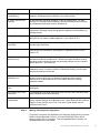
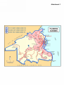
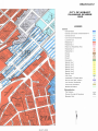
CITY OF HOBART PLANNING SCHEME 1982
USER GUIDE
1. Purpose of the
Guide
The provisions and structure of a planning scheme are not always easy
to understand at first glance. The purpose of this Guide is to give you an
understanding of how the City of Hobart Planning Scheme 1982
operates and how to find relevant sections. It is not intended to replace
the need for advice from a Council Planning Officer, Planning Consultant
or legal practitioner where necessary and you are encouraged to contact
a Council Planning Officer if you plan to undertake any development.
2. What is a planning
scheme?
A planning scheme sets out policies and requirements for the use,
development, protection and conservation of land. Planning Schemes
are prepared under the Land Use Planning and Approvals Act 1993 and
are required to further the sustainable development objectives of that
Act. Planning Schemes operate to provide for the fair, orderly and
sustainable use and development of air, land and water. Public
involvement in the planning system is encouraged. (Note that other
approvals such as building approval may be required for any proposed
development.)
There is a planning scheme for every municipality in Tasmania and three
within the City of Hobart. The other two are the Battery Point Planning
Scheme 1979 and the Sullivans Cove Planning Scheme 1997.
Attachment 1 shows the area covered by each Scheme.
The Scheme is available for inspection or purchase at Council’s
Customer Service Centre in either hard copy or CD-ROM format. It is
also available on line at www.hobartcity.com.au
3. Who is affected by
this planning
scheme?
All people, corporations, the Crown, government departments, public
authorities and the Council must comply with the Planning Scheme
unless specifically exempted by legislation. Examples of these
exemptions include mining, marine farming and forestry operations on a
private timber reserve.
4. What does the
Planning Scheme
consist of?
The Planning Scheme consists of four maps showing zones and
precincts, a written document and any maps, plans or other documents
incorporated in it. Zones indicate areas of broadly similar values
indicating in general terms the preferred future land use. Precincts within
a zone provide a greater level of direction as to how the area should
develop in the future. Attachment 2 provides an example of the planning
scheme map showing zones and precincts.
The main parts of the written document are:
Part 1 - Preliminary – Sets out general provisions including the
requirement to obtain approval for use and development and lists
exemptions from the need to obtain planning approval.
Part 2 - Administration – Sets out the administrative provisions relating
to planning applications including the matters which Council is required
to consider when determining applications and details of information to
be submitted with applications.
Part 4 - Principles of Development Control – Contains the principles
to be applied to all development. The principles relate to aspects of
development such as density, landscaping, traffic, parking and heritage.
Part 5 - Zone Objectives and Statements of Desired Future
Character – Contains the objectives of each zone and a statement
describing the desired future character of each precinct throughout the
City.
Schedules – These contain detailed provisions for a number of aspects
of development including; use, signs, heritage, parking, land clearing and
significant landscapes. There are also Schedules applying to some
zones or areas eg Bushland Management, Gregory Street and the
Pinnacle of Mt Wellington.
5. How do I use the
Planning Scheme?
To get a general idea of the type of development preferred in your
area:
Step 1 Look at the Key to Scheme Maps (last page of the written document or
first part of CD-ROM or internet version) and find which map covers your
property.
Step 2 Go to the appropriate map and note the name of the zone and any
precinct that applies to your land or the surrounding area. (If you do not
have access to the maps contact a Council Planning Officer for the
information.)
Step 3 Go to Part 5 of the Planning Scheme and find the relevant zone objective
and Statement of Desired Future Character for the precinct in which your
property is located. The objective of the zone will give you an idea of the
character and types of development that are intended in the zone. The
Statement of Desired Future Character for the precincts in the zone
provide more detail for those precincts.
Step 4 Go to the Use Schedule (Schedule A) and find the relevant zone and
precinct in Schedule A Table A1. This Table will tell you the uses that are
permitted, discretionary or prohibited in each zone and precinct. Clauses
A.5, A.6 and A.7 define permitted, prohibited and discretionary uses.
Applications for discretionary uses and development are advertised for
public comment before a decision is made and people who make a
representation can appeal against any decision. (Further information in
regard to appeals is available on request) If the use is considered not to
be listed within a use group it is discretionary.
CITY OF HOBART PLANNING SCHEME 1982 – USER GUIDE
2
6. What if I have a
particular
development in
mind?
The following is provided to help determine:
• Whether a planning approval under the Planning Scheme is needed
from Council; and
•
The relevant schedules and standards that the proposal would need
to comply with.
Note that ‘development’ includes building, construction, demolition,
works, subdivision, vegetation removal, erection of a sign and a material
change in use. (For the complete definition of what constitutes
development see clause 1.7.1 of the Planning Scheme.)
Step 1 Determine if planning approval is required
Look at clause 1.6 - Exemptions and check if your proposed
development is listed in the exemptions. Exemptions are also provided in
Schedules G Signs and I Clearing of Land and the Telecommunication
Infrastructure Schedule. If your proposed development is not exempted
by clause 1.6 or these schedules, planning approval is required. Check
with a Council Planning Officer to confirm whether or not your proposal is
exempt as it may not be possible to determine until building plans have
been prepared. (Note that no development is exempt in Precincts 1, 2, 3
and 4.)
Step 2 Determine the zone and precinct affecting the property
2.1 - Look at the Key to Scheme Maps (last page of the written document
or first part of CD-ROM or internet version) and find which zone map
covers your property.
2.2 - Go to the appropriate zone map and note the name of the zone and
any precinct that applies to your land. (If you do not have access to the
zone maps contact a Council Planning Officer for the information.)
2.3 - Go to Part 5 of the Planning Scheme and find the relevant zone
objective and Statement of Desired Future Character for the precinct in
which your property is located. The objective of the zone will give you an
idea of the character and types of development that are intended in the
zone. The Statement of Desired Future Character for the precincts in the
zone provide more detail for those precincts.
Step 3 Determine the type of development
a) Does the proposed development involve a change of use i.e. is it a
new use, the re-establishment of an abandoned use, or a material
change in the intensity or scale of a use? If so, go to Step 4.1.
b) If the proposed development does not involve a change of use:
•
Is it building work or other work (other than for an advertising sign or
subdivision) or clearing of land? If so, go to Step 4.2.
•
Is it subdivision? If so, go to Step 4.3.
•
Is it an advertising sign? If so, go to Step 4.4.
CITY OF HOBART PLANNING SCHEME 1982 – USER GUIDE
3
Step 4 Determine the assessment category of the proposal
4.1 - Changes of Use
a) Check the 'use' definitions in A Use Schedule clause A.1 and
determine which definition best describes the proposed development. If
the proposed use fits within more than one use definition then the
proposed development will need to comply with the planning scheme
requirements of each of those uses. Remember if the use is considered
not to be listed within a use group it is discretionary.
b) Refer to Schedule A Table A1 and find the row that is applicable to the
zone and precinct in which the land is located. Determine from the Table
whether the proposed use is permitted, discretionary or prohibited. Don’t
forget to check the notes to the table as they may change the status of
the proposal.
c) If the proposed use is:
• Prohibited - Council may not approve the use except under the
circumstances referred to in Principles 3 or 4 (see part 4 of the
Planning Scheme).
• Permitted or Discretionary - go to Step 5.
4.2 - Building or other work (other than for an advertising sign) that
does not involve a change of use or subdivision
Check the definition of ‘development’ in clause 1.7.1 to see if the
proposed development would fit within any of the development
categories. If it is included planning approval will be required unless
exempt under clause 1.6. Go to step 5.
4.3 - Subdivision
All subdivision including boundary adjustment requires planning approval
and is advertised for public comment. For relevant provisions refer to
Schedule B and Schedule K if the subdivision is in a residential zone.
Go to step 5.
4.4 - Advertising Signs
The provisions applying to signs are provided in Schedule G. This
Schedule defines sign types and specifies exempt, permitted,
discretionary and prohibited signs in each zone. Go to step 5.
Step 5 Determine the applicable Schedules
Determine which of the following Schedules will apply to your proposed
use or development and then go to Step 6:
Schedule
Applies to:
A Use
Any change of use or re-establishment of use.
B Density
Development including subdivision - provisions relate to plot ratio,
dwelling density and lot sizes. Table B1 does not apply to Use Groups I
to IV (these include houses, flats and elderly persons units) in the
residential zones. See Schedule K for relevant provisions.
CITY OF HOBART PLANNING SCHEME 1982 – USER GUIDE
4
C Height
All buildings and structures.
D Siting and
Landscaping
All buildings, walls and decks - provisions relate to property boundary
setbacks, landscaping and setbacks from watercourses.
E Traffic Access and
Parking
All development including changes of use and subdivision. For Use
Groups I to IV (these include houses, flats and elderly persons units) in
the residential zones also refer to Schedule K.
F Heritage
Any use or development on properties listed in the Heritage Register,
properties in Heritage Areas and properties adjacent to listed places or
Heritage Areas.
G Signs
Any sign greater than 0.2 square metres in area. (Some signs are
exempt from the need to obtain approval – see clause G.4.1.)
H Gregory Street Local
Area Plan
All use and development within the Gregory Street Local Area Plan area.
Includes sign provisions.
I Clearing of Land
The removal or destruction of vegetation or listed significant trees.
Exemptions are provided for some types of vegetation removal (see
Clause I.3).
Telecommunications
Infrastructure
Use and development associated with the provision of
telecommunications infrastructure. (Some low impact facilities such as
domestic antenna and receivers are generally exempt from the need to
obtain approval – see clause 3.)
K Rescode
Subdivision and development involving Use Groups I to IV within the
residential zones. Provisions relate to residential density, private open
space and parking and access.
L Bushland
Management
All use and development on land contained within the Landscape and
Skyline Conservation and Low Density Residential Zones where
proposed use or development is to be located within an existing
bushland habitat.
M Pinnacle Local Area
Plan
All use and development within the Pinnacle Local Area Plan area (Mt
Wellington).
N Precinct 16A Local
Area Plan
All development including signs within the Precinct 16A Local Area Plan
area (Elizabeth Street North Hobart).
O Significant
Landscapes
All use and development on land within the listed significant landscapes.
These include Pillinger Drive/Bracken Lane, Huon Road corridor and the
Pipeline Track corridor in the Fern Tree area. Other areas may be
included in the future.
Step 6 - Making a development application
If a permit is required, an Application for Planning Approval form must be
filled out and lodged with Council. A Council Planning Officer will be
happy to assist you if necessary. Fees are payable after a decision on
the application has been made.
CITY OF HOBART PLANNING SCHEME 1982 – USER GUIDE
5
The application must include all necessary supporting information such
as plans, reports and photographs so that the proposal is fully described
and can be understood by all interested parties. The Planning Scheme in
some cases specifies what information is required to accompany
applications (see clauses 2.8, K.2A and L.3.3 for example). Site
Development Plans may be required in some circumstances - see
clauses 2.7.1 and L.3.3. Planning application check lists are available for
particular types of development.
Clause 2.3.2 of the Planning Scheme sets out the matters that Council is
required to have regard to when determining development applications.
You should ensure that your application contains sufficient information
for Council to consider these matters.
If your application is discretionary it will be advertised for public comment
for 14 days before Council makes a decision.
OTHER
INFORMATION
How do I find out about the Planning Scheme requirements
affecting my land?
You should first speak to a Council Planning Officer to find out how the
Scheme affects your land. You can ask to speak to a Planning Officer at
the Hobart City Council Customer Service Center at the corner of
Elizabeth and Davey Streets, Hobart or phone 03 6238 2175.
Changes to the Planning Scheme
The Planning Scheme is not a static document and will change over
time. A Council Planning Officer can tell you if an amendment affecting
your land has been proposed.
The latest version of the Scheme is available for inspection or purchase
at Council’s Customer Service Centre in either hard copy or CD-ROM
format. It is also available on line at www.hobartcity.com.au
Applications to use or develop land
The need for early discussion with Council
If you propose to use or develop land, first discuss the proposal in detail
with a Council Planning Officer. Early discussion will confirm whether a
permit is necessary and identify any other requirements.
The decision
Following consideration of your application, Council will decide to either
issue a permit or refuse to grant a permit.
A permit can be issued with or without conditions, and a proposal can
only begin and continue if all the conditions on the permit are met.
You and any other person who made a representation in regard to your
application will have the right to appeal against Council’s decision to the
Resource Management and Planning Appeals Tribunal. For further
information in regard to appeals visit www.rmpat.tas.gov.au
CITY OF HOBART PLANNING SCHEME 1982 – USER GUIDE
6
What is the difference between building and planning permits?
Planning permits should not be confused with building permits. Building
permits are issued under the Building Code of Australia and generally cover
the constructional aspects of a building or other development. A building
permit is required in most cases involving development. You should consult
Council’s Building Surveyor if any building is proposed. If a planning permit
is required, it must be obtained before a building permit can be issued.
Compliance with Planning Schemes
Under the Land Use Planning and Approvals Act 1993 (Sections 63 and 64)
Council is obliged to ensure that the requirements of a planning scheme are
met. Council or a person with a proper interest may apply to the Resource
Management and Planning Appeals Tribunal for an order requiring
compliance with the Planning Scheme.
Contact a Council Planning Officer (Phone 03 6238 2175) if you:
• Have a general enquiry about the Planning Scheme.
• Are unsure what requirements apply to your land.
• Are unsure of the steps in the planning application process.
• Would like to know how the Planning Scheme may be changed.
• Want a planning permit application form.
• Want to buy a copy of the Planning Scheme or an amendment.
• Want more information about Planning Appeals.
Useful web sites
• Find the planning schemes at www.hobartcity.com.au
• Find information about planning scheme amendments at
www.rpdc.tas.gov.au
• Find information about planning appeals at www.rmpat.tas.gov.au
• Find the Land Use Planning and Approvals Act 1993 and other
legislation at www.thelaw.tas.gov.au
CITY OF HOBART PLANNING SCHEME 1982 – USER GUIDE
7