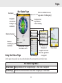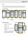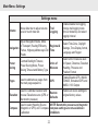
1
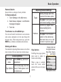
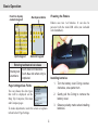
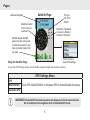
Endura™ GPS
Sierra, Safari &
Out&Back
Operations Guide
Operation Manual
for
Sierra, Safari
and Out&Back
Copyright © 2009 Navico
All Right Reserved.
No part of this manual may be copied, reproduced, republished, transmitted or distributed for any purpose, without prior
written consent of Lowrance.
Endura™ is a trademark and Lowrance ® and Navico ® are registered trademarks of Navico, Inc.
Accuterra® is a registered trademark and NEXTMAP ® is a registered trademark of Intermap Technologies Corporation.
Mapping Database, copyright © 2009 NAVTEQ. NAVTEQ ON BOARD is a trademark of NAVTEQ.
microSD ™ is a trademark of the SD Card Association.
Navico may find it necessary to change or end our policies, regulations and special offers at any time. We
reserve the right to do so without notice. All features and specifications subject to change without notice.
For user manuals and the most current information on this product, its operation and accessories, visit our web site:
www.lowrance.com
Lowrance Electronics
12000 E Skelly Dr.
Tulsa, OK 74128-2486
WARNING: When a GPS unit is used in a vehicle, the vehicle operator is solely responsible
for operating the vehicle in a safe manner. Vehicle operators must maintain full surveillence of
all pertinent driving, boating or flying conditions at all times. An incident or collision resulting in
damage to property, personal injury or death could occur if the operator of a GPS-equipped vehicle
fails to pay attention to travel conditions and vehicle operation while the vehicle is in motion.
Contents
Table of Contents
Basic Operation................................ 2
Trip Computer................................................9
Adjusting the backlight: ..................................2
Restore Defaults..............................................3
Touchscreen vs. Arrow/Mark keys...................3
Working with Menus........................................3
Page Settings/Data Fields...............................4
Installing batteries...........................................4
Mini-USB Cable and microSD card.................5
Loading files onto Endura:...............................5
Elevation......................................................10
Nav Status Page..........................................11
Compass Page.............................................12
Main Menu: Map/Find..................... 13
Waypoints......................................................14
Geocaches....................................................16
Trails..............................................................17
Points of interest............................................18
Address.........................................................18
Routes...........................................................19
Navigating a Route........................................20
Tools..............................................................20
Pages................................................. 6
Map Page........................................................6
Display Mode...................................................7
Orientation.......................................................7
North Up..........................................................7
Course Up.......................................................7
Track Up..........................................................7
Detail Settings.................................................7
Satellite Page.................................................8
Nav Options...................................................23
Specifications................................. 24
1
Basic Operation
Turning on Endura
Titlebar
The titlebar is located at
the top of the screen.
It displays battery strength
and satellite reception
indicators.
Hold down the power key for three seconds to
turn on Endura. The first time Endura is
turned on, the select Language screen will
appear. Touch the desired language.
Turning off Endura
Satellite reception
Battery strength
Cursor
Selects objects on the Map page and
pans the map when using arrow keys.
The cursor will appear when you touch
the screen or press the arrow keys.
Hold down the Power key for three seconds and the
Standby menu will appear. Continue to hold down
the power key to turn off the unit, or touch Standby
to switch the unit into Standby mode.
Standby preserves battery life without turning off
Endura. That allows you to resume using the unit
without going through the power-on sequence.
Back tab
Touching the Back tab will take you
back to the previous page.
Backlight
Press the Power key to toggle the backlight on/off.
Options/More Options
Touch the Options or More Options tab
to open context and settings menus.
Adjusting the backlight:
1. T
ap the Power key to view the
backlight meter.
Done tab
Touch the Done tab to finalize changes
and return to the previous page.
2. D
rag your finger along the meter to
make adjustments.
2
Basic Operation
Restore Defaults
Resets all device settings to factory defaults.
To Restore defaults:
1. Touch Settings on the Main menu.
Adjusting Features/Settings
Toggle
2. S
elect Restore Defaults. A confirmation
message will appear.
To adjust: Touch option field
until desired setting is shown
Submenu(s) appear when
feature/setting field is
touched
3. Touch Yes.
Touchscreen vs. Arrow/Mark keys
You can use the unit’s touchscreen to access menus
and execute commands or do the same thing with
the arrow keys. When using arrow keys, press the
Mark key to finalize commands and selections.
Submenu
Working with Menus
The method for adjusting Endura menus varies from
menu to menu. Here are some tips on menu usage.
To adjust: Touch desired
option on the submenu(s)
then touch Back or Done tab
to return to previous page
Display mode can
be toggled between
Base Map, Imagery
Each Page has a page options
and Hybrid
Page Options
menu used to adjust its
features and settings.
Accessing Menus
Main Menu
items
Setting changes each time
you touch the menu option
Press Menu key and touch
desired item
When a page is selected,
touch the screen and/or
options tab to access its page
options.
From a main page, touch the
Page Options screen; if tabs appear, touch
the Options tab
3
Map options menu
Basic Operation
Touch to display
numeric keypad
Alpha keypad
Powering the Endura
Backspace/delete
Endura uses two AA batteries. It can also be
powered with the mini-USB cable (not included
with Out&Back).
Numeric keypad
Entering text/numerical values
Touch desired characters.
Entering text
Touch Done tab when entry is
& numbers
completed.
Installing batteries
1. T
urn the battery cover D-ring counterclockwise, one-quarter turn.
Page Settings/Data Fields
You can choose the data types
that will be displayed on the
Map, Trip Computer, Elevation
and Compass pages.
2. G
ently pull the D-ring to remove the
battery cover.
3. O
bserve polarity marks when installing
batteries.
To make adjustments, touch the screen or options
tab and select Page Settings.
4
Basic Operation
GPX user files (trails, routes and waypoints) are
loaded onto Endura’s internal memory using the
mini-USB cable. Accessory map files are stored on
microSD cards (sold separately).
Audio (MP3 or WMA), video (MPEG, AVI or
WMV) and picture (JPEG or BMP) files can be
stored internally or on microSD cards. (Audio and
video files can not be used on Out&Back).
Installing battery cover
1. S
lide the cover at a slight angle to insert
tabs into slots at the bottom of battery
compartment.
Loading files onto Endura
When Endura is connected to your computer the
device will switch to PC mode and will show a PC
connect screen. Endura will appear on your computer
as “Endura” when using the mini-USB cable. When
a micro SD card is used, it will be shown on your PC
as “Endura SD Card.”
2. O
nce the battery cover is in place, turn
the D-ring clockwise one-quarter turn.
Mini-USB Cable and microSD card
A mini USB cable is used to transfer data between
Endura and a computer.
The Micro SD slot is
located next to the miniUSB port, under the
rubber weathercap, on the mini-USB microSD
bottom of the unit.
Copy/paste or drag and drop the desired picture,
audio or video file onto the Endura directory on your
computer.
Headphone jack
Sierra and Safari have a 3.5mm
headphone jack on the side of the
unit, allowing you to listen to audio.
When installing a microSD card make sure the
card’s label if facing the same direction as Endura’s
display screen.
5
Pages
The Safari and Sierra display Map, Satellite, Trip Computer, Elevation, Navigation and Compass
pages. Elevation and Compass pages are displayed optionally on the Out&Back. See Settings in
the Main Menu section for information on adding/removing pages.
Data field
Map Page
Zoom In
Latitude/Longitude
Zoom Out
Cursor
Navigating
a trail
Current
position
Map options menu
On the Map Page you can:
Map Scale
Return to previous
screen
•
Drag your finger across the screen to move the map.
•
elect items by touching them on-screen. Touching the screen will display the cursor, Zoom,
S
Options and Back tabs.
•
se arrow keys to fine tune cursor position over selected items. Touch the screen or press
U
the Mark key to view on-screen info.
•
Drop a waypoint at the cursor location with a quick press of the Mark key.
6
Pages
Map Options menu
Map display mode, orientation, detail and page display settings are adjusted from the Map Options menu.
Touch the Options tab on the Map page to access the Map Options menu.
Display Mode
Basemap
displays points, roads, water features, etc.
Imagery
displays satellite images, hillshade, etc.
Hybrid
displays both basemap and satellite imagery
Orientation
North Up
keeps North at the top of the screen
Course Up
aligns map with your route or initial Go To course
Track Up
map rotates as your heading changes
Detail Settings
Detail Level
toggles level of map detail between Low, Medium and High
Roads, Contour Lines, Trails,
Waypoints, Points of Interest,
Cursor Information
touching these map details toggles them on/off; they will
only be visible on the map when turned on
Page Settings
Top Left, Top Right, Bottom Left selects data types to be displayed in four data fields in the
& Bottom Right Data Fields
corners of the Map page (See page 4 example)
7
Pages
Satellite Page
Latitude/Longitude
Satellite location
from horizon to
overhead
Fix type:
2D, 3D or
WAAS
Elevation, Estimated
Accuracy & Position
Dilution of Precision
Satellite signal strength;
green bars are being used
to determine position; gray
bars are being tracked, but
not used
Touch screen to
view GPS settings
Using the Satellite Page
Access the GPS Settings menu, check satellite signal strength and position accuracy.
GPS Settings Menu
GPS
WAAS/EGNOS
Touch GPS, WAAS/EGNOS or Simulated GPS to Enable/Disable the feature
Simulated GPS
WARNING: Simulated GPS simulates operation and allows you to travel a selected route.
Do not attempt actual navigation while in Simulated GPS mode.
8
Pages
Trip Computer
Touch a data field
to access Trip
Computer menu
Data
Fields
Trip Computer menu
Data Fields
Using the Trip Computer page
Use the Trip Computer menu to display desired trip information and then monitor it all in one place.
Trip Computer Menu
Select Item Data
Touch this option to select a data type for the selected data field
Reset All Trip Data
Touch this option to reset trip data values to zero
9
Pages
Current or cursor
elevation
Elevation
Zoom in
Zoom out
Elevation
scale
Cursor — touch/drag to move
Current position
Return to
previous
screen
Using the Elevation Page
View elevation history based on time or distance.
From Elevation Page you can:
•
Set Barometric pressure sensor (Sierra and Safari only) or GPS as elevation source
•
Calibrate elevation using GPS data or by manually entering benchmark data
•
Select Page Settings display data
10
Pages
Nav Status Page
Destination
When no destination is set,
page states “Not Navigating”
Navigation
arrow shows
bearing to
destination
Compass rose;
top indicates
current heading
Distance traveled
Distance
remaining to
destination
Touch screen to open
Nav Status menu.
Using Nav Status Page
Nav Settings
Nav Status menu
changes per
navigation scenario:
trail, route, geocache
or waypoint
Let the green arrow guide you to your destination or the next point in your trail or route.
Nav Status Page Menu
Show Details Displays details for the navigation target — trail, route or waypoint
Nav Settings
Controls the methods/modes used while navigating to a destination
11
Show Details
Pages
Compass Page
Data
fields
Bearing to
destination
Current
heading
Compass
Rose
Data fields
Compass options menu
appears when screen is
touched
Calibration screen
Using the Compass Page
Align the green arrow with the dark arrow to navigate to your destination or the next point in a trail or route.
Compass Page Options Menu
Heading Source
Select Magnetic Sensor (Sierra and Safari only) or GPS as source
Calibrate Compass Repeatedly rotate Endura in a Figure 8 pattern until calibration is complete
Page Settings
Select data to be shown in data fields in four corners of Compass Page
12
Main Menu: Map/Find
Map
Main menu
Press the Menu key to access the Main menu, touch Map to view the Map page.
Find
Used to search for items like waypoints, geocaches, points of interest, routes and trails
and provides access to Goto/Navigation commands.
Favorites
A list of your commonly used waypoints, geocaches, trails, points of interest,
addresses and routes.
Find menu
13
Main Menu: Find
Adding items to Favorites
1. Select the desired item (waypoint, route, etc.) from the Find menu.
2. T
ouch the More Options tab and touch Add to Favorites. (You may have to navigate through
an internal menu before the More Options tab will be visible.)
Waypoints
Used to create, delete, edit/customize, categorize and navigate to waypoints. To save a waypoint, hold down
the Mark key for three seconds or select New Waypoint from the waypoint list.
To access waypoint functions:
1. Touch Waypoints on the Find menu
2. Touch the desired waypoint. The Waypoint Edit screen will appear.
From Waypoint Edit screen you can:
•
Show waypoint on map or navigate to (Goto) waypoint
•
Touch More Options tab to access Add to Favorites or Delete waypoint
•
Input Name and Description and select Icon
•
Manually enter Latitude/Longitude and Elevation
•
Record a Voice Note
Waypoint Edit Screen
14
Main Menu: Find
View waypoint location on map
Navigating to waypoint
Input waypoint name
Input Latitude/Longitude
Select category;
choose icon
Input Elevation
Waypoint Edit Screen
Input description
Return to previous
screen
Add to Favorites
15
Record a voice note
Main Menu: Find
Geocaches
Used to view, customize and navigate to geocaches. Geocaches can be uploaded onto Endura from geocaching
web sites.
To upload Geocaches:
1. Plug the mini USB cable into the Endura and your computer. It will be shown as a mass
storage device on your computer.
2. Copy and paste the geocaching GPX file from its location to the GPX folder on Endura.
Geocaching functions:
Geocache list
Geocache menu
•
ilter geocache list by All/
F
Found/Not Found, Type,
Size, Difficulty & Terrain
•
iew selected geocache on
V
map
•
View hints
•
iew description and recent logs created
V
by other geocachers
•
I nput field notes such as found, not found
or needs maintenance
Geocache screen
Show Hint
Filter Options
16
More Options
Log Field
Note
Main Menu: Find
Trails
Used to create, delete or navigate (forward or reverse) trails. GPX trails can be previously save trails from
Endura or trails downloaded from community websites.
Navigation
direction
Find menu
Trails screen
Trails list
Touch elevation
graphic to view trail
elevation
Trail Options include:
More Options menu
•
Show trails on Map
•
View/edit trail description
•
avigate forward or reverse
N
(backtrack)
•
iew date, trail length and min/max
V
elevation
•
iew enlarged trail elevation
V
graphic
17
Main Menu: Find
Points of interest
Gives you access to a places database for
restaurants, lodging, tourist sites, etc.
Address
Used to search for addresses and street
intersections.
Find menu
POI Categories
Subcategories for
Food and Drink
NOTE: Address function is available on Sierra and optionally on Safari with accessory
mapping cards.
From Address screen you can:
•
Searching for an Address
To find an address enter search info in
the following order:
avigate
N
to
address
or
intersection (will only support
turn-by turn with an optional TBT
accessory card)
•
Input house number, street, city/
town/suburb, state and country
•
dd addresses to Favorites list
A
from More Options menu
Country
1.
4. Street
2. State
5. House Number
3. City
More Options
18
Main Menu: Find
Routes
Allows you to create, delete, edit and navigate (forward or reverse) routes. Waypoints, Geocaches, Points of
Interest and Addresses can be used in route creation. Additional route points can be added from the map.
Creating a New Route
New route
selected
Touch Add Route
Point
Find menu
appears: select a
category
Route functions include:
Waypoints list
Touch Add to
Route tab
Waypoint listed
as route point
More Options
menu
•
Edit route from route screen or
from Map
•
Show route on map
•
esequence points in route or add route
R
to Favorites
•
ename route by touching Name field then
R
entering data using on-screen keypad
19
Navigation
direction
menu
Main Menu: Find/Tools
Navigating a Route
Select Route
from Routes List
Touch Forward
or Reverse
Touch Navigate
tab
Map appears with
route highlighted
Tools
Provides access to applications used to listen to music, view pictures and videos. The MP3 and video player
are not available on Out&Back.
Tools Menu
MP3 Player
Plays MP3 and WMA music files
Picture Viewer
Displays JPEG and BMP pictures
Video Player
Plays MPEG, AVI and WMV videos
Video player
Picture viewer
20
Main Menu: Tools
Uploading files to Endura
GPX Files
Trails, routes and
geocaches
Accessory
Outdoor, marine or
mapping files turn-by-turn mapping
Music
MP3 and WMA
Video
MPEG, AVI and WMV
Picture
JPEG and BMP
Use mini-USB cable to copy/paste files onto “Endura”
directory on your computer
Contained on microSD cards (sold separately) or
downloaded from mapselect.com
Music, video and picture files can be uploaded to
Endura via the mini-USB cable (internal memory) or a
microSD card
To upload files:
1. P
lug the USB cable into the Endura and your computer. Endura will be shown as “Endura”
(mini-USB) or “Endura SD Card” (microSD card) on your computer.
2. C
opy/paste or drag/drop the desired file(s) onto the Endura directory shown on your
computer. The relevant application will find it automatically.
NOTE: If you have a microSD card installed, you will only be able to upload files to the microSD
card. To upload files to Endura’s internal memory, you must remove the card from the card slot.
21
Main Menu: Settings
Settings menu
Volume
Trail
Logging
Move slider bar to adjust volume
level or touch mute tab
Enable/disable trail logging,
change trail logging mode
(time or distance) and select
logging interval
Adjust Navigation Mode, Mode
of Transport, Routing Efficiency,
Regional &
Navigation
Ferries, Highways/Motorways/Toll Time
Roads
Select Time Zone, Daylight
Savings, Time Display format,
Language and Region
Power
Saving
Controls Backlight Timeout,
Power Saving Mode, Power
Saving Timeout and Battery Type
Units of
Measure
Select unit of measure used
for Speed, Distance, Elevation,
Heading, Pressure and
Position Format
Pages
Used to add/remove pages from
the main page sequence
GPS
Enable/Disable GPS, WAAS/
EGNOS, Simulated GPS and
NMEA 0183 Output
Elevation
Used to Calibrate Elevation and
choose Elevation source (GPS or
Barometric pressure)
Restore
Defaults
Compass
Used to select Heading Source
NOTE: Barometric pressure and magnetic
(Magnetic or GPS) and Compass compass settings are not available on
Calibration
Out&Back.
22
Restore all device settings to
original factory values
Main Menu: Nav Options
Nav Options
Allows you to access the Endura’s navigation information from one location. Nav Options can only be
accessed while you are navigating. The submenu is context sensitive, depending on navigation target.: trail,
route, waypoint or geocache.
Stop navigating
confirmation screen
Nav Status Screen
Show Details
screen
Reverses the direction of
the route or trail you are
navigating
Nav Settings
23
Specifications
Dimensions
Feature
5.1” x 2.3” Wx 1.2” D (130mm x 60mm x 31mm)
Preloaded Maps
Weight
Topo Contour
Interval (feet)
5.8oz (165g) without batteries
Sierra
Safari
Out&Back
Premium
Advanced
Basic
100
500
—
P
P
P
Add on Maps
Display
Color, 2.7” (6.8cm) touchscreen
Accepts GPX trail /
POI data
P
P
Batteries
Geocaching App
P
P
P
Uses two AA batteries (not included)
3D Compass
P
P
—
Data Transfer
Barometic Altimeter
P
P
—
Uses up to 32GB microSD cards
Trip Recorder/Route
Recording
P
P
P
Uses Mini USB data/power port
Power Standby Mode
P
P
P
Waterproof
Picture Viewer
P
P
P
IPx7 with rubbor armoring
MP3 Player
P
P
—
Waypoints, Routes & Trails
Video Player
P
P
—
Waypoints: 2000 (Max)
Waypoints per route: 250 (Max)
Headset jack/speaker
P
P
—
Trails: 30 (Max)
Microphone
P
P
—
Optional
Optional
—
Routes: 60 (Max)
Road Turn-by-turn
For more information, visit www.lowrance.com/endura
24
*988-0161-54A*
www.lowrance.com/endura
© Copyright 2009
*988-0160-54A*
All Rights Reserved
Navico Holding AS
© Copyright 2009
All rights Reserved
Navico Holdings AS