1
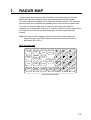
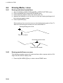
VIDEO PLOTTER
RP-25
Your Local Agent/Dealer
9-52 Ashihara-cho,
Nishinomiya, Japan
Telephone :
0798-65-2111
Telefax :
0798-65-4200
All rights reserved.
Printed in Japan
FIRST EDITION : FEB. 1996
F
PUB.No. OME-30400
( HIMA ) RP-25
: JAN. 08,2002
*00080745701*
*00080745701*
*00080745701*
*OME30400F00*
*OME30400F00*
*OME30400F00*
SAFETY INSTRUCTIONS
CAUTION
No one navigational aid should be relied exclusively for the safety of
vessel and crew. The navigator has the responsibility to check all aids
available to confirm position. Electronic aids are not a substitute for
basic navigational principles and common sense.
Digital charts cannot replace official nautical charts.
Digital charts are intended as an aid to navigation. Position should always
be checked against nautical charts, as well as other aids to navigation.
Digital charts cannot replace the radar.
Digital charts can only show own ship's position relative to a chart feature
(coastline, lighthouse, etc.); they cannot show other vessels, as does the
radar. Digital charts can never replace the radar.
Handle chart/memory cards carefully.
The chart and memory cards are weak against heat and magnetic material.
Keep cards away from heat source.
Keep cards away from magnets and magnetic material.
Replace cards in their protective cases after use.
i
FORWORD
A Word to RP-25 Owners
Congratulations on your choice of the FURUNO RP-25 Video Plotter. We are
confident you will see why the FURUNO name has become synonymous with
quality and reliability.
For over 50 years FURUNO Electric Company has enjoyed an enviable
reputation for innovative and dependable marine electronics equipment. This
dedication to excellence is furthered by our extensive global network of agents
and dealers.
Your RP-25 is designed and constructed to meet the rigorous demands of the
marine environment. However, no machine can perform its intended function
unless installed function unless installed, operated and maintained properly.
Please carefully read and follow the recommended procedures for operation and
maintenance.
We would appreciate hearing from you, the end-user, about whether we are
achieving our purposes.
Thank you for considering and purchasing FURUNO equipment.
Features
The Video Plotter RP-25 is an optional circuit board which is accommodated in
the display unit of the FR/FAR-2805 series radars, and provides video plotter
functions such as waypoint making and route creation.
The main features are
! Radar map function
• Displays/hides the user-made map by one-touch simple operation.
• 1,500 of marks/lines maximum are storable.
! Radar Plotter function
• Chart overlay on radar display
• Target track is displayed on head-up mode.
• Memory card can be used together with chart card.
• Radar position correction
• Arrival alarm function
ii
The RP-25 function may be changed depending on your FR/FAR-2805 series
radar specification. Refer to the following table to recognize your RP-25 working.
Your 2805 spec.
R (Regular) type
IMO type
(German, Netherland)
Radar map
Yes
Video plotter
Yes
No
-
iii
TABLE OF CONTENTS
1. RADAR MAP ..................................................................................................1-1
1.1 Preparation .................................................................................................................. 1-2
1.2 Making a radar map ..................................................................................................... 1-3
1.2.1 Selecting the entering way ....................................................................... 1-3
1.3 Erasing Contents of the Radar Map ............................................................................. 1-6
1.3.1 Erasing the mark/line independently......................................................... 1-6
1.3.2 Erasing all mark/line ................................................................................. 1-6
1.4 Position and bearing correction.................................................................................... 1-7
1.4.1 Radar map correction............................................................................... 1-7
1.4.2 Cursor data correction .............................................................................. 1-7
1.4.3 Releasing the radar map correction.......................................................... 1-7
2. VIDEO PLOTTER ...........................................................................................2-1
2.1 Overview...................................................................................................................... 2-1
2.1.1 Selecting Displays .................................................................................... 2-1
2.1.2 Display modes.......................................................................................... 2-2
2.2 Chart Cards ................................................................................................................. 2-3
2.2.1 Displaying chart cards .............................................................................. 2-3
2.2.2 Chart position correction........................................................................... 2-4
2.2.3 Canceling chart correction........................................................................ 2-4
2.2.4 Adding correcting value to cursor data...................................................... 2-4
2.3 Setting up the Video Plotter ......................................................................................... 2-5
2.3.1 Hiding/showing graphics........................................................................... 2-5
2.3.2 Setting the navigation data ....................................................................... 2-5
2.4 Track............................................................................................................................ 2-8
2.4.1 Recording the own ship’s track................................................................. 2-8
2.4.2 Recording other ship’s track ..................................................................... 2-9
2.4.3 Smoothing................................................................................................ 2-9
2.4.4 Erasing track .......................................................................................... 2-10
2.5 Marks, Lines .............................................................................................................. 2-11
2.5.1 Entering mark......................................................................................... 2-11
2.5.2 Entering line ........................................................................................... 2-13
2.6 Erasing Marks, Lines ................................................................................................. 2-14
2.6.1 Erasing individual marks/lines ................................................................ 2-14
2.6.2 Erasing marks/lines on a area ................................................................ 2-14
2.6.3 Erasing all marks.................................................................................... 2-15
2.7 Waypoints .................................................................................................................. 2-16
2.7.1 Entering waypoints ................................................................................. 2-16
2.7.2 Waypoint list........................................................................................... 2-17
2.7.3 Displaying a waypoint............................................................................. 2-19
2.8 Navigation Lines ........................................................................................................ 2-21
2.8.1 Entering navigation line .......................................................................... 2-21
2.8.2 Navigation line list ................................................................................ 2-22
iv
2.8.3 Deleting navigation lines .........................................................................2-23
2.8.4 Setting up the navigation lines ................................................................2-24
2.8.5 Displaying navigation lines......................................................................2-26
2.9 Recording and Replaying Data...................................................................................2-26
2.9.1 Formatting memory (RAM) card..............................................................2-26
2.9.2 Recording data .......................................................................................2-27
2.9.3 Replaying data........................................................................................2-28
3. MAINTENANCE (FOR TECHNICIANS).........................................................3-1
3.1 Initial Settings...............................................................................................................3-1
3.2 Replacement of Battery on RP Board...........................................................................3-2
MENU TREE....................................................................................................AP-1
LATITUDE ERROR TABLE (ON 96 NM RANGE) ..........................................AP-3
SPECIFICATIONS ........................................................................................... SP-1
v
1.
RADAR MAP
A radar map is a combination map lines and symbols whereby the user can
define and input the navigation data, route planning and monitoring data.
The radar map has the capacity of 1,500 points of mark and line. The map data
can be memorized to facilitate the repeated use on the routine navigation area.
The user can create a radar map on-real time while using the radar for
navigation or at leisure time at anchor or while the radar is not being used. Place
of a map can be made for any waterways apart from the actual own ship
location.
Note: Own ship position display requires an input from radionavigational
equipment such as a GPS receiver in accordance with the format as
defined by IEC 61162-1.
Keys for radar map
ORIGIN
MARK
VECTOR
TRUE/
REL
VECTOR
TIME
TARGET
DATA
TARGET
BASED
SPEED
AUTO
PLOT
LOST
TARGET
HISTORY
CHART
ALIGN
VIDEO
PLOT
TRAIL
MARK
RADAR
MENU
E,AUTO
PLOT
MENU
NAV
MENU
1
2
3
4
5
6
7
8
9
CANCEL
-
ENTER
0
Key panel (right side)
1-1
1. RADAR MAP
1.1
Preparation
For R-type radar, confirm that the radar display appears. When the video plotter
or radar/video plotter display appears, press the [VIDEO PLOT] key several
times to select the radar display.
1. Press the [NAV MENU] key to show NAV INFORMATION 1 menu.
2. Press [1] key to show RADAR MAP menu.
[RADAR MAP]
1
2
3
4
5
6
[NAV INFORMATION 1]
MAP
OFF/ON
NAV DATA POSN
ALIGN + CURSOR
OFF/ON
MARK ENTRY MODE
CURSOR/L/L/OWN SHIP
ERASE MARK
OFF/AREA/ALL
MEMORY IN USE
MARK = 1000
Number of current used mark/line
(Max. 1500 points)
Radar map menu
3. Press [2] key several times to set MAP ON, and then press the ENTER key.
“MAP” appears at the right side of screen.
4. Press [NAV MENU] key to close the menu.
1-2
1. RADAR MAP
1.2
Making a Radar Map
Marks/lines can be entered in three different ways.
1.2.1
Selecting the entering way
1. Press the [NAV MENU], [1] in that order to show RADAR MAP menu.
2. Press the [5] key several times to select CURSOR, L/L or OWN SHIP POSN.
CURSOR: Enters mark/line at the position selected by cursor
L/L:
Enter mark/line at the position selected by L/L values
OWN SHIP POSN: Enter mark/line at the current own ship’s position
3. Press the [ENTER] key.
4. Press the [NAV MENU] key to close the menu.
CURSOR
1. Press the [MARK] key to show ENTER MARK menu.
[ENTER MARK]
MARK
01.
02.
03.
04.
05.
06.
07.
08.
09.
10.
11.
12.
13.
14.
15.
16.
17.
18.
19.
20.
21.
22.
01
NAV LINE
COAST LINE
CONTOUR LINE
PROHIBITED AREAS
CABLE
LINE CHANGE
MARK CANCEL
Enter mark menu
1-3
1. RADAR MAP
2. Press the numeric key to select the number for desired mark.
For example, press the [1] [2] key in order when you want to select “●”.
3. Operate the trackball to move the cursor to the desired position.
4. Press the [ENTER] key. The selected mark is entered at the selected
position.
5. Repeat step 2 through 4. When using the same mark, repeat step3 and 4.
6. Press the [MARK] key to close the menu.
When entering the line, follow the steps in below.
1. Press the [MARK] key to show ENTER MARK menu.
2. Press the numeric key to select the desired line.
No.14 through 20 are for line, the following table shows the shapes of No.16
through 20.
No./name 16 NAV LINE 17 COAST LINE
Shape
18 CONTOUR
LINE
19 PROHIBITED
AREAS
20 CABLE
White line
Shapes for lines
3. Operate the trackball to the position you want to enter the line.
4. Press the [ENTER] key.
Repeat step 3 and 4 to extend the same line. To change the line shapes, repeat
step 2 through 4.
5. Press the [2] [1] [ENTER] in order to finish the entering line.
L/L (Longitude/Latitude)
1. Press the [MARK] key.
When L/L is selected at RADAR MAP MENU, the L/L entering field appears
above the ENTER MARK menu.
L/L entering field
00 00.000 N/S
5-N 6-S
0 00.000 E/W
7-E 8-W
ENTER MARK menu (on selecting L/L)
1-4
1. RADAR MAP
2. Press the numeric keys to enter the value for the desired latitude.
When you enter “45º67.888”, for example, press [4] [5] [6] [7] [8] [8] [8] in that
order.
3. Press the [ENTER] key.
4. Press the [5] or [6] key to select North or South.
[5] key: North, [6] key: South
5. Press the [ENTER] key.
6. Press the numeric key to enter the value for the desired longitude.
When you enter “123º45.666”, for example, press [1] [2] [3] [4] [5] [6] [6] [6] in
that order.
7. Press the [ENTER] key.
8. Press the [7] or [8] key to select East or West.
[7] key: East, [8] key: West
9. Press the [ENTER] key.
10. Press the numeric key to select the desired mark.
11. Press the [ENTER] key to enter the mark at he position selected at step 2
and 9.
OWN SHIP POSN (POSITON)
1. Press the [MARK] key.
2. Press the numeric key to select the desired mark.
3. Press the [ENTER] key.
The mark is entered at the own ship’s position anytime you press this key.
1-5
1. RADAR MAP
1.3
Erasing Contents of the Radar Map
1.3.1
Erasing the mark/line independently
1.
2.
3.
4.
5.
Select CURSOR at MARK ENTRY MODE field on RADAR MAP menu.
Press the [MARK] key to show the ENTER MARK menu.
Press the [2] key twice to select MARK CANCEL.
Operate the trackball to move the cursor to the mark you want to erase.
Press the [ENTER] key.
When erasing the line, move the cursor to the starting/ending point. Selecting the
connecting point erases both lines connected to it.
Starting/ending point
Erased line
Connecting point
Erased line
1.3.2
Erasing all mark/line
You can erase all marks/lines displayed on the current screen, all marks/lines
entered before now.
1. Press the [NAV MENU] [1] key in order to show the RADAR MAP menu.
2. Press the [6] key several times to select AREA or ALL.
AREA: Erases all marks/lines within a square which is 20% larger than the
effective radar display.
ALL: Erases all marks/lines which you have been entered.
3. Press the [ENTER] key.
Memorizing the mark/line
Marks/lines are stored by using the battery on the RP Board. When the battery is
low, the stored marks/lines are erased. After changing the battery, reenter the
marks/lines.
1-6
1. RADAR MAP
1.4
Position and bearing correction
1.4.1
Radar map correction
When there is an error between the radar screen and marks/lines, do the
following procedures.
1. Press the [CHART ALIGN] key.
“MAN ALIGN” appears at the right side of screen.
2. Operate the trackball to align the radar screen and radar map.
3. Press the [CHART ALIGN] key again.
The screen is fixed, and “ MAN ALINED” appears instead of “MAN ALIGN”.
1.4.2
Cursor data correction
The above correction value can be added to the cursor position’s L/L data.
1. Press the [NAV MENU] [1] key in order to show the RADAR MAP menu.
2. Press the [4] key twice to select ON at ALIGN CURSOR field.
When deleting the correcting value from the cursor data, select OFF.
3. Press the [NAV MENU] key to close the menu.
1.4.3
Releasing the radar map correction
1. Press the [NAV MENU] [1] key in order to show the RADAR MAP menu.
2. Pres the [3] key to select NAV DATA POSN.
3. Press the [ENTER] key.
The correction is released and “MAN ALINED” disappears.
4. Press the [NAV MENU] key to close the menu.
1-7
2.
VIDEO PLOTTER
2.1
Overview
If your 2805 radar is for R (Regular) type, the video plotter function is available in
addition to he radar map’s.
Keys for video plotter
ORIGIN
MARK
VECTOR
TRUE/
REL
VECTOR
TIME
TARGET
DATA
TARGET
BASED
SPEED
AUTO
PLOT
LOST
TARGET
HISTORY
CHART
ALIGN
VIDEO
PLOT
TRAIL
MARK
RADAR
MENU
E,AUTO
PLOT
MENU
NAV
MENU
1
2
3
4
5
6
7
8
9
CANCEL
-
ENTER
0
Control panel (right)
2.1.1
Selecting Displays
The RP-25 has three displays: Radar, Video Plotter and Radar/Video Plotter
(Combination). Displays are selected by pressing the [VIDEO PLOT] key, the
keying sequence of which is shown in the figure below.
Radar Display
Radar/Video Plotter
Display (Combination)
Video Plotter
Display*
*Exclusive of Deep Sea specification
Displays
Note 1: When a menu appears, displays cannot be selected. I n this case, press
the [NAV MENU] key to close the menu.
Note 2: Video Plotter function is not available when “MAP” appears at the right
side of screen. Press the [VIDEO PLOT] key to select Radar/Video
Plotter or Video Plotter display (“MAP” disappears).
2-1
2. VIDEO PLOTTER
Sample video plotter display
Range
Range/bearing
to cursor
Motion mode
12/2
3.458 NM
+
179.9 R
Waypoint
TM
W12
W11
W10
Own ship's position
OWN SHIP
35 20.370 N
141 18.370 E
+CURSOR PSN
35 20.360 N
141 18.770 E
Origin mark
Own ship mark
Cursor position
Cursor
Note: Grid line is not appeared on G-type.
2.1.2
Display modes
The RP-25 has five presentation modes.
• NORTH UP
• COURSE UP
• HEAD UP
• HEAD UP TB
• NORTH UP
• NORTH UP TM
Press the [MODE] key to select the mode.
Note 1: On HEAD UP and HEAD UP TB mode, the chart data is not appeared
though target tracks.
Note 2: On HEAD UP and HEAD UP TB mode, the screen may be seemed
flashing because these mode changes the screen when the gyro data
has 1º variation.
True motion automatic return
On the radar/video plotter display and the true motion mode, the own ship mark
returns to the center of the screen when own ship reaches at the threes quarter
position of the selected range.
2-2
2. VIDEO PLOTTER
2.2
Chart Cards
CAUTION
WARNING
Chart cards are intended as an aid to
navigation. The navigation has the
responsivility to check all aids available
to confirm position.
2.2.1
Handle chart cards and memory cards
with care.
Keep cards away from direct sunlight,
heat sources, and active gases.
Keep cards away from water and
chemicals.
Keep the connector free foreign
material.
Do not drop the cards.
Displaying chart cards
To display a chart;
1. Insert chart card in left side slot of the two chart card drive.
Eject button
for right card drive
Card Drive
Right: RAM card
Left: Chart card
Display unit
Eject button
for left card drive
Card slot location
2. Press the [POWER] button to turn the power on.
The chart data appears (NU, CU, TM modes only).
When a chart card is inserted after turning the power on, press the [RANGE +/-]
key to change the range. The chart data appears.
2-3
2. VIDEO PLOTTER
2.2.2
Chart position correction
There may be instances when the radar image is not overland on the chart
correctly. This is mainly due to position error inherent in the navigation aid
connected to the radar. You can align chart with the radar image as follows.
Note: There is no alteration between own sip’s data value and it displayed on
the navigator though the chart position is corrected.
1. Press the [CHART ALIGN] key.
“MAN ALIGN” appears at right side of the screen.
2. Operate the trackball to align the chart data and radar echoes.
3. Press the [CHART ALIGN] key to fix the screen.
“MAN ALIGN” changes to “MAN ALIGNED”.
2.2.3
Canceling chart correction
1. Press the [NAV MENU], [0] key in order to show VIDEO PROT 2 menu.
[VIDEO PLOTTER 2]
1
2
3
5
[VIDEO PLOTTER 1]
NAV DATA POSN
ALIGN + CURSOR
OFF/ON
MARK ENTRY MODE
CURSOR/L/L/OWN SHIP
Video plotter 2 menu
2. Press the [2] key.
NAV DATA POSN is in reverse video.
3. Press the [ENTER] key.
4. Press the [NAV MENU] key to close the menu.
2.2.4
Adding correcting value to cursor data
On correcting the chart position, the value can be added to the cursor position
data.
1. Press the [NAV MENU], [0] key to show the VIDEO PLOTTER 2 menu.
2. Press the [3] key several times to select OFF or ON at ALIGN + CURSOR
field.
OFF: Not added correction value to the cursor data
ON: Added correction value to the cursor data
3. Press the [ENTER] key.
4. Press the [NAV MENU] hey to close the menu.
2-4
2. VIDEO PLOTTER
2.3
Setting up the Video Plotter
2.3.1
Hiding/showing graphics
1. Press the [NAV MENU], [8] key in order to show DISPLAY SELECT menu.
[DISPLAY SELECT]
1
2
3
4
5
6
7
8
9
0
[VIDEO PLOTTER 1]
SYMBOL
OFF/ON
COAST LINE
OFF/ON
LAND DENSITY
OFF/ON
PLACE NAME
OFF/ON
MARK
OFF/ON
OWN SHIP PLOT
OFF/ON
TARGET PLOT
OFF/ON
CONTOUR LINE
OFF/ON
GRID
OFF/ON
Display select menu
2.
3.
4.
5.
The current settings are in reverse video (default setting: all item is ON.)
ON/OFF setting is described on chapter 3 “Initial settings”.
Pres the numeric key of which the item you want to show (hide) twice to
select ON (OFF).
Press the [ENTER] key.
Repeat step 2 and 3 for other items.
Press the [NAV MENU] key to close the menu.
Note: TARGET PLOT is not available when your radar does not have ARPA
function.
2.3.2
Setting the navigation data
The navigation data displayed around the video plotter screen can be set as
follows.
1. Press the [NAV MENU], [1] key in order to show NAV INFORMATION 1
menu.
2-5
2. VIDEO PLOTTER
[NAV INFORMATION 1]
1
2
3
4
5
6
7
8
9
0
[VIDEO PLOTTER 1]
SELECT NAVAID
GPS+LC/
DEAD RECKONING
OWN SHIP POSN
OFF/L/L
POSN
00 00.000 N/S
000 00.000 E/W
+ CURSOR DATA
OFF/L/L
WPT DATA
OFF/REL/TRUE
[WAY POINT]
[NAV LINE]
WIND DATA
OFF/ON
[NAV INFORMATION 2]
Nav information 1 menu
2. For item 2, 3, 5, 6 and 9, press the appropriate numeric key several times to
select the setting, and then press the [ENTER] key.
3. For item 4 POSN, do the following procedures.
a) Press the [4] key.
b) Press the numeric key to enter the value of latitude for own ship’s position.
c) Press the [ENTER] key.
d) Press the [4] key to select North or South.
e) Press the [ENTER] key.
f) Press the numeric key to enter the value of longitude for own ship’s position.
g) Press the [ENTER] key.
h) Press the [4] key to select East or West.
i) Press the [ENTER] key.
At the SELECT NAVAID (item 2) field;
Connecting with the external navigator: Select GPS+LC.
Not connected with the external navigator: Select DEAD RECKONING. Enter
the L/L data referring to the step a) through i) in above.
4. Press the [0] key to show NAV INFORMATION 2 menu.
2-6
2. VIDEO PLOTTER
[NAV INFORMATION 2]
1
2
3
4
5
6
7
8
9
0
[NAV INFORMATION 1]
WIND GRAPH
OFF/ON
WIND UNIT
M/S/KT
CURRENT DATA
OFF/ON
CURRENT GRAPH
OFF/ON
DEPTH DATA
OFF/ON
DEPTH GRAPH
OFF/ON
DEPTH SCALE
10/20/50/100/200/500
DEPTH UNIT
M/FT/FA
[NAV INFORMATION 3]
Nav information 2 menu
5. Do the setting for each items similar to the NAV INFORMATION 1 menu.
6. Press the [0] key to show NAV INFORMATION 3 menu.
[NAV INFORMATION 3]
1
2
3
4
[NAV INFORMATION 2]
WATER TEMP
OFF/ON
DATE
OFF/UTC/LOCAL
+00:00
USED WPL
NAV LINE/WP
Nav information 3 menu
7. Press the [3] key several times to select OFF, UTC or LOCAL at the DATE
(item 3) field.
8. Press the [ENTER] key.
On selecting LOCAL, press the numeric key to enter the Coordinated Universal
Time. For example, 15 minutes forward:
a) Press the [3] key to select +.
b) Press the [ENTER] key.
c) Press the [0] [0] [1] [5] in order.
d) Press the [ENTER] key.
9. Press the [NAV MENU] key.
2-7
2. VIDEO PLOTTER
2.4
Track
2.4.1
Recording the own ship’s track
Own ship’s track can be stored in the memory (Max. 6,000 points). When a track
memory becomes full the oldest track is deleted to make room for the latest.
The relation between the own ship track and storage time is shown in the table
below.
Own track plot interval and storage time
Plotting interval
Storage time
Plotting interval
Storage time
10 sec
16 hrs 40 min
2 min
200 hrs
30 sec
50 hrs
3 min
300 hrs
1 min
100 hrs
6 min
600 hrs
1. Press the [NAV MENU], [5] key in order to show OWN SHIP PLOT, TARGET
PLOT menu.
[OWN SHIP PLOT,
TARGET PLOT ]
1
2
3
4
5
6
7
8
[VIDEO PLOTTER 1]
OWN SHIP PLOT
OFF/ON
OWN SHIP PLOT INTVL
10S/30S/1/2/3/6 MIN
TARGET PLOT
OFF/ON
TARGET PLOT INTVL
10S/30S/1/2/3/6 MIN
SMOOTHING
OFF/1/2/3/4/5/6/7/8/9
Own ship plot, target plot menu
2. Press the [2] key several times to select ON at OWN SHIP PLOT (item 2)
field.
3. Press the [ENTER] key.
When your ship is at anchor or returning to port you probably will not need to
plot (record) the track. In this case, select OFF at step 2.
2-8
2. VIDEO PLOTTER
2.4.2
Recording other ship’s track
When your radar has ARPA function, tracks of 10 targets (other ships) can be
recorded. Memory capacity for other ship’s track is 6,000 points, but this value is
divided equally among ten targets, so there are 600 points per target. When a
track memory becomes full the oldest track is deleted to make room for the
latest.
The relation between the own ship track and other ship’s track plotting intervals
and storage time is shown in the table below.
Other target plot interval and storage time
Plotting interval
Storage time
Plotting interval
Storage time
10 sec
100 min
2 min
20 hrs
30 sec
5 hrs
3 min
30 hrs
1 min
10 hrs
6 min
60 hrs
1. Press the [NAV MENU], [5] key in order to show OWN SHIP PLOT, TARGET
PLOT menu.
2. Press the [5] key several times to select OFF at TARGET PLOT (item 5) field.
3. Press the [ENTER] key.
4. Press the [NAV MENU] key to close the menu.
2.4.3
Smoothing
Even when the vessel is sailing in a straight line the track shown on the display
looks irregular. This is due to signal variation of the external navigator. You can
compensate for this irregularity with smoothing.
A smoothing factor between 1 and 9 is available. OFF provides no smoothing. In
most cares a smoothing setting between 1 and 5 is satisfactory.
1. Press the [NAV MENU], [5] key in order to show OWN SHIP PLOT, TARGET
PLOT menu.
2. Press the [8] key several times to select the setting desired.
3. Press the [ENTER] key.
4. Press the [NAV MENU] key to close the menu.
2-9
2. VIDEO PLOTTER
2.4.4
Erasing track
The display may become full of track when, for example, own ship traces the
same route several times. You can erase all or a percentage of the track to the
clear the display. Further, you can erase the tracks of other ships.
1. Press the [NAV MENU], [9] key in order to show ERASE menu.
[ERASE]
1
2
3
4
5
6
[VIDEO PLOTTER 1]
OWN SHIP PLOT
30/50/80/ALL
TARGET PLOT
30/50/80/ALL
MARKS
OFF/AREA/ALL
WAYPOINT
OFF/ALL
NAV LINES
OFF/ALL
Erase menu
2. For own ship’s track erasing, press the [2] key several times to select OWN
SHIP PLOT and the amount of track you wish to erase.
For example, 30% erases the oldest 30% of the track points stored in the track
memory.
3. Press the [ENTER] key.
4. To erase other ship’s track, press the [3] key to select TARGET PLOT and
amount of track to erase.
5. Press the [ENTER] key.
6. Press the [NAV MENU] key to close the menu.
2-10
2. VIDEO PLOTTER
2.5
Marks, Lines
2.5.1
Entering mark
You can inscribe marks on the display to denote important points, for example, a
buoy or a wreck. The mark memory capacity is 6,000 points.(20 types mark and
lines).
Selecting method of entry
Marks can be entered by cursor position, L/L or own ship’s position.
1. Press the [NAV MENU], [0] key to show VIDEO PLOTTER 2 menu.
[VIDEO PLOTTER 2]
1
2
3
5
[VIDEO PLOTTER 1]
NAV DATA POSN
ALIGN + CURSOR
OFF/ON
MARK ENTRY MODE
CURSOR/L/L/OWN SHIP
Video plotter 2 menu
2. Press the [5] key several times to select CURSOR, L/L or OWN SHIP.
3. Press the [ENTER] key.
4. Press the MARK key, and select the mark shape.
CURSOR; enters the mark at the cursor position. Operate the trackball to
select the position and then press the [ENTER] key.
L/L; After selecting L/L, the latitude/longitude field appears above ENTER
MARK menu by pressing the [MARK] key. Press the numeric key to enter the
L/L values which you want to enter the mark, and then press the [ENTER]
key.
OWN SHIP; The mark is entered at the own ship’s position anytime the
[ENTER] key is pressed.
2-11
2. VIDEO PLOTTER
Selecting mark
1. Press the [MARK] key to show ENTER MARK menu.
[ENTER MARK]
MARK
01.
02.
03.
04.
05.
06.
07.
08.
09.
10.
11.
12.
13.
14.
15.
16.
17.
18.
19.
20.
21.
22.
01
NAV LINE
COAST LINE
CONTOUR LINE
PROHIBITED AREAS
CABLE
LINE CHANGE
MARK CANCEL
Enter mark menu
2. Press the numeric key to select the mark shape desired.
When selecting “·”, for example, press the [0], [7] in order.
3. The mark is entered at the position selected at the previous section anytime
the [ENTER] key is pressed.
2-12
2. VIDEO PLOTTER
2.5.2
Entering line
You can enter the line similar to mark.
1. Pres the [MARK] key to show ENTER MARK menu.
2. Press the numeric key to select line shape desired.
No.14 through 20 are for line. Shapes of line No.16 through 20 are as below.
No./name 16 NAV LINE
Shape
17 COAST
LINE
18 CONTOUR
LINE
19 PROHIBITED
AREAS
20 CABLE
White line
3. The line is entered at the position selected on the previous page anytime the
[ENTER] key is pressed.
Entering independent lines
When you enter the independent line at the new position, do the following steps.
Otherwise, the line becomes one.
1.
2.
3.
4.
5.
Press the [MARK] key to show ENTER MARK menu.
Press the [2], [1] key in order to select LINE CHANGE (item 21).
Press the [ENTER] key.
Press the numeric key for new line shape.
Press the [ENTER] key.
2-13
2. VIDEO PLOTTER
2.6
Erasing Marks, Lines
2.6.1
Erasing individual marks/lines
1.
2.
3.
4.
Select CURSOR at MARK ENTRY MODE on VIDEO PLOTTER 2 menu.
Press the [MARK] key to show ENTER MARK menu.
Press the [2] key twice to select mark cancel (item 22).
Operate the trackball to move the cursor on the mark (starting/ending point of
line) which you want to erase.
5. Press the [ENTER] key.
When erasing a line, move the cursor on the starting/erasing point of line. To
select the connecting point erases two lines connected to it.
Starting/ending point of line
This line is erased.
Connecting point of lines
These lines are erased.
2.6.2
Erasing marks/lines on a area
The following procedure erases all marks and lines within a square which is 20%
larger than the effective display area.
1. Press the [NAV MENU] [9] key in order to show ERASE menu.
2-14
2. VIDEO PLOTTER
[ERASE]
1
2
3
4
5
6
[VIDEO PLOTTER 1]
OWN SHIP PLOT
30/50/80/ALL
TARGET PLOT
30/50/80/ALL
MARKS
OFF/AREA/ALL
WAYPOINT
OFF/ALL
NAV LINES
OFF/ALL
Erase menu
2. Press the [4] key several times to select AREA at MARKS (item 4) field, and
then press the [ENTER] key.
2.6.3
Erasing all marks
To erase all marks and lines in memory, follow the procedures in below.
1. Press the [NAV MENU], [9] key in order to show ERASE menu.
[ERASE]
1
2
3
4
5
6
[VIDEO PLOTTER 1]
OWN SHIP PLOT
30/50/80/ALL
TARGET PLOT
30/50/80/ALL
MARKS
OFF/AREA/ALL
WAYPOINT
OFF/ALL
NAV LINES
OFF/ALL
Erase menu
2. Press the [4] key twice to select ALL at MARKS (item 4) field.
3. Press the [ENTER] key.
2-15
2. VIDEO PLOTTER
2.7
Waypoints
2.7.1
Entering waypoints
In navigation terminology, a particular location is known as a “waypoint,” whether
it be a starting point, a destination point or an intermediate on a voyage.
This unit can store 97 waypoints, numbered 01 to 97. Waypoints may be entered
by the cursor, by manual input of latitude and longitude, or own ship’s position.
Entering waypoints by the cursor
1. Press the [NAV MENU], [4] key in order to show ENTER WPT, NAV LINE
menu.
[ENTER WPT,
NAV LINE]
1
2
3
4
5
6
[VIDEO PLOTTER 1]
[ENTER WPT]
[WPT LIST]
[ENTER NAV LINE]
[NAV LINE LIST]
Enter wpt, nav line menu
2. Press the [2] key to show ENTER WPT menu.
3. Press the [3] key several times to select CURSOR at WPT ENTER MODE
(item 3) field, and then press the [ENTER] key.
4. Operate the trackball to move the cursor to the position which you wish to
enter.
5. Press the [2] key to select WPT NO.
6. Press the numeric key to select the desired number for the waypoint in two
digits.
7. Press the [ENTER] key.
The position selected is memorized as waypoint and L/L values for it appears.
8. For other waypoint entering, repeat step4 through 7.
Entering waypoints by latitude and longitude
1. Press the [NAV MENU], [4], [2] in that order to show ENTER WPT menu.
2. Press [3] key several times to select L/L at WPT ENTER MODE(item 3) field,
and the press the [ENTER] key.
3. Press the [2] key to select WPT NO.
4. Press the numeric key to enter the desired number for waypoint in two digits.
5. Enter the values for L/L as below.
a) Press the numeric key to enter the value for latitude in seven digits, and
then press the [ENTER] key. If necessary, press the [2] key to select North
or South.
2-16
2. VIDEO PLOTTER
b) Press the [ENTER] key.
c) Press the numeric key to enter the value of longitude in eight digits, and
then press the [ENTER] key. If necessary, press the [2] key to select East or
West.
d) Press the [ENTER] key.
6. To enter other waypoint, repeat step 4 and 5.
Entering waypoints at own ship’s position
1. Press the [NAV MENU], [4], [2] key in that order to show ENTER WPT menu.
2. Press the [3] key to select OWN SHIP POSN at WPT ENTER MODE (item 3)
field, and then press [ENTER] key.
3. Press [2] key to select WPT NO.
4. Press the numeric key to enter the desired number for the waypoint in two
digits, and then press the [ENTER] key.
The waypoint is entered at own ship’s position.
2.7.2
Waypoint list
The waypoint list stores position data of all registered waypoints. You can display
it as follows.
1. Press the [NAV MENU], [4] key in order to show ENTER WPT, NAV LINE
menu.
[ENTER WPT,
NAV LINE]
1
2
3
4
5
6
[VIDEO PLOTTER 1]
[ENTER WPT]
[WPT LIST]
[ENTER NAV LINE]
[NAV LINE LIST]
Enter wpt, nav line menu
2. Press the [3] key to show WPT LIST.
2-17
2. VIDEO PLOTTER
[WPT LIST 1]
1 [ENTER WPT, NAV LINE]
WPT
00
340 44.01 N
135 24.56 E
01
34 42.11 N
136 31.58 E
02
33 97.69 N
134 64.35 E
03
** **.** N
*** **.** E
04
** **.** N
*** **.** E
05
** **.** N
*** **.** E
06
** **.** N
*** **.** E
07
** **.** N
*** **.** E
9
0
ERASE WPT 00
[WPT LIST 2]
Wpt list menu
The list shows waypoints 01 through 07, the data of not registered number
are displayed as asterisks. To show the next page, press the [0] key (Press
the [1] key to return to the previous page).
2-18
2. VIDEO PLOTTER
2.7.3
Displaying a waypoint
Internal storage waypoint
1. Press the [NAV MENU], [2] key in order to show WAY POINT menu.
2. Press the [7] key several times to select VIDEO PLOTTER at WPT DATA
(item 7) field.
3. Press the [ENTER] key.
[WAY POINT]
1
2
3
4
5
6
7
8
[VIDEO PLOTTER 1]
WPT
OFF/ON
WPT NO. 00
00 00.000 N
000 00.000 E
WPT DATA
VIEO PLOTTER/NAVIGATION
ARRIVAL ALARM
OFF/ON
0.00 NM
Way point menu (on selecting video plotter)
4.
5.
6.
7.
Press the [2] key several times to select ON at WPT (item 2) field.
Press the [ENTER] key.
Press the [3] key.
Press the numeric key to enter the waypoint no. you want to display in two
digits.
8. Press the [ENTER] key. The L/L data and line between own ship and
waypoint.
9. Press the [NAV MENU] key to close the menu.
2-19
2. VIDEO PLOTTER
External waypoint
The waypoint from the external navigator can be displayed.
1. Press the [NAV MENU], [2] key to show WAY POINT menu.
2. Press the [7] key several times to select NAVIGATION at WPT DATA (item 7)
field.
3. Press the [ENTER] key.
[WAY POINT]
1
2
3
4
5
6
7
8
[VIDEO PLOTTER 1]
WPT
OFF/ON
WPT LINE
OFF/ON
WPT NO.
OFF/ON
WPT DATA
VIEO PLOTTER/NAVIGATION
ARRIVAL ALARM
OFF/ON
0.00 NM
Way point menu (on selecting navigation)
4. Press the appropriate key to select ON for showing the waypoint, line and
waypoint number.
[2] key: .Showing the waypoint mark
[4] key: Showing the line between own ship and waypoint
[5] key: Showing the waypoint number
5. Press the [ENTER] key.
6. Press the [NAV MENU] key to close the menu.
2-20
2. VIDEO PLOTTER
2.8
Navigation Lines
25 navigation lines may be entered, and each line may have up to 30 waypoints.
(The total number of waypoints is 97.)
2.8.1
Entering navigation line
Entering new navigation line
1. Press the [NAV MENU], [4] in order to show ENTER WPT, NAV LINE menu.
[ENTER WPT,
NAV LINE]
1
2
3
4
5
6
[VIDEO PLOTTER 1]
[ENTER WPT]
[WPT LIST]
[ENTER NAV LINE]
[NAV LINE LIST]
Enter wpt, nav line menu
2. Press the [5] key to show ENTER NAV LINE menu.
[ENTER NAV LINE]
1
2
8
9
[VIDEO PLOTTER 1]
NAV LINE
00
WPT 01-> 02 -> ->
-> -> ->
-> -> ->
-> -> ->
ADDING WPT
(00 -> 00)
DESELECTING WPT(00 -> 00)
Enter nav line menu
3. Press the [2] key to select NAV LINE (item 2).
4. Press the numeric key to enter the number (in two digits) for new navigation
line, and then press the [ENTER] key.
5. Press the numeric key to enter the number (in two digits) for the waypoint
which you want to enter to the navigation line.
6. Press the [ENTER] key.
7. Repeat step 5 to complete the navigation line.
8. Press the [NAV MENU] key to close the menu.
2-21
2. VIDEO PLOTTER
Adding waypoit to navigation lines
To add waypoints to a navigation line;
1. Press the [NAV MENU], [4], [5] key in that order to show ENTER NAV LINE
menu.
2. Press the [2] key.
3. Press the numeric key to enter the number (in two digits) for the navigation
line which you want to add the waypoint, and then press the [ENTER] key.
The cursor moves to the end of the navigation line contents.
4. Press the numeric key to enter the number (in two digit) for the waypoint
which you want to add.
5. Press the [ENTER] key.
6. Press the [NAV LINE] key to close the menu.
You can add waypoints to a navigation line by selecting ADDING (item 8) on
ENTER NAV LINE menu.
Removing waypoints from navigation lines
To remove waypoints from a navigation line, follow the procedure in below.
1. Press the [NAV MENU], [4], [5] key in that order to show ENTER NAV LINE
menu.
2. Press the [2] key.
3. Press the numeric key to enter the number (in digits) for the navigation line
which you want to remove the waypoint, and then press the [ENTER] key.
4. Press the [9] key to select DESELECTING (item 9).
5. Press the numeric key to enter the number (in digits) for the waypoint which
you want to remove.
6. Press the [ENTER] key.
If there are same-numbered waypoints in a navigation line, the one near the end
may be erased.
2.8.2
Navigation line list
The navigation line list, which shows all navigation lines registered, can be
displayed by pressing the [NAV MENU], [4], [6] key in that order.
2-22
2. VIDEO PLOTTER
2.8.3
Deleting navigation lines
Deleting individual navigation lines
1. Press the [NAV MENU], [4], [6], [9] key in that order to select ERASE NAV
LINE (item 9) on NAV LINE LIST menu.
2. Press the numeric key to enter the number (in two digits) for the navigation
line which you want to delete.
Note: The navigation line in use cannot be deleted.
3. Press the [ENTER] key.
4. Press the [NAV MENU] key to close the menu.
Deleting all navigation lines
1. Press the [NAV MENU], [9] key in order to select ERASE NAV LINE (item 9)
on ERASE menu.
2. Press the [6] key twice to select ALL at NAV LINE (item 6) field.
3. Press the [ENTER] key.
4. Press the [NAV MENU] key to close the menu.
2-23
2. VIDEO PLOTTER
2.8.4
Setting up the navigation lines
Navigation lines can be set up as follows:
1. Press the [NAV MENU], [3] key to show NAV LINE menu.
2. Press the [7] key several times to select VIDEO PLOTTER at NAV LINE
DATA (item 7) field.
3. Press the [ENTER] key.
[NAV LINE]
1
2
3
4
5
6
7
8
9
[VIDEO PLOTTER 1]
NAV LINE
NAV WIDTH
OFF/ON
0.00NM
WPT NO.
OFF/ON
WPT
(**)->@->(**)
(**)->(**)
NAV LINE DATA
VIEO PLOTTER/NAVIGATION
ARRIVAL ALARM
OFF/ON
0.00 NM
TURNING LINE
OFF/ON REVISED
Nav line menu (Video plotter mode)
4. Press the [4] key several times to select ON at NAV WIDTH (item 4) field.
5. Press the [ENTER] key.
6. Press the numeric key to enter the width for navigation line.
Dashed lines appears at both sides of the navigation line. If unnecessary, select
OFF at step 4.
7. Press the [ENTER] key.
8. Press the [5] key several times to select ON at WPT NO. (item 5) field.
Waypoint No. and marks appears on the navigation line.
9. Press the [ENTER] key.
10. Press the [6] key and then enter the waypoint number in the following case;
·Enter the number of which you are going to the waypoint
·Skip the waypoint which you are going to, and set the next waypoint as
destination
2-24
2. VIDEO PLOTTER
11. Press the [ENTER] key.
For example, when you select the navigation line which has waypoints
11→12→13→14, and you are going to waypoint 12, the display shows “(11)
→@→12→(13) →(14)”. “@” means the own ship’s position.
12. If you want to be alerted when own ship nears a waypoint, press the [8] key
several times to select ON at ARRIVAL ALARM (item 8) field.
13. Press the [ENTER] key.
14. Press the numeric key t enter the arrival alarm range, and then press the
[ENTER] key.
15. Press the [9] key several times to set TURNING LINE (item 9).
OFF: Turns turning lines off.
ON: Use this setting when vessel is not to correct cross track error to return to
course set, after arriving at turning line location.
REVISED: Use this setting when vessel is to return to course set after correcting
cross track error, after arriving at turning line location.
No cross track error
correction at turning line
Cross track error
correction at turning line
Navigation
line
Turning line
Course
Turning line
Own ship
Track
TURNING LINE: ON
TURNING LINE: REVISED
16. Press the [ENTER] key.
17. Press the [NAV MENU] key to close the menu.
Note: The turning line function requires the correct settings of TURN RATE and
SPEED RATE (on SHIP INFORMATION menu). For details, ask your
dealer.
2-25
2. VIDEO PLOTTER
2.8.5
Displaying navigation lines
Internal navigation lines
Navigation lines made at the previous section can be displayed as follow.
1. Press the [NAV MENU], [3] key to show NAV LINE menu.
2. Press the [7] key several times to select VIDEO PLOTTER at NAVLINE
DATA (item 7) field.
3. Press the [2] key twice to select ON at NAV LINE (item 2) field.
4. Press the [ENTER] key.
5. Press the [3] key to select NAV LINE NO. (item 3).
6. Press the numeric key to enter the number for the navigation line which you
want to display.
7. Press the [6] key, and then enter the waypoint number which you go to.
8. Press the [ENTER] key.
External navigation line
The navigation line from the external navigator can be displayed.
1. Press the [NAV MENU], [3] key to show NAV LINE menu.
2. Press the [7] key several times to select NAVIGATION at NAVLINE DATA
(item 7) field.
2.9
Recording and Replaying Data
2.9.1
Formatting memory (RAM) card
Before you can use a memory (RAM) card with the RP-25, the card must be
formatted. Formatting prepares the recording surface of the card for use with the
system, and deletes all data recorded in the memory card.
Note: You can format cards you’ve used before, however, in which case all prior
information on them is erased.
1. Insert the memory card in the right side card slot.
Eject button
for right card drive
Card Drive
Right: RAM card
Left: Chart card
Display unit
Eject button
for left card drive
Card slot
2-26
2. VIDEO PLOTTER
2. Pres the [NAV MENU] , [6] key in order to select CARD.
3. Press the [6] key to select RECORD
4. Press the [ENTER] key to show RECORD CARD menu.
[RECOARD CARD]
1
2
3
4
0
[VIDEO PLOTTER 1]
OWN SHIP PLOT
FILE
TARGET PLOT
FILE
MARK
FILE
FORMAT
NO/YES
Record card menu
5. Press the [0] key twice to select YES at FORMAT (item 0) field.
6. Press the [ENTER] key.
When the formatting finishes, “COMPLETED” appears at the bottom of the
menu.
2.9.2
Recording data
When the track memory becomes full, the oldest track is erased to make room
for the latest. Further, when the mark memory becomes full you cannot enter
another mark unless you erase a mark. Thus you should save important data to
a memory card.
1.
2.
3.
4.
5.
Insert a formatted memory card in the right hand card slot.
Press the [NAV MENU] key.
Press the [6] key several times to select RECOARD at CARD (item 6) field.
Press the [ENTER] key.
Press the appropriate key depending on the recorded item.
Own ship’s track: [2] key
Target track: [3] key
Marks: [4] key
6. Press the numeric key to enter the file title (max. seven digits).
7. Press the [ENTER] key.
When the recording finishes, “COMPLETED” appears at the bottom of the menu.
2-27
2. VIDEO PLOTTER
2.9.3
Replaying data
1.
2.
3.
4.
Insert the memory card which has data in the right hand card slot.
Press the [NAV MENU] key.
Press the [6] key several times to select REPLAY.
Press the [ENTER] key.
[REPLAY CARD 1]
1
2
3
4
5
6
7
8
9
[VIDEO PLOTTER 1]
FILE
FILE
FILE
FILE
FILE
FILE
FILE
FILE
Replay card menu
5. Press the numeric key to enter the number for the file which you wish to
replay.
When the data replaying finishes, “COMPLETE” appears at the bottom of the
menu.
The next page can be displayed by pressing the [0] key.
2-28
3.
MAINTENANCE
(FOR TECHNICIANS)
3.1
Initial Settings
An item on the DISPLAY SELECT menu can be deleted thru the INITIAL
SETTING menu. If it is necessary to change the settings, follow the procedure
below.
1. Turn the radar off.
2. Dismount the SPU Board from the display unit, and then on #4 of DIP switch
S on the board.
3. Remount the SPU board to the display unit.
4. Turn the radar on.
5. Press the [NAV MENU], [0], [0] key in order to show VIDEO PLOTTER
INITIAL SETTING menu.
[VIDEO PLOTTER
INITIAL SETTING]
1
2
3
4
5
6
7
8
9
0
[VIDEO PLOTTER 2]
SYMBOL
OFF/ON
COAST LINE
OFF/ON
LAND DENSITY
OFF/ON
PLACE NAME
OFF/ON
MARK
OFF/ON
OWN SHIP PLOT
OFF/ON
TARGET PLOT
OFF/ON
CONTOUR LINE
OFF/ON
GRID
OFF/ON
Video plotter initial setting menu
6.
7.
8.
9.
Press the appropriate numeric key to select turning on or off item.
Press the [ENTER] key.
Repeat step 6 and 7 to set the other items.
Turn the radar off, and then turn off #4 of DIP switch S1 on the SPU Board
arranged at step 2.
3-1
3. MAINTENANCE (FOR TECHNICIANS)
3.2
Replacement of Battery on RP Board
The RP Board is mounted in the display unit of the FR-2805 series radars. For
general maintenance and trouble shooting, therefore, refer to radar’s operator’s
manual. The only maintenance required for the RP-25 is the replacement of the
battery on the RP-Board.
A lithium battery on the RP Board preserves RP-25 data when power is off. The
life of the battery is about three years. When the radar self-test shows low
battery voltage, have the battery replaced at your earliest convenience, so that
important data will not be lost.
Before replacing the battery, save data to a RAM card, if necessary.
CAUTION
DANGER
Be sure the battery is inserted "plus" side
up to prevent damage to card and equipment.
Do not open the equipment.
High voltage which can shock, burn or
cause death exists inside the equipment.
Do not work inside the equipment unless
familiar with electrical circuits.
Turn off the power at the mains
switchboard before begining the
installation.
Post a sign near the switch to indicate
it should not be turned on while the
equipment is being installed.
JP1
Lithium
battery
Fire, electrical shock or serious injury
can result if the power is left on or is
applied while the equipment is being
installed.
Name
Type
Code No.
Lithium battery
ER3S
000-127-759
1. Turn the radar off, and then dismount the RP Board from the display unit.
Lay the board on insulating materials.
2. Cut jumper wire JP1. This cuts off the battery circuit.
3. Replace battery.
4. Attach jumper wire JP1.
5. Remount the RP Board to the display unit.
3-2
MENU TREE
[RADAR MAP display]
NAV MENU key
NAV INFORMATION 1 menu
1 [RADAR MAP]
1 [NAV INFORMATION 1]
2 MAP
3 NAV DATA POSN
4 ALIGN + CURSOR
5 MARK ENTRY MODE
6 ERASE MARK
2 SELECT NAVAID
GPS+LC/DEAD RECKONING
3 OWN SHIP POSN
OFF/L/L
4 POSN
00 00.000 N/S
OFF/ON
OFF/ON
CURSOR/L/L/OWN SHIP
OFF/AREA/ALL
000 00.000 E/W
5 + CURSOR DATA
OFF/L/L
6 WPT DATA
OFF/REL/TRU
7 [WAYPOINT]
1 [NAV INFORMATION 1]
2 WPT
OFF/ON
4 WPT NO.
7 WPT DATA
VIDEO PLOTTER/NAVIGATION
8 ARRIVAL ALARM
OFF/ON
0.00 NM
8 [NAV LINE]
1 [NAV INFORMATION 1]
2 NAV LINE
OFF/ON
3
4 NAV WIDTH
OFF/ON
0.00 NM
5 WPT NO.
OFF/ON
6 WPT
(**)->@->(**)->(**)
7 NAV LINE DATA
VIDEO PLOTTER/NAVIGATION
8 ARRIVAL ALARM
OFF/ON
9 TURNING LINE
OFF/ON/REVISED
9 WIND DATA
OFF/ON
0 [NAV INFORMATION 2]
1 [NAV INFORMATION 1]
2 WIND GRAPH
OFF/ON
3 WIND UNIT
m/s/KT
4 CURRENT DATA
OFF/ON
5 CURRENT GRAPH OFF/ON
6 DEPTH DATA
OFF/ON
7 DEPTH GRAPH
OFF/ON
8 DEPTH SCALE
10/20/50/100/200/500
9 DEPTH UNIT
m/FT/FA
0 [NAV INFORMATION 3]
1 [NAV INFORMATION 2]
2 WATER TEMP OFF/ON
3 DATE
OFF/UTC/LOCAL
4 USED WPL
NAV LINE/WP
AP-1
[VIDEO PLOTTER screen]
NAV MENU key
VIDEO PLOTTER 1 menu
1 [NAV INFORMATION ]
1 [VIDEO PLOTTER 1]
2 SELECT NAVAID
3 OWN SHIP POSN
4 OWN SHIP
GPS+LC/DEAD RECKONING
OFF/L/L
00 00.000 N/S
000 00.000 E/W
5 + CURSOR DATA
OFF/L/L
6 WPT DATA
OFF/REL/TRU
7 [WAY POINT] (Same as 2 [WAY POINT])
8 [NAV LINE] (Same as 3 [NAV LINE])
9 WIND DATA
OFF/ON
1 [NAV INFORMATION 1]
0 [NAV INFORMATION 2]
2 WIND GRAPH
OFF/ON
3 WIND UNIT
m/s/kt
4 CURRENT DATA
OFF/ON
5 CURRENT GRAPH OFF/ON
6 DEPTH DATA
OFF/ON
7 DEPTH GRAPH
OFF/ON
8 DEPTH SCALE
10/20/50/100/200/500
9 DEPTH UNIT
m/ft/FA
0 [NAV INFORMATION 3]
1 [NAV INFORMATION 2]
2 WATER TEMP OFF/ON
1 [VIDEO PLOTTER 1]
3 DATE
OFF/UTC/LOCAL
2 WPT
OFF/ON
4 USED WPL
NAV LINE/WP
3 WPT NO.
OFF/ON
7 WPT DATA
VIDEO PLOTTER/NAVIGATION
8 ARRIVAL ALARM
OFF/ON
0.00NM
2 [WAY POINT]
3 [NAV LINE]
1 [VIDEO PLOTTER 1]
2 NAV LINE
3
4 NAV WIDTH
5 WPT NO.
6 WPT
7 NAV LINE DATA
8 TURNING LINE
OFF/ON
0.00 NM
OFF/ON
(**)->@->(**)
VIDEO PLOTTER/NAVIGATION
OFF/ON/REVISED
1 [ENTER WPT, NAV LINE]
1 [VIDEO PLOTTER 1]
2 WPT NO.
0 00.000 N/S 0 00.000 E/W
2 [ENTER WPT]
3 WPT ENTER MODE CURSOR/L/L/OWN SHIP POSN
3 [WAY POINT LIST]
1 [ENTER WPT, NAV LINE]
5 [ENTER NAV LINE]
2 WAY POINT LIST
6 [NAV LINE LIST]
9 ERASE WPT
4 [ENTER WPT, NAV LINE]
5 [OWN SHIP, TARGET PLOT]
1 [VIDEO PLOTTER 1]
2 OWN SHIP PLOT
3 OWN SHIP PLOT INTVL
5 TARGET PLOT
6 TARGET PLOT INTVL
8 SMOOTHING
6 CARD
REPLAY/RECOARD
8 [DISPLAY SELECT]
1 [VIDEO PLOTTER 1]
2 SYMBOL
3 COAST LINE
4 LAND DENSITY
5 PLACE NAME
6 MARK
7 OWN SHIP PLOT
8 TARGET PLOT
9 CONTOUR LINE
0 GRID
9 [ERASE]
0 [VIDEO PLOTTER 2]
AP-2
OFF/ON
1 [VIDEO PLOTTER 1]
2 OWN SHIP PLOT
3 TARGET PLOT
4 MARKS
5 WAY POINT
6 NAV LINE
1 [ENTER WPT, NAV LINE]
2 NAV LINE
8 ADDING WPT
9 DESELECTING WPT
1 [ENTER WPT, NAV LINE]
9 ERASE NEW LINE
OFF/ON
10S/30S/1M/2M/3M/6M
OFF/ON
10S/30S/1M/2M/3M/6M
OFF/1/2/3/4/5/6/7/8/9
OFF/ON
OFF/ON
OFF/ON
OFF/ON
OFF/ON
OFF/ON
OFF/ON
OFF/ON
OFF/ON
30/50/80/ALL
30/50/80/ALL
OFF/ON
OFF/ON
OFF/ON
1 [VIDEO PLOTTER 1]
2 NAV DATA POSN
3 ALIGN + CURSOR
5 MARK ENTER MODE
OFF/ON
CURSOR/L/L/OWN SHIP POSN
LATITUDE ERROR TABLE
(ON 96 NM RANGE)
(nm)
EBL
LAT
70°
65°
60
55°
50°
45°
40°
35°
30°
25°
20°
15°
10°
5°
0°
5°
10°
15°
20°
0.21980213
0.21229339
0.43290201
0.41810678
0.632803
0.61115946
0.8134132
0.78556318
0.20316898
0.40012949
0.58486463
0.19249832
0.37910698
0.18036264
0.35519924
0.16685429
25°
30°
35°
40°
45°
0.96923215
0.93600295
1.09551918
1.05790007
1.1884382
1.14755221
1.24517456 1.26402037
1.20224625 1.22034042
0.75173456
0.89565021
1.0122297
1.09793265
1.15016811 1.16737294
0.55411863
0.71218478
0.84848102
0.95885565
1.03998717
1.08933651 1.10552105
0.51915545
0.66721485
0.79485438
0.89818413
0.97406698
1.02021439 1.03525547
0.32858822
0.48024119
0.61716701
0.73517843
0.83067689
0.90076355
0.94332783 0.95711098
0.15207608
0.13614047
0.29947644
0.26808546
0.437672
0.39177186
0.56242216
0.50339693
0.66990732
0.59953781
0.7568477
0.67725844
0.82060477
0.73420069
0.85926197 0.87168229
0.76865661 0.77961957
0.11916876
0.2346542
0.3428901
0.44054055
0.52460545
0.59251483
0.6422089
0.67220131 0.68162348
0.1012901
0.19943707
0.29139874
0.37433139
0.44568053
0.50326182
0.54532952
0.57063015 0.57843983
0.08264056
0.16270211
0.23768966
0.30527334
0.36336372
0.41017869
0.44429984
0.46471615 0.47085389
0.06336208
0.04360137
0.12472888
0.0858064
0.18217162
0.12526714
0.23389198
0.16073056
0.27828148
0.19108136
0.31397386
0.21537949
0.33988878
0.23289096
0.35526538 0.35968447
0.24311083 0.24577764
0.02350883
0.04623087
0.0674093
0.08634588
0.10242699
0.11514595
0.1241207
0.12910605 0.13000029
0.00323737
0.0063035
0.00903844
0.01130406
0.01299309
0.01403609
0.0144058
0.0141187
0.01323356
(nm)
EBL
LAT
70°
65°
60
55°
50°
45°
40°
35°
30°
25°
20°
15°
10°
5°
0°
50°
55°
60°
65°
1.24442563
1.18701379
1.09356117
0.96694117
1.20131324
1.14577786
1.05546143
0.93315023
1.14905813
1.09582188
1.00932899
1.08805799
1.03752602
1.0187708
0.94174265
70°
75°
80°
85°
90°
0.81103484
0.63061092
0.43117887
0.21881975 7.429E-10
0.78260251
0.60843159
0.41596331
0.21107193 7.165E-10
0.89225746
0.74821409
0.58162173
0.397582
0.20171772 6.8466E-10
0.95551494
0.84457408
0.70813132
0.55038538
0.37617487
0.19082831 6.476E-10
0.97133397
0.89442885
0.79046297
0.66265924
0.51496026
0.35190481
0.17848659 6.0561E-10
0.89774948
0.82653562
0.73033596
0.61214392
0.47561599
0.32495654
0.16478648 5.5903E-10
0.85754099
0.81733258
0.75235195
0.66465066
0.55696981
0.43265198
0.29553516
0.14983224 5.0817E-10
0.76681293
0.73069528
0.67244242
0.59390696
0.49755683
0.38639524
0.26386458
0.13373769 4.5345E-10
0.67024897
0.63849695
0.58741521
0.51864327
0.43435714
0.33719779
0.23018583
0.11662531 3.9527E-10
0.568584
0.54143927
0.49791741
0.43943239
0.36785173
0.28543407
0.19475522
0.09862535 3.341E-10
0.46259176
0.44026091
0.40463016
0.35687717
0.29854675
0.23149802
0.15784242
0.07987479 2.704E-10
0.35307892
0.3357319
0.30826343
0.2716059
0.22696965
0.17580013
0.11972833
0.06051633 2.0459E-10
0.2487894
0.22864776
0.20955062
0.18426754
0.15366517
0.1187643
0.08070304
0.0406973
0.12684572
0.11982348
0.10924302
0.09552679
0.0791912
0.04106355
0.04106355
0.02056855 6.8923E-11
0.01184713
0.01008727
0.008104
0.00605903
0.00411455
0.00111154
0.00111154
0.00028325
1.3728E-10
0
AP-3
SPECIFICATIONS
Radar Plotter
Radar Map
Display
Radar Display, Video Plotter display,
Radar/Video Plotter display
Radar display only
Display Mode
HU*, TM, CU, NU, CG
(No chart available in HU and CG mode)
HU, TM, CU, NU, CG
*Not available in G-type.
Display Range
0.125/0.25/0.5/0.75/1/1.5/2/3/4/6/8/12/16/24/32/48/72/96*/120*
*FR/FAR-2825 only
Projection
Mercator
Useable Range
80ْ latitude or below
Electronic Chart Card
Land features filled
-
Track Capacity
Own ship: 6,000 points
Other ship: 6,000 points
Own ship plot interval:
-
Ichnography
OFF/10sec/30sec/1min/2min/3min/6min
Marks
Mark capacity: 6,000 points
Mark capacity: 1,500 points
Nav Line
Coast line
Contour line
Prohibited line
Cable
Course Line
Internal setting or external input from navaid.
-
Data Display (requires ٠ Own ship’s latitude and longitude position
external sensors)
٠ Cursor latitude and longitude position
٠ Range/bearing, estimated time to arrive to waypoint
٠ Range and bearing from origin mark to cursor
-
٠ Depth
٠ Water temperature
Alarm
Arrival alarm (audible)
SP-1