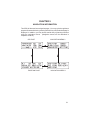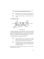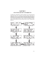
1
GPS 100 PERSONAL NAVIGATORTM OWNER'S MANUAL GARMIN GPS 100 Personal NavigatorTM OWNER'S MANUAL © 1992 GARMIN, 9875 Widmer Road, Lenexa, KS 66215 Printed in Taiwan. All rights reserved. No part of this manual may be reproduced or transmitted in any form or by any means, electronic or mechanical, including photocopying and recording, for any purpose without the express written permission of GARMIN. Information in this document is subject to change without notice. GARMIN reserves the right to change or improve their products and to make changes in the content without obligation to notify any person or organization of such changes or improvements. October, 1992 190-00001-00 Rev. A PREFACE GARMIN thanks you for selecting the industry’s first high performance, full featured Personal NavigatorTM. The GPS 100 represents our commitment to provide you with a portable navigation unit that is versatile, extremely accurate, and easy to use. We are confident you will enjoy using your unit for many years to come. The GPS 100's rugged construction and quality components offer the reliability demanded by the harshest operating environments. It may be used in marine, aviation, and land vehicles as well as by hunters, hikers, and military forces. The unit may be operated portably using its own battery pack, or it may use a 12 or 24 volt external power source for fixed mounted applications. You can even use a 115 or 230 volt battery charger for planning trips at home. This manual and accompanying quick reference card provide complete information on safely operating the GPS 100 to its full potential. An exciting practice voyage has been planned for you to practice your navigation skills using the built-in simulator. Afterwards try a trip of your own to realize the value of the GPS 100 as your Personal NavigatorTM. If you have any questions or comments, our Customer Support Department is eager to serve you. GARMIN is fully committed to your satisfaction as a customer. GARMIN International, Inc. 9875 Widmer Road Lenexa, KS 66215 i CAUTION The GPS system is operated by the government of the United States which is solely responsible for its accuracy and maintenance. The system is under development and is subject to changes which could affect the accuracy and performance of all GPS equipment. Although the GPS 100 is a precision electronic NAVigation AID (NAVAID), any NAVAID can be misused or misinterpreted, and therefore become unsafe. Use the GPS 100 at your own risk. To reduce the risk, carefully review and understand all aspects of this Owner's Manual and thoroughly practice operation using the simulator mode prior to actual use. When in actual use, carefully compare indications from the GPS 100 to all available navigation sources including the information from other NAVAIDs, visual sightings, charts, etc. For safety, always resolve any discrepancies before continuing navigation. The altitude calculated by the GPS 100 is geometric height above mean sea level and could vary significantly from altitude displayed by pressure altimeters in aircraft. NEVER use GPS altitude for vertical navigation. NOTE: This equipment has been tested and found to comply with the limits for a Class B digital device, pursuant to Part 15 of the FCC Rules. These limits are designed to provide reasonable protection against harmful interference in a residential installation. This equipment generates, uses and can radiate radio frequency energy and, if not installed and used in accordance with the instructions, may cause harmful interference to radio communications. However, there is no guarantee that interference will not occur in a particular installation. If this equipment does cause harmful interference to radio or television reception, which can be determined by turning the equipment off and on, the user is encouraged to try to correct the interference by one or more of the following measures: · · · · ii Re-orient or relocate the receiving antenna. Increase the separation between the equipment and receiver. Connect the equipment into an outlet on a circuit different from that to which the receiver is connected. Consult the dealer or an experienced radio/TV technician for help. TABLE OF CONTENTS CHAPTER 1 2 PAGE INTRODUCING THE GARMIN GPS 100 1-1 1.1 1.2 1.3 1.4 1-1 1-2 1-3 1-4 GPS 100 Capabilities Basic Package Optional Accessories Operational Modes GETTING STARTED - GPS 100 FUNDAMENTALS 2-1 2.1 2.2 2.3 Keypad Operation Entering Data Viewing Messages 2-2 2-4 2-5 3 INITIALIZATION 3-1 4 WAYPOINTS 4-1 4.1 4.2 4.3 4.4 4.5 4.6 4.7 4.8 4.9 4-2 4-2 4-4 4-5 4-6 4-6 4-7 4-8 4-9 5 6 Waypoint Definition Creating Waypoints Using Waypoints Using Waypoints By Scanning Reviewing Waypoints Modifying Waypoints Nearest Waypoints Proximity Alarm Waypoints Waypoint Catalog NAVIGATION INFORMATION 5-1 5.1 5.2 5-2 5-5 CDI and Navigation Summary Present Position GETTING THERE FAST — GOTO 6-1 iii 7 ROUTES 7-1 7.1 7.2 7.3 7.4 7.5 7.6 7-2 7-3 7-4 7-5 7-7 7-7 8 AutoStoreTM 8-1 9 TRIP PLANNING AND GPS STATUS 9-1 9.1 9.2 9.3 9.4 9.5 9-1 9-2 9-3 9-4 9-5 10 11 12 Trip Planning Fuel Planning Density Altitude/TAS (Aviation Feature) Wind Aloft (Aviation Feature) Vertical Navigation (Aviation Feature) DATE AND TIME FUNCTIONS 10-1 10.1 10.2 10.3 10.4 10.5 Date and Time Alarm Clocks Event Timers Sunrise/Sunset Battery Timer 10-1 10-2 10-3 10-5 10-5 CUSTOMIZING THE GPS 100 11-1 11.1 11.2 11.3 11.4 11.5 11.6 11.7 11.8 GPS Status User Selectable Alarms CDI Settings Offset Navigation/Magnetic Variation Audio/Display Characteristics Navigation Display Units Map Datum/Interface Waypoint/Route Transfer ADVANCED FEATURES 12.1 12.2 12.3 iv Navigating Using Routes Route Catalog Editing Routes Activating Routes Deleting Routes Closest Point of Approach Building Routes Using AutoStoreTM Parallel Offset Navigation Course To Steer (CTS) 11-2 11-3 11-5 11-6 11-8 11-9 11-11 11-12 12-1 12-1 12-2 12-3 12.4 12.5 Vertical Navigation (Aviation Feature) Closest Point of Approach 12-4 12-5 13 MESSAGES 13-1 14 INSTALLATION AND MAINTENANCE 14-1 14.1 14.2 14.3 14.4 14.5 14.6 14.7 15 Specifications Electrical Wiring Gimbal Bracket Installation Slide Mount Operation Battery Pack Operation Maintenance Customer Support SAMPLE SIMULATED TRIP 14-1 14-3 14-4 14-6 14-9 14-10 14-10 15-1 APPENDICES A GPS — HOW DOES IT WORK A-1 A.1 A.2 A.3 A-1 A-1 A-2 GPS Overview Coverage and Accuracy GPS Receiver Designs B ACRONYMS AND ABBREVIATIONS B-1 C LOCAL TIME TO UTC TIME CONVERSION C-1 D INDEX D-1 v CHAPTER 1 INTRODUCING THE GARMIN GPS 100 1.1 GPS 100 CAPABILITIES The GPS 100 provides a host of powerful capabilities which were previously unavailable or found only in much larger and more expensive systems: · Performance: State-of-the-art MultiTracTM receiver tracks up to eight satellites while providing high receiver sensitivity, fast first fix, and continuous navigation updates. · Portability: Goes where you go - on land, sea, or in the air. The builtin simulator allows you to plan your next trip or hone your navigation skills at home or in your office. · Navigation: Illuminated keypad and display provide the navigation information you need at a glance. Store up to 250 alphanumeric waypoints and 10 reversible routes. The GOTO function sets an instantaneous course to the waypoint of your choice. The AutoStoreTM function helps you build routes as you go. A flashing Message Annunciator and an audible message tone keeps you fully informed of your navigation status. · Personalized: Configure your unit the way you like by selecting nautical units, Course Deviation Indicator (CDI) sensitivity, keypad and display features, map datums, and interface options. · Low Power Consumption: Battery Saver operation, which draws less than 250 milliamps of current, provides 14 hours of continuous operation with six AA size alkaline batteries. The QuickFixTM mode provides on demand position fixes in as little as 15 seconds and over 100 hours of battery life at four fixes per hour. · Trip Planning: Analyze distance, time, and fuel requirements for your trip. Compute the time of sunrise and sunset at your destination. Calculate density altitude before you take off, and true airspeed as you fly. Vertical navigation guides you to your cruise altitude and puts you in the traffic pattern before landing. 1-1 · Multi-purpose Alarms: Dual alarm clocks and timers allow the GPS 100 to watch the clock for you. Arrival, anchor drag, CDI, and hazard alerts help you safely navigate your craft. · Offset navigation: The offset navigation feature allows you to traverse your route a fixed distance left or right from a defined course. · Interfaces: Interface with marine or aviation autopilots and graphical plotters. Down load waypoints and routes to your PC for permanent record. We encourage you to read this manual and experiment using the built-in simulator. This will help you quickly master the features of the GPS 100. 1.2 BASIC PACKAGE Your GARMIN GPS 100 basic package includes: · · · · · · · · · GPS 100 Unit Rechargeable Battery Pack 115V/230V Battery Charger Gimbal Mount Assembly Power/Data Cable Wrist Strap Owner's Manual Quick Reference Card Warranty Card The basic package allows you to use your GPS 100 for both portable and fixed operations. The unit may be operated from external AC power using the battery charger, external 12 or 24 volt DC power using the power/data cable, or using a battery pack. Handheld Operation: For handheld operation, the GPS 100 is powered by the battery pack which can be recharged using the supplied battery charger. (NOTE: This battery pack is permanently sealed and should never be opened.) An optional AA size battery pack is available if you wish to use disposable batteries. 1-2 In order to track GPS satellites, the unit must be situated with the antenna pointed straight up and should not be blocked by objects or people (signal reception through thin fabric such as canvas may be adequate but degraded). A wrist strap is provided to prevent accidental dropping of your GPS 100. (Connect the wrist strap to the eyelet on the back of the unit.) Gimbal Mount Operation: A gimbal mount is supplied for fixed installation in a boat or land vehicle. The unit may be operated using vehicle power through the power/data cable or it may be operated using the battery pack. While using vehicle power, you may wish to leave the battery pack in the unit. Vehicle power will automatically maintain the rechargeable battery pack at full capacity. In the event of vehicle power failure, the GPS 100 will automatically switch to battery power. In addition to supplying power to the unit, the power/data cable allows you to interface your GPS 100 with other marine electronic devices such as plotters or autopilots (see Section 14.2 on electrical wiring). 1.3 OPTIONAL ACCESSORIES The following optional accessories are available for your specific needs: · · · · · · Magnetic Mount Antenna Kit Marine/RV Remote Antenna Kit Personal Computer Kit Carrying Case AA Size Battery Pack Data Transfer Cable (unit-to-unit) Marine/RV Operation: A Marine/RV Remote Antenna Kit is available for those installations that require an external antenna for an unobstructed view of the sky. This kit includes a remote weather-proof antenna and 30 feet of low-loss antenna cable. The remote antenna has been constructed to thread onto a standard 1" antenna mount. Antenna mounts, commonly used to attach VHF radio antennas and Loran-C couplers, are readily available from your local marine accessories dealer. 1-3 A Magnetic Mount Antenna KIt is available for temporary attachment of the GPS 100 antenna to a metalic surface. This kit includes a remote weatherproof antenna and 10 feet of low-loss antenna cable. Personal Computer Kit: A Personal Computer Kit is available for real-time track plotting/map generation and downloading of almanac, waypoints, and routes. Perform satellite visibility computations and useful DXF format conversion for interfacing to various CAD and GIS (Geographical Information System) programs. Waypoints and routes may be uploaded from a PC back to your GPS 100 using this kit. Data Transfer Cable: A data transfer cable is available to transfer waypoints and routes from one GPS 100 to another. This cable comes complete with GPS 100 connectors and can be used in conjunction with the battery charger. Carrying Case: A carrying case is available for convenient storage or transportation of your GPS 100. This case can be worn on your belt or over the shoulder. A utility pocket is provided for storing spare battery packs as well as other small items. The unit may be operated directly from the case by unzipping the top and bottom zippers and raising the antenna. AA Size Battery Pack: A AA size battery pack is available if you wish to use disposable batteries for GPS 100 operation. The AA battery pack should be filled with six high quality alkaline batteries commonly found at retail stores. 1.4 OPERATIONAL MODES If your GPS 100 is powered by an external source, it will provide continuous navigation updates. Typical time to first fix is less than 2.5 minutes. (If you have used your unit within the hour, it may take as little as 15 seconds.) If your GPS 100 is powered by the battery charger or a battery pack, you may select one of four operational modes: 1-4 Normal mode offers continuous position updates as if you were using an external power source. The GPS 100 will typically operate 8 hours on a single pack of alkaline batteries, or 5 hours using the rechargeable battery pack. Battery Saver mode, suitable for most applications, offers navigation updates that adapt to your needs while extending battery life. The GPS 100 will typically operate 14 hours on a single pack of alkaline batteries, or 8 hours using the rechargeable battery pack. QuickFixTM mode offers the convenience of quick, on demand position updates and extended battery life for surface navigation users. A single pack of alkaline batteries will last over 100 hours at four fixes per hour. After your position has been calculated, you may turn the unit off, or it will automatically turn off two minutes after the last keypress. When you are ready for a new position fix, simply turn the unit on. The GPS 100 will quickly re-acquire satellites and calculate a new position. To manually cancel QuickFixTM mode, turn the unit off prior to obtaining a position fix. If you have not requested a new position fix for 30 minutes, the QuickFixTM mode will automatically be cancelled. Simulator mode allows you to simulate the operation of the GPS 100 while at home or in your office. The simulator mode can be used while learning to use your GPS 100 and is ideal for planning routes and entering waypoints. Keep in mind that the GPS 100 is not tracking satellites in the simulator mode. You should never attempt to use the simulator mode for actual navigation. 1-5 CHAPTER 2 GETTING STARTED — GPS 100 FUNDAMENTALS The front panel consists of a 3- line, 22- character LCD display and 21 keys. Both the display and keypad are illuminated for your convenience while operating in the darkness. Flashing “M” character for new messages; steady “M” if messages remain on the Message page after you view them. No “M” character if no messages. Information displayed on the LCD is commonly referred to as a “page”. Notice the “M” character in the upper right-hand corner of the display illustrated above. This symbol is known as the Message Annunciator and will flash if the GPS 100 wishes to tell you something. The unit also contains an internal tone generator that will sound with the flashing Message Annunciator (if your unit is connected to an external alarm system, it will also be activated). Cursor on Alphanumeric Field Numeric Field 2-1 Confirmation Field Cursor on Cyclic Field The area of the page with light characters and dark background is called the cursor. The cursor may be moved to locations on the page called fields. A field is a group of characters treated as a single unit of information which allow you to enter data. You will encounter four types of fields. Numeric fields accept numbers. For example, you will enter the time in an numeric field. Alphanumeric fields accept numbers as well as letters. For example, you will enter the date in an alphanumeric field. Cyclic fields allow you to select from one of several available options. For example, you may select between ETE (estimated time enroute) or ETA (estimated time of arrival) using a cyclic field. Cyclic fields are indicated on the display by a “>” character. Confirmation fields allow you to indicate your acceptance or rejection. For example, you will be asked to confirm the initial position, date, and time before satellite acquisition begins. Confirmation fields always end with a “?” character. 2.1 KEYPAD OPERATION The ON/OFF key is a dual function rocker key that controls system power and panel backlight intensity. When the unit is on, pressing the ON/BRT side of the key will increase the backlight intensity. Pressing the OFF/DIM side will decrease the backlight intensity. To turn the unit off, press and hold the OFF/DIM side of the ON/OFF key for three seconds until the display is blank. Pressing the MSG key allows you to view messages. (See Section 2.3 and 2-2 Chapter 13 for more details.) Pressing the GOTO key allows you to activate the GOTO function, which will set an instantaneous course to any waypoint. (See Chapter 6 for more details.) Pressing the AUTOSTO key allows you to capture your present position on an instantaneous basis. The AutoStoreTM function also allows you to place the waypoints in a route. (See Chapter 8 for more details.) Pressing the SET key selects the setup pages which allow you to customize the unit as you like. (See Chapter 11 for more details.) Pressing the RTE key selects the route pages which allow you to edit, review, activate, and delete routes. (See Chapter 7 for more details.) Pressing the WPT key selects the waypoint pages which allow you to create, edit and delete waypoints. In addition, you may view your nearest waypoints and set waypoint proximity alarms. (See Chapter 4 for more details.) Pressing the NAV key selects the navigation pages which allow you to view navigation information and perform planning functions. (See Chapters 5, 9, and 10 for more details.) Pressing the right or left side of this rocker key allows you to move the cursor, scroll through information lists, and enter letters of the alphabet. The alphanumeric keys allow you to enter letters and numbers into the GPS 100. If you want to enter a number, for instance “1”, simply press the 1 key. If you want to enter a letter, for example “A”, press the 1 key, then press the right arrow key once to select “A” (you may also press the left arrow key three times to display the "A"). Pressing the CLR key erases information in the cursor field. If the cursor is 2-3 over a cyclic field, pressing the CLR key will toggle through several available options. If the cursor is over a confirmation field, pressing the CLR key indicates rejection. Pressing the ENT key completes the process of data entry. If the cursor is over a confirmation field, pressing the ENT key indicates your approval. 2.2 ENTERING DATA The GPS 100 features a keypad feedback tone which will sound each time you press a key. If you enter data which is not appropriate for the field, the feedback tone will quickly sound three times indicating an error. The keypad feedback tone can be turned off if you wish (see Section 11.5 for more information). Data is entered into the unit using the keypad and fields. In order to enter data you must first move the cursor over the desired field by pressing the right or left arrow key. To enter a number... · Press the key that is labeled with the desired number. The numbers will fill in from the left side of the field similar to a typewriter. You must enter any leading zeros in the field. For example, if you wish to enter “51” in a 3 space field, you must press the 0, 5, and 1 keys in that order. · Press the CLR key if you enter an incorrect number. · Press the ENT key when you have filled each space of the field with numbers. To enter a letter... · Press the key that is labeled with the desired letter. · Press the right or left arrow key until the desired letter is displayed. · Press the CLR key if you enter an incorrect letter. · Press the ENT key when all the characters are entered. (Note: Some fields allow only letters and no numbers. For example, the 2-4 hemispheric designation for latitude is either an “N” for North or “S” for South. If you wish to enter an “N” for North, press the 5 key, which is also labeled with the letter N. The GPS 100 will automatically display “N” for you.) To change a cyclic field... · Press the CLR key. To indicate approval on a confirmation field... · Press the ENT key. To indicate rejection on a confirmation field... · Press the CLR key. 2.3 VIEWING MESSAGES Message Annunciator MESSAGE PAGE From time to time, the GPS 100 will use a message to tell you of conditions that need your attention. When the GPS 100 has a new message for you, the Message Annunciator will flash. When this occurs, press the MSG key to view new message(s). Continue to press the MSG key until the page you were viewing prior to pressing the MSG key is displayed. While the Message Annunciator is flashing, the GPS 100 will also generate an audible tone to alert you of the message. Messages that demand immediate attention such as an arrival alarm generate a quick tone that will not stop until you view the message. All other messages generate a slow tone that will cease after 15 seconds. The message tone may be turned off if you wish (see Section 11.5 for more information). Certain messages will remain on the Message Page after being viewed. If this occurs, the Message Annunciator will be in view but will not flash. If no messages exist on the Message Page, the Message Annunciator will 2-5 not be visible and the message page will appear as illustrated below. Refer to Chapter 13 for a complete list of GPS 100 messages. 2-6 CHAPTER 3 INITIALIZATION By now you should have a basic understanding of the GPS 100. Turn your unit on and we will walk you through the initialization process. (You may need to use the battery charger when you operate the unit for the first time. Please allow the unit to remain on the battery charger for at least 14 hours before actual field use.) SELF TEST PAGE When you turn your GPS 100 on, the Self Test Page will be displayed for approximately 2 seconds. During this time, the GPS 100 will conduct a series of self tests. UTC Date UTC Time Initial Latitude Initial Longitude Nearest Waypoint Bearing & Range from Waypoint INITIALIZATION PAGE Following completion of the self tests, the Initialization Page will be displayed. This page allows you to verify and change, if necessary, the UTC date/time and initial position. (UTC, essentially the same as Greenwich Mean Time, is the time of day at 0 degrees longitude. See Appendix C for UTC/local time conversion.) NOTE: The UTC date and time has been set by the factory and will be updated by information received from the satellites. Unless the date/time is in error by more than 20 minutes, it need not be updated. 3-1 To update the initial date... · Use the right or left arrow key to position the cursor over the date field. · Press the number keys associated with the UTC day of the month. For example, to enter the 14th day of June, press the 1 key followed by the 4 key. Remember to press the CLR key if you make a mistake. · Use the alphanumeric keys to enter the first 3 characters of the UTC month, i.e. JAN, FEB, MAR, APR, MAY, JUN, JUL, AUG, SEP, OCT, NOV, or DEC. · Enter the last two digits of the UTC year. For example, in the year 1991 you would enter “91”. In the year 2005 you would enter “05” · Press the ENT key when you have finished entering the UTC date. To update the initial time... · Use the right or left arrow key to position the cursor over the UTC time field. · Enter the time in 24 hour UTC format. For example, if the UTC time is 14:30 (i.e. 2:30 PM), press the 1, 4, 3, and 0 keys. · Press the ENT key when you have finished entering the UTC time. The position on the Initialization Page is the last position stored in the GPS 100. This page also displays the bearing and range from the nearest waypoint, which typically will be the destination of your last trip. You may verify the initial position by comparing the displayed latitude/ longitude with your actual position (obtained from a map or chart). Alternatively, you may find it easier to verify that the initial position is within a reasonable distance from the displayed waypoint. Unless your unit has been moved more than 800 nautical miles with the power off, you should not have to re-enter the initial position. (For fast satellite acquisition, the displayed position should be within 60 nautical miles from your actual position.) To update the initial position by latitude/longitude... 3-2 · Use the right or left arrow key to position the cursor over the latitude field. · Check the hemispheric designation (“N” or “S”) of the latitude. If it is correct, go to the next step. If it is incorrect, press the CLR key followed by the key labeled with the correct hemispheric designator for your position. For example, if your position is North of the Equator press the 5 key. This will cause an “N” to be displayed in the first character of the latitude. Similarly, press the 7 key for “S” if your position is South of the Equator. · Enter your approximate latitude in degrees and minutes. · Press the ENT key when your latitude is correct. The cursor will automatically move to the longitude field. · Check the hemispheric designation (“E” or “W”) of the longitude. If it is correct, go to the next step. If it is incorrect, press the CLR key followed by the key labeled with the correct hemispheric designator for your position. For example, if your position is in the Eastern Hemisphere, press the 2 key. This will cause an “E” to be displayed in the first character of the longitude. Similarly, press the 8 key for “W” if your position is in the Western Hemisphere. · Enter your approximate longitude in degrees and minutes. · Press the ENT key when your longitude is correct. Alternatively, you may enter the name of a nearby waypoint. The GPS 100 will use the position of the waypoint as its initial position. You will find this method convenient if the nearby waypoint is already programmed and stored in memory (see Chapter 4 for information on waypoints). To update the initial position by waypoint name... · Use the right or left arrow key to position the cursor over the waypoint name on line 3. · Enter the waypoint name. The GPS 100 will display the latitude/ longitude of the entered waypoint on line 2. 3-3 When the initial data is acceptable to you, use the right or left arrow key to place the cursor over “OK?”. Press the ENT key to accept the Initialization data. MODE SELECTION PAGE If you are operating the unit with a battery pack or with the battery charger, the above page will be displayed asking you to select the operational mode before proceeding. Recall that you may select Normal, Battery Saver, QuickFixTM, or Simulator mode as described in Section 1.4. To select the operational mode... · Use the left arrow key to place the cursor to the right of “>” on line 3. · Press the CLR key until the desired operational mode is displayed. For example, to select QuickFixTM mode, press the CLR key until “QUICKFIX” is displayed. · Use the right arrow key to place the cursor over “OK?”. · Press the ENT key to accept the operational mode. Your GPS 100 is now initialized and the Satellite Status Page will be displayed (see Section 11.1 for more information on the Satellite Status Page). If you are not operating your GPS 100 in the Simulator mode, it will immediately begin acquiring satellites. This processs is fully automatic and, under normal circumstances, will take 2-3 minutes to obtain navigation information. The GPS 100 will inform you when it is ready for navigation with the message “READY FOR NAVIGATION". If four or more satellites with good geometry are available, the GPS 100 will automatically operate in the 3D mode in which latitude, longitude, and altitude are computed. If only three satellites are available, the unit will automatically operate in 2D mode in which only latitude and longitude are computed. When operating in the 2D mode, the unit will ask you to enter an altitude with the message “NEED ALT - PRESS NAV” (see Section 5.2 on altitude entry). 3-4 Your GPS 100 will automatically update satellite orbital data as it operates. If you have not operated your unit for a period of six months or longer, it will search the sky to collect new orbital data. You will be informed when your unit is searching the sky with the message “SEARCHING THE SKY”. Once satellite orbital data is collected, it will be stored in battery backed up memory. This means the data will not be lost when you turn your GPS 100 off. If the GPS 100 cannot acquire enough satellites for 2D or 3D navigation, you will be informed with the message “POOR GPS COVERAGE”. If this situation occurs, check the installation and make sure the antenna is properly connected and not obstructed. You may wish to repeat the initialization steps and verify that the initial data are correct. Where to go from here... If you are using your GPS 100 for the first time, we encourage you to review Chapter 4 on waypoints, Chapter 5 on navigation, and Chapter 6 on GOTO. Additionally, you may wish to go through Chapter 11 on custom setups. Finally, you don’t want to miss our sample trip in Chapter 15 using the builtin simulator! This will help you quickly master the power and capability of the GPS 100. 3-5 CHAPTER 4 WAYPOINTS One of the many powerful features of the GPS 100 is its ability to create, store, and use 250 alphanumeric waypoints. A waypoint consists of a name (up to five letters or numbers) and its latitude/longitude location. You will have the opportunity to use waypoints extensively while operating the GPS 100. For example, you can build a route using waypoints, you can perform trip/fuel planning using waypoints, and you can even calculate the time of sunrise and sunset for a waypoint of interest. The GPS 100 features four waypoint pages. You may cycle through these pages as illustrated below by pressing the WPT key until the desired page is displayed. WAYPOINT DEFINITION PAGE WAYPOINT CATALOG PAGE NEAREST WAYPOINT PAGE PROXIMITY WAYPOINT PAGE 4-1 4.1 WAYPOINT DEFINITION Waypoint Name Proximity Indicator Nearest Waypoint Indicator Latitude Longitude Reference Waypoint Bearing & Range from Reference WAYPOINT DEFINITION PAGE The Waypoint Definition Page displays the waypoint name (up to 5 characters), its latitude/longitude, and an optional reference. The reference waypoint option allows you to compute the relative position (range and bearing) of the displayed waypoint from a better known location. The reference for each waypoint will be stored in memory to help you remember where the waypoint is located. If the waypoint is used as a proximity alarm (see section 4.8 for more information), it will be indicated by “PROX” on line 1. Additionally, if the waypoint is one of the 9 nearest waypoints, it will be indicated by “NRx” on line 1 (“x” ranges from 1 to 9, with 1 meaning the closest). 4.2 CREATING WAYPOINTS NEW WAYPOINT PAGE When a waypoint name has been entered that does not exist in memory, the GPS 100 will assume you wish to create a new waypoint. The New Waypoint Page will ask you to select one of three methods for defining the waypoint position: direct latitude/longitude entry, relative to an existing waypoint, or relative to your present position. 4-2 To enter the waypoint position directly... · Place the cursor over “ENTER POSN?” and press the ENT key. The Waypoint Definition Page will appear with the cursor over waypoint latitude as illustrated below. · Enter the waypoint latitude. · Enter the waypoint longitude. · With the cursor over “OK?”, press the ENT key. The waypoint is now stored in memory. To create a waypoint offset from a reference waypoint... · Move the cursor over “REF WPT?” and press the ENT key. The Waypoint Definition Page will appear with the cursor over the reference waypoint name as illustrated below. · Enter the name of the reference waypoint. The position of the reference waypoint will be displayed on line 2. · Enter the bearing from the reference waypoint to the new waypoint. · Enter the distance from the reference waypoint to the new waypoint. The resulting waypoint position will be displayed on line 2. · With the cursor over “OK?”, press the ENT key. The waypoint is now stored in memory. 4-3 To create a waypoint offset from your position... · Move the cursor over “RELATIVE TO PRES POSN?” and press the ENT key. The Waypoint Definition Page will appear with the cursor over the bearing and your position will be displayed on line 2 as illustrated below. · Enter the bearing from your present position to the new waypoint. · Enter the range from your present position to the new waypoint. The resulting waypoint position will be displayed on line 2. · With the cursor over “OK?”, press the ENT key. The waypoint is now stored in memory. 4.3 USING WAYPOINTS Once you have created a waypoint, you may use it on any page requiring a waypoint name. When a waypoint name is entered, the Waypoint Definition Page will be displayed asking you to confirm the position of the waypoint. For example, each time you enter a waypoint into a route, the Waypoint Definition Page will be displayed. To accept the waypoint definition... · With the cursor over “OK?”, press the ENT key. To reject the waypoint definition... · With the cursor over “OK?”, press the CLR key. Once a waypoint definition has been accepted or rejected, the previous page will be displayed. 4-4 4.4 USING WAYPOINTS BY SCANNING The GPS 100 offers a waypoint scanning feature which will simplify waypoint name entry. A waypoint list is available for scanning in any waypoint name field. The list consists of up to nine nearest waypoints within 100 nm and a complete list of waypoints which are organized alphabetically (numbers are ordered before the letters of the alphabet). The nearest waypoint list is placed in front of the complete list so that, in the event of an emergency, you may quickly access the desired nearest waypoint. To enter waypoint name by scanning... · With the cursor over a blank waypoint name field, press the WPT key. The nearest waypoint will be displayed in the waypoint field. · Use the right and left arrow keys to scan through the list of waypoints, starting with the nearest list and followed by the complete list. · With the desired waypoint shown, press the ENT key to select the waypoint (use the CLR key to cancel the scanning operation at any time). To avoid scanning through the entire waypoint list, you may want to enter the first few characters of the waypoint name. To scan waypoints with specified initial characters... · Enter the desired number of initial characters of the waypoint name into a waypoint field as normally done when entering a waypoint name. · Press the WPT key to display the first waypoint that begins with the character(s) you have entered. · Use the right and left arrow keys to scan through the list of the waypoints that matches the entered characters. · With the desired waypoint shown, press the ENT key to select the waypoint (use the CLR key to cancel the scanning operation at any time). 4-5 Variable rate scanning is implemented to allow you to quickly go from one end of the list to the other. When the arrow keys are pressed briefly, you will go through the waypoints one at a time. As you hold the arrow keys for a longer period of time, the waypoint list will start to scroll rapidly; the longer the arrow keys are held while scanning, the larger the step through the list. 4.5 REVIEWING WAYPOINTS The GPS 100 allows you to quickly review waypoint information without entering the waypoint name. For example, you may review the waypoints in a route, or review the definition of the nearest waypoints. In general, if the cursor is over a waypoint name, you may quickly review the definition of that waypoint. To review a waypoint definition... · Move the cursor over a waypoint name and press the ENT key. The definition of the waypoint will be displayed on the Waypoint Definition Page with the cursor over “OK?”. · With the cursor over “OK?”, press the ENT key to return to the previous page. 4.6 MODIFYING WAYPOINTS You may modify the position of a waypoint while viewing the Waypoint Definition Page. (NOTE: If a waypoint is being used for navigation, its position cannot be modified. An attempt to modify the position of such a waypoint will result in the message “CANNOT CHNG ACTV WPT”.) To change the waypoint position by latitude/longitude entry... · Enter the new latitude and longitude. · Move the cursor over “OK?” and press the ENT key. To change the waypoint position by reference... 4-6 · Enter the reference waypoint name. If the desired reference is already there, you may skip this step. · Enter the bearing from the reference to the desired waypoint location. · Enter the distance from the reference to the desired waypoint location. The GPS 100 will display the resulting latitude and longitude. · With the cursor over “OK?”, press the ENT key. 4.7 NEAREST WAYPOINTS Total Nearest Waypoints Rank Name Bearing & Range from present position NEAREST WAYPOINT PAGE An important feature of the GPS 100 is the ability to display up to 9 waypoints nearest to your position (not further than 100nm). In an emergency, you may use the nearest waypoint feature to find the closest point of safety in your area. The Nearest Waypoint Page displays 3 waypoints at a time. Additional waypoints are viewed by “scrolling” through the nearest waypoint list. The total number of nearest waypoints is displayed in the upper right corner of the page. To scroll through the nearest waypoints... · Place the cursor over the waypoint name on line 3 and press the right arrow key to scroll down the list. · Place the cursor over the waypoint name on line 1 and press the left arrow key to scroll up the list. Remember the waypoint review feature will allow you to quickly scan the definition of a nearest waypoint by pressing the ENT key with the cursor over the desired waypoint. 4.8 PROXIMITY ALARM WAYPOINTS 4-7 Name Alarm Distance Total Proximity Waypoints PROXIMITY WAYPOINT PAGE The Proximity Waypoint Page allows you to define an alarm circle around a waypoint. Boaters may wish to define a proximity alarm waypoint around a rock or sand bar. Pilots may wish to define a proximity alarm waypoint around a restricted use airspace such as a MOA or TCA. The GPS 100 will notify you with an alarm tone and the message “PROX ALARM-PRESS NAV” if you enter the alarm circle. After you view this message, press the NAV key. The Position Page will display the range and bearing from the proximity waypoint to your position. (See Section 5.2 for information on the Position Page.) The GPS 100 allows you to define a maximum of 9 proximity waypoints. The Proximity Waypoint Page displays 3 proximity waypoints at a time. Additional waypoints are viewed by scrolling through the proximity waypoint list. The number of proximity waypoints is displayed in the upper right corner of the page. To scroll through the proximity waypoints... · Place the cursor over the alarm distance on line 3 and press the right arrow key to scroll down the list. · Place the cursor over the waypoint name on line 1 and press the left arrow key to scroll up the list. To add a waypoint to the proximity list... · Scroll down the list until the cursor is over a blank waypoint name. · Enter the desired waypoint name. · Enter the radius of the alarm circle. If the newly entered proximity circle overlaps with any existing circle, you will be informed with the message “PROXIMITY OVERLAP”. This message will 4-8 also be displayed each time you turn the GPS 100 on as long as the overlap remains. (WARNING: If you enter the overlap area, the unit will only inform you of the nearest proximity waypoint.) To remove a waypoint from the proximity list... · Place the cursor over the waypoint name you wish to delete. · Press the CLR key, the waypoint name will blank. · Press the ENT key, the waypoint will be removed from the proximity waypoint list. 4.9 Waypoint Catalog Route Use Waypoint Names Number of User Waypoints Proximity Use WAYPOINT CATALOG PAGE The Waypoint Catalog Page displays up to six waypoints in alphabetical order. Additional waypoints are viewed by scrolling through the waypoint list. The status of a waypoint is displayed immediately to the left of the waypoint name. The status consists of the first route number (0..9) in which the waypoint is used (if any), and an asterisk “*” if you entered the waypoint in the proximity list. For example, waypoint OILRG is a proximity waypoint, and waypoint OKLND is used in route 2. A total of 250 waypoints can be permanently stored in memory. The number of waypoints you have defined is shown in the upper right-hand corner of the page. To scroll through the waypoint list... · Place the cursor over the last waypoint name on line 3 and press the 4-9 right arrow key to scroll down the list. · Place the cursor over the first waypoint name on line 1 and press the left arrow key to scroll up the list. The Waypoint Catalog Page allows you to delete waypoints which are not used in any route and are not members of the proximity list. (NOTE: If you wish to delete a waypoint that is used in a route or is a member of the proximity list, first remove it from the route and/or proximity list before attempting to delete the waypoint.) To delete a waypoint from memory... · Place the cursor over the desired waypoint and press the CLR key. The waypoint name will become blank. · Press the ENT key, the waypoint will be deleted from memory. The Waypoint Catalog Page also allows you to rename user waypoints. To rename a user waypoint... · Place the cursor over the desired waypoint. · Enter a unique waypoint name. If you enter a name that is already used, you will be informed with the message “WPT EXISTS ____” (where the blank will be filled in with the waypoint name). Enter a different waypoint name if this occurs. After entering a unique waypoint name, the Rename Waypoint Page will be displayed as illustrated below. RENAME WAYPOINT PAGE · 4-10 With the cursor over “OK?” press the ENT key. The waypoint will be renamed, the Waypoint Catalog Page will be displayed and the waypoint list will be re-ordered alphabetically. CHAPTER 5 NAVIGATION INFORMATION The GPS 100 features four navigation pages. You may cycle through these pages as illustrated below by pressing the NAV key until the desired page is displayed. In addition, you may access a wide array of planning functions using the navigation menus. (Navigation menus will be described in Chapters 9 and 10.) CDI PAGE NAVIGATION MENU 2 POSITION PAGE NAVIGATION MENU 1 5-1 5.1 CDI AND NAVIGATION SUMMARY “Active From” Waypoint “Active To” Waypoint Velocity Distance Direction CDI Time/Track CDI PAGE The CDI Page displays virtually all the information you need to guide your craft. Included is a graphical course deviation indicator (CDI) which illustrates your position relative to the course. The to/from arrow in the center of the CDI indicates if you are navigating to the waypoint (up arrow) or if you have passed the waypoint (down arrow). If you have set the CDI alarm, the limits of the alarm will be displayed with brackets (i.e. “[“ and “]”) as illustrated. You may set CDI alarm, CDI sensitivity, and CDI representation of the course from the Setup Pages (see Sections 11.2 and 11.3 for more details). During the process of acquiring satellites, the GPS 100 will not provide navigation data. The area of the CDI will indicate this condition as illustrated below. The “active from” and “active to” waypoints on line 1 indicate where you have come from and where you are going (see Section 7.1 for illustration). When using the GOTO function, the CDI Page will appear as illustrated below (see Chapter 6 for more details on the GOTO function). If the GPS 100 is not navigating to a waypoint (i.e., there is no “active to” waypoint), the CDI area will indicate this condition as illustrated below. 5-2 The cyclic fields, indicated by the “>” character, can be used to select the type of information you wish to see. To use a cyclic field, place the cursor to the right of the “>” and press the CLR key. You may select one of two velocity options: · GS - Ground speed. GS is the speed measured relative to the ground; also known as velocity over ground (VOG). · VMG- Velocity made good. VMG is velocity in the direction of the desired course. It is the speed at which you are closing on the “active to” waypoint. You may select one of six direction options: · CMG- Course made good. CMG is the bearing from the “active from” waypoint to your position. · TRK- Track. TRK is the direction of movement relative to the ground. · BRG- Bearing. BRG is the direction from your position to the “active to” waypoint. · TRN- Off course error. “L” indicates you should turn to the left, “R” indicate you should turn to the right. The degrees indicate the angle you are off course. · CTS- Course to steer. CTS is the recommended direction to steer in order to reduce cross track error and stay on course (see Section 12.3 for an example using CTS). · DTK- Desired track. DTK is the course between the “active from” and “active to” waypoints. You may select one of four distance options: 5-3 · RNG - Range. RNG is the distance from your position to the “active to” waypoint. · ATD - Along track distance. ATD is the along track distance to the “active to” waypoint. It is measured from the point on the course closest to your position. · DMG- Distance made good. DMG is the along track distance from the “active from” waypoint. It is measured from the point closest to your position. · STR - Steer direction and distance. “L” indicates you should steer to the left, “R” indicates you should steer to the right. The distance indicates how far you are off course. You may display one of two time options or track: 5-4 · ETE-Estimated time enroute. ETE is the time it will take to reach the “active to” waypoint based on your speed. · ETA- Estimated time of arrival. ETA is the time at which you will arrive at the “active to” waypoint based on your speed. · TRK- Track. TRK is the direction of movement relative to the ground. 5.2 PRESENT POSITION Altitude EPE/DOP Latitude Longitude Velocity/ Ground Speed Reference Select Track POSITION PAGE The Position Page displays your ground speed, track, and position relative to the selected earth datum (see Section 11.7 for more information on earth datums). The altitude displayed is the elevation above mean sea level (MSL); it is NOT equivalent to the altitude displayed on pressure altimeters in aircraft and should not be used for vertical navigation. You may display one of two system quality factors: · DOP- Dilution of precision. DOP is a measure of the satellite geometry quality and hence the relative accuracy of your position (1 meaning the best and 10 meaning poor). · EPE- Estimated position error. EPE, computed using the satellite geometry (DOP), signal and data quality, receiver tracking status and other factors, is an overall measure of your position accuracy. EPE and DOP are advisory information only and are not to be used as absolute measures of accuracy. 5-5 In place of the speed and track information on line 3, you may want to calculate the range and bearing from a reference to your present position. (This information will give you a better understanding of where you are relative to a known location.) To calculate range/bearing from a reference waypoint... · Press the CLR key on line 3 to select the reference waypoint option. · Enter the reference waypoint name. The GPS 100 will continuously display range and bearing from the waypoint as illustrated below. If you have entered the alarm circle of a proximity waypoint (see Section 4.8 on proximity waypoints), you will be informed with the message “PROX ALARM-PRESS NAV”. When the NAV key is pressed, the Position Page illustrated above will be displayed with the proximity alarm waypoint already entered in the reference field for you. The GPS 100 will continually update the range and bearing from the proximity waypoint to your position on line 3. If the GPS 100 needs altitude to perform 2D navigation, you will be informed with the message “NEED ALT - PRESS NAV”. When you press the NAV key, the Position Page will be displayed as illustrated below: The last known altitude will be displayed to the right of “ALT:” as illustrated above. If the altitude is correct, simply press the ENT key with the cursor over the altitude. Otherwise, enter the altitude of your antenna. (If your antenna is mounted on a high mast, make sure you add the mast height.) If your speed is less than 65 knots, you need to enter your altitude only once. If your speed is 65 knots or greater, the unit will ask you to update your altitude every 10 minutes with the message “NEED ALT - PRESS NAV”. 5-6 CHAPTER 6 GETTING THERE FAST — GOTO The GOTO function allows you to quickly set a course from your position to any waypoint. GOTO Waypoint Velocity Distance Direction CDI Time/Track CDI PAGE (GOTO MODE) To activate the GOTO function... · Press the GOTO key. The CDI Page will be displayed with the cursor over the GOTO waypoint field on line 1. · Enter the desired GOTO waypoint name. Navigation information to the GOTO waypoint will be displayed. Alternatively, the GOTO function may be quickly activated from any page (e.g. the Nearest Waypoint Page) by placing the cursor over the desired waypoint name and pressing the GOTO key. The Waypoint Definition Page will be displayed and the GOTO function will be activated upon confirmation of this page. You may cancel the GOTO function at any time. To cancel the GOTO function... · Place the cursor over the GOTO waypoint name on the CDI Page. · Press the CLR key, the GOTO waypoint name will become blank. · Press the ENT key. The GPS 100 will navigate using route 0, if available. 6-1 CHAPTER 7 ROUTES The GPS 100 allows you to create and store 10 routes, numbered 0 through 9, containing up to 9 waypoints each. Routes can be travelled in the order in which you define the waypoints, or they may be reversed. The GPS 100 features three route pages. You may cycle through these pages as illustrated below by pressing the RTE key until the desired page is displayed. ACTIVE ROUTE PAGE ROUTE CATALOG PAGE CPA PAGE 7-1 7.1 NAVIGATING USING ROUTES POINT BOUY7 BOUY9 BAY Route 0 is called the active route and is the route used for navigation. The waypoint toward which you are navigating is called the “active to” waypoint. The waypoint immediately behind you is called the “active from” waypoint. The line defined by two consecutive waypoints in a route is called a “leg”. The leg that connects the “active from” and “active to” waypoints is called the “active leg”. The GPS 100 features automatic leg selection which will select the route segment closest to your position as the active leg. If you wish to navigate to a waypoint other than that chosen by the GPS 100, use the GOTO function to choose the desired waypoint. The GPS 100 also features automatic leg sequencing. As you pass a waypoint in the route, the unit will automatically select the next waypoint as the “active to” waypoint. If your speed is greater than 65 knots, the GPS 100 will provide smooth steering around the turn. 7-2 7.2 ROUTE CATALOG Copy From Copy To Route Number Total Distance First & Last Waypoint of Route ROUTE CATALOG PAGE The Route Catalog Page gives a list of the routes stored in the GPS 100. This page shows the route number, first/last waypoint names composing the route, and the total distance traversed by the route. For example, in the illustration above, route 0 begins at FTMYR (Fort Myers, Florida), ends at NASAU (Nassau in the Bahamas), and is 364.8 nautical miles long. Up to two routes are displayed at a time on the Route Catalog Page. Additional routes may be displayed by scrolling. To scroll the Route Catalog Page... · Place the cursor over the route on line 3 and press the right arrow key to scroll down the list. · Place the cursor over the route on line 2 and press the left arrow key to scroll up the list. The waypoints of an existing route may be copied to an empty route using the Route Catalog Page. This is useful if you wish to store the contents of route 0 before activating a new route. Also, you may copy a route and then make changes to form a new route. To copy a route... · Enter the number of the route you wish to copy in the “copy from” field (this field defaults to “0”). · Enter the number of the route you wish to copy to in the “copy to” field. 7-3 7.3 EDITING ROUTES Waypoints of Route Route Number Activate Route Reverse (Invert) Route ROUTE REVIEW PAGE The Route Review Page displays the waypoints of a route and allows you to create, change, review, and activate routes. To display the Route Review Page... · Place the cursor over the desired route on the Route Catalog Page and press the ENT key. Routes are created by entering the desired waypoint names on the Route Review Page. To create a route... · Move the cursor over an empty route on the Route Catalog Page and press the ENT key. The Route Review Page will be displayed. · Enter up to 9 waypoints you wish to use in the route. Routes are changed using the Route Review Page. You may insert waypoints into or delete waypoints from any route you choose. Note that if a route already contains 9 waypoints, you must delete unwanted waypoints before adding new ones. To insert a waypoint into a route... · 7-4 Move the cursor over the desired route on the Route Catalog Page and press the ENT key. The Route Review Page will be displayed. · Move the cursor over the position in the route where you wish to enter the new waypoint. · Enter the new waypoint. The waypoints of the route will shift to the right to make room for the new waypoint. To delete a waypoint from a route... · Place the cursor over the desired route on the Route Catalog Page and press the ENT key. The Route Review Page will be displayed. · Place the cursor over the waypoint you wish to delete. · Press the CLR key followed by the ENT key to delete the waypoint. 7.4 ACTIVATING ROUTES "Active from" Waypoint "Active to" Waypoint Time Selection "Active to" Waypoint Indicator Waypoint Distance Time ACTIVE ROUTE PAGE Routes are activated using the Route Review Page. You may activate any route in the displayed order or in reverse order. (NOTE: When a new route is activated, the previous contents of route 0 will be overwritten. If you wish to save route 0, be sure to copy it to an empty route first.) To activate a route... · Place the cursor over the desired route on the Route Catalog Page and press the ENT key. The Route Review Page will be displayed. · With the cursor over “ACT?”, press the ENT key to activate the route in the displayed order. Use “INV?” field to activate the route in reverse order. 7-5 Immediately after activating a route, the Active Route Page will be displayed. This page displays the waypoints of the active leg on line 1, and up to 2 waypoints on lines 2 and 3. Distance and time information is displayed to the right of each waypoint name. You may choose to display ETA (estimated time of arrival) or ETE (estimated time enroute) using the cyclic selection field on line 1. (NOTE: When activating a route, check the active leg to be sure you agree with the selection. If not, use the GOTO function to select the leg you desire.) Notice the arrow to the left of waypoint 4 (KYWST) in the previous illustration. This arrow indicates that KYWST is the “active to” waypoint. You may view additional waypoints on lines 2 and 3 by scrolling. To scroll the active route... · Place the cursor over the waypoint name on line 2 and press the left arrow key to scroll up the list. · Place the cursor over the waypoint name on line 3 and press the right arrow key to scroll down the list. If you wish, you may change route 0 directly from the Active Route Page. To add a waypoint to the active route... · Place the cursor over the position where you wish to enter the new waypoint. · Enter the waypoint name. The waypoints of the route will scroll down to make room for the new waypoint. To delete a waypoint from the active route... · Place the cursor over the waypoint you wish to delete. · Press the CLR key followed by the ENT key to delete the waypoint. 7-6 7.5 DELETING ROUTES Routes can be deleted using the Route Review Page. To delete a route... · Place the cursor over the desired route on the Route Catalog Page and press the CLR key. The Route Review Page will be displayed as illustrated below. · With the cursor over “DEL?” press the ENT key. The route is now deleted and the Route Catalog Page will be displayed. 7.6 CLOSEST POINT OF APPROACH Route Number First/Last Waypoint of Route Reference Waypoint Bearing & Range from Reference CPA PAGE The Closest Point of Approach (CPA) function computes the point on a route which is closest to a location of interest. This may be particularly useful for creating a waypoint on your route referenced to a NAVAID, or for finding the point on your route at which you will pass by a lighthouse or bouy. The closest point of approach must fall between the waypoints of a route leg. If this point does not exist, you will be informed with the message “INVALID CPA WPT”. 7-7 To create a CPA waypoint... · Select the desired route on line 2 using the CLR key. The first and last waypoints of the route will be displayed. · Enter the waypoint name of the location of interest in the reference waypoint field. The GPS 100 will display the bearing and distance from the waypoint to the closest point of approach. If you wish, the CPA waypoint can be inserted into the route. The CPA waypoint will be named based on the reference waypoint name with a number (0..9) appended to the end. For example, if you entered “TXK”, the CPA waypoint will be “TXK0”. If you entered a waypoint name with 5 characters, the CPA waypoint name will be identical to the first 4 characters you entered plus a number (0..9). For example, if you entered “HOOZE”, the CPA waypoint will be named “HOOZ0”. If the GPS 100 cannot assign a unique name to the CPA waypoint, you will be informed with the message “INVALID CPA WPT”. To insert a CPA waypoint in the selected route... · With the cursor over “OK?” press the ENT key. See Section 12.5 for an application example on using the CPA function. 7-8 CHAPTER 8 AUTOSTORETM Waypoint Name Latitude Longitude Route Store Number AutoStoreTM PAGE The AutoStoreTM function allows you to capture your position at the touch of a button so that you may easily return later. Additionally, you may record your navigation path by inserting the captured waypoints into a route. The AutoStoreTM Page displays the AutoStoreTM waypoint name, captured position, and optional storage route. The waypoint name begins with a “+” character followed by a 3 digit number, for example “+010”. AutoStoreTM waypoints may be used for any waypoint operation and will be part of the 250 available waypoints. To capture your present position... · Press the AUTOSTO key. The AutoStoreTM Page will be displayed with the default waypoint name on line 1. · If you wish to give the waypoint a name of your own, move the cursor over the waypoint name and enter the name of your choice. If you enter a waypoint name that is already used, you will be informed with the message “WPT EXISTS _____” (where the blank will be filled in with the waypoint name). Enter a different waypoint name if this occurs. · If you wish to place the waypoint in a route, enter the desired route number. This route will be used for subsequent AutoStoreTM operations until it is changed or when the route becomes full. If you attempt to place the waypoint in a route that already contains nine waypoints, you will be informed with the message “ROUTE IS FULL”. Select a different route if this occurs. 8-1 · If you do not wish to store the waypoint in a route, make sure the route number is blank. · With the cursor over “OK?” press the ENT key. See Section 12.1 for an application example using the AutoStoreTM function. 8-2 CHAPTER 9 TRIP PLANNING The GPS 100 allows you to perform trip and fuel planning, and calculate aviation data such as vertical speed, true airspeed, and wind. These functions are accessed from Navigation Menu 1, illustrated below, which is displayed by pressing the NAV key. To select a function from this menu, place the cursor over the desired function and press the ENT key. NAVIGATION MENU 1 9.1 TRIP PLANNING Waypoint/Route Selection From Waypoint To Waypoint Speed Time Distance Bearing TRIP PLANNING PAGE The Trip Planning Page allows you to calculate the distance, bearing, and time requirements between any two waypoints or for any programmed route. To perform trip planning between two waypoints... • • · · Use the CLR key to select “WPT” on line 1. Enter the from waypoint. If you wish to use your present position, leave it blank. Enter the to waypoint. If you wish to use your present position, leave it blank. The speed field will display your present speed. You may enter a 9-1 different speed to calculate time requirements. The GPS 100 will display the distance and bearing between the two geographical points. In addition, the time requirement will be displayed based on speed. Use the cyclic field to select estimated time enroute (ETE) or estimated time of arrival (ETA). To perform trip planning for a programmed route... • Use the CLR key to select the desired route as illustrated below. (The waypoint/route selection field will cycle through all programmed routes containing 2 or more waypoints, i.e., RT0 to RT9.) Total/Leg Selection • • The first and last waypoints, total distance, and ETA/ETE information will be displayed for the entire route, as indicated by “TTL”. To display the distance, bearing, and ETA/ETE information for each individual leg, use the CLR key to change from “TTL” to the desired leg. (The leg field will cycle through every programmed leg, i.e., LG1 to LG8, and the route total, TTL.) 9.2 FUEL PLANNING Waypoint/Route Selection From Waypoint To Waypoint Speed Time Fuel Flow Fuel Required FUEL PLANNING PAGE The Fuel Planning Page allows you to calculate fuel requirements for any route you have programmed or between any two waypoints. To calculate the fuel requirements between two waypoints... 9-2 · Use the CLR key to select “WPT” on line 1. · Enter the from waypoint. If you wish to use your present location, leave it blank. · Enter the to waypoint. If you wish to use your present location, leave it blank. · The speed field will display your present speed. You may enter a different speed to calculate time and fuel requirements. · Enter the fuel flow in units per hour (e.g., gallons per hour.) The GPS 100 will calculate fuel requirements in the corresponding units (e.g., gallons) required to go from point 1 to point 2. In addition, the time requirement will be displayed based on speed. Use the cyclic field to select estimated time enroute (ETE) or estimated time of arrival (ETA). You may calculate the fuel required for a programmed route in a manner similar to the trip planning described in Section 9.1. 9.3 DENSITY ALTITUDE/TAS (Aviation Feature) Indicated Altitude Calibrated Airspeed Altimeter Setting Total Air Temperature Density Altitude True Airspeed DENSITY ALTITUDE/TAS PAGE The Density Altitude/TAS function will help you calculate critical aircraft performance data. To calculate density altitude and true airspeed... · Enter the indicated altitude from your altimeter. · Enter your calibrated airspeed. If you do not know your calibrated 9-3 airspeed, use indicated airspeed instead. · Enter your altimeter setting. · Enter the total air temperature (TAT). TAT is the temperature of the air including the heating effect caused by speed (the temperature read on a standard outside air temperature gauge found on most piston aircraft is TAT). The GPS 100 will display the resulting density altitude and true airspeed. The TAS computed on this page will automatically become the default value used in the wind aloft calculations described in the following section. 9.4 WIND ALOFT (Aviation Feature) Heading True Airspeed Wind Direction (from) Wind Speed Head/Tail Wind WIND ALOFT PAGE The Wind Aloft Page allows you to calculate the direction and speed of the wind. This calculation requires TAS and heading information. If you have calculated TAS on the Density Altitude/TAS Page, it will be offered as the default. To calculate wind aloft... · Enter your present heading. · Enter the TAS (optional if you have computed TAS on the Density Altitude/TAS Page). The GPS 100 will display the wind direction, speed, and the head/tail wind you are encountering. 9.5 VERTICAL NAVIGATION (Aviation Feature) 9-4 Initial Altitude Final Altitude Offset Distance VNAV Waypoint Vertical Speed Before/After VNAV Switch VNAV PLANNING PAGE Pilots will find the VNAV function useful for calculating vertical speed requirements. In order to use the VNAV feature, the aircraft speed (or speed entered in simulator mode), must be greater than 65 knots. To calculate vertical speed requirements... · Enter the initial (from) altitude. · Enter the final (to) altitude. · Enter the offset distance from the waypoint at which you will reach your final altitude. · Use the CLR key to select “BEFORE” if the offset is before the waypoint, select “AFTER” if the offset is beyond the waypoint. · Use the CLR key to select the VNAV waypoint from the active route. The GPS 100 will display the required vertical speed. To activate the VNAV function... · Review the calculated vertical speed. If you wish to change the vertical speed, enter the desired vertical speed. · Move the cursor over “OFF” and use the CLR key to select “ON”. When activated, this page will recommend the altitude (FROM altitude on line 1) and vertical speed (on line 3) required to complete the maneuver. NOTE: The altitude and climb rate displayed on the VNAV Planning Page are only 9-5 recommendations. Altitude and climb rate should be controlled by the pilot in command with due regard for airspeed and other aircraft performance limitations. You will be informed with the message “START ALTITUDE CHNG” when you are less than 15 seconds from the point at which the desired VNAV maneuver is to begin. You will be informed with the message “FINAL ALTITUDE ALERT” when the recommended altitude is within 1000 feet of the final altitude. The VNAV function will be cancelled automatically if the active route is changed in any way (e.g., using the GOTO function or adding a waypoint.) You will be informed with the message “VNAV CANCELLED”, if this occurs. See Section 12.4 for an application example using the VNAV function. 9-6 CHAPTER 10 DATE AND TIME FUNCTIONS The GPS 100 allows you to view current date and time, set alarm clocks and timers, and calculate sunrise/sunset times. These functions are accessed from Navigation Menu 2, illustrated below, which is displayed by pressing the NAV key. To select a function from this menu, place the cursor over the desired function and press the ENT key. NAVIGATION MENU 2 10.1 DATE AND TIME Local/UTC Select UTC Date/Time Local Date/Time DATE/TIME PAGE The Date/Time Page displays the date and time in both UTC and local formats. In addition, you may select local or UTC for time displays on other pages (for example ETA on the Active Route Page). To change the time display... · Use the CLR key to select either “LOCAL” or “UTC”. 10-1 The GPS 100 will keep track of local as well as UTC time. UTC, which is essentially the same as Greenwich Mean Time (GMT), does not change with local time zones. It is the time at 0 degrees longitude which passes through the city of Greenwich, England. UTC time is set on the Initialization Page. While navigating, the GPS 100 will automatically correct UTC time with accurate information received from the satellites. Due to the irregular nature of time zones, the unit does not attempt to correct your local time when you pass from one time zone to another. If you cross a time zone boundary, update the local time manually. To enter your local date and time... · Move the cursor over the local date field and enter your local date. · Move the cursor over the local time field and enter your local time in 24 hour format. 10.2 ALARM CLOCKS Alarm Time Alarm Switch ALARM CLOCK PAGE The Alarm Clock Page features two independent alarm clocks. These alarms allow you to concentrate on other important tasks while the GPS 100 watches the clock for you! To set an alarm clock... · Enter the desired alarm time in 24 hour format. Enter local time if you have selected local time on the Date/Time Page. Enter UTC time if you have selected UTC time on the Date/Time Page (see Section 10.1 for more details). · Press the CLR key to select “ON” for the alarm clock. 10-2 When the selected alarm time has been reached, the GPS 100 will automatically inform you with the message “ALARM CLOCK 1” or “ALARM CLOCK 2”. To cancel an alarm clock... · Press the CLR key to select “OFF” for the alarm clock. 10.3 EVENT TIMERS Time Timer Select EVENT TIMER PAGE The GPS 100 features two timers available on separate pages. Each can be used as either an elapsed timer or count down timer. These timers can be useful for measuring the elapsed time since a certain event, or they can tell you when a specified amount of time has expired. To set the count down timer... · Move the cursor over the cyclic field on line 3 and press the CLR key until “COUNT DOWN” is displayed. · Enter the count down time in hours, minutes, and seconds. The cursor will automatically move to “START?”. · With the cursor over “START?”, press the ENT key. The timer will start counting down. When the count down timer reaches 0, you will be informed with the message “TIMER 1 EXPIRED” or “TIMER 2 EXPIRED”, and the count down timer will begin to count up showing you the elapsed time since the timer has expired. You may stop the count down timer at any time. When stopped, the count down time will freeze at its last value. To stop the count down timer... 10-3 · Move the cursor over “STOP?” and press the ENT key. The count down timer may be reset at any time while running or stopped. When reset, the count down timer value will return to its initial value. To reset the count down timer... · Move the cursor over “RESET?” and press the ENT key. The elapsed timers count up instead of counting down. They do not generate messages but simply measure time from the point at which they were started. To start an elapsed timer... · Move the cursor over the cyclic field on line 3 and press the CLR key until “ELAPSED TIME” is displayed. · Move the cursor over “RESET?” and press the ENT key. The elapsed time will be reset to zero and the cursor will automatically move to “START?”. · With the cursor over “START?” press the ENT key to start the elapsed timer. You may stop the elapsed timer at any time. To stop the elapsed timer... · Move the cursor over “STOP?” and press the ENT key. 10.4 SUNRISE/SUNSET 10-4 Waypoint Sunrise Time Date Sunset Time SUNRISE/SUNSET PAGE The Sunrise/Sunset Page will calculate sunrise and sunset times for any location and date worldwide. This can be helpful if you wish to be at your favorite fishing spot at the crack of dawn, or if you wish to return home before dark. When first selected, this page displays the time of sunrise and sunset for your position and date. You may enter the waypoint and date of your choice. To calculate sunrise and sunset times... · Enter the desired waypoint name. If you wish to use your present position, leave it blank. · Enter the desired date. The GPS 100 will display the sunrise and sunset times for the waypoint and date you have entered. If you have selected local time on the Date/Time Page, the sunrise and sunset times will be displayed in local time. Otherwise, they will be displayed in UTC time (see Section 10.1 for more information on time selections). 10.5 BATTERY TIMER BATTERY TIMER PAGE The Battery Timer Page indicates whether the GPS 100 is operating on a battery pack or from an external power source. Additionally, it displays the accumulated time which a battery pack has been used. You may want to reset the timer, by entering all zero's in the timer field, when a fresh battery pack is inserted. . 10-5 CHAPTER 11 GPS STATUS AND UNIT CUSTOMIZATION The GPS 100 is designed for maximum flexibility. The unit features Setup Pages that allow you to customize your unit by setting a wide array of parameters. You may cycle through the GPS Status and Setup Pages as illustrated below by pressing the SET key until the desired page is displayed. As you change setup parameters, keep in mind that the changes you make will not become effective until you move the cursor over “OK?” and press the ENT key. GPS STATUS PAGE ALARM PAGE CDI SETTINGS PAGE OFFSET NAV/MAG VAR PAGE DATA TRANSFER PAGE MAP DATUM/INTERFACE PAGE UNITS PAGE AUDIO/DISPLAY PAGE 11-1 11.1 GPS STATUS Receiver Status EPE/DOP Satellite ID Signal Quality GPS STATUS PAGE The GPS Status Page shows the status of the receiver and estimated position error (EPE) or dilution of precision (DOP). (See Section 5.2 for more information on EPE and DOP.) The following is a list of possible receiver status messages : SEARCH SKY” The GPS 100 is in the process of searching the sky for visible satellites. You will be informed with the message “SEARCHING THE SKY”. “ACQUIRING” The GPS 100 is in the process of acquiring visible satellites. “2D NAV” The GPS 100 is in the 2D navigation mode. You must supply the GPS 100 with altitude. “3D NAV” The GPS 100 is in the 3D navigation mode and will compute altitude. “2D QFIX" The GPS 100 is in the 2D QuickFixTM mode. You must supply the GPS 100 with altitude. “3D QFIX" The GPS 100 is in the 3D QuickFixTM mode and will compute altitude. “SIMULATOR" The GPS 100 is in the simulator mode. This mode should be used only for practice and trip planning. Never use this mode for actual navigation. “POOR CVRGE" The GPS 100 is unable to acquire sufficient satellites for navigation. 11-2 “NEED ALT” The GPS 100 needs altitude in order to start and/or continue 2D navigation. Go to the Position Page and enter altitude (see Section 5.2 for more information). “NOT USABLE” The GPS 100 is unusable (possibly due to incorrect initialization data or abnormal satellite conditions). Turn the unit off and back on. Check the initialization data. The GPS Status Page also shows the identifier and signal quality of up to 8 visible satellites. The identifier is a character from “1” through “9” and “A” through “W” (the letters “A” to “W” represent satellites 10 through 32). Below each satellite identifier is the signal quality number, 1 through 9, with 9 indicating the strongest signal. If a satellite is visible but not tracked, the signal status will be blank. 11.2 USER SELECTABLE ALARMS Alarm Distance Alarm Switch ALARM PAGE The Alarm Page features 3 alarms: CDI, arrival, and anchor drag. When an alarm condition occurs, you will be notified with an alarm tone and a message. The CDI alarm will notify you with an alarm tone and the message “CDI ALARM” if your craft has deviated from course beyond the limit you set. This can be useful while navigating a narrow channel or flying in an airway. If you are using the offset navigation feature (see Section 11.4), keep in mind that your course deviation is relative to the parallel track you selected, not the original course. To set the CDI alarm... · · Enter the CDI alarm distance. The cursor will move over the cyclic field to the right of the CDI alarm distance. Press the CLR key to select “ON” for the CDI alarm. 11-3 · Move the cursor over “OK?” and press the ENT key. The CDI alarm is now armed. To turn off the CDI alarm... · Move the cursor over the cyclic field to the right of the CDI alarm distance. Press the CLR key to select “OFF” for the CDI alarm. · Move the cursor over “OK?” and press the ENT key. The CDI alarm is now cleared. The arrival alarm will inform you with an alarm tone and the message “ARRIVAL AT _____” when you reach your destination. If your speed is less than 65 knots, the alarm radius you enter will also be used to inform you when you approach a waypoint with the message “APPROACHING _____”. To set the arrival alarm... · Enter the arrival alarm distance. · Press the CLR key to select “ON” for the arrival alarm. · Move the cursor over “OK?” and press the ENT key. The arrival alarm is now armed. To turn off the arrival alarm... · Move the cursor over the cyclic field to the right of the arrival alarm distance. Press the CLR key to select “OFF” for the arrival alarm. · Move the cursor over “OK?” and press the ENT key. The arrival alarm is now cleared. The GPS 100 is capable of monitoring your anchor for slippage. If your boat drifts away from the anchor position more than the specified distance, you will be informed with an alarm tone and the message “ANCHOR DRAG ALARM”. To set the anchor drag alarm... 11-4 · Enter the anchor alarm distance. · Press the CLR key to select “ON” for the anchor drag alarm. · Move the cursor over “OK?” and press the ENT key. The anchor drag alarm is now armed. To turn off the anchor drag alarm... · Move the cursor over the cyclic field to the right of the anchor drag distance. Press the CLR key to select “OFF” for the anchor drag alarm. · Move the cursor over “OK?” and press the ENT key. The anchor drag alarm is now cleared. 11.3 CDI SETTINGS CDI Scale CDI Orientation CDI SETTINGS PAGE The CDI Settings Page allows you to select the characteristics of the CDI displayed on the CDI Page (see Section 5.1 for more information on the CDI Page). The CDI scale, which refers to the distance that is represented by the CDI, can be set at ±0.25, ±1.25, ±5.00, and ±10.00 distance units. For example, if your CDI is set to ±5.00 nautical miles, the ends of the CDI represent left and right 5.0 nautical miles of cross track error. (Some autopilots may not perform well using the most sensitive CDI settings. In this event, you may wish to select a less sensitive setting to avoid “hunting”.) To set the CDI scale... 11-5 · Move the cursor over the cyclic field to the right of “CDI SCALE” and use the CLR key to select the desired CDI scale. · Move the cursor over “OK?” and press the ENT key. You may select the orientation of the CDI center. If you wish to have the center of the CDI represent your desired course, the CDI hash will represent your position. You must steer toward the center of the CDI to eliminate cross track error. If you wish to have the center of the CDI represent your position, the CDI hash will represent the desired course. You must steer toward the CDI hash to eliminate cross track error. To select the CDI orientation... · Move the cursor over the cyclic field to the right of “STEER TO”. · If you wish the center of the CDI to represent your desired course, use the CLR key to select “CENTER” (typically used in the marine environment). Select “D-BAR” to have the center of the CDI represent your position (typically used in the aviation environment). · Move the cursor over “OK?” and press the ENT key. 11.4 OFFSET NAVIGATION/MAGNETIC VARIATION Offset Distance (left or right) Heading Mode Select Mag Var OFFSET NAV/MAG VAR PAGE The GPS 100 features parallel offset navigation which allows you to track to the left or right of your course by a desired distance (see Section 12.2 for an application example using offset navigation). To use offset navigation... 11-6 · Move the cursor over the offset distance. · If you wish to navigate to the left of your course, simply enter the desired offset distance. Otherwise press the CLR key, followed by “R”, and then enter the desired offset distance. · Move the cursor over “OK?” and press the ENT key. While using offset navigation, you will be informed with the message “OFFSET NAV IN EFFECT”. (NOTE: Offset navigation is only available for route navigation. You will be informed with the message “CANNOT OFST GOTO RTE” if offset navigation is not allowed. If you enter a large offset which causes a leg to be reversed, you will be informed with the message “OFST TOO BIG FOR RTE” and offset navigation will not become effective. If you activate a new route or use the GOTO function, offset navigation will be cancelled and you will be informed with the message “OFFSET NAV CANCELLED”.) To cancel offset navigation... · Move the cursor over the offset distance. Press the CLR key followed by the ENT key. · Move the cursor over “OK?” and press the ENT key. The GPS 100 offers you three magnetic variation options. You may select TRUE, AUTO, or USER magnetic correction for all track, course, and heading information. If you select TRUE, all information displayed on other pages will be referenced to the true North pole. If you select AUTO magnetic heading, all information will be corrected with the automatic magnetic variation computed by the GPS 100. If you select USER magnetic heading, all information will be corrected by the magnetic variation you enter. To select true heading... · Move the cursor over the heading mode select field and press the CLR key until “TRUE HDG” is displayed. · Move the cursor over “OK?” and press the ENT key. To select automatic magnetic heading... 11-7 · Move the cursor over the heading mode select field and press the CLR key until “AUTO MAG” is displayed. The automatic magnetic variation at the present position will be displayed. · Move the cursor over “OK?” and press the ENT key. To select user magnetic heading... · Move the cursor over the heading mode select field and press the CLR key until “USER MAG” is displayed. · Move the cursor over the magnetic variation and enter the desired value. · With the cursor over “OK?” press the ENT key. 11.5 AUDIO/DISPLAY CHARACTERISTICS Tone Select Light Timeout Select Contrast Select AUDIO/DISPLAY PAGE The Audio/Display Setup Page allows you to select the characteristics of the audio tones and display. To select audio tones... · Move the cursor over the tone select field and press the CLR key until the desired tone setting is selected. Select “MSG AND KEY” to turn on both message and keypress feedback, “MSG ONLY” to turn on message tone only, or “NONE” to turn off both. · Move the cursor over “OK? and press the ENT key. While operating under battery power, the GPS 100 will automatically turn the backlighting off for you after a specified period of time (backlighting is 11-8 restored by pressing any key). This feature will help you conserve battery power. To set the backlighting timeout... · Move the cursor over the light timeout select field, press the CLR key to select the desired timeout delay. You may select 30 seconds, 60 seconds, 120 seconds, or “NONE” (which means the backlighting will never turn off while the unit is operating). · Move the cursor over “OK?” and press the ENT key. The GPS 100 display contrast may be adjusted to suit your viewing angle needs. To change the display contrast... · Move the cursor over “CHANGE CONTRAST?” and press the ENT key. The page will change as illustrated below. · Press the right or left arrow key to adjust the contrast. · Press the ENT key to confirm the contrast changes. 11.6 NAVIGATION DISPLAY UNITS Position Distance/Speed Altitude/ Vertical Speed Pressure Temperature UNITS PAGE The GPS 100 allows you to select position, distance, speed, and altitude units that best suit your needs. In addition, aviation users may select 11-9 pressure and temperature units for density altitude/TAS calculations. To set the position format... · Move the cursor over the position format field and press the CLR key to select “DEG-MIN-SEC” (degrees, minutes, and seconds), or “DEGMIN” (degrees and hundredths of minutes.) · Move the cursor over “OK?” and press the ENT key. To select the distance and speed units... · Move the cursor over the cyclic field immediately to the right of "NAV” and press the CLR key to select the desired distance and speed units. You may select from Nautical units (nm, kt), Statute units (mi, mh), or Metric units (km, kh). · Move the cursor over “OK?” and press the ENT key. To select the altitude and vertical speed units... · Move the cursor over the cyclic field immediately to the right of “ALT” and press the CLR key to select the desired altitude units. You may select from English units (ft, FPM), or Metric units (mt, MPM). · Move the cursor over “OK?” and press the ENT key. To set the pressure and/or temperature units... · Move the cursor over the cyclic field to the right of “PRES” and press the CLR key to select the desired pressure units. You may select from inches of mercury (HG), or millibars (MB). · Move the cursor over the cyclic field to the right of “TEMP” and press the CLR key to select the desired temperature units. You may select from Fahrenheit (°F) or Celsius (°C). · Move the cursor over “OK?” and press the ENT key. 11.7 MAP DATUM/INTERFACE 11-10 Map Datum Output Format MAP DATUM/INTERFACE PAGE The Map Datum/Interface Page allows you to select the map datum and output data format. The GPS 100 calculates your position based on the WGS-84 map datum. If your charts (or other electronic devices) are created using a different datum, you must set the GPS 100 map datum for consistency (a position in the WGS-84 datum could differ by 1000 feet or more from one calculated using another datum). Check the datum in the legend of your chart and the manuals of your other navigation equipment interfaced to the GPS 100. To set the map datum... · Move the cursor over the output format and press the CLR key to select the desired map datum. You may select from AUSTRALIA, EUROPE, GREAT BRITAIN, HAWAII, INDIA, IRELAND, NAD27 ALASKA, NAD27 CANADA, NAD27 USA, NAD83, NEW ZEALAND, SOUTH AFRICA, SOUTH AMERICA, TOKYO, WGS72, and WGS84. · Move the cursor over “OK?” and press the ENT key. You may select the output data format of the GPS 100. “NMEA 0180”, “NMEA 0182” and “NMEA 0183” are available for interfacing with other marine electronic devices. The “AVIATION” format is used in aviation installations. You may select “DOWNLOAD” to download your stored waypoints and routes from the GPS 100 to a personal computer. Finally, you may turn the output “OFF” if you do not use the interface (see Section 14.1 for more information on NMEA interfaces). To select the GPS 100 output format... 11-11 · Move the cursor over the cyclic field to the right of “OUTPUT” and press the CLR key to select the desired output format. · Move the cursor over “OK?” and press the ENT key. 11.8 WAYPOINT/ROUTE TRANSFER Number of Waypoints Transmitted/Received Number of Routes Transmitted/Received DATA TRANSFER PAGE Transfer Select Field Waypoints and routes may be transferred from one GPS 100 to another, or from a PC to a GPS 100. The Data Transfer Page allows you to select the desired data transfer operation (receive waypoints/routes or transmit waypoints/routes). Data transfer operations require an optional PC kit or data transfer cable. One of two methods may be chosen to receive waypoints and routes from a PC or from another GPS 100. “RECEIVE (UPDATE)” allows the unit to receive new waypoints and routes without deleting old waypoints and routes not changed by the receive operation. “RECEIVE (REPLACE)” deletes all of the unit’s old waypoints and routes, including waypoints used in proximity alarms, and replaces them with new waypoints. To transfer waypoints and routes from a PC to a GPS 100... · Select “RECEIVE (UPDATE)” or “RECEIVE (REPLACE)” on the Data Transfer Page. · Move the cursor over “OK?” and press the ENT key. · Run the PC upload program. · The GPS 100 will display the message “WPT/RTE RX STARTED” when the first data record is received. The number of waypoints and routes received will be displayed on line 2. · The PC will indicate when the transfer operation is complete. 11-12 · Select “STOP” and press the ENT key with the cursor over “OK?” to stop the transfer and continue normal operation. To transfer waypoints and routes from one GPS 100 to another... · Select “RECEIVE (UPDATE)” or “RECEIVE (REPLACE)” on the Data Transfer Page of the unit to receive the waypoints and routes. · Move the cursor over “OK?” and press the ENT key. · Select “TRANSMIT” on the unit that will transmit waypoints and routes. · Move the cursor over “OK?” and press the ENT key. · The receiving GPS 100 will display the message “WPT/RTE RX STARTED” when the first data record is received. The number of received waypoints and routes will be displayed on line 2 (the transmitting GPS 100 will also display the number of waypoints and routes transmitted).· The transmitting GPS 100 will display the message “WPT/RTE TX COMPLETE” when all data has been transmitted. · Select “STOP” and press the ENT key with the cursor over “OK?” to stop the transfer and continue normal operation. NOTE: While a GPS 100 is receiving or transmitting waypoint and route data, only the Message Page may be viewed (i.e., any keypress to access another page will result in the error tone). 11-13 CHAPTER 12 ADVANCED FEATURES 12.1 BUILDING ROUTES USING AutoStoreTM GARMIN’s AutoStoreTM feature, introduced in Chapter 8, allows you to capture your position and store it in a route of your choice at the touch of a button. By doing so, you are building a route consisting of waypoints stored along the path you travel. +005 FISH +004 +003 +002 HOME +001 Suppose you are heading out for a long day of fishing. You are not sure, due to the fantastic fishing reported in the area, if you will return before dark. You do, however, want to record your path as you proceed to your destination so that you can safely return from the opposite direction. Simply use the AutoStoreTM function to record strategic waypoints as you travel and insert these waypoints in an empty route (eg. Route 5) from the AutoStoreTM Page (see Chapter 8 for more information). 12-1 When you are ready to return, activate the route you created in reverse order (use “INV?” instead of “ACT?” when activating the route). The GPS 100 will automatically guide you back to your destination by passing over the waypoints you created! As an added benefit, you now have a route that will take you back to your fishing spot at any time. 12.2 PARALLEL OFFSET NAVIGATION 3 NM WPT2 WPT3 WPT4 WPT1 Parallel offset navigation, introduced in Section 11.4, can be extremely useful in either the marine or aviation environment. Offset navigation allows you to translate your course to the left or right of the actual route by a distance you choose. This feature can help you stay clear of dangerous areas and can also help with specialized navigation such as shrimping, weather avoidance, airway navigation, or search and rescue. Suppose you are navigating in an area with a coast line as illustrated above. You wish to navigate a course that is 3 nautical miles off the coast. Create several waypoints along the coast line. Create and activate a route using these waypoints, then go to the Offset Navigation/Mag Var page to set the offset distance. 12-2 The GPS 100 will automatically guide you along the offset path as you desired! 12.3 COURSE TO STEER (CTS) Course To Steer (see Section 5.1) is a GARMIN exclusive that recommends an optimal direction to steer that will guide you to the course and proceed efficiently along your route. CTS will even help you steer around a smoothed turn when using your GPS 100 in an airplane! As an example, suppose you activate the route illustrated above. The GPS 100 chooses the closest leg with a desired track of 45 degrees but your position happens to be 2 nautical miles off course. The unit will automatically compute the optimal course to steer (which is 15° in this example). Simply go to the CDI page, select "CTS" on line 2, and "TRK" on line 3. Turn your craft such that your track (TRK) matches the recommended course to steer. 12-3 As you approach the course, CTS will slowly change and, once on course, will be identical to the desired track. 12.4 VERTICAL NAVIGATION (Aviation Feature) The vertical navigation (VNAV) function, introduced in Section 9.5, will help you plan climbs and descents and will recommend the altitude at which you should be in order to accomplish the desired maneuver. 9500 FT 5 NM 2500FT FT 2500 Suppose you are travelling from Denver, Colorado to the Beech factory in Wichita, Kansas. You are flying VFR at 9,500 feet MSL. You wish to be at 2500 feet (500 feet above Beech's traffic pattern altitude) 5 nautical miles from the airport. Additionally, you wish to descend at 1000 feet per minute. Enter the above data on the VNAV Planning page and turn the VNAV function on. The GPS 100 will inform you when it is time to begin your descent into Beech with the message “START ALTITUDE CHNG”. While descending, monitor the page for the recommended altitude during the maneuver (displayed in the FROM altitude field). 12-4 When the recommended altitude is within 1000 feet of the final altitude, the GPS 100 will inform you with the message “ FINAL ALTITUDE ALERT”. 12.5 CLOSEST POINT OF APPROACH The closest point of approach feature, introduced in Section 7.6, allows you to create a waypoint on the path of a route that is directly abeam a reference waypoint of interest such as a navigation aid. This feature will help you locate your position relative to known points nearby your route. BOUY7 25° 5.9 NM LTHSE LTHSO OUTLT Suppose you are navigating around the coastline of a point with a lighthouse as illustrated above. You need to know when you pass abeam the lighthouse so that you can turn inland but, due to poor visibility, you cannot see the lighthouse. The CPA function will help you find your way! First, create a waypoint with the position of the lighthouse (this information should be available on your map or chart). Go to the CPA page, enter the route number (0 if it is your active route) and the name of the waypoint representing the lighthouse. 12-5 In the above illustration, the GPS 100 calculated the closest point of approach as 025°, 5.9 nautical miles from the lighthouse. This is the point along your route at which you will pass abeam the lighthouse. If you want this point to be a part of your route, simply press the ENT key with the cursor over “OK?”. This places a waypoint named “LTHS0” into your route giving you the ability to navigate to the closest point of approach — and know exactly when you pass abeam the lighthouse! Suppose your are departing Love airport in Dallas, Texas (KDAL) bound for Adams Field in Little Rock, Arkansas (KLIT). You wish to proceed direct to Little Rock, but ATC requires an additional waypoint along your route. You determine that your direct route will take you past the Texarkana VOR (TXK). Use the CPA function to create a waypoint on your direct route from Dallas to Little Rock. In this example, the GPS 100 created a CPA waypoint on the 334° radial 27.5 nm from TXK. This waypoint allows you to comply with ATC requests while flying a direct route from Dallas to Little Rock. 12-6 CHAPTER 13 MESSAGES The GPS 100 uses the Message page to communicate important information to you. Some messages are advisory in nature, others are warnings that may require your intervention. This chapter provides a complete list of GPS 100 messages and their meanings. Please pay careful attention to all messages. ACQUIRING ADDNL SATS - The GPS 100 is operating in the QuickFixTM mode and is in the process of acquiring additional satellites. The GPS 100 antenna should be held in full view of the sky until this message is removed from the message page. ALARM CLOCK 1 - The alarm time for alarm clock 1 has been reached. ALARM CLOCK 2 - The alarm time for alarm clock 2 has been reached. ANCHOR DRAG ALARM - Your craft has drifted outside the anchor drag radius set on the Alarm Page. APPRCHNG OFFST _____ - You are less than one minute from reaching the indicated waypoint offset by the parallel track distance. APPROACHING _____ - You are less than one minute from reaching the indicated waypoint. ARRIVAL AT _____ - Your craft has entered the arrival alarm circle for the indicated waypoint. ARRVL AT OFFST _____ - Your craft has entered the arrival alarm circle for the indicated waypoint offset by the parallel track distance. BATTERY LOW - The battery pack is low on power. AA batteries should be replaced and the rechargeable battery pack should be recharged for continued operation. CANNOT CHNG ACTV WPT - An attempt has been made to modify the position of the “active to” or “active from” waypoint. The GPS 100 will not allow the modifications. CANNOT OFST GOTO RTE - An attempt has been made to engage the 13-1 offset navigation feature while the GPS 100 is navigating using a single waypoint route. The GPS 100 will not allow offset navigation in this situation. CDI ALARM - Your course deviation has exceeded the limit you specified on the Alarm Page. COLLECTING DATA- The GPS100 is collecting orbital data while searching the sky. The antenna should have a good view of the sky and the GPS100 should be allowed to finish data collection before turning the unit off. DEGRADED ACCURACY - The accuracy of the GPS 100 position is degraded beyond 500 meters due to satellite geometry or data quality. Additional cross checking should be performed by the user to verify the integrity of the GPS 100 position. DO NOT USE FOR NAV - The GPS 100 is in the simulator mode and must not be used for actual navigation. FINAL ALTITUDE ALERT - The suggested altitude is within 1000 feet of the final altitude entered on the VNAV Planning Page. INVALD CPA WPT _____ - The closest point of approach cannot be created from the waypoint entered on the CPA Page. This occurs when the computed point does not fall on one of the route legs, or when a unique waypoint name for the closest point of approach cannot be made. LEG NOT SMOOTHED - The upcoming leg is too short for smooth waypoint transitions. Expect a rapid change in the CDI. MEMORY BATTERY LOW - The battery that sustains user memory is low and should be replaced by an authorized GARMIN service center as soon as possible. Failure to do so may result in loss of stored data, including all waypoints and routes. NEED ALT - PRESS NAV - The GPS 100 needs altitude input in order to start and/or continue 2D navigation. Press the NAV key and enter your antenna altitude on the Position Page. The altitude you enter should be as accurate as possible. An inaccurate altitude will directly translate into inaccurate position and navigation information. OFFSET NAV CANCELLED - Offset navigation has been cancelled due to 13-2 a GOTO operation or activation of a new route. OFFSET NAV IN EFFECT - Offset navigation mode is in effect. OFST TOO BIG FOR RTE - The parallel track distance is too large for the active route. OSC NEEDS ADJUSTMENT - The GPS 100 has detected excessive drift in its internal crystal oscillator which may result in longer acquisition time. The unit should be taken to an authorized GARMIN service center as soon as possible. POOR GPS COVERAGE - The GPS 100 cannot acquire sufficient satellites necessary to provide navigation. PWR DOWN AND RE-INIT - The GPS 100 is unusable until power has been cycled and the unit re-initialized. Questionable initialization data may have been entered on the Initialization Page or abnormal satellite conditions may exist. PROX ALARM-PRESS NAV - Your craft has penetrated the alarm circle of a proximity waypoint. Press the NAV key to view your position relative to the proximity waypoint. PROXIMITY OVERLAP - The circles defined by two proximity waypoints overlap. When entering the area of the overlap, the GPS 100 will alarm you of the closest proximity waypoint, but not both. You should be certain this condition is desirable. READY FOR NAVIGATION - The GPS 100 is ready for navigation. RECEIVER FAILED - The GPS 100 has detected a failure in the receiver hardware. If the message persists, the GPS 100 is unusable and should be taken to an authorized GARMIN service center. ROM FAILED - The GPS 100 has detected a failure in its permanent memory. If this message occurs, the unit is unusable and should be taken to an authorized GARMIN service center. ROUTE IS FULL - An attempt has been made to add more than 9 waypoints to a route. The GPS 100 will not allow more than 9 waypoints per route. ROUTE IS NOT EMPTY - An attempt has been made to copy a route to a 13-3 non-empty route. The GPS 100 will not allow you to copy a route to a nonempty route. SEARCHING THE SKY - The GPS 100 is in the search-the-sky mode. Allow the unit to complete its data collection before turning it off. START ALTITUDE CHNG - The altitude change entered on the VNAV Planning Page is about to begin. STEEP TURN AHEAD - This message appears approximately 1 minute prior to a turn that requires a bank angle in excess of 25 degrees in order to stay on course. STORED DATA LOST - Stored user data, including waypoints, routes, and satellite orbital data has been lost due to a low memory battery. TIMER 1 EXPIRED - Count down timer 1 has expired. TIMER 2 EXPIRED - Count down timer 2 has expired. VNAV CANCELLED - The VNAV function has been cancelled due to a change in the active route. WPT EXISTS _____ - You have entered a waypoint name on the AutoStoreTM Page that already exists in memory. Enter a waypoint name that does not exist. WPT MEMORY FULL - The waypoint memory is full. You should delete unused waypoints to make room for new waypoints. 13-4 CHAPTER 14 INSTALLATION AND MAINTENANCE 14.1 SPECIFICATIONS GPS 100 Specifications* —————————————————————————————PHYSICAL Case: Splash and corrosion proof Size: 6.25"w x 3.95"d x 2"h (159mm x 100mm x 51mm) Weight: 25 ounces (0.71kg) with AA battery pack 28 ounces (0.80kg) with rechargeable battery pack POWER Input: Rechargeable battery pack Alkaline battery pack (6 AA size) 12 or 24 volt DC with power cable (10-33 volt DC) 115 or 230 volt AC with battery charger Current: 245 milliamps in Normal mode using batteries (445 milliamps with full backlighting). 155 milliamps in Battery Saver mode when using batteries (355 milliamps with full backlighting). 145 milliamps when using 12 volt DC external power (265 milliamps with full backlighting). 14-1 ENVIRONMENTAL Temperature: -15°C to +70°C (+5°F to +158°F ) operating -40°C to +70°C (-40°F to +158°F) storage Humidity: 95% non-condensing PERFORMANCE Receiver: MultiTracTM, tracking up to 8 satellites Acquisition Time : (typical) 2 minutes 2D 2.5 minutes 3D 15 seconds QuickFixTM Update Rate: Once per second, continuously Accuracy: Position: 15 meters (49 ft) RMS** Velocity: 0.1 knots RMS steady state Dynamics: 695 knots velocity, 3g dynamics INTERFACES NMEA 0180, NMEA 0182 NMEA 0183 with BWC, GLL, RMB, RMC, R00, WPL and XTE AVIATION (proprietary) PC download —————————————————————————————NOTES: * All specifications are subject to change without notice. ** Subject to accuracy degradation to 100m 2DRMS under the United States Department of Defense imposed Selective Availability program. 14-2 14.2 ELECTRICAL WIRING The GPS 100 power/data cable allows you to connect the unit to vehicle power systems, other marine electronics, and a remote alarm/beeper. The harness will plug into the connector located at the left rear corner of the GPS 100. To connect to vehicle power systems... · Connect the RED harness lead (with fuse) to the positive (+) side of a 12 or 24 volt DC power source. · Connect the BLACK harness lead to the negative (-) side of the 12 or 24 volt DC power source. You may also power your GPS 100 using a 12 or 24 volt automobile type cigarette lighter by connecting a lighter adapter to the power/data cable. To connect lighter adapter... · Connect the RED harness lead to the positive (+) adapter lead. · Connect the BLACK harness lead to the negative (-) adapter lead. The GPS 100 will drive a remote alarm or relay that requires no more than 100 milliamps of current. (WARNING: Devices which draw current in excess of 100 milliamperes may damage your unit and will void your warranty. Consult the instructions included with the remote alarm or relay for current drain information.) 14-3 To connect to a remote alarm system... · Connect the BLUE harness lead to the negative side of a transistor alarm or relay switch. · Connect the positive side of the alarm or relay to the positive side of the 12 or 24 volt DC power source. The GPS 100 may be connected to other marine electronics such as an autopilot or plotter which use an NMEA 0180, NMEA 0182 or NMEA 0183 data interface. The unit can provide data for up to 3 NMEA “listeners” simultaneously. Refer to installation instructions of these devices for further information. To connect the GPS 100 to an NMEA electronic device... · Connect the YELLOW harness lead to the NMEA “A” line of a twowire, shielded cable. · Connect the BLACK harness lead to the NMEA “B” line of the shielded cable. · Connect the BLACK harness lead to the shield of the shielded cable. (The opposite end of the shield should not be grounded.) 14.3 GIMBAL BRACKET INSTALLATION 14-4 The GPS 100 comes with a standard slide-in gimbal bracket for fixed installations. The gimbal bracket may be mounted on a flat surface or overhead using screws or bolts. To install the slide mount... · Place the slide mount into the metal bracket. You may need to pull both sides of the metal bracket apart slightly to allow room for the slide mount. · Secure the assembly with the supplied washers and knobs. Make certain the teeth of the bracket and slide mount are meshed. 14-5 To change the slide mount angle... · Loosen the two knobs at least 2 or 3 turns. · Rotate the slide mount to the desired angle. · Re-tighten the knobs. 14.4 SLIDE MOUNT OPERATION The slide mount has been designed for easy insertion and removal of your GPS 100 if you wish to use the unit in another boat/vehicle, plan at home, or prevent theft. When placing the GPS 100 into the slide mount, you may leave the battery pack installed or remove it for separate storage. If you leave the battery pack installed, it will provide emergency back up power in the event of vehicle power failure. When using an external power source, the rechargeable battery pack will be automatically charged to full capacity by vehicle power. 14-6 To insert the GPS 100 into the slide mount... · Slip the GPS 100 into the slide mount. · Gently press on the outer edges of the front panel until the unit locks securely into place. · Connect the power/data cable if an external power source is used. · Connect the portable antenna or the antenna cable. 14-7 To remove the GPS 100 from the slide mount... · Disconnect the portable antenna or the antenna cable. · Disconnect the power/data cable if an external power source is used. · Gently pull the two thumb latches apart. · Pull the GPS 100 from the slide mount. 14-8 14.5 BATTERY PACK OPERATION The GPS 100 battery pack has been designed for easy removal and insertion. To remove the battery pack... · Press and hold the tabs located at the rear of the unit toward the center. · Push the battery pack out using your fingers. To replace the battery pack... · Push the battery pack into the unit until the tabs snap into place. 14-9 14.6 MAINTENANCE The GPS 100 is constructed of high quality material and does not require user maintenance. Please refer any repairs to an authorized GARMIN service center. (The unit contains no user servicable parts, do not attempt repairs yourself.) Never allow gasoline or solvents to come into contact with your unit. Damage to the case may occur which is not covered by your warranty. The waypoints, routes, custom settings, and other data stored in the GPS 100 are maintained by an internal battery. (These data will not be lost even if you remove the AA or rechargeable battery pack for separate storage.) The internal memory battery should typically last three to five years. If the GPS 100 detects a low memory battery, you will be informed with the message “MEMORY BATTERY LOW”. You should return your unit to an authorized GARMIN service center as soon as possible for service. Failure to do so may result in loss of data each time you turn your unit off (indicated by the message “STORED DATA LOST”). Your GPS 100 contains a highly accurate crystal oscillator which may drift after many years of operation. If the unit detects excessive oscillator drift, you will be informed with the message “OSC NEEDS ADJUSTMENT”. You should return your unit to an authorized GARMIN service center as soon as possible. Failure to do so may result in degraded acquisition performance. 14.7 CUSTOMER SUPPORT Should you require additional assistance, please call our Customer Support Department. Customers in the continental United States may use our toll free number: 1-800-800-1020. Customers outside the continental United States may call 1-913-599-1515. 14-10 CHAPTER 15 SAMPLE SIMULATED TRIP After you have gained a basic understanding of the GPS 100, you are ready to embark on a sample trip! You should operate your unit with a battery pack or battery charger. (The sample illustrations in this chapter assume that the factory default settings have not been changed. If you have changed these parameters, the unit may display slightly different data than presented here.) FTMYR DRYTG KYWST You are planning a trip from Ft. Myers, Florida to the Dry Tortugas and then on to Key West, Florida. Turn on your GPS 100 for initialization. The Self Test Page will be displayed as illustrated below. 15-1 After about two seconds, the Self Test Page will be replaced by the Initialization Page with current date and time as illustrated below. (NOTE: The initial position may have been set and satellite data collected at the factory. In this event, an initial position will be shown on the Initializtion Page below.) The GPS 100 is ready to accept initialization data! Initialize your GPS 100 · Press the right or left arrow key to move the cursor over the latitude as illustrated below. · Press the 2, 6, 3, 0, 3, 6 keys to enter 26°30.36'. · Press the ENT key to complete the latitude. The cursor will move to the longitude as illustrated below. · Press the 0, 8, 1, 0, 0, 0, 0 to enter 081°00.00'. · Press the ENT key to complete the longitude. The cursor will move to “OK?” as illustrated below. 15-2 · With the cursor over “OK?”, press the ENT key. The Mode Selection Page will be displayed as illustrated below, asking you to select the operational mode. Select the simulator mode... · Use the left arrow key to move the cursor over the operational mode field. · Press the CLR key until the “SIMULATOR” option is selected as illustrated below. · Move the cursor over “OK?” and press the ENT key. You have just selected SIMULATOR mode. The GPS 100 will sound its message tone, flash its Message Annunciator, and display the Satellite Status Page as illustrated below. Flashing Press the MSG key. The Message Page will be displayed as illustrated below. The GPS 100 is warning you that it is in the SIMULATOR mode and should not be used for actual navigation. Press the MSG key to return to the Satellite Status Page. 15-3 We will now take you through the process of creating the waypoints used in the sample trip. You will create a waypoint by entering its position directly, you will create a waypoint by entering an offset from a reference (existing) waypoint, and finally, you will create a waypoint by entering an offset from your present position. Create waypoint KYWST by entering the position directly... · Press the WPT key until the Waypoint Definition Page is displayed as illustrated below. · Press the right or left arrow key to place the cursor over the waypoint name field as illustrated below. We will be creating a waypoint named KYWST, the Key West area of South Florida. · Enter the waypoint name KYWST. Begin by pressing the 4 key (which also has a “K” printed on it). Then press the right or left arrow key until “K” is displayed. Press the 9 key (which also has a “Y” printed on it) followed by the right or left arrow key until “Y” is displayed. Continue entering the rest of the letters of KYWST using the same method. When finished, press the ENT key. The New Waypoint Page will appear. · With the cursor over “ENTER POSN?”, press the ENT key. The Waypoint Definition Page will return with the cursor over latitude. Notice that the GPS 100 filled in the latitude/longitude designator for you! 15-4 · Enter the latitude of Key West, Florida (N24°34.03) by pressing 2, 4, 3, 4, 0, 3. Press the ENT key when you are finished. The cursor will automatically move over longitude as illustrated below. · Enter the longitude of Key West, Florida (W081°46.15) by pressing 0, 8, 1, 4, 6, 1, 5. Press the ENT key when you are finished. Move the cursor over "OK" as illustrated below. · With the cursor over “OK?” press the ENT key to store the waypoint KYWST. You have just created the waypoint KYWST by entering latitude/longitude. Create waypoint DRYTG relative to waypoint KYWST... We will be creating a waypoint named DRYTG which will be located in the Dry Tortugas area of the Gulf of Mexico. The Dry Tortugas are located 277° (magnetic), 75 nautical miles from Key West, Florida. Move the cursor back to the waypoint name field to begin. · Enter the waypoint name DRYTG. The New Waypoint Page will appear again. This time move the cursor over “REF WPT?” and press the ENT key. The Waypoint Definition Page will return with the cursor over the reference field as illustrated below. 15-5 · Enter KYWST in the reference field. After doing so, the latitude and longitude will automatically fill in with the position of KYWST and the cursor will move over bearing as illustrated below. · Enter the bearing from Key West to the Dry Tortugas which is 277 degrees. After doing so, the cursor will move over distance as illustrated below. · Enter the distance from Key West to the Dry Tortugas which is 75 nautical miles (remember to enter the leading zero). The GPS 100 will display the resulting latitude and longitude and the cursor will move over “OK?” as illustrated below. · With the cursor over “OK?”, press the ENT key to store the waypoint DRYTG. You have just created a waypoint (DRYTG) relative to an existing waypoint (KYWST) with a bearing/range offset. Create waypoint FTMYR relative to present position... · Enter the waypoint name FTMYR which is the name we have chosen for Fort Myers, Florida. The New Waypoint Page will be displayed once again. · Move the cursor over “RELATIVE TO PRES POSN?” and press the ENT key. The Waypoint Definition Page will return with the cursor over bearing. The waypoint position will be filled in with your present position. 15-6 · Move the cursor over “OK?” and press ENT. You have just created a waypoint right at your present position named FTMYR. Now that the sample waypoints are created, we will create the sample route using these waypoints. Create the sample route... · Press the RTE key until the Route Catalog Page is displayed as illustrated below. · Press the right or left arrow key until the cursor is over route 1. · With the cursor over route 1, press the ENT key. You have just selected the Route Review Page for route 1 as illustrated below. Notice that the route is empty (it does not contain any waypoints). · Enter FTMYR as the first waypoint of the route. This is the waypoint from which our voyage will start. 15-7 · Enter DRYTG as the second waypoint of the route. · Enter KYWST as the third waypoint of the route. This is the waypoint where our voyage will end. If you haven’t already guessed, you have just created a route that will take you from Fort Myers to the Dry Tortugas and on to Key West. Activate the sample route... · Move the cursor over “ACT?” and press the ENT key to activate the sample route. The active route page will be displayed as illustrated below. The sample route is now active. This page displays the waypoint you are going from (FTMYR) and the waypoint you are going to (DRYTG) on line one as well as distance and time information on lines 2 and 3. The time information will be blank until the simulation speed has been entered. Set the simulation speed · Press the NAV key until the CDI Page is displayed as illustrated below. · Move the cursor to the field next to “GS” as illustrated below. 15-8 · Press 0, 1, 5, followed by the ENT key, to indicate 15 knots (You may enter any speed you wish). The simulation velocity is now set. The page will indicate velocity, bearing, range, CDI and ETE information. · You may use the CLR key while the cursor is over any field proceeded by “>” to select a different display option. Try placing the cursor over “TRK” and press the CLR key. The GPS 100 will display “BRG” which stands for bearing! Experiment with your GPS 100! · Now that we have started you on a fantasy trip to the Dry Tortugas, why don’t you take some time to experiment with the GPS 100? Press each page selection key to get familiar with available pages. Practice using the cyclic fields to display new information. Examine the Active Route Page as the simulation progresses. If you want, change the simulation speed. You won’t break the GPS 100 even if you enter an outrageous speed like 999 knots! · As you progress through the simulation, the GPS 100 will alert you with a message when you are within one minute of reaching the waypoint DRYTG. When passing DRYTG, the GPS 100 will automatically sequence to the next waypoint which is KYWST. · At some point during the simulation, you may wish to try the GOTO function. Suppose severe weather was reported over your VHF com in the Dry Tortugas area. You wish to shorten your trip by heading directly to Key West, Florida. Simply press the GOTO key. The CDI Page will be displayed as illustrated below. · Enter KYWST. The GPS 100 will set an instantaneous course and 15-9 you are on your way to Key West! · If you have not customized your unit, this may be a good time to review Chapter 11 for information concerning custom settings. Doing so will help you understand what each setting will do. · If you wish to stop the simulation, simply turn the GPS 100 off. We recommend that you delete the routes (see Section 7.5) and the waypoints (see Section 4.9) created in this simulation prior to using your unit again. 15-10 APPENDIX A GPS — HOW DOES IT WORK? A.1 GPS OVERVIEW The Global Positioning System (GPS) is a satellite based navigation system that provides precise position, velocity, and time information. This navigation system may be used in marine, aviation, and land vehicles, as well as by hunters, hikers, and military forces. The heart of the Global Positioning System, when complete, will consist of 21 satellites and 3 spares. Circling the earth twice daily, these satellites will be distributed among six orbits approximately 10,900 nautical miles above the earth. Each satellite continuously transmits precise timing waveforms and navigation messages including satellite status, orbital data, and clock corrections. The satellite signal is modulated by two high-rate, bi-phase, shifted key codes: a protected code (P-Code) and an unprotected code (C/A Code). The P-code is reserved for military use, and the C/A Code is intended for public access. This signal is extremely resistant to interference from weather, earth-based radio signals, and electronic equipment. Several ground stations are strategically located to monitor the satellites and accumulate ranging information from the navigation signals. This information is processed at the master control station for determination of orbital data which is then uploaded to the satellites. A typical GPS receiver consists of an antenna, signal processing electronics, and processor. The primary function of a receiver is to acquire signals, recover orbital data, make range and Doppler measurements, and process this information in real-time to obtain the user position, velocity and time. A.2 COVERAGE AND ACCURACY As with Loran-C, the actual accuracy of GPS depends in part on the geometric relationship between the transmitters (i.e. the satellites) and the user. Errors in range measurements may result in disproportionately larger errors in position depending on the geometry of the satellites being used for navigation. A-1 When all GPS satellites have been deployed, 3D coverage with good geometry will be available 24 hours a day worldwide. Until then, there may be periods of time when only 2D coverage is available with occasional outages in coverage. A.3 GPS RECEIVER DESIGNS Until now, most GPS receiver designs could be categorized as one of three types: · Continuous Receiverstypically consist of five or more channels with each channel dedicated to the tracking of one satellite. Receivers with this design provide the highest performance but are also large, expensive, and consume more power. A high dynamics vehicle such as a fighter aircraft typically requires a continuous receiver. · Multiplex Receivers typically consist of a single channel which rapidly sequences through five satellites at a four millisecond rate. Receivers with this design provide high update rates but suffer from degraded signal tracking capability. For example, a multiplex receiver may not reliably track satellites at low elevation angles. · Sequential Receivers typically consist of one or two channels which sequence through multiple satellites at a rate much slower than that of the multiplex receivers. Receivers with this design provide good signal tracking sensitivity at low cost, but lack high update rates of continuous receivers. GARMIN’s MultiTracTM design represents a major breakthrough in GPS receiver technology. Using this proprietary technology, the GPS 100 provides high update rates and tracking capability similar to continuous receivers, but consumes far less power and space. This design can handle any navigation situation from the palm of your hand to the cockpit of a fast personal jet. In addition to MultiTracTM, the GPS 100 incorporates the latest innovations in software design. As a result, this feature packed Personal NavigatorTM is extremely easy to use. The unit tracks all visible satellites and provides the user with continuous navigation information. Satellite transitions, data collection, and acquisition of newly launched satellites are all automatically handled by its built-in intelligence. A-2 APPENDIX B ACRONYMS AND ABBREVIATIONS ALT - Altitude - Kilometers ATD - Along Track Distance - Knots BRG - Bearing MAG VAR - Magnetic Variation CAS - Calibrated Airspeed MB CDI - Course Deviation Indicator CMG - Course Made Good CPA - Closest Point of Approach - Millibars Of Pressure - Statute Miles Per Hour - Statute Miles MPM - Meters Per Minute CTS - Course To Steer - Meters DALT - Density Altitude - Nautical Miles DIS - Distance To Waypoint PRES - Pressure DMG - Distance Made Good PROX- Proximity DTK - Desired Track REF - Reference Waypoint ETA - Estimated Time of Arrival RNG - Range ETE - Estimated Time Enroute SPD - Speed FPM - Feet Per Minute STR - Steer To FR - From TAS - True Airspeed - Feet TAT - Total Air Temperature - Ground Speed TEMP- Temperature GS HDG - Heading TRK - Track Angle IALT - Indicated Altitude TRN - Off Course Error - Kilometers Per Hour UTC - Universal Time Coordinated B-1 APPENDIX C LOCAL TIME TO UTC TIME CONVERSION To find UTC time from your local time, add the adjustment for your longitude zone given below. (If you are in a daylight savings time zone, subtract one hour from the adjustment.) For example, if you are at longitude W081°00.00' and your local time is 11:00 standard time, add 5 hours to obtain UTC time which is 16:00. Longitude Zone W180.0° W172.5° W157.5° W142.5° W127.5° W112.5° W097.5° W082.5° W067.5° W052.5° W037.5° W022.5° W007.5° E007.5° E022.5° E037.5° E052.5° E067.5° E082.5° E097.5° E112.5° E127.5° E142.5° E157.5° E172.5° to to to to to to to to to to to to to to to to to to to to to to to to to W172.5° W157.5° W142.5° W127.5° W112.5° W097.5° W082.5° W067.5° W052.5 W037.5° W022.5° W007.5° E007.5° E022.5° E037.5° E052.5° E067.5° E082.5° E097.5° E112.5° E127.5° E142.5° E157.5° E172.5° E180.0° Adjust +12 +11 +10 +9 +8 +7 +6 +5 +4 +3 +2 +1 0 -1 -2 -3 -4 -5 -6 -7 -8 -9 -10 -11 -12 NOTE: The time zone boundaries given above may be different depending on your area. Consult your charts for more accurate information concerning time zones. C-1 APPENDIX D INDEX A C Active from waypoint 7-2 Active route 7-2 Active Route Page 7-5 Active to waypoint 7-2 Alarm Clock Page 10-2 Alarm Page 11-3 Alarms alarm clock 10-2 anchor drag 11-4 arrival 11-4 CDI 11-3 proximity 4-8 Along Track Distance (ATD) 5-4 Alphanumeric field 2-2 Altitude density 9-3 GPS 5-5 manual entry 5-6 units 11-9 Anchor drag alarm 11-4 Arrival alarm 11-4 Audio/Display Page 11-8 Automatic magnetic variation 11-7 AutoStoreTM Page 8-1 Aviation output 11-11 CDI Page CDI Settings Page Closest point of approach Confirmation field Contrast adjustment Copy route Count down timer Course Made Good (CMG) Course To Steer (CTS) CPA Page Cursor Cyclic field B E Backlighting adjusting timeout Battery pack AA size Rechargeable Removing Battery Saver mode Bearing (BRG) 2-2 11-9 1-3 1-2 14-9 1-5 5-3 5-2 11-5 7-7 2-2 11-9 7-3 10-3 5-3 5-3 7-7 2-2 2-2 D Data entry 2-4 Date/Time Page 10-1 Data Transfer Page 11-12 Density Altitude/TAS Page 9-3 Desired Track (DTK) 5-3 Dilution of Precision (DOP) 5-5 Display 2-1 Distance Made Good (DMG) 5-4 Download output 11-11 Elapsed timer Estimated Position Error (EPE) Estimated Time of Arrival (ETA) Estimated Time Enroute (ETE) Event Timer Page 10-3 5-5 5-5 5-5 10-3 D-1 F Field numeric alphanumeric cyclic confirmation Fuel Planning Page 2-2 2-2 2-2 2-2 9-2 G Gimbal bracket GOTO waypoint GPS Status Page Ground Speed (GS) 14-4 6-1 11-2 5-3 I Initialization Initialization Page Installation Interface format 3-1 3-1 14-1 11-11 K Key press tone Keypad 2-4 2-2 L Local date/time 10-1 M Magnetic variation automatic mode 11-7 manual mode 11-7 true mode 11-7 Maintenance 14-10 Manual altitude entry 5-6 Map datum 11-11 Map Datum/Interface Page 11-11 D-2 Message annunciator Message Page Mode Selection Page MultiTracTM 2-5 2-5 3-4 A-2 N Navigation 2D 3D Vertical (VNAV) Navigation Menu 1 Navigation Menu 2 Navigation units Nearest Waypoint Page New Waypoint Page NMEA output Normal mode Numeric field 3-4 3-4 9-5 9-1 10-1 11-10 4-7 4-2 11-11 1-5 2-2 O Offset navigation Offset Nav/Mag Var Page Operational mode Output Aviation Download NMEA 11-6 11-6 1-4 11-11 11-11 11-11 P Page Parallel track Position Page Pressure units Proximity alarm Proximity Waypoint Page 2-1 11-6 5-5 11-10 4-8 4-8 Q QuickFixTM mode UTC time 1-5 R Range (RNG) Reference waypoint Rename Waypoint Page Route Catalog Page Route Review Page 5-4 4-2 4-10 7-3 7-4 S Searching the sky Self test Self Test Page Simulator mode Slide mount Steer (STR) Sunrise/Sunset Page 3-5 3-1 3-1 1-5 14-5 5-4 10-5 10-2 V Velocity Made Good (VMG) Vertical navigation (VNAV) VNAV Planning Page 5-3 9-5 9-5 W Waypoint Catalog Page Waypoint Definition Page Waypoint Scanning Wind Aloft Page Wiring 4-9 4-2 4-5 9-4 14-3 T Temperature units Time local UTC Timers countdown elapsed event Track (TRK) Trip Planning Page True airspeed (TAS) True heading Turn smoothing 11-10 10-1 10-1 10-3 10-3 10-3 5-3 9-1 9-3 11-7 7-2 U Units Page User mag var 11-9 11-7 D-3 GARMIN International, Inc. 9875 Widmer Road Lenexa, KS 66215 1-800-800-1020 (913) 599-1515 190-00001-00 Rev. A