1
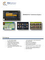
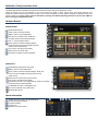
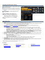
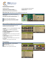
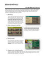
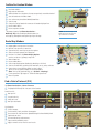
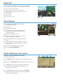
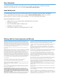
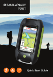
XiteSolutions North America Inc 2014 XSG2NA-X1 Infotainment System Family with Rand McNally RV GPS XSG2NA-X1L 10.4” Infotainment System XSG2NA-X1DM 10.4” Dual Monitor Infotainment System X1DM/L Features • • • • • • • • • 10.4” Touch Screen Display Rand McNally RV GPS Dedicated 7” 2nd Monitor Temperature/Compass Display iPod and iPhone Audio playback SiriusXM - SXV200 Tuner GPS System Clock/DST/TZ set DVD/CD/USB Core Module House Mode Audio Distribution (Optional) • • • • • • Touch Screen Multi Camera Management with CVS300/350 Camera Audio/Video Support Aux Output Supporting Navigation and Camera Display Split Screen (PIP) Operation Integrated Bluetooth for HF calling, stream audio from device and many app sources AM/FM with RDS XiteSolutions North America Inc XSG2NA-X1S 6” Infotainment System X1S Features • • • • • • • 6” Touch Screen Display Rand McNally RV GPS Temperature/Compass Display iPod and iPhone Audio playback SiriusXM - SXV200 Tuner GPS System Clock/DST/TZ set Front access DVD/CD/USB and 3.5mm audio inputs • • • • • • • Touch Screen Multi Camera Management with CVS300/350 Split Screen (PIP) Operation Camera Audio/Video Support Quick Camera View Button Integrated Bluetooth for HF calling, stream audio from device and many app sources Aux Output for Entertainment Sources AM/FM with RDS XSG2NA-X1 Family Quick Start Guide This Quick Start Guide is intended to provide basic instructions to begin using your Infotainment Center. Failure to properly focus on the operation of your motor vehicle can result in death, serious injury and property damage. The Infotainment Center should never be used at a time or in a manner that distracts you from properly focusing on operation of the motor vehicle in which it is installed. Please review all disclaimers, warnings and detailed operating instruction in your Owner’s Manual prior to using your Infotainment Center. Hardware Buttons 1 XSG2NA-X1DM/L 2 3 4 1 5 6 7 8 9 Bluetooth Microphone PWR. Press to enter/exit standby MENU. Press to access Main Menu DIM. Press to increase screen brightness. Changes saved for both day/night modes VOL +/-. Press to adjust volume NAVI, Press to enter/exit navigation display. Press and hold to only hear navigation prompts (mutes current audio source) PIP. Press to use split screen display MUTE. Press to mute all audio IR Receiver for Remote Control Operation 2 3 4 5 6 7 8 9 XSG2NA-X1S 1 2 3 4 5 6 7 8 9 DVD/CD Eject (left) and disc slot (right) MENU. Press to access Main Menu NAVI, Press to enter/exit navigation display. Press and hold to only hear navigation prompts (mutes current audio source) CAM. Press to access manual Camera view. PIP. Press to use split screen display Power/Volume Knob. Turn to adjust volume. Press once to Mute. Press and hold to enter/exit Standby RV GPS SD Card Slot. For Navigation Only Aux Inputs. USB and 3.5mm audio ports Bluetooth Microphone 1 2 7 3 4 5 8 6 9 Header Information 1 2 3 4 5 Audio Source Icon. (Tap to access Main Menu) Outside Temperature Display Compass Heading Current Time Bluetooth Connection Status 1 2 3 4 5 Accessing the Infotainment Features 1 1. 2 2. 3 3. To access the Main Menu or change screens, tap source Icon in top left corner. Select a new media source. Audio from current source will continue to play during navigation or camera video display nd Select Aux Zone to change display source on 2 monitor output 1 2 3 4.4 5 Select Settings to change system/source options. To change source settings, go to the audio source you wish to change then go into settings. Select the source on the bottom right. Touch Page Number to go to next Settings Page 5 4 Source Quick Tips RADIO: Tap AS button to Auto Store 6 Presets of the available Radio Stations in your area. iPod: Connect your iPod/iPhone to the iPod cable supplied to listen to audio tracks on you Apple device. (see Dealer for location) o Use the control buttons and Menu to find tracks/playlists. Tap your selection. SiriusXM: Note: A subscription is required to enjoy SiriusXM Satellite radio. Please see your Owner’s Manual or go to www.siriusxm.com (in Canada www.xmradio.ca) and click ACTIVATE RADIO. Features of SiriusXM: o Replay: Press Replay to listen up to 1 hour of previous audio on your current channel. (may vary by tuner model) o Song/Artist Alerts: Store up to 50 of your favorite Songs and Artists. Tap FUNC > ALERT+. You will be notified when saved alerts are playing on other channels. o My Favorites: Create your own virtual category of your favorite channels. Tap CAT+ to save the current Channel as a favorite. To use MY FAVORITES Category, Tap CAT and Scroll down to MY FAVORITES and Tap. Choose a Channel. o Automatic Mature Channel and User defined Channel Locking. Please see Owner’s Manual On-Screen Manual Camera Selection: Tap Camera Icon to go to Manual Camera view. Tap screen center to bring up camera icons. Tap the camera you wish to view. To hear Rear Camera Audio tap the Speaker icon. Bluetooth: To connect you phone Tap NEW button and follow your phone prompts and instructions. After connection you can: o Make Hands Free Calls o Download your phonebook form you cell phone* o Listen to your stored audio tracks* o Stream and control audio from many of today’s popular Apps using the audio controls on-screen* DVD/CD/USB: Insert your disc or USB device and use the on-screen controls to enjoy your media.** RV GPS Navigation: Please see your separate RV GPS Quick Start Guide to help you get on your way and begin using all the features this Industry Leading navigation software from Rand McNally has to offer * Pending device limitations from your phone/hardware manufacturer. Please see individual device manuals ** Please see Owner’s Manual for a full list of supported file and disc formats. For Support: RiverPark Inc 800-422-7717 www.riverparkinc.com [email protected] XiteSolutions North America Inc. [email protected] www.xsna.ca Rand McNally www.randmcnally.com/support 800-333-0136 XiteSolutions North America Inc Rand McNally Selling and Demo Tips: Why Rand McNally RV GPS Software Proprietary road data. Lifetime Map and construction updates Proprietary RV Class based routing algorithms Advanced POI amenities filtering and information On-Screen Navigation Tips and tutorials Campground Services and Review RM Editors Picks Exits Quick View: See what POI’s are available at the next 4 exits Slide out to show Points of Interest and amenities at upcoming exits. The list displays the distance to the next exit, exit name and number, and a count of available amenities. 1 3 1 Tap on an exit to bring up the notes icon. 1. 2 Tap the icon to display local amenities by category. 2. 3 Tap on any item in the list to route to that location. 3. 2 Select and Filter Campgrounds and Travel Centers To select only locations with amenities that you are interested in, filter your search results. 1. From the main menu Tap Choose Destination > Points of Interest. 2. Select a search type (My RV, City, My Route, or Destination). 3. Tap RV Campgrounds > Commercial (Woodall’s Reviewed) or Travel Centers. 4. Tap Select Services. 5. Click on the check box of each amenity to be included in the search. 6. Tap OK. The window displays POI locations with your selected amenities. 7. Tap on a location from the list. 8. A check next to Filter indicates the search terms have been applied. Tap Filter to return to general search results. POI Quick Stop 1 1. Tap Choose Destination > Points of Interest. 2 Select Quick Stops 2. 3. 3 Choose from 6 popular POI brands 3 Tap Filter to return to general search results. 2 The RV GPS Top Ten List What’s unique about a GPS navigation system designed specifically for RVers? Rand McNally’s RV GPS was designed to meet the unique challenges of driving an RV, with award-winning routing and tools that help you plan, prepare, and enjoy the ride. Check out these top ten features and capabilities and see for yourself! 1) RV Routing The RV GPS begins with award-winning routing, specific to the type of RV. Choose your vehicle from 11 different types. Routing factors in legal and physical restrictions based on the vehicle’s height, weight, and length. It also takes into account state restrictions on bridges, as well as propane. Spoken and visual directions tell you where to head next, and favor right- or left-hand turn preferences depending on vehicle size. 2) Points of Interest for the RVer You’ll find millions of points of interest on the RV GPS, from travel centers, stores, and RV service locations to parks, banks, restaurants, and more. Find rest stops and fueling stations with dumps, propane, and diesel fuel details. 3) Exit Information Use the Exits Quick View slideout to access exit information, with more than 150,000 locations just off the interstate. Find propane availability, emergency services, stores, restaurants, hotels, and more. 4) Campgrounds, Including Amenities Search for campgrounds at National and State Parks, military campgrounds, and more, including available amenities. View Woodall’s “5W” campground ratings and apply filters to return results based on the specific amenities you’re looking for. 5) Checklists Store your pre-trip checklist on the RV GPS and remind yourself to complete each task before starting out. Build your own custom checklists for the campsite, and even set maintenance alerts. 6) Safe Driving In addition to providing spoken and visual turn-byturn directions, the RV GPS can warn you when you’re coming up to a hill, sharp curve, or speed limit change. Junction view with lane assist shows a 3D image of upcoming highway maneuvers, with arrows to guide you to the correct lane. 7) Address Book Save frequent destinations in the address book. Sort addresses by name, distance, or date, or use address book groups to keep like destinations organized. You can also display address book icons right on the map. 8) Trails Use this feature to record a breadcrumb trail when you leave your campsite, and display it on the map to easily find your way back. 9) Road Atlas Cross-References Don’t get rid of that atlas! The RV GPS includes cross-references to the Rand McNally Road Atlas and Motor Carriers’ Road Atlas, for easy locating on a printed map. 10) Rand McNally Trips Discover new places with pre-planned trips and Rand McNally proprietary trip content, including 12,000 Editor’s Pick destinations. Look up “Best of the Road” stops, many with photos and videos. You’ll also find a fuel log, quick planner, multi-stop routing, and more. From RV routing to unique tools and features, Rand McNally’s RV GPS is the perfect travel companion for the RVer. Main Menu 1 2 3 4 5 6 7 Enter RV information and access RV-specific tools. Show location on the map and view navigation instructions. Choose a destination. Select general, route, and map preferences. Mute/unmute the speaker. Adjust speaker volume. Battery status indicator. Note: Some icons may not be present, depending on specific hardware Enter RV Information and Set Warnings 1. Tap RV Tools > RV Info or Warnings. 2. Tap 3. Tap the option button to be changed. 4. Enter new settings. 5. Tap and to view options. to save changes. Set Routing and Device Options 1. Tap Preferences. 2. Tap the General, Route or Map tab. 3. Tap 4. Tap the option button to be changed. 5. Enter new settings. 6. Tap and to view options. to save changes. Route to a Destination 1. 2. 3. 4. 5. 6. Tap Choose Destination > New Location. Tap Address. Enter the name of the city. (Note: As you type, the keyboard displays only the next possible letter.) Prompts appear in the top bar. Tap the city to select. Or, tap List to view cities beginning with the letter(s) you entered. Enter the street name. (Note: If the letters you need do not appear, tap Expand Search.) Enter the house number. See Confirm Destination Window (page 6). Tips • You can also route to a new location by City Center, Intersection, or Latitude/Longitude, or choose Address > Zip Code Search. • View recent destinations by tapping Choose Destination > History. View recent cities by tapping Choose Destination > New Location > Address > History. • View saved locations by tapping Choose Destination > Address Book. 7 1 2 4 3 5 6 Confirm Destination Window 1 2 3 4 5 6 7 8 9 1 Destination address. Begin route to destination. Add the location as a via point on the way to a previously entered destination.* Save the location to the Address Book. Cross reference to printed Rand McNally Road Atlas. View the map. Change the starting location for a route to the location displayed here. Return to Main Menu. Return to previous window. 9 2 5 3 6 4 8 7 NOTE: This window may include additional buttons based on the type of destination selected. *To manage via points, Tap Choose Destination > Multi-Stop Trips. You can add up to 50 destinations in a multi-stop trip, and optimize routing for trips of up to 10 stops. Route Map Window 1 2 3 4 5 6 7 8 9 10 11 12 13 Repeat spoken next-maneuver instructions. Name of street you will turn onto next. Show arrival time, remaining time, or other options. Slide out to show upcoming exit information. Directions list slideout. Tap Route Display Options to select turn-by-turn, highway, or map view. Zoom in/zoom out. Return to Main Menu. Select a map display option (Heading Up, North Up, or 3D View). View current road name, upcoming cross road name, or city, county and state. View and save current location, detour, or cancel a route. Tap on the current speed to display the Virtual Dashboard. (Note: Turns red for speed warnings; set in RV Tools > Warnings.) Current speed limit. Tap to open a “Tell Rand” about speed limits. Mute the speaker. 2 1 3 4 5 12 11 7 13 10 9 6 8 7 Find a Point of Interest (POI) Tap Choose Destination > Points of Interest. 1 Find popular RV-friendly POIs near your current location. 6 Search for a POI: 2 Near your RV 3 In a particular city 4 Along your route 5 Near your destination 2 4 3 5 1 POI Categories: 6 Select a category. 7 Find restaurants, hotels, and other subcategories. 8 View custom POIs that have been uploaded through the Rand McNally Dock. 9 Tap location to select. 10 View and edit ratings and comments. 11 Tap to search by available services. 12 Apply or remove services filter for search results. 7 8 10 9 11 12 Junction View When on a route, Junction View displays when you have an upcoming maneuver. Once past the maneuver, Junction View closes and the previous window displays. 1 2 3 4 5 6 1 Signs to follow for the next maneuver. Number and direction of lanes for the next maneuver. Distance to the upcoming maneuver. Distance decreases as you approach the ramp. Lane assist arrow. Mute the speaker. Return to previous window. 2 3 4 6 5 Virtual Dashboard 1 Sunrise and sunset times based on vehicle location (latitude/longitude) and day. 2 Current speed. 3 Elevation at current location. 4 Percentage of current trip completed, distance to next maneuver, and the number of miles and time spent on the trip to this point. 5 Average uphill and downhill speeds. 6 Gather trip information for up to three trips. Includes odometer settings, hours, and speeds. 7 Reset trip information for the selected trip (Tab 1, Tab 2 or Tab 3). 8 Select to automatically reset the information in each tab after the vehicle has remained stationary for the specified number of hours. 9 View fuel logs and add fuel purchase information. 10 Return to the Route Map Window. 9 1 6 3 4 5 8 7 Checklists, Maintenance, Trails, and Fuel Tap RV Tools > Checklists, Maintenance, Trails, Fuel. Then tap on each tab to view. 1 Use Checklists to create and complete task lists to prepare for a trip. 2 Add notes in the Maintenance tab to record dates of service for your RV. 3 Use Trails to record a “bread-crumb” path of GPS coordinates where your RV has traveled. Tap any record to view the trail, edit the name, or set the color. 4 Use the Fuel tab to view a list of fuel purchases. Tap Add Fuel to record the date, location and cost of fuel purchase. Tap Save. Tap any record to make changes. 10 2 1 2 3 4 More Information For a detailed description of the features of your device, please see the RVNDTM User Manual. The User Manual can be downloaded from the Rand McNally Dock, and is also available at www.randmcnally.com/support. Rand McNally Dock The Rand McNally Dock enables you to receive software upgrades and access map updates, construction updates, and additional features. Simply download the Dock software for your PC or Mac at www.randmcnally.com/dock, remove the SD card from your device and insert it into your PC or Mac using SD card adapter. Then start the Rand McNally Dock software. With the Rand McNally Dock, you can also: • Upload custom POIs, such as red light cameras and railroad crossings, to your device • Download the User Manual • Access the Rand McNally support site and online store • Read product news and announcements • Send feedback and suggestions to Rand McNally through “Tell Rand” Warnings, End-User License Agreement, and Warranty Pay attention to road conditions and street signs, and obey all traffic and safety laws. Traffic laws and current traffic conditions must always be observed and take precedence over the instructions issued by the Rand McNally navigation system. The User should be aware of situations where current traffic conditions and the instructions from the navigation system may be in conflict. Some states prohibit the use of windshield mounts and may otherwise restrict the usage of navigation and other electronic devices in the vehicle. It is the User’s responsibility to ensure compliance with all laws and regulations. The use of the navigation system does not relieve the User of his/her responsibilities. The User is ultimately responsible for the vehicle under his/her control and should be aware of the surroundings at all times. If after reading these statements the User decides not to accept these terms, the User should not use the navigation system. Rand McNally hereby grants you (“User”) a single-user non-exclusive, non-transferable license to use the Rand McNally navigation system (hereinafter referred to as the “Product” (including software and associated data)) for User’s own internal business or personal use and not for resale, sublicense or commercial use. This Product and the software incorporated in it and related documentation are furnished under license and may be used only in accordance with this license. Except as permitted by such license, the contents of this Product and software may not be disclosed to third parties, copied or duplicated in any form, in whole or in part, without the prior written permission of Rand McNally. This Product and software contain proprietary and confidential information of Rand McNally and its licensors. Rand McNally grants User a limited license for use of this Product and the software incorporated in the Product for its normal operation. By using the Product, User acknowledges that the content of this document and the Product are the property of Rand McNally and its licensors and are protected by U.S. copyright, trademark and patent laws and international treaties. THE USER MAY NOT: • Use the Product on a network or file server, time-sharing or to process data for other persons. • Use the Product to create any routing tables, files, databases or other compendiums. • Copy, loan or otherwise transfer or sublicense the Product, its software or content. • Modify, or adapt the Product in any way, or decompile, disassemble, reverse engineer or reduce to human readable form the Product and software incorporated therein. • Alter, remove or obscure any copyright notice, trademark notice, or proprietary legend from the Product, its software or content. This license will terminate automatically if User fails to comply with any of the terms of this license and User agrees to stop using the Product. Rand McNally may revise or update the Product and is not obligated to furnish any revisions or updates to User. Caution: Rand McNally makes no warranty as to the accuracy or completeness of the information in the Product and disclaims any and all express, implied or statutory warranties, including any implied warranty of merchantability or fitness for a particular purpose. It is the user’s responsibility to use this product prudently. This product is intended to be used only as a travel aid and must not be used for any purpose requiring precise measurement of direction, distance, location or topography. RAND MCNALLY AND ITS LICENSORS DO NOT MAKE ANY OTHER WARRANTY OR REPRESENTATION, EITHER EXPRESS OR IMPLIED, WITH RESPECT TO THE PRODUCT, INCLUDING ANY WARRANTY AS TO QUALITY, PERFORMANCE, TITLE OR NON-INFRINGEMENT. IN NO EVENT WILL RAND MCNALLY OR ITS LICENSORS BE LIABLE FOR ANY INDIRECT, SPECIAL, INCIDENTAL, OR CONSEQUENTIAL DAMAGES ARISING OUT OF THE USE OR INABILITY TO USE THE PRODUCT, EVEN IF ADVISED OF THE POSSIBILITY OF SUCH DAMAGES. Some states do not allow limitations on how long an implied warranty lasts and/or do not allow the exclusion or limitation of incidental or consequential damages, so the above limitations may not apply to some consumers. The User agrees to allow User-provided information to Rand McNally to be used for internal business evaluation purposes, including, but not limited to, evaluating the effectiveness of the services provided, methods to simplify or improve User experiences. Such information will not be used by third parties or in any way that discloses the identity of the User. Rand McNally may make use of third party software in the Product. Notwithstanding the terms and conditions of this license, use of some third party materials included in the Product may be subject to other terms and conditions. The official third party copyright notices are provided at the end of this License. The User agrees to indemnify, defend and hold Rand McNally and its licensors (including their respective licensors, suppliers, assignees, subsidiaries, affiliated companies, and the respective officers, directors, employees, shareholders, agents and representatives of each of them) free and harmless from and against any liability, loss, injury (including injuries resulting in death), demand, action, cost, expense or claim of any kind or character, including but not limited to attorney’s fees, arising out of or in connection with any use or possession by the User of this Product. These terms and conditions constitute the entire agreement between Rand McNally (and its licensors and suppliers) and the User pertaining to the subject matter hereof, and supersedes in their entirety any and all written or oral agreements previously existing between us with respect to such subject matter. The above terms and conditions shall be governed by the laws of the Illinois, without giving effect to (i) its conflict of laws provisions, or (ii) the United Nations Convention for Contracts for the International Sale of Goods, which is explicitly excluded. The User agrees to submit to the jurisdiction of Illinois for any and all disputes, claims and actions arising from or in connection with the Data provided to the User hereunder. User shall not export the Product in violation of any U.S. or foreign laws. Rand McNally’s licensors shall be third party beneficiaries of Rand McNally’s rights under this license, but are not parties hereto and have no obligations hereunder. By using this product you agree to be bound both by the foregoing and to the terms of use found at www. randmcnally.com/RVGPS. Restricted Rights Legend. For governmental agencies: Use, reproduction or disclosure is subject to restrictions set forth in subparagraph (c) (1) (iii) of the Right in Technical Data and Computer Software clause at DFARS 52.227-7013, as amended. Copyright © 2013 Rand McNally. Portions © 2012 NAVTEQ. This data includes information taken with permission from Canadian authorities, including © Her Majesty the Queen in Right of Canada, © Queen’s Printer for Ontario. © 2012 Allstays, LLC. © 2011 Bringfido.com. © 2011 Fishing Hot Spots, Inc. © 2012 InfoGation. © 2012 MyWeather.com. © 2011 The RVer’s Friend. © 2012 Woodall’s. Exit Authority © 2011 Zenrin USA, Inc. All rights reserved. U.S. Patent Nos. 7,580,791 and 8,214,141. Support www.randmcnally.com/support 800-333-0136 RVND_7715_QSG_081412