1
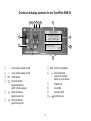
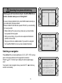
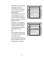
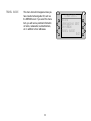
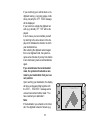
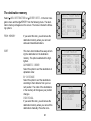
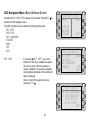
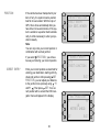
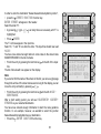
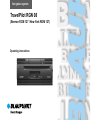
Navigation system
TravelPilot RGN 08
(Bremen RCM 127 / New York RDM 127)
Operating instructions
General information
Route guidance
Operating the system while driving
The current traffic routing situation can differ from
the data stored on the CD-ROM.
Allowing yourself to be distracted by the TravelPilot RGN 08 can lead to a situation where you are
“driving blind”.
Due to system limitations, the TravelPilot RGN 08
cannot warn of altered traffic routing conditions e.g. due
to road construction measures. If you do not pay
attention to the actual traffic routing conditions, there is
a danger that you will cause a serious accident. Furthermore, you will be violating road traffic regulations.
• Please ensure that you take notice of signs relating
to the current traffic routing situation. As the driver,
you are solely responsible for traffic safety.
• Use the latest CD-ROM for the TravelPilot RGN 08
in order to avoid this problem as much as possible
right from the start. Ask your dealer for the latest
update.
If you are not paying attention to the current traffic
situation around you, you could cause a serious accident.
Please consider the fact that at a speed of 50 km/h you
are travelling 14 m every second.
• Before starting off on your journey, make sure you
have familiarised yourself with the system.
• While you are driving, only use the voice output
and directional symbols on the monitor.
• Stop your vehicle at a suitable location if you wish
to re-program the TravelPilot RGN 08 or look up
more detailed information.
2
Control and display elements for the TravelPilot RGN 08
3
4
5
6
7
9
8
2
10
1
11
12
1
2
3
4
5
6
–
+
ON
7 AUX Switch to navigation
8
Select character,
repeat voice output,
switch on voice output
9
Header line
:
Input field
;
Selection field
<
/
Function keys
Voice output volume control
Voice output volume control
On/off button
Select character,
page through lists,
switch off voice output
Select character,
page through lists
Select character,
page through lists
3
The guidance system provides audio-visual information.
You will be given precise information over the car stereo
loudspeakers with regard to such things as when and where
to take the next road turning.
The volume and tone of the voice output can be adjusted.
Directional symbols are used to convey information on the
car stereo display screen. Furthermore, the name of the
street that the vehicle is presently driving down is displayed
as well as the current distance to the destination and the
remaining time required to drive there. Prior to taking a
turning, the name of the road that is to be turned into is
displayed.
If you did not follow a suggested direction, a new route to the
destination will be calculated within a few seconds. So, for
instance, this means that you can by all means take a “secret
route around the houses” that you are familiar with even
though the TravelPilot has at the time given you other
directions.
The system knows where one-way streets, areas restricted
to traffic (e.g. pedestrian precincts, etc.) and no-left or noright turns are situated, and takes these into account when
calculating routes for passenger cars.
Area of use
The TravelPilot RGN 08 has been designed for use in
passenger cars.
The CD-ROM currently does not include any limitations
relating to lorries and buses such as height restrictions
or maximum permitted loads. If these are disregarded,
there is a danger that you will cause an accident.
Furthermore, you will be violating road traffic regulations.
• The TravelPilot RGN 08 can only be used, without
any limitations applying, in passenger cars.
Product information
The TravelPilot RGN 08 is an active guidance system for the
Bremen RCM 127 and New York RDM 127 car stereo
systems.
Using this system, you can let yourself be guided to your
required destination if a navigation CD has been inserted
that is valid for your present location and destination in
question.
CDs, such as the Merian Scout travel guide and other
country-specific CDs, are also available.
Delivery
TravelPilot RGN 08
The navigation system comprises a powerful computer with
CD-ROM drive, GPS receiver, GPS antenna and the latest
CD-ROM version.
4
Table of contents
DSC Navigation Menu (Direct Software Control) ...... 29
GPS Info......................................................................... 29
Position .......................................................................... 30
Direct entry ..................................................................... 30
From destination memory .............................................. 31
NAV Language ............................................................... 31
Standby .......................................................................... 32
Demo.............................................................................. 32
Version ........................................................................... 33
Example for entering a destination ............................ 34
Switching on navigation ................................................ 6
Basic navigation menu ..................................................... 7
Entering the destination ................................................ 7
Memory ............................................................................ 8
City ................................................................................... 9
Street/Junction ............................................................... 11
Other destinations .......................................................... 11
Centre ............................................................................ 12
Surrounding destinations ............................................... 12
Non-urban ...................................................................... 13
Travel guide ................................................................... 14
Start ................................................................................ 15
Quick route ..................................................................... 15
Short route ..................................................................... 15
Own choice .................................................................... 15
Jam ahead ..................................................................... 20
Information on the display .......................................... 23
Demo mode................................................................... 37
Appendix ....................................................................... 39
CD-ROM ........................................................................ 39
Changing the CD............................................................ 39
Wrong CD-ROM ............................................................. 40
Tyre change and calibration ........................................... 40
Error massages .............................................................. 41
CD read error ................................................................. 41
Info Menu ...................................................................... 24
Route list ........................................................................ 24
The destination memory .............................................. 26
From memory ................................................................. 26
Sort ................................................................................. 26
Save position .................................................................. 27
Save destination ............................................................. 27
Delete ............................................................................. 28
5
Operating the system while driving
S
AUXILIARY MENU
Allowing yourself to be distracted by the TravelPilot RGN 08 can
lead to a situation where you are “driving blind”.
If you are not paying attention to the current traffic situation around you,
you could cause a serious accident.
Please consider the fact that at a speed of 50 km/h you are travelling
14 m every second.
• Before starting off on your journey, make sure you have familiarised yourself with the system.
• While you are driving, only use the voice output and directional
symbols on the monitor.
• Stop your vehicle at a suitable location if you wish to re-program
the TravelPilot RGN 08 or look up more detailed information.
NAVI
EXIT
S
NAV MENU
PLEASE ENTER
DESTINATION
ENTER DEST.
EXIT
Switching on navigation
Press AUX with the car radio switched on. AUXILIARY MENU will appear on the screen with a list of the equipment connected.
Press the
NAVI function key to display the last navigation page
used.
To access the main navigation menu, press the EXIT
function key
as often as necessary.
6
S
HILDESHEIM
KAISERSTRASSE
KENNEDYDAMM
INFO MENU
START NAVIGATION
NEW DESTINATION
Main navigation menu
The system will either prompt you to enter a destination or show the
destination selected last.
In the main navigation menu you can choose from the following options:
INFO MENU (if a destination has been entered)
START NAVIGATION (if a destination has been entered)
ENTER DEST. or NEW DESTINATION
S
NAV MENU
PLEASE ENTER
DESTINATION
ENTER DEST.
EXIT
Entering the destination
S
Press the
ENTER DEST. or
NEW DESTINATION function key.
A selection of the possible ways to enter a destination will appear on the
display:
MEMORY,
if the destination has been stored in the memory.
CITY,
if your destination is in a different city to the destination entered last.
STREET/JUNCTION,
if the destination is in the same city. This assumes that the destination
entered last contains a city name.
OTHER DEST.,
if you wish to select a city centre, a train station, a car park, an airport, a
petrol station, a motorway exit, a motorway junction or a motorway service area as your destination.
7
ENTER DEST.
MEMORY
CITY
STREET/JUNCTION
OTHER DEST.
EXIT
MEMORY
Allows you to select your destination from
the memory. This assumes that you have
already stored at least one destination in
the memory.
MEMORY.
Press
The destination memory menu will appear
on the screen.
Select
FROM MEMORY to access the
memory and read the destinations stored
there.
/ rocker switch or the funcPress the
tion keys next to the m/n arrows to page
through the display if there are more than
four destinations available.
Press the
/
rocker switch to move
the display vertically.
The arrows (m/n, w/v) on the right and at
the bottom indicate in which directions you
can page or move through the display.
Make your selection by pressing the
function key which corresponds to your
destination.
Then press
START to activate the route
calculation and following that, the route
guidance.
Press EXIT
to cancel your entry and
return to the main navigation menu. The
original destination will remain stored.
8
S
DEST. FROM MEMO
FROM MEMORY
SORT
SAVE POSITION
SAVE DESTINATION
DELETE
EXIT
S
FROM MEMORY
BLAUPUNKT, HILDE
HILDESHEIM, KAIS
HILDESHEIM, RÖME
STUTTGART, KARLSn
v
EXIT
S
DESTINATION
HILDESHEIM
KAISERSTRASSE
KENNEDYDAMM
START
EXIT
CITY
Allows you to enter the city in which your
destination is located.
If a city has already been entered, its name
will appear in place of CITY.
CITY.
Press
The name of the city for the destination last
selected, if there is one, will appear in the
input line. A selection field containing letters and numbers will appear below it.
Enter the city name as follows:
/
rocker switch to
Use the / ,
select the first letter (it will appear on a
highlighted background).
Press
ENTER.
The input line will disappear from the display and the first letter will appear.
If you want to correct a letter, press
until the cursor moves to that letter. Select
the new letter by pressing / ,
/
and confirm your selection by pressing
ENTER.
In order to find the desired destination on
the list more quickly, you can enter two to
six characters, depending on how easily
identifiable the individual place name is.
After completing your entry, press
to the
right or left of the input line.
9
S
ENTER CITY
STUTTGART
ABCDEFGHIJKLMNOP
QRSTUVWXYZÄÖÜ
0123456789 -.
ENTER
EXIT
S
ENTER CITY
HIL
ABCDEFGHIJKLMNOP
QRSTUVWXYZÄÖÜ
0123456789 -.
ENTER
EXIT
S
ENTER CITY
HILDES
ABCDEFGHIJKLMNOP
QRSTUVWXYZÄÖÜ
0123456789 -.
ENTER
EXIT
A list from which you can select your destination will appear on the screen.
If the desired city name does not appear,
you can use the / rocker switch to
page through the list.
If the city/city district names are too long to
appear on the display, you can use the
/
rocker switch or the function keys
next to the m/n arrows to move through the
display from side to side.
The arrows (m/n, w/v) on the right and at
the bottom indicate in which directions you
can page or move through the display.
Select the destination city by pressing the
corresponding function key .
Note:
If the city selected is stored on the navigation CD more than once, another selection
list will appear on the screen.
After you have selected the city, the Enter
Dest. menu will remain on the screen. It will
indicate the name of the city selected.
10
S
SELECT CITY
HILDESHEIM
m
HILDESHEIM NEUHO
HILDESHEIMER WAL
HILDFELD
n
v
EXIT
S
ENTER DEST.
MEMORY
HILDESHEIM
STREET/JUNCTION
OTHER DEST.
EXIT
STREET/JUNCTION
This menu item will not appear unless the
streets in the city selected are included on
the digital map on the navigation CD.
Enter the street name and select the street
from the list as described previously in the
section on “CITY”.
After you have selected the street, it will
appear below the city.
To start navigation, all you have to do is
enter the city and street. If you enter a
junction as well, you can make your destination more precise. If this is not necesSTART NAVIGATION to
sary, press
activate the route calculation and following
that, route guidance.
ENTER JUNCTION
This menu item will display all of the streets
which cross or are connected with the
street selected.
Select the junction or connected street
which is closest to your destination by
pressing the corresponding function key .
Then you can activate the route calculation
and route guidance functions.
OTHER DEST.
Allows you to select other, special destinations stored on the navigation CD. This
might include city centres, train stations,
11
S
HILDESHEIM
KAISERSTRASSE
ENTER JUNCTION
START NAVIGATION
NAV MENU
S
SELECT JUNCTION
BISMARCKSTRASSE m
HANNOVERSCHE STR
KARDINAL-BERTRAM
KENNEDYDAMM
n
v
EXIT
S
ENTER DEST.
MEMORY
CITY
STREET/JUNCTION
OTHER DEST.
EXIT
airports, motorway exits/junctions/service
centres, petrol stations, car parks, border
crossings and garages.
OTHER DEST. from the
If you select
Enter Dest. menu, you will see a menu with
a number of different menu items.
CENTRE
S
OTHER DEST.
CENTRE
SURROUNDING DEST
NON-URBAN
TRAVEL GUIDE
EXIT
This menu item will list all of the city districts stored for the city selected.
SURROUNDING DEST,
SURROUNDING DEST If you select
you will see a menu with the following
menu items:
DESTINATION AREA
If you select this item, a list of special destinations located in the area of the destination activated last will appear.
POSITION AREA
If you select this item, a list of special destinations located in the area of your current
position will appear.
TOWN AREA
If you select this item, a list of special destinations located in the area of any town you
enter will appear. Enter the town as described in the section on “Entering the destination”.
12
S
SURROUNDING DEST
DESTINATION AREA
POSITION AREA
TOWN AREA
EXIT
S
DESTINATION AREA
RAILWAY STATION m
PETROL STATION
CAR PARK
CAR RENTAL
n
v
EXIT
NON-URBAN
Use this menu item to select destinations
outside the city limits, such as AIRPORT,
BORDER CROSS., M-JUNCTION,
MOTORWAY EXIT or MOTORWAY
SERVICE.
After you have selected a non-urban destination, a selection field containing letters
and numbers will appear on the display.
If you know the name or the city in which
the desired destination is located, enter it
here as usual. This will take you to the desired destination on the list more quickly.
13
S
RAILWAY STATION
.4 HILDESHEIM HB
1nHILDESHEIM OS
6mHARSUM
7vBETTMAR
v
EXIT
m
After you have selected a special destination from one of these areas, the display
will show a list of destinations which can be
selected.
The lists for DESTINATION AREA and
POSITION AREA are sorted according to
distance and include information on the
distance and direction.
The lists for TOWN AREA are sorted alphabetically and do not include information on
the distance and direction at this point.
to move the display to the side
Press
and reveal the information on the distance
and direction. If the distance exceeds 99
km, rrw will appear on the display.
S
NON-URBAN
AIRPORT
BORDER CROSS.
M-JUNCTION
MOTORWAY EXIT
n
EXIT
S
AIRPORT
ABCDEFGHIJKLMNOP
QRSTUVWXYZÄÖÜ
0123456789 -.
ENTER
EXIT
TRAVEL GUIDE
This menu item will not appear unless you
have inserted a travel guide CD, such as
the MERIAN scout. If you select this menu
item, you will receive practical information
on hotels, restaurants, tourist attractions,
etc. in addition to their addresses.
14
S
OTHER DEST.
CENTRE
SURROUNDING DEST
NON-URBAN
TRAVEL GUIDE
EXIT
START
QUICK ROUTE
After the destination has been entered, the
ROUTE OPTIONS menu can be called up
START function key.
by pressing the
You can select options by pressing the corresponding
function key. The following
options for route calculation are available
for selection:
A route is calculated that requires as short
a journey time as possible to your destination.
SHORT ROUTE
An optimised route is calculated which is
the shortest possible route to your destination.
OWN CHOICE
This menu item allows you to include or
exclude the MOTORWAY, FERRY and
TOLL options for the route calculation. To
do so, press the required
function key.
By repeatedly pressing the
function key,
the selected option can be activated (inverse display) or deactivated (normal display). Furthermore, using this same method of selection with the QUICK ROUTE
menu item, you can set whether a quick or
short route should be calculated on the basis of the selected options.
15
S
DESTINATION
HILDESHEIM
KAISERSTRASSE
KENNEDYDAMM
START
EXIT
S
ROUTE OPTIONS
QUICK ROUTE
SHORT ROUTE
OWN CHOICE
EXIT
S
ROUTE OPTIONS
MOTORWAY
FERRY
TOLL
QUICK ROUTE
START
EXIT
Any combination of options can be selected (e.g. with motorway - with ferry - no toll short route).
After you have selected the options you
START function key.
require, press the
If you press the EXIT
function key, you
will return to the main navigation menu.
Note:
A situation my arise where a route is calculated which includes an option that you actually wanted excluded when making your
selections. If, for example, you excluded
the “ferry” option but your destination is
only reachable by ferry because it is located on an island, the system will calculate a
route which includes the ferry option contrary to your selection.
After you have entered your destination
and guidance has been started by pressing
START function key, you can begin
the
your journey. The system begins to calculate a route using the road map that is
stored on the CD. The display shows a
message informing you that the route is
being calculated. Afterwards, an arrow appears indicating the direction in which the
destination lies. The CALCULATING...
message is displayed and the voice output
16
S
ROUTE OPTIONS
MOTORWAY
FERRY
TOLL
QUICK ROUTE
START
EXIT
S
CALCULATING...
219
km
RÖMERRING
indicates that: “The route is being calculated”.
The distance to the destination “as the
crow flies” is also displayed.
If you are travelling with your vehicle down
a digitised street, you will be guided to your
destination (after the route calculation has
been completed) by spoken recommendations and by the directional symbols on the
display
The voice output volume can be adjusted
during an announcement by pressing the
+ / – rocker switch. If you press the
rocker switch, the latest voice announcement will be repeated. By pressing the
rocker switch, you can deactivate voice
output. To switch it on again press the
rocker switch.
You can exit the directional symbol display
and go to the main navigation menu without interrupting route guidance by pressing
one of the lower
/
function keys.
Voice output will also be interrupted if you
do this. By pressing
START NAVIGATION you can switch the directional symbol display and voice output back on. You
can display the info menu for approx. 3
seconds by pressing the rocker switch
during the journey.
17
S
NDR 2
294
km
1.2
km
5:31
RÖMERRING
S
HILDESHEIM
KAISERSTRASSE
KENNEDYDAMM
INFO MENU
START NAVIGATION
NEW DESTINATION
If you are driving your vehicle down a nondigitised road (e.g. car park, garage, multistorey car park) the OFF ROAD message
will be displayed.
If your vehicle is outside the digitised network (e.g. abroad), OFF MAP will be displayed.
In such cases, you can orientate yourself
by referring to the arrow shown in the display which indicates the direction in which
your destination lies.
After entering the digitised network again
from a non-digitised road, the system requires a few minutes of journey time before
it can start issuing route recommendations
again.
If you should leave the recommended
route, the system will calculate a new
route to your destination from your current position.
Upon reaching your destination, the display
will show a chequered flag together with
the DEST. REACHED! message and a
voice announcement will be made: “You
have reached your destination”.
Note:
If the destination you entered is not included in the digitised network of streets (e.g.
18
S
DEST. REACHED!
special destinations such as workshops,
etc.), an arrow will appear in the display, as
soon as you leave the digitised area, indicating the direction in which your destination lies. The voice output announcement
for this is: “You have reached the area of
your destination”.
If you are in the immediate vicinity of your
destination, the voice output announcement will inform you that: “You have
reached your destination”. If the destination
you selected (e.g. a stored location) is not
situated within the digitised area, you will
hear the announcement: “No route guidance is available to your destination”. The
display will then show NO ROUTE and the
arrow will point in the direction in which the
destination lies.
19
S
NO ROUTE
219
km
RÖMERRING
JAM AHEAD
Using the “JAM AHEAD” function, the calculated route can be altered according to
the current traffic situation. This means that
if you see a problem with the traffic up
ahead or you are informed about this over
the radio (e.g. a traffic jam or road works),
you can exclude certain route sections
starting from your current vehicle position.
The route sections that can be excluded
refer to the road network that lies ahead of
you and your vehicle. Each section comprises the section of road located between
two road junctions. The first section that
can be excluded comprises the length of
road starting from your vehicle and ending
at the next junction but one. The navigation
system then calculates a new route starting
from the next possible turning which, if possible, will bypass the traffic disruption. To
call up the traffic jam function, press the
function key.
upper left
Example:
You have entered a small town and are
driving your vehicle between road turning A
and turning B. The traffic information you
hear on the radio informs you that there is
a disruption to traffic between turning C
and D.
20
S
NDR 2
294
km
1.2
km
5:31
RÖMERRING
S
TRAF. JAM FUNCT.
JAM AHEAD
EXIT
Press the upper left
function key. The
TRAF. JAM FUNCT. menu will appear.
Press the
JAM AHEAD function key. A
list of route sections that can be excluded
will then appear. The first section in the list
that can be excluded is the length of road
starting from your current vehicle position
up to the next possible turning but one, i.e.
in this case this is the distance from your
present vehicle position up to turning C. By
function key,
pressing the appropriate
you can add the subsequent route section
to this exclusion as well. Route sections
that have been excluded are displayed inversely.
In our example, this would be section
1900 m between C and D. By pressing
the corresponding
function keys again,
the sections you selected can be removed
from the exclusion list (displayed normally).
Once you have selected the desired length
of the route section to be excluded, press
the EXIT
function key. A new route will
then be calculated taking the traffic disruption into account.
21
S
TRAF. JAM FUNCT.
JAM AHEAD
EXIT
S
EXCLU. FROM LIST
1000 m
5320 m
1900 m
5500 m
2300 m
6000 m
3220 m
6500 m
4570 m
EXIT
If you did not exclude any route sections,
you can leave the traffic jam menu by
function key and no
pressing the EXIT
new route will be calculated.
If an alternative route was calculated and
you press the upper left
function key
again, the traffic jam menu will appear
again and will offer you the further option of
cancelling the alternative route. If you want
to do this, press the
CANCEL JAM
function key.
A new route will then be calculated and the
navigation menu will appear.
Note:
The traffic jam function is cancelled either
when the destination has been reached,
when a new destination is entered or when
a new traffic jam is entered.
22
S
TRAF. JAM FUNCT.
JAM AHEAD
CANCEL JAM
EXIT
Information on the display
S
NDR 2
During route guidance, the following information will appear on the display:
-
the driving recommendation symbol (in the centre)
the distance remaining to the destination (on the top left)
the driving time remaining to the destination (on the bottom left)
the distance to the next turn-off point (on the top right)
the street you are currently travelling on (bottom)
-
1.2
km
5:31
RÖMERRING
S
As you approach a turn-off point, you will also see:
-
294
km
the name of the street you will turn onto (top) until the turn has been
completed
a bar graph which leads up to the turn-off point (to the right of the
directional symbol)
B1/SCHÜTZENALLEE
294
km
5:31
RÖMERRING
23
Info Menu
S
HILDESHEIM
KAISERSTRASSE
KENNEDYDAMM
INFO MENU
START NAVIGATION
NEW DESTINATION
There are two ways to activate the Info menu.
•
•
Press INFO MENU in the main navigation menu.
Note: This menu item will not appear unless you have already selected a destination.
During route guidance, press .
In this case, the Info menu will disappear from the screen after a few
seconds if no selection is made.
ROUTE LIST
This menu item is only displayed if route
guidance is active. If route guidance is not
active, the current road name will be displayed instead.
The route list displays a list of roads from
your present location up to your destination
as well as information on distance and
small route-recommendation symbols.
If there are more than four entries, you can
page vertically through the list by pressing
the / rocker switch. Press the
/
rocker switch for horizontal scrolling.
Note:
Even if you have set a route to be calculated which excludes the use of motorways,
the route will initially still be calculated and
displayed by the system with motorways
included whilst you are still a long distance
24
S
HILDESHEIM
KAISERSTRASSE
KENNEDYDAMM
ROUTE LIST
NAV MENU
away from your final destination. Since the
route is continuously optimised by the system throughout the journey, the route can
still fulfil your selected requirements (i.e. by
not using motorways) as you draw closer to
your required destination.
to return to the info menu
Press EXIT
NAV MENU
Return to the main navigation menu.
25
The destination memory
S
DEST. FROM MEMO
FROM MEMORY
SORT
SAVE POSITION
SAVE DESTINATION
DELETE
EXIT
Select
NEW DESTINATION or
ENTER DEST. in the main navigation menu and then
MEMORY from the following menu. The destination memory will appear on the screen. The menu includes the following options:
FROM MEMORY
If you select this item, you will access the
destination memory where you can read
and select stored destinations.
SORT
This menu item includes three ways of sorting the destinations in the destination
memory. The option selected will be highlighted.
ALPHABETIC ORDER
Select this option to sort the destinations in
alphabetic order.
BY DISTANCE
Select this option to sort the destinations
according to their distance from your current position. The order of the destinations
in the memory will change as your position
changes.
INDIVIDUAL
If you select this item, you will access the
destination memory where you can sort the
destinations manually. Press the corre-
S
26
FROM MEMORY
BLAUPUNKT, HILDE
HILDESHEIM, KAIS
HILDESHEIM, RÖME
STUTTGART, KARLSn
v
EXIT
S
SORT
ALPHABETIC ORDER
BY DISTANCE
INDIVIDUAL
EXIT
sponding function key
to select the destination you wish to move. The destination
will be highlighted. If necessary, use /
to page through the list until you find the
place where you want to store the destination. Press the corresponding function key
at that location to move the destination.
SAVE POSITION
SAVE DESTINATION
You can save your current position as a
destination. This is particularly useful if you
want to return to this destination when you
are in an unfamiliar city, e.g. your hotel.
You will be required to enter a short name.
After completing the entry, press the functo the left of the input line.
tion key
You can save the last destination you entered. To find it more easily, you can enter
a short name.
If you do not want to enter a short name,
just press the function key
to the left of
the input line.
27
S
SORT
ALPHABETIC ORDER
BY DISTANCE
INDIVIDUAL
EXIT
S
ENTER NAME
ABCDEFGHIJKLMNOP
QRSTUVWXYZÄÖÜ
0123456789 -.
ENTER
EXIT
DELETE
EXIT
If you activate this sub-menu you will see
the destinations stored in the destination
memory. If there are more than four entries
you can use / to page through the list.
Select the entry you wish to delete by
pressing the corresponding function key .
You will see an on-screen prompt and can
cancel the deletion process at this point if
you wish. If you really want to delete the
entry, press the function key
next to
DELETE.
Returns you to the Enter Dest. menu.
S
DELETE
BLAUPUNKT, HILDE
HILDESHEIM, KAIS
HILDESHEIM, RÖME
STUTTGART, KARLSn
v
EXIT
S
DELETING THE
DESTINATION
DELETE
28
EXIT
DSC Navigation Menu (Direct Software Control)
Press S until DSC-MAIN MENU appears in the header. Press NAVI
access the DSC navigation menu.
The DSC navigation menu contains the following menu items:
GPS INFO
POSITION
NAV LANGUAGE
STANDBY
DEMO
VER
EXIT
GPS INFO
S
DSC-MAIN MENU
TUNER
NAVI
to
GPS INFO, you will be
If you select
informed of how many satellites are available and how many of them are being received. In addition, the position (geographical longitude and latitude) of the vehicle will
also be displayed.
Return to the DSC navigation menu by
pressing EXIT .
DISPLAY
VARIOUS
KEYCARD
EXIT
S
DSC NAVIGATION
GPS INFO
DEMO
POSITION
NAV LANGUAGE
STANDBY
VER
EXIT
S
GPS STATUS
25 SAT.AVAILABLE
3 SAT.RECEIVED
E 09'89'00
N 52'11'00
EXIT
29
POSITION
DIRECT ENTRY
If the vehicle has been transported by car
train or ferry, the system must re-position
itself to its new location. With the help of
GPS, this is done automatically after you
have driven for several minutes. If the system is unable to re-position itself automatically, it will be necessary to enter your position manually.
Note:
You can only enter your current position in
combination with a street junction.
POSITION, you will see
If you select
two ways of entering your current position.
Enter your current position as described for
entering your destination, starting with city,
street and junction. After pressing
SET
POSITION, you can adjust your distance
to the junction more precisely using
-M
and M+ . Then press SET. Your current position will be set and the DSC navigation menu will appear in the display.
S
ENTER POSITION
DIRECT ENTRY
FROM DEST.MEMORY
EXIT
S
DIRECT ENTRY
CITY
STREET/JUNCTION
EXIT
S
SET POSITION
-M
M+
10
METRES AHEAD
SET
30
EXIT
FROM DEST.MEMORY You will access the destination memory. If
one of the destinations stored corresponds
to your current position, select this destina-M and M+
to adjust your
tion. Use
distance to the junction more precisely and
set your position. If the destination you
have selected cannot be used for setting
your position the following message will
appear in the display: ENTERED POSITION NOT OK!
S
ENTERED
POSITION
NOT OK!
EXIT
S
NAV LANGUAGE
You can select an overview of the languages available for navigation.
Select the language desired by pressing
the corresponding function key . It takes
approximately 30 seconds to load the language.
NAV LANGUAGE
AMERICAN IMP.
ENGLISH METRIC
FRANCAIS
DEUTSCH
n
EXIT
S
ENGLISH METRIC
LOADING
LANGUAGE
PLEASE
WAIT...
31
STANDBY
DEMO
When you switch off your vehicle’s ignition,
you also switch off the TravelPilot. When
the system is switched back on, you must
re-activate route guidance. To put route
guidance on standby, you can enter a
standby time. During this standby time, the
route guidance in progress will remain
stored. When your vehicle is re-started,
route guidance will resume functioning immediately and continue automatically as if
it hadn’t been interrupted.
Select the standby time by pressing
-TIME and TIME+
and set it.
The standby time can be set to a maximum of 30 minutes!
Simulates route guidance from start to
finish. There are two options available.
If you select ON, you can use all of the input functions in the navigation menu. Press
START NAVIGATION to start the
demonstration (simulates driving from your
starting point to your destination). It will run
through once.
If you select CONTINUOUS, the simulation
from start to finish will repeat continuously.
Press OFF to end the demo and restart
navigation.
32
S
DSC NAVIGATION
GPS INFO
DEMO
POSITION
NAV LANGUAGE
STANDBY
VER
EXIT
S
STANDBY TIME
-TIME
TIME+
0
MINUTES
SET
EXIT
S
DEMO MODE
ON
CONTINUOUS
OFF
EXIT
VER
Indicates the software version.
EXIT
Returns to the navigation menu.
S
33
DSC NAVIGATION
GPS INFO
DEMO
POSITION
NAV LANGUAGE
STANDBY
VER
EXIT
Example for entering a destination
S
ENTER CITY
Selected destination:
Hildesheim, Kaiserstrasse/Kennedydamm junction
Use the function keys
in the navigation menu to select the following
menu items one after the other:
• NEW DESTINATION or ENTER DEST.
• CITY
“ENTER CITY” will appear in the header on the screen.
Select the letter “H”:
/
as many times as necessary until “H” is
• by pressing / or
highlighted.
• Press ENTER.
The “H” will appear in the input line.
Select “I”, “L” , “D” , “E” and “S” one after the other. The input line should
now read “HILDES”.
You have now entered enough letters to come close to the city name
HILDESHEIM in the list of cities.
• Finish the entry by pressing the function key
to the left of the input
line.
The list of cities will now appear on the display.
Note:
If you cannot find the name of the city on this list, you can use to page
through the entries.
• Press the function key to the left of the city name HILDESHEIM.
After a short time the Enter destination menu will appear on the display.
34
HIL
ABCDEFGHIJKLMNOP
QRSTUVWXYZÄÖÜ
0123456789 -.
ENTER
EXIT
S
ENTER CITY
HILDES
ABCDEFGHIJKLMNOP
QRSTUVWXYZÄÖÜ
0123456789 -.
ENTER
EXIT
S
SELECT CITY
HILDESHEIM
m
HILDESHEIM NEUHO
HILDESHEIMER WAL
HILDFELD
n
v
EXIT
In order to enter the destination “Kaiserstrasse/Kennedydamm junction”,
• press the STREET/JUNCTION function key.
ENTER STREET will appear in the header.
Select the letter “K”:
• by pressing / or
/
as many times as necessary until “K” is
highlighted.
• Press ENTER.
The “K” will now appear in the input line.
Select “A”, “I” and “S” one after the other. The input line should now read
“KAIS”.
You have now entered enough letters to come close to the street name
KAISERSTRASSE in the list of streets.
• Finish the entry by pressing the function key to the left of the input
line.
The list of streets will now appear on the display.
Note:
If you cannot find the name of the street on this list, you can use to page
through the entries. If the street names are too long for the display you can
move the entry vertically by pressing
/
.
•
Finish the entry by pressing the function key to the left of KAISERSTRASSE.
After a short waiting period, you will see HILDESHEIM KAISERSTRASSE as your selected destination.
You have now entered enough information to start the route guidance
function. In our example, however, we wanted to select the junction
Kaiserstrasse/Kennedydamm as our destination.
• Press the ENTER JUNCTION function key.
35
S
ENTER STREET
KAIS
ABCDEFGHIJKLMNOP
QRSTUVWXYZÄÖÜ
0123456789 -.
ENTER
EXIT
S
SELECT STREET
KAISER-FRIEDRICHm
KAISER-WILHELM-S
KAISERSTRASSE
KALENBERGER GRABn
v
EXIT
S
HILDESHEIM
KAISERSTRASSE
ENTER JUNCTION
START NAVIGATION
NAV MENU
The monitor will now show a listing of all the streets which either intersect
with or are directly connected to “Kaiserstrasse”.
• Page through the list by pressing .
• Press the function key to the left of KENNEDYDAMM.
Now the destination input is complete. The monitor will now read “HILDESHEIM, KAISERSTRASSE KENNEDYDAMM” as the destination and
you can start the route guidance function.
S
SELECT JUNCTION
BISMARCKSTRASSE m
HANNOVERSCHE STR
KARDINAL-BERTRAM
KENNEDYDAMM
n
v
EXIT
S
DESTINATION
HILDESHEIM
KAISERSTRASSE
KENNEDYDAMM
START
EXIT
36
Demo mode
S
AUXILIARY MENU
Guide for operating the system when installed in a shop display panel:
If the RGN 08 is to be operated in demo mode while installed in a
demo wall (e.g. in a shop display), a minimum calibration must be
carried out. Open the auxiliary menu by pressing the AUX key and
then press the 9, 5, 7 function keys one after another. After approx. 8 seconds, the service menu will appear. Press the
rocker switch until the selection arrow v points to Navigation
and then switch back to the auxiliary menu by pressing the S key
twice.
To run the demo mode, proceed as follows:
1. Select DEMO from the DSC menu. The demo mode menu will then
appear.
If ON is selected, the route will be travelled along only once and will
then stop. A new destination must then be entered and route guidance must be restarted.
If CONTINUOUS is selected, the demo will run in a continuous loop,
i.e. it will continue to repeat the route from the starting point to the
destination.
2. After selecting one of these menu items, the system will be restarted.
3. After the system has restarted, select POSITION from the DSC
menu and, as described in the Chapter entitled “Example for entering
a destination”, select a town, a street and the appropriate crossing.
After entering the address, press the SET POSITION function
key.
37
NAVI
7
9
EXIT
5
S
DEMO MODE
ON
CONTINUOUS
OFF
EXIT
4. Now the distance to the crossing has to be set. It is recommended
to 50 METRES
that the position be set using -M and M+
AHEAD.
5. Next select the SET function key.
6. Now enter a destination in the usual manner and start route guidance. After the route has been calculated, the demo will run automatically. While in demo mode, all functions can be operated as if the
unit were operating under real conditions.
7. The system can be made to return to normal navigation mode by selecting OFF in the demo mode menu. The navigation computer will
then restart and will return to the main navigation menu.
38
Appendix
CD-ROM
The data required for route guidance are stored digitally on the CD-ROM.
For details on the exact contents of the CD, please refer to the information
accompanying it.
Changing the CD
CD slot
The CD-ROM can only be changed whilst the vehicle is stationary. The
system must be switched on. To eject a CD-ROM, slide the locking lever to
the left. The CD-ROM will then be ejected. While the CD is being ejected,
the locking lever must not be slid back to the right. Carefully insert the new
navigation CD-ROM – with its label facing uppermost – as far into the CD
slot as necessary until the CD-ROM player begins to draw the CD in by
itself. After the CD has been drawn in completely, slide the locking lever
back to the right again.
Note:
After changing the CD, the system will, if necessary, automatically reload
the language. Loading the language usually takes approx. 30 seconds.
locking lever
39
Wrong CD-ROM
S
If the wrong CD-ROM is inserted into the navigation computer, the following
error message will appear: “PLEASE CHECK CD-ROM!”. If this is the
case, remove the incorrect CD-ROM and replace it with the correct one.
For technical reasons this error message will also appear if the maximum
permitted temperature is exceeded while the unit is operating. Let the unit
continue running until the internal ventilation fan has cooled the computer
down to its normal operating temperature. When this has been achieved,
the computer will automatically start up again and the main navigation
menu will appear.
Tyre change and calibration
When changing the vehicle’s tyres from summer to winter tyres and back
again, errors in distance measurements may arise (in particular if using
wheel sensors). If, after a tyre change, the resulting distance errors
negatively influence the system’s navigation behaviour, the system will
need to be re-calibrated. Please consult a TravelPilot dealer with regard to
this. Normal tyre wear is automatically taken into account by the system.
Caution: If calibration is incorrect, this can lead to a malfunctioning
of the system. If in doubt, please consult a TravelPilot
dealer.
40
PLEASE
CHECK
CD-ROM!
Error messages
If one of the listed error messages appears in the top line of the display while
the unit is in operation, please consult your service workshop.
Possible error messages:
•
•
•
•
•
Check calibration
Check travel sensor
Check GPS antenna
Defective GPS receiver
Check GYRO
CD read error
This error appears if the data could not be read correctly from the CD-ROM
(e.g. due to strong vibrations or a damaged CD-ROM). If the error message
does not disappear, the navigation computer must be checked and tested
at a service point.
Subject to modification!
41
Blaupunkt-Werke GmbH
Bosch Gruppe
11/98
K7/VKD 8 622 401 214 D3 (GB)