1
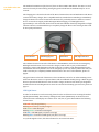
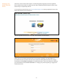
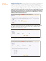
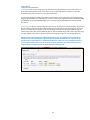
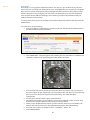
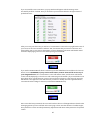
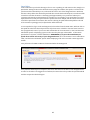
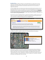
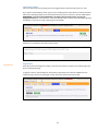
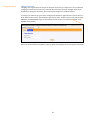
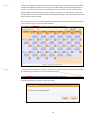
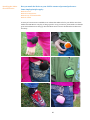
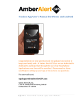
V3 User’s Manual Congratulations on your wise purchase to keep your family safe. At Amber Alert GPS, Inc. we are dedicated to child safety and hope that through the use of our Device your lives will be enriched. Please call us if you need help in setting up your Device or if you have any questions. You can reach us toll free at: 1-888-334-3958 Monday through Friday from 9am to 5pm MST Amber Alert GPS, Inc. 1196 W. South Jordan Parkway, Suite B South Jordan, UT 84095 1 Table of Contents What is Included in the Packaging? ---------------------------------------------------- 3 Your Amber Alert GPS V3 Device LED Light Status ------------------------------------------------------------------------ 4 Turning Device ON/OFF ------------------------------------------------------------- 5 Easy Smartphone Applications --------------------------------------------------------- 5 Coverage Map ------------------------------------------------------------------------------ 5 Alerts ---------------------------------------------------------------------------------------- 5 Setting up your Amber Alert GPS Device Settings ---------------------------------------------------------------------------------- 7 SOS – Help Me Alert-------------------------------------------------------------------- 8 Setting Up Alert Recipients Email and SMS/Text Users ----------------------------------------------------------- 9 Voice Users ------------------------------------------------------------------------------ 11 Features Map Page -------------------------------------------------------------------------------- 12 Map Page: Reports --------------------------------------------------------------------- 13 Home ------------------------------------------------------------------------------------- 14 Alerts Zone Alert ------------------------------------------------------------------------------- 15 Speed Alert ------------------------------------------------------------------------------ 18 Breadcrumb ----------------------------------------------------------------------------- 19 Predator Alert -------------------------------------------------------------------------- 20 Low Battery Alert ---------------------------------------------------------------------- 21 Page Device --------------------------------------------------------------------------------- 21 Change Password ------------------------------------------------------------------------- 22 History -------------------------------------------------------------------------------------- 23 Logout --------------------------------------------------------------------------------------- 23 Firmware ----------------------------------------------------------------------------------- 24 Battery Consumption --------------------------------------------------------------------- 24 Device Specifications --------------------------------------------------------------------- 25 Compliance with Applicable Laws ----------------------------------------------------- 25 Attaching the Amber Alert GPS Device ------------------------------------------------ 26 GPS for Beginners ------------------------------------------------------------------------- 27 2 What Is Included in the Packaging? Included in your packaging: Amber Alert GPS Device 1 attached Faceplate Mini USB Charger Quick Start Guide (pictured below) The back of the Quick Start Guide contains important information, such as your Username, Password, and Device phone number. You will need this information to log into the Tracking Portal and to call the Device. Please keep this information in a secure place for future reference. 3 Your Amber Alert GPS V3 Device The Amber Alert GPS Device (the “Device”) does not have an ON or OFF button. The unit is on at all times and can only be turned off by pressing the green and red buttons simultaneously for 10-12 seconds. The charging port is located on the side of the Device between the Voice and SOS buttons. The Device comes with a battery charger, but is compatible with any standard micro USB charger. Immediately charge the Device for at least 4 hours before first time use, preferably next to a window or exterior door to receive the strongest possible GPS signal. When charging, a red LED light located approximately 1 inch around the device from the red button blinks; when fully charged the red light remains solid. It is recommended that you completely charge the Device each evening so that it will be at its peak performance. Voice Button USB Charging Port SOS Button LED Light Indicators The red button located on one side of the Device is the SOS Button, and is for use in an emergency. Holding down this button, for four seconds or longer, sends an alert to your pre-determined emergency contacts. The SOS Button also has a bump on it so that it can be distinguished from the Voice Button and can be pushed in case of an emergency by ‘feel’ only. Please practice this with your child so that they are completely familiar with this feature. For more on the SOS Alert, please see page 8. The green button on the side of the Device is the Voice Button, and is for use when initiating a Voice Alert from the Device. Voice is a separate feature with an additional monthly charge. When the green button is pressed and held down for four seconds or longer, the Device will call the pre-designated number listed in the Tracking Portal. For more on Voice Alerts and setting up Voice Users, please see page 11. LED Light Status In order for the Device to track accurately, please check to see if the Device is receiving the needed signals (GPS and GSM). This is done by clicking the red button (SOS Button) on the Device. Once clicked, the Device will display one of three colors: red, blue, or green which indicate the following feature status: Solid Red = fully charged battery Blinking Red = battery not fully charged Solid Green = solid GPS signal Blinking Green = intermittent GPS signal Solid Blue = full GSM signal (cell phone coverage) Blinking Blue = intermittent GSM signal (cell phone coverage) To cycle through the colors, click the red button for one second each time. 4 Turning Device ON/OFF There is 1 way to turn the Device on and off. To Turn Off: To Turn On: or Press and hold the green and red buttons simultaneously for 10-12 seconds. You will hear a beep to indicate the Device is turning off. Plug the Device into a power source (best option). Press and hold either the green or red button (or both buttons simultaneously) for approximately 10-12 seconds to turn the Device back on. Once turned back on, the Device will beep. Some Users turn the unit off to conserve battery. When traveling by plane, turn the Device off prior to boarding. Getting Started with the App Coming Soon: Coverage Area The Amber Alert GPS Device comes with an active pre-installed SIM card. Both AT&T® and T-Mobile® are approved carriers. To view the coverage map in your area, please go to: New Android, BlackBerry,and iPhone Applications are in development. They will be launched to the public this Fall (2011). We will notify all our customers as soon as our new Apps are available for download. We are very excited about these Apps, and believe you will enjoy the enhanced functionality. Not only will our new apps work with your current Amber Alert GPS V3 device, but you will also be able to track Smartphone to Smartphone, enabling you to keep track of your active teens and college kids. Launch details will be coming soon!. AT&T®: http://www.wireless.att.com/coverageviewer/#?type=voice T-Mobile®: http://www.t-mobile.com/coverage/pcc.aspx Alerts An Alert is the process by which the User is notified of an event from the Device. For example, if the Device arrived at a pre-determined location (Zone Alert): the SOS button was pressed (SOS Alert); the device breached a predefined virtual boundary (Zone Alert); or the Device surpassed a pre-determined speed threshold (Speed Alert). Alerts can be set up and sent to the User two ways: email and/or SMS (text message). Please note that SMS (text message) alerts are an additional cost. The Email or SMS (text message) will display: The name of the Alert (Help Me!, Speed!, Zone Name!,, etc.). The name of the Device (The name you chose for the Device when setting it up.). The closest address, where the Device is currently located at the time of the Alert, with date and time. The GPS signal connection (Real Time or Last Known) and the number of satellites acquired. 5 Setting Up your Amber Alert GPS Device The Device comes activated and ready for use after being fully charged (as previously explained above) and has been tested for quality assurance before shipment. NOTE: The Device will not work unless Set Up is completed by the user. To set up the Device preferences, go to www.amberalertgps.com. In the top right-hand corner, click LOGIN. The following screen will appear: Click the login link located at the bottom right. The following screen will appear: Please enter your Username and Password. Your Username is typically your email address, as provided at the time of purchase and also listed on the back of the Quick Start Guide. If you forget your Password, click FORGOT PASSWORD. You will be directed to a new screen where you will enter your email address and click SEND PASSWORD. To change your password, please go to page 22 for further instructions. 6 Settings When you log into the Tracking Portal, you will be directed to the Map page. FIRST TIME USERS MUST GO TO THE SETTINGS PAGE to set your preferences for the Device. Click the Settings tab to reset or revise your settings at any time. Four important things take place in the Settings tab: 1. 2. 3. 4. 5. Select a name for your Device and type that name into the box entitled “Device Name”. Choose the unit of measurement for the speed setting (MPH or KPH) and the distance setting (feet/kilometers). Select the Time Zone where you are located. The default setting for the SOS Alert on your Device is “Enabled”, as shown in the SOS Status button of your Settings. In other words, if you press and hold the red SOS button on the Device, an Alert will be sent to the Users you have designated. If you want to disable the SOS Alert, click the Disable button under the Settings tab. Some Users elect to disable the SOS button because their child is prone to pushing it without there being a real emergency, or because of concerns that the button will be pushed accidently. If you choose to disable the SOS button, you can always enable it at a later time by returning to the Settings page. PLEASE NOTE that no SOS Alerts will be sent to any Users if the SOS Status is disabled. Click the “Update” button at the bottom of the Settings page to save your new settings or to update to new settings. Please use the scroll bar on this page to view all the settings options. 7 SOS – Help Me Alert The SOS Alert is one of the most popular features on the Device, and is activated by pressing and holding down the red button on the Device for at least 4 seconds. To ensure proper use of this feature, practice with your child how to press and hold down the button. When practicing with your child, include practicing pressing the button discreetly, or when the Device is in a pocket or jacket. The SOS (red) button has a bump on its surface so it has a different feel than the green button. When the SOS Alert is activated, the server will send out a Help Me Alert every 5 minutes to all designated Users 2 successive times. If you have purchased the SMS (text message) alerts, and you have made the selection under the Users tab to receive the SOS Alert via SMS, then the server will send out Help Me SMS (text message) Alerts every 5 minutes to up to two Primary Users 2 successive times. When the SOS button is disabled, it will still send and display an SOS message (highlighted in orange) in the Reports window on the Map page, but no Email or SMS Alert will be sent to any Users. The default setting for the SOS button is “Enabled”. If you wish to disable the SOS button, click on the SETTINGS tab. Scroll down to see the last settings option. Use the drop down menu to change the Device to “Disabled”. Click UPDATE. Example of an SOS Help Me Alert delivered via email. 8 Setting Up Alert Recipients Users (Email and SMS/Text) The type of Alerts you are entitled to receive (SOS, Zones, Predator, Breadcrumb, Speed, Battery), as well as how you are entitled to receive them (SMS and/or Email) is determined by the type of Monthly Service Plan you have purchased. If you have purchased a plan that does not entitle you to receive certain Alerts, you may upgrade your plan at any time. Assuming you have purchased a Monthly Service Plan that entitles you to receive all or some Alerts, then your first step is to identify each of the individuals that you would like to receive the Alerts. To do so, please log into the Tracking Portal and click on the Users tab. The individual that made the initial purchase of the Device will be listed as the first user (Primary User). The Primary User’s first and last name, email address and phone number will be displayed at the top of the list. To add an additional User(s), please click the “Add User” button in bottom left-hand corner. To add a User, enter the first name, last name, email address and phone number of the individual. Click SUBMIT. If the User information was entered correctly, a pop-up window will appear indicating: “User Successfully Created”. Click OK. Once a User has been successfully created, you will have the opportunity to customize the type of Alerts that particular User will receive, as well as how the User will receive those Alerts. 9 VERY IMPORTANT: In order to receive Alerts for a Device, the User must be linked to the Device. Please check the box located after the words “Link User With This Device”. Make sure to select how you would like each particular user to receive Alerts (SMS, Email, or both) and which Alert Type(s) you would like the user to receive, such as Battery, Breadcrumb, Predator, SOS, Speed, and Zone. In the example above, Olivia Thompson is set to receive Battery Alerts by Email only, Breadcrumb Alerts by SMS only, Predator, SOS and Zone Alerts by SMS and Email, and Speed Alerts by Email only. Alert delivery to each of your designated Users may be customized in any manner you select. Once you have made all the desired selections for a particular User, click the SUBMIT button. A pop-up window will appear indicating: “Update Successful”. Click OK. Click FINISH to return back to the original Users page. To Edit Users, please click the EDIT button located after the particular User’s Email address. You will then be directed to the previous page shown above, and may make any desired changes. Example of Email Alert: Note: Some Email Alerts will provide a URL map link. If your Email has a link, click on the link to view a map. A map will appear similar to the map below. Click the numbers at the bottom of the link to zoom in and zoom out. 10 Voice Users 1 Way Voice with Voice Alert Voice Alert: If the wearer of the Device would like to alert the Primary User to listen in, they can press and hold the green button on the Device for 4 seconds. The Device will place a call to the number listed as the Current Voice User (pictured below). To set up the designated telephone number for this feature, click on the User’s tab. On the line that displays the individual user’s information, you’ll see 3 tabs to the right titled: EDIT, SET VOICE USER, and DELETE. Click on SET VOICE USER. If set correctly, a pop up will display the words “Update Successful”. 1 Way Voice: To initiate a monitoring call to the Device, call the Device’s phone number. The Device’s phone number is listed on the Quick Start Guide that was included in your packaging. By calling the Device, you will be able to listen in to the surroundings of the Device. The Device will not ring or vibrate when called, but will automatically pick up after 2 audible rings on the caller’s end. The rings are only audible to the caller. The caller can mute their phone to shut out any background noise. Important Note Regarding Voice Monitoring: The legality of listening to conversations in which you are not a participant is governed by local, state and federal law. Consult all applicable laws to determine the conditions pursuant to which you are permitted to listen to conversations without the consent of one or all of the parties to the conversation. You are responsible for complying with all applicable laws (see page 24). 11 Features Map Page To locate your Device at any time, simply log in to the Tracking Portal via your computer or your Smartphone Applacation (coming soon). Device locations are updated every 5 minutes on the Map page. Green Map Marker = current location Yellow Map Marker = last known location Red Map Marker = previous locations Orange Map Markers = SOS Alerts Blue Man = Predator “Registered Sex Offender” If the Device cannot obtain a GPS signal, it will pull the last known latitude and longitude coordinates saved on the Device (last known location). The Map Markers are numbered from 1 to 100, with the number 1 representing the most current location. If you have not purchased the Predator Alert service, the Blue Man icon will not appear on your Map page display. There are two map-viewing options, represented by the bar at the top right-hand corner of the Map. If you select the Map button, the locations will be displayed in a typical street map format. If you select the Satellite button, you have the option to view the locations either in satellite form only, or if you prefer, you may select the drop down box entitled “Labels” to display the street names overlaid on the satellite image. To view the address and details of a location, simply click on any map marker, or on the report related to such map marker. If your screen has been open to the Map page for a period of time, remember to click the Refresh button to draw down the most current location information. 12 Map Page: Reports The Reports are now visible on the right side of the Map page. The map markers correspond with report details such as Date/Time, Battery, and GPS strength. These details are represented by the following words and icons: To display the Report details, check the box next to the word “REPORTS”. As you scroll through each individual report, the Map Marker related to that report will bounce on the page, making it easy for you to associate each report to a particular Map Marker location. To hide the Reports and expand the Map page, uncheck the “Reports” box. If the Device has not reported a new location in the previous 10 minutes, click the PING Button at the top of the screen. This will send a ‘wake up and report’ command to the Device. 13 Home Page The Home page enables you simultaneously to view multiple devices on the same screen. Each Device is represented by a different color so you can easily distinguish between Devices. If you wish to view the address of a particular Device, click the Detail button located to the right side of your selected Device. If you wish to see all the locations for a particular device, click the More button located to the right side of your selected Device. There are two map-viewing options, represented by the bar at the top right-hand corner of the Map. If you select the Map button, the locations will be displayed in a typical street map format. If you select the Satellite button, you have the option to view the locations either in satellite form only, or if you prefer, you may select the drop down box entitled “Labels” to display the street names overlaid on the satellite image. 14 Alerts Zone Alert Zone Alerts are a very popular and effective feature. You may set up to 20 Zones at any one time. Zones can be set up around your child’s school, home, and neighborhood or anywhere you designate. Once a Zone is created and activated on the Tracking Portal, these parameters will remain set until edited or deleted. You may configure your Zone Alert to be delivered to you and other designated Users via email and/or SMS (text message). Once enabled, you will receive notification that your child has entered or exited a Zone. To set up a Zone Alert, log into the Tracking Portal, click the Alerts tab, and then click on the first tab labeled “Zone”. To create a Zone, do the following: Type in an address or landmark (for example, maybe you only have the word Disneyland or the Arizona Desert Botanical Gardens.) Click “SHOW MAP”. A map will appear with a marker placed on the address or landmark you specified. A shaded circle representing the radius will also be shown. If the location of the pin on the map is not precisely where you want it to be, you can move the pin. To adjust the pin, drag the pin to your desired location and drop it. To move the map, place your cursor away from any pins and click and drag. The radius will adjust automatically. Use the “plus” sign and “minus” sign to zoom in and out. The default zone radius is set at 1,000 feet. If you want to adjust the radius, press the drop down arrow in the Zone Radius box and select your desired radius. When you are satisfied with the location you have selected, click how you would like to be alerted. Select the boxes that say: Alert When Entering and/or Alert When Exiting. Give your Zone a name, for example “School”, “Grandma’s”, “Home”, etc. Click “CREATE ZONE”. 15 If you successfully create a new Zone, a pop-up window will appear with the message: Zone Successfully Created. Click OK. Now you should see your new Zone added to the right column of predefined zones. After you create your first Zone, you will see a “Current Status” notice in the top right-hand corner of your screen. If the “Current Status” indicates “ON”, that means that your Zones are all active and Alerts will be sent to your Users in the manner you have designated. The menu tab labeled “Zones” should be displaying a green circle icon with a plus sign in the middle. If you wish to DEACTIVATE all Alerts to All Users, press the STOP button located above the “Current Status” notice. REMEMBER, if you press the STOP button, no Zone Alerts will be sent to any of your designated Users, the “Current Status” notice will indicate “OFF”, and the menu tab labeled “Zones” will be displaying a red circle icon with a minus sign in the middle. (If you would like to turn Zone Alerts off for a particular User or Users, but not all Users, please go to the Users tab, press the Edit button to the right of the User whose Alerts you desire to modify, select the applicable Device, customize the Alert settings for that User, and click the SUBMIT button.) Once a Zone has been penetrated, the server will send out Alerts to all designated Users based on the messaging options you have selected on the Users page. Please note that because of satellite angles, Zone parameters can be exceeded prematurely. Experiment with Zone radius perimeters for optimal results. 16 Zones can be changed at any time. To edit a Zone, Click the EDIT button next the Zone you want to change, and the following screen will appear: You may enter a new address, change the radius, or change when you receive alerts. After you make your changes, click SAVE. 17 Speed Alert To be notified that your child is driving too fast or is in a speeding car with someone else, simply set a Speed Alert. During the interval in which the Device pings the satellites, the speed is recorded. If the speed exceeds the threshold you set, an alert will be sent to each of the designated Users. Each time the Device drops below the threshold speed and then exceeds the threshold speed, a new alert will be sent. Please note that the Device is checking speed approximately every 5 minutes and may not recognize each time the speed parameter is exceeded. So, for example, if your speed alert is set at 45 mph, and the Device has just reported with a speed that is below 45mph, and the vehicle driver then exceeds the speed limit for 2 minutes, but returns to driving at speeds below 45mph before the end of the 5-minute reporting period, no Speed Alert will be delivered. To set a Speed Alert, log in to the Tracking Portal, select Alerts from the main menu, and then click on the Speed tab. Select the desired speed in the drop down menu. Check the “Current Status” notice in the top right-hand corner of your screen and confirm that the “Current Status” is “ON”, and the menu tab labeled “Speed” is displaying a green circle icon with a plus sign in the middle. To deactivate Speed Alerts to all Users, click the STOP button. REMEMBER, if you press the STOP button, no Speed Alerts will be sent to any of your designated Users, the “Current Status” notice will indicate “OFF”, and the menu tab labeled “Speed” will be displaying a red circle icon with a minus sign in the middle. Your preferences for MPH or KPH are determined under the Settings Tab. Every time the defined speed is surpassed, the server will send out one Alert to each designated User. In order for the Alert to be triggered a second time, the Device has to drop under the speed threshold and then surpass the threshold again. 18 Breadcrumb Breadcrumb is an easy and convenient way to receive regular Alerts specifying the location of the Device at your preset interval. To select a reporting interval for the Device, log in to the Tracking Portal, select Alerts from the main menu, and click the Breadcrumb tab. From the drop down menu, select a tracking interval of 15, 30, 45 or 60-minutes. Click the START button to activate. Alerts will be sent to designated Users at the selected interval. To deactivate Breadcrumb Alerts to all Users, click the STOP button. REMEMBER, if you press the STOP button, no Breadcrumb Alerts will be sent to any of your designated Users, the “Current Status” notice will indicate “OFF”, and the menu tab labeled “Breadcrumb” will display a red circle icon with a minus sign in the middle. Alerts will continue on the set interval until stopped. 19 Predator Alert Our Device is the only children’s GPS device on the market that lets you know when it is near a registered sex offender’s residence. Amber Alert GPS ties in with US Department of Justice Dru Sjopdin National Sex Offender database and identifies when the Device is near the home of a registered sex offender. To receive Predator Alerts, select Alerts from the main menu and then click the Predator tab. If you have purchased this service, the “Current Status” notice in the top right-hand corner of the screen should indicate “ON”. To deactivate Predator Alerts to all Users, click the STOP button. REMEMBER, if you press the STOP button, no Predator Alerts will be sent to any of your designated Users, the “Current Status” notice will indicate “OFF”, and the menu tab labeled “Predator” will display a red circle icon with a minus sign in the middle. Once the Device has arrived within 500 feet of a registered sex offender’s residence, the server will send out an email alert to designated Users. If SMS (text message) alerts have been purchased, the server will send out an SMS (text message) alert to the designated Users. A registered sex offender’s residence will be represented on the map by the blue man icon. To view the details of a specific sex offender, click the icon. A Predator details pop-up will appear. Predator Alert’s (registered sex offender proximity alerts) are based upon data provided by the United States Department of Justice Dru Sjodin National Sex Offender Public Website (“NSOPW”) database. That website can be found at [www.nsopw.gov]. The NSOPW expressly warns that it cannot guarantee the accuracy, completeness or timeliness of the information drawn from the state registries. Accordingly, we cannot guarantee the accuracy, completeness or timeliness of the data upon which our Predator Alert services are based. 20 Low Battery Alerts The server will send one low battery Alert to designated Users when the battery life is at 15%. If you wish to disable Battery Alerts, log on to the Tracking Portal, select Alerts from the main menu, followed by clicking the Battery tab. To deactivate Battery Alerts to all Users, click the STOP button. REMEMBER, if you press the STOP button, no Battery Alerts will be sent to any of your designated Users, the “Current Status” notice will indicate “OFF”, and the menu tab labeled “Battery” will display a red circle icon with a minus sign in the middle. Example of a Low Battery Alert delivered via email. Page Device Page Device If the Device has been misplaced, a Page can be sent to the Device to help locate it. When paged, the Device will begin beeping. To page the Device, click the Help tab, then click the Page Device tab. Click the START button to initiate the page. The Device will begin to beep. The Device will beep for 20 seconds. 21 Change Password Change Password Changing your Login Password is simple. To keep the location of your child secure, we recommend changing your Password at least every 3 months. The Username cannot be changed online. If you would like to change the Username, please call Technical Support at 1-888-334-3958. To change your Password, log in to the Tracking Portal. On the far right side of the screen, there is a drop down arrow located to the immediate right of your name. Click the down arrow and select MY PROFILE. Click PASSWORD. Type in a New Password and retype a second time to confirm. Click SUBMIT when finished. Once your Password has been updated, a pop up window will display the words “Update Successful”. 22 History To view or download the Device location data for a particular day, select the History tab. A monthly calendar will display the number of locates per day and the number of Email and SMS/Text Alerts sent out. To view the location data for a particular day, click on the Locates link. A map will then display all of the location data generated by the Device on that day. To download the location data for a particular day, click on the Export button and follow the prompts. The downloaded information will be in Microsoft Excel format. We retain your Device’s historical information for approximately 3 months. If you wish to maintain a record, print the report or save the downloaded file. Log Out To Logout of the Tracking Portal, click the drop down arrow located at the far right of the main menu bar, immediately to the right of your name, and click Logout. The following window will pop up. Click Logout again. 23 Firmware Periodically, you will be asked to perform a firmware update on your Device. You may receive an email or phone request. The firmware on the Device controls the capabilities on the Device. Our engineering team is constantly working to improve Device functionality. Firmware updates are designed to enhance the performance of the Device. If you receive a request to update, please follow the instructions given in the email or phone conversation. Instructions are also updated through the User Portal under the Help tab. Battery Consumption Battery operated products require the user to achieve a balance between battery life and performance. Everyone wants the fastest and most current updates and the ability to view the Device as it moves close to real-time. There is, however, a direct and inverse relationship between the frequency of updates and the overall battery life, with more frequent updates resulting in a shorter battery life. Increasing the size of the device’s battery likewise increases its cost, weight, and size. The Amber Alert GPS Device provides the user real-time updates approximately every 5 minutes, recording tracking history for later playback so that the user can see everywhere the Device has been – even when you’re not watching. The Amber Alert GPS Device balances the need for long battery life by embedding a 3D motion sensor that enables the Device to power off and conserve power after 60 seconds of no movement. The instant the Device moves, it powers back up, reconnects, and resumes transmission. Many factors affect battery life. These factors include, but are not limited to: region (rural or suburban), proximity to cell towers, indoor use versus outdoor use, cell phone inhibitors placed in public areas such as schools, areas next to military bases, etc. Typical battery life for the standard battery is 24+ hours. Typical battery life for the extended battery is 48+ hours. 24 Device Specifications PHYSICAL SPECIFICATIONS: Dimensions Housing Weight Standard Battery 1.94” x 1.94” x1.03” ABS , PC 50g 650 mAh Rechargeable Lithium Ion OPTIONAL EXTENDED BATTERY: Dimensions 1.94” x 1.94” x1.25” Housing ABS , PC (Acrylonitrile Butadiene Styrene/Polycarbonate) Weight 60g Battery 1100 mAh Rechargeable Lithium Ion ELECTRICAL SPECIFICATIONS: Operating Voltage 3.7 V ENVIRONMENTAL SPECIFICATIONS: Operating and Storage temp -10C to +60C Functional Compliance with Applicable Laws GPS TECHNOLOGY: GPS Sensitivity Horizontal accuracy Time-to-first-fix MTK 14 channel -160 dBm >1m Average 60 seconds CERTIFICATIONS: FCC PTCRB ATT Mexico NOM Industry Canada Yes Yes Yes Yes Yes You agree to use our Products and Services (including the Device) only for lawful purposes. In your use of our Products and Services you are responsible for complying with all applicable federal, state and local laws. If you are located outside of the United States, you are responsible for complying with the laws of your country or legal jurisdiction with respect to your use of our Products and Services. Amber Alert GPS. Inc. and its affiliates bear no responsibility or liability for any use of its Products or Services that may be unlawful in the United States or elsewhere. 25 Attaching the Amber Alert GPS Device How you attach the Device to your child is a matter of personal preference. Some simple principles apply: Make it secure Make it inconspicuous Make it easy and comfortable Make it a habit A variety of accessories are available on our website that make it fun for your child to wear their Amber Alert GPS Device every day. If using a pouch to carry your Device, please make sure that the green and red buttons are facing up. This will allow easier access to the SOS and Voice buttons if necessary. 26 GPS for Beginners How does GPS work? A GPS satellite orbits the Earth at an altitude of a little over 12,000 miles and travels almost 9,000 miles per hour. It completes an orbit about twice a day. It transmits data that indicates its location and the current time. All GPS satellites synchronize operations so that these repeating signals are transmitted at the same instant. The signals, moving at the speed of light, arrive at our GPS receiver at slightly different times because some satellites are farther away than others. The distance to the GPS satellites can be determined by estimating the amount of time it takes for their signals to reach our Device. How Many Satellites Do We Use? There are between 24–30 satellites in operation orbiting on 6 different axes at any given time. It takes at least 3 different satellites to calculate a position. With an unobstructed view, our Device can be seen and receive a signal from up to 12 satellites at the same time. How Accurate is GPS? Our Device has been known to give a location of within a few feet. Generally, it will give a location within 10–20 yards. The more satellites that can see the Device the better the accuracy will be. Satellites Acquired: (0-2 no current signal, 3-6 lowest accuracy, 7–9 medium accuracy, 10–12 highest accuracy). Are There False Readings? Yes, it is not uncommon to receive a false reading from time to time. A false reading can be the result of obstructions such as (i) being inside homes, schools or buildings; (ii) locations in urban areas between large buildings; (iii) locations in hilly or mountainous areas; (iv) locations around military bases or government installations; and (v) natural occurring phenomena such as electromagnetic or solar events. What is a GPS Bounce? GPS bounce is also known as multipath. Multipath results when the direct path to your receiver is blocked (by your body, your house, roof, trees, mountains, buildings, etc) and the signal from the satellite is REFLECTED by some object. The reflecting surface may be: buildings, mountains, the ground, or any object that happens to be a radio reflector at 1.6Ghz. Multipath are radio signals which have traveled FURTHER to get to your receiver than they should have. This can result in your GPS miscalculating its position because the signals may have traveled from feet to miles further to get to you than the path of a direct line of sight signal. How Do We Get An Address for Latitude and Longitude? We take the latitude and longitude and use publically available mapping systems like Google and MapQuest to calculate the addresses that are shown on our tracking server. 27