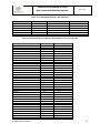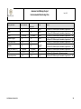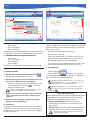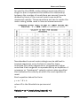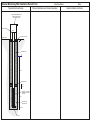
1
Amulsar Gold Mining Project Environmental Monitoring Plan Revision History Revision Date V1 27 Aug 14 V2 9 Feb 15 V3 May 2015 Details Prepared Appendix 8.13 of ESIA version 9 Golder Associates CN Revision incorporating lender feedback and formatting into Geoteam template Revision for 2015 (pre-construction) monitoring programme May 2015 Checked Approved AJB The Amulsar Environmental Monitoring plan (EMP) is a "live" document that will be updated throughout the life of the Project as necessary to reflect the monitoring requirements particular to the current Project phase. This revision (V3) applies to the Pre-Construction Phase. GEOTEAM-ENV-PLN0225 i Amulsar Gold Mining Project Environmental Monitoring Plan May 2015 Table of Contents 1 INTRODUCTION ................................................................... 1 1.1 Objectives and Goals .................................................................................... 1 1.2 Scope of the Environmental Monitoring Plan .............................................. 2 2 Management Structure and Technical Competence ......... 3 3 Weather and Atmospheric Pressure .................................. 5 4 Air Quality ............................................................................ 6 4.1 Nitrogen dioxide and sulphur dioxide .......................................................... 6 4.2 Dust ................................................................................................................ 7 4.3 Fine Particulates ............................................................................................ 8 5 Noise .................................................................................... 9 6 Surface Water .................................................................... 10 6.1 Monitoring Network ..................................................................................... 10 6.2 Flow Monitoring ........................................................................................... 10 6.3 Surface Water Quality Sampling................................................................. 13 7 Groundwater, including Springs ...................................... 17 7.1 Monitoring Network ..................................................................................... 17 7.2 Monitoring Programme ............................................................................... 18 8 Soils.................................................................................... 23 9 Ecology .............................................................................. 24 10 Cultural Heritage................................................................ 25 GEOTEAM-ENV-PLN0225 ii Amulsar Gold Mining Project Environmental Monitoring Plan May 2015 11 Summary Monitoring Schedule ........................................ 26 12 Project Compliance Targets ............................................. 27 12.1 Air Quality .................................................................................................... 27 12.2 Noise ............................................................................................................ 27 12.3 Water ............................................................................................................ 28 12.4 Soil................................................................................................................ 33 13 Data Management and Record Keeping .......................... 34 14 Quality Assurance ............................................................. 35 14.1 Water Level Data from Level Loggers ........................................................ 35 14.2 Quality Assurance of Water Quality Samples............................................ 35 14.3 Calibration of Water Quality Field Probes ................................................. 36 14.4 Groundwater and Surface Water Data Handling Procedures ................... 36 15 PERFORMANCE MONITORING ........................................ 38 15.1 Verification and Monitoring ........................................................................ 38 15.2 Review of Incidents with Authorities ......................................................... 38 15.3 ESMS Management Review ........................................................................ 38 15.4 Annual Audit ................................................................................................ 38 16 SUPPORTING PROCEDURES ........................................... 39 GEOTEAM-ENV-PLN0225 iii Amulsar Gold Mining Project Environmental Monitoring Plan May 2015 List of Appendices APPENDIX A: Method Statements MS-01 Method Statement for Quarterly Download of Surface Water Data Loggers and Manual Stage Measurement Troll Operator's Guide MS-02 Method Statement for Sampling Surface Water and Springs MS-03 Method Statement for Surface Water and Spring Flow Measurement AquaCalc Pro Stream Flow Computer Instruction Manual MS-04 Method Statement for Measurement of Field Parameters MS-05 Method Statement for Installation and Download of Pressure Transducers in Groundwater Monitoring Wells MS-06 Method Statement for Sampling Groundwater Monitoring Boreholes Geotech Portable Bladder Pumps Installation and Operation Manual MS-07 Method Statement for Supervision of Installation of Groundwater Monitoring Wells Amulsar Monitoring Well Installation Record Form APPENDIX B: LIST OF ALL SURFACE WATER MONITORING LOCATIONS APPENDIX C: LIST OF ALL GROUNDWATER MONITORING WELLS AND SPRINGS APPENDIX D: DRAWINGS Location for Noise and Air Quality Monitoring Receptors Surface Water Continuous Flow Locations 2013/14 Surface Water and Spot Flow Locations 2013/14 Groundwater Monitoring Locations 2013/14 Soil Geochemistry Survey Locations and Soil Associations GEOTEAM-ENV-PLN0225 iv Amulsar Gold Mining Project Environmental Monitoring Plan May 2015 Glossary BRSF EBRD ESIA ESMP ESMS Geoteam g/t HLF IFC Lydian mg/m2/d NOx PM PM2.5 PM10 RA SO2 SOP SPZ TSP VOC WHO µm Barren Rock Storage Facility European Bank for Reconstruction and Development Environmental and Social Impact Assessment Environmental and Social Management Plan Environmental and Social Management System Geoteam CJSC grams per ton Heap Leach Facility International Finance Corporation Lydian International Ltd milligrams per square meter per day Oxides of nitrogen Particulate Matter Very fine particles with a diameter of less than 2.5 microns Small particles with a diameter of 10 microns or less Republic of Armenia Sulphur dioxide Standard Operating Procedure Sanitary Protection Zone Total Suspended Particles Volatile Organic Compound World Health Organisation micron or micrometre (one millionth of a metre) GEOTEAM-ENV-PLN0225 v Amulsar Gold Mining Project Environmental Monitoring Plan GEOTEAM-ENV-PLN0225 May 2015 vi Amulsar Gold Mining Project Environmental Monitoring Plan 1 May 2015 INTRODUCTION Lydian International (Lydian), and its wholly owned Armenian subsidiary, Geoteam CJSC (Geoteam), is developing the Amulsar Project (the Project), a gold mine and associated process facilities located in central Armenia. The proposed Amulsar mine will exploit a gold deposit via open pit mining and heap leach processing techniques, using dilute cyanide solution. The Project has a Mining Licence for the proposed pit and has received state environmental assessment approvals. Permits also exist for ongoing exploration activities. The Project is currently at the design stage, with minimal fieldwork related to geotechnical investigation planned for most of 2015, ahead of a potential start of construction in Q3 2015. The Project is subject to various environmental and social commitments arising out of environmental impact assessments required for state environmental assessment approval, together with licences, permits and other agreements necessary to meet Armenian legislation. Additional commitments arise from the Environmental and Social Impact Assessment (ESIA) which has been undertaken for the Project in compliance with, amongst others, the Performance Requirements (PR) of the European Bank for Reconstruction and Development (EBRD) and the Performance Standards (PS) of the International Finance Corporation (IFC). Environmental and social (E&S) commitments are being managed by Geoteam through the Project Environmental and Social Management System (ESMS). The ESMS includes a set of Management Plans (MPs), such as this one, that detail requirements placed upon Lydian/Geoteam in order to fulfil the Project’s environmental and social commitments. The implementation of the ESMS for exploration and early construction works commenced in 2013, and the system is intended to develop in parallel with the Project. As such, the MPs will be revised and improved to meet the needs of the Project. This document presents the Environmental Monitoring Plan (EMP) for the Amulsar Project. It is a "live" document that will be updated as necessary to reflect the different monitoring requirements of the pre-construction, construction (including early works), operational, and closure phases of the Project. It is based upon the exploration phase EMP which was developed by Golder Associates Ltd, and was used during exploration both to gather environmental baseline parameters and subsequently to monitor them. This current version of the EMP is applicable to the pre-construction phase of the Project. The next revision of the plan is expected to be necessary immediately prior to the start of (early) construction works. 1.1 Objectives and Goals The objective of monitoring is to check for any variations from baseline conditions. In the context of the Amulsar Project, it has two main elements: • To check performance against the numerical Project compliance targets and assessment criteria as set out in Section 2.4 of the ESIA (reproduced in this EMP as Chapter 12). These criteria are a combination of Armenian legal requirements and standards derived from good international industry practice; and • To measure and evaluate the effectiveness of the Project mitigation measures as identified in Chapter 6 of the ESIA and the associated MPs. GEOTEAM-ENV-PLN0225 1 Amulsar Gold Mining Project Environmental Monitoring Plan May 2015 Implementation of the EMP will inform the environmental management of the Project and identify the need for any modifications or additional actions required to ensure that the Project commitments are met. 1.2 Scope of the Environmental Monitoring Plan This plan brings together all of the environmental monitoring requirements relevant to the current Project phase as specified in the E&S MPs which have been developed as part of the ESIA, as well as the monitoring required to comply with Armenian legislation. It contains all of the monitoring that will be the responsibility of the Amulsar site-based environmental team. The MPs developed as part of the ESIA, and whose monitoring requirements are included in this EMP, are: • Air Quality, Noise and Vibration Management Plan (AQNVMP, Ref GEOTEAM-HSE-PLN0148); • Cultural Heritage Management Plan (CHMP, Ref GEOTEAM-ENV-PLN0218); • Acid Rock Drainage Management Plan (ARDMP, Ref GEOTEAM-ENV-PLN239); • Biodiversity Management Plan (BMP, Ref GEOTEAM-ENV-PLN0227); and • Surface Water Management Plan (SWMP, Ref GEOTEAM-ENV-PLN0214). The EMP is part of the overall Project Environmental and Social Management Plan (ESMP) and will be managed through the Project ESMS. GEOTEAM-ENV-PLN0225 2 Amulsar Gold Mining Project Environmental Monitoring Plan 2 May 2015 Management Structure and Technical Competence The Lydian Executive Vice President (EVP) has overall responsibility for E&S management, compliance, and performance of the Amulsar Project. The EVP is also responsible for the relationship with IFC and EBRD (who are existing shareholders and potential lenders) with respect to E&S issues, and with the Independent Environmental and Social Consultant (IESC) appointed by the lenders. The day-to-day environmental management of the Project within Armenia is the responsibility of Geoteam, which is responsible for: • Communicating the requirements of this plan to its staff or any contractors who will be engaged to deliver the monitoring activities; • Monitoring and auditing the implementation of this plan and ensuring activities are completed as required and in a timely fashion; and • Taking action to correct any failures to complete the required monitoring activities in accordance with this plan. Geoteam is responsible for ensuring that any staff completing monitoring activities have received appropriate training, have the necessary tools and equipment to complete monitoring and are competent to complete the tasks assigned. Specific responsibilities for Geoteam personnel relating to this plan are described in Table 1. Table 1: Geoteam Environmental Management Structure Title Project Director/General Manager Sustainability & Permitting Senior Manager Environmental Manager Environmental Officer GEOTEAM-ENV-PLN0225 Role Ensuring that the Project complies with its legal obligations with respect to the environment; ensuring that designated managers understand their responsibilities and have sufficient resources to carry out their functions effectively; and reviewing and approving all training programmes and ensuring that any recommendations are duly implemented. Implementing the ESMP via the ESMS; and ensuring that sufficient staff and material resources are available to implement the EMP. Implementing all aspects of this monitoring plan to support the Project during construction, operation and closure; liaison with and management of contractor environmental staff; ensuring all results are reported correctly (including transcription into Monitor Pro database); and reporting the outcomes to the Sustainability & Permitting Senior Manager. Delivery of monitoring activities in accordance with this plan and as instructed by the Environmental Manager. 3 Amulsar Gold Mining Project Environmental Monitoring Plan Title Contractors GEOTEAM-ENV-PLN0225 May 2015 Role Completion of activities in accordance with this plan as instructed by Geoteam. The contracting strategy for the Project has not yet been finalised, and it is therefore not yet known what the contractor set-up will be in terms of E&S management. Larger contractors may have their own E&S staff who will be expected to conform with the Project ESMP and ESMS, and to cooperate with Geoteam staff as necessary during monitoring activities. The contracting strategy and E&S arrangements will be finalised prior to start of work on site. 4 Amulsar Gold Mining Project Environmental Monitoring Plan 3 May 2015 Weather and Atmospheric Pressure Lydian/Geoteam maintain and operate two automated meteorological stations located at the site camp and the proposed Heap Leach Facility (HLF) location (Table 2). Table 2: Weather Station Barometry Monitoring Locations Location ID Easting Northing Camp 560828 4401512 HLF 554367 4399951 Notes To be relocated during construction / operation outside facilities footprint. To be relocated during construction of the HLF. The two meteorological stations record continuous data for temperature, wind speed, wind direction, humidity, rainfall and air pressure. Monitoring will be maintained throughout Project execution in order to inform any necessary modelling updates (e.g. water balance modelling) and to inform interpretation of other monitoring data (e.g. dust and noise). Geoteam also has two barometric loggers, which are deployed temporarily and on an as-needed basis for the purpose of determining correction factors to be applied to continuous groundwater flow/level data measured at the site by pressure transducer data loggers (see Chapters 6 and 7). As required by the Surface Water Management Plan (SWMP, Ref GEOTEAM-ENV-PLN0214), meteorological data produced by the above stations will need to be supplemented by measurements of snowpack depth at widely distributed points on and near the Barren Rock Storage Facility (BRSF) and around the open pits. This information will be an important element in the SWMP because snowmelt is the primary source of spring runoff. Snowpack depth measurement will commence during Winter 2015/2016. GEOTEAM-ENV-PLN0225 5 Amulsar Gold Mining Project May 2015 Environmental Monitoring Plan 4 Air Quality 4.1 Nitrogen dioxide and sulphur dioxide Air Quality in terms of nitrogen dioxide (NO2) and sulphur dioxide (SO2) is currently monitored at five points in the communities around the Project site (Table 3). Following a review related to the Project ESIA, six new long-term monitoring points have been proposed to replace the current five (AQ1-AQ6 in Table 4). These new points are to be verified for accessibility in 2015. NO2 and SO2 monitoring will be undertaken at both the old and new monitoring points for a period of six months, after which monitoring at the old points will be discontinued. Until the end of 2014, NOx and SO2 monitoring was undertaken using passive Gradko diffusion tubes deployed on a monthly basis. Gradko tubes contain adsorbent material which is exposed for a period of one month and is then sent for analysis by UV/Visible Spectrophotometry in a UK-based laboratory which is accredited by the United Kingdom Accreditation Service (UKAS). However, in early 2015 Geoteam was notified that the Gradko tubes contain trace quantities of a chemical substance for which the European Union has imposed an export ban. Therefore, use of the Gradko tubes will no longer be possible. Geoteam's consultant, Wardell Armsntrong International, is currently working on an alternative solution for NO2 and SO2 monitoring. Table 3: Current Air Quality Monitoring Points Location Jermuk Kechut Gndevaz Saravan Gorayk Easting 557736 557475 553224 555510 565063 Northing 4410479 4406082 4401116 4396861 4392644 Table 4: Air Quality Monitoring Points to be established during 2015 Location Easting NO2, SO2, and dust monitoring points AQ1 Jermuk 557751 AQ2 Kechut 558583 AQ3 Gndevaz 553593 AQ4 Saravan 555340 AQ5 Saralanj 558107 AQ6 Gorayk 564951 Total Suspended Particulates (TSP) monitoring points AQ7 Kechut 557475 AQ8 Gndevaz 553224 AQ9 South West of Tigranes 560672 / Artavazdes AQ10 North of BRSF 559983 GEOTEAM-ENV-PLN0225 Northing 4409515 4406880 4399987 4397674 4397027 4393686 4406082 4401116 4403805 4398093 6 Amulsar Gold Mining Project May 2015 Environmental Monitoring Plan 4.2 Dust When work is taking place on site, visual assessment will be important for day-to-day management of dust. A number of monitoring stations provide back-dated data to measure the success of the processes implemented through visual inspections of operations. When potentially dust-generating activities are ongoing on site, visual inspections will be undertaken at least once a day, and more often if wind direction or strength changes during the working day. Dust has been monitored at eight locations in the past (Table 5 and Drawing, Appendix D). From 2015, dust monitoring will be undertaken at a total of 12 locations: the six new locations at which NO2 and SO2 will be monitored (see above), and six of the current locations. All locations to be monitored are listed in Table 6. The locations will be monitored using DustScan DS100 passive monitors. The DustScan DS100 operates with a multi-directional sticky pad gauge which collects airborne dust as it passes over the gauge. Pads are held in place and protected with a removable rain cap. The sampling head is aligned to magnetic north to ensure directional information is obtained. Dust deposition is measured as a percentage of the effective area covered (%EAC) over the sampling period. %EAC is monitored over a period of one month after which the pads are returned to an accredited laboratory for analysis. Table 5: Historical Dust Monitoring Locations Location Easting Northing ADN1 East of BRSF 562019 4402723 ADE2 East of Vorotan & proposed pits 565255 4398514 ADS3 South of proposed pits near M2 road 561005 4393813 ADW4 West of proposed pits 559983 4398101 ADJ5 Jermuk 557945 4407300 ADG7 Gndevaz 553381 4401233 ADHLP8 East of Gndevaz 556272 4401361 ADHLP9 At the HLF site 553118 4398905 Table 6: Dust Monitoring Locations from 2015 Location Easting Northing ADN1 East of BRSF 562019 4402723 ADE2 East of Vorotan & proposed pits 565255 4398514 ADS3 South of proposed pits near M2 road 561005 4393813 ADW4 West of proposed pits 559983 4398101 ADHLP8 East of Gndevaz 556272 4401361 ADHLP9 At the HLF site 553118 557751 558583 553593 555340 558107 564951 4398905 4409515 4406880 4399987 4397674 4397027 4393686 AQ1 AQ2 AQ3 AQ4 AQ5 AQ6 Jermuk Kechut Gndevaz Saravan Saralanj Gorayk GEOTEAM-ENV-PLN0225 7 Amulsar Gold Mining Project Environmental Monitoring Plan 4.3 May 2015 Fine Particulates Due to equipment problems in the past, a reliable baseline for Total Suspended Particulates (TSP) has not yet been established. Four points will be established for TSP monitoring in 2015 (points AQ7 – AQ10 in Table 5). At the Kechut (AQ7) and Gndevaz (AQ8) locations, continuous monitoring of TSP, PM10, and PM2.5 particles will be undertaken using dedicated Turnkey Osiris monitors deployed in semi-permanent installations. Logged data will be downloaded and checked for integrity on a weekly basis. At the AQ9 and AQ10 locations, monitoring will be undertaken over a number of 24-hour periods using a Haz-Dust EPAM-5000 monitor, in order to establish baseline conditions. GEOTEAM-ENV-PLN0225 8 Amulsar Gold Mining Project May 2015 Environmental Monitoring Plan 5 Noise Noise baseline conditions in the local communities have been established in the past. It is not considered necessary to continue monitoring until noise-generating activities commence on site. Monitoring will take place as necessary at seven community locations as identified in Table 7. Table 7: Noise Monitoring Locations to be established in 2015 Location Easting Northing NP1 Jermuk 557751 4409515 NP2 Kechut 558583 4406880 NP3 Gndevaz 553593 4399987 NP4 Saravan 555340 4397674 NP5 Saralanj 558107 4397027 NP6 Gorayk 564951 4393686 Note: NP1 to NP6 are in the same locations as the air quality monitoring points AQ1 to AQ6 (Table 4). Noise monitoring will be undertaken using type 1 Cirrus noise meters with environmental monitoring kits. Surveys will record noise data including hourly noise level (LAeq and LA90), date, times, weather conditions and any other relevant information (e.g. noise generating activities occurring at the time of the survey). GEOTEAM-ENV-PLN0225 9 Amulsar Gold Mining Project Environmental Monitoring Plan 6 Surface Water 6.1 Monitoring Network May 2015 Surface water flow measurement has been conducted at numerous river, stream and spring locations during Project exploration and development. Appendix B contains a full list of the surface water points that have been monitored in the past; Appendix C includes a list of spring locations. 6.2 Flow Monitoring Surface water flow measurement is conducted via both continuously monitored gauges, comprising constructed weirs and pressure transducers, and by spot measurement. For the pre-construction phase, periodic flow measurement is to be undertaken in order to provide data for ongoing Project design work. Of highest priority is measuring flows associated with Spring snow-melt run-off, particularly at the HLF and BRSF. Table 8 lists the locations at which flow measurements will be made during the pre-construction period. The locations are shown on the Drawing in Appendix D. Note that points designated "FDMP" in Table 8 denote "Final Design Monitoring Points" proposed by Global Resource Engineering Ltd (GRE) and are new locations for measurement. Table 8 includes locations at which pressure transducers are installed, giving continuous flow monitoring data. Locations without transducers will be measured for flow quarterly, except for the HLF and BRSF locations, at which measurement will be undertaken on a weekly basis during Spring snow-melt. Table 8: Surface Water Flow Measurement Locations ID Arpa River Easting Northing AW009 550603.15 4397518.02 AW010 552316.48 4400814.59 ARPA 2 ARPA 4 AW029 FDMP7 AWJ6 Abstraction pt. Darb River AW005 AW006 AW064 North Erato AW019A AW021 AW041 551192.00 550666.00 558924.00 559201.93 556919.50 4398869.00 4397541.00 4406963.00 4406909.27 4405190.99 General notes High flow in Spring makes spot flow measurement impossible High flow in Spring makes spot flow measurement impossible Transducer in place Transducer in place Location to be confirmed 557442.58 555262.90 556770.00 557377.00 560085 561095.00 556959.00 GEOTEAM-ENV-PLN0225 4395363.10 4396738.34 4395947.00 4400099.00 4398184 4394653.00 4399817.00 Transducer in place Transducer in place Transducer in place 10 Amulsar Gold Mining Project Environmental Monitoring Plan May 2015 ID Darb 1 Darb 2 MP 1 MP2 MP4 FDMP20 Vorotan River Easting 556684.00 554406.00 562330.00 562507.00 557769.00 558104.76 Northing 4395861.00 4396838.00 4400023.00 4399174.00 4399489.00 4396822.95 AW001 563258.40 4402024.85 AW003 566529.24 4393084.58 AW015 563200.09 4399504.18 AW030a FDMP15 FDMP16 FDMP17 FDMP18 FM 12 VOROTAN GAUGE HLF FDMP10 FDMP11 FDMP12 FDMP13 FDMP14 FDMP9 562900.68 562726.21 562940.81 562223.17 562387.86 561271.00 4401041.17 4400758.58 4400062.58 4399383.78 4399052.63 4404624.00 Appears to be AW025 - to be checked Appears to be AW026 - to be checked Appears to be AW035 - to be checked Appears to be AW036 - to be checked Transducer in place 562989.60 4401173.31 Transducer in place 552908.94 553049.17 553012.27 552526.34 552424.88 553520.27 553943.00 553342.00 554236.00 553081.00 552191.00 554026.00 4399074.92 4398998.77 4398898.39 4398652.84 4398393.96 4399358.17 4399134.00 4398815.00 4399873.00 4399538.00 4398413.00 4399517.00 Transducer stolen prior to 18/4/15 Transducer removed on 20/4/15 Transducer in place Proposed flume location 560908.00 4402694.00 560763.00 4403199.00 560420.00 558626.00 560338.18 559401.07 560421.09 560468.38 560636.06 560815.22 560836.67 553189.10 4401997.00 4405564.00 4401656.55 4399420.77 4401677.86 4402686.42 4403005.14 4403460.34 4405070.76 4399406.51 Transducer in place Transducer in place When snow melts When snow melts When snow melts When snow melts When snow melts When snow melts When snow melts When snow melts 560538.1584 560439.2284 560415.3294 4401263.122 4401368.005 4401364.274 When snow melts When snow melts When snow melts Site28 G1 Site28 G2 Site28 G3 Site28 G4 BRSF AW030 AW040 AW040a Site 27 FM10 FDMP1 FDMP19 FDMP2 FDMP3 FDMP4 FDMP5 FDMP6 FDMP8 Springs SP27.1 SP27.2 SP27.3 GEOTEAM-ENV-PLN0225 General notes Transducer in place Transducer in place Transducer in place Transducer in place Transducer in place High flow in Spring makes spot flow measurement impossible, but Vorotan Gauge is nearby High flow in Spring makes spot flow measurement impossible Also Sp 13.7 AW040 is a drinking water pipeline; assume AW040A should be measured 11 Amulsar Gold Mining Project Environmental Monitoring Plan ID SP27.4 SP27.5 SP27.6 SP27.7 SP27.8 SP27.9 SP27.10 SP27.11 SP27.12 SP27.13 SP27.14 SP27.15 SP27.16 SP27.17 SP27.18 SP27.19 SP27.20 SP27.21 SP27.22 SP27.23 SP27.24 SP27.25 Easting 560444.6214 560469.0688 560459.5098 560362.9064 560350.0484 560340.4234 560301.3594 560270.6474 560286.7874 560228.5974 560222.0194 560228.0124 560118.8564 560175.0994 560357.0144 560404.8431 560494.378 560504.477 560399.0621 560535.0791 560530.3291 560516.045 Northing 4401396.214 4401425.01 4401435.219 4401442.928 4401457.681 4401463.864 4401467.132 4401429.404 4401390.299 4401394.762 4401389.209 4401375.072 4401435.29 4401464.487 4401631.608 4401662.019 4401650.408 4401647.135 4401696.35 4401515.25 4401511.187 4401496.306 May 2015 General notes When snow melts When snow melts When snow melts When snow melts When snow melts When snow melts When snow melts When snow melts When snow melts When snow melts When snow melts When snow melts When snow melts When snow melts When snow melts When snow melts When snow melts When snow melts When snow melts When snow melts When snow melts When snow melts When construction starts, elements of the Project surface water management infrastructure will need to be monitored, both visually to ensure their integrity and function is maintained, and also in terms of water quality when there is discharge to the environment. These facilities include diversion channels and culverts, and sediment ponds. In particular, there will be a network of monitoring points associated with the Acid Rock Drainage Management Plan (ARDMP, Ref GEOTEAM-ENV-PLN0239). Identification of specific facilities to be monitored will be included in this EMP following the completion of the Project detailed design. 6.2.1 Continuous Flow Measurements Continuous measurement of water level is completed by installing a water level data logger (pressure transducer) in a stilling well (a pipe with holes to allow water entry at a fixed location in the stream, supported by a stake or other appropriate stabilisation). The elevation of the water level is established by reference to a surveyed gauge board at the monitored location. The pressure transducer is placed within the stilling well at a depth below the minimum surface water level and automatically records the water pressure acting on its sensor due to the overlying water column at a frequency specified by the user. The elevation of the transducer sensor is calculated by reference to a manually recorded water level on the gauge board at the time of installation. The serial number of the pressure transducer installed at each location must be recorded at the time of installation. For surface water logging, transducers should record on a 15 minute interval. The locations at which continuous monitoring is undertaken are listed in Table 8. A method statement describing the procedure that will be followed during installation and downloading of pressure transducers is presented in Appendix A. Transducer data must be downloaded on a frequency such that the maximum memory capacity of the data logger is not exceeded between downloads. For the frequency assigned in this monitoring plan (minimum 15 minute interval recording), a period of six months is allowable as this will not exceed the logger capacity of 65,000 measurements, though monthly or quarterly download intervals are preferred. GEOTEAM-ENV-PLN0225 12 Amulsar Gold Mining Project Environmental Monitoring Plan May 2015 Transducer data must be corrected with barometric data. The water level recorded by the pressure transducers will be verified by comparison with manual water level measurement. Regular spot flow measurements under a range of flow conditions must be completed at continuously gauged locations to calibrate the recorded stage (level) measurements. 6.2.2 Manual Level Measurements at Gauged Locations Where surveyed gauge boards have been installed for surface water level measurement, on each monitoring visit the time, date and the water level must be recorded. The water level is read directly from the gauge board. A photograph should also be taken for record. The method statement for installation and download of continuous flow measurements in Appendix A includes description of manual level recording from gauge boards. 6.2.3 Spot Flow Measurements The methodology for spot measurement of spring flows and surface waters is different as the volume of flow in monitored surface water courses is greater than at spring discharges. To complete spot flow measurements of larger flows, a cross-sectional flow velocity profile is constructed for the stream flow. Water velocity is measured at a number of points at a known distance across the stream channel and at each measurement location, the water depth is recorded. The flow is calculated as an integration of the flow velocity over the segment area attributed to each measurement. Spring flows are typically small and an approximate flow measurement can be readily made by capturing the entire discharge in a measuring vessel of known volume (a wide neck bottle, measuring jug or calibrated bucket) and recording the time to filling. Where spring discharges are high it may be more appropriate to measure flows by establishing the cross sectional area of the flow channel at a point close to the discharge and recording the flow velocity using an appropriate float. Method statements describing both procedures to be applied for manually estimating flow are presented in Appendix A. 6.3 Surface Water Quality Sampling Water quality monitoring incorporates collection of water samples for laboratory analysis, and measurement of a number of in-field quality parameters which cannot be accurately determined from stored samples. Table 9 lists the surface water monitoring points at which sampling will be undertaken during the pre-construction period. This represents a minimal sampling programme and is justified by the fact that no work will be ongoing on site. The locations include three community water sources that occur within the Project’s watershed. As we are likely to be perceived by local residents and CSOs as impacting drinking water sources, it may become necessary to enhance the water source monitoring programme in future. Table 9: Surface Water Sampling Locations ID AW001 AW003 AW041 Location Justification for monitoring Near small hydro plant Vorotan River - near Gorayk gauge site and Spandaryan reservoir Darb tributary west of Erato Up-gradient Vorotan. GEOTEAM-ENV-PLN0225 Down-gradient Vorotan. Flow from mountain. 13 Amulsar Gold Mining Project Environmental Monitoring Plan ID Location FDMP3 FM10 (TBC) Madikenc spring Stream discharging from BRSF. AW052 Residence in Gndevaz AWJ-6 AWJ-5 AW010 AW009 AW070 New location at north edge of BRSF. East of Kechut (water supply for town). Discharge from Spandaryan-Kechut tunnel. Arpa outflow from Kechut Reservoir. Arpa west of Gndevaz. Arpa down-gradient of Gndevaz near fish farm. Spring north of Gorayk used for drinking water (new monitoring location). May 2015 Justification for monitoring Northward-flowing discharge from BRSF area Monitor potential impacts on water supply. Water from Seven spring that crosses Project site in a pipeline. Monitor potential impacts on tunnel water. Arpa up- and down-gradient of Project area. Monitor potential impacts on water supply. The twelve locations will be sampled quarterly. Water samples must be collected in clean, sterile, air tight, non-leaching sample bottles; suitable sample bottles are supplied by analytical laboratories and the bottles recommended by the laboratory for each analysis type should be used. Where preservatives are used to prevent deterioration of the samples in storage and transit (e.g. for metals analysis), samples must be filtered using a 45 μm filter. In-field measurement of a number of parameters is required to record chemistry which may change in stored samples. For each field parameter, measurements must be repeated until three consecutive measurements are recorded which are within the tolerable uncertainty range specified in Table 10; all three measurements must be recorded to demonstrate that the required measurement accuracy has been achieved. The procedure that will be followed to record field parameter measurements is described in Method Statements presented in Appendix A. Surface water samples should be collected using a clean, uncontaminated collection vessel (such as a stainless steel grab sampler or clean disposable bailer) which has been rinsed three times in the sampled waters before the sample is collected. Water is then transferred to the sample bottles. Surface water samples will be analysed at an internationally accredited laboratory to determine water quality. The parameters to be analysed by the laboratory are detailed in Table 11, with their units of measurement and limit of detection. Antimony, cobalt and beryllium have particularly low water quality standards in the Republic of Armenia, low detection limits are required for these substances. The analytical monitoring schedule is the same as has been employed to date, except that cyanide and petroleum hydrocarbons have been removed. The baseline for these determinands has been established adequately, and there is no need to continue monitoring for them before work starts on site. In addition to the schedule in Table 11, the three drinking water samples will be analysed for gross alpha and beta radiation, to reflect an ESIA commitment to investigate the occasional presence of this type of radioactivity. GEOTEAM-ENV-PLN0225 14 Amulsar Gold Mining Project May 2015 Environmental Monitoring Plan Table 10: In-field Measurements, Surface Waters Parameter pH Temperature Units pH units ºC Tolerable Uncertainty* Limit of Detection +/-0.5 units 0.01 units +/-0.5 ºC 0.01 ºC +/-10% of average Electrical Conductivity µS/cm 1 µS/cm reading Dissolved Oxygen mg/l +/-1 mg/l 0.01 mg/l Colour of Water Qualitative Not applicable Not applicable Turbidity of Water NTU +/- 0.5 NTU +/- 0.5 NTU *This is the uncertainty of measurement allowed between 3 consecutive readings before the value is recorded. Table 11: Determinands for Analysis, Surface Waters Determinand** Bicarbonate alkalinity Carbonate alkalinity Total alkalinity Ammoniacal Nitrogen as N* Aluminium Antimony - Total and Dissolved Arsenic - Total and Dissolved Barium Beryllium Boron Bromide Cadmium – Total and Dissolved Calcium Chloride Chromium - Total and Dissolved Cobalt - Total and Dissolved Copper - Total and Dissolved Iron – Total and Dissolved Lead - Total and Dissolved Lithium Manganese - Total and Dissolved Magnesium Mercury Molybdenum - Total and Dissolved Nickel - Total and Dissolved Nitrate as N Nitrite as N Phosphate as P* Potassium Selenium Silver Sodium Strontium Sulphate as S* Sulphide GEOTEAM-ENV-PLN0225 Units mg/l mg/l mg/l µg/l µg/l µg/l µg/l mg/l µg/l mg/l mg/l µg/l mg/l mg/l µg/l µg/l µg/l µg/l µg/l µg/l µg/l mg/l µg/l µg/l µg/l mg/l mg/l mg/l mg/l µg/l µg/l mg/l µg/l mg/l mg/l Limit of Detection 2 2 2 10 10 0.1 1 0.01 0.01 0.01 0.05 0.1 1 1 1 0.1 1 10 1 1 4 1 0.1 1 1 0.3 0.01 0.01 1 1 1 1 1 3 0.05 15 Amulsar Gold Mining Project Environmental Monitoring Plan May 2015 Determinand** Units Limit of Detection Tin µg/l 1 Uranium µg/l 1 Vanadium - Total & Dissolved µg/l 1 Zinc - Total & Dissolved µg/l 5 Biological Oxygen Demand mg/l 5 Chemical Oxygen Demand mg/l 5 Conductivity µS/cm 100 pH pH units N/A Suspended Solids mg/l 5 Notes: *May be as molecular concentration (i.e. NH4, PO4 and SO4 respectively), with detection limit adjusted accordingly. **Dissolved concentration unless specified. In compliance with the Biodiversity Management Plan (BMP), aquatic invertebrate indicators must be monitored at a selection of surface water locations on an annual basis when Project activities start. The details of the programme will be confirmed prior to start of construction. GEOTEAM-ENV-PLN0225 16 Amulsar Gold Mining Project Environmental Monitoring Plan 7 Groundwater, including Springs 7.1 Monitoring Network 7.1.1 Groundwater Monitoring Wells May 2015 Appendix C includes a table and figure indicating all groundwater monitoring wells that have been installed at Amulsar. There are 60 groundwater wells historically installed at Amulsar, but not all are serviceable or are deemed to require continuous monitoring. The majority of wells in the network are installed piezometers; however a number of the older wells are of uncertain construction and may be open wells, cased only in the upper few metres. All wells installed prior to 2013 are assumed to have no annular grout above the screen section and therefore are effectively open through their entire saturated length. Many monitoring wells in the network have failed as a result of unstable ground conditions or construction issues. Rehabilitation of the monitoring wells (clean out, repair or redrilling) may be necessary to implement monitoring during future Project phases. Certain of the wells included in the plan have historically been recorded as dry. However, in no case has this been established over the full annual cycle. It is necessary to establish that the wells remain dry throughout the year (i.e. that they are recorded dry in all four quarterly monitoring rounds) before they can be removed from the Monitoring Plan. All of the monitoring wells used for current and historical monitoring require regular surveying to establish and maintain a reliable reference elevation. The reference datum for monitoring is the top of headworks for all wells, or top of installation pipe where no external headworks are fitted. The reference datum surveyed should be recorded during surveying. Groundwater has been encountered at a range of depths across the regional study area. In some areas (e.g. Site 14, Site 28) a distinct perched water table within shallow superficial deposits has been identified situated above the regional water table, which occurs in the bedrock at depth. In these areas, paired monitoring wells are present at some locations so as to monitor both units. Based on the current hydrogeological understanding, groundwater encountered in fractured silicified rocks in the mountain peak (pit) area is also perched, which predominantly discharges to springs surrounding the mountain peak. However, in this area wells are installed only in the perched groundwater and are not believed to extend to the regional water table (continuously saturated zone). 7.1.2 Springs Springs are discharges of groundwater at surface. The water discharging from springs is chemically distinct from surface water, and representative of water quality in the aquifer which feeds the springs. Spring discharges are a key component in understanding the water balance of an area, which allows quantification of groundwater recharge rates and informs understanding of groundwater flow. A number of permanently flowing springs has been identified surrounding the Erato, Tigranes and Artavazdes peaks of Amulsar. The locations of all known springs are tabulated in Appendix C and shown on the drawings in Appendix D. The spring elevations are not accurately known at present; therefore surveying of the locations is required. GEOTEAM-ENV-PLN0225 17 Amulsar Gold Mining Project Environmental Monitoring Plan 7.2 May 2015 Monitoring Programme During the pre-construction phase, groundwater monitoring and sampling will be undertaken at 10 existing wells as indicated in Table 12. It is recognised that there is a lack of groundwater information relating to the BRSF site, and it is considered necessary to install five additional monitoring wells at this location, if possible during the 2015 field season. In advance of these new wells being installed, the existing wells in the BRSF vicinity will be checked and will be sampled if any of them contain water. Table 12: Groundwater Monitoring Wells to be sampled ID RCAW408* DDAW007 Location T/A pit, west Erato pit, east DDAW009* Erato pit, west DDGW002 (spring) DDGW005 Vorotan, SE of T/A pit Vorotan, east of BRSF HLF HLF HLF HLF HLF GGDW016A* GGDW016* GGDW013A* GGDW013* GGDW011* Notes from ESIA Lower 30m collapsed; water level assumed to be perched. Lower 40m collapsed but water levels similar to installation. Justification for monitoring Monitoring of pit area. Down-gradient Vorotan sample. Up-gradient Vorotan sample. Nested pair in HLF footprint. Nested pair in HLF footprint. Well collapsed during installation. Water levels likely perched in colluvium. (TBC) South of BRSF (TBC) South of BRSF (TBC) North of BRSF (TBC) North of BRSF (TBC) North of BRSF * Groundwater level monitoring transducer installed Up-gradient HLF location. Up-gradient of BRSF Down-gradient of BRSF During the .construction phase it is likely that other wells will need to be installed, in addition to those required around the BRSF as noted above. This requirement will be confirmed during detailed Project design, but is likely to include two additional monitoring wells at the HLF (down-gradient of the pad and process pond), and three wells surrounding the pits, to replace wells that will be destroyed during operations (east of Tigranes-Artavazdes, at lower elevation than RCAW406; west of TigranesArtavazdes; and west of Erato). The procedure for supervision of monitoring well installation is described in Appendix A, Method Statement MS-07. 7.2.1 Groundwater Level Measurement 7.2.1.1 Manual Measurement Manual measurement of groundwater levels is made using a water level meter lowered into the well from surface until the water surface is encountered. The depth to water is recorded relative to the GEOTEAM-ENV-PLN0225 18 Amulsar Gold Mining Project Environmental Monitoring Plan May 2015 monitoring reference datum (top of headworks or top of installation pipe). The reference datum point must also be noted at the time of measurement. The water level meter must be designed for groundwater level measurement, and must meet international quality standards, incorporating a calibrated, non-stretch measuring tape with graduated markings at a minimum of 1 cm intervals. Three repeated readings are taken, with the tolerable uncertainty for the readings being +/-1 cm. The base of each borehole will be monitored annually, using a water level meter or weighted measurement tape. A method statement describing the procedure that will be followed to undertake manual water level measurements in groundwater monitoring wells is presented in Appendix A. 7.2.1.2 Continuous Measurement Continuous measurement of water level is completed by installing a water level data logger (pressure transducers) in each monitoring well. The pressure transducer is placed within the borehole at a depth below the minimum seasonal groundwater level and automatically records the water pressure acting on its sensor due to the overlying water column at a frequency specified by the user. The transducers are emplaced in each borehole below groundwater with the depth of emplacement below the reference monitoring datum recorded; either by reference to the measured logger position above the measured borehole base (recorded prior to installation using the water level meter) or by measurement of the suspension cable prior to installation. For monitoring at Amulsar, loggers should be set on a minimum interval of six hours. The serial number of the pressure transducer installed at each location must be recorded at the time of installation. The locations to be monitored, which have transducers installed, are identified in Table 12. A method statement describing the procedure that will be followed during installation of pressure transducers is presented in Appendix A. The water level of the well must be recorded prior to logger installation, at any time the logger position is adjusted to access the borehole, and prior to removal of the logger for download. Transducer data must be downloaded on a frequency such that the maximum memory capacity of the data logger is not exceeded between downloads. For the frequency assigned in this monitoring plan (minimum six hourly recording), a period of six months is allowable, though three month download intervals are recommended. Transducer data must be corrected with barometric data. The water level recorded by the pressure transducers will be verified by comparison with manual water level measurement. 7.2.2 Groundwater Quality Monitoring Groundwater quality monitoring incorporates collection of water samples for laboratory analysis, and measurement of a number of in-field quality parameters which cannot be accurately determined from stored samples. 7.2.2.1 Quality Monitoring in Groundwater Monitoring Wells A number of methods can be applied to sample water in groundwater wells. Two methods are used at Amulsar: • Low flow sampling using a bladder pump, applied in deep wells which cannot easily be sampled using other pumping methods; and • Standard flow sampling using inertial flow pumps in shallow and intermediate depth wells. GEOTEAM-ENV-PLN0225 19 Amulsar Gold Mining Project Environmental Monitoring Plan May 2015 The column of water which is present inside the groundwater monitoring well installation has a chemistry which is different to the surrounding aquifer formation, because this water has been exposed to the atmosphere. Before in-field quality measurements are recorded or water samples are taken from a groundwater monitoring well it is necessary to ensure that the sample obtained is representative of water quality in the aquifer formation and not of the standing water in the borehole. In the first method described above, water is removed from the well at a low flow rate such that the column of water in the borehole is not disturbed, and water is drawn in horizontally from a small vertical interval surrounding the pump. Pumping is undertaken and field quality parameters (pH, temperature, conductivity and dissolved oxygen) are recorded. These parameters change as the captured water quality changes, and sampling may be undertaken when stable water quality is observed: at this point it is considered that the water being drawn into the well is representative of the surrounding formation. In the second method described above, the standing water is removed from the well by purging (pumping out) three times the volume of the well. Once purging has been completed, the quality of water flowing into the borehole is considered to be representative of the surrounding formation and can be sampled. Water purged from boreholes may be discharged to ground without the requirement for collection and disposal. However, the discharge point must be located a sufficient distance from the borehole that the risk of infiltration of water into the borehole through the collar is minimised. For shallow wells sampling using an inertial pump is practicable and time efficient as Teflon (PTFE) tubing (such as that provided by Waterra In-Situ Ltd) can be installed permanently in the monitoring wells, installation of HDPE tubing is also acceptable for boreholes at Amulsar for the monitoring suite currently proposed. For deeper wells, a bladder pump is recommended. The pumping rates using this type of pump are low, and therefore a low flow sampling technique is more appropriate. Ideally, dedicated pumps should be installed in each well. However, if pumps are reused between wells a decontamination process must be followed. Where multiple wells are present at a monitoring location, the shallow installation or monitoring well must be sampled first, followed by the deeper installation or monitoring well. Water samples must be collected in clean, sterile, air tight, non-leaching sample bottles; suitable sample bottles are supplied by analytical laboratories and the bottles recommended by the laboratory for each analysis type should be used. Where preservatives are used to prevent deterioration of the samples in storage and transit (e.g. for metals analysis), samples must be filtered using a 45 μm filter. The procedure to be followed to take groundwater samples using the two methods described above is described in Method Statements presented in Appendix A. In-field measurement of a number of parameters is required to record chemistry which may change in stored samples. In-field measurement of parameters must be completed using a flow-through cell which prevents access of oxygen to the water flow prior to quality measurement. Three separate infield meter readings will be recorded for each parameter, acceptable measurement accuracy is achieved when these readings are within the tolerable uncertainty range specified in Table 13. The procedure that will be followed to record field parameter measurements is described in Method Statements presented in Appendix A. Groundwater samples will be analysed at an internationally accredited laboratory to determine water quality. The parameters to be analysed by the laboratory are detailed in Table 14, with their units of measurement and limit of detection. Antimony, cobalt and beryllium have particularly low water quality standards in the Republic of Armenia, low detection limits are required for these substances. GEOTEAM-ENV-PLN0225 20 Amulsar Gold Mining Project May 2015 Environmental Monitoring Plan Table 13: In-field Measurements, Groundwater Parameter pH Temperature Electrical Conductivity Dissolved Oxygen Redox Potential Colour of Water Units pH units ºC µS/cm mg/l mV Qualitative Tolerable Uncertainty +/-0.5 units +/-0.5 ºC +/-10% of average reading +/-1 mg/l +/-20.0 mV Not applicable Limit of Detection 0.01 units 0.01 ºC 1 µS/cm 0.01 mg/l 0.1 mV Not applicable Table 14: Determinands for Analysis, Groundwater (Including springs) Determinand** Bicarbonate alkalinity Carbonate alkalinity Total alkalinity Ammoniacal Nitrogen as N* Aluminium Antimony Arsenic Barium Beryllium Boron Bromide Cadmium Calcium Chloride Chromium Cobalt Copper Iron Lead Lithium Manganese Magnesium Mercury Molybdenum Nickel Nitrate as N Nitrite as N Phosphate as P* Potassium Selenium Silver Sodium Strontium Sulphate as S* Sulphide Tin GEOTEAM-ENV-PLN0225 Units mg/l mg/l mg/l µg/l µg/l µg/l µg/l mg/l µg/l mg/l mg/l µg/l mg/l mg/l µg/l µg/l µg/l µg/l µg/l µg/l µg/l mg/l µg/l µg/l µg/l mg/l mg/l mg/l mg/l µg/l µg/l mg/l µg/l mg/l mg/l µg/l Limit of Detection 2 2 2 10 10 0.1 1 0.01 0.01 0.01 0.05 0.1 1 1 1 0.1 1 10 1 1 4 1 0.1 1 1 0.3 0.01 0.01 1 1 1 1 1 3 0.05 1 21 Amulsar Gold Mining Project Environmental Monitoring Plan Determinand** Uranium Vanadium Zinc Biological Oxygen Demand Chemical Oxygen Demand Conductivity pH GEOTEAM-ENV-PLN0225 Units µg/l µg/l µg/l mg/l mg/l µS/cm pH units May 2015 Limit of Detection 1 1 5 5 5 100 N/A 22 Amulsar Gold Mining Project Environmental Monitoring Plan 8 May 2015 Soils A total of 93 soil samples were obtained from the Project site in 2008 - 2010 as part of the environmental baseline sampling programme (Appendix D, Drawing 4). These samples were submitted for multi-element chemical analysis, giving an indication of baseline soil chemical quality. In order to validate the ESIA and confirm that impacts to soils are not significant, soils analysis from these same locations will need to be conducted on a regular basis, with a minimum frequency of every 3 years. Soil erosion surveys will also be required, at locations to be determined. The above work will be commenced after construction starts and will be detailed in an updated version of this EMP. GEOTEAM-ENV-PLN0225 23 Amulsar Gold Mining Project Environmental Monitoring Plan 9 May 2015 Ecology The Biodiversity Management Plan (BMP) identifies a number of monitoring requirements, some of which are day-to-day observations, with some being formal, periodic surveys undertaken by specialists. The BMP addresses actions to be taken in relation to the implementation of the Project on site. A separate document, the Biodiversity Action Plan (BAP), is concerned with actions that need to take place in the wider region (for example the establishment of a biodiversity offset) and which will generally be undertaken by specialist teams. The BAP actions are generally not within the scope of this EMP, except where there is overlap with the BMP, and therefore specific BAP actions are not included in this EMP. Monitoring actions required by the BMP apply from the start of construction, and will be detailed in a later version of this EMP. GEOTEAM-ENV-PLN0225 24 Amulsar Gold Mining Project Environmental Monitoring Plan 10 May 2015 Cultural Heritage The Cultural Heritage Management Plan (CHMP) requires the development of an Archaeological Monitoring Execution Procedure (AMEP) in order to guide the day-to-day implementation of the chance finds procedure (CHP). It is expected that environmental staff will have a role to play in the AMEP. Appropriate training will be given. Monitoring actions required by the CHMP apply from the start of construction, and will be detailed in a later version of this EMP. GEOTEAM-ENV-PLN0225 25 Amulsar Gold Mining Project Environmental Monitoring Plan 11 May 2015 Summary Monitoring Schedule A summary of the environmental monitoring schedule is presented in Table 15. Quarterly monitoring best captures the seasonal range if completed in November, February, May and August. It is essential that the full seasonal range of data is captured, including the winter monitoring round. Where continuous measurement of surface water flow and groundwater level is proposed, locations are also included in the requirements for quarterly manual monitoring. This is because the locations must be visited for data download on a monthly basis for at least 8 months, then quarterly with the water quality monitoring. A manual measurement should be made during this visit to calibrate the digital measurements. Table 15: Amulsar Environmental Monitoring Schedule Climate Air Quality Monitored Parameters Temperature, wind speed, wind direction, humidity, rainfall, atmospheric pressure Total suspended particulates, PM10, PM2.5 NO2 and SO2 Dust Noise Noise level, including hourly noise level (LAeq and LA90), Continuous flow Surface water Spot flow Frequency Locations Continuous Camp meteorological station HLF meteorological station Periodic to establish baseline Continuous (monthly data recovery) for six months Continuous (monthly data recovery) Continuous (monthly data recovery) for six months None required preconstruction Continuous recording Quarterly; weekly during Spring melt. Water quality sampling Quarterly Groundwater level Quarterly (or continuous where transducers installed) Water quality: Quarterly Groundwater GEOTEAM-ENV-PLN0225 Kechut, Gndevaz, BRSF, SW of pits Saravan, Gndevaz, Gorayk, Kechut and Jermuk (existing locations) Saravan, Gndevaz, Gorayk, Saralanj, Kechut, Jermuk (new locations) Locations north, south, east and west of proposed pits; HLF site; east of Gndevaz; Saravan, Gndevaz, Gorayk, Saralanj, Kechut and Jermuk Jermuk, Kechut, Gndevaz, Saravan, Saralanj, and Gorayk 13 locations (Table 8) 58 locations (Table 8) 12 locations (Table 9) Eight locations (Table 12) plus routine download from transducers; also any monitoring well at the BRSF that is found to contain water, plus new BRSF wells when installed Ten locations (including two springs; Table 12) plus any well at BRSF found to contain water, plus new BRSF wells when installed. 26 Amulsar Gold Mining Project May 2015 Environmental Monitoring Plan 12 Project Compliance Targets The Project is committed to complying with relevant international and/or national standards for environmental releases, whichever is more stringent. This section presents the specific compliance criteria for the various environmental release categories that could result from Project implementation. Further detail may be found in Section 2.4 of the ESIA. 12.1 Air Quality The air quality standards to be adopted by the Project are based on those of the IFC Environmental, Health and Safety (EHS) Guidelines (2007) and EU Directive 2008/50/EC, as identified in Table 16. Table 16: Ambient Air Quality Standards Ambient Air Quality Guidelines for Human Health (from the WHO / IFC EHS Guidelines) and Critical Levels for Vegetation (from EU Directive 2008/50/EC) Guideline Value Critical Levels for Pollutant Receptor Averaging Period for human health vegetation in µg/m3 3 in μg/m Human Sulphur Dioxide (SO2) Oxides of Nitrogen (NOx) Nitrogen Dioxide (NO2) Particulate Matter PM10 Particulate Matter PM2.5 Ozone 24 Hour 20 N/A Vegetation Calendar Year and Winter (1 October to 31 March) N/A 20 Vegetation Calendar Year N/A 30 Human Calendar Year 40 N/A Human 24-hour 50 N/A Human 24-hour 25 N/A N/A N/A Human N/A Notes: The 24 hour referencing period, for human health criteria, has been selected for Compliance Target that for the Project will be based on the Guideline Values and monitored biannually. 12.2 Noise The noise standards to be adopted by the project are based on Armenian Order No.138 and the IFC EHS Guidelines, as identified in Table 17. GEOTEAM-ENV-PLN0225 27 Amulsar Gold Mining Project Environmental Monitoring Plan May 2015 Table 17: Noise Standards Compliance Targets at Residential Properties within Communities A-weighted broadband sound pressure level, LAeq,1hr (dB) Receptor Edge of community closest to mine Daytime (07:00-22:00) Night time (22:00-07:00) Absolute noise level (compliance criteria 45 a 45 b not to be exceeded) Predicted site noise level should not exceed +3 b +3 b the background (or ambient) by: Notes: Source of compliance criteria: a Order 138; norm 9 and 12 b IFC EHS Guidelines Standards for air overpressure related to blasting and for ground vibration are based on those of the Australian and New Zealand Environment Conservation Council (ANZECC) (1990), as indicated in Table 18. Table 18: Airblast and Ground Vibration Standards Airblast and ground vibration compliance criteria Criteria Recommended Limit Maximum level for airblast 115 dBL a Maximum ground vibration 5 mm/s, Peak Vector Sum (PVS) vibration b Notes: a The level of 115 dBL may be exceeded on up to 5% of the total number of blasts over a period of 12 months. The level should not exceed 120 dBL at any time b PVS level of 5 mm/s may be exceeded on up to 5% of the total number of blasts over a period of 12 months. Level should not exceed 10 mm/s at any time 12.3 Water Project water quality standards have been developed for discharge of treated domestic wastewater (Table 19), industrial effluent (Table 20), and for receiving water (Table 21). Table 19: IFC Indicative Values for Treated Sanitary Sewerage Discharges Pollutants Units Guideline Value pH pH 6–9 BOD mg/l 30 COD mg/l 125 Total nitrogen mg/l 10 Total phosphorus mg/l 2 Oil and grease mg/l 10 Total suspended solids mg/l 50 Total coliform bacteria MPNb /100 ml 400a Notes: a) Not applicable to centralized, municipal, wastewater treatment systems, which are included in EHS Guidelines for Water and Sanitation. GEOTEAM-ENV-PLN0225 28 Amulsar Gold Mining Project Environmental Monitoring Plan Pollutants Units b) MPN = Most Probable Number. c) The compliance point is 500m from the discharge outlet. May 2015 Guideline Value Table 20: IFC Guidelines for Mining Effluent Determinand pH (SU) Temperature °C Biochemical Oxygen Demand (BOD) Chemical Oxygen Demand (COD) Oil and Grease Total Suspended Solids (TSS) Arsenic Phenols Cadmium Copper Chromium (VI) Cyanide Cyanide Free Cyanide WAD Iron (total) Lead Mercury Nickel Zinc GEOTEAM-ENV-PLN0225 Guidelines value (µg/l) 6-9 <3 differential 50mg/l 150mg/l 10 50 mg/l 100 500 50 300 100 1000 100 500 2000 200 2 500 500 29 Amulsar Gold Mining Project Environmental Monitoring Plan May 2015 Table 21: Standards for Receiving Water Quality Quality indicators Arpa Catchment Vorotan Catchment Ammonium ion 0.4 0.4 Chloride ion 6.88 8 Nitrate ion 2.5 Nitrite ion Unit Source mg N/l RA Decree N75-N Basin specific standards, Appendices 3 - 25 mg/l RA Decree N75-N Basin specific standards, Appendices 3 - 25 2.5 mg N/l RA Decree N75-N Basin specific standards, Appendices 3 - 25 0.06 0.06 mg N/l RA Decree N75-N Basin specific standards, Appendices 3 - 25 Phosphate ion 0.1 0.1 mg/l RA Decree N75-N Basin specific standards, Appendices 3 - 25 Phosphorus, Total 0.2 0.2 mg/l RA Decree N75-N Basin specific standards, Appendices 3 - 25 16.04 17.02 mg/l RA Decree N75-N Basin specific standards, Appendices 3 - 25 4 mg N/l RA Decree N75-N Basin specific standards, Appendices 3 - 25 Sulphate ion Total inorganic nitrogen 4 Total mineralization 131.88 110 mg/l RA Decree N75-N Basin specific standards, Appendices 3 - 25 Aluminium 144 284 μg/l RA Decree N75-N Basin specific standards, Appendices 3 - 25 μg/l RA Decree N75-N Basin specific standards, Appendices 3 - 25 Antimony, total 0.28 0.5 Arsenic, total 20 20 μg/l RA Decree N75-N Basin specific standards, Appendices 3 - 25 Barium 28 12 μg/l RA Decree N75-N Basin specific standards, Appendices 3 - 25 μg/l RA Decree N75-N Basin specific standards, Appendices 3 - 25 μg/l RA Decree N75-N Basin specific standards, Appendices 3 - 25 μg/l RA Decree N75-N Basin specific standards, Appendices 3 - 25 mg/l RA Decree N75-N Basin specific standards, Appendices 3 - 25 μg/l RA Decree N75-N Basin specific standards, Appendices 3 - 25 μg/l RA Decree N75-N Basin specific standards, Appendices 3 - 25 Beryllium Boron Cadmium, total Calcium Chromium, total Cobalt, total GEOTEAM-ENV-PLN0225 0.038 450 1.014 100 11 0.36 0.054 450 1.01 100 10.5 0.28 30 Amulsar Gold Mining Project Environmental Monitoring Plan Quality indicators Arpa Catchment Vorotan Catchment Unit Source May 2015 21 22 μg/l RA Decree N75-N Basin specific standards, Appendices 3 - 25 Cyanide, total 1000 1000 µg/l IFC Mining Effluent Guideline Value Cyanide, free 100 100 µg/l IFC Mining Effluent Guideline Value Cyanide, WAD 500 500 µg/l IFC Mining Effluent Guideline Value 0.16 mg/l RA Decree N75-N Basin specific standards, Appendices 3 - 25 10.14 μg/l RA Decree N75-N Basin specific standards, Appendices 3 - 25 Copper, total Iron, total Lead, total 0.072 10.14 3 2 μg/l RA Decree N75-N Basin specific standards, Appendices 3 - 25 Magnesium 50 50 mg/l RA Decree N75-N Basin specific standards, Appendices 3 - 25 Manganese, total 12 8 μg/l RA Decree N75-N Basin specific standards, Appendices 3 - 25 Lithium Mercury (total) 0.3 0.3 μg/l RA Decree N75-N Appendix 2, National standards Molybdenum, total 0.82 2 μg/l RA Decree N75-N Basin specific standards, Appendices 3 - 25 Nickel, total 10.34 10.45 μg/l RA Decree N75-N Basin specific standards, Appendices 3 - 25 Potassium 3.12 4.46 mg/l RA Decree N75-N Basin specific standards, Appendices 3 - 25 μg/l RA Decree N75-N Basin specific standards, Appendices 3 - 25 Selenium, total 20 20 Silicate ion 25 23.64 mg Si/l RA Decree N75-N Basin specific standards, Appendices 3 - 25 Sodium 10 8.46 mg/l RA Decree N75-N Basin specific standards, Appendices 3 - 25 0.16 μg/l RA Decree N75-N Basin specific standards, Appendices 3 - 25 Tin, total Vanadium, total Zinc, total 0.08 10 16 μg/l RA Decree N75-N Basin specific standards, Appendices 3 - 25 100 100 μg/l RA Decree N75-N Basin specific standards, Appendices 3 - 25 Oil products 0.1 0.1 μg/l RA Decree N75-N Appendix 2, National standards Phenols 0.005 0.005 μg/l RA Decree N75-N Appendix 2, National standards GEOTEAM-ENV-PLN0225 31 Amulsar Gold Mining Project Environmental Monitoring Plan May 2015 Vorotan Catchment Unit 5 5 mgo2 /l RA Decree N75-N Basin specific standards, Appendices 3 - 25 COD-Cr 25 25 mgo2 /l RA Decree N75-N Basin specific standards, Appendices 3 - 25 Colour <5 (natural) <5 (natural) degree RA Decree N75-N Basin specific standards, Appendices 3 - 25 Dissolved oxygen >6 >6 mgO2 /l RA Decree N75-N Basin specific standards, Appendices 3 - 25 162 µS/cm mg-equ/l CaCO3 points RA Decree N75-N Basin specific standards, Appendices 3 - 25 Quality indicators BOD5 Electroconductivity Arpa Catchment 215.62 Hardness 10 10 Odour (20°C and 60°C) <2 (natural) <2 (natural) pH Suspended particles GEOTEAM-ENV-PLN0225 6.5-9.0 6.5-9.0 6.8 5.5 Source RA Decree N75-N Basin specific standards, Appendices 3 - 25 RA Decree N75-N Basin specific standards, Appendices 3 - 25 RA Decree N75-N Appendix 2, National standards mg/l RA Decree N75-N Basin specific standards, Appendices 3 - 25 32 Amulsar Gold Mining Project May 2015 Environmental Monitoring Plan 12.4 Soil Standards for soil quality have been adopted as indicated in Table 22. Table 22: Standards for Soil Quality Compliance Targets for Soil within Project Affected Area (mg/kg) Baseline Conditions Substance MACa CCME (1999), Agricultural Soilsd Maximum Concentration (All Data)b Arsenic 2 12 161 Cobalt 5 40 38 Copper 3 63 97.4 Mercury Manganese Nickel Zinc Antinomy 2.1 6.6 0.6 Open Pit (OP)c Max Concentration 161 Heap Leach Facility (HLF)c 13.4 18.3 31 30.8 55.6 79 42.2 0.1 -- 1680 1040 4 50 101 20 70 288 N/A 200 126 96.9 20 137 47.4 59.2 288 0.1 1680 OP BRSF HLF 0 84.6 19.6 20.5 2.4 OP BRSF HLF 1400 58.8 100 Compliance criteriae (mg/kg) Max Concentration 20.5 1,500 4.5 Barren Rock Storage Facility (BRSF)c Max Concentration OP BRSF HLF OP BRSF HLF 127.1 2.4 OP BRSF HLF Vanadium 150 130 108 83.4 101 103 Notes: a Ecological norms for soil quality expressed as Maximum Allowable Concentrations (RA standards) b Data from sampling points within the Project boundary c Data from sampling points within area of the Project, where soil will be removed during construction d Canadian Council of Ministers for the Environment - Soil Quality Guidelines, see: 190 23.6 15.4 40 63 93 63 6.6 1967 68 67.6 100 339 70 70 200 56 20 20 130 http://www.ccme.ca/ourwork/soil.html?category_id=44 e Compliance targets identified as: 1) Where the natural background concentrations, as measured within the soil, exceed the MAC and CCME, the compliance target is set at the maximum recorded area concentration + 15% tolerance 2) Otherwise compliance target identified to conform with CCME in accordance with requirements for agricultural soils GEOTEAM-ENV-PLN0225 33 Amulsar Gold Mining Project Environmental Monitoring Plan 13 May 2015 Data Management and Record Keeping All records and results will be stored both physically and electronically with the exception of data logger downloads, which will be stored electronically at two locations. Physical results will be maintained in the Lydian/Geoteam site office. A back up copy of data logger downloads will be saved at a hard disk location at the Lydian/Geoteam office to ensure that data is recoverable if any problems are encountered with the monitoring database. Electronic results will be transcribed onto the EHS Monitor Pro system where compatible, within five days of receiving the results. Where data cannot be uploaded into Monitor Pro, it will be maintained in an alternative database format. Laboratory analysis results will be checked for internal consistency and for anomalous results (results significantly outside the normal range for the location or area) either prior to or immediately following upload, so that any anomalous results can be addressed with the laboratory in a timely fashion and whilst the laboratory are still in possession of the sample. The procedures to be followed for checking of incoming data are described in Section 14.4. A brief quarterly monitoring report will be produced within two months of the end of the Quarter. All monitoring records will be maintained by the Environmental Manager. Copies of all monitoring results shall be maintained as a minimum until ten years following mine closure. GEOTEAM-ENV-PLN0225 34 Amulsar Gold Mining Project Environmental Monitoring Plan 14 Quality Assurance 14.1 Water Level Data from Level Loggers May 2015 Pressure transducers and data loggers are used to record water level data in a number of boreholes. These will be retrieved monthly or quarterly when possible (some are inaccessible for longer periods during winter). All pressure transducers have a manufacturer’s specification that details the full scale of water depth that the specific model can record with an associated accuracy of measurement. Following the download of the water level data recorded by the pressure transducers and data loggers the data will firstly be analysed to determine that the full scale of water depth that the pressure transducer can measure was not exceeded. The elevation of the data logger sensor will be calculated from the water level measurement recorded at the time of installation. The water level elevation over the monitored period will be calculated from the sensor elevation and corrected pressure record. The calculated groundwater elevations from the manual dips measured prior to the removal of the transducer from the borehole will be compared with the elevation measurement from the pressure transducer. The tolerable uncertainty for the difference in these elevations is +/-10 cm. If this tolerance is exceeded, action will be taken to investigate any cause of error in the logged data. This will include actions such as investigating incorrect placement resulting in slipping of the logger during monitoring, reviewing the potential for stretching of the suspension cable and replacing with materials less susceptible to stretching, reviewing water quality data for the monitoring location to confirm whether discrepancy may be caused by density effects and, if no physical problems are identified, downloading of the data the diagnostics utility function of the data logger software to test the equipment and obtain a memory dump suitable for discussion with technical support from the supplier. If accuracy problems cannot be solved via discussion with technical support, the pressure transducer will need to be replaced. 14.2 Quality Assurance of Water Quality Samples Field blank, equipment blank and duplicate samples will be collected as part of the monitoring quality assurance procedure. One field blank and one equipment blank will be collected per quarterly monitoring round. One duplicate groundwater and one duplicate surface water sample will be collected per quarterly monitoring round. The field blank will consist of a sample of deionised water that will be taken into the field and will be discharged into sample bottles in the same fashion, and subjected to the same storage and transport procedures, as the sample bottles being filled in the field during one day of monitoring. Analysis will be carried out on the field blank for those indicator parameters and contaminants for potential concern which are liable to be affected by the sample collection, transport and storage procedures: metals, Total Petroleum Hydrocarbons (TPH), ammoniacal nitrogen, Total Organic Carbon (TOC), conductivity and pH. The equipment blank shall consist of a sample of deionised water which has been passed through the sampling pump and sample lines after cleaning. The equipment blank shall be analysed for substances that are distinguishing features of the chemical signature of the groundwater to be sampled: iron, manganese, barium and sulphate. The duplicate sample will be taken at a selected monitoring location and will comprise a full second sample taken immediately following collection of the scheduled sample at the sampling location. The duplicate will be given a unique identifier that does not imply which groundwater sample it duplicates. A GEOTEAM-ENV-PLN0225 35 Amulsar Gold Mining Project Environmental Monitoring Plan May 2015 comparison of the duplicate samples will be undertaken using a relative percent difference analysis. This will be defined using the equation below and the benchmark is anticipated to be within +/-10%. Relative Percentage Difference = Lab1value – Lab2value x 100 Total of Lab values In addition, charge balance calculations of the major ion analysis will be undertaken by Geoteam or by the analysing laboratory. The tolerance level for the calculations will be +/-10%. This will be defined using the equation below: Tolerance Level = equivalent cationic concentration – equivalent anionic concentration x 100 Total equivalent concentration 14.3 Calibration of Water Quality Field Probes All instrumentation will be calibrated in accordance with manufacturer’s instruction. pH meters, dissolved oxygen and conductivity meters will be calibrated daily before use, using standard calibration solutions. The redox electrical potential (Eh) meter shall be checked against the calibration solution at the start of each day. If the value recorded by the probe is not within the tolerable uncertainty, a pre-treatment shall be undertaken and the value shall be rechecked. If it is still not within the tolerable uncertainty, the probe shall be calibrated to the calibration solution. The Eh meter will not be varied from the factory calibration unless this is essential. All instruments are maintained in accordance with manufacturer’s instructions, and are function-checked prior to use to check that they are working correctly. 14.4 Groundwater and Surface Water Data Handling Procedures Where data is recorded on paper in the field and transferred to electronic media prior to upload to the Monitor Pro database, checks will be completed to verify the accuracy of the data transfer from paper to electronic media. This check will be undertaken by on the transferred data by a third party (not the author), who should check every value in the transferred data set. The following quality assurance procedures will be undertaken for laboratory samples either prior to or immediately following upload to the Monitor Pro database: • Check that the analytes requested in the analysis schedule (chain of custody) submitted to the laboratory have been analysed at the detection limits requested; • Where metals analysis is completed for total and dissolved metals, confirm that the dissolved result is less than or equal to the dissolved result. If not, investigate any discrepancies with the laboratory; • Review the analysis for field and equipment blank samples. Investigate the occurrence of any above detection results. Detections in the equipment sample for contaminants of potential concern are of significance to the monitoring program and, if verified, will be address by implementing changes to the decontamination procedure. Detection of substances in the field blank may suggest contamination of the samples is occurring during handling. Detections will be GEOTEAM-ENV-PLN0225 36 Amulsar Gold Mining Project Environmental Monitoring Plan May 2015 verified with the laboratory and action taken to investigate possible contamination sources and address them. • Calculate the relative percentage difference between paired duplicate samples using the method described in Section 8.2. Where the acceptable tolerance of +/- 10% is exceeded, confirm the reported result with the laboratory. If significant variance remains between the duplicate samples, this will be carried forward to inform the understanding of uncertainty associated with the reported results. • Check the ionic (charge) balance of the analyses. Where the acceptable tolerance of +/- 10% is exceeded, query analytical results with the laboratory. If the error cannot be reduced, this will be carried forward to inform the understanding of uncertainty associated with the reported results. The findings of these quality assurance checks will be documented for every sampling round and records held at the Lydian/Geoteam site office and supplied to the any parties relying on the monitoring data. GEOTEAM-ENV-PLN0225 37 Amulsar Gold Mining Project Environmental Monitoring Plan 15 PERFORMANCE MONITORING 15.1 Verification and Monitoring May 2015 Whenever monitoring indicates a non-conformance related to Project standards, requirements and commitments, Geoteam reserves the right to issue a Non-conformance Report (NCR), Corrective Action Request (CAR), Work Improvement Notice (WIN) and Temporary Work Suspensions (TWS) to the relevant applicant, which will include a time frame for addressing the issue. In addition to internal verification and monitoring and audits conducted by Geoteam, external audits may also be carried out by recognised third parties including Armenian regulatory authorities. 15.2 Review of Incidents with Authorities Geoteam shall cooperate fully with the competent authorities in any investigation and review of accidents and incidents. 15.3 ESMS Management Review The Environmental Manager shall ensure that all activities and contingency plans covered by this Plan are duly discussed in the ESMS Management Review meetings. As appropriate, the Environmental Manager and the Sustainability and Permitting Senior Manager shall provide information on the performance of the plan and recommendations for further improvement. 15.4 Annual Audit The Environmental Manager and the Sustainability and Permitting Senior Manager shall ensure that all activities and contingency plans covered by this Plan are subject to an ESMS audit (the minimum frequency shall be annual). The results of audits are to be discussed during annual management meetings, where the management team shall provide information on the performance of the site and recommendations for further improvement. GEOTEAM-ENV-PLN0225 38 Amulsar Gold Mining Project Environmental Monitoring Plan 16 May 2015 SUPPORTING PROCEDURES The following documents are used to support and implement this Plan: • ESMS Policy Manual (Ref GEOTEAM-ENV-PLN0200); • Document Control Procedure (Ref GEOTEAM-ENV-PRO0210); • Air Quality, Noise and Vibration Management Plan (AQNVMP, Ref GEOTEAM-HSE-PLN1048); • Cultural Heritage Management Plan (CHMP, Ref GEOTEAM-ENV-PLN0218); • Acid Rock Drainage Management Plan (ARDMP, Ref GEOTEAM-ENV-PLN0239); • Biodiversity Management Plan (BMP, Ref GEOTEAM-ENV-PLN0227); and • Surface Water Management Plan (SWMP, Ref GEOTEAM-ENV-PLN0214). GEOTEAM-ENV-PLN0225 39 Amulsar Gold Project Environmental Monitoring Plan Appendix A Method Statements GEOTEAM‐ENV‐PLN0225 May 2015 APPENDIX A November 2013 13514250010.529 Amulsar Groundwater and Surface Water Monitoring Plan MS-01 METHOD STATEMENT FOR QUARTERLY DOWNLOAD OF SURFACE WATER DATA LOGGERS AND MANUAL STAGE MEASUREMENT AMULSAR SCOPE This Method Statement (MS) details the procedure for download of the surface water pressure transducer data loggers at continuous flow gauging locations, and manual recording of gauge board levels. GENERAL INSTRUCTIONS 1. In the event that a step in the method statement procedure cannot be completed all work is to stop, the equipment and/or system made safe and the Site Supervisor informed. 2. All staff involved in the works must have completed a site induction training course. 3. All works shall be undertaken utilising the correct Personal Protection Equipment (PPE), specified in this method statement. 4. Work adjacent to rivers is hazardous and should be managed through an appropriate safe system of work. RELATED DOCUMENTATION For all water quality samples: Groundwater and Surface Water Sampling Plan including Drawing 1: Surface Water Continuous Flow Monitoring Locations; Health, Safety & Environment Plan (HASEP) and risk assessments. SPECIAL TOOLS, MATERIALS AND EQUIPMENT Appropriate PPE. Minimum requirement: high visibility vests; hand protection (gloves); protective footwear and a lifejacket when sampling water courses exceeding 1.0 m in width; Gauge board clean/repair kit: cloth and/or brush, black marker or black paint; Field laptop; Docking station for Troll 100s; Com unit for Troll 200s; Wire Snips; Wire; Plastic Ties; Paper towel; Maps/Site plan; GPS; Mobile phone; and Camera. CONTINGENCY PLANS Golder Associates Page 1 of 3 November 2013 13514250010.529 Amulsar Groundwater and Surface Water Monitoring Plan MS-01 METHOD STATEMENT FOR QUARTERLY DOWNLOAD OF SURFACE WATER DATA LOGGERS AND MANUAL STAGE MEASUREMENT AMULSAR In the event of any abnormal incident, cease work, make the area safe and contact Environmental and Social Manager or the Senior Geologist. STEP 1.0 PROCEDURE ACTION Data Download Procedure 1. Before leaving for site, check all equipment is packed and check battery levels on laptop and camera. Ensure that docking station and com unit software is installed on the laptop. 2. On arrival at the monitoring location, take upstream and downstream photos of site; 3. Take Stage reading from gauge board at the time of data download Note the time and level Take a photograph of the gauge board. 4. Check condition of gauge board and cable and note any maintenance issues: Clean gauge board with a cloth or brush if necessary (i.e. if levels are becoming difficult to read), taking care to avoid damage to the level markings; Retouch level markings with paint if necessary. Rugged Troll 200 5. Remove dust cap from data port, and remove the dust cap from the data cable. Stow safely. Connect the communication unit to the direct read transducer cable and the communication unit USB to the laptop; 6. Download the data (refer to Annex 1 or software manual if required); 7. Check the download data (beginning and end dates and logging interval); 8. If the download has been successful, wipe the data on the data logger to clear memory capacity for the coming monitoring period and restart logging at the required interval; 9. Disconnect the com unit from the transducer cable and replace dust cap. Replace the dust cap on the data cable; Rugged Troll 100 10. Following water level measurement, carefully remove the datalogger for download; note the time when this is carried out. 11. Remove the wire/cable and logger from the still well (housing). Connect the logger to the laptop using the docking station and download the data. Check the location ID programmed against its real location and record the logger serial number for checking against installation records. In addition, review the level data to assess whether the datalogger has been submerged beyond Golder Associates Page 2 of 3 November 2013 13514250010.529 Amulsar Groundwater and Surface Water Monitoring Plan MS-01 METHOD STATEMENT FOR QUARTERLY DOWNLOAD OF SURFACE WATER DATA LOGGERS AND MANUAL STAGE MEASUREMENT AMULSAR the recommended depth or is in danger of becoming above the groundwater level at the depth it is installed. 12. Stop and restart the datalogger to allow reprogramming. Select future start to restart logging shortly after re-emplacement. 13. Delete any data points recorded by the datalogger since the commencement of step 1.13. 14. Carefully replace the reprogammed logger in the stilling well. All Data 15. Calculation of the water elevation from the barometrically compensated pressure record and sensor elevation calculated from the water level at installation shall be completed as soon as possible after download to allow corrective action to be taken. This value will be verified against the water level recorded manually prior to the download according to the procedure described in the Groundwater and Surface Water Monitoring Plan and corrective actions implemented in required. COMPLETION OR CESSATION OF WORK A daily log of events will be recorded by the Engineer; Any incidents to be reported to the Environmental and Social Manager. END OF INSTRUCTION ATTACHMENTS: ANNEX 1 Golder Associates Page 3 of 3 Level TROLL® Family For Sales & Service Contact 2650 E. 40th Ave. • Denver, CO 80205 Phone 303-320-4764 • Fax 303-322-7242 1-800-833-7958 www.geotechenv.com Level TROLL® 100 and Level TROLL® 200 Operator’s Guide The Level TROLL 100 and 200 are rugged, accurate instruments for measuring pressure, level, and temperature in natural groundwater and surface water, as well as industrial, waste, and other installations. Both instruments have completely sealed bodies that contain an absolute (non-vented) pressure sensor, temperature sensor, real-time clock, microprocessor, sealed lithium battery, and internal memory. The Level TROLL 100 is designed to hang by a backshell hanger from a suspension wire. The Level TROLL 200 can utilize the backshell hanger or can connect to a cable for easy top-of-well RS485 communications via RuggedReader® handheld PC or laptop PC. Additionally, Level TROLL 200 cables with stripped and tinned cable ends can communicate with data loggers or PLC devices via RS485 or SDI-12. A. Install software from the In-Situ Software CD or www.in-situ.com. 1. Win-Situ 5 • Click the Win-Situ 5 link and follow the instructions. • For a USB Docking Station, be sure to select the “Install USB Drivers” option. 2. Win-Situ Mobile (for the RuggedReader) • Click the Win-Situ Mobile link and follow the instructions to install WinSitu Software Manager (desktop component of Win-Situ Mobile). • If running Windows® XP or earlier: Also install Microsoft® ActiveSync® 4.5 or higher (not required for Windows Vista™). • USB or RS232 Docking Station for the Level TROLL 100 or 200 • To install Win-Situ Mobile on the RuggedReader: Connect the RuggedReader to the PC via USB cable, establish a connection via ActiveSync, launch the Win-Situ Software Manager, click Win-Situ Mobile, click Install. Have your In-Situ Software License Certificate handy. • USB or RS232 TROLL® Com for the Level TROLL 200 only 3. Win-Situ Baro Merge (version 1.3.1.6 or higher) • Win-Situ 5 control software for programming and downloading • Install Baro Merge if you plan to post-correct level data to compensate for barometric pressure. Communication Components ® • Optional software: Win-Situ® Baro Merge™ for barometric compensation, Win-Situ® Mobile for the RuggedReader, Win-Situ® Sync to transfer downloaded data logs from a RuggedReader to a PC Other Accessories • Level TROLL 100: suspension cable, RuggedReader handheld PC, BaroTROLL® 100 for logging barometric pressure data • Level TROLL 200: suspension cable, RuggedReader® handheld PC, BaroTROLL® 100 for logging barometric pressure data, SDI-12 compatible cable with bare wire uphole termination, RS485 compatible cable with bare wire uphole termination, or RS485 compatible cable with watertight cable connectors. • Level TROLL 200 Cable Suspension Kit: creates a weight-bearing loop capable of suspending up to 100 lbs of cable and instrument. Getting Started You will need— • Level TROLL 100 or 200 instrument • USB or RS232 Docking Station or TROLL Com (for Level TROLL 200 only). You will need RS232 models for connection to a RuggedReader. • In-Situ Software/Resource CD, or Internet connection • Desktop / laptop PC, or RuggedReader 4. Win-Situ Sync • Install Win-Situ Sync if you want to automatically transfer downloaded log files from a RuggedReader to a PC. B. Connect to the Docking Station (Level TROLL 100 and 200) 1 2 3 • Unscrew and remove the hanger from the Level TROLL 100. • Invert the instrument. Align the notch on the Level TROLL 100 body with the tab on the rim of the Docking Station to ensure the pins are mated for communication. • Place the Level TROLL 100 into the Docking Station. • Connect the docking station cable to the computer. The hanger is the only removable part of the Level TROLL 100. Do not attempt to take the instrument apart. There are no userserviceable parts in the instrument body. C. Connect to the TROLL Com (Level TROLL 200 only) • Connect to the TROLL Com as described in the TROLL Com instruction sheet. The TROLL Com 200 requires a minimum of 8 VDC. If you lose connection to your instrument, particularly over long distances, replace the TROLL Com 200 battery. Page 2 Home tab Data tab Site box Site Data folder C:\Documents and Settings\[Login]\My Documents\WinSitu Data\ 2 Check the COM port Clock sync 3 Connect to the Level TROLL 100 Device is not connected Device is connected Fig 2. Home tab with device readings Fig. 1. Win-Situ Data tab on first connection D. SDI-12 Wire Connections (stripped and tinned only) C. Create a Site • Black = ground • Red = 12 V supply line • Blue = serial data line Remaining wires should be terminated (grounded) at the data recorder. For more information, refer to the Level TROLL 200 Cable instruction sheet. Logged Level TROLL data are organized by the site where the data were logged. You will need a site when setting up a data log. Follow the steps below to create a new site: E. RS485 Wire Connections (stripped and tinned only) • Black = ground • Red = 12 V supply line • Blue = RS485 (+) • Green = RS485 (-) Remaining wires should be terminated (grounded) at the data recorder. • Select File menu > New > Site. • Enter a short, descriptive name—for example, a project, well, river, gaging station, town, nearby landmark, etc. (max: 32 characters). • Enter any additional options you want, then click Save. • To set the new site in the Level TROLL: Return to the Home tab, click the down arrow beside the site box (Fig. 2), and select your new site. D. Set up a Data Log Programming the Level TROLL 100 • Click the Logging tab A. Launch the Software 1. Start Win-Situ by double-clicking the desktop shortcut • On the Data tab, click the Site Data folder (Fig. 1). . • Win-Situ launches at the Data tab, shown in Fig. 1. 2. When you launch for the first time, the software may ask if you want to select a COM port. Do one of the following: • Answer Yes to the prompt, then check or change the port in the Comm Settings dialog, and click OK to close it, or • Answer No to bypass this step. Win-Situ's default is COM 1. For USB communication, be sure to select the correct COM port. See the sidebar below. 3. Win-Situ asks if you want to connect to the device. If the Level TROLL is connected to your computer as shown on page 1, answer Yes. 4. Software connects and displays a reading of all supported parameters in the Home tab (Fig. 2). B. Set the Clock Data collection schedules depend on the device clock, shown with the system (PC) clock near the top of the screen when connected (Fig. 2). If the device clock is red, synchronize it to the system clock by clicking the Clock Sync button (Fig. 2). • Click the “New” button . at the bottom of the Logging tab. The Logging Setup Wizard will prompt you through the configuration of a data log. For details, refer to Win-Situ’s Help menu. TIP: When logging Level (DTW or Surface), select the option “Set First Logged Reading to____” for the Level Reference. Be sure to select a Scheduled start, so the log will start automatically. TIP: When logging Depth, choose a Scheduled start, or start the log before disconnecting by selecting it in the Logging tab and clicking “Start” . Which USB Port Am I Using? When a USB Docking Station is connected, the drivers that were downloaded with Win-Situ 5 are installed. After installation, check which COM port the connected USB Docking Station is using: • Windows 2000, Windows XP: Control Panel > System > Hardware tab > Device Manager > Ports. Click the plus sign to display the ports. • Windows Vista: Control Panel > System > Device Manager (User permission required) > Ports. Click the plus sign to display the ports. Remember the port number. You will need it to connect to the instrument in Win-Situ software. Page 3 E. Disconnect and Deploy the Instrument BaroTROLL® 100 Instrument Exit the software (File menu > Exit). Remove the Level TROLL from the docking station or TROLL Com. Connect to the backshell hanger and wire or to the cable. Install the device in the field location. The BaroTROLL 100 is a special model of Level TROLL 100 that logs barometric pressure and temperature in air. This data can be used to correct the Level TROLL 100 and 200 data by compensating for barometric pressure effects during the course of a log. TIP: A Scheduled log will start at its programmed start time only if the device clock is correctly set (see B on this page). Downloading the Logged Data • Retrieve the Level TROLL 100 by pulling up the cable. Dry the instrument and remove the hanger. Place the Level TROLL 100 in the docking station (see page 1) and establish a software connection. • For the Level TROLL 200, remove the cap from the cable and attach the TROLL Com 200. Connect the TROLL Com to a PC or RuggedReader device and establish a software connection. • Click the Logging tab and then the log. The symbol the log is running. If the log stopped on schedule, the symbol is shows . TIP: It is not necessary to stop the log before downloading, but if you want the device to stop logging, press “Stop” , or suspend it by pressing “Pause” . Remember to resume the log if suspended! • To download, press the “Download” button and select a download option. The log will be copied to the PC or RuggedReader. TIP: Use Win-Situ Sync to transfer downloaded logs from a RuggedReader to a desktop or laptop PC running Win-Situ. This will assure that the logs are placed in the Win-Situ working directory. Pressure due to atmosphere (measured by BaroTROLL ) BaroTROLL 100 Note: BaroTROLL 100 instruments with serial numbers greater than 144621 can be used with Level TROLL 200 cables and TROLL Com, or the docking station. Earlier models are compatible with the docking station only. A. Programming the BaroTROLL 100 • Connect as for the Level TROLL 100. • Program as for the Level TROLL 100. Be sure to sync the clock! The measurements can be quite far apart as long as they cover the same general time period as the Level TROLL 100 log. • If the Level TROLL 100 log used a reference (“Set first logged reading to”), the BaroTROLL log should start before the Level TROLL log to ensure barometric pressure at the time of the first reading is captured. • Disconnect, attach the hanger, and deploy suspended or lying in a protected location above water level, near the submerged Level TROLL 100 or 200. One possibility is shown in Fig. 3. DO NOT submerge a BaroTROLL 100. • Download data as for the Level TROLL 100 and 200. Correcting for Barometric pressure effects As shown in Fig. 3, the Level TROLL 100 and 200 instruments measure all pressure forces detected by their absolute pressure sensors. These forces include barometric (also called atmospheric) pressure and the pressure of the water above the sensor. As a result, logged data will show the effects of changes in barometric pressure. These effects can be removed manually (see the technical note “Manual Barometric Correction” in the Downloads section of the In-Situ website). To automatically remove barometric pressure effects, use Win-Situ Baro Merge software. A. Using Baro Merge Software You will need: Water Pressure due to Level atmosphere + water column (measured by Level TROLL 100) Pressure due to water column (calculated by subtracting BaroTROLL data from Level TROLL data) • Win-Situ Baro Merge and Win-Situ 5 installed on a desktop/laptop PC • One or more Level TROLL 100 logs in your Win-Situ working directory • A BaroTROLL 100 log in your Win-Situ working directory covering the time period of the Level TROLL 100 log(s) to be corrected 1. Launch Baro Merge from the desktop shortcut or the Win-Situ 5 Tools menu. Level TROLL 100 2. In the main window, select “Use a BaroTROLL file” for the compensation method (Fig. 4). TIP: Information on the other two compensation methods may be found in Baro Merge Help (press F1 in Baro Merge). Fig. 3. BaroTROLL 100 & Level TROLL 100 deployment Page 4 A. Warranty Provisions In-Situ Inc. warrants the Level TROLL 100 and 200 and BaroTROLL 100 for one (1) year from date of purchase against defects in materials and workmanship under normal operating conditions. To exercise this warranty, contact Technical Support at the phone or e-mail address below for a return material authorization (RMA) and instructions. Complete warranty provisions are posted on our web site at www.In-Situ.com. B. How to Contact Us Fig 4. Baro Merge options with BaroTROLL file method selected 3. C lick to select a BaroTROLL 100 log file. (Baro Merge displays these automatically by site when they are in the proper location.) • Click the plus sign to expand the site and display the logs. • Check the BaroTROLL 100 file you want to use, then click OK . 4. The main window returns to the screen with the BaroTROLL 100 log file displayed (Fig. 4). Click Next to continue. 5. Baro Merge reads and displays the values in the BaroTROLL 100 log. Edit the values if you wish, or click Next to continue. TIP: For details on adding or editing values and time stamps in the table, see Baro Merge Help (search for “Manual Entry”) . 6. N ow choose the Level TROLL 100 log file(s) you wish to correct (shown automatically when in the proper location). • You may check R as many files as you like. For best results the time stamps in the BaroTROLL 100 log and the Level TROLL 100 log(s) should overlap. (Baro Merge will use the first and last barometric values for Level TROLL data points beyond the barometric data time stamps.) 7. Click OK . The barometric compensation is applied. When processing is complete, click OK again. 8. Click to close Baro Merge. • T he compensated log files may be viewed or exported from the Data tab in Win-Situ. The original Level TROLL 100 log file is not changed. A corrected log file with the same name and path is created with the file extension “–BaroMerge.wsl.” • For more information, refer to the Win-Situ Baro Merge Technical Note at www.in-situ.com. Technical Support: 800 446 7488 Toll-free 24 hours a day in the U.S. and Canada Mailing/Shipping Address: In-Situ Inc. 221 East Lincoln Ave. Fort Collins, CO 80524 USA Phone: 970 498 1500 Fax: 970 498 1598 Internet: www.in-situ.com E-mail: [email protected] C. To Obtain Repair Service (U.S.) If you suspect that your Level TROLL 100 is malfunctioning and repair is re quired, you can help assure efficient servicing by following these guidelines: • Call or e-mail In-Situ Technical Support ([email protected]). Have the product model and serial number handy. • Be prepared to describe the problem, including how the instrument was being used and the conditions noted at the time of the malfunction. • If Technical Support determines that service is needed, they will ask that your company pre-approve a specified dollar amount for repair charges. When the pre-approval is received, Technical Support will assign an RMA (Return Material Authorization) number. • Clean the instrument and/or cable. Decontaminate thoroughly if it has been used in a toxic or hazardous environment. • Carefully pack your instrument and/or cable in a suitable shipping box. • Mark the RMA number clearly on the outside of the box with a marker or label. • Send the package, shipping prepaid, to ATTN: Repairs at the address above. The warranty does not cover damage during transit. We recommend the customer insure all shipments. Warranty repairs will be shipped back prepaid. D. Outside the U.S. Contact your international In-Situ distributor for repair and service information. Page 5 Level TROLL 100 and 200 Specifications Operational Temp. Range -20°C to 50° C (-4°F to 122° F) Pressure Sensor (Non-Vented) Piezoresistive Storage Temp. Range -40°C to 80° C (-40°F to 176° F) Material Ceramic Diameter 1.03 in (26.2 mm) OD Calibrated temperature 0° to 50° C Length 5.5 in (14.0 cm) Accuracy @ 15° Typical ± 0.1% FS Weight 0.33 lb (0.15 Kg) Accuracy Full Scale Maximum ± 0.3% FS Material ABS Resolution ± 0.01 or better Output connection USB or RS232 Range Power 3.6 V lithium internal battery Level TROLL Battery Life 5 years or 2 million readings 0-30 ft, 0-9.0 m 0-100 ft, 0-30 m 0-250 ft, 0-76 m Memory 0.5 MB—Level TROLL 100 Burst pressure 0-30 ft: 60 ft, 18 m 0-100 ft: 134 ft, 40.8 m 0-250 ft: 368 ft, 112 m 1.0 MB—Level TROLL 200, BaroTROLL 100 50,000—Level TROLL 200 Units of measure Pressure Level psi, kPa, bar, mbar, mm Hg, ft, in, m, cm, mm Fastest Logging Rate 1 per sec Temperature Sensor Silicon Log Types Linear, Fast Linear, Event Accuracy ± 0.3° C Suspension Cable (for use with a backshell hanger and Level TROLL 100 or 200) Poly-coated 304 stainless steel 50 ft, 150 ft, 300 ft Resolution 0.01° C or better Units of measure Celsius, Fahrenheit Cable (Level TROLL 200 only) 24/4 AWG Data Records 32,000—Level TROLL 100 RS485 with connector, RS485 stripped and tinned, or SDI-12 stripped and tinned BaroTROLL 100 Range: 7 to 30 psia (0.5 to 2 bar, 0.5 to 2 atm, 14.25 to 61 in Hg) Docking Station (Level TROLL 100 and 200) USB or RS232 TROLL Com (Level TROLL 200 only) USB or RS232 for RS485 communications via RS485 cable with connector Minimum System Requirements Win-Situ 5: 400 MHz Pentium® II processor; 128 MB RAM, 100 MB free disk space; Internet Explorer® 6.01 or higher; Windows® 2000 Professional SP4 or higher, Windows XP Professional SP2 or higher, or Windows Vista; CD-ROM drive; RS232 serial port or USB port Win-Situ Mobile: RuggedReader® with Microsoft Windows Mobile® operating system (Yellow RuggedReader, Pocket PC 2003 or later; Blue RuggedReader, Windows Mobile 5 or later), at least 16 MB data storage memory (SD/CF card or built-in non-volatile memory), Microsoft® ActiveSync® v. 4.5 or higher for Windows 2000/Windows XP Page 6 Declaration of Conformity Manufacturer: In-Situ, Inc. 221 East Lincoln Avenue Fort Collins, CO 80524 USA Declares that the following product: Product name: Model: Product Description: Level TROLL Level TROLL 200 The Level TROLL measures and logs level and temperature in natural groundwater and surface water. is in compliance with the following Directives: 89/336/EEC for Electromagnetic Compatibility (EMC) Directive 73/23/EEC for Safety Directive and meets or exceeds the following international requirements and compliance standards: • Immunity EN 61326:1997, Including Amendments A1:1998, A2:2001, A3:2003, Electric Equipment for Measurement, Control and Laboratory Use • Emissions Class A requirements of EN 61326:1997, Electric Equipment for Measurement, Control and Laboratory Use Supplementary Information: The device complies with the requirements of the EU Directives 89/336/EEC and 73/23/EEC, and the CE mark is affixed accordingly. Bob Blythe President and CEO In-Situ Inc. May 27, 2009 Declaration of Conformity Manufacturer: In-Situ, Inc. 221 East Lincoln Avenue Fort Collins, CO 80524 USA Declares that the following product: Product name: Model: Product Description: Level TROLL Level TROLL 100 The Level TROLL measures and logs level and temperature in natural groundwater and surface water. is in compliance with the following Directives: 89/336/EEC for Electromagnetic Compatibility (EMC) Directive 73/23/EEC for Safety Directive and meets or exceeds the following international requirements and compliance standards: • Immunity EN 61326:1997, Including Amendments A1:1998, A2:2001, A3:2003, Electric Equipment for Measurement, Control and Laboratory Use • Emissions Class A requirements of EN 61326:1997, Electric Equipment for Measurement, Control and Laboratory Use Supplementary Information: The device complies with the requirements of the EU Directives 89/336/EEC and 73/23/EEC, and the CE mark is affixed accordingly. Bob Blythe President and CEO In-Situ Inc. November 12, 2007 1 800 446 7488 (toll-free, US and Canada) or 970 498 1500 www.in-situ.com Information is subject to change without notice. In-Situ and the In-Situ Inc. logo, Win-Situ, TROLL, BaroTROLL, RuggedReader, RuggedCable, and Baro Merge are trademarks or registered trademarks of In-Situ Inc., Fort Collins, CO, USA. Microsoft, Windows, Excel, Internet Explorer, Windows Mobile, Windows Vista, and ActiveSync are trademarks or registered trademarks of Microsoft Corporation, USA and other countries. Pentium is a registered trademark of Intel. Copyright © 2008-2009 by In-Situ Inc. All rights reserved. 0066202 rev 002 08/09 November 2013 13514250010.529 Amulsar Groundwater and Surface Water Monitoring Plan MS-02 METHOD STATEMENT FOR SAMPLING SURFACE WATER AND SPRINGS AMULSAR SCOPE This Method Statement (MS) details the procedure for the sampling of surface water using a grab sample from river crossings or bank side and for sampling springs at the point of discharge. GENERAL INSTRUCTIONS 1. In the event that a step in the method statement procedure cannot be completed all work is to stop, the equipment and/or system made safe and the Site Supervisor informed. 2. All staff involved in the works must have completed a site induction training course. 3. All works shall be undertaken utilising the correct Personal Protection Equipment (PPE), specified in this method statement. 4. Work adjacent to rivers is hazardous and should be managed through an appropriate safe system of work. RELATED DOCUMENTATION For all water quality samples: Groundwater and Surface Water Sampling Plan including Drawing 2: Surface Water Quality and Spot Flow Locations; Health, Safety & Environment Plan (HASEP) and risk assessments; Sample Submission/Chain of Custody forms; Method Statement (MS-04) Measurement of Field Parameters; Hazardous substance assessment, where required (e.g. sample preservatives) Relevant Guidance BS 6068-6.14:2009, Water Quality – Part 6: Sampling; BS EN ISO 5667-3:2009, Water Quality-Sampling – Part 3: Guidance on the Preservation and Handling of Samples; and BS EN ISO 5667-6:2009, Water Quality-Sampling – Part 6: Guidance on Sampling of Rivers and Streams. SPECIAL TOOLS, MATERIALS AND EQUIPMENT Appropriate PPE. Minimum requirement: high visibility vests; safety glasses; hand protection (gloves); protective footwear and a lifejacket when sampling water courses exceeding 1.0 m in width; Portable water monitoring kit (field parameters including turbidity meter) and flow cell; Sampling equipment: stainless steel grab sampler and disposable bailers if required; Relevant sample containers from laboratory, labels and pens and storage boxes (cool boxes); Filters and syringes; Cool boxes; Ice packs (need to be put in freezer night before sampling); Golder Associates Page 1 of 4 November 2013 13514250010.529 Amulsar Groundwater and Surface Water Monitoring Plan MS-02 METHOD STATEMENT FOR SAMPLING SURFACE WATER AND SPRINGS AMULSAR Paper towels; Bubble wrap; Plastic bags, ziplock bags; Duct tape; Maps/Site plan; GPS; Mobile phone; and Camera. CONTINGENCY PLANS In the event of any abnormal incident, cease work, make the area safe and contact Environmental and Social Manager or the Senior Geologist. STEP 1.0 PROCEDURE ACTION Measurement of Field Parameters 1.1. Record the monitoring point being samples, the date, time and weather conditions and the flow conditions and visible quality of the surface water. 1.2. Field parameters will be measured in accordance with MS-04, Measurement of Field Parameters. A calibrated, portable multi-parameter field test kit will be used to measure field parameters. 1.3. Measurements will be taken for pH, temperature, dissolved oxygen (DO), electrical conductivity, and turbidity. Sample colour will also be recorded. The results will be saved to the equipment and duplicated in the Engineer’s notebook for future quality assurance purposes. 1.4. All field equipment must within its respective calibration period. 1.5. Take photographs as detailed below and record the photograph number on the field form/notebook. Upstream; Downstream; and Actual sampling location. Sample Collection 1.1. All water sampling equipment and bottles will be stored and handled carefully to avoid contamination from soils at the sampling location. 1.2. For surface waters, clean sampling equipment will be used to obtain a grab sample from the watercourse, ideally mid-stream in an area of flow. The sampling device should not be allowed to contact the stream bed. 1.3. Long handled grab samplers are suitable where the sample location can be reached from Golder Associates Page 2 of 4 November 2013 13514250010.529 Amulsar Groundwater and Surface Water Monitoring Plan MS-02 METHOD STATEMENT FOR SAMPLING SURFACE WATER AND SPRINGS AMULSAR the river bank. If sampling is completed from a bridge, disposable bailers may be used to safely collect a water sample from the mid-stream flow. 1.4. If using a grab sampler, rinse the grab sampler 3 times in the watercourse and then collect the sample. If using a bailer that is reused, rinse the bailer 3 times in the water course before collecting the sample. 1.5. Wading to collect direct grab samples should be avoided for safety reasons. However, if a sample is collected directly, the sampler should stand downstream of the sample collection point. Preserved samples must not be collected by direct submersion of sample bottles in the watercourse. 1.6. For spring sampling, sample bottles for parameters not requiring preservative will be filled directly from the spring discharge at the point of exit from the ground, where possible. 1.7. Where spring samples cannot be collected directly from the spring discharge, and for filtered and preserved samples, samples will be collected in a clean, sterile container or cup which has been rinsed 3 times with water from the sample location. 1.8. Appropriate sample containers will be filled to the required level with surface/spring water and sealed. 1.9. Sample containers will be stored in a cool box (and later transferred to a refrigerator if required) at a temperature between 1 °C and 5 °C in order to preserve the sample during transport to refrigeration at the site and then the laboratory. 1.10. For the purposes of dissolved metal analysis, all samples shall be filtered to 0.45 m on site as per the instructions below: Rinse a clean, sterile container or cup 3 times with water from the sample location, then fill up; Place a bottle containing HNO3 preservative on a stable surface; Draw water from the container into the syringe and place a filter on the end of the syringe; Filter the water into the bottle containing HNO3 preservative; and Repeat until the bottle is full and secure the lid, replacing the filter if it gets clogged up with sediment. Sample Dispatch and Chain of Custody 1.1. Complete the Chain of Custody and/or Sample Submission Sheet as required by the contracted laboratory. This will include information on client, sample type, sample location, date of sampling, analytical requirements, sampler’s name and contact details. Retain a copy with the sampling records. 1.2. Sample packaging for transport to laboratory shall follow the principles below: Clean any dirt or other contamination from the outside of the sample bottles; Line each cool box with a large plastic bag; Place at least 6 ice packs on the outside of the bag and sample bottles on the inside; Wrap all glass bottles in bubble wrap or put in a bubble wrap bag. If enough bubble wrap is available, double wrap the glass bottles to ensure that they do not break during Golder Associates Page 3 of 4 November 2013 13514250010.529 Amulsar Groundwater and Surface Water Monitoring Plan MS-02 METHOD STATEMENT FOR SAMPLING SURFACE WATER AND SPRINGS AMULSAR transport; The engineer must sign the Sample Submission Sheet/Chain of Custody form to record the person(s) responsible for the samples; and Use bubble wrap to fill any empty space and to keep the samples from shifting during transport. 1.3. Tape the cool boxes shut at both hinges and ensure the laboratory is aware to the number of boxes to be received. COMPLETION OR CESSATION OF WORK A daily log of events will be recorded by the Engineer; All equipment to be cleaned and calibrated (see MS04); and Any incidents to be reported to the Environmental and Social Manager. END OF INSTRUCTION Golder Associates Page 4 of 4 November 2013 13514250010.529 Amulsar Groundwater and Surface Water Monitoring Plan MS-03 METHOD STATEMENT FOR SURFACE WATER AND SPRING FLOW MEASUREMENT AMULSAR SCOPE This Method Statement (MS) details the procedure for spot flow measurement in water courses using the cross-sectional area/velocity method, and spot flow measurement at springs using the timed discharge/volume method. GENERAL INSTRUCTIONS 1. In the event that a step in the method statement procedure cannot be completed all work is to stop, the equipment and/or system made safe and the Site Supervisor informed. 2. All staff involved in the works must have completed a site induction training course. 3. All works shall be undertaken utilising the correct Personal Protection Equipment (PPE), specified in this method statement. 4. Work adjacent to rivers is hazardous and should be managed through an appropriate safe system of work. RELATED DOCUMENTATION At all locations: Groundwater and Surface Water Sampling Plan including Drawing 1: Surface Water Continuous Flow Locations; Health, Safety & Environment Plan (HASEP) and risk assessments; Equipment manual for the AquaCalc PRO flow meter. SPECIAL TOOLS, MATERIALS AND EQUIPMENT Appropriate PPE. Minimum requirement: high visibility vests; safety glasses; hand protection (gloves); protective footwear and a lifejacket when sampling water courses exceeding 1.0 m in width; Portable flow meter; Measuring tape long enough to extend across the measurement locations with stakes/pins to secure the tape on either bank. Rubber boots, hip waders, or chest waders (depending on depth of water); Spare batteries for the flow meter and any tools required for battery replacement; Stop watch; Containers of known (measured or marked) volume around 1 L, 5 L and 10 L in capacity (beaker, bucket or wide neck bottle); Ruler (for measuring small flow channels); GPS; Mobile phone; and Camera. CONTINGENCY PLANS In the event of any abnormal incident, cease work, make the area safe and contact Golder Associates Page 1 of 5 November 2013 13514250010.529 Amulsar Groundwater and Surface Water Monitoring Plan METHOD STATEMENT FOR SURFACE WATER AND SPRING FLOW MEASUREMENT MS-03 AMULSAR Environmental and Social Manager or the Senior Geologist. STEP 1.0 PROCEDURE ACTION Spot Measurement of Surface Water Flow in a Defined Channel 1. Before going to site, check that the battery has been charged and all required equipment is in good working order. Run any pre-deployment diagnostics described in the flow meter manual (Annex 1). 2. Assemble the flow meter; 3. Note the exact location for flow measurement, take a GPS reading and note it on the stream gauging field form. Mark the banks with a stake or mark a tree to indicate where flow measurement is taken. 4. Clear any loose debris (branches, weeds) impeding flow along the measurement crosssection. 5. Fix the tape measure to either the left or right bank so that the zero mark is at the shoreline. If it is not possible to set the zero point on the tape measure at the water’s edge, record the point on the tape which corresponds with the water’s edge; 6. Secure the tape to the opposite bank so that the tape is perpendicular to the direction of flow; 7. Record the starting point side (left/right) and direction (looking upstream/downstream) and the total width on the stream gauging field form. 8. Define the frequency of measurements across the channel. Measurements should be taken at approximately every 0.5 m or less, ensuring that at least 4 measurements can be made (i.e. if channel is just 1.2 m wide, take measurements every 0.3m). Add in the measurement locations in such a way as to characterize any significant gradients in velocity or depth along the cross-section. 9. Measure and record the distance from the water’s edge, mean column velocity and water depth at each measurement location across the channel. The following steps should be taken to operate the AquaCalc PRO flow meter (further information is provided in Annex 1): a. Turn on the power using the On/Off switch; b. Set readings to m/s if it isn’t already set as such; c. Set averaging interval to a minimum of 20 seconds using key pad in Section Setup Menu; d. Use Measure key to go to the Measure screen; e. Attach sensor to mount on wading rod; and f. Lower sensor to desired depth and begin measurement by pressing Measure key. 10. If the water is less than 0.75 m deep, use the velocity meter to measure the velocity at 60% of the total depth. This is 0.6 x depth, as measured from the water surface. 11. If the water is greater than or equal to 0.75 m, then measure and record the velocity at both 20% and 80% of the total depth. This is 0.2 x depth, and 0.8 x depth as measured from the Golder Associates Page 2 of 5 November 2013 13514250010.529 Amulsar Groundwater and Surface Water Monitoring Plan METHOD STATEMENT FOR SURFACE WATER AND SPRING FLOW MEASUREMENT MS-03 AMULSAR water surface (PLEASE NOTE THAT IF WATER IS DEEPER THAN 0.75 M IT SHOULD NOT BE ENTERED UNLESS THE WATERCOURSE IS SLOW FLOWING AND THE FOOTING IS FIRM) 12. Hold the wading rod so that the sensor is parallel to the direction of flow. THE OPERATOR SHOULD BE BEHIND AND TO THE SIDE OF THE FLOW METER SO AS TO NOT CREATE ANY BACKWATER THAT MIGHT AFFECT THE VELOCITY. 13. At each location the velocity has been sampled for 20 seconds and no errors are indicated by the unit, record the flow velocity. 14. The water depth at each measurement point and the recorded velocity should be manually recorded by another member of the field team on the stream bank, even if digital calculation of stream flow is undertaken to allow an independent quality assurance check and in case of loss of digital data. 15. When the stream transect is complete, record the flow and flow velocity calculated by the AquaCalc PRO (if completed automatically). If flow is not automatically calculated, calculation should be completed manually (e.g. using an appropriate Microsoft Excel calculation spreadsheet) on return to the office using the recorded depth and velocity measurements. 16. The following points should be noted regarding maintenance of the AquaCalc Pro: a. Make sure not to submerge the AquaCalc Pro meter in water or expose it to large amounts of rainfall. The unit should always be kept in the protective case and inside the vehicle during transport to and from the sites. b. The sensor of the AquaCalc Pro meter should be cleaned with mild soap and water to keep the carbon electrodes free of non-conductive grease or oils. Hydrocarbon solvents should not be used on the sensor as they damage the sensor; c. Ensure that spare batteries are always carried. replacement procedures. See manual (Annex 1) for d. Calibration - Once a month or whenever a problem is noted with the AquaCalc PRO meter, a zero calibration check should be performed to determine if the internal circuitry is functioning properly. Spot Measurement of Spring Flows 17. On arrival at the spring identify an appropriate point to measure the discharge in close proximity to the exit point from the ground. Ideal locations will be where the spring discharge forms a spout or cascade, or where the flow is directed into a single defined channel. 18. If necessary, a temporary dam can be constructed across the spring flow using soil or available materials and a v-notch weir or spout created for measurement purposes. Care should be taken to capture the entire flow. 19. Based on the geometry of the discharge, select an appropriate measurement method: either capturing the total flow into a collection container, or estimating the flow in the stream channel slightly downstream of the discharge point. Time and Known Volume Method Golder Associates Page 3 of 5 November 2013 13514250010.529 Amulsar Groundwater and Surface Water Monitoring Plan MS-03 METHOD STATEMENT FOR SURFACE WATER AND SPRING FLOW MEASUREMENT AMULSAR 20. Take a container of known volume or with graduated volume markings; 21. Set the container under the spring discharge, capturing the entire flow; 22. At the same time, start the stop watch to time filling; 23. Record time to fill to the volume marker, or entire container if specified total volume, record time and volume and calculate the flow rate. 24. Repeat the measurement twice more. If the repeat measurements are not within 10% of the original measurement, amend the measurement method until a consistent flow measurement is obtained. Velocity and Cross Sectional Area Method 25. This method is intended for use only for small discharges where the water depth is too shallow to use the AquaCalc PRO (e.g. typically for flows less than 10 cm deep and channels less than 50 cm wide; for wider channels, it is preferable to identify a location where the channel narrows and the flow deepens to a suitable depth). 26. Select a section of the discharge channel for the measurement which has a clear flow channel with minimal debris or vegetation obstructing the flow; 27. Note the exact location for flow measurement; record the GPS co-ordinates of the location. Mark the banks with a stake or mark a tree to indicate where flow measurement is taken. 28. Mark out the start and end of a length of the channel for the measurement, the segment should be such that it takes at least 5 seconds for the flow to travel the length of the segment; 29. At a minimum of 0.5 m intervals along the segment, record the channel width and water depth at 25%,50% and 75% of the channel width from the bank; 30. Identify a suitable object to use a float for the measurement. This will depend on the water depth; ideally the float should be neutrally buoyant and should not protrude too far from the water surface to reduce wind influence. However, it should not touch the bottom of the channel to prevent drag. 31. Drop the float into the centre of the flow stream, time the float between the start and end of the marked stream channel segment; 32. Repeat the velocity measurement twice more, and take the average of the three readings; 33. If the channel is wide enough, repeat steps 31 and 32, dropping the float in half way between the channel centre and each bank; 34. Calculate the flow velocity as distance/time, and the total flow as cross sectional area x flow velocity. COMPLETION OR CESSATION OF WORK Golder Associates Page 4 of 5 November 2013 13514250010.529 Amulsar Groundwater and Surface Water Monitoring Plan MS-03 METHOD STATEMENT FOR SURFACE WATER AND SPRING FLOW MEASUREMENT AMULSAR A daily log of events will be recorded by the Engineer; All equipment to be cleaned and calibrated; and Any incidents to be reported to the Environmental and Social Manager. END OF INSTRUCTION ATTACHMENTS: ANNEX 1 Golder Associates Page 5 of 5 AquaCalc Pro Stream Flow Computer Instruction Manual AquaCalc Pro Instruction Manual Important Notice This manual, key stroke examples, and programs contained herein are provided for the user's benefit, but are subject to change without notice. The JBS Instruments Company makes no warranty of any kind with regard to this manual, key stroke examples, or programs contained herein, including but not limited to, the implied warranties of fitness for a particular purpose. JBS Instruments Company shall not be liable for any errors or for incidental or consequential damages in connection with the furnishing, performance, or use of this manual or the examples and programs contained herein. © AquaCalc, 2004, 2008. All rights reserved. Reproduction, adaptation, or translation of this manual, including any computer firmware and software programs, is prohibited without prior written permission of the JBS Instruments Company, except as allowed under copyright laws. JBS Instruments Company grants you the instrument owner the right to use any program contained in this manual for the AquaCalc . The programs that control the AquaCalc are copyrighted and all rights are reserved. Reproduction, adaptation, or translation of those programs without prior written permission of the JBS Instruments Company is also prohibited. JBS Instruments Company 311 D Street West Sacramento, CA 95605 USA Voice 916.372.0534 Fax 916.372.1624 E-Mail [email protected] WWW.JBSENERGY.COM For questions concerning the operation of the AquaCalc or accessories, call your authorized dealer. For technical questions concerning hardware, firmware, upgrades, or custom applications, contact JBS Instruments at the above phone numbers. AquaCalc Pro Manual Price $25.00 Copyright 2004, 2008, JBS Energy, Inc. AquaCalc Pro Instruction Manual 2008-08-12a.docx 8/12/2008 v1.3. AquaCalc Pro Menu Structure Measure Options 1) Measure Section Setup (2 screens) Setup Vertical Setup Review Totals Section Totals 1-10 Main Menu 2) Sections Setup 11-20 3) Download 21-30 4) Meter Setup Meter Settings (2 Screens) Save Owner ID 5) System Preferences RESET Pro About JBS Instruments -3- AquaCalc Pro Instruction Manual -4 - JBS Instruments Table of Contents Getting Started – The Basics 11 Improving Accuracy / Reducing Errors 12 Glossary of Important Terms 13 Basics: Getting Around the AquaCalc. 14 Data Entry Tips and Shortcuts 14 Special Features of the AquaCalc 15 Sounds: Hearing “Clicks” and Beeps 15 Important Notes 15 Using the Keypad 17 Keypad Descriptions 17 On/ Off – Automatic Power Off 17 Soft-Keys 18 Navigation Keys 18 Number Keys 19 1/Method Coeff ..................................................................19 2/Ice ...................................................................................19 3/Distance ..........................................................................19 4/ ........................................................................................20 5/ ........................................................................................20 6/Stream Depth .................................................................20 7/ ........................................................................................20 8/Wall Coeff .......................................................................20 9/Observe Depth ................................................................21 0/Edge ................................................................................21 +/-/Vertical Angle ...............................................................21 ./Horizontal Angle ...............................................................22 Special Keys 22 New Vertical ........................................................................22 Measure ..............................................................................23 Menu ...................................................................................23 Esc .......................................................................................23 JBS Instruments -5- AquaCalc Pro Instruction Manual Enter ................................................................................... 23 Turning Your AquaCalc On and Off 23 Menus and Screens – Navigating the AquaCalc Pro25 The Main Menu 25 Additional Main Menu Features 26 AquaCalc Pro Menu Structure 28 Measure Screen 29 The Measure Screen Features ......................................... 29 Instantaneous Velocity Indicator ................................. 29 Tag Line Distance and Stream Depth ......................... 29 Individual Observation Information ............................. 30 Suggested Wading Rod or Suspension Settings......... 30 Horizontal Angle and Method Coefficient.................... 30 Navigating in the Measure Screen ................................... 31 Changing Verticals ........................................................ 31 Changing the Observation Depth................................. 31 Returning to the Main Menu ........................................ 31 Measure Screen Soft-Keys ............................................... 31 Measure Options (Soft-Key in Measure Screen)......... 31 Setup (Soft-Key in Measure screen) ............................ 32 Sections Screen 33 The Sections Screen ......................................................... 33 Creating a New Section ................................................ 34 Opening an existing Section ........................................ 35 Deleting a Section ........................................................ 35 Deleting Only the Observations in a Section ............... 35 Section Setup Screen 35 Section Setup Menu – (Page 1)................................... 36 Section Setup Menu - Page 2 ...................................... 38 -6 - JBS Instruments Table of Contents Vertical Setup Menu Page ........................................... 39 Review Totals (Soft-Key in Measure Screen) .............. 40 Section Totals (Soft-Key in Measure Screen > Review Totals) ........................................................................... 40 Download Section 41 Meter Setup 42 Default Meter .....................................................................42 Changing Meters in a Discharge Measurement ...............42 Meter Settings (Screen 1) ..................................................43 Meter Settings (Screen 2) ..................................................44 Existing Built-in Current Meters: ........................................45 Using Non-Standard Current Meters including OTT type .46 Step-by-step procedure to add a non-standard current meter ...................................................................................50 System Preferences 50 Owner ID Softkey (System Preferences Screen) ..............52 Reset Pro Softkey (System Preferences Screen) .............52 About SoftKey (System Preferences Screen)....................52 Increasing Accuracy using the Automated Modes 53 Description of Automated Percent Flow Mode 53 Turning on the Percent Flow Automated Mode 55 Using the Percent Flow Mode ............................................55 Prev. Vert %Q ................................................................ 56 Splitting Sub-section with High Percent Q. .................. 56 Entering an Adjusted Estimated Q (Optional) ...................56 Making a Discharge Measurement 57 A Little Theory – The USGS Midsection Method 57 Calculating Discharge ........................................................58 Calculating the Mean Velocity of a Vertical ......................59 Adjusting Observed Velocity with Method and Horizontal Angle Coefficients...............................................................60 Turning On and Setting up JBS Instruments 61 -7- AquaCalc Pro Instruction Manual Turn the AquaCalc On. ...................................................... 61 Create a New Section ........................................................ 61 Vertical Setup .................................................................... 63 In the Measure Screen ...................................................... 63 Aborting a Measurement ............................................. 65 Halting a Measurement................................................ 65 Performing a Measurement from a Bridge or Cableway 66 Erratic Flow Reset 67 Using the Ice Draft Mode 67 Recommended Depth Setting for Ice Measurements and Sectional Rods ................................................................... 68 Adjusting Ice Measurements with Coefficients ............... 69 Using the Method Coefficient to enter the 0.92 Ice Coefficient Automatically. ............................................ 70 Performing Wall Measurements 71 Performing Flood Measurements 72 Using the 0.2 Flood Measurement Method ..................... 72 Proper use of Flood Coefficients ...................................... 73 Reviewing a Measurement in the AquaCalc Pro 76 Measurement Screen ........................................................ 76 Vertical Totals .................................................................... 76 Section Totals .................................................................... 77 Downloading Measurements to a Computer 79 Using DataLink to Download Measurements 79 Graphing a measurement in the AquaCalc Pro Analyzer 83 Using Other Programs to Download the AquaCalc 84 HyperTerminal Settings ..................................................... 85 Transferring Data .............................................................. 85 Transfer Information ......................................................... 85 On The PC...................................................................... 85 On The AquaCalc .......................................................... 86 Troubleshooting -8 - 87 JBS Instruments Table of Contents Special Problems with the AquaCalc Pro 87 If You Cannot Enter the Measure screen from Main Menu:87 Turbulent Flow Resetting 88 Identifying the Problem ......................................................89 Bad or Poorly Adjusted Cat Whisker contacts ..................89 Pygmy Meter Spin Test ......................................................89 Poor Electrical Contacts .....................................................90 Wading Rod Problems ........................................................91 Problems with Suspension Equipment .............................91 Diagnostics Screen 91 Upgrading the AquaCalc Pro firmware 92 Appendix 95 Factors Affecting the Accuracy of Discharge Measurements 95 Selecting a Good Measurement Location 97 Adjustment of Current Meters 98 Spin Test .............................................................................98 Special problems with the Price AA current meter ...........98 Special problems with the pygmy meter ...........................98 Sample AquaCalc Output AquaCalc Pro Output - Header Description 99 102 AquaCalc Pro Output - Measurement Section Column Descriptions 106 Angle Coefficient Protractor JBS Instruments 107 -9- AquaCalc Pro Instruction Manual -10 - JBS Instruments Getting Started – The Basics Collecting stream data used to require juggling an arm load of gadgets while counting clicks, writing notes, and performing calculations. The AquaCalc changed all that, and has become the standard for impulse current meter measurements. You enter the depth and distance at each station. The AquaCalc measures velocity and elapsed time. Then, the AquaCalc calculates the total stream discharge and mean velocity. After stream measurement is complete, you can transfer the data to a laptop or personal computer. It's the fastest, easiest, and most accurate and complete stream measurement instrument available today. The AquaCalc can automatically recommend appropriate distance locations (verticals), and depth locations whether used with a wading rod or in a suspended measurement so that your completed discharge measurement meets USGS standards with fewer observations. The AquaCalc will help you work faster and more efficiently, whether you are a seasoned hydrographer measuring many streams, a novice just learning the trade, or a scientist collecting research data. The AquaCalc improves accuracy in the field and saves time in the office. It eliminates transcription errors by transferring the data directly to a personal computer, using a standard ASCII format. Your AquaCalc is designed for years of trouble-free operation. It is sturdy, water resistant and will become an indispensable tool for any hydrographer. The AquaCalc Pro series follows the policies and procedures of the USGS‟ methodology for making discharge measurements. The Mid Section Method is used exclusively in this version. JBS Instruments -11- AquaCalc Pro Instruction Manual Improving Accuracy / Reducing Errors We recommend that you follow these simple rules to reduce errors and loss of data: We highly recommend the use of the Calculate Percent Flow Mode which calculates the next vertical‟s location such that the current subsection discharge will not exceed the specified maximum percent of total discharge (typically 5% of total discharge). This feature will reduce errors and shorten your time to a high quality measurement. Monitor the battery condition and change the 9volt batteries when the first warning appears. Always carry spare 9-volt batteries when in the stream. The AquaCalc Pro will operate on just one battery, it is not necessary to have two batteries. However, always use two batteries when available. Pay attention to the frequency of the “clicks” and the displayed velocity for indications of a fouled meter or other problems. Always review your data before leaving the measurement site to insure good data entry. At a minimum, always write down the following information in your field notes: total Q, mean velocity, area and width. Upload your data as soon as possible to your laptop or PDA after completing your measurement. The AquaCalc has three standard measurement modes; single point, two-point, and three-point mode. Understand each, and learn when to use each method. -12 - JBS Instruments Getting Started – The Basics Glossary of Important Terms There are a few basic terms that are important to working with the AquaCalc Pro. Section – Measurement section from beginning edge to ending edge. Vertical - A location in the section identified by a tag-line distance where depth and velocity measurements are performed. Observation (often abbreviated as Observe or Obs.) -- An individual velocity measurement performed in a Vertical. Observation Depth - A location in the vertical as measured from the surface, .2, .6, or .8. Sub-Section - Also known as a “panel”. The area of a stream related to a vertical, extending halfway to each of the adjacent verticals and from surface to bottom as shown in the following figure. Vertical A Tagline Vertical B Vertical C Subsection -Sectionarea Area GID – Gage ID / Station or Section Identifier UID – User ID / Users name or identifier Soft-Key – The three keys that are located directly below the display. The functions of these keys are redefined by the AquaCalc firmware as needed. Firmware – The program that is loaded into the flash JBS Instruments -13- AquaCalc Pro Instruction Manual memory of the AquaCalc. Basics: Getting Around the AquaCalc. There are three keys that are used to move between screens in the AquaCalc: Menu, Esc, and Enter. Menu Key – Will return you to the Main Menu in most screens. Enter Key – Completes most entries. In some screens press this key to return to the previous screen. Esc Key – Used to exit some screens. Data Entry Tips and Shortcuts There are three ways the user can enter information when requested by the AquaCalc: -14 - Toggle between predetermined values: Pressing the appropriate key toggles (or cycles) through predefined values. For example: Pressing the 4) Baud Rate key in the System Preferences Menu cycles through the available communication baud rates. Selection of Menu Items - When presented with a list of choices, such as a list of available meters, an item may be selected by pressing the indicated key on the numeric keypad. Value Entry: When using the alphanumeric entry screen text and numeric values are entered by the user, such as Gage ID and Distance, they are displayed at the bottom of the screen during the entry process. Pressing Enter accepts the entry, while pressing Esc discards the value entered. The Left Arrow (< JBS Instruments Getting Started – The Basics ) key deletes the last key entered and the Right Arrow (>) key adds a space to a text entry. Special Features of the AquaCalc The AquaCalc has several modes that can speed measurements while improving accuracy. Automated Set Distance Mode Automated Percent Flow Mode Auto Carry Mode Ice Mode Sounds: Hearing “Clicks” and Beeps The AquaCalc Pro has a built-in speaker that allows you to hear current meter “clicks”, keypad presses, and data entry confirmation tones. The keypad beeps and meter beeps (those made each time a signal is received from the current meter) can be turned on or off in the System Preferences Menu, which is available from the Main Menu. The “uh-oh” sound signals you that the AquaCalc has not received the input it was expecting or that you cannot perform the function you selected. Important Notes To achieve continued trouble free use of the AquaCalc Pro pay particular attention to the current meter's "cat whisker" contacts located in the Price AA or Pygmy current meter contact chamber. The proper setting and a good maintenance program will insure trouble free counting of the current meter revolutions. The use of a magnetic head JBS Instruments -15- AquaCalc Pro Instruction Manual in place of the contact chamber will provide even better results. If you are not familiar with the USGS established procedures for measuring discharge of surface waters, it is imperative that you obtain assistance prior to the collection of surface water records. Other methods of stream flow data collection, while acceptable for hand calculation methods, will generate errors in the volume calculations when used with the AquaCalc. -16 - JBS Instruments Using the Keypad The keypad on the AquaCalc Pro has 25 keys. Some of the keys have multiple uses, particularly the numeric keys which are used in the Measure screen. Keypad Descriptions Soft-Keys Navigation Keys Numeric keypad On/ Off – Automatic Power Off Press the On/Off key to turn on the AquaCalc. Press and hold the On/Off key until the beep changes tones to turn the unit off. The power down screen will then appear and count down ten seconds. Pressing any key during this countdown will return the AquaCalc Pro to the Main Menu screen. To save batteries, the AquaCalc will power down at the default setting of 10 minutes. This setting can be changed in the System Preferences. JBS Instruments -17- AquaCalc Pro Instruction Manual Soft-Keys The functions of the three keys centered directly under the display are changed depending upon the active menu or screen. The function of each key is displayed on the bottom rows of the display when they are active. Navigation Keys Up and Down Arrow Keys – While in the Measure screen, these keys are used to change the Observation Depth. When in the Main Menu they are used to adjust the display contrast. Also used to edit alphanumeric entries. Left and Right Arrow keys – While in the Measure screen, the Left and Right Arrow keys are used to move between verticals. Enter – The Enter key completes an entry, and exits out of a menu. This key is primarily used to finish entering required input, such as depth and distance. Shortcut: Data entries with the AquaCalc can be streamlined by using the ENTER key to complete the task. As an example, a depth of 5 feet would be entered as 5.00; performing four keystrokes. By using the ENTER key to complete the task, the operator would key in 5, then Press ENTER which would complete the entry; for a total of two keystrokes. Using the automated approach all decimals and zeros are entered automatically. Menu – This allows the user to access the Main. -18 - JBS Instruments Using the Keypad Esc – Used to cancel data entry in Reversed Text Escape key allows the user to cancel or back out of a data entry screen without making changes. Number Keys Most of the number keys have two functions; the first is to enter a number, and the second is defined by the text in the upper left portion of the key. The following description identifies these special functions. 1/Method Coeff Allows the user to edit the Method Coefficient. The Method Coefficient provides the user with an alternative Coefficient called the Method Coefficient or M-COEF. The M-COEF allows the user to apply a second coefficient to the sub-section velocity to modify the subsection vertical discharge. 2/Ice Allows the user to enter an Ice Draft; the ice draft function must be turned on in the section setup menu before this function is active. The Ice Draft is used when measuring stream where ice is present and holes have been punched or drilled to reach the water. Please see 3/Distance Enter or edit the tag line Distance. This key is used to enter the distance as read directly from the tag line. The distances entered can be any positive or negative number and can be entered sequentially in either ascending or descending order. The distance numbers allowed are 0.00 to 9,999.00 feet. JBS Instruments -19- AquaCalc Pro Instruction Manual 4/ User enters a numeric value of 4 (The Dry Line function has not been implemented) 5/ User enters a numeric value of five. No other functions. 6/Stream Depth Enter the Depth. This is a direct entry of depth when performing a wading measurement. When the AquaCalc Pro is set up for a sounding measurement then the depth is based on zeroing the reel when the cups are at the surface of the water (USGS preferred method). The depth that is read from the reel is directly entered into the AquaCalc Pro and according to the weight and hanger bar selected the correct depth will be displayed. Using the AquaCalc Pro in this manner sets the 2, 6, and 8 tenths observations at the correct location in the vertical. Note: Valid depths in the AquaCalc Pro are from 0.00 to 99.99 feet. 7/ User enters a numeric value of 7. 8/Wall Coeff Enter or edit the wall coefficient. The Wall Coefficient is used to apply a coefficient to a designated wall vertical that will apply a percentage of the adjacent vertical average velocity. -20 - JBS Instruments Using the Keypad Distance from wall as a ratio of the depth Mean vertical velocity, as related to Vp 0.00 0.65*Vp 0.25 0.90*Vp 0.50 0.95*Vp 1.00 1.00*Vp Vp is defined as the mean velocity in the vertical at a distance from the wall that is equal to the depth. 9/Observe Depth User can only enter a numeric value of 9, (Observe Depth not yet implemented. Use the up and down arrow key to change the Observation Depth. In case you enter the wrong observation depth and wish to swap measurements use the Measurement Options Softkey and select the Swap Obs option) 0/Edge Marks a vertical as an edge of water. The first vertical is automatically marked as an edge of water but the user must mark the ending edge. The AquaCalc algorithm requires a starting point and an ending point to correctly calculate the total discharge of the channel. These starting and ending points are Starting Edge Of Water, and Ending Edge Of Water, or Left Bank Edge Of Water and Right Bank Edge Of Water. It is best to close a section with an Edge or Wall, and while not essential, we recommend that a measurement have an even number of edges. +/-/Vertical Angle The Vertical Angle is not implemented. JBS Instruments -21- AquaCalc Pro Instruction Manual ./Horizontal Angle The horizontal angle entry is used to correct for flow conditions that are not perpendicular to the tag line, such as at bridge that angles across a stream. It is entered as a coefficient that corresponds to the angle from perpendicular; The decimal point must be entered. Angle in degrees Coefficient 0 1.00 15 0.97 30 0.87 45 0.71 60 0.50 75 0.26 90 0.00 To enter a Horizontal Angle coefficient, press the period / Horiz Angle key while in the Measure screen and enter a coefficient. When completed press the Enter key. An Angle Coefficient Protractor that can be used in the stream is available from JBS, and is reprinted in the back of this manual. Special Keys New Vertical While in the Measure screen, pressing this key will create a new vertical and request the user to enter the Tag Line Distance of the new vertical. -22 - JBS Instruments Using the Keypad Measure When in the Measure screen, pressing the Measure key starts the internal stopwatch and begins counting the meter revolutions or clicks. Pressing Measure from the Main Menu screen will take you directly into the Measure screen. When the Measure key is pressed, the AquaCalc will start the timer, count the revolutions, and display the instantaneous velocity, until the measurement is completed. Menu Used to go to the Main Menu in many screens Esc Cancels editing of numbers in any and restores the previous value. entries, Enter Used to complete entries and exit screens. Pressing Enter will move you back to the previous screen. Turning Your AquaCalc On and Off Turn on the AquaCalc by pressing the On/Off key. (You may turn off the AquaCalc by returning to the main menu and then pressing and holding the On/Off key.) As the AquaCalc starts, it will briefly display an opening screen and then will display the Main Menu. JBS Instruments -23- AquaCalc Pro Instruction Manual -24 - JBS Instruments Menus and Screens – Navigating the AquaCalc Pro The Main Menu The AquaCalc Pro Main Menu is the primary screen for navigation within the AquaCalc. The second line in this screen, displays the number of sections that have been used out of the total of thirty that are available, below which is the Gage ID or Section Identifier (GID) for the current section. Important Note: When you turn your AquaCalc on, it creates a new Section, and automatically names the new section with the date and time. This remains the name of the section until changed by the user. This feature allows two-button access to start measuring. Main Menu Sections Used: 24/30 GID 08/02/08 15:45 1) 2) 3) 4) 5) Measure Sections Download Section Meter Setup System Preferences 08/02/04 15:49:06 Reopen Last The Main Menu contains several items that can be selected by pressing the appropriate number on the keypad corresponding to the number at the left of the menu item. (Please see the previous section for more information on the keypad) JBS Instruments -25- AquaCalc Pro Instruction Manual For example, to go to the Measure screen, press the 1 key while in the Main Menu (You may also press the Measure key to go to the Measure screen). Additional Main Menu Features Other not so obvious features are available in the Main Menu as well. From the Main Menu, the contrast of the display can be adjusted using the Up and Down Arrow keys. The first “Soft-Key” which is located under the current date and time, when pressed, will take the user directly to system preferences display where the date and time can be changed as well as the other system preferences. The right hand Soft-Key ReOpen Last allows you to reopen the last section you were using when the AquaCalc was turned off. The top line in the display below MAIN MENU “Sections Used: 7/30” informs the user of the amount of sections that has already been used. The Main Menu Items are as follows: 1) Measure – This takes you to the measure screen where a majority of the measurement tasks are performed. You may also access the measure screen by pressing the Measure key. 2) Sections Menu – This is where a section can be Opened, Deleted or a New one created. The Sections Setup is made up of three groups of ten sections. These different groups are accessed using the Soft-Keys “1-10”, “1120”, “21-30” located at the bottom of the screen. -26 - JBS Instruments Menus and Screens 3) Download Section– Selecting this option will send the currently opened section data to your computer. 4) Meter Setup – The Meter setup screen is available by selecting this option. The Meter Settings screen is used to manage your current meters, including naming, assigning serial numbers, and entering calibrations for non-standard meters. 5) System Preferences – This menu item opens the Preferences and System Settings sub menu where you can set time and date, change auto power off settings, Baud rate, turn on and off beep tones for the keypad and meter, adjust the contrast of the display, and adjust the units (SAE/English or Metric). The Date and Time Soft-Keys will also take you to System Preferences. Important Note: If you turn off the AquaCalc, or if the AquaCalc turns itself off automatically, you will need to use the “ReOpen Last” Soft-Key on the Main Menu to load and return to your last section. JBS Instruments -27- AquaCalc Pro Instruction Manual AquaCalc Pro Menu Structure Measure Options 1) Measure Section Setup (2 screens) Setup Vertical Setup Review Totals Section Totals 1-10 Main Menu 2) Sections Setup 11-20 3) Download 21-30 Meter Settings (2 Screens) 4) Meter Setup Save Owner ID 5) System Preferences RESET Pro About -28 - JBS Instruments Menus and Screens Measure Screen The Measure Screen Features -> Measure Distance 5 Depth * 3.3 27.00 7.00 Obs Time Revs Vel 2 =6 0.00 0 0.00= 8 Vert. Vel. 0.00 Set TSet Rod to:7.00 Signal Indicator and Instantaneous Velocity Vertical Information Area includes vertical number Observation Information Area H.Angle: 0d Method Coeff: 1.00 1.00 Comments, Coefficients, and Menus Area Meas. Options Setup Review Totals Soft-Key Labels Area The most common screen or display the user will see when using the AquaCalc is the Measure screen. This screen can be accessed by pressing the Measure key or the 1 key in the Main menu. Instantaneous Velocity Indicator When connected to a spinning current meter, the top line will show an instantaneous velocity along with a flashing asterisk (*) that corresponds to the current meter “clicks”. Tag Line Distance and Stream Depth The second line displays the number of the vertical, and the tag line distance as well. The third line displays the depth of the stream, water surface to bottom, at the vertical being measured. JBS Instruments -29- AquaCalc Pro Instruction Manual Individual Observation Information In the center of the screen three lines identify the 2, 6, and 8 observation locations, along with the elapsed time of the measurement and revolution counter. Changing Observation Depth: You may move between the .2 .6 and .8 observation depth lines by pressing the Up and Down navigation keys. The Vertical Velocity (Vert. Vel.) line shows the calculated mean velocity for the vertical. Suggested Wading Rod or Suspension Settings The AquaCalc can recommend where to set your wading rod or suspended cable reel for .2, .6, and .8 measurements. There are three types of “suspensions” that you can select: Top-set Wading Rod, Suspended Cable, or Sectional Rod (see the “Section Setup” heading for more information). The line below the Vertical Velocity shows the recommended setting for: The Wading Rod (“Set Rod to”), The Cable Reel setting (“Set Reel to”) or Sectional Rod setting (“Set Sect to”) This recommended meter depth will change depending on the observation depth setting of .2, .6, or .8. Ice Measurements When performing ice measurements, the suggested depth is calculated from the bottom up, and not the top down. See “Using the Ice Draft Mode” topic in the “Making a Discharge Measurement with the AquaCalc” Chapter for more information on performing Ice Measurements. Horizontal Angle and Method Coefficient The Horizontal Angel (H. Angle) is display on line 12 in both degrees and as a coefficient. -30 - JBS Instruments Menus and Screens The Method Coefficient is entered using the Method Coeff / 1 key. The Method coefficient is used to adjust a measured velocity at the hydrographers discretion. Please see the description of this key in the Keypad section. The last two lines identify the current function for each of the three Soft-Keys. Navigating in the Measure Screen The navigation keys on the keypad, which include the arrow keys are designed to provide a special functions. Changing Verticals Use the Left and Right Arrow keys to move between verticals in a section. The right arrow moves you to the next vertical and the left arrow to the previous. A warning message will appear when you try to move past the last vertical. Changing the Observation Depth Use the Up and Down Arrows to move between the Observation Depths. Returning to the Main Menu Use the Menu key to return to the Main Menu from within the Measure screen. Measure Screen Soft-Keys Measure Options (Soft-Key in Measure Screen) While in the Measure Screen, pressing the Measure Options Soft-Key opens up a menu that allows access to functions that apply to the current Vertical and the Observations in that Vertical. These include: JBS Instruments -31- AquaCalc Pro Instruction Manual 1) Velocity: Meas./Est. – Defines how the velocity at the observation will be obtained either measured or estimated. 2) V. Depth: Meas./Est. – Defines how the stream depth at the vertical will be obtained either measured or estimated. 3) Flow Dir.: Normal/Reverse – Identifies the direction of flow in the vertical. 4) Reserved for future use. 5) Swap Obs. Data: - Allows the user to move around observations in the event a measurement was taken at the wrong observation location. With the Up and Down navigation keys select the observation to move, select the Soft-Key for Meas.Options, select 5 for Swap Obs Data, now select the Obs by number 2, 6 or 8 to where the Obs is to be moved to. In the case where a value exists in the location you are moving to they will be swapped. 6) Erase Obs Data – Allows the user to erase the selected observation. 7) Delete Vertical - Allows the user to delete the current vertical. Setup (Soft-Key in Measure screen) From the measure screen, pressing the Setup Soft-Key opens up a menu that allows access to Section Setup, and Vertical Setup. The Soft-Keys also allow the adjustment of the display contrast. See the “Section Setup Screen” topic later in this chapter for more information on section settings. Adjust Contrast / Darken and Lighten (Soft-keys in Setup) When in the field and standing in the sun, your display may begin to darken due to heat and become hard to see. When this occurs, you can adjust the contrast of the -32 - JBS Instruments Menus and Screens display from the Measure Screen by selecting the Setup Soft-Key then the Darken / Lighten Soft-Keys. Sections Screen The Sections Screen The AquaCalc Pro can store up to 30 different and complete discharge measurements at the same or at different cross-sections. These are called “Sections” in the AquaCalc Pro. The Sections Menu is used to open, add, and delete sections. To “setup” a section, (i.e. enter information about the section) open the Section and go to the Measure screen. While there press the Setup Soft-Key and select 1) Section Setup From the Main Menu, Select “2) Sections” from the Main Menu. The Sections Menu will be displayed. Sections Menu Sections 1 - 10 GID: 09/30/01 14:02:00 1)10/16/03 10:31 2)08/26/04 15:30 3)SAMPLE SECTION ID 4) 5) 6) 7) 8) 9) 0) Select a Section 1-10 11-20 21-30 The Sections area is divided into three screens with each screen displaying 10 measurements. You may switch between screens by using the Soft-Keys at the bottom of the section screen “1-10”, “11-20”, “21-30”. In this screen, Sections may be created, opened or deleted. Select a section by pressing the appropriate number key. JBS Instruments -33- AquaCalc Pro Instruction Manual Important Note: The AquaCalc can store a maximum of 30 sections. If all of the sections are filled you will not be able to create a new section in the Sections Menu. You will also not be able enter the Measure screen from the Main Menu. You must first delete a section in the Section Menu. Pressing a number key in the Section menu will cause that section to flash. If the section has data in it, the SoftKey menu will change to show the Open and Delete Section and Delete Obs. options. Sections Menu Sections 1 - 10 GID: 09/30/01 14:02:00 1)10/16/03 10:31 2)08/26/04 15:30 3)SAMPLE SECTION ID 4) 5) 6) 7) 8) 9) 0) Select a Section Delete Open Delete Obs. Sect. Creating a New Section To create a new section in the Sections screen: 1. Select an empty section location by pressing a number key with a blank Section ID, then press the New Soft-Key. This will place you directly into the Section Setup menu. 2. Enter the Section information in pages 1 and 2 of the Section Setup screen. When completed, the Measure screen will appear with the first vertical defined as Water Edge. -34 - JBS Instruments Menus and Screens Opening an existing Section To open a section, select its corresponding number on the keypad and then select the Soft-Key Open. After opening a section, the AquaCalc will return to the Main Menu. Deleting a Section To delete a section, select its corresponding number and then select the Soft-Key Delete . A warning is given and the user is requested to select a second Soft-Key, select Yes Continue and the section will be deleted and you will be returned to the Sections Menu. Deleting Only the Observations in a Section To delete the observations within a Section without deleting the Section information or the vertical and tag line distance information, select the sections corresponding number in the Sections Menu and then select the Soft-Key Delete Obs. Notice that a warning is given, then select Yes Continue and the section observations will be deleted but the section and vertical information will remain. Section Setup Screen The Section Setup Screen is accessed by pressing the Setup Soft-Key in the Measure Screen followed by the 1) Section Setup option. JBS Instruments -35- AquaCalc Pro Instruction Manual Section Setup 1)GID: 01/01/2008 12:01 2)UID: BOB 3)Meter: PAA11 std2 5)Equip Susp. Cable 6)Sound Wt: C30 0.50 7)Ice Draft: No 8) Meas: - .6 9)Meas.Time(S): 40 0)Pct.Q Limit: 5 ------ ------ More Section Setup Menu – (Page 1) 1) GID: - Section Identifier (Gage ID) The gage ID identifies the individual discharge measurement and can be edited here using alphanumeric characters. The AquaCalc automatically creates a Section Identifier based on the time that the new section was created. 2) UID: - The User ID identifies the person making the measurement. It can be entered by selecting this option. The User ID can include alphanumeric characters. 3) Meter: - Allows selection of a current meter from the current meter table. (Defaults to the first meter in the first location in the table). 4) Flood Coef: Only visible and usable if the “8) Meas: .2 FLOOD” measurement option is selected. Used to enter a flood coefficient which is applied to each velocity measurement in the section. During a flood, velocity measurements can be taken at the 0.2 depth location across the section and then corrected to the mean velocity using a velocity profile coefficient. Please see the section titled “Performing Flood Measurements” in the “Making Discharge Measurements” chapter -36 - JBS Instruments Menus and Screens for more information. The default flood coefficient value is 1.00. 5) Equip: - Selection of TopSet Rod, Sect. Rod or Susp. Cable. 6) Sounding Wt: - Select a value of a Columbus weight C15 through C300 including hanger bar position or User 0.00 which will not calculate an offset for zero, and requires the user to enter their own offset on the reel. 7) Ice Draft: No/Yes – Turns ice measurement on or off. The Measure Screen will display a line below the Depth that allows the entry of the Ice Draft. Please see the heading “Using the Ice Draft Mode” in the chapter for more information. 8) Meas.: Selection of measurement type. This is allows the user to specify the type of measurement to be performed. This will setup the measure screen for any combination of a 2, 6 or 8 tenths measurement so that the measurement screen observation locations are predetermined. For example: If you were going to do a wading measurement and all of the verticals were going to be 6 tenth observations, then you would set the value to 6. Every new vertical will default to an observation depth of 6 tenths. In addition, the “.2 FLOOD” option allows for measurements during flood conditions. During a flood, velocity measurements can be taken at the 0.2 depth location across the section and then corrected to the mean velocity using a velocity profile coefficient. Please see the section titled “Performing Flood Measurements” in the “Making Discharge Measurements” chapter for more information. 9) Measure Time(S): Set how long the AquaCalc counts clicks for each observation. Can be set to JBS Instruments -37- AquaCalc Pro Instruction Manual count for 0 to 250 seconds. The default is 40 seconds. Warning Do not set the measurement time to zero, the AquaCalc will not be able to measure. 10) Pct. Q Limit: - Percent of Total Discharge per Subsection/Panel Limit. In its Percent Q Automated Mode, the AquaCalc can recommend the next tagline distance based upon the velocity in the previous vertical, so that each sub-section does not exceed the limit set here. Enter the maximum percent of estimated discharge per sub-section/panel. The default setting, and the standard used by the USGS in most circumstances, is five percent. You must also enter the Estimated Discharge in the second screen of the Section Setup Menu, and turn on the Percent Q Mode in the Vertical Menu. Section Setup Menu - Page 2 Section Setup -- Beginning -1)Water Edge: Right 2)Slope%: 0.0000 3)Gage Ht.: 0.00 4)StaffHt: 0.00 5)Estimated Q: 0.00 --- Ending --6)Gage Ht: 0.00 7)Staff Ht: 0.00 8) Adj.Est.Q: 0.00 9)Quality: na Back ----- ------ -- Beginning -1) (Beginning) Water Edge: - This identifies the starting edge of water for the first vertical and -38 - JBS Instruments Menus and Screens helps identify whether you were moving right-toleft or left-to -right during the discharge measurement. Enter Right or Left facing downstream. 2) Slope: - Enter the slope of the stream as a percent. Slope is a required entry to calculate the Manning and Chezy values. 3) (Beginning) Gage Ht: - Beginning recording gage height. Often a stream height taken from a datalogger. 4) (Beginning) Staff Ht: - Beginning staff gage height. The staff gage height at the beginning of the measurement. 5) Estimated Q: - Estimated total discharge as taken from the rating table or a previous measurement. When the Percent Q Automated Mode (see Vertical Setup), is turned on the AquaCalc will recommend the next tag line distance based upon the Percent Q Limit set in the previous Section Setup Menu screen and the value entered here. -- Ending -6) (Ending ) Gage Ht: - Ending recording gage height. Often taken from sites data logger. Corresponds to Begin 7) (Ending) Staff Ht: - Ending staff gage height. 8) (Ending) Adj. Est. Q: - An estimated value of Q that changed after the start of the measurement. 9) Quality: The users assessment as to the quality of the measurement Excellent, Good, Fair, or Poor. Select Esc to return to the Measure screen. Vertical Setup Menu Page The first 3 selections are either/or selections. The second three are selectable as desired. JBS Instruments -39- AquaCalc Pro Instruction Manual 1) ( ) 5 Pct.Q Method. – Selects the next vertical based on the estimated Q and the percent value in this case 5%. We strongly recommend the use of Automated Percent Flow Mode to improve the accuracy of your measurement. Please see the chapter Increasing Accuracy using the Automated Modes at page 53 for more information on using the Automated Percent Flow mode. ( * ) Use Previous Width – Select the next vertical based on the last two verticals. Do not confuse distance between verticals with a panel / sub-section width. Please see the chapter Increasing Accuracy Using Automated Modes at page 53 for more information on using this automated feature. 2) ( ) Manual Entry – Standard manual entry of tag line distance. 3) ( ) Copy Depth – Copies the previous depth. 4) ( ) Copy Method Coefficient – Copies the previous Method Coefficient. 5) ( ) Copy Horizontal Angle – Copies the previous Horizontal angle. Select Esc to return to the Measure screen. Review Totals (Soft-Key in Measure Screen) Selecting the Review Totals soft-key in the Measure Screen opens up the Vertical Totals Screen. While in this screen you can scroll left or right using the arrow keys to review the sub-section totals. The Section Totals screen can be accessed by pressing the Section Totals Soft-Key. Section Totals (Soft-Key in Measure Screen > Review Totals) This Soft-Key found in the Vertical Totals screen allows the user to review the Section Totals. To properly display -40 - JBS Instruments Menus and Screens the Percent of Discharge difference from the Estimated Q (Q Diff %), you must have entered a Estimated Q in the Section Setup menu. Likewise, the Manning and Chezy Factor need a slope entered in the Section Setup to produce valid numbers. Select Esc twice to return to the Measure screen. Select Menu to return to the Main Menu screen. Download Section Completed sections can be transferred (or “downloaded”) from the AquaCalc to your computer. You may use the AquaCalc DataLink Pro program (available on CD and from our website www.jbsenergy.com), or use any other program that can retrieve data from the serial port; such as HyperTerminal. Please see the chapter Downloading Measurements to a Computer on page 79 for more detailed instructions. To download a specific section, you must first open the previously saved section in the Sections menu. To open and download a section: 1. Open the Sections Menu. 2. Select a section by selecting its corresponding number. The section identifier line will blink on and off to indicate that it is selected. 3. Select the Open Soft-Key. You will be returned to the Main Menu and the section identifier will be displayed on the“GID:” line. 4. Select 3) Download Section to send the section to the DataLink program via the serial port of your computer. JBS Instruments -41- AquaCalc Pro Instruction Manual Meter Setup Select Meter Setup from the Main Menu. There are the two screens for the meter setup: The Meter setup allows the user to configure the AquaCalc Pro for any type of meter that provides a digital or analog signal. The AquaCalc can store ten meters. Default Meter The meter in the number one or first location is the default meter for use with all of the 30 sections. If you use a different meter more often, then it is more efficient to configure a meter in the first position that will meet these daily needs and to avoid using the wrong meter. Changing Meters in a Discharge Measurement Only one meter can be used in a given section. If you select and use the wrong meter during a discharge measurement, simply select the correct meter from the meter table in the Measurement Section Setup menu and all of the discharge and summary information will be recalculated. Important Note: The AquaCalc copies the meter rating / coefficients from the Meter into the Section and uses these coefficients until the meter is changed within the Section. When a different meter is selected, the AquaCalc copies the new meter’s coefficients and recalculates the discharge. -42 - JBS Instruments Menus and Screens When changing meters mid-stream: If meter coefficients are changed in the Meter Screen for an existing current meter, these changes will not be reflected in the active Section unless the meter selection is reloaded. If you change the current meter ratings / coefficients of an existing meter, you must re-select the current meter in the Section for the changes to the ratings to be reflected in the discharge. Only one set of meter coefficients are used per complete section. If meter coefficients are changed in the Meter Screen for an existing current meter, these changes will not be reflected in the active Section unless the meter selection is reloaded. If you change the current meter ratings / coefficients of an existing meter, you must re-select the current meter in the Section for the changes to the ratings to be reflected in the discharge. The following are the descriptions for the two meter screens: Meter Settings (Screen 1) METER SETTINGS EDIT METER 1 of 10 1) Name: PAA11 std2 2) ID #: 8350 3) Type: PAA11 4) 5) 6) 7) 8) 9) Units: SAE Revs/Pulses 1/1 Min. Depth 1.50 Max. Depth 0.00 Min. Velocity 0.25 Max. Velocity 8.00 Select Meter _____ SAVE <- -> More 1) Name - Alphanumeric name entered by the user ( Joe‟s AA). 2) ID # - Usually the serial number of the meter (8304). 3) Type: PAA11, Pygmy, PAA51, PAAo14, PAAg12, PYGg12, NonStd. JBS Instruments -43- AquaCalc Pro Instruction Manual The user can select from the list of available meter types or select NonStd. When selecting from the available list of meters all parameters for that meter will automatically setup. When selecting NonStd the user will be required to enter the meter parameters. 4) Units: SAE or Metric 5) Revs/Pulses – Revolutions versus pulses 6) Min: Depth – Enter minimum depth in which this current meter may be used. 7) Max: Depth – Enter maximum depth for which this current meter can be used. 8) Min: Velocity – Enter minimum velocity for which this current meter can be used. 9) Max: Velocity – Enter maximum velocity for which this current meter can be used. Meter Settings (Screen 2) The second page of the Meter Settings section is used to enter and review meter coefficients. Each meter can have custom meter coefficients that define the relationship between meter revolutions and the velocity. These coefficients are typically obtained from the current meter manufacturer and can represent from one to three “segments”. Please see the following section “Using Non-Standard Current Meters” for a better explanation meter rating curves and these settings. -44 - JBS Instruments Menus and Screens METER SETTINGS EDIT METER 1 of 10 1) Name: PAA11 std2 2) ID #: 8350 --VELOCITY PROFILE-3) Slope 1: 2.2048 4) Offset 1: 0.0178 5) Intercept: 6) Offset 2: 7) Slope 2: 8) Intercept: 9) Slope 3: 0) Offset 3: Back SAVE _____ 1) Name: - Alphanumeric name entered by the user ( Joe‟s AA). 2) ID # : - Usually the serial number of the meter (8304). 3) Slope 1: - Coefficient representing the slope of lowest velocity curve segment 4) Offset 1: - Coefficient representing the offset of lowest velocity curve segment 5) Intercept: - Crossover point from segment 1 to segment 2 6) Slope 2: - Coefficient representing the slope of middle velocity curve segment 7) Offset 2: - Coefficient representing the offset of middle velocity curve segment 8) Intercept: - Crossover point from segment 2 to segment 3 9) Slope 3: - Coefficient representing the slope of highest velocity curve segment 10) Offset 3: - Coefficient representing the offset of highest velocity curve segment Existing Built-in Current Meters: Meter Descriptions: JBS Instruments -45- AquaCalc Pro Instruction Manual PAA11 – The standard USGS type Price AA vertical axis current meter with the USGS standard # 2 rating connected to the 1 to 1 binding post Pygmy - The standard USGS type Pygmy vertical axis current meter with the USGS standard # 2 rating PAA51 – The standard USGS type Price AA vertical axis current meter with the USGS standard # 2 rating connected to the 5 to 1 binding post PAAo14 - The standard USGS type Price AA vertical axis current meter with the USGS standard # 2 rating equipped with a 4 to 1 optical head PAAg12 - The standard Gurley, USGS type Price AA vertical axis current meter with the USGS standard # 2 rating equipped with a 1 to 2 optical head PYGg12 - The standard Gurley, USGS type Pygmy vertical axis current meter with the USGS standard # 2 rating equipped with a 1 to 2 optical head NonStd – User setup required Using Non-Standard Current Meters including OTT type The AquaCalc Pro has the current meter rating equations for many standard United States Geological Survey (USGS) meters built in when shipped to the user. The AquaCalc can also accept custom current meter equations for non-standard USGS and European type horizontal axis meters. Most contact type current meters can be used with the AquaCalc if the rating equation is known from calibration tests. In addition to the built-in current meter rating curves for the Price AA and Pygmy meters, the AquaCalc can store rating curves for user defined “non-standard” current meters including OTT type meters. -46 - JBS Instruments Menus and Screens As used by the USGS, meter rating curves are either a single or pair of equations that define the relationship between the number of revolutions per second (counts divided by time) of the current meter cups and the measured velocity. These equations are use to create the meter rating tables used in manual measurements. Non-standard current meter ratings can be defined in several segments, one of which is used for lower velocities, the other segments for progressively higher velocities. Each segment is represented by an equation. A crossover or “breakpoint” velocity value is also specified that indicates the velocity at which the next equation is used. Each equation takes the form: y=m*R+b where R is the Revolutions per second or Velocity = m * (revolutions/second) + b JBS Instruments -47- AquaCalc Pro Instruction Manual Where m is the slope of the line and b is the value where the line intercepts the velocity axis (which in the AquaCalc Pro is identified as the “Offset”). Velocity = Slope * (revolutions/second) + Offset The AquaCalc Pro can handle non-standard meter rating curves with up to three line segments representing three velocity ranges. The “Intercept” value in the AquaCalc Pro represents the crossover or breakpoint velocity value at which second (or third) segment is used. Figure 1: Current Meter Definition in the AquaCalc Pro Velocity = m x (rev/sec) + b m = slope Slope 3: m3 = slope of line 3 b = offset Offset 3: b3 = offset of line 3 Offset 2: b2 = offset of line 2 Offset 1: b1 = offset of line 1 v e l o c i t y Intercept (2): velocity value of breakpoint Slope 2: m2 = slope of line 2 Intercept (1): velocity value of breakpoint Slope 1: m1 = slope of line 1 revolutions per second So for a sample Price Type AA Standard No. 1 two segment equation example (This rating is no longer used and has been replaced with new Price Type AA Standard No. 2 below and is included as an example only): EQUATIONS: V=2.18R + .020(2.200) 2.17R + .030 Note that the value in parenthesis (2.200) represents the velocity above which the second segment is used. The above equation would be entered into the second AquaCalc Pro Meter Settings screen as follows: -48 - JBS Instruments Menus and Screens METER SETTINGS EDIT METER 1 of 10 1) Name: PAA 2 CUST 2) ID #: CUSTOM2 --VELOCITY PROFILE-3) Slope 1: 2.1800 4) Offset 1: 0.0200 5) Intercept: 2.2000 6) Offset 2: 0.3000 7) Slope 2: 2.1700 8) Intercept: 9) Slope 3: 0) Offset 3: Back SAVE _____ A single segment rating curve equation (such as the new Price Type AA Standard No. 2) would be entered in the second Meter Setup screen as: EQUATION: V = 2.2048R + 0.0178 METER SETTINGS EDIT METER 1 of 10 1) Name: PAA 1 CUST 2) ID #: CUSTOM1 --VELOCITY PROFILE-3) Slope 1: 2.2048 4) Offset 1: 0.0178 5) Intercept: 6) Offset 2: 7) Slope 2: 8) Intercept: 9) Slope 3: 0) Offset 3: Back JBS Instruments SAVE _____ -49- AquaCalc Pro Instruction Manual Step-by-step procedure to add a non-standard current meter 1) From the main menu, select number 4 “Meter Setup” 2) Use the right arrow navigation key to select a new meter to specify. 3) Press number 1 to name this meter 4) Press number 2 to name the meter ID number 5) Press number 3 to select the type of meter “NonStd” 6) Press number 4 to change to metric if required. 7) Press number 5 to change revolutions/pulses 8) Using the „2 of 2‟ Soft-Key, go to page 2 9) Utilizing keypad number 3 through 0, enter meter constants 10) Press Save System Preferences System Preferences screen allows the user to customize the AquaCalc Pro for his or her needs. 1) Set Time – Allows the user to change the time of day 2) Set Date – Allows the user to change the date 3) Auto Pwr-off> Off, 5min, 10min, 30min - Auto Power Off settings determine how long the AquaCalc will wait after not receiving any input or disable Auto-Power Off. 4) Baud Rate> 300, 1200, 4800, 9600 – Sets the communication rate for serial communications that the AquaCalc uses to send data to your computer. Your computer and the programs used -50 - JBS Instruments Menus and Screens to communicate with the AquaCalc must be set to the same baud rate for information to be exchanged. 5) Keypad beep> Yes, No – User can turn off and on the key audible key click 6) Meter beep> Yes, No or Meas - Allows the user to select when the current meter beeps. The AquaCalc can beep each time it senses a “click” or current meter contact. A setting of “Yes” produces a beep each time the current meter turns and sends a signal When set to “Meas”, the AquaCalc will beep only while performing a measurement. When set to “No”, the meter beep is turned off. 7) Lighten Display – Allows the user to adjust the display contrast. This setting is saved. 8) Darken Display – Allows the user to adjust the display contrast. This setting is saved. 9) Sect.Units> SAE or METRIC – Set the units for depth, distance, and discharge. The SAE uses “English” units of feet, feet per second and cubic feet per second. The “Metric” setting uses meters, meters per second, and cubic meters per second 10) Default Preferences – Will set the unit to factory default settings. When displaying the System Preferences screen, three new Soft-Keys appear. These keys are used to; Set or change the Owner ID, Reset the entire System to default settings and erase all data, and View the About screen, which provides information about the AquaCalc Pro, such as: User ID, Serial Number, and Firmware version. JBS Instruments -51- AquaCalc Pro Instruction Manual There are also three Soft-Keys on this screen Owner ID, RESET PRO and About. Owner ID Softkey (System Preferences Screen) Owner ID allows the user to enter his or her name or ID using an alphanumeric screen keypad. Reset Pro Softkey (System Preferences Screen) The Reset Pro Soft-Key resets all of the operating systems in the Pro, erases, checks the memory and performs a complete diagnostic test. When pressing this key it must be held down until the key beep quits to be activated. Two more Soft-Keys appear Yes Continue and No Cancel. About SoftKey (System Preferences Screen) The About Soft-Key brings up a screen that displays the Serial number of the unit, Firmware version, Company name and address, phone numbers, and web site URL address. -52 - JBS Instruments Increasing Accuracy using the Automated Modes The AquaCalc can automatically suggest and enter a tagline distance when you use the automated modes. The distance that the AquaCalc enters can be determined in two different ways: Percent Flow Mode (Recommended) - Calculates the next vertical distance such that the current sub-section discharge will not exceed the specified maximum percent of total discharge. Calculate Distance Mode - Calculates the next distance based on the difference between the previous two distances. Useful if you move across the stream in fairly even increments. Description of Automated Percent Flow Mode The Percent Flow Mode is a very powerful tool in increasing the accuracy of discharge measurements and the efficiency of the hydrographer. Using this mode a hydrographer can produce more accurate measurements with fewer measurements and in a shorter time. USGS standards dictate that under normal flow and measurement conditions, an individual sub-section‟s discharge may not exceed 5% (this percentage can be changed by the user in the AquaCalc). Using this automated method, you enter an estimated Q based on the current stage and a previously created rating curve or rating table or based on a very recent measurement under very similar conditions. The AquaCalc then monitors your sub-section discharge and JBS Instruments -53- AquaCalc Pro Instruction Manual recommends the location of your next vertical, keeping each sub-section discharge below the limits you set. If a sub-section exceeds the suggested limits, you will be notified. The following concepts are important: Vertical – A tag-line distance and all of the observations at that tag-line distance. Sub-Section – The area of a stream associated with a vertical. The sub-section width includes a distance halfway to the verticals adjacent to it. The height of the sub-section is the stream depth at the vertical. Percent Flow in a Sub-Section – The discharge in an individual sub-section, divided by the total stream discharge, expressed as a percentage of the total stream discharge. USGS recommends that under normal conditions no single sub-section contain more than 5% of the total stream‟s discharge. Estimated Total Q – Estimated total stream discharge as determined by the stream‟s stage and rating curve or observations. (Acess: Section Setup Menu >2 of 2>Estimated Q) Adjusted Estimated Q – The total stream discharge used to calculate the percent flow in a subsection. This value is initially set to be equal to the Estimated Total Q entered above and can be changed by the user during a section measurement. (Access: Section Setup Menu >2 of 2>Adj. Est Q) Suggested Tagline Distance – The AquaCalc will suggest the next vertical / tagline distance based on the velocity measured and the depth in the previous vertical / tag-line distance. It will recommend a distance that produces a sub-section area for the previous vertical when multiplied by the velocity will not exceed the specified percent flow (typically 5%). This is all based on an accurate stage/discharge rating or an accurate previous section discharge. -54 - JBS Instruments Increasing Accuracy Using Automated Modes Turning on the Percent Flow Automated Mode To turn on the Automated Percent Flow Mode you need to perform the following steps: 1) Select the Percent Q Mode - In the Vertical Setup Screen (Measure > Setup > Vertical Setup), press the 1 key to turn on the Percent Q Mode. The percentage shown will vary based on the Percent Q Limit set below. 2) Enter a Percent Q Limit - Enter the discharge-persubsection upper limit (typically 5% under normal conditions) in the Section Setup screen Measure > Setup softkey > Section Setup > Pct. Q Limit 3) Enter an Estimated Q - Enter the estimated discharge based on a rating curve or a previous measurement in the Section Setup screen. Measure > Setup softkey > Section Setup > 2 of 2 > 5) Estimated Q. Using the Percent Flow Mode After you have completed observations in the first vertical, the AquaCalc will suggest the next tag-line distance by placing a value in the Distance location after you press the New Vertical key. -> Measure Distance 3 Depth * 0.0 4.00 1.00 Obs Revs Time Vel 2 =6 91 40.28 2.20= 8 Vert.Vel.: 2.20 Set TSet Rod: 0.00 H.Angle: 0d 1.00 Method Coeff: 1.00 Prev.Vert. %Q: 5.0 Meas. Review Options Setup Totals Set your current meter at this suggested tag-line location to perform the next measurement and keep the previous JBS Instruments -55- AquaCalc Pro Instruction Manual vertical/sub-section Q below the percentage you have selected. Prev. Vert %Q The third line from the bottom will display the percent of total discharge for the previous vertical/sub-section. If you change the Distance, this percentage will also change. Remember, the Distance for the next vertical affects the calculated discharge for the previous sub-section panel by changing the width of the previous panel. Splitting Sub-section with High Percent Q. Rapid changes in depth or velocity may cause the AquaCalc to suggest a next vertical distance that is very small or may cause the sub-section Q to exceed the percentage limit. If the distance recommended is unreasonably small, that suggests that the previous panel was too wide, and that you need to insert a vertical before the previous vertical. Simply move back along the tag-line and create a new vertical before the problem vertical problem. The AquaCalc will prompt you to Insert a vertical. Press the Insert soft-key to create a vertical back along the tag-line. Entering an Adjusted Estimated Q (Optional) The hydrographer may find that a change in stage, an inaccurate rating curve, or a poorly estimated flow results in too many warning flags during the cross-section measurements. Changing the Adjusted Estimated Q value allows the hydrographer work with a different Q while retaining the initial estimated value for the record. This can be set using the following key sequence: Measure > Setup soft-key > Section Setup > 2 of 2 > 5) Estimated Q. Setting the Adjusted Q to zero will turn off the Percent Flow Mode, including all warnings, while preserving the Estimated Q entered at the beginning of the measurement. -56 - JBS Instruments Making a Discharge Measurement This section discusses the steps necessary to perform a discharge measurement with the AquaCalc Pro. These steps include: Creating a new section in the AquaCalc Setting up the Section for the measuring conditions Making Observations Reviewing measurements in the AquaCalc Subsequent sections discuss transferring the completed sections from the AquaCalc to your computer. But first, a little theory. A Little Theory – The USGS Midsection Method It is important to understand how a section discharge is calculated in the AquaCalc. The AquaCalc uses the Midsection method that is used by the United States Geological Survey and is well documented in the now out of print Geological Survey Water-Supply Paper 2175 by S. E. Rantz and others titled “Measurement and Computation of Streamflow: Volume 1. Measurement of Stage and Discharge”. This document is published on the Internet and can be reviewed at: http://water.usgs.gov/pubs/wsp/wsp2175/ Using this method, a cross-section at the stream is selected at which to measure. A tag-line (basically a tape measure) is stretched perpendicularly across the water from one edge of water to the opposite side. The stream is broken into “sub-sections” by taking velocity JBS Instruments -57- AquaCalc Pro Instruction Manual measurements at selected “verticals” in the stream. Several velocity measurements may be taken at different depths in each vertical. Based on USGS standards, no more than 5% of the total discharge should occur in any sub-section. This is designed to increase the accuracy of the total discharge. Please see the following diagram. Greater Accuracy in less Time The AquaCalc has an automated mode which will suggest the proper placement of the current meter to optimize the quality of the discharge measurement with the fewest possible individual observations. See the Chapter titled “Increasing Accuracy Using the Automated Modes”. Figure 2: Sketch of Mid-Section Method (Rantz 1982) Calculating Discharge A section discharge is the sum of the discharge in each of the individual subsections associated with each vertical. The sub-section discharge is calculated by multiplying the mean velocity for the vertical times the area of the subsection. The area is determined as the depth of the subsection times its width. The width for a subsection is determined for a given vertical by taking the distance half-58 - JBS Instruments Making a Discharge Measurement with the AquaCalc way from the previous vertical to the distance halfway to the next vertical as shown by the below by the bold rectangle indicating the subsection area for vertical number 4. The following is the sub-section discharge equation for vertical number four: b b q4 v 4 5 3 d 4 2 where q = subsection discharge v = mean velocity of vertical b = distance from initial bank point d = depth at the vertical. It is important to note that each subsection assumes an equal depth across the sub-section. Good in-stream practices will place the locations of verticals at locations that minimize either the loss or gain of area: at breaks in the slope of a stream-bed. Also note that there is a “lost triangle” of area at the left of the drawing, just to the right of vertical number 1. It is important when selecting bank side verticals that the discharge in these “lost triangles” be insignificant. The total discharge for the stream is the sum of the subsection discharge values. Calculating the Mean Velocity of a Vertical The AquaCalc defaults to taking measurements at the sixtenths, two-tenths, and eight-tenths of stream depth locations in a vertical. A measurement taken at the 6tenths (.6) depth is considered to approximate the mean velocity in the vertical. When a two point measurement is taken at the 2-tenths (.2) and 8-tenths (.8) position, the average of the measured velocities is used as the mean velocity of the vertical: JBS Instruments -59- AquaCalc Pro Instruction Manual v v.2 v.8 2 When velocity measurements are taken at the .2 and .6 and .8 positions, the .2 and .8 velocities are averaged, and that velocity is then averaged with the .6 velocity: v.2 v.8 v.6 2 v 2 Adjusting Observed Velocity with Method and Horizontal Angle Coefficients The Horizontal Angle and Method Coefficients can be used to adjust the velocity in each observation. They are simple multipliers to the measured observation velocity. The horizontal angle entry is used to correct for flow conditions that are not perpendicular to the tag line, such as at bridge that angles across a stream. It is entered as a coefficient that corresponds to the angle from perpendicular; The decimal point must be entered. Angle in degrees -60 - Coefficient 0 1.00 15 0.97 30 0.87 45 0.71 60 0.50 75 0.26 90 0.00 JBS Instruments Making a Discharge Measurement with the AquaCalc An Angle Coefficient Protractor that can be used in the stream is available from JBS, and is reprinted in the back of this manual. For example: the Horizontal Angle Coefficient for a flow 30 degrees from perpendicular is equal to 0.87. A measured velocity of 3 fps becomes 2.61 fps when the coefficient is applied: 3 fps x 0.87 = 2.61 fps To enter a Horizontal Angle coefficient, press the Period / Horiz Angle key while in the Measure screen and enter a coefficient. When completed press the Enter key. The Method Coefficient is used at the discretion of the hydrographer to adjust the velocity of an observation. An example of its use might be at a vertical where it is not possible to place the current meter at the 6 tenths depth due to weed growth. A coefficient might be used to adjust the velocity measured at a point closer to the surface. To enter a Method coefficient, press the 1 / Method Coeff key while in the Measure screen and enter a coefficient. When completed press the Enter key. Turning On and Setting up Turn the AquaCalc On. Press the On/Off key to turn on the AquaCalc (Press and hold the On/Off key to turn off the AquaCalc.) The main Menu screen appears. Create a New Section There are two ways to create a new section: 1. Select 1) Measure from the Main Menu and go directly to the Measure screen. This will create a new section and give it a Section identifier (Gage ID or GID) consisting of the current date and time. JBS Instruments -61- AquaCalc Pro Instruction Manual You will be placed in the Measure screen where you can start to measure or you can choose to setup the new section by choosing the “Setup” Soft-Key and then selecting 1) Section Setup by pressing the “1” key. Refer to the Sections Screen sub-heading in the Menus and Screens chapter for more information on section setup. or you can create a new section by; 2. Select 2) Sections from the Main Menu to enter the Sections Menu and create a new section by pressing a number key corresponding to an on screen number with a blank line next to it (the number will blink when selected) and then pressing the New Soft-Key. You will be placed in the Section Setup screen Setup the section. Refer to the Sections Screen sub-heading in the Menus and Screens chapter for more information on section setup. Sections Menu Sections 1 - 10 GID: 09/30/01 14:02:00 1) SAMPLE NEW SECTION 2) 3) 4) 4) 6) 7) 8) 9) 0 Select a Section 1-10 11-20 21-30 After setting up the section, you will be placed in the Measure screen with the first vertical defined as Water Edge. -62 - JBS Instruments Making a Discharge Measurement with the AquaCalc Vertical Setup 1. Choice of subsection panel width calculated by 5% Q method, Based on the previous width or Manual entry. 2. The Pro can also be setup to copy the depth, Method Coefficient, and Horizontal angle. In the Measure Screen After setting up a section, press the Esc key to return to the Measure screen. -> MEASURE Distance 1 Depth Obs Time Revs * 3.3 0.00 0.00 Vel Water Edge Meas. Options Setup Review Totals The Display will now show Water Edge in the center of the display. 1) Connect your wading rod and current meter up the AquaCalc using the provided cable. 2) Enter a tag line distance for the Water Edge by pressing the Distance/3 key and entering a number using the numeric keypad and then pressing the Enter key. A measurement may not be performed at the Water Edge. 3) In the stream, move to the next tag line distance where you wish to perform a measurement. JBS Instruments -63- AquaCalc Pro Instruction Manual 4) Press the New Vertical key on the AquaCalc to move to the next vertical. -> MEASURE Distance 2 Depth Obs Time Revs 2 =6 0.00 0 8 Vert. Vel.: Set TSet Rod: * 3.3 2.00 0.50 Vel 0.75 0.75 0.50 H. Angle: 0d 1.00 Method Coeff: 1.00 Prev.Vert. %Q: 4.0 Meas. Review Options Setup Totals 5) Enter the tag line distance as requested followed by the Enter key. 6) Press the Stream Depth/6 key and enter a depth for the stream, pressing the Enter key to complete the entry. 7) Select Observation Depth (.2 .6 .8) using the Up and Down arrow keys, noticing that the active line changes (identified by the equal signs in each margin). 8) Notice that the “Set Tset Rod:” line changes as different observation depths are chosen. 9) Press the Measure key to begin measuring, press the Halt Soft-key to stop a measurement before the time is complete and record a partial measurement. Press the Esc key or the Abort Soft-Key to cancel the measurement and not record a measurement. 10) Enter Horizontal Angle, Method Coefficient, and any other items that are necessary to define the conditions at the vertical by pressing the appropriate keys on the numeric keypad. -64 - JBS Instruments Making a Discharge Measurement with the AquaCalc 11) Select a new Observation Depth in the existing Vertical if desired by using the scroll keys, and perform another measurement. All observation velocities must be either a single point, two point, or three point. All other combinations are illegal and the vertical velocity will equal zero. 12) When all of the measurements are complete in the Vertical, press the “Next Vertical” key. 13) Notice that if an estimated Q was entered then the bottom reversed line (darkened line) will display the previous verticals percent of total Q “Prev.Vert. %Q: 4.0”. 14) Enter a Distance and a Stream Depth for the new vertical. 15) Perform a measurement in the new vertical. 16) Continue across the stream until finished. 17) When the section is complete, Mark the last vertical as the edge of water by pressing the Edge/0 key. 18) Use the Display Total Soft-Key to review the Section summary. Aborting a Measurement To abort a measurement prior to the normal elapsed time interval and not record a velocity, press the Abort SoftKey. This will cancel the timer and the counter and display the previous values or zero. Halting a Measurement Halting a measurement stops the clock and records the time, count and calculates the velocity up to that point without making a complete measurement. To stop a measurement prior to the normal elapsed time interval, press the Halt Soft-Key. This will stop the time and the JBS Instruments -65- AquaCalc Pro Instruction Manual count and display the meter revolutions count values when it was halted. Performing a Measurement from a Bridge or Cableway Performing a cable or suspended measurement in the AquaCalc Pro is similar to performing one with a wading rod with these exceptions. 1. You must select the appropriate suspension method from the Section Setup 5) “Equip: TopSet Rod/Susp.Cable/Sect. Rod” toggle option in the Section Setup menu found by selecting Setup > 1) Section Setup > 5) Equip: Susp.Cable Line 6) Sounding Weight will appear allowing you to toggle through standard weight and hanger bar combinations. Hit the Enter key when completed. 2. When setting the Stream depth you will be prompted to: ”Zero the reel with the centerline of the meter cups at the water surface and lower the sounding weight to the bottom” and then ” Enter the reading into the AquaCalc as read directly from the reel, Do not add the remainder the AquaCalc will do it for you”. The AquaCalc Pro will suggest a setting for the reel for the selected observation. Enter these values and measure. Proceed with the section as above, setting the reel as recommended at each vertical. Use Halt During Floods Suspended measurements from a bridge or cableway are often used during flood and high flow situations. In fast moving currents with debris in the stream, use the “Halt” Softkey in the Measure Screen to stop an observation and record the velocity measured up to that point. The use of flood coefficients to perform measurements at the .2 depth only, can speed your measurement in critical -66 - JBS Instruments Making a Discharge Measurement with the AquaCalc flows. Please see the “Performing Flood Measurements” section in this chapter for more information on using an AquaCalc during flood measurements. Erratic Flow Reset The AquaCalc Pro will restart the count and the measurement time if the time between “clicks” becomes erratic, either too fast or too slow. This condition in most cases is generally caused by a bad connection or an improperly adjusted current meter. If it is found that the Instantaneous velocity indicator in the upper right area of the display indicates that the AquaCalc is counting but yet no counts appear in the display after a few revolutions, two problems could exist: You could be measuring in an illegal vertical (the first waters edge vertical will not let you measure), Or, the AquaCalc could have come out of sync, just Abort the measurement using the Abort Soft Key and start over. Remember the cups must spin prior to pressing the Measure key. Using the Ice Draft Mode The AquaCalc Pro has an Ice Draft Mode that helps when performing measurements in streams having a layer of ice on the water. This mode allows you to enter the ice draft in feet or tenths of a foot, and the total depth of the water. JBS Instruments -67- AquaCalc Pro Instruction Manual The ice draft is the distance from the bottom of the ice to the surface of the water. The AquaCalc will subtract the ice draft from the total water depth when calculating the discharge. The Ice Draft Mode is turned on in the Section Menu which is accessible from either the Main Menu or in the Measure Screen using the Setup soft-key followed by the 1) Section Setup Key. Toggle the Ice Draft Mode on using the 7) Ice Draft key and return to the Measure screen by pressing the Measure key. A third line is now visible at the top of the screen identifying the Ice Draft entry location. While in the Measure screen, press the 2/Ice key to enter the Ice Draft. When using a topset rod, the AquaCalc will suggest the proper rod setting meter placement. Recommended Depth Setting for Ice Measurements and Sectional Rods When using a sectional rod, the suggested depth is the distance up from the bottom. If you are using a sectional rod, and measuring from the top down, you must -68 - JBS Instruments Making a Discharge Measurement with the AquaCalc calculate the depth placement of the current meter manually. Adjusting Ice Measurements with Coefficients Because of the roughness of the underside of ice cover, ice measurements have a different velocity profile than those in open water. Ice measurements are discussed in the Geological Survey Water-Supply Paper 2175 by S. E. Rantz and others titled “Measurement and Computation of Streamflow: Volume 1. Measurement of Stage and Discharge”. The Water Supply Papers on page 155 recommend that: “…two vertical velocity curves be defined when ice measurements are made to determine whether any coefficients are necessary to convert the velocity obtained by the 0.2 and 0.8 depth method, or by the 0.6-depth method, to the mean velocity. Normally the average of the velocities obtained by the 0.2- and -.8-depth method gives the mean velocity, but a coefficient of about 0.92 usually is applicable to the velocity obtained by the 0.6-depth method.” JBS Instruments -69- AquaCalc Pro Instruction Manual Figure 3: Typical Vertical Velocity Curve Under Ice Cover (Rantz 1982) While recommending that velocity curves be defined before being applied, the factor of 0.92 is suggested as a applicable for 0.6-depth measurements where a velocity profile is not performed. No coefficient is recommended for 0.2 -0.8 averaged velocity measurements. Using the Method Coefficient to enter the 0.92 Ice Coefficient Automatically. This typical 0.92 coefficient can be entered as a Method Coefficient and the Copy Method Coefficient option (Measure Screen > Setup softkey > 2) Vertical Setup > 5) Copy Meth. Coef) will copy the same coefficient to each new vertical. Just be sure to only apply the coefficient to 0.6 depth measurements. Set the coefficient to 1.00 for 0.2-0.8 velocity averaged verticals. -70 - JBS Instruments Making a Discharge Measurement with the AquaCalc A method coefficient is used for just such circumstances as these; the measured velocity in a vertical needs to be adjusted for some reason. Adjusting for velocity profile changes due to weed growth might be another use of the Method Coefficient. Performing Wall Measurements When measuring near a vertical surface or wall, a Wall Coefficient must be used to compensate for the inability to measure the velocity at the wall. The velocity at the wall will be less than the velocity in the adjacent section. The following is an excerpt from the Water Supply Papers, please refer to Figure 2: Sketch of Mid-Section Method (Rantz 1982)1: “When the cross-section boundary is a vertical line at the edge of the water as at vertical n, the depth is not zero and velocity at the end vertical may or may not be zero. The formula for q, or q,t is used whenever there is water only on one side of an observation vertical such as at piers, abutments, and islands. It is necessary to estimate the velocity at an end vertical, usually as some percentage of the adjacent vertical, because it is impossible to measure the velocity accurately with the current meter close to a boundary. There is also the possibility of damage to the equipment if the flow is turbulent. Laboratory data suggest that the mean vertical velocity in the vicinity of a smooth sidewall of a rectangular channel can be related to the mean vertical velocity at a distance from the wall equal to the depth. The tabulation below gives values that define the relation.” This is an excerpt from: Rantz, Measurement and Computation of Stream Flow , Chapter 5. 1 JBS Instruments -71- AquaCalc Pro Instruction Manual Distance from wall, as Mean vertical velocity, a ratio of the depth as related to VD 0.00 0.65V .25 .90V .50 .95V 1.00 1.00V NOTE-V IS the mean vertical velocity at a distance from the vertical wall equal to the depth. Performing Flood Measurements The Two-Tenths method is often used during flood measurements due to the speed needed during flood events and the difficulty and danger in placing measurement equipment at greater depths. In the AquaCalc Pro, a section can be set up to take observations only at the .2 location, and the velocities adjusted using a Flood Coefficient. Using the 0.2 Flood Measurement Method During flood conditions, observations are often made at only the 0.2 observation depth and a coefficient is applied to each velocity observation in the section that convert the 0.2-depth observations to a mean flow. The AquaCalc has a special setup that can be used in flood conditions where only a 0.2 measurement is desired. A global Flood Coefficient is applied to each measured velocity prior to the calculation of discharge. Please see the next section for discussion of the proper selection and use of Flood Coefficients. 1. In the Measure Screen select the Setup Soft-Key and then select 1) Section Setup. This will open the Section Setup screen. -72 - JBS Instruments Making a Discharge Measurement with the AquaCalc Section Setup 1)GID: 01/01/2008 12:01 2)UID: BOB 3)Meter: PAA11 std2 4)Flood Coef.: 0.87 5)Equip Susp. Cable 6)Sound Wt: C30 0.50 7)Ice Draft: No 8) Meas: .2 FLOOD 9)Meas.Time(S): 40 0)Pct.Q Limit: 5 ------ ------ More 2. Press the 8 key until “8) Meas.: .2 FLOOD” shows. 3. Press the 4 key “4) Flood Coef:” and enter the Flood Coefficient. 4. Make all of your observations in the Measure screen in the .2 depth position. The resulting calculated vertical velocities will all be adjusted by the Flood Coefficient. Adjusting a single vertical using a coefficient Proper use of Flood Coefficients2 The following excerpt from: Measurement and Computation of Stream Flow , by S.E. Rantz, et. al. ,Chapter 5. discusses the proper application of flood coefficients. “In the 0.2-depth method the velocity is observed at 0.2 of the depth below the surface and a coefficient is applied to the observed velocity to obtain the mean in the vertical. The method is principally used for measuring flows of such high velocity that it is not possible to obtain depth This sub-section is an excerpt from: Rantz, Measuremet and Computation of Stream Flow , Chapter 5. 2 JBS Instruments -73- AquaCalc Pro Instruction Manual soundings or to position the meter at the 0.8- or 0.6-depth. A standard cross section or a general knowledge of the cross section at a site is used to compute the 0.2-depth when it is impossible to obtain soundings. A sizable error in an assumed 0.2depth is not critical in the determination of velocity because the slope of the vertical-velocity curve at this point is usually nearly vertical. (See fig. 5.4.) The 0.2-depth is also used in conjunction with the sonic sounder for flood measurements. The measurement made by the 0.2-depth method is normally computed by using the 0.2-depth velocity observations without coefficients, as though each observation were a mean in the vertical. The approximate discharge thus obtained divided by the area of the measuring section gives the weighted mean value of the 0.2-depth velocity. Studies of many measurements made by the two-point method show that for a given measuring section the relation between the mean 0.2-depth velocity and the true mean velocity either remains constant or varies uniformly with stage. In either circumstance, this relation may be determined for a particular 0.2-depth measurement by recomputing measurements made at the site by the two-point method using only the 0.2-depth velocity observation as the mean in the vertical. The plotting of the true mean velocity versus the mean 0.2-depth velocity for each measurement will give a velocity-relation curve for use in adjusting the mean velocity for measurements made by the 0.2-depth method. If at a site too few measurements have been made by the two-point method to establish a velocity-relation curve, vertical-velocity curves are needed to establish a relation between the mean velocity and the 0.2-depth velocity. The usual -74 - JBS Instruments Making a Discharge Measurement with the AquaCalc coefficient to adjust the 0.2-depth velocity to the mean velocity is about 0.87. (See table 2.) The 0.2-depth method is not as reliable as either the two-point method or the 0.6-depth method when conditions are equally favorable for a current-meter measurement by any of the three methods” Distance below water surface in percentage of total depth 0 Typical Vertical Velocity Curve 10 1.160 1.160 20 1.149 30 1.130 40 1.108 50 1.067 60 1.020 70 0.953 80 0.871 90 0.746 0.648 100 0.500 0.700 0.900 Velocity, in feet per second 1.100 For the profile presented in the above figure, the 0.2 Flood coefficient would be 0.2 Flood Coefficient = 1 / 1.149 = 0.87. JBS Instruments -75- AquaCalc Pro Instruction Manual Reviewing a Measurement in the AquaCalc Pro The AquaCalc Pro‟s larger screen and improved on-screen reports and output format make it easier to review data in the field, either viewing the measurement in the Pro or by viewing the output file using a laptop computer. The Pro has several methods for reviewing measurements. To use these features it is best to have entered an estimated discharge based on the stage and station rating curve. As with the previous versions, reviewing the total discharge and the final mean velocity serves as a good first check: Are they reasonable? If not, check for entry errors by reviewing each vertical. This is easy with the Pro, as all measurements in a vertical are displayed at once, along with the velocity for each observation. There are three levels of summary detail that can be used for review: 1. Measurement screen 2. Vertical Totals screen 3. Section Totals screen Measurement Screen At the bottom of the measurement screen, the AquaCalc Pro displays the percent of total discharge (%Q) for the previous vertical‟s sub-section. Scroll through the verticals using the left and right arrow keys, and note the reasonableness and consistency of these values. Vertical Totals Pressing the Review Totals soft-key while in the measure screen, will display a Vertical Totals screen showing Area and the vertical‟s discharge. You may also use the left and right arrows in this screen to scroll between verticals. -76 - JBS Instruments Making a Discharge Measurement with the AquaCalc Section Totals Pressing the Section Totals key in The Vertical Totals Screen will display summary statistics for the entire section including the percent difference in the discharge as estimated from the rating curve and the measured discharge, plus the mean velocity and area. JBS Instruments -77- AquaCalc Pro Instruction Manual -78 - JBS Instruments Downloading Measurements to a Computer The AquaCalc can transfer completed sections to a computer for review, storage, and printing. To transfer data to a computer you will need to use the supplied DataLink software and the AquaCalc download cable. The resulting file is formatted in a readable comma-separatedvalue (CSV) format that can be opened in most wordprocessing and spreadsheet programs. The AquaCalc data can also be uploaded to a PC by using any commercially available communications package such as the HyperTerminal program that comes with Windows. Using DataLink to Download Measurements The following describes the AquaCalc DataLink Pro software. For more complete information, please see the help file in DataLink. To use DataLink to download data from the AquaCalc: 1) Install the The AquaCalc DataLink software provided. The DataLink program can be obtained from the JBS website at www.jbsenergy.com. Note: Other serial communications packages such as HyperTerminal (which comes with Microsoft Windows™) can also be used to download a section from the AquaCalc to your computer. 2) Connect the AquaCalc Pro to the serial communications port of your computer using the provided data cable. JBS Instruments -79- AquaCalc Pro Instruction Manual 3) Start the DataLink program. 4) Click the Settings button to bring up the Settings dialog box. -80 - JBS Instruments Downloading Measurements to Your Computer 5) Choose the appropriate communications port and baud rate. The baud rate you choose must match the baud rate you set in the AquaCalc in the System Preferences screen. The default baud rate is 9600. No Serial Port? If your computer only has USB ports and does not have a serial port with a female DB9 connection, you will need to purchase a USB to serial converter. 6) Select the New button from the tool bar in DataLink. The Create New Capture Dialogue box will appear on the screen requesting that you create a new file or overwrite an existing file; you can also append data to an existing file. JBS Instruments -81- AquaCalc Pro Instruction Manual 7) When a dialog box appears telling you to press “Enter” on the AquaCalc, close this dialogue box by pressing the “Cancel” button in DataLink. 8) Press the 3 key “3) Download Section” on the AquaCalc to begin the data transfer. Information will fill the screen. When the AquaCalc has finished sending data, it will beep twice. If you do not see information appear in the DataLink screen check your connections and the setting for the communications port and the baud rate in both the AquaCalc and DataLink. -82 - JBS Instruments Downloading Measurements to Your Computer The data file can be reviewed in the window, and can also be opened in Excel by selecting the Excel toolbar button. Save an unedited copy of your measurement We recommend that you save an unaltered version of the AquaCalc file in the original format for record purposes. Graphing a measurement in the AquaCalc Pro Analyzer After an AquaCalc measurement has been downloaded into DataLink Pro, it can be opened using the AquaCalc Pro Analyzer, an Excel worksheet that DataLink Pro opens when the “Analyzer” button is clicked in the toolbar. The Analyzer will also display preformatted reports. Please refer to the Help menu in DataLink Pro from more information. JBS Instruments -83- AquaCalc Pro Instruction Manual Figure 4: AquaCalc Pro Analyzer Using Other Programs to Download the AquaCalc Windows includes a terminal program called Hyperterminal that can be used to download measurements when you do not have the DataLink program. Other terminal software programs can be used in the same way. The most critical step is to insure that both the AquaCalc and the terminal software are using the same communication settings. -84 - JBS Instruments Downloading Measurements to Your Computer HyperTerminal Settings 1. Select Run from the Windows Start Menu. Type in “hypertrm” and press the Enter key. This will stater Hyperterminal. 2. Select a name and icon for the upload settings, such as “AquaCalc” 3. Press ENTER 4. Select O.K. 5. At the Phone Number menu, go to Connect Using and select one of the following: Direct to Com 1, Direct to Com 2, Direct to Com 3 or Direct to Com 4. 6. Select O.K. Transferring Data 1. At the Port Settings screen specify the following: Bits per sec (Baud Rate) = 9600 Data bits = 8 Parity = None Stop bits = 1 Flow control = None 2. Select O.K. Transfer Information On The PC 1. Select Transfer from the pull down windows area, 2. Specify Capture Text 3. In the Capture Text window specify the file and folder location to store the uploaded data. For example C:\Files\Sacramento River\I Street Bridge\T1 06-06-96.txt. JBS Instruments -85- AquaCalc Pro Instruction Manual 4. Press Start. On The AquaCalc 1. Connect the upload cable to the AquaCalc and to your computer. 2. Turn the AquaCalc ON, Press Enter then Press Setup to access Main Menu. 3. At the Main menu, press 5) System Preferences 4. Press the 4) Baud Rate key until the 9600 setting appears. See the previous headings for the proper settings for the AquaCalc. 5. Press the Menu key to return to the Main Menu. 6. Press the 3) Download Section key from the Main menu to download the current section. -86 - JBS Instruments Troubleshooting If you have problems with your AquaCalc, we encourage you to contact us at JBS Instruments. The following section may help with more common problems. Special Problems with the AquaCalc Pro Uneven number of Edge of Water measurements - It is possible to enter an uneven number of Edges in the AquaCalc Pro. An uneven number of edges results in the improper application of wall coefficients. When working with bridge piers and braided streams check for this problem. Wrong Meter Constants - Be careful when editing meters and changing meter ratings. It is possible to have a meter that has a name of “PAA11 std2” (the default Price AA 1:1 name) and have specified a meter type of “PYGMY”. This will cause the wrong meter constants to be used. If You Cannot Enter the Measure screen from Main Menu: The AquaCalc Pro can store a maximum of 30 sections. Each time you turn on the AquaCalc Pro, and immediately press the Measure key, the AquaCalc creates a new measurement with the current date and time as the Section Identifier (or GID for “Gage Identifier). This can rapidly fill up the 30 available section spaces with empty sections. Use the “Reopen Last” Soft-Key in the Main Menu to open the last section that was viewed, and use the Delete Soft-Key in the Section menu to delete old sections. JBS Instruments -87- AquaCalc Pro Instruction Manual Turbulent Flow Resetting The AquaCalc and its operating system firmware were designed not miss a click or double count a click. This makes the AquaCalc robust in its ability to count signals generated by various current meters. These signals are commonly called “clicks” when heard through headphones. During counting, the AquaCalc looks for patterns in the clicks and determines a “window” of time in which it expects the next click to appear. When the AquaCalc senses a click that it believes is not a valid signal (most often a click that has occurred outside the “window”: too soon before or too long after the previous click), it warns the user and then “resets” the measurement time and counter to zero and begins counting again. The “reset” function of the AquaCalc was originally designed to sense turbulent flow conditions in surging streams (which the USGS qualifies as a poor measurement) and inform the user. The AquaCalc recognizes a bad, missing or rejected signal and then to allow the user to take corrective actions to insure a quality measurement. There are varying conditions that can cause an AquaCalc to reset during a measurement: highly turbulent flow (a valid reset condition), broken, loose or corroded connections, worn bushings, pivot pins, or cup-bearings, a dirty or oily cam lobe and whisker, or a poorly adjusted cat whisker. Any one of the above conditions will cause the AquaCalc to reset during a measurement. -88 - JBS Instruments Troubleshooting Note: There is a small probability that the above problems can produce multiple clicks per revolution. If these false clicks are spaced at regular intervals in time, the AquaCalc could very well count them for the full 40 seconds and yield an erroneous velocity measurement. Identifying the Problem During the investigation into the customer complaints, it was often found that poorly adjusted or maintained measurement equipment was the problem. (In fact, often technicians using the same equipment with head-sets were also getting false counts, but not realizing it.) Given the greater difficulty in properly adjusting the Pygmy meter, these points are more particular to the Pygmy meter than the Price AA but can affect both. Bad or Poorly Adjusted Cat Whisker contacts The cam and cat whisker contacts must be cleaned daily before or after usage. Oil and carbon build-up on the whisker and cam lobe increases the resistance in the electrical circuit, causing a week signal that the AquaCalc will reject. This rejection of signal was built into the AquaCalc to filter out false signals generated by the wading rod and terminal connectors on the sounding cable when submerged in highly conductive water. The wading rod and current meter acts as a capacitor and, depending upon the conductivity of the water, the signal strength can vary greatly. The USGS has published standards for maintenance for current meters. in OFFICE OF SURFACE WATER TECHNICAL MEMORANDUM NO. 99.06 available from the USGS website. Pygmy Meter Spin Test An incorrectly adjusted Pygmy meter whisker can lead to the rapid buildup of carbon deposits in the contact chamber, degrading the electrical signal. JBS has found JBS Instruments -89- AquaCalc Pro Instruction Manual that a spin test of 60 seconds +/- 5 seconds will provide the correct amount of tension between the whisker and the cam lobe to generate a strong enough signal for the AquaCalc. Spin test times less than those recommended above will work, but over time they increase carbon deposits on the whisker and cam lobe, thereby increasing the electrical resistance in decreasing the signal strength. The increased tension on the cat whisker keeps the contact cleaner for longer periods of time by burnishing the cam lobe and whisker hair against each other. Slow velocities (2 to 3 counts in 40 seconds) with a large dwell angle of contact between the cat whisker and the cam, cause arching for longer periods, and tend to cause the build up of carbon faster than during normal velocities. Poor Electrical Contacts All electrical contacts should be inspected and cleaned on a routine basis. Areas that have been known to fail are: spade connectors loose or not soldered, corrosion build up where the wire attaches to the bottom of the wading rod, loose connections where the rod attaches to the bottom of the wading rod, loose bayonet connections, corroded bayonet connections, corroded AquaCalc connectors and broken wires. worn and out of tolerance bushings and bearing surfaces: A badly worn upper bushing will allow the bucket wheel assembly to wobble. If the cam lobe wobbles when in -90 - JBS Instruments Troubleshooting contact with the cat whisker, the AquaCalc could detect multiple clicks and reset. A bad pivot pin can allow the bucket wheel to move vertically up and down producing false counts, which will cause the AquaCalc to reject the signal and reset the measurement. Wading Rod Problems If you have problems with the AquaCalc restarting / resetting a measurement, and you do not feel that you are in a turbulent flow condition, chances are that there is a problem in getting a good signal from the current meter to the AquaCalc. Please check the following connections: Loose or poorly installed AquaCalc Rod bracket Loose phone jack Loose Pigtail screw and connectors Internal shorting or corrosion Problems with Suspension Equipment It is more frequent to have problems with connections in suspended measurements due to the condition of most bridge cranes and sounding reels. Check the following for Corroded slip rings and dirty brushes Loose connectors Isolated B reel connector Loose terminal connector Diagnostics Screen The AquaCalc Pro has a diagnostics screen that allows the user a fast and easy method to insure that the AquaCalc JBS Instruments -91- AquaCalc Pro Instruction Manual Pro‟s main hardware components are functioning properly. You may access the Diagnostics screen by holding down the Enter key, then holding down the On/Off key, in the display “Power on CPU” will appear in the top line of the display. Continue to hold down the keys until the Diagnostics screen appears. AQCALCPRO H/ W SETUP RTC sn XXXXXXXXXXXX RTC 17: 50: 34 01/ 14/ 04 CPU 00: 32. 55 I NTERNAL H/ W TESTS SRAM P_FL D_FL RTC Pass Pass Pass Pass I / O 00 00 00 FI RMWARE TI CPU: 11/ 07/ F/ W- L: 08/ 21/ F/ W- H: 08/ 21/ REBOOT 00 00 01 MESTAMP 00 09: 53 03 08: 03 03 08: 03 LOAD PROGRAM F/ W- L F/ W- H Pro Serial Number Real Time Clock Date and Time CPU Clock Time since turned on Ram memory, Program Flash memory, Data Flash memory and Real time clock, Pass or Fail status Firmware date and time stamps for both the CPU and the Flash Soft-Key Labels for rebooting and loading flash Upgrading the AquaCalc Pro firmware When you received your AquaCalc it contained the latest firmware version. As JBS continues to improve the AquaCalc Pro, we will make firmware updates available to our customers. To obtain updates please contact JBS Instruments. Updates can also be obtained from our website at www.jbsenergy.com. Look for the AquaCalc Pro Downloads location. The basic steps are as follows: 1. Copy all data from the AquaCalc Pro to your computer using the DataLink program. WARNING: All Sections and observations in the AquaCalc Pro may be lost when updating the firmware! -92 - JBS Instruments Troubleshooting 2. Obtain the AquaCalc Pro Firmware Updater Installation Program by contacting JBS or downloading it from the JBS website at www.jbsenergy.com. 3. Download and save the Updater Setup file to your computer. 4. Run the Updater Installation Program to install the Updater software on your computer. (Note this step only installs the Updater software onto your computer, it does not up date the firmware in the AquaCalc. That is done next.) 5. Connect the AquaCalc Pro to your computer using the data communications cable provided with your AquaCalc Pro. 6. Run the AquaCalc Pro Firmware Updater by selecting AquaCalc Firmware Updater from the JBS Instruments folder of the Windows Start Menu. Follow the onscreen directions in the Updater. 7. After your AquaCalc Pro firmware has been updated, you may remove the Updater software from your computer using the Windows Add/Remove Software function found in the Control Panel. JBS Instruments -93- AquaCalc Pro Instruction Manual -94 - JBS Instruments Appendix Good site selection, techniques and equipment maintenance makes for good discharge measurements. This Appendix contains extracts and notes to help you perform better discharge measurements using the AquaCalc Pro. Factors Affecting the Accuracy of Discharge Measurements 1. Equipment must be properly assembled and maintained. Spin tests before and after each measurement provides a good indication of the condition of the equipment. 2. Selection of an appropriate discharge measurement cross-section. 3. Selection and number of observation verticals in a measurement can affect the accuracy of a measurement. A rule of thumb is to have from 25 to 30 verticals in a cross-section and spaced so that each subsection will have an approximate equal discharge usually less than 5% of the total flow. 4. Rapidly changing stage looses the significance of the value when compared to the calculated discharge requiring the weighted mean stage will have to be calculated. Other methods of minimizing stage error is to shorten the time it takes to make the measurement, change the count time to 20 seconds, or do a flood measurement and make all observation 2 tenths or some distance from the surface and apply an appropriate coefficient to adjust the velocity to the 6 tenths mean value. JBS Instruments -95- AquaCalc Pro Instruction Manual 5. Inaccuracies of depth and velocity most often occur when sounding deep streams and rivers. The weight should be of sufficient size that the weight and meter hang straight down and are not carried downstream by the force of the velocity. A weight of insufficient size will artificially increase the depth therefore increasing the area overstating the total discharge. Velocities not perpendicular to the measurement section tag line can also cause an erroneous total discharge. The cosine of the horizontal angle the meter makes with the perpendicular must be measured and applied to the velocity in that vertical. When sounding deep rivers with limited visibility the surface horizontal angle must be used for all observation in the vertical. This is an assumption that the angle at the surface is the same thru ought the entire depth and therefore could be erroneous. 6. Measuring in icy conditions and freezing temperatures. Slush ice will cause erroneous results by affecting the bearings, contact chamber and bucket wheel assembly. Avoid measuring in slush ice conditions if at all possible. Freezing temperatures can also cause ice build up on the current meter affecting its performance characteristics. When measuring in freezing conditions once the current meter is submerged it should not be taken out of the water until the measurement is complete. This will require the hydrographer to tag his sounding cable a known distance from the bottom of the weight so that the depth can be measured without removing the current meter from the water. 7. Wind can affect a measurement in a number of ways. Wind can obscure the angle of the current making the observer believe there is a horizontal angle component. Wind can also have an adverse affect on the 2 tenths measurement in shallow streams therefore affecting the velocity distribution in the vertical. -96 - JBS Instruments Appendix Selecting a Good Measurement Location Selection of the cross-section is extremely important to a high quality discharge measurement. The following criteria make the best cross-section locations: 1. The cross section should be in a straight reach of the stream with the flow lines parallel to each other. 2. The cross section should be far enough downstream from bridge piers and other obstructions such as boulders to present a laminar flow condition. 3. Velocities and depths should be within the measurement criteria for the meter selected. Pygmy current meter depths > 0.3 ft and < 1.5 ft with velocities > 0.25 ft/sec and < 3.0 ft/sec, Price AA current meter depths > 1.5 ft with velocities > 0.25 ft/sec and < 8.0 ft/sec. 4. The banks and streambed should be relatively uniform and free of boulders and aquatic growth. 5. Flow should be relatively uniform and free of eddies, slack water, and excessive turbulence. 6. The measurement cross-section should be relatively close to the gaging station control to avoid the effect of tributary inflow between measurement section and the control section and to avoid the effect of storage between measurement section and the control section during periods of rapidly changing stage. JBS Instruments -97- AquaCalc Pro Instruction Manual Adjustment of Current Meters Spin Test The following are acceptable spin test times for current meters: Pygmy > 1.5 minutes with 0.5 minutes minimum acceptable value for field use. Pygmy outfitted with a digital magnetic head > 3.0 minutes with 1.0 minutes minimum acceptable value for field use. Price AA > 4.0 minutes with 1.5 minutes minimum acceptable value for field use. Special problems with the Price AA current meter Loose connections or broken wires Damaged pivot pins Oily and/or dirty contacts Improperly adjusted current meters It is recommended that the contact chamber on the Price AA meter be replaced with a magnetic head. This eliminates the constant adjustment of the contacts. Special problems with the pygmy meter Improperly adjusted current meters Damaged pivot pin Upper bushing out of tolerance Oily and/or dirty contacts Not removing the shipping pin It is recommended that the pygmy meter have a retrofitted magnetic head, designed by JBS. -98 - JBS Instruments Appendix Sample AquaCalc Output <csv> AquaCalc Pro (tm) by JBS Instruments (c)2002 S/N:,0000006F77BC Firmware Version:, AQP-1V1.0.12 File Version:, V1.5 Gage ID:, User ID:, Meter name:, Meter id:, Meter type:, Meter Standard:, Meter Revs/Pulses:, Meter Const.S1:, Meter Const.O1:, Meter Const.C1:, Meter Const.S2:, Meter Const.O2:, Meter Const.C1:, Meter Const.S3:, Meter Const.O3:, Beg Time:, End Time:, Meas Time:, Section Diff:, Beg Gage height:, End Gage height:, Beg Staff height:, End Staff height:, Estimated Q:, Adjusted Q:, Measure time:, Measure standard:, Measure equipment:, Sounding Weight:, Measure ice:, Flood Measurement:, Flood Coef:, Max Vertical Q:, Percent Slope:, Measure Start at:, Vertical Count:, Section Velocity:, Section Width:, Section Area:, Section Q:, Section Diff:, Section Pct Err:, Section Quality:, Section WetPerim:, Section Hyd Rad:, Section Manning:, Section Chezy:, JBS Instruments 01/01/04 13:03 RON FAUBION PAA11 std2 0-00A PAA11 SAE 1/1 2.2048 0.0178 0.0000 0.0000 0.0000 0.0000 0.0000 0.0000 01/01/04 13:11 01/01/04 15:01 1.83 694.60 132.05 132.10 0.00 0.00 0.00 0.00 40 SAE Susp.Cable C15 0.50 No No 0.00 5% 0.0000 REW 27 3.97 56.20 174.87 694.60 694.60 0.0% na 58.72 2.98 0.0000 0.0000 -99- AquaCalc Pro Instruction Manual VERT, FLAGS 1, 2, 3, 3, 4, 4, 5, 5, 6, 6, 7, 7, 8, 8, 9, 9, 10, 10, 11, 11, 12, 12, 13, 13, 14, 14, 15, 15, 16, 16, 17, -100 - DIST,TDPTH,IDRFT,EDPTH,OBS, TIME,REVS,HA,HC:VF,METH,CLOCK, MVEL, OVEL, VVEL, 5.00, 9.10, 11.00, 11.00, 13.00, 13.00, 15.00, 15.00, 17.00, 17.00, 19.00, 19.00, 21.00, 21.00, 23.00, 23.00, 25.00, 25.00, 27.00, 27.00, 29.00, 29.00, 31.00, 31.00, 33.00, 33.00, 35.00, 35.00, 37.00, 37.00, 39.00, 0.00, 2.50, 3.35, 3.35, 3.15, 3.15, 3.40, 3.40, 4.40, 4.40, 3.20, 3.20, 3.15, 3.15, 3.15, 3.15, 3.30, 3.30, 3.30, 3.30, 3.39, 3.39, 3.30, 3.30, 3.45, 3.45, 3.37, 3.37, 3.49, 3.49, 3.60, 0.00, 0.00, 0.00, 0.00, 0.00, 0.00, 0.00, 0.00, 0.00, 0.00, 0.00, 0.00, 0.00, 0.00, 0.00, 0.00, 0.00, 0.00, 0.00, 0.00, 0.00, 0.00, 0.00, 0.00, 0.00, 0.00, 0.00, 0.00, 0.00, 0.00, 0.00, 0.00, 2.50, 3.35, 3.35, 3.15, 3.15, 3.40, 3.40, 4.40, 4.40, 3.20, 3.20, 3.15, 3.15, 3.15, 3.15, 3.30, 3.30, 3.30, 3.30, 3.39, 3.39, 3.30, 3.30, 3.45, 3.45, 3.37, 3.37, 3.49, 3.49, 3.60, E, , o6,40.69, o2,41.29, o8,41.14, o2,40.46, o8,40.13, o2,40.07, o8,40.73, o2,40.16, o8,40.21, o2,40.03, o8,40.24, o2,40.27, o8,40.31, o2,40.13, o8,40.16, o2,40.10, o8,40.18, o2,40.11, o8,40.40, o2,40.10, o8,40.11, o2,40.33, o8,40.18, o2,40.20, o8,40.46, o2,40.13, o8,40.12, o2,40.03, o8,40.17, o2,40.13, , 5, 24, 16, 71, 50, 79, 52, 92, 47, 95, 64, 99, 62, 102, 52, 105, 58, 106, 52, 111, 59, 108, 54, 102, 69, 107, 82, 109, 79, 105, , 0, 0, 0, 0, 0, 0, 0, 0, 0, 0, 0, 0, 0, 0, 0, 0, 0, 0, 0, 0, 0, 0, 0, 0, 0, 0, 0, 0, 0, 0, , ,13:11, 1.00,1.00,13:15, 1.00,1.00,13:20, 1.00,1.00,13:19, 1.00,1.00,13:29, 1.00,1.00,13:31, 1.00,1.00,13:34, 1.00,1.00,13:33, 1.00,1.00,13:38, 1.00,1.00,13:37, 1.00,1.00,13:42, 1.00,1.00,13:41, 1.00,1.00,13:46, 1.00,1.00,13:45, 1.00,1.00,13:49, 1.00,1.00,13:48, 1.00,1.00,13:53, 1.00,1.00,13:52, 1.00,1.00,14:04, 1.00,1.00,13:56, 1.00,1.00,14:10, 1.00,1.00,14:09, 1.00,1.00,14:13, 1.00,1.00,14:12, 1.00,1.00,14:15, 1.00,1.00,14:15, 1.00,1.00,14:18, 1.00,1.00,14:17, 1.00,1.00,14:23, 1.00,1.00,14:20, 1.00,1.00,14:26, , 0.29, 1.30, 0.88, 3.89, 2.76, 4.36, 2.83, 5.07, 2.59, 5.25, 3.52, 5.44, 3.41, 5.62, 2.87, 5.79, 3.20, 5.84, 2.86, 6.12, 3.26, 5.92, 2.98, 5.61, 3.78, 5.90, 4.52, 6.02, 4.35, 5.79, JBS Instruments , 0.29, 1.30 0.88, 3.89 2.76, 4.36 2.83, 5.07 2.59, 5.25 3.52, 5.44 3.41, 5.62 2.87, 5.79 3.20, 5.84 2.86, 6.12 3.26, 5.92 2.98, 5.61 3.78, 5.90 4.52, 6.02 4.35, 5.79 SSAREA, SSQ,SSPCT, 0.00, 0.29, 0.00, 7.50, 0.00, 2.17, 0.0%, 0.3%, 1.09, 6.53, 7.10, 1.0%, 3.33, 6.30, 20.95, 3.0%, 3.60, 6.80, 24.47, 3.5%, 3.83, 8.80, 33.72, 4.9%, 4.39, 6.40, 28.08, 4.0%, 4.42, 6.30, 27.87, 4.0%, 4.25, 6.30, 26.76, 3.9%, 4.50, 6.60, 29.67, 4.3%, 4.35, 6.60, 28.71, 4.1%, 4.69, 6.78, 31.80, 4.6%, 4.45, 6.60, 29.38, 4.2%, 4.69, 6.90, 32.40, 4.7%, 5.21, 6.74, 35.12, 5.1%, 5.19, 6.98, 36.21, 5.2%, Appendix 17, 18, 18, 19, 19, 20, 20, 21, 21, 22, 22, 23, 23, 24, 24, 25, 25, 26, 27, 39.00, 41.00, 41.00, 43.00, 43.00, 45.00, 45.00, 47.00, 47.00, 49.00, 49.00, 51.00, 51.00, 53.00, 53.00, 55.00, 55.00, 57.00, 61.20, 3.60, 3.40, 3.40, 3.80, 3.80, 3.90, 3.90, 3.90, 3.90, 3.70, 3.70, 3.32, 3.32, 3.58, 3.58, 3.45, 3.45, 2.40, 0.00, JBS Instruments 0.00, 0.00, 0.00, 0.00, 0.00, 0.00, 0.00, 0.00, 0.00, 0.00, 0.00, 0.00, 0.00, 0.00, 0.00, 0.00, 0.00, 0.00, 0.00, 3.60, 3.40, 3.40, 3.80, 3.80, 3.90, 3.90, 3.90, 3.90, 3.70, 3.70, 3.32, 3.32, 3.58, 3.58, 3.45, 3.45, 2.40, 0.00, o8,40.33, o2,40.24, o8,40.15, o2,40.08, o8,40.14, o2,40.31, o8,40.22, o2,40.14, o8,40.24, o2,40.32, o8,40.46, o2,40.20, o8,40.14, o2,40.09, o8,40.32, o2,40.74, o8,40.11, o6,40.30, E, , 71, 102, 85, 106, 78, 105, 83, 98, 72, 101, 55, 91, 54, 74, 42, 59, 31, 41, , 0, 0, 0, 0, 0, 0, 0, 0, 0, 0, 0, 0, 0, 0, 0, 0, 0, 0, , 1.00,1.00,14:25, 1.00,1.00,14:29, 1.00,1.00,14:28, 1.00,1.00,14:32, 1.00,1.00,14:31, 1.00,1.00,14:38, 1.00,1.00,14:38, 1.00,1.00,14:42, 1.00,1.00,14:41, 1.00,1.00,14:45, 1.00,1.00,14:44, 1.00,1.00,14:48, 1.00,1.00,14:47, 1.00,1.00,14:51, 1.00,1.00,14:50, 1.00,1.00,14:54, 1.00,1.00,14:53, 1.00,1.00,14:59, , ,15:00, -101- 3.90, 5.61, 4.69, 5.85, 4.30, 5.76, 4.57, 5.40, 3.96, 5.54, 3.01, 5.01, 2.98, 4.09, 2.31, 3.21, 1.72, 2.26, , 3.90, 5.61 4.69, 5.85 4.30, 5.76 4.57, 5.40 3.96, 5.54 3.01, 5.01 2.98, 4.09 2.31, 3.21 1.72, 2.26, , 4.84, 7.20, 34.87, 5.0%, 5.15, 6.80, 34.99, 5.0%, 5.08, 7.60, 38.57, 5.6%, 5.16, 7.80, 40.28, 5.8%, 4.68, 7.80, 36.52, 5.3%, 4.28, 7.40, 31.66, 4.6%, 4.00, 6.64, 26.54, 3.8%, 3.20, 7.16, 22.92, 3.3%, 2.47, 2.26, 0.00, 6.90, 7.44, 0.00, 17.02, 16.82, 0.00, 2.5%, 2.4%, 0.0%, AquaCalc Pro Instruction Manual AquaCalc Pro Output - Header Description <csv> AquaCalc Pro (tm) by JBS Instruments (c)2002 S/N: 0000006F2B19 Firmware Version: (blank line) Current Meter Identification Number AQP-1V1.1.1 File Version: V1.4 Gage ID: 1534000.709 User ID: MARK JONES Meter name: A94156 Meter id: A94156 Meter type: Meter Standard: Meter Revs/Pulses: -102 - Computer File Type identifying Comma Separated Value Header beginning PAA11 SAE 1/1 Firmware Version Identification File Version (blank line) Gaging Station Identification Number Hydrogapher Identification Meter Name Meter Identification Number Meter Type Measurment Type SAE=English/SI=Metric Ratio of Meter Revolutions per pulse JBS Instruments Default Default Default User 15,a,n User 15, a,n User 10, a,n User User n/a User n/a User n/a Appendix Meter Const.S1: 2.2048 Meter Constant 1: m1 – slope (m) of line segment 1 where Velocity = (m * rev/sec) +b Meter Const.O1: 0.0178 Meter Const.C1: 0 Meter Const.S2: 0 Meter Const.O2: 0 Meter Const.C1: 0 Meter Const.S3: 0 Meter Const.O3: 0 Meter Constant 1: O1 – Offset (b) of line segment 1 where Velocity = (m * rev/sec) +b Velocity changeover point of line segment 1 to line segment 2 Meter Constant 2: O2 – Offset (b) of line segment 2 where Velocity = (m * rev/sec) +b Meter Constant 2: m2 – slope (m) of line segment 2 where Velocity = (m * rev/sec) +b Velocity changeover point of line segment 2 to line segment 3 Meter Constant 3: m3 – slope (m) of line segment 3 where Velocity = (m * rev/sec) +b Meter Constant 3: O3 – Offset (b) of line segment 3 where Velocity = (m * rev/sec) +b Date and Time at the Beginning of the Measurement Date and Time at the end of the Measurement Beg Time: 09:41 End Time: 10:16 Meas Time: Section Diff: JBS Instruments 02/23/04 02/23/04 0.58 -37.32 Time for Duration of the entire Measurement Percent difference from Estimated Q -103- User / Default standard meters 1.4, n 1.4, n 2.2, n 1.4, n 1.4, n 2.2, n 1.4, n 1.4, n Calculated Calculated Calculated Calculated AquaCalc Pro Instruction Manual Beg Gage height: 0 End Gage height: 0 Beg Staff height: 0 End Staff height: 0 Estimated Q: Adjusted 230 Q: 230 Measure time: Measure standard: Measure equipment: Sounding Weight: 40 SAE Flood Coef: -104 - User 4.2, n User 4.2, n User 4.2, n User 4.2, n Calculated 6.2, n User 6.2, n User 2, n User User TopSet Rod NA Measure ice: Flood Measurement: Inside Gage Height Reading from Inside Gage at Beginning of Measurement Inside Gage Height Reading from Inside Gage at End of Measurement Stage Height Reading from Staff Gage at Beginning of Measurement Stage Height Reading from Staff Gage at End of Measurement Estimated Discharge - based on Stage Height and Rating Curve / Table Adjusted Estimated Discharge based on Stage Height and Rating Curve / Table. (This value is entered during measurement and changes warning messages.) User recommended Measurement Time in Seconds (1-99) Measurement Units – SAE=English / SI=Metric No No Identifies whether Ice Draft Mode used Identifies whether .2 Flood Mode used 0 JBS Instruments User Appendix Max Vertical Q: 5% 2n Percent Slope: 0 1.4, n Measure Start at: REW Vertical Count: 22 Section Velocity: 0.74 Section Width: 144 Section Area: 261.65 Section Q: 192.68 Section Diff: -37.32 Section Pct Err: -16.20% Section Quality: Section WetPerim: Beginning Edge of Water / Bank: REW:Right Edge of Water / LEW: Left Edge of Water User Number of Verticals in the Measurement Mean Velocity Width in Feet of the Stream not including Width of Piers, Islands, etc. Cross-section Area Total Discharge of Water Calculated Calculated Calculated Calculated Calculated Calculated Percent difference from Estimated Q Calculated User na Calculated 145.46 Section Hyd Rad: 1.8 Calculated Section Manning: 0 Calculated Section Chezy: JBS Instruments Calculated 0 -105- AquaCalc Pro Instruction Manual AquaCalc Pro Output - Measurement Section Column Descriptions Column Heading Description Created by Width, Type VERT Vertical Number Calculated 2, number DIST Tag Line Distance User 5, number TDPTH Total Depth User 4, number IDRFT Ice Draft User 4, number EDPTH Effective Depth Calculated 4, number OBS Observation Depth User 2, alpha-num TIME Calculated 5, number REVS Observation Time in seconds Revolutions Calculated 3, number HA Horizontal Angle Calculated 2, number HC:VF User 4, number METH Horizontal Coefficient : Vertical Factor Method Coefficient User 4, number CLOCK Clock time of observation Calculated 5, alpha-num MVEL Measured Velocity Calculated 4, number OVEL Observed Velocity Calculated or User 4, number VVEL Vertical Velocity Calculated 4, number SSAREA Subsection Area Calculated 4, number SSQ Sub-Section Discharge Calculated 4, number SSPCT Sub-Section Percent of Total Discharge Not used Calculated 4, alpha-num FLAGS -106 - JBS Instruments Appendix Angle Coefficient Protractor The protractor on the following page can be used to enter the horizontal angle coefficient. It is also available from JBS printed onto clear heavyweight plastic. Please see the contact information at the beginning of this manual. JBS Instruments -107- AquaCalc Pro Instruction Manual -108 - JBS Instruments November 2013 13514250010.529 Amulsar Surface Water and Groundwater Monitoring Plan MS-04 METHOD STATEMENT FOR MEASUREMENT OF FIELD PARAMETERS AMULSAR SCOPE This Method Statement (MS) details the procedure for the measurement of field parameters which should be recorded whenever a groundwater or surface water sample is collected, and during purging of groundwater monitoring boreholes. Field parameters include temperature, pH, oxidation/reduction potential (ORP) and turbidity. electrical conductivity, dissolved oxygen, This MS should be read in conjunction with the Health, Safety and Environmental Plan (HASEP). GENERAL INSTRUCTIONS 1. In the event that a step in the method statement procedure cannot be completed all work is to stop, the equipment and/or system made safe and the Environmental and Social Manager informed. 2. All staff involved in the works must have completed a site induction training course. 3. All works shall be undertaken utilising the correct Personal Protection Equipment (PPE), specified in this method statement. RELATED DOCUMENTATION Environmental Safety and Health Plan and risk assessments; Equipment instruction manuals. Relevant Guidance BS EN ISO 5667-11:2009, Water Quality-Sampling. Part 11: Guidance on Sampling of Groundwaters; BS EN ISO 5667-6:2009, Water Quality-Sampling – Part 6: Guidance on Sampling of Rivers and Streams. United States Geological Survey (USGS) SPECIAL TOOLS, MATERIALS AND EQUIPMENT Appropriate PPE. Minimum requirement: high visibility vests, safety glasses, hand protection (gloves), and protective footwear. Additional specific requirements for surface water and groundwater monitoring are set out in MS02 and MS06 respectively, and must be adhered to; Maps and drawings, notebook/forms and writing materials; Portable water monitoring kit (field parameters) and flow cell; Turbidity meter Calibration solutions and distilled water; Spare probes, spare C cell batteries and maintenance kit; Appropriate surface and/or groundwater sampling equipment; Hand tools (e.g. screwdrivers); GPS; Golder Associates Page 1 of 4 November 2013 13514250010.529 Amulsar Surface Water and Groundwater Monitoring Plan MS-04 METHOD STATEMENT FOR MEASUREMENT OF FIELD PARAMETERS AMULSAR Mobile phone; and Camera. PRE COMMENCEMENT 1. Work will only commence following acceptance of the appropriate Method Statements (MS) and the H&S risk assessment by the Environmental and Social Manager. 2. Prior to mobilising to site the Engineer will have read and understood this Method Statement and the H&S risk assessment for the work to be completed. 3. Work adjacent to rivers carries particular hazards and these must be reflected in the Health, Safety and Environment Plan and in the safe system of work. CONTINGENCY PLANS In the event of any abnormal incident, cease work, make the area safe and contact Environmental and Social Manager or the Senior Geologist. STEP 1.0 PROCEDURE ACTION Equipment Specification 1.1. Unless otherwise stated the equipment to be used will be as follows: Horiba U-50 series pH, ORP, temperature, conductivity and dissolved oxygen meters; Hanna HI-93703 Turbidity meter. Checks and Calibration 1.2. All equipment should be checked and calibrated at the start of each day using the manufacturer’s instructions before the fieldwork is to be undertaken. Dissolved oxygen should be recalibrated at each borehole location. 1.3. Between each calibration, first rinse the probe with tap water and then gently shake off excess water from the probe before new calibration. 1.4. During short term storage and transport to and from site the travel cup should have approximately 1 cm of tap water inside to keep the probe moist (do not use de-ionized or distilled water to store the probe). 1.5. Check that there is sufficient battery life and that there are 2 C-cell backup batteries (or suitable size for kit) and an appropriate size screwdriver in the case. Undertaking Field Measurements 1.6. At each sampling location, remove the probe(s) from their case(s) and turn them on, allow the dissolved oxygen probe time to warm up and recalibrate the dissolved oxygen probe if Golder Associates Page 2 of 4 November 2013 13514250010.529 Amulsar Surface Water and Groundwater Monitoring Plan MS-04 METHOD STATEMENT FOR MEASUREMENT OF FIELD PARAMETERS AMULSAR the value reported in open air is below 95% saturation. 1.7. When sampling in surface water, avoid rapidly flowing or turbulent water as this increases the amount of time required for a reading to stabilise. When using the flow through cell, ensure that flow is slow enough that entrainment of air or turbulence in the flow cell does not occur. 1.8. Completely immerse the probes in the watercourse or insert the probes into the flow through cell in the case of groundwater. When monitoring surface water it is recommended that the hard protective cover is used on the probes to prevent damage. 1.9. Keep the probes in the same position until the reading stabilises within the prescribed error tolerance (Note: this could take up to 10 minutes in high velocities and/or low conductivities). 1.10. Once the readings have stabilised, record the three measurements recorded for each parameter (to demonstrate that an acceptable error tolerance has been achieved). 1.11. Once the readings have stabilised, collect a sample from the rising pipe or water course to put into the turbidity cuvette (sample bottle). Ensure no bubbles are present in the sample, and place it into the turbidity meter cell. Detailed instructions are provided below if using a Hanna Turbidity Meter. Undertaking Field Measurements – Hanna Turbidity Meter 1.12. Remove the turbidity meter from the protective case and place on a level surface. 1.13. Put on nitrile gloves. 1.14. Turn on the turbidity meter. It should initially read - - - - FTU 1.15. Take one sample bottle (cuvette), remove the lid and rinse the inside of the bottle 3 times with the sample water. 1.16. Fill the sample bottle to within 0.5 cm of the rim, allow any bubbles to escape and close the lid. 1.17. Wipe thoroughly around the bottle with the blue lint-free cloth included inside the box so no finger prints are visible on the bottom 2 cm of the bottle. 1.18. Place the bottle in the turbidity meter with the tip of triangle on the bottle aligned with the arrow on the outside of the hole. 1.19. Press the “read” button and wait about 25 seconds for the value to appear. 1.20. Write the turbidity value on the field form. 1.21. Discard the sample water. Clean the inside and outside of the bottle using a small amount of the antistatic solution, rinse the inside of the bottle with a small amount of 0 FTU solution and place the bottle back in the case. Golder Associates Page 3 of 4 November 2013 13514250010.529 Amulsar Surface Water and Groundwater Monitoring Plan MS-04 METHOD STATEMENT FOR MEASUREMENT OF FIELD PARAMETERS AMULSAR COMPLETION OR CESSATION OF WORK A daily log of events will be recorded by the Engineer. Any incidents to be reported to the Environmental and Social Manager. END OF INSTRUCTION Golder Associates Page 4 of 4 November 2013 13514250010.529 Amulsar Surface Water and Groundwater Monitoring Plan MS-05 METHOD STATEMENT FOR INSTALLATION AND DOWNLOAD OF PRESSURE TRANSDUCERS IN GROUNDWATER MONITORING WELLS AMULSAR SCOPE This Method Statement (MS) details the procedure for installation of pressure transducers for continuous groundwater level measurement in groundwater monitoring wells. This MS should be read in conjunction with the Health, Safety and Environmental Plan (HASEP). GENERAL INSTRUCTIONS 1. In the event that a step in the method statement procedure cannot be completed all work is to stop, the equipment and/or system made safe and the Environmental and Social Manager informed. 2. All staff involved in the works must have completed a site induction training course. 3. All works shall be undertaken utilising the correct Personal Protection Equipment (PPE), specified in this method statement. RELATED DOCUMENTATION Environmental Safety and Health Plan and risk assessments; Groundwater and Surface Water Sampling Plan including Drawing 3: Groundwater Monitoring Locations. SPECIAL TOOLS, MATERIALS AND EQUIPMENT Appropriate PPE. Minimum requirement: high visibility vests, safety glasses, hand protection (gloves), and protective footwear. Maps and drawings, notebook/forms and writing materials; Water level tape; For installation: pressure transducers of known range, pre-programmed to appropriate start time and at sampling interval as specified in the Surface Water and Groundwater Sampling Plan; For download, field laptop; Non-stretch Kevlar cord or steel wire, cut to pre-measured lengths where a specific installation depth is specified; If steel wire, rope grips; Duct tape (to secure loggers at surface); Hand tools (e.g. screwdrivers); GPS; Mobile phone; and Camera. PRE COMMENCEMENT 1. Work will only commence following acceptance of the appropriate Method Statements (MS) and the H&S risk assessment by the Environmental and Social Manager. Golder Associates Page 1 of 4 November 2013 13514250010.529 Amulsar Surface Water and Groundwater Monitoring Plan MS-05 2. METHOD STATEMENT FOR INSTALLATION AND DOWNLOAD OF PRESSURE TRANSDUCERS IN GROUNDWATER MONITORING WELLS AMULSAR Prior to mobilising to site the Engineer will have read and understood this Method Statement and the H&S risk assessment for the work to be completed. CONTINGENCY PLANS In the event of any abnormal incident, cease work, make the area safe and contact Environmental and Social Manager or the Senior Geologist. STEP 1.0 PROCEDURE ACTION 1.1. Before departure, ensure that the field laptop has sufficient batteries and that docking station driver/data logger management software has been installed. Recording Standing Water Level 1.2. The borehole cover will be opened and the plastic cap that seals the top of the borehole installation (if present) removed. 1.3. If a logger is already installed, it will not be removed until a water level measurement has been taken. 1.4. The water level tape will be lowered into the well until a tone is heard. The water level will be recorded in relation to a pre-defined mark on the top of the borehole casing and the reading repeated two further times for accuracy. The water depth will be recorded to the nearest centimetre and the reference point used in measurement will be recorded. 1.5. The water level tape will then be lowered to the base of the borehole. A record of the base level in relation to the ground level will be made. The water level tape will be rewound. Dry the water level tape as it is being raised using paper toweling. Pressure Transducer Installation 1.6. The height of the standing water column measured in Steps 1.3 and 1.4 will be calculated. 1.7. The height of the standing water column in the borehole will be compared to the design specification for pressure transducer installation provided in the Groundwater and Surface Water Monitoring Plan; 1.8. If the height of the standing water column is comparable to the estimated value in the Plan and a logger with a range equal to the range detailed in the Plan is available, the logger will be suspended at the depth indicated in the Plan; 1.9. If the height of the standing water column is not comparable to the value estimated in the Plan and/or a logger of the designed range is not available, the installation design must be adjusted by the Engineer. The pressure transducer must be installed at a depth which does Golder Associates Page 2 of 4 November 2013 13514250010.529 Amulsar Surface Water and Groundwater Monitoring Plan MS-05 METHOD STATEMENT FOR INSTALLATION AND DOWNLOAD OF PRESSURE TRANSDUCERS IN GROUNDWATER MONITORING WELLS AMULSAR not exceed its design range + 3 m (to provide an allowance for rise in water level). The depth of installation must be recorded. 1.10. The serial number and range of the logger will be recorded at the time of installation, along with the date and time of installation. The timing interval to which the logger is programmed will be recorded. 1.11. Where the pressure transducer is to be installed 0.5 m from the borehole well base, the suspension cord/cable will be attached to the pressure transducer. The transducer will be lowered to the base of the borehole and pulled back by 0.5 m (measured from the reference point used in step 1.3). The suspension cable will be secured to the borehole headworks. 1.12. Where the pressure transducer is to be installed at a specific depth, the data logger will be attached to a suspension cable of known length, and lowered into the borehole. The suspension cable will be secured in place to the borehole headworks at surface. The length of the suspension cable will be recalculated to adjust for the length used to tie the logger and secure at surface. 1.13. In conjunction with the placement of the water level data loggers, there will also be the emplacement of a barometric data logger in the headworks of one nominated borehole or surface water stilling well as specified in the Groundwater and Surface Water Monitoring Plan to measure and record changes in atmospheric pressure. The data-logging of the barometric data logger will be programmed to automatically record at a date and time identical to highest frequency logger (this is likely to be surface water data loggers). Pressure Transducer Download 1.14. Following water level measurement the datalogger will be removed for download, and the time when this is carried out noted. 1.15. The wire/cable and logger will be removed from the borehole. The logger will be connected to the docking station and via USB to laptop. The data will be downloaded. The location ID programmed will be checked against its real location, the logger serial number will be recorded for checking against installation records. In addition the level data will be reviewed to assess whether the datalogger has been submerged beyond the recommended depth or is in danger of becoming above the groundwater level at the depth it is installed. 1.16. The datalogger will be stopped and restarted to allow reprogramming. Future starting will be selected to restart logging shortly after re-emplacement. 1.17. Any data points recorded by the datalogger since the commencement of step 1.13 shall be deleted. 1.18. Calculation of the water elevation from the barometrically compensated pressure record and sensor elevation calculated from the water level at installation shall be completed as soon as possible after download to allow corrective action to be taken. This value will be verified against the water level recorded manually prior to the download according to the procedure described in the Groundwater and Surface Water Monitoring Plan and corrective actions implemented in required. Golder Associates Page 3 of 4 November 2013 13514250010.529 Amulsar Surface Water and Groundwater Monitoring Plan MS-05 METHOD STATEMENT FOR INSTALLATION AND DOWNLOAD OF PRESSURE TRANSDUCERS IN GROUNDWATER MONITORING WELLS AMULSAR COMPLETION OR CESSATION OF WORK A daily log of events will be recorded by the Engineer. Any incidents to be reported to the Environmental and Social Manager. END OF INSTRUCTION Golder Associates Page 4 of 4 November 2013 13514250010.529 Amulsar Groundwater and Surface Water Monitoring Plan MS-06 METHOD STATEMENT FOR SAMPLING GROUNDWATER MONITORING BOREHOLES AMULSAR SCOPE This Method Statement (MS) details the procedure for sampling groundwater monitoring boreholes using submersible pumps. GENERAL INSTRUCTIONS 1. In the event that a step in the method statement procedure cannot be completed all work is to stop, the equipment and/or system made safe and the Site Supervisor informed. 2. All staff involved in the works must have completed a site induction training course. 3. All works shall be undertaken utilising the correct Personal Protection Equipment (PPE), specified in this method statement. RELATED DOCUMENTATION For all water quality samples: Health, Safety & Environment Plan (HASEP) including risk assessment; Groundwater and Surface Water Monitoring Plan, including Drawing 1: Groundwater Monitoring Locations; Sample Submission Sheet/Chain of Custody (from contracted analytical laboratory); Method Statement (MS-04) Measurement of Field Parameters; Hazardous substance assessment e.g. sample preservatives (nitric acid, zinc acetate, sodium hydroxide and sulphuric acid) and diesel/petrol for vehicle; Relevant Guidance BS 6068-6.14: 2009, Water quality – Part 6: Sampling; BS EN ISO 5667-3:2009, Water Quality-Sampling. Part 3: Guidance on the Preservation and Handling of Samples; BS EN ISO 5667-11:2009, Water Quality-Sampling. Part 11: Guidance on Sampling of Groundwaters. SPECIAL TOOLS, MATERIALS AND EQUIPMENT Appropriate PPE. Minimum requirement: high visibility vests; safety glasses; hand protection (gloves); hearing protection (where use of compressor requires this); and protective footwear. Equipment for measurement of field parameters: flow cell, oxygen, pH, electrical conductivity and temperature probes; Submersible bladder pump, control unit and portable petrol air compressor and/or inertial pump foot valve and tubing; Filters and syringes; Cool boxes; Ice packs; Paper towel; Bubble wrap; Plastic bags, ziplock bags; Duct tape; Golder Associates Page 1 of 7 November 2013 13514250010.529 Amulsar Groundwater and Surface Water Monitoring Plan MS-06 METHOD STATEMENT FOR SAMPLING GROUNDWATER MONITORING BOREHOLES AMULSAR 25 litre containers of tap water for equipment decontamination; Relevant sample containers, labels and pens and storage boxes (cool boxes); Water level tape; Hand tools; GPS; Maps; Mobile phone; and Camera. PRE COMMENCEMENT 1. Work will only commence following acceptance of the appropriate Method Statements (MS) and the H&S risk assessment by the Environmental and Social Manager. 2. Prior to mobilising to site the Engineer will have read and understood this Method Statement and the H&S risk assessment for the work to be completed. 3. Before commencing sampling works, the Engineer will ensure generator (if required) has sufficient fuel. Refuelling of the generator, if required, should be carried out with the compressor switched off, after cooling and within a drip tray. Petrol fuel will be transported in jerry cans. Nitrile gloves and eye protection must be worn during refuelling. 4. Carry out function test of equipment (generator/compressor and field testing kit) and calibrate field testing kit daily using appropriate solutions (e.g. conductivity solution, dissolved oxygen solution, pH 4 and pH 7 buffer solutions) prior to leaving the mine camp or appropriate storage area. Prior to commencing work at the sampling location undertake a Point of Work Safety Assessment. CONTINGENCY PLANS In the event of any abnormal incident, cease work, make the area safe and contact Environmental and Social Manager or the Senior Geologist. STEP 1.0 PROCEDURE ACTION Recording Standing Water Level 1.1. The borehole cover will be opened and the plastic cap that seals the top of the borehole installation (if present) removed. 1.2. No data loggers or installed pipework will be removed from the borehole until a water level has been recorded. 1.3. The water level tape will be lowered into the well until a tone is heard. The water level will be recorded in relation to a pre-defined mark on the top of the borehole casing and the reading repeated two further times for accuracy. The water depth will be recorded to the nearest centimetre and the reference point used in measurement will be recorded. 1.4. The water level tape will then be lowered to the base of the borehole. A record of the base Golder Associates Page 2 of 7 November 2013 13514250010.529 Amulsar Groundwater and Surface Water Monitoring Plan MS-06 METHOD STATEMENT FOR SAMPLING GROUNDWATER MONITORING BOREHOLES AMULSAR level in relation to the ground level will be made. The water level tape will be rewound. Dry the water level tape as it is being raised using paper toweling. Purging Using Low Flow Sampling Using a Bladder Pump 1.5. Prior to sampling, any data-loggers encountered in the borehole will be carefully removed. Any metal wires or cord carrying data loggers will be coiled up in a tidy manner to avoid trip hazards and damage to the wires/cord. 1.6. In all boreholes, sampling will be completed 3 m above the borehole base. Where a dedicated pump is not in place already, a bladder pump is lowered into the borehole until it is at required depth, and secured at this level. 1.7. Connect the air line from the compressor to the control unit; connect the pump air line to the control unit. Apply whip checks to all lines carrying compressed air to ensure that they are secure. 1.8. The rising pipe from the pump is connected to the flow cell at surface. Field parameters will be measured in accordance with MS-04, Measurement of Field Parameters. A calibrated, portable multi-parameter field test kit will used to measure field parameters. 1.9. Measurements will be taken for pH, temperature, dissolved oxygen (DO), redox potential (ORP), colour and electrical conductivity. The results will be saved to the equipment memory and duplicated in the Engineer’s notebook, together with the time/date/weather of measurements and other relevant observations. 1.10. To start the compressor Turn petrol supply on; Adjust choke as required; and Pull starting handle Purging rate and pump controller set up Turn the pump controller pressure regulator to zero; Adjust the pump controller vent and drive dials; Start the pump; and During the drive cycle only, increase the pressure (60 – 125 psi). 1.11. If necessary adjust the discharge and refill times until water flows from the well into the flow cell. Flow rate should be low enough such that drawdown is not caused within the borehole. As a guideline, flow rates should be reduced to 0.1 L/min and should not exceed 0.5 L/ min in fine grained formation. 1.12. Purge a minimum of three litres to clear the water line. Purged water can be allowed to discharge to ground at the Amulsar site; however, the discharge point must be located such that water flows away from the borehole and does not pool around the borehole headworks. 1.13. Continue purging until the conductivity, temperature and pH field parameters stabilize with three consecutive stable readings on a frequency proportional to the flow rate (at a minimum 30 seconds apart), or a maximum purge of 15L is reached. Record all measurements or at least the three final measurements. Golder Associates Page 3 of 7 November 2013 13514250010.529 Amulsar Groundwater and Surface Water Monitoring Plan MS-06 METHOD STATEMENT FOR SAMPLING GROUNDWATER MONITORING BOREHOLES AMULSAR 1.14. Care will be taken to ensure that all field equipment is within its calibration period as appropriate (see MS-04). 1.15. Parameter stabilisation should be determined as follows and should apply to three successive readings: Parameter Stabilisation requirement Temperature pH Conductivity Dissolved oxygen ±0.5°C ±0.5% ±10% ±1 mg/l Purging Using an Inertial Pump 1.16. Prior to sampling, any data-loggers encountered in the borehole will be carefully removed. Any metal wires or cord carrying data loggers will be coiled up in a tidy manner to avoid trip hazards and damage to the wires/cord. 1.17. The dimensions of the installation and depth to groundwater. Based on the requirement for purging of the boreholes prior to sampling, at least 3 well volumes of groundwater will be removed. To calculate the total purge volume representing 3 well volumes the following equations will be used: 2 V = 3 x [ x (/2000) ] x [B – A] x 1000 Where V = Volume of purged water (litres) = Diameter of standpipe installation (mm) B = Depth to base of installation, below ground level or datum (m) A = Depth to groundwater level, below ground level or datum (m) It should be noted that for ease of calculation, a single well volume (litres) for approximately 50 mm ID installations, can be calculated by applying a factor of 2 to the total water column length (m). 1.18. If no sampling tubing is installed at the well location, clean and unused Teflon or HDPE tubing will be installed. A foot value will be attached to the end of the tubing. The tubing will be lowered to the base of the borehole, when it reaches a stable base, it will be cut at least 1 metre above the borehole top. If cut shorter than the full borehole length, the tubing must be attached to and suspended from the borehole headworks if left in-situ. 1.19. To avoid taking the sample from too close to the base of the well, raise the tubing a minimum of 2 m to lift the intake from the borehole base, or if the water column is shorter than 2 m, to the middle of the water column. 1.20. Groundwater will be pumped (purged) from the well by raising and lowering the inertial pump until a minimum of 3 well volumes has been removed. 1.21. Where recharge is poor, purging will continue until either 3 well volumes have been Golder Associates Page 4 of 7 November 2013 13514250010.529 Amulsar Groundwater and Surface Water Monitoring Plan MS-06 METHOD STATEMENT FOR SAMPLING GROUNDWATER MONITORING BOREHOLES AMULSAR removed or until the well has been purged dry and recharged 3 times. After the third recharge, field parameters can be measured as described below. 1.22. Where groundwater recharge is good, after 3 well volumes have been purged, the discharge pipe should be connected to the flow cell. Purging should continue until the field parameters have reached a stable value, within the error tolerance described below and the in the Groundwater and Surface Water Monitoring Plan. Dissolved oxygen usually requires the longest time for stabilisation. 1.23. Field parameters will be measured in accordance with MS-04, Measurement of Field Parameters. A calibrated, portable multi-parameter field test kit will used to measure field parameters. 1.24. Measurements will be taken for pH, temperature, dissolved oxygen (DO), redox potential (ORP), total dissolved solids (TDS), and turbidity. The results will be saved to the equipment memory and duplicated in the Engineer’s notebook, together with the notes recording the time/date/weather conditions at the time of measurements and other relevant observations (including sample colour). 1.25. Care will be taken to ensure that all field equipment is within its calibration period as appropriate (see MS-04). 1.26. Parameter stabilisation should be determined as follows and should apply to three successive readings: Parameter Stabilisation requirement pH Conductivity Redox potential (ORP) Dissolved oxygen ±0.1% ±3% ±10mv ±10% Sample Collection 1.27. When purging is complete, groundwater samples will be collected by disconnecting the flow cell and pumping water from the water line or discharge tubing directly into the appropriate sample containers. 1.28. Filtered samples shall be taken first, followed by other samples. 1.29. Appropriate pre-labelled sample containers will be filled to the required level with groundwater and sealed. 1.30. Sample containers will be stored in a cool box (and later transferred to a refrigerator if required) at a temperature between 1 °C and 5 °C in order to preserve the sample during transport to the laboratory. 1.31. For the purposes of dissolved metal analysis, all samples shall be filtered to 0.45 m on site using one of the methods below: Golder Associates Page 5 of 7 November 2013 13514250010.529 Amulsar Groundwater and Surface Water Monitoring Plan MS-06 METHOD STATEMENT FOR SAMPLING GROUNDWATER MONITORING BOREHOLES AMULSAR Syringe and filter paper: 1.31.1. Rinse a clean, sterile container 3 times with water from the discharge pipe, then fill up with groundwater; 1.31.2. Place a 125 mL sample bottle containing HNO3 preservative on a stable surface; 1.31.3. Draw water from the container into the syringe and place a filter on the end of the syringe; 1.31.4. Filter the water into the 125 mL bottle containing HNO3 preservative; 1.31.5. Repeat until the bottle is full and secure the lid, replacing the filter if it gets clogged up with sediment. Do not allow the bottle to overflow. In-line Filter: 1.31.6. Attach the in-line filter to the inertial pump tubing; 1.31.7. Place a 125 mL sample bottle containing HNO3 preservative on a stable surface; 1.31.8. Pumping slowly to produce a low flow rate, discharge water through the filter and into the sample bottle. Do not allow the bottle to overflow. Equipment Removal and Decontamination 1.32. On completion of sampling, if a dedicated inertial pump is used, the tubing and foot valve is lowered to the base of the borehole until it is resting in a stable position. 1.33. If a bladder pump is used, the pump will be removed from the borehole, with care taken to reel the air and water lines back onto cable reels to avoid damage or tangling. 1.34. Carefully replace any removed data loggers in the borehole, do not disturb the logger attachment at surface and ensure that the suspension point is unchanged. 1.35. Following equipment removal, or replacement, the borehole will be secured at the top. The plastic cap (if present) will be replaced and the surface cover or headworks closed. 1.36. Before moving to the next location, the equipment will be decontaminated to avoid crosscontamination between boreholes. 1.37. The polyethylene bladder in the bladder pump will be replaced with a new, unused bladder. The procedure for bladder replacement is described in the manufacturers instruction manual in Annex A. 1.38. The bladder pump water line will be rinsed with clean tap water (using a clean funnel to apply a pressure head and drive flow); a minimum of 5 litres of tap water will be rinsed through the tubing. 1.39. The flow cell will be wiped dry with paper towel. 1.40. The effectiveness of the decontamination procedure will be evaluated through collection of equipment blanks. To collect an equipment blank, deionised water will be passed through the bladder pump and water line. Once at least one litre has passed through, sample bottles will be filled from the discharge line. One equipment blank should be taken during each monitoring quarterly monitoring round. Other quality assurance samples are described in the Groundwater and Surface Water Management Plan. Golder Associates Page 6 of 7 November 2013 13514250010.529 Amulsar Groundwater and Surface Water Monitoring Plan MS-06 METHOD STATEMENT FOR SAMPLING GROUNDWATER MONITORING BOREHOLES AMULSAR Sample Dispatch and Chain of Custody 1.41. Complete the Chain of Custody and/or Sample Submission Sheet as required by the contracted laboratory. This will include information on client, sample type, sample location, date of sampling, analytical requirements, sampler’s name and contact details. Retain a copy with the sampling records. 1.42. Sample packaging for transport to laboratory shall follow the principles below: Clean any dirt or other contamination from the outside of the sample bottles; Line each cool box with a large plastic bag; Place at least 6 ice packs on the outside of the bag and sample bottles on the inside; Wrap all glass bottles in bubble wrap or put in a bubble wrap bag. If enough bubble wrap is available, double wrap the glass bottles to ensure that they do not break during transport; The engineer must sign the Sample Submission Sheet/Chain of Custody form to record the person(s) responsible for the samples; and Use bubble wrap to fill any empty space and to keep the samples from shifting during transport. 1.43. Tape the cool boxes shut at both hinges and ensure the laboratory is aware to the number of boxes to be received. COMPLETION OR CESSATION OF WORK A daily log of events will be recorded by the Engineer; All equipment to be cleaned and calibrated (see MS-04); and Any incidents to the reported to the Environmental and Social Manager. ATTACHMENTS: ANNEX A END OF INSTRUCTION Golder Associates Page 7 of 7 Geotech Portable Bladder Pumps Installation and Operation Manual Rev. 02/18/2013 Part# 11150323 TABLE OF CONTENTS DOCUMENTATION CONVENTIONS..........................................................................................2 CHAPTER 1: SYSTEM DESCRIPTION......................................................................................4 FUNCTION AND THEORY: .....................................................................................4 SYSTEM COMPONENTS: .......................................................................................5 SYSTEM OPERATION: ............................................................................................5 CHAPTER 2: SYSTEM MAINTENANCE...................................................................................8 CHAPTER 3: SYSTEM SPECIFICATIONS..............................................................................10 CHAPTER 4: REPLACEMENT PARTS LIST...........................................................................12 THE WARRANTY......................................................................................................................20 EQUIPMENT RETURN POLICY...............................................................................................20 EQUIPMENT DECONTAMINATION.........................................................................................20 DECLARATION OF CONFORMITY.....................................................................................Back 1 DOCUMENTATION CONVENTIONS This uses the following conventions to present information: WARNING CAUTION An exclamation point icon indicates a WARNING of a situation or condition that could lead to personal injury or death. You should not proceed until you read and thoroughly understand the WARNING message. A raised hand icon indicates CAUTION information that relates to a situation or condition that could lead to equipment malfunction or damage. You should not proceed until you read and thoroughly understand the CAUTION message. A note icon indicates NOTE information. Notes provide additional or supplementary information about an activity or concept. NOTE 2 In order to ensure that your pump has a long service life and operates properly, adhere to the cautions below and read this manual before use. For long term storage greater than 1 week, care should be taken to clean and dry all pump components. This will help with long term reliability. An inert lubricant can be used on the o-ring seals to promote longevity and elasticity. Pump operation and decontamination should be performed to your standard operating procedures. Operation of system utilizing non-Geotech OEM parts could result in equipment failure or malfunction. This includes air and fluid tubing. Avoid operating the system without securely anchoring safety cable attached to down well components. Always wear gloves and be mindful of contaminated fluids contacting your person and entering the environment when operating any ground water sampling device. Do not operate this equipment if it has visible signs of significant physical damage other than normal wear and tear. Notice for consumers in Europe: This symbol indicates that this product is to be collected separately. This following apply only to users in European countries: This product is designated for separate collection at an appropriate collection point. Do not dispose of as household waste. For more information, contact the seller or the local authorities in charge of waste management. 3 Chapter 1: System Description Function and Theory: Geotech’s pneumatic Portable Bladder Pumps operate with a unique action, ideal for both gentle low-flow sampling and high flow rate purging. Timed on/off cycles of compressed air alternately squeeze the flexible bladder to displace water out of the pump to the surface and exhaust allowing the pump to refill. Fluid enters the pump through the fluid inlet check valve at the bottom of the pump body, via hydrostatic pressure (automatically by submergence). As a result, the entire pump MUST be submerged to operate. Next, the internal part of the bladder fills with fluid. Compressed air enters the space between the bladder and the interior of the pump housing. The inlet check valve closes and the discharge check valve (top) opens. Compressed air squeezes the bladder, pushing the fluid to the surface. The discharge check valve prevents back flow from the discharge tubing as the inlet check valve opens again to fill the pump. Therefore, the discharge check valve engages during the fill cycle and disengages during the exhaust cycle. Driven by the GEOCONTROL PRO or GEOCONTROL II, this cycle automatically repeats. An optional drop tube can be used to sample from depths below the specified maximum sampling depth. The drop tube assembly connects a remote intake to the pump through a tube connected to the pump inlet. The intake depth can be any custom length of tubing. The pump assembly itself must still be submerged below the water level. This means the depth to water cannot exceed the maximum pumping depth of the pump. Note: Compressed air does not contact the sample. The bladder prevents contact between the pump drive air and the sample. Be sure to read and understand your portable generator and/or portable air compressor user manual for proper installation and operation and Earth grounding instructions. If using portable compressed gas tanks, be sure to exercise proper caution, use safety protection devices as outlined by the supplier, and observe any additional safety requirements mandated by local jurisdiction. 4 System Components: Geotech’s Portable Bladder Pumps consist of four components as follows: (1) Bladder Assembly (2) External Pump Housing (3) Internal Tube Assembly (4) Inlet Screen Assembly Optional: Drop Tube Intake Assembly System Operation: The user must determine site specific parameters such as water level, recharge rate and adherence to low flow purging guidelines. READ BEFORE PROCEEDING ANY FURTHER Before deploying any sampling pump, secure a safety cable to an anchoring point at or near the well head to the pump. Geotech Portable Bladder Pumps can be operated using a variety of controllers. Be sure to consult the user guide specific to the controller you are using. The Geotech Portable Bladder Pump requires two tubing lines. One of the lines is used for the air supply and exhaust. The second line is used for discharge fluid. See the system specifications section of this manual for tubing sizes. When using the 1.66" (4 cm) diameter pump, the larger diameter tube is for fluid and the smaller one for air. If a Drop Tube Intake assembly is employed, a third tubing line is necessary. On the .675" (1.7 cm) and .85" (2 cm) diameter pumps, both air and fluid lines are the same size. The letter “A” has been stamped near the hose barb on the top of the pump. This indicates the air supply and exhaust line barb. The remaining barb is for the discharge fluid line. 5 System Operation, continued: Failure to attach air and fluid lines to the appropriate ports could result in damage to the bladder. Use of an air source and controller not supplied by Geotech could result in pressure buildup and unexpected pressure storage in the pump and airline. Therefore, operation of the pump is not recommended with equipment other than that provided by Geotech. Once tubing and safety cable are in place, slowly deploy the pump, screen first, into the well. If depth to water is known, a mark can be placed on the tubing to indicate when the pump has reached the desired level. To operate as designed, the pump should be fully submerged. Optimal pump performance is achieved with submergence of greater than 10 feet of water column. Less submergence could result in reduced pumping performance depending on type of fluid* being pumped and physical condition of the bladder. Older, worn bladders can develop a shape memory and may not be able to fill completely without sufficient submergence. In any case, pumping will still be achieved and the sampling event can be completed. A thin, less rugged bladder could fill more easily in lower submergence applications. Geotech has chosen to implement the use of more reliable heavy walled Poly or robust PTFE material to accommodate longer life of the bladder and overall reliability of the pump. * Designed for pumping groundwater only, other fluids at user’s risk. 6 System Operation, continued: Once the pump is at the desired level within the well bore, set the controller timers to pressurize and exhaust. These settings should be such that the bladder is never over compressed. A good rule of thumb is to set the pressure cycle so that the fluid stream exiting the fluid line just starts to fall off when the Discharge/Charge timer expires. If the controller being used has a pressure gauge, you will notice the pressure level will climb and then ‘stall out’ during pumping and start to ‘climb’ after all of the water has been evacuated from the pump. If you notice the pressure climbing after a pump cycle, reduce the pressurization time. Using the volume per cycle specifications guide in this manual, set the exhaust/delay time to optimize the amount of fluid discharged during the pressure cycle. Both fill/exhaust times and discharge/pump times will vary depending on submergence, depth to water, tubing size and overall tubing length. For deployment of optional Drop Tube Assembly attach desired length of drop tube to the intake hose barb and hose barb on bottom of pump. Send the drop tube intake down the well followed by the drop tube tubing, then the pump and finally the air and fluid discharge lines. More information can be found in the user manual specific to the controller you are using. 7 Chapter 2: System Maintenance Bladder Removal Steps: Remove the lower PTFE compression ring (#21150042) by pulling off end of the internal center tube assembly (#21150091). Pull the lower end of the bladder towards the middle of the internal center tube assembly and remove O-ring (#11150319) from the lower end of the tube. Remove the upper PTFE compression ring (#21150042) and slide the ring off of the end of the internal center tube assembly (#21150091). Slide the bladder (#21150054) off of the internal center tube weldment assembly (#21150091). Note: Part numbers listed in the assembly procedure described above pertain only to the 1.66 Portable Bladder Pump. The .675 and .850 Portable Bladder Pumps assemble similarly, however, with different part numbers which can be found in the following sections. Note: SS Ball must be inside Intake Assembly. This configuration may damage pump. 8 Reassembly Steps: Install O-ring (#11150319) to upper end of the center tube weldment assembly (#21150091). Slide bladder (#21150054) onto the center tube assembly and over the O-ring (#11150319) on the upper end of the center tube assembly. Be careful not to roll the O-ring when sliding the bladder over this end. Slide a PTFE compression ring (#11150042) over the bladder and push down over bladder and upper end of the center tube. With the upper end of the bladder secured by the PTFE compression ring, slide the second compression ring over the bladder about midway down the assembly. 9 Reassembly Steps, continued: Slide the bladder up, beyond the bottom of the center tube assembly, exposing the lower end of the center tube and install the O-ring (#11150319) into the groove on the lower end. Slide the bladder back down over the O-ring being careful not to roll the O-ring. Now slide the PTFE compression ring over the bladder until it seats flush with the bottom of the center tube assembly. Replace the outer housing (#21150041). Be sure the outer housing is sealed against the upper cap. Replace the bottom intake assembly (#51150067) by screwing it into the bottom of the pump. There shouldn't be any gaps between the outer housing and top or bottom caps. Inspect O-rings and bladder for damage. Replace if torn, ripped or excessively worn. 10 Chapter 3: System Specifications 1.66 Portable .850 Portable .675 Portable Pump Housing 316 SS 316 SS 316 SS Pump Ends 316 SS 316 SS 316 SS Bladder Material Virgin PTFE Virgin PTFE Virgin PTFE Outer Diameter 1.66" (40 mm) .850" (21.6 mm) .675" (17 mm) Length w/Screen 19" (48 cm) 18 5⁄ 8" (47 cm) 18 3 ⁄4" (47.625 cm) Weight 3.0 lbs. (1.36 kg) 1.1 lbs. (500 g) .83 lbs. (376 g) Volume/Cycle 5 oz. (150 mL) 1 oz. (29 mL) .5 oz. (15 mL) Min. Well I.D. 2" (50 mm) 1" (25 mm) .75" (19 mm) Max. Operating Pressure 100 psi (7 bar) 100 psi (7 bar) 100 psi (7 bar) Min. Operating Pressure 5 psi (ash)* (.3 bar) 5 psi (ash)* (.3 bar) 5 psi (ash)* (.3 bar) Max. Sampling Depth 200' (61 m) 200' (61 m) 200' (61 m) .17" ID x .25" OD .17" ID x .25" OD .17" ID x .25" OD (4 mm ID x 6 mm OD) (4 mm ID x 6 mm OD) (4 mm ID x 6 mm OD) .25" ID x .375" OD (6 mm ID x 9.5 mm OD) .17" ID x .25" OD (4 mm ID x 6 mm OD) .17" ID x .25" OD (4 mm ID x 6 mm OD) Tubing Size Air Discharge *ash = above static head Model: All Portable Bladder Pumps discussed in this manual have the same general specifications. IP rating: (NA) Submersible to 500 feet (152 m) of water column. Operating Temp: 32 (0°C) to 212 (100°C) degrees Fahrenheit ambient air or fluid temperature. 11 System Specifications, continued: Special care must be taken to avoid burns and exposure to out-gassing of volatiles when pumping fluids at elevated temperatures. Altitude: 9000 feet (2.75 km) above sea level. Special air source considerations need to be taken into account 9000 feet (2.75 km) above mean sea level (AMSL). Weight: See individual pump listings above. Size: See individual pump listings above. Humidity: (NA) 12 Chapter 4: Replacement Parts List MODEL 1.66 PORTABLE BLADDER PUMP CE – 81150034 Item 1 2 3 4 5 6 7 8 9 10 11 12 13 14 15 16 17 18 19 20 21 22 23 24 25 Qty 1 § § 1 1 1 2 1 2 2 1 1 1 1 1 1 1 1 1 1 1 § 1 2 § § 1 1 § § Description Part No. BLADDER, PTFE, 1.66 PORTABLE BLADDER, PE, 1.66 PORTABLE, EA BLADDER, PE, 1.66 PORT, 12PK HOUSING, SS6, 1.66, PORTABLE BP HOSEBARB, SS6, MOD, 1/4 X 1/4 MPT MODIFIED DISCHARGE HOSEBARB, SS6, .170 X 1/8 MPT AIR LINE RING, COMPRESSION, PTFE 1.66 BP, CE PORTABLE BALL, SS6, 3/8" O-RING, VITON, 2.5MM X 23MM O-RING, VITON, 2.5MM X 36MM ASSY, HANGER, 166, PBP, SFTY CB, CE CAP UPPER WELDMENT, SS, 1.66, PBP CE PLUG, BALL RETAINER, 1.66 PBP CE O-RING, VITON, #014 BALL, SS6, 1/2" ORING, VITON, 2MM X 20MM CAP LOWER, SS, 1.66, PRTBL BP, CE SCREEN, INTAKE, 1.66, SS6, PBP, CE DISC, PTFE, 1.66, PBP PORTABLE RING, SNAP, SS6, INTERNAL, 1.66 BP PORTABLE ASSY, BOTTOM INTAKE 1.66 PBP, CE ASSY, LOWER CAP, 1.66 PBP, DROP TUBE, CE DROP TUBE, CAP LOWER, 1.66 PBP, CE SS HOSEBARB, SS6, 1/2 X 3/8 MPT TUBING, PE, 3/8 X 1/2, FT POLYETHYLENE ASSY, INTAKE, 1.66 PBP, DROP TUBE, CE INTAKE, DROP TUBE, 1.66 PBP, DROP TUBE, CE MANUAL, PBP, CE SPARE PARTS KIT, 1.66, PBP, CE [Items 5 (2), 6, 7 (2), 8 (2), 12, 13, 14, 16, 17, 18] KIT, 1.66 PBP, O-RING SET, CE O-RING SERVICE KIT [Items 7 (2), 8 (2), 12, 14] 21150054 21150055 21150056 21150041 11150106 21150019 21150042 17500081 11150319 11150318 51150068 21150091 21150096 17500119 17500082 11150332 21150094 21150095 21150043 11150051 51150067 51150128 21150098 16600217 87050503 51150071 21150113 11150323 51150066 91150012 § = Sold Separately 1.66 Portable Bladder Pump Service Kits If pump purchased before 10/18/10, you can access the legacy manual part number 11150272 on our website at www.geotechenv.com or contact Geotech directly for more information. 13 1.66 Portable Bladder Pump Components 14 MODEL .85 PORTABLE BLADDER PUMP CE – 81150115 Item Description Part No. 1 BLADDER ,PTFE, .85 PORTABLE BP 51150051 § BLADDER, PE, .85" PORTABLE BP, EA 21150100 § BLADDER, PE, .85 PORT, CE, 12PK 21150099 2 1 HOSEBARB, SS6, MOD, .170 X 1/8 NPT DISCHARGE 11150118 3 1 HOSEBARB, SS6, .170 X 10/24 AIR 17200245 4 2 BALL, SS6, 1/4" 17500079 5 1 CAP UPPER WELDMENT, SS6, .85 BP PORTABLE 21150045 6 2 RING, COMPRESSION, PTFE, .850, CE, PORTABLE BP 21150048 7 2 O-RING, VITON, CS .0629, ID 17.1MM 17500112 8 4 O-RING, VITON, #012 17500111 9 1 HOUSING, SS6, .850, PORTABLE BP 21150047 10 1 ASSY, BOTTOM INTAKE, .85 PBP PORTABLE 51150118 11 1 CAP, LOWER, SS6, .850, PORTABLE BP 21150046 12 1 SCREEN, INTAKE, SS6, .85 PORT BP PORTABLE 21150050 13 1 DISC, PTFE, .85 PBP PORTABLE 21150049 14 1 RING, SNAP, SS6, INTERNAL, .85 BP 11150053 15 § ASSY, LOWER CAP, .850 PBP, DROP TUBE, CE 51150129 16 1 DROP TUBE, CAP LOWER, .850 PBP, CE SS 21150109 17 2 HOSEBARB, SS6, 1/4 X 1/8 MPT 17200072 18 § TUBING, PE, 1/4 X 3/8, FT POLYETHYLENE 87050502 19 § ASSY, INTAKE, .850 PBP, DROP TUBE CE 51150069 20 1 INTAKE, DROP TUBE, .850 PBP, CE, SS 21150111 1 MANUAL, PBP, CE 11150323 § SPARE PARTS KIT, .85, PBP, CE [Items 4 (2), 6 (2), 7 (2), 8 (4), 12, 13, 14] 51150123 § KIT, .85 PBP, O-RING SET, CE, O-RING SERVICE KIT [Items 7 (2), 8 (4)] 91150013 1 Qty § = Sold Separately 15 .850 Portable Bladder Pump Components 16 MODEL .675 PORTABLE BLADDER PUMP CE – 81150115 Item Description Part No. 1 BLADDER, PTFE, .675, PBP, CE 51150126 § BLADDER, PE, .675 PORTABLE, EA 21150102 § BLADDER, PE, .675 PORT, CE, 12PK 21150101 2 1 HOUSING, SS6, .675, PORTABLE BP 21150032 3 2 HOSEBARB, SS6, .170 X 10/24 AIR 17200245 4 1 WELDMENT, INNER, SS6, .675 PBP 51150125 5 2 O-RING, VITON, #014 17500119 6 2 O-RING, VITON, #107 17500604 7 2 RING, COMPRESSION, PTFE, .675 PORTABLE BP, CE 21150106 8 1 O-RING, VITON, #009 17500113 9 1 ASSY, BOTTOM INTAKE, .675", PBP 51150120 10 1 RETAINER, BALL, .675 PBP, TACO 21150087 11 1 BALL, SS6, 1/4" 17500079 12 1 CAP, LOWER, SS6, .675 BP 21150031 13 1 SCREEN, INTAKE, SS6, .675 PBP 11150317 14 1 DISC, PTFE, .675 BP 21150033 15 1 RING, SNAP, SS, .675 PBP 11150182 16 § ASSY, LOWER CAP, .675 PBP, DROP TUBE, CE 51150130 17 1 DROP TUBE, CAP LOWER, .675 PBP, CE SS 21150110 18 2 HOSEBARB, SS6, 1/4 X 1/8 MPT 17200072 19 § TUBING, PE, 1/4 X 3/8, FT POLYETHYLENE 87050502 20 § ASSY, INTAKE .675 PBP, DROP TUBE CE 51150070 21 1 INTAKE, DROP TUBE, .675 PBP, CE, SS 21150112 1 MANUAL, PBP, CE 11150323 § SPARE PARTS KIT, .675, PBP, CE [Items 5(2), 6 (2), 7(2), 8, 10, 11, 13, 14, 15] 51150124 § KIT, .675 PBP, O-RING SET, CE O-RING SERVICE KIT [Items 5 (2), 6 (2), 8] 91150014 1 Qty § = Sold Separately 17 .675 Portable Bladder Pump Components 18 System Troubleshooting: Be sure to read and understand your portable generator and/or portable air compressor user manual for proper installation and operation and Earth grounding instructions. If using portable compressed gas tanks be sure to exercise proper caution and safety protection devices as outlined by the supplier and any additional safety requirements mandated by local jurisdiction. DO NOT OPERATE THIS EQUIPMENT IF IT HAS BEEN DAMAGED, BROKEN, SMASHED OR EXCESSIVELY WORN. BROKEN COMPONENTS POSE A SEVERE THREAT TO THE SAFETY OF THE OPERATOR AND HIS OR HER ENVIRONMENT. CONTACT GEOTECH FOR ANY SERVICE OR REPAIR NEEDS. Problem: Air in fluid line or flow cell. Solution: Ensure timer settings on controller are such that the bladder is not being over pressurized. Verify PTFE collar is in place at either end of the bladder. Inspect O-rings for damage and replace if needed. Inspect bladder for cuts and holes and replace if needed. Occasionally, significant amounts of dissolved gasses can be encountered in ground water, especially in deep well areas with significant hydraulic pressures. When this fluid is exposed to atmosphere out-gassing may occur. Refer to your SOP for specifics on dealing with this situation. Problem: Not pumping any fluid (and no air either). Solution: Verify the pump is below static water level. Inspect air line tubing for kinks, cracks or breaks. Make sure you are not getting leaks at any fittings. Replace damaged or worn tubing.Cut tubing back and re-terminate at leaking fitting joint. Problem: Not pumping any fluid (air is coming out fluid discharge line). Solution: Disassemble pump and inspect the O-rings and bladder. Replace either or both if damaged. Verify the pump is below static water level. 19 Notes: 20 THE WARRANTY For a period of one (1) year from date of first sale, product is warranted to be free from defects in materials and workmanship. Geotech agrees to repair or replace, at Geotech’s option, the portion proving defective, or at our option to refund the purchase price thereof. Geotech will have no warranty obligation if the product is subjected to abnormal operating conditions, accident, abuse, misuse, unauthorized modification, alteration, repair, or replacement of wear parts. User assumes all other risk, if any, including the risk of injury, loss, or damage, direct or consequential, arising out of the use, misuse, or inability to use this product. User agrees to use, maintain and install product in accordance with recommendations and instructions. User is responsible for transportation charges connected to the repair or replacement of product under this warranty. Equipment Return Policy A Return Material Authorization number (RMA #) is required prior to return of any equipment to our facilities, please call 800 number for appropriate location. An RMA # will be issued upon receipt of your request to return equipment, which should include reasons for the return. Your return shipment to us must have this RMA # clearly marked on the outside of the package. Proof of date of purchase is required for processing of all warranty requests. This policy applies to both equipment sales and repair orders. FOR A RETURN MATERIAL AUTHORIZATION, PLEASE CALL OUR SERVICE DEPARTMENT AT 1-800-833-7958 Model Number: _____________________________________________________ Serial Number: _____________________________________________________ Date of Purchase: _____________________________________________________ Equipment Decontamination Prior to return, all equipment must be thoroughly cleaned and decontaminated. Please make note on RMA form, the use of equipment, contaminants equipment was exposed to, and decontamination solutions/methods used. Geotech reserves the right to refuse any equipment not properly decontaminated. Geotech may also choose to decontaminate equipment for a fee, which will be applied to the repair order invoice. 21 Declaration of Conformity Geotech Environmental Equipment Inc. 2650 E 40th Avenue Denver, CO 80205 Following products are covered: Geotech product PN 81150034 1.66 PORTABLE BLADDER PUMP CE 81150115 .85 PORTABLE BLADDER PUMP CE 81150117 .675 PORTABLE BLADDER PUMP CE • Conforms with the principal safety objectives of the European Directive 73/23/EEC, [for UK only - as implemented by the Electrical Equipment (Safety) Regulations 1994], by application of the following standards: EN 61010 Year of affixation of the CE Marking: 2010 • Conforms with the protection requirements of the European Directive 89/336/EEC, [for UK only - as implemented by the Electromagnetic Compatibility Regulations 1992], by application of the following standards: EN 61326-1, emissions class A. Signatory: Joe Leonard Product Development Year of manufacture: 2010 EMC conformity established 3/3/2010. This declaration is issued under the sole responsibility of Geotech Environmental Equipment Inc. Model ___________________________________________________ Serial Number ____________________________________________ Geotech Environmental Equipment, Inc. 2650 East 40th Avenue • Denver, Colorado 80205 (303) 320-4764 • (800) 833-7958 • FAX (303) 322-7242 email: [email protected] website: www.geotechenv.com In the EU Geotech Equipos Ambientales S.L. Abat Escarré # 12 Mollet del Valles, Barcelona 08100, España Tlf: 93 5445937 email: [email protected] • website: www.geotechenv.com/spain.html Printed in the United States of America August 2014 14514150095.517 Amulsar Surface Water and Groundwater Monitoring Plan MS-07 METHOD STATEMENT FOR SUPERVISION OF INSTALLATION OF GROUNDWATER MONITORING WELLS AMULSAR SCOPE This Method Statement (MS) details the procedure for supervision of installation of groundwater monitoring wells for monitoring of groundwater level and groundwater quality. This MS should be read in conjunction with the Health, Safety and Environmental Plan (HASEP). GENERAL INSTRUCTIONS 1. In the event that a step in the method statement procedure cannot be completed all work is to stop, the equipment and/or system made safe and the Environmental and Social Manager informed. 2. All staff involved in the works must have completed a site induction training course. 3. All works shall be undertaken utilising the correct Personal Protection Equipment (PPE), specified in this method statement. RELATED DOCUMENTATION Environmental Safety and Health Plan and risk assessments; Environmental Monitoring Plan; Design documents relating to proposed new wells. SPECIAL TOOLS, MATERIALS AND EQUIPMENT Appropriate PPE. Minimum requirement: high visibility vests, safety glasses, hand protection (gloves), and protective footwear. Maps and drawings, notebook/forms and writing materials; Copies of the Record of Monitoring Well Installation Form; Calculator; GPS; Mobile phone; and Camera. PRE COMMENCEMENT 1. Work will only commence following acceptance of the appropriate Method Statements (MS) and the H&S risk assessment by the Environmental and Social Manager. 2. Prior to mobilising to site the Engineer will have read and understood this Method Statement and the H&S risk assessment for the work to be completed. CONTINGENCY PLANS In the event of any abnormal incident, cease work, make the area safe and contact Environmental and Social Manager or the Senior Geologist. Golder Associates Page 1 of 3 August 2014 14514150095.517 Amulsar Surface Water and Groundwater Monitoring Plan MS-07 STEP 1.0 METHOD STATEMENT FOR SUPERVISION OF INSTALLATION OF GROUNDWATER MONITORING WELLS PROCEDURE AMULSAR ACTION 1.1. Drilling will proceed until the borehole has progressed to at least 10 m below the water table, unless alternative criteria are defined by the specific well design. Water strikes should be monitored during drilling. Installation should not be undertaken until it is confirmed that the observed water level is stable or rising. 1.2. Once the base depth of the borehole has been defined, the supervising engineer will review the well design based on the template provided in Attachment 1. 1.3. The supervising engineer will calculate and record on the Record of Installation Form in Attachment 1: 1.3.1. The volume of bentonite grout required, based on the borehole diameter (d 1), installation diameter (d2) and number of metres of grouting (L): (( ) ( ) ) 1.3.2. The volume of bentonite pellets required (as above, where L is 1 m); 1.3.3. The volume of fine sand filter required (as above, where L is 1 m); 1.3.4. The volume of coarse sand filter required (as above, where L is 8 m if a 6 m screen is used, or the screen length plus 2 m if a shorter screen is required by site setting). 1.4. The driller will mobilise the appropriate installation materials to the drill site. Unless otherwise specified by the well design, this will comprise a 6 m length of 50 mm internal diameter (ID) slotted well screen, the required length of plain HDPE 50 mm ID installation pipe, bentonite pellets, fine sand filter material, coarse sand filter material, materials for liquid grouting, cement for surface sealing and lockable casing headworks. 1.5. The supervising engineer will monitor the installation, recording: 1.5.1. 1.5.2. 1.5.3. 1.5.4. 1.5.5. 1.5.6. The length of pipework installed; The volume of installation materials installed; The recorded depth of the top of the gravel filter pack before placement of the sand filter; The recorded depth of the top of the sand filter pack before placement of the bentonite seal; The recorded depth of the top of the bentonite seal before grouting of the borehole; Volume of grout pumped into the annual void and final grouted level. 1.6. After a suitable interval has been left for the grout to cure, the supervising engineer will ensure that the driller seals the headworks with a cement seal and places the lockable headworks; 1.7. The supervising engineer will clearly mark the identity of the borehole on the headworks Golder Associates Page 2 of 3 August 2014 14514150095.517 Amulsar Surface Water and Groundwater Monitoring Plan MS-07 METHOD STATEMENT FOR SUPERVISION OF INSTALLATION OF GROUNDWATER MONITORING WELLS AMULSAR using appropriate materials (paint or a paint pen). COMPLETION OR CESSATION OF WORK A daily log of events will be recorded by the Engineer. Any incidents to be reported to the Environmental and Social Manager. ATTACHMENTS Record of Monitoring Well Installation Form END OF INSTRUCTION Golder Associates Page 3 of 3 Amulsar Monitoring Well Installation Record Form Template Borehole Design Steel cylindrical headworks with lockable circular swivel cap concreted into postion Removable cap 50mm Concrete to 0.5m depth Ground surface 0.5m Bentonite Grout 10.0m Bentonite Pelets 1.0m 0.5m 50mm ID, 1mm slotted HDPE pipe with 250 µm filter sock 6.0m Non calcareous gravel filter pack 1.0m min. End cap Borehole Name: Planned Installation and Volume Calculation Date: Actual Installation and Notes Amulsar Gold Project Environmental Monitoring Plan May 2015 Appendix B List of all known surface water monitoring points GEOTEAM‐ENV‐PLN0225 Amulsar Gold Project Environmental Monitoring Plan Appendix B - Surface Water Monitoring Locations Catchment Gauge point* Type+ Arpa (downstream AWJ5 Spot of Kechut Arpa1 Continuous Reservoir) Arpa2 Continuous Arpa3 Continuous / spot Arpa4 Continuous AW009 Spot AW010 Spot Arpa (upstream of AWJ1 Spot Kechut Reservoir) AWJ2 Spot AWJ3 Tunnel inflow to Kechut Reservoir Arpa tributary (downstream of Kechut Reservoir) Arpa tributary (upstream of Kechut Reservoir) Darb Easting Northing 555468 4404865 551192 4398869 550666 550603 552316 4397541 4397518 4400815 Not considered essential for monitoring (EMP) 557829 4410072 Not considered essential for monitoring (EMP) AWJ4 AW040 AWJ6 Spot Spot Spot 556364 560763 556919 4406943 4403199 4405191 Site 28 G1 Site 28 G2 Site 28 G3 Site 14 Gauge AW028 AW029 AW063 FM10 FM11 FM12 Site 27 AW003a Continuous Continuous Continuous Continuous Spot Spot Spot Continuous (not on map) Continuous Continuous Spot 554243 553078 552338 4399884 4399467 4398438 559437 558924 561244 558626 557815 561271 560420 566529 4407259 4406963 4405352 4405564 4405075 4404624 4401997 4393085 GEOTEAM‐ENV‐PLN0225 May 2015 Different coords in different tables in EMP Different coords in different tables in EMP Different coords in different tables in EMP Amulsar Gold Project Environmental Monitoring Plan Appendix B - Surface Water Monitoring Locations Catchment Gauge point* Type+ AW005 Spot AW006 Spot Darb1 Continuous Darb2 Continuous Darb tributary AW004 Spot pre-2012 AW021 Spot AW021a Continuous MP3 Continuous MP4 Continuous AW041 Spot North Erato Continuous AW019 AW019a Spot AW064 Spot Por-1 Spot Vorotan AW001 Spot AW002 AW003 Spot AW015 Spot AW017a Spot AW065 Spot Vorotan Continuous AW007 (not on map) AW008 (not on map) Vorotan tributary AW002 Spot AW017 Spot AW025 Spot AW026 Spot GEOTEAM‐ENV‐PLN0225 Easting 557443 555263 556684 554406 Northing 4395363 4396738 4395861 4396838 560690 561095 557156 557769 556959 557377 4394467 4394653 4398429 4399489 4399817 4400099 560085 556770 564943 563258 4398184 4395947 4392263 4402025 566529 563200 565584 565876 562990 4393085 4399504 4406649 4394950 4401173 May 2015 Benick’s Pond Stream from Benick’s Pond Sampled once; no longer monitored Location unknown (EMP) Location unknown (EMP) 564786 562876 562989 4406991 4400742 4400057 Amulsar Gold Project Environmental Monitoring Plan Appendix B - Surface Water Monitoring Locations Catchment Gauge point* Type+ AW027 Spot AW030 Spot AW030a AW066 AW067 FM1 FM2 FM3 FM4 FM5 FM6 Hi FM6 WEIR MP1 MP2 AW036 Spot Spot Spot Spot 2012-14 Spot 2012-14 Spot 2012-14 Spot 2012-14 Spot Spot Spot Continuous Continuous May 2015 Easting Northing 563215 4399294 560908 4402694 Adit discharge; classified as both surface water and spring (EMP) 562901 4401041 565929 4394212 564921 4392336 562068 562850 562834 562330 562507 4402763 4401230 4401248 4400023 4399174 Not considered essential for monitoring (EMP) AW037 Not considered essential for monitoring (EMP) Unknown locations AW006a Location unknown (EMP) AW006b Location unknown (EMP) AW016 Location unknown (EMP) * Black text locations from Table 4.9.4 of ESIA; red text locations from Figure 4.9.5 of ESIA; blue text locations from EMP (V2, 9 February 2015) + From Figure 4.9.5 of ESIA and EMP (V2, 9 February 2015); EMP takes precedence (to reflect current situation) GEOTEAM‐ENV‐PLN0225 Amulsar Gold Project Environmental Monitoring Plan May 2015 Appendix C List of all known groundwater monitoring wells and spring monitoring points GEOTEAM‐ENV‐PLN0225 Amulsar Gold Project May 2015 Environmental Monitoring Plan Appendix C (1) - Groundwater Monitoring Wells Area Monitoring Well ID Northing Incl.* SITE 13 RCAW399 560702 4402856 Not surveyed 90 SITE 13 RCAW400 561263 4402314 Not surveyed 90 SITE 13 RCAW401 562336 4403139 Not surveyed 90 SITE 13 RCAW403 562432 4402226 Not surveyed 90 DDAW-002 562169 4402759 DDAW-003 561490 4402807 SITE 13 SITE 13 Site 13 Not surveyed Not surveyed DDAW-004 GEOTEAM‐ENV‐PLN0225 Easting Headworks Elevation Installation Piezometer, screened near base, gravel annular fill to surface Piezometer, screened near base, gravel annular fill to surface Piezometer, screened near base, gravel annular fill to surface Piezometer, screened near base, gravel annular fill to surface Installed (linear) Depth (m bgl) Vertical Depth (m bgl) Transducer Installed? 53 53 No 45 45 Yes 66 66 No 24 24 Yes 90 Uncertain 32 32 Yes 90 Uncertain 28 28 Yes Yes Notes Amulsar Gold Project May 2015 Environmental Monitoring Plan Appendix C (1) - Groundwater Monitoring Wells Area Monitoring Well ID Northing Incl.* Installation Piezometer, screened near base, gravel annular fill to surface Piezometer, screened near base, gravel annular fill to surface Piezometer, screened near base, gravel annular fill to surface Piezometer, screened near base, gravel annular fill to surface Pit RCAW405a 561640 4397780 Not surveyed 90 Pit RCAW406 562083 4398009 Not surveyed 60 Pit RCAW408 560871 4397975 Not surveyed 68 Pit RCAW286 561533 4398618 Not surveyed 90 Pit RCAW288 560562 4398393 Not surveyed 58 Uncertain 4399375 Not surveyed 90 Piezometer, screened near base, grouted to surface Pit DDAW007 GEOTEAM‐ENV‐PLN0225 Easting Headworks Elevation 561249 Installed (linear) Depth (m bgl) Vertical Depth (m bgl) Transducer Installed? 128 128 No 173 150 No 77 71 Yes 80 80 No 41 35 No 82.7 82.7 No Notes Amulsar Gold Project May 2015 Environmental Monitoring Plan Appendix C (1) - Groundwater Monitoring Wells Area Monitoring Well ID Northing Erato DDAG-369 560714 4399630 Erato DDAG-371 560647 4399251 Not surveyed Not surveyed Incl.* Transducer Installed? 297.8 279.8 No 60 Piezometer 120 103.9 No 61.1 61.1 No 72.8 72.8 Yes 120 120 Yes DDAW005 560158 4401268 Pit DDAW008 560799 4400239 Not surveyed 90 Pit DDAW009 559342 4399870 Not surveyed 90 DDAW390 DDAW393 562728 561697 4396738 4396213 Site 6 DDGW001 565751 4397752 Site 6 DDGW003 566545 4395357 Site 6 DDGG001 566044 4395779 Site 11 DDGW005 563068 4403536 Vertical Depth (m bgl) Piezometer BRSF 2871 2715 Not surveyed Not surveyed Not surveyed Not surveyed Installation Installed (linear) Depth (m bgl) 70 Not surveyed GEOTEAM‐ENV‐PLN0225 Easting Headworks Elevation 90 Piezometer, screened near base, grouted to surface Piezometer, screened near base, grouted to surface Piezometer, screened near base, grouted to surface 66 32.8 90 Uncertain 60 60 No 90 Uncertain 50 50 No 90 Uncertain 8.2 90 No 90 Uncertain 52 52 No Notes Amulsar Gold Project May 2015 Environmental Monitoring Plan Appendix C (1) - Groundwater Monitoring Wells Area Site 11 Monitoring Well ID DDGW007 Northing 564001 4404566 Not surveyed 90 Incl.* 90 HLF GGDW002 555310 4401315 Not surveyed HLF GGDW003A 556151 4401409 Not surveyed 90 HLF GGDW005 556028 4402133 Not surveyed 90 HLF GGDW006 557348 4402276 Not surveyed 90 Site 28 GGSC-035 552753.9 4398474 1636.4 90 Site 28 GGDW-016A 552170.1 4398445 1587.0 GEOTEAM‐ENV‐PLN0225 Easting Headworks Elevation Installation Uncertain Piezometer, screened near base, grouted to surface Piezometer, screened near base, grouted to surface Piezometer, screened near base, grouted to surface Piezometer, screened near base, grouted to surface Piezometer, screened near base, grouted to surface Piezometer, screened near base, grouted to surface Installed (linear) Depth (m bgl) Vertical Depth (m bgl) Transducer Installed? 58 58 No 100.5 100.5 No 100 100 No 83.8 83.8 No 112 112 No 17 17 No Yes Notes Amulsar Gold Project May 2015 Environmental Monitoring Plan Appendix C (1) - Groundwater Monitoring Wells Area Monitoring Well ID Northing Incl.* Site 28 GGDW-016 552174 4398443 1587.0 Site 28 GGDW-014 552384.7 4398975 1677.5 90 Site 28 GGDW-013A 553230.7 4399013 1664.5 90 Site 28 GGDW-013 553219.9 4399010 1663.4 90 Site 28 GGDW-010A 553901.6 4399558 1794.2 90 Site 28 GGDW-010B 553897.9 4399557 1793.9 90 GEOTEAM‐ENV‐PLN0225 Easting Headworks Elevation Installation Piezometer, screened near base, grouted to surface Piezometer, screened near base, grouted to surface Piezometer, screened near base, grouted to surface Piezometer, screened near base, grouted to surface Piezometer, screened near base, grouted to surface Piezometer, screened near base, grouted to surface Installed (linear) Depth (m bgl) Vertical Depth (m bgl) Transducer Installed? Yes 93 93 No 21 21 Yes 63.6 63.6 Yes 24.4 24.4 Yes 70 70 Yes Notes Amulsar Gold Project May 2015 Environmental Monitoring Plan Appendix C (1) - Groundwater Monitoring Wells Area Monitoring Well ID Northing Incl.* Site 28 GGDW-015 554003.1 4399203 1794.1 Site 28 GGDW-007 552536 4398302 1620.9 90 Site 28 GGDW-008 552932.2 4398566 1653.2 90 Site 28 GGDW-011 554714.3 4399713 1918.3 90 Site 28 GGDW-012 553947.5 4398843 1818.7 90 Site 28 GGDW-009A 552980.3 4399665 1695.9 90 Site 28 GGDW-009 552978.5 4399660 1695.8 90 GEOTEAM‐ENV‐PLN0225 Easting Headworks Elevation Installation Piezometer, screened near base, grouted to surface Piezometer, screened near base, grouted to surface Piezometer, screened near base, grouted to surface Piezometer, screened near base, grouted to surface Piezometer, screened near base, grouted to surface Abandoned Piezometer, screened near base, grouted to surface Installed (linear) Depth (m bgl) Vertical Depth (m bgl) Transducer Installed? No 129 129 Yes 60 60 No 60 60 Yes 70.6 70.6 Yes 26 26 No 118 118 Yes Notes Amulsar Gold Project May 2015 Environmental Monitoring Plan Appendix C (1) - Groundwater Monitoring Wells Area Monitoring Well ID Easting Northing Headworks Elevation BRSF GGSC-050 560542.5 4401892 2518.0 90 BRSF DDAW-011A 559883.7 4401861 2628.1 90 BRSF DDAW-013 560225 4402622 2525.3 90 BRSF DDAW-012 560817.2 4401622 2585.0 90 SITE 13 GGSC-037 560789.8 4403154 1636.4 90 pit GGW715 563391 4396312 1587.0 pit GGW716 561965 4396314 1587.0 * inclination of borehole form horizontal, in degrees GEOTEAM‐ENV‐PLN0225 Incl.* Installation Piezometer, screened near base, grouted to surface Not yet drilled Piezometer, screened near base, grouted to surface Piezometer, screened near base, grouted to surface Piezometer, screened near base, grouted to surface Installed (linear) Depth (m bgl) Vertical Depth (m bgl) Transducer Installed? 25 25 No 30 25 No 100 100 Yes 34 34 Yes 22 22 Yes No No Notes Amulsar Gold Project May 2015 Environmental Monitoring Plan Appendix C (2) - Springs Catchment Spring ID Type Easting Northing Elevation (m) 551486 560366 562148 552757 556861 559055 560761 558382 557907 557805 560538 560439 560415 560444 560469 560459 560362 560350 560340 560301 560270 560286 560228 560222 560175 560357 560404 560494 4397535 4398449 4399951 4401419 4405248 4405496 4405505 4405951 4405643 4405764 4401263 4401368 4401364 4401396 4401425 4401435 4401442 4401457 4401463 4401467 4401429 4401390 4401394 4401389 4401464 4401631 4401662 4401650 1568 Arpa catchment A A A A A A A A A A A A A A A A A A A A A A A A A A A A SP44 SP54 SP60 SP73 SP80 SP81 SP82 SP83 SP89 SP90 SP27.1 SP27.2 SP27.3 SP27.4 SP27.5 SP27.6 SP27.7 SP27.8 SP27.9 SP27.10 SP27.11 SP27.12 SP27.13 SP27.14 SP27.15 SP27.16 SP27.17 SP27.18 GEOTEAM‐ENV‐PLN0225 Perennial Perennial Perennial Perennial Perennial 1730 1962 2021 2008 Notes Amulsar Gold Project May 2015 Environmental Monitoring Plan Appendix C (2) - Springs Catchment Spring ID A A A A A A A A A A A Darb catchment D D D D D D D D D D D D D D D SP27.19 SP27.20 SP27.21 SP27.22 SP27.23 SP27.24 SP27.25 SP28.1 SP28.2 Spring8, Flow Spring8, Quality SP11 SP12 SP14 SP19 SP20 SP24 SP28 SP30 SP31 SP33 SP35 SP36 SP37 SP38 SP39 GEOTEAM‐ENV‐PLN0225 Type Perennial Perennial Ephemeral Perennial Ephemeral Easting Northing 560504 560494 560504 560399 560535 560530 560516 551957 552633 4401647 4401650 4401647 4401696 4401515 4401511 4401496 4398346 4398806 560365 4401446 560356 4401703 561171 561097 561463 561101 560948 561064 561553 562211 560288 562241 559726 560194 559926 560190 560925 4394314 4394413 4394468 4394992 4395080 4395285 4395507 4395748 4395766 4396003 4396080 4396104 4396118 4396210 4396286 Elevation (m) 2538 2539 2353 Notes Amulsar Gold Project May 2015 Environmental Monitoring Plan Appendix C (2) - Springs Catchment Spring ID D D D D D D D D D D D D D D D D D D D D D D D D D D D D D SP40 SP46 SP48 SP50 SP51 SP52 SP53 SP61 SP63 SP64 SP65 SP67 SP68 SP69 SP70 SP71 SP85 SP86 SP87 SP28.3 SP28.4 SP28.5 Spring4 Spring6 Spring9 Spring10 Spring11 ERW1 ERW2 GEOTEAM‐ENV‐PLN0225 Type Perennial Perennial Perennial Perennial Perennial Perennial Easting Northing 561534 559739 559608 560769 560100 560561 560366 558755 559403 558801 559295 559854 569131 557571 558963 558732 558633 559191 557557 554311 553878 553864 560377 561270 559868 562058 561411 559834 559534 4396322 4398049 4398161 4398235 4398386 4398432 4398449 4400414 4400504 4400586 4400672 4400942 4401149 4401172 4401280 4401343 4399846 4399700 4398259 4398975 4397842 4397876 4398236 4398704 4400912 4396216 4396181 4399745 4399409 Elevation (m) 2698 2453 Notes Amulsar Gold Project May 2015 Environmental Monitoring Plan Appendix C (2) - Springs Catchment Spring ID D ERW3 D ERW4 D ERW5 Vorotan catchment V SP1 V SP2 V SP3 V SP4 V SP5 V SP6 V SP7 V SP8 V SP9 V SP10 V SP13 V SP15 V SP16 V SP17 V SP18 V SP21 V SP22 V SP23 V SP25 V SP26 V SP27 V SP29 V SP32 V SP34 V SP41 GEOTEAM‐ENV‐PLN0225 Type Perennial Perennial Perennial Perennial Easting Northing 560019 560381 560390 4398365 4398468 4398354 563893 563820 563772 563635 563629 562374 564355 562810 564314 562501 564068 564173 563738 563270 563470 562849 564131 564652 565384 562855 564982 563743 564104 564139 564426 4392500 4392563 4392657 4392730 4392761 4392824 4393904 4393980 4394190 4394282 4394432 4394523 4394647 4394737 4394806 4395109 4395173 4395239 4395322 4395349 4395355 4395554 4398808 4396050 4396526 Elevation (m) 2199 2206 2250 2309 Notes Amulsar Gold Project May 2015 Environmental Monitoring Plan Appendix C (2) - Springs Catchment Spring ID V V V V V V V V V V V V V V V V V V V V V V V V V V V V V SP42 SP43 SP45 SP47 SP49 SP55 SP56 SP57 SP58 SP59 SP62 SP66 SP72 SP74 SP75 SP76 SP77 SP78 SP79 SP84 SP88 SP13.1 SP13.2 SP13.3 SP13.4 SP13.5 SP13.6 SP13.7* SP13.8 GEOTEAM‐ENV‐PLN0225 Type Perennial Perennial Perennial Perennial Easting Northing 563836 564351 551486 561959 562262 562106 563161 561432 563047 562418 562986 562482 562714 561778 561049 562288 561291 562156 563078 562364 562252 560891 560940 561083 561088 561111 560869 560908 560902 4396826 4396918 4397535 4398192 4398198 4398931 4399028 4399090 4399208 4399367 4400455 4400904 4401404 4401576 4401603 4401615 4401764 4401844 4401958 4401738 4399810 4402708 4402220 4402384 4402386 4402518 4402286 4402691 4402638 Elevation (m) 2345 2513 2403 2429 Notes Amulsar Gold Project May 2015 Environmental Monitoring Plan Appendix C (2) - Springs Catchment Spring ID V V V V V V V V V V V V V V V V V V V V V V V V V v SP13.9 SP13.10 SP13.11 SP13.12 SP13.13 SP13.14 SP13.15 SP13.16 SP13.17 SP13.18 SP13.19 SP13.20 SP13.21 SP13.22 SP13.23 SP13.24 SP13.25 SP13.26 SP13.27 SP13.28 SP13.29 SP13.30 SP13.31 Spring GA1 Spring GA2 Spring GA3 GEOTEAM‐ENV‐PLN0225 Type Perennial Perennial Perennial Perennial Perennial Perennial Perennial Easting Northing 560905 561655 561647 561622 561719 561726 561701 561827 561885 561541 561464 561551 561550 561551 561458 561467 561477 560965 561193 561165 561141 561299 561584 4402266 4403067 4402177 4402141 4402244 4402247 4402249 4402432 4402535 4402215 4402154 4402669 4402670 4402671 4402579 4402569 4402561 4402247 4402515 4402516 4402664 4402713 4402310 562181 4399415 562255 4399053 562297 4399031 Elevation (m) 2416 2454 2416 2415 Notes Amulsar Gold Project May 2015 Environmental Monitoring Plan Appendix C (2) - Springs Catchment Spring ID V Spring GA4 Spring GA5 Spring1 Spring2 Spring3 Spring5 Spring7 V V V V V V Type Perennial Perennial Perennial Perennial Perennial Perennial Perennial Easting Northing 562316 4399014 562318 4398967 561516 562272 561434 561961 561134 4399068 4397950 4399102 4397927 4399920 Elevation (m) Notes * SP 13.7 is also surface water monitoring location AW030 (discharge from adit) Information from Chapter 4.8 of ESIA and Spring Survey Interpretive Report - Update (Golder Associates, June 2014). Catchment interpreted from various sources. Where "type" is not identified it is assumed to be ephemeral. Key to spring ID Spring Identified by Geoteam in 2010 SP13.x / SP27.x Identified by Geoteam in April 2011 GA Identified by Golder in August 2011 ERW Identified by Geoteam in July 2012 SP1-SP90 Identified by Geoteam in November 2013 / February 2014 Other springs DWJ1, DWJ2, DWJ3, DWJ5, DWJ6, DWJ7, DWJ8, DWJ9, DWJ10 and DWJ11 are geothermal springs located in the Arpa catchment around Jermuk. They occur significantly upstream (north) of the point where the Amulsar Project area intersects the Arpa catchment. GEOTEAM‐ENV‐PLN0225 Amulsar Gold Project Environmental Monitoring Plan Appendix D Drawings GEOTEAM‐ENV‐PLN0225 May 2015 APPENDIX B m 4,415,000 33 0 0 3120 315 0 3090 –n o to ne l n " " 0m " MP_2 0 m REFERENCES m 0 m 0 m 3,000 235 0 ta n 2500 m " AW021_A POR_1 2200 m 20 5 m m 2700 0 560,000 565,000 2450 m 290 0m 275 0m 285 0m 2650 m 50 m 2150 m 2200 m 22 2400 m 150 0 TITLE Spandaryan reservoir m 0m " 0 28 ³ LYDIAN INTERNATIONAL LTD. AMULSAR GOLD PROJECT GORAYK m 0 24 555,000 3,000 METERS SCALE 1:110,000 1 CENTIMETER = 1.1 KILOMETERS WHEN PRODUCED AT SIZE A3 2450 2050 m 550,000 0 PROJECT UGHEDZOR m 1,500 0 ro Vom m 5 21 m 29 0 4,395,000 " Coordinate System: WGS 1984 UTM, Zone 38 North, Meter. Data provided by client 0 27 18 0 SARAVAN0 Darb m 23 0 " " 1600 MP_1 MP_3 Darb_1 SARALANJ 0 FM-6-HI "" FM-6-WEIR 570,000 0 SURFACE WATER CONTINUOUS FLOW LOCATIONS 2013/14 PROJECT No. 4,390,000 m 0m 26 5 " " Site_28_G3 14 5 VOROTAN GAUGE MP_4 " HydroPlant 4,400,000 " " Site_27 2800 m 1900 m m 1550 ha " 2600 m Site_28_G1 15 5 wa c te r " FM-5 24 2450 m 00 m 0 17 5 4,405,000 m 2100 m 0m 2000 m 195 0m 19 185 00 m 0m m 0 " m 22 0 FM-12 0 21 5 " 0 23 FM-11 Darb_2 0m 4,410,000 2800 m 2450 m 2450 m " FM-10 NORTH ERATO GAUGE " 17 0 0m Arpa m ARPA_2 545,000 Town p e ra t ional KECHUT ARPA_4 540,000 0 297 0 28 2 0 2500 m 290 0 0 26 " Site_28_G2 1250 30 0 23 2020 50m 2350 m 2430 m 2200 m 2400 2250 m m 2050 m 21 00 2150 2850 m 0 25 8 ! m m 0 0 19 0 19 5 2650 m 2040 m192 183 0 0 160 0 m 0 15 0 m " GNDEVAZ m Reservoir m 170 0 m 4,410,000 0 MP_1 old 00 17 Haul Road Proposed Mine Infrastructure 0m 235 Kechut reservoir 0 185 17 Z:\GIS_WORKSPACE_WORLD\ARMENIA\13514250010\Mapping\Surface water and groundwater monitoring plan\SW-Continuous-Flow-Locations-2013-to-2014.mxd | 19/11/2013 09:54:51 | lidoyle 50 m 17 4,400,000 4,390,000 4,395,000 4,405,000 00 m m m 2300 m Contour 0 294 0 0 Road 5 22 5 23 Gas Pipeline Mine Pit " MP_2 Surface water flow gauging location, 2013/2014 River 3000 m JERMUK 0m 00 230 21 2850 m " m 0 321 m m MP_3 0 ! ! ! Tunnel Arpa Sevan 5 27 0 230 2700 m m 0 22 5 5 25 " " ! ! ! FM-6-WEIR " MP_4 m 2400 m 0 " 2520 " 24 5 VOROTAN GAUGE " FM-6-HI 0m 0 324 230 0 2500 m 0 0 HydroPlant " 0 0 327 2850 260 22 (SHPP) 20 22 80 31 8 Legend 0 Site_27 " FM-5 30 6 8 28 m 2600 m 2490 2500 m Site_28_G3 0 2300 m 2400 m NORTH ERATO GAUGE 0 " Site_28_G2 " 25 5 " 0 275 9 21 1800 m 2 m 0 m 1500 0 0 Site_28_G1 13 0 235 00 25 m 2650 m 24 2670 00 m 570,000 2910 2790 0 0m 0 m 26 4 2600 m m 0 240 6 21 2450 0 2760 270 0 0 27 23 1 m 1850 m 1800 m 1750 00 15 m 2350 m 13 5 m 50 0 20207 m GNDEVAZ 50 21 m m Gndevaz Reservoir ("disused reservoir") 1550 230 0 0m m 2450 0 565,000 0m 240 1 26 19 6 24 0 m7 190023 80 560,000 3 30 m 0 0 273 0 555,000 2450 m 0 180 4 23 0 201 " 550,000 2000 m 0 186 1950 5 16 21 0 189 0 545,000 2550 4,415,000 540,000 m Bourne End, UK 13514250010 DESIGN HG 28/10/2013 GIS LD 19/11/2013 CHECK HG 19/11/2013 REVIEW HG 19/11/2013 FILE No. SCALE AS ABOVE REV 0 DRAWING 1 2100 0 Spring GA5 Kechut reservoir Spring 6 1900 m AW017a Contour Haul Road Town HydroPlant AW030 " AW001 Spring 8 AW010 4,400,000 m GNDEVAZ 15 50 Road AW040 Arpa m Tunnel Arpa Sevan River AW063 AWJ-6 Spring 2 Spring 5 Gas Pipeline Proposed Mine Infrastructure 24 24 50 m 00 m 00 17 AW029 AWJ-5 Spring 4 ! ! ! AW017 AW028 AWJ-4 AW027 ! ! ! 4,405,000 24 50 m Spring GA2 MP_2 Spring GA3 KECHUT AW015 AW035 m 00 23 AW0019A 0 m 00 26 ERW5 ERW3 2520 0 Biannual Water Quality Biannual AW041 23 00 0 185 21 00 m 200 0 m Z:\GIS_WORKSPACE_WORLD\ARMENIA\13514250010\Mapping\Surface water and groundwater monitoring plan\SW-Quality-Spot-Flow-Locations-2013-to-2014.mxd | 18/11/2013 18:10:15 | lidoyle 195 0 m 4,405,000 4,395,000 4,400,000 19 185 00 m 0m 17 50 m ERW4 Legend Quarterly Water Quality 24 50 m Spring GA4 Spring 1 AW025 276 0 2400 2700 2730 m Spring GA1 Spring 3 2220 2790 AW026 m ERW2 30 AWJ-2 21 0 216 50 25 25 00 m ERW1 AW030a Spot Flow Spring 7 22 50 0 20 7 40 Spring239 7 23 225 0 22 8 2310 0 565,000 m 9 24 0m 23 0560,000 4,410,000 555,000 2460 90 550,000 50 27 24 00 m 21 JERMUK Spring 8 26 7 m 2430 4,410,000 0 235 m m AW009 REFERENCES Darb 23 5 0 15 50 m 16 00 m AW005 25 00 m AW065 AW021 AW066 UGHEDZOR AW003 21 50 50 m AW067 560,000 2565,000 2 00 m 0 2,500 METERS 1 CENTIMETER = 0.8 KILOMETERS SCALE 1:80,000 WHEN PRODUCED AT SIZE A3 ³ PROJECT LYDIAN INTERNATIONAL LTD. AMULSAR GOLD PROJECT TITLE SURFACE WATER QUALITY AND SPOT FLOW LOCATIONS, 2013/2014 PROJECT No. AW003a 24 00 m m 22 00 m 22 555,000 1,250 GORAYK m 24 50 m 00 24 20 50 m 550,000 2,500 an rot Vo SARALANJ Spring 10 m 50 21 AW064 m Spring 11 Coordinate System: WGS 1984 UTM, Zone 38 North, Meter. Data provided by client 29 00 m 4,395,000 AW006 m 14 50 m 00 27 SARAVAN Spandaryan reservoir Bourne End, UK 13514250010 DESIGN HG 28/10/2013 GIS LD 18/11/2013 CHECK HG 18/11/2013 REVIEW HG 18/11/2013 FILE No. SCALE AS ABOVE REV 0 DRAWING 2 555,000 560,000 565,000 4,405,000 4,405,000 Legend DDGW007 # ! ! ! # 2014 Groundwater Level, more than quarterly ( ! 2014 Groundwater Level, quarterly ! D 2014 Groundwater Quality ! ! ! 2014 Continous Groundwater level Gas Pipeline Tunnel Arpa Sevan River # GGDW005 ! ( D #BH-501 ! RCAW-399 ! # ( # ! D #DDAW002 ! ( DDAW003 D # GW-502D ! ( RCAW-400 ! ( D ! ( D #GGDW006 D Haul Road Proposed Mine Infrastructure " HydroPlant Reservoir Town # GW-503 ! ( ! D D # ! Spring 8 # GGDW-003A DDAW005 !Spring 9 D DDAW008 # ! ( D GW-411A # ! ( GW-411B ! D GW-405B GW-404A ! # ! ( GW-403 ( ! GW-404B GW-401A # BH-409 # ( GW-401B ! # GW-407 ! ( D D D D Spring 7 ERW1 ! D D D ! ERW2 ! DDAW007D ! Spring 3 ( D ! !Spring 1Spring GA4 D ! D D ERW4 Spring 6 ! D !! # ERW3 ! D ! ( RCAW288 DD !D RCAW-406 ERW5D # Spring 4 D ! ( ! ! D#D Spring 2 RCAW-408 Spring 5 # DDAW009 ! ( # GW-409 ( GW-405A ! # ! D 4,400,000 4,400,000 Contour RCAW-403 GNDEVAZ # GGDW-002 ( ! Road # GW-410 ! ( D DDGW001 # ! ( D SARAVAN GGW716 ! D GGW715 !! D ! ( D REFERENCES Spring 10 Coordinate System: WGS 1984 UTM, Zone 38 North, Meter. Data provided by client DDGG001 # SARALANJ # 4,395,000 DDGW003 4,395,000 Z:\GIS_WORKSPACE_WORLD\ARMENIA\13514250010\Mapping\Surface water and groundwater monitoring plan\Groundwater-Monitoring-Locations-2013-to-2014.mxd | 19/11/2013 09:52:13 | lidoyle # DDGW005 ! ( D 1,500 750 0 1,500 METERS 1 CENTIMETER = 0.6 KILOMETERS SCALE 1:60,000 WHEN PRODUCED AT SIZE A3 ³ PROJECT UGHEDZOR LYDIAN INTERNATIONAL LTD. AMULSAR GOLD PROJECT GORAYK TITLE ! ( D 555,000 560,000 565,000 AW067 GROUNDWATER MONITORING LOCATIONS, 2013/2014 PROJECT No. Bourne End, UK 13514250010 DESIGN HG 28/10/2013 GIS LD 19/11/2013 CHECK HG 19/11/2013 REVIEW HG 19/11/2013 FILE No. SCALE AS ABOVE REV 0 DRAWING 3 DRAWING 4