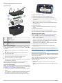
1
Alpha 100 with T5 ® Owner’s Manual June 2014 190-01771-00_0A Printed in Taiwan All rights reserved. Under the copyright laws, this manual may not be copied, in whole or in part, without the written consent of Garmin. Garmin reserves the right to change or improve its products and to make changes in the content of this manual without obligation to notify any person or organization of such changes or improvements. Go to www.garmin.com for current updates and supplemental information concerning the use of this product. Garmin®, the Garmin logo, Alpha®, BlueChart®, and City Navigator® are trademarks of Garmin Ltd. or its subsidiaries, registered in the USA and other countries. ANT+™, BaseCamp™, and tempe™ are trademarks of Garmin Ltd. or its subsidiaries. These trademarks may not be used without the express permission of Garmin. microSD™ and the microSDHC logo are trademarks of SD-3C, LLC. Windows® and Windows NT® are registered trademarks of Microsoft Corporation in the United States and other countries. Mac® is a trademark of Apple Computer, Inc., registered in the U.S. and other countries. Other trademarks and trade names are those of their respective owners. Table of Contents Getting Started............................................................... 1 Setting Up the Alpha System ..................................................... 1 Device Overviews ...................................................................... 1 Alpha 100 Handheld Device .................................................. 1 T5 Dog Collar Device ............................................................ 1 Getting More Information ........................................................... 1 Registering Your Device ............................................................ 1 Installing the Battery Pack ......................................................... 1 Charging the Handheld Device .................................................. 2 Charging the Dog Collar Device ................................................ 2 Turning On the Devices ............................................................. 2 Turning Off the Devices ........................................................ 2 Acquiring Satellite Signals ......................................................... 2 Using the Touchscreen .............................................................. 2 Locking the Touchscreen ........................................................... 2 Unlocking the Touchscreen ................................................... 2 Dog Collar Device Setup............................................... 2 Methods to Add a Dog Collar Device to a Handheld Device ..... 2 VHF Radio Information .......................................................... 3 Adding a Dog Over MURS/VHF ............................................ 3 Adding a Dog Using the Track and Train Codes ................... 3 Sharing a Dog Wirelessly ...................................................... 3 Editing Dog Information ............................................................. 3 Resetting a Dog's Statistics and Track .................................. 3 Changing the Length of the Dog's Track ............................... 3 Changing the Dog Name ....................................................... 3 Changing the Color of the Dog's Track ................................. 3 Changing the Dog Type ........................................................ 3 Changing the Dog ID ............................................................. 3 Setting Dog Alerts ................................................................. 4 Removing a Dog ................................................................... 4 Fitting the Collar on Your Dog .................................................... 4 Enabling Bark Detection ............................................................ 4 Communication with the Collar .................................................. 4 Dog Tracking.................................................................. 4 Tracking Your Dog on the Map .................................................. 4 Tracking and Training One Dog at a Time ................................. 4 Dog Status Icons ........................................................................ 5 Dog Tracking Compass ............................................................. 5 Navigating to Your Dog .............................................................. 5 Tracking with BaseCamp™ BaseStation ................................... 5 Pausing Dog Tracking ................................................................ 5 Pausing All Dog Tracking ........................................................... 5 Location Alerts ........................................................................... 5 Setting a Geofence Alert ....................................................... 5 Setting a Radius Alert ........................................................... 5 Editing Location Alerts .......................................................... 5 Dog Training................................................................... 5 Training Methods ....................................................................... 6 Setting Up the Training Keys for One Dog ................................. 6 Customizing the Training Keys .................................................. 6 Contact Tracking............................................................ 6 Adding a Contact Using MURS/VHF ......................................... 6 Adding a Contact Using a Contact ID ........................................ 6 Initiating an Emergency Alert ..................................................... 6 Sending a Message to Your Contacts ....................................... 6 Tracking a Contact ..................................................................... 6 Finding Your Contact ID ............................................................. 6 Changing Your Contact ID ......................................................... 7 Updating a Contact ID ................................................................ 7 Hunting with the Alpha System.................................... 7 Marking a Covey ........................................................................ 7 Turning On the Collar Light ........................................................ 7 Turning On Rescue Mode .......................................................... 7 Waypoints, Routes, and Tracks.................................... 7 Waypoints .................................................................................. 7 Marking Your Current Location ............................................. 7 Marking a Waypoint Using the Map ...................................... 7 Editing a Waypoint ................................................................ 7 Repositioning a Waypoint to Your Current Location ............. 7 Moving a Waypoint on the Map ............................................. 7 Increasing the Accuracy of a Waypoint Location .................. 8 Projecting a Waypoint ........................................................... 8 Deleting a Waypoint .............................................................. 8 Routes ........................................................................................ 8 Creating a Route ................................................................... 8 Editing the Name of a Route ................................................. 8 Navigating a Saved Route .................................................... 8 Editing a Route ...................................................................... 8 Reversing a Route ................................................................ 8 Viewing a Route on the Map ................................................. 8 Viewing the Active Route ...................................................... 8 Deleting a Route ................................................................... 8 Tracks ........................................................................................ 8 Recording Track Logs ........................................................... 8 Viewing Details about the Track ............................................ 8 Viewing the Elevation Plot of a Track .................................... 8 Navigating to the Start of a Track .......................................... 9 Changing the Track Color ..................................................... 9 Saving the Current Track ...................................................... 9 Saving a Location on a Track ................................................ 9 Clearing the Current Track .................................................... 9 Deleting a Track .................................................................... 9 Archiving a Saved Track ....................................................... 9 Archiving Tracks Automatically ............................................. 9 Sending and Receiving Data Wirelessly .................................... 9 Navigation.......................................................................9 Map ............................................................................................ 9 Measuring Distance on the Map ................................................ 9 Compass .................................................................................... 9 Calibrating the Compass ....................................................... 9 Navigating with the Bearing Pointer ...................................... 9 Course Pointer ...................................................................... 9 Where To? Menu ..................................................................... 10 Finding a Waypoint by Name .............................................. 10 Finding a Waypoint Near Another Waypoint ....................... 10 Navigating with Sight 'N Go ..................................................... 10 Elevation Plot ........................................................................... 10 Calibrating the Barometric Altimeter ................................... 10 Navigating to a Point on the Plot ......................................... 10 Changing the Plot Type ....................................................... 10 Resetting the Elevation Plot ................................................ 10 Trip Computer .......................................................................... 10 Resetting the Trip Computer ............................................... 10 Applications................................................................. 10 Setting a Proximity Alarm ......................................................... 10 Calculating the Size of an Area ................................................ 10 Viewing the Calendar and Almanacs ....................................... 10 Setting an Alarm ...................................................................... 10 Opening the Stopwatch ............................................................ 10 Satellite Page ........................................................................... 10 Changing the Satellite View ................................................ 11 Turning Off GPS .................................................................. 11 Simulating a Location .......................................................... 11 VIRB™ Remote ....................................................................... 11 Marking Your Truck Location ..................................................... 7 Table of Contents i Controlling a VIRB Action Camera with Your Handheld Device ................................................................................. 11 Customizing Your Device............................................ 11 Customizing the Main Menu .................................................... 11 Customizing the Data Fields .................................................... 11 Enabling the Map Data Fields ............................................. 11 System Settings ....................................................................... 11 Dog Settings ............................................................................ 11 Contact Settings ....................................................................... 11 Display Settings ....................................................................... 11 Calibrating the Touchscreen ............................................... 11 Appearance Settings ................................................................ 11 Setting the Device Tones ......................................................... 12 Map Settings ............................................................................ 12 Advanced Map Settings ...................................................... 12 Track Settings .......................................................................... 12 Routing Settings ....................................................................... 12 Changing the Units of Measure ............................................... 12 Time Settings ........................................................................... 12 Position Format Settings .......................................................... 12 Heading Settings ...................................................................... 12 Altimeter Settings ..................................................................... 12 Marine Map Settings ................................................................ 13 Device Information....................................................... 13 Viewing Device Information ..................................................... 13 Updating the Software ............................................................. 13 Device Care ............................................................................. 13 Cleaning the Device ............................................................ 13 Cleaning the Touchscreen .................................................. 13 Specifications ........................................................................... 13 Alpha 100 Handheld Device Specifications ........................ 13 T5 Dog Collar Device Specifications ................................... 13 Battery Information ................................................................... 13 Long-Term Storage ............................................................. 13 Maximizing the Battery Life ................................................. 13 Saving Energy While Charging the Device .............................. 14 Data Management ................................................................... 14 File Types ............................................................................ 14 Installing a Memory Card .................................................... 14 Connecting the Handheld Device to a Computer ................ 15 Connecting the Collar to a Computer .................................. 15 Transferring Dog Tracks to BaseCamp ............................... 15 Deleting Files ...................................................................... 15 Disconnecting the USB Cable ............................................. 15 Appendix .......................................................................15 Accessories and Replacement Parts ....................................... 15 Purchasing Accessories ...................................................... 15 ANT+ Sensors ..................................................................... 15 T5 Battery Replacement Instructions .................................. 16 Replacing the Collar Strap .................................................. 16 Replacing the VHF Antenna in the Dog Collar Device ........ 16 Changing the Fuse in the Vehicle Power Cable .................. 17 Data Field Options ................................................................... 17 Index ..............................................................................19 ii Table of Contents Getting Started T5 Dog Collar Device WARNING See the Important Safety and Product Information guide in the product box for product warnings and other important information. Setting Up the Alpha System NOTICE Avoid using a high-powered radio (greater than 5 watts) in close proximity to the device. It may cause irreversible damage to the device. Before you can use the Alpha handheld device and the T5 dog collar device, you must set up the devices. 1 Install the battery in the handheld device (Installing the Battery Pack). 2 Charge the handheld device (Charging the Handheld Device). 3 Charge the dog collar device (Charging the Dog Collar Device). 4 Turn on the devices (Turning On the Devices). 5 If necessary, add the dog collar device to the handheld device (Adding a Dog Over MURS/VHF). 6 Acquire satellite signals (Acquiring Satellite Signals). 7 Attach the collar (Fitting the Collar on Your Dog). Device Overviews Alpha 100 Handheld Device VHF antenna À Á  à Collar GPS antenna Power key Getting More Information You can find more information about this product on the Garmin® website. • Go to www.garmin.com/alpha. • Go to www.garmin.com/outdoor. • Go to www.garmin.com/learningcenter. • Go to http://buy.garmin.com, or contact your Garmin dealer for information about optional accessories and replacement parts. Registering Your Device Help us better support you by completing our online registration today. • Go to http://my.garmin.com. • Keep the original sales receipt, or a photocopy, in a safe place. Installing the Battery Pack WARNING This product contains a lithium-ion battery. To prevent the possibility of personal injury or product damage caused by battery exposure to extreme heat, store the device out of direct sunlight. 1 Turn the D-ring counter-clockwise, and pull up to remove the cover. À Á Â Ã Ä Å Æ Ç GPS antenna VHF radio antenna Training keys 2 Locate the metal contacts on the end of the lithium-ion battery. 3 Insert the battery into the compartment, contacts first. Power key Mounting spine microSD™ memory card slot (under battery) Battery cover D-ring Mini-USB port (under weather cap) 4 Press the battery into place. 5 Replace the battery cover, and turn the D-ring clockwise. Getting Started 1 Charging the Handheld Device NOTICE To prevent corrosion, thoroughly dry the USB port, the weather cap, and the surrounding area before charging or connecting to a computer. You should fully charge the battery before you use the device for the first time. Charging a fully depleted battery takes about 2 hours. NOTE: The device will not charge when it is outside the temperature range of 32° to 104°F (0° to 40°C). 1 Lift the weather cap À. • On the dog collar device, hold the power key until the status LED flashes and the collar beeps. Turning Off the Devices • On the handheld device, hold the power key until the LCD display turns off. • On the dog collar device, hold the power key until the status LED changes color. Acquiring Satellite Signals Both the collar and handheld device must acquire satellite signals before you put the collar on your dog. Acquiring satellites can take a few minutes. 1 Go outdoors to an open area. 2 Turn on both devices (Turning On the Devices). 3 Select the power key on the handheld device. shows the GPS signal strength. When the collar has acquired satellite signals, the status LED flashes a double-blink or triple-blink in green. Using the Touchscreen 2 Plug the small end of the power cable into the mini-USB port Á on the device. 3 Plug the other end of the power cable into an appropriate power source. Charging the Dog Collar Device NOTICE To prevent corrosion, thoroughly dry the contacts on the collar and the surrounding area before connecting the charging clip. You should fully charge the battery before you use the device for the first time. Charging a fully depleted battery takes about five hours. The device will not charge when outside the temperature range of 32° to 104°F (0° to 40°C). 1 Snap the charging clip À onto the device Á. • • • • • • • Select Select Select Select Select Select Select to open the application drawer. to open a menu. to close the page and return to the previous page. to return to the previous page. to save changes and close the page. and to scroll. to search by name. Locking the Touchscreen You can lock the screen to prevent inadvertent screen touches. 1 Select the Power key. 2 Select . Unlocking the Touchscreen 1 Select the Power key. 2 Select . Dog Collar Device Setup Methods to Add a Dog Collar Device to a Handheld Device 2 Plug the included power cable into the mini-USB port on the charging clip cable. 3 Plug the power cable into a power source. The status LED is solid red when the collar is charging. 4 After the status LED turns solid green, remove the charging clip from the collar. Turning On the Devices • On the handheld device, hold the power key until the LCD display turns on. 2 If you purchased the dog collar device and the handheld device separately, you must add the dog collar device to the handheld device. You can add up to 20 dog collar devices to one handheld device. Using MURS/VHF: Allows you to add a dog collar device after you have placed the dog collar device into pairing mode by pressing the power key. This method is helpful when you are adding a new accessory collar to the system prior to leaving for the hunt (Adding a Dog Over MURS/VHF). Entering the track and train codes: Allows you to add a dog collar device that you do not own and that is not in the area. The dog's owner must determine if you can only track the dog or can track and train the dog. This method requires the dog's owner to find and communicate the codes to the person adding the dog collar device. This method is helpful when you would like to add a dog collar device during a hunt, but you are not near the dog. For example, you are adding another member of your hunting party's dog collar device to your handheld device, but you do Dog Collar Device Setup not own the dog collar device (Adding a Dog Using the Track and Train Codes). NOTE: This feature varies based on dog collar device type and feature availability in your area. You may see track codes only or track and train codes. Sharing wirelessly using ANT+™ wireless technology: Allows you to add a dog collar device that you do not own and that is not in the area. The dog's owner must determine if you can only track the dog or can track and train the dog. This method does not require the dog's owner to find and communicate the codes to the person adding the dog collar device. This method also adds dog information, such as the dog's name, communication settings, and initial position, from the sending handheld device to your device. The two handheld devices must be within range 3 m (10 ft.) to share data wirelessly. This method is helpful when you want to add a dog collar device during a hunt, but you are not near the dog. For example, the dogs have already been let loose, and you are near the dog owner, who can share the dog wirelessly (Sharing a Dog Wirelessly). VHF Radio Information This product may be used only on specific radio frequencies, which vary depending on the country of use. See the product packaging or go to www.garmin.com/tracking-legal for details about the radio frequency of this product. Adding a Dog Over MURS/VHF 1 If the dog collar device is on, turn off the dog collar device 2 3 4 5 (Turning Off the Devices). Hold until the dog collar device emits two series of beeps (about 2 seconds), and then release . The status LED flashes rapidly in green. The dog collar device is now ready to be linked, or paired, with a handheld device. On the handheld device, select Dog List > Add Dog. Bring the dog collar device near the handheld device, and select Yes. After successfully adding the dog collar device, enter the name of the dog, and select > OK. Adding a Dog Using the Track and Train Codes NOTE: This feature varies based on dog collar device type and feature availability in your area. Before you can add a dog using the track and train codes, the dog owner must find the track and train codes (Finding the Dog ID and Track and Train Codes) and tell them to you. If you are not near the dog you want to add or you cannot put the collar into pairing mode, you can add the dog using the track and train codes. 1 Select Add Dog. 2 When asked if you are near the collar, select No. 3 When asked if you know the track and train codes, select Yes. 4 Enter the track or train code for the collar, and select . The dog’s track code allows you to track the dog. The dog’s train code allows you to both track and train the dog. 5 Enter the name of the dog, and select > OK. Finding the Dog ID and Track and Train Codes You can share a dog’s track code so another person can view your dog’s location with the map and dog tracking compass. Also, you can share a dog’s train code so another person can track your dog and train (correct) your dog. 1 Select Dog List. 2 Select a dog. Dog Collar Device Setup 3 Select Show Info. Sharing a Dog Wirelessly Before you can share data wirelessly over ANT+, you must bring your Alpha handheld device within 10 ft. (3 m) of the other handheld device. 1 Select Dog List. 2 Select the dog to share. 3 Select Share Wirelessly. 4 Select an option: • To allow the other person only to track your dog's location with the map and dog tracking compass, select Track Only. • To allow the other person to track your dog and correct your dog's behavior, select Track and Train. 5 On the other handheld device, select Dog List > > Receive Wirelessly. Editing Dog Information Resetting a Dog's Statistics and Track You might want to clear the dog statistics and track before a new hunt. 1 Select Dog List. 2 Select a dog. 3 Select Show Info > Reset > Yes. Changing the Length of the Dog's Track You can adjust the length of the dog's tracks shown on the map. Showing less tracks on the map can help to declutter the map view. Changing the length of the track shown on the map does not affect the tracks stored in the internal memory. 1 Select Setup > Dogs > Dog Track On Map. 2 Select an option to show more or less of the tracks on the map. Changing the Dog Name 1 Select Dog List. 2 Select a dog. 3 Select Show Info. 4 Select the dog’s name. 5 Enter the name, and select > OK. Changing the Color of the Dog's Track You can change the track color of the dog. It is helpful to have the track color match the color of the collar strap, if possible. 1 Select Dog List. 2 Select a dog. 3 Select Show Info. 4 Select the colored square next to the dog’s name. 5 Select a color. Changing the Dog Type Before you can change the dog type, the collar must be turned on and within range of the handheld device. 1 Select Dog List. 2 Select a dog. 3 Select Show Info > > Change Dog Type. 4 Select a dog type. Changing the Dog ID Before you can change the dog ID, the collar must be turned on and within range of the handheld device. 3 If you are experiencing interference from other collars or handheld devices in the area, you might need to change the ID for the dog. 1 Select Dog List. 2 Select a dog. 3 Select Show Info. 4 Select > Change ID. 5 Select an available ID. If another handheld device is tracking this dog, for best results, remove the dog from the device, and use the track and train codes (Adding a Dog Using the Track and Train Codes) or share wirelessly over ANT+ (Sharing a Dog Wirelessly) to add the dog again. Setting Dog Alerts You can adjust how the handheld device alerts you to certain actions of the dog. 1 Select Setup > Dogs > Dog Alerts. 2 Select an alert. 3 Select the handheld device action for the specific alert. 4 Repeat steps 2 and 3 as needed. Removing a Dog 1 Select Dog List. 2 Select a dog. 3 Select Remove. Fitting the Collar on Your Dog Before you can put the collar on the dog, you must pair the handheld device and collar (Adding a Dog Over MURS/VHF), and acquire satellite signals (Acquiring Satellite Signals). 1 Position the collar with the VHF whip antenna pointing up, the GPS antenna facing up, and the LEDs facing forward. 2 Place the collar around the middle of the dog's neck. 3 Tighten the strap so it is snug around the dog's neck. NOTE: The collar should fit tightly and should not be able to rotate or slide on the dog's neck. The dog must be able to swallow food and water normally. You should observe your dog's behavior to verify the collar is not too tight. automatically. After bark detection is enabled, you can set up a bark alert (Setting Dog Alerts). Communication with the Collar You should keep an unobstructed line of sight between your handheld device and the dog collar device to produce the best communication signal. To achieve the best line-of-sight conditions, you should move to the highest elevation point in your area (for example, on the top of a hill). Best Good Poor Dog Tracking The handheld device allows you to track your dog, using the tracking compass or map. The map displays your location and your dog's location and tracks. The compass pointer indicates the direction of the dog's current location. Tracking Your Dog on the Map Before you can track a dog or contact on the map, you must add them to the handheld device (Adding a Dog Over MURS/VHF and Adding a Contact Using MURS/VHF). You can view the dog's location and other contacts' locations on the map. 1 Select . 2 If necessary select and to zoom in and out of the map. TIP: If necessary, select to track the dog using the dog tracking compass (Dog Tracking Compass). 4 If the strap is too long, cut off the excess, leaving at least 3 in. (7.62 cm) to spare. Enabling Bark Detection NOTE: This feature is not available in all areas. Select Setup > Dogs > Bark Detection. A barking icon appears on the dog tracking page and the map page. When the dog collar device is active and properly fitted on the dog (Fitting the Collar on Your Dog), it detects barks 4 Tracking and Training One Dog at a Time NOTE: This feature applies only to dog collar devices with training features. When you are tracking and training multiple dogs, you can enable the device to display only one dog at a time, and you can ensure the dog being viewed on the compass is the dog being trained. 1 Select > > List Sync On. 2 Select and to cycle through the dogs. Dog Tracking 2 Select a dog. 3 Select Show Info > Dog Status Icons Sitting > Stop Tracking. Running Pausing All Dog Tracking On point If you are moving the dogs during a hunt and you do not want to record the transportation of the dogs, you can pause the tracking of all of the dogs. 1 Select . 2 Select > Pause All Tracking. Treed Unknown* *The unknown status icon indicates that the collar has not acquired a satellite signal and that the handheld device cannot determine the location of the dog. Dog Tracking Compass To open the dog tracking compass, select . Location Alerts Location alerts notify you when your dogs or contacts enter or exit a particular location. You can create a custom geofence or use a radius around your current location. A geofence is an invisible boundary around an area and is created using points on the map. The virtual boundaries of a geofence are accurate up to approximately 10 ft. (3 m). Geofences perform best when sized to cover an area encompassing an average sized backyard (approximately ¼ acre). Setting a Geofence Alert You can use the dog tracking compass to view the direction and distance to your dog. The dog tracking compass also shows the dog's status, such as running or on point (Dog Status Icons). The color of the pointer corresponds to the color of the dog track. The dog tracking compass is most accurate when the dog is more than 30 ft. (9.1 m) away. When the dog is less than 30 ft. (9.1 m) away, "Near" appears. Navigating to Your Dog 1 Select Dog List. 2 Select the dog. 3 Select Show Info > Go. The map opens. 4 Follow the magenta line to the dog. 5 If necessary, select to track the dog using the dog tracking compass. Tracking with BaseCamp™ BaseStation Before you can track your dogs and contacts using BaseCamp, you must download BaseCamp to your computer (www.garmin.com/basecamp). The BaseStation feature of BaseCamp allows you to track your dogs and contacts in real-time on a computer. For more information on using BaseCamp, see the help file in the application. 1 Select Setup > System > BaseCamp BaseStation > Prompted. 2 Open BaseCamp. 3 Follow the on-screen instructions. Pausing Dog Tracking You can pause the tracking of a single dog during a hunt. This can be helpful if the dog is taking a break. 1 Select Dog List. Dog Training You can set up an invisible boundary around an area and receive an alert when a dog or contact enters and exits that area. 1 Select Setup > Location Alerts > Add Alert > Geofence. 2 Select a point on the map, and select Use. 3 Repeat step 2 to define a geofence with up to 10 points. 4 Select Done. Setting a Radius Alert You can receive an alert when a dog or contact gets within or outside of a certain distance away from you. 1 Select Setup > Location Alerts > Add Alert > Radius. 2 Select the unit of measurement. 3 Enter the radius distance, and select . Editing Location Alerts 1 Select Setup > Location Alerts. 2 Select an alert. 3 Select an option: • Select Disable to turn off notifications for this alert. • Select Set Alert Type to set the way the device notifies you for this alert. • Select Set Alert Mode to set the notification to sound on exit, entrance, or both. • Select Delete to remove the alert. Dog Training You should research and investigate the training methods best suited for you, your dog, and your needs. This manual provides some basic guidelines for training, but each dog has unique training needs. When used properly, the Alpha training system is a very effective training tool to aid your dog in reaching its full potential. The use of the training system should be part of an overall training program. Begin training your dog on a leash, without the Alpha training system. You should train your dog how to heel, sit, and come to you. After the dog understands these three basic commands, you can begin training with the dog collar device and the leash. Finally, when the dog consistently obeys commands using the leash and collar, you may be able to remove the leash to train with only the dog collar device. 5 Training Methods NOTE: Training features are not available in all areas for tracking collars. Tone: Activates an audible tone instead of stimulation. A tone can be used as either a positive or negative training cue, depending on your training program. Vibration: Applies vibration instead of stimulation to the dog the entire time you press the training key, for a maximum of 8 seconds. The effectiveness of vibration may vary based on the dog's temperament and experience. Setting Up the Training Keys for One Dog NOTE: Training features are not available in all areas for tracking collars. Before you can assign the training keys to a dog, you must add the dog to the handheld device (Adding a Dog Over MURS/ VHF). By default, the training keys are set to tone (T), vibration (V), or light (L) for each key. This mode is most useful when training only one dog. When training multiple dogs, it may be helpful to customize a training key for each dog and for each training method (Customizing the Training Keys). 1 Select Setup > Training > Training Buttons. 2 Select the area at the top of the screen directly below the keys. 3 Select . In this mode, the left key provides a tone. The right key provides a vibration. Customizing the Training Keys NOTE: Training features are not available in all areas for tracking collars. Before you can assign the training keys to a dog, you must add a dog to the handheld device (Adding a Dog Over MURS/VHF). You can assign a specific dog training method to each training key. You can add multiple pages of training key settings. This mode is most useful when training multiple dogs. 1 Select Setup > Training > Training Buttons > Change Mode. 2 Select below the key you are customizing. 3 Select the dog to train with this key. 4 Select tone (T), vibration (V), or light (L). 5 Repeat steps 2-4 for all three keys. 6 If you need to train with more than three keys, select > Insert Page, and program the additional keys. 7 Select . Contact Tracking You can track other hunters so you know where they are at all times. You can also send messages to your contacts. One Alpha handheld device can track up to 20 devices, including T5 dog collar devices and Alpha handheld devices. Adding a Contact Using MURS/VHF Before you can add a contact using MURS/VHF, you should be near the contact, and you must turn on the transmitter (Turning On the Transmitter). You can add fellow hunters to your handheld device so you can track them on the map (Tracking a Contact) and send messages to them (Sending a Message to Your Contacts). > Contacts > Add. 1 On your handheld device, select 6 2 Bring the two handheld devices near each other, and select Yes on your handheld device. 3 On the contact's handheld device, select > Contacts > Pair. 4 On your handheld device, enter the name of the contact, and select > OK. The contact is added to your handheld device. You can repeat this procedure using another hunter's handheld device to add your contact ID to that device. Adding a Contact Using a Contact ID Before you can add a hunter using a contact ID, the hunter must find the contact ID (Finding Your Contact ID) and send it to you. You must also turn on the transmitter (Turning On the Transmitter). If you are not near the hunter you want to add, you can add the hunter using a contact ID. > Contacts > Add. 1 On your handheld device, select 2 When asked if you are near the other handheld device, select No. When asked if you know the contact ID, select Yes. 3 4 Select the contact ID for the contact you are adding. 5 Enter the name of the contact, and select > OK. The contact is added to your handheld device. You can repeat this procedure using another hunter's handheld device to add your contact ID to that device. Initiating an Emergency Alert Before you can initiate an emergency alert, you must turn on the transmitter (Turning On the Transmitter). Before someone can receive your emergency alert, someone must add you as a contact (Adding a Contact Using MURS/ VHF). You can use an emergency alert when you need immediate assistance and you are away from your group. Select > Contacts > > Yes. When your contact accepts your emergency alert request, the device displays a message indicating that your contact has started navigating to your location. After receiving the alert, your contacts can navigate to your location. Sending a Message to Your Contacts You can send and receive automated messages. There are 18 messages choose from, such as "Help" and "I'm Coming." > Contacts > Message. 1 Select 2 Select a message. The message is sent to your contacts with your name before the message. Anyone tracking your handheld device receives the message. Tracking a Contact You can keep track of contacts' locations using the map. Select . Finding Your Contact ID Select Setup > Contacts > Pairing Setup. The contact ID for your handheld device is listed under ID. Contact Tracking Changing Your Contact ID If you are experiencing interference from other collars or handheld devices in the area, you might need to change the contact ID for your handheld device. 1 Select Setup > Contacts > Pairing Setup > ID. 2 Select a contact ID that is not yet assigned to another device in the area. If you select a contact ID that interferes with devices in the area, you should select a new contact ID. Each time a contact changes their contact ID, you must update the contact ID in your handheld device(Updating a Contact ID). Updating a Contact ID If a contact has changed their contact ID (Changing Your Contact ID), you can quickly update the contact ID in your handheld device. > Contacts. 1 Select 2 Select the contact. 3 Select Show Info. 4 Select > Change ID. 5 Select the contact ID that matches the contact's new contact ID. Hunting with the Alpha System You can perform many tasks that are very helpful when you are hunting with the Alpha system. • Mark your truck's location (Marking Your Truck Location). • Track your dogs (Tracking Your Dog on the Map). • Track your fellow hunters (Tracking a Contact). • Mark the location of a covey (Marking a Covey). • Send messages to your fellow hunters (Sending a Message to Your Contacts). • Turn on the collar light (Turning On the Collar Light). • Put the collar into rescue mode to save battery power (Turning On Rescue Mode). • Pause tracking while you move the dogs (Pausing Dog Tracking). Marking Your Truck Location You can mark the location of the truck, so you can navigate back to your truck after the hunt. 1 Select New Hunt. 2 Follow the on-screen instructions. Marking a Covey You can mark a covey location and enter the estimated number of birds flushed and the number of birds taken. 1 Select Mark. 2 Select Covey. 3 Enter the number of birds flushed. 4 Enter the number of birds taken. 5 Select OK. Turning On the Collar Light You can turn on the LEDs on the collar at night to help locate a dog or to warn drivers if a dog wanders near a road. The light is visible for up to 100 yards. 1 Select Dog List. 2 Select a dog. Hunting with the Alpha System 3 Select Show Info. 4 Select > Adjust Collar Light. 5 Select Continuous, Blink Slow, or Blink Fast. TIP: Select different light setting for each dog to help you identify the dogs in the field. Turning On Rescue Mode You can turn on rescue mode to conserve battery power at the end of a long hunt or if your dog might get out of range. 1 Select Dog List. 2 Select a dog. 3 Select Show Info > > Rescue Mode. After you have turned on rescue mode, it stays on until you turn it off. When the collar battery power falls below 25%, the collar data updates only once every 2 minutes. Waypoints, Routes, and Tracks Waypoints Waypoints are locations you record and store in the device. Marking Your Current Location 1 Select Mark. 2 Select an option: • Select New. • Select a default location name, such as Truck or Camp. 3 Select Save. Marking a Waypoint Using the Map 1 Select . 2 Select the location on the map. 3 Select the information bar along the top of the screen. 4 Select > OK. Editing a Waypoint Before you can edit a waypoint, you must create a waypoint. Select > Waypoint Manager. Select a waypoint. Select an item to edit, such as the name. Enter the new information. Select . 1 2 3 4 5 Repositioning a Waypoint to Your Current Location You can change the position of a waypoint. For example, if you move your vehicle, you can change the location to your current position. > Waypoint Manager. 1 Select 2 Select a waypoint. 3 Select > Reposition Here. The waypoint location changes to your current location. Moving a Waypoint on the Map > Waypoint Manager. 1 Select 2 Select a waypoint. 3 Select > Move Waypoint. 4 Select the new location on the map. 5 Select Move. 7 Increasing the Accuracy of a Waypoint Location You can refine a waypoint location for more accuracy. When averaging, the device takes several readings at the same location and uses the average value to provide more accuracy. > Waypoint Manager. 1 Select 2 Select a waypoint. 3 Select > Average Location. 4 Move to the waypoint location. 5 Select Start. 6 Follow the on-screen instructions. 7 When the confidence status bar reaches 100%, select Save. For best results, collect 4 to 8 samples for the waypoint, waiting at least 90 minutes between samples. Projecting a Waypoint You can create a new location by projecting the distance and bearing from a marked location to a new location. > Waypoint Manager. 1 Select Select a waypoint. 2 3 Select > Project Waypoint. 4 Enter the bearing, and select . 5 Select a unit of measure. 6 Enter the distance, and select . 7 Select Save. Deleting a Waypoint > Waypoint Manager. 1 Select 2 Select a waypoint. 3 Select > Delete > Yes. Creating a Route > Route Planner > Create Route > Select First 1 Select Point. Select a category. Select the first point on the route. Select Use > Select Next Point. Select a point. Repeat steps 3 through 6 to add all the points in the route. . Navigating a Saved Route > Route Planner. 1 Select 2 Select a route. 3 Select View Map > Go. 4 Navigate using the compass (Navigating with the Bearing Pointer) or map (Map). Editing a Route > Route Planner. 1 Select 2 Select a route. 3 Select Edit Route. 4 Select a point. 5 Select an option: 8 Viewing a Route on the Map > Route Planner. 1 Select Select a route. 2 3 Select View Map. Viewing the Active Route > Active Route. 1 Select 2 Select a point in the route to view additional details. Deleting a Route > Route Planner. 1 Select Select a route. 2 3 Select Delete Route > Yes. A track is a recording of your path. The track log contains information about points along the recorded path, including time, location, and elevation for each point. A route is a sequence of waypoints or locations that leads you to your final destination. Editing the Name of a Route > Route Planner. 1 Select 2 Select a route. 3 Select Change Name. 4 Enter the new name, and select Reversing a Route > Route Planner. 1 Select 2 Select a route. 3 Select Reverse Route. Tracks Routes 2 3 4 5 6 • To view the point on the map, select Review. • To change the order of the points on the route, select Move Up or Move Down. • To insert an additional point on the route, select Insert. The additional point is inserted before the point you are editing. • To remove the point from the route, select Remove. Recording Track Logs > Setup > Tracks > Track Log. 1 Select 2 Select Record, Do Not Show or Record, Show On Map. If you select Record, Show On Map, a line on the map indicates your track. 3 Select Record Method. 4 Select an option: • To record tracks at a variable rate that create an optimum representation of your tracks, select Auto. • To record tracks at a specified distance, select Distance. • To record tracks at a specified time, select Time. Select Interval. 5 6 Complete an action: • If you selected Auto for the Record Method, select an option to record tracks more or less often. NOTE: Using the Most Often interval provides the most track detail, but fills up the device memory quicker. • If you selected Distance or Time for the Record Method, enter a value, and select . As you move with the device turned on, a track log is created. Viewing Details about the Track > Track Manager. 1 Select 2 Select a track. 3 Select View Map. The beginning and the end of the track are marked by flags. Select the information bar along the top of the screen. 4 Information about the track is listed. Viewing the Elevation Plot of a Track > Track Manager. 1 Select Waypoints, Routes, and Tracks 2 Select a track. 3 Select Elevation Plot. Navigating to the Start of a Track You can navigate back to the beginning of a track. This can be helpful when finding your way back to camp or the trail head. > Track Manager > Current Track > View Map. 1 Select 2 Select TracBack. The map page opens with your route marked with a magenta line. 3 Navigate using the map (Map) or the compass (Navigating with the Bearing Pointer). Changing the Track Color > Track Manager. 1 Select 2 Select a track. 3 Select Set Color. 4 Select a color. Saving the Current Track > Track Manager. 1 Select 2 Select a track. 3 Select an option: • To save the entire track, select Save Track. • To save part of the track, select Save Portion, and select the part to save. Saving a Location on a Track > Track Manager. 1 Select 2 Select a track. 3 Select View Map. 4 Select a location along the track. 5 Select the information bar along the top of the screen. 6 Select . 7 Select OK. Clearing the Current Track Select > Track Manager > Current Track > Clear Current Track. Deleting a Track > Track Manager. 1 Select 2 Select a track. 3 Select Delete > Yes. Archiving a Saved Track You can archive saved tracks to save memory space. > Track Manager. 1 Select 2 Select a saved track. 3 Select Archive. Archiving Tracks Automatically 1 Select Setup > Tracks > Auto Archive. 2 Select an option. Navigation You can navigate routes and tracks, to a waypoint, geocache, photo, or any saved location in the device. You can use the map or the compass to navigate to your destination. Map represents your location on the map. As you travel, the icon moves and leaves a track log (trail). Waypoint names and symbols appear on the map. When you are navigating to a destination, your route is marked with a magenta line on the map. When the map orientation is Track Up, objects on the map appear to rotate around your position. As you travel, the entire map reorients in the direction you are facing. You can stabilize the objects by setting the orientation to North Up (Map Settings). To open the map, select . Measuring Distance on the Map You can measure the distance between two points. 1 From the map, select a location. 2 Select > Measure Distance > Use. 3 Move the pin to another location on the map. Compass The handheld device has a 3-axis, tilt-compensated compass. You can use a bearing pointer or a course pointer to navigate to your destination. Calibrating the Compass NOTICE Calibrate the electronic compass outdoors. To improve heading accuracy, do not stand near objects that influence magnetic fields, such as vehicles, buildings, and overhead power lines. You should calibrate the compass after moving long distances, experiencing temperature changes, or removing the battery. > Compass > > Calibrate Compass > Start. 1 Select 2 Follow the on-screen instructions. Navigating with the Bearing Pointer When navigating to a destination, points to your destination, regardless of the direction you are moving. > Compass. 1 While navigating to a destination, select 2 Turn until points toward the top of the compass, and continue moving in that direction to the destination. Course Pointer The course pointer is most useful if you are navigating on water or where there are no major obstacles in your path. It also helps you avoid hazards to either side of the course, such as shoals or submerged rocks. To enable the course pointer, from the compass, select > Setup Heading > Go To Line/Pointer > Course (CDI). Sending and Receiving Data Wirelessly Before you can share data wirelessly, you must be within 10 feet (3 m) of a compatible Garmin device. You can share waypoints, geocaches, routes, and tracks wirelessly. > Share Wirelessly. 1 Select 2 Select Send or Receive. 3 Follow the on-screen instructions. Navigation The course pointer À indicates your relationship to the course line leading to the destination. The course deviation indicator (CDI) Á provides the indication of drift (right or left) from the 9 course. The scale  refers to the distance between dots à on the course deviation indicator, which tell you how far off course you are. Where To? Menu You can use the Where To? menu to find a destination to navigate to. Not all Where To? categories are available in all areas and maps. Finding a Waypoint by Name > Where To? > Waypoints > 1 Select 2 Enter the name. 3 Select . > Spell Search. Finding a Waypoint Near Another Waypoint > Waypoint Manager. 1 Select 2 Select a waypoint. 3 Select > Find Near Here. 4 Select a category. The list displays waypoints near the original waypoint. Navigating with Sight 'N Go You can point the device at an object in the distance, lock in the direction, and navigate to the object. > Sight 'N Go. 1 Select Point the device at an object. 2 3 Select Lock Direction > Set Course. 4 Navigate using the compass (Navigating with the Bearing Pointer) or map (Map). Elevation Plot By default, the elevation plot displays the elevation for an elapsed time. You can customize the plot (Changing the Plot Type) and the data fields (Customizing the Data Fields). To open the elevation plot, select > Elevation Plot. Calibrating the Barometric Altimeter You can manually calibrate the barometric altimeter if you know the correct elevation or the correct barometric pressure. 1 Go to a location where the elevation or barometric pressure is known. > Elevation Plot > > Calibrate Altimeter. 2 Select 3 Follow the on-screen instructions. Navigating to a Point on the Plot > Elevation Plot. 1 Select Select an individual point on the plot. 2 3 4 5 6 Details about the point appear in the upper-left corner of the plot. Select > View Map. Select the information bar along the top of the screen. Select Go. Navigate using the compass (Navigating with the Bearing Pointer) or map (Map). Changing the Plot Type You can change the elevation plot to display pressure and elevation over time or distance. > Elevation Plot > > Change Plot Type. 1 Select 2 Select an option. Resetting the Elevation Plot Select > Elevation Plot > Track > Yes. 10 > Reset > Clear Current Trip Computer The trip computer displays your current speed, average speed, maximum speed, trip odometer, and other helpful statistics. You can customize the trip computer layout, dashboard, and data fields (Customizing the Data Fields). > Trip Computer. To open the trip computer, select Resetting the Trip Computer For accurate trip information, reset the trip information before beginning a trip. Select > Trip Computer > > Reset > Reset Trip Data > Yes. Applications Setting a Proximity Alarm Proximity alarms alert you when you or your dogs are within a specified range of a particular location. A tone sounds when you enter the designated radius. > Proximity Alarms. 1 Select 2 Select Create Alarm. 3 Select a category. 4 Select a location. 5 Select Use. 6 Enter a radius. When you enter an area with a proximity alarm, the device sounds a tone. Calculating the Size of an Area > Area Calculation > Start. 1 Select 2 Walk around the perimeter of the area you want to calculate. 3 When finished, select Calculate. Viewing the Calendar and Almanacs You can view device activity, such as when a waypoint was saved, and almanac information for the sun and moon, and hunting and fishing. 1 Select . 2 Select an option: • To view device activity for specific days, select Calendar. • To view the sunrise, sunset, moonrise, and moonset times, select Sun and Moon. • To view the predicted best times for hunting and fishing, select Hunt and Fish. 3 If necessary, select or to view a different day. Setting an Alarm 1 2 3 4 Select > Alarm Clock. Select and to set the time. Select Turn Alarm On. Select an option. The alarm sounds at the selected time. If the device is off at the alarm time, the device turns on and sounds the alarm. Opening the Stopwatch Select > Stopwatch. Satellite Page The satellite page shows your current location, GPS accuracy, satellite locations, and signal strength. Applications Changing the Satellite View By default, the satellite view is with North at the top. You can change the view of the satellites to be oriented with your current track toward the top of the screen. > Satellite > . 1 Select 2 Select Track Up. Turning Off GPS Select > Satellite > > Use With GPS Off. Simulating a Location > Satellite > > Use With GPS Off. 1 Select 2 Select > Set Location On Map. 3 Select a location. 4 Select Use. VIRB™ Remote The VIRB remote function allows you to control your VIRB action camera from a distance. Go to www.garmin.com/VIRB to purchase a VIRB action camera. Controlling a VIRB Action Camera with Your Handheld Device Before you can use the VIRB remote function on your handheld device, you must enable the remote setting on your VIRB camera. See the owner's manual for your VIRB camera for more information. 1 Turn on your VIRB camera. > VIRB Remote. 2 From your handheld device, select 3 Wait while the handheld device connects to your VIRB camera. 4 Select an option: • To start and stop recording video, select REC. • To take a photo, select . Customizing Your Device Customizing the Main Menu You can move, add, and delete items in the main menu. 1 From the main menu, select Setup > Main Menu. 2 Select a menu item. 3 Select an option: • Select Move Up or Move Down to change the location of the item in the list. • Select Remove to delete an item from the list. • Select Add Page to place an item on the list after you have removed it. • Select > Restore Defaults to reset the order of all items in the menu. Customizing the Data Fields Before you can customize the data fields on the map, you must enable the data fields (Enabling the Map Data Fields). You can customize the data fields and dashboards of the map, compass, elevation plot, and trip computer. 1 Open the page for which you will change the data fields. 2 Select a data field to customize. 3 Select the new data field. For data field descriptions, see Data Field Options. Customizing Your Device Enabling the Map Data Fields Select Fields. > > Setup Map > Dashboard > Small Data System Settings Select Setup > System. GPS: Sets the GPS to Normal, WAAS/EGNOS (Wide Area Augmentation System/European Geostationary Navigation Overlay Service), or Demo Mode (GPS off). For more information about WAAS, go to http://www.garmin.com /aboutGPS/waas.html. BaseCamp BaseStation: Sets how the device connects to BaseCamp when the device is connected to the computer. Dog Settings Select Setup > Dogs. Dog Track On Map: Sets the length (duration in minutes or hours) of the dog track on the map. Reducing the duration of the track shown can reduce the clutter on the map. Zoom Map To Dogs: Automatically zooms the map to show all of the dogs' locations and your location unless you manually pan the map. Dog Alerts: Sets how you are alerted to certain actions (Setting Dog Alerts). Bark Detection: Enables the bark detection feature. This feature is not available in all areas. Contact Settings Select Setup > Contacts. Contact Track On Map: Sets the length (duration in minutes or hours) of the contact track on the map. Zoom Map To Contacts: Automatically zooms the map to show all of the contacts' locations and your location unless you manually pan the map. Message Alerts: Sets message alerts to Tone, Vibrate, Tone and Vibrate, or Message Only. Pairing Setup: Sets the options your device uses to track and communicate with other devices. Display Settings Select Setup > Display. Backlight Timeout: Adjusts the length of time before the backlight turns off. Screen Capture: Allows you to save the image on the device screen. Battery Save: Saves the battery power and prolongs the battery life by turning off the screen when the backlight times out (Turning On the Handheld Battery Save Mode). Calibrate Screen: Aligns the screen to properly respond to touches (Calibrating the Touchscreen). Calibrating the Touchscreen You can calibrate the screen, if it does not seem to be responding properly. 1 Select Setup > Display > Calibrate Screen. 2 Follow the on-screen instructions. Appearance Settings Select Setup > Appearance. Mode: Sets a light background, a dark background, or automatically switches between the two based on the sunrise and sunset time for your current location. Background: Sets the background image. 11 Day Highlight Color: Sets the color for selections made when in day mode. Night Highlight Color: Sets the color for selections made when in night mode. Setting the Device Tones You can customize tones for messages, keys, warnings, and alarms. 1 Select Setup > Tones. 2 Select a tone for each audible type. Map Settings Select Setup > Map. Orientation: Adjusts how the map is shown on the page. North Up shows north at the top of the page. Track Up shows your current direction of travel toward the top of the page. Automotive Mode shows an automotive perspective with the direction of travel at the top. Guidance Text: Sets when the guidance text on the map is shown. Dashboard: Sets a dashboard to display on the map. Each dashboard shows different information about your route or your location. Map Information: Enables or disables the maps currently loaded on the device. Map Speed: Adjusts the speed at which the map is drawn. A faster map drawing speed decreases the battery life. Advanced Map Settings Select Setup > Map > Advanced Setup. Auto Zoom: Automatically sets the zoom level for optimal use of your map. When Off is selected, you must zoom in or out manually. Detail: Sets the amount of detail shown on the map. Showing more detail may cause the map to redraw more slowly. Shaded Relief: Shows detail relief on the map (if available) or turns off shading. Vehicle: Allows you to select a position icon, which represents your position on the map. Zoom Levels: Sets the zoom level at which map items will appear. Map items do not appear when the map zoom level is higher than the selected level. Text Size: Sets the text size for map items. Track Settings Select Setup > Tracks. Track Log: Turns track recording on or off. Record Method: Sets a track recording method. Auto records the tracks at a variable rate to create an optimum representation of your tracks. Interval: Sets a track log recording rate. Recording points more frequently creates a more-detailed track, but fills the track log faster. Auto Archive: Sets an automatic archive method to organize your tracks. Tracks are saved and cleared automatically based on the user setting. Color: Sets the color of the track line on the map. Routing Settings The device calculates routes optimized for the type of activity you are doing. The routing settings available vary based on the activity selected. Select Setup > Routing. 12 Activity: Sets an activity for routing. The device calculates routes optimized for the type of activity you are doing. Route Transitions: Sets how the device routes from one point on the route to the next. This setting is available only for some activities. Distance routes you to the next point on the route when you are within a specified distance of your current point. Lock On Road: Locks the position icon, which represents your position on the map, onto the nearest road. Changing the Units of Measure You can customize units of measure for distance and speed, elevation, depth, temperature, and pressure. 1 Select Setup > Units. 2 Select a measurement type. 3 Select a unit of measure for the setting. Time Settings Select Setup > Time. Time Format: Sets the device to show time in a 12-hour or 24hour format. Time Zone: Sets the time zone for the device. Automatic sets the time zone automatically based on your GPS position. Position Format Settings NOTE: Do not change the position format or the map datum coordinate system unless you are using a map or chart that specifies a different position format. Select Setup > Position Format. Position Format: Sets the position format for the location information. Map Datum: Sets the coordinate system on which the map is structured. Map Spheroid: Shows the coordinate system the device is using. The default coordinate system is WGS 84. Heading Settings You can customize the compass settings. Select Setup > Heading. Display: Sets the type of directional heading shown on the compass. North Reference: Sets the north reference used on the compass. Go To Line/Pointer: Sets the behavior of the pointer that appears on the map. Bearing points in the direction of your destination. Course (CDI) shows your relationship to the course line leading to the destination. Compass: Automatically switches from an electronic compass to a GPS compass when you are traveling at a higher rate of speed for a period of time. Calibrate Compass: Calibrates the compass (Calibrating the Compass). Altimeter Settings Select Setup > Altimeter. Auto Calibration: Automatically calibrates the altimeter each time the device is turned on. Barometer Mode: Sets how the device measures barometric information. Variable Elevation allows the barometer to measure changes in elevation while you are moving. Fixed Elevation assumes the device is stationary at a fixed elevation, so the barometric pressure should change only due to weather. Customizing Your Device Pressure Trending: Sets how the device records pressure data. Save Always records all pressure data, which can be helpful when you are watching for pressure fronts. Plot Type: Sets the type of data recorded and displayed in the plot. Records elevation changes over a period of time or distance, records barometric pressure over a period of time, or records ambient pressure changes over a period of time. Calibrate Altimeter: Calibrates the altimeter. Marine Map Settings Select Setup > Marine. Marine Chart Mode: Sets the type of chart the device uses. Nautical displays various map features in different colors so the marine POIs are more readable and so the map reflects the drawing scheme of paper charts. Fishing (requires marine maps) displays a detailed view of bottom contours and depth soundings and simplifies map presentation for optimal use while fishing. Appearance: Sets the appearance of marine navigation aids on the map. Marine Alarm Setup: Sets alarms for when you exceed a specified drift distance while anchored, when you are off course by a specified distance, and when you enter water of a specific depth. Device Information Viewing Device Information You can view the unit ID, software version, and license agreement. Select Setup > About. Updating the Software Before you can update the handheld device or collar software, you must connect the handheld device (Connecting the Handheld Device to a Computer) or the collar (Connecting the Collar to a Computer) to the computer. You must update the software on the handheld device and collar separately. NOTE: Updating the software does not erase any of your data or settings. 1 Go to www.garmin.com/products/webupdater. 2 Follow the on-screen instructions. Device Care NOTICE Do not store the device where prolonged exposure to extreme temperatures can occur, because it can cause permanent damage. Never use a hard or sharp object to operate the touch screen, or damage may result. Avoid chemical cleaners and solvents that can damage plastic components. Secure the weather cap tightly to prevent damage to the USB port. Cleaning the Device 1 Wipe the device using a cloth dampened with a mild detergent solution. 2 Wipe it dry. Cleaning the Touchscreen 1 Use a soft, clean, lint-free cloth. 2 If necessary, lightly dampen the cloth with water. Device Information 3 If using a dampened cloth, turn off the device and disconnect the device from power. 4 Gently wipe the screen with the cloth. Specifications Alpha 100 Handheld Device Specifications Battery type Rechargeable, replaceable lithium-ion Battery life Up to 20 hr. Operating temperature range From -4° to 140°F (from -20° to 60°C) Charging temperature range From 32° to 104°F (from 0° to 40°C) Long-term storage temperature From 32° to 77°F (from 0° to 25°C) range VHF wireless range Up to 9 mi. ANT+ low power wireless range About 10 ft. (3 m) Water rating IEC 60529 IPX7* *The device withstands incidental exposure to water of up to 1 m for up to 30 min. T5 Dog Collar Device Specifications Battery type Internal rechargeable lithium-ion battery Battery life From 20 to 40 hr. Operating temperature range From -4° to 140°F (from -20° to 60°C) Charging temperature range ANT® wireless range From 32° to 104°F (from 0° to 40°C) VHF radio range Up to 9 mi. (14.48 km) Water rating 1 ATM* Up to 10 m *The device withstands pressure equivalent to a depth of 10 m. Battery Information WARNING This product contains a lithium-ion battery. To prevent the possibility of personal injury or product damage caused by battery exposure to extreme heat, store the device out of direct sunlight. Do not use a sharp object to remove batteries. CAUTION Contact your local waste disposal department to properly recycle the batteries. Long-Term Storage NOTICE The normal long-term decrease in the charging capacity of lithium-ion batteries can be accelerated by exposure to elevated temperatures. Storing a fully charged device in a location with a temperature outside the long-term storage temperature range can significantly reduce its recharging capacity. When you do not plan to use the handheld device for several months, the battery should be removed. Stored data is not lost when the battery is removed. When you do not plan to use the collar for several months, the battery should be charged to about 50%. The device should be stored in a cool, dry place with temperatures around the typical household level. After storage, the collar should be fully recharged before use. Maximizing the Battery Life You can do several things to extend the life of the batteries in the handheld device and collar. • Reduce the backlight brightness (Adjusting the Backlight Brightness). 13 • Reduce the backlight timeout (Adjusting the Backlight Timeout). • Select a longer duration for your handheld update rate (Changing Your Handheld Update Rate). • Turn off the transmitter (Turning Off the Transmitter). • Use battery save mode (Turning On the Handheld Battery Save Mode) • Decrease the map drawing speed (Adjusting the Map Drawing Speed). • Put the dog collar device into rescue mode (Turning On Rescue Mode) to conserve the collar battery. • Extend the duration for the collar update rate (Changing the Dog Collar Device Update Rate) to conserve the collar battery. Adjusting the Backlight Brightness Extensive use of screen backlighting can significantly reduce battery life. You can adjust the backlight brightness to maximize the battery life. NOTE: The backlight brightness may be limited when the battery is low. 1 Select . 2 Use the slider bar to adjust the backlight brightness. The device may feel warm when the backlight setting is high. Adjusting the Backlight Timeout You can decrease the backlight timeout to maximize the battery life. 1 Select Setup > Display > Backlight Timeout. 2 Select an option. Changing the Dog Collar Device Update Rate Before you can change the collar update rate, the collar must be turned on and within range of the handheld device. You can select a longer duration for the update rate to conserve battery power. 1 Select Dog List. 2 Select a dog. 3 Select Show Info > > Change Update Rate. Changing Your Handheld Update Rate You can select a longer duration for the update rate to conserve battery power. 1 Select Setup > Contacts > Pairing Setup > Update Rate. 2 Select a new update rate. Turning On the Handheld Battery Save Mode You can use battery save mode to prolong the battery life. Select Setup > Display > Battery Save > On. When in battery save mode, the screen shuts off when the backlight times out. Turning Off the Transmitter You can disable transmitting to conserve battery power on the handheld device when you are not communicating with contacts. NOTE: At cold temperatures, if you transmit when the battery is low, the device may shutdown. Select Setup > Contacts > Pairing Setup > Transmitting > Off. When the transmitter is off, you cannot send your location or messages to contacts. Saving Energy While Charging the Device You can turn off the device display and all other features while charging. 1 Connect your device to an external power source. The remaining battery capacity appears. 2 Hold the power key for 4 to 5 seconds. The display turns off, and the device goes into a low power, battery charging mode. 3 Charge the device completely. Data Management You can store files on your device. The device has a memory card slot for additional data storage. NOTE: The device is not compatible with Windows® 95, 98, Me, Windows NT®, and Mac® OS 10.3 and earlier. File Types The handheld device supports these file types: • Files from BaseCamp. Go to www.garmin.com/trip_planning. • JPEG photo files. • GPX geocache files. Go to www.opencaching.com. • GPI custom POI files from the Garmin POI Loader. Go to www.garmin.com/products/poiloader. Installing a Memory Card WARNING Do not use a sharp object to remove user-replaceable batteries. You can install a microSD memory card in the handheld device for additional storage or pre-loaded maps. 1 Turn the D-ring counter-clockwise, and pull up to remove the cover. 2 Remove the battery. 3 Slide the card holder À to OPEN and lift up. 4 Place the memory card with the gold contacts facing down. Adjusting the Map Drawing Speed You can reduce the map drawing speed to conserve battery power. Select Setup > Map > Map Speed > Normal. Turning On the Transmitter Before you can add a contact or initiate an emergency alert, you must ensure the transmitter is enabled. NOTE: In cold temperatures, if you transmit when the battery is low, the device may shut down. Select Setup > Contacts > Pairing Setup > Transmitting > On. 14 5 Close the card holder. 6 Slide the card holder to CLOSE to lock it. 7 Replace the battery and cover. Device Information Connecting the Handheld Device to a Computer NOTICE To prevent corrosion, thoroughly dry the USB port, the weather cap, and the surrounding area before charging or connecting to a computer. 1 Lift the weather cap À. Disconnecting the USB Cable If your device is connected to your computer as a removable drive or volume, you must safely disconnect your device from your computer to avoid data loss. If your device is connected to your Windows computer as a portable device, it is not necessary to safely disconnect. 1 Complete an action: • For Windows computers, select the Safely Remove Hardware icon in the system tray, and select your device. • For Mac computers, drag the volume icon to the trash. 2 Disconnect the cable from your computer. Appendix Accessories and Replacement Parts Purchasing Accessories Go to http://buy.garmin.com. 2 Plug the small end of the USB cable into the mini-USB connector Á on the device. 3 Plug the other end of the USB cable into an available USB port on the computer. Your device and memory card (optional) appear as removable drives in My Computer on Windows computers and as mounted volumes on Mac computers. Connecting the Collar to a Computer NOTICE To prevent corrosion, you should dry the contacts on the collar and the surrounding area before connecting the charging clip. You can connect the collar to your computer to use with programs like BaseCamp. The collar is not a mass storage device. 1 Snap the charging clip onto the collar. 2 Plug the small end of the USB cable into the mini-USB port on the charging clip cable. 3 Plug the other end of the USB cable into a USB port on the computer. Transferring Dog Tracks to BaseCamp You can transfer the dog tracks to BaseCamp. 1 Connect the collar to the computer (Connecting the Collar to a Computer). The collar turns on automatically. 2 Select . 3 Open BaseCamp. BaseCamp recognizes and transfers the collar's internal track log. Deleting Files NOTICE If you do not know the purpose of a file, do not delete it. Your device memory contains important system files that should not be deleted. 1 2 3 4 Open the Garmin drive or volume. If necessary, open a folder or volume. Select a file. Press the Delete key on your keyboard. Appendix Optional Maps You can use additional maps with the device, such as BirdsEye satellite imagery, BlueChart® g2, and City Navigator® detailed maps. Detailed maps may contain additional points of interest, such as restaurants or marine services. For more information, go to http://buy.garmin.com or contact your Garmin dealer. ANT+ Sensors Your device can be used with wireless ANT+ sensors. For more information about compatibility and purchasing optional sensors, go to http://buy.garmin.com. tempe™ The tempe is an ANT+ wireless temperature sensor. You can attach the sensor to a secure strap or loop where it is exposed to ambient air, and therefore, provides a consistent source of accurate temperature data. You must pair the tempe with your device to display temperature data from the tempe. Using Optional Fitness Accessories 1 Bring the device within range 10 feet (3 m) of the ANT+ 2 3 4 5 accessory. Select > Setup > Fitness. Select Heart Rate Monitor or Bike Cadence Sensor. Select Search for New. Customize the data fields to view the heart rate or cadence data (Customizing the Data Fields). Tips for Pairing ANT+ Accessories with Your Garmin Device • Verify that the ANT+ accessory is compatible with your Garmin device. • Before you pair the ANT+ accessory with your Garmin device, move 10 m (32.9 ft.) away from other ANT+ accessories. • Bring the Garmin device within range 3 m (10 ft.) of the ANT+ accessory. • After you pair the first time, your Garmin device automatically recognizes the ANT+ accessory each time it is activated. This process occurs automatically when you turn on the Garmin device and only takes a few seconds when the accessories are activated and functioning correctly. • When paired, your Garmin device receives data from only your accessory, and you can go near other accessories. 15 T5 Battery Replacement Instructions T5 Components 2 Replace the battery cover. 3 Replace the screws to secure the battery cover. 4 Connect the battery connector and power connector. You may need to use a flat screwdriver to help secure the connectors. 5 Select the power key to test the connections. When properly connected, a tone is emitted and the status LED blinks green. 6 Turn off the device. 7 Verify the gasket located inside the bottom cover is fully seated. 8 Replace the back plate. 9 Replace the six screws to secure the back plate. After you install the new battery, charge the collar completely. Replacing the Collar Strap À Á Â Ã Ä Å Back plate Power key Battery connector Battery cover Battery Power connector Removing the Old Battery Before you replace the battery, you must remove all dirt, water, and debris from the device. You must also have a small Phillips screwdriver. 1 Remove the six screws from the outer edges of the back plate. NOTE: You should leave the two inner screws in place. 2 Pry off the back plate. 3 Disconnect the battery connector and power connector. 4 Remove the screws that secure the battery cover. 5 Remove the battery cover and the battery. Remember the orientation of the battery. You must install the new battery the same way. After you remove the old battery, contact your local waste disposal department to properly recycle the battery. Installing the New Battery Before you replace the battery, you must remove the old battery (Removing the Old Battery). You also must have a small Phillips screwdriver. You may need a small flat screwdriver. 1 Install the new battery using the same orientation as the old battery. The connector À should face the end nearest the power key, and the bump Á where the wires connect to the battery should face toward the side with the charging clip contacts. 16 Before you replace the collar strap, you must remove all dirt, water, and debris from the device (Cleaning the Device). 1 Pull the collar strap out of the GPS antenna, VHF antenna guide, and the dog device. You may need to push and pull the collar strap to properly remove it. You may need to loosen the screw on the GPS antenna case, but do not remove them. 2 Thread the new collar strap through the dog device, VHF antenna guide, and GPS antenna. 3 If necessary, tighten the screws that secure the GPS antenna case. Replacing the VHF Antenna in the Dog Collar Device NOTICE Do not excessively bend the band that connects the main device case with the GPS antenna. When the cover is removed, do not disturb the sealant opposite the VHF antenna, because this can damage the waterproof seal of the dog collar device. Before you replace the VHF antenna, you must remove all dirt, water, and debris from the device. Also, you need a small Phillips screwdriver. 1 Remove the 4 screws À from the cover over the VHF antenna. NOTE: You should note the location of the one short screw Á. Appendix 2 Pry off the cover. 3 Remove the screw  securing the VHF antenna to the back plate. 4 Pull the length of the antenna from the antenna guide to remove the old antenna. 5 Loop the antenna guide around the collar strap, and thread the new VHF antenna through the guide. This helps to point the antenna up. 6 Replace the screw securing the VHF antenna to the back plate. 7 Replace the cover over the VHF antenna. 8 Replace the 4 screws on the cover, replacing the short screw in the correct location. Changing the Fuse in the Vehicle Power Cable NOTICE When replacing the fuse, do not lose any of the small pieces and make sure they are put back in the proper position. The vehicle power cable does not work unless it is assembled correctly. If your device does not charge in your vehicle, you may need to replace the fuse located at the tip of the vehicle adapter. 1 Rotate the end piece À 90 degrees counter clockwise to unlock it. TIP: You may need to use a coin to remove the end piece. 2 Remove the end piece, the silver tip Á, and the fuse Â. 3 Insert a new fast-blow fuse that has the same current, such as 1 A or 2 A. 4 Place the silver tip in the end piece. 5 Push in the end piece and rotate it 90 degrees clockwise to lock it back into the vehicle power cable Ã. Data Field Options Accuracy of GPS: The margin of error for your exact location. For example, your GPS location is accurate to within +/12 feet (3.65 m). Ambient Pressure: The uncalibrated environmental pressure. Ascent - Average: The average vertical distance of ascent since the last reset. Ascent - Maximum: The maximum rate of ascent in feet per minute or meters per minute since the last reset. Appendix Ascent - Total: The total elevation distance ascended since the last reset. Barometer: The calibrated current pressure. Battery Level: The remaining battery power. Bearing: The direction from your current location to a destination. You must be navigating for this data to appear. Cadence: The revolutions of the crank arm or strides per minute. Your device must be connected to a cadence accessory. Course: The direction from your starting location to a destination. Course can be viewed as a planned or set route. You must be navigating for this data to appear. Descent - Average: The average vertical distance of descent since the last reset. Descent - Maximum: The maximum rate of descent in feet per minute or meters per minute since the last reset. Descent - Total: The total elevation distance descended since the last reset. Distance to Destination: The remaining distance to the final destination. You must be navigating for this data to appear. Distance to Next: The remaining distance to the next waypoint on the route. You must be navigating for this data to appear. Elevation: The altitude of your current location above or below sea level. Elevation - Maximum: The highest elevation reached since the last reset. Elevation - Minimum: The lowest elevation reached since the last reset. ETA at Destination: The estimated time of day you will reach the final destination (adjusted to the local time of the destination). You must be navigating for this data to appear. ETA at Next: The estimated time of day you will reach the next waypoint on the route (adjusted to the local time of the waypoint). You must be navigating for this data to appear. Glide Ratio: The ratio of horizontal distance traveled to the change in vertical distance. Glide Ratio to Dest: The glide ratio required to descend from your current position to the destination elevation. You must be navigating for this data to appear. GPS Signal Strength: The strength of the GPS satellite signal. Heading: The direction you are moving. Heart Rate: Your heart rate in beats per minute (bpm). Your device must be connected to a compatible heart rate monitor. Location (lat/lon): The current position in latitude and longitude regardless of the selected position format setting. Location (selected): The current position using the selected position format setting. Odometer: A running tally of distance traveled for all trips. This total does not clear when resetting the trip data. Off Course: The distance to the left or right by which you have strayed from the original path of travel. You must be navigating for this data to appear. Pointer: An arrow points in the direction of the next waypoint or turn. You must be navigating for this data to appear. Speed: The current rate of travel. Speed Limit: The reported speed limit for the road. Not available in all maps and in all areas. Always rely on posted road signs for actual speed limits. Speed - Maximum: The highest speed reached since the last reset. Speed - Moving Avg.: The average speed while moving since the last reset. 17 Speed - Overall Avg.: The average speed while moving and stopped since the last reset. Sunrise: The time of sunrise based on your GPS position. Sunset: The time of sunset based on your GPS position. Time of Day: The current time of day based on your current location and time settings (format, time zone, daylight saving time). Time to Destination: The estimated time remaining before you reach the destination. You must be navigating for this data to appear. Time to Next: The estimated time remaining before you reach the next waypoint in the route. You must be navigating for this data to appear. To Course: The direction in which you must move to get back on the route. You must be navigating for this data to appear. Trip Odometer: A running tally of the distance traveled since the last reset. Trip Time - Moving: A running tally of the time spent moving since the last reset. Trip Time - Stopped: A running tally of the time spent not moving since the last reset. Trip Time - Total: A running tally of the total time spent moving and not moving since the last reset. Turn: The angle of difference (in degrees) between the bearing to your destination and your current course. L means turn left. R means turn right. You must be navigating for this data to appear. Velocity Made Good: The speed at which you are closing on a destination along a route. You must be navigating for this data to appear. Vertical Speed: The rate of ascent or descent over time. Vertical Speed to Dest: The rate of ascent or descent to a predetermined altitude. You must be navigating for this data to appear. Waypoint at Dest: The last point on the route to the destination. You must be navigating for this data to appear. Waypoint at Next: The next point on the route. You must be navigating for this data to appear. 18 Appendix Index statistics 3 track and train codes 3 tracking 4, 5 tracks 3, 15 training 6 training basics 5 type 3 update rate 14 A accessories 1, 15 alarms clock 10 marine 13 proximity 10 tones 12 alerts 6 dog 4 location 5 almanac 10 altimeter 12 calibrating 10 ANT+ sensors 15 pairing 15 area calculation 10 B backlight 11, 14 bark detection 4 BaseCamp 5, 11, 14, 15 battery 13, 16 charging 2, 14 installing 1 life 12 maximizing 7, 11, 13, 14 replacing 16 storage 13 beacon 7 bearing pointer 9 C calendar 10 calibrating altimeter 10 screen 11 charging 14 collar 2 handheld 2 cleaning the device 13 cleaning the touchscreen 13 collar 4 charging 2 fitting 4 light 7 replacing battery 16 replacing strap 16 VHF antenna 1, 16 compass 5, 9 calibrating 9 navigating 9 settings 12 computer, connecting 15 contact 6, 14 adding 6 ID 6, 7 settings 11 update rate 14 viewing on map 6 course, pointer 9 covey, marking 7 D data, sharing 9 data fields 11 deleting, all user data 15 device care 13 registration 1 dog 4 adding 2, 3 alerts 4 collar 7 ID 3 information 3 navigating to 5 settings 11 Index E elevation 8, 10 plot 10 F files, transferring 14 fuse, changing 17 S satellite signals 10, 11 acquiring 2 screen locking 2 settings 11 settings 11–13 sharing data 9 Sight 'N Go 10 software, updating 13 specifications 13 stopwatch 10 sunrise and sunset times 10 T line-of-sight radio communication 4 locking, screen 2 tempe 15 temperature 15 time settings 12 tones 12 TracBack 9 tracks 3, 8, 9 navigating 9 recording 8 settings 11, 12 training tone 6 vibration 6 transferring files 14 tracks 15 trip information resetting 10 viewing 10 trip planner. See routes troubleshooting 1 M U G geofences 5 GPS 10, 11 settings 11 H hunter. See contact hunting and fishing times 10 I icons 5 K keys 1 training 6 L main menu, customizing 11 maps 7, 8 data fields 11 measuring distances 9 navigation 9 optional 15 orientation 9, 12 settings 12–14 zoom 12 zooming 4 marine, alarms setup 13 measuring distances 9 memory card 1, 14 messages 6 microSD card. See memory card N unit ID 13 units of measure 12 updates, software 13 USB connector 1 disconnecting 15 mass storage mode 14 transferring files 14 user data, deleting 15 V VHF antenna 1, 16 VIRB remote 11 VIRB remote 11 W on-screen buttons 2 WAAS 11 waypoints 7, 10 deleting 8 editing 7, 8 projecting 8 saving 7 P Z navigation 5, 9, 10 altimeter 10 O pairing, ANT+ sensors 15 pausing dog tracking 5 power cables, changing the fuse 17 power key 1, 2 product registration 1 proximity alarms 10 zooming, maps 4 R radio communication 4 radio frequencies 3 registering the device 1 replacement parts 15, 16 rescue mode 7 routes 8 creating 8 deleting 8 editing 8 navigating 8 settings 12 viewing on the map 8 19 www.garmin.com/support +43 (0) 820 220230 + 32 2 672 52 54 0800 770 4960 1-866-429-9296 +385 1 5508 272 +385 1 5508 271 +420 221 985466 +420 221 985465 + 45 4810 5050 + 358 9 6937 9758 + 331 55 69 33 99 + 39 02 36 699699 (+52) 001-855-792-7671 0800 0233937 +47 815 69 555 00800 4412 454 +44 2380 662 915 (+35) 1214 447 460 +386 4 27 92 500 0861 GARMIN (427 646) +27 (0)11 251 9999 +34 93 275 44 97 + 46 7744 52020 +886 2 2642-9199 ext 2 0808 238 0000 +44 (0) 870 8501242 +49 (0)180 6 427646 20 ct./Anruf. a. d. deutschen Festnetz, Mobilfunk max. 60 ct./Anruf 913-397-8200 1-800-800-1020 © 2014 Garmin Ltd. or its subsidiaries