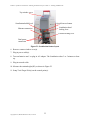
1
University of California at Davis California Department of Transportation Accelerated Project Delivery: Case Studies and Field Use of 3D Terrestrial Laser Scanning in Caltrans Projects: Phase I - Training and Materials Kin S. Yen Kevin Akin Bahram Ravani Ty A. Lasky: Principal Investigator Report Number: CA08-1647 AHMCT Research Report: UCD-ARR-08-06-30-06 Final Report of Contract: 65A0210, T.O. 08-13 AHMCT Advanced Highway Maintenance and Construction Technology Research Center Department of Mechanical and Aerospace Engineering Division of Research and Innovation Copyright 2011, AHMCT Research Center, UC Davis Copyright 2011, AHMCT Research Center, UC Davis Technical Documentation Page 1. Report No. 2. Government Accession No. 3. Recipient’s Catalog No. CA08-1647 4. Title and Subtitle 5. Report Date Accelerated Project Delivery: Case Studies and Field Use of 3D Terrestrial Laser Scanning in Caltrans Projects: Phase I – Training and Materials June 30, 2008 6. Performing Organization Code 7. Author(s): 8. Performing Organization Report No. Kin S. Yen, Kevin Akin, Bahram Ravani, and Ty A. Lasky UCD-ARR-08-06-30-06 9. Performing Organization Name and Address 10. Work Unit No. (TRAIS) AHMCT Research Center UCD Dept of Mechanical & Aerospace Engineering Davis, California 95616-5294 11. Contract or Grant 12. Sponsoring Agency Name and Address 13. Type of Report and Period Covered California Department of Transportation PO Box 942873, MS #83 Sacramento, CA 94273-0001 Final Report January 2008 - June 2008 IA 65A0210 - Task Order 08-13 14. Sponsoring Agency Code Caltrans 15. Supplementary Notes 16. Abstract This report documents the AHMCT research project “Accelerated Project Delivery: Case Studies and Field Use of 3D Terrestrial Laser Scanning in Caltrans Projects: Phase I – Training and Materials.” The report body provides motivation and background information for fixed 3D terrestrial laser scanning, along with the details for Caltrans District training and deployment. The report appendices provide in-depth material suitable for use in future Caltrans training, deployment, and on-going use of 3D laser scanning, including: planning and scanning field work, overlaying digital image and point cloud data, point cloud registration, point cloud post-processing, scanner setup and troubleshooting, and an equipment packing list. 17. Key Words 18. Distribution Statement 3D Laser Scanning, Accuracy, Precision, Resolution, LIDAR, Surveying, Design, Training, Deployment, TLS No restrictions. This document is available to the public through the National Technical Information Service, Springfield, Virginia 22161. 20. Security Classif. (of this report) 20. Security Classif. (of this page) 21. No. of Pages Unclassified Unclassified 75 Form DOT F 1700.7 (8-72) (PF V2.1, 6/30/92) Copyright 2011, AHMCT Research Center, UC Davis Reproduction of completed page authorized i 22. Price Copyright 2011, AHMCT Research Center, UC Davis Field Use of 3D Terrestrial Laser Scanning in Caltrans Projects: Phase I – Training and Materials ABSTRACT This report documents the AHMCT research project “Accelerated Project Delivery: Case Studies and Field Use of 3D Terrestrial Laser Scanning in Caltrans Projects: Phase I – Training and Materials.” The report body provides motivation and background information for fixed 3D terrestrial laser scanning, along with the details for Caltrans District training and deployment. The report appendices provide in-depth material suitable for use in future Caltrans training, deployment, and on-going use of 3D laser scanning, including: planning and scanning field work, overlaying digital image and point cloud data, point cloud registration, point cloud postprocessing, scanner setup and troubleshooting, and an equipment packing list. Copyright 2011, AHMCT Research Center, UC Davis iii Copyright 2011, AHMCT Research Center, UC Davis Field Use of 3D Terrestrial Laser Scanning in Caltrans Projects: Phase I – Training and Materials TABLE OF CONTENTS Table of Contents ......................................................................................................................v List of Figures ........................................................................................................................ vii List of Tables ........................................................................................................................... ix Disclaimer/Disclosure............................................................................................................. xi List of Acronyms and Abbreviations .................................................................................... xiii Acknowledgments....................................................................................................................xv Chapter 1: Introduction ........................................................................................................... 1 Background and Motivation ........................................................................................................... 1 Brief 3D Laser Scanner Overview .................................................................................................. 2 Limitations........................................................................................................................................ 3 Laser Scanning Survey General Workflow ................................................................................... 4 Chapter 2: Laser Scanner Survey Training and Deployment Summary............................... 5 Laser Scanning Survey and Point Cloud Post-processing Training............................................ 5 Deployment Status ........................................................................................................................... 6 New Deliverable: External Camera Kit ....................................................................................... 11 Deployment Challenges / Lessons Learned.................................................................................. 13 Future Work................................................................................................................................... 18 References .............................................................................................................................. 21 Appendix A: Laser Scanning Survey Planning and Scanning ............................................ 23 Laser Scanning Survey General Workflow ................................................................................. 23 Planning for a 3D Laser Scanning Survey ................................................................................... 23 Scanning Phase............................................................................................................................... 25 Introduction to Cyclone Navigator............................................................................................... 25 Edit Cyclone Preferences............................................................................................................... 27 Adding a Database Cyclone Navigator for Existing or New Data ............................................. 28 Configure Scanner in Cyclone Navigator .................................................................................... 31 Step (1): ScanStation or ScanStation 2 setup .............................................................................. 32 Step (2) to (7): Performing Scan ................................................................................................... 34 Appendix B: Overlay Images from External Camera .......................................................... 39 Introduction.................................................................................................................................... 39 General Workflow.......................................................................................................................... 39 Using the External Camera Kit .................................................................................................... 40 Stitching Photos into Equirectangular Panoramic Image Using PTGui................................... 40 Copyright 2011, AHMCT Research Center, UC Davis v Field Use of 3D Terrestrial Laser Scanning in Caltrans Projects: Phase I – Training and Materials Convert Equirectangular Panoramic Image into Six Cubic Images Using Pano2QTVR ....... 40 Register the Six Cubic Images onto the ScanWorld Point Cloud in Cyclone........................... 41 Appendix C: Cyclone Registration ........................................................................................ 43 Typical Registration Steps............................................................................................................. 43 Tips in Identifying and Fixing Registration Errors .................................................................... 43 Appendix D: Point Cloud Post-processing Training Topics ................................................ 45 Appendix E: Network Setting for Connecting ScanStation or ScanStation 2..................... 47 Perform Manual Changes ............................................................................................................. 47 Using a Pre-configured Batch (.bat) File...................................................................................... 47 Appendix F: Troubleshooting Network Connection Problems with Scanstation or Scanstation 2 ................................................................................................................................ 51 Appendix G: Training Scripts for Applying Image Overlay from External Digital Camera ....................................................................................................................................................... 53 Appendix H: Laser Scanning Equipment Package List....................................................... 57 Items:............................................................................................................................................... 57 Appendix I: Honda EU2000i Generator Usage Instruction ................................................ 59 Starting and Stopping Generator ................................................................................................. 59 Generator Maintenance................................................................................................................. 59 Copyright 2011, AHMCT Research Center, UC Davis vi Field Use of 3D Terrestrial Laser Scanning in Caltrans Projects: Phase I – Training and Materials LIST OF FIGURES Figure 1: Working principle of phase-based and time-of-flight 3D laser scanners ...............................................2 Figure 2: Overall workflow.........................................................................................................................................4 Figure 3: Map of Caltrans laser scan projects ..........................................................................................................7 Figure 4: Night scanning of the old Bay Bridge for the design and construction of the new Bay Bridge detour8 Figure 5: Map of District 4 laser scanning projects..................................................................................................8 Figure 6: District 6 field practice training on Highway 99.......................................................................................9 Figure 7: District 11 field practice training at the Highway 805 and 905 interchange........................................10 Figure 8: District 5 field practice session.................................................................................................................10 Figure 9: External camera kit for panoramic photo ..............................................................................................11 Figure 10: Example panoramic photograph at the Presidio and Golden Gate Bridge Doyle Drive approach .12 Figure 11: Example panoramic photograph, District 11, Mast Boulevard at Highway 52.................................12 Figure 12: From point cloud to plastic physical model ..........................................................................................13 Figure 13: Overall workflow.....................................................................................................................................23 Figure 14: ScanStation 2 package ............................................................................................................................24 Figure 15: Display license .........................................................................................................................................26 Figure 16: License manager......................................................................................................................................26 Figure 17: Cyclone preferences ................................................................................................................................28 Figure 18: Adding a database for existing and new scan data...............................................................................30 Figure 19: Add a new scanner ..................................................................................................................................31 Figure 20: Scanner IP address location ...................................................................................................................32 Figure 21: ScanStation feature layout .....................................................................................................................33 Figure 22: Measuring scanner height (HI) ..............................................................................................................34 Figure 23: ScanStation orientation definition .........................................................................................................36 Figure 24: ScanStation and ScanStation 2 external camera kit ............................................................................40 Copyright 2011, AHMCT Research Center, UC Davis vii Copyright 2011, AHMCT Research Center, UC Davis Field Use of 3D Terrestrial Laser Scanning in Caltrans Projects: Phase I – Training and Materials LIST OF TABLES Table 1: Caltrans District laser scanning survey training dates for Phase 1 project.............................................6 Copyright 2011, AHMCT Research Center, UC Davis ix Copyright 2011, AHMCT Research Center, UC Davis Field Use of 3D Terrestrial Laser Scanning in Caltrans Projects: Phase I – Training and Materials DISCLAIMER/DISCLOSURE The research reported herein was performed as part of the Advanced Highway Maintenance and Construction Technology (AHMCT) Research Center, within the Department of Mechanical and Aerospace Engineering at the University of California – Davis, and the Division of Research and Innovation at the California Department of Transportation. It is evolutionary and voluntary. It is a cooperative venture of local, State and Federal governments and universities. The contents of this report reflect the views of the authors who are responsible for the facts and the accuracy of the data presented herein. The contents do not necessarily reflect the official views or policies of the State of California, the Federal Highway Administration, or the University of California. This report does not constitute a standard, specification, or regulation. Copyright 2011, AHMCT Research Center, UC Davis xi Copyright 2011, AHMCT Research Center, UC Davis Field Use of 3D Terrestrial Laser Scanning in Caltrans Projects: Phase I – Training and Materials LIST OF ACRONYMS AND ABBREVIATIONS AHMCT ANSI ASTM CAD Caltrans CMAG DEM DHCP DHIPP DOT DRI DRWLS DTM FOV ISO LADAR LASER LIDAR LOS MS NIST OEM OLS PDF QA/QC RMS RMSE S/W TIN TLS TOF VIM XYZI Advanced Highway Maintenance and Construction Technology Research Center American National Standards Institute American Society for Testing and Materials Computer-Aided Design California Department of Transportation Construction Metrology and Automation Group Digital Elevation Model Dynamic Host Configuration Protocol Digital Highway Inventory Photography Program Department of Transportation Caltrans Division of Research and Innovation Caltrans Division of Right of Way and Land Surveys Digital Terrain Model Field-of-View International Organization for Standardization Laser Radar Light Amplification by Stimulated Emission of Radiation Light Detection and Ranging Line-of-Sight Microsoft National Institute of Standards and Technology Original Equipment Manufacturer Caltrans Office of Land Surveys Portable Document Format Quality Assurance / Quality Control Root Mean Squared Root Mean Squared Error Software Triangulated Irregular Network Terrestrial Laser Scanner Time-of-Flight International Vocabulary of Basic and General Terms in Metrology X, Y, Z location and Intensity Copyright 2011, AHMCT Research Center, UC Davis xiii Copyright 2011, AHMCT Research Center, UC Davis Field Use of 3D Terrestrial Laser Scanning in Caltrans Projects: Phase I – Training and Materials ACKNOWLEDGMENTS The authors thank the California Department of Transportation (Caltrans) for their support; in particular, the guidance and review provided by Kevin Akin of the Office of Land Surveys. The authors thank John Borden, A.J. Burgess, Robbie Dolan, Richard Erskine, John Fundus, Tom Gillett, William Jackson, Robert McMillan, Jimmy Pallares, Chuck Tuomainen, Dave Olander, Mark Turner, and C.J. Vandegrift for their valuable participation and contributions. The authors also thank the District TLS users and technicians for their valuable feedback, including Matt Herbert, Chelsie Hopkins, Carol Puszert, Scott Rhinehart, Ned Salman, Nick Tatarian, Tom Taylor, Eric Vance, and James White. Moreover, the authors express gratitude to Leica Geosystems and Trimble for their generous support in providing software licenses for training— our work would not have been feasible without their gracious assistance. The authors also acknowledge the dedicated efforts of the AHMCT project team members who have made this work possible. Copyright 2011, AHMCT Research Center, UC Davis xv Copyright 2011, AHMCT Research Center, UC Davis Field Use of 3D Terrestrial Laser Scanning in Caltrans Projects: Phase I – Training and Materials CHAPTER 1: INTRODUCTION Background and Motivation Terrestrial 3D laser scanners (TLS)—a new class of survey instrument—have recently become very popular and are increasingly used in providing as-built and modeling data in various applications, including land surveying, archeological studies, architecture, bridge structures, and highway surveys. These scanners measure thousands of data points (each point includes distance, angle, and reflected return signal power) per minute and generate a very detailed “point cloud” data set. The point cloud can then be post-processed to create an exceptionally accurate and detailed 3D Computer-Aided Design (CAD) model. Consequently, model information, such as relative angle and length dimensions, can be extracted from the resulting 3D surface CAD model. Some of the data available with 3D laser scanners are difficult or impossible to measure using traditional surveying instruments. Traditional survey instruments, e.g. Total Station and Digital Level, are limited to locating one point at a time. In the traditional survey process, surveyors, particularly the rod-man, are often exposed to all manner of environmental hazards including walking across the roadway exposed to high-speed traffic, climbing steep slopes, and standing close to high-speed traffic or other unsafe areas to place the prism or rod. The use of reflectorless Total Stations has improved safety, but due to large incidence angles on horizontal and vertical surfaces the measurements can be inaccurate. Other DOTs and private contractors have used laser scanning in highway survey applications and found that it reduces lane closures, decreases the risk of injuries, and increases productivity [47]. The resulting detailed 3D model allows engineers to extract all the required data in the office, decreasing or eliminating the need for surveyors to return to the site for additional measurements. Using 3D laser scanners can dramatically improve safety and efficiency over current survey methods, and can produce a better product. In related research [3], the California Department of Transportation (Caltrans) Office of Land Surveys (OLS) and the Advanced Highway Maintenance and Construction Technology (AHMCT) Research Center evaluated several terrestrial laser scanning systems, including hardware, software, and overall workflow [2]. The research project also produced a set of recommendations on laser scanning workflow, quality assurance / quality control (QA/QC) procedures, usage guidelines, and data exchange methods. Since then, Caltrans has purchased three Leica ScanStation 2 laser scanners as well as licenses of Leica Cyclone and Trimble RealWorks Survey point cloud post-processing software. In support of Caltrans deployment of this new technology, AHMCT researchers are developing laser scanning survey instructional materials and conducting training classes with Caltrans OLS surveyors, to promote consistent and correct use (workflow, controls setup, and QA/QC process) of 3D laser scanners throughout Caltrans. Along with motivation and background, and a record of the current Caltrans district training and deployment activities, this research report contains a collection of instructional material developed under this research contract, along with related materials from other sources. Separate from this research, Leica Geosystems has developed a comprehensive and detailed Cyclone software manual. Thus, the training materials in this report are supplemental to the Leica Cyclone beginner and intermediate manuals. In addition, this report provides detailed status of the current 3D Laser scanning training and deployment in Caltrans districts, as well as district personnel feedback on the use of the equipment. Copyright 2011, AHMCT Research Center, UC Davis 1 Field Use of 3D Terrestrial Laser Scanning in Caltrans Projects: Phase I – Training and Materials Brief 3D Laser Scanner Overview The ground-based (or terrestrial) 3D laser scanner is a recently developed instrument that uses advanced laser measurement technology capable of obtaining thousands of point measurements per second. 3D laser scanners of interest for highway operations use either the Time-of-Flight (TOF) measurement method or phase-based measurement to obtain target point distance (see Figure 1). Time-of-Flight measurement technology is based upon the principle of sending out a laser pulse and observing the time taken for the pulse to reflect from an object and return to the instrument. Advanced high-speed electronics are used to measure the small time difference and compute the range to the target. The range is combined with high-resolution angular encoder measurements (azimuth and elevation angles) to provide the three-dimensional location of the point. The electronics also determines the reflected power. This type of technology is similar to that used in Total Stations. However, the difference between 3D laser scanners and Total Stations is the speed of measurement. Typical Total Stations may measure up to eight distances per second. In contrast, the 3D laser scanner is capable of measuring up to 50,000 distances per second, as of this report, with speed increasing for emerging commercial systems. In phase-based measurement technology, the phase difference is measured between the reflected beam and the transmitted amplitude-modulated continuous-wave laser beam. The target distance is proportional to the phase difference and the wave length of the amplitude-modulated signal. In addition, the amplitude of the reflected beam provides the reflected power. Figure 1: Working principle of phase-based and time-of-flight 3D laser scanners Typically, phase-based scanners are capable of achieving a much higher number of point measurements in a second relative to time-of-flight scanners—their point measurement rate is from about five to one hundred times greater. However, they have shorter useful range (typically 25-100 m). Time-of-flight scanners can provide longer range, typically between 75 m to 1000 m. Generally, phase-based scanners are used in physical plant (e.g. factory) and indoor survey Copyright 2011, AHMCT Research Center, UC Davis 2 Field Use of 3D Terrestrial Laser Scanning in Caltrans Projects: Phase I – Training and Materials applications where range requirements are shorter and multiple scans from several locations are desirable due to view obstruction from structures and pipes. On the other hand, scanners based on TOF technology are usually used in outdoor pavement, architecture, and geo-technical related survey applications where range requirements are larger. Therefore, TOF-based scanners are more suitable for typical DOT applications. A 3D laser scanner provides 3D positional information in a manner similar to a Total Station. The 3D scanner has higher measurement speed, resulting in more measurements in a shorter amount of time. The 3D laser scanner gives the user many measurement points at a shorter range, while the Total Station provides the user with pin-point measurement at lower speed but with longer range. Even though the user may scan the area of interest with a high-density scan, the resulting 3D laser scanner measurement points may not necessarily lie exactly on top of the point of interest. On the other hand, the surveyor can use the Total Station optical sight to aim and measure the exact point of interest. The useful range of a Total Station is generally a few times larger than that of a laser scanner. Despite having shorter range than Total Station, the 3D laser scanner can accurately position objects at over 1000 times the speed of a Total Station, which allows it to quickly produce large amounts of survey data. The resulting data set, commonly referred to as a “point cloud”, provides a realistic visualization of the features of interest and detailed three-dimensional data for modeling, volume calculation, and angle orientation measurement, results that are difficult to obtain using traditional survey instruments. Using the 3D Laser scanner on projects with a large amount of detail allows surveyors to significantly reduce survey field time and results in more survey site detail, reducing or eliminating the need to return to the field for additional measurements. In practical laser scanner applications, multiple scans at different locations are often required to capture the entire survey site, due to the site size exceeding the useful range of the laser scanner, or the scanner’s line-of-sight being obscured by structures in one or more of the scan locations. Post-processing of multiple point cloud data sets from various scan locations must be performed to combine and tie the data sets to an existing control/coordinate system, in order for the overall data set to be useful for surveyors. Otherwise, users may only extract relative positional information of objects within each individual point cloud. This post-processing process is commonly referred to as registration / geo-referencing [2-3]. Limitations Laser scanner performance in real-life applications is usually not as good as the stated manufacturer specifications due to a number of environmental factors that adversely affect performance. Scanner performance and accuracy can be adversely affected by surface reflectivity and color, edges, temperature, atmospheric conditions, and interfering radiation such as bright lights or direct sunlight [1]. Thick vegetation reduces the amount of useful information the scanner can collect by obscuring objects of interest. In addition, these scanners may not be appropriate for every application. Like the Total Station, a laser scanner requires direct line-ofsight to the points of interest. Copyright 2011, AHMCT Research Center, UC Davis 3 Field Use of 3D Terrestrial Laser Scanning in Caltrans Projects: Phase I – Training and Materials Laser Scanning Survey General Workflow Laser scanning survey may be divided into four phases: planning, scanning, registration and QA/QC, and finally post-processing. Only the scanning phase is required to be performed in the field. Thus, laser scanning surveys generally reduce field time, but the office post-processing time is generally increased. Figure 2 illustrates the general laser scanning survey workflow. Office Work Register Point Cloud, Generate Registration Error Report, and Perform QA/QC Develop Deliverable Requirements and Scan Plan Post-processing Point Cloud Data to Create Deliverables Perform Laser Scanning Survey in the Field Field Work Figure 2: Overall workflow Copyright 2011, AHMCT Research Center, UC Davis 4 Field Use of 3D Terrestrial Laser Scanning in Caltrans Projects: Phase I – Training and Materials CHAPTER 2: LASER SCANNER SURVEY TRAINING AND DEPLOYMENT SUMMARY Laser Scanning Survey and Point Cloud Post-processing Training In this research project, AHMCT researchers provided technical support, training, and training materials in conjunction with Caltrans OLS Headquarters surveyor Kevin Akin. Typically, the training class lasted four days. The first day focused on job planning, control setup, hardware setup, and using the ScanStation to acquire data with the Cyclone scan module was well as the external camera kit. Trainees received hand-on experience in using the software, and in hardware setup to scan a parking lot in the afternoon of the first training day. In the morning of the second day of training, after reviewing previous training material, trainees practiced laser scanning in the field. The field practice session can be carried out on other training days if the weather is not appropriate for scanning. Training includes point cloud registration, QA/QC, and troubleshooting of registration problems in the afternoon of the second day. In the beginning of third day of training, point cloud registration steps are reviewed. After that, trainees practice point cloud registration and solving common registration problems. Instruction on point cloud data extraction with Cyclone begins in the afternoon of the third training day, concluding on the last instruction day. Instruction topics include: understanding the Cyclone modules—Scan, Register, and Model—and how they are accessed, using the seek and pick tool, unifying point clouds, clearing traffic “noise” within the point cloud, creating lines, polylines, patches, cylinders, cones, spheres, alignments, and cross sections, using limit box and fence tool, performing bridge clearance measurements, working with Cyclone Virtual Surveyor, creating animation, and exporting data to and importing from CAD and roadway design packages. Caltrans also uses Trimble RealWorks to process point cloud data; further details on the use of RealWorks is provided in related training course materials. The Cyclone training course is quite intensive and covers extensive materials. At the end of the training, a set of ScanStation equipment is left with the District surveyors so that they can start using the equipment immediately to solidify what they have learned. AHMCT researcher and Caltrans Headquarters Copyright 2011, AHMCT Research Center, UC Davis 5 Field Use of 3D Terrestrial Laser Scanning in Caltrans Projects: Phase I – Training and Materials continue to provide technical support to District surveyors throughout their laser scanning projects. Throughout this research project, the training material was developed and refined by AHMCT researchers. These materials are located in the appendix. Training material from other authors and organizations can be found at AHMCT’s Laser Scanning Resources Website http://hardhat.ahmct.ucdavis.edu/mediawiki/index.php/LaserScanResources In addition, Kevin Akin produced a detailed documentation of workflow using Cyclone Virtual Surveyor to extract data for import into Autodesk CAiCE. Furthermore, Leica Geosystems created two training manuals (High Definition Surveying Basic Training Manual; and High Definition Surveying Intermediate Training Manual) in addition to various application notes, videos, tips and tricks. Deployment Status In support of the Caltrans Office of Land Survey deployment of laser scanning technology, AHMCT procured a Leica Geosystems ScanStation and Cyclone software licenses. Since then, District 4 has purchased a ScanStation 2 and two sets of Cyclone Model, Publisher, and Register licenses. After that, Caltrans Headquarters purchased two Leica Geosystems ScanStation 2 scanners and two Cyclone Model and Register licenses. The goal is to have one ScanStation 2 scanner each for the northern and southern California regions. Since 2007, Caltrans surveyors have performed over 20 projects using laser scanning technology as shown in Figure 3. As of the end of Phase 1, four (4, 5, 6, and 11) of twelve Caltrans Districts have been trained on use of Leica ScanStation and Cyclone point cloud post-processing software. Training dates are shown in Table 1. After training, District 4, 6, and 11 surveyors performed scan projects on their own. Training for remaining districts is expected to occur in Phase 2 research. Because of the size of the district and the nature of their survey work, District 9 surveyors are currently not expected to be trained to use ScanStation and Cyclone software. District 7 plans to use laser scanning in a rock-fall study, and District 1 plans to apply laser scanning at a landslide site. Table 1: Caltrans District laser scanning survey training dates for Phase 1 project Caltrans District 4 5 6 11 Copyright 2011, AHMCT Research Center, UC Davis Training Date Multiple Jan. 2008 Sep. 2007 Jun. 2008 6 Field Use of 3D Terrestrial Laser Scanning in Caltrans Projects: Phase I – Training and Materials Figure 3: Map of Caltrans laser scan projects Some District 4 surveyors previously received training from Leica Geosystems in conjunction with Caltrans’ evaluation of an HDS 2500 laser scanner. AHMCT provided District 4 with technical support and updates on the latest best practices and recommended workflow. Since then, District 4 surveyors used a ScanStation laser scanner in a few pilot studies. They used AHMCT’s ScanStation in two projects related to the new Bay Bridge detour construction. In addition, District 4 scanned the V-bar of the main bridge column of the new SFOakland Bay Bridge. These jobs were made easier, safer, and faster using laser scanner vs. Copyright 2011, AHMCT Research Center, UC Davis 7 Field Use of 3D Terrestrial Laser Scanning in Caltrans Projects: Phase I – Training and Materials traditional survey methods. The use of laser scanner in these projects allowed District 4 surveyors to prove to their management the value and effectiveness of the laser scanner as a survey instrument. As a result, District 4 secured funding to purchase a ScanStation 2 and Cyclone software licenses. They have successfully deployed the ScanStation 2 and performed numerous scans on new and old Bay Bridge structures and other project sites as shown in Figure 5. Currently, District 4 is using two ScanStation 2 scanners extensively on the Doyle Drive project. Over sixty historical buildings and landmarks in the Presidio area were scanned. This high profile project is currently the largest use of laser scanners in Caltrans. Figure 4: Night scanning of the old Bay Bridge for the design and construction of the new Bay Bridge detour Figure 5: Map of District 4 laser scanning projects The deployment training in District 6 was the first laser scanning survey training class conducted by AHMCT and Caltrans Headquarter. While it occurred in September 2007, prior to Copyright 2011, AHMCT Research Center, UC Davis 8 Field Use of 3D Terrestrial Laser Scanning in Caltrans Projects: Phase I – Training and Materials the official start of this research project, it is documented here as it significantly enhanced the results of the current research. The training structure was slightly different from the above description. The training was split into field crew training and point cloud post-processing training. For four days, over ten District 6 surveyors were taught to use the ScanStation to collect data in the field at Highway 99 and Avenue 12. At the same time, a different group of surveyors were taught to use Cyclone in the office. The Highway 99 pavement was freshly paved black asphalt, which due to lower reflectivity effectively cut the practical ScanStation scan range in half. The survey work speed was about 0.6 to 0.75 miles per day as opposed to a more typical 0.75 to 1 miles per day. In addition, the crew size at the work site was about 7 to 8 surveyors. It was quickly apparent that laser scanning survey was less efficient and slower than traditional means in this arrangement. Nevertheless, the field work of the project was nearly completed at the end of the fourth day. This first session also provided valuable lessons in conducting the training, as reflected in the revised approach used for subsequent training. Figure 6 show the pilot project worksite and District 6 surveyors being trained. Figure 6: District 6 field practice training on Highway 99 In June 2008, Caltrans District 11 surveyors—Chelsie Hopkins, Jason Webb, and Dave Olander—received training in operating a Leica Geosystems ScanStation 2 laser scanner and using Leica Cyclone point cloud post-processing software from AHMCT Research Center and Caltrans Headquarters personnel. District 11 San Diego surveyors used a Leica ScanStation 2 to survey the California Highway 805 and 95 interchange during the second day of training, as shown in Figure 7. After the training, District 11 surveyors independently conducted projects using the ScanStation 2. In one project, they scanned a petroglyph (a rock carving or inscription) at a historically significant site (see subsequent Figure 12). Copyright 2011, AHMCT Research Center, UC Davis 9 Field Use of 3D Terrestrial Laser Scanning in Caltrans Projects: Phase I – Training and Materials Figure 7: District 11 field practice training at the Highway 805 and 905 interchange In January 2008, Caltrans District 5 surveyors—Neal Dickey, Robert MacKenzie, Richard Majernik, Brian Meeks, and Jonathan Walsh—received training in operating a Leica Geosystems ScanStation 2 laser scanner and using Leica Cyclone point cloud post-processing software. Figure 8 shows the District 5 surveyors being trained to do field work with the ScanStation. Figure 8: District 5 field practice session Copyright 2011, AHMCT Research Center, UC Davis 10 Field Use of 3D Terrestrial Laser Scanning in Caltrans Projects: Phase I – Training and Materials Figure 9: External camera kit for panoramic photo New Deliverable: External Camera Kit The AHMCT Research Center assembled two external camera kits for Caltrans surveyors to improve digital photographic image quality for overlaying on the point cloud generated by the ScanStation. The kit consists of a Canon SLR digital camera with a Sigma 8 mm fisheye lens mounted on a pano (panoramic) mount as shown in Figure 9. The digital camera is mounted in the vertical position and tilted up 15 degrees. The pano mount is secured to a tribrach adapter through a precision-machined spacer so that the 8 mm lens nodal point is aligned to the center of the ScanStation rotating mirror. A series of detents (click stops) allow the user to turn and reposition the camera every 30 degrees quickly and easily take a series of 12 photos. Each set of 12 photos can be stitched together, resulting in a 33 MP panoramic image. Example panoramic images are shown in Figure 10 and 11. These panoramic images can then be converted to six cubic images for Cyclone to import and overlay onto the point cloud. In addition, they can be converted to a QuickTime VR media file providing the point of view from the scanner. The panoramic images, including point cloud overlay, have proven useful in identifying features, and help post-processing personnel better understand the setup and job site. Copyright 2011, AHMCT Research Center, UC Davis 11 Field Use of 3D Terrestrial Laser Scanning in Caltrans Projects: Phase I – Training and Materials Figure 10: Example panoramic photograph at the Presidio and Golden Gate Bridge Doyle Drive approach Figure 11: Example panoramic photograph, District 11, Mast Boulevard at Highway 52 The 3D laser scanner and resulting point cloud data can enable new types of deliverables. A 3D laser scanner can produce a dense point cloud of an object. The point cloud can then be converted to a mesh surface model, and a 3D printer can use this model to create a plastic scale replica of the object. Figure 12 illustrates the general concept. The top image is a snapshot of a point cloud generated from scanning a historically significant American Indian site. The middle image is the computer generated mesh surface model derived from the point cloud. The bottom image is the final plastic model created by a 3D printer. The model gives archeologists a better understanding of the site, and a tool to effectively communicate to others about the site. Copyright 2011, AHMCT Research Center, UC Davis 12 Field Use of 3D Terrestrial Laser Scanning in Caltrans Projects: Phase I – Training and Materials Figure 12: From point cloud to plastic physical model Another new deliverable made possible by the 3D laser scan point cloud is a 3D Portable Document Format (PDF) file. Previously, CAD models generated from survey data could only be easily viewed in CAD software. Thus, the end users (data customers) needed CAD software installed on their computer to view the CAD model. In addition, they had to learn to use the CAD software package. Now, Adobe has enabled CAD models to be embedded into a PDF file, allowing users to view and interact with CAD models using a free PDF reader. Furthermore, the current version of MicroStation can export CAD models directly to 3D PDF. Thus, CAD models extracted from point clouds via CloudWorx or Cyclone can be readily converted into a 3D PDF file using MicroStation. The main advantage is to allow a wider audience to view the 3D data. Deployment Challenges / Lessons Learned The deployment of Leica Geosystems 3D laser scanning system has had varying degrees of success in different Caltrans districts. By nature, some deployment challenges are technological, while some are institutional. Copyright 2011, AHMCT Research Center, UC Davis 13 Field Use of 3D Terrestrial Laser Scanning in Caltrans Projects: Phase I – Training and Materials District-Specific Comments, Challenges, and Lessons Learned District 1 (D1) D1 has one experienced TLS user, Eric Vance. He has been using TLS for about 10 years. He did not note many problems with it. He has done 5 to 6 scanning projects in D1. He found that: Equipment scanning speed has increased significantly since he started scanning. Time in field is shorter than with traditional methods. Time in office is longer. However, the office cost rate is lower, and only needs one person. A two-person crew for scanning and another two-person crew to survey other features that scanning does not pick up is a very efficient arrangement. It is hard to determine man hole covers, light boxes, and similar features in the point cloud. He has spent two months analyzing data so far from the downtown Willits scans. People can become overwhelmed with the data in post processing. He has used the Trimble VX for land slides; it does not work well for large landslide areas. For this and similar applications, a laser scanner is better. CloudWorx plug-ins for AutoCAD and MicroStation may work well for some customers who are familiar with CAD software. This way, the end users do mining of data in the software they are comfortable using. District 3 (D3) Matt Herbert of D3 found that: D3 has not yet found a good project for scanning. Their crew needs training on equipment and software. It is good to do training in winter time when the workload is lower. He will work with Kevin Akin to set up training in 2010. District 4 (D4) Tom Taylor of D4 found that: TLS is another tool in the toolbox. Copyright 2011, AHMCT Research Center, UC Davis 14 Field Use of 3D Terrestrial Laser Scanning in Caltrans Projects: Phase I – Training and Materials Some people are more comfortable with traditional survey tools. Currently, D4 is running two scanning crews (two persons on each crew) on the Doyle Drive project. In general, D4 has two dedicated field crews, and two persons dedicated to office data post-processing. They plan to rotate office and field personnel to do cross-training. Speed and power of computers are the most limiting factors. One of their customers even provided a new workstation for TLS post-processing because the customer is very supportive of the TLS technology. While they have made some related upgrades, they need to further upgrade their infrastructure of networks, computers, and servers. Education and training for their customers and their management is the key. It enables them to provide new deliverables, 3D and 4D modeling, to their customers. TLS gives surveyors a new way to be involved in other areas. They enjoy great management support for adopting TLS. They have sought out and marketed TLS to management to cultivate their support. Customer requests include: as-builts between contracts, and visualization of buildings. He likes the idea of Vanguard for Scanner. Cost-benefit is good for HD video and scan point cloud models. D4 would like to evaluate 3D Reshaper software to process point clouds. 3D Reshaper can find break lines automatically. TLS guidelines are needed. District 5 (D5) Nick Tatarian of D5 commented that: D5 has completed one project on a rockslide. The crew felt the scanner was overkill for this project; The job using TLS took longer than with Total Station. TLS survey takes about one day in the field, two days in the office. It is time-consuming to extract needed points. D5 is looking for the right projects for scanner use, such as a bridge site survey. However, their bridge customers do not yet see it as a great tool. D5 found that customer acceptance and need for point clouds and related deliverables is currently lacking. They will need top-down buy-in to move ahead. Copyright 2011, AHMCT Research Center, UC Davis 15 Field Use of 3D Terrestrial Laser Scanning in Caltrans Projects: Phase I – Training and Materials The right software for end users is needed District D6 Scott Rhinehart of D6 found that: D6 surveyors have done one project on HWY99 Surveyors are still exposed to traffic, and an attenuator truck could block the scanner FOV. Leaves & debris in gutters are a problem for determining the feature break line. On one project, the gutter flow line was obscured by debris. The crew had to tie in FL by conventional means. Scanning should be used in appropriate jobs, such as a bridge site survey. It should not be used for day-to-day purposes. Their crews need more practice. District D7 James White of D7 noted that: D7 surveyors have done one slide project at HWY39 for Geotech. D7 has one person (Carol Puszert) doing post-processing. Having an office technician for post-processing is critical since not many surveyors want to sit in front of point clouds all day. They must find the right person to do the office portion. District D11 Ned Salman and Chelsie Hopkins of D11 commented that: D11 has scanned a couple of bridge sites and one archeological site. They would need additional (refresher class) training. Their slow computer hampered initial post-processing. Computers were slow and kept crashing. This may be due to the graphic card driver settings or the driver itself. They are happy with scanning and data gathering. They have a hard time trying to extract data from point clouds Copyright 2011, AHMCT Research Center, UC Davis 16 Field Use of 3D Terrestrial Laser Scanning in Caltrans Projects: Phase I – Training and Materials More scanners would help, as the district then would not have to wait for one, giving added flexibility. Summary of Challenges and Lessons Learned Some of the key challenges include: Point cloud post processing software has a steep learning curve, and the associated skills have a short shelf life. In addition, users found that the software skills that they have invested time and resources to learn are quite “perishable,” i.e. the skills decay without regular use. Existing computers and servers in the district offices are ill-equipped for handling and processing the huge data sets. Additional investment will be needed to store and process point cloud data. The optimal 3D laser scanning workflow and crew structure and size does not fit well with existing District survey crew size and structure. 3D laser scanning survey workflow favors small crew size (two people). Typical Caltrans crew size is three to four. Moreover, while some survey customers may find the point cloud data interesting, they don’t know what to do with the point cloud and/or 3D data. The ScanStation hardware package is large, heavy, and bulky compared to other survey instruments. The first two generations of laser scanners were slow; however, emerging commercial systems alleviate this aspect. There is a lot of heavy and bulky equipment to carry around, generally requiring a few trips back and forth from the vehicle to the instrument setup location. The setup and data collection takes too long. Long post processing time to final deliverables. Customers typically want the traditional deliverables – e.g., 2D plots. There has been a lack of demand from Structures, the group most in need of the detailed products available from TLS technology. Some field crews say they can produce the traditional deliverables faster with conventional methods. Successful TLS Deployment and Overcoming Some of the Obstacles By reasonable measures, District 4 enjoys the most successful deployment. They have done more projects with 3D laser scanning than other districts. Their customer feedback has been positive. In some cases, Caltrans and AHMCT have generated interest in more extensive laser scanning use. District 4 has had two dedicated surveyors working with 3D laser scanners for over Copyright 2011, AHMCT Research Center, UC Davis 17 Field Use of 3D Terrestrial Laser Scanning in Caltrans Projects: Phase I – Training and Materials four years. Their dedication and experience and support from management are vital to overcome the types of difficulty encountered by users in Districts 6 and 11. In addition, many of their projects involve urban environments with complex scenes and large construction projects, which are well-suited for 3D laser scanning while making survey with traditional methods difficult. District 6 and 11 surveyors are comfortable with data acquisition in the field with the ScanStation. However, they find that post-processing is difficult and time consuming to extract data for final deliverables. This is in part related to their current computers, most of which are inadequate to handle these massive point cloud data. Thus, the software runs very slow and crashes often, leading to user frustration. Their workstations should be upgraded. Caltrans Headquarters procured new workstations for point cloud post-processing; however, lead time was long. In addition, these district users found that large time and resource investment is required to learn this new tool. Based on the user feedback, Caltrans Headquarters, Leica Geosystems, and AHMCT researchers continue to take steps to mitigate these deployment challenges. New powerful workstations dedicated for point cloud post-processing are now available to some of the district surveyors in their offices. Leica Geosystems has continue to add new tools (automated and semiautomated) and better workflow documentation to simplify data extraction. The software and hardware are still in their infancy. Revised or new software and hardware will better address these deployment challenges. Still, the districts must find or cultivate personnel who enjoy working at a desk, possess great computer skills, are detail-oriented, understand the final deliverables, and are able to work independently and accomplish a task to achieve successful deployment of this new tool. Finally, the 3D laser scanning crew size must be small for an efficient operation. Through this deployment process, we found that suitable projects for 3D laser scanning are rock slides, steep embankments, bridge structures, and historical preservation. Pavement survey is often better done with traditional survey means. Despite the noted setbacks and difficulties, we found that the deployment of 3D laser scanning technology is progressing well based on experience in deploying other new and innovative systems in Caltrans. In Caltrans, as in any large and diverse organization, deployment of new technology will take time, patience, and continuous effort. The overall project objective has been met. However, work remains to complete the deployment to other Caltrans Districts and overcome deployment challenges; this work continues under a Phase 2 research effort. Future Work These findings and comments echo other 3D laser scanning system users’ feedback, and are not unique to Caltrans or the Leica Geosystems HDS scanner and software. New software is available that promises better post-processing data extraction. A few new 3D laser scanners (e.g. Leica Geosystems C10 and Riegl VZ400) show potential for significant reduction in field work time. They are smaller, lighter, and can be run without a laptop computer. In addition, their internal batteries are smaller and lighter, with longer life. These changes may overcome some of the initial technological challenges and improve overall efficiency of 3D laser scanning surveys. Future work includes: Copyright 2011, AHMCT Research Center, UC Davis 18 Field Use of 3D Terrestrial Laser Scanning in Caltrans Projects: Phase I – Training and Materials Conducting training in Districts 1, 2, 3, 7, 8, 10, and 12, updating training materials, and exploring means to speed up point cloud post-processing. Marketing new deliverables to survey customers’ management to enlist their support for this new technology. Upgrade CAD workstations, network, and servers for District offices. Creating a laser scanning user group in Caltrans. D1 and D4 like the user group idea. D4 likes to meet in person, but GoToMeeting or similar webinar seems to work well for everyone. Creating stationary and mobile laser scanning guidelines in the Survey Manual. Currently, a draft of Chapter 7 of the Survey Manual has been sent to the laser scanning Technical Advisory Group (TAG) and circulated externally. When complete, the availability of guidelines for using TLS should be advertised. Developing automated methods of filtering and extracting data from point clouds. Arranging refresher or additional scan classes as needed for districts that have already been trained. The main objective is to increase the usage of TLS. Mark Turner, Office Chief of Land Surveys, indicated “Deploy it, Drive it all home.” Any new information regarding hardware and software improvements, training materials, and best practices and workflow will be made available at the AHMCT Laser Scanning Resources site: http://hardhat.ahmct.ucdavis.edu/mediawiki/index.php/LaserScanResources Copyright 2011, AHMCT Research Center, UC Davis 19 Copyright 2011, AHMCT Research Center, UC Davis Field Use of 3D Terrestrial Laser Scanning in Caltrans Projects: Phase I – Training and Materials REFERENCES 1. 2. 3. 4. 5. 6. 7. W. Boehler and A. Marbs, "3D Scanning Instruments," in The International Archives of Photogrammetry, Remote Sensing and Spatial Information Sciences, Corfu, Greece, 2002. J. Hiremagalur, K.S. Yen, K. Akin, T. Bui, T.A. Lasky, and B. Ravani, "Creating Standards and Specifications for the Use of Laser Scanning in Caltrans Projects," AHMCT Rept. # UCD-ARR-07-06-30-01, Davis, 2007. J. Hiremagalur, K.S. Yen, T.A. Lasky, and B. Ravani, "Testing and Performance Evaluation of Fixed Terrestrial 3D Laser Scanning Systems for Highway Applications," Transportation Research Record: Journal of the Transportation Research Board, (2098): pp. 29-40, 2009. G. Jacobs, "Understanding the 'Useful Range' of Laser Scanners," Professional Surveyor Magazine, 2004. G. Jacobs, "Registration and Geo-Referencing," Professional Surveyor Magazine, pp. 3037, 2005. E.J. Jaselskis, Z. Gao, A. Welch, and D. O’Brien, "Pilot Study on Laser Scanning Technology for Transportation Projects," in Mid-Continent Transportation Research Symposium, Ames, Iowa, August, 2003. T. Schulz, H. Ingensand, and M. Steiner, "Laser Scanning and Noise Reduction Applied to 3D Road Surface Analysis " in Proceedings of the FIG Working Week, 2005. Copyright 2011, AHMCT Research Center, UC Davis 21 Copyright 2011, AHMCT Research Center, UC Davis Field Use of 3D Terrestrial Laser Scanning in Caltrans Projects: Phase I – Training and Materials APPENDIX A: LASER SCANNING SURVEY PLANNING AND SCANNING Laser Scanning Survey General Workflow Laser scanning survey may be divided into four phases: planning, scanning, registration and QA/QC, and finally post-processing. Only the scanning phase is required to be performed in the field. Thus, laser scanning survey generally reduces field time, but the office post-processing time is generally increased. Figure 13 (repeat of Figure 2 for convenience) illustrates the general laser scanning survey workflow. In the planning phase, users examine the project deliverable requirements, project limits, and scope of work to determine the number of scanning setups, the scanner setup locations, and control point locations. When developing the scanner setup and control locations, the users consider the scanner instrument’s field of view, practical scan range, and any blockage of lineof-sight to key features and control targets due to buildings, structures, and vegetation. The user should also review the equipment checklist (see Appendix H) to make sure no components are missing or damaged. In addition, the user should make sure all batteries (two Leica ScanStation batteries, and all notebook computer batteries) are fully charged. Office Work Register Point Cloud, Generate Registration Error Report, and Perform QA/QC Develop Deliverable Requirement and Scan Plan Post-processing Point Cloud Data to Create Deliverable Perform Laser Scanning Survey in the Field Field Work Figure 13: Overall workflow Planning for a 3D Laser Scanning Survey Scan Plan considerations Deliverable requirements Copyright 2011, AHMCT Research Center, UC Davis 23 Field Use of 3D Terrestrial Laser Scanning in Caltrans Projects: Phase I – Training and Materials Scope of work Scanner location and control setup (Aerial photo, Digital Highway Inventory Photography Program (DHIPP) photos, and Google Earth all help for this) Scanner field of view Blockage of line-of-sight to key features or targets Maximum usable range ~ 80 m to 90 m (half the range if the pavement is new asphalt overlay) Registration target placement (< 65 m, 75 m max from scanner) Extra target for QA/QC Equipment Checklist (See Appendix H) Weather forecast check (rain, wet pavement, snowing, fog) Figure 14: ScanStation 2 package To Do list before going to the field Locate all equipment on the equipment list Fully charge batteries o ScanStation batteries (2 or more) o Panasonic Toughbook (recommended) or other notebook computer batteries (2) Gas for Honda Generator Standard safety equipment, including hard hats, safety vests, safety goggles, boots, water, etc. Voice radios Copyright 2011, AHMCT Research Center, UC Davis 24 Field Use of 3D Terrestrial Laser Scanning in Caltrans Projects: Phase I – Training and Materials Check weather forecast for rain, wet pavement, snow, high winds, and fog. Scanning Phase Scanning phase work includes setup and break down of the hardware as well as operating the Cyclone scanning software to acquire all the necessary data for post-processing. This section provides some basic Cyclone setup information. It is supplemental to the both Leica Geosystems High Definition Surveying Basic Training Manual and the High Definition Surveying Intermediate Training Manuals. If you are a Caltrans surveyor, please contact Kevin Akin ([email protected]). Generally, laser scanning using a ScanStation(2) has the following steps: 1) Setup and power up the Leica ScanStation(2). 2) Power up the notebook computer and connect the Ethernet cable from the notebook computer to the ScanStation(2). 3) Run Cyclone Scan to “Connect” to ScanStation(2). 4) Check to see if the dual-axis level compensator is on and within range. 5) Scan the area of interest. 6) Acquire the registration target(s), measure HT (Scanner Height), calculate the registration errors, and apply the registration. 7) “Disconnect” the scanner within Cyclone. 8) Break down the ScanStation(2) setup and move to the next setup location. 9) Repeat setup 1 to 8. The details of each step can be found in this appendix or Leica Geosystems High Definition Surveying Basic Training Manual sections 1 and 2. Introduction to Cyclone Navigator Cyclone is Leica Geosystems HDS software composed of several modules, including Cyclone-SCAN, Cyclone-REGISTER, Cyclone-MODEL, Cyclone-PUBLISHER, CloudWorx for MicroStation, Cyclone II TOPO, Cyclone-VIEWER Pro, and other modules that Caltrans does not currently use. Each module requires its own license, and the license file (license.dat or *.lic) is located in the Cyclone installation folder (the default is C:\Program Files\Leica Geosystems\Cyclone). To display available licenses, left-click (normal mouse click) on “Help” in Cyclone – Navigator window, and left-click on “Display License” as shown in Figure 15a. Figure 15b shows the licenses available to the users. Left-click the “Close” button to close the Cyclone License window. Copyright 2011, AHMCT Research Center, UC Davis 25 Field Use of 3D Terrestrial Laser Scanning in Caltrans Projects: Phase I – Training and Materials (a) (b) Figure 15: Display license If the Cyclone installation uses a license server, the user should check out only the specific licenses to be used during the session. For example, if the user only plans to do modeling work, they should only check out the Cyclone-MODEL license, thus leaving Cyclone-REGISTER for others to use. This is critical if the number of licenses is small. Configure the licenses to be checked out for the session 1. Left-click on “Help” in Cyclone – Navigator window, and Left-click on “License Manager” as shown in Figure 16a. 2. If “Yes” appear in the “Available” column of the Cyclone License Manager (Figure 16b), the License available to the users to use. The “” in the “Use” column in the middle indicates that the particular module license will be checked out during the current session, and thus unavailable to other users. 3. To disable or deselect certain licenses and make available to others, left-click the “” in the “Use” column next to the module license, the “” will disappear. Now, left-click on the “OK” button to close the Cyclone License Manager window. 4. The user must exit and restart Cyclone Navigator for the changes to take effect. (a) (b) Figure 16: License manager Copyright 2011, AHMCT Research Center, UC Davis 26 Field Use of 3D Terrestrial Laser Scanning in Caltrans Projects: Phase I – Training and Materials Edit Cyclone Preferences Cyclone default installation preferences may not match with the Caltrans user preferences. For example, default units are metric. To change default preferences: 1. Left-click on “Edit” in Cyclone – Navigator window, and left-click on “Preferences” as shown in Figure 17a. 2. Left-click on the pull-down menu on the top-right corner of the Edit Preferences window and select “Default” as shown in Figure 17b. The default selection is “Session”. 3. Left-click on “Unit” tab in the Edit Preferences window, and left-click on “Linear Units” as shown in Figure 17b. Then left-click on “feet” or other desired unit of choice; if feet are the units selected, make sure that the Imperial Type is set to “U.S. Survey” in the next selection box as shown in Figure 17c. U.S. Survey Feet are by law the official type of foot unit to use in California. 4. Left-click on “Apply” or “Ok” button at the bottom to save the changes as the default. Copyright 2011, AHMCT Research Center, UC Davis 27 Field Use of 3D Terrestrial Laser Scanning in Caltrans Projects: Phase I – Training and Materials (a) (b) (c) Figure 17: Cyclone preferences Adding a Database Cyclone Navigator for Existing or New Data Cyclone stores all data (control points, LiDAR point clouds, and photos) in a database file with extension .imp. To access the data, the user must add a link to the *.imp database file in Cyclone Navigator. In addition, the user must add a new database with Cyclone Navigator before a new scan job begins. To add a database in Cyclone Navigator: 1. Left-click on “Configure” in Cyclone – Navigator window, and left-click on “Databases…” as shown in Figure 18a. 2. Left-click on the “Add…” button in Configure Database as shown in Figure 18b. 3. Left-click on the “…” button next to Database Filename field in Add Database as shown in Figure 18c. Copyright 2011, AHMCT Research Center, UC Davis 28 Field Use of 3D Terrestrial Laser Scanning in Caltrans Projects: Phase I – Training and Materials 4. Select the file location. To create a new database file, type in a filename with .imp at the end in the File name field of the “Create/Select a Cyclone DB” window as shown in Figure 18d. In the case of accessing an existing Cyclone database file, select (left-click) the file. After that left-click on the “Open” button as shown in Figure 18d. 5. The Database Name field in the Add Database window will automatically fill in using the filename. The user may change it by typing in the field. Left-click on the “OK” button to complete the add database process as shown in Figure 18d. 6. Lastly, left-click on “Close” button to close the Configure Database window. Inside the Configure Database window (Figure 18f), the user can also perform the following operations to an individual database by first highlighting the database with a left-click on the database name as shown in Figure 18f: To remove the link between Cyclone Navigator and the database file and keep the imp file, left-click on the “Remove” button. To remove the link between Cyclone Navigator and the database file and delete the imp file, left-click on the “Destroy” button. To reduce the size of the database file, left-click on the “Compact” button. To improve Cyclone performance when opening that database file, left-click on the “Optimize” button. To make the database invisible in the Cyclone – Navigator window, left-click on the “” next to the database name. This operation helps reduce the clutter in the Cyclone – Navigator window. To make the database visible again, left-click on the empty square box next to the database name. Copyright 2011, AHMCT Research Center, UC Davis 29 Field Use of 3D Terrestrial Laser Scanning in Caltrans Projects: Phase I – Training and Materials (b) (a) (c) (d) (e) (f) Figure 18: Adding a database for existing and new scan data Copyright 2011, AHMCT Research Center, UC Davis 30 Field Use of 3D Terrestrial Laser Scanning in Caltrans Projects: Phase I – Training and Materials Configure Scanner in Cyclone Navigator The user must add the scanner in Cyclone Navigator before connecting to it for scanning. Users must perform this operation once per notebook computer per scanner. Typically, Caltrans ScanStation 2 scanners are paired with a dedicated laptop. Thus, this operation may not be required (as it likely will have occurred during initial setup and deployment). To add a scanner in Cyclone Navigator: 1. Left-click on “Configure” in Cyclone – Navigator window, and left-click on “Scanners…” as shown in Figure 19a. 2. Left-click on the “Add…” button in Configure Scanners, as shown in Figure 19b. 3. Select the scanner model using the pull-down menu next to the Scanner Model field in the Add Scanner window, as shown in Figure 19c. Next, enter a unique scanner name in the Scanner Name field, and enter the unique IP address of the Scanner in the IP Address field. The scanner’s unique IP address is labeled on the base of the scanner next to the serial number. For Caltrans, the IP should start with 10.1. Left-click on the “OK” button to close the Add Scanner window. 4. Finally, left-click on “Close” button to close the Configure Scanners window. (a) (b) (c) (d) Figure 19: Add a new scanner To make the scanner invisible in the Cyclone – Navigator window, left-click on the “” next to the scanner IP address in the Configure Scanner window (Figure 19d). This operation helps reduce the clutter in the Cyclone – Navigator window. To make the scanner visible Copyright 2011, AHMCT Research Center, UC Davis 31 Field Use of 3D Terrestrial Laser Scanning in Caltrans Projects: Phase I – Training and Materials again, left-click on the empty square box next to the scanner IP address Configure Scanner window. To remove a particular scanner in Cyclone Navigator permanently, left-click on the “Remove” button in the Configure Scanner window after highlighting the scanner by leftclicking on the scanner name under the scanner column. Figure 20: Scanner IP address location Step (1): ScanStation or ScanStation 2 setup ScanStation and ScanStation 2 setup is very similar to a Total Station. The user can use known backsight, resection, or traverse methods to geo-reference each scan setup. Traverse is not recommended for pavement surveys. Setup scanner (See ScanStation 2 manual for detailed instructions) 1. Setup the dual clamp tripod. It should be elevated as high as possible. 2. Setup and level the tribrach. 3. Tighten all the tripod screw and lever clamps and place sand bags on each tripod leg. 4. Set the ScanStation on the tribrach and lock it in place by flipping the tribrach locking lever. 5. Unlock the ScanStation by pulling out and rotating (counter-clockwise) the scan head, locking lever located at the back of the scanner, as shown in Figure 21. The ScanStation will not boot up with lock engaged. Copyright 2011, AHMCT Research Center, UC Davis 32 Field Use of 3D Terrestrial Laser Scanning in Caltrans Projects: Phase I – Training and Materials Top window cover ScanStation bubble level Quick Scan set button ScanStation head locking lever Ethernet connection Tribrach locking lever Dual power connection Figure 21: ScanStation feature layout 6. Remove scanner window cover(s). 7. Plug in power cable(s). 8. Turn on batteries and / or plug in AC adapter. The ScanStation takes 3 to 5 minutes to boot up. 9. Plug in network cable. 10. Measure the station height (HI), as shown in Figure 22. 11. Setup Twin Target Pole(s) on the control point(s). Copyright 2011, AHMCT Research Center, UC Davis 33 Field Use of 3D Terrestrial Laser Scanning in Caltrans Projects: Phase I – Training and Materials Front window Station height (HI) measurement mark Figure 22: Measuring scanner height (HI) Step (2) to (7): Performing Scan Notebook computer setup 1. Boot notebook computer, usually a Panasonic Toughbook. 2. Plug in network cable 3. Login as Caltrans User (usually no password required). The notebook computer wired network should already be setup for scanning, and should not require any modifications. See Appendix E for details of the wired network setup for scanning. Cyclone SCAN 1. 2. 3. 4. Start Cyclone (Cyclone Navigator). Create database if needed (Adhere to file, project, and ScanWorld naming conventions). Click on “SCANNERS” in Cyclone Navigator. Double-click “AHMCT UCDAVIS” or other available scanner in Cyclone Scanners (See “configure scanner”). 5. Double-click on the scanner name and open Cyclone SCAN. 6. Select the Cyclone database and project (see figure below). Copyright 2011, AHMCT Research Center, UC Davis 34 Field Use of 3D Terrestrial Laser Scanning in Caltrans Projects: Phase I – Training and Materials Connecting to Scanner Click on “Scanner” and then “Connect” when the scanner is ready. See Appendix E and Appendix F if Cyclone SCAN is unable to connect to the scanner. Using dual-axis level compensator: 1. Check to see if dual-axis level compensator is enabled by clicking “Scanner” and see if there is a “check” next to “Enable Dual-axis Compensator”. 2. Check if the Compensator is “In Range” by clicking “Scanner” and then “Bubble Level.” 3. Note that using dual-axis level compensator may be inappropriate in high vibration environments. Taking picture using the internal camera 1. 2. 3. 4. Set the Field-of-View (See Figure 23 for the scanner orientation definition). Adjust the camera exposure by clicking “Image” and then “Image Exposure…”. Adjust the exposure time in milliseconds. Click on the “Image” button at the lower right-hand corner of Cyclone Scan Control. Copyright 2011, AHMCT Research Center, UC Davis 35 Field Use of 3D Terrestrial Laser Scanning in Caltrans Projects: Phase I – Training and Materials Figure 23: ScanStation orientation definition For detailed steps of scanning the area of interest, importing control points, navigating in Cyclone, and field registration, please refer to the Leica Geosystems High Definition Surveying Basic Training Manual sections 1 and 2. Based on our experience of common mistakes that users make, the following are items to be mindful of, i.e. these are worth double-checking: 1) When importing control points, be careful with x, y (Northing and Easting) ordering and unit selection (particularly “US Survey feet” and “feet”). 2) Don’t forget to click “Apply” to commit your registration after calculating the registration error in the “Field Registration” setup step. 3) Currently, “Traverse” with ScanStation (2) is not recommended for high-accuracy work, e.g. pavement surveys. In addition, the user should take good field notes when the scanner is actively scanning. Secondly, the user should check the status of notebook computer and ScanStation batteries after 2 to 3 hours of use. In general, the scanner batteries run time is about 5 hours total when both batteries are being used at the same time. The user should check the battery status often to minimize the risk of complete power loss to either the scanner or the notebook computer during a scan. The typical Panasonic Toughbook CF74 battery run time is about 3 hours. When batteries are low, the Honda EU2000i generator can be used to charge notebook computer and ScanStation batteries, and power the ScanStation using AC adapter. It is a good practice to keep one battery connected to the scanner in case of generator failure due to running out of fuel or Copyright 2011, AHMCT Research Center, UC Davis 36 Field Use of 3D Terrestrial Laser Scanning in Caltrans Projects: Phase I – Training and Materials other causes. The user should backup the data to portable drive, USB Drive, or on DVD+/-R at the end of the day. The details of ScanStation (2) setup break-down steps can be found in the ScanStation (2) user manual. Copyright 2011, AHMCT Research Center, UC Davis 37 Copyright 2011, AHMCT Research Center, UC Davis Field Use of 3D Terrestrial Laser Scanning in Caltrans Projects: Phase I – Training and Materials APPENDIX B: OVERLAY IMAGES FROM EXTERNAL CAMERA Introduction See “Manual for Cyclone External Camera Workflow” PDF. Link to this file is available at http://hardhat.ahmct.ucdavis.edu/mediawiki/index.php/LaserScanResources General Workflow 1. Take pictures using pano-fixture and digital camera. Typically 12 pictures per scan setup, i.e. every 30 degrees. Optionally one extra photo with camera facing upward. 2. Download photo and group each scan position’s photos into a different directory. 3. Stitch all photos together into a single rectangular panoramic image using PTGui.1 4. Convert rectangular panoramic image into six cubic images using Pano2QTVR.2 The user should consider newer tools are available from this vendor, specifically Pano2VR and Object2VR. 5. Optionally, create a 3D viewing QuickTime movie (.mov) using Pano2QTVR. 6. Rename cubic images. 7. Apply image overlay within each ScanWorld in Cyclone. See “HDS external camera workflow instructions” at http://software.lgshds.com/public/camera for details. 1 2 http://www.ptgui.com http://gardengnomesoftware.com Copyright 2011, AHMCT Research Center, UC Davis 39 Field Use of 3D Terrestrial Laser Scanning in Caltrans Projects: Phase I – Training and Materials Using the External Camera Kit Figure 24: ScanStation and ScanStation 2 external camera kit 1. Take pictures using pano-fixture and digital camera. Typically 12 pictures per scan setup, i.e. every 30 degrees. 2. Download photos and group each scan setup’s photos into a directory with directory name the same as the ScanWorld name. Stitching Photos into Equirectangular Panoramic Image Using PTGui Stitching all photos together into a single rectangular panoramic image using PTGui. See PTGui website for detail or other support websites. Convert Equirectangular Panoramic Image into Six Cubic Images Using Pano2QTVR Convert rectangular panoramic image in six cubic images using Pano2QTVR. Optionally create 3D viewing QuickTime mov using Pano2QTVR. Copyright 2011, AHMCT Research Center, UC Davis 40 Field Use of 3D Terrestrial Laser Scanning in Caltrans Projects: Phase I – Training and Materials Register the Six Cubic Images onto the ScanWorld Point Cloud in Cyclone Rename cubic images manually or using renamer.bat See “HDS external camera workflow instructions” at http://software.lgshds.com/public/camera for detailed instructions. Renamer.bat bat file contents: # This bat file rename cubic map file output from # pano2qtvr to cyclone cube nomenclature ren ren ren ren ren ren *_0.jpg *_1.jpg *_2.jpg *_3.jpg *_4.jpg *_5.jpg *_f.jpg *_r.jpg *_b.jpg *_l.jpg *_u.jpg *_d.jpg Copyright 2011, AHMCT Research Center, UC Davis 41 Copyright 2011, AHMCT Research Center, UC Davis Field Use of 3D Terrestrial Laser Scanning in Caltrans Projects: Phase I – Training and Materials APPENDIX C: CYCLONE REGISTRATION Typical Registration Steps 1. 2. 3. 4. Right-click and select “create” and then “Registration”. Double-click to open the registration. Click “ScanWorld” and “Add ScanWorld”. Select the ScanWorld and “Known Coordinates” (control points) and click “>>” and then “OK”. 5. Right-click on “Known Coordinates” and select “Set Home ScanWorld”. Home ScanWorld is highlighted in bold. 6. Click “Constraint” and then “Auto Add Constraints”. 7. Click “Registration” and then “Register”. 8. Examine errors and check for large errors. 9. Accept the registration by clicking “Registration” and “Create ScanWorld/Freeze Registration”. 10. Final step is to click on “Registration” and “Create and Open ModelSpace” if the user would like to view the final registration immediately. Alternatively, the user can click on “Registration” and “Create ModelSpace” to only create the ModelSpace without opening the viewer. Tips in Identifying and Fixing Registration Errors Registration error report. Disabling control points. Fixing bad controls and registrations. Disable resection station point. Check for incorrect target height due to using the wrong twin target top or bottom. Look for error 2.15 m (7.054 ft), 0.45 m (1.476 ft), and 1.7 m (5.577 ft). 2.15 m is the extended top target height, 0.45 m is the extended bottom target height, and 1.7 m is the height difference between the top target and bottom target on the twin target pole. o Fix that in scan control. Open up the scan control (open up the dummy scanner or the actual scanner), "redo" the field setup, or edit target height in the register. Start with the first ScanWorld and register it. It the registration is adequate add another ScanWorld and register those two. Keep adding and registering until the problem ScanWorld is identified. Register the problem ScanWorld by itself and try to determine the problem. Open up control space of the ScanWorld to better understand the setup of each ScanWorld. Look for incorrectly labeled target points. E.g., control point label appears twice at different location. Extreme large errors on all points usually means one of the control points has an incorrect coordinate. Get field notes, draw a site plan. Copyright 2011, AHMCT Research Center, UC Davis 43 Copyright 2011, AHMCT Research Center, UC Davis Field Use of 3D Terrestrial Laser Scanning in Caltrans Projects: Phase I – Training and Materials APPENDIX D: POINT CLOUD POST-PROCESSING TRAINING TOPICS The AHMCT and Caltrans point cloud post-processing training topics include: Using the Seek tool. Understanding and switching between Pick, Multi-pick, and View modes. Unifying point clouds after registration. Clearing traffic “noise” after unify point cloud. Creating a line or polyline, alignment, and cross sections. Creating Hot Keys configuration. Using Limit Box. Using Fence Tool. Creating and using Layer feature in Cyclone. Using Cyclone Virtual Surveyor to export a CAiCE .tss file. Refer to Kevin Akin’s MS Word document and batch files. Modeling patch, cylinder, and cone. Making a rectangular patch and a circular patch. Getting patch information. Creating bridge Clearance Measurements. Producing an animation: o Steps: 1. Create Object - insert camera - repeat to add more camera (requires at least 3 cameras). 2. Select camera(s) with multi-pick tool (at least 3 cameras). 3. Create object - animation - create path - set path. 4. Animation editor. 5. Set keyframes. Exporting data to MicroStation and other CAD packages. Point cloud data exchange between Cyclone and RealWorks Survey. Copyright 2011, AHMCT Research Center, UC Davis 45 Copyright 2011, AHMCT Research Center, UC Davis Field Use of 3D Terrestrial Laser Scanning in Caltrans Projects: Phase I – Training and Materials APPENDIX E: NETWORK SETTING FOR CONNECTING SCANSTATION OR SCANSTATION 2 Perform Manual Changes 1. Right-click on “Local Area Connection” and select (left-click) Properties. 2. Left-click on “Internet Protocol (TCP/IP) and then left-click on the “Properties” button as shown in the figure below. 3. Enter “10.1.100.100” as IP address, “255.255.0.0” as Subnet mask, and “10.1.1.1” as Default gateway. Leave DNS server blank as shown in figure below. After that, left-click on the “Ok” button (see figure below). 4. Left-click on the “Ok” button in the “Local Area Connection Properties” window. Using a Pre-configured Batch (.bat) File Double-click on the file named network_ip_to_scanning_ip.bat or network2ip_to_scanning_ip.bat. To change back to Dynamic Host Configuration Protocol (DHCP) double-click on ipchange_to_dynamic.bat. These batch files are ASCII text files with .bat file extension: the contents of the batch files are shown below. Normally, you would use the "network_ip_to_scanning_ip.bat " file to change the IP address setting for connecting to ScanStation (such as the notebook at Fresno). Note that the Toughbook CF74 that we have for Copyright 2011, AHMCT Research Center, UC Davis 47 Field Use of 3D Terrestrial Laser Scanning in Caltrans Projects: Phase I – Training and Materials ScanStation 2 has a slightly different network setting, the 10/100/1000baseT Ethernet appears as "Network Connection 2" instead of "Network Connection" as on most computer. "Network Connection" is taken up by the Bluetooth network. In this case, use "network2ip_to_scanning_ip.bat" instead. "network2ip_to_Dynamic.bat" changes the network setting back to DHCP. If you are an experienced user, you can use "ipconfig /all" on the command prompt to see the network settings. Alternatively, you can go to network properties to see the setting changes made by the batch file. network_ip_to_scanning_ip.bat file contents @echo off echo Configuring wire network connection for ScanStation to following settings: echo IP Address = 10.1.100.100, SMask = 255.255.0.0 echo Gateway = 10.1.1.1 echo Please wait... IP is now being set to STATIC!!! netsh interface ip set address name="Local Area Connection" source=static addr=10.1.100.100 mask=255.255.0.0 netsh interface ip set address name="Local Area connection" gateway=10.1.1.1 gwmetric=1 echo off pause network2ip_to_scanning_ip.bat file contents @echo off echo Configuring Network Connection 2 IP address for ScanStation Connection: echo IP Address = 10.1.100.100, SMask = 255.255.0.0 echo Gateway = 10.1.1.1 echo Please wait... IP is now being set to STATIC!!! netsh interface ip set address name="Local Area Connection 2" source=static addr=10.1.100.100 mask=255.255.0.0 netsh interface ip set address name="Local Area connection 2" gateway=10.1.1.1 gwmetric=1 echo off pause ipchange_to_dynamic.bat file contents @echo off echo Setting your IP Address back to Dynamic (DHCP)... echo Please wait... IP is now being set to DYNAMIC HOST CONFIGURATION PROTOCOL (DHCP) netsh interface ip set address "Local Area Connection" dhcp echo Done!! Pause network2ip_to_Dynamic.bat file contents @echo off Copyright 2011, AHMCT Research Center, UC Davis 48 Field Use of 3D Terrestrial Laser Scanning in Caltrans Projects: Phase I – Training and Materials echo Setting your IP Address back to Dynamic (DHCP)... echo Please wait... IP is now being set to DYNAMIC HOST CONFIGURATION PROTOCOL (DHCP) netsh interface ip set address "Local Area Connection 2" dhcp echo Done!! Pause Copyright 2011, AHMCT Research Center, UC Davis 49 Copyright 2011, AHMCT Research Center, UC Davis Field Use of 3D Terrestrial Laser Scanning in Caltrans Projects: Phase I – Training and Materials APPENDIX F: TROUBLESHOOTING NETWORK CONNECTION PROBLEMS WITH SCANSTATION OR SCANSTATION 2 Check if the CAT5 network cable is connected at both ends (notebook and scanner). Some network cable connectors have become worn on the ScanStation 2 and the weight of the cable pulled the plug down, causing connection loss. Check to see if the light at the network connector is illuminated. o If not, check for physical damage on the cable and connector. o Re-insert the connector into the scanner and computer to check for poor connection. o Replace the CAT5 cable. o Re-check the LED light next to RJ45 connector to see if it is on. Check if the RDY indicator light on ScanStation (center LED) is on (green) If not: o Is the ScanStation / ScanStation 2 power on? o If the RDY light is blinking yellow, check to see if the scanner is “unlocked”. o If it is not unlocked, power down the scanner, unlock it, and then power it on. o If it is unlocked, wait for the RDY light to go green. If the RDY indicator light on ScanStation (center LED) is on (green), then check the computer setting: o Move mouse to “Start” -> “Run”, type “CMD” to launch a command prompt. o Type “ipconfig” at the command prompt. You should see the following appear under “Local Area Connection”: IP Address. . . . . . . . . . . .: 10.1.100.100 Subnet Mask . . . . . . . . . . .: 255.255.0.0 Default Gateway . . . . . . . . .: 10.1.1.1 o If any of the setting do not match, reconfigure the computer network connection for scanning (see Appendix E). Then try pinging the scanner if the COM light is on Green using the “ping” command. For example, if your scanner ip address (labeled on the ScanStation) is 10.1.200.1. Type “ping 10.1.200.1” on the command prompt. If you see “Request timed out”, it is likely caused by one of: o Computer not connected to the scanner. o Computer network setting incorrect. o Wrong scanner IP address used. o Selected the wrong scanner to start Cyclone SCAN. o ScanStation is performing self-test. The Scanner is connected to the computer but it will not begin scanning. o Check to make sure the scanner is unlocked. The scanner cannot function unless it is unlocked and allowed to complete the “bootup” sequence. Copyright 2011, AHMCT Research Center, UC Davis 51 Copyright 2011, AHMCT Research Center, UC Davis Field Use of 3D Terrestrial Laser Scanning in Caltrans Projects: Phase I – Training and Materials APPENDIX G: TRAINING SCRIPTS FOR APPLYING IMAGE OVERLAY FROM EXTERNAL DIGITAL CAMERA Video can be viewed at: http://hardhat.ahmct.ucdavis.edu/mediawiki/index.php/LaserScanResources Welcome to the UC Davis Advanced Highway Maintenance & Construction Technology Research Center’s Leica ScanStation and Cyclone Software Training Series. This material was developed in conjunction with the Caltrans Office of Land Surveys, under on-going research. My name is Kin Yen. In this clip, we will discuss overlaying panoramic digital image from external digital camera onto point clouds. For more information, please contact us using the information at the end of this video clip. Show a cover slide with AHMCT info, AHMCT and CT logo, Date, the video topic, picture of ScanStation and Cyclone screen shot. Detail written instructions are also available in the file: Manual_for_External_Camera_Workflow.pdf In this tutorial, we will discuss overlaying panoramic digital image from external digital camera onto point clouds. 1. ScanStation has a built-in camera to take digital image that automatically align with resulting scan point clouds. 2. External camera provides better quality images but require extra setup to combine the images, align and overlay them to the point clouds. 3. General workflow: a. Take 12 pictures (every 30 degrees) using the pano-fixture and digital camera. b. Stitch the images into a single rectangular panoramic image using PTGui. c. Covert rectangular panoramic image to cubic images and QuickTime movies using Pano2QTVR. d. Aligning cubic images to point clouds in Cyclone. In this video, we will focus on stitching the images into a single rectangular panoramic image using PTGui. Lets’ begin: First, we separate images from each setup using the creation time stamp on file. You may see the file creation time in “Window File Explorer” detail view (shown here using file explorer with detail view). JPG image files taken at the same scanner setup point have file creation time within minutes of each other. JPG Image files take at each setup are moved to separate file folders using the same name as the corresponding ScanWorld name. Now we may begin the process of stitching the images into a single rectangular panoramic image using PTGui. PTGui is a commercial software that cost about $100. See http://www.ptgui.com for details. There are many PTGui tutorials available online. You may achieve similar results using free open-source software called Hugin (see detail at http://hugin.sourceforge.net/). Hugin is a little more difficult to work with. Copyright 2011, AHMCT Research Center, UC Davis 53 Field Use of 3D Terrestrial Laser Scanning in Caltrans Projects: Phase I – Training and Materials PTGui Instructional Video: In this video, I will show you the steps in stitching images taken from the HDS external camera kit. After installing and registering PTGui, you will see this after launching PTGui. You may then open a template file or configure the software setting manually. In this demonstration video, I will show how to configure the setting manually. First left-click “1. Load Images…” button in the “Project Assistant” tab, go to the folder where the images are located and select all image files using the mouse and/or holding down the “shift” or “ctrl” key when left-clicking on the files. After that, left-click on “Open” button. If there are duplicating or bad images, you may remove it by selecting the image by left-clicking with the mouse on the image in the “Source Image” tab and then left-click on the “Remove” button at the bottom of the “Source image” tab to remove any unnecessary image. If you are unsure of whether any image is a duplicate, you may leave them in. The software will use them all automatically and adjust for it. The second step is left-click on “2. Align images…” button in the “Project Assistant” tab. The software will attempt to align all the images automatically. This process may take a few minutes depending on the CPU speed, number of images and their resolution. Once the PTGui finish aligning the images automatically, you may examine the result in the “Panorama Editor” window to see if the images are aligned properly by checking whether the panorama image looks “right”. In the rare cases where the PTGui auto-alignment process fails, the user will have to “help” PTGui align the images manually. Examples of these failed case will be discussed in other training videos. After seeing that the auto-alignment result is acceptable, click on “Run Optimizer” button on the left hand bottom of the “Optimizer” tab. If you don’t see the “Optimizer” tab, left-click on the “Advanced>>” button on the top right hand side in the “Project Assistant” tab to see more options and tabs. After running the optimizer, a new “Optimizer Result” window will pop up showing you how good the alignment is. Click “Ok” to accept the changes. Last step is to create the rectangular panorama image file by left-clicking with the mouse on the “Create Panorama” tab. The user may set the final panorama image file size by left-clicking with the mouse on the “Set optimum size…” button and select “Maximum size”. The file output format should be JPEG (.jpg). Then, type in or select the file output location into “Output file:” input box. I recommend creating the panorama image in the same folder as the source images. Lastly, left-click with the mouse on the “Create Panorama” button. This final process could take several minutes. Summary: In this video, we show you how to use PTGui to stitch together 12 images taken with a digital camera on a pano-fixture. The resulting rectangular panoramic image will be used to convert to six cubic images and QuickTime movies using Pano2QTVR. These six cubic images are then imported into Cyclone for point cloud / image alignment. A different video will show these other process. If you have any questions or suggestions please contact me (Kin Yen) or Kevin Akin. End of video: Contact information – name, email, phone Kin Yen Copyright 2011, AHMCT Research Center, UC Davis 54 Field Use of 3D Terrestrial Laser Scanning in Caltrans Projects: Phase I – Training and Materials [email protected] 530-754-7401 Kevin Akin Kevin [email protected] 916-227-7650 Video can be viewed at: http://hardhat.ahmct.ucdavis.edu/mediawiki/index.php/LaserScanResources Copyright 2011, AHMCT Research Center, UC Davis 55 Copyright 2011, AHMCT Research Center, UC Davis Field Use of 3D Terrestrial Laser Scanning in Caltrans Projects: Phase I – Training and Materials APPENDIX H: LASER SCANNING EQUIPMENT PACKAGE LIST Items: Leica ScanStation(2) and transport enclosure Leica Tripod with double clamping system Two ScanStation Batteries Panasonic Toughbook (recommended) or other notebook computer with extra battery, data backup hard drive, mouse, notebook case, AC & 12VDC charger Spare CAT5 network cable(s) One tool bag with o tape measure o Ethernet cables o power extension o ScanStation battery chargers (2) o power cable (2) o and AC adapter One carrying case with two Twin Target Poles Two Twin Target pole tripods Honda EU2000i Generator Sandbags for scanner and target tripods Copyright 2011, AHMCT Research Center, UC Davis 57 Copyright 2011, AHMCT Research Center, UC Davis Field Use of 3D Terrestrial Laser Scanning in Caltrans Projects: Phase I – Training and Materials APPENDIX I: HONDA EU2000I GENERATOR USAGE INSTRUCTION Starting and Stopping Generator See: http://www.hondapowerequipment.com/pdf/manuals/31Z07610.pdf Generator Maintenance See: http://www.hondapowerequipment.com/pdf/manuals/31Z07610.pdf Copyright 2011, AHMCT Research Center, UC Davis 59