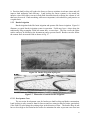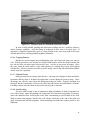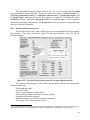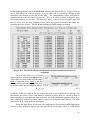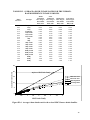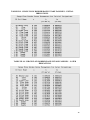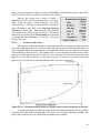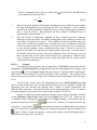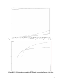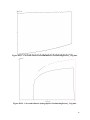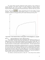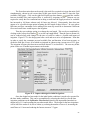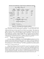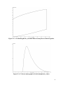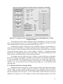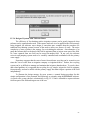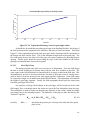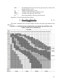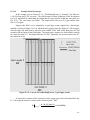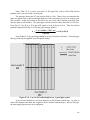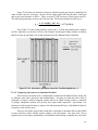
1
NRCS National Engineering Handbook
Part 623
IRRIGATION
Chapter 4
Surface Irrigation
Contents
LIST OF FIGURES ................................................................................................................ v
LIST OF TABLES ................................................................................................................. ix
GLOSSARY............................................................................................................................. x
I
THE PRACTICE OF SURFACE IRRIGATION....................................................... 1
I.1
INTRODUCTION .................................................................................................................................... 1
I.1.1
Surface Irrigation Processes ............................................................................................................... 2
I.2
SURFACE IRRIGATION CONFIGURATIONS.................................................................................. 2
I.2.1
Basin Irrigation................................................................................................................................... 3
I.2.1.1
Development Costs ................................................................................................................... 3
I.2.1.2
Field Geometry ......................................................................................................................... 3
I.2.1.3
Soil Characteristics ................................................................................................................... 4
I.2.1.4
Water Supply ............................................................................................................................ 4
I.2.1.5
Climate...................................................................................................................................... 5
I.2.1.6
Cropping Patterns...................................................................................................................... 5
I.2.1.7
Cultural Factors......................................................................................................................... 5
I.2.1.8
Land Leveling ........................................................................................................................... 5
I.2.2
Furrow Irrigation ................................................................................................................................ 6
I.2.2.1
Development Costs ................................................................................................................... 7
I.2.2.2
Field Geometry ......................................................................................................................... 7
I.2.2.3
Soil Characteristics ................................................................................................................... 7
I.2.2.4
Water Supply ............................................................................................................................ 8
I.2.2.5
Climate...................................................................................................................................... 8
I.2.2.6
Cropping Patterns...................................................................................................................... 8
I.2.2.7
Cultural Factors......................................................................................................................... 8
I.2.2.8
Land Leveling ........................................................................................................................... 8
1.2.3
Border Irrigation................................................................................................................................. 9
I.2.3.1
Development Costs ................................................................................................................... 9
I.2.3.2
Field Geometry ....................................................................................................................... 10
I.2.3.3
Soil Characteristics ................................................................................................................. 10
I.2.3.4
Water Supply .......................................................................................................................... 10
I.2.3.5
Climate.................................................................................................................................... 10
i
I.2.3.6
Cropping Patterns.................................................................................................................... 11
I.2.3.7
Cultural Factors....................................................................................................................... 11
I.2.1.8
Land Leveling ......................................................................................................................... 11
I.2.4
Summary of Surface Irrigation Methods .......................................................................................... 12
I.3
WATER MANAGEMENT IN SURFACE IRRIGATION SYSTEMS.............................................. 12
I.3.1
Choosing a Surface Irrigation System .............................................................................................. 13
I.3.2
Inlet Discharge Control Practices ..................................................................................................... 13
I.3.3
Changing the Field Geometry and Topography................................................................................ 14
I.3.4
Tailwater Recovery and Reuse ......................................................................................................... 14
I.3.5
Automation and Equipment.............................................................................................................. 15
I.3.5.1
Border and Basin Facilities and Automation ............................................................................ 15
I.3.5.2
Furrow Irrigation Facilities and Automation ............................................................................ 16
I.3.6
Cutback............................................................................................................................................. 18
I.3.7
Surge Irrigation................................................................................................................................. 19
I.3.7.1
Effects of Surging on Infiltration ............................................................................................. 20
I.3.7.2
Surge Flow Systems ................................................................................................................ 20
II
SURFACE -- NRCS SURFACE IRRIGATION SIMULATION, EVALUATION,
AND DESIGN SOFTWARE....................................................................................... 22
II.1
OVERVIEW............................................................................................................................................ 22
II.2 GETTING STARTED ............................................................................................................................ 22
II.3.1 File Operations and Exiting SURFACE............................................................................................ 23
II.3.2 Input.................................................................................................................................................. 24
II.3.3 Output............................................................................................................................................... 24
II.3.4 Units ................................................................................................................................................. 24
II.3.5 Simulation ........................................................................................................................................ 25
II.3.6 Design............................................................................................................................................... 25
II.4 DATA INPUT.......................................................................................................................................... 25
II.4.1 Entering Field Characteristics........................................................................................................... 26
II.4.1.1
Basic Field Geometry.............................................................................................................. 27
II.4.1.2
Manning n ............................................................................................................................... 27
II.4.1.3
Field Slope .............................................................................................................................. 27
II.4.1.4
Flow Cross-Section ................................................................................................................. 28
II.4.2 Infiltration Characteristics ................................................................................................................ 29
II.4.3 Inflow Controls................................................................................................................................. 32
II.4.3.1
Simulation Shutoff Control..................................................................................................... 33
II.4.3.2
Inflow Regime ........................................................................................................................ 33
II.4.3.3
Leaching Fraction ................................................................................................................... 34
II.4.3.4
Simulation Speed and Graphical Presentation ........................................................................ 34
II.4.4 Hydrograph Inputs............................................................................................................................ 34
II.4.5 Design Panel..................................................................................................................................... 36
II.5 OUTPUT.................................................................................................................................................. 36
II.5.1 Printed Output .................................................................................................................................. 36
II.5.2 Plotted Output................................................................................................................................... 36
II.6
SIMULATION ........................................................................................................................................ 38
II.7 DESIGN ................................................................................................................................................... 39
II.7.1 Input Data for Design ....................................................................................................................... 40
II.7.1.1
Total Available Flow .............................................................................................................. 40
ii
II.7.1.2
Total Time Flow is Available.................................................................................................. 40
II.7.1.3
Maximum Velocity ................................................................................................................. 41
II.7.1.4
Design Flow ............................................................................................................................ 41
II.7.1.5
Cutoff Time............................................................................................................................. 41
II.7.2 Field Layout...................................................................................................................................... 42
II.7.3 Simulation of Design ........................................................................................................................ 42
II.7.4 Results .............................................................................................................................................. 43
II.7.5 Printed Output .................................................................................................................................. 43
II.8 SAMPLE DATA SETS........................................................................................................................... 43
II.8.1 FreeDrainingFurrow_1.cfg ............................................................................................................... 43
II.8.2 FreeDrainingFurrow_2.cfg ............................................................................................................... 43
II.8.3 FreeDrainingBorder_3.cfg................................................................................................................ 44
II.8.4 FreeDrainingBorder_4.cfg................................................................................................................ 44
II.8.5 BlockedEndBorder.cfg ..................................................................................................................... 44
II.8.6 Basin_5.cfg....................................................................................................................................... 44
II.8.7 Basin_6.cfg....................................................................................................................................... 45
II.8.8 CutbackDesign.cfg ........................................................................................................................... 45
III
SURFACE IRRIGATION EVALUATION .............................................................. 46
III.1 INTRODUCTION .................................................................................................................................. 46
III.2 SOME IMPORTANT SURFACE IRRIGATION CONCEPTS......................................................... 46
III.2.1
Soil Moisture ............................................................................................................................... 46
III.2.1.1
Example 1 ............................................................................................................................... 50
III.2.1.2
Example 2 ............................................................................................................................... 50
III.2.2
Infiltration .................................................................................................................................... 51
III.2.2.1
Basic Theory ........................................................................................................................... 51
III.2.2.2
Revised NRCS Intake Families............................................................................................... 53
III.2.3
Irrigation Efficiency and Uniformity ........................................................................................... 60
III.2.3.1
Irrigation Efficiency............................................................................................................... 61
III.2.3.2
Application Efficiency ............................................................................................................ 61
III.2.3.3
Storage or Requirement Efficiency ......................................................................................... 61
III.2.3.4
Distribution Uniformity .......................................................................................................... 61
III.2.3.5
Deep Percolation Ratio ........................................................................................................... 62
III.2.3.6
Tailwater Ratio........................................................................................................................ 62
III.2.3.7
Example .................................................................................................................................. 62
III.2.4
Water Measurement..................................................................................................................... 63
III.3 FIELD EVALUATIONS ........................................................................................................................ 64
III.3.1
Standard Field Evaluation Procedure........................................................................................... 64
III.3.1.1
Flow Shape.............................................................................................................................. 64
III.3.1.2
Example .................................................................................................................................. 67
III.3.1.3
Advance and Recession .......................................................................................................... 68
III.3.1.4
Example .................................................................................................................................. 70
III.3.2
Infiltration .................................................................................................................................... 70
III.3.2.1
Volume Balance Equation....................................................................................................... 71
III.3.2.2
Volume Balance Estimate of Kostiakov a, K, and Fo.............................................................. 72
III.3.2.3
Example .................................................................................................................................. 73
III.3.2.4
Adjusting Infiltration for Furrow Wetted Perimeter ............................................................... 76
III.3.2.5
General Comment ................................................................................................................... 77
IV
REDESIGNING SURFACE IRRIGATION SYSTEMS ......................................... 78
iii
IV.1 THE OBJECTIVE AND SCOPE OF SURFACE IRRIGATION DESIGN...................................... 78
IV.2 THE BASIC DESIGN PROCESS ......................................................................................................... 79
IV.2.1
The Preliminary Design ............................................................................................................... 79
IV.2.2
Detailed Design ........................................................................................................................... 80
IV.3 BASIC DESIGN COMPUTATIONS .................................................................................................... 81
IV.3.1
Free Draining Surface Irrigation Design...................................................................................... 81
IV.3.1.1
Example Free Draining FurrowDesign..................................................................................... 82
IV.3.1.2 Example Free Draining Border Design................................................................................... 86
IV.3.2
Blocked-end Surface Irrigation Design........................................................................................ 88
IV.3.2.1
Example Blocked End Border Design...................................................................................... 90
IV.3.3
Design Procedure for Cutback Systems....................................................................................... 91
IV.3.3.1
Example Furrow Cutback Design ............................................................................................ 91
IV.3.4
Design of Systems with Tailwater Reuse .................................................................................... 93
IV.3.4.1
Example Furrow Tailwater Reuse Design................................................................................ 95
IV.3.5
Design of Surge Flow Systems .................................................................................................... 96
IV.3.5.1
Example Surge Flow Design.................................................................................................... 97
IV.4 HEADLAND FACILITIES.................................................................................................................... 98
IV.4.1
Head Ditch Design....................................................................................................................... 98
IV.4.1.1
Sizing Siphon Tubes and Spiles ............................................................................................. 101
IV.4.1.2
Sizing Small Ditch Gates ....................................................................................................... 101
IV.4.1.3
Sizing Check Outlets and Large Ditch Gates.......................................................................... 101
IV.4.2
Gated Pipe Design ..................................................................................................................... 103
IV.4.2.1
Choosing a Pipe Material....................................................................................................... 104
IV.4.2.2
Gated Outlets ......................................................................................................................... 104
IV.4.2.3
Gated Pipe Sizing .................................................................................................................. 105
IV.4.2.4
Example Gated Pipe Design................................................................................................... 107
IV.4.3
Comparing Alternatives for Headland Facilities........................................................................ 109
APPENDIX A. A NOTE ON THE DEVELOPMENT OF THE ORIGINAL NRCS
INTAKE FAMILIES AND THEIR MODIFICATIONS FOR FURROW
IRRIGATION ............................................................................................................ 111
A.1
INTRODUCTION ................................................................................................................................ 111
A.2
EVOLUTION OF THE ORIGINAL CONCEPT .............................................................................. 111
A.3
MODIFICATIONS FOR FURROW IRRIGATION......................................................................... 112
A.4 MODIFICATIONS FOR BORDER, BASIN, AND FURROW IRRIGATION .............................. 113
A.4.1 NRCS Intake Family Designation .................................................................................................. 113
A.4.2 Adjusting Intake for Furrow Irrigated Conditions .......................................................................... 114
A.4.3 Converting Between Border/Basin Infiltration and Furrow Intake................................................. 114
iv
LIST OF FIGURES
Figure I-1. Layout and function of irrigation system components.................................... 1
Figure I-2. The basic phases of a surface irrigation event. ................................................ 2
Figure I-3. Typical basin irrigation system in the western U.S. ........................................ 3
Figure I-4. Furow irrigation using siphon tubes from a field bay..................................... 6
Figure I-5. Contour furrow irrigation. ................................................................................ 7
Figure I-6. Border irrigation in progress............................................................................. 9
Figure I-7. Illustration of contour border irrigation. ......................................................... 9
Figure I-8. Tailwater outlet for a blocked-end border system......................................... 11
Figure I-9. A typical tailwater recovery and reuse system............................................... 15
Figure I-10. Typical border and basin field outlets. ......................................................... 16
Figure I-11. A wheel lift slide gate before and after automation..................................... 16
Figure I-12. Two methods of supplying water to furrows................................................ 17
Figure I-13. Gate pipe options for furrow irrigation........................................................ 17
Figure I-14. Schematic Cablegation system....................................................................... 18
Figure I-15. Advance and recession trajectories for a surge flow system....................... 19
Figure I-16. Early surge flow system.................................................................................. 20
Figure I-17. The automated butterfly surge flow valve.................................................... 21
Figure II-1. The main SURFACE screen. .......................................................................... 23
Figure II-2. The SURFACE command bar........................................................................ 23
Figure II-3. The SURFACE input tabbed notebook. ......................................................... 24
Figure II-4. The SURFACE tabular output screen........................................................... 25
Figure II-5. The Field Characteristics panel of the input tabbed notebook................... 26
Figure II-6. Illustration of multiple sloped surface irrigated field.................................. 28
Figure II-7. The Infiltration Characteristics panel of the input tabbed notebook. ....... 30
Figure II-8. The NRCS reference intake family for initial continuous flow furrow
irrigations.................................................................................................... 31
Figure II-9. The Inflow Controls panel of the input tabbed notebook. .......................... 32
Figure II-10. The Hydrograph Input panel of the input tabbed notebook..................... 35
Figure II-11. A typical advance/recession plot from the SURFACE graphics output... 37
Figure II-12. A typical runoff hydrograph from the SURFACE graphic output. ......... 37
Figure II-13. A typical plot of intake distribution for the SURFACE graphics output. 38
v
Figure II-14. The main simulation screen.......................................................................... 38
Figure II-15. The SURFACE design panel. ........................................................................ 39
Figure III-1. Components of the soil-water matrix........................................................... 47
Figure III-2. Components of soil water.............................................................................. 48
Figure III-3. Variation of available soil moisture with soil type...................................... 49
Figure III-4. Average 6-hour intake rate for the revised NRCS furrow intake families.
...................................................................................................................... 54
Figure III-5. Reference wetted perimeters for the revised NRCS intake families......... 57
Figure III-6. Reference flow for the NRCS intake families. ............................................ 57
Figure III-7. Distribution of applied water in surface irrigation. ................................... 60
Figure III-8. Cross-sectional shapes for furrow and border/basin irrigation................ 66
Figure III-9. Example cross-section evaluation using the SURFACE software. ............ 67
Figure III-10. Field measurement points for advance and recession evaluations in the
field. ............................................................................................................. 68
Figure III-11. Advance/recession curve for the example FreeDrainingFurrow_2.cfg
data. ............................................................................................................. 74
Figure III-12 Tailwater hydrograph for the example FreeDrainingFurrow_2.cfg data.
...................................................................................................................... 74
Figure III-13. Corrected advance/recession curve for FreeDrainingFurrow_2.cfg data.
...................................................................................................................... 75
Figure III-14. Corrected tailwater hydrograph for FreeDrainingFurrow_2.cfg data. . 75
Figure III-15. Final simulated tailwater hydrograph for FreeDrainingFurrow_2.cfg
data. ............................................................................................................. 76
Figure IV-1. FreeDrainingFurrow_1 advance/recession trajectory. .............................. 83
Figure IV-2. FreeDrainingFurrow_1 tailwater hydrograph. .......................................... 83
Figure IV-3. Soil moisture distribution from FreeDrainingFurrow_1 data. ................. 84
Figure IV-4. SURFACE Design Panel for initial FreeDrainingFurrow_1 condition. ... 84
Figure IV-5. Improved design for initial irrigations......................................................... 85
Figure IV-6. Selecting the later irrigation conditions....................................................... 86
Figure IV-7. FreeDrainingBorder_4 advance and recession plots for initial irrigations.
...................................................................................................................... 87
Figure IV-8. Tailwater hydrograph for FreeDrainingBorder_4 data. ........................... 87
Figure IV-9. Design Panel for the final design of the FreeDrainingBorder_4, initial
irrigation example...................................................................................... 88
Figure IV-10. Stages of a blocked-end irrigation.............................................................. 89
vi
Figure IV-11. Simulation of the BlockedEndBorder data. .............................................. 91
Figure IV-12. Simulated tailwater hydrograph using the CutbackDesign.cfg data file.92
Figure IV-13. Schematic tailwater reuse system............................................................... 94
Figure IV-14. FreeDrainingFurrow_2.cfg design of the field using the main water
supply. ......................................................................................................... 96
Figure IV-16. Typical surface irrigation head ditch configurations. ............................ 100
Figure IV-17. Typical operational conditions of surface irrigation siphons and spiles.
.................................................................................................................... 102
Figure IV-18. Typical head-discharge curve for gated pipe outlets.............................. 105
Figure IV-19. Layout of FreeDrainingFurrow_1 gated pipe system. ........................... 107
Figure IV-19. Layout of FreeDrainingFurrow_1 gated pipe system. ........................... 108
Figure IV-20. Alternative gated pipe layout for FreeDrainingFurrow_1. ................... 109
Figure A-1. Comparison between the average 6-hour intake rate and the basic intake
rate of the original SCS intake families. ................................................ 114
vii
LIST OF TABLES
TABLE I-1. A GENERAL COMPARISON OF SURFACE IRRIGATION METHODS.
...................................................................................................................... 12
TABLE III-1. AVERAGE ROOTING DEPTHS OF SELECTED CROPS IN DEEP,
WELL-DRAINED SOILS......................................................................... 49
TABLE III-2. AVERAGE 6-HOUR INTAKE RATES FOR THE FURROW-BASED
REFERENCE INTAKE FAMILIES. ...................................................... 54
TABLE III-3. CONTINUOUS FLOW FURROW INTAKE FAMILIES – INITIAL
IRRIGATIONS. ......................................................................................... 55
TABLE III-4. CONTINUOUS FLOW FURROW INTAKE FAMILIES – LATER
IRRIGATIONS. ......................................................................................... 55
TABLE III-5. SURGE FLOW FURROW INTAKE FAMILIES – INITIAL
IRRIGATIONS. ......................................................................................... 56
TABLE III-6. SURGE FLOW FURROW INTAKE FAMILIES – LATER
IRRIGATIONS. ......................................................................................... 56
TABLE III-7. CONTINUOUS FLOW BORDER/BASIN INTAKE FAMILIES –
INITIAL IRRIGATIONS. ........................................................................ 58
TABLE III-8. CONTINUOUS FLOW BORDER/BASIN INTAKE FAMILIES –
LATER IRRIGATIONS. .......................................................................... 58
TABLE III-9. SURGE FLOW BORDER/BASIN INTAKE FAMILIES – INITIAL
IRRIGATIONS. ......................................................................................... 59
TABLE III-10. SURGE FLOW BORDER/BASIN INTAKE FAMILIES – LATER
IRRIGATIONS. ......................................................................................... 59
TABLE IV-1. MINIMUM RECOMMENDED SIPHON AND SPILE SIZES FOR
SURFACE IRRIGATION SYSTEMS................................................... 102
TABLE IV-2. MINIMUM RECOMMENDED DITCH GATE SIZES FOR SURFACE
IRRIGATION SYSTEMS....................................................................... 103
TABLE IV-3. MINIMUM RECOMMENDED CHECK OUTLET AND LARGE
DITCH GATE SIZES FOR SURFACE IRRIGATION SYSTEMS... 103
TABLE IV-4. MINIMUM RECOMMENDED GATED PIPE DIAMETERS FOR
VARIOUS FRICTION GRADIENTS. .................................................. 106
TABLE A-1. LAYERED SCS RING INFILTROMETER DATA................................ 112
ix
GLOSSARY
ac-ft
A common English unit for water volume called an “acre-foot”. It is the
volume of water required to cover an acre with water one foot deep. One
ac-ft equals 325,851 gallons or 1,233 cubic meters.
advance phase
The period of time between the introduction of water to surface irrigated
field and the time when the flow reaches the end of the field.
advance time (tL)
The elapsed time between the initiation of irrigation and the completion of
the advance phase. Usual units are minutes or hours.
application efficiency (Ea)
See irrigation efficiency.
available water (AW) Soil moisture stored in the plant root zone between the limits of field
capacity (FC) and the permanent wilting point (PWP). Sometimes
referred to as allowable soil moisture depletion or allowable soil water
depletion. Usual units are inches of water per inch of soil depth.
basic intake rate (fo) The final or steady state infiltration rate of a ponded soil surface. Usual
units are cubic feet per foot of length per minute for furrows and feet per
minute for borders and basins.
basin irrigation
Irrigation by flooding level fields. The perimeter of basins is usually fully
contained by surrounding dikes.
block-end
The practice of using dikes at the downstream end of the surface irrigated
field to prevent or control runoff (tailwater).
border irrigation
A surface irrigation configuration in which irrigation is applied to
rectangular strips of the field. Borders typically have a slope in the
direction of irrigation but not laterally.
bulk density (γb)
Mass of dry soil per unit volume. Typical values in irrigated soils range
from about 65 pounds per cubic foot (lbs/ft3) (1.05 g/cm3) for a clay soil to
as much as 100 lbs/ft3 (1.6 g/cm3) for sandy soils.
cablegation
An automated surface irrigation system employing a continuously moving
plug in sloping gated pipe. Outlet flows are highest near the plug and
diminish away from it thereby creating a cutback regime.
cfs
Abbreviation for “cubic feet per second”, a common English unit of
discharge which is a rate of the flow or discharge equal to 448.8 gallons of
water flowing each minute, gpm, or 28.32 liters per second (lps).
chemigation
The process of applying chemicals to an irrigated field through the
irrigation stream. Chemigation is also referred to as fertigation when used
to define through-system fertilizer applications.
consumptive use
The water extracted by plants from the soil during their growth process or
evaporated from the cropped surface (plant and soil). Usual units are
inches.
x
contour irrigation
The practice of arranging furrows, borders, or basins along the natural
contours of a field.
conveyance efficiency
See irrigation efficiency
conveyance loss
Water lost from the conveyance system due to evaporation, seepage from
the conveyance (ditch, pipe, canal, etc.), leakage through control and
turnout structures or valves, or is unaccounted for due to measurement
errors.
cropping pattern
The term cropping pattern has two connotations. The first is the seasonal
sequence of crops grown on a single field. The second is a more general
term describing the distribution of cropped acreages in an area in any one
year.
crop root zone
The soil depth from which crop extracts the water needed for its growth.
This depth depends on the crop variety, growth stage, and soil. Usual
units are inches or feet.
cumulative intake (z, Z)
The depth (z) or volume per unit length (Z) of water infiltrating a
field during a specified period, usually the time between the initiation of
irrigation and the end of the recession phase. Usual units are feet or inches
for z and cubic feet per foot of length for furrows.
cutback irrigation
The practice of using a high unit discharge during the advance phase and
a reduced one during the wetting or ponding phase to control runoff.
cutoff time (tco)
Cumulative time since the initiation of irrigation until the inflow is
terminated. Also referred to as set time. Usual units are minutes or hours.
cycle time
Length of water application periods, typically used with surge irrigation.
Usual units are minutes.
deep percolation (DP)
The depth or volume of water percolating below the root zone.
The depth or volume of deep percolation divided by the average depth or
volume of water applied to a field is the deep percolation ratio (DPR).
deficit irrigation
The practice of deliberately under-irrigating a field in order to conserve
water or provide a capacity to store expected precipitation.
depletion time (td)
The elapsed time between the initiation of irrigation and the recession of
water following cutoff at the field inlet. Usual units are minutes.
distribution system
The network of ditches or pipes, and their appurtenances, which convey
and distribute water to the fields.
ditch
Constructed open channel for conducting water to fields.
ditch gate
Small controlled opening or portal in a ditch used to divert water directly
to furrows, borders, or basins.
distribution uniformity (DU) See uniformity.
effective precipitation Portion of total precipitation which becomes available for plant growth.
evapotranspiration
See consumptive use.
xi
fertigation
See chemigation.
field bay
A narrow strip at the head of an irrigated field which is constructed
slightly below field elevation used to redistribute water flowing from a
pipe or ditch before flowing over the field.
field capacity (Wfc)
The dry weight soil moisture fraction in the root zone when vertical
drainage has effectively ceased following irrigation or heavy rainfall.
Generally, field capacity is assumed to occur at a negative one-third
atmosphere or one bar of soil moisture tension.
field length
The dimension of the irrigated field in the direction of water flow. Usual
units are feet.
flow rate (q, Q)
The volume of water passing a point per unit time per unit width (q) or per
furrow (Q). Another term for flow rate is discharge. See also unit
discharge. In surface irrigation flow rate is typically expressed in units of
cfs or gpm.
flood irrigation
An alternative expression for surface irrigation.
furrow irrigation
The practice of surface irrigation using small individually regulated field
channels called furrows, creases, corrugations, or rills.
gated pipe
Portable pipe with small individually regulated gates installed along one
side for distributing irrigation water onto a field.
gpm
Acronym for gallons per minute. See also cfs, unit discharge.
head ditch
A small channel along one part of a field that is used for distributing water
in surface irrigation.
infiltration
The process of water movement into and through soil.
infiltration rate (I)
The time-dependent rate of water movement into an irrigated soil. Usual
units are inches or feet per minute or hour.
infiltrometer
A device, instrument, or system to measure infiltration rates.
intake family
Grouping of intake characteristics into families based on averge 6-hour
intake rates.
intake rate
A term often used interchangeably with infiltration rate but in technical
terms is the process of infiltration when the surface geometry is
considered such as in furrow irrigation.
intake reference flow (Qinfilt) The discharge at which intake is measured or evaluated in a
surface irrigation system. Usual units are cfs or gpm.
irrigation efficiency In general terms the efficiency or performance of an irrigation system is
measured or expressed as the amount of water used beneficially by the
crops divided by the total amount of water made available to the crops. In
order to provide more specific assistance in evaluating irrigation
performance of surface irrigation systems at the field level, the following
terms have been defined:
xii
application efficiency (Ea) The ratio of the average depth or volume of the irrigation
water stored in the root zone to the average depth or volume of
irrigation water applied to the field. Inefficiencies are caused by
deep percolation and tailwater losses.
conveyance efficiency (Ce) Ratio of the water delivered, to the total water diverted or
pumped into an open channel or pipeline at the upstream end.
Inefficiencies are caused by leakage, spillage, seepage, operational
losses and unaccountable water due to poor measurement.
irrigation efficiency (Ie)
At the field level, irrigation efficiency is the ratio of the
average depth or volume of irrigation water stored in the root zone
plus the depth or volume of deep percolation that is needed for
leaching to the average depth or volume of irrigation water
applied.
Inefficiencies are caused by tailwater and deep
percolation losses above the leaching requirement.
storage or requirement efficiency (Er)
Ratio of the amount of water stored in the
root zone during irrigation to the amount of water needed to fill the
root zone to field capacity. Inefficiencies are caused by underirrigating part of the field.
irrigation interval
The interval between irrigation events. Usual units are days.
irrigation requirement
Quantity of water, exclusive of effective precipitation, that is
required for crop demands including evapotranspiration, leaching, as well
as special needs such as seed bed preparation, germination, cooling or
frosts protection. Where there is an upward flow from a shallow
groundwater, it should reduce the amount of water required from the
irrigation system. The irrigation requirement is often called the “net”
irrigation requirement. Recognizing that no irrigation system can exactly
supply the irrigation requirement due to inefficiencies, a “gross”
irrigation requirement is often estimated by dividing the irrigation
requirement by an irrigation efficiency term. Usual units are inches.
irrigation set
A subdivision of the field that is individually irrigated. Sets are generally
required whenever the supply flow is too small to irrigate the entire field
at once.
land leveling
A general reference to the process of shaping the land surface for better
movement of water. A more correct term is land grading. When land
grading is undertaken to make the field surface level, the term land
leveling can be used as a specific reference. Related terms are land
forming, land smoothing, and land shaping.
leaching
The process of transporting soluble materials from the root zone in the
deep percolation. The most common of these materials are salts, nutrients,
pesticides, herbicides and related contaminants.
leaching fraction (LF)
Ratio of the depth of deep percolation required to maintain a salt
balance in the root zone to the depth of infiltration. Also referred to as the
leaching requirement.
xiii
MAD (zreq, Zreq)
An abbreviation for management allowable depletion or maximum
allowable deficiency. MAD is the soil moisture at which irrigations
should be scheduled. In the evaluation or design of surface irrigation
systems, MAD is referenced as a required depth per unit length, zreq, or a
volume per unit length per unit width or furrow spacing, Zreq.
opportunity time (τreq)
The cumulative time between recession and advance at a specific
point on the surface irrigated field. Usual units are minutes or hours.
permanent wilting point (Wpw)
Moisture content, on a dry weight basis, at which plants can
no longer obtain sufficient moisture from the soil to satisfy water
requirements and will not fully recover when water is added to the crop
root zone. Classically, this occurs at about -15 atmospheres or15 bars of
soil moisture tension.
porosity (φ)
The ratio of the volume of pores in a soil volume to the total volume of the
sample.
pump-back system
See tailwater reuse system.
recession phase
A term referring to the drainage of water from the field surface following
the termination of inflow.
recession time (tr)
The interval between the initiation of irrigation and completion of the
recession phase. Usual units are minutes or hours.
resistance coefficient (n)
A parameter in the Manning Equation that provides an expression
of hydraulic resistance at the boundary of the flow.
return flow
Deep percolation, tailwater, conveyance seepage, and spills from an
irrigation system which flow into local streams, rivers, lakes, or reservoirs.
run length (RL)
Distance water must flow over the surface of a field to complete the
advance phase. The field length is the longest run length. Usual units are
feet.
runoff
A general term describing the water from precipitation, snow melt, or
irrigation that flows over and from the soil surface. In surface irrigation,
runoff is used interchangeably with tailwater.
run time (RT)
See cutoff time.
saturation (S)
The ratio of the volume of water to the volume of pore space in a soil.
siphon tube
Relatively short, light-weight, curved tube used to divert water over ditch
banks.
slide gate
A regulated ditch or canal offtake used to divert water to irrigated borders
and basins. See also ditch gate.
soil dry weight
The weight of a soil sample after being dried in an oven at 95-105 oC for
12-24 hours. Usual units are grams since as metric units are typically used
for these measurements.
soil moisture content (θ)
soil.
The ratio of the volume of water in a soil to the total volume of the
xiv
soil moisture depletion (SMD)
The depth or volume of water that has been depleted from
the available water in a soil. This can also be viewed as the amount of
water required to return the soil moisture to field capacity.
specific gravity (γs)
The ratio of the unit weight of soil particles to the unit weight of water at
20 oC.
spile
A small pipe or hose inserted through ditch banks to transfer water from
an irrigation ditch to a field.
subbing
The horizontal movement of water from a furrow into the row bed.
surface irrigation
A broad class of irrigation systems where water is distributed over the
field surface by gravity flow. See border, basin and furrow irrigation.
surge irrigation
Surface irrigation by short pulses or surges of the inflow stream during the
advance phase and then by high frequency pulses or surges during the
wetting or ponding phase.
tailwater
See runoff.
tailwater reuse system
An appurtenance for surface irrigation systems where there is
tailwater runoff. The tailwater is first captured in a small reservoir and
then diverted or pumped back to the irrigation system, i.e., either to the
same field or to anther in proximity.
uniformity
Irrigation uniformity is a qualitative measure of how evenly water is
applied by the surface irrigation system.
distribution uniformity (DU) In surface irrigation, the distribution uniformity is the ratio
of the depth or volume infiltrated in the least irrigated quarter
(sometimes called the low quarter) of the field to the average depth
or volume infiltrated in the entire field.
unit discharge
The discharge or flow rate of water applied to an irrigated field per unit
width or per furrow. Typical units are cfs and gpm.
wetted perimeter
Length of the wetted contact per unit width between irrigation water and
the furrow, border, or basin surface, measured at right angles to the
direction of flow. Usual units are inches or feet.
wetting or ponding phase
The period of time in an irrigation event between the completion of
advance phase and the cutoff time.
wild flooding
Surface irrigation system where water is applied to the soil surface without
flow controls and without management of flowrate and cutoff time.
xv
I
The Practice of Surface Irrigation
I.1
INTRODUCTION
Surface irrigation is the oldest and most common method of applying water to croplands.
Also referred to as “flood irrigation”, the essential feature of this irrigation system is that water is
applied at a specific location and allowed to flow freely over the field surface and thereby apply
and distribute the necessary water to refill the crop root zone. This can be contrasted to sprinkle
or drip irrigation where water is distributed over the field in pressurized pipes and then applied
through sprinklers or drippers to the surface.
Surface irrigation has evolved into an extensive array of configurations which can broadly
be classified as: (1) basin irrigation, (2) border irrigation, (3) furrow irrigation, and (4) wild
flooding. The distinction between the various classifications is often subjective. For example, a
basin or border system may be furrowed. Wild flooding is a catch-all category for the situations
where water is simply allowed to flow onto an area without any attempt to regulate the
application or its uniformity. And since no effort is made to regulate the application or
uniformity, this type of surface irrigation does not need attention in this handbook. If control of
the wild flooding event is introduced, it then evolves into a border, basin or furrow system.
An irrigated field is only one component of an irrigation system as illustrated in Fig. I-1.
Figure I-1. Layout and function of irrigation system components.
Water must be diverted from a stream, captured and released from a reservoir, or pumped
from the groundwater and then conveyed to the field. Excess water needs to be drained from the
field. Each of these components requires design, operation, and maintenance of regulating and
1
control structures. In order for the system to be efficient and effective, the flow not only must be
regulated and managed, but most importantly, it must also be measured. Thus, the on-field
component (surface, sprinkle or drip), is the heart of the irrigation system. And, while it is
necessary to limit the scope of this Chapter of the NRCS National Engineering Handbook to a
guide for the evaluation and design of the surface irrigation system itself, it should be
appreciated that the surface irrigation system is entirely dependent on the other components for
its performance.
I.1.1
Surface Irrigation Processes
There are three general phases in a surface irrigation event: (1) advance; (2) wetting or
ponding; and (3) recession. These are illustrated graphically in Fig. I-2. The advance phase
occurs between when water is first introduced to the field and when it has advanced to the end.
Between the time of advance completion, or simply advance time, and the time when water is
shutoff or cutoff, is the period designated as the wetting or ponding phase. The wetting or
ponding phase will not be present if the inflow is terminated before the advance phase is
completed – a typical situation in borders and basins but a rarity in furrows.
The wetting phase is accompanied by tailwater runoff from free-draining systems or by
ponding on blocked end systems. After the inflow is terminated, water recedes from the field by
draining from the field and/or into the field via infiltration. This is the recession phase. All
numerical models of surface irrigation attempt to simulate these processes.
Figure I-2. The basic phases of a surface irrigation event.
I.2
SURFACE IRRIGATION CONFIGURATIONS
Choosing a particular surface irrigation system for the specific needs of the individual
irrigator depends on the proper evaluation and consideration of the following factors: (1) costs
of the system and its appurtenances, (2) field sizes and shapes, (3) soil intake and water holding
2
characteristics, (4) the quality and availability (timing of deliveries, amount and duration of
delivery) of the water supply, (5) climate, (6) cropping patterns, (7) historical practices and
preferences, and (8) accessibility to precision land leveling services.
I.2.1
Basin Irrigation
Basin irrigation is distinguished by a completely level field with perimeter dikes to
control and/or prevent runoff. Figure I-3 illustrates the most common basin irrigation concept.
Figure I-3. Typical basin irrigation system in the western U.S.
I.2.1.1 Development Costs
Basin irrigation is generally the most expensive surface irrigation configuration to
develop and maintain, but often the least expensive to operate and manage. Land leveling is the
most costly development and maintenance requirement, although the perimeter diking can also
be expensive to form and maintain. In areas where turnouts from the delivery system have
relatively small discharges, development costs may also be increased by necessary changes in the
irrigation system upstream of the basin.
Since basins are typically designed to pond the water on their surfaces and prevent
tailwater, they are usually the most efficient surface irrigation configurations. In addition,
management is almost always simpler.
I.2.1.2 Field Geometry
In the absence of field slope to aid the movement of water on the field surface, the “run
length”, or distance the water has to advance over the field tends to be minimized. Many basins
3
take on a square rather than a rectangular shape, but this depends entirely on the availability of
sufficient flow rates and the intake characteristics of the soil.
One of the major advantages of basins is their utility in irrigating fields with irregular
shapes and small fields.
I.2.1.3 Soil Characteristics
Basin irrigation systems usually operate at less frequent intervals than furrows or borders
by applying a larger depth during irrigation. Consequently, medium to heavy soils with their
high moisture holding capacity are better suited to basins than lighter soils. The efficiency and
uniformity of basin irrigation depend on the relative magnitude of the field inflow and the soil
intake. A soil with a relatively high intake characteristic will require a substantially higher flow
rate to achieve the same uniformity and efficiency as for a heavier soil.
Since the water may cover the entire basin surface, a soil that forms dense crusts upon
drying may have detrimental impacts on seed germination and emergence. It is common practice
to furrow soils of this nature to reduce crusting problems. On the other hand, basin irrigation is
an effective means for reclamation and salt leaching.
Many of the heavier soils will form cracks between irrigations which may be responsible
for much of the water that infiltrates during irrigation. These soils are also susceptible to
forming compacted layers (hard pans or plow pans) at the cultivation depth. The impact of
cracking in basin irrigation is an increased applied depth while the impact of a “plow pan” is to
restrict it.
I.2.1.4 Water Supply
The water supply to an irrigated field has four important characteristics: (1) its quality;
(2) its flow rate; (3) its duration; and (4) its frequency of delivery.
The quality of the water added to the field will be reflected in the quality of the water
throughout the root zone. Salinity is usually the most important quality parameter in surface
irrigation and the higher the salinity in the irrigation water the higher will be the concentration of
salts in the lower regions of the root zone. However, since basins do not apply water to the crop
canopy as does sprinkle irrigation, water supplies with relatively high salinities can be used
Some water supplies also have poor quality due to toxic elements like Boron. .
The most important factor in achieving high basin irrigation uniformity and efficiency
while minimizing operational costs is the discharge applied to the field. In basin irrigation, the
higher the available discharge the better, constrained only by having such a high flow that
erosion occurs near the outlet.
The duration of irrigation is dependent on the depth to be applied, the flow rate onto the
field, and the efficiency of the irrigation. Basin irrigation’s typically high discharges and high
efficiencies mean that basin irrigations may require less total time than borders and furrows.
This coupled with the fact that basins usually irrigate heavier soils and apply larger depths means
that the irrigation of basin is typically less frequent than borders or furrows. The duration and
frequency of basin irrigation impose different requirements on the water supply system than
systems operated to service border and furrow systems.
4
I.2.1.5 Climate
Whenever water ponds on a cropped surface for an extended period of time the oxygencarbon dioxide exchange between the atmosphere and the roots is disrupted. If the disruption is
long enough, the crops will die. This process is sometimes called “scalding”. Scalding is
perceived as a serious risk in basin irrigation by irrigators in hot dry climates. Of course rice
farming depends on this process for weed control.
Another climate related impact of basin irrigation is the effect of water temperature on
the crop at different stages of growth. Irrigation with cold water early in the spring can delay
growth whereas in the hot periods of the summer it can cool the environment – both of which can
be beneficial or detrimental in some cases.
One important advantage of basins in many areas of high rainfall is that they can more
effectively capture it than can borders or furrows. Thus basins enjoy the benefits of higher levels
of effective precipitation and may actually require less irrigation delivery during rainy periods as
long as the crops are not damaged by subsequent scalding or flooding.
I.2.1.6 Cropping Patterns
With its full wetting and large applied depths, basin irrigation is most conducive to the
irrigation of full-stand crops like alfalfa, grains, grass, and rice. Row crops can be and often are
grown in basins as well. Widely spaced crops like fruit trees do not require as much of the total
field soil volume to be wetted and thus basin irrigation in these instances is less useful. Although
it should be noted that mini-basins formed around each tree and then irrigated in pass-through or
cascade fashion are found in many orchard systems. Cascading systems are usually less efficient
and have low uniformity due to poor water control.
Basin irrigation is also more effective with deep rooted crops like alfalfa than with
shallow rooted crops like vegetables. Crops which react adversely to crown-wetting do not favor
basins.
I.2.1.7 Cultural Factors
Because surface irrigation depends on the movement of water over the field surface,
whose properties change from year to year and crop to crop as well as from irrigation to
irrigation, surface irrigation management is a difficult task to do well and consistently. Basin
irrigation reduces this burden by eliminating tailwater from the management process. However,
where basin irrigation has not been practiced previously, the added costs and the uncertainty
associated with a lack of experience are often substantial barriers to its adoption.
Basin irrigation is less common in the US than either border or furrow systems but has
been shown to have significant advantages. Nevertheless, most irrigators will stay with practices
that have been used previously in their area rather than take the risk associated with a new
technology. Consequently, demonstrations are often necessary to introduce basin irrigation.
One of the criticisms of basin irrigation when used with square fields is the increased
equipment turns during cultivating, planting, and harvesting operations.
I.2.1.8 Land Leveling
Before the advent of the laser guided land grading equipment, it was common to find
surface elevations as much as one or two inches lower or higher than the design elevations of the
5
field. Land leveling operators varied in skill and experience. Today, the precision of land
grading equipment is much greater and does not depend nearly as much on operator skill and
experience.
It should come as no surprise that since the field surface must convey and distribute water
any undulations will impact the flow and therefore the efficiency and uniformity. Basin
irrigation is somewhat less dependent on precision field topography than either furrow or border
systems because of high flows or the ponding, but many users of basin irrigation insist that the
most important water management practice they have is “lasering”. Precision land leveling is an
absolute prerequisite to high performance surface irrigation systems, including basins. This
includes regular precision maintenance during field preparations (land smoothing).
I.2.2
Furrow Irrigation
Furrow irrigation is at the opposite extreme of the array of surface irrigation configurations
from basins. Rather than flooding the entire field, small channels called furrows and sometimes
creases, rills, or corrugations are formed and irrigated as shown in Fig. I-4. The amount of water
per unit width on a furrow irrigated field may only be 20% of the water flowing over a similar
width in a basin. Infiltration is two-dimensional through the wetted perimeter rather than a
vertical one-dimensional intake. Furrows can be blocked at the end to prevent runoff but this is
not a common practice unless they are used in basins or borders to compensate for topographical
variation or provide a raised seed bed to minimize crusting problems. The distinction between a
furrowed basin or a furrowed border and furrow irrigation lies in the semantic preference of the
user. For purposes of evaluation and design, both of these situations would fall under the term
furrow irrigation.
Figure I-4. Furow irrigation using siphon tubes from a field bay.
6
I.2.2.1 Development Costs
Furrow irrigation systems are the least expensive surface irrigation systems to develop
and maintain primarily because minimal land leveling is required to implement a furrow system
and less precise land smoothing is necessary for maintenance. The furrow themselves can be
formed with cultivation equipment at the time of planting.
While less expensive to implement, furrow systems are substantially more labor intensive
than basins. Variations in individual flows, slopes, roughness, and intake alter the advance rate
of each furrow and there are often substantial differences in how long it takes the water to reach
the end of the furrow. In addition, some furrows are compacted by the wheel traffic of planting
and cultivation equipment and have substantially different characteristics than non-traffic
furrows. Irrigators compensate by adjusting the furrow flows and thereby need to be at the field
longer. Further, they also have to assess how long to allow the water to run off the field before
shutting it off as opposed to shutting the flow off in a basin when the correct total volume has
been added to the field.
Because most furrow systems allow field tailwater, they are seldom as efficient as basin
systems and thereby require more water per unit area. Measures such as the capture and reuse of
tailwater can be employed to increase efficiency. Another alternative is a concept called cutback
that involves reducing the furrow inflow after the flow has reached the end of the furrow. Surge
flow and cablegation systems are examples of automated cutback systems.
I.2.2.2 Field Geometry
Furrow irrigated fields generally have slopes in both the direction of the flow and the
lateral direction. These slopes can vary within a field although the slope in the direction of flow
should not vary significantly unless it is flattened at the end of the field to improve uniformity.
Figure I-5 illustrates the use of contour furrows to irrigate irregularly sloped fields. One of the
major advantages of furrow irrigation is that undulations in topography have less impact on
efficiency and uniformity than they do in either basin or border irrigation.
Figure I-5. Contour furrow irrigation.
I.2.2.3 Soil Characteristics
Furrow irrigation can be practiced on nearly all soils but there are two important
limitations. First, the risk of erosion is higher in furrow irrigation than in either basin or border
irrigation because the flow is channeled and the flow velocities are greater. Secondly, since the
furrow actually wets as little as 20% of the field surface (depending on furrow spacing), applying
7
relatively large depths of irrigation water in the heavy soils can require extended periods of time
and will result in low efficiencies. A four or six inch irrigation application is common in basin
and border irrigation but would not be feasible with a furrow system on a particularly heavy soil.
Furrow irrigation is more impacted by soil cracks than borders and basins since the
cracks often convey flow across furrows. Furrows are probably less impacted by restrictive
layers due to their inherent two-dimensional wetting patterns.
I.2.2.4 Water Supply
Since the flow on the field is substantially less than in a basin or border system, a major
advantage of furrow irrigation is that it can accommodate relatively small delivery discharges per
unit area. As furrows typically apply smaller depths per irrigation, the availability of the
delivery must be more frequent and for longer durations. More water on a volumetric basis is
required for furrow irrigation because of its lower application efficiency in most cases.
Salts can accumulate between furrows and therefore the quality of irrigation water is
more important in furrow systems than in basins or borders.
I.2.2.5 Climate
The climate over a surface irrigated field does not have significant impacts on the furrow
irrigation. Scalding is seldom a problem even when the furrow ends are blocked. High winds
can retard the furrow advance but this is rarely a problem. The effect of water temperature is
less in furrows than in borders or basins because the wetted area is less.
I.2.2.6 Cropping Patterns
Furrows are ideally suited for row crops of all kinds but are also used in solid plantings
like alfalfa and grains. When the seed bed is between furrows and must be wetted, it is necessary
to apply water to the furrows for extended periods and efficiencies of these emergent irrigations
can be very low. The lateral movement of water or “subbing”, “wetting-across”, etc. is a
relatively slow process so many irrigators of higher value crops like vegetables use portable
sprinkle systems for the emergent irrigations. Special crops like rice are generally not irrigated
with furrows because of the need for a uniform submergence to control weeds.
I.2.2.7 Cultural Factors
Most of the cultural factors affecting furrow irrigation are the same as those noted
previously for basin irrigation. The higher labor requirements require a resource in US
agriculture that is becoming critically short. The lower efficiencies are problematic in an era of
diminishing supplies, competition by urban needs, and the detrimental impact of salts and
sediments on the quality of receiving waters when efficiencies are low. When polypipe is used
to distribute water to the furrows an environmental concern with its disposal is raised. On the
other hand, furrow irrigation is more flexible than either borders or basin as the configuration is
easily changed by simply increasing or decreasing the number of furrows being irrigated
simultaneously or by irrigating alternate furrows.
I.2.2.8 Land Leveling
While precision land leveling is not as critical to furrow irrigation as it is to basin and
border irrigation, an irrigator cannot expect to achieve high uniformities and efficiencies without
8
it. Precision land leveling will reduce the furrow to furrow variations in advance times and will
improve both uniformity and efficiency. Land leveling for furrow systems is also much less
intrusive since field slopes can run in both field directions thereby reducing the volume of soil
that has to be moved. Land smoothing, while not as important, is nevertheless a good practice on
a regular basis.
1.2.3
Border Irrigation
Border irrigation looks like basin irrigation and operates like furrow irrigation. Figure I-6
illustrates a typical border irrigation system in operation. Fields may have a slope along the
traditionally long rectangular fields but cannot have a cross-slope. The flow covers the entire
surface and may be blocked at the downstream end to prevent runoff. Borders can also follow
the contour lines in terraced fields as shown in Fig. I-7.
Figure I-6. Border irrigation in progress.
Figure I-7. Illustration of contour border irrigation.
I.2.3.1 Development Costs
The two major development costs for borders are land leveling and border construction.
Land leveling is more extensive than for furrows and less extensive than for basins, particularly
if the field is leveled along the existing slope in the direction of flow. The border dikes do not
have to be as high as for basins but do need to be maintained in order to prevent cross-flow into
9
adjacent borders and care should be taken to intercept the flow that can occur in the dead furrow
created by the diking equipment.
Borders do not generally require as much labor as furrow irrigation but do require more
than for basins since the time of cutoff has to be judged properly. In fact, furrow system cutoff
times are usually after the completion of advance and for borders, they are typically shorter and
before the completion of the advance phase. Consequently, achieving high efficiencies is more
difficult in border irrigation than in furrow irrigation. Traditionally, free draining borders have
about the same efficiency and uniformity as furrows thereby reducing the economic feasibility of
borders that allow tailwater. However, borders can also be blocked to prevent runoff and
achieve efficiencies as high as those for basins thereby becoming slightly more economical than
basins.
I.2.3.2 Field Geometry
Borders are usually long and rectangular in shape. Often referred to as “border strips”,
borders contain the flow within side dikes to direct the flow over the field. Borders can be
furrowed where necessary for elevating a seed bed or compensating for micro-topography within
the border. Borders can also be level or nearly level making them effectively the same as basins.
Distinguishing borders from basins is often based on the rectangular shape rather than slope and
in any event the differences are only semantic.
I.2.3.3 Soil Characteristics
Borders do not generally have erosion problems except near outlets and tailwater drains
so they are somewhat more flexible irrigation systems than furrows. The slope aids advance and
recession so border irrigation can be applied to the full range of soils so long as the flow per unit
width is selected properly. However, as with basins, borders are better suited to the heavier soils
and crusting soils may require special care such as furrowing.
I.2.3.4 Water Supply
Typical water applications under border irrigation are similar to basin systems and
usually larger than furrows. In general border systems require 3-5 times as much flow per unit
width as furrow systems and somewhat less than basins. For example, it would not be unusual to
irrigate furrows on a spacing of at 2.5 feet with a 15 gpm flow (6 gpm/ft) and to irrigate a border
with the same soil with a flow of 20 gpm/ft. The same water quality constraints noted for basins
apply to borders as well. Consequently, water supplies for borders should be relatively high
discharges for relatively short durations on relatively long intervals.
I.2.3.5 Climate
Scalding is a more serious problem in blocked end borders than in basins because the end
depths are greater and require longer to drain from the field. It is common practice to provide
blocked end borders with surface drainage capability in case an error is made in the time of
cutoff and too much water ponds at the end of the field. Figure I-8 shows one of these end drains
in a border irrigated alfalfa field.
10
Figure I-8. Tailwater outlet for a blocked-end border system.
In areas of high rainfall, ponding and subsequent scalding may be a problem without a
surface drainage capability. And, the timing of irrigations in these areas is a critical issue. If
irrigation is completed immediately prior to a large rainfall event, water may pond at the lower
end and therefore the scalding potential might be substantial.
I.2.3.6 Cropping Patterns
Borders are used to irrigate most solid planting crops, and if furrowed, many row crops as
well. Widely spaced trees are usually not irrigated with borders unless the borders enclose the
tree line and leave an empty space between tree rows. And rice is not grown in borders. Since
the water ponds the entire surface, crops with sensitivity to scalding may not be well irrigated
with borders. Likewise, borders are better suited to deeply rooted crops like alfalfa than shallow
rooted crops like vegetables.
I.2.3.7 Cultural Factors
Many growers like two things about borders – the long travel lengths for their machinery
operations and the slope to facilitate the application of water during the initial wetting. These
advantages are offset by more labor and management than for basins. Properly designed and
managed, blocked end borders will have the same high efficiencies and uniformities as basins.
Leaching is better in borders than in furrows but not as good as in basins.
I.2.1.8 Land Leveling
Precision land leveling is just as important to high performance in border irrigation as it
is for either basins, where the ponding can compensate for some micro-topography, or furrows,
where the channeled flow will keep the water from concentrating in one location of the field.
With precision land grading a border flow will advance uniformly to the end of the field and
apply a uniform and efficient irrigation. Land smoothing to maintain the surface profile is also
important.
11
One of the interesting features of borders as with furrows is that the field slope does not
need to be the same. In some heavy soils, the slope can be flattened over the lower 25% of the
border to increase uniformity at the end of the field.
I.2.4
Summary of Surface Irrigation Methods
Choosing one type of surface irrigation over another is very subjective because of the
number of criteria to consider and the complicated interactions among the criteria. Table I-1
below gives a general summary of the discussion above and some typical comparsions.
TABLE I-1. A GENERAL COMPARISON OF SURFACE IRRIGATION
METHODS.
Selection Criteria
Necessary
Development Costs
Most Appropriate
Field Geometry
Amount and Skill of
Labor Inputs Required
Furrow Irrigation
Low
Border Irrigation
Moderate to High
Basin Irrigation
High
Rectangular
Rectangular
Variable
High labor and high
skill required
Moderate labor and
high skill required
Land Leveling and
Smoothing
Minimal required but
needed for high
efficiency.
Smoothing needed
regularly
Moderate initial
investment and
regular smoothing is
critical
Soils
Light to moderate
texture soils
Row crops
Low discharge, long
duration, frequent
supply.
Moderate to heavy
textured soils
Solid-stand crops
Moderately high
discharge, short
duration, infrequent
supply
All, but better in low
to moderate rainfall
Scalding
High with blockedends
Low labor and
moderate skill
required
Extensive land
leveling required
initially but
smoothing is less
critical if done
periodically
Moderate to heavy
textured soils
Solid-stand crops
High discharge, short
duration, infrequent
supply
Crops
Water Supply
Climate
Principal Risk
Efficiency and
Uniformity
I.3
All, but better in low
rainfall
Erosion
Relatively low
All
Scalding
High
WATER MANAGEMENT IN SURFACE IRRIGATION SYSTEMS
Surface irrigation is difficult to manage at consistently high levels of performance
(efficiency and uniformity) because the basic field characteristics change from irrigation to
irrigation, crop to crop, and year to year. For example, the soil intake changes dramatically
between the first irrigation following cultivation and the next. The field is also smoother so long
as the crops do not grow in the flow path, but will become rougher as the season progresses
12
when they do. These variations cause the water to not only infiltrate at different rates but also
change how fast the water advances over the field and recedes from it after the flow is turned off.
If an irrigator misjudges the behavior of the system, the performance will decline. It is not
surprising that surface irrigation efficiencies worldwide are low.
At the appraisal, design, or rehabilitation stage, the essential questions to be asked about
the surface irrigation system are what kind of surface system should be selected, what unit flows
to choose, when to turn the inflow off, what the field slope should be as well as its length, what
structures and facilities are needed, and what should be done about tailwater if the field is to
allow it? At the operational stage, the questions are what the unit flow should be and when it
should be shut off? In other words, water management in surface irrigation systems involves
both design and operational questions that involve the same set of parameters. The following are
some general guidelines. More specific tools will be presented in subsequent sections.
I.3.1
Choosing a Surface Irrigation System
The eight factors discussed under basin, furrow, and border irrigation above will
generally dictate the type of surface system that should be employed in a particular situation, but
the irrigation specialist, advisor, or extension agent should not be surprised if it is not the last
factor, a cultural factor, that is the deciding factor. The crops to be irrigated may determine the
system immediately. For instance, if paddy rice is the major crop, basins will nearly always be
the logical choice. Not always however. Some rice areas in the southern US prefer lowgradient, blocked-end borders to facilitate drainage and to better accommodate second crops like
corn.
Future water quality goals for watersheds may be such that the surface irrigation systems
must have a higher efficiency than can be achieved with furrows and therefore dictate basins,
blocked end borders, or furrow systems with tailwater reuse. In many cases there may not be a
definite advantage associated with any form of surface irrigation. The system selected must be
based on farmer preference, cropping pattern, or environmental constraints.
Land leveling is nearly always the most expensive operation on the field itself and
choosing a border or basin system over a furrow system must consider these capital costs in lieu
of the savings in operational costs like water, labor and maintenance that emerge over a period of
years. Consequently, leveling costs are probably the first indicator. Consider for example a field
that would require $300 per acre to level it for basins. If the water cost is $15 per acre-foot, a not
unusual figure, it would require many years to recapture the investment costs of the leveling with
water savings alone. On the other hand if labor is critically expensive and short, perhaps the
basins would be a more feasible choice. In short, if a change in surface irrigation system is
contemplated, examining the leveling costs after considering cultural factors will prove useful.
I.3.2
Inlet Discharge Control Practices
There is an interesting trade-off between the inflow rate and the time of cutoff which
influence uniformity and efficiency differently. If the discharge per unit width is too small the
water will advance very slowly over the field resulting in poor uniformity and low efficiency.
The problems with uniformity will be due to the large differences in the time water is allowed to
infiltrate along the field (intake opportunity time). Low efficiency is caused by intake exceeding
the soil’s ability to store it in the root zone of the crop (deep percolation). If the unit flow is
13
incrementally increased, both uniformity and efficiency will increase and this increase will
continue in a positive manner for basin irrigation but not for border and furrow irrigation.
In free draining furrow and most border systems the incremental increase in unit discharge
(with a corresponding decrease in cutoff time so the volume required is approximated) will reach
a point where the efficiency reaches a maximum and begins to decline even as uniformity
continues to increase. The cause of this peaking of efficiency is the gradual increase in field
tailwater that will more than offset the decreases in deep percolation as uniformity improves.
One of the problems in surface irrigation is that the first irrigation of the season following
planting or cultivation often requires two or three times the flow rate that subsequent irrigations
need to achieve acceptable uniformity. The infiltration rates are higher during these “initial”
irrigations and thus the need for higher inlet flows. As the soil intake diminishes during the
season, the inlet flows can be reduced. Thus, the design and operation of surface irrigation
systems requires adjusting the inlet flow and its duration to achieve maximum efficiencies.
I.3.3
Changing the Field Geometry and Topography
Cultivation, planting, and harvesting with modern US agriculture and its advanced
mechanization are more efficient for large fields with long lengths of run. As the soil texture in a
large field may range from clay and clay loam to silt loam and sandy loam, the length of the field
may be too long for efficient surface irrigation. Dividing the field in half, thirds, or quarters is
often an effective way to achieve better uniformities and efficiencies. However, because a field
subdivision costs the farmer in mechanization efficiency, land area, and money for the changes,
surface irrigation should be evaluated first using the field dimensions that correspond to property
lines, organization of supply pipes or ditches, or what the farmer is currently doing.
Good design practice avoids slope changes unless necessary to change type of surface
irrigation system. Surface irrigation can be configured to work well within a range of slopes
between 0 and 0.5%. If a flatter slope is needed to control erosion at the end of a sloping field,
flattening the last quarter of a field’s slope is easily accomplished with modern laser guided land
leveling equipment and need not be prohibitively expensive.
Surface irrigation performance can always be improved by accurate leveling and smoothing
of the field surface. As noted previously, most irrigators consider precision land grading as the
best water management practice.
Furrowing borders or basins also reduces the effect of topographical variations. Some
soils are too coarse textured for efficient surface irrigation, but practices aimed at incorporating
crop residues and animal manures not only change intake rates but also improve soil moistureholding capacity. When water advance over a freshly cultivated field is a problem due to high
intake, a limited discharge, or an erosion problem, the surface is often smoothed and compacted
by attachments to the planting machinery.
I.3.4
Tailwater Recovery and Reuse
In order to convey water over the field surface rapidly enough to achieve a high degree of
application uniformity and efficiency, the discharge at the field inlet must be much larger than
the cumulative intake along the direction of advance. As a result, there remains a significant
fraction of the inlet flow at the end of the field which will run off unless the field is diked or the
tailwater is captured and reused. In many locations, the reason to capture tailwater is not so
much for the value of the water but for the soil that has eroded from the field surface. Other
14
conditions exist where erosion is not a problem and the water supply is abundant, so the major
emphasis is merely to remove the tailwater before waterlogging and salinity problems emerge.
Finally, it may be cost-effective to impound the tailwater and pump it back to the field inlet for
reuse or store it for use on lower-lying fields. A typical tailwater reservoir and pump-back
system is shown in Fig. I-9.
Figure I-9. A typical tailwater recovery and reuse system.
I.3.5
Automation and Equipment
High labor requirements are a disadvantage of surface irrigation that many irrigators cite as
reasons for converting to sprinkle or drip irrigation. Automation which can regulate the supply
flow to various parts of the field and properly adjust unit flows and cutoff times is a critical need in
surface irrigation. Unfortunately, experience to date has been mixed because a standard
technology has not been developed for widespread use.
I.3.5.1 Border and Basin Facilities and Automation
Some of the common facilities for border and basin irrigation are shown in Fig. I-10. They
include single gate offtakes, ditch gates, siphons, alfalfa valves, and simple check-dividers, to show
a few options. The automation for basin and border involves mechanizing and controlling
individual outlets and is comparatively straight forward for the single gate offtakes. For instance
the jack gate shown in Fig. I-10 can readily be equipped with a remotely controlled actuator such
as a pneumatic piston. Where water control involves siphons or ditch gates automation is generally
impractical.
As a rule, automation of border and basin offtakes involves retrofitting mechanization to
the gate, and then connecting it via wire, telephone, or radio to a controller where the irrigator
can make remote changes or where regulation can be made of the system at specified time
intervals. The wheel-actuated gate shown in Fig. I-11 can be equipped with a small electric
motor and gear assembly to automate the offtake. In any event, whenever automation can be
reduced to single gate as for many borders and basins, it is much more feasible and reliable than
for furrow systems.
15
Figure I-10. Typical border and basin field outlets.
Figure I-11. A wheel lift slide gate before and after automation.
I.3.5.2 Furrow Irrigation Facilities and Automation
Furrows are often supplied water by some of the same facilities used in borders and basins.
For example, shown in Fig. I-12 are two furrow systems supplied by ditch gates and siphon tubes.
16
Figure I-12. Two methods of supplying water to furrows.
Perhaps the most common furrow irrigation system is one using gated pipe. Two examples
are shown in Fig. I-13 to illustrate both the rigid and flexible options. Rigid gate pipe is generally
found in aluminum or pvc and range in size from 6-inch to 12-inches with gate spacings ranging
from 20-48-inches. The flexible gated pipe, or polypipe, can be purchased in sizes from 12 to 18
inches with wall thicknesses of 7 - 10 mil. An advantage of flexible gated pipe is being able to
place gates at any spacing desired. In fact, occasionally gates are not used at all, just holes
punched in the pipe.
Figure I-13. Gate pipe options for furrow irrigation.
17
Furrow systems can also be served by “field bays” or narrow shallow channels at the
head of the field that create a small reservoir from which individual furrows are supplied water.
Figure I-4 presented earlier showed an example of this furrow irrigation configuration. In this
case water is diverted from a head ditch into the field bay and then diverted into the furrows with
siphons.
I.3.6
Cutback
In order to achieve the most uniform surface irrigation, the advance phase has to occur
fairly quickly and to do so requires a relatively large unit flow. In border or basin irrigation the
inflow is terminated in most cases before the advancing front reaches the end of the field. In
furrow irrigation, however, it is nearly always necessary to maintain inflow well beyond the
completion of advance in order to refill the root zone. Consequently the runoff or tailwater
volume can be high and the efficiency low. One way of overcoming this problem is to allow a
high flow during the advance phase and then reduce it to a smaller value during the wetting
phase and thereby minimize tailwater. This is called “cutback”. A simple example is the use of
two siphons per furrow during the advance phase and then reducing the flow by eliminating one
of the siphons during the wetting phase.
Furrow irrigation automation has not been very successful until the advent of the “surge
flow” concept although systems like the “Cablegation” system developed in Idaho have proven
to work well during field research and demonstration studies. Cablegation involves a
mechanized “plug’ attached to a cable which is extended at a fixed rate from the upper end of the
system. The flows from gated openings near the plug have higher rates than those away from the
plug and thus as the plug moves along the pipe the flow in the upstream furrows decrease.
Figure I-14 shows a schematic of a typical Cablegation system. Cablegation is an interesting
form of a more general concept called “cutback” irrigation. Cablegation has not found
widespread use due to its complex hardware, difficult management requirements and lack of
standardized and commercial equipment.
Figure I-14. Schematic Cablegation system.
18
As a concept, cutback is an attractive way to improve furrow irrigation performance. In
practice, it is almost impossible to implement in the field and it is inflexible. Of course with
simple furrow irrigation system using siphons it can be done with substantial labor. But since
the advance time and wetting time need to be about equal, the savings in tailwater may be nearly
offset by increases in deep percolation. In terms of automation, the practicable ways of
implementing cutback are the Cablegation system or surge flow.
I.3.7
Surge Irrigation
Under the surge flow regime, irrigation is accomplished through a series of short duration
pulses of water onto the field. A typical advance/recession plot for a surged system is illustrated in
Fig. I-15. Thus instead of providing a continuous flow onto the field, a surge flow regime would
replace a six hour continuous flow set with something like six 40-minute surges. Each surge is
characterized by a cycle time and a cycle ratio.
Figure I-15. Advance and recession trajectories for a surge flow system.
The cycle time is the sum of an on-time and an off-time which do not need to be equal.
The ratio of on-time to the cycle time is the cycle ratio. Cycle times can range from as little as one
minute during a cutback phase to as much as several hours in low gradient borders and basins.
Cycle ratios typically range from 0.25 to 0.75. By regulating these two parameters, a wide range
of surge flow regimes can be produced to improve irrigation efficiency and uniformity.
19
I.3.7.1 Effects of Surging on Infiltration
Since its introduction in 1979, surge flow has been tested on nearly every type of surface
irrigation system and over the full range of soil types. Results vary depending on the selection of
cycle time, cycle ratio and discharge. Generally, the intermittent application significantly reduces
infiltration rates and thus the time necessary for the infiltration rates to approach the final or 'basic'
rate. To achieve this effect on infiltration rates, the flow must completely drain from the field
between surges. If the period between surges is too short, the individual surges overlap or coalesce
and the infiltration effects are generally not created.
The effect of having reduced the infiltration rates over at least a portion of the field is that
advance rates are increased. Generally, less water is required to complete the advance phase by
surge flow than with continuous flow. Surging is often the only way to complete the advance
phase in high intake conditions like those following planting or cultivation. As a result, intake
opportunity times over the field are more uniform. However, since results will vary among soils,
types of surface irrigation, and the surge flow configurations, tests should be conducted in areas
where experience is lacking in order to establish the feasibility and format for using surge flow.
I.3.7.2 Surge Flow Systems
The original surge flow system involved automating individual valves for each furrow
using pneumatic controls. One of the early systems is shown in Fig. I-16. The complexity and
cost of these systems proved to be infeasible and a simpler system involving an automated
butterfly valve like the one shown in Fig. I-17 was developed to implement surge flow by
sequentially diverting the flow from one bank of furrows to another on either side of the value.
Figure I-16. Early surge flow system.
The automated butterfly valves have two main components, a butterfly valve and a
controller. The valve body is an aluminum tee with a diverter plate that directs water to each side
of the valve. The controller uses a small electric motor to switch the diverter plate and its type
varies with its manufacturer. Most controllers can be adjusted to accomplish a wide variety of
surge flow regimes. For instance, most controllers have both an advance stage and a cutback stage.
During the advance stage water is applied in surges that do not coalesce and can be sequentially
lengthened. Specifically, it is possible to expand each surge cycle so surges that wet the
20
downstream ends of the field are longer than those at the beginning of irrigation. During the
cutback stage, the cycles are shortened so the individual surges coalesce.
Figure I-17. The automated butterfly surge flow valve.
Adaptation for border and basin systems can be made by automating existing control
structures and perhaps by a new control structure. Generally, the surge cycle time for these
systems must be 2-4 times as long as in furrow systems to allow complete recession between
surges.
21
II
SURFACE -- NRCS Surface Irrigation Simulation, Evaluation,
and Design Software
II.1
OVERVIEW
The practices of surface irrigation evaluation and design have changed significantly since
the first publication of the SCS National Engineering Handbook, Section 15 Irrigation, Chapters
4 and 5 describing border and furrow irrigation. Two generations ago engineers relied on tables,
nomographs, and slide rules to choose a flow and a field length. “Rules-of-thumb” led to choices
of flow, length of run, and slope. A generation ago, the slide rule was replaced by programmable
handheld calculators and computer models supplemented available tables and nomographs.
Calculation of advance and recession trajectories allowed the irrigation specialist to more
accurately evaluate uniformity and efficiency. Realistic assessments of the impact of changing
flows, length, and slopes were possible. Today, the “personal computer” has replaced all of its
predecessors. Information is “on-line” and “real-time”. Rules-of-thumb are almost entirely
unknown in current curricula, and very few graduating engineers have even seen a slide rule.
Analyses now focus on hydrodynamic, zero-inertia, or kinematic wave models. Tomorrow, most
of what is carried in a brief case will be carried in a shirt pocket. And perhaps, a new generation
of biosensors will be available that will allow surface irrigation systems to be managed “on-line”
and “real-time”.
In recognizing the need to update Section 15, the NRCS also recognized the need to
provide modern tools for simulating, evaluating, and designing surface irrigation systems. The
NRCS SURFACE program was written to fulfill this need.
SURFACE is a comprehensive software package for simulating the hydraulics of surface
irrigation systems at the field level, selecting a combination of sizing and operational parameters
that maximize performance, and a convenient way to merge field data with the simulation and
design components. The programming uses a 32 bit C++ language to encapsulate the numerical
procedures which describe the “hydrodynamic” theory in general use today. The software has
been written for “IBM compatible” micro or personal computer systems utilizing Microsoft
Corporation’s Windows 95 or later operating systems. This section provides the reader with a
user’s manual for the SURFACE program and some detailed data sets that demonstrate its use.
II.2
GETTING STARTED
SURFACE and its companion files can be obtained from your state irrigation specialist
or IT personnel. The local IT person can provide help installing the program.
There are a number of files included in the package.
These include the
NRCS_SURFACE.EXE file, and several sample input data files with a cfg extension.
II.3
SPECIAL CONTROLS
The opening or main screen of SURFACE is shown above as Fig. II.1. Program controls
can be accessed via either a set of speed buttons or a series of drop-down menus. A closer look
at this part of the main screen is shown in Fig. II.2.
22
Figure II-1. The main SURFACE screen.
Figure II-2. The SURFACE command bar.
The SURFACE software can be run from the Run command of the Windows Start menu,
by double clicking on NRCS_SURFACE.EXE from the Windows Explorer, or by clicking on a
shortcut icon the user has created. In whatever case, the first program screen the user sees will
be as shown above will involve four basic tasks: (1) inputting or retrieving data from a file; (2)
manipulating data and storing them; (3) simulating the surface irrigation system described by the
input data; and (4) viewing, storing, and printing results. In addition, there are two special cases
provided in the software to manipulate data and/or simulations. The first is to derive infiltration
parameter values from field measurements and the second is to simulate alternative system
configurations as part of an interactive design feature. Both of these will be described separately
below.
II.3.1 File Operations and Exiting SURFACE
The program and any window or screen
object can be closed by clicking on the
buttons.
The program itself can also be closed by clicking on
the File menu selecting Exit as shown here.
Existing input files can be accessed through
the open menu item under the File drop-down menu
as shown or by clicking the speed button
.
Once the user has finalized a set of input data, it should be saved to an existing or new
file. Saving to an existing file can be accomplished from the File menu using the Save option or
23
by clicking on the save speed button
. The Save As option from the File menu reveals a
dialog box in which the user can save the data under a new file name.
II.3.2 Input
are one click actions that will cause the
Both the Input menu and the speed button
input tabbed notebook to appear in the main screen as shown in Fig. II-3. Data can then be input
and viewed.
Figure II-3. The SURFACE input tabbed notebook.
II.3.3 Output
The SURFACE software includes tabular
as well as graphical presentation of simulation
results. These options can be accessed from the
main menu by clicking on Output and then
choosing displayed (numerical) or plotted results.
Two speed buttons are also available for displayed
and plotted
results. Figure II-4
illustrates the displayed data window. Both will be discussed more in sections below.
II.3.4 Units
The input data and results of simulation,
design, and evaluation can be displayed in
metric or English units. This is a user selectable
option accessed via the Units menu at the top of
the main screen as shown here. Units may also
be selected from the “Infiltration Characteristics” panel in the input tabbed notebook.
24
Figure II-4. The SURFACE tabular output screen.
There are three options, two for English and one for a metric system of units. The default
selection is English-gpm as shown. The selected system of units is stored with the input data file
so each time the user loads the particular file those units will be displayed and used. Thus, the
unit selection should be made before entering input data and/or before saving the input data file.
II.3.5 Simulation
The selection of Simulate on the main menu bar or the speed button
will cause the
simulation programming to execute using whatever data are currently stored in memory. A
number of safety checks are made to insure that the appropriate characteristics of the surface
irrigation system are defined. The simulation programming utilizes a fully hydrodynamic
analysis of the system. Input data options are provided to increase or decrease the execution
speed to suit the visual appearance of the graphics screen that presents the simulation results time
step by time step. A more detailed discussion of the simulation functions will be given later
along with some example problems.
II.3.6 Design
The Design option on the main menu bar will open the input data tabbed notebook to the
Design Panel. This can also be accessed through the input options noted earlier. The design
programming allows the user to simulate and modify various design configurations in an
interactive mode.
II.4
DATA INPUT
Providing input data to the SURFACE software involves two activities: (1) defining the
characteristics of the surface irrigation system; and (2) defining the model operational control
parameters.
25
The input tabbed notebook, shown earlier as Fig. II-3, can be accessed from the Input
menu command or the speed button. The tabs are from left to right: (1) Inflow Controls; (2)
Field Topography and Geometry; (3) Infiltration Characteristics; (4) Hydrograph Inputs; and
(5) Design Panel. Input data for the first three panels are required for all applications of the
SURFACE software. The fourth, Hydrograph Inputs is an optional feature to allow field data
inputs to the simulation programming. The Design Panel is only for interactive design functions
and will be discussed separately.
II.4.1 Entering Field Characteristics
The first data the user may wish to define are those associated with the field topography
and geometry. This panel is shown in Figure II-3 and repeated below in Fig. II-5 for the
border/basin input.
Figure II-5. The Field Characteristics panel of the input tabbed notebook.
The geometry and topography of the surface irrigated field is described by inputting the
following parameters:
Field length and width;
Field cross-slope;
Type of system (furrow or border/basin)
Unit spacing for borders and basins, or furrow spacing;1
Downstream boundary condition;
Manning roughness, n, for the first and later irrigations;
Three slope values in the direction of flow;
1
Furrow spacing refers to the spacing between adjacent irrigated furrows. When alternate furrows are irrigated, an
unused furrow lies between the irrigated furrows and is not considered in the definition of furrow spacing.
26
Two distance parameters associated with the three slopes; and
Four measurements of flow cross-section.
II.4.1.1
Basic Field Geometry
The basic geometry of the field includes its length or the distance water will run, its width
and cross-slope, the type of surface irrigation system, a unit width or furrow spacing, and the
nature of the downstream field boundary. The field’s cross slope is not utilized in the software
but is needed to design the headland pipes or ditches used to irrigate the field. These parameters
are constant within each “field” and may not represent the entire area being irrigated.
The simulation program evaluates the hydraulics of the irrigation over a unit width.
Typically, the unit width for border and basin simulation is one foot but can be other dimensions
if desired. Whatever value that is selected must be consistent with the Simulated Unit Flow. In
other words, if the unit width is 2.5 ft, the simulated unit flow must be the discharge onto the
border or basin that flows within this width.
If the system is configured for furrows, the simulation evaluates the flow in a single
“average” furrow.
II.4.1.2
Manning n
One of the most important considerations in surface irrigation evaluation and design is
the changes that occurs on the field surface as it is irrigated. Newly tilled soil is usually
hydraulically “rougher” than soil surfaces that have been smoothed by the flow of water during
irrigation. On the other hand, surfaces such as borders and basins may become hydraulically
rougher as crop density and size increase.
The SURFACE software includes the feature necessary to examine two field conditions
which are noted as first irrigation and later irrigation conditions. In order to perform the various
simulations, the software requires input of two estimates of the Manning n coefficient for these
two conditions.
Freshly constructed furrows typically have n values of about 0.03-0.05 depending on the
soil aggregation. Previously irrigated furrows without crops growing in the furrow itself will
have substantially lower n values. Measurements have been reported where these n values have
been as low as 0.015. In the absence of more detailed information, it is probably sufficient to use
an n value of 0.04 for first irrigations and 0.02 for later irrigations, but the user has an
opportunity to apply judgment here where necessary.
The Manning n values for borders and basins vary over a much wider range than they do
for furrows, primarily because they are affected by the crop and the geometry of its crown. A
freshly tilled and prepared border or basin with a bare soil surface probably has an n value about
the same as for furrows, 0.03-0.05. After initial irrigations and before substantial crop growth,
the n value may be as low as 0.15-0.02, but later as the water is impeded by the crop, the n
values can be as high as 0.80 for a crop like an alfalfa-grass mix. The SURFACE software can
be used in conjunction with field measurements of advance and recession to estimate the n
values and this will be described later.
II.4.1.3
Field Slope
The SURFACE software is capable of simulating fields with a compound slope as shown
in Fig. II.6. Up to three slopes can be located in the field by two distance values. When the field
27
has only one slope, the same value needs to be entered for all three slopes and both distance
values should be set to the field length. A field with two slopes can be defined by setting the
second and thirds slopes to the same value and the second distance to be the difference between
the field length and the first distance.
Figure II-6. Illustration of multiple sloped surface irrigated field.
II.4.1.4
Flow Cross-Section
The flow cross-section is defined and computed with
four parameters, top width, middle width, base, and maximum
depth. As these are entered eight parameters labeled Rho1,
Rho2, Sigma1, Sigma2, Gamma1, Gamma2, Cch, and Cmh are
automatically computed.
It is important that the four
dimensions required in the input screen are those that are
associated with the unit discharge for border and basins or per furrow for those systems. If the
Field System selected is a border or basin, the values of top width, middle width, and bottom
width are the same and equal to the unit width.
The values of Rho1 (ρ1), Rho2 (ρ2), Sigma1 (σ1), Sigma2 (σ2), Gamma1 (γ1), Gamma2
(γ2), Cch, and Cmh are based on the following relationships:
WP = γ1 y γ2
(II-1)
A = σ 1 yσ 2
(II-2)
A2 R4/3 = ρ1 A ρ2
(II-3)
ρ2 =
10 4γ 2
3 3σ 2
(II-4)
ρ1 =
σ110/3- ρ2
γ 14//3
(II-5)
T = ( Cch) yCmh
(II-6)
28
The parameters WP, A, y, R, and T are the flow cross sectional wetted perimeter, crosssectional area, depth, hydraulic radius, and surface top width, respectively. For borders and
basins in which the unit width is b feet, the values of the respective parameters are: γ1=b; γ2=0;
σ1=b; σ2=1; ρ1=b2; ρ2=10/3, Cch =b; and Cmh=0. For furrows, these parameters take on many
values and need to be computed from the cross-sectional measurements of Tmax, Tmid, Base, and
Ymax. The SURFACE program does this by numerically integrating the furrow shape.2
On
the
lower
center
of
the
Field
Topography/Geometry notebook is a Manning flow
calculator shown here. Once the basic shape has been
defined by the unit width for borders or Tmax, Tmid, Base,
and Ymax for furrows, the user can enter a slope, a Manning
n and a flow. The Manning calculator will then compute
the depth of flow, the cross-sectional area, depth and
wetted perimeter. Or the user can enter the slope and
Manning n along with any one of the other variables such
as area and the remaining others will be determined. The
Manning calculator will assist the user in evaluating border
and dike heights, checking whether or not the furrow has
overflowed due to the flow or blocked end, or to determine what the maximum flow could be
without breaching the border dikes or furrow perimeters.
The Manning calculator can also be used to approximate the conditions in open channel
field ditches. It should be noted that the procedures were written for irregular shapes like typical
furrows and are only approximate for the regular trapezoidal shapes. To use the calculator or
field ditch evaluation and design, set the “Field System” to furrows by checking the appropriate
box. Then in the “Flow Cross Section” boxes enter the channel shape. Finally, move the cursor
to the Manning calculator and enter the respective parameters.
II.4.2 Infiltration Characteristics
The tabbed notebook where infiltration functions are defined is shown in Fig. II.7. These
data comprise the most critical component of the SURFACE software. Four individual
infiltration functions can be defined: (1) a function for first conditions under continuous flow;
(2) a function for later irrigations under continuous flow; (3) a function for first irrigations under
surge flow; and (4) a function for later irrigations under surge flow. The user is referred to
Section III for a detailed discussion of how these parameters are defined and measured, but they
are important enough to be given further attention here. Note that the model does not allow a
cracking term for surge flow since it is assumed the cracks will close during the first surge on the
dry soil portion of the field.
The values of Cch, γ1, σ1, and ρ1, also depend on the units used. The SURFACE software only displays the
metric values even when English units are used for input.
2
29
Figure II-7. The Infiltration Characteristics panel of the input tabbed notebook.
Just below the four intake parameters are two boxes labeled Qinfilt, gpm which are used
to enter the flow at which the intake parameters are defined. Furrow intake parameters are
always defined for a unique flow whereas border and basin parameters are not. The SURFACE
software uses the values of Qinfilt to adjust furrow intake parameters for changes in flow. Note
that Qinfilt boxes are not provided for the surge flow conditions as they must be the same as the
respective continuous flow value. In other words, the Qinfilt value for the initial surge flow
condition is assumed to the same as that for the initial continuous flow condition.
It is not necessary to define infiltration for each of the four conditions. However, they
must be defined for the cases the user wishes to simulate, evaluate, or design by having checked
the boxes next to the Simulate label. Specifically looking at the figure below, if the user is
interested in only simulating the initial continuous flow, then the values necessary are just in that
column. If surge flow is to be
evaluated, the intake coefficients
are necessary in the first and third
columns. By changing the check
box selections, the user can
simulate later irrigation conditions
as well. The surge flow check boxes are deactivated since it is necessary for the simulation of an
initial surge flow or later surge flow condition that the associated continuous flow intake be used
for the flow of water over the dry portion of the field.
The SURFACE software includes sets of values for a, k, fo, and c (or a, K, Fo, and C)
buttons. The intake functions
which can be accessed by clicking on one of the
represented are based on the original USDA-SCS intake families modified to be consistent with
30
for the intake equations used in the SURFACE software (See Section III.2.2). Figure II-8 show
one of these tables for a furrow system. A set of values can be selected by clicking on the
associated radio button on the left of the table. The corresponding values will then be
automatically entered in the boxes of Figure II-7. The c or C values are terms to adjust for large
field cracks and may be set to zero. The value of fo and Fo are basic or long tern intake rates and
may be set to zero for short irrigation events which are typical for borders and basins but
generally not so for furrows. The k or K and a parameters should always be defined.
Figure II-8. The NRCS reference intake family for initial continuous flow furrow
irrigations.
The root zone deficit, zreq, is entered
in the input boxes below the Tables buttons.
These values are always entered as the target
depth of irrigation or the depth of the soil
moisture deficit and can be converted to an
equivalent volume per unit length as follows:
Z req = zreq w
(II-7)
in which w is the unit width in feet for borders and basin or the irrigated furrow spacing. For
convenience the values of root zone moisture depletion in these input are entered in units of
inches and then are converted into units of feet for use in the infiltration equations where k, fo,
and c values have units of ft, ft/mina, and ft respectively for borders and ft3/ft/mina, ft3/ft/min,
and ft3/ft for K, Fo, and C in furrow infiltration.
Below the input boxes for the root zone depletion are the associated intake opportunity
times to achieve infiltration equal to the root zone deficit. In the figure above, a 4-inch deficit
31
will require 204 minutes of infiltration. These input boxes are updated whenever values of the
intake coefficients or zreq are input. Values of intake opportunity time can also be input directly
and the values of zreq will be adjusted automatically.
At the bottom of the page are four
checkboxes to switch between English and metric
units and between furrow and border/basin
configurations. This feature is provided in the
software to allow the user to compare the furrow and border/basin intake parameters for various
unit widths, furrow geometries, and flow rates. The simulations can be run from this point if the
user wishes to compare furrow and border irrigation performance (if the field has a slope) or
level furrows and basin irrigation if the field is level.
Finally, at the right of the intake parameters are three input boxes and a
button labeled Two-Point. The software uses what is called the two-point
volume balance procedure to estimate the a and k or K intake parameters. A
more detailed explanation of this procedure will be provided later in Section
III.3.2. Usually, field measurements of advance time to the field midpoint and
end are made to adjust intake parameters, thus this tool is part of the software’s
evaluation capability.
II.4.3 Inflow Controls
The SURFACE programming is controlled by the model control parameters as shown in
Fig. II-9. User input is required for three options: (1) Simulation Shutoff; (2) Inflow Regime;
and (3) Run Parameters.
Figure II-9. The Inflow Controls panel of the input tabbed notebook.
32
II.4.3.1
Simulation Shutoff Control
The basic “cutoff” or “shutoff” for surface irrigation system occurs when the inflow to
the furrow, border or basin is terminated at the field inlet. Unlike drip or sprinkle systems in
which this represents the end of the water applications, surface irrigation systems have a
continuing or recession phase that can, depending on the type of system and its configuration,
involve a significant application of water to parts of the field.
The termination of field inflow for the purposes of software
execution is defined by two check boxes and an input box, “Time of Cutoff”. Under the heading
Simulation Shutoff Control, the user must select either to terminate inflow at a specific time
(“By Elapsed Time or Number of Surges”) or when the downstream end of the field has received
a depth of water approximately equal to zreq.
As a numerical safety measure, the “Time of Cutoff” will always terminate the simulated
inflow even when the check box “By Target Application, zreq” is checked. Thus, to let inflow
control to be managed by zreq, the cutoff time must be entered as a large value. Likewise, the
number of surges specified for surged systems dominates the applied depth control and should be
set to a large number. If zreq controls the shutoff time, the control value is the same as zreq
specified in the Infiltration Characteristics panel. The simulation portions of the models also
require a time step which is designated as “Dtm”. The software always computes a default value
which can be overridden with an input value, particularly if the
software is encountering convergence or stability problems in the
numerical procedure.
The discharge the program will use in the
simulation is specified by the user’s entry into the
Simulated Unit Inflow box.
II.4.3.2
Inflow Regime
The SURFACE software will simulate both continuous and surge flow irrigation. There
are three continuous and four surge flow regimes as shown in Fig. II-9. The user may select one
regime at a time by clicking on the respective check box.
Generally, surface irrigation systems are designed with a fixed inflow during the advance
phase. This value is specified in the Simulated Unit Inflow box. Note that this flow is the
discharge into each furrow or into each unit width of border or basin. Occasionally, during
efforts to evaluate surface irrigation systems, an inflow hydrograph is measured and the user
would like to evaluate the effect of inflow variations. This option requires the Continuous
Inflow Hydrograph check box to be selected and an input hydrograph specified in the
Hydrograph Inputs panel in the tabbed notebook.
Under a surge flow regime, there are two cycle options. The first is a fixed cycle on-time
surge flow system and the second is a variable on-cycle time option. It is assume that the offtime equals the on-time and thus the actual cycle time is double the on-time. In other words, the
cycle ratio, on-time divided by cycle time is always 0.50.
SURFACE offers two ways to vary the surge to surge cycle on-time. The first is by
multiplying the first surge on-time by a user-specified fraction (See the Surge Adj. Ratio edit
box). For example, if the first surge on-time is 30 minutes and it is desirable to expand the
surges by 10% each cycle, then the Surge Adj. Ratio can be set to 1.1. The second way of
33
varying the surge cycle time is by adding a fixed amount of time to each surge on-time via the
Surge Adj Time parameter. If one begins with a 60 minute cycle and wishes to expand it by 10
minutes each surge, then the Surge Adj Time parameter is set to 10. In both cases of variable
cycle surge flow, the cycle times can be compressed by specifying a value less than 1.0 for
Surge Adj. Ratio or a negative number for Surge Adj Time the user should be careful with this
input.
The concepts of continuous and surge flow are fairly standard surface irrigation terms.
Cutback is a concept of having a high initial flow to complete the advance phase and a reduced
flow thereafter. Both continuous and surged systems can
operate with a cutback regime. If a cutback regime is
selected, two additional parameters are required. The
first is the definition of the Cutback Ratio and the second is the definition of CB Length
Fraction. A cutback ratio of 0.80 results in a reduction of inflow to 80% of the initial flow. A
cutback length fraction of 0.8 initiates the cutback flow when the advance has completed 80% of
the field length. Likewise, a cutback length fraction of 1.2 results in the cutback when the
software estimates the advance would have exceeded the field length by 20%. In surge flow
simulation, the CB Length Fraction should always be set to a value greater than 1.0.
There is one note of caution. If the advance phase has been completed and the cutback is
sufficient to dewater the end of the field, the simulations will often fail. These are situations
where the cutback causes a front-end recession prior to inflow shut off. In some cases the
simulations will compute the front end recession and subsequent advance without problems, but
the numerical failures are common enough that the software has been programmed to
discontinue simulation for all case of front-end recession during cutback.
II.4.3.3
Leaching Fraction
Although the software does not simulate or evaluate
water quality parameters like salinity, the definition of irrigation
efficiency includes a leaching fraction term. A more detailed discussion of efficiency is given in
Section III.
II.4.3.4
Simulation Speed and Graphical Presentation
Modern computers will execute the most intensive of the
SURFACE programming too fast for a clear run-time graphical
presentation. In order to adjust computational speed, the software has
built-in delays that can be adjusted by moving the Simulation Speed
track bar to the right (faster) or left (slower).
The lower track bar will adjust the plotting slope of the run-time surface and subsurface
profiles. This feature has been included solely for presentation purposes and has no
computational or physical ramifications.
II.4.4 Hydrograph Inputs
Three of the important uses of software such as SURFACE are: (1) to evaluate the
operation of existing surface irrigation systems; (2) to simulate the design of a surface irrigation
system; and (3) to compare the simulated and measured conditions. The Hydrograph Inputs
panel of the input tabbed notebook has been included to provide a convenient way to input three
important field measurements, which might be useful in the three main uses of the software.
34
These three field measurements are: (1) an inflow hydrograph; (2) a tailwater or runoff
hydrograph; and (3) advance and recession trajectories. On the panel are three mini-spreadsheets
as shown in Fig. II-10. Data in these spreadsheets can be input from or output to Microsoft
Excel spreadsheets with simple drag and drop or copy and paste operations.
Figure II-10. The Hydrograph Input panel of the input tabbed notebook.
The first mini-spreadsheet describes the inflow hydrograph. These data can be measured
in the field or simply input by the user to test a flow change behavior of the system. The
hydrograph is defined by elapsed time (the time since the beginning of irrigation), and the
discharge into a furrow or border/basin unit width. It is not necessary to develop and input these
data on equal time steps as the software includes interpolation algorithms to match
computational points with the input points.
The second hydrograph is for any surface runoff of tailwater that might be recorded or
estimated. It is not necessary to have a tailwater hydrograph if, for example, the end of the field
is blocked.
Finally, a mini-spreadsheet is available to record advance and recession trajectories. In
this case, the data do not represent a hydrograph and may have points on the two trajectories
where data are not available. If data are not available for both trajectories or at certain points, the
user should enter a -1 as shown. The software will ignore the negative values and use what data
points are available to plot the trajectories.
Below the spreadsheets are three buttons labeled “Update Inflow Hydrograph”.
Clicking on each of these buttons is necessary to record the data in the software arrays for use
and storage later. Any input data not updated with these buttons will not be available to the
computational algorithms of the software nor for later storage in files. However, once updated,
the hydrographs and trajectories are stored in the cfg file and will reappear upon opening such a
file. It is not necessary to update these data once recorded unless changes are made. And, it
35
should be noted that any updated data in these spreadsheets will be plotted in the graphic output
screens discussed below whenever the Continuous Inflow Hydrograph check box is checked.
II.4.5 Design Panel
The interactive design capabilities of the SURFACE software will be discussed in a
separate section below. It has been included with the input tabbed notebook to facilitate data
entry and change during the interactive design process.
II.5
OUTPUT
The SURFACE software includes both tabular and
graphical display output capabilities. Output is accessed from
the main screen by selecting Output and then choosing either
printed or plotted output from the drop-down menu. Printed
output can be accessed directly by clicking once on the
button, and likewise, plotted output can be directly accessed by
the
button.
If the user would like a printout of the software’s basic input data, then the “Print Input
Data” option can be selected.
II.5.1 Printed Output
Figure II-4 showed the primary
printed output screen. Selecting the File
option from the main command bar provides
various print and save options. Data can be
saved in a comma delimited text file, but the
mini-spreadsheets on the form are also
Microsoft Excel compatible so the user can
also drag and drop or copy and paste the data
from the screen directly. Tabular output can
be either printed or previewed. Each selection of the print or save options allows the user to
choose one of two sets of data: (1) the advance/recession/infiltration profiles; and/or (2) the
runoff hydrographs.
A Units option on the main command bar is available to change the units of previewed or
printed data.
II.5.2 Plotted Output
Choosing plotted output reveals the plotting screen. The
screen command bar has two drop-down menus accessed by
selecting Files or Current Data Plot Options. The Files options
are either to open and existing output file or to save the current
output to a file, either of which lead to standard file open/save
dialog boxes.
The Current Data Plot Options selection provides plots of
advance and recession, a runoff or tailwater hydrograph, depth of
water at the end of the field, and the distribution of applied depths
36
over the field. A typical plot of the advance recession data is shown in Fig. II-11 showing as
well data from recorded field measurements. Figure II-12 shows a typical tailwater hydrograph
and Fig. II-13 shows the plot of infiltrated water.
Figure II-11. A typical advance/recession plot from the SURFACE graphics output.
Figure II-12. A typical runoff hydrograph from the SURFACE graphic output.
37
Figure II-13. A typical plot of intake distribution for the SURFACE graphics output.
II.6
SIMULATION
Once the input and control data have been entered, the simulation is executed by clicking
on the calculator button
or the simulate menu. The simulation screen will appear and the
run-time plot of the advance and recession profiles will be shown as illustrated in Fig. II-14.
Figure II-14. The main simulation screen.
There are three important regions in the simulation screen. The first occupies the upper
38
two-thirds of the screen and plots the surface and subsurface movements of water as the advance
and recession trajectories are computed. The target or required depth of application is plotted as
zreq so that when an infiltrated depth exceeds this value the user can see the loss of irrigation
water to deep percolation (The subsurface profile color changes as the depth exceeds zreq).
In the lower right side of the screen a summary of the simulated irrigation event will be
published after the completion of recession. The uniformity and efficiency terms are defined
later in Section III. The bottom four edit windows give a mass balance of the simulation,
including an error term describing the computed differences between inflow, infiltration, and
runoff (if the field is not diked). As a rule an error less than 5% is acceptable – most simulations
will have errors of about 1%.
In the lower left side of the
screen, a runoff hydrograph will be
plotted for the cases where the
downstream end of the field is not diked.
Note that neither the advancerecession nor the runoff hydrograph are
intended to be quantitative, as no units
are included in the plot. These details are presented in the plotted and printed output from the
model.
II.7
DESIGN
The SURFACE software includes an interactive field design program located within the
input data tabbed notebook. This panel is shown in Fig. II.15.
Figure II-15. The SURFACE design panel.
39
II.7.1 Input Data for Design
Although the interactive design process does not require all of the data needed for the
respective input tables, it is prudent to enter all of the information for the input tabbed notebook
table, Inflow Controls; Field Topography/Geometry; and Infiltration Characteristics. The
hydrograph inputs are not required because designs are based on a fixed inflow rate. There are
then five special inputs for the design process: (1) total available flow; (2) total time flow is
available; (3) maximum non-erosive flow velocity; (4) the design flow per unit width; and (5) the
design cutoff time. Note that the design flow per unit width and the cutoff time may be different
than the “Simulated Unit Inflow” and the “Time of Cutoff” entered into the Inflow Controls
table. Thus, if the calculator button, , is selected on the main window command bar, the
simulation will be different than if the “Simulate Design”
design panel is selected. The flow, time of cutoff, and run length can be different.
II.7.1.1
button in the
Total Available Flow
The field water supply is defined by its discharge, duration, and frequency of availability.
For design purposes, the total available flow entry on the design panel should be the maximum
available to the field. This should be a relatively reliable maximum since the field configuration
will depend on this flow for efficient operations.
In many cases of surface irrigation the available flow from the delivery system will not
efficiently irrigate the entire field at one time, or with one “set”. Consequently, the field must be
partitioned into “sets” which are irrigated sequentially. The number of sets depends on the total
available flow as follows:
Ns =
QoW f L
QT w RL
(II-8)
where Ns is the number of sets required to irrigate the field; Wf is the width of the field; w is the
unit width in the same units as Wf ; QT is the total available flow; Qo is the design flow in the
same units as QT ; L is the length of the field; and RL is the run length in the same units as L. As
an example, suppose the field is 2361 feet in width and should be irrigated by furrows spaced at
3 foot intervals and with a unit flow of 24 gpm. The field is 1180 feet long but will be
subdivided into 590 foot long furrows. If the available flow to the field is 2376 gpm, the number
of sets will be:
Ns =
II.7.1.2
24 gpm ⋅ 2361 feet 1180 feet
= 16
2376 gpm ⋅ 3 feet 590 feet
Total Time Flow is Available
Depending upon the policies of the delivery system, there may be a limit on the time the
flow will be made available to the field. For instance, many systems operate on a rotational
delivery scheme where the field can receive water every 7-21 days for a fixed number of hours.
Suppose the “set time” or the time required by each set to completely irrigate it is 4 hours or 240
minutes. The time needed to irrigate the entire field is:
TT = N s ⋅ tco = 16 sets ⋅ 4 hrs / set = 64 hours
in which TT is the total required time and tco is the cutoff time for each set.
40
The required total time to irrigate the field has to be less than the actual total time the
flow is available, or else, the field must be irrigated at different times.
II.7.1.3
Maximum Velocity
In order to prevent erosion, the designer will need to place an upper limit on flow
velocity over the field. This limit may be as low as 30 ft/mn for erosive soils to as high as 75
ft/mn if the soil is quite stable. The actual velocity over the field will be highest at the field inlet
and will depend on the unit discharge, field slope, and field roughness.
Generally, erosive velocity is more of a concern in furrow irrigation than in border
irrigation. It is generally not a concern in basin irrigation except near the delivery outlets.
Typical values of maximum velocity for furrow systems are shown in the following table.
II.7.1.4
Soil Type
Suggested
Maximum
Non-Erosive
Velocity in
feet/min
Fine sands
30
Sandy Loams
36
Silt Loams
39
Clay Loams
49
Clay
75
Design Flow
The performance of surface irrigation systems is highly dependent on the unit discharge
and thus this parameter may be the most important management parameter either the designer or
irrigator considers. Unit flows that are too small advance slowly and can result in poor
uniformity and efficiency as well as excessive deep percolation. Flows that are too high may
result in low efficiencies due to excessive tailwater or downstream ponding although the
uniformities will typically be high.
In an interactive design process, the designer searches for a design flow that maximizes
efficiency subject to a lower limit on adequacy. For example, one may wish to find the flow that
maximizes irrigation or application efficiency while insuring that at least 95% of the field root
zone deficit has been replaced by the irrigation.
II.7.1.5
Cutoff Time
Shutting the flow off when irrigation is complete is one of the most important operational
parameters in surface irrigation and one that is often most difficult to determine. Many irrigators
choose “convenient” cutoff times, also called “set times”, in order to reduce irrigating time or
move the delivery from set to set at easily scheduled times.
41
As a rule, designed cutoff times should be an integer fraction of a day and hourly. For
instance, one could have 1, 2, 3, 4, 6, 8, and 12 hours set times in one day. Setting a cutoff time
of 252 minutes is unworkable without automation. Having said this however, under severe water
supply constraints, many irrigators manage their water on intervals that are highly variable and
often at intervals of much less than an hour.
II.7.2 Field Layout
On the right side of the design panel the SURFACE software includes a field divider
tool. Two up-down buttons are provided at the top of a rectangular representation of the field.
Note the width and length scales are not equal so that very
wide fields still assume the vertical rectangular shape.
By clicking on the top or bottom button of
the vertical up-down button the field can be
subdivided along its length axis. As shown, the field length
has been cut in half. Likewise, by clicking on the buttons of
the horizontal up-down button, the field width can be
subdivided. In this case the field has been subdivided into 4
width sections. Each rectangular subdivision represents one
“set” in the irrigation scheme – in the case here there are 8
sets.
The easiest way to interactively design a surface
irrigate field with the SURFACE software is to determine the
most efficient unit discharge and then subdivide the field until the constraints on total available
supply and total available time are satisfied. This will be demonstrated in a following section.
In many situations the fields that require re-design have irregular shapes. It may be
necessary to partition the field into two or more separately managed units to achieve a square or
rectangular layout. In other cases it may be necessary to design for a single field dimension like
the average run length, or a set of average run lengths corresponding to the dimensions of the
expected set layout. It is always good practice to evaluate the extreme conditions like the
maximum and minimum run lengths to anticipate the management problems the irrigator will
face.
II.7.3 Simulation of Design
The interactivity of the SURFACE design programming is accessed by clicking on the
“Simulate Design” button at the bottom of the design panel. The runtime advance, recession, tailwater hydrograph, and results will shown
on the main screen. The results will also be posted on the design panel as noted below. During
the design simulation, the input tabbed notebook will be hidden until the simulation is
completed. If the simulation is interrupted, the user will need to click on the
button to make
the tabbed notebook re-appear. Iteratively choosing the design flow, cutoff time, and then if
necessary the run length will allow the user to develop designs that produce maximum
efficiencies and uniformities.
42
II.7.4 Results
Each design simulation produces an estimate of its
performance with six indicators:
1.
Application Efficiency – the percentage of the
field delivery that was captured in the root zone of
the crop;
2.
Irrigation Efficiency – an extension of Application
Efficiency to include leaching water where a leaching fraction has been specified;
3.
Requirement Efficiency – the percentage of the root zone deficit that is replaced
during the irrigation;
4.
Distribution Uniformity – the ratio of applied water in the least watered 25% of
the field to the average over the entire field;
5.
Tailwater Fraction – the fraction of applied irrigation water that runs off as
tailwater; and
6.
Deep Percolation Fraction – the fraction of applied water percolating below the
root zone.
II.7.5 Printed Output
A printout of the principle input data and a graphical print of the design panel can be
obtained by clicking the
button. The graphical printout
of the design panel will be the same as illustrated in Fig. II-16 and will require a graphicscapable printer.
II.8
SAMPLE DATA SETS
II.8.1 FreeDrainingFurrow_1.cfg
The FreeDrainingFurrow_1 data set describes a 64 acre furrow irrigated field supplied by
a well with a capacity of 2400 gpm. The furrows are irrigated on 30-inch spacings. The soil is a
silt loam with an average 6-hr intake rate of 0.2585 ft3/ft/hr which within the 2.5 foot furrow
spacing, is 1.24 in/hr (Curve No. 1.00- 1.50). The target depth of application is 4-inches. The
furrow stream is 32 gpm with a 8-hour cutoff time. The maximum non-erosive velocity of 39
feet/min was taken from the table shown earlier.
A simulation of these data reveals that substantial over-irrigation occurs at the upper end
of the field and substantial under-irrigation occurs at the downstream end. The application
efficiency is about 48%, primarily because more than 51% of the inflow was lost in deep
percolation. For a 4-inch irrigation it would require only 160 minutes to infiltrate the desired
depth. The 8-hour cutoff time is necessary to allow completion of the advance time.
II.8.2 FreeDrainingFurrow_2.cfg
The FreeDrainingFurrow_2 data describe a 113 acre field supplied by a canal. The
typical canal flow that is available to the field is 10.0 cfs. The field is currently irrigated by
furrows on 30 inch spacings with a required depth of application of 3.5 inches. The soil is a clay
43
loam with an average 6-hr intake rate of 0.052 ft3/ft/hr or 0.25 in/hr (Curve No. 0.25) over the
2.5 foot spacing of the furrows. An inflow of 0.033 cfs is being applied over a 24-hour set time.
The maximum non-erosive velocity was assumed to be 49 ft/min.
The uniformity of this irrigation is excellent at nearly 97% but the application efficiency
is poor at only 52% primarily because nearly 40% of the applied water is lost as tailwater. There
is about 7.5 percent deep percolation which is excessive given the leaching fraction of 5%.
II.8.3 FreeDrainingBorder_3.cfg
This data set describes a 33 acre field supplied by a well with a capacity of 3400 gpm.
The soil is a clay but with an average 6-hr intake rate of 0.54 in/hr in part because of a cracking
component.
The field is currently irrigated as a free draining border using 1200 foot runs and a unit
flow of 13.5 gpm/ft. The inflow is cutoff at 4 hours and before the end of the advance phase.
The resulting application efficiency is 69%. The field requires a leaching requirement of 9% but
this irrigation configuration produces a 20% deep percolation. In addition, more than 11% of the
inflow resulted in tailwater.
This field has a grass surface which is described by a Manning n value of 0.18 during
both initial and later irrigations.
II.8.4 FreeDrainingBorder_4.cfg
The FreeDrainingBorder_4 data describe a 24.7 acre field irrigated by canal water supply
having a maximum flow rate of 6 cfs and a maximum availability of 48 hours. The soil intake
characteristics were selected on the basis of NRCS curve 0.50 which has an average 6-hour
intake rate of 0.5 in/hr.
Based on the simulation of this field using the NRCS 0.50 intake curve, a unit flow of
0.036 cfs/ft applied for 4 hours, the application efficiency of this system would be about 39%
due primarily to a loss of almost 44% of the inflow to tailwater. A 10% leaching requirement
was more than satisfied with the nearly 17% of deep percolation.
II.8.5 BlockedEndBorder.cfg
This data set describes a border irrigated field of 33 acres having 1,200 foot dimensions.
It has a relatively steep slope of 0.00264 but also relatively rough surface indicated by a
Manning n of 0.24 for initial and later irrigations due to a crop like alfalfa growing in the border.
The six-hour intake rate for this soil is 0.55 in/hr. The target application depth is 3 inches
and with the intake coefficients given will require an intake opportunity time of about 312
minutes for initial irrigations and 441 minutes for later irrigations.
With a unit flow of 0.025 cfs/ft the field irrigates with an application efficiency of 66%.
The 5% leaching fraction is exceeded by a deep percolation of about 33%.
II.8.6 Basin_5.cfg
The Basin_5 data comes from a 19.7 acre field irrigated by a canal water supply limited
to 5.3 cfs over a 48 hour period. The soil has a 6-hour intake rate of 0.95 inches/hour which is
typical of silt loam soil. The target depth of application is 4 inches.
44
A simulation of the data as given shows an application efficiency of about 57% due
primarily to a deep percolation loss of about 43%. The flow barely completes the advance phase
in the 7 hours of application so there is also substantial under-irrigation near the downstream end
of the basin.
II.8.7 Basin_6.cfg
The Basin_6 data comes from a large 193 acre basin system with a clay soil (the average
6-hour intake rate is 0.47 in/hr). An irrigation district supplies water to the field with an upper
limit on flow of 16 cfs and availability of 96 hours per irrigation.
Under present operations, the application efficiency is about 63%. A 5% leaching
requirement is exceeded by a deep percolation loss of more than 36% of the inflow.
II.8.8 CutbackDesign.cfg
A furrow irrigated field of about 21 acres is supplied by a well with a capacity of 1200
gpm. Each furrow is initially irrigated with a flow of 14 gpm which is reduced to 8.4 gpm after
the advance phase is completed. The total set time is 12 hours and the resulting application
efficiency is more than 79%. If the cutback is not initiated the application efficiency would
decrease to 51% as the tailwater losses increase from 21% to about 49% of the total inflows.
The soil of this field is a clay loam with an average 6-hour infiltration rate of 0. ft3/ft/hr
or 0.24 in/hr (Curve No. 0.25) over the 2.5 foot spacing of the furrows. The target applied depth
is 2.5 inches which is not quite satisfied. There is also a 5% leaching to consider.
45
III
Surface Irrigation Evaluation
III.1
INTRODUCTION
An evaluation of a surface irrigation system will identify various management practices
and field layouts that can be implemented to improve the irrigation efficiency and/or uniformity.
The evaluation may show, for example, that achieving better performance requires a reduction in
the flow and duration of flow at the field inlet, or it may indicate that improvements require
changes in the field size and topography. Perhaps a combination of several improvements will
be necessary. Thus, the most important objective of the evaluation is to improve surface
irrigation performance. The procedures for field evaluation of irrigation systems are found in the
NRCS National Engineering Handbook Part 652, National Irrigation Guide, particularly Chapter
9 – “Irrigation Water Management.” This section will not attempt to repeat each of the various
procedures applicable to surface irrigation but to supplement some of them in more detail or with
more recent developments.
III.2
SOME IMPORTANT SURFACE IRRIGATION CONCEPTS
III.2.1 Soil Moisture
As commonly defined, the available moisture for plant use is the soil water held in the soil
matrix between a negative apparent pressure of one-tenth to one-third bar (field capacity) and a
negative 15 bars (permanent wilting point). However, the soil moisture content within this
pressure range will vary from 3 inches per foot for some silty loams to as low as 0.75 inches per
foot for some sandy soils.
Consider the simplified unit volume of soil comprised of solids (soil particles), liquid
(water), and gas (air) as shown in Fig. III-1. The porosity, (φ), of the unit volume is
φ=
Vp
V
(III.1)
The volumetric water content, θ, is
θ=
Vw
V
(III-2)
The saturation, S, which is the portion of the pore space filled with water, is
S=
Vw
Vp
(III.3)
Porosity, saturation, and moisture content in a soil are related by the expression:
θ = Sφ
(III-4)
There are a number of ways to measure water in a soil. These include: tensiometers;
resistance blocks; wetting-front detectors; soil dielectric sensors; time domain reflectometry;
frequency domain reflectometry; neutron moderation; and heat dissipation3. However, one of the
3
Charlesworth, P. 2000. Soil Water Monitoring. Irrigation Insights Number 1. Land and Water Australia, GPO
Box 2182, Canberra ACT 2601, Australia. 96 p. Email: <[email protected]>
46
most common and simplest is the gravimetric method in which soil samples are extracted from
the soil profile, oven-dried, and evaluated on the basis of the dry weight moisture fraction, W, of
the soil sample:
sample wet wt. - sample dry wt. Ww
W =
=
(III-5)
Ws
sample dry wt.
Figure III-1. Components of the soil-water matrix.
The dry weight moisture fraction can be converted to volumetric water content as
follows:
θ = γb W
(III-6)
where γb is the bulk density or bulk specific weight of the dry soil. Also, γb is related to the
specific weight of the soil particles, γs, by:
γ b = γ s ( 1 - φ)
(III-7)
Field capacity, Wfc, is defined as the moisture fraction of the soil when rapid drainage has
essentially ceased and any further drainage occurs at a very slow rate. For a soil that has just
been fully irrigated, rapid drainage will generally cease approximately after one day for a "light"
sandy soil and after approximately 3 days for a "heavy" soil. This corresponds to a soil moisture
tension of 1/10 to 1/3 atm (bar).
The permanent wilting point, Wpw, is defined as the soil moisture fraction at which
permanent wilting of the plant leaf has occurred and applying additional water will not relieve
the wilted condition. This point is usually taken as the soil moisture content corresponding to a
soil moisture tension of 15 bars.
The volumetric moisture contents at field capacity and permanent wilting point become:
47
θ fc = γ bW fc
(III-8)
θwp = γ bWwp
(III-9)
The total available water, TAW, to the plants is approximately the difference in these
volumetric moisture contents multiplied by the depth of the root zone, RD:
(
)
TAW = θ fc - θ wp RD
(III-10)
It should be noted that Eq. III-10 is not technically exact because crop roots do not extract
water uniformly from the soil profile.
The relation among field capacity, permanent wilting point, total available water, and soil
type is illustrated in Figs. III-2 and III-3. Table III.1 lists some common rooting depths for
selected crops.4
Figure III-2. Components of soil water.
4
Doorenbos, J., and W. O. Pruitt. 1977. Crop Water Requirements (Revised Edition). FAO Irrig. Drain. Pap. 24.
United Nations, Food and Agriculture Organization, Rome.
48
Figure III-3. Variation of available soil moisture with soil type.
TABLE III-1. AVERAGE ROOTING DEPTHS OF SELECTED CROPS IN
DEEP, WELL-DRAINED SOILS.
Crop
Alfalfa
Almonds
Apricots
Artichokes
Asparagus
Barley
Beans (dry)
Beans (green)
Beans (lima)
Beets (sugar)
Beets (table)
Broccoli
Cabbage
Cantaloupes
Carrots
Cauliflower
Celery
Chard
Cherries
Citrus
Corn (field)
Corn (sweet)
Cotton
Cucumber
Eggplant
Figs
Grain and Flax
Root Depth,
ft
5
7
7
4.5
3.0
4
3.5
3
3.5
3
3
2
2
5
2
2
2
3
4.5
4.5
4
3
4
4
3
7
4
Crop
Grapes
Ladino clover and grass mix
Lettuce
Melons
Milo
Mustard
Olives
Onions
Parsnips
Peaches
Pears
Peas
Peppers
Potatoes (Irish)
Potatoes (sweet)
Prunes
Pumpkins
Radishes
Spinach
Squash (summer)
Strawberries
Sudan grass
Tomatoes
Turnips
Walnuts
Watermelon
Root Depth,
ft
3
2
1
5
4
3.5
5
1
3.5
7
7
3
3
3
4.5
6
6
2
2
3
5
5
3
3
7
5
The management allowed deficit, MAD, is the soil moisture that can be used by the crop
before irrigation should be scheduled. For deeply rooted and stress tolerant crops like alfalfa, the
49
MAD can be as much as 60-65% of TAW whereas for shallow rooted and stress sensitive crops
like vegetables, the MAD level should not exceed 35-40% of TAW. Some crops like cotton and
alfalfa seed require a stress period in order to produce lint or seeds and MAD may need to be as
much as 80% of TAW for some irrigations late in the maturation period. In the absence of cropspecific information in a locality, assuming a MAD level of 50% of TAW can be generally used
to schedule irrigations.
The soil moisture deficit, SMD, is the depletion of soil moisture at particular soil
moisture content, θ, and can be expressed as a depth of water as follows:
(
)
SMD = θ fc - θ RD
(III-11)
III.2.1.1
Example 1
One of the most important characteristics of soil is its bulk density or bulk specific
weight. When evaluating soil moisture, particularly with the gravimetric method, this parameter
is necessary to accurately estimate TAW, SMD, MAD, etc. The following example is given to
demonstrate these relationships.
What is the bulk density or bulk specific weight of an undisturbed sample 12 inches long
by 1 inch in diameter and weighing when collected 0.573 lbs? The entire sample was oven-dried
to specification and then saturated with 3.594 cubic inches of water. The specific weight of the
soil particles is 165.434 lbs/ft3.
The solution to this question is found in Eq. III-7 which relates porosity to bulk density
and the specific weight of the soil particles: Recognizing that the 3.594 in3 of water occupies the
entire pore space in the sample then the porosity from Eq. III-1 is:
φ=
Vp
=
3.594
π ( 1)
12 ⋅
4
Then from Eq. III-7 for γb yields:
V
2
= 0.381= 38.1%
γ b = γ s ( 1 - φ ) = 165.434
lbs
lbs
gm
× ( 1 - 0.381 ) = 102.404 3 = 1.640
3
ft
ft
cm 3
III.2.1.2
Example 2
The most important uses of soil moisture characterizations are those that assist the
irrigator determine when to irrigate and how much to apply. A corollary problem for the surface
irrigation evaluation is determining the soil moisture prior to irrigation so an estimate of
efficiency can be made. This example is a typical exercise as part of a surface irrigation
evaluation.
A number of soil samples from throughout a 65 acre border-irrigated field were collected
and evaluated gravimetrically. The bulk density, field capacity and wilting point were estimated
for each soil depth during earlier evaluations. All the data were averaged by depth and are
presented along with the average dry weight soil moisture fraction in the table below. How much
water should the surface irrigation system apply based on these data?
50
Soil Depth, in
Soil Bulk
Density,
gm / cm 3
Wfc
Wwp
W
0-6
1.25
0.24
0.13
0.16
6-12
1.30
0.28
0.14
0.18
12-24
1.35
0.31
0.15
0.23
24-36
1.40
0.33
0.15
0.26
36-48
1.40
0.31
0.14
0.28
The data presented above are presented on a dry weight basis not a volumetric basis and
need to be converted as follows:
θ fc = γ bW fc
θwp = γ bWwp
θ = γ bW
Soil
Moisture,
in
0-6
0.300
0.163
0.200
1.200
6-12
0.364
0.182
0.234
1.404
12-24
0.419
0.203
0.311
3.732
24-36
0.462
0.210
0.364
4.368
36-48
0.434
0.196
0.392
4.704
Depth
Weighted
Average
0.412
0.195
0.321
Soil Depth,
D, in
Values for two key soil moisture parameters that can be determined from the above data
are as follows: (1) TAW = (0.412-0.195)(48 inches) = 10.416 inches; (2) SMD=(0.4120.321)(48 inches) = 4.368 inches, or 41.9% of TAW. If the irrigation were to occur at this point,
the volume the system should apply is 4.368 inches and this will require (4.368 in/12 in/ft)(65
ac) = 23.66 acre-feet.
If the reader works through this example one will note that expressing bulk density in
gm/cm makes θ a dimensionless number since 1 gm of water has a volume of 1 cm3. This
allows the evaluator to express the equivalent depth in any units desired.
3
III.2.2 Infiltration
III.2.2.1
Basic Theory
Infiltration is perhaps the most crucial factor affecting surface irrigation. This parameter
controls the amount of water entering the soil and secondarily impacts the duration of both
advance and recession. In other terms, infiltration has an important impact on the duration of the
irrigation itself. Unfortunately infiltration exhibits very large variability over a field and is
51
difficult to characterize on a field scale because of the large number of measurements generally
necessary.
One of the simplest and most common expressions for infiltration is the Kostiakov
Equation which can be written in general terms for furrow irrigation as:
Z = Kτ a
(III-12)
in which Z is the cumulative volume of infiltration per unit length, ft3/ft. The coefficient K has
units of ft3/ft/mina while a is dimensionless. The “intake opportunity time, ft, τ , has units of
minutes.
In a border or basin where a unit width can also be defined, infiltration is expressed as:
z = kτ a
(III-13)
where z is the cumulative depth of infiltration, ft; the coefficient k has units of /ft/mina and a is
dimensionless as before. The units of Eqs. III-12 and III-13 must be different since a unit width
such as that used for borders and basins cannot be used for furrow systems. The wetted
perimeter of the furrow does not usually equal the distance between furrows.
The duration of the water application for border and basin systems is usually short
enough that the intake rate derived from Eq. III-13, I= ∂z/ ∂τ , will not significantly
underestimate infiltration at the end of irrigation. However it generally will in furrow irrigation
systems. A more generally applicable relation for furrows is Kostiakov-Lewis Equation which
adds a term for final or “basic” intake rate, fo ft/min, for borders and basins, or Fo ft3/ft/min for
furrows. The Kostiakov-Lewis function for furrows is:
Z = Kτ a + Foτ
(III-14)
z = kτ a + f oτ
(III-15)
and for borders and basins is:
It should be noted that k will have different values in Eqs. III-13 and Eq. III-15 due to the
width implied as will the values of K in Eqs. III-12 and III-14. For this manual, it will be
assumed that the exponent, a, has the same value for both furrow and border/basin irrigation.
The cumulative intake in furrow can be expressed as an equivalent depth by:
z = Z/w
(III-16)
where w is the furrow spacing. However, Eq. III-16 assumes complete later uniformity between
furrows which is generally not the case. Nevertheless it is often convenient to express the
required intake necessary to refill the root zone as a depth, zreq, and then determine the
corresponding required furrow intake Zreq using Eq. III-16. One note of caution is that Eq. III-16
does not imply that k=K/w or that fo=Fo/w. These relations are described below.
Since surface irrigation is often applied to the heavier soils and some of these tend to
crack, Eqs. III-14 and III-15 can be extended to include a combined term for cracking and
depression storage, c, C:
z = kτ a + f oτ + c
(III-17)
52
Z = Kτ a + Foτ + C
(III-18)
The units of c and C are the same as z and Z, respectively. To date, there are no general
recommendations for the cracking terms.
One can observe that if fo is set to zero, Eq. III-17 has the same form as the NRCS
infiltration family equations:
z = kτ a + c
(III-19)
III.2.2.2
Revised NRCS Intake Families
The original SCS intake families, based on Eq. III.19 with a fixed c value, have provided
users with a starting point in the design and evaluation of surface irrigation systems. These
original intake family curves are revised in this manual to correspond to Eqs. III-14 and III-15.
In order to provide the revised families that are typical of values found in field measurements,
there are several assumptions that have been made.
1.
The availability of data in the form of Eqs. III-14 and III-15 is much greater for furrow
systems than for either borders or basins. Consequently, the reference family structure
is formulated for furrow irrigation and then modified for borders and basins.
2.
The intake families should encompass both initial and later irrigations since the intake
characteristics are usually reduced after the first irrigation. The reference family of
curves is for the initial irrigations. Changes due to previous irrigations have been
estimated from field experience and expressed as a modification of the reference
family.
3.
The intake families are denoted with numbers varying from 0.02 to 4.00. These family
categories are the average infiltration rate over the first six hours of irrigation. For
initial continuous flow irrigations the average 6-hour intake rate is essentially the same
as the family designation, but 6-hour intake rates for subsequent irrigations are less.
The Table III-2 below shows the average 6-hour intake rates for each soil and irrigation
regime.5
4.
The effect of surge flow for initial irrigations is approximately the same as the effect of
previous irrigations under continuous flow. Intake under surge flow systems during
subsequent irrigations is based on adjustment of the initial irrigation surge flow intake.
5.
It has been assumed that the exponent a in Eqs. III-14 and III-15 are the same value, i.e.,
the a exponent is the same for furrow and border/basins for each soil.
A comparison of the total 6-hour cumulative intake for the reference family and the three
other furrow irrigated conditions is shown in Fig. III-4. The intake parameters for furrows are
shown in Tables III-3 – III-6.
5
A review of how the original SCS intake families were developed is included in Appendix A.
53
TABLE III-2. AVERAGE 6-HOUR INTAKE RATES FOR THE FURROWBASED REFERENCE INTAKE FAMILIES.
NRCS
Curve No.
Soil Type
0.02
0.05
0.10
0.15
0.20
0.25
0.30
0.35
0.40
0.45
0.50
0.60
0.70
0.80
0.90
1.00
1.50
2.00
4.00
Heavy Clay
Clay
Clay
Light Clay
Clay Loam
Clay Loam
Clay Loam
Silty
Silty
Silty Loam
Silty Loam
Silty Loam
Silty Loam
Sandy Loam
Sandy Loam
Sandy Loam
Sandy
Sandy
Sandy
Initial
Continuous
Flow Irrig. 6hour Intake
Rate, in/hr
0.022
0.055
0.099
0.145
0.193
0.242
0.292
0.343
0.395
0.447
0.500
0.605
0.710
0.815
0.918
1.021
1.517
1.994
3.966
Later
Continuous
Flow Irrig. 6hour Intake
Rate, in/hr
0.017
0.042
0.074
0.106
0.138
0.170
0.202
0.234
0.265
0.296
0.326
0.386
0.445
0.501
0.556
0.610
0.855
1.074
1.834
Initial Surge
Flow Irrig. 6hour Intake
Rate, in/hr
0.018
0.045
0.080
0.115
0.150
0.185
0.221
0.256
0.291
0.326
0.361
0.429
0.495
0.560
0.624
0.686
0.973
1.234
2.180
Later Surge
Flow Irrig. 6hour Intake
Rate, in/hr
0.016
0.039
0.068
0.097
0.126
0.155
0.183
0.211
0.239
0.266
0.293
0.345
0.396
0.445
0.492
0.538
0.745
0.926
1.527
Cumulative Intake, inches
25
20
Reference NRCS Itake Family
Initial Cont. Flow
15
Later Cont. Flow
Initial Surge Flow
10
Later Surge Flow
5
0
0
0.5
1
1.5
2
2.5
3
3.5
4
NRCS Intake Family
Figure III-4. Average 6-hour intake rate for the revised NRCS furrow intake families.
54
TABLE III-3. CONTINUOUS FLOW FURROW INTAKE FAMILIES – INITIAL
IRRIGATIONS.
TABLE III-4. CONTINUOUS FLOW FURROW INTAKE FAMILIES – LATER
IRRIGATIONS.
55
TABLE III-5. SURGE FLOW FURROW INTAKE FAMILIES – INITIAL
IRRIGATIONS.
TABLE III-6. SURGE FLOW FURROW INTAKE FAMILIES – LATER
IRRIGATIONS.
56
To determine the Kostiakov-Lewis parameters for border and basin irrigation, it has been
assumed that the infiltration through the furrow perimeter is uniform and that the a exponent is
the same for both situations. Recognizing that one-dimensional border/basin infiltration will be
different per unit width than in furrow, a reference wetted perimeter for each furrow family has
been defined that is intended to compensate for these differences. Figure III-5 shows typical
values of wetted perimeter for furrow irrigation in each of the soil families. These values will
change with slope, roughness, crop, and cultural practice and are therefore only for reference
purposes. To convert from furrows to borders or basins, the furrow K and Fo coefficients are
divided by the reference wetted perimeter. Tables for initial and later border and basin irrigation
under both continuous and surged flow are given in Tables III-7 to III-10.
W etted Perim eter, inches
Reference Furrow Wetted Perimeter
30
25
20
15
10
5
0
0.00
0.50
1.00
1.50
2.00
2.50
3.00
3.50
4.00
NRCS Intake Family No.
Figure III-5. Reference wetted perimeters for the revised NRCS intake families.
It is also necessary to specify a reference discharge for the furrow irrigation families
since furrow intake is proportional to the wetted perimeter and must be adjusted based on the
actual flow in the furrow. The values of the reference wetted perimeter and flow are given in
Tables III-3 – III-6. Figure III-6 shows the relationship of reference flow to intake family.
Reference Furrow Dischage
Reference Flow, gpm
70
60
50
40
30
20
10
0
0.00
0.50
1.00
1.50
2.00
2.50
3.00
3.50
4.00
NRCS Intake Family No.
Figure III-6. Reference flow for the NRCS intake families.
57
TABLE III-7. CONTINUOUS FLOW BORDER/BASIN INTAKE FAMILIES –
INITIAL IRRIGATIONS.
TABLE III-8. CONTINUOUS FLOW BORDER/BASIN INTAKE FAMILIES –
LATER IRRIGATIONS.
58
TABLE III-9. SURGE FLOW BORDER/BASIN INTAKE FAMILIES – INITIAL
IRRIGATIONS.
TABLE III-10. SURGE FLOW BORDER/BASIN INTAKE FAMILIES – LATER
IRRIGATIONS.
59
III.2.3 Irrigation Efficiency and Uniformity
The effectiveness of irrigation can be described by its efficiency and uniformity. Because
an irrigation system applies water for evapotranspiration and leaching needs as well as
occasionally seed bed preparation, germination, or cooling there have emerged a number of
different efficiencies and ratios to give specific measures of performance. The most important
indicator of how well the irrigation served its purposes is how it impacted production and
profitability on the farm.
When a field with a uniform slope, soil and crop receives steady flow at its upper end, a
water front will advance at a monotonically decreasing rate until it reaches the end of the field.
If it is not diked, runoff will occur for a time before recession starts following cutoff. Figure III7 shows the distribution of applied water along the field length stemming from these
assumptions. The differences in applied depths are non-uniformly distributed with a
characteristic shape skewed toward the inlet end of the field.
Figure III-7. Distribution of applied water in surface irrigation.
The amount of water that can be stored in the root zone is L × zreq , but as shown, some
region of the root zone has not received water owing to the spatial distribution of infiltration.
The depth of water that would refill the root zone is zreq, beyond which water percolates below
the roots and is “lost” to the drainage or groundwater system. Generally these flows return to
receiving waters where they can be used elsewhere. Thus, they are lost in terms of the local
condition but perhaps not to the regional or basin locale. The negative connotations of loss
should be kept even though this water may be recovered and reused. The quality of these flows
is nearly always degraded and the timing of when they are available elsewhere may not be
useful.
Computing each of these components requires a numerical integration of infiltrated depth
over the field length. For the purposes of this discussion, it is convenient to define the
components as follows:
60
Vin is the total depth (per unit width) or volume (per furrow spacing) of water applied to
the field.
VRZ is the total depth (per unit width) or volume (per furrow spacing) of water necessary
to replace the soil moisture deficit.
Vrz is the depth of water (per unit width) or volume (per furrow spacing) of irrigation
water that is actually stored in the root zone.
Vdi is the depth of water (per unit width) or volume (per furrow spacing) that represents
under-irrigation.
Vdp is the depth of water (per unit width) or volume (per furrow spacing) of water that
percolates below the root zone.
Vtw is the depth of water (per unit width) or volume (per furrow spacing) of water that
flows from the field as tailwater.
VL is the depth of water (per unit width) or volume of (per furrow spacing) of water
needed for leaching.
Vlq is the average depth (per unit width) or volume (per furrow spacing) of infiltrated
water in the least-irrigated 25% of the field.
III.2.3.1
Irrigation Efficiency
The definition of irrigation efficiency, Ei, represents the fraction of water applied to the
field that could be considered beneficially used:
Ei =
Vrz + VL
Vrz + VL
=
Vin
Vrz + Vdp + Vtw
(III-20))
III.2.3.2
Application Efficiency
Application efficiency is a subset of irrigation efficiency which evaluates only how well
the irrigation water was stored in the root zone:
V
Vrz
Ea = rz =
(III-21)
Vin Vrz + Vdp + Vtw
III.2.3.3
Storage or Requirement Efficiency
A measure of how well the root zone was refilled is called storage or requirement
efficiency and is described as:
Vrz
V
Er = rz =
(III-22)
VRZ z ⋅ w ⋅ L
req
III.2.3.4
Distribution Uniformity
Application or distribution uniformity concerns the distribution of water over the actual
field and can be defined as the infiltrated depth or volume in the least-irrigated 25% of the field
divided by the infiltrated depth or volume over the whole field:
61
DU =
4.0 ⋅ Vlq
(V
rz
+ Vdp
(III-23)
)
III.2.3.5
Deep Percolation Ratio
The deep percolation ratio indicates the fraction of applied irrigation water infiltrating the
soil that percolates below the root zone:6
DPR =
Vdp
Vin
=
Vdp
(III-24)
Vrz + Vdp + Vtw
III.2.3.6
Tailwater Ratio
The tailwater ratio is the fraction of irrigation water applied to the field that runs off as
tailwater:
V
Vtw
(III-25)
TWR = tw =
Vin Vrz + Vdp + Vtw
III.2.3.7
Example
A furrow-irrigated set consists of 27 furrows spaced 30 in. apart with a furrow length of 1320 ft.
At the time that the irrigation event was begun, the soil moisture deficit was 4.3 in. The estimated
leaching requirement was 0.4 inches. Each furrow had an inflow of 13 gpm for 24 hours. The
distribution of infiltrated water depth along the furrow length was as follows:
Furrow
length, l/L
Infiltrated
depth (in)
.05
.15
.25
.35
.45
.55
.65
.75
.85
.95
6.2
6.0
5.8
5.6
5.4
5.1
4.8
4.3
3.7
3.0
What were the values of the various efficiencies and uniformities for this irrigation
event?
In most field evaluations, the volume of tailwater will be measured. The exception of
course is for the case of basins or blocked-end borders where runoff is restricted. In this case the
volume of tailwater is not given and must be computed.
The first step is to estimate the total volume of water that has infiltrated the soil from the
data above. One way is to determine a best fit line through the data, and integrate the function,
multiply by the furrow spacing (2.5 ft) and length. Another is simply to average the depths,
multiply by the furrow spacing and then by the total field length. The result of a sophisticated
numerical analysis is a total intake of 1,366 ft3 and that of simple averaging is 1,372 ft3.
The volume of inflow to each furrow was 13 gpm for 24 hours which translates to 2,502
ft3. The total tailwater is therefore 2,502-1366 = 1136 ft3, or the TWR from Eq. III-25 is 0.454 or
45.4%.
6
Note that precipitation during the irrigation event and perhaps within 1-3 days will also contribute to the total
amount of water percolating below the root zone. The deep percolation ratio is intended as a quantitative measure of
irrigation performance and does not include precipitation and thus may not represent all the deep percolation that
occurs.
62
The next question is how much deep percolation occurred? Analyses based on a
numerical procedure are very helpful for this computation since a partial integration is necessary.
One could estimate the deep percolation graphically as well. Using the more elaborate analysis,
the intake profile is integrated between 0 and 990 feet at which point the intake is less than the
soil moisture deficit and it is assumed that no deep percolation occurs. This yields a total intake
over the portion of field where deep percolation occurs of 1,226 ft3, of which 886 ft3 are captured
in the root zone (990 feet * 4.3 inches * 2.5 ft /12 in/ft). The total estimated volume of deep
percolation is therefore 340 ft3, or DPR = 340/2502 = 0.136, or 13.6%.
The total intake in the last 330 feet of furrow can be calculated similarly and should equal
about 140 ft3 making the total water stored in the root zone 1,026 ft3 (140 + 886). The
application efficiency, Ea, from Eq. III-21 is therefore 1,026/2502 = 0.410, or 41.0%.
The sum of application efficiency, Ea, the tailwater ratio, TWR, and the deep percolation
ratio, DPR should total to 100%. In this case the total is 100%.
If the root zone had been completely refilled, the volume there would have been 1,183 ft3
(4.3 inches * 1320 ft * 2.5 ft). Since only 1,026 ft3 was stored, the storage or requirement
efficiency, Er, from Eq. III-22 is 1,026/1,183 = 0.8756 or 87.6%.
The distribution uniformity, DU, can now be found from Eq. III-23 as 4*140/1366 =
0.410, or 4110%.
This is a very poor irrigation and would be a candidate for much better management
and/or design. However, some improvement in the numbers at least is possible by including the
leaching in the evaluation. An approximate volume of leaching can be found by assuming
leaching occurs wherever deep percolation occurs, in this case over the first 990 feet of the
furrow. The volume of leaching is therefore 0.4 inches * 990 ft * 2.5 ft /12 = 82.5 ft3. The
irrigation efficiency from Eq. III-20 is (1125+82.5)/2502 = 0.483, or 48.3%.
III.2.4 Water Measurement
One of the simplest and yet most important concepts in surface irrigation can be
described mathematically as follows:
QT TT = DA
where: QT
TT
D
A
=
=
=
=
(III-26)
Total flow delivered to the field;
Total time the flow, QT, is delivered to the field;
Depth of water applied to the field; and
Area of the field.
As an example, if it requires a flow of 10 cfs for 48 hours to irrigate a field of 40 acres,
the depth that will be applied will be about 12 inches. The flow rate delivered to a field is
critically important in two respects. First, the surface irrigation system is highly sensitive to the
flow because it determines how fast or slow the field will be irrigated. And secondly, the
efficient surface irrigator must judge the effectiveness of his management by planning a target
depth of application for each irrigation and then assessing the performance of the system as it
operates. In both cases a significant difference between the flow necessary to apply the
appropriate depth in the planned period and the actual flow delivered will adversely impact the
63
efficiency and uniformity of the surface irrigation. Flow measurement is vitally important in
surface irrigation.
The NRCS uses the “Water Measurement Manual” of the Bureau of Reclamation, U.S.
Department of the Interior as its water measurement guide (Section 15, Chapter 9, National
Engineering Handbook). This manual is also available from your state irrigation specialist or IT
personnel, or can be downloaded directly from:
http://www.usbr.gov/pmts/hydraulics_lab/ pubs/index.html
III.3
FIELD EVALUATIONS
III.3.1 Standard Field Evaluation Procedure
The basic objective of a surface irrigation field evaluation is to establish a water balance
for the field and thereby identify each of the components necessary to determine the efficiencies
and uniformities noted in Eqs. III-20 through III-25. Standard practices are developed in other
NRCS manuals7. and will not repeated here in detail However, based on recent experience, a
number of simplifications and modifications can be suggested.
III.3.1.1
Flow Shape
In order to estimate flow depths it is necessary to describe the shape of the flow crosssection. For borders and basins this shape is generally assumed to be a wide rectangular sheet
which can be evaluated by examining a unit width within the border or basin. In furrow
irrigation, however, it is necessary to describe the actual shape so that relationships between
depth and area and/or wetted perimeter can be calculated.
Furrow shapes are nearly always irregular but can be described using a series of power
functions. The following analysis uses the Manning equation as the primary relationship
between depth, slope, cross-section, and flow.
An expression relating wetted perimeter, WP, can be defined as a function of flow depth,
y, as follows:
WP = γ1 yγ2
(III-27)
where γ1 and γ2 are numerical fitting parameters. Both wetted perimeter and depth should be
expressed in feet. Similarly, a function of cross-sectional area, A in ft2, and depth in ft can be
expressed as:
A = σ 1 yσ 2
(III-28)
where again σ1 and σ2 are numerical fitting parameters. The top width, T, can be described as:
T = Cch ⋅ y Cmh
(III-29)
It has been found that for most furrows the hydraulic section can be defined as:
7
NRCS National Engineering Handbook Part 652, National Irrigation Guide Template, Chapter 9 – Irrigation Water
Management.
64
A2 R 4/3 = ρ1 A ρ2
(III-30)
in which,
ρ2 =
10 4γ 2
3 3σ 2
(III-31)
ρ1 =
σ110/3- ρ2
γ 14//3
(III-32)
and,
The values of γ1, σ1, and Cch are equal to the unit width used to describe the flow. The
parameter ρ1 equals the unit width squared. The values of γ2, σ2, Cmh, and ρ2 for borders and
basins are 0.0, 1.0, 0.0, and 3.33, respectively. Values for furrows will be defined below.
Using the English form of the Manning equation, the cross-sectional flow area at the field
inlet, Ao in ft2, can be determined for any flow, Qo in cfs and field slope, So, greater than about
0.00001 as follows:
⎡ 0.4529 ⋅ Qo2 ⋅ n 2 ⎤
Ao = ⎢
⎥
So ⋅ ρ1
⎣
⎦
1/ρ2
(III-33)
If the field has a slope less than 0.00001, then inlet area, Ao, will increase as the advance
proceeds down the field and must be re-computed for each advance distance. For this case, the
value of the field slope, So is replaced in Eq. III-33 by:
So =
y0
x
(III-34)
where yo is the depth of flow, in ft, at the field inlet and x is the advance distance in ft.
Figure III-8 illustrates the basic border/basin and furrow shapes. Measuring a furrow
cross section in the field involves four simple measurements: (1) the total depth of the furrow,
Ymax; (2) the base width, Base; (3) the top width at the Ymax depth, Tmax; and the furrow width at
a depth of Ymax/2, Tmid. The units of Ymax, Tmax, and Tmid are feet.8
The values of the furrow geometry, γ1, γ2, σ1, and σ2 can then be calculated as follows:
For convenience, the units used in the input boxes of the SURFACE software are inches. The values of γ1, γ2, σ1,
σ2, ρ1, and ρ2 depend on the units used. In the SURFACE software, only the metric values are displayed.
8
65
Figure III-8. Cross-sectional shapes for furrow and border/basin irrigation.
2
2 ⎤⎤
⎡⎡
2
2
⎢ ⎣⎢ Base + Ymax + (Tmid - Base ) + Ymax + (Tmax - Tmid ) ⎦⎥ ⎥
log ⎢
⎥
⎡ Base + Y 2 + T - Base 2 ⎤
⎢
⎥
( mid
) ⎥
max
⎢⎣
⎢⎣
⎥⎦
⎦
γ2 =
log2
⎡ Base + Y 2 + T - Base 2 + Y 2 + T - T 2 ⎤
( mid
)
( max mid ) ⎥
max
max
⎢
⎣
⎦
γ1 =
γ2
Ymax
⎡ Ymax ⎛ Base
Tmax ⎞ ⎤
⎢ 2 ⎜ 2 + Tmid + 2 ⎟ ⎥
⎝
⎠⎥
log ⎢
Y
T
Base
⎞
⎢
max ⎛
+ mid ⎟ ⎥
⎢⎣
2 ⎜⎝ 2
2 ⎠ ⎥⎦
σ2 =
log2
σ1 =
Ymax
2
Tmax ⎞
⎛ Base
⎜ 2 + Tmid + 2 ⎟
⎝
⎠
σ2
Ymax
(III-35)
(III-36)
(III-37)
(III-38)
66
⎡T ⎤
log ⎢ max ⎥
⎣ Tmid ⎦
Cmh =
log [ 2 ]
Cch =
III.3.1.2
Tmax
Cmh
ymax
(III-39)
(III-40)
Example
Rather than demonstrate these computations in a laborious example, the reader should
open an application of the SURFACE software. From the main screen, click on the input data
button,
, to open the input tabbed notebook with the software’s default data set as shown in
Fig. III-9 below.
Figure III-9. Example cross-section evaluation using the SURFACE software.
Make sure the field system is furrow irrigation by noting the checked Furrows radio
button. Then enter 15.0 inches for the Top Width, 12 inches for the Middle Width, 2 inches for
the Bottom Width, and 4 inches for the Maximum Depth. As these numbers are entered, the
67
metric values are displayed in the boxes below labeled Rho1 –Cch and will change as Eqs. III-31
to III-32 and Eqs. III-35 to III-40 are executed by the software.
Suppose this furrow had a slope of 0.0001, a
Manning n of 0.025, and was conveying a flow of 17 gpm.
What would the depth, wetted perimeter, and crosssectional area be? The answer can be found by entering the
slope, Manning n, and flow in the Manning Equation
Calculator as shown here. What would the flow depth be
if the system was a border of the same slope? This can be
determined by clicking on the Border/Basin check box and
re-entering the slope, Manning n or the flow. The result
will be 0.094 feet.
III.3.1.3
Advance and Recession
Most general evaluation procedures recommend that advance and recession be measured
at several points along the field. However, these data do not provide sufficient information to
justify the added labor associated with the evaluation and certainly not the problems associated
with trafficking within the field. The readings that are most important are those shown in the
advance-recession graph in Fig. III-10, namely: (1) the start time; (2) time of advance to the field
midpoint; (3) the time of advance; (4) the time of cutoff; (5) the time of recession at the field
inlet; (6) the recession time at the field midpoint; and (7) the time of recession.
Figure III-10. Field measurement points for advance and recession evaluations in the field.
As a practical matter, the start time, time of advance, and recession time are all available
from the inflow and outflow hydrographs if the field is free draining. Blocked end fields will
require the recession time to be noted when the ponded water vanishes.
68
Two simple equations of advance and recession can be developed. For the advance
trajectory, a simple power relationship is usually sufficient:
x = pt xr
(III-41)
⎛ L ⎞
log ⎜
⎟
⎝ .5L ⎠
r=
⎛ t ⎞
log ⎜ L ⎟
⎝ t .5L ⎠
(III-42)
in which:
p=
and,
L
t Lr
(III-43)
where,
min;
x = the distance from the field inlet to the advancing front, ft;
tx = time from the beginning of irrigation until the advancing front reaches the point x,
t.5L = the time from the beginning of irrigation until the advancing front reaches the field
mid point, min;
tL = the advance time, min;
L = the field length, ft; and
p, r = fitting coefficients.
The recession trajectory can be represented by a quadratic function:
tx = h + i ⋅ x + j ⋅ x 2
(III-44)
h = td
(III-45)
in which:
2
i=
(
2
m tL - t.5L - td m - 1
(
L m2 - m
j=
)
) , where m = .5L
L
tL - td - i ⋅ L
L2
(III-46)
(III-47)
where,
t x = the time of recession at a distance x from the field inlet, min;
td = the time of recession at the field inlet, sometimes called the time of depletion, min;
t.5L = the time of recession at the field midpoint, min; and
tL = the time of recession, min.
The intake opportunity time, τ, at any point x is defined as:
τ = tx - t x
(III-48)
69
III.3.1.4
Example
In the example data set labeled FreeDrainingFurrow_2.cfg, field data are reported for
advance and recession measurements in the “Hydrographs Inputs” panel of the input tabbed
notebook. Calculate the advance and recession curves for this field evaluation.
The advance curve represented by Eq. III-41 is determined as follows. The advance time
to the midpoint of the field given by the station at 1013 feet is 116.0 minutes and the advance
time to the end of the field at 2050.5 feet is 352.7 minutes. These numbers are show under the
button on the infiltration characteristics panel. They are also indicated in the
“Advance and Recession” spreadsheet on the hydrograph inputs panel. The inflow is shutoff at
1440 minutes. The time of depletion, td , at the inlet is 1444 minutes as shown at the recession
time in the hydrograph inputs panel. The time of recession at 1013 feet, t.5L , along the furrow is
1482 minutes, and the recession time at the end of the furrow, tL , is 1502 minutes.
The value of r from Eq. III-42 is
⎛ L ⎞
⎛ 2050.5 ⎞
log ⎜
log ⎜
⎟
.5L ⎠
1013 ⎟⎠
⎝
⎝
r=
=
= .63413
⎛ tL ⎞
⎛ 352.7 ⎞
log ⎜
log ⎜
⎟
⎟
⎝ 116.0 ⎠
⎝ t .5L ⎠
The value of p is found from Eq. III-43:
p=
L
2050.5
=
= 49.70
r
t L 352.7 .63413
The recession curve is defined by Eqs. III-44 to III-47:
h = td = 1444 min
i=
i=
j=
(
m 2 tL - t.5L + td m 2 - 1
(
2
L m -m
)
) , where m = .5L =
L
(
.494 2 ( 1502 ) - 1482 - 1444 .494 2 - 1
(
2
2050.5 .494 - .494
)
1013
= 0.494
2050.5
) = 0.04652
tL - td - i × L 1502 - 1444 - 0.04652 × 2050.5
=
= -0.000008889
L2
2050.5 2
III.3.2 Infiltration
Not only is infiltration one of the most crucial hydraulic parameters affecting surface
irrigation, but unfortunately, it is also one of the most difficult parameters to assess accurately in
70
the field. The importance of knowing the infiltration function in order to describe the hydraulics
of a surface irrigation event, along with the inherent difficulties in obtaining reliable estimates of
this parameter, means that the investigator should expect to spend considerable time and effort in
assessing infiltration before proceeding with the design of a surface irrigation
system.
In the past, the three most commonly employed techniques for measuring
infiltration were cylinder infiltrometers, ponding, and inflow-outflow field
measurements. For furrow irrigation, the blocked furrow method has been used,
while a more recent technique is the flowing or recycling furrow infiltrometer.
III.3.2.1
Volume Balance Equation
An alternative to making individual point measurements of infiltration is to compute a
representative intake from advance, recession, and the tailwater hydrograph, if available. This
involves a two level iterative procedure. Assuming a furrow configuration for purposes of
demonstration, the first level uses a volume balance computation:
60Qo t x = σ y Ao x + σ z Kt xa x +
1
F t x + Cx
(1+ r ) o x
(III-49)
in which Qo is the inflow per unit width or per furrow at the upstream end of the field in cfs; tx is
the time since inflow was initiated, in min; σy is the surface flow shape factor; Ao is the flow
cross-sectional area at the flow’s upstream end at time tx, in ft2; x is the distance from the inlet
that the advancing front has traveled in tx minutes, in ft; σz is the “subsurface shape factor”
described by:
σz =
a + r (1 - a) + 1
( 1 + r )( 1 + a )
(III-50)
where r is the exponent in the power advance equation, Eq. III-41.
The value of σy is generally assumed to be constant with values between 0.75 and 0.80.
However, its value actually changes with field slope, flow shape, slope of advance trajectory, and
field length. At the time of the writing of this manual, no general guidelines were available for
selecting a value of σy except that to assume it has a constant value of 0.77. A temporary
estimation is provided as follows but users of this manual should be aware that new information
will provide a better approximation in the future.
The flow velocity at the advancing front when it has reached the field midpoint can be
found by differentiating Eq. III-41 and then dividing the result by the average velocity at the inlet
to define a dimensionless velocity:
*
V.5L
dx
r -1
dt x r p t .5L
=
=
Vo
Qo /Ao
(III-51)
and when the advance has reached the end of the field:
71
dx
dt
r p t Lr -1
VL* = x =
Vo
Qo /Ao
(III-52)
The value of σy at both the midpoint and the field length can then be estimated as:
σy
σy
III.3.2.2
x= L
=
x =0.5L
0.778
(III-53)
*
1 + 0.363e -12.07VL
=
0.778
*
1 + 0.363e -12.07V.5L
(III-54)
Volume Balance Estimate of Kostiakov a, K, and Fo
Data from the field evaluation will have defined Qo (and therefore Ao), as well as t.5L, tL
*
(and therefore r, V.5L
, VL* , and σy). The unknowns in Eq. III-49 are the intake parameters a, K,
and Fo (or a, k, fo, and c if the border/basin evaluation is being conducted). The value of the
cracking term c or C, must be input separately if it is known. Solving for these in Eq. III-49
provides the methodology for evaluating the average infiltration function along the length of a
field using basic evaluation data.
As noted above, the procedure for finding intake parameter is iterative. The steps are as
follows for furrow systems specifically and are the same for border/basin systems with the
appropriate intake parameters (Note that the software accomplished these steps interactively as
will be demonstrated below.):
1.
Assume an initial value of Fo to be zero. Equation III-49 can then be solved for any
distance from the field inlet to define the volume balance at any time during the advance
phase, but perhaps the two most important are the distance from the inlet to the field
midpoint and to the end of the field. Doing so, but consolidating known terms on the
right hand side yields the following two volume balance expressions:
σ z Kt La =
Qo t L - σ y Ao x= L L L
1
Ft L
1+ r o L = I
L
(III-55)
and
a
σ z Kt .5L
=
Qo t .5L - σ y Ao x= .5L (.5 L) .5L
1
F t (.5L)
1 + r o .5L
= I .5 L
(III-56)
Taking the log of both equations provides a definition of a and K as follows:
⎛ I ⎞
log ⎜ L ⎟
⎝ I .5L ⎠
a=
⎛ t ⎞
log ⎜ L ⎟
⎝ t .5L ⎠
(III-57)
72
Then r is computed from Eq. III-37 in order to find σz from Eq. III-50. Then K is found
by substitution back into Eq. III-55:
K=
IL
σ z t La
(III-58)
2.
Select 10-20 points along the field length, including the inlet and field end, and compute
the depth of infiltration at each point using Eq. III-15 (the Kostiakov –Lewis equation)
with the a, K, and Fo parameters available from Step 1 along with the intake opportunity
time, τ, from Eq. III-48. Then determine the total volume of infiltrated water as
demonstrated in subsection III-2.3.7.
3.
The total volume of infiltration computed in Step 2 should equal the volumetric
difference between the inflow and outflow hydrographs for free draining systems or the
total inflow for blocked end systems. This is unlikely for the first iteration unless the
value of Fo is indeed the assumed value. Generally, the volume of infiltration calculated
in the first iteration will be too low and Fo will need to be increased. If Fo is initially set
to zero and the resulting volume of infiltration from Steps 1-3 above is too low, the
values of a, K, and Fo are as good as the volume balance can provide. A revised value of
Fo should be made based on the error in the infiltrated volume and steps one, two and
three repeated using revised values of the Kostiakov-Lewis parameters. When the least
error is produced, the best estimate of the average field intake has been made with the
volume balance methodology.
III.3.2.3
Example
To demonstrate this procedure, open an application of SURFACE and load the data file
designated as FreeDrainingFurrow_2.cfg and then open the input notebook by clicking on the
input button
. Select the Input Control panel and click the “Continuous Inflow Hydrograph”
radio button. Then simulate the system by clicking on the run button. The resulting in the
advance/recession plot is shown in Figure III-11 and the tailwater hydrograph is shown in Figure
III-12.
Except for the recession curve, the hydrograph data in the FreeDrainingFurrow_2.cfg
data set are not simulated too well, and the intake parameters need to be adjusted. Actually, the
hydrograph data were derived from different from a furrow of similar characteristics but
different intake parameters. Note that the inflow for the hydrograph data is 0.033 cfs whereas
the intake parameters in the data set were derived from an inflow of 0.022 cfs.
In order to calibrate the intake parameters using the volume balance procedure, click first
on the Infiltration Characteristics panel and set the Qinfilt box to 0.033 cfs. Make sure the
“Continuous Inflow Hydrograph” radio button in the Input Control is selected and that the
parameters in the boxes below the
are set to 352.7 minutes, 116 minutes and 1013 feet
button and notice that the a and K parameters are adjusted
respectively. Then click the
to 0.2473 and 0.01859 respectively. Repeat the simulation using these data by clicking on the
button. Finally, activate the advance/ recession and tailwater runoff hydrograph plots as
presented below in Figs. III-13 and III-14.
73
Figure III-11. Advance/recession curve for the example FreeDrainingFurrow_2.cfg data.
Figure III-12 Tailwater hydrograph for the example FreeDrainingFurrow_2.cfg data.
74
Figure III-13. Corrected advance/recession curve for FreeDrainingFurrow_2.cfg data.
Figure III-14. Corrected tailwater hydrograph for FreeDrainingFurrow_2.cfg data.
75
The volume balance procedure calibrated the intake parameters so they produced an
accurate simulation of the advance trajectory but under estimated the volume of tailwater
indicating that the value of Fo is too large. To adjust the calibration so both the advance
trajectory and the tailwater hydrograph are simulated accurately, reduce the value of Fo, by trial
and erro, click on the
to adjust a and K with each Fo trial, and then re-run the
simulation. When the value of Fo is about 0.00025 ft3/ft/min, a is 0.3273, and K is 0.01432
ft3/ft/mina, the advance fit will appear like Fig. III-13 and the tailwater plot like Fig. III-15.
Figure III-15. Final simulated tailwater hydrograph for FreeDrainingFurrow_2.cfg data.
III.3.2.4
Adjusting Infiltration for Furrow Wetted Perimeter
Three situations exist that may require an adjustment of the infiltration parameters, a, k
and fo, or a, K, and Fo. The first is when values from Tables III.3 – III-6 need to be adjusted to
distinguish between furrow and border/basin infiltration rates independently of Tables III-7 – III10. The second case occurs where intake coefficients might be modified is where one wishes to
delineate the effects of wetted perimeter variations along a furrow. The basic argument for not
making this adjustment is that simultaneous adjustments must also account for varying roughness
and cross-section, both of which tend to minimize the effect of wetted perimeter. And the third
case occurs when the furrow infiltration coefficients have been defined using furrow advance
data (and derived from one value of inflow, slope, length of run, etc.), but then the simulation or
design analysis is based on a different values of field parameters. This is the most important of
the three possible reasons for adjusting infiltration coefficients since improving simulation or
design capabilities inherently implies field definition of infiltration.
The infiltration coefficients K, a and Fo in Tables III-3 – III-6 and Eq. III-14 are defined
76
for furrow irrigation at a specific discharge and therefore a specific wetted perimeter. If the
simulated flow is significantly different from the discharge where infiltration is defined, the
intake coefficients should be adjusted. Although there are a number of studies that have
examined ways to adjust infiltration for wetted perimeter, most require a substantially more
rigorous treatment of infiltration than can be accommodated here. Consequently, a relatively
simple adjustment is used. Using From Eqs. III-27, III-28, and III.30, the wetted perimeter can
be extracted and defined for the flow where the coefficients are determined:
γ2
WPInfilt = γ 1σ
γ2
σ2
1
2
⎛ 0.4529 ⋅ QInfilt
⎞ σ2 ρ2
n2 ⎟
⎜
3600
⎜
⎟
So ρ1
⎜
⎟
⎜
⎟
⎝
⎠
(III-56)
where Qinfilt is the flow where the infiltration coefficients have been determined in ft3/min and
WPInfilt is the corresponding wetted perimeter in ft. Then the coefficient ξ is defined as:
⎡ WPo ⎤
(III-57)
ξ=⎢
⎥
⎣⎢ WPInfilt ⎦⎥
in which WPo is the actual wetted perimeter at the field inlet. Then the Kostiakov-Lewis
equation is revised by multiplying the K and Fo parameters by ξ:
Z = ξ ⎡⎣ Kτ a + Foτ ⎤⎦
III.3.2.5
(III-58)
General Comment
The adjustment of infiltration for wetted perimeter variation along the furrow is one topic
of interest to model developers. It has generated some interesting debate. On one hand, the
wetted perimeter is known to vary along the furrow with the decreasing flow and should be
adjusted accordingly at each computational node. This concept is technically correct so far as
discharge variation is concerned but relies also on the assumption that hydraulic roughness and
cross-section are constant along the furrow, an assumption that is known to be weak. The other
side of the argument is that two other important parameters are varying in a fashion that
compensates for the diminishing discharge along the furrow. The roughness increases along the
furrow as the effects of less water movement produces less smoothing of the furrow surface, thus
increasing wetted perimeter. Also with less flow along the furrow the flow cross-section is less
eroded and therefore less efficient. The result is that wetted perimeter remains nearly constant
over a substantial length of furrow in spite of discharge reduction. This assumption was made in
nearly all early versions of surface irrigation models. Report after report shows this to be
adequate.
Another important issue in this regard is the spatial variability of infiltration and
roughness. A number of studies have shown that measurements of roughness, K, a and Fo will
exhibit a great deal of variation over a field. The analysis above assumes the values input will be
representative of nearly average values for the field. Thus, while attempts have been made to
adjust infiltration and roughness for the effects noted above, there are no provisions for spatial
variation.
77
IV
Redesigning Surface Irrigation Systems
The vast majority of design efforts in the surface irrigation arena will be devoted to
modifying or fine tuning systems already in place rather than the development of entirely new
systems. Perhaps a more descriptive term would be “redesign”. One can readily see different
“design” objectives in the two views of surface irrigation design. The focus of “new system”
design is to create a workable, profitable, and effective system. The focus of redesign or design
modification is conservation of water, labor, soil, and capital resources.
The context of this section is redesigning surface irrigation systems for improving their
performance. The term “design” will be used in the discussion and examples in order to be
consistent with historical practice.
IV.1
THE OBJECTIVE AND SCOPE OF SURFACE IRRIGATION DESIGN
The surface irrigation system should replenish the root zone reservoir efficiently and
uniformly so crop stress is avoided. It should provide a uniform and effective leaching
application when needed. And occasionally, it may need to be capable of meeting special needs
such as seed bed preparation, cooling, frost protection, and chemigation. It may also be used to
soften the soil for better cultivation or even to fertilize the field and apply pesticides. Resources
like energy, water, nutrients, and labor should be conserved.
The design procedures outlined in the following sections are based on a target application
depth, zreq, which equals the soil moisture extracted by the crop between irrigations. The value
of zreq is equivalent to the soil moisture deficit. Design is a trial and error procedure. A selection
of lengths, slopes, field inflow rates and cutoff times can be made that will maximize efficiency
and uniformity for a particular configuration. Iterating through various configurations provide
the designer with information necessary to find a global optimum. Considerations such as
erosion and water supply limitations will act as constraints on the design procedures. Many
fields will require a subdivision to utilize the total flow available within a period of availability.
This is a judgment that the designer must make after weighing all other factors that are relevant
to the successful operation of the system. Maximum efficiencies, the implicit goal of design,
will occur when the least-watered areas of the field receive a depth equivalent to zreq.
Minimizing differences in intake opportunity time will minimize deep percolation and maximize
uniformity. Surface runoff should be controlled or reused.
The design intake opportunity time is defined in the following way from Eqs. III-17 and
III-18:
a
Z req = Kτ req
+ Fo τ req + C , for furrows
(IV-1)
zreq = kτ
a
req
+ f o τ req + c , for borders and basins
where Zreq is the required infiltrated volume per unit length and per unit width or per furrow
spacing and τreq is the design intake opportunity time. In the cases of border and basin irrigation
Zreq is numerically equal to zreq. However for furrow irrigation the furrow spacing must be
introduced to reconcile Zreq and zreq as follows:
78
Z req = zreq w
(IV.2)
where w is the furrow to furrow spacing.
Whether the irrigation specialist is designing a new surface irrigation system or seeking
to improve the performance of an existing system, the design should be based on careful
evaluation of local soil, topography, cultural, and climatic conditions. The selection of system
configurations for the project is in fact an integral part of the project planning process.
In either case, the data required fall into six general categories. These were noted in
Section I and are provided here for emphasis.
IV.2
1.
the nature of irrigation water supply in terms of the annual allotment, method of
delivery and charge for water, discharge and duration, frequency of use and the
quality of the water;
2.
the topography of the land with particular emphasis on major slopes, undulations,
locations of water delivery and surface drainage outlets;
3.
the physical and chemical characteristics of the soil, especially the infiltration
characteristics, moisture-holding capacities, salinity and internal drainage;
4.
the cropping pattern, its water requirements, and special considerations given to
assure that the irrigation system is workable within the harvesting and cultivation
schedule, germination period and the critical growth periods;
5.
the marketing conditions in the area as well as the availability and skill of labor,
maintenance and replacement services, funding for construction and operation,
energy, fertilizers, seeds, pesticides, etc.; and
6.
the cultural practices employed in the farming region especially where they may
constrain a specific design or operation of the system.
THE BASIC DESIGN PROCESS
The surface irrigation design process is a procedure to determine the most desirable
frequency and depth of irrigation within the capacity and availability of the water supply. This
process can be divided into a preliminary design stage and a detailed design stage.
IV.2.1 The Preliminary Design
The operation of the system should offer enough flexibility to supply water to the crop in
variable amounts and schedules and thereby allow the irrigator some scope to manage soil
moisture for maximum yields as well as water, labor and energy conservation, and changes in
cropping patterns. Water may be supplied on a continuous or a rotational basis in which the flow
rate and duration may be relatively fixed. In those cases, the flexibility in scheduling irrigation is
limited by water availability or to what each farmer or group of farmers can mutually agree upon
within their command areas. On-demand systems should have more flexibility than continuous
or rotational water schedules and are driven by crop demands. During preliminary design the
limits of the water supply in satisfying an optimal irrigation schedule should be evaluated. It is
particularly important that water measurement be an integral component of the water supply and
that it is capable of providing the appropriate depth of water to the field as indicated by Eq. III24.
79
The next step in the design process involves collecting and analyzing local climate, soil
and cropping patterns to estimate the crop water demands. From this analysis the amount of
water the system should supply through the season can be estimated. Comparing the net crop
demands with the capability of the water delivery system to supply water according to a variable
schedule can produce a tentative schedule. Whichever criterion (crop demand or water
availability) governs the operating policy at the farm level, the information provided at this stage
will define the limitations of the timing and depth of irrigations during the growing season.
The type of surface irrigation system selected for the farm should be carefully planned.
Furrow systems are favored in conditions of relatively high bi-directional slope, row crops, and
small farm flows and applications. Border and basin systems are favored in the flatter lands,
large field discharges and larger depths of application. A great deal of management can be
applied where flexibility in frequency and depth are possible.
IV.2.2 Detailed Design
The detailed design process involves determining the slope of the field, the furrow,
border or basin inflow discharge and duration, the location and sizing of headland structures and
miscellaneous facilities; and the provision of surface drainage facilities either to collect tailwater
for reuse or for disposal.
Land leveling can easily be the most expensive on-farm improvement made in
preparation for irrigation. It is a prerequisite for the best performance of the surface system.
Generally, the best land leveling strategy is to do as little as possible, i.e. to grade the field to a
slope that involves minimum earth movement. Exceptions occur where other considerations
dictate a change in the type of system, say, basin irrigation, and yield sufficient benefits to offset
the added cost of land leveling.
If the field has a general slope in two directions, land leveling for a furrow irrigation
system is usually based on a best-fit plane through the field elevations. This minimizes earth
movement over the entire field, and unless the slopes in the direction normal to the expected
water flow are very large, terracing and benching would not be necessary. A border must have a
zero slope normal to the field water flow and thus will require terracing in all cases of cross
slope. Thus, the border slope is usually the best-fit sub-plane or strip. Basins, of course, are
level, i.e. no slope in either direction. Thus, terracing is required in both directions. When the
basin is rectangular; its largest dimension should run along the field's smallest natural slope in
order to minimize leveling costs.
Field length becomes a design variable at this stage and again there is a philosophy the
designer must consider. In mechanized farming long rectangular fields are preferable to short
square ones. This notion is based on the time required for implement turning and realignment.
The next step in detailed design is to reconcile the flows and times with the total flow and
its duration allocated to the field from the water supply. On small fields, the total supply may
provide a satisfactory coverage when used to irrigate the whole field simultaneously. However,
the general situation is that fields must be broken into 'sets' and irrigated part by part, i.e. basin
by basin, border-by-border, etc. These subdivisions or 'sets' must match the field and its water
supply.
Once the field dimensions and flow parameters have been formulated, the surface
irrigation system must be described structurally. To apply the water, pipes or ditches with
80
associated control elements must be sized for the field. If tailwater is permitted, means for
removing these flows must be provided. Also, the designer should give attention to the operation
of the system. Automation will be a key element of some systems.
The design algorithms herein utilized are programmed in the NRCS SURFACE software
discussed in Section II. This section is intended to demonstrate the design and improvement
processes.
IV.3
BASIC DESIGN COMPUTATIONS
The difference between an evaluation and a design is that data collected during an
evaluation include inflows and outflows, flow geometry, length and slope of the field, soil
moisture depletion and advance and recession rates. The infiltration characteristics of the field
surface can then be deduced and the efficiency and uniformity determined for that specific
evaluation. Design procedures, on the other hand, input infiltration functions (including their
changes during the season and as flows change), flow geometry, field slope and length to
compute advance and recession trajectories, the distribution of applied water, and tailwater
volumes or pond. The design procedures also determine efficiencies and uniformities. However,
the design process can be applied to many more field conditions than an evaluation to determine
efficiencies and uniformities through of the surface irrigation model, NRCS SURFACE.
There are five basic surface irrigation design problems:
1.
2.
3.
4.
5.
Free-draining systems;
Blocked-end systems;
Free-draining systems with cutback;
Free-draining systems with tailwater recovery and reuse; and
Surge flow systems.
The philosophy of design suggested here is to evaluate flow rates and cutoff times for the
first irrigation following planting or cultivation when roughness and intake are at their
maximums, as well as for the third or fourth irrigation when these conditions have been changed
by previous irrigations. This will yield a design that will have the flexibility to respond to the
varying conditions the irrigator will experience during the season. All of the specific data
required for design were enumerated in Section II.
IV.3.1 Free Draining Surface Irrigation Design
All surface irrigation systems can be configured to allow tailwater runoff. However, this
reduces application efficiency, may erode soil from the field, or cause similar problems associated
with degraded water quality. It is therefore not a desirable surface irrigation configuration.
However, where water is inexpensive the costs of preventing runoff or capturing and reusing it
may not be economically justifiable to the irrigator. In addition, ponded water at the end of the
field represents a serious hazard to production if the ponding occurs over sufficient time to damage
the crop (“scalding”).
Furrow irrigation systems normally allow the outflow of tailwater. Tailwater outflow
from border systems is less common but remains a typical feature. As a rule, tailwater runoff is not
a feature included in basin irrigation except as an emergency measure during high rainfall events or
when the irrigators over-fill the basin. Thus, the design algorithms herein for free draining field
conditions apply primarily to furrow and border systems.
81
The basic design procedures for free draining systems involve eight steps: (1) identify the
“field control point”; (2) determine the required intake opportunity time (τreq); (3) select a unit
flow and compute the advance time (tL ); (4) compute the cutoff time; (5) evaluate uniformity
and efficiency; (6) iterate steps 1 – 5 until the optimal system is determined, usually on the basis
of maximum irrigation efficiency subject to a lower limit on storage efficiency; (7) repeat the
design computation for the later irrigation conditions; (8) configure the field into sets that will
accommodate the water supply, and (9) determine how to uniformly apply water using pipes,
ditches, and controls.
At the end of this procedure, the designer should consider whether or not the field
geometry should be changed, reducing the run length for example, or perhaps targeting a
different application depth. Since the design computations can be made quickly, the designer
should examine a number of alternatives before recommending one to the irrigator.
The location of the field control point is where the minimum application will occur. In
free-draining furrows, this point is at the downstream end of the field. In borders the field
control point may be at either end of the field depending on the recession processes and cannot
be determined until the irrigation regime is simulated by the SURFACE software. The cutoff
time is approximated by the sum of the required intake opportunity time, τreq, and the advance
time, tL, for furrows. Recession can usually be neglected in furrow irrigation if the design
computations are being made manually. For borders, the cutoff time is either of two conditions:
(1) when the difference between the recession time ( tL ) and the advance time (tL,) equals the
required intake opportunity time (τreq) for the case where the field control point is at the
downstream end of the field; or (2) when the recession time at the field inlet (or depletion time,
td ) equals the required intake opportunity time in the case where the field control point is at the
field inlet.
There are volume balance procedures for accomplishing the free draining design process
and they work reasonably well for furrow irrigation. They can be used for free draining borders
but the recession computations are inaccurate. Consequently, it is not recommended that volume
balance be used in design but rather the hydrodynamic features of the NRCS SURFACE
software or a similar program such as the SRFR
software.9
IV.3.1.1
Example Free Draining FurrowDesign
Open an instance of SURFACE, load the
FreeDrainingFurrow_1.cfg data file supplied with the
software, and execute the simulation programming,
,
for the initial intake condition. At the end of the
simulation observe the distribution of infiltrated water and
runoff as well as the various efficiencies and uniformity
that were determined. Then click on the plot output
9
Strelkoff, T.S., Clemmens, A.J., and Schmidt, B.V. 1998. SRFR v. 3.31 -- Computer Program for Simulating Flow
in Surface Irrigation: Furrows-Basins-Borders. U.S. Water Conservation Lab., USDA/ARS, 4331 E. Broadway,
Phoenix, AZ 85040.
82
results,
, and from the drop down menu Current Data Plot Options select Advance Data and
then Tailwater Data. These two plots are reproduced here as Figures IV-1 and IV-2. The specific
uniformity and efficiency terms associated with this irrigation are shown in the Simulated System
Performance box in the lower right of the simulation screen.
Figure IV-1. FreeDrainingFurrow_1 advance/recession trajectory.
Figure IV-2. FreeDrainingFurrow_1 tailwater hydrograph.
83
The distribution of applied water from the main simulation screen is reproduced in Figure
IV-3.
Figure IV-3. Soil moisture distribution from FreeDrainingFurrow_1 data.
Here is a classic case of a field that is too long for the soil intake characteristics. Even
with a furrow stream of 32 gpm, the advance is not completed for almost seven hours. At the
inlet where the intake opportunity time needed was only 160 minutes to apply the 4 inch depth
required, the actual depth applied is almost 9.5 inches.
To begin examining alternatives to improve this irrigation, open the input tabbed
notebook by clicking on the input button,
. Then select the Design Panel, shown in Figure
IV-4.
Figure IV-4. SURFACE Design Panel for initial FreeDrainingFurrow_1 condition.
84
The first observation that can be made is the total flow required to irrigate the entire field
simultaneously, shown in red is more than 30,000 gpm which is more than 12 times the flow
available (2400 gpm). Click on the right field layout up-down button,
, until the conflict
between available flow and required flow is resolved by irrigating in sets. Thirteen sets are
required to satisfy the flow constraint but in doing so total time the supply needs to be available
has increased to 104 hours whereas only 96 hours are allowed. Consequently, there does not
appear to be a feasible design option irrigating the full length of these furrows. In cases where
both time and flow constraints can be managed, the next step would be to determine if different
flows and cutoff times would improve the irrigation.
Thus the next redesign option is to change the run length. This can be accomplished by
clicking on the left up-down button, , to cut the run length in half. Then the furrow stream size
can be reduced along with changes in the time of cutoff to achieve a feasible and improved
irrigation. Figure IV-5 is the design panel after a trial and error series of adjustments. Note that
in order to satisfy the constraints on total available flow and duration, it has been necessary to
divide the field into 18 sets, all of which are irrigated in 4-hours using a stream size of 22.5 gpm.
The irrigation efficiency has been increased from about 47% to about 68%. The user may at this
point wish to see if further improvements can be made.
Figure IV-5. Improved design for initial irrigations.
Once the design has been made for the initial intake conditions it needs to be repeated for
the later intake conditions. This can be accomplished by selecting the check box for the later
irrigation conditions on the Infiltration Characteristics panel in the input tabbed notebook as
shown in Fig. IV.6 and repeating the procedure noted above. The design for the later irrigations
will be left to the reader to do, but as a hint, try reducing the number of sets to 9, increasing the
cutoff time to 11 hours and reducing the furrow stream to 7.5 gpm.
85
Figure IV-6. Selecting the later irrigation conditions.
One of the most difficult aspects of surface irrigation is the reconciliation of the water
supply characteristics and the on-field irrigation requirements. It can be observed that in the
designs described above, the flow required was less than the total available. This assumes the
supply flow rate is flexible. If the design processes are repeated with the delivery fixed at 2,400
gpm, the efficiency at the field level might be reduced considerably. In the case of the
FreeDrainingFurrow_1 example, setting the Design Flow to 22.86 gpm for the initial irrigations
reduces the irrigation efficiency by only one percent. The later irrigations in this case are not a
serious problem. By reducing the unit flow to 7.62 gpm, it is possible to accommodate the entire
2,400 gpm supply and achieve about the same application efficiency of nearly 72%.
IV.3.1.2
Example Free Draining Border Design
In an open instance of SURFACE, load the FreeDrainingBorder_4.cfg and execute the
simulation for the initial irrigation conditions. Figures IV-7 and IV-8 show the advance and
recession trajectories and the tailwater hydrograph. The resulting soil moisture distribution
shows that most of the border length was under-irrigated. The application efficiency is only
39%, primarily due to a 43% loss of tailwater. The 10% leaching fraction is more than satisfied
with a nearly 17% deep percolation loss.
Both the unit discharge and the time of cutoff time are too large. By iteratively reducing
the unit inflow and the duration of the irrigation it is possible to substantially improve the
performance of this irrigation. In this case, it is not necessary to adjust the field length since the
advance is relatively rapid. Figure IV-9 shows the design panel after several iterations. The
irrigation efficiency has been improved to about 73% and the leaching requirement has been met
on average although not uniformly. The irrigation set time has been decreased to 3 hours from
the original 4 hours and the unit inflow has been reduced from 0.036 cfs/ft to 0.026 cfs/ft.
86
Figure IV-7. FreeDrainingBorder_4 advance and recession plots for initial irrigations.
Figure IV-8. Tailwater hydrograph for FreeDrainingBorder_4 data.
87
Figure IV-9. Design Panel for the final design of the FreeDrainingBorder_4, initial
irrigation example.
The design for the later intake conditions requires adjustments to the flow and cutoff
time. By decreasing the flow to 0.01 cfs/ft and extending the cutoff time to 10 hours, the field
can be irrigated in three sets achieving an application efficiency of 57%.
Although this irrigation example has been substantially improved, the performance is
relatively poor and demonstrates two inherent problems with free draining borders. First, there
can be as much as 5 times the amount of water on the field surface at the cutoff time as a furrow
system and therefore tailwater can be a major problem. Secondly, if a substantial leaching
requirement is needed high tailwater losses are unavoidable. The best performing borders, like
basins, are those with blocked ends as will be demonstrated below.
The designer must now address the issue of whether or not the field has to accommodate
the full 6 cfs during each irrigation, or whether it can be operated with a flexible supply flow.
For the first irrigations, the field would need to irrigate with six sets each having a reduced flow
of about 0.027 cfs/ft. The irrigation efficiency would decrease to 69% indicating that the
efficiency “cost” would be about 4% due to fixing the field supply rate. Later irrigations would
remain the same.
IV.3.2 Blocked-end Surface Irrigation Design
Blocking the end of basin, border, or furrow systems provides the designer and operator
with the ability to achieve potential application efficiencies comparable with most sprinkle
systems. While blocked-end fields have the potential for achieving high efficiencies, they also
represent the highest risk to the grower. Even a small mistake in the cutoff time can result in
substantial crop damage due to the scalding associated with prolonged ponding on the field.
88
Consequently, all blocked-end surface irrigation systems should be designed with emergency
facilities to drain excess water from the field.
Figure IV-10 shows the four stages of typical blocked-end irrigation. In Fig. IV-10a
water is being added to the field and is advancing. In Figure IV-10b, the inflow has been
terminated and depletion has begun at the upstream end of the field while the flow at the
downstream end continues to advance. This is important. Typical field practices for blockedend surface irrigation systems generally terminate the inflow before the advance phase has been
completed.
In Figure IV-10c, the depletion phase has ended at the upstream end, the advance phase
has been completed, and the residual surface flows are ponding behind the downstream dike.
Finally, in Figure IV-10d, the water ponded behind the field dike has infiltrated or been released
and the resulting subsurface profile is uniform along the border and equal to the required or
target application.
The dilemma for the designer of a blocked-end surface irrigation system is in determining
the cutoff time. In practice, the cutoff decision is determined by where the advancing front has
reached. This location may be highly variable because it depends on the infiltration
characteristics of the soil, the surface roughness, the discharge at the inlet, the field slope and
length, and the required depth of application. Until the development and verification of the zeroinertia or hydrodynamic simulation models, there were no reliable ways to predict the influence
of these parameters or to test simple design and operational recommendations.
Figure IV-10. Stages of a blocked-end irrigation.
One simplified procedure for estimating the cutoff time is based on the assumption that
the field control point is at the field inlet for blocked-end systems. By setting the field control
point at the upstream end of the field, the cutoff time is approximated by the intake opportunity
time, τreq and is independent of the advance time, tL. The specific cutoff time, tco, may be
89
adjusted for depletion as follows:
tco = κ τ req
(IV-3)
where κ is a simple fraction that reduces tco sufficiently to compensate for the depletion time. As
a rule, κ would be 0.90 for light textured sandy and sandy loam soils, 0.95 for medium textured
loam and silty loam soils, and 1.0 for clay and clay loam soils.
The volume of water the designer would like to apply to the field is as follows:
Vreq = ψ zreq wL
(IV-4)
in which the ψ is greater than 1.0 to allow for some deep percolation losses (leaching). If for
instance the value of w is 1.0 foot and with L and zreq also in feet, then Vreq is in ft3. If a blockedend system could apply Vreq uniformly, it would also apply water with 100% application
efficiency. Although a blocked-end system obviously cannot do so, the designer should seek a
maximum value of efficiency and uniformity. Since Eq. IV-4 represents the best first
approximation to that design, it is at least the starting point in the design process.
Given that the inflow will be terminated at tco, the inflow rate must be the following to
apply Vreq to the field:
Qo =
Vreq
tco
(IV-5)
The procedure for selecting tco and Qo for blocked-end systems given above is very
simple yet surprisingly reliable. However, as one’s intuition must surely warn, it cannot work in
every case and needs to be checked by simulating the results with the SURFACE software. The
risk with the simplified procedure is that some of the field will be under-irrigated and thus using
Eq. IV-5 to select a flow rate rather than a more rigorous approach will be conservative.
IV.3.2.1
Example Blocked End Border Design
Open the file BlockedEndBorder.cfg and examine the input data. The target application
depth is 3 inches and with the intake coefficients given will require an intake opportunity time of
nearly 312 minutes for initial irrigations and 441 minutes for later irrigations. However, from
the earlier simulation in which more than 26% of the inflow as deep percolation, the 3-inch
application is probably too small. A more realistic value is 4 inches.
As a starting point, assume the values of κ and ψ in Eqs. IV-3 and IV-4 are 0.70 and
1.15 respectively. Accordingly, the times of cutoff can be estimated to the nearest on-half hour
as 330 minutes and 420 minutes, respectively after rounding to the half-hour. From Eq. IV-4, the
volume needed to replace the soil moisture depletion is 460 ft3/ft so that from Eq. IV-5, the unit
inflow should be 0.023 cfs/ft initially (460 ft3/330 min/60 sec/min) and then 0.018 cfs/ft later. If
these values are simulated in the SURFACE software, the results, shown in Figure IV-11,
indicate an irrigation efficiency of more than 80% in both cases but the uniformity is poor near
the end of the field. Succeeding iterations can be simulated by making small adjustments to the
cutoff time and the inflow but these will produce only small improvements. Further
improvements will require either shortening the run length or flattening the lower 25% of the
90
field to improve uniformity at the end of the field.
Figure IV-11. Simulation of the BlockedEndBorder data.
IV.3.3 Design Procedure for Cutback Systems
The concept of cutback has been around for a long time. A relatively high flow is used at
the start of an irrigation to speed the advance phase along and then a reduced flow is
implemented to minimize tailwater. As a practical matter however, cutback systems have never
been very successful. They are rigid designs in the sense that they can only be applied to one
field condition. Thus, for the condition they are designed for they are efficient but as the field
conditions change between irrigations or from year to year, they can be very inefficient and even
ineffective. One adaptation of the concept was the “Cablegation” system. Another was the
development and adaptation of surge flow. Both have provided a flexible method of applying
the cutback concept although the complexity of Cablegation is problematic.
The SURFACE software does allow one to simulate the conceptual cutback regime for
both continuous and surge flow systems. Cutback irrigation involves a high continuous flow until
the advance phase is nearing completion or has been completed, followed by a period of reduced or
cutback inflow prior to the time of cutoff. The concept of cutback is more applicable to furrow
irrigation systems than border systems and will thus be illustrated herein.
IV.3.3.1
Example Furrow Cutback Design
Run the SURFACE software with the CutbackDesing.cfg file loaded. Notice that the data
file in the input tabbed notebook indicates the inflow regime has been defined by checking the
Continuous Flow w/ Cutback box, and inputting 0.60 for the value of Cutback Ratio and 1.05 for
91
the CB Length Fraction. After looking at the data, click on the run button
. The simulated
flow will complete the advance phase and then the inflow will be reduced resulting in the tailwater
hydrograph shown in Fig. III-12.
Figure IV-12. Simulated tailwater hydrograph using the CutbackDesign.cfg data file.
If the cutback ratio is too small, the reduced inflow wave will reach the end of the field
and the downstream end of the field will dewater. For example set the cutback ratio to 0.50 and
repeat the simulation. The version of the SURFACE software provided at the time of this manual
cannot simulate this condition reliably. Consequently, an alert such as shown below will be
presented on the screen as shown below and the simulation stopped. As instructed the user
should adjust either the Cutback Ratio or the CB Length Fraction until the downstream does not
dewater.
92
IV.3.4 Design of Systems with Tailwater Reuse
The efficiency of free-draining surface irrigation systems can be greatly improved when
tailwater can be captured and reused. If the capture and reuse is to be applied to the field currently
being irrigated, the tailwater reuse design is somewhat more complex than the procedure for
traditional free-draining systems because of the need to utilize two sources of water. The major
complexity of reuse systems is the strategy for re-circulating the tailwater. One alternative is to
pump the tailwater back to the head of the field it originated from to irrigate some part of the field.
Or, water captured from one field can be reused on another field. In any case, the tailwater
reservoir and pumping system need to be carefully controlled and coordinated with the primary
water supply.
Experience suggests that the costs of water from tailwater recycling can be as much as ten
times the cost of water from an irrigation company or irrigation district. Further, the recycling
system can be so difficult to manage and maintain that irrigators abandon them. To resolve these
and related problems it is suggested that recycling be very simple, irrigate the field it originates
from primarily, and not be mixed with the primary supply but rather irrigate a portion of the field
independently.
To illustrate the design strategy for reuse systems, a manual design procedure for this
simple configuration is first presented, and following, an example using the SURFACE software.
A typical reuse system shown is schematically in Fig. IV-13 and is intended to capture tailwater
from one part of the field and irrigate one of the sets.
93
Figure IV-13. Schematic tailwater reuse system.
If the surface runoff is to be captured and utilized on another field, the reservoir would
collect the runoff from the n sets of Fig. IV-13 and then supply the water to the headland facilities
of the other field. This requires a larger tailwater reservoir but perhaps eliminates the need for the
pump-back system.
In the simplest case of runoff reuse on an independent part of a field, the design is same
whether the tailwater is collected and reused on the originating field or on another field. The
procedure listed below deals with reuse on the originating field:
1.
Compute the inflow discharge per unit width or per furrow and the time of cutoff
for a free draining system that achieves as high an irrigation efficiency as possible
without recycling. This discharge is a reasonable trade-off between the losses to
deep percolation and tailwater and therefore will tend to minimize the size of the
tailwater reservoir.
2.
Evaluate the subdivision of the field into sets that will accommodate the total
available flow and the duration of the supply.
3.
Compute the total runoff volume per unit width or per furrow, Vro from the
originating field.
4.
Compute the number of furrows or unit widths that can be irrigated from the
recycled tailwater and the number that will be irrigated with the primary supply:
Nr =
Vro N T
(Vro + Qo tco )
(IV-6)
in which Nr is the number of unit widths or furrows that can be irrigated by the
reuse system and NT is the total unit widths or furrows in the field. And,
94
Np =
( Fw − N r w )
w
(IV-7)
where Fw is the field width in feet, Np is the number of furrow or unit widths to be
irrigated by the main water supply and w is the unit width or furrow spacing in
feet.
5.
Steps 1 – 3 should then be repeated with an adjusted field width equal to the
actual width, Fw, minus the width of the field to be irrigated with the recycled
tailwater, Nr w.
6.
The application efficiency, Ea, of this system is:
zreq Fw L
Ea = 100
Qo t co N p
(IV-9)
7
The maximum volume of the tailwater reservoir would be equal to the total
volume of recycled tailwater, NpQotco if the reuse system only operates after the
primary supply has been shut off or directed to another field. A smaller reservoir
is possible if the recycling can be initiated sometime during the irrigation of the
main sets. Unless land is unavailable, the simplest system uses the maximum
tailwater storage.
8.
The tailwater during later irrigations may not be greater than during the initial
irrigations. However, performing the design for both is since the capacity of the
tailwater reservoir will be dictated by the maximum runoff.
IV.3.4.1
Example Furrow Tailwater Reuse Design
As an example of this procedure, consider the FreeDrainingFurrow_2.cfg data set.
Following the procedure outlined above, the first step is to determine a flow and cutoff time that
achieves as high of uniformity and efficiency as possible.
One of the better options is to simply reduce the inflow from 0.033 cfs per furrow to 0.023
cfs per furrow and leave the cutoff time and target depth as defined. This will reduce the tailwater
fraction from about 40% to about 20%.
The volume balance within each furrow is
computed in the performance box in the lower
right hand side of the screen. From the design
panel it can be observed that the field during this
initial irrigation would need to be divided into
three sets. Since the field is 2400 feet wide and the furrow spacing is 2.5 feet, the tailwater from
the first set, and the size of the tailwater reservoir, would be,
2400 feet wide 1
1ac - ft
398 ft 3 /furrow
= 2.92 ac - ft.
2.5 feet/furrow 3 sets
43,560 ft 3
From Eq. IV-6 the number of furrows that can be irrigated by reuse is,
95
( 398 ft
Nr =
3
/furrow ) ( 2400 ft )
Vro N T
2.5 ft / furrow
=
= 160 furrows
3
(Vro + Qo tco ) ( 398 ft /furrow + .023 cfs ⋅ 60 ⋅ 1440 mn )
The width of the field that should be irrigated by the main water supply is 2400-160 x 2.5 =
2000 feet. The value of 2,400 feet in the Field Topography/Geometry input panel needs to be
replaced by 2,000 feet to reconfigure the field width. is made within the design panel as shown in
Figure IV-14.
Computations now need to be repeated for the later irrigation conditions. After a few
simulations it can be suggested that the target depth be decreased to 3 inches, the time of cutoff
be increased to 30 hours (1,800 mn), the furrow stream reduced to about 4.5 gpm. This will
result in a tailwater loss of about 123 ft3 per furrow and the field can be irrigated in two sets with
the 10 cfs available. Following the same process as before, the number of furrows that can be
supplied by the tailwater reuse system is 98. The reservoir volume would only need to be about
3.25 ac-ft for this condition as opposed to about 2.9 ac-ft for the initial irrigations.
IV.3.5 Design of Surge Flow Systems
A rational design procedure for surge flow systems has not been developed and thus is
not included in the design features of the SURFACE software. This does not mean that design is
not possible. The simulation capabilities of the software can simulate any surge flow
configuration, and through a trial and error process, a design can be derived that is efficient and
effective.
Figure IV-14. FreeDrainingFurrow_2.cfg design of the field using the main water supply.
96
There are two critical design and operational rules for surge flow systems. First, the
surges applied to the field during the advance phase should not coalesce, i.e., the advance front
of one should not catch up and merge with a preceding surge. The second rule is that at the end
of advance when cutback is desirable, the opposite should be facilitated – each surge should
coalesce or merge.
The hydraulics of surges that do not coalesce behaves very much like the hydraulics of
continuous flow at the same discharge, whereas the hydraulics of coalesced surges behaves very
much like a cutback discharge. Thus, in the same irrigation management regime are the means
to expedite rapid advance to minimize deep percolation as well as an effective way to implement
cutback to minimize tailwater runoff during what some call the “soak cycle”.
IV.3.5.1
Example Surge Flow Design
The FreeDrainingFurrow_1.cfg file was used in
Section IV.3.1.1 to illustrate the problem of irrigating a long
furrow in a relatively high intake soil. This is also one of the
conditions that surge flow was originally thought to offer
some advantage. If this file is loaded into the SURFACE
software it can be modified to simulate various surge flow
options. For purposes of example, the Inflow Regime in the
Inflow Control panel of the input tabbed notebook can be
changed to a surge flow regime by checking on the box labeled “Fixed Cycle Surge Flow”. Then
under the headings of Run Parameters the number of surges can be set to a number like 7, and
the “surge cycle on-time” to a value like 40 minutes. For the purposes of this demonstration, the
furrow stream has left at 32 gpm but the target depth of application reduced to 3 inches. Also,
the time step, Dtm, should be reduced to 0.5 minutes. Figure IV-15 shows the resulting
advance/recession plot. The performance of the system is shown at the right. The
implementation of surge flow in this case increased the application efficiency by only14% since
the nearly 52% deep percolation loss and 1% tailwater loss under continuous flow became a 15%
deep percolation loss and a 24% tailwater loss under the surge flow regime.
Another alternative is to use expanding cycles, for example if the Variable Surge Flow
box is selected and a value of 15 minutes is entered into the Surge Adj Time box and the number
of surges reduce to 4, the application efficiency can be increased another 6%.
97
Figure IV-15. Surge flow advance and recession plot for FreeDrainingFurrow_1 example.
IV.4
HEADLAND FACILITIES
Water supplied to the surface irrigation system is distributed onto the field by various
combinations of head ditches or pipelines equipped with outlets such as gates, siphons, spiles,
and checks. Some of these are illustrated in Section I and are collectively known as headland
facilities.
The design of surface irrigation headland facilities should satisfy three general criteria:
(1) the water supply to the system must be distributed onto the field evenly; (2) the capacity of
the headland facilities must be sufficient to accommodate the supply discharge; and (3) the
headland facilities should prevent erosion as the flow emerges onto the field. It is not necessary
for the individual outlets to be calibrated and capable of measuring flow but they should be
adjustable enough to regulate the outlet flows.
IV.4.1 Head Ditch Design
A number of standards and manuals exist for the design of open channels and these
should be reviewed in designing surface irrigation head ditches.10 11 This part of the National
Engineering Handbook will not replace these documents but will present a few simple tools and
guidelines for the design of head ditches.
10
11
USDA-NRCS. 1977. Design of Open Channels. Technical Release No. 25.
USDA-NRCS. 1997. National Engineering Handbook, Part 652, Irrigation Guide.
98
Head ditches come in various configurations, lined and unlined, and equipped with
different ways to divert water onto the field -- some of which are shown in Fig. IV-16. These
can be designed so far as capacity is concerned with the “Manning Equation Calculator” found
on the Field Characteristics panel of the input tabbed notebook of the SURFACE software.
There are three general criteria for effective head ditch design. The first is that flatter side
slopes are better than steep ones. When the head ditch is diked-up to allow the diversion of water
onto the field, ditches with flat side slopes have greater storage capacity at the higher ponded
depths. Most small head ditches have slopes ranging between 1:1 to 1.5:1.
The second criterion for head ditch design is that the ditch capacity should carry the design
flow at two-thirds of the ditch’s constructed depth when it is not diked up for irrigation. This will
allow offtakes such as spiles and ditch gates to be located above the water level in the areas of the
field not being currently irrigated.
The third criterion is that the maximum depth in the ditch should not exceed 90% of the
constructed depth. This criterion will come into focus as the ditch is diked to divert water onto the
fields, and therefore, the design of offtakes should be such that the total flow can be diverted
without exceeding the 90% limit. The remaining 10% of the ditch depth is freeboard and is
necessary as a safety measure.
For example, in Section IV.3.2.1 --Blocked End Border
Example, the flow required from the main supply was 10.0 cfs.
If it is assumed that the head ditch is to be a trapezoidal
concrete ditch running on the 0.0001 cross slope then the
question is what the ditch dimensions should be. It should be
kept in mind that only certain sizes of these ditches may be
available from local contractors due to equipment limitations.
For the purposes of this example, a ditch with a 3 foot depth, a
2-foot bottom width, a slope of 1.25:1, and a Manning n of
0.018, a typical value for concrete ditches, can be initially
selected. Then using the “Manning Equation Calculator” in a
trial and error manner a channel can be designed.
As can be seen at the right, this ditch would carry the
10 cfs flow at a depth of 2.236 feet which is slightly more than
the 2.0 feet specified under the two-thirds rule noted above.
Increasing the bottom width to 30 inches would yield a depth
of just over 2-feet. The maximum depth in the ditch should not
exceed 90% of the depth, or 2.7 feet.
99
Figure IV-16. Typical surface irrigation head ditch configurations.
100
This ditch is somewhat large due to the relatively flat cross slope of the field. It may be
useful to construct the ditch on a steeper grade by elevating the inlet.
IV.4.1.1
Sizing Siphon Tubes and Spiles
Siphon tubes and spiles act as simple orfices. For the purpose of design, minor losses at
their entrance and friction losses are assumed to be negligible. The design of these devices
involves choosing a diameter that will accommodate the necessary flow. There are two
conditions that typically exist in the operation of the siphons and spiles. The first is when the
downstream end of the siphon or spile is submerged by the water level in the field as shown in
Fig. IV-17b. The second condition occurs when the downstream end discharges freely into the
air as shown in Figs. IV-17a and IV-17c. The head on these structures should be the typical
difference between the operational level of the head ditch and either the field water level or the
center line of the freely discharging spile or siphon. Table IV-1 provides guidelines for selecting
siphon and spile diameters as a function of maximum discharge and head.
As an example, recall that in the example present in Section IV.3.1.1 a furrow flow of
22.5 gpm was suggested. From Table IV-1 it can be noted that when the head on the siphon or
spile is about one foot or less, a 2-inch tube diameter should be selected. If the head is one foot
or greater, the tube diameter can be reduced to 1.5 inches.
Another example using the information from Section IV-4-1 above is also illustrative.
Suppose the diversion from the ditch is to be accomplished by siphon tubes and assume further
the elevation of the water surface in the field is equal to the non-diked water elevation. The head
on the siphons would therefore be the maximum water surface elevation in the ditch, at a depth
of 2.7 feet, minus the field elevation of the field water surface, at a ditch depth of about 2 feet, or
0.7 feet, or about 8 inches. From Table IV-1 six-inch siphons would carry about 350 gpm and
thus it would require 13 such siphons to divert the 10 cfs (4490 gpm) ditch flow. A better and
less labor intensive solution would be either larger ditch gates or check outlets, both of which are
discussed below.
IV.4.1.2
Sizing Small Ditch Gates
Small ditch gates as illustrated in Fig. IV-16 typically have round entrances and may be
flush with the ditch side or recessed and vertical. The conduit through the ditch berm is also
circular as a rule and submerged at the field side, making the offtake a submerged orifice.
Commercial sizes from 2 inches to 24 inches are available. For 6-inch and smaller, the design is
the same as for siphons and spiles detailed in Section IV.4.1.
IV.4.1.3
Sizing Check Outlets and Large Ditch Gates
A typical check outlet was shown in Fig. IV-16. They are usually equipped with simple
slide inserts to close the opening when not in use although many check outlets are situated above
the water level of the normal water flow in the ditch. These outlets normally operated at or near
a free flow regime and therefore their flows are dependent only on the water level in the ditch.
The head on these outlets is defined as the difference between the water elevation in the ditch
and the elevation of the check crest.
101
Figure IV-17. Typical operational conditions of surface irrigation siphons and spiles.
TABLE IV-1. MINIMUM RECOMMENDED SIPHON AND SPILE SIZES FOR
SURFACE IRRIGATION SYSTEMS.
Table IV-2 gives the suggested minimum diameter gates for full open and completely
submerged conditions (see Fig. IV-17b).
102
TABLE IV-2. MINIMUM RECOMMENDED DITCH GATE SIZES FOR SURFACE
IRRIGATION SYSTEMS.
The sizing of large
ditch
gates
like
the
border/basin gates illustrated in
Figure IV-16 can be considered
similarly to check outlets when
at the maximum flow, the gate
itself is raised above the water
surface
(specifically
as
illustrated in Figure IV-16). Unlike small ditch gates, the large gates are almost always
rectangular in shape.
Table IV-3 gives the sizing of check outlets and large ditch gates.
TABLE IV-3. MINIMUM RECOMMENDED CHECK OUTLET AND LARGE DITCH
GATE SIZES FOR SURFACE IRRIGATION SYSTEMS.
IV.4.2 Gated Pipe Design
Gated pipe is generally used for furrow irrigation, although in some cases it has been
used for border and basin systems. Usually, borders and basins require larger flows than would
normally be available through gated pipe systems. Gated pipe is available in aluminum, rigid
plastic (polyvinyl), and lay flat (polypipe) from various manufacturers. Aluminum pipe is
available in 5-inch, 6-inch, 8-inch, 10-inch, and 12-inch diameters. Polyvinyl gate pipe is
usually available in 6-inch, 8-inch, 10-inch, and 12-inch. Lay flat is available in the same sizes
as well as 9-inch, 15-inch 16-inch, 18-inch, and 22-inch.
103
The design of gated pipe involves three steps: (1) choosing a pipe material; (2) selection
and location of the gated outlets; and (3) the selection of the pipe size.
IV.4.2.1
Choosing a Pipe Material
In selecting a particular type of irrigation gated pipe, irrigators must balance their needs
against the cost, availability, operation, and maintenance of aluminum, rigid plastic, and lay flat
pipe.
Aluminum gated irrigation pipe has been used the longest for furrow irrigation. It is the
most expensive gated pipe but one that has the longest useful life (10-15 years) when proper
maintenance is applied. Aluminum gated pipe typically costs about 50% more than polyvinyl
and three times as much as the lay flat gated pipe. It is easy to move and install, and since it is
supplied in 20, 30, or 40 foot lengths it is easy to store and clean. One of the disadvantages of
aluminum gated pipe aside from its high initial cost, is the leakage from the pipe joints when
maintenance is not adequate. Once the gates are installed the flexibility of alternative furrow
spacing is reduced as well. The sizes of aluminum pipe are somewhat restricted with the most
generally available sizes being 6, 8, 10, and 12 inch diameters.
Polyvinyl gated pipe is rigid like the aluminum pipe, easy to install and maintain, but will
not be as rugged as aluminum and therefore should not have the expected life. It does however
have a lower initial costs and a wider range of sizes. Polyvinyl gated pipe can be obtained for
same size of pipe as aluminum but for 15 and 18-inch sizes on special order.
Lay-flat plastic gated pipe has become very popular in many locations in recent years. Its
initial cost is low and it may only be useable for one or two seasons. It is the disposable
alternative to aluminum and polyvinyl pipe. It also comes in wide range of sizes, 5-22 inches in
diameter and is provided in rolls of several hundred feet rather than the 20-40-foot lengths of the
rigid pipe. It is thus easier to install and remove. On the other hand it is more susceptible to
tears and punctures and it is very difficult to remove sediments from the pipe due to its length.
The offtakes can be installed in the field with simple tools and then replaced with inexpensive
plugs if the spacing needs to be changed for other crops. Thus, the lay-flat gated pipe is the most
flexible in terms of use. Lay-flat tubing has two additional disadvantages. First, the pressure
head that it can accommodate is substantially below the value for the rigid pipes, and second, it
is generally necessary to prevent the pipe from moving between irrigations due to wind.
IV.4.2.2
Gated Outlets
There are several gates used in gated pipe. They range from slide gates to simple plugs
and the discharge characteristics depend on their size and shape. A typical head discharge curve
for fully-open slide gates is shown in Fig. IV-18 and is presented for general guidance. In design
practice, it will be necessary to know the specific characteristics of the gate actually used in the
pipe. Figure IV-18 is intended to be an approximate tool that can be used to size the gated pipe
itself.
104
General Head-Discharge Relation for Gated Pipe Outlets
60
G ate D ischa rge, gpm
50
40
30
20
10
0
0.0
0.5
1.0
1.5
2.0
2.5
3.0
3.5
Head, feet
Figure IV-18. Typical head-discharge curve for gated pipe outlets.
It should also be noted that preceding any design of the headland facilities, the design of
the field system must be completed so the unit flows and times of cutoff are known. Then from
Figure IV-18 the operating head on the fully open gate can be determined which corresponds to
the design unit flow (furrow flow). This is the minimum design head in the gated pipe. The
flow from gates closer to the inlet end of the pipe will require regulation by adjusting the gate
opening. Finally, gates should be spaced along the pipe at the same distance as the furrow
spacing even when alternate furrows are irrigated.
IV.4.2.3
Gated Pipe Sizing
The design of gated pipe relies on several pieces of information. From the field design
the unit or furrow discharges are known along with the total flow available to the field. The
water supply to the field should also be characterized by its energy or head at the field inlet. This
information may need to be developed from the elevation of the water source if coming from a
canal or ditch, or from the pressure in the main supply pipeline if otherwise. If the field cannot
be irrigated in a single set, its subdivisions should also be known. This information will establish
the length of gated pipe segments. Finally, the field topography should yield the slope along
which the gated pipe will be laid.
For purposes of design, the discharge in the gated pipe will be assumed to be the total
field supply flow even though where the outlets are opens the flow diminishes along the pipe.
This assumption is made to insure an adequate pipe diameter in the reaches which are simply
conveying water to the irrigating location. The hydraulics of the pipe are thus described by the
“Bernouli” equation:
H inlet = h f L/100 + ( ELend - ELinlet ) + H min
in which,
Hinlet =
(IV-10)
the total head (pressure plus velocity) at the inlet end of the gated
pipe, in feet;
105
Hmin
=
L
ELend
ELinlet
hf
=
=
=
=
the minimum head at the end of the pipe necessary to deliver the
design unit flow, in feet;
length of the gated pipe, in feet;
elevation of the end of the gated pipe, in feet;
elevation of the pipe inlet, in feet; and
the friction gradient in the pipe, in feet/100 feet.
Equation IV-10 can be solved for hf as follows:
hf =
H inlet - ( ELend - ELinlet ) - H min
L/100
(IV-11)
Then with a computed value of hf, the designer can select the proper pipe diameter from
Table IV-4.
TABLE IV-4. MINIMUM RECOMMENDED GATED PIPE DIAMETERS FOR
VARIOUS FRICTION GRADIENTS.
106
IV.4.2.4
Example Gated Pipe Design
In the example give in Section IV.3.1., “FreeDrainingFurrow_1 Example”, the field was
1,180 feet long and 2,362 feet wide. The field design for initial irrigations called for eighteen
sets to be organized by subdividing the length into two parts and the width into nine parts (see
Fig. IV-5). The cross-slope was 0.0001. The design furrow flow was 22.5 gpm and the total
flow is 2,362 gpm.
Suppose this field is to be irrigated by a gated pipe system supplied by a buried pipe
mainline as shown in Figure IV-19 in which the basic supply enters the field in a 1,500 foot pipe
from the upper left hand corner, traverses to the middle of the field width, then turns 90o and
extends to the mid point of the field length. The supply pipe connects to a canal offtake in which
the water elevation is 15 feet higher than the 90o turn. Optimally, the pressure head at the 90o
turn should be 6 feet.
Figure IV-19. Layout of FreeDrainingFurrow_1 gated pipe system.
A conservative estimate of the friction loss in the supply pipe can be determined from Eq.
IV.11 by using the canal free surface as the reference point. Thus:
hf
supply pipe
=
0 - ( 0 - 15 feet ) - 6
1500/100
= 0.6 ft/100 ft
107
From Table IV-4, it can be seen that a 2,400 gpm flow with a 0.06 ft/100t friction
gradient can be conveyed with a 16-inch pipe.
The pressure head at the 90o turn into the field is 6 feet. Three valves are situated at the
upper to regulate flow to the left and right branches of the gated pipe as well as to control to the
lower section. At the mid section of the field a two-way valve can be located to shift the flow
into the right or left branches. The gated pipe sections extend in either direction for 1180 feet.
From Fig. IV-18 a flow of 22.5 gpm will require a head of about 0.6 feet. Thus, the friction
gradient computed from Eq. IV-11 for the pipes running uphill is:
hf =
6 - ( 0 + 0.0001 × 1180 ) - 0.6
1180/100
= 0.448 ft/100 ft
From Table IV-4, the gated pipe should be at least 16 inches in diameter. Generally pipe
this big could only be supplied as lay-flat plastic tubing.
Figure IV-19. Layout of FreeDrainingFurrow_1 gated pipe system.
It may not be desirable to use large diameter lay-flat diameter gated pipe. In order to
reduce the diameter and allow the irrigator a choice between aluminum, pvc, and lay-flat pipe,
the main supply pipes need to be reconfigured.
108
Figure IV-20 shows an alternative design in which the gated pipe layout is subdivided in
order to reduce the size of the pipe. In this case the supply pipes still carry the entire 2,400 gpm
and are the same diameter as above. There are nearly 1,200 feet more of these pipes however.
The individual gated pipes are now only 390 feet long. The friction gradient for this case is:
hf =
6 - ( 0 + 0.0001 × 390 ) - 0.6
390/100
= 1.375 ft/100 ft
From Table IV-4 this would probably require only a 12 inch pipe and therefore could be
lay-flat, aluminum or polyvinyl. However the irrigator and designer might consider it unlikely
that the savings in gated pipe cost would compensate for the additional buried mainline.
Figure IV-20. Alternative gated pipe layout for FreeDrainingFurrow_1.
IV.4.3 Comparing Alternatives for Headland Facilities
This section is not meant to be a comprehensive treatment of headland facility design, but
to illustrate some basic principles and methodologies. Keeping in mind that most work to
modernize or improve surface irrigation systems will occur within existing systems, a workable
if perhaps suboptimal solution will present itself upon initial inspection. Specifically, one
indication of what should be done to improve the function and efficiency of headland facilities is
to improve what already exists.
There are no reliable criteria that would allow a designer to determine the best head ditch
or pipe with their various offtake options without a site assessment. One only need visit an
irrigated area to find many combinations of headland facilities doing essentially the same tasks
109
but doing so in a manner that suits the irrigator best. Historically, selecting irrigation facilities
has been primarily concerned with the cost side of cost-effectiveness. However, with the goal of
modernization in mind and anticipating that effectiveness will become increasingly important,
irrigation efficiency will be substantially more important in the future.
Perhaps one of the most important features of surface irrigation systems of the future will
be the capability to precisely regulate the unit flows onto the field. This requires that the total
flow to the field be known accurately and that the unit flows can be achieved precisely. Earlier
sections of this chapter have demonstrated that when the proper flow is added to a border, basin,
or furrow, high uniformities and efficiencies will result. This suggests that adjustable gates are
better selections than checks, spiles, or siphons. Seepage and leakage losses from the headland
facilities should be minimized which suggests lined head ditches or pipelines.
One of the most important factors in choosing a particular type of headland facility, a
head ditch or pipe for instance, is the type of surface irrigation system being serviced. As a rule,
pipes that carry the flow necessary for border or basin irrigation are far more expensive than
lined or unlined ditches. Outlets from head ditches for border and basin irrigation systems
should have a high flow capacity and therefore the outlets are generally slide gates or checks.
The smaller ditch gates, siphons, and even gated pipe should not be ruled out where the soils
have low intake rates and/or the fields have relatively high slopes. Furrow irrigation systems on
the other hand work best when flows to individual furrows can be regulated. This can be
accomplished by siphon tubes, spiles or ditch gates from a head ditch or by gated pipe. Since the
gated pipe outlets are more easily regulated than siphons, spiles, or ditch gates many irrigators
engaged in improving their systems’ performance choose gated pipe.
Another important factor is the flexibility to accommodate changes in cropping patterns.
The crop rotations of some farming units involve border irrigation for some crops and furrow
irrigation for others. A head ditch with ditch gates works well in both circumstances but gated
pipe might be equally effective, particularly if intake rates are low.
Finally, labor is rapidly becoming the farm’s most critical shortage and any surface
irrigation system modernization and improvement program must reduce the labor required to
operate it effectively if efficiency is to be increased. Automation is the ultimate labor saving
technology. Thus, all things being equal, the best headland facilities might be those that can be
automated.
However the headland facilities are selected, they must be capable of delivering the
proper unit flow to the field under varying conditions through the season and year to year.
110
Appendix A. A Note on the Development of the Original NRCS Intake
Families and Their Modifications for Furrow Irrigation
A.1
INTRODUCTION
In the 1950’s various personnel of the Soil Conservation Service (SCS) of the USDA
began a concerted effort to develop general intake relationships to support surface irrigation
assessments when field measurements were not available. In the 1950’s, 1670 ring infiltrometer
tests were made in grass and alfalfa fields of Colorado, Wyoming, North Dakota, South Dakota,
and Nebraska. Most but not all of the tests were conducted within irrigated fields. The
individual tests were averaged in groups of five for analysis.
In 1959, J. T. Phelan proposed the intake families now found in the USDA-SCS National
Engineering Handbook, Section 15, Chapters 4 – Border Irrigation and 5—Furrow Irrigation. As
the need to revise the NEH to make it current with existing surface irrigation technology
emerged in the late 1990’s, so too did the need to re-examine and revise the intake families.
A.2
EVOLUTION OF THE ORIGINAL CONCEPT
The ring infiltrometer data collected in the 1950’s were evaluated in several ways using
principally regression. One of the first concepts explored was that of the “basic intake rate”
which was defined as, “that rate when the change of the rate per hour was one-tenth of its value
in inches per hour.” In assuming initially that intake could be represented by the function,
z = kτ a + c
(A-1)
in which z is the cumulative intake in inches, τ is the intake opportunity time, in minutes, and k,
a and c are empirical constants. The definition of basic intake rate, Ib, in inches per hour, was
then,
∂z
Ib =
∂τ
∂2 z
∂z ⎞
⎛
when 2 = abs ⎜ 0.10 ⎟
∂τ
∂τ ⎠
⎝
(A-2)
This relationship occurs when,
τ = -600 ( a - 1)
(A-3)
The basic intake rate thus defined was extracted from the ring infiltrometer data and
grouped into 10 layers represented by averages of all the tests within the layer. The time to
infiltrate 1, 2, 3, 4, and 6 inches were interpolated from each of the 5-reading averages and then
averaged over the layer as shown in Table A-1. Then the Philip equation was used to fit the data
in Table A-1. The expression of the Philip equation is
z = Sτ 0.5 + Aτ
(A-4)
12
in which S is the soil “sorptivity” and A is the soil “transmissivity”, and the resulting fit with
the layer ring data produced the following relations:
12
Philip, J. R. 1957. The Theory of Infiltration: 4. Sorptivity and the Initial Moisture Content and 5. The Influence
of the Initial Moisture Content. Soil Science 84:257-337.
111
TABLE A-1. LAYERED SCS RING INFILTROMETER DATA.
Average
Range of Ib,
in/hr
Under 0.1
0.11-0.20
0.21-0.40
0.41-0.70
0.71-1.25
1.26-1.80
1.81-2.40
2.41-3.40
3.41-4.80
Over 4.80
Total
No. of Test
Groups
7
21
35
49
80
54
23
29
18
18
334
Ib,
in/hr
0.084
0.141
0.291
0.542
1.02
1.49
2.16
2.89
3.93
5.71
τ1,
min
262
136
65.1
40.5
22.0
12.9
11.4
7.85
6.38
4.27
τ2,
min
1146
545
209
119
64.8
39.5
32.1
22.5
17.5
11.1
τ3,
min
τ4,
min
τ6,
min
2913
1288
439
223
118
75.1
53.9
40.2
30.6
21.2
5770
2407
731
344
176
119
78.5
59.6
42.6
30.7
15600
6002
1510
626
313
239
132
101
73.2
51.3
S = 0.1766 ⋅ I b0.392
(A-5)
A = 0.01282 × I b - 0.00175, B ≥ 0
(A-6)
and
Values of S and A were then computed for Ib values corresponding to the SCS (now
NRCS) Intake Family designation, 0.05 in/hr to 4 in/hr. Rather than use these values as the basis
for the intake families, it was decided to convert Eq. A-4 to the form of Eq. III-19:
z = kτ a + c
(A-7)
This was accomplished by using Eqs. A-4—A-6 to compute values of τ for three values of z, 1,
3, and 9 inches. Then values of k, a, and c were computed from the three points and became the
NRCS Intake Family values in use until the publication of this chapter.
A.3
MODIFICATIONS FOR FURROW IRRIGATION
Throughout the 1950’s and 1960’s a small group of SCS personnel also wrestled with the
question of how to represent infiltration in furrow irrigation. Field data were sparse but there
were data which suggested that intake could be related to flow, slope, and roughness – in other
words wetted perimeter. There was also some understanding that infiltration from the furrow
sides was occurring at different rates than from the furrow bottom.
The methodology for developing intake relationships from advance, recession, and
inflow-outflow was not well understood. Nevertheless, SCS personnel were making field
112
measurements and attempting to determine intake parameters. By the late 1960’s, these analyses
generally centered on adjusting the original intake family coefficients for wetted perimeter.
Specifically, furrow irrigation intake was expressed as:
⎛ wp ⎞
z = ( kτ a + c ) ⎜
(A-8)
⎟
⎝ w ⎠
in which wp is the furrow wetted perimeter in feet and w is the irrigated furrow spacing in feet.
The wp/w adjustment was limited to a value no greater than 1.0.
A substantial effort was made to express wetted perimeter as a function of flow, Manning
n, furrow slope, and furrow shape. Values of Manning n were typically 0.03 or 0.04 and the
furrow shape was generally represented as trapezoidal. The concept of a furrow-based “basic
intake rate” was maintained. In the end, the concept of relating basic intake rates in cylinder and
furrow tests was abandoned. Instead, a fairly large number of values of wetted perimeter were
computed using trapezoidal shapes ranging from a 0.2 ft bottom width and 1:1 side slopes to 0.5
ft bottom widths with 2:1 side slopes. Values of flow, slope, and Manning n were included in
the analysis. The data were then simulated by the following relation:
⎛ Qn ⎞
wp = 0.2686 ⎜
⎟
⎝ S⎠
0.4247
+ 0.0462
(A-9)
where wp is the wetted perimeter in feet, Q is the flow in gpm, S is the furrow slope, and n is the
Manning n.
The differences between lateral and vertical infiltration were introduced by adjusting the
0.0462 constant in Eq. A-9 by 0.7 to a new value of 0.7462. The basis of this adjustment is
described in Chapter 5 (Second Edition), “Furrow Irrigation”, Section 15 – Irrigation, or the
National Engineering Handbook, page 5-30 as:
“To account for both vertical intake, which is influenced by gravitational forces, and
horizontal intake, which is influenced by suction forces, the wetted perimeter is increased
by an empirical constant of 0.700. This factor is an average value derived from studies
that indicate that horizontal intake is a function of the 0.4 power of intake opportunity
time.”
A.4
MODIFICATIONS FOR BORDER, BASIN, AND FURROW IRRIGATION
A.4.1 NRCS Intake Family Designation
The basic infiltration rate generally occurs substantially beyond the time when, “that rate
when the change of the rate per hour was one-tenth of its value in inches per hour.” A more
rationale and understandable concept for an intake family would be the average 6-hour intake
rate. A plot of the 6-hour intake rate for each of the previous NRCS intake curves is shown in
Figure A-1. Given the ambiguity of the definition of basic intake and the problems associated
with this definition in the Kostiakov intake equations, it seems reasonable to modify the concept
of the intake family to one based on the average 6-hour intake rate in inches/hour. Furthermore,
the ring data originally used to develop the intake families have two very serious limitations.
First, they do not deal with the initial irrigations following cultivation. And second, they do not
113
represent the physical condition where water flows over the surface and displaces soil. Thus, a
change in how the families are defined can be made without serious physical limitations.
4.00
Average 6-Hour Intake Rate, in/hr
3.50
3.00
Original Basic Intake Values
2.50
2.00
1.50
6-Hour Avergage Intake Rates
1.00
0.50
0.00
0
0.5
1
1.5
2
2.5
3
3.5
4
NRCS Intake Family Number
Figure A-1. Comparison between the average 6-hour intake rate and the basic intake rate
of the original SCS intake families.
A.4.2 Adjusting Intake for Furrow Irrigated Conditions
Furrow intake is independent of furrow spacing until the wetting patterns between
furrows begin to interact or overlap. When the original SCS manuals were written with the
furrow adjustments based on the ring infiltrometer equations there were few actual furrow intake
measurements and measurement methods in place. Thus, it was necessary and rational to
accommodate furrow irrigation by adjusting one-dimensional ring functions in the late 1960’s. It
is no longer rational because more data are available and more sophisticated analyses have been
developed.
In addition, there are now two fundamental pieces of data associated with furrow intake
measurements that render Eqs. A-8 and A-9 obsolete. First, the flow of each furrow
measurement, as well as the actual wetted perimeter, is known. It is no longer necessary to
approximate neither Manning n nor the furrow shape. Consequently, the reference state for any
furrow intake measurement is the flow and wetted perimeter in the furrow at the time of the
measurement. Any adjustment for different flows or different shapes and wetted perimeters on
the same soil should be made on the basis of an adjusted wetted perimeter and not the furrow
spacing. The revised intake families of Section III are based on this modification.
A.4.3 Converting Between Border/Basin Infiltration and Furrow Intake
At the time of this manual preparation, the number of furrow intake measurements
available for evaluation in the general sense is substantially greater than measurements
114
corresponding to border/basin irrigation. Consequently, it is suggested that the historical practice
found in earlier NRCS documents in which the furrow intake is derived from border/basin
infiltration should be reversed. Furthermore, it is no longer realistic to ignore the intake
characteristics of the initial irrigations. In this manual, the reference intake family has been
based on the estimated 6-hour intake rates of freshly formed furrows with a corresponding
reference flow and wetted perimeter. Estimates of border/basin infiltration curves are then
derived by multiplying the furrow K and Fo and parameters by the ratio of furrow wetted
perimeter to the unit width to determine their border/basic counterparts, k and fo:
k=
F
K
, fo = o
WPr
WPr
(A-10)
in which WPr is the reference wetted perimeter at which the furrow families are defined.
115