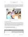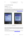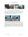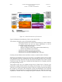
1
Key Usability and Ethical Issues in the
NAVI programme (KEN)
Deliverable 3
Products and Services for Personal Navigation –
Usability Design
Part III
Case Studies and Usability Guidelines
Version 2.1
Eija Kaasinen (ed.)
VTT Information Technology
Last modified on 08.01.03
KEN_D3_III_21.doc
KEN
Products and Services for Personal Navigation –
Usability Design
Part III – Case Studies and Guidelines
Version 2.1
7.1.2003
Version history
Version
Date
Author(s)
Description
0.1
22.05.2001
Eija Kaasinen
First draft
0.2
26.6.2001
Eija Kaasinen
Contributions from KEN partners
Matti Helin
Juha Kolari
Juha Luoma
Rolf Södergård
1.0
29.6.2001
Eija Kaasinen
Ari Ahonen
Chapter 5, Usability evaluation of some commercially
available navigation products and services
Veikko Ikonen
Abstract, Conclusions
Sari Lehtola
1.1
16.7.2001
Ari Ahonen
2.01
10.9.2002
Eija Kaasinen
Language-check by Richard Walker
Minor modifications
New chapters:
Chapter 5: Related research – literature studies
Chapter 7: Case studies with NAVI-projects
Chapter 8: Usability guidelines
2.02
19.9.2002
Eija Kaasinen
Divided into Parts I, II and III
2.06
17.10.2002
Eija Kaasinen
Additional contributions to case studies
2.07
25.10.2002
Eija Kaasinen
Keiju case
2.08
11.11.2002
Eija Kaasinen
Language-check by Richard Walker
2.1
7.1.2003
Eija Kaasinen
Case studies Gimodig and Navisearch
Guidelines, Tiivistelmä
Contact information
Eija Kaasinen
VTT Information Technology
P.O. Box 1206, FIN-33101 Tampere, Finland
Street Address: Sinitaival 6, Tampere
Tel. +358 3 3163 323, fax +358 3 316 3380
Email: [email protected]
Web: http://www.vtt.fi/tteEnd of editable fields
Copyright © KEN Consortium 2002. All rights reserved.
The information in this document is subject to change without notice and does not represent a commitment on
the part of KEN Consortium. No part of this document may be reproduced without the permission of KEN
Consortium.
KEN
Products and Services for Personal Navigation –
Usability Design
Part III – Case Studies and Guidelines
Version 2.1
7.1.2003
Tiivistelmä
Tämä KEN-projektin raportin Usability Design kolmas osa (D3, Part III) esittelee joukon
henkilökohtaisen navigoinnin tuotteiden ja palveluiden käytettävyystutkimuksia.
Evaluoimme vuonna 2001 käyttäjien kanssa erilaisia kaupallisia navigointituotteita ja –
palveluita: perinteisiä GPS-laitteita, GPS-modulilla varustettua PDA-laitetta, puhelinta
johon on integroitu GPS-laite, matkapuhelimen paikannettuja palveluita sekä
sisätilaopastusta. Tavoitteenamme oli tunnistaa käyttäjäystävällisiä suunnitteluratkaisuja
sekä tyypillisiä käytettävyysongelmia, joita voisimme yleistää muidenkin
henkilökohtaisen navigoinnin tuotteiden suunnitteluun.
KEN-projektin tehtävänä on ollut auttaa NAVI-ohjelman jäseniä navigointituotteiden
käytettävyyden suunnittelussa. Tässä yhteydessä olemme tehneet kymmenen erilaista
tapaustutkimusta yhdessä NAVI-ohjelman projektien ja organisaatioiden kanssa. Nämä
tutkimukset käsittelevät eri tyyppisten henkilökohtaisen navigoinnin tuotteiden
käytettävyyden suunnittelua ja evaluointia: tekstiviestipohjaiset palvelut, kontekstin
mukaan muuntuvat palvelut, mobiilit 3D-kartat, mobiili multimedia navigointipalveluissa,
henkilöiden paikantaminen ammattisovelluksissa, mobiilit maastokartat ja paikannetut
hakupalvelut.
Tässä raportissa kuvattujen tapaustutkimusten sekä tämän raportin II-osassa kuvattujen
kirjallisuuskatsausten perusteella olemme laatineet käytettävyyden suunnitteluohjeita
henkilökohtaisen navigoinnin tuotteiden ja palveluiden suunnitteluun. Olemme
jäsentäneet ohjeet seuraavasti: ohjeita käytettävyyden suunnitteluun ja evaluointiin,
ohjeita informaation esittämiseen, ohjeita käyttöliittymän toteutukseen sekä ohjeita eri
tyyppisten palveluiden toteutukseen. Lisäksi annamme ohjeita tuotteiden käyttöönoton
suunnitteluun sekä kansainvälistämiseen ja lokalisointiin.
Ohjeemme perustuvat rajalliseen määrään tapaustutkimuksia eivätkä ne varmastikaan
kata kaikkia tilanteita. Emme pyri antamaan tarkasti noudatettavia ohjeita vaan
pikemminkin tarkistuslistoja asioista, joihin suunnittelussa on muistettava kiinnittää
huomiota. Toivomme, että näistä ohjeista on apua tuotteiden ja palveluiden suunnittelussa
ja että niitä voidaan käyttää pohjana kun laaditaan yritysten sisäisiä käytettävyyden
suunnitteluohjeita. Ohjeet ovat käytettävissä myös HTML-muodossa KEN-projektin
sisäisillä verkkosivuilla.
VTT Information Technology
i
Modified on 08.01.03
KEN
Products and Services for Personal Navigation –
Usability Design
Part III – Case Studies and Guidelines
Version 2.1
7.1.2003
Abstract
Part III of KEN Deliverable 3 presents a collection of usability design and evaluation case
studies. We start with the results of usability evaluations of different commercially
available navigation products and services. These evaluations cover traditional GPS
devices, GPS module on a PDA, GPS integrated to a mobile phone, location-based
services on a mobile phone as well as an indoor guidance system. The evaluations of the
commercial products took place in 2001. The aim was to identify user-friendly solutions
and usability problems that can be generalised in other personal navigation products and
services as well.
In addition to evaluating commercially available navigation products and services, the
KEN project has also assisted NAVI projects and organisations in the usability design and
evaluation of their navigation products and services. The results of this work are reported
as ten case studies in the fields of text message-based navigation services on mobile
phones, context-aware services, mobile 3D maps, mobile multimedia in personal
navigation, locating people in work contexts, mobile geographic maps and location-based
search services.
Based on the case studies as well as the literature reviews presented in Part II of this
report, we propose usability guidelines for different kinds of personal navigation products
and services. The guidelines are organised as guidance for usability design and
evaluation, guidance for information presentation, guidance for the user interface and
guidance for different types of personal navigation services. In addition, we give guidance
on taking a product or service into use and on internationalisation and localisation.
The guidelines are based on a limited amount of case studies and they do not cover all
possible issues. Rather than giving exact instructions for the design, we present check lists
of issues that should be considered when making design decisions. We hope that these
guidelines provide a good starting point for the design and a good basis to build in-house
guidelines on. The guidelines are also available as a HTML version on the internal Web
site of the KEN project.
VTT Information Technology
ii
Modified on 08.01.03
KEN
Products and Services for Personal Navigation –
Usability Design
Part III – Case Studies and Guidelines
Version 2.1
7.1.2003
Table of Contents
1
INTRODUCTION.................................................................................................................. 1
1.1
1.2
1.3
1.4
1.5
PURPOSE ............................................................................................................................... 1
SCOPE ................................................................................................................................... 1
DEFINITIONS, ACRONYMS AND ABBREVIATIONS .................................................................. 2
OVERVIEW OF PART III......................................................................................................... 2
ACKNOWLEDGEMENTS ......................................................................................................... 3
2
USABILITY EVALUATION OF SOME COMMERCIALLY AVAILABLE
NAVIGATION PRODUCTS AND SERVICES........................................................................... 4
2.1 INTRODUCTION ..................................................................................................................... 4
2.2 GARMIN GPS 12................................................................................................................... 4
Rolf Södergård
2.2.1 The subject of the evaluation....................................................................................... 4
2.2.2 Testing environment .................................................................................................... 6
2.2.3 Test users..................................................................................................................... 7
2.2.4 Test tasks ..................................................................................................................... 7
2.2.5 Test method ................................................................................................................. 8
2.2.6 Usability problems found in the tests .......................................................................... 8
2.2.7 Usability problems typical for the kind of devices tested ............................................ 9
2.2.8 General usability problems ....................................................................................... 11
2.2.9 Conclusions............................................................................................................... 14
2.2.10
Practical considerations in arranging the tests .................................................... 14
2.3 BENEFON ESC!.................................................................................................................... 16
Ari Ahonen and Veikko Ikonen
2.3.1 The subject of evaluation .......................................................................................... 16
2.3.2 The structure of the user interface ............................................................................ 17
2.3.3 Evaluation methods................................................................................................... 19
2.3.4 Results ....................................................................................................................... 22
2.3.4.1
2.3.4.2
2.3.4.3
Good solutions identified ............................................................................................... 22
Usability problems ......................................................................................................... 23
User needs for navigation .............................................................................................. 27
2.3.5 Discussion ................................................................................................................. 27
2.3.6 Conclusions............................................................................................................... 29
2.4 MAGELLAN GPS COMPANION FOR PALM ........................................................................... 30
Ari Ahonen, Veikko Ikonen and Sari Lehtola
2.4.1 The subject of the evaluation..................................................................................... 30
2.4.2 Evaluation methods................................................................................................... 30
2.4.3 Device-related results ............................................................................................... 30
2.4.4 Software-related results ............................................................................................ 31
2.4.5 Conclusions............................................................................................................... 35
2.5 SONERA POINTER ............................................................................................................... 36
Veikko Ikonen, Ari Ahonen, Eija Kaasinen and Sari Lehtola
2.5.1 The subject of the evaluation..................................................................................... 36
2.5.2 Evaluation Methods .................................................................................................. 37
2.5.3 Usability-related results............................................................................................ 39
2.5.4 Utility-related results ................................................................................................ 42
2.5.5 Conclusions............................................................................................................... 44
VTT Information Technology
iii
Modified on 08.01.03
KEN
Products and Services for Personal Navigation –
Usability Design
Part III – Case Studies and Guidelines
Version 2.1
7.1.2003
2.6 CEBIT 2001 MOBILE GUIDE ................................................................................................ 47
Eija Kaasinen
2.6.1 The subject of the evaluation..................................................................................... 47
2.6.2 Evaluation methods................................................................................................... 48
2.6.3 Results ....................................................................................................................... 48
2.6.4 Conclusions............................................................................................................... 50
2.7 SUMMARY OF THE USABILITY RESULTS............................................................................... 51
2.8 REFERENCES ....................................................................................................................... 52
3
USABILITY EVALUATION IN CO-OPERATION WITH NAVI PROJECTS ........... 52
3.1 INTRODUCTION ................................................................................................................... 52
3.2 USABILITY TEST OF THREE LOCATION-BASED SMS-SERVICES ............................................ 52
Rolf Södergård, Minna Kulju and Veikko Ikonen
Abstract .................................................................................................................................. 53
3.2.1 Introduction............................................................................................................... 53
3.2.2 The evaluated services .............................................................................................. 53
3.2.3 Evaluation method .................................................................................................... 54
3.2.4 Usability problems found in the tests ........................................................................ 56
3.2.5 Results of the interviews............................................................................................ 60
3.2.6 Results of the grouping task ...................................................................................... 61
3.2.7 Evaluation of the test method .................................................................................... 63
3.2.8 Conclusions............................................................................................................... 65
Appendix A: Test users ........................................................................................................... 66
Appendix B: Test tasks ........................................................................................................... 67
3.3 MOBILE INFORMATION ON WEATHER AND ROAD CONDITIONS – A USER STUDY .................. 68
Pirkko Rämä
3.4 LOCATION-AWARE AND PERSONALISED TOURIST INFORMATION ........................................ 70
Eija Kaasinen, Veikko Ikonen, Olli Sotamaa and Teija Vainio
3.4.1 Introduction............................................................................................................... 70
3.4.2 Methods..................................................................................................................... 70
3.4.3 Results ....................................................................................................................... 71
3.5 USER REQUIREMENTS FOR CONTEXT-BASED SERVICES ....................................................... 75
Juha Kolari, Eija-Liisa Kasesniemi, Santtu Toivonen and Eija Kaasinen
3.5.1 Introduction............................................................................................................... 75
3.5.2 Set-up ........................................................................................................................ 76
3.5.3 Context boundaries ................................................................................................... 78
3.5.4 Information needs for peer context and communication ........................................... 81
3.5.5 Information needs for local content .......................................................................... 82
3.5.6 Conclusions and recommendations........................................................................... 83
3.5.7 References ................................................................................................................. 84
3.6 MOBILE 3D MAP ................................................................................................................. 85
Minna Kulju, Teija Vainio and Tytti Virtanen
3.6.1 The subject of the evaluation..................................................................................... 85
3.6.2 Evaluation Methods .................................................................................................. 85
3.6.3 Results ....................................................................................................................... 87
3.6.4 Conclusions............................................................................................................... 90
3.7 MOBILE MULTIMEDIA IN PERSONAL NAVIGATION ............................................................... 91
Ari Ahonen
3.7.1 Introduction............................................................................................................... 91
3.7.2 Usability evaluations and participants...................................................................... 92
3.7.3 General usability findings ......................................................................................... 93
3.7.4 Usability findings concerning the use of multimedia ................................................ 94
VTT Information Technology
iv
Modified on 08.01.03
KEN
Products and Services for Personal Navigation –
Usability Design
Part III – Case Studies and Guidelines
Version 2.1
7.1.2003
3.7.5 Conclusions............................................................................................................... 95
3.8 LOCATING PEOPLE IN WORK CONTEXTS – CASE BENEFON .................................................. 96
Raisa Suihkonen and Veikko Ikonen
3.8.1 Introduction............................................................................................................... 96
3.8.2 The Setup of the study ............................................................................................... 96
3.8.3 The Puzzle Interview Method in the Benefon Case ................................................... 98
3.8.4 Results of Evaluation – attitudes towards professional positioning and navigation103
3.8.5 Conclusions............................................................................................................. 106
3.8.6 References ............................................................................................................... 107
3.8.7 Appendix An example of the scenarios: Social Worker Scenario........................... 108
3.9 UTILISING VEHICLE LOCATION IN DATA COLLECTION AT FINNISH ROAD ENTERPRISE - THE
KEIJU SYSTEM ........................................................................................................................... 110
Virpi Anttila and Saija Niskanen
3.9.1 Objectives and method ............................................................................................ 110
3.9.2 Keiju system ............................................................................................................ 110
3.9.3 Usability study of the Keiju system.......................................................................... 115
3.9.4 Conclusions............................................................................................................. 118
3.9.5 References ............................................................................................................... 119
3.10
GIMODIG – FIELD EVALUATION OF MOBILE TOPOGRAPHIC MAPS ................................ 120
Ari Ahonen, Annu-Maaria Nivala and Rolf Södergård
3.10.1
Introduction ........................................................................................................ 120
3.10.2
Methods and participants ................................................................................... 121
3.10.3
Results related to maps ....................................................................................... 125
3.10.4
Field test results: software and GPS .................................................................. 128
3.10.5
Field test results: PDA as platform .................................................................... 129
3.10.6
Concluding remarks............................................................................................ 129
3.11
NAVISEARCH – AN INTEGRATED LOCATION-AWARE SERVICE DIRECTORY .................. 131
Eija Kaasinen, Veikko Ikonen and Raisa Suihkonen
3.11.1
Introduction ........................................................................................................ 131
3.11.2
Subject of evaluation........................................................................................... 131
3.11.3
Objectives of evaluation...................................................................................... 133
3.11.4
Expert evaluation................................................................................................ 133
3.11.5
User evaluation methods .................................................................................... 135
3.11.6
Experiences of the Test Set-up ............................................................................ 138
3.11.7
Contexts of use and utility................................................................................... 140
3.11.8
Usability evaluation results ................................................................................ 143
3.11.9
Suggestions for new features .............................................................................. 152
3.11.10 Conclusions......................................................................................................... 153
3.11.11 References........................................................................................................... 154
4
USABILITY GUIDELINES FOR PRODUCTS AND SERVICES FOR PERSONAL
NAVIGATION ............................................................................................................................ 154
Eija Kaasinen, Ari Ahonen, Virpi Anttila, Veikko Ikonen, Minna Kulju, Juha Luoma,
Teija Vainio and Rolf Södergård
4.1 USABILITY DESIGN AND EVALUATION .............................................................................. 155
4.1.1 Early design decisions and actions ......................................................................... 155
4.1.2 Check lists for field evaluation................................................................................ 156
4.1.3 Designing personal navigation for professional use............................................... 158
4.2 INFORMATION PRESENTATION .......................................................................................... 159
4.2.1 Terminology ............................................................................................................ 159
4.2.2 Mobile maps............................................................................................................ 160
4.2.3 3D city models......................................................................................................... 162
4.2.4 Multimedia .............................................................................................................. 162
4.3 USER INTERFACE .............................................................................................................. 163
VTT Information Technology
v
Modified on 08.01.03
KEN
Products and Services for Personal Navigation –
Usability Design
Part III – Case Studies and Guidelines
Version 2.1
7.1.2003
4.3.1 Navigation device.................................................................................................... 163
4.3.2 Feedback to the user ............................................................................................... 164
4.3.3 User input................................................................................................................ 164
4.4 SERVICES .......................................................................................................................... 165
4.4.1 Route guidance........................................................................................................ 165
4.4.2 Location-based services .......................................................................................... 166
4.4.3 Push type services ................................................................................................... 167
4.4.4 Locating people....................................................................................................... 167
4.5 TAKING THE PRODUCT INTO USE ....................................................................................... 168
4.6 INTERNATIONALISATION AND LOCALISATION ................................................................... 169
5
CONCLUSIONS................................................................................................................. 170
VTT Information Technology
vi
Modified on 08.01.03
KEN
Products and Services for Personal Navigation –
Usability Design
Part III – Case Studies and Guidelines
Version 2.1
7.1.2003
1 Introduction
1.1 Purpose
Key Usability and Ethical Issues in the NAVI programme (KEN project) is one of the
horizontal support projects in the Personal Navigation (NAVI) programme of the Ministry
of Transport and Communications in Finland. The aim of the KEN project is to ensure
that usability and ethical issues are taken into account in the projects of the NAVI
programme. Together with the projects, we are identifying and solving usability and
ethical problems related to personal navigation.
One of the tasks of the KEN project is to give guidance for designing usable navigation
products and services. The first deliverable by the KEN project, Deliverable 1, Basics of
Human-Centred Design in Personal Navigation, presented general principles for usability
design and evaluation as well as general usability design guidelines and standards that can
be utilised in designing products and services for personal navigation.
The KEN project has identified the most suitable usability design and evaluation methods
for navigation products and services. We have also studied different navigation products
and services to identify general usability design guidelines for different types of products
for personal navigation. Based on this work, we enhance the contents of Deliverable 1,
concentrating on issues specific to Personal Navigation. As in Deliverable 1, we classify
the guidance as methods and guidelines. Methods give guidance on defining user
requirements and evaluating products and services, whereas guidelines present design
solutions that have already proved to be usable in previous products.
This report is targeted at anyone participating in the design of products and services for
personal navigation. Reading the report does not require any background knowledge
about personal navigation.
1.2 Scope
This is the second version of Deliverable 3. This version enhances the first version of the
deliverable by presenting overviews of related research as literature reviews. We also
present the results of our case usability studies with NAVI projects and organisations. The
deliverable has been divided into three parts:
Part I Usability design and evaluation methods
Part II Related research
Part III Case studies and usability guidelines
Part I complements the overview of usability design and evaluation methods presented in
KEN deliverable 1 by presenting methods specific to mobile products and services. The
contents of Part I were originally published in version 1 of this report, in the summer of
2001.
VTT Information Technology
1
Modified on 08.01.03
KEN
Products and Services for Personal Navigation –
Usability Design
Part III – Case Studies and Guidelines
Version 2.1
7.1.2003
Part II presents an overview of other published research results on key application or
technology fields for personal navigation.
Part III presents the results of our usability design and evaluation case studies. Part of the
cases studies deal with commercial products and services but the major part focuses on
case studies conducted together with NAVI projects and organisations. The case studies
with the commercial products were originally published in version 1 of this report, in the
summer of 2001.
1.3 Definitions, Acronyms and Abbreviations
GPS
Global Positioning System
GSM
Global System for Mobile Communications
HMI
Human-Machine Interface
PN
Personal Navigation
PNS
Personal Navigation System
WAP
Wireless Application Protocol. A lightweight protocol to provide
browser-based services to small mobile devices.
1.4 Overview of Part III
One aim of the KEN project is to define guidelines for the usability design of navigation
products and services. We began in Part II of this report with literature reviews of
usability studies in essential application areas: in-vehicle systems, context-aware services,
services based on locating people, 3D models in route guidance. We also presented
reviews on user issues: the human being as a navigator, as well as Design for All issues.
Chapter 2 of this report describes the results of usability evaluations of different
commercially available navigation products and services. These evaluations took place in
2001. The aim was to identify user-friendly solutions and usability problems that could be
generalised in other personal navigation products and services as well.
In addition to evaluating commercially available navigation products and services, the
KEN project has also assisted NAVI projects and organisations in the usability design and
evaluation of their navigation products and services. The results of this work are reported
as case studies in chapter 3 of this deliverable. The report concludes with Chapter 4, in
which we propose usability guidelines for personal navigation products and services,
based on the case studies and literature reviews.
VTT Information Technology
2
Modified on 08.01.03
KEN
Products and Services for Personal Navigation –
Usability Design
Part III – Case Studies and Guidelines
Version 2.1
7.1.2003
1.5 Acknowledgements
The case studies presented in chapter 3 of this deliverable are based on our co-operation
with NAVI projects and organisations. The authors wish to thank these projects and
organisations for their valued contribution:
q
Radiolinja for the case study of three location-based SMS-services
q
Finnish Road Enterprise for the case study of Mobile information on weather and road
conditions as well as the case study of Locating people in work conditions
q
WH@M project for the case study of Location-aware and personalised tourist information
q
Kontti project for the case study of User requirements for context-based services
q
Arcus Software for the case study of Mobile 3D maps
q
Wamppi project for the case study of Mobile multimedia in personal navigation
q
Benefon for the case study of locating people in work contexts
q
Finnish Geodetic Institute for the case study of Mobile geographical maps
q
Navisearch project for the case study of Location-based service directory
The co-operation with these partners has made our research concrete and helped us to
recognise usability guidelines for different kinds of personal navigation services.
VTT Information Technology
3
Modified on 08.01.03
KEN
Products and Services for Personal Navigation –
Usability Design
Part III – Case Studies and Guidelines
Version 2.1
7.1.2003
2 Usability evaluation of some commercially available
navigation products and services
2.1 Introduction
From March to June 2001, we evaluated a number of commercially available navigation
products and services. The objective of the evaluations was to identify user-friendly
solutions and usability problems that can be generalised in other PN products and
services. Previous theoretical work suggested that the main problems in a navigation
device would be caused by the small size of the device – resulting in a small display and
limited keyboard – display quality, mobile use, information visualisation, etc. Also,
general usability problems associated with feedback, consistency, terminology and the
like could be expected.
In this chapter we report the results of the evaluations, concentrating on findings related
to PN. Chapter 5.2, reporting the evaluation of the Garmin navigation device, is more
thorough and it can be used as an example of analysing and presenting the results of a
usability evaluation.
For all products and services, we started with expert evaluations. Based on the results of
the expert evaluation we continued with small-scale user evaluations of some of the
products and services. The user evaluations took place in usability labs or outdoors.
2.2 Garmin GPS 12
Rolf Södergård
Helsinki University of Technology
2.2.1 The subject of the evaluation
Garmin GPS 12 is a navigation device that can locate itself using GPS information from
satellites. The user can create and edit waypoints (i.e. locations), and save them in the
device’s memory. The main use of the device is to navigate to different waypoints.
The device has a small display (roughly 3,5*6 cm) and seven buttons. The user interface
consists of five main pages and several sub-pages. A picture of the device and a transition
diagram between the five main pages can be found in Figures 1 and 2.
VTT Information Technology
4
Modified on 08.01.03
KEN
Products and Services for Personal Navigation –
Usability Design
Part III – Case Studies and Guidelines
Goto
Version 2.1
7.1.2003
Page
power/light
Mark
Quit
Enter
directional button
display
Figure 1. The device used in the tests with the names of the buttons and the display
shown.
Satellite page
The satellite page contains a schematic diagram of the sky above the user, displaying the
satellites from which the device is receiving a signal. At the bottom of the page is a graph
showing the strength of the signal from each satellite.
Position page
The position page contains numeric data of the user's heading, speed, position, and the
time of day. It also has two variable-data fields, which display average speed (AVSPD)
and trip time (TTIME). See Figure 2.
Map page
The map page displays the track the user has taken, along with waypoints. It also provides
functions for zooming and panning, and numeric information about the user's heading and
speed.
Compass page
The compass page contains a virtual compass that displays an arrow pointing towards the
waypoint the user is navigating to. The page also contains numeric information about the
direction the waypoint is in, the distance to it, and the user's heading and speed.
Menu page
The menu page contains the device's main menu. The commands open sub-pages for
manipulating waypoints, routes, etc.
VTT Information Technology
5
Modified on 08.01.03
KEN
Products and Services for Personal Navigation –
Usability Design
Part III – Case Studies and Guidelines
Quit
7.1.2003
Quit
Page
Quit
Version 2.1
Page
Page
Position page
Satellite page
Quit
Quit
Page
Compass page
Page
Menu page
Figure 2. A transition diagram showing the device's five main pages: Satellite page,
Position page, Map page, Compass page, and Menu page.
2.2.2 Testing environment
The tests were conducted as field tests outdoors. Three different locations were selected,
with the users performing one to three test tasks at each location. The users walked from
one location to another while using the Garmin device to navigate. The total distance the
user had to walk was a few kilometres.
The test instructor accompanied the users at all times. He gave the test tasks to the users,
asked clarifying questions and, sometimes, offered advice if the uses couldn’t finish a task
on his/her own. The test instructor also recorded the tests.
The tests were recorded on a mini digital video camera. The users were asked to think
aloud when performing the tasks. The camera was mounted on a tripod and focused on
the device, showing only the hand of the user as (s)he operated the device. When moving
between locations, the instructor tried to keep the camera focused on the device,
sometimes filming the surrounding terrain when it was necessary to give context to the
users’ comments. Only parts of the transitions between the locations were recorded.
While the users were performing the tasks, they sat on a stool. The device was placed on
another stool in front of them. The users were asked to operate the device while keeping it
VTT Information Technology
6
Modified on 08.01.03
Map page
KEN
Products and Services for Personal Navigation –
Usability Design
Part III – Case Studies and Guidelines
Version 2.1
7.1.2003
on the stool, so it remained in the picture. The camera was situated behind the user’s left
shoulder for right-handed users and right shoulder for left-handed users, so their hand
would not obscure the device so much while they were operating it. A sketch of the test
setting is given in Figure 3.
video camera
GPS device
test instructor
test user
Figure 3. A sketch of the test setting while a right-handed user is performing the tasks.
2.2.3 Test users
The device was evaluated with six test users, one at a time. The users were divided into
two groups. Three of the users were classified as experienced, having previous experience
of GPS devices, ranging from a few months to several years. None of the users had used
exactly the same device that was tested. The three other users were classified as novices,
and had no previous experience of GPS devices. The users were:
Experienced users:
WOMAN, 30, DENTIST
MAN, 48, SOFTWARE DEVELOPER
MAN, 61, PENSIONER
Novice users:
WOMAN, 23, PUBLIC HEALTH NURSE
WOMAN, 27, DUTY MANAGER
MAN, 58, MANAGEMENT CONSULTANT
2.2.4 Test tasks
A total of seven tasks were used in the tests. The tasks concentrated around the two main
functions of the device: the different ways of marking waypoints, and navigating from
waypoint to waypoint. Also, manipulating the map display and deleting information were
tested. The tasks were given to the users one by one. Two of the six users did not finish
all the tasks, one of them completing only two.
VTT Information Technology
7
Modified on 08.01.03
KEN
Products and Services for Personal Navigation –
Usability Design
Part III – Case Studies and Guidelines
Version 2.1
7.1.2003
2.2.5 Test method
Before the test, the test instructor explained the course of the test to the user. He described
his own role in the test, asked the user to think aloud while performing the test tasks, and
explained what would be recorded.
During the test itself, the users performed the test tasks one at a time. The instructor first
read the task description out loud, then gave it to the user on a piece of paper. The
instructor sometimes asked clarifying questions, or gave advice if the user couldn’t make
progress.
After the test, the instructor interviewed the users briefly. This was done to find out if
there were any additional usability issues that had not come up during the tests.
2.2.6 Usability problems found in the tests
The recordings of the tests were written into text protocols. The protocols were then
analysed to find possible usability problems. Typically, problems manifested themselves
in situations where the user’s path of actions differed greatly from the optimal solution to
the problem at hand. There were no great differences between the experienced and novice
users. Mostly, the experienced users knew what to look for, but still encountered the same
kinds of problems as the novice users did.
In this chapter, the usability problems have been divided into two sub-chapters. The first
one lists the problems that can be thought of as being caused by the kind of the device
tested. These problems are of concern to anyone designing navigation devices. The
second sub-chapter lists problems that are of a more general nature. These problems are
of less interest in this context.
The problems have been divided into three severity classes: minor, intermediate, and
severe. A problem’s basic classification is determined by how many users encounter it
and how much it affects a user in completing his/her task (see Figure 4). In addition, the
estimated severity of a problem may be affected by whether the same users encountered it
repeatedly or not. (Nielsen, 1993)
VTT Information Technology
8
Modified on 08.01.03
KEN
Products and Services for Personal Navigation –
Usability Design
Part III – Case Studies and Guidelines
Version 2.1
7.1.2003
Few
Many
Small
Minor
Intermediate
Large
Impact of the problem on
the users who encounter
it
Proportion of users experiencing the problem
Intermediate
Severe
Figure 4. A table to estimate the severity of usability problems based on the proportion of
users who encounter them and the impact of the problems on the users who encounter
them. (adapted from Nielsen, 1993)
Each sub-chapter starts with a table of the problems listed in the chapter. For each
problem, the following information is given:
• Nr. The number of the problem for reference in the following discussion.
• Description. A brief description of the problem.
• Severity. The severity class of the problem.
• #. The number of users who encountered the problem in the tests.
• Impact. The impact of the problem on the users.
• Persistent. The same user encountered the problem repeatedly. A “-“ means there
was no possibility of re-encountering the problem due to a lack of similar tasks
later in the test.
In each chapter, the table is followed by a more thorough discussion of the problems. The
problems have been listed in decreasing order by severity. Problems in the same severity
class are listed in no particular order.
2.2.7 Usability problems typical for the kind of devices tested
This chapter discusses encountered usability problems that are typical for the kind of
device that was tested. The problems in this chapter have been divided into categories,
according to the aspect of the device that causes them. Each category has its own subchapter.
VTT Information Technology
9
Modified on 08.01.03
KEN
Products and Services for Personal Navigation –
Usability Design
Part III – Case Studies and Guidelines
Version 2.1
7.1.2003
Small display
Nr
1.1.1
1.1.2
1.1.3
1.1.4
Description
Unfamiliar abbreviations
Difficult manipulation of the map
Missing field captions
Too small a font
Severity
Severe
Intermediate
Intermediate
Minor
#
6
4
5
2
Impact
Large
Small
Small
Small
Persistent
Yes
Yes
No
Yes
1.1.1
Many abbreviations are used in the device. A lot of them are unfamiliar to the users, and
cause confusion. They may even cause a user to be unable to complete a task. All of the
users reported several unfamiliar abbreviations.
1.1.2
When using the map page, a lot of manipulation – i.e. zooming and panning – of the map
is needed to get an overview. This problem is further aggravated by two other issues:
Firstly, there is no map of the terrain in the device. Because of this, when panning across
an area where waypoints are sparse, one may lose all reference points and can get “lost”
in the panning function. In such a situation, the only solution seems to be to quit the
function and start over. Secondly, the waypoint symbols do not scale according to the
level of magnification. Therefore, when trying to get an overview of a large area,
waypoint symbols may overlap or hide the track information in the map.
1.1.3
A few field captions have been left out, obviously to save screen space. This causes
problems in understanding the meanings of some of the fields.
1.1.4
A relatively small font has been used for some of the text. Especially the font used for
units is very small. This caused problems in reading for some users. Two users had
problems differentiating between “W”, “H”, and “M”. This problem may be more severe
for users with impaired vision.
Limited keyboard
Nr
1.2.1
1.2.1
Description
Missing alphanumeric keyboard
Severity
Intermediate
#
6
Impact
Small
Persistent
Yes
The device has no alphanumeric keyboard. Instead, alphanumeric information is entered
using the device’s directional button. This is very slow. Luckily, one does not have to
insert such information very often in normal use, usually only when saving waypoints.
Other issues
Nr
1.3.1
1.3.2
1.3.3
1.3.4
1.3.5
1.3.1
Description
Missing terrain information
Direction information shown only
when moving
Inaccuracy in forests
Monochrome display
Glare from the display in bright
lighting conditions
Severity
Severe
Severe
#
6
6
Impact
Large
Large
Persistent
Yes
Yes
Intermediate
Intermediate
Minor
5
6
1
Small
Small
Small
Yes
Yes
Yes
The device lacks a map of the environment. Therefore, the user has no terrain information
while navigating. The only information (s)he has is the direction the target waypoint is in.
This may cause serious problems if the direct route to the target position is blocked, e.g.
VTT Information Technology
10
Modified on 08.01.03
KEN
Products and Services for Personal Navigation –
Usability Design
Part III – Case Studies and Guidelines
Version 2.1
7.1.2003
by a river. Also, some kind of seasonal information might be useful, as the
aforementioned river might not be a hindrance at all during wintertime.
1.3.2
The device shows heading information only while moving. This means that the
information may be a little out-of-date as the user may actually already be facing another
direction when the information becomes available. Also, this complicates some tasks that
are done in one place, e.g. panning the map to a given direction.
1.3.3
The device is inaccurate in forests and similar places where there are blockages overhead.
This, together with problem 1.3.2, can lead to quite frustrating situations, for example
when the user is walking in a dense forest where one cannot walk straight for long
distances, turning from one direction to another continuously. Normally, though, the
inaccuracy is not severe enough to cause serious problems.
1.3.4
The device has a monochrome display, which makes it difficult to visually separate
overlapping objects. This problem becomes worse when the level of magnification
decreases.
1.3.5
The display has quite a lot of glare in bright lighting conditions. This may make it
difficult to read the display clearly. Normally, this is not too much of a problem – just a
little bit inconvenient – as the user can easily just look at the device from a slightly
different angle. The problem may be more severe in situations where the device might be
at a fixed position, e.g. in a boat.
2.2.8 General usability problems
This chapter lists encountered usability problems that are of a generic nature. These
include problems with consistency, unfamiliar terminology, insufficient feedback, etc.
Usability problems like these can be found in many types of devices and software. The
problems have been divided into sub-chapters by kind.
Feedback
Nr
2.1.1
2.1.2
2.1.3
Description
Insufficient feedback for user
actions
A separate page for error messages
Insufficient feedback on the
system’s state
Severity
Intermediate
#
6
Impact
Small
Persistent
Yes
Minor
Minor
6
1
Small
Small
No
-
2.1.1
The device offers insufficient feedback for the user’s actions. This is especially evident in
saving waypoints. When selecting Save, the device returned to its previous state without
any feedback of a successful save. All of the users expected more direct feedback, and
commented they were not sure if the waypoints were saved. Feedback on the deletion of a
waypoint is insufficient as well.
2.1.2
Error messages and other information are shown on a page of their own (i.e. the Messages
page). E.g. when the user tries to perform an illegal operation, a message starts blinking
very briefly on the screen with a few seconds’ intervals, saying “Message! Press Page”.
The text flashes so briefly (less than one second, sometimes less than 0.5 seconds) that the
user often has to wait for several flashes before she can understand what it says.
2.1.3
The device sometimes offers insufficient feedback on its state. E.g. in the Goto menu, the
user can always choose Cancel goto even if the Goto function is not active. The same
goes for the Traceback function.
VTT Information Technology
11
Modified on 08.01.03
KEN
Products and Services for Personal Navigation –
Usability Design
Part III – Case Studies and Guidelines
Version 2.1
7.1.2003
Consistency
Nr
2.2.1
2.2.2
2.2.3
2.2.4
Description
Selecting
Traceback
doesn’t
automatically bring up the Compass
page
The number of decimals in the
Distance field varies
Missing Save command for routes
Several different commands for
deleting information
Severity
Intermediate
#
5
Impact
Small
Persistent
-
Intermediate
1
Large
-
Minor
Minor
5
2
Small
Small
No
2.2.1
When the user selects Traceback from the Goto menu, the display shows the route page
with the backtracking waypoints. Normally, when the user selects a waypoint from the
Goto menu, the display shows the Compass page. This caused users to think they would
have to select the backtracking waypoints one by one when navigating by using the
Traceback function.
2.2.2
The number of decimals in the DST (distance) field on the Waypoint page differs when
editing and displaying the information: when the user is editing the field value, it shows
one decimal, otherwise two decimals. This caused one user to enter a distance 10 times
too long.
2.2.3
There is no Save command needed or available for saving routes. This causes confusion,
as users get accustomed to explicitly saving information, as that is what is needed when
entering waypoints. All of the users reported not being quite sure if the route they had
entered was saved.
2.2.4
Several different commands are used for deleting information: Clear (or CLR, as it is
abbreviated) is used for deleting entire routes, Remove for deleting individual waypoints
from a route, and Delete for deleting waypoints from the device’s memory.
Terminology
Nr
2.3.1
2.3.2
Description
Unclear error message for trying to
delete an active waypoint
The command GOTO on a button
looks like an abbreviation
Severity
Intermediate
#
2
Impact
Large
Persistent
Yes
Minor
1
Large
No
2.3.1
When a user tries to delete a waypoint belonging to the active route (or one that is being
navigated to), the device displays the error message “Active waypoint. Can’t be deleted.”
Most users did not understand what it means for a waypoint to be active. The message
could be improved by explicitly stating that the waypoint belongs to the active route or
has been selected from the Goto menu.
2.3.2
The text on the Go to button (which is used to select a waypoint to navigate to) is written
as GOTO. One user thought that GOTO was an abbreviation for something else, so she
did not use the button until as a last resort. The term “goto” is probably natural for people
with computer programming experience, but “go to” would be more understandable for
the general population.
VTT Information Technology
12
Modified on 08.01.03
KEN
Products and Services for Personal Navigation –
Usability Design
Part III – Case Studies and Guidelines
Version 2.1
7.1.2003
Other issues
Nr
2.4.1
2.4.2
2.4.3
2.4.4
2.4.5
2.4.6
Description
The bearing field is reset if the
distance field’s value is left as zero
An unselectable command-like Quit
text appears while panning the map
Only the first row of multi-row
field values is highlighted when
activated
The scrolling of the waypoint list is
unpredictable
Changing a waypoint’s name is
done on a separate page
The power button is hard to
recognise
Severity
Severe
#
1
Impact
Large
Persistent
-
Minor
4
Small
Yes
Minor
6
Small
Yes
Minor
2
Small
Yes
Minor
1
Small
No
Minor
4
Small
-
2.4.1
On the Waypoint page, if user first enters a value for the BRG (bearing) field, then starts
to edit the DST (distance) field but for some reason exits it before changing the value
from zero, the BRG field is reset. This is very hard to notice, and may cause serious
problems.
2.4.2
When the user selects the Pan command on the Map page, activation moves to the ZM
(zoom) field and a command-like Quit text appears to the right of it. Users tried
repeatedly to activate the quit command by moving right with the directional button. The
Quit text is not a command, though, and therefore cannot be selected. The users’ actions
only caused the map to pan to the right. This was very hard to notice, as the users
typically pressed the directional button for a short time, causing the map to pan only one
pixel.
2.4.3
When highlighting field values, in the case of multi-row text, only the first row is
highlighted. This causes problems in understanding the field values in situations like the
one shown in Figure 5.
DISPLAY:
NAME
WITH SYMBOL
Figure 5. When activation is moved to multi-row field values, only the first row of the
value is highlighted. The complete field value in the picture is "Name with symbol".
2.4.4
While scrolling the waypoint list (either on the Waypoint list page or in the Goto menu),
the list scrolls a screen-full at a time when scrolling downwards from the bottom of the
page, or upwards from its top. This is probably good when there are lots of waypoints in
the list, but can be annoying in situations where the needed waypoint would be next in the
list in the scrolled-to direction. Also, it may even cause difficulties in noticing a waypoint
in the list. Furthermore, it is very difficult to know at what position of the list the selection
is at – i.e. are there still three screenfuls to go to the end of the list, or is this the last one?
– as there is no indicator of it. This is further complicated by the fact that there are some
commands at the bottom of the page, but the selection moves to them only when the list
has been scrolled through. A picture of the Waypoint list is presented in Figure 6.
VTT Information Technology
13
Modified on 08.01.03
KEN
Products and Services for Personal Navigation –
Usability Design
Part III – Case Studies and Guidelines
Version 2.1
7.1.2003
Figure 6. The Waypoint list. Activation is moved to the command at the bottom only when
the list has been scrolled all the way down, even though there is no way to know whether
this is so.
2.4.5
One cannot change a waypoint’s name by just entering a new name in place of the old
one. Instead, one has to select Rename and then enter the new name using a kind of dialog
page. This seems unnecessary.
2.4.6
Most users had problems in recognising the power button. Some even turned the device
over when looking for it. The button at its current location seems too be closely
associated with the “normal” operating buttons. It should be clearly separated from the
other buttons, e.g. in the upper left or right corner of the device.
2.2.9 Conclusions
In the Garmin device there were usability problems caused by the physical limitations of
the device and the context the device was used in. Such problems should be considered
when designing other navigation devices as well. Steps should be taken to facilitate easy
map manipulation and data entry. Terrain information should be provided about the
environment, preferably in colour, and direction information should be up-to-date even
when standing still - not unlike in a compass. The use of abbreviations should be kept to a
minimum. Of course, general usability issues such as feedback, consistency, terminology,
etc. should not be forgotten.
2.2.10
Practical considerations in arranging the tests
Some practical issues arose when arranging the usability tests. This chapter includes a
brief discussion of them.
Recording the tests
In addition to the digital video camera, two stools were needed: the device was placed on
one of them and the test user sat on the other one. The camera was mounted on a tripod.
The device was operated by the user with one hand, while keeping it on the stool. This
was necessary to keep the device in focus. The drawback of this method is that it is quite
an unnatural way for the user to operate the device. A better solution would be to have a
tiny camera attached to the device. This way the user could handle the device freely as in
a real situation.
VTT Information Technology
14
Modified on 08.01.03
KEN
Products and Services for Personal Navigation –
Usability Design
Part III – Case Studies and Guidelines
Version 2.1
7.1.2003
Picture and sound
Light sometimes reflected from the device’s display, especially in tests conducted when
the sky was clear. This resulted in slight difficulties in reading the display when analysing
the tapes. To alleviate the problem, the device’s contrast setting was adjusted to its
highest setting. Other measures that might be taken to overcome the problem include
shading the display somehow and conducting the tests later in the day.
Background noise periodically made it hard to hear what the users were saying. This was
mostly because there was a construction site near to one of the test locations. Also, two of
the test locations were on fairly open ground, making wind an issue. The noise the wind
made in the video camera’s microphone partly covered the user’s speech. The users had
to sit so that the microphone of the camera was facing away from the wind.
Weather
When conducting tests outdoors, weather has to be taken into consideration. Some people
may not like sitting on a stool in the rain just to be a test user. In addition, the equipment
needed in the tests may not be waterproof, as was the case with the video camera in these
tests. Luckily, the tests were conducted in summertime, and none of them had to be
postponed due to rain. In cold weather the users might need to wear gloves, which could
make operating the device harder. In the tests, the users were advised to wear waterresistant shoes for their own comfort. Warm clothes proved necessary, as one gets cold
fairly quickly when sitting still for expended periods of time. Warm drinks were provided
for the users in a thermos flask.
VTT Information Technology
15
Modified on 08.01.03
KEN
Products and Services for Personal Navigation –
Usability Design
Part III – Case Studies and Guidelines
Version 2.1
7.1.2003
2.3 Benefon Esc!
Ari Ahonen and Veikko Ikonen
VTT Information Technology
2.3.1 The subject of evaluation
Benefon Esc! was the first mobile device to integrate a GPS receiver into a dual band
GSM phone (Figure 7). The device offers all standard GSM and GPS functions, and in
addition it utilises MPTP protocol for transferring location information between Benefon
Esc! phones and third party service providers via SMS messages. Location information
transfer enables novel services like locating other Esc! users, reporting one's own location
or requesting route or location information from service providers. The GSM phone and
GPS receiver are separate in the sense that either of them can be shut down while the
other remains functional. The device is not WAP capable. In our evaluations, we were
using the first commercial release of the device (May 2001).
The phone measures 129 * 49 * 23 mm – which means the phone is roughly the same size
as most new mobile phones available on the market (for comparison the Nokia 6210
measures 130 * 47 * 19 mm). The main characteristic physical feature of the Benefon
Esc! is a GPS antenna at the top of the phone. The antenna needs to be raised in order to
operate the GPS properties of the phone. The device has a relatively large grey scale
display, which has a screen resolution of 100 * 160 pixels. The display can show up to 15
lines of text on screen. The GPS receiver has 12 channels meaning that it can receive
signals from 12 different satellites.
Users can download maps into the map memory of Esc! using the Mobile Maps Service
Protocol (MMSP). Currently, the maps are available at the Internet site of Genimap Oy
(www.genimap.com). The maps available from Genimap fall into four categories: road,
city, and topographic maps and nautical charts.
GPS antenna on the
back side (not shown)
Power button
+ button
- button
Soft key
functions
The keypad is
also used to
scroll
and
zoom the map
Figure 7. Front and side views of Benefon Esc! (Source of original pictures of
device: Benefon Esc! commercial brochure, available from www.benefon.com)
VTT Information Technology
16
Modified on 08.01.03
KEN
Products and Services for Personal Navigation –
Usability Design
Part III – Case Studies and Guidelines
Version 2.1
7.1.2003
2.3.2 The structure of the user interface
Benefon Esc! has five different basic screens: one of the screens is for the neutral state,
the four others are for conveying navigation information (Figure 8). The user can access
the menus from these screens by using softkeys. Between the five basic screens the user
can navigate by using + and - buttons located on the left side of device, next to the power
button. The GSM functions of the phone can be accessed from the neutral screen; GPS
functions from any of the navigation screens. The quick menu and main menu can be
accessed from all of the screens: Quick menu contains options to lock the keypad, power
GPS on/off and to change the (sound)environment.
GSM Menu
Quick menu
Phone book
Messages
Recent Calls
Network
Services
Help Desk
Lock Keypad
GPS Receiver on/off
Environment
Main Menu
Phone
Map
Guide
Position
Movement
GPS Menu
Accessories
Settings
Waypoints
Routes
Friend Find
Maps
Settings
SMS & coords
Request service
Request AGPS
Environments
User interface
Time
Units
Power
Update position
Clear
destination
Reset meters
GSM
GPS
Help desk
Emergency calls
Security
Reset settings
Figure 8. Benefon Esc! screens and principal menus. (Source of screenshots: Benefon
Esc! commercial brochure, www.benefon.com. Neutral screen picture slightly modified).
VTT Information Technology
17
Modified on 08.01.03
KEN
Products and Services for Personal Navigation –
Usability Design
Part III – Case Studies and Guidelines
Version 2.1
7.1.2003
Navigation features
Navigation information is conveyed to the user via four navigation pages (Figures 9 and
10). The information field on the top of each navigation page contains information on
satellite signal strength, battery charge and GSM network field strength. The two
additional data fields in the Map and Guide screens are adjustable (not shown in the
picture of Map screen): the user can choose the information that is displayed on these data
fields from 23 possibilities. If more than one type of information is chosen for one data
field, the content of the field is changed approximately every 4.5 seconds. All the data
fields on the Position and Movement screens are fixed – the user cannot modify
information displayed on these fields.
Map screen (Kartta). Map screen shows the user's current position on the map. The user
can scroll the map by using the number keys ( 2 up, 8 down, etc.) and can change the
scale by using * (zooming out) and # (zooming in) keys on the bottom row of the keypad.
The map that is displayed on the screen depends on what maps the user has downloaded
into the memory of the device and the preferences the user has set up. The screen also
displays information about map scale, track (direction of movement) and bearing
(direction of destination). The icons on the top of the page (GPS, battery, GSM) and the
two data fields can optionally be shown; they can be hidden with one key press to
increase the map area of the screen (as done in the picture).
Guide screen (Opaste). Guide screen displays a compass, and the same icons and data
fields on top of the screen as on Map screen. When using the compass the user needs to
keep the arrow on the top of the compass ring pointed in the direction of movement
(which is the natural position to hold the device in the hand): the arrow in the middle of
compass then points in the direction of the destination (if a destination is set) and the
rotating disk of compass bearings indicates the direction of movement. The device does
not contain an actual magnetic or electrical compass but the information is derived from
satellite signals – therefore the compass is not as reliable as an ordinary compass and it
operates only when the user is moving. When standing still, the compass field is blank –
arrow and compass bearings are not shown.
a)
b)
Figure 9. Map (a) and Guide (b) screens. (Source: Benefon Esc! commercial
brochure, www.benefon.com)
VTT Information Technology
18
Modified on 08.01.03
KEN
Products and Services for Personal Navigation –
Usability Design
Part III – Case Studies and Guidelines
Version 2.1
7.1.2003
Position screen (Paikkatieto). The four data fields in the two upper rows contain
information about time, date, elevation and sunset/sunrise and dawn/dusk times. In the
middle of the screen a field displays the current location co-ordinates. The satellite
window at the bottom of the page shows satellite signal strength information of
individual satellites graphically as vertical bars. (Esc! does not provide a map of satellite
positions on the sky nor their numbers, as is customary for GPS receivers.)
Movement screen (Etenemistiedot). Movement page is meant mostly for waypoint and
route navigation. The two data fields on the top row show speed, top speed, average
speed and odometer. The information in the fields changes automatically every 4.5
seconds. The fields on the next row show track (direction of movement) and bearing
(direction to the destination). The rest of the fields in the middle and bottom of the page
contain actual route and waypoint information.
a)
b)
Figure 10. Position (a) and Movement (b) screens. (Source: Benefon Esc!
commercial brochure)
2.3.3 Evaluation methods
The evaluation methods consisted of expert evaluations, interviews of potential users and
usability evaluation in the open-air environment (Figure 11). The laboratory evaluation
was abandoned because of the nature of the study. The main emphasis of the study was on
gathering knowledge of the navigation solutions of the device and evaluating the usability
of the device in almost real-life situations. Another reason for evaluating the device in the
open-air environment was that GPS does not work indoors.
In our study we concentrated on the navigation features of Benefon Esc!, paying less
attention to other features. The same focus is maintained throughout this report. Also
some navigation-related aspects were also given less attention, namely emergency
locationing, nautical charts and the tracking a friend (Friend Find function) option.
The usability evaluation with the GPS test users was planned to last from one and a half
to two hours, including interviewing. Because of this time limitation, only some aspects
were gone through in the interviews and usability evaluation. Some other aspects were
covered in more details in the expert evaluations. One extra source of excitement for the
researchers was the bug in the device's software, which caused occasional crashing of the
system. Due to the fixed timetable of the evaluation it was not possible to wait for the
software update. We concluded after the expert evaluations and pilot evaluation in
VTT Information Technology
19
Modified on 08.01.03
KEN
Products and Services for Personal Navigation –
Usability Design
Part III – Case Studies and Guidelines
Version 2.1
7.1.2003
Kärsämäki that the damage / harm to the results of the evaluation could be minimised by
flexible evaluation planning.
A brief introduction to the NAVI programme, the KEN project and the device to be
evaluated was given at the beginning of the evaluations and interviews. The aim and the
procedure of the study were also gone through before the actual user evaluation and
interviews.
a)
b)
Figure 11. An user evaluation situation in the center of Tampere (a) and an expert user
interview in Kärsämäki fire station (b).
Expert evaluation
Two usability experts of VTT Information Technology in Tampere used the Benefon Esc!
from the end of the May till the middle of June (28.5.01 – 13.6.01) daily in turns. The
navigation environments varied from woods to the city.
Expert user interviews
Two hunters with some experience of GPS were interviewed without an actual user
evaluation in the field (Table 1). The first user was evaluating the device in Kärsämäki on
4.6.01 at the local fire station and near by it. He went through all the navigation menus
and evaluated the device in about one and a half hours. This user evaluation was, on the
one hand, a preliminary evaluation for the planning of user studies in the open-air
environment and, on the other hand, it gave the first attitudes of a potential user of the
device for the study.
The second interview was done after the user evaluations in the field. The aim of this
interview was to get more opinions for the evaluation of the device from the viewpoint of
an experienced GPS user.
VTT Information Technology
20
Modified on 08.01.03
KEN
Products and Services for Personal Navigation –
Usability Design
Part III – Case Studies and Guidelines
Version 2.1
7.1.2003
Interviewee
Gender
Age
Profession
Years of GSM use
Current phone model
Hobbies
GSM experience (+++)
Need for navigation
1 (4.6.01)
male
38
Fireman
5
Nokia 3210
Hunting, sport spectator
++
Hunting
2 (18.6.01)
male
35
Salesman (Fishing and hunting)
10
Ericsson T 28
Fishing and hunting
++
Fishing and hunting
GPS experience (++)
+
++
Table 1. Background information about interviewed expert users.
User evaluation
Five open-air evaluations of the device in urban conditions were carried out in the city
centre of Tampere in Finland. Four of these cases were held in immediate surroundings of
Keskustori (central square). One evaluation started from Atalpa (university building) and
ended near the railway station after a walk in rainy conditions. Another (6th) evaluation
was held in the woods of Hervanta, Tampere. Due to the timetable it was not possible to
evaluate the device any further in rural areas. The user evaluation consisted of tasks that
the user was asked to do. Some functions were gone through with the users during the
evaluation and some more familiarising with the device was done after the actual
evaluation. The users were encouraged to talk aloud while doing the tasks.
The usability evaluation of the navigation device in the open-air environment differs
greatly from the evaluations done in the laboratory. Video recording the evaluation was
abandoned due to the difficulties it may have added to the evaluation: without recording
devices designed especially for this purpose, it is difficult to record the use of the mobile
device sufficiently accurately. The evaluation and the interview were, however, recorded
on a mini disc because this equipment does not disturb the users during the evaluation.
The mini disc recorder was carried in the user’s pocket and the microphone attached to
the shirt collar. Two researchers participated the evaluation situation. One controlled the
evaluation while the other made observations and took notes of the evaluation.
The users (Table 2) consisted of three younger men, of whom two were students, and
three older men, who were selected for the evaluation with the help of the Finnish
Hunting and Fishing Association. Because the emphasis on the evaluation was mainly on
the use and usability of navigation with GPS technology, it was thought that the
evaluation group should include persons who have experience of navigation by different
methods. In this evaluation there were no female users only because the first available
candidates for the evaluation were all male users by chance. Due to the nature and
timetable of the study, it was reasoned that the absence of female users would not overly
distort the results.
The evaluation plan had to be quite flexible because of the open-air environment.
Conditions changed much due to the weather (rain, cold, and heat) and the behaviour of
the users in the evaluation situation (e.g. user staring at the device while walking in the
street). The users were asked to perform the following tasks: i) To locate themselves
using the device, ii) To zoom in and out of a map, iii) To save their current location as a
waypoint, iv) To search for a restaurant from the Yellow Pages service, v) To set the
waypoint as a target, vi) To construct a route, vii) To look for a friend (find a friend
service).
VTT Information Technology
21
Modified on 08.01.03
KEN
Products and Services for Personal Navigation –
Usability Design
Part III – Case Studies and Guidelines
Evaluation user
Gender
Age
Profession
Years of GSM use
Current phone model
Hobbies
GSM experience (+++)
Need for navigation
GPS experience (++)
1 (14.6.01)
male
28
Student
6
Nokia 3210
Exercise,
culture
++
Shopping and
searching for
services
2 (14.6.01)
male
27
Student
5
Nokia 3210
-
-
Version 2.1
7.1.2003
4 (15.6.01)
male
62
Pensioner
4
Nokia 5210
Fishing, icehockey coach
++
Fishing
5 (15.6.01)
male
59
Pensioner
5
Nokia 3310
Fishing
++
While driving
car or
motorbike.
3 (15.6.01)
male
59
Repairman
5
Nokia 3310
Hunting,
shooting
+
Hunting,
searching for
shops
-
-
+
++
++
Fishing
6 (18.6.01)
male
29
Driver
10
Nokia 7110
Boating,
hiking
++
Addresses
searching,
boating,
hiking
+
Table 2. Background information on participants in the user evaluation.
2.3.4 Results
This chapter is divided into three subsections. In the first part we point out those good
solutions that have been carried out in Esc! and that we believe to have importance also
for the design of other devices. The second part describes usability problems that we
encountered. The last section entitled User needs for navigation describes our findings on
the user demand for services.
All of the results from the above-mentioned evaluation activities are presented together.
When reading the results, one should keep in mind that the usability tests were not carried
out as a standardised experiment – instead, each test situation was carried out differently
according to the prior skills of the user and the environment of use. Therefore, the results
are best interpreted as valuable insights into matters of importance rather than absolute
facts.
2.3.4.1
Good solutions identified
Several types of maps available. There are several different kinds of maps available for
Benefon Esc! The context of use greatly influences the kind of information the user
needs: different maps are required in urban navigation and wilderness exploration. With
Esc! the user can choose what kind of map (s)he wishes to use.
Separate GPS and GSM. Both parts of the device can operate independently of each
other. This is essential since the GPS drains the battery in a few hours.
Feedback. The device gives sound feedback each time user makes a selection. For
example, after creating a waypoint the user sees a message window with an appropriate
confirmation text and hears a sound indicating that the command has been accomplished.
Adjustment possibilities. Benefon Esc! offers good possibilities to adjust the device
according to one's preferences and the current context of use. When using the factory
settings, the highlighted menu selection bar was difficult to see in bright outdoor lighting
conditions, but the device allowed the user to adjust the screen contrast. The user can also
choose measuring units according to his/her wishes.
VTT Information Technology
22
Modified on 08.01.03
KEN
Products and Services for Personal Navigation –
Usability Design
Part III – Case Studies and Guidelines
Version 2.1
7.1.2003
Well-designed navigation screens. The way in which information is presented on
navigation screens is well planned - relevant information that belongs together is gathered
on the same screen. Adjustable data fields enable the user to see the information that (s)he
needs.
Customer Help Desk. The Customer Help Desk arrangement is well thought out: the
user can send an SMS message to Benefon's Help Desk asking for assistance, and then
subsequently receives a call from the Help Desk. This saves the customer from the
unpleasant experience of waiting on hold – of course, the advantage is lost if the Help
Desk does not answer quickly.
2.3.4.2
Usability problems
This subchapter presents the problems that we identified in the study. The structure of the
chapter is arranged so that the problems are arranged into categories according the general
topic they concern: each section contains a table listing the most prominent problems,
which are then described in more detail in the following text.
Each table contains two columns. The one on the left briefly describes the problem, and
the column on right indicates which evaluation methods brought the problem to the
evaluators’ attention: EE stands for expert evaluation and UE for user evaluation. The
number in brackets after UE indicates the number of test users that
encountered/mentioned the problem in question.
Navigation
Directions are not given close enough to the destination.
EE, UE[2]
To grasp the outline of a longer route is difficult.
EE, UE[3]
Degrees are not a natural way to indicate direction for all users.
UE[2]
Table 3. Navigation-related usability problems.
One navigation-related usability issue that users encountered was that the device would
not give directions as close to the destination as they desired: when the user was 50
metres away from the destination, the device stopped giving directions to the destination.
The outdoor-oriented users remarked that the directions should continue closer to the
destination in non-urban conditions.
All of the users who were given a task of navigating a slightly longer route (3 users, route
length a few hundred meters) encountered a problem with the map display: grasping the
outline of a longer route was difficult if the point of the current location and destination
were not visible on the map at the same time – even a blurry and unclear map that showed
both points at the same time seemed to facilitate orientation a lot.
VTT Information Technology
23
Modified on 08.01.03
KEN
Products and Services for Personal Navigation –
Usability Design
Part III – Case Studies and Guidelines
Version 2.1
7.1.2003
Maps
Cluttering of map displays: maps become unclear when the scale is increased (zooming out).
EE, UE[all]
Scrolling the map with keypad difficult/unresponsive
EE, UE
Difficult to locate a desired Point of Interest or area on the map
EE, UE
The way in which the scale is indicated was hard to understand (e.g., 0.09 km).
UE[2]
Table 4. Usability problems related to maps.
One major problem with the maps was that their quality suffered greatly when the scale
was increased (i.e., when zooming out). The users generally thought that the maps were
really useful only when viewed at the smallest scale (the closest view). However, some
users mentioned that in already familiar areas also less accurate map could be beneficial
to some extent.
Another difficulty for the user was how to find a specific point of interest or an area on
the map – scrolling through the map for long distances was found to be troublesome with
the small display. The fact that scrolling the map was slow and jerky did not help the
situation. When using the only scale at which the map was not blurry (the most accurate),
the user could not see the entire street names, which made map reading more difficult. On
the other hand, when zooming out the street names became so unclear that they were no
longer readable. Some users also had trouble understanding the way the scale was
indicated on the screen. The use of an unfamiliar connotation (e.g. 0.09 km, 1.12 km)
might have made the recognition even more difficult.
Terminology and Icons
English acronyms are not familiar for all non-English speaking users (ETE, ETA).
UE
Navigation terminology is not familiar for non-expert users
EE
Satellite signal and GSM field symbols were not easy to understand
UE[2]
Table 5. Usability problems related to terminology and icons.
Many (older) users commented positively on the fact that the menus were available in
Finnish. Some problems remained, however: some acronyms in the Finnish menus were
English derivatives (ETE, ETA), even though the Finnish-language users’ manual speaks
of corresponding Finnish acronyms (ASA, AKA). In our evaluation the users' knowledge
of navigation terminology was not really examined in great detail, but it seems that nonexpert users are not familiar with navigation terms (the difference between heading/track
VTT Information Technology
24
Modified on 08.01.03
KEN
Products and Services for Personal Navigation –
Usability Design
Part III – Case Studies and Guidelines
Version 2.1
7.1.2003
– bearing, and all the abbreviations used in navigation). Even the fact that cardinal points
are marked on the compass using the first letters of the English words (NESW) turned out
to be a problem for one user (even though this way of marking is customarily the case
with all compasses). For less technologically oriented users also the icons for GPS signal
strength and GSM field strength were not intuitively recognisable.
Menu structure and accessibility of functions
Complex menu structure is hard to learn
EE, UE[1]
Difficult to access the received SMS location information (Friend Find, Yellow Pages)
EE, UE[1]
Accessing commands/ preferences from places where needed occasionally difficult
EE
Not easy enough to reach GPS power option
UE[1]
Table 6. Usability problems related to menus and accessing the functions.
Benefon Esc! contains a multitude of menus and options that the user needs to access.
This is quite natural since both GSM and GPS properties have to be accounted for. Based
on the expert evaluation, the menu system is not easy to follow: For example, the GPS
and GSM parts are not separated logically from each other in the menu structure, and
preferences are not located close to the place from where they would most likely be
accessed.
Some often-needed options were not easily accessible, for example
•
In order to turn the GPS receiver on/off, the user needs to perform six key presses.
•
Changing the destination is quite tedious – there is no shortcut from navigation
screens; instead the user has to go through four menus to do it.
•
Some often-needed options are hidden at the end of menus (for example, "Show on
map" in Friend Find menu and "Write message" in SMS Messages menu).
Yellow Pages
Selection of companies that were included in Yellow Pages service was insufficient/unhelpful
EE, UT
Location information inaccurate at times
EE
Lacking notification of service costs
EE, UE[2]
Table 7. Usability problems related to Yellow Pages service.
VTT Information Technology
25
Modified on 08.01.03
KEN
Products and Services for Personal Navigation –
Usability Design
Part III – Case Studies and Guidelines
Version 2.1
7.1.2003
The Yellow Pages service through which the user can access location-aware service
information is not really as such a property of Benefon Esc!, but it is nevertheless
considered here because it brings up some important issues. The service operates in the
following way: When the Yellow Pages service receives an SMS message from a user
requesting service information based on some keyword (like restaurant, gas station), it
sends back two SMS messages containing information about the two nearest companies
that match the user's request. One SMS message contains the location information that
Esc! can display on the map screen, and the other SMS message contains written
information about the companies in question (name, address, and telephone number).
The major difficulty with using the service was that Benefon Esc! stores the two
messages in two totally separate places: the first as a waypoint, and the second as an SMS
message. Thus it became extremely difficult to access one piece of information from the
other. (At first, when the messages are received, they are presented in a window that pops
up – the accessibility becomes problematic after the user exits this window). The content
of the service also left a lot to be desired: the accuracy of points signalling the companies’
locations on the map could be off the actual location by nearly 100 metres. In addition,
the selection of companies listed in the Yellow Pages was quite limited – for example, the
closest restaurant with a dance floor was found to be in Riihimäki – when the user tested
the service in the centre of Tampere. When asked, the users generally mentioned that they
would have preferred to be notified about the price of the service when using it.
Other
Battery life short – standard battery flat in 3 hours
EE, UE[1]
Manual: The information provided is not always accurate (for example, Friend Find )
EE
Manual: Discrepancies between manual and device menus
EE
Software problem caused the device to crash occasionally
EE, UE[4]
Table 8. Miscellaneous usability problems.
The battery life (with the standard battery supplied with the phone) was found to be a
problem: a full battery is drained in approximately three hours if the GPS signal receiving
is set at full power.
The manual did not provide sufficient information about all the characteristics of
available services. For example, the manual did not mention with regard to Friend Find
what happens if the other Esc! that receives a location request is turned off or if the GPS
part of that Esc! is turned off at the moment when the location request is sent. As
mentioned earlier, the manual also uses Finnish navigation abbreviations, whereas the
corresponding English derivatives appear in the Finnish menus of the device. In addition,
the manual states that a symbol should appear on the screen to indicate locked keyboard,
but there was none.
VTT Information Technology
26
Modified on 08.01.03
KEN
2.3.4.3
Products and Services for Personal Navigation –
Usability Design
Part III – Case Studies and Guidelines
Version 2.1
7.1.2003
User needs for navigation
The users were asked about their needs for navigation in their everyday lives. As
assumed, the needs of the hunters and fishermen mainly concerned their outdoor hobbies.
The need to mark the exact place and to be able to get back there very close (as near as 010 meters) was commented as the most needed features for navigation devices, especially
in the case of fishing.
Also in the woods and in hunting, navigation is one of the basic skills one has to know.
However, the methods of navigation in the woods as in boating vary a lot. For example,
people use landmarks (road, hill, lake, etc.) and knowledge of time (approximately) and
sun position as a methods to navigate without technical devices. Usually, especially in
unfamiliar country, people also use maps and compass to meet their navigational needs.
New technology was warmly welcomed by the majority of the user evaluators as a
navigational aid in nature. Their enthusiasm to use GPS navigators in the natural
environment as a backup for the more traditional methods of navigation was quite strong.
The user evaluators thought that it would be useful to be able to use a GPS device to
check the correctness of their knowledge of distance and direction. The reliability of
devices was, however, doubted (e.g. batteries) and the price of the integrated (GPS +
GSM) solutions was thought to be too high. One of the younger user evaluators was not
willing to utilise new technology in the wilderness. He did not like the idea of using a
GPS device when hiking.
The use of the navigation device in cities or when travelling was mentioned as an useful
aid in unfamiliar environments. Also the possibilities of utilising the device at work were
mentioned with regard to searching for unfamiliar addresses, locating employees or
travellers, and e.g. pinpointing hunting companions in some situations. The Friend Find
(locates your friend – let him locate you) function was, however, commented on pretty
negatively in this user group for their own use in everyday life. It was mentioned that it is
easier to call a friend if you want to know where (s)he is. Clearly, the idea of being
monitored by someone in everyday life without good reason was not pleasing to the users.
The idea of smart searches using the device with addresses, maps and waypoints was
commented on positively. The need for this kind of service was valued especially in
strange places and when looking for some special services or products.
2.3.5 Discussion
The need for different information in different situations was one clear and maybe even
obvious finding: in urban conditions users got more benefit from map navigation, whereas
in forest conditions the compass was the method of choice for orienteering. Had the
topographic map been more accurate and offered more information about terrain type and
small paths, it might have been more useful in the forest environment. As one interviewed
hunter stressed, in the forest environment the direction to the destination is the most
important piece on information, followed in second place by the distance to the
destination, followed a long way behind by all other information.
What navigational information is then really important for the user and how should the
information be presented? If the user is told the direction of movement of one of his
friends at a given point in time (which is exactly what the Friend Find service provides,
VTT Information Technology
27
Modified on 08.01.03
KEN
Products and Services for Personal Navigation –
Usability Design
Part III – Case Studies and Guidelines
Version 2.1
7.1.2003
among other things), the usefulness of this information is quite limited, since in normal
traffic or walking the movement changes in quite a random fashion. The information that
would possibly offer more value for the user could be the average direction in which the
friend has travelled, say, during the last half an hour - or possibly information on how far
the user has moved during the last half an hour, or whether (s)he has been stationary. One
step even further would possibly be the situation in which the service would transmit
information about a friend's planned behaviour: how long the friend is going to stay in
one place, or which way the friend is going to travel.
There might not be one single best way in which navigation information should be
presented to all users – especially in the case of products and services that are targeted at
mass markets, i.e. for non-expert users. One has to take into account that not everybody
knows how to use a compass, and that many people cannot understand directions in
degrees. In our user evaluations the users indicated different preferences for the way in
which they wanted to get the information about direction; some preferred cardinal
directions (north, south-west etc.) while others preferred the degree format ( 0 - 359°). In
addition to personal preferences, the environment could also affect the way information is
presented: in the forest, accurate compass bearings might be the best solution, whereas in
the city environment it might be possibly more useful to be told the cardinal direction – or
in some cases the direction could even be best presented in relation to a fixed landmark
(towards the main square, towards Tuomiokirkko ).
In route guidance one major question appears to be how can we help the user to perceive
the whole route that is about to be travelled. It would benefit the user if there were a way
to offer a global view of the planned route – not merely to show on the map the
surroundings of the starting point and destination; seeing the current location and
destination at the same time on the map was important to our test users.
A user's need for the information that is contained in a map varies depending on the
purpose of use. In Esc! this is resolved by offering the user different kinds of map
materials (road, city, topographic maps and nautical charts). Another way to tackle the
problem would be to create an adjustable map, to which the user would be able to add all
those pieces of information that (s)he needs: depending on the need, one could add
topographic features, tourist attractions, small roads, etc.
In real-life outdoor situations, the battery life problem significantly limits the usefulness
of Esc!. One alternative way to try to relieve the problem would be to use an external case
for standard batteries. The user could use this additional power source in situations where
it would be necessary, and in wilderness conditions the standard batteries would be a
simple and affordable solution to achieve longer operational time.
It seems that location-aware guidance services should be able to deal with quite accurate
searches: when testing the Yellow Pages service one person was looking for a restaurant
with a dance floor, another for a vegetarian restaurant, and a third for an ordinary
restaurant. However, the Yellow Pages service made absolutely no distinction between
music bars, erotic restaurants and other facilities – the probability of satisfying the user
need was close to chance level.
One more question that needs to be addressed at some level is the notification of the price
of the offered service – should the user be informed if the service costs more than
standard communication prices, or should the responsibility be left to the user to find out
VTT Information Technology
28
Modified on 08.01.03
KEN
Products and Services for Personal Navigation –
Usability Design
Part III – Case Studies and Guidelines
Version 2.1
7.1.2003
possible additional costs. Most of our test users thought that it would be desirable to be
notified of the cost of the service when using Yellow Pages. (At the moment, there is no
notification of the price.)
2.3.6 Conclusions
Benefon Esc! was accepted readily by the test users and in general received positive
comments. As the first device that combines GPS with a GSM phone, it introduces many
novel features and good design solutions, but also suffers from some usability problems.
These good solutions and problems have been discussed in the previous pages even
though the emphasis has been on the problems – as is usually the case with usability
evaluations.
In this study we identified the following general usability guidelines for navigation
products and services:
•
Design of the menu hierarchy becomes extremely important when devices have more
and more features.
•
Additional information on the POI (Point of Interest) that user locates on the map
should be easily accessible.
•
Locating the point of interest on the map becomes a major difficulty if the screen is
small and scrolling is not extremely efficient.
•
The user’s needs and capabilities should decide the form in which information is
presented to the user.
•
Different maps and different information will be needed for different purposes and in
different environments.
•
The user should be provided with some sort of overview of the whole route to the
destination.
•
Designers should clarify whether non-expert users are willing to adopt navigation
terminology, or should the services be provided without complicated terms.
VTT Information Technology
29
Modified on 08.01.03
KEN
Products and Services for Personal Navigation –
Usability Design
Part III – Case Studies and Guidelines
Version 2.1
7.1.2003
2.4 Magellan GPS Companion for Palm
Ari Ahonen, Veikko Ikonen and Sari Lehtola
VTT Information Technology
2.4.1 The subject of the evaluation
Figure 12. Magellan GPS Companion attached to
Palm Vx. Together the devices measure 170 *80 *
30 mm. Palm has a touch screen which is used to
control the GPS device as well; the GPS device
itself has one physical button on the front panel
which seems to serve no function at all. GPS
companion has its own power source (two AAA
batteries).
Magellan GPS Companion for Palm is a 12-channel GPS receiver that connects directly
into the serial port of Palm V(x) models (Figure 12). It is advertised as a versatile system
that is good for both travelling and outdoor activities, but the operating instructions
explicitly forbid the user to use the product while driving a vehicle. In European markets
Magellan companion ships with two software applications: Route Europe and Nav
Companion. Route Europe is a road map and route planning application, and Nav
Companion is a software application that offers on Palm's screen the traditional GPS
functions of heading and speed information, marking waypoints, plotting the route, etc. In
our evaluation we used Magellan GPS Companion for Palm with the above-mentioned
programs (Route Europe Version 2.0 and Nav Companion Version 1.1) together with a
Palm Vx PDA-device.
2.4.2 Evaluation methods
Three usability experts of VTT Information Technology used the product in different
locations in forest and urban environments in Finland (Tampere, Kärsämäki, Joensuu,
Nivala, Helsinki). Each person evaluated the product individually for a few days, using
the product occasionally in everyday situations. In addition, one inexperienced and one
experienced GPS user evaluated the product for about one hour.
2.4.3 Device-related results
There are two apparent factors that cause problems when Palm is used as a navigation
device: the display resolution and the touch screen. The screen resolution of Palm Vx
(160 * 160) is relatively low when compared to many other current PDA devices - even
though it is superior to the traditional GPS devices. The low-resolution monochrome
display severely limits the precision of map information that can be presented on the
screen. In mobile use the touch screen input system becomes problematic as well: since
VTT Information Technology
30
Modified on 08.01.03
KEN
Products and Services for Personal Navigation –
Usability Design
Part III – Case Studies and Guidelines
Version 2.1
7.1.2003
there is no way to lock the input system, and as the device has to be turned on in order to
use the GPS positioning, the system is constantly prone to take unintentional input. For
active outdoor use Palm encounters some other usability problems: outdoors it is
relatively easy to lose the slender stylus (the input pen), and Palm lacks the ruggedness
that is required of a device that is meant to be used in the outdoor environment.
2.4.4 Software-related results
One general usage problem is that only the currently active software application receives
the GPS signal at a time. It is therefore impossible, for example, simultaneously to plot
the route with Nav Companion and follow the map with Route Europe. The applications
are totally independent of each other.
If the GPS device is attached to Palm, it is turned on automatically when either of the
applications using it is activated – and turned off when the user exits the application.
However, this is not clearly indicated to the user (neither in the manuals nor in the
applications) and thus the user might be left in uncertainty concerning the power
consumption of the GPS device. In addition, there is no way to turn off the GPS device
when using an application (for example, for pre-trip route planning purposes) other than
to disconnect it from Palm.
Route Europe
Route Europe is a road map and route planning software application, which can be used
with or without a GPS receiver attached to Palm. Using the GPS receiver enables the user
to see his/her position on the map. The program provides simple maps of road networks
of European countries. The maps contain information about roads, cities and suburbs, but
no other information. The user can choose the level of detail that determines how small
roads are displayed on the screen.
With Route Europe the user can plan the route between two locations based on three
alternative criteria: the quickest, shortest or alternative route. The quickest route
calculates the route by combining distance and road speed, whereas the shortest route is
determined solely on the basis of distance. The alternative route option calculates a novel
route for a given journey that has not been used before. The planned route is shown on the
map, and an itinerary shows the road and city information of the route as well as the
estimated travel time.
The manual, which is delivered on the same CD as the program itself, is written in
English. It is concise and clear, and covers all the aspects of the application. However, the
total absence of a help function in the program itself is a serious drawback. No printed
manual comes with the program.
VTT Information Technology
31
Modified on 08.01.03
KEN
Products and Services for Personal Navigation –
Usability Design
Part III – Case Studies and Guidelines
Version 2.1
7.1.2003
Scale
Menus:
GPS signal icon
- Maps
- GPS
Zoom bar
Route location
Adjustment of
map detail level
Find – locate a given place
Plan – calculate a route
View – Adjust map options
Figure 13. A screenshot of Route Europe.
Positive notes
•
The scalability of the maps is good. It is possible to change the scale from 500
kilometres to 500 metres in small increments. The change of scale can be done by
using a zoom bar (resembling a traditional scroll bar), which is located either on the
right or the left side of the screen (the user can select the layout). The design of the
zoom function also has a good compatibility with user's cognitive model (Wickens &
Hollands, 2000): sliding the stylus upwards increases the scale and sliding it down
zooms in. Unfortunately, the slowness of the application sometimes makes the zoom
bar rather unresponsive to the user’s commands.
•
The user can control the detail level of the map, and also choose what information
(s)he wants to have in the trip itinerary (place names, road names, all information).
The importance of having the possibility to choose the items in the itinerary is
highlighted by the fact that Route Europe cannot tell which information is important
for the user. As the application considers all major road intersections as location
points, these appear in the itinerary as "unnamed locations" unless the information is
somehow filtered (for example, by requesting the application to show only place
names). Most of the location points are totally irrelevant for the user and only make it
harder to find really important exits and other locations. For example, when planning
a trip from Helsinki to Tampere the application shows 40 unnamed locations – most
of them highway exits.
•
GPS signal information is well presented: an icon in the upper right corner of the
screen tells whether GPS information is received or not - allowing the user to know
whether the information is current or outdated. The same icon can be used to centre
the map on the GPS signal location. (A possible difficulty arising from this
arrangement is, however, that the user may not understand that the icon can be used
for something – to centre the screen – as the user might consider the icon as a mere
indicator of GPS status.) In addition, the circle indicating the location on the map
changes shape, depending on whether it depicts the current position or the position
VTT Information Technology
32
Modified on 08.01.03
KEN
Products and Services for Personal Navigation –
Usability Design
Part III – Case Studies and Guidelines
Version 2.1
7.1.2003
where the GPS signal was last received (a dot appears in the middle of the circle
when the position information is current).
Usability problems
•
The application is occasionally rather slow, possibly due to Palm's 20 MHz processor.
•
The screen gets totally blurred when using high detail and large scale as settings.
•
It is difficult to deal with the selected route: the departure point and destination point
are indicated graphically as stars on the display. In case they do not fit the screen
simultaneously, one cannot easily see which points have been designated.
Additionally, it is difficult or impossible to delete the active route, i.e., to return to a
neutral state in which no route is active (selecting a new route is always possible).
•
The road map of Road Europe is too vague to be used comfortably alone, and the use
of Route Europe requires the user to have a better (paper) map at his/her disposal. The
map only contains information on major roads. Thus the application is usable only
when planning long journeys via major routes. For example, planning a route from
one suburb to another within a city would be quite impossible due to the lack of
information on small roads.
•
There can be only one active map in the memory at a time, so it is impossible to plan
routes between locations in two different countries, for example a route from Helsinki
to Oslo.
•
The application provides no information concerning the GPS device (battery level,
signal strength).
Nav Companion v. 1.10
With Nav Companion software it is possible to use Palm like a traditional GPS receiver.
The application has seven different screens that give the user information about location
(longitude and latitude) and movement (heading, speed). The user can also mark
waypoints and use these for navigation, and plot the travelled route on the screen. The
Nav Companion does not contain any cartographic information.
GPS signal indicator
Menus:
Screens:
- Tools
- Options
- Position
- Status
- Speed
- Plot (shown)
- Nav2
- Waypoints
- Routes
Scale
Display
orientation:
- North up
- Track up
Figure 14. Plot screen of Nav Companion.
VTT Information Technology
33
Modified on 08.01.03
KEN
Products and Services for Personal Navigation –
Usability Design
Part III – Case Studies and Guidelines
Version 2.1
7.1.2003
The Status screen conveys satellite information. The Position and Speed screens show
location and movement information. The Plot screen (Figure 14) shows the recorded
route and chosen waypoints on the screen. The user can customise the Nav2 screen to
show GPS-related information. The Waypoints and Routes screens are used to manage
waypoint-related information.
Positive notes
•
Most options can be reached easily from the menus on the top of the screen, and the
help functions of the application provide concise information that relates to the active
screen.
•
Most standard options are well accounted for, and the user can choose between track
up and north up display orientations. Research has shown that both methods have
their values (Kaasinen et al. 2001, 60).
Usability problems
From the user's point of view, Nav Companion is rather unintuitive and difficult to use.
Some major problems that stand out are:
•
The state of the system is not clearly indicated. The user cannot easily follow what
the system is currently doing and what it is not doing: The application does not
indicate whether some information is current/recently acquired or whether it is
inferred/outdated. There is no indication on the screen when the tracklog is active (if
the application is plotting the travelled route on the screen).
•
The use and management of waypoints and routes is cumbersome. In addition, the
screen information does not indicate whether a route is active; it only shows the
waypoint that has been set as the destination.
•
Some desirable features are missing: the user cannot scroll the plot screen since the
screen is always centred on the last recorded position. The travelled route cannot be
saved for future reference. It is not possible to assign graphical icons to waypoints.
•
The display gets cluttered very easily, and the user cannot control all the information
that is presented on the screen: there is no way to remove certain lines connecting
waypoints or indicating the direction to them. In addition, if the GPS signal is lost for
some time and then acquired again, the application connects the point where the
signal was lost with the point where it was acquired again with a line similar to that
used to denote the actually recorded route. This option cannot be turned off.
•
The documentation for Nav Companion was limited and not available in the local
language (Finnish). In addition, the manuals were available only in electric form and
do not cover some confusing details of the applications. Moreover, the technical
aspect of the terminology makes is even harder for the users to come to terms with the
product.
VTT Information Technology
34
Modified on 08.01.03
KEN
Products and Services for Personal Navigation –
Usability Design
Part III – Case Studies and Guidelines
Version 2.1
7.1.2003
2.4.5 Conclusions
Magellan GPS Companion for Palm is one of the first attempts to integrate GPS into a
PDA device. It has, however, some difficulties associated with it: for outdoor activities
the device lacks the desired ruggedness that is an essential quality of an outdoor
navigation device – resistance to blows, dirt and water. Palm equipped with Magellan
GPS Companion is not meant for the in-vehicle navigation situation either, even though it
has some value as a route planner. The equipment would seem to be best suited for urban
navigation. Unfortunately, the map material that is shipped with Magellan GPS
Companion lacks the precision for this kind of use, and also the GPS signal receiving is at
risk in urban environments due to high buildings.
The true power of GPS-assisted applications can be harnessed only when the properties of
the applications that now included with Palm as separate programs (Route Europe and
Nav Companion) are encompassed into a seamless solution - the same application should
offer the map and route planning properties, as well as route tracking and navigation
information.
In this study we identified the following general usability guidelines for navigation
products and services:
•
The application has to inform the user clearly
1) what the state of GPS locationing is (is the signal being received or not), and
what happens when the signal is lost (recording/plotting of the route is stopped
etc.)
2) when the GPS device is turned on and using the batteries
3) if the information (location, speed, heading) is current or outdated
•
The importance of instructions increases when the product is targeted at novel user
group - like people with no previous experience of GPS devices. At the same time the
importance of translating the menus and manuals into the user's native language is
heightened.
•
The user needs to have the possibility to control the level of detail on the screen.
Also, the user should be able to see the information that (s)he wants – and only that
information. This helps to reduce the cluttering of a small display.
•
Low resolution monochrome displays have limitations in presenting cartographic
information.
•
For mobile use there should be a possibility to lock the input device.
•
If the map information is downloaded in pieces to the navigation device, the designer
should consider the possibility that the user might need to plan a route between two
points in separate map areas.
VTT Information Technology
35
Modified on 08.01.03
KEN
Products and Services for Personal Navigation –
Usability Design
Part III – Case Studies and Guidelines
Version 2.1
7.1.2003
2.5 Sonera Pointer
Veikko Ikonen, Ari Ahonen, Eija Kaasinen and Sari Lehtola
VTT Information Technology
2.5.1 The subject of the evaluation
Sonera Pointer was a service that utilised the mobile phone's location in information
retrieval. When one is making a request for a service, e.g., nearby gasoline stations or
information on the district in which one is currently located, the location of the mobile
phone is communicated to the server based on the information of the GSM base station
nearest to the caller.
When evaluated (June 2001), the Sonera Pointer service included three different
categories. Pointer Bensa (Gasoline) gave information on the cheapest gasoline stations
near the located telephone. The information included the price of the selected gasoline
type, the name of the gasoline station (e.g. Esso Messukylä, Shell Hervanta) and the date
and time of the price information. The user could also define manually the city or
municipality from which (s)he wanted the information. After the price list, the user could
find a list of the contact details (phone number, street address) for the gasoline stations.
The price of the search was FIM 4.16 ( EUR 0.7) plus connection costs.
Figure 15. Sonera Pointer service categories
Figure 16. Pointer Bensa
Pointer Opas (Guide) offered information about the district (city or municipality) in
which the user and his/her mobile phone were located. The information was arranged
under the following labels: Nähtävyydet, Tapahtumat, Aktiviteetit, Majoitus,
Matkailuneuvonta (Sightseeing and attractions, Events, Activities, Accommodation and
Tourist information). An example of the information available is: "Tampereen kaupungin
matkailutoimisto, Verkatehtaankatu 2, (03) 314 66 800, ma–pe 8.30-17" (City of Tampere
Tourist Office, Verkatehtaankatu 2, tel. (03) 314 66 800, open Mon. - Fri. 08.30-17.00).
One could also search for information manually by giving the name of a city or
VTT Information Technology
36
Modified on 08.01.03
KEN
Products and Services for Personal Navigation –
Usability Design
Part III – Case Studies and Guidelines
Version 2.1
7.1.2003
municipality. The source of the information was www.lomasuomi.fi. The price of the
search was FIM 3.50 ( EUR 0.59) plus connection costs.
Pointer Fakta (Fact) gave statistical facts about the city or municipality in which the user
was located. One could also define manually the city or municipality on which one
wanted information. The information was provided by Statistics Finland (Tilastokeskus)
and contained e.g., age structure, average incomes, the standard of education and average
prices of apartments. In Helsinki you could also define the different city districts on
which you wanted information. Comparisons between different cities and councils were
also available. The price of the search was FIM 4.16 ( EUR 0.7) plus connection costs.
Sonera Pointer was a WAP service that could be used with any WAP device with
Sonera's GSM connection. In our evaluation the Nokia 6210 was used as the device
platform.
h a lv im m a t a s e m a t
l ä h is t ö l l ä
95
98
H a lv im m a t
a s e m a t tietyllä
p a ik k a k u n n a lla
Bensa
99
L is t a a
kunnat
D ie s e l
P a lu u
tietoja
p a lv e lu s t a
E t u s ivu
S o n e r a P o in t e r
O pa s
* 7 .2 9 m k / l E s so
M e s s u k y lä
1 0 . 0 5 .0 1 1 0 : 0 5
*6.98 m k /l N e ste
...
<<Pa luu
<<Pa lve lun a lku u n
<<E t u s ivu
A s e m ie n tie d o t :
* 7 .2 9 E s s o M e s s u k y l ä
Puh. 0 3 -363 0062
M e s s u k y län k a t u 2 9
*6.98 N este
...
<<Pa luu
<<Pa lve lun a lku u n
<<E t u s ivu
Fakta
T ulossa
E t u s ivu
P a luu
Figure 17. The structure of the Sonera Pointer Bensa menu (e.g. 95-octane gasoline
called from Hervanta, Tampere ).
2.5.2 Evaluation Methods
The aim of the evaluation of the Sonera Pointer WAP service was to gather information
on key usability issues related to location-aware services and to evaluate the users' point
of view of the services available. The expert evaluation was the first phase of the Sonera
pointer usability evaluation. The aim of the expert evaluation was to identify the main
usability problems of the service and to design the user evaluation.
The second phase of the evaluation was the user evaluation. Five users with variable
experience of using mobile devices tested Sonera Pointer in VTT Information
Technology's usability laboratory. There are two rooms in the laboratory. One is used for
the actual tests and interviews and the other serves as a control room. Three usability
VTT Information Technology
37
Modified on 08.01.03
KEN
Products and Services for Personal Navigation –
Usability Design
Part III – Case Studies and Guidelines
Version 2.1
7.1.2003
experts of VTT Information Technology took part in the test. Beside an interviewer there
was also an observer in the same room who took notes during the interviews. One
usability expert observed the situation in the control room. The test users carried out
specified tasks using the Pointer Service on the Nokia 6210. They were also interviewed
to ascertain their opinions of the service. Each test took about 1 - 1 1/2 hours. The users in
the evaluation are described in Table 9.
Test user
#1
female
57
production
manager
Years of GSM 2
use
Current phone Nokia 3210
model
Previous
models
Most
used TV guide, flight
text-TV pages schedules
Gender
Age
Profession
Most
used Mukanetti,
Jippii, Google
websites
www
usage, 0-1
hours/week
WAP
experience
-
#2
#3
#4
#5
male
64
entrepreneur,
retired
-
female
26
student
male
25
student
female
46
office secretary
4.5
4.5
5
-
Nokia 3210
Siemens S35i
(WAP)
Nokia
1610, Panasonic 500,
Benefon Smart Nokia 6110
TV
guide,
TV
guide, weather
weather
forecast,
forecast,
domestic news
discussion
pages
e-mail
MTV3,
TTKK
Iltalehti, TTKK
0-1
10-20
Internet in use
all day, uses
during
the
workday
Ericsson 628
-
-
-
+
news,
sport,
main menu
Sonera Plaza,
Kela, Merita
0-1
Table 9. The test users
The test users knew fairly well the functions that their mobile phones have. They also
knew fairly well the services that can be used on phones. They were interested in new
mobile phone services and thought that mobile phones can also be used for purposes other
than just talking.
The test users differed from each other in so far as they had been using different
possibilities of mobile phones. All (4) but one test user, who did not have a mobile phone
of his own, had been using text messages and number or name lists. The second most
used functions and services (used by 3 test users) were changing and downloading new
ring tones, using short cut keys, call transfer and playing games. The following features
were used by one or two test users; changing PIN code, news, entertainment services or
services such as answering machine, calendar, alarm clock, infrared connection, e-mail,
predictive text input (T9), WAP services, adding name to a caller group, creating ring
tones or icons, and browsing WWW pages. None of the users had revised caller group
settings or retrieved a new caller group icon.
A brief introduction to the NAVI programme, the KEN project and the Sonera Pointer
services was given at the beginning of the test event. The aim and the procedure of the
VTT Information Technology
38
Modified on 08.01.03
KEN
Products and Services for Personal Navigation –
Usability Design
Part III – Case Studies and Guidelines
Version 2.1
7.1.2003
test were also explained before the actual user evaluation. The user evaluation consisted
of three test tasks that the user was asked to perform. The tasks were constructed as a
story to motivate the test participants (Annex 1). The first task was to search for nearby
gasoline stations, the second was to search for information on accommodation in
Tampere, and the third task was to search for the age structure of Tampere. The test users
were encouraged to talk aloud while performing the tasks.
Figure 18. User evaluation of Sonera Pointer
2.5.3 Usability-related results
The usability of the Sonera Pointer services and the aspect of location-awareness are
emphasised in presenting the results. Some general usability problems related to the novel
users of GSM and WAP are also brought up because of their influence on the user
experience of the service. The observations from the user evaluations are presented in
Table 10. The results with the first test user are presented comprehensively. The
experiences with the other users are described in detail only in the case of new problems
or observations. Otherwise we just refer to the findings described before.
UMx = usability problem related to mobile phone
UWx= usability problem related to WAP in general
Px = usability problem related to the Sonera Pointer service
User
ID
1
Sex
Age
F
57
GSM / WAP
experience
++
VTT Information Technology
Observations
The user found the service menu easily and went forward to
the Pointer services with a little guidance. She easily found
the Assistant section of the service, but still thought the
menu rather complicated. The user easily found the Pointer
Bensa service and could easily choose the right octane. She
39
Modified on 08.01.03
KEN
Products and Services for Personal Navigation –
Usability Design
Part III – Case Studies and Guidelines
Version 2.1
7.1.2003
did not notice that the list of gasoline stations continues and
could be scrolled down. Coming back to the Sonera Pointer
menu was not clear, so the user went there via the Start up
page.
She was guided to the Sonera Pointer Fakta service. The
terminology of Sonera services was found unclear and
dubious.
UM1: The light was shut down automatically too quickly
for the user.
UM2: The user could not see the text and the information
on the display well.
UM3: Double choose click was experienced as being very
frustrating. (none of the test users noticed that the call
button (green phone) could be used as a short cut)
UW1: It was pretty unclear how the connection to the
WAP-service was done. First, there is information
"Calling" and the phone number, and then there is a little
globe going round and round. When calling for the first
time the globe is in the middle of the screen and later in the
upper left corner of the display. The symbol is not easy to
interpret.
UW2: The symbol for the open telephone connection is a
very small earpiece in the upper left corner of the screen.
The status of the system was not very clear.
P1: Continuing list of information was not presented clearly
enough.
P2: Information of the services could also be presented in
other ways (maps and so on).
P3: Terminology of the Sonera services unclear.
P4: Backward navigation in the service dubious.
2
M
64
+
Inexperienced user could not immediately interpret the
symbols and notices of the functions of the mobile phone
and WAP.
UM3
UW1: "This isn't quite so simple...(Ei tää nyt ihan
yksinkertaista oo)".
UW2: The information of the status of the system
(searching information or connecting to the service) was not
clearly presented.
P1, P4
P5: The information given should be divided more clearly.
Different text groups should be more clearly distinguished
from each other.
3
F
26
+++
UW1 & UM3: Connecting to the service was at first
dubious to the user.
P3, P4
UW3: Disconnecting the WAP pretty unclear.
"Too many stages. Too deep structure."
4
M
25
++++
UM3, P1, UW2, P3 ,P5 , P6
5
F
46
++
User went to the WAP service menu and to the Sonera
Services independently.
P3, UW1, P1 Structure of presented information (back, to
VTT Information Technology
40
Modified on 08.01.03
KEN
Products and Services for Personal Navigation –
Usability Design
Part III – Case Studies and Guidelines
Version 2.1
7.1.2003
the first page and the first station) was commented on
negatively., P4, P6
UM4: Finnish terminology of commands was commented
on negatively (" exit is not good, back is better ...poistu ei
hyvä, takaisin parempi).
UW2
UM5 The duration of the data transfer varies and the user is
not sure how the selected function is proceeding.
Table 10. Usability observations from the user evaluations
Nokia 6210 WAP phone
All of the test users were bewildered when selecting WAP functions with the Nokia 6210.
When the user wants to make a choice (s)he has to do so twice: after (s)he has chosen
"Valinnat (Options)" via the left soft key, the service opens the "Valinnat (Options)"
menu giving a new option "Valitse (Select)". After choosing this, the user can get on to
the wanted point. None of the test users realised that the call button (green phone) could
have been used as a short cut key.
WAP Browser
The state of the system is illustrated with different icons. An earpiece icon shows when
the connection to Sonera services is open. A revolving globe tells when the sub-service is
seeking for the requested information. Icons are located on the upper corners of the
display. They are small-sized and therefore not very noticeable. Thus the state of the
service is not always clear to the users. The service easily stays on unintentionally and the
phone bill could be quite a surprise for the user. While connecting to Sonera services or to
the Pointer sub-services, there is a notification "Soitto (Calling)" on the display. Not all of
the test users understood that this was an indication about the creation of connection. This
should be explained better.
Sonera WAP Services
The Pointer service is one of Sonera´s WAP services. Sonera WAP services are classified
into five different categories according to the purpose of use. The categories are Viestijät,
Säästäjät, Ostajat, Avustajat and Huvittajat (Messengers, Savers, Buyers, Assistants and
Entertainers). For the test users selecting the correct category was not obvious. The
Pointer service is in the Avustajat (Assistants) category. Some test users thought it would
be in the Viestijät (Messengers) category.
One of the most difficult things in using Sonera Pointer was navigating the Service menu.
It was not always easy to find the required information in the service. The problems are
related to the required navigation path and the terms used. The required path is not always
the one that would be chosen intuitively. Some terms are confusing and obscure
(especially the main menu "Viestijät, Säästäjät, ..).
Sonera Pointer
There are some inconsistencies in the Pointer service. These inconsistencies complicated
the use, making it troublesome here and there. For instance, the Sonera Service is difficult
to quit. It is not obvious that when using it one is actually making a call. The test users
VTT Information Technology
41
Modified on 08.01.03
KEN
Products and Services for Personal Navigation –
Usability Design
Part III – Case Studies and Guidelines
Version 2.1
7.1.2003
tried to quit using ways other than the quickest (disconnecting the call). When trying to
quit the service by using the command "Poistu (Exit)" via the right soft key, a notice
appeared that said "Erroneous address". It is also possible to quit via the "Valinnat
(Options)" menu but that was not obvious either. The "Options" menu is reachable via the
left soft key. Also the logic of use was a bit different in each of the sub-services (Bensa,
Opas, Fakta). As far as usability is concerned, it is important to have as coherent a system
as possible.
Backward navigation was also found difficult. Going back in the service does not
conform to the same rules in all the three sub-services. It does not even stay the same
within one sub-service. Choosing "Peruuta (Back)" or "Poistu (Exit)" via the right soft
key is sometimes available for backward navigation. The Options menu includes
alternative backward navigation functions: Aloitussivulle (Start up page), Paluu (Back).
On the bottom of the page there are sometimes links for backward navigation: Paluu
(Back), Palvelun alkuun (Beginning of the service), Etusivu (Front page). The different
alternatives for backward navigation were difficult to interpret. Sometimes the users
found themselves on the beginning page of the Sonera services when they were just trying
to go to the preceding level. It would be easier if backward navigation logic stayed the
same throughout the service. There should always be a possibility to go one step
backward to the preceding level.
Not all of the test users noticed that in some cases there was more text available in
addition to the text visible on the display. They did not notice that the text could be
scrolled down by using the arrow keys. There was no cue on the screen that there was
more text available. The problem was especially serious with the Bensa (Gasoline)
service. The results are presented to the user on one page as illustrated in Figure 17. First
the user gets a list of <price, station name, time>. After that there are links to Paluu
(Back), Palvelun alkuun (Beginning of the service), Etusivu (Front page). Since these
links are typically on the bottom of a page, it was hard to notice that after these links there
still was a list of contact information for the gasoline stations.
The test users had problems with some headings that were not descriptive enough, e.g.,
PÄÄVALIKKO (Main menu). The heading texts are the main navigation aids in WAP
services, so their naming should be considered carefully.
The users had some difficulties in reading the texts. Small text on the display was hard to
read for some test users. In some of the services there was grouped information. Different
groups are not separated clearly enough. The test users had problems discerning which
texts belong to which group. For example, the Fakta sub-service has information on age
distributions in different areas of Finland. It is difficult to tell which information belongs
to which age class. It is not always clearly shown which sub-service one is in.
2.5.4 Utility-related results
Table 11 presents the comments of the test users about the utility of the services.
VTT Information Technology
42
Modified on 08.01.03
KEN
Products and Services for Personal Navigation –
Usability Design
Part III – Case Studies and Guidelines
Version 2.1
7.1.2003
PB = Pointer Bensa (Fuel), PG = Pointer Opas(Guide) and PF = Pointer Fakta(Facts)
User
ID
1
sex Age
Opinions
F
57
2
M
64
PB: The user did not like the Pointer Fuel service and would not use it. She fills
the tank when needed and does not pay attention to the price of the fuel. She
commented at first that the service was pretty complicated to use and not very
useful in the city. Later, however, she commented that Pointer was pretty easy to
learn.
"Meant for younger persons (small display – small text)".
Price of the service was commented on negatively.
PG: The user could use hotel search especially in an unfamiliar environment. Price
of the service affordable. Could also use other Guide Services in some situations.
She emphasised the need for real-time information (road works, etc.).
PF: The user would not use this service to search for the kind of information
presented. The person would prefer to use the Internet or other media to get socalled factual information. Small display does not work well enough for this kind
of service.
General: Pointer is not too difficult to use when guided. However, for the first
time user, she thought it would be pretty hard to use by oneself. "Too many choose
and start and choose and start and so on....Sometimes information on the display
encouraged one to use arrow buttons to go ahead in the list on the display, but not
always."
If this were the user’s own phone and she had practised it, then it would not to be
too difficult.
The symbols were not intuitive for the user or they were not clear or big enough
(earth, earpiece).
She did not understand Sonera Service’s main titles, but proceeded by trial and
error.
The user noticed the expenses that are charged for the service.
Opportunities: Location-based services useful in woods and in cases of emergency.
Smart search services would be OK if based on user initiative (pull).
Threats: Privacy. Location-based ads commented on negatively (if not pull).
PB: "Expenses of the services do not cover the possible savings of the fuel price."
PG: Information on the price, available rooms and possibility to make reservations
could be useful in hotel information.
PF: Not useful at first. The information on apartments was thought to be useful.
General: The idea that you can get information to your mobile phone is basically
good. Price too high for the user of the services. Usefulness of location-based
services doubtful in some cases. In cases of emergency or accidents, information
on the location of the victim would be very useful.
The user did not see any real threats in location-based services. The user did not
want any entertainment (games) on his mobile phone.
3
F
26
PB: Probably would use the service.
PG: Information on the price, availability of the rooms and possibility to make
reservations could be useful. The user could use the service.
PF: Not needed.
General: Likes the location-based services. Sees some threats (privacy).
User noticed the price presented on the display. Price of under FIM 3 could be
pretty affordable for the user (Fuel search price still too high).
First users: Students of technology.
"I will use services that I'll find easily but I won’t look for others".
4
M
25
PB: Very restricted selection of gasoline stations. More information needed: street
names, route guide, and maps.
VTT Information Technology
43
Modified on 08.01.03
KEN
Products and Services for Personal Navigation –
Usability Design
Part III – Case Studies and Guidelines
Version 2.1
7.1.2003
PG: More information needed. Hotels: price, location, and direct call. For tourist
information useful. Useful in strange places.
PF: Pretty useless information for mobile devices.
General: Location-based services do not raise any fears for the user.
Prices of the services are too high.
"The service is pretty easy to use.... If I had used this kind of phone model before it
would be even more smooth" (different logic and different titles in different
phones).
The user was a very experienced mobile phone and WAP user. The logic of the
use opened to the user very quickly.
More guidance needed to get to the service: route guidance, driving instructions
(text or maps). However, he commented that the maps would be pretty hard to
deliver to small displays.
5
F
46
"Does this phone know that we are in Tampere."
PB: I would search for the nearest station, not for the cheapest." Pretty expensive
service if you are looking for the cheapest station.
I would call to the gasoline station to get driving instructions. Textual driving
instructions could be dubious if you are not sure where you are and in what
direction the gas station is. A map could be good.
PG: More information needed on the accommodation (price, the quality of the
hotel – how many stars, possibility to make reservation.
PF: Terminology: Guide and Facts can be mixed in some cases. The presentation
of the information was not easy to read. Table format would be good.
General: Services are useful to the user. The nearest service is often needed in a
strange place. The location of the service could be given in various ways: by
calling to the service, text or especially maps could work well.
Location-based services commented on positively and do not raise any fears for
the user. "Terminology of services should be thought out very carefully."
"I would perhaps use the services but would be aware of how much the service
costs."
Table 11. User opinions of the utility of the Pointer Services
2.5.5 Conclusions
The usability of the Sonera Pointer services in many cases suffered from the same
usability problems noticed in mobile phones and in using WAP in general. All of the test
users, however, learnt pretty quickly to find services from WAP and could use the
services despite the problems. The two most irritating problems relating to the phone and
WAP were the double click to select a function (Nokia 6210 feature) and the invisibility
of the status of the system (connection on/off, loading information, and so on).
Problems with Sonera Pointer Services arose mainly from inconsistencies in different
Pointer services. For example, the logic to navigate backwards in the services did not stay
the same in different stages of the Pointer services. The users thought that the points in
the service were unclearly named, making it more difficult to navigate backwards. In
stead of links like "Aloitussivu" and "Etusivu", link names like "Sonera palvelut",
"Pointer palvelut" would be more descriptive. Links for backward navigation should
always be the last links on a page. It is confusing to continue the page after these links.
Detailed information should be put behind separate links. In Pointer Bensa, there could be
a link for each station where the user can find the contact and other detailed information.
VTT Information Technology
44
Modified on 08.01.03
KEN
Products and Services for Personal Navigation –
Usability Design
Part III – Case Studies and Guidelines
Version 2.1
7.1.2003
One of the reasons to test Sonera Pointer services was that it was one of the first services
in Finland that utilises the mobile phone’s location in information retrieval. This kind of
possibility was in general seen as a useful addition to the use of mobile phone. However,
it was brought up that locating the mobile phone with this degree of accuracy (city,
district) did not help very much compared to the manual input of the current location.
Most of the test users did not see any real threats in location-based services, and locating
a mobile phone was thought to be very useful especially in cases of emergency or
accidents in strange places.
The user’s opinions of the usefulness of different Pointer services varied a lot. Pointer
Guide was seen as the most useful service for the users. The availability of information
especially in strange places was ranked high among the users. More information on the
place (e.g. hotel price, route guidance, and the possibility to reserve a room) was needed
to better utilise the service. The price of the service was seen as being reasonably
affordable. The information given in Pointer Fact was considered pointless. It was
commented that the statistical information on places is usually not needed when one is on
the move. Also the restrictions of the small display were mentioned as a usability problem
when utilising that kind of information. Pointer Bensa (Fuel) was ranked as the most
futile service for the users. The price of the service was the deciding factor. It was
mentioned that realising a profit by using Pointer Bensa was almost impossible. Also the
list of the Fuel Stations presented in the service was thought to be too short and too
selective. The users commented that on the road drivers often need information on the
nearest station, not the cheapest.
The users thought that the guidance to the service (hotel, fuel station, sightseeing etc.)
was inadequate. Extra guidance in the form of maps, text or as a phone service was
thought necessary. The accuracy of the information (real time) was also mentioned as a
critical issue in using any of these services. Sonera Pointer utilises to some degree
adequately the information on the phone’s location (e.g. hotel information in the city), but
it still fails to give personal navigation guidance for the user to get to the point (the place
of interest).
The user evaluation of Sonera Pointer provides evidence that there is a need for locationaware services. The key issues are location accuracy, access to detailed information when
needed, navigation guidance to the identified service, and reasonable pricing.
VTT Information Technology
45
Modified on 08.01.03
KEN
Annex 1
Products and Services for Personal Navigation –
Usability Design
Part III – Case Studies and Guidelines
Version 2.1
7.1.2003
Test tasks for Sonera Pointer
Olet lomailemassa Suomessa. Olet lähtenyt Turusta iltapäivällä
ajelemaan ja tavoitteenasi on jossain vaiheessa huomenna olla
Jyväskylässä. Moottoritiellä ajellessasi huomaat bensamittarin
viisarin lähestyvän huolestuttavasti alarajaa. Ajat Hervannan
liittymästä sisään, ajat Hervannan keskustaan ja pysäköit auton
sopivaan paikkaan.
"Jahas. Sitä ollaan Tampereella nääs. Katsotaanpa paljonko se
bensa maksaa halvimmillaan täällä ja mistä sitä saa?
Tehtävä 1. Etsi Soneran Pointer -palveluista lähistön
bensiiniasemien hintatiedot.
Haettuasi bensiinin päätätkin majoittua yöksi Tampereelle.
Mieleesi ei muistu yhtään tuttua paikkaa, joten turvaudut taas
Sonera Pointeriin.
Tehtävä 2. Hae Sokos Hotelli Ilveksen tiedot Sonera
Pointerista.
Illalla Hotelli Ilveksessä mietit sopivaa keskustelunaihetta iltaa
varten. Päätät hakea Sonera Pointerista Tampereen kaupungin
ikäjakauman.
Tehtävä 3. Hae Tampereen kaupungin ikäjakauma vuodelta
1999 Sonera Pointer -palvelusta.
VTT Information Technology
46
Modified on 08.01.03
KEN
Products and Services for Personal Navigation –
Usability Design
Part III – Case Studies and Guidelines
Version 2.1
7.1.2003
2.6 Cebit 2001 Mobile Guide
Eija Kaasinen
VTT Information Technology
2.6.1 The subject of the evaluation
Deutsche Messe AG and lesswire AG had together developed the CeBIT 2001 Mobile
Fair Guide. The CeBIT 2001 visitors with handheld computers (Palm or Pocket PC) could
utilise this digital tradeshow guide based on LocalNavigator software. The visitors could
load the guide from the web before their trip to CeBIT (http://www.cebit.de/4514). A
light version of the CeBIT 2001 Mobile Fair Guide could also be downloaded from
dedicated data “download stations” at the fair.
Figure 19. CeBIT Mobile Guide – available functions and showing the location of an
exhibitor in hall 4.
In hall 13, Lesswire demonstrated how the guide could be used with an indoor navigation
system. The indoor navigation system was based on Bluetooth beacons, installed on the
ceiling of the hall. The whole network included 130 LocalNavigator Bluetooth base
stations in the area of 25,000 sq. m. Lesswire organised guided tours of the hall to
demonstrate the system.
Deutsche Messe AG and lesswire AG plan to include additional features to the future
version of the Bluetooth-based LocalNavigator (http://www.cebit.de/4514):
VTT Information Technology
47
Modified on 08.01.03
KEN
Products and Services for Personal Navigation –
Usability Design
Part III – Case Studies and Guidelines
Version 2.1
7.1.2003
q
It allows you to register your profile with respect to your personal areas of interest in the
system, using your Bluetooth-capable handheld computer. You can then plan your visit to
the fair in a much more targeted fashion, visiting only those exhibitors of interest to you.
q
Your LocalNavigator will inform you immediately if you get side-tracked from the route to
ensure that you do not miss any stands of particular importance to you.
q
It will also advise you of any events and presentations taking place at the fair which
coincide with the date and time of your visit.
q
You will be able to surf the Internet, irrespective of where you are. This eliminates the need
to carry catalogues with you: During your visit to a particular stand of interest you can
download the relevant digital information and forward this to your email address.
q
You will also be able to communicate with other visitors at the fair1.
2.6.2 Evaluation methods
The CeBIT mobile fair guide was evaluated in an expert evaluation by a single evaluator.
The guide was run on Compaq´s Pocket PC and the evaluator used the system in real
conditions when planning a visit to the fair and when visiting the fair.
2.6.3 Results
The service was quite simple, including only the most essential functions. Because the
fair was so large, the pocket guide turned out to be very handy. The route guidance
included the following functions:
q
Search an exhibitor and locate it on the map.
q
Have a look at exhibitors by category
q
Make a tour: select exhibitors and add them to the tour. You could store several different
tours. The tour was arranged according to the hall numbers.
q
Have a look at the program of events at CeBIT 2001
q
Search nearest restaurants (would have been more useful if it had searched for the nearest
restaurant with free tables)
The map included two kinds of views – overview of all the 26 halls and a hall view of
each individual hall.
1
Actually, at CeBIT 2001, Wapme Systems AG was providing a service called
MeetPeople@CeBit. The service included networking, tech talk, parties and even blind dates. The
users could register and give their user profiles at the stand of Wapme Systems. The system then
arranged the contact by using SMS.
VTT Information Technology
48
Modified on 08.01.03
KEN
Products and Services for Personal Navigation –
Usability Design
Part III – Case Studies and Guidelines
Figure 20. CeBIT Mobile Guide – planning
a tour
Version 2.1
7.1.2003
Figure 21. CeBIT guide – updating the
tour after visiting a stand
Planning and using the tours turned out to be useful. In this version of the guide, the tour
was organised according to the hall numbers. Inside a hall, the stands were organised in
alphabetic order. It would have been useful if the guide had organised the route inside the
hall from one stand to another to minimise walking. Now the "improvised" route inside a
hall included a lot of "zigzagging". It was not easy to find out which way the letters of the
corridors and numbers of the stands were going. On the positive side, you certainly found
some interesting stands only because you were not using a predefined route.
Now the route only included the name of the exhibitor and contact information. Quite
often, you forgot why you selected a certain exhibitor on your route. Going to the stand
you were not certain what to expect. A short description of what is presented at the stand
would have helped a lot. A small but annoying detail was that my Compaq iPaq turned
out to be very slow when turning pages and the CeBIT Guide application did not give any
feedback when "turning the page".
The classification in the CeBIT Guide was not accurate enough for my needs. E.g., you
could find navigation products and services under the categories "Mobile Communication
systems", "Mobile GPS", "Navigation services", "GSM positioning services", "Traffic
information systems", "Telematic traffic services" etc. This produced a lot of candidates
for visiting, making the preplanning of the tours difficult. It would have been a good idea
to visit the web sites of the exhibitors when planning the trip to check if they really were
worth visiting. Unfortunately, I did not do that and that was why my tours included quite
many exhibitors that turned out to be uninteresting to me.
The Bluetooth version of the guide was a prototype and seemed to include some bugs,
e.g., you had to log on to the service each time you wanted to locate yourself. The
accuracy of the location was 20 meters, not quite enough for walking route guidance.
VTT Information Technology
49
Modified on 08.01.03
KEN
Products and Services for Personal Navigation –
Usability Design
Part III – Case Studies and Guidelines
Version 2.1
7.1.2003
However, the guide presented nicely the route from the current location to the point of
interest. You just had to check carefully your starting point before taking the route. Next
year, CeBIT plans to offer a Bluetooth-based guidance system in all the exhibition halls.
This demonstration provided evidence that this kind of service will be technically
possible and useful.
2.6.4 Conclusions
The indoor navigation system turned out to be very useful even without actual
positioning. It seems that the essential characteristics for these kinds of services include:
q
planning your route(s) beforehand. To do this you often need additional information on the
points of interest. The system should be able to help you in organising the route to minimise
walking or some other criteria
q
finding a certain point of interest and showing the route there
q
retrieving information related to the point of interest
q
providing information about occasionally found points of interest
q
storing your own information, e.g., comments, related to individual points of interest
Similar to outdoor route guidance systems, the Guide requires the visitor to plan the
routes beforehand. It would be interesting to study how people in general plan their fair
visits and how these kinds of systems fit in with their habits.
VTT Information Technology
50
Modified on 08.01.03
KEN
Products and Services for Personal Navigation –
Usability Design
Part III – Case Studies and Guidelines
Version 2.1
7.1.2003
2.7 Summary of the usability results
Utility of the service
Seamless solution. The utility of the service is increased if the user can access all
navigation and information services via one single application without having to resort to
switching applications for each individual piece of information (location, route guidance,
text information etc.).
Information search services (Yellow Pages etc.) need to provide the user with sufficient
breadth and specificity of information. The user needs to be informed of the limitations of
the service.
Presenting the information to the user
User information needs depend on the purpose of use. Only the information that the user
requires should be displayed. There is not always one best way to present information to
the user since the skills and preferences of the users vary and so does the context of use.
q
How to present information about direction non-graphically – degrees, cardinal points, or in
relation to a landmark
q
Excess information, such as small intersections in the trip’s itinerary, makes perception of
important issues more difficult and wastes precious space on the screen.
q
The information included in the map should depend on the purpose of use (hiking vs. city
navigation).
The user needs to be provided with metainformation – information about the quality of
information
q
How recent is the information? Is the information about my location current or 30 minutes
old?
q
How accurate is the information? A GPS device could provide estimated locationing error.
The navigation systems introduce a lot of unfamiliar terms and abbreviations, for example
heading, bearing, track, ETE, ETA (suunta, suuntima, AKA, ASA). Non-expert users
cannot be expected to be familiar with these expressions.
Navigation usability
Easy and effective on-screen map manipulation and efficient methods for locating a point
of interest on the map are central for pleasantness of use. Navigation to the destination is
made easier if the user can be provided with an overview of the route.
As it comes to route guidance and information, flexibility of use requires that the
application supports both pre-trip route planning and on-the-route information regarding
occasionally encountered points of interest.
VTT Information Technology
51
Modified on 08.01.03
KEN
Products and Services for Personal Navigation –
Usability Design
Part III – Case Studies and Guidelines
Version 2.1
7.1.2003
When more and more features are incorporated into a single device, the navigation
hierarchy and menus become increasingly complicated. Small displays limit the amount
of information that can be displayed at a time. Important issues are:
q
Coherent grouping of information. Ideally, the user must see all the necessary information for
a given task in a single view.
q
Accessibility of information and options directly from the point in the application where the
need for that piece of information or option arises.
Outdoor use specific issues
Ruggedness and power supply. The devices that are meant to be used outdoors should be
durable against the environmental elements. The devices also need to provide the user
with long enough operational time.
Lockable input device. The input system needs to be lockable since the device is likely to
be stored in pockets or bags.
2.8 References
Benefon. (2001). Benefon Esc! Käyttäjän Opas (User's Manual). In Finnish.
Magellan. (2000). GPS Companion Manual. Version 1.1
Palmtop Software Ltd. (1999). Route Europe Manual.
3 Usability evaluation in co-operation with NAVI
projects
3.1 Introduction
In addition to evaluating commercially available navigation products and services, the
KEN project has also assisted NAVI projects and organisations in the usability design and
evaluation of their navigation products and services. This work has covered key areas of
personal navigation and we expect that the results as such will be useful to organisations
that are currently developing and designing corresponding products and services. This
chapter presents the results of these evaluations. Based on these results, the evaluations of
the commercially available products (chapter 2) and our literature research (Part II of this
deliverable) we have defined general usability design guidelines for navigation products
and services. These guidelines are presented in chapter 4.
3.2 Usability test of three location-based SMS-services
Rolf Södergård1, Minna Kulju2 and Veikko Ikonen2
Helsinki University of Technology
1
VTT Information Technology
52
Modified on 08.01.03
KEN
Products and Services for Personal Navigation –
Usability Design
Part III – Case Studies and Guidelines
Version 2.1
7.1.2003
2
VTT Information Technology
Abstract
The Usability Laboratory at the Helsinki University of Technology and VTT Information
Technology studied the usability of the location-based SMS-based services Route guide,
Service guide, and Event calendar. The tests were conducted to identify usability
problems within the services. In addition, the proposed groupings of information for the
WAP versions of two of the services were tested.
A total of 18 usability problems were identified. The most severe problems were
associated with navigation with the aid of Route guide, the lack of synonyms and place
names understood by the services, and long reply messages that have to be divided into
parts. It is hardly possible to use Route guide in its present form when driving a vehicle in
real-life situations.
In addition to the problems, a number of good features were identified in all the services.
In particular, the information provided by Service guide and Event calendar generated
positive comments from the users.
The names of the services, commands and keywords have been translated from Finnish
for the needs of this report.
3.2.1 Introduction
The Usability Laboratory at the Helsinki University of Technology and VTT Information
Technology studied the usability of SMS-based location-based services. The tests were
conducted in November and December 2001. The goal of the tests was to identify
potential usability problems in the services. A secondary goal for the tests was to evaluate
the planned grouping of information in the WAP versions of the services.
The names of the services, commands and keywords, etc. have been translated from
Finnish for the needs of this report.
3.2.2 The evaluated services
Three location-based SMS-based services were tested: Service guide, Event calendar, and
Route guide. Service guide is a service that locates services such as automatic teller
machines, restaurants, or hotels in the vicinity of a specific location. Event calendar
provides information about upcoming events such as sport events, plays, or exhibitions.
Route guide is a navigation guide that provides route information for vehicles from point
A to point B. To use any of the services, the user sends a GSM short message to a service
number, consisting of specific commands, keywords, and possibly location information
(e.g. address/es). (S)he then receives one or more short messages from the service,
containing the relevant information, or an error message.
Service guide
The command for Service guide is find. Keywords include services such as automatic
teller machine, church, and pharmacy. Optional location information may contain e.g. the
VTT Information Technology
53
Modified on 08.01.03
KEN
Products and Services for Personal Navigation –
Usability Design
Part III – Case Studies and Guidelines
Version 2.1
7.1.2003
name of a city, or a specific neighbourhood. If location information is not provided, the
service uses the location that the short message is sent from. The user then receives
information about two services of the specified kind nearest to the given location. The
user can then opt to find more options by sending another short message containing the
words find more. The user can also send a message consisting of the word route, his/her
current location (i.e. address), and the ID number of the desired service to receive route
information to the selected location (see Route guide below).
Event calendar
The command for Event calendar is event. Keywords include events such as theatre, ice
hockey, and music. Optional location information may contain e.g. the name of a city, or a
specific neighbourhood. If location information is not provided, the service uses the
location that the short message is sent from. The user receives information about the next
two events of the specified kind at the given location.
Route guide
The command for Route guide is route. The user then lists the origin and destination
addresses. (S)he receives route guidance between the two addresses. The information
consists of the initial compass point, the names of the streets, the directions in which to
turn at intersections, and distances.
3.2.3 Evaluation method
Testing environment
The tests were conducted as field tests in Töölö, Helsinki. While the navigation
information provided by the Route guide service was optimised for vehicles (e.g. it caters
for one-way streets), the tests were conducted on foot due to safety considerations. The
user was accompanied by the test conductor and test assistant at all times. The instructor
gave the test tasks to the users, asked clarifying questions and, sometimes, offered advice
if the user couldn’t finish a task on his/her own. The tests were recorded on a digital minidisc. The users were asked to think aloud and comment on the services when performing
the tasks.
As the services were under construction at the time of testing, a sort of Wizard-of-Oz
prototype of the services was used for the tests. This means that all SMS communication
was conducted between the user and a representative of the customer. The test users were
informed that the respondent was actually a human being and not a computer, so the delay
between messages would be longer than when using a real service, and human errors were
possible.
Test users
Six test users were used in the tests, one at a time. The users were divided into two
groups. Four of the users were classified as VAS (Value-Added Services) users, and two
as non-VAS users. VAS-users had previous experience of SMS-based value-added
services, whereas the non-VAS users had only basic SMS experience. Below are brief
VTT Information Technology
54
Modified on 08.01.03
KEN
Products and Services for Personal Navigation –
Usability Design
Part III – Case Studies and Guidelines
Version 2.1
7.1.2003
listings of each of the user’s characteristics. More thorough accounts can be found in
Appendix A.
VAS users
• male, 25, student, has tried phone directory enquiries services a few times
• male, 26, musician, has tried DJ Esko a few times
• female, 26, student, has tried an aphorism service a few times
• male, 55, janitor (retired), has used directory enquiries services on a weekly basis
for a few years
Non-VAS users
• male, 25, student
• male, 47, scenographer
Test tasks
The evaluation included five test tasks. The tasks consisted of using all of the three
services. Two tasks required finding services with Service guide, one required finding
events using Event calendar, and two required navigation to a specific location using
Route guide. A complete listing of the test tasks (in Finnish) can be found in Appendix B.
The users were divided into two groups, A and B. There were three users in each of the
groups. Certain tasks varied between the two groups, as they were instructed to find
different information using the services. This was done to gather information about
different use cases.
Test method
Before the tests, the test instructor explained the course of the test to the users. (S)he
described her role and that of the test assistant in the tests, asked the users to think aloud
while performing the test tasks, and explained what would be recorded and how the
records would be used. The users were also interviewed to gather background information
about their age, profession, hobbies, previous GPS and VAS use etc.
During the tests, the users performed the test tasks one at a time. The instructor read the
task descriptions out loud. The users were provided with hypothetical marketing material
that contained information about the correct formats of the required messages. For some
of the tasks, the users were first asked for their thoughts on what the message would need
to contain, before they were given the material. The instructor sometimes asked clarifying
questions, or gave advice if the user failed to make progress. After the tests, the instructor
and test assistant interviewed the users. The users were also asked to complete a grouping
task to evaluate the planned grouping of information for the WAP versions of the Service
guide and Event calendar services.
VTT Information Technology
55
Modified on 08.01.03
KEN
Products and Services for Personal Navigation –
Usability Design
Part III – Case Studies and Guidelines
Version 2.1
7.1.2003
3.2.4 Usability problems found in the tests
The recordings of the tests were written into test protocols. The protocols were then
analysed to identify possible usability problems. In total, 18 usability problems were
identified. In this chapter, the usability problems have been divided into four categories:
messages sent by the user to the services; messages sent by the services to the user ;
navigation using Route guide and the hypothetical marketing material used in the tests.
The tests were conducted on foot. Therefore, some of the problems are likely further
aggravated if driving a vehicle. Also, new problems may appear that were not
encountered during these tests.
The problems have been divided into three severity classes: minor, intermediate, and
severe. The basic classification of a problem is determined by how many users encounter
it and how much it affects a user in completing his/her task (see Table 122). In addition,
the estimated severity of a problem may be affected by whether the same users encounter
it repeatedly or not. (Nielsen, 1993)
Few
Many
Small
Minor
Intermediate
Large
Impact of the problem on
the users who encounter
it
Proportion of users experiencing the problem
Intermediate
Severe
Table 12: Table used to estimate the severity of usability problems based on the
proportion of users who encounter them and the impact of the problems on the users who
encounter them. (adapted from Nielsen, 1993)2
Each category of usability problems is described starting with a table of the problems. For
each problem, the following information is given:
• Nr. The number of the problem for reference in the following discussion.
• Description. A brief description of the problem.
• Severity. The severity class of the problem.
• #. The number of experienced users who encountered the problem in the tests. A
“-” means the problem was not encountered during user testing, but was found in
expert evaluation of the service. In such a case, the severity class of the problem
is an estimation.
• Impact. The impact of the problem on the users.
2 Nielsen, J. 1993. Usability Engineering. USA. Academic Press.
VTT Information Technology
56
Modified on 08.01.03
KEN
Products and Services for Personal Navigation –
Usability Design
Part III – Case Studies and Guidelines
Version 2.1
7.1.2003
The table is followed by a more thorough discussion of the problems. The problems have
been listed in decreasing order of severity. Problems falling in the same severity class are
listed in no particular order.
Messages from the user to the services
Nr
1.1
1.2
1.3
1.4
1.5
1.6
1.7
Description
The services do not understand names of familiar
places
The services do not understand enough synonyms
Route guide requires manual locating of the user
Finding the route to a particular service requires that
the user sends two messages
The user can't use abbreviations for street and town
names
The user has to include the building number in
addresses
The Finnish equivalent of the verb route is not
included in the lexicon of Nokia mobile phones
Severity
Severe
#
6
Impact
Large
Severe
Intermediate
Intermediate
4
2
1
Large
Large
Large
Intermediate
3
Small
Minor
1
Small
Minor
1
Small
1.1
Users don't know the addresses of well-known buildings. Rather, they just call them by
their names (e.g. Finlandia building, main post office). The services should recognise
such place names.
1.2
The services don't recognise enough synonyms for all the keywords. Cases to consider
include at least singular vs. plural (e.g. hotel/hotels), event vs. the place of the event (e.g.
play/theatre), and different ways of spelling particular words (e.g. pizza/pitsa, both
correct in Finnish). One special case is street names. Many people have problems with
spelling them, e.g. Minna Canthin katu proved problematic for many users as they were
not sure whether there was an "h" in "Canthin", and whether they should type "Minna
Canthin katu" or "Minna Canthinkatu".
1.3
Using Route guide requires that the user enters his/her current (or starting) location
manually. This is inconsistent with the Service guide and Event calendar services, which
can use automatic locating of the user.
1.4
The user is required to send two messages to receive the route to a particular service: the
first one to locate the service using Service guide, and the second one to receive the route
using Route guide.
1.5
The users have to type the full name of streets and towns. Abbreviations for both should
be supported.
1.6
The user has to include a building number for all addresses with Route guide. This
requires unnecessary typing.
1.7
The Finnish verb counterpart of the command route (used for retrieving the navigation
route to a particular service) is not in the lexicon of Nokia's mobile phones. This causes
small problems for users using the lexicon for text entry.
Messages from the services to the user
Nr
2.1
2.2
2.3
Description
Handling multi-part messages is difficult
Multi-part messages are divided into parts at random
points
Users don't know compass points in real-life situations
VTT Information Technology
57
Severity
Severe
Severe
#
5
6
Impact
Large
Large
Severe
6
Large
Modified on 08.01.03
KEN
Nr
2.4
2.5
2.6
Products and Services for Personal Navigation –
Usability Design
Part III – Case Studies and Guidelines
Description
The service returns hotels that have no vacancies
The signature at the end of the messages may cause
an additional message on its own
The distance estimations provided by the services are
not always accurate
Version 2.1
7.1.2003
Severity
Intermediate
Intermediate
#
1
-
Impact
Large
Large
Minor
1
Small
2.1
When receiving messages that are divided into several parts, the users often have
problems trying to locate the first or some other particular part of the message. This
requires a lot of attention and may be outright dangerous if done while driving a vehicle.
Also, two users repeatedly forgot that the message continued in another part, and thought
that it ended rather unexpectedly. Moreover, it causes problems for users when they have
to switch between messages, as they tend to lose the idea in the text while performing the
operations necessary to find the next part of the message. These problems are at least
partially alleviated by mobile phones that support the handling of multi-part messages.
2.2
Multi-part messages are divided into parts at 160-character intervals. This causes
problems, as the parts often do not form meaningful wholes. Also, if a phone number is
divided between two messages, the user cannot make use of the Use number function
available in some mobile phones.
2.3
Users often don't know compass points, especially in unfamiliar environments and in
cloudy weather. Still, there seems to be no other way to point the user in the right
direction.
2.4
When locating nearby hotels using Service guide, hotels that have no vacancies are listed
as well. This may cause unnecessary phone calls for the user. Hotels with no vacancies
should not be listed, or the no vacancy information should be provided somehow. This
problem may apply to other similar services.
2.5
Each message is signed by the service provider. This causes longer messages, and may
cause an additional message that contains no useful information for the user.
2.6
The distance estimates provided by the Service guide are not always accurate. As an
example, in the tests, the estimated distances to two adjacent hotels differed by 200
metres.
Navigation using Route guide
While the Route guide service is designed for vehicle navigation, it was tested on foot due
to safety considerations. Therefore, testing the service while driving a vehicle would most
likely reveal additional problems. However, the problems that were encountered, apply —
and are quite possibly further aggravated— when driving.
Nr
3.1
3.2
3.3
3.1
Description
The navigation routes are too complicated
The directions for the junction are inadequate
The turn direction sometimes goes unnoticed
Severity
Severe
Severe
Intermediate
#
6
6
2
Impact
Large
Large
Large
The navigation routes provided by Route guide follow a sort of a "bee line heuristic". This
means that the service creates a route that stays as close as possible to the direct line
between the origin and destination locations. This often results in routes that use a high
number of different streets. This easily leads to long reply messages, requiring division
into several parts. Also, following the directions becomes difficult. A better heuristic to
follow could be minimising the number of turns.
VTT Information Technology
58
Modified on 08.01.03
KEN
3.2
Products and Services for Personal Navigation –
Usability Design
Part III – Case Studies and Guidelines
Version 2.1
7.1.2003
There is a traffic roundabout in Töölö that caused problems for all the users while
navigating. The instructions provided by the service were inadequate and unclear. See
Figure 22 for details. The turn direction sometimes goes unnoticed, if it is located right at
the end of a particular part of a multi-part message. The user has to return to the previous
part to make sure which way to turn.
facing
Topeliuksenkatu
(continues to both
left and right)
right MECHELININKATU drive
30m, left junction drive 40m,
Destination Topeliuksenkatu 19
helsinki
Figure 22. The traffic roundabout in Töölö, and an example of instructions for navigating
to get to Topeliuksenkatu 19. At the roundabout, it is not clear which direction is left
because 1) Turning left is not an explicit instruction since there are two streets on the left
2) From the roundabout, you are only allowed to turn right (if you are driving)
"Marketing material"
Nr
4.1
4.2
Description
Users don't understand the meaning of the instruction
"origin address town, destination address town"
Users think they have to reply to the message from
Service guide by using the reply-function of their
mobile phones
Severity
Intermediate
#
2
Impact
Large
Minor
2
Small
4.1
Some users had problems understanding what the instruction "origin address town,
destination address town" for Route guide meant. They thought only the town had to be
entered, and not the whole address.
4.2
Some users were confused by the instruction “reply to the message...” (on the paper
instructions) for retrieving more options from Service guide. They thought they had to use
the Reply function of their mobile phones. One of them even deleted a message he had
already entered and started over, because he thought that the service wouldn't work if he
sent a new message instead of replying. This caused anxiety to the users.
VTT Information Technology
59
Modified on 08.01.03
KEN
Products and Services for Personal Navigation –
Usability Design
Part III – Case Studies and Guidelines
Version 2.1
7.1.2003
3.2.5 Results of the interviews
The users were interviewed after the tests. The results of the interviews are summarised in
this chapter. Some of the comments below were actually made by the users during the
tests and not the actual interviews. The results of the separate grouping task are discussed
in Chapter 3.2.6: Results of the grouping task.
General comments
Overall, the users liked the services and some thought they would use them. The users
who were familiar with the Töölö area found Service guide to be more useful than Route
guide. With users less familiar with the neighbourhood, the opposite was true.
The automatic locating of the user generated positive comments. However, the users were
not familiar with the technology and had unrealistic expectations of its accuracy. Some of
them expected the accuracy to be 10 or even 6 metres.
The messages the user sends to the services
The users generally remembered the correct formats of the short messages after using
them only once. However, two users commented that the formats were too complicated.
Two users said that the number of the service provider is harder to remember than the
correct formats.
Users thought that the command route for retrieving the navigation route to a particular
service was very useful. The reason was that it reduced the amount of typing required. In
general, users thought that the less typing is required, the better the service is.
Three of the users suggested that Service guide could be improved by allowing the user to
specify more closely what kind of service (s)he is looking for. An example of this would
be searching for “cheap” hotels instead of just hotels in general.
Most users favoured the message format hotel over find hotel for Service guide and Event
calendar. The command find or event does however help the user realise that these are
separate services and return different kinds of information.
The messages the services send to the user
All users thought that, in general, the messages contained all the relevant information.
They especially liked the ticket prices, phone numbers, and times of events supplied by
Service guide and Event calendar. Most users also commented on the distance estimates
of Service guide positively. One user liked the estimated distances of Route guide.
Compass points that were provided by Service guide and Route guide got a mixed
reception: most users said they could not always know where the said direction was, but
maintained that the information was necessary.
The users liked the navigation information provided by Route guide with the exception of
the problems listed in Chapter 0 Navigation using Route guide. They thought that in
general, the information was adequate. This suggests that a service such as this is useful
for on-foot navigation.
VTT Information Technology
60
Modified on 08.01.03
KEN
Products and Services for Personal Navigation –
Usability Design
Part III – Case Studies and Guidelines
Version 2.1
7.1.2003
All the users noticed the signatures at the ends of the messages. For the most part, they
didn't think it made any difference who had signed the message. They thought that the
accuracy of the information was all that mattered. The situation may be different with real
services, where several service providers may exist.
3.2.6 Results of the grouping task
A grouping task was given to the users after the interview to study the proposed grouping
of information for the WAP version of Service guide. A diagram of the grouping is
presented in figure 23. The users were given a piece of paper that listed the high-level
classes (Lodging, Restaurant, etc.). The names of the sub-classes (hotels, pizza, etc.) were
given on separate pieces of paper and the users were asked to group them under the
corresponding super-classes. The results obtained from this task are not conclusive
enough to make far-reaching assumptions about how well users would find the
information they need from the WAP menu. However, they do give some indication that
the proposed grouping is in line with most users' thinking.
Overall, all but one user grouped the information in a way similar to the one proposed.
amusement parks/zoos proved to be the most controversial of the groups, as many users
thought it could belong to both Attractions and Recreation/Hobbies. One user felt it didn't
really fit into any of the super-classes.
Another controversial issue was churches, as two users mentioned that it could be
considered as recreation by some. The same comment was made by one user about
ironmonger.
Service guide
Lodging
Restaurant
Attractions
Recreation / hobbies
Other services
hotels
pizza
monuments
golf course
off-licence
camping
hamburger
churches
pharmacy
hostels
kebab
zoos
/
amusement
parks
indoor
swimming
pool
Chinese
Indian
service
station
tennis court
ATM
museums
gym
laundry
Mexican
post office
restaurant
(other)
ironmonger
café
shoemaker
tourist info
Figure 23. The proposed grouping of information for the WAP version of Service guide.
VTT Information Technology
61
Modified on 08.01.03
KEN
Products and Services for Personal Navigation –
Usability Design
Part III – Case Studies and Guidelines
Version 2.1
7.1.2003
One user thought of an additional sub-class to Attractions, namely ‘buildings’. This could
include famous buildings such as the Olympic stadium or the Finlandia building.
Three users commented that Recreation/Hobbies only contains sports facilities. Another
comment made by three users was that Other services is too broad a class.
One user grouped together facilities that are usually found at the same place. As an
example, he grouped hotels, golf course and laundry under Lodging, as many hotels have
golf courses and laundries.
One minor issue that none of the users commented on, but should still be considered, is
the use of singular vs. plural forms. Some of the class names — both high and low level
— are in the singular and some in the plural form. While it is natural to use the singular
form for Lodging, there is no need for it in the case of Restaurant. Also, the sub-classes
under Restaurant, Recreation/Hobbies and Other services are in the singular form,
whereas the ones under Lodging and Attractions are in the plural form. One form should
be selected and used consistently, and only be deviated from when necessary.
In addition to the grouping task, the users were asked to comment on the proposed
grouping of information for the WAP version of Event calendar. A diagram of the
grouping can be found in Figure 24. The diagram was shown to the users, and they were
asked to comment on it.
Event calendar
Sports
Culture & entertainment
soccer
theatre
baseball
music
volleyball
classical
Ice hockey
jazz & blues
floorball
pop & rock
basketball
easy listening
opera
art
dance
movies
festivals
exhibitions
Figure24. The proposed grouping of information for the WAP version of Event calendar.
Users generally agreed with the grouping. Two of them commented that Sports should
contain a separate sub-class for other sports also. One user said he particularly liked the
way the music sub-class was further divided into classical, jazz & blues, etc.
VTT Information Technology
62
Modified on 08.01.03
KEN
Products and Services for Personal Navigation –
Usability Design
Part III – Case Studies and Guidelines
Version 2.1
7.1.2003
An additional issue not commented on by the users is the ambiguity of the class dance. It
is not clear whether the title means dance as an art form or as an activity.
3.2.7 Evaluation of the test method
A number of practical and methodological issues arose during the tests that need to be
considered when designing further usability tests as field tests. These issues are discussed
in this chapter.
Wizard-of-Oz prototyping
As the services were at a quite early stage of development at the time of the tests, a sort of
Wizard-of-Oz prototype was used. This meant that instead of computerised services, the
users’ messages were replied to by a representative of the customer, hereafter called
“wizard”. The wizard operated a Nokia Communicator. His/her location was unknown to
the users, but they were informed of this arrangement. The messages from the services to
the users — replies to the commands and error messages — had been prepared
beforehand as far as possible, but the wizard had to edit them somewhat e.g. in the case of
error messages. The pre-typed messages were made possible by the limited interaction
allowed by the system, and the nature of the test tasks. The users were divided into two
groups, and there were two possible navigation routes for each group, resulting in a total
of four different routes.
The Wizard-of-Oz arrangement worked quite well, but there were a few drawbacks.
Firstly, the delay between the user’s message and the reply was sometimes too long, up to
several minutes. The delay was longest in the cases of user messages that had not been
anticipated. Some sort of delay has to be expected due to the additional typing that has to
be done by the wizard at times. However, this delay should be kept to a minimum as a
significant amount of time during the tests was spent waiting for the service’s reply. This
in turn decreases the number of test tasks that can be used, and is uncomfortable for the
users in cold or rainy weather. The reply times could possibly be decreased by having the
same person act as the wizard during all of the tests, and providing him/her with some
device that has a computer-size keyboard to facilitate fast typing. Secondly, human errors
and minor inconsistencies in the kinds of messages the services accepted were possible.
The inconsistencies manifested themselves between users, not within users. The users
were informed of the possibility of errors. The inconsistencies could again be minimised
by having the same person act as the wizard during all of the tests. Thirdly, the phone
number to which the users’ messages were sent was a regular GSM number, and not a
typical service number. This was only a minor problem, though, as this was pointed out to
the users and the number was saved on the SIM card used in the tests. Finally, there was
one case where the wizard was not present at the time the test should have begun.
Furthermore, the test conductors had no way of directly contacting the person who was to
act as the wizard in that particular instance. This caused the test to be delayed by 45
minutes, and was due to a human error. All schedules should be checked beforehand to
minimise the possibility of such problems, and the test conductors should have the
personal phone numbers of the wizard/s.
VTT Information Technology
63
Modified on 08.01.03
KEN
Products and Services for Personal Navigation –
Usability Design
Part III – Case Studies and Guidelines
Version 2.1
7.1.2003
Testing a vehicle navigation service on foot
Although the routes provided by Route guide were designed for vehicular navigation, the
usability of the service was tested on foot. This method was chosen due to safety
considerations, and did imply a few drawbacks. Firstly, the length of the routes that could
be used was severely limited. Secondly, the usability of the navigation information was
probably over-estimated due to the drastically decreased speed, resulting in greatly
lengthened reaction time. Finally, the navigation routes were unnatural for on-foot
navigation due to catering for one-way streets etc. However, this was not too much of a
problem as this fact was pointed out to the users.
Test users’ knowledge of the area
Most of the test users were fairly familiar with the Töölö area, where the tests were
conducted. This, together with the slow speed of walking, resulted in few problems with
navigation, as they did not have to look for the names of the streets. Also, most users
knew that Mannerheimintie is oriented along a North-South axis, and used this
information when estimating compass points. It would be better to test services such as
Route guide in an environment not familiar to the users, such as an unfamiliar town. This
would in turn lead to practical problems such as difficulties in recruiting test users.
Weather
The last two test tasks and the post-test interview were conducted indoors in a café. This
was necessary, as the weather was quite cold (around 0ºC) during the tests, and in spite of
being instructed to wear warm clothes, some users seemed to be dressed too lightly. Even
if this had not been the case, there is no point in interviewing the users outdoors. The pretest questionnaire was filled in outdoors, and the first few tasks before the first navigation
task were also performed outdoors. It would have been better to perform all these
activities indoors. Now it took more than half an hour before the users could actually start
walking and navigating. It was hard for them to concentrate once they got cold.
Picture and sound
No videotaping of the tests was needed due to the nature of the services. Only sound was
recorded on a digital mini disc to keep track of the users’ comments. All the interaction
between the users and the services was contained in the short messages sent between
them. The messages were saved so they could be analysed later. Also, the users were
asked to read out loud the messages they sent and received.
Other issues
The users were instructed to bring their own mobile phones along, so there would not be
additional problems due to the operating of an unfamiliar phone. A SIM card was
provided by the customer so the users would not have to pay for the short messages they
sent. Also, two back-up mobile phones were provided in case of battery failure or other
problems. The two SIM cards originally provided for the tests were malfunctioning, and
could not be used. This was noticed during the pilot test, and the SIM cards were replaced
for the actual tests. All equipment should be tested beforehand. Two of the users had to
use one of the back-up phones in the tests. One could not remove the back cover of his
VTT Information Technology
64
Modified on 08.01.03
KEN
Products and Services for Personal Navigation –
Usability Design
Part III – Case Studies and Guidelines
Version 2.1
7.1.2003
mobile phone to replace his own SIM card. Another had an old mobile phone that used a
different kind of SIM card. This had not been expected, as none of the people arranging
the tests were aware of such a possibility. These users encountered additional problems
due to the unfamiliar interface of the phone, but these problems were not taken into
account during the analysis.
3.2.8 Conclusions
A total of 18 usability problems were identified. The most severe problems were
associated with navigation with the aid of Route guide, the lack of synonyms and place
names understood by the services, and long reply messages that have to be divided into
parts. It is hardly possible to use Route guide in its present form when driving a vehicle in
real-life situations.
In addition to the problems, a number of positive features were identified in all the
services. In particular, the information provided by Service guide and Event calendar
generated positive comments by the users.
All the services that were tested contained both problems and positive features. By fixing
the problems, the usability of the services can be increased. At least all the severe
problems should be fixed if possible. The fixing of intermediate problems is also highly
recommended, but they and minor problems can be prioritised according to available
recourses. The positive features that were identified during testing should be learned from
and capitalised on in other parts of the services where applicable.
The most problematic service was Route guide. It provided routes that were too
complicated to remember. Therefore, the user is required to constantly follow the route on
the display of the mobile phone, which is highly dangerous when driving, and may
actually be banned by law in the near future. Due to the complicated nature of the routes,
the value of the service as a tool for planning ahead is limited. Route Guide may be useful
when there is another person in the car who can read out the instructions to the driver.
The usability of the service would probably be greatly improved by favouring simplicity
of routes over short driving distance. The service did work quite well in the tests since the
navigation was done on foot. This suggests that a similar service would be of value to
pedestrians, once the usability problems have been fixed and the routes are optimised for
walking.
VTT Information Technology
65
Modified on 08.01.03
KEN
Products and Services for Personal Navigation –
Usability Design
Part III – Case Studies and Guidelines
Version 2.1
7.1.2003
Appendix A: Test users
Sex:
Age:
Profession:
Education:
Hobbies:
Previous VAS usage:
Previous GPS usage:
Male
25
Student
Undergraduate student
Sports
Has tried directory enquiries services a few times within the last year
-
Sex:
Age:
Profession:
Education:
Hobbies:
Previous VAS usage:
Previous GPS usage:
Male
26
Musician
Undergraduate student
Mountain biking, sports in general
Has tried Dj Esko a few times within the last year
-
Sex:
Age:
Profession:
Education:
Hobbies:
Previous VAS usage:
Previous GPS usage:
Female
26
Student
Undergraduate student
Snowboarding, flamenco
Has tried a citations service a few times
Once
Sex:
Age:
Profession:
Education:
Hobbies:
Previous VAS usage:
Previous GPS usage:
Male
55
Janitor (retired)
Vocational school
Computers, watching television, literature, listening to radio, painting
Has used directory enquiries services on a weekly basis for three years
-
Sex:
Age:
Profession:
Education:
Hobbies:
Previous VAS usage:
Previous GPS usage:
Male
25
Student
Undergraduate student
Sports
-
Sex:
Age:
Profession:
Education:
Hobbies:
Previous VAS usage:
Previous GPS usage:
Male
47
Scenographer
B.A.
Theatre, dancing, gardening
-
VTT Information Technology
66
Modified on 08.01.03
KEN
Products and Services for Personal Navigation –
Usability Design
Part III – Case Studies and Guidelines
Version 2.1
7.1.2003
Appendix B: Test tasks
Olet turkulainen ja käymässä Helsingissä. Samalla, kun kuljet tutustumassa paikkoihin,
haluat hyödyntää tekstiviesteillä toimivia, liikkumista helpottavia palveluja.
(1)
Haluat tietää hyvissä ajoin ennen iltaa lähiseudun hotellit.
JATKO: Mikään näistä ei vaikuta kiinnostavalta, joten haluaisit enemmän
vaihtoehtoja.
(2)
Haluat mennä käymään helsinkiläisen ystäväsi luona
Ryhmä A:n osoite Valhallankatu 2
Ryhmä B:n osoite Minna Canthin katu 16
Navigointi annettuun osoitteeseen.
(3)
Ryhmä A: Päätäsi alkaa särkeä ja tarvitsisit lääkettä.
Ryhmä B: Sinulle alkaa tulla nälkä ja mielesi tekee pitsaa.
Navigointi valittuun paikkaan.
(4)
Ryhmä A: Olet huomenna palaamassa kotiisi Turkuun ja pohdit, olisiko siellä jotain
kiinnostavaa näytelmää.
Ryhmä B: Olet huomenna palaamassa kotiisi Turkuun ja pohdit, olisiko siellä jotain
kiinnostavaa rock-konserttia.
(5)
Olet menossa pääpostiin, ja sillä suunnalla ollessasi haluaisit nostaa rahaa automaatista.
VTT Information Technology
67
Modified on 08.01.03
KEN
Products and Services for Personal Navigation –
Usability Design
Part III – Case Studies and Guidelines
Version 2.1
7.1.2003
3.3 Mobile information on weather and road conditions – a user
study
Pirkko Rämä
VTT Building and Transport
The study was designed to investigate driver needs for information services provided by
mobile phone. The Finnish Road Enterprise and Sonera developed the service at the test
site on Road 1 between Helsinki and Turku. In the pilot, text messages on weather and
road conditions were provided to users upon request. The service replied to the request
with a text message indicating whether the road condition was normal, poor or very poor
on the relevant road section. The user of the service was localised based on the GSM
message, and local information was provided based on decoded data from road weather
stations. The aim of these types of services, which utilise the databases of the Finnish
Road Enterprise and its partners in co-operation, is to provide high quality and timely
information and contribute to improved traffic safety, mobility and comfort. Earlier
research in Finland shows that drivers accept road and weather information services and
appreciate the information they give. However, this is the first time a service localising
the user was piloted.
Figure 25. The service was localised based on the GSM message, and local information
was provided by the mobile phone.
VTT Information Technology
68
Modified on 08.01.03
KEN
Products and Services for Personal Navigation –
Usability Design
Part III – Case Studies and Guidelines
Version 2.1
7.1.2003
The system was tested over 1 month in April 2001. The data was collected by phone
interviews at the beginning of May. In total, 13 subjects participated in the study. All the
subjects were licenced male drivers who volunteered for the study and gave their
permission for their mobile phones to be localised. However, the final data included 10
subjects only, as three subjects were excluded due to technical problems resulting in
insufficient data. The mean age of the subjects was 39. The distance they had driven
during the last 12 months varied from 3,000 km to 70,000 km. All subjects had owned a
mobile phone for over 4 years. They used the Internet at least once a week, and six used
the Internet on a daily basis.
During the test month, the subjects used the service between 2 and 50 times. Those who
used the system most frequently partly made test calls to check that the system functioned
technically. The service was used both before and during travel.
The users were requested to evaluate the service and the human-machine interface. In
general, they were quite satisfied with various aspects of the information provided. They
were most satisfied with the text message search and the speed of information retrieval. In
general, the users were also satisfied with the comprehensibility of the messages and the
reliability and usefulness of the information. The structure of the information and the
presentation order of items were criticised the most. The subjects were also asked to
estimate how many times the messages had affected their behaviour. Because of the short
period and partly good weather, most of the subjects did not report behavioural effects.
Notably, however, in some cases the weather and road condition information retrieved by
mobile phone was reported to affect the time set aside for their journey, or even the mode
of travel or decision to cancel the trip. In addition, the users indicated improved comfort
and driver behaviour. However, in this limited pilot the users had few opportunities to test
the service in real circumstances.
Subjects assessed how much they would be willing to pay to purchase a mobile service
providing real-time weather and road condition information. The indicated purchase price
ranged from 0 to 12.6 euros per month or 1.7 euros per search, with corresponding means
of 3 euros/month and 0.6 euros/search. The majority of users said they would prefer
monthly payments over payments for search.
Finally, users were asked how they thought the service could be improved, and requested
to suggest ideas for information contents in mobile services. Firstly, all subjects preferred
a push service to a pull one. Secondly, several ideas concerning weather messages were
presented: warning messages, consistent messages, weather and road temperatures,
information on the effects of weather on travelling time, automatic messages, real-time
information, wider coverage area, voice messages, greater content, a range from general
to detailed information, etc. Thirdly, other information contents for a mobile service were
suggested: incident information, traffic situation, route guidance, gas stations, gas price,
rest areas, cafeterias, maintenance actions, road numbers, forecast for the next day, road
condition at the destination, etc.
The main implication of this limited user study is that a weather and road condition
information service using mobile phones and text messages is a promising approach. The
pilot users seemed to appreciate many aspects of this sort of system and found that it
offered many advantages. The service was assessed to be useful. In addition, pilot users
put forward several suggestions on how to develop the service further.
VTT Information Technology
69
Modified on 08.01.03
KEN
Products and Services for Personal Navigation –
Usability Design
Part III – Case Studies and Guidelines
Version 2.1
7.1.2003
3.4 Location-aware and personalised tourist information
Eija Kaasinen1, Veikko Ikonen1, Olli Sotamaa2 and Teija Vainio2
1
VTT Information Technology
2
University of Tampere
3.4.1 Introduction
WH@M (The World in your H@nds on the Move, 1.12.2000-31.12.2002) is a research
project in the EC's IST research programme. The objective of the project is the
development of an innovative suite of software modules and services capable of
collecting multisource (public, private, etc.) information (e.g. tourism, weather, maps,
etc.), capable of processing and disseminating this information through the web but
particularly through personal mobile devices (that are compliant with current and
emerging communication standards, such as WAP) and capable of customising the
information dispatched by means of advanced user profiling techniques
(www.whamproject.com)
The WH@M consortium is made up of partners from Spain, Greece and Finland. The
KEN project co-operated with the Finnish partner, Viatek Ltd. The Finnish partners Viatek Ltd. and Levi Travel Ltd - are developing a tourist information system for the Levi
area, a major skiing resort in northern Finland.
The WH@M project was an interesting case study of usability, ethical and legal issues
when designing location-aware and personalised tourist information system, where the
service contents come from several individual service providers.
3.4.2 Methods
Our co-operation took place during the spring, summer and autumn of 2001. At that time,
the WH@M project itself had already collected and documented initial user requirements.
In Finland, this was based on a survey study on the web (300 potential Levi visitors) and
a survey in Levi (70 visitors). In addition to the tourists, the WH@M project group had
also interviewed local service providers in the Levi area to identify their own
requirements for the system as well.
KEN, together with the Regulatory Framework project of the NAVI-programme,
organised two design walkthrough meetings with the WH@M project. At the first
meeting we went through draft user requirements report and visualisations of the user
interface of the planned system. At the second meeting we went through draft functional
specifications and mock-ups of the system. The KEN group got the reports before the
meetings so that we could read them through and write down preliminary comments
ahead of the meeting. After the design walkthrough meetings, KEN provided a memo of
the issues identified at the meeting.
On the one hand, the co-operation with the WH@M project gave us a valuable insight
into integrating usability design, ethical audit and considerations of legal issues into the
design process. On the other hand, the walkthroughs of the design reports and the fruitful
discussions gave us practical information on user requirements, the requirements of the
service providers and implementation issues with these kinds of applications.
VTT Information Technology
70
Modified on 08.01.03
KEN
Products and Services for Personal Navigation –
Usability Design
Part III – Case Studies and Guidelines
Version 2.1
7.1.2003
The KEN team in this case study included Veikko Ikonen (VTT), Olli Sotamaa
(University of Tampere), Teija Vainio (University of Tampere) and Eija Kaasinen (VTT).
Samuli Simojoki (HIIT) represented the Regulatory Framework project.
3.4.3 Results
The design process
The design walkthrough meetings provided quick and multidisciplinary feedback on early
design ideas. The group identified potential problems in the design, suggested ideas for
improvements and invoked new design ideas. It was essential that each participant to the
meeting had properly familiarised him/herself beforehand with the documentation that
was the subject of the meeting. Writing a short but concrete memo of the meeting’s
findings was an important step to put the suggestions into practice.
A design walkthrough meeting is a good method for all phases of human-centred design.
The method can also be used when interpreting user evaluation results into design
decisions, as we did at our first meeting. We did not include end users in the group
because the participants were quite familiar with the application field. When designing for
more distinct user groups, the participation of end users will be important (pluralistic
walkthrough).
Attitudes of the users (the web survey by WH@M)
The respondents to the web survey were mostly frequent Levi visitors. Only about 10%
had never been to Levi before and half of them visited Levi every year. Levi is quite a
popular resort for business trips combined with recreational activities (28% of the
respondents). The business travellers usually take part in pre-organised group activities.
The high season in Levi takes place from late February to the end of April. During this
period, accommodation and restaurants are booked well in advance.
The respondents were quite interested in different kinds of information services. More
than half ranked information on weather, ski slopes and tracks (business hours, location
and condition), skibus schedule, stores business hours and event information as very
interesting. Over 65 % of the respondents said that they would like to receive special
offers via their mobile phone during the trip. 75 % preferred receiving location
information on a map whilst the others preferred a text format.
User interface
The terminology in the menu structure should be descriptive and easy to understand. The
menu texts and other terminology can be separately evaluated with users during the early
phases of the design. Non-native users should also be kept in mind, and uncommon terms
and phrases should be avoided.
The menus should be organised so that the user can easily pick up the right sub-menus to
navigate to the necessary function. User evaluation will also be needed to enable the
menu structure to be designed in such a way that it supports the most common usage
paths. The information or function that is most likely to be needed next should be the
easiest to access.
VTT Information Technology
71
Modified on 08.01.03
KEN
Products and Services for Personal Navigation –
Usability Design
Part III – Case Studies and Guidelines
Version 2.1
7.1.2003
Consistency improves usability. The user interface structure and terminology in different
parts of the service should remain constant. The user should always have the option to
review the selections (s)he has already made and revise or cancel them.
Error messages should clearly inform the user of where the error lies (user terminal,
network, and service) and how it can be overcome.
Information contents
The utility of the system will be improved if it includes personal and topical information.
One example of topical information likely to be useful is the various events that are taking
place, for example a skiing competition. The system could include event-specific
information and functions. Event information could even be the feature that draws user to
the service. After first utilising the event information, the users can then enhance usage to
the other functions.
Mobile services today are based on text and simple graphics. When designing the
systems, it is wise to prepare for future devices with multimedia capabilities. Alternative
information formats should be provided as soon as users are able to receive them with
their terminal. The service could automatically adapt the appearance and information
contents according to the user terminal.
Timely information is essential in mobile services. The user should also receive
information on the quality of the information provided, e.g., how recent is the information
and who is providing it.
The information could be linked with useful functions. E.g., when reviewing restaurant
menus, the user may want to make a reservation right away.
Landmarks
Frequent visitors to Levi are familiar with key areas and landmarks. Guidance based on
these would be easy to understand for them, e.g., "in Etelärinteet area", "next to Gondoli".
New visitors are more likely to need an overview map of the whole area, where the point
of interest and the route is marked.
Language
Non-native users should be kept in mind. If the service is not available in the user's own
language, the user will probably use the English version. The terminology and phrases
should be selected in such a way that users with modest language skills can also
understand the user interface and the information contents.
Locating the user
The user should give his/her permission before his/her location information is used e.g.,
for location-aware services. Location history should not be stored purposelessly. Current
legislation does not define how the permission is to be obtained, e.g., should the
permission be given as a part of the registration process and should the permission remain
valid from one usage session to another. The user should be allowed to cancel his/her
permission to be located at any time. If the service provider has to ask the teleoperator for
VTT Information Technology
72
Modified on 08.01.03
KEN
Products and Services for Personal Navigation –
Usability Design
Part III – Case Studies and Guidelines
Version 2.1
7.1.2003
the location information, the operator may require permission separately each time unless
the user’s permission is registered in the operator’s system.
In some situations, the user may like to order a tracking service, for instance when hiring
a snowmobile for a trip in the surrounding woods. The user can be confident that in a case
of emergency, (s)he can be located and help will be sent to the right place. Also the
snowmobile rental would benefit from the system if the positioning device was integrated
into the snowmobile. It would then be easy to track the fleet and prevent thefts.
User profile
The registration should not be obligatory. If the user chooses not to register, (s)he could
get a limited version of the service.
Configuring the profile can become a major effort. All approaches that save these efforts
are worth considering. The quick profile introduced in WH@M is a promising approach.
Predefined profiles could also be available, e.g., snowboarders, cross country skiers or
those travelling with children. The user could then fine-tune the quick profile or the
ready-made profile any time as new preferences are identified.
The user should also be able to fine-tune the profile during use with his/her mobile
terminal. If the user cannot change all the attributes of his/her profile within the mobile
service, it would be beneficial to provide web access points at the area where the user
could login and make the changes via the Internet. However, the main functions, e.g.,
stopping push services, should be available via the mobile service itself.
The business travellers often share – at least partially – the same schedule. It might be
beneficial if the tour leader could build a common group profile for the visit. Each visitor
could then fine-tune the profile with personal preferences. A similar kind of group profile
might be beneficial with families or friends travelling together. The tour leader could
have some extra functions, not available to others, e.g., for group management and for
changing pre-made group reservations. Future versions of the system could support group
communication and include group-locating services for the members of the group.
The user profile should be stored for future trips. The same user can visit Levi in different
capacities (business trip or with family/friends, as trip leader or ordinary participant).
That is why the user should be able to maintain separate profiles for different roles. The
user may wish to utilise the same user profile when visiting other skiing resorts and using
similar kinds of tourist information systems. This need for interoperability could be
addressed in future versions of the system.
The user profile should not restrict information access, but rather make the most
important elements easiest to access. The user should have access to other information in
the system as well, in spite of the profile.
Planning versus spontaneity
The user can build his/her user profile before the visit on the web service of the system. It
is important that the users are able to revise their profile during the visit as well, both with
their own device (the mobile phone) and at public Internet terminals available in the Levi
area. Some users may want to register on the system and build their user profile only after
VTT Information Technology
73
Modified on 08.01.03
KEN
Products and Services for Personal Navigation –
Usability Design
Part III – Case Studies and Guidelines
Version 2.1
7.1.2003
getting to Levi. This should also be possible. Small revisions to the profile should be
easily available as a part of the phone service, e.g., "no more messages of this kind",
"please provide information related to this event automatically to me".
Business visitors may have a predefined schedule whereas ordinary visitors may want to
plan their daily schedule more spontaneously. The business visitors might benefit from
reminders of the next activities.
Usage data
The system does not log usage data. Some information, however, needs to be stored, e.g.,
ticket and service reservations. Sometimes it may be useful to log the last location of the
user. The user should be informed of which data is stored, for what purpose and for how
long. The user should be provided with a possibility to check and remove his/her own log
data.
Push
In the user survey, the attitude of the users was quite positive towards push messages.
However, this attitude will soon change if the users feel that they are getting "spammed"
– they get too many useless messages. The situation is not easy to manage because the
push messages are coming from the numerous local service providers. The service
providers should agree on common rules: how many messages each service provider is
allowed to send per day and how should the messages be targeted to the users according
to their profiles. The user should be able to stop push messages on three levels:
1. no more push messages from this service provider
2. no more push messages about this subject
3. no more push messages at all
All push messages will not be commercial messages. For instance, some tourists currently
order wake up calls in case of nightly aurora borealis. This could be done via the WH@M
service as well.
When ordering a push service, the user should get a notification message. If the
probability of the push message (e.g., aurora borealis) is low, the user should be told this
as well.
Some push messages can be sent to all users, regardless of their profile. These messages
can be e.g., storm warnings or other emergency messages. Using these kinds of systems
should not lead to neglecting conventional ways of warning people.
User feedback
The user should not be required to tell his/her identity to give feedback. On the other
hand, if the user expects to get an answer to the feedback, (s)he should be able to provide
identity as well. If the feedback form includes a questionnaire, the user should be
informed why the feedback is being collected and for what purpose it will be used. User
feedback is valuable, so it is appropriate to thank the user for the feedback. And of course,
quick response to feedback and questions strengthens the impression of a well-designed
and well-maintained service.
VTT Information Technology
74
Modified on 08.01.03
KEN
Products and Services for Personal Navigation –
Usability Design
Part III – Case Studies and Guidelines
Version 2.1
7.1.2003
Content creation by the users
A message board open to any user will require a moderator who reviews the messages
before publishing them. User trials will be needed to see how willing the users are to
communicate in this way. Group communication within the users’ own group is another
interesting idea.
A public screen for the message board could encourage the users to engage in public
discussion. Giving comments should be as easy as possible, e.g. filling in the subject field
should not be obligatory. If the users are able to define the user profiles to which their
message is targeted, the message board could be personalised as well. However, it is
realistic to keep in mind that most users may not bother doing anything extra.
User groups and communities
A user who belongs to a user group may have access to information about other members
of the group. The group leader may have additional rights. The group should agree on this
kind of information sharing beforehand and the system should make sure that all the users
of the group have given their permission to the construction of the group and the sharing
of information.
Context-awareness
The system should identify when a user leaves and the holiday is over. Then the service
can change its behaviour accordingly. The user should still have access to the service
because (s)he may want to view or forward holiday memories. Similarly, the user may
want to access the service before the holiday, e.g., to plan forthcoming activities when
travelling to the holiday resort.
In the future versions, context-awareness can be utilised in many other ways as well. The
users and their tasks are quite well defined in a tourist information system designed for a
certain holiday resort. That is why user needs may be predicted according to the user's
location and the user profile.
3.5 User requirements for context-based services
Juha Kolari, Eija-Liisa Kasesniemi, Santtu Toivonen and Eija Kaasinen
VTT Information Technology
3.5.1 Introduction
People who use their mobile device widely to manage their lives are expected to be a
major user group of the future. Services that support context awareness, personalisation
and communication are presumed to address the needs of this group of users. Users want
personalised services and the usability of mobile interfaces practically demands it.
However, users often do not actively personalise a service. Context awareness requires
the user to actively make choices. Context itself is a personal concept: the life of each
user is a unique sequence of important locations, times and situations.
VTT Information Technology
75
Modified on 08.01.03
KEN
Products and Services for Personal Navigation –
Usability Design
Part III – Case Studies and Guidelines
Version 2.1
7.1.2003
The Kontti project studies and develops methods for personalisation and adaptation of
context-aware services. Technologically, the project will run the gamut of current and
upcoming mobile technologies. The research focus is in media, device and network
adaptation along with user preferences. The project began on 1.1.2002 and will run
through 2003. The project is funded in part by Tekes and its NETS programme as well as
Nokia, Radiolinja, Teamware and VTT Information Technology.
The KEN project participated to a context study that was a part of the user requirements
phase of the Kontti-project. The purpose of the study was to identify how users describe
the contexts in their lives and what the information and communication needs in those
contexts are.
The approach was broken down further to group-specific (and in some cases, individual)
contexts and contexts which could be generalised across the studied groups. The different
groups that were interviewed are described in the following chapter.
The topics of the study can be summarised as follows:
• Generic, everyday contexts
• Group specific contexts
• Information needs
• Creating contextual information
Some aspects of the users’ requirements identified in this project have been derived from
earlier work conducted in the WAP UAPROF project (Kolari et al. 2002).
3.5.2 Set-up
The interviews were conducted between March and April 2002 by Kontti researchers
together with Ari Ahonen, Veikko Ikonen and Rolf Södergård from the KEN project.
In addition to the topics described in the previous chapter, the participants were also
shown images of different context-sensitive service concepts. The concepts represented
communication within a context (leaving either personal or public messages to a
location), context sensitive information at an event (theatre happening) and tourist
information (history and images of Tampere) (Figure 26).
VTT Information Technology
76
Modified on 08.01.03
KEN
Products and Services for Personal Navigation –
Usability Design
Part III – Case Studies and Guidelines
Version 2.1
7.1.2003
Figure 26. Service concepts under scrutiny.
Interviewees
The interviewees were chosen from groups that would represent different approaches to
context, i.e. group-specific contexts. Furthermore, all interviewees could be seen as
representing generic contexts, as they were also members of families or other social units,
which are not specific to that particular group.
A total of 28 people were interviewed, of which 15 were male and 13 were female. The
age of the participants ranged from 14 to 72. The users’ experience level in the use of the
Internet and mobile services varied from little experience to wide experience. The groups
were chosen to represent different approaches to context: teens, active senior citizens,
participants to events (music festival, ice-hockey), hobby groups (golf, bowling) and
students in joint housing.
Naturally, the groups overlapped somewhat. Communication among friends and
households was discussed in each group. Some users were active participants in music
events, while being bowling or golfing enthusiasts as well (Figure 27). This provided a
basis for comparison as to how the preparation, communication, information needs and
contexts vary between different types of hobbies.
VTT Information Technology
77
Modified on 08.01.03
KEN
Products and Services for Personal Navigation –
Usability Design
Part III – Case Studies and Guidelines
Version 2.1
7.1.2003
Figure 27. Different target groups took part in the interviews.
3.5.3 Context boundaries
There have been several classifications of contexts. For instance, Schmidt et al. (1998)
have proposed a context classification that contains two general categories: Human
factors and Physical environment. The Human factors category consists of User, Social
environment and Task. Physical environment consists of Location, Infrastructure and
Conditions.
Of these, our context study interviews touched mainly on User, Social environment and
Location, while adding some aspects that do not appear to fit to the categories above,
mainly the “sphere of influence” concept.
Sphere of influence is one of the more complex issues when it comes to predicting and
identifying the user’s context. Contexts usually have a sphere of influence. The sphere
makes the context relevant before it can be identified as the active context. When the
context is active - whether it is a hobby, meeting, weekend or other context – there is
often less need for information than there is before the actual context.
Interviewees described that they need to check information before events such as
presentation, trip, weekend, and hobby. For instance, one user knew that if a certain friend
calls when he’s at school, the friend will want to know whether the user will be playing
golf that evening. This action makes “golf” the relevant context for both of them,
although it would be difficult, if not impossible, to automatically identify it as such.
Talking about contexts
Users were asked about the places, times and situations that related to their everyday life
and hobbies. Some gave a rundown of their daily activities and contexts. From such
information from all the users and groups, the following general categories were drawn:
Location, Time, Mode of spending time, Mood, Social context and Virtual context.
VTT Information Technology
78
Modified on 08.01.03
KEN
Products and Services for Personal Navigation –
Usability Design
Part III – Case Studies and Guidelines
Version 2.1
7.1.2003
Due to the complexity of the subject, an infinite number of different categories could
naturally be drawn. The following contexts are described according to how the
interviewees themselves described their life and hobbies.
Location is an obvious choice to describe a context. Location could be a fixed location,
such as a certain suburb, the centre of the city or “5th floor at the mall”. The location
could also be relative, such as home, work, the movies, which acquire their meaning only
once the user defines what/where is “home” for him or her. There may be a common and
official definition for a geographic region such as a city, but the location of a home needs
to be “filled in” by the user. A moving location, such as a vehicle is also possible. A
moving vehicle can also define a stationary location, such as a bus line.
The number of external contexts varies a lot according to the person's particular situation
in life. For example the contexts of some adolescents were restricted to one suburb during
schooldays. The youngest interviewees usually spent all their weekdays in a very limited
area (less than one kilometre). Their home, school and the nearest shopping centre were
located close together, and it took only minutes to walk from school to social after-school
activities with friends. On the one hand, they did not have a specific need for travelling,
and on the other they did not have permission from their parents to wander far from
home.
Pupils and students felt that location should be more accurate than “school” or “home”.
At least at school, different sub-areas should be defined, such as school diner, classrooms
and schoolyard. Teenagers compared e.g. location-based messages to graffiti texts and
pictures. They wanted to scrape a digital message onto a certain microplace, such as your
desk in a classroom.
Figure 28. Photos taken by teens of some of the contexts in their life.
Time is the easiest context to identify. Users mentioned weekdays and weekends as
contexts with different informational needs. The division was often related to work/school
and leisure. Morning was mentioned as the time of day when people would read news and
e-mail. One interviewee mentioned a refinement to the context: he would most likely be
reading news “in the morning, in the tram”. Seasonal changes may also affect information
needs, also in relation with holiday seasons.
VTT Information Technology
79
Modified on 08.01.03
KEN
Products and Services for Personal Navigation –
Usability Design
Part III – Case Studies and Guidelines
Version 2.1
7.1.2003
Mode of spending time. The division between work and leisure is also a function of time
for many. For others, it is not as easy to discern whether the user is “at work”. Work can
take place at irregular times and places. Whether the user feels he/she is at work reflects
for instance on his/her willingness to receive work-related mail.
Mood is the context that is least likely to be automatically identified anytime soon.
Contexts such as “partying” or “relaxing” may not be connected to a certain place or time,
and as such will need to be chosen actively by the user. Some of these states of mind are
not contexts in which the user has contextual information needs him/herself, but rather
other people may need this information e.g., to assess whether the user is available or not.
Social context runs through all other contexts. All situations can be seen in relation to a
social context. The relevance of social contexts was seen in reminders and personal
messages. One could imagine a user sending a message that activates once a certain group
of friends are at the same place (town, campus, mall) at the same time: “You’ve all
arrived at the campus. Remember we were supposed to have lunch together when all of us
are nearby! Call!” Social context can take on many different forms, which could also be
defined as separate contexts themselves.
Virtual context. The context can be something virtual as well. The young girls that were
interviewed had created their own virtual "places" or "worlds" on the web, such as wizard
castles, dog kennels and horse stables. They mixed reality and images. On their web sites,
they had created virtual animals that they could equip and buy food for with virtual
money. They talked about imaginary places as if they were real. In addition, they always
wanted to give "real" faces to the virtual creatures: they sought photos of dogs and horses
from the net or borrowed digital photos from their friends. Examples of virtual contexts
can be picked up from the adults' world as well. Newsgroups and chatboards on the net
are full of virtual lives with virtual personalities.
Individual and shared contexts
At least three types of contexts need to be considered for the system to be flexible enough
for the users. There needs to be common contexts, which can be selected and chosen by
the users from a pre-made list of contexts. In this way, users do not need to create the
most common contexts from scratch. Users also need to create their own personal
contexts, as pre-made contexts cannot adapt to the multitude of dimensions contained in
each user’s life. In addition, to enable groups of users to utilise common context, there
needs to be group contexts. In group contexts, there is an agreement between the
members of the groups regarding what the variables of the contexts are.
Common contexts are, for instance, places for which a reasonable agreement regarding
their boundaries can be reached. Contexts like these include landmarks, city areas,
buildings and other points of interest. There should be a pre-made list of these contexts to
choose from.
Personal contexts can be highly variable and difficult to distinguish. Context is spread
throughout time and place: "Golf" is the context at school when a friend of a particular
interviewee calls him during the day and asks whether he'll be on the range that day. The
content of contexts like “Home”, “Work” needs to be defined by the users themselves.
VTT Information Technology
80
Modified on 08.01.03
KEN
Products and Services for Personal Navigation –
Usability Design
Part III – Case Studies and Guidelines
Version 2.1
7.1.2003
An example of a shared group context was discussed with an interviewee who
sometimes played petanque on a playground with his friends. To them, the playground
was quite another thing compared to the children who used it during daytime. Moreover,
to other groups, the same playground was a place to sunbathe or even have a barbecue.
For the context to work within a group there needs to be an agreement that, within a
certain group, the definition of a certain context applies to its members. Then the group
can e.g., send messages to the common context to certain members of the group.
3.5.4 Information needs for peer context and communication
Peer context
The location or current context of friends was one piece of information that the
interviewees felt they sometimes needed. When arriving at a place of hobby, an event,
school or a new place, “getting one’s bearings” usually included answering questions
such as “Who is here today?” or “Where are my friends?”, “Who is going to the movies
today?” The habit and acceptance of using technical devices for this task did seem
stronger among the younger interviewees. Elderly interviewees had their doubts about
creating a system that allows them to check on their friends in this manner.
The information that the users may like to give out to others varies. Users need to have
the option to choose the way in which a context appears to others. For instance, “At
school” can appear as “Not available, send SMS” to one group, and to others as “At
school, movies in the evening.” There is a need to both limit the number of people who
can access the information and describe it differently to different groups who are allowed
to access the information.
Messages
Users not only have the need to receive information related to a context, but also interact
with other users and generate their own material. Three categories can be distinguished in
the kinds of context-based messages that were discussed in the interviews. These are as
follows:
•
•
•
Personal communication (leaving messages or media to a certain context)
Public communication (opinions, guest book, bulletin board)
Reminders (leave a message to work at home)
Personal communication (Figure 29) divided opinions. The main division was between
how younger and older interviewees perceived the need for location-based peer messages
and/or saw fun in them. Younger users (14 to 25) were excited by the idea of peer
messaging whereas older interviewees (40 to 70) found little interest in it. Often,
however, the context-based messages for peers needed a more precise identification of
location than is possible with current infrastructure. The context that younger users
mentioned were ‘5th floor at the mall’ or particular places at school. “Mall” and “school”
are not accurate enough context locations for the way in which the younger interviewees
envisioned using the system.
The target context of the message can be a challenge when designing a context-based
message system. It may be simple to leave messages to the context that is currently active.
VTT Information Technology
81
Modified on 08.01.03
KEN
Products and Services for Personal Navigation –
Usability Design
Part III – Case Studies and Guidelines
Version 2.1
7.1.2003
On the other hand, leaving messages to
another context is also needed. Moreover, if
the context is not based merely on location
co-ordinates, there needs to be an agreement
about which context corresponds to the
recipient’s context.
Public communication is directed at a wider
audience, at an event or a particular location.
Support was more evenly spread for locationbased public messages. The information
would be more like a location-based guest
book or a bulletin board as opposed to a
directed message to one recipient. Some
users still found little interest in posting
messages to such a forum, but could imagine
reading them.
Figure 29. An example of locationReminders are messages that the user can based message at an event.
leave for him/herself to a particular context:
“When you pass by this store, remember to buy...”, “When you step in at work, the first
thing you have to do is...”. The feature would require leaving the message remotely, for
instance, to work when at home.
Adding messages to a social context came up more rarely. One could imagine a situation
where a group of friends decide to do something together “once they are within the same
neighbourhood”. So, when the users arrive at the same building or the same
neighbourhood at the same time, they would be reminded of their plans to do something
together.
3.5.5 Information needs for local content
The concept pictures that were shown to users
depicted both the context-based messaging and
contents provided by a content provider. The
response to messages was sometimes lukewarm, but
the information offered by parties other than peer
users was accepted in quite a positive manner.
Event and tourist information was appreciated
across the users (Figure 30). When a particular event
takes place, be it a single concert or an event that
lasts for several days, users were keen to access
current information and especially changes to the
program. The need for such information increases if
the event or tourist attraction(s) are spread
geographically.
Figure 30. Event information was
Simple news material received contradictory
appreciated across user groups.
comments. Some users could identify the moments
when they were most likely to read the news (“In the morning”, “in the tram”), but often
VTT Information Technology
82
Modified on 08.01.03
KEN
Products and Services for Personal Navigation –
Usability Design
Part III – Case Studies and Guidelines
Version 2.1
7.1.2003
general news items were not found context-specific enough to warrant a context-adaptive
approach. People simply access the news when they have time. As the specificity of the
news items increases, the viability of linking them to a certain context would no doubt
increase as well (“line-up at a sports event”). Otherwise it would be a matter of
identifying the moments when the user is in a context where she/he “has the time”.
For golfers and bowling enthusiasts, group-specific information needs included
information about reservations and current game scores.
Naturally, all local information is not of interest to everyone. Consider, for instance, the
Helsinki railway station with the adjacent shopping mall. Within the same geographic
area, the users interested may vary greatly . Some groups may only be interested in the
shopping aspect, others in the means of transport that the area offers.
3.5.6 Conclusions and recommendations
In the interviews, all aspects of context-awareness found support to some extent.
However, interviewees usually had their own favourite concepts and disregarded others.
Context variables could be generalised across user groups. The preferred location-based
services, however, differed according to age.
The main division was between how younger and older interviewees perceived the need
for and/or fun in location-based messages. Younger users (14 to 25) were excited by the
idea of peer messaging whereas older interviewees (40 to 70) found little interest in it.
Support was more evenly spread for location-based public messages, as was the need for
personal reminders.
Event and tourist information was appreciated across the users. Simple news material
received contradictory comments. Some users could identify the moments when they
were most likely to read the news (“In the morning”, “in the tram”), but often general
news items were not found context-specific enough to warrant a context-adaptive
approach.
Some principles for creating, selecting and accessing contexts were identified in the
study:
•
•
Many contexts need to be actively selected as they cannot be automatically identified.
When using context to constrain the presentation of information, or to simplify the
specification of a task, it is crucial that the adaptation does not inappropriately overdetermine the user's interaction.
There is also a need for information in a limited area (5th floor, corner of McDonalds,
classrooms at school).
•
Users want to select whether their context is accessible to other users and in what
form. Users find this more acceptable than pinpointing their actual location. The
context can appear as “not available”, “studying” or “travelling”, whichever the user
chooses.
•
Users would also like to differentiate between requests for context information that
come from their friends/acquaintances and those that come from other sources. The
user could, for instance, choose to recommend a method of contacting when at the
VTT Information Technology
83
Modified on 08.01.03
KEN
Products and Services for Personal Navigation –
Usability Design
Part III – Case Studies and Guidelines
Version 2.1
7.1.2003
movies, showing the text “At the movies. Use SMS” to their friends, and perhaps
“Contact at work” for members of his/her workgroup.
•
Users need access to inactive contexts as well. There needs to be a way to override
the automatically chosen context.
Potential pitfalls
Many of the contexts the users described would be difficult, if not impossible, to identify.
Users may want more precise identification of location than is currently possible.
Moreover, automatic identification of context is not always desirable anyway. One needs
to find the balance between active selection of context by the user and automatisation.
Some active selection will be needed, but too much will dilute the idea of automatic
context specificity.
Users need ready-made contexts that they can choose from, but also the option to create
and edit their own contexts. Cities, areas within them, landmarks and other points of
interest are contexts for which there is a high degree of agreement regarding what the
context consists of. Highly personal contexts need to be defined by the users themselves.
“At university” can be a different concept altogether for different users.
Handling parallel contexts is an issue which needs to be solved in a simple and
straightforward manner. For conflicting contexts (“at work”, “weekend”, “Hervanta”),
there should be a clear indication of which context is the primary one. Some contexts,
such as time and location, can appear at the same time, if the user has not identified a
priority. Keeping the creation and editing of contexts simple enough is a challenge.
3.5.7 References
Cheverst, K.; Davies, N.; Mittchell, K.; Efstratiou, C. (2001). Using Context as a Crystal
Ball: Rewards and Pitwalls. In Personal and Ubiquitous Computing Vol. 5, Issue 1.
[online http://link.springer.de/link/service/journals/00779/tocs/t1005001.htm].
Kolari, J. ; Juha, Laakko, T.; Kaasinen, E.; Aaltonen, M.; Hiltunen, T.; Kasesniemi, E-L.;
Kulju, M.; Suihkonen, R. (2002) Net in Pocket? Personal mobile access to web services.
VTT Publications 464. VTT Information Technology, Espoo.
Schmidt, A., Beigl, M., Gellersen, H. W. (1998) There is more to context than location. In
Proc. of the Intl. Workshop on Interactive Applications of Mobile Computing (IMC98),
Rostock, Germany, November 1998. [online, cited 13 June 2002]
http://www.rostock.igd.fhg.de/~imc98/Proceedings/imc98-SessionMA1-1.pdf
WAP Forum (1999) Wireless Application Group. User Agent Profile Specification. 10November-1999. [online, cited 29 October 2001] http://www.wapforum.org/
Wireless Village (2002). Wireless Village Presence Attributes specification, Version 1.0.
February
2002.
[online,
cited
13
June
2002]
http://www.wirelessvillage.org/docs/WV_PA_v1.0.pdf
VTT Information Technology
84
Modified on 08.01.03
KEN
Products and Services for Personal Navigation –
Usability Design
Part III – Case Studies and Guidelines
Version 2.1
7.1.2003
W3C (2001) Composite Capability/Preference Profiles (CC/PP): Structure and
Vocabularies. W3C Working Draft 15 March 2001. [online, cited 13 June 2002]
http://www.w3.org/TR/CCPP-struct-vocab/
3.6 Mobile 3D map
Minna Kulju1, Teija Vainio2 and Tytti Virtanen1
1
VTT Information Technology
2
University of Tampere
3.6.1 The subject of the evaluation
Arcus Software produces 3D maps for web browsers and wireless devices and develops
software solutions for 3D mapping process. Having already built several 3D virtual cities,
the company focuses on 3D navigation applications for third generation mobile
technology (www.arcussoft.com). In this case study, we looked at usability issues in
different kinds of mobile 3D maps.
In the laboratory evaluation there were five panoramic views of real environment, each
view from different places in Helsinki. The panoramic views were presented to the users
on a PC. Also there were pictures from a 3D model of Helsinki from different
perspectives. The pictures of different buildings were presented on a PDA (Compaq iPaq)
and the corresponding axonometric views were printed on paper.
In the field test there were four different predefined routes and on each route we used a
different guidance method utilising a 3D model of Helsinki. Some of the guidance was on
PDA (Compaq iPaq) and some was printed on paper. The user’s task was to walk from
point A to point B following the route guidance given to him/her.
3.6.2 Evaluation Methods
There were two user evaluation phases in this study: firstly, a laboratory evaluation with
six users, and secondly, a field evaluation with four users. The users represented both
sexes, different ages and different backgrounds. The persons who participated in the test
did not have much previous experience of 3D city models, but they were all familiar with
map usage. They were all very experienced with PCs but had limited experience of PDAs.
The users in the laboratory evaluation are described in table 13 and the users in the field
evaluation in table 14.
In the laboratory evaluation the recognition of 3D models of different environments was
tested. The users were shown panoramic street level views on a PC, as well as a series of
pictures taken from the model, using a PDA. The first task was to try to recognise the
same building from the picture of the model on the PDA (Compaq iPaq) and from the
panoramic view on the PC. The second task was to locate the position of the panoramic
camera in a 3D map printed on paper both in colour and grey scale.
The laboratory evaluation took place at VTT Information Technology’s usability
laboratory. There are two rooms in the laboratory. One is used for the actual tests and
interviews and the other serves as a control room. Two evaluators were engaged in the
test situation. The tests were recorded on videotape for further analysis.
VTT Information Technology
85
Modified on 08.01.03
KEN
Test user
Gender
Age
Profession
Products and Services for Personal Navigation –
Usability Design
Part III – Case Studies and Guidelines
Pilot
Female
30
Trainee
research
scientist
5
Years
of
GSM use
Nokia 9210
Current
phone model
#1
Male
38
Did
inform
5
#2
#3
Male
Male
43
27
not FMS-operator Trainee
research
scientist
10
5
Version 2.1
7.1.2003
#4
#5
Female
Female
29
47
Project
co- office
ordinator
secretary
0,5
4
Nokia 6310
Benefon
Nokia 8210
Nokia 9210
Nokia
3D model usage
Very rarely
Rarely
Rarely
Very rarely
Very rarely
Never
PDA usage
Map usage
Comments
Sometimes
Sometimes
VTT staff
Never
Sometimes
Technologyoriented and
very
enthusiastic
person
Never
Frequently
Red-green
colour-blind
Never
Sometimes
Has played
lots of 3D
games
Very rarely
Very rarely
Not
very
familiar with
axonometric
pictures
Never
Frequently
Not
very
familiar with
technology
Table 13. The test users in the laboratory evaluation
The purpose of the field test was to study the feasibility of different guidance methods
utilising a 3D city model in real navigation. The user’s task was to walk different routes
from the starting point to the end point following to the guidance given. Each route was
about 500 meters long and included several turns.
The field test consisted of three different test routes shown on a PDA, each with a
different guidance method: 1) an animation based on the 3D model of the area, 2) a series
of pictures taken from above street-level of the 3D model and the route marked as a line,
and 3) pictures taken from the street perspective of the 3D model, with textual
information on streets and turning signs (Figure 33 ). The fourth route was navigated with
the help of an orthographic axonometry (bird’s eye view) of the 3D model, a 3D map, on
paper where the route was marked as a line (Figure 35 ). Navigation between the end
point of the previous route and the beginning of the next route was also done using an
orthographic axonometry on paper.
The field evaluation was conducted in Helsinki. Three evaluators were engaged in the test
situation. The interviewer was with the test user and helped him/her use the device and
also gave him/her instructions (Figure 31). The task of the first observer was to ensure
that the route was correct and also to take care of safety matters: she looked out for traffic
and other hazards. The second observer worked with a video camera and took pictures
from critical points. The user’s comments were recorded on a minidisc.
VTT Information Technology
86
Modified on 08.01.03
KEN
Products and Services for Personal Navigation –
Usability Design
Part III – Case Studies and Guidelines
Test user
#1
#2
#3
#4
Gender
Age
Profession
Years of GSM
use
Current phone
model
3D model usage
Female
27
Student
5
Female
54
Secretary
3
Male
32
Research scientist
6
Male
40
Consultant
6
Nokia 5510
Nokia 6210
Nokia 6110
Nokia 6150
Sometimes
Never
Rarely
Very rarely
PDA usage
Map usage
Sometimes
Frequently
Never
Frequently
Very frequently
Sometimes
Sometimes
Sometimes
Version 2.1
7.1.2003
Table 14. The test users in the field evaluation
A short introduction to the NAVI programme and the KEN project was given at the
beginning of the test event. The aim and the procedure of the test were also explained
before the actual user evaluation. The role of each evaluator was explained to the user as
well. The test users were encouraged to talk aloud while performing the tasks.
Figure 31. The field test situation
3.6.3 Results
The results from laboratory evaluation and field test were collected together and are
discussed in this chapter.
The congruence between real environment and 3D model is essential when using a 3D
model as a navigation tool. The precision required depends largely on the usage situation.
In the laboratory evaluation, users paid more attention to the details of buildings than in
the field evaluation. Familiar and unique buildings (e.g. landmarks and public buildings
such as the house of parliament and the Kiasma art museum) can be less detailed than
ordinary buildings for successful identification. The colour of the buildings, the number
of windows and floors and also notable details such as bays and towers play important
roles when the users are comparing a building in the 3D model to a building in a real
environment (Figure 32).
VTT Information Technology
87
Modified on 08.01.03
KEN
Products and Services for Personal Navigation –
Usability Design
Part III – Case Studies and Guidelines
Version 2.1
7.1.2003
Figure 32. The shape of the building (left) and the windows (right) play an important role
when users try to identify the building in 3D model
The biggest difference when comparing a 3D map to a traditional city map is that on a 3D
map the user can see the facades of the buildings. In the field tests the visibility of the
facades helped the users orient themselves and navigate to their destination. The
additional information given to the users (street names, route lines and arrows for turn
directions) also turned out to be very helpful (Figure 33).
Figure 33. The additional information in route 3 helped users in navigation.
In some cases the surroundings of a building play a very important role when users try to
associate the model with the real environment (Figure 34). For example in the laboratory
evaluation there were some buildings which were easier to recognise with the
surroundings than without. In the field test the guidance for route 3 contained one
building with the wrong appearance. The users recognised the park near the building to be
the same as in the guidance material and concluded quite rightly that the place was correct
but the model of the building was wrong. So, it is important to model those details of the
environment that the users tend to pay attention to, e.g. parks, trees, streets, paving and
squares.
VTT Information Technology
88
Modified on 08.01.03
KEN
Products and Services for Personal Navigation –
Usability Design
Part III – Case Studies and Guidelines
Version 2.1
7.1.2003
Figure 34. Roads and crosswalks in the 3D model helped the users identify the
environment.
When the users navigated in a strange environment with the help of guidance, they
checked the instructions every now and then. Typically the users made decisions
concerning navigation and orienteering at street crossings to check which way to go next.
To support the users’ navigation ability, the 3D model should be very much alike the real
environment in these places.
When users navigated from one point to another with the help of the route guidance based
on the 3D city model, they relied heavily on the same principles that they use when
navigating with traditional maps. Users counted the number of crossroads that would be
encountered before reaching the turning they wanted to make. Also, some users tried to
make use of a wider view (couple of blocks) of the environment to support the navigation.
The visibility of the streets and the wider view were good on axonometric views, whereas
the animation was too fast for users to be able to count the intersections (Figure 35).
Moreover, the number of streets and blocks were easy to count in the guidance that was
provided for route 2 (series of pictures from above street-level).
Selecting the viewpoints in a 3-dimensional route guidance is crucial. The viewpoint
affects both the visibility of the streets and the ease of identifying buildings. Distance
estimation was quite difficult with the 3D model but this can be eased with proper
viewpoint selection. On the test routes, a number of quick camera viewpoint changes
from one compass point to another confused the users. The viewpoint should be changed
smoothly so that the user can easily follow it.
The name of the streets constitutes important information on traditional maps and the
users expressed the desire that the map made of the 3D model also includes street names.
However, some users said that the visibility of street names could be optional so that
street names can be turned on and off when necessary.
In all guidance methods, the role of landmarks was emphasised. Objects such as parks
and churches and other unique buildings played an important role as landmarks. With the
help of these landmarks, the users could outline the environment, orient themselves and
follow the route guidance provided.
VTT Information Technology
89
Modified on 08.01.03
KEN
Products and Services for Personal Navigation –
Usability Design
Part III – Case Studies and Guidelines
Version 2.1
7.1.2003
Figure 35. In the axonometric view the number of streets and blocks was easy to count.
Some users would have liked to use a real 3D model of the city in the navigation so as to
be able to walk freely around the model to get familiar with the environment. Also, the
use of a real 3D model would make it possible to look ahead from the street if the user is
unsure of the right direction. Some users expressed the wish to have a positioning system
to be able to locate themselves on the 3D map.
There were also some usability problems caused by the test device and programs.
Because of the sunny weather during the tests, the users sometimes had great difficulties
to see the images on the PDA because the PDA’s display reflected the sunlight. Also
some users had difficulties in controlling the animation with the Pocket TV program.
3.6.4 Conclusions
Using the route guidance made of a 3D model and a 3D map was a whole new experience
for the users and it took them a while to get used to this new concept. After getting
familiar with the concept, the users could easily use the route guidance on the PDA and
they enjoyed it as well.
The users liked the axonometric views of the 3D model because of the general view of the
area and because they could see the whole route at a glance. The users also expressed the
wish to first get the axonometric view of the route and then receive more specific
guidance from the street perspective.
In this study we identified the following general usability guidelines for this kind of
navigation services:
•
The 3D model should be congruent with the real environment especially at crucial
places where users have to make decisions concerning navigation and orienteering
(such as street crossings).
•
In addition to modelling buildings, the neighbourhood also contains elements that
help users orient themselves, e.g. parks, streets, paving and
crossroads, and these elements should be modelled to ensure precise identification.
•
VTT Information Technology
90
Modified on 08.01.03
KEN
Products and Services for Personal Navigation –
Usability Design
Part III – Case Studies and Guidelines
Version 2.1
7.1.2003
•
The visibility of the streets in a 3D model is very important because the users are used
to navigate with the help of streets.
•
Additional information such as street names and turn directions is essential to the
user.
•
Viewpoint selection is important. An axonometric view is good for getting an
overview of the route whereas street-level viewpoint may be better for navigation.
3.7 Mobile multimedia in personal navigation
Ari Ahonen
VTT Information Technology
3.7.1 Introduction
WAMPPI is a research project at VTT Information Technology, funded by TEKES,
Celtius Ltd., Oplayo Ltd., Radiolinja Group and Tecnomen Group in addition to VTT.
This two-year project was started in 2001 in order to develop software for provision of
scalable multimedia contents for mobile terminals, and demonstrate the technical
feasibility of the software by building a pilot application offering location-aware services
for city tourists. Central Helsinki was chosen as the area where the WAMPPI system was
to be demonstrated. The KEN project participated in user evaluations of prototype
WAMPPI systems in laboratory conditions.
One of the most important aspects in the project has been to evaluate the use of
multimedia as a means of providing city guidance information. Video streams, both real
time and pre-recorded, voice narrations and 360 degree panoramic pictures have been
used together with the more traditional medium of text and still pictures.
The WAMPPI client application that was developed in the project offers the end user a
number of services. Most of the services can be accessed either via a menu structure or
via a map interface (map interface shown in Figure 36). The services that the client
application (running on a PDA) offers include the following content and functionalities
for guidance purposes:
•
•
•
•
information about points of interest (POI), such as buildings of interest and other
locations like public squares, by means of text, still pictures, panoramas, and narrated
videos (Figure 36)
pre-recorded guided tour videos including embedded hyperlinks to information
about points of interest (buildings shown on the video, Figure 36).
route guidance to destinations utilising user positioning. The requested route is
shown as a line in the map view. In addition, the user is provided with a panorama
picture that shows the direction in which the user needs to go in order to reach the
destination (if a suitable panorama picture from close to initial user location is
available).
real time videos that the user can pan and zoom.
VTT Information Technology
91
Modified on 08.01.03
KEN
•
•
Products and Services for Personal Navigation –
Usability Design
Part III – Case Studies and Guidelines
Version 2.1
7.1.2003
locationing of a friend. The service is not fully implemented but it demonstrates how
information regarding a friend's location could be offered in the application.
location based information. The application notifies the user of nearby landmarks
that are visible and easily recognisable to help him/her keep track of her or his
location on the map.
Figure 36. Screenshots of a development version of the WAMPPI client application. Left:
map view. Middle: Information about POI. Right: Guided tour video. This is a black-andwhite copy: the actual screenshots were in colours
The client part of the client-server system has been extensively tested in usability
evaluations during the development project. This report presents the main navigationrelated usability results that can be learned from the WAMPPI usability evaluations. The
report is based on laboratory evaluations in which a WAMPPI mock-up (running on a
desktop PC) was evaluated with 16 participants. The final field evaluation of the system
will take place in central Helsinki in late autumn 2002 using PDAs as terminal devices.
More information concerning the WAMPPI project and the technologies that were used in
implementing the system can be found at http://www.vtt.fi/tte/projects/WAMPPI/.
3.7.2 Usability evaluations and participants
Usability evaluations took place at VTT Information Technology in Tampere. The
evaluations were run at two points during the development project: after development of
an application mock-up running locally in a PC environment, and after implementing an
end-to-end application in VTT's mobile Internet development and test environment.
Both usability evaluations very further divided into two phases: in the first phase a group
of test users used the system and quick feedback was given to the development team so
that improvements could be carried out. After implementing the improvements, another
group of test users used the system. A more thorough analysis and reporting were then
carried out to serve as feedback for the next development stage.
Altogether, 16 users took part in the evaluations, nine of them female and five male. The
average age was 26, the age range being from 23 to 29. Most of the people taking part in
VTT Information Technology
92
Modified on 08.01.03
KEN
Products and Services for Personal Navigation –
Usability Design
Part III – Case Studies and Guidelines
Version 2.1
7.1.2003
evaluations were either researchers in the IT sector (6) or university students (8). On
average, the participants were quite skilled users of computer and Internet services. They
used navigation-related tools and services (maps, guidebooks, electronic services etc.) to
varying degrees, mostly in connection with their hobbies (e.g., travelling, sailing). Most
users were familiar with central Helsinki at least to some degree.
The tests consisted of a series of tasks that the user was asked to perform with the
WAMPPI application. The tasks were designed so that the user used all the major
functionalities provided in the application (guided tours, multimedia information on POIs,
route guidance etc.) On average, the tests ran for about one and a half hours. Evaluators
made notes during the test situations and in addition, the tests were recorded with video
equipment for further analysis.
3.7.3 General usability findings
Map. Most users found the map to be an intuitive user interface: most of the information
that was provided in the application could be accessed either via a menu structure or via a
map interface. Users used mainly the map as the interface and resorted to menu structure
mostly in cases where they could not locate the place they were looking for on the map
screen. This is partly affected by the fact that users had some prior knowledge of the POIs
in central Helsinki and their whereabouts. Had the service covered a totally unfamiliar
city with a larger area than it did at the time, the users probably would have needed either
an efficient menu structure or search functionality to locate the POIs they were interested
in.
The users stressed the importance of having maps with good resolution, and also clearly
visible street names on the maps. Users also reported that the usefulness of the map would
be increased if it employed traditionally used map colours (green for parks, blue for water
bodies).
Map-related functionality. One of the challenges in the design of the UI was to decide
how to implement map-related functionalities in a usable manner
• the panning of the map versus focusing the map either on the user location or some
other location
• selecting active points on the map
These tasks easily interfered with each other and it was not always intuitively clear to the
user why the application behaved the way it did. Major problems that emerged included
how to indicate clearly to the user whether clicking a POI on the map would centre the
map on the POI or open the content information related to the POI in question, when
would the map be centered on the user location and when could the map be panned at
will.
User control over media type. The users liked the possibility of being able to choose
from different media types and control the quality of the pictorial material. In the real
application the information will be downloaded in real time over wireless links with
limited bandwidth, resulting in longer download times for better quality material as well
as possibly increased cost of use due to the cost of data transfer.
Novelty of terminology. Finding short English names for the icons and functionalities
provided in the software that would be understood by Finnish test users was not a trivial
task. The users were generally new to navigation software and therefore did not have
VTT Information Technology
93
Modified on 08.01.03
KEN
Products and Services for Personal Navigation –
Usability Design
Part III – Case Studies and Guidelines
Version 2.1
7.1.2003
prior expectancies of terminology (as people tend to have regarding generic Windows
software).
Route guidance. A clear finding concerning route guidance was that the users preferred
seeing initially the whole route to be travelled in the map view. This requires that the
zoom level is adjusted automatically so that the appropriate map area can fit onto the
screen.
Locationing of a friend and location-based information. In general, the users liked the
locationing of a friend that was demonstrated in the application. However, some of them
made remarks about the privacy issues involved. Similarly, the users considered locationbased information (application that notified the user of nearby landmarks) positively.
Based on the mock-ups, it is still relatively difficult to assess the real usefulness of this
information, and the field evaluations are expected to shed more light on the issue.
3.7.4 Usability findings concerning the use of multimedia
Panorama pictures. The users found the panorama pictures to be useful as a part of the
guidance system. The panorama pictures provided 360 degree views that the user could
rotate at will, and they were provided from different locations in central Helsinki. The
panorama pictures helped the users form a concept of how places they were going to visit
would look like. Since the users knew the location of the panorama pictures on the map,
this would enhance the ability of the user to follow the map in an unfamiliar environment.
Video. The use of video was found to be a challenging task. From the initial usability
evaluations, it was easy to see difficulties that would emerge with using video in route
guidance purposes. Two main difficulties were apparent: a route between two locations is
an abstraction whereas a video showing that route presents one instance of that route.
Video contains a lot of extra information that is not really relevant to route guidance
purposes, such as cars and people that happened to be present at the time the video was
shot, as well as information regarding the time of day and time of year. The other problem
was the time required to watch the video – the longer the route, the longer it would take to
watch the video representing that route.
Because of these issues and user feedback, it was chosen to use video not as route
guidance but as a means of presenting interesting routes to the user in the form of guided
tours. The users indicated that they saw the possibility of conveying the general
atmosphere and general views of interesting areas that may be worth visiting as the main
benefit of the video.
In terms of underlying technology there were two other main difficulties that were
identified: the width of view that could be provided was too narrow to be adequate for
route guidance purposes: the user does not greatly benefit from having narrow tunnel
vision that shows only the area that is straight ahead without seeing the buildings and
areas that surround the route. Also the quality of the video was deemed inadequate by
many users (the quality of the video stream in PC mock-ups was chosen to approximate
the quality that would be feasible in PDA environment). The quality was problematic in
two ways: the resolution was not accurate enough and the video stream was rather jerky.
A question that warrants further study is to identify which of these quality problems was
experienced as the most problematic by the users.
VTT Information Technology
94
Modified on 08.01.03
KEN
Products and Services for Personal Navigation –
Usability Design
Part III – Case Studies and Guidelines
Version 2.1
7.1.2003
Hyperlinks that were embedded in the guided tour videos (the MVQ video coding
technology that was used enabled the creation of objects in the video stream) were
considered positively by the users. By clicking on the desired building in the video, the
user was able to access further information about the building in question.
Text and still pictures. When given the possibility to choose between different
information formats concerning points of interest, the users generally preferred to see the
text or still pictures first and on that basis, decide whether they would like to watch short
narrated videos.
Real time video. The users were rather cautious about the idea of using real time video as
part of a city guidance service, as they saw relatively few potential applications for its
use. The users saw the possibility of conveying the current atmosphere in places of
interest and information on how many people were present (for example, at an event or a
restaurant queue) as the main benefit of the real time video.
Controlling the multimedia. Real-time video and panorama pictures were new to the
users in this context of use and many users did not initially realise that they could pan the
view in real-time video or panorama pictures (by clicking the screen in the mock-up, or
by touching the screen in the PDA version). Many of the users did not immediately
recognise that real time video was a live broadcast and similarly, all users did not
immediately realise that the panorama pictures provided a 360 degree view of the place in
question. Therefore it was found necessary to add short instructions to the relevant
screens to inform the users of the way in which the service could be used.
3.7.5 Conclusions
The evaluation of the WAMPPI mock-ups has been an example of how an iterative
design approach and conducting usability evaluations at different phases of the
development process help specify design plans and remove obstacles to usability. More
detailed usability evaluation results of the WAMPPI system can be presented, however,
only after conducting the final usability evaluations in real outdoor settings.
Three main conclusions can be drawn from the usability evaluations conducted so far:
•
•
•
Users preferred using the map as a user interface to using the menu structure. In
navigation-related applications, the map seems to be an intuitive UI but care has to be
taken when designing how the user can handle the map and access information
through it.
The use of multimedia can add value to the end user experience. However,
multimedia must not be used for its own sake. For example, videos need to be
interesting enough so that the users will invest their time in watching them. The
quality of the material affects the user experience to a great degree.
The new navigation-related services that can be provided to users, such as real time
videos and panorama pictures, are not necessarily familiar to the user and the users
may not know how to utilise them. Therefore the use of these features should be
explained either in the instructions or in the product itself.
VTT Information Technology
95
Modified on 08.01.03
KEN
Products and Services for Personal Navigation –
Usability Design
Part III – Case Studies and Guidelines
Version 2.1
7.1.2003
3.8 Locating people in work contexts – Case Benefon
Raisa Suihkonen and Veikko Ikonen
VTT Information Technology
3.8.1 Introduction
The usability study of locating people in work contexts was carried out between May and
August 2002 with Benefon. The objective of the study was to find out how different kinds
of occupational groups could take advantage of mobile technology that is based on
positioning and geographic information. In addition, the objective was to verify the
upcoming product concept of Benefon and make sure that it would be appropriate for the
planned purpose of use.
During the work on the Benefon case, researchers from Benefon and VTT Information
Technology carried out two rounds of interviews. The researchers from Benefon
interviewed representatives of different occupational groups in the US, the UK and
Norway, whilst the researchers from VTT interviewed a number of representatives in
Finland. There were 23 interviews in all (14 interviews were conducted abroad and 9 in
Finland). Two of the Finnish interviews were pilot interviews.
3.8.2 The Setup of the study
Each interview was divided into three sections: The Design of the Mobile Device, Usage
Scenarios and The Puzzle Interview. There were three interviewers in each interview.
Each interviewer had his/her own section to carry out. The other two evaluators took
notes. The interviews were recorded on a MiniDisc and the Puzzle Interview section was
videotaped. In the Design section we used pictures and two different kinds of realistic
looking plastic mock-ups to visualise the size of the device including lay-out and size of
the buttons and screen. The interviews took approximately 2 to 3.5 hours to conduct. This
was the general sequence of events of each interview but occasionally the order of the
sections varied because there were e.g., several interviewees present at the same time.
The Interviewees
There were two kinds of interviewees in the Benefon case: decision-makers at the
selected target group companies and potential end users. The decision-makers were e.g.
representatives from fleet and workflow management system companies, tracking
application/service developers, business-to-business solution dealers, geostatistic
companies and logistic firms. They were also either rather educated or had a very long
experience in the field. All the interviewees had at least some experience in using the
Internet and mobile phones, and some of them had also used PDAs and positioning
devices. The background forms were used to gather information about the users’
experience with technology.
Methods
The interviewers used different research methods in each section of the interview. The
Design section was a structured interview and the Usage Scenario section was conducted
as a thematic interview by using six usage scenarios as a guide to visualising the context
VTT Information Technology
96
Modified on 08.01.03
KEN
Products and Services for Personal Navigation –
Usability Design
Part III – Case Studies and Guidelines
Version 2.1
7.1.2003
of use, functionality of the device and user’s interaction with the system. Scenarios
focused on the user’s view of what is happening in different work situations, how it
happens and why. The scenarios dealt with the following occupations: Police officer,
social worker, security guard, courier, field electrician and motorist (which is more a
hobby than occupation). The scenarios were described as storyboards of annotated
cartoon panels with close-up pictures of the mobile device and different kinds of screen
views. Every scenario also included a flow chart of the story, by which the researchers
meant to help the interviewees see and understand the course of events and the story as a
whole.
A lot of background work had been done to create the scenarios. Benefon started the work
by collecting information about the occupations dealt with the scenarios, and by
interviewing representatives of different occupational groups as early as in January 2002.
The interviews dealt with each interviewee’s work routines and information about their
working environment. Finally, between May and June the scenarios were created in
workshops by Benefon and VTT.
The focus of this report is on the results of the Usage Scenario interviews and assessment
of the Puzzle Interview method. The Puzzle Interview method is described below.
The Puzzle Interview Method
The first version of the Puzzle Interview method was developed and tested by the
University of Art and Design, Helsinki. It was specially tailored for the European
Technology and Research Project MORE (Mobile Rescue Phone, carried out between
1997 and 2000) in which an easy-to-use prototype of a safety mobile phone for elderly
and disabled users was developed. The service system for the phone concept was also
developed during the project.
In the MORE research project, the purpose of the Puzzle Interview method was to make
conversation regarding the features of the mobile device easier for the people being
interviewed. Developing the method was a necessity because a mobile phone as a device
was completely unfamiliar to many of the interviewees. In the Puzzle Interview method,
the features of the device were presented on pieces of paper that were quite similar to
playing cards. Following the principles of contextual inquiry, the Puzzle Interview eased
the conversation by lowering the level of abstraction to concrete product features. The
interviewees were able to express their preferences towards different kinds of technical
solutions in two ways: through action and discussions (i.e. by talking about their views of
the features, by making a trade-off of the cards and by re-arranging them during the
process). The Puzzle Interview has been developed to collect user response for initial
product concept and design choices. The ideas for the Puzzle Interview has been drawn
from participatory design, ethnography and low-fidelity prototyping.
The objectives of the Puzzle Interview method in the MORE project were the following:
•
•
Supporting the interview visually by presenting the design parameters to the primary
users in an understandable form.
Using text and drawings to increase users’ understanding about difficult-tounderstand issues during the interview.
• Helping users remember these issues during the interview because of the
continuous visibility.
VTT Information Technology
97
Modified on 08.01.03
KEN
•
•
Products and Services for Personal Navigation –
Usability Design
Part III – Case Studies and Guidelines
Version 2.1
7.1.2003
• Helping users see the entirety of the issues at hand.
• Helping users group and arrange the information to support reasoning.
Experimenting with an approach that would help disabled and elderly users
participate in the task of defining ideal solutions.
Making trade-offs about the number of features, complexity of the interface, and the
physical size of the product and its components.
(Keinonen & Soosalu: Puzzle Interview, Visual Support for User Involvement)
The Puzzle Interview consisted of cardboard mock-ups (or computer-based simulations)
of the product, cardboard sheet and the playing cards which the interviewee had to place
on the cardboard sheet as shown in Figure 37. The cards for the puzzle were divided into
three categories: features, interface components and dialogue principles. The features
layer on the puzzle board was divided into two areas: the essential choices and would-benice-to-have choices. The colour coding was used to correspond to the categories and
areas for the cards.
Figure 37. The MORE setup (Keinonen & Soosalu: Puzzle Interview, Visual Support for
User Involvement).
3.8.3 The Puzzle Interview Method in the Benefon Case
In the Benefon case, we modified the method a little and studied what kinds of features
were preferred among different occupational target group representatives when designing
a mobile device that utilises positioning and geographic information. Decision-makers
and potential end users had to consider what could be useful in their working environment
and everyday work situations.
We classified the features of the device into seven different categories. There were 7 to 22
features in each category (usually approximately 10 features). Every feature was
presented to the interviewee as a card, which contained the name of the feature and also
VTT Information Technology
98
Modified on 08.01.03
KEN
Products and Services for Personal Navigation –
Usability Design
Part III – Case Studies and Guidelines
Version 2.1
7.1.2003
its picture (see Figure 38). The cards were given to the interviewee by explaining one
category and one feature at a time. Every card was carefully explained to the interviewee
and s(he) was asked to say whether s(he) understood or remembered the meaning of the
feature during the interview. The objective of the process was to sort out the cards into the
most necessary and unnecessary features and weight alternative features instead of just
asking which features would be needed in the device. Both kinds of cards (necessary and
unnecessary) from each category were sited on the cardboard sheet (see Figure 39). The
interviewee was asked to explain his/her choices during the interview.
Figure 38. Examples of Cards.
Not all the cards had to be used but they could be laid aside as neutral features. On the
other hand, if the interviewee wanted to site more cards on the cardboard sheet e.g. as
necessary features, this was allowed. The interviewee was also given the possibility to
create his/her own cards if they did not exist in the categories. When the Puzzle Interview
was finished, the cards on the board represented the device that the interviewee
considered useful to him/herself at work. Upon concluding the puzzle, the interviewee
was asked what were the three most important features among all the features (in order to
compare the features between categories), what was the value of the device to him/herself
and finally, was asked to give an estimate of the price of the device that (s)he had just
created.
VTT Information Technology
99
Modified on 08.01.03
KEN
Products and Services for Personal Navigation –
Usability Design
Part III – Case Studies and Guidelines
Version 2.1
7.1.2003
Figure 39. The Cardboard Sheet.
Assessment of the Puzzle Interview Method
The main challenges identified during the Benefon case were:
1. Selecting the terms and pictures for the puzzle cards. There are quite difficult
technical terms, which must be explained and even renamed. In addition, figuring out
what kind of picture is descriptive enough to be drawn on the card or how to describe
a feature by using only a few words, is challenging.
2. How to make sure that an interviewee understands the procedure correctly (how to
play the puzzle)?
3. Explaining the meaning of the features/cards in an understandable way.
4. How to make sure that the interviewee remembers the meaning of difficult terms
during an interview? The picture on the card is not always enough with some difficult
feature names.
5. The puzzle takes quite a lot of time, especially when it is part of an extensive
interview.
6. How to make sure the interviewee comments on his/her choices enough? Towards the
end of the session (and if the session is pretty long) the interviewee may get tired and
it is possible that s(he) just slings the cards on the cardboard sheet without thinking
and explaining his/her choices to the interviewer.
VTT Information Technology
100
Modified on 08.01.03
KEN
Products and Services for Personal Navigation –
Usability Design
Part III – Case Studies and Guidelines
Version 2.1
7.1.2003
7. How to make sure that the features in a certain category are easy to compare with
each other?
8. Different occupational groups had different needs for the device. From the puzzle
interview’s point of view, it meant that some categories were unnecessary for some
interviewees. How to define which categories are included in the puzzle? If there are
some ”extra” categories in the puzzle, the selected focus or the purpose of use may
change during the interview, e.g., ”I don’t need these features at work but if I could
use this device also at home...”
9. All the cards could not be sited on the cardboard sheet in the way that an interviewee
wanted.
Figure 40. The set-up of the Puzzle Interview.
Some suggestions to improve the Puzzle Interview:
In the Benefon case, there were quite a lot of categories and features to play with. In the
future, it would be useful to reduce the amount of features and categories in a way that all
the ”self-evident” features (that we already know to be important) are left out of the
puzzle. By including the ”self-evident” features in the puzzle we may create a situation in
which the interviewee selects them as the most necessary features, even though we
already know that they will be included in the device anyway (e.g. sending SMS
messages). It could be more useful to get information about the importance of productspecific or not-so-familiar features and how they are sited on the cardboard sheet. In the
future, the cardboard sheet could be prepared by adding the ”self-evident” features (if
they exist) on the board beforehand, e.g. on the upper edge of the board, so that an
interviewee can see the ”self-evident features” as some kind of an initial state when
constructing his/her own mobile device.
By reducing the amount of categories it will be possible to shorten the interview and
prevent the interviewee from getting too tired. In the Benefon case, we had seven
categories in total. The optimal amount would probably be between three and five
categories depending on the amount of features per category. It would also be better if
VTT Information Technology
101
Modified on 08.01.03
KEN
Products and Services for Personal Navigation –
Usability Design
Part III – Case Studies and Guidelines
Version 2.1
7.1.2003
there was no more than ten features per category, because it is pretty hard to outline
concurrently twenty features and prioritise them as well.
Explaining the features should be done by using examples related to the interviewees
life/work (this is particularly essential for novice users). In the puzzle interview it seemed
important that interviewees were able to relate the features to some practical situation. In
that way, it was easier for them to evaluate whether the feature in question was necessary
at all, or in some cases, to even figure out a new purpose of use for it. For this reason it
was also preferred to go through the scenarios before the puzzle interview.
On the cardboard sheet the amount of cards/choices per category should not be restricted
to be smaller than the maximum amount of cards per category. In the Benefon case we
had at first e.g. five card sites for the most necessary and unnecessary features on the
puzzle board (see Category C in Figure 41). However, the interviewee was given e.g. 13
cards per category, which was more than the amount of card sites on the puzzle board (10
sites on two rows). Despite the actual amount of card sites on the cardboard, the
interviewee may want to site more than five cards as necessary features and not
necessarily any of the cards as unnecessary features. Should this be the case, there is no
need for restricting the amount of card sites on the cardboard sheet.
Instead of restricting the amount of card sites on the cardboard, we should make sure that
all the cards from each category get some value. E.g. if there are only five cards in
category C as a whole (see Figure 41.), the interviewee could site all five cards on one
row or some of them e.g. on the first row, second row and third row, so that some card
sites remain empty. The interviewee could also weight the cards so that the first card per
row is either the most necessary, the most neutral (the second row) or the most
unnecessary (the third row). In this way every card would get some value, which is based
on the location of the card on the cardboard sheet. This approach would also give better
information about the user’s preferences and would be useful when analysing the results.
Figure 41. The Suggestion about Category C (five cards as whole).
VTT Information Technology
102
Modified on 08.01.03
KEN
Products and Services for Personal Navigation –
Usability Design
Part III – Case Studies and Guidelines
Version 2.1
7.1.2003
The results of the puzzle interview could be analysed in such a way that we create the
table with two columns: Name of the card/feature and Location of the card on the
cardboard. Location could be based on the values given by the researcher. Values are
given from 1 to 15 so that the first row gets the values 1 to 5, the second row gets the
values 6 to 10 and the third row gets the values 11 to 15. Now we could run the results
from all the categories by defining a condition e.g. values between 1 and 5 give us all the
necessary features from every category. However, this would demand that all the
categories are of the same size (five cards/category). On the other hand, this problem
could be solved by defining the values according to the biggest category so that e.g. the
neutral rows always start with the same value (the next value of the total amount of cards
in the biggest category. E.g. if there are 12 cards in the largest category, all neutral rows
begin with the value 13).
In conclusion, we noticed that careful testing of the Puzzle Interview concept before the
interviews is an absolute necessity. It is useful to test the concept several times to make
sure that all the difficult terms are understandable, the pictures of the cards are descriptive
enough, the interviewers are able to make themselves clear and the features of the device
are logically divided into selected categories. The concept can be tested at the beginning
by the researchers themselves and then by carrying out a number of pilot interviews (2 to
3). In addition, the interviewee has to be encouraged to explain all the choices (s)he has
made and to say when there is something unclear in the Puzzle during the interview.
3.8.4 Results of Evaluation – attitudes towards professional positioning and
navigation
The six usage scenarios that we constructed for the Benefon case were evaluated by
potential end users and/or the decision-makers at the selected target group companies. We
evaluated 1 or 2 scenarios in each interview depending on the occupation of the
interviewee (see Appendices). Most of the usage scenario-related results are confidential.
However, here are a number of points that came up during the interviews.
The Field Electrician Scenario (pilot interviews):
End user
•
•
•
•
The interviewee took the idea of positioning and especially tracking with a pinch of
salt. The users of the device should be aware of when they are being tracked.
The field electricians need paper maps every day when they start their work shifts.
Maps could also be replaced with route guidance on a mobile device.
The instructions related to tasks could be available on a mobile device. In some cases
e.g. plugging charts could be useful.
In some cases an SOS button could also be useful, even though emergency situations
do not occur very often.
Decision-maker
•
•
The decision-maker of the same company took an opposite view towards positioning
and tracking. The company is quite keen to know where its employees are during the
working day (including log in/out information).
The goal is also to reduce driving back and forth during the working day.
VTT Information Technology
103
Modified on 08.01.03
KEN
•
•
•
Products and Services for Personal Navigation –
Usability Design
Part III – Case Studies and Guidelines
Version 2.1
7.1.2003
It would be useful that field electricians are able to pick up new tasks by using their
mobile phones. Tasks should also include instructions (e.g. plugging charts etc.).
A co-ordinate information should be easy to send to a service centre or some third
party.
Geographic information should be received quickly (without waiting too long).
The Security Guard Scenario:
Decision makers (Cleaning contractor)
•
•
•
•
The cleaning contractor was very interested in knowing where employees are and
how long they stay at one target.
The effective allocation of resources was considered to be important because it can
lead to cost reduction. Location information can also be input to the invoicing system.
The device should be quite simple and easy to use because the majority of employees
are immigrants and they do not necessarily speak Finnish or even English. In
addition, the immigrant cleaners are not always as familiar with technology as
Finnish cleaners because of the lower level of technical infrastructure in their native
countries.
Route guidance would be useful in the mobile device, because at present all the
employees are guided to their first assignment by the supervisor. The risk of getting
lost exists permanently.
Decision-maker and end user (Medical information technology company)
•
•
•
•
•
•
•
•
•
In hospitals, positioning devices could be used by patients (e.g. patients with
Alzheimer’s disease), security guards and nursing staff. The company has tested
location-based services with all these groups and the feedback has been quite
positive.
Making an alarm call (e.g. security guard’s or nursing staff’s device) should be
simple, fast, quiet and unnoticeable.
Data security is important for the nursing staff.
The device should be easy to use (especially for patients and elderly people).
Four potential user groups and requirements based on their ability to use the device
were mentioned:
1. Those who do not need to know anything about the functionality of the device,
e.g. forgetful users who just carry the device to be located when needed (the
device could be placed into a special waistcoat).
2. Those who are capable of pressing the SOS button if needed, e.g. elderly people.
3. Those who can switch the GPS on by using e.g. a short cut button.
4. Other groups.
Two major benefits for patients, security guards and nursing staff: positioning and
SOS button.
Low hierarchy is a necessity in the menus of the device.
“Less technology to access the map and route”, e.g. short cut buttons.
Rehabilitation nurses may find route guide useful. At present, they use paper maps.
VTT Information Technology
104
Modified on 08.01.03
KEN
Products and Services for Personal Navigation –
Usability Design
Part III – Case Studies and Guidelines
Version 2.1
7.1.2003
The Social Worker Scenario:
End-user
•
•
•
•
•
•
•
Employees do not have company-owned mobile phones. There is only one shared
mobile phone available to the employees (which is being used in the field).
The possibility to use an SOS function with the device was considered to be useful
for social workers (but mainly in the field during house calls). In other situations, the
geographic information is not so important.
The alarm should go straight to the nearest police patrol’s device.
The device should also enable access e.g. to customer records, population registers
etc.
Social workers work in close co-operation with the police force (they are located in
the same building). The police often accompany social workers on a house call (they
drive the car and protect the social workers at risky destinations e.g. house calls to the
homes of drug addicts and alcoholics).
The device should be small, silent and unnoticeable.
Even a screen light could create a dangerous situation in a hostile environment while
social workers are in the field.
•
The data security is important
The Police Scenario:
End users and decision-makers
•
•
•
•
•
•
•
•
•
•
•
•
Today all communication is done by radiophones and mobile phones.
All the information required should be loaded straight to a police car, because at
present it must be requested from the duty officer.
Data security is important.
Geographic information and tracking are relevant in police work. High positioning
accuracy, e.g. at intervals of 20 seconds and/or after pressing a SOS button.
Tracking intervals could also be standardised according to the speed of the vehicle or
person being tracked. A certain speed would correspond to a specific tracking
interval.
It would be useful to have access to different kinds of data records.
There are different kinds of maps and marine charts in a police car. There are also
radios and GPS devices in the car and, in some bigger police vehicles, even laptop
computers.
There are no in-vehicle navigation devices in use yet.
New tasks could be assigned based on patrol position and task position.
Route guidance from patrol position to task assignment site would be useful (route
and map).
Information about surroundings was not seen to be so important because generally
police officers know the city very well.
In general, all information that can be sent/received between patrol and service centre
to help their work would be useful.
VTT Information Technology
105
Modified on 08.01.03
KEN
Products and Services for Personal Navigation –
Usability Design
Part III – Case Studies and Guidelines
Version 2.1
7.1.2003
The Courier Scenario:
Decision-makers
•
•
•
•
•
Route guidance (instructions by voice) would be needed in courier services and the
transport business.
The service centre needs to get information about route changes. Tracking a vehicle is
a useful feature and could be implemented e.g. in a way that tracking triggers would
react e.g. when there is a significant change in route or speed of the vehicle,
especially when transporting valuable goods.
The owners of the cargo are interested in the geographic information of carrier and
cargo.
An acknowledge receipt is essential.
SOS function in a mobile phone would also be useful.
The Motorist Scenario:
End user
•
•
•
•
•
•
•
The motorist scenario was about getting help while driving when something
unexpected happens.
Preliminary route planning on a PC would be appreciated. This should include route
request and viewing the proposed route.
The postcode would be a very useful way of identifying the target (in parallel to the
street address)
The route should be displayed as a map and alternatively also as textual driving
instructions (spoken aloud if possible)
An extra benefit would be provided if the routing system could suggest alternative
routes based on up-to-date real-time traffic information
The problem with this scenario is that a number of occasional individuals (possibly
members of a motorist club) may need the services for motorists but are not able to
use them since they do not exist as yet. There is no company or organisation who is
capable or willing to maintain e.g. a service centre for motorists at the moment.
Hopefully this will change in the future because the idea was accepted among
potential end users.
3.8.5 Conclusions
The Puzzle Interview method is most useful in order to get detailed information about the
preferences of the end users. In practice, it means sorting the features into a certain order
by the interviewee (by pushing the interviewee into choosing the most necessary and
unnecessary features). The Puzzle Interview is not very useful for linking the features to a
user’s life or, in this case, working day. Therefore, the Puzzle Interview works best as part
of an extensive interview, especially with usage scenarios. By using scenarios as an aid to
visualise the context of use, it is easier to link work-related needs to feature preferences.
During our work on the Benefon case, we noticed that the best order to carry out the
interviews was to start with the usage scenarios and then play the feature puzzle. In this
VTT Information Technology
106
Modified on 08.01.03
KEN
Products and Services for Personal Navigation –
Usability Design
Part III – Case Studies and Guidelines
Version 2.1
7.1.2003
way, the interviewee first had to tell us about his/her working day and the needs that s(he)
had for his/her mobile phone. The interviewee also had the chance to comment on our
scenarios and tell us if they were useful from his/her point of view, and what should be
done in a different way or what is a realistic way to act in his/her workplace. Finally,
when users started to play the puzzle, we already knew a lot about the work of the
interviewees and the requests they may have for the new product concept. Some of the
items we discussed in the scenario session came up again when the puzzle section was
carried out. However, the puzzle also brought up new issues that had not been discussed
in the scenario session. This helped us pay attention to the features we did not discuss
earlier.
In general the interviewees liked the scenarios presented to them. Using annotated cartoon
panels was quite a useful and informative way to present the stories to the interviewees
because we had to deal with difficult technical terms and functions during the interviews.
In particular, the flow chart proved to be a very useful part in the scenarios (see
Appendices) because it helped the interviewees understand the story as a whole.
According to the results of our study in the Benefon case, it seems that the end users and
decision-makers of different occupational groups are quite interested in positioning
devices as well as exploiting geographic information in their workplaces or working
environment. However, the interviewees thought that the device should be quite simple,
easy to use and easy to tailor to the needs of the company/organisation in question. Some
of the users pointed out that it is important to them to know when they are being located
and how accurate the positioning is. The set-up and controlling of the device should be
able to be done remotely so that the end user does not have to do everything by
her/himself. Many decision makers who were interviewed considered that the possibility
to use new positioning technology could make the allocation of resources easier and more
effective, which would also reduce costs. Of course, the price of the device should be
reasonable so that the investment is profitable.
3.8.6 References
Carrol, J. M. (ed.). (1995). Scenario-Based Design. London
Keinonen, T. (2000). Pieniä tarinoita pienistä puhelimista” [Small stories of small
phones] in Keinonen, T. (ed.) Miten käytettävyys muotoillaan? [How to design usability?]
Taik, Helsinki. In Finnish.
Keinonen & Soosalu. Puzzle Interview, Visual Support for User Involvement
VTT Information Technology
107
Modified on 08.01.03
KEN
3.8.7 Appendix
Products and Services for Personal Navigation –
Usability Design
Part III – Case Studies and Guidelines
Version 2.1
7.1.2003
An example of the scenarios: Social Worker Scenario
Page 1 of the scenario
VTT Information Technology
108
Modified on 08.01.03
KEN
Products and Services for Personal Navigation –
Usability Design
Part III – Case Studies and Guidelines
Version 2.1
7.1.2003
Page 2 of the scenario
VTT Information Technology
109
Modified on 08.01.03
KEN
Products and Services for Personal Navigation –
Usability Design
Part III – Case Studies and Guidelines
Version 2.1
7.1.2003
3.9
Utilising Vehicle Location in Data Collection at Finnish
Road Enterprise - The Keiju System
Saija Niskanen and Virpi Anttila
VTT Building and Transport
3.9.1 Objectives and method
The main aims of this study were:
•
to investigate the advantages and disadvantages of the Keiju system in real use
•
to study potential concerns, problems and other issues that need to be taken into
account when implementing this type of new system
•
to investigate what kind of opinions the workers have regarding the positioning of
vehicles and individuals.
The data was collected by interviewing three people. They included two drivers and one
worker from the maintenance personnel.
3.9.2 Keiju system
Introduction
Keiju is a joint database system collecting, processing and providing information related
to road maintenance. Before the Keiju system was put into use in 1999, all information on
road construction and maintenance was reported by various formulas and papers. The
information had to be checked many times and it was saved in various records. Because
of the high number of people involved and numerous procedures to save the data, the
overlapping saving and checking routines led to high expenses and the reliability of the
data suffered. One of the main aims of Keiju was therefore to make the routines of
collecting data about road maintenance easier and automatic. In addition, the information
was expected to be more accurate and available sooner since the time spent on data
processing was expected to decrease. With Keiju, the data would be gathered with reliable
routines, which should also increase the reliability of the information.
The Keiju Server includes a database server, application server and three web-servers.
Other parts of the system are either for information producing or using the information
(Figure 42). AutoKeiju (VehicleKeiju) is a truck computer used by the drivers. It includes
a vehicle computer with the road database, programs and accessory devices used in the
winter. The GPS and GSM are used for the data transfer. The GPS transmits location
information to AutoKeiju every other second and saves part of the points in the computer.
The Keiju Server includes IntraKeiju used by the office personnel.
There are 500 data-collecting AutoKeiju (in-car devices) computers installed in
maintenance equipment vehicles in Finland at the moment and approximately 900 drivers
are using these systems. The information collected by each AutoKeiju device is collected
and processed in the Keiju server. The required information is transferred to IntraKeiju,
which is used by approximately 200 management workers and 200 other workers. This
management personnel is situated at 11 units all over the country (Helsinki, Tampere,
Hämeenlinna, Turku, Pori, Jyväskylä, Savo-Karjala, Kaakkois-Suomi, Oulu, Rovaniemi
and Vaasa).
VTT Information Technology
110
Modified on 08.01.03
KEN
Products and Services for Personal Navigation –
Usability Design
Part III – Case Studies and Guidelines
Autokeiju (VehicleKeiju)
-road database
-programs
-GPS, GSM
-connection
to
accessories
(plough,
bottom blade, sanding
gear, salting machine)
Version 2.1
7.1.2003
ASE-Vehicle
monitoring
Keiju
Server
Cross-section monitoring
Intrakeiju
Checking
reports
Tes time
-information on work
and its realisation
-usage of materials
Teamtime
Materials
management
Financial
management
Calculation
salaries
of
Figure 42. Information flows in Keiju (Autti 2002).
AutoKeiju – data collecting in-vehicle device
Information collected by AutoKeiju includes the following aspects:
• identification of individual
• type of vehicle (a truck)
• type of maintenance actions (a task)
• location
• time
• length of trip
• amount of material being used.
The appearance of the AutoKeiju is quite similar to that of an ordinary computer (Figure
43). The keyboard is needed infrequently, because most cases can be managed by using
the mouse. If needed, a small palm keyboard is easier to use in a small space such as the
cabin of a truck. The monitor is smaller than those used in ordinary offices. Every driver
can place AutoKeiju devices where it suits him best. The display can be switched off at
night to avoid glare.
VTT Information Technology
111
Modified on 08.01.03
Reporting to
customers
KEN
Products and Services for Personal Navigation –
Usability Design
Part III – Case Studies and Guidelines
Version 2.1
7.1.2003
Figure 43. AutoKeiju (the display shown on right) (Finnish Road Enterprise)
The driver switches on AutoKeiju in the truck when the working time begins.
Specifically, he chooses from the menu the task he is going to start his day with. If he has
only one task to carry out during the day, he just shuts down the computer when the day
is over. In the case where he has to change to another task during the day, he closes the
previous task and takes the new one from the menu at the time it begins. The computer
automatically calculates the hours spent on each task. This information is used for the
calculation of salaries as well. In addition, the computer calculates the materials taken
from stock according to the information that the driver has entered manually into the
computer. The manual input of the tasks is valid during summertime, but in the winter the
system is more automatized. For example, the system calculates automatically the total
amount of salt used according to the information that the driver has entered into the
computer. During wintertime, Keiju and other car devices are connected in a way that, for
example, when the truck begins to plough, this information is automatically transferred to
Keiju. The end of the task is transferred accordingly. The extra equipment connections for
Keiju are the front plough, base blade and sprinklers (sander and salting tools).
VTT Information Technology
112
Modified on 08.01.03
KEN
Products and Services for Personal Navigation –
Usability Design
Part III – Case Studies and Guidelines
Version 2.1
7.1.2003
IntraKeiju – information processing and presentation system
IntraKeiju is used by the management and maintenance personnel of the Finnish Road
Enterprise on their office computers. The information contained inside IntraKeiju is in
table format (Figure 44). It consists of a browser program inside an ordinary computer,
through which the basic system information is maintained and updated. The information
from Keiju can be reported with IntraKeiju (the management reports, for example).
IntraKeiju can also be used by the drivers for registering the hours worked (manually),
but only in cases where drivers do not have AutoKeiju in their trucks or the AutoKeiju
device in their trucks does not work. Users of IntraKeiju have different profiles with
different access rights. According to these rights a user can have access either to his/her
own files only or also to the files of other individuals.
ASE - map interface for data presentation
The ASE Vehicle monitoring program is a map interface in the Intranet that is used only
during wintertime by the weather centres at the Finnish Road Enterprise. The data
collected by ASE is transferred to Keiju Server. Afterwards this data can be reported in
the same way by IntraKeiju as the data collected by AutoKeiju. ASE gives real-time
information on the trucks and the tasks they are engaged in. The objective of ASE is to
make the work done in weather centres easier and improve control over the situation on
the roads during wintertime. Before ASE came into use, the weather centre had to make a
phone call to a driver in order to find out what he was doing and where. With a map, it is
possible to see the situation on roads at a glance as a point data of the trucks (Figure 45).
The licence number of each truck can also be shown in the map. With the map interface it
is possible to draw pictures based on the information of past events. According to the
position information, weather centres can for example assign a task to the nearest truck
driver. Drivers do not use ASE in their trucks.
VTT Information Technology
113
Modified on 08.01.03
KEN
Products and Services for Personal Navigation –
Usability Design
Part III – Case Studies and Guidelines
Version 2.1
7.1.2003
Figure 44. A view from IntraKeiju, which shows the task (salting of roads) of one truck
during approximately one hour. The data consists of the number of the road, period of
time, duration in minutes, length in meters and the length of the road section (Finnish
Road Enterprise).
VTT Information Technology
114
Modified on 08.01.03
KEN
Products and Services for Personal Navigation –
Usability Design
Part III – Case Studies and Guidelines
Version 2.1
7.1.2003
Figure 45. A view from the map interface of the ASE Vehicle Monitoring System, on
which the position of a truck and the action it has carried out on road sections in the
southwest Finland is shown (Finnish Road Enterprise).
3.9.3 Usability study of the Keiju system
Advantages of the system
The main advantages of AutoKeiju indicated by the drivers included (1) reduced
paperwork and (2) the useful real-time information that can be accessed with a computer
when on duty. Compared to the earlier ways of collecting and registering information
with various formulas, AutoKeiju with its automatic and fast information transfer has
reduced paperwork. Manually filled formulas for different actors are no longer needed.
When a working task is chosen from the in-vehicle computer, the relevant information is
automatically transferred to the Keiju server and used for different purposes (calculation
of working hours, stock management etc.). The driver has to enter the information into the
in-vehicle computer only once. Lunchtime is also registered automatically.
In case of urgent notification or information, drivers can receive from the maintenance
centre emails that appear automatically on the screen. This is not a very common way of
receiving e-mails, but if an important message has to reach all drivers at the same time for
example, it is possible to send an one-to-all message. Because AutoKeiju is connected to
the Internet, important real-time information can be obtained. The most used site is that of
the weather forecast, for which there is a direct line with one push of a button. The
VTT Information Technology
115
Modified on 08.01.03
KEN
Products and Services for Personal Navigation –
Usability Design
Part III – Case Studies and Guidelines
Version 2.1
7.1.2003
forecast can be chosen from any weather centre area in Finland. Animated weather fronts
(radar) show when a snowfall is expected to end, for example.
The maintenance personnel using IntraKeiju reported two advantages: (1) reduced
paperwork and (2) improved error detection in the records. In addition, the maintenance
personnel has benefited from the reduced paperwork, since the system is automatic.
Previously, it was fairly time consuming to register each task manually to the computer,
which the drivers reported with different formulas. At the same time, the number of
mistakes has decreased.
With IntraKeiju it can be checked that the event information is correct. If a driver has
made a mistake with the manual registering of the amount of salt he has taken from stock
for example, it is easy to detect this error with IntraKeiju either visually or from the event
reports produced weekly. The accurate event information can also be utilised as an
argument of quality when reporting to customers.
Potential problems in implementation of new technology
Implementing new technology to a working environment is always a challenge. Usually
there are substantial differences between users (e.g. previous experience with new
technology and attitudes towards new working methods). However, the workers are
usually trained in one big group with no time for personal training. Also, due to time
schedules and possible technical problems, the time for training is too short and
theoretical, with no use of the actual system during the training session.
Some of these problems were relevant with the implementation of Keiju as well. Before
the first training event, drivers did not receive much general information about the
AutoKeiju system. One single introductory training event was held in each area unit for
all drivers. However, due to technical problems, only the main principles of the system
were reviewed and no AutoKeiju device was available at that time.
With new systems the problem might also be that for some trainees too much new
information is given at the same time and some of this information is forgotten after the
introduction. Some drivers experience more difficulties adapting to the use of a new
system. Especially older drivers may need more training in order to learn how to use
computer-based systems. Because of differences between users, more personal training as
opposed to training in a big group might have been more useful, especially at the
beginning.
When the AutoKeiju computers were installed in trucks, not all drivers knew how to use
them. Therefore the degree of utilisation was lower at the beginning and the registrations
of tasks and working time were not made by AutoKeiju as planned, but manually with the
office computer. Sometimes AutoKeiju was switched off the wrong way, leading to a
malfunction in the computer. Also, the interface of AutoKeiju was only in Finnish and
this may have caused some problems in the Swedish speaking areas of Finland.
Once difficulties were detected, some improved training actions were started. Within the
last year, every driver has had an intensive personal training given by a maintenance staff
who has travelled personally to all the main offices in the metropolitan area and taught no
more than three drivers at the same time with a demonstration AutoKeiju computer. In
addition, the contact persons in each office were taught separately how to use and how to
VTT Information Technology
116
Modified on 08.01.03
KEN
Products and Services for Personal Navigation –
Usability Design
Part III – Case Studies and Guidelines
Version 2.1
7.1.2003
teach others to use AutoKeiju. Also, all drivers, maintenance personnel and management
personnel have their own Keiju folders with instructions for Keiju. Following these
improvements, Keiju has been adopted quite well and problems with the computer have
diminished as well. Nowadays the system usually generates irritation among the drivers
only when it does not work properly. At present, only a few drivers do not want to use the
computer in their trucks.
Using Autokeiju in daily routines
During the summer, tasks are classified according to the need for their positioning by a
GPS. If a task needs to be positioned, it is classified positive and is positioned when the
task is chosen from the menu. During wintertime the driver does not need to feed
manually the task he is carrying out. The task is recognised automatically. In winter the
operating principle is as follows: when the truck lays the plough down or begins to
sprinkle salt or sand, this information is transferred to Keiju and the system starts to
calculate the time spent on the task. After the summer, the trucks are checked to ensure
that this automatic data transfer needed in winter is working properly. The parameters for
the extra equipment have to be correctly computed to avoid problems and mistakes.
Starting the computer in the winter takes longer because of the cold weather. If the driver
takes on a task before the computer is ready, it is possible to do the registration into the
system afterwards with the right starting time. Whenever the working time is left open at
the end of the working day, the driver is asked if he wants to continue the open task the
next time he is registered in the system. The computer also informs the driver if there are
hours that have not been transferred to the system.
AutoKeiju is updated by the drivers every Monday with the new information and tasks.
At the beginning there were some problems with information delivery, but most of the old
computers that presented these problems have now been replaced by new ones. As
regards to the traffic safety, using AutoKeiju does not interfere with the driving, because
it is not allowed to use it while driving.
Using IntraKeiju
Overall, IntraKeiju is currently quite a complete system with no substantial problems.
However, it can sometimes be slow and the beginning of October is generally
problematic, because old tasks have to be removed and new ones have to be installed.
This is the time when the old regional contracts of road management end and the new
ones start. Problems may also appear with stock management if some drivers do not use
Keiju.
Using the location of the vehicle
The basic idea of the Keiju system is the effective collection and processing of reliable
daily maintenance data. In addition, the calculation of salaries and inventory control of
materials are based on Keiju data collection. The location information is a vital part of
data collection, because it is important to know where and when the maintenance has
been conducted. This location-based information is for example one base on customer
information provision (which road sections are safe to drive etc.) The absence of some
drivers’ information would interfere with the whole procedure. Therefore no driver can
VTT Information Technology
117
Modified on 08.01.03
KEN
Products and Services for Personal Navigation –
Usability Design
Part III – Case Studies and Guidelines
Version 2.1
7.1.2003
refuse to use AutoKeiju. Although it is possible to switch it off, it is expected that every
driver uses the computer in the truck every working day.
The positioning data is kept in registers first in the Keiju server and later with back up
files that are transferred to another system. The Keiju server needs to be emptied every
now and then, because the full files and memory would make the system slow. The
positioning data is available only to the personnel at maintenance centres in Finland.
Drivers can also receive information about other drivers’ tasks based on the information
that they have entered into their AutoKeiju computers.
There has not been a written agreement between the employer and employees about using
AutoKeiju, since the positioning is done by equipment installed in the employers’
vehicles. However, drivers are aware of the fact that they can be located while driving the
truck. Providing the location information automatically has eased the normal reporting
routines that a driver need to do anyway and is therefore seen as beneficial to drivers as
well.
Opinions of the positioning system differ quite a lot. Especially at the beginning, there
were doubts about the positioning. After some training and own experience with the
system, many drivers have got used to the system. Although most drivers accept the
positioning, some individuals say that they have a feeling of surveillance, even if they
know that the system has been installed for other purposes. They think that inside the
borders of Finland, there is no safety reason to be positioned. The situation could be
different if there is any need to drive in other countries, for example in Russia. In that
case, knowing the location of the maintenance persons might be very useful. Some
differences in opinions have appeared in different parts of Finland. More specifically, it
seems that the acceptance and adoption of the system has been faster and easier in
Northern Finland than in other parts of the country.
3.9.4
Conclusions
The Keiju system has been considered useful, although there have been some negative
opinions, especially on the positioning of the truck. At first drivers thought that this
system was installed only for surveillance and attitudes towards AutoKeiju were
somewhat negative. It might have been useful to provide more information and training
before the computers were installed in trucks and an in-depth clarification of the reason
for the new system should have been provided. More time and planning would probably
be needed when introducing a completely new system. This was noticed quite quickly and
further, more personal training and introduction about the advantages and disadvantages
of the system was organised as quickly as possible. Following these improvements, the
correct use and acceptance of the system has improved.
There are three levels in information provision and training for the Keiju system – the
drivers have their own contact person and the contact persons are in touch with the
maintenance personnel for example in management centres. The maintenance personnel
in management centres have a good network for discussion with each other. Secondly, the
maintenance person informs contact persons if any new information has appeared.
Thirdly, if the drivers experience problems with Keiju, they will first call their own
contact person.
VTT Information Technology
118
Modified on 08.01.03
KEN
Products and Services for Personal Navigation –
Usability Design
Part III – Case Studies and Guidelines
Version 2.1
7.1.2003
An interest for the subject was considered important, because it is a prerequisite to
properly learning anything new. However, it took quite a long time (i.e., a couple of
years) to get used to AutoKeiju organisation-wide. Using it is now routine for the drivers
to the extent that one cannot even drive without the computer because it really has
reduced the time spent on filling in formulas and papers manually. In this sense, working
has also become more efficient. The system is comprehensive and at the moment it has all
the data that is considered useful. More information types can be added later if needed.
According to the users, the information given by the Keiju system is reliable. Of course
there can be problems with the programs and they need maintenance from time to time.
Also, the programs have to be updated from time to time in order to minimise the errors
in the data collection or manually entered information. Drivers have to update AutoKeiju
every Monday with possible new tasks and other information. Should they forget to do so,
the following suggestion to make the system better was given: when the driver switches
on the computer on Monday morning, there could appear an automatic note on the screen
to remind the driver of the update.
Keiju has generated a lot of discussion among the drivers even to this day, also around the
negative aspects of the system. Drivers have naturally got more used to the system in
time. Older drivers may have had more difficulties in adoption, but through better
personalised training, they have learned to use the system as well. The automatic e-mails
were criticised somewhat because the messages may as well be sent by phone calls or text
messages. However, the advantage of the automatic e-mails is that they can reach all
drivers at the same time, if needed.
The Keiju system has been shown to have other valuable solutions as well. The system
can be used for example when deciding on customers’ application for compensation of
damages. For example, travellers may send feedback to the Finnish Road Enterprise if
their car’s windshield has been broken by the action of a truck (e.g. a falling snowdrift
from a bridge onto a car). It is possible to check the positioning data on Keiju to see if a
truck was at the site of the accident at that time. If the accident turns out to be the
consequence of a truck’s action e.g. snowploughing, the compensation is paid to the
customer. Another example could be a case of fatal accident on a road section. In these
cases for example the winter maintenance actions made on this section of the road can be
checked (when e.g. was the last time that this road section was ploughed).
The system requires skilful use from the driver. Firstly, he has to use AutoKeiju in his
truck according to the task he is doing or starting. Secondly, it is important to record all
material taken from stock, otherwise the stock management is not up-to-date. Currently,
once drivers have got used to the AutoKeiju system and have become more careful with
the recordings, problems may still occur. In these cases, drivers can contact their contact
persons and also the maintenance personnel. It has been very important that every user
(driver) was given his own contact person, who is responsible for taking care of these
Keiju system-related problems. One needs to keep in mind that the drivers’ main job and
expert knowledge is the maintenance work.
3.9.5 References
Autti, R. (2002). Keiju hääti lomakkeet [Keiju turned forms out]. Tiennäyttäjä 4, 16-17.
VTT Information Technology
119
Modified on 08.01.03
KEN
Products and Services for Personal Navigation –
Usability Design
Part III – Case Studies and Guidelines
Version 2.1
7.1.2003
3.10 GiMoDig – field evaluation of mobile topographic maps
Ari Ahonen, Annu-Maaria Nivala2 and Rolf Södergård31,
1
VTT Information Technology
2
Finnish Geodetic Institute
3
Adage Oy
3.10.1 Introduction
This case studied mobile electronic topographic maps. The aim of the study was to clarify
the end-user needs and requirements for mobile electronic maps, and learn about potential
usability problems associated with the use of mobile maps.
The study consisted of two phases: laboratory tests were carried out to find out about
the differences between traditional paper maps and electronic maps, and what kind of
information people hope to find in topographical maps in the context of outdoors route
planning. The main part of the study consisted of a field test that took place in Nuuksio
National Park in Espoo, Southern Finland. In these field tests, the participants used
mobile maps on a PDA platform in wayfinding tasks.
The study was part of the GiMoDig project (Geospatial Info-Mobility Service by RealTime Data-Integration and Generalisation), which in an IST programme project funded
by the EU. The objective of the GiMoDig project is to develop methods for delivering
geospatial data to a mobile user by means of real-time data-integration and generalisation.
The project aims for a seamless data service infrastructure providing access, through a
common interface, to topographic geo-databases maintained by the national mapping
agencies. The Finnish Geodetic Institute acts as a co-ordinator for the project. The other
participants are the University of Hanover, the Federal Agency for Cartography and
Geodesy (Germany), the National Survey and Cadastre - Denmark, the National Land
Survey of Sweden and the National Land Survey of Finland.3
More information about GiMoDig can be found on the web-site of the project
http://gimodig.fgi.fi/index.php.
The report is organised in the following way: chapter 3.9.2 presents the methodology used
in the study, as well as the participants. The following chapters present the results both
from laboratory tests and the field tests in a combined form. The main emphasis is on the
field test results, and generally the results presented in the text are from the field tests.
The places where laboratory test results are presented are explicitly indicated.
This study was made in co-operation with the KEN project and GiMoDig project
(Geospatial Info-Mobility Service by Real-time data-integration and generalisation).
Besides the authors, who carried out the usability tests and prepared this report, the
following persons have contributed to the planning and preparation of the work: Eija
Kaasinen (VTT); Jaakko Kähkönen, Lassi Lehto, Tiina Sarjakoski, Tapani Sarjakoski
(Finnish Geodetic Institute); Antti Jakobsson, Ismo Kemppainen, Reino Ruotsalainen
(National Land Survey of Finland).
3 Source: http://gimodig.fgi.fi/summary.php
VTT Information Technology
120
Modified on 08.01.03
KEN
Products and Services for Personal Navigation –
Usability Design
Part III – Case Studies and Guidelines
Version 2.1
7.1.2003
3.10.2 Methods and participants
Laboratory tests
The laboratory tests were carried out in September and early October 2002. The main
purpose of the laboratory tests was to find out the kind of map information that people use
for (hiking) route planning purposes, and how electronic maps differ from traditional
paper topographic maps.
The six participants were given two tasks involving the use of paper and electronic maps.
The first task involved finding a route to Nuuksio National Park and planning a hiking
route there, whilst the second task was to plan an alternative hiking route in Nuuksio
National Park. Half of the participants performed the first task with paper maps and the
second task with electronic material, whilst the other half used electronic maps for the
first task and paper maps for the second task.
The electronic maps used in the test included a selection of maps from the Karttapaikka
electronic map service provided by the National Land Survey of Finland4
(Maanmittauslaitos) and a map of Nuuksio from the www pages of the Finnish Forest and
Park Service5 (Metsähallitus). The Karttapaikka map service contains redundant map
information, so it was decided to use only some of the maps available. The paper maps
that were used included Maastokartta/Peruskartta 1:20000 Veikkola and
Maastokartta/Topografinen kartta 1:50000 Lohja from Maanmittauslaitos, and GT2
Tiekartta Helsinki-Hämeenlinna 1:200000 from Genimap.
Three of the tests were carried out at the VTT Information Technology usability lab in
Tampere, and the other three were carried out at different locations in the Helsinki area.
By their structure, the tests were not usability tests in the strict sense, but more of a
mixture of an interview and a usability test. Since it was the content that was evaluated
and not the service, all the users did not cover exactly the same material.
Six users took part in the study, half of them female and half male (Table 15). The users
differed from each other greatly in terms of age (average 37.5, range 23 to 69), experience
with information technology and experience with maps and hiking activities. Four of the
participants had some prior knowledge of Nuuksio National Park, but even they rated
their familiarity with Nuuksio to be low.
Field tests
Six participants took part in the field test that took place at the end of September 2002.
Three of the participants were female and three were male (average age 43, range 24 to
60). The participants had different backgrounds in outdoor wayfinding activities. Two of
them assessed themselves as having good map reading skills, whereas four thought they
had weak or average map reading skills. Two of the participants had at least some
experience with GPS devices, and the same two had previous experience with PDArelated devices. Two of the users were totally new to Nuuksio, whilst the other four had
4 http://www.kartta.nls.fi - 12 different maps were chosen from the available maps. The scales
varied between 1:1.000.000 and 1:1000.
5 http://www.metsa.fi/luo/kpuistot/nuuksio/kartta.htm
VTT Information Technology
121
Modified on 08.01.03
KEN
Products and Services for Personal Navigation –
Usability Design
Part III – Case Studies and Guidelines
Version 2.1
7.1.2003
little or some familiarity with Nuuksio. Two of the participants had previously been in the
area where the test took place. (Table 16.)
The tests took place in Nuuksio National Park in Espoo, Southern Finland. The area
offers good facilities (campsites, fire places, information services, etc.) and includes many
guided routes.
The users were provided with electronic maps that were presented via an application
(Genimap Navigator LT) running on a PDA (Compaq iPaq 3870). There were maps of
four different levels that the user could view. The maps are shown in figure 46. The data
was derived from the Topographic Database of the National Land Survey of Finland (at
scale 1:10 000), and the maps were specifically designed for the purposes of the test (e.g.
some service information was added on top of the topographic base map). The software
application that was used enabled the user to scroll the map, to move between map levels,
and to measure distances between locations on the map. Other options were also available
but they were not used in the study. In addition, the software supported the use of a GPS
receiver (in the tests Pretec CompactGPS) attached to the PDA device. When activated,
the GPS provided location information that was displayed on the map as a blue dot.
a)
c)
b)
Figure 46. The maps that were used in the field test. Map a is on the smallest scale and
map c on the largest. The size difference in the picture does not correspond to differences
in scale. The map with the largest resolution (not shown) was identical to map c
regarding the information content.
The users were given two wayfinding tasks. Upon arriving at Nuuksio National Park, the
user was shown his or her current location on the map. The user was then asked to use the
maps to find camping grounds in the area, and describe the image that they formed of the
camping areas based on the map information. The user was then asked to find the way to
VTT Information Technology
122
Modified on 08.01.03
KEN
Products and Services for Personal Navigation –
Usability Design
Part III – Case Studies and Guidelines
Version 2.1
7.1.2003
two campsites that were predetermined by the evaluators. The user then walked the route
via the closer campsite to the second campsite.
At the second camping area, the user was offered coffee and snacks. The user was
interviewed about his or her experience with using the maps. After this, in the second
wayfinding task, the user had to find the way back to the place where the test started
using a different route than before. In this task, a GPS receiver was attached to the PDA
device.
During the tests, two evaluators walked with the participant. The evaluators observed the
participant's behaviour and interviewed him or her during the test. The test was
documented with a minidisc-player that the user carried around in his or her pocket.
Certain parts of the test were also recorded with a video camera to obtain audio-visual
material. Figure 47 presents a number of photographs taken during the tests.
Figure 47. Pictures from the field tests in Nuuksio NationalPark.
VTT Information Technology
123
Modified on 08.01.03
Map use
Frequency
of
being outdoors
PDA
use
GPS use
4
seldom
no
no
2
Monthly: topographic, road
Seldom: city
7
monthly
no
once
1
sailing,
snowboarding
Monthly: maps in www
Seldom: topographic, road, CDROM maps
5
monthly
no
monthly
1
Engineer
golf,
skiing
Weekly: road, maps in www
Monthly: topographic, city
6
monthly
seldom
no
3
laboratory
technician
Photogr. lab
technician
reading,
outdoors
Monthly: city, maps in www
Seldom: topographic, road
2
monthly
no
no
2
dentist
Licentiate in
dentistry
sports, reading
Weekly: city
Monthly: road, maps in www
Seldom: topographic
5
monthly
no
no
4
Person
Sex
Age
Profession
Education
Hobbies
#1
male
59
Lithographer
Middle
school
bowling, tennis
Monthly: road, city
#2
female
27
Secretary
yomerkonomi
sports, hiking
#3
male
23
student
B.Sc.
#4
male
33
software
engineer
#5
female
51
#6
female
32
Reported map categories used
fishing,
Assessment of
own skills [1-7]
Familiar with
Nuuksio [1-7]
Table 15. The laboratory test participants.
Map use
Frequency of
being outdoors
PDA use
GPS
use
6
monthly
no
no
4
bad (?)
weekly
no
no
2 (?)
mediocre (?)
weekly
no
no
1
Monthly: road, city
Seldom: topographic, CD-ROM
3
weekly
no/daily
once
3
Monthly: road, city
Seldom: topographic, maps in www
2
monthly
no
no
1
Daily: road, city
Monthly: topographic, maps in www,
CD-ROM
6
weekly
monthly
little
4
Person
Sex
Age
Profession
Education
Hobbies
#1
male
26
artist
Bachelor of
Arts
-
Weekly: city
Seldom: topographic, road, maps in
www
#2
female
50
accountant
Bachelor of
Commerce
sports
Seldom: topographic
#3
female
24
operator
Bachelor of
Commerce
floorball, savate
Monthly: maps in www
Seldom: papermaps
#4
male
60
consult
M. Phi.
sports, literature
#5
female
60
informatician
B. Phi.
-
#6
male
35
sales manager
M. Phi.
sailing,
cycling
Reported map categories used
hiking,
Table 16. The field test participants.
Assessment of
own skills [1-7]
Familiar with
Nuuksio [1-7]
KEN
Products and Services for Personal Navigation –
Usability Design
Part III – Case Studies and Guidelines
Version 2.1
7.1.2003
3.10.3 Results related to maps
Symbols
Problems with understanding the map symbols. Based on the tests, it seems that users
had difficulties understanding the map symbols because of three kinds of reasons:
1. The symbols were not clearly presented. Some users had trouble distinguishing
between contour line symbols and path symbols because they were almost the same
colour. Also, the colour of the guided tour route was so similar to the colour of the
road that these were confused with each other. The symbol for ‘cliff’ became
impossible to recognise when it was too short (the symbol is based on the repetition
of a simple pattern).
2. The user did not know the meaning of the symbol. The users differed greatly in their
experience with maps. At the same time, most of the users were familiar with most
of the map signs. However, the symbol for bedrock (avokallio) in particular was
novel to most of the users.
3. Symbols were not correctly recognised because they were not semantically associated
with the concept they were supposed to represent. For example, one user
misunderstood the national-park area that was marked in green, and thought it
indicated a wooded area.
Other issues with map symbols. A number of other issues also came up that affected the
ease of understanding map symbols. These can be summarised in the following way:
1. User orientation to the environment is improved if the shapes of map symbols match
the actual shape of the corresponding environmental feature. For example, a user had
difficulties orienting himself because the shape of an area symbol for parking place
was different from the actual shape on the parking place. The same issue came up
with certain path junctions that were not marked in the map exactly as they were in
reality.
2. Terminology can vary between different map providers that depict the same area
(luontotupa, ulkoilumaja). This can cause difficulties especially for less experienced
users.
3. The placement of the symbols should be accurate. At the same time, the symbols
should not conceal any other important information underneath. Therefore one has to
decide how to best indicate the accurate location in a non-obtrusive way.
Need for a legend. Based on the usability tests, it seems that the users need to have the
possibility of checking the meaning of map symbols. The ideas that were discussed
during the tests were the possibility to 1) use a query tool to get an explanation of a map
symbol, and 2) have the option of showing or hiding the map legend.
VTT Information Technology
125
Modified on 08.01.03
KEN
Products and Services for Personal Navigation –
Usability Design
Part III – Case Studies and Guidelines
Version 2.1
7.1.2003
Map information content
The main conclusion concerning map information arising both from the laboratory and
field tests is that the map should contain information about services as well as terrain in
order to be useful for route planning.
In the tests, the users were asked about their information needs regarding the use of
mobile maps for hiking purposes. The information needs that were mentioned in the
laboratory and field tests can be classified as follows:
•
Availability of services: camping areas, places where campfires are permitted (and
which places can be used during a forest fire alert), cabins, toilets, availability of
firewood, places for washing up, availability of drinking water, places to cook,
information points, services available at the campsites.
•
Information about park areas: areas where fishing is allowed/prohibited, restricted
wildlife conservation areas, interesting areas in the park.
•
Information concerning the use of the park: places to swim, information about
terrain/vegetation type, beauty spots, places of special interest (giant's kettle,
hiidenkirnu), what one is allowed to do in the park, how to book a cabin, what is not
permitted to do in the area.
•
Routes: the routes that are marked in the park (and how they are marked in the park),
how long and demanding the routes are, how can one travel the routes (walking,
cycling) and whether the routes are suitable for families with small children or for
people with special needs.
•
Landmarks for navigation: man-made objects (e.g. bridges, gates) should be
indicated on large scale maps (they are distinctive landmarks in outdoor settings and
therefore easily recognisable).
•
Information about forest fire alerts
Map levels
The electronic map material that was used in the field test consisted of four map levels.
The users thought that the possibility to change from one map level to another was useful.
During the tests, the users mainly used the two intermediate levels and rarely looked
either at the map on the largest or the map on the smallest scale. In general, the users
thought the scale changes between maps to be adequate.
The problem with the largest scale map was that it did not contain any new information
compared to the previous level map. Given the display size limitations of small devices,
one could summarise the difficulty as follows
-
A small map area makes it difficult for the user to plan the route and make
sense of larger geographic entities, therefore the map should be shown to the
user on the smallest scale that can still be perceived with ease.
VTT Information Technology
126
Modified on 08.01.03
KEN
Products and Services for Personal Navigation –
Usability Design
Part III – Case Studies and Guidelines
-
Version 2.1
7.1.2003
Merely zooming the map (i.e. showing the map on a greater scale) generally
makes it more difficult to use if no new information is provided. As the scale
increases, the degree of information should increase as well.
As can be expected, the users generally used the smaller scale maps to plan the route and
larger scale maps to walk the route. Each map level (or scale) should contain information
that is relevant for the purpose of use. With small scale maps, this includes an overview
of the area with information about the general terrain as well as routes and services
available. With larger scale maps, this information can be enhanced by adding more
details, such as landmarks and more precise information about the services that are
available at camping areas.
In the laboratory tests, it also came up that the user should have the possibility to see
areas adjacent to the area of interest: not only the national park area but the surrounding
areas as well, to be able to place the area in a larger context.
One finding concerning the map symbols was that the size of the service symbols (info,
camping place) should change according to the scale. This was not the case with the
maps that were used in the test, and it clearly caused usability problems with the larger
scale maps, in which the symbols appeared overly large.
Indication of scale
The test maps used in the field tests did not provide the users with scale information.
When the users were asked about which method of indicating the scale they would prefer,
the clear favourite was the bar scale. The users did not consider ratio (e.g. 1:20 000) as an
easy way of indicating the scale. Two users also suggested the possibility of showing an
(optional) grid on the map, which could help to estimate distances on the map.
With the UI (user interface) software, there was a tool for measuring distances on the
map, and the users found this tool very useful in route planning: the user could point
locations on the map and get the distance as-the-crow-flies between these locations. By
adding multiple measurement points, the user could estimate the curvilinear route as
vector segments.
Electronic map vs. paper map
When traditional paper maps and electronic maps are contrasted, the results of the
laboratory and field tests seem to indicate that, in the eyes of the users, the main benefits
of paper maps is that they display large areas at once. This makes it easier to see the
overall picture and plan routes. However, the main problem with traditional paper maps
seems to be that they do not necessarily cover the whole area of interest (the area of
interest may be divided into separate map sheets). Also, the area of interest may be
located at one corner of the map, which is not the optimal solution. Another problem with
traditional maps is that it is difficult to display terrain features and services unobtrusively:
if there are many service symbols (depicting camping areas, etc.) to include in the map,
they may hide a considerable amount of topographic information underneath.
The positive aspects of electronic maps include first of all the ability to zoom the map and
move between different map levels. In addition, a clear advantage is the possibility for
customisation of the map information content and presentation format. Moreover, the
VTT Information Technology
127
Modified on 08.01.03
KEN
Products and Services for Personal Navigation –
Usability Design
Part III – Case Studies and Guidelines
Version 2.1
7.1.2003
electronic maps have the benefit of offering novel services to the user: the possibility of
measuring distances between given points and add own points of interest on the map.
The electronic maps also offer the possibility of integrating information from different
sources (available services, national park management announcements, meteorological
information, etc.) and display this value-added information using different information
presentation formats. In fact, electronic maps can be used as a UI or portal for information
access.
The negative aspects of electronic maps include the small available display size
(especially with mobile use) and the dependence on the platform and its inherent
weaknesses.
Table 17 summarises the characteristics of paper and electronic maps.
Paper
Electronic
+ large area visible
+ familiar, reliable
- not necessarily of optimal area, not centred
- difficult to display terrain features
and services unobtrusively
+ map levels, zoom
+ customisation
+ tools (measurement)
+ information integration
+ possibilities for information presentation
- small display (mobile)
- depend on platform,
vulnerable to platform weaknesses
Table 17. Characteristics of paper and electronic maps.
3.10.4 Field test results: software and GPS
In the field test, a number of usability issues came up relating to the Genimap Navigator
LT software that was used as a platform for the maps. In general, the software was well
suited for the purpose of the research. Some problems that came up with the software
were that
-
the software was sometimes rather slow, especially after the GPS unit had
been attached to the PDA device. This caused the user to give input more
rapidly than the maps were updated, with the effect that the maps bounced
around recklessly.
-
there was no indication that a process was taking place (e.g. hourglass) when
the user had to wait after giving input
-
the user could not see which one of the UI tools that were used to operate the
map was active: many users made errors because of this; e.g. accidentally
zooming the map when they really wanted to focus the map on a particular
location
-
the distance measurement tool also presented some problems: the tool did not
centre the map to the last measurement point, making it difficult to measure
VTT Information Technology
128
Modified on 08.01.03
KEN
Products and Services for Personal Navigation –
Usability Design
Part III – Case Studies and Guidelines
Version 2.1
7.1.2003
long routes; there was no option to remove the last measurement point only,
which meant that after making a mistake the whole route had to be deleted;
the tool could not be used at the same time as the GPS receiver since the
information was located at the same display location as the GPS information.
The GPS receiver and positioning worked fine in the tests. It was also clear that the users
liked the GPS positioning and found it to be helpful for wayfinding (even though this was
not empirically tested). On the other hand, the users did not consider the additional
information (speed, coordinate and heading information) very important.
There was one major difficulty associated with the GPS use: once the GPS was turned on,
the user could not pan the map since the software focused the map on the user location all
the time. Therefore, planning the route became a tedious/impossible task.
3.10.5 Field test results: PDA as platform
A widely used, commercially available PDA (Compaq iPaq 3870) with colour display
(240*320 resolution) was used as the end-user device. During the tests, the users operated
the device via the touch sensitive screen.
The duration of battery charge was not a problem in the tests because a single evaluation
lasted less than three hours (and the GPS was used less than one hour). However, some
concerns came up: how long would the batteries last in actual use, and how much would
cold weather reduce the operational time.
Other considerations that came up concerning the physical device were that
-
some users wished that the most important features such as panning and
zooming the map could be carried out with one hand.
-
at least two users suggested that the device should have a wrist strap in case
the device should slip out of their hand.
-
some users dropped the stylus and some commented that sooner or later they
would lose it in the forest.
-
there were no operability problems with the PDA but it seemed that in more
extreme conditions, the device should be (more) resistant against water, dirt,
and rough handling.
-
sometimes the reflections on the display made it slightly difficult for the user
to see the map clearly.
-
In a couple of instances, the users accidentally gave input through the touch
sensitive display when they only wanted to point a particular location on the
map to another person. It would probably be useful to have the possibility of
deactivating the screen (e.g. while hiking).
3.10.6 Concluding remarks
While evaluating the results, one should keep in mind that they arose in the context of
using the map to plan routes and finding one's way in a well-tended national park in
southern Finland. In other contexts of use, the results could have been different in some
respects. Also, one should not forget that the tests did not necessarily exactly capture the
VTT Information Technology
129
Modified on 08.01.03
KEN
Products and Services for Personal Navigation –
Usability Design
Part III – Case Studies and Guidelines
Version 2.1
7.1.2003
real use situations. For example, during the tests the users held the PDA device in their
hand virtually all the time when they were walking around. It is possible that in real life
the use could be different.
The major conclusion from the tests is that all the information that may be useful to the
user cannot be displayed simultaneously, and different users may benefit from different
information presentations. This supports the idea of empowering the user by offering him
or her the possibility of affecting the information that is displayed on the map, for
example by using different presentation layers or optionally displayed service/topographic
information categories. Some of the users suggested this by themselves, and the ones to
whom it was proposed regarded it as a good idea.
Individual users are different and therefore have different information needs and choices
of routes they wish to travel: the more experienced outdoor people may want to travel
more independently, and therefore need more detailed terrain information. On the other
hand, people travelling with small children may have a particular need for an estimate of
the difficulty of the guided routes available, detailed information about services available
at camping grounds etc.
Users regarded the positioning information provided by the GPS as an important part of
the total service: many users indicated that if they had to choose between traditional paper
map and PDA-based electronic map, they would choose the electronic map if it includes
GPS, but without the GPS they would opt for the paper map.
Only six participants took part in the field evaluation and therefore it is not possible to
present results concerning the differences in user behaviour. However, it is possible to
identify themes that may be of importance either for product development or of interest
for future research
-
many users turned the device in their hands in order to match the map
orientation to the direction they were looking at. This suggests that users
would benefit from having the possibility to choose forward-up map
orientation.
-
users may differ greatly in terms of map sign knowledge and ability to use a
map: more experienced users may be more able to use complex cartographic
information such as contour lines as an aid in orientation
-
trails (and especially trail crossings) and water bodies are possibly among the
most important environmental information that the people use to locate
themselves on the map, in addition to distinct landmarks such as cliffs.
-
people may act differently when they are unsure of the direction: confident
risk takers may be willing to risk getting lost in pursuit of following the route
of their choice, whereas some other people may want to stay on the safe side.
-
people may utilise available features differently: for example, in the field test
one participant adopted a strategy of using the distance measurement tool as
an aid to plan the route: he drew the route on the map with the vector
segments between measurement points (subsequent measurement points were
joined together with a line sement).
VTT Information Technology
130
Modified on 08.01.03
KEN
Products and Services for Personal Navigation –
Usability Design
Part III – Case Studies and Guidelines
Version 2.1
7.1.2003
3.11 NAVIsearch – an integrated location-aware service directory
Eija Kaasinen, Veikko Ikonen and Raisa Suihkonen
VTT Information Technology
3.11.1 Introduction
Navisearch Location Search Pilot (Navisearch) can be described as a location-based
service catalogue that integrates location-based information from different information
sources and can utilise information about the location of the user device from different
sources. The user can search information from all these sources with a single search.
Navisearch has been implemented as a web service, a WAP (Wireless Application
Protocol) service and an SMS (Short Message Service) service. All versions include
approximately the same functions. In this evaluation we assessed all versions, although
the user evaluation was focused on the WAP version. The technology, as well as the
evaluation results as a whole are included in the final report of the Navisearch project;
available on the internal Web pages of NAVI programme.
The case description starts with a short technical description of the Navisearch service in
chapter 3.10.2 and an overview of the objectives of the evaluation in chapter 3.10.3.
Expert evaluation was the first phase of the usability evaluation. The aim of the expert
evaluation was to identify the main usability problems with the service (both the web
version and the mobile version) to ensure these problems were solved ahead of the user
evaluation. Expert evaluation and associated results are described in chapter 3.10.4.
The second phase of the evaluation was user evaluation. The aim of the user evaluation
was to identify the main usability problems with actual users and in real use with the
mobile version of Navisearch. User evaluation methods are described in chapter 3.10.5
and the results in chapters 3.10.6 to 3.10.9. Chapter 3.10.6 describes our experiences of
the test set-up and chapter 3.10.7 describes the contexts of Navisearch use during the
evaluation and utility experienced by the users. Chapter 3.10.8 describes the usability
evaluation results in details and chapter 3.10.9 presents the ideas of the users for useful
new features to the Navisearch service. Finally, chapter 3.10.10 concludes the results.
3.11.2 Subject of evaluation
Navisearch Location Search Pilot (Navisearch) can be described as a location-based
integrated directory service available on the Web and on mobile devices both as an SMS
and a WAP service. Navisearch integrates location-based information from different
information sources, and can utilise device location data from different sources. In this
evaluation, the device location data was cell-based location by teleoperators Sonera and
Radiolinja. The information sources can be general Internet pages, databases from content
providers (e.g. tourism services) or directory services (e.g. yellow pages). The user can
search information from all these sources with a single search. Navisearch is targeted to
mobile users but can also be used through a general Internet interface. The queries and the
results of the search can be presented in HTML, WML and SMS formats. The user's
terminal can be a PC, PDA, WAP phone or an ordinary GSM handset. In this evaluation
we assessed all the versions, although the user evaluation was focused on the mobile
WAP version.
VTT Information Technology
131
Modified on 08.01.03
KEN
Products and Services for Personal Navigation –
Usability Design
Part III – Case Studies and Guidelines
Version 2.1
7.1.2003
Figure 48. General architecture of Navisearch.
Figure 48 illustrates the architecture of the Location Search Pilot.
The contents of the pilot version of Navisearch included:
- Regional programme E18 (south-western Finland) gave their databases
of located services for test use (travel information as well as
information on the municipal services of Turku):
- Turku Touring (City of Turku)
- Business catalogue of Salo region (Salon Seudun Puhelin Oy)
- Turku Event Calendar (City of Turku)
- Genimap Oy database of services for travellers
- Directory services by Suomen Keltaiset Sivut Oy
- Directory services by Eniro (Kaupunki-Info / City info)
Genimap, Suomen Keltaiset Sivut and Eniro contents covered the whole of Finland.
Keltaiset Sivut and Eniro services were accessed via a predefined search protocol (Third
party proprietary protocol). Information bases from the other providers were converted,
geocoded if necessary and stored into the Navisearch POI database from where the data
could be accessed. The maps were available from the Map Server by Genimap, who also
provided geocoding services.
The location of the user was available from the NAVI Testbed server. The user gave
permission to capture his/her location by sending a text message "ns" to NAVI Testbed.
Then the NAVI Testbed could get the location of the user from the operator and redirect
the location to Navisearch. The teleoperators (Sonera and Radiolinja) used cell-based
locationing. The location data was stored at Navisearch for one hour (this period was
originally five minutes and it was changed during the evaluations). The users were using
VTT Information Technology
132
Modified on 08.01.03
KEN
Products and Services for Personal Navigation –
Usability Design
Part III – Case Studies and Guidelines
Version 2.1
7.1.2003
their own (or their employer's) cell phone subscriptions. The users who were using their
own phone subscriptions charged the E18 programme for the additional phone costs.
In the user evaluation, the users were using the Navisearch service with a Nokia 7650
Media phone and a Nokia 3330 WAP phone. The Nokia 7650 Media phone and Nokia
6210 WAP phone were used in the expert evaluation. Navisearch maps were available
only via Radiolinja network connection.
3.11.3 Objectives of evaluation
Usability is defined by the International Organization for Standardization (ISO, 1998) as
the effectiveness, efficiency and satisfaction with which specified users can achieve
specified goals in particular environments. Usability in this study was defined according
to the ISO definition. The effectiveness of the Navisearch service was defined as how well
the functions and contents of Navisearch fulfilled the needs of the users in different usage
contexts. The efficiency of the service was defined as how quick and easy it was for the
user to find services with Navisearch service, compared to alternative ways of doing the
same thing in different usage contexts. The satisfaction of the users with the Navisearch
service was defined as the user's opinion of the usage experience of the service, the
assessed utility as well as the anticipated future use.
The aim of the expert evaluation was to identify potential usability problems in the
Navisearch service and propose improvements to the service with the aim of solving these
problems before the user evaluation. The expert evaluation was carried out two months
before the planned user evaluation, so as to ensure that there was enough time to make the
necessary changes to the service ahead of the user evaluation.
The aim of the user evaluation was to identify potential usability problems in the actual
everyday use of the Navisearch service. Although the planned evaluation was quite small
– both in terms of the number of users and in terms of the evaluation period – another aim
was to get preliminary feedback about the utility of the service.
Navisearch installation was not included in the evaluation. The evaluators installed the
service for the test users so that they could access a ready-made Navisearch bookmark on
their phone.
3.11.4 Expert evaluation
Navisearch evaluation started with an expert evaluation in August 2002. Two usability
experts from VTT, Veikko Ikonen and Eija Kaasinen, were responsible for the evaluation.
Matti Penttilä introduced the evaluators to the Navisearch service. The evaluators first
assessed the service independently and then analysed and reported the results together.
During the evaluation, the evaluators occasionally consulted the technical staff of
Navisearch, mainly because of technical problems encountered and misunderstandings
with the intended ways of using the service. The expert evaluation was a heuristic
evaluation, i.e. the evaluators compared the implementation of the service to relevant
usability design guidelines (Nielsen, 1994). The evaluation was based on WAP design
guidelines (Nokia, 2002) and draft guidelines by the KEN project for location-aware
services (Kaasinen, 2002).
VTT Information Technology
133
Modified on 08.01.03
KEN
Products and Services for Personal Navigation –
Usability Design
Part III – Case Studies and Guidelines
Version 2.1
7.1.2003
In the expert evaluation, we identified some usability problems in the service. The main
recommendations to improve the Navisearch service included:
1. The manual should better support taking the service into use
- clear description of the functions and limitations
- terminology should be familiar to the user or it should at least be
explained to the user
- description of the SMS locationing – why and how
- registration should be made easier – easier and shorter registration
message and code
- guidance in including the code into the bookmark
- description of information contents
- guidance in recommended search terms
2. Error messages should be more kind and more informative. The user should be told
where the problem is and what he/she should do (try again, change search term, wait
until Monday.. )
3. The search results of the SMS service are divided into several messages. It should be
ensured that the splitting of the message does not cause usability problems (e.g., if an
address or a phone number is cut)
4. On-screen navigation
- the WAP service should include better support for backward
navigation; also back from Yellow pages
- address search should be better available; it is probably more essential
than the co-ordinate-based search
- the different parts (pages) of the service (giving location / search /
results) should be made easier to identify, by naming them and using
page headers. The names of the pages could then be also utilised in
backward navigation (e.g., "back to location", "back to search", "back
to results")
5. Location page:
- if the user inputs a street address, the corresponding radio button
should be set on
- text prediction could be utilised in giving addresses – some street
names are long and difficult to spell properly
6. Search page:
- it may be difficult to find the right search term; ready-given list of
service classes could help
- the attribute settings should remain in their set values in consecutive
searches: the user may not notice that the attributes have returned to
default values
7. Results page:
- links back to "New location" and "New search"
- when the link goes to "Keltaiset sivut", the given search result is not
always available there (web version)
VTT Information Technology
134
Modified on 08.01.03
KEN
Products and Services for Personal Navigation –
Usability Design
Part III – Case Studies and Guidelines
Version 2.1
7.1.2003
8. The map
-
the red button gives the wrong impression about the accuracy of the
location
sometimes the user’s actual location is even outside the small map
supplied
the map could include more information to better support identification
of the location: district, town, scale…
POIs on the map do not indicate on which side of the street the POI is
located
all POIs should be shown on the map (currently "Keltaiset sivut"
points are not shown)
backward navigation links should be added: "New Search", "New
location" and "Back to Results"
the map page could include all POI information (address, phone
number); at least the web version
minus-zoom will be needed, e.g., as alternative scales
the zoom alternatives could be grouped differently to indicate the
compass points:
NW N
W
NE
C
SW
S
E
SE
3.11.5 User evaluation methods
User evaluation of Navisearch took place from 24 October to 20 November 2002. At that
time, the service had been revised according to the recommendations of the expert
evaluation. Unfortunately, all recommended changes could not be implemented.
The users
The service was evaluated in the Turku area with 7 test users. These users were selected
for the test because each of them presented both end-users and, alike, service providers or
information producers of the service. Users had connections to the E18 project and they
were asked to participate in the evaluation by one partner of that project. The objective of
the E18 Co-operation Project is to develop the E18 transport corridor over the route Oslo
- Stockholm - Helsinki - St. Petersburg into an internationally competitive route of high
standard, where both the environmental and cultural values are taken into account and
made use of (http://www.e18.net/). With these committed and highly motivated users, our
goal in the Navisearch evaluation was to identify key usability and utility issues related to
this kind of service, rather than a detailed analysis of the everyday mass-usage of the
service with so called ordinary users. The E18 voluntary test users were all males but one.
In this kind of small-scale evaluation, the male focus was acceptable and presumably did
not affect the results much.
Three of the users were affiliated to the Turku city (e.g. they produce tourist information
and did produce the information for Navisearch also). Two of the users were breakdown
recovery entrepreneurs, who, as a part of their work, often search for local services but
also have their own company available in location-based directory services. One of the
VTT Information Technology
135
Modified on 08.01.03
KEN
Products and Services for Personal Navigation –
Usability Design
Part III – Case Studies and Guidelines
Version 2.1
7.1.2003
users was a volunteer of Autoliitto, an association that offers roadside assistance to
drivers. The user was chosen for the evaluation also as a representative of mobile
hobbyists who regularly need information on nearby services in not so familiar regions.
One user was working in Autoliitto and he also represented motoring hobbyists.
Each user could use the service for approximately three weeks, the test periods ranging
from 20 to 28 days. All users except one had Nokia a 7650 media phone as their device.
One of the users had a Nokia 3330 WAP phone for two weeks and then a Nokia 7650 for
the last test week. Five users had a Sonera cell phone subscription and two users a
Radiolinja subscription. Because of technical problems, Navisearch maps were available
only to Radiolinja subscribers. Maps on Keltaiset sivut were available to all users.
Figure 49. Device platforms in the evaluation: Nokia 6210, Nokia 7650 and Nokia 3330
All the users were fluent PC and Internet users. WAP services, as well as other
commercial services for mobile phones, had not been used widely by the users. However,
the overall mobile phone usage (including phone calls, SMS usage, calendar) of the group
was more routine than the average. Some of the users who did mobile work could be
classified as heavy users of mobile phones (several phones, several phone calls
concurrently). Traditional service catalogues were familiar to the users and for some users
these catalogues were vital for their work.
VTT Information Technology
136
Modified on 08.01.03
KEN
User
?
Products and Services for Personal Navigation –
Usability Design
Part III – Case Studies and Guidelines
Gender
Age
Profession
Version 2.1
7.1.2003
Web
usage
Overall mobile
phone usage
Yellow pages
usage
???
???
??
??
??
?
computers,
web-coding
???
?
???
-
??
???
???
-
??
??
???
Hobbies
road service,
computing,
salt-water
aquarium
motoring,
collecting,
exercise
#1
male
41
maintenance
man
#2
male
54
district chief
#3
male
25
project worker
#4
male
36
#5
male
31
#6
female
24
project worker
exercise,
movies, dogs
???
??
??
#7
male
49
information
management
designer
-
??
??
?
breakdown
recovery
entrepreneur
breakdown
recovery
entrepreneur
= little experience ? ? = some experience ? ? ? = high experience
Table 18. The test users
The start-up interview
The service was installed and introduced individually to each user in a start-up interview.
A Navisearch WAP address was set as a WAP bookmark to the user's phone. The user's
crypted phone number was included in the bookmark so that the user did not have to input
the code. The Navisearch phone number where to send the location request SMS was
stored into the phonebook of the phone as "Navisearch".
The user filled in a background form which measured his/her familiarity with mobile
phones, the Web and Yellow pages services. The user also signed a research permission
to allow the evaluators to collect and access log data during the test. Then the evaluators
described the basics of the service to the user using the web version of the service as a
demonstrator. The user also got a one-page ‘getting started’ manual describing the very
basics of the service. The manual described the two ways to use the service: 1) locate
yourself and then search for services nearby and 2) give an address and then look for
services close to this address. Typical error situations and guidance on how to overcome
these were also described in the manual. The start-up interview continued with three
simple test tasks that the user was asked to perform with the WAP version of Navisearch
to get familiar with the service:
-
look for a service close to a given address
locate him/herself
look for a given service close to the location
When carrying out the test tasks, the users could freely decide where to search and what
kind of services to search for. In case of problems, the evaluators gave indirect advice by
VTT Information Technology
137
Modified on 08.01.03
KEN
Products and Services for Personal Navigation –
Usability Design
Part III – Case Studies and Guidelines
Version 2.1
7.1.2003
asking questions that guided the user in solving the problem him/herself. The test
situation was audio-recorded for later analysis.
After the test tasks, the user could freely use the service to get more familiar with it. The
start-up interview ended by giving "home work" to the user. The user was asked to fill in
a one-page diary where (s)he had to specify the date when (s)he had searched for certain
types of services for the first time. Later on, the user was supposed to update just the
numbers of times that given types of services were used. The diary also included space to
write down remarks or descriptions of error/problem situations. The user was asked to fill
in the diary daily during the test period. The 7650 users were also asked to take photos of
their different contexts of using the service, and got a short ‘getting started’ guide for
taking photos.
One of the evaluators acted as a contact person and the test users were told to contact her
in case of any problems with the service or the test device. In the end, the users hardly
contacted the evaluator at all, even though some of them encountered problems that could
have been solved had they described what the trouble was. However, the evaluator
contacted each person at the midpoint of the evaluation period to find out how things
were going.
Log data
During the test period, usage data was logged. The log included date, time and location
for each location SMS received. A separate log included usage of the Navisearch WAP
version: date, time, location, search term and the number of search results. An additional
log was maintained for the web version of Navisearch but the users accessed the web
version only a couple of times. This is understandable because the users were asked to use
the mobile version during the evaluation and the possibility to use the web version was
not specially emphasised.
Closing-up interview
After the three-week test period, each test person was again interviewed individually in a
closing-up interview. The user was asked about his/her experiences of the service and
(s)he was asked to describe different situations where (s)he had been using the service.
The next three phases of the interview brought up more issues related to the usability and
utility of the Navisearch service: 1) We asked the user to show us how (s)he had been
using the service; 2) The usage diary was talked through and 3) The photos taken during
the test period were reviewed and discussed. The interview was semi-structured and in
addition to the feedback on the service as such, the users were asked about the pricing of
the system, privacy experienced, expected utility and usage situations. Also, the closingup interviews were audio-recorded.
3.11.6 Experiences of the Test Set-up
The test set-up worked pretty well with the motivated users even though there were a few
problems with the service. Inoperability of the service was not unusual and the reasons for
the inoperability were various. Users were patient enough to keep using the service
despite the occasional inoperabilities or frustration due to repeated empty search results.
The available technical maintenance for the service was not described well enough to the
VTT Information Technology
138
Modified on 08.01.03
KEN
Products and Services for Personal Navigation –
Usability Design
Part III – Case Studies and Guidelines
Version 2.1
7.1.2003
users during the start-up interview (e.g., if the service did not work on Friday evening it
was likely that it would not work until Monday). In this evaluation, full time maintenance
was not absolutely necessary but the users should have been informed about the level of
the maintenance.
As mentioned before, we had one of the evaluators as a contact person and the test users
were told to contact her in case of any problems with the service or the test device. Based
on our earlier experiences, the so-called ordinary users are not very active in reporting
inoperabilities during field evaluations. We thought that in this case the test users would
be more willing to inform us about the problems because of their connection to the cooperation project, E18. The users made notes of the problems they encountered but rarely
contacted the evaluator, even though some of them experienced problems that could have
been solved if they had informed the evaluators aboput the problem. The users should be
encouraged more to give feedback. First of all, the users will need clear error messages
that describe the problem. The users should be told - if possible - what is wrong, how
long the problem is likely to last and, in relevant cases, ask the users to contact a
designated person (by SMS, e-mail or phone call).
When planning the field evaluation, we did not know whether usage logs could be
implemented for the evaluation. This is why we asked the users to keep a semi-structured
diary of the service usage. The diary was implemented as a form where the users updated
the number of searches for different types of services. At the beginning, people wrote
their searches into the diary pretty dutifully, and also wrote the problems that they
encountered with the service. On the one hand, the form that listed certain types of
services may have resulted in that users did search all these categories and picked up
search terms from the named service categories. On the other hand, the list encouraged
the users by giving examples of information contents that was included in Navisearch.
After all, the usage logs were implemented for the field evaluation and we could analyse
the usage from them. Thus the usage diaries were not needed to analyse the usage. Log
files are the primary tools to collect usage data. If usage diaries are used instead of the
logs, the form should be modified to be more neutral than our form was. In the evaluation
of the Navisearch service, logs helped evaluators analyse the usage of the service; what
were the search terms as well as when and where the service was used. However, the logs
did not collect information about malfunctions. This information would have been very
useful both to the user evaluation and to the technical developers of the service.
Diaries and photos turned out to be helpful in the final interview. Diaries helped the users
remember the usage situations and the details related to them. Photos taken by the user
also constitute valuable materials when presenting the result of the evaluations e.g., to the
project group. They provide a good illustration of the contexts of usage and use to the
other parties.
In the evaluation of Navisearch, the users got thorough guidance in using the system and
the service was installed in a ready-to-use form for them. The ‘getting started’ manual
gave step-by-step instructions in using the service. The diary proposed various types of
services that the user could search. As a whole, the users got much more guidance than an
average user would get when taking a commercial service into use. The reason for this
thorough guidance was that we wanted to study the utility of the service and did not want
the usability problems previously identified (identified in the expert evaluation) to restrict
the usage too much.
VTT Information Technology
139
Modified on 08.01.03
KEN
Products and Services for Personal Navigation –
Usability Design
Part III – Case Studies and Guidelines
Version 2.1
7.1.2003
It is possible that we made the introduction of the service somewhat too easy for the user.
Since the users did not install the service themselves, they could not understand all the
information they were given if the service was not working, and if the error situation was
none of the typical error situations presented in the ‘getting started’ manual.
With commercial services, installation and routines for taking the product into use should
be designed and evaluated carefully. Available location-based services may vary by
district and thus the user should have ways of identifying the available services as well as
their features and contents. Once identified, the service should be easy to install, take into
use and use.
3.11.7 Contexts of use and utility
During the field evaluation period, the seven test users made a total of 117 locationings,
which on average equates roughly to 17 locationings per user (a range of 14 to 25).
Locationings were made mainly in the Turku region (107 out of 117) where the users
were living and working. 10 locationings were made outside the Turku region by three
users. Two of the users were on business trips and one of the users took a leisure trip. All
users had willingly presented the Navisearch service to others and the users on the
business trip used Navisearch a few times for an actual need in a social situation (e.g.
looking for a restaurant to have lunch). The users tested the service both during their
working days and in their leisure time. Besides the Turku centre, where the majority of
the locationings were made, users also tested the service in nearby areas while working or
at home.
Figure 50. Regional usage of the service
The users said that most of the usage situations were not real use but test use while sitting
down somewhere, e.g. on the bus or in their car (but not while driving), at the office or at
home. Mainly, the users considered Navisearch to be useful in unfamiliar regions and in
unfamiliar parts of their home town. It was also mentioned to be useful in some work
related situations, e.g. in business trips. Some occupations were highlighted as potential
user groups: taxi drivers, towing service professionals, drivers of delivery vehicles and
patrolmen. Motorists were also mentioned. Navisearch was often described as a service
for a traveller. A trip is usually planned beforehand but the Navisearch service could play
an assistive role in search and route guidance issues. The users mentioned that Internet
maps or paper maps would be primarily used in order to plan the trip.
VTT Information Technology
140
Modified on 08.01.03
KEN
Products and Services for Personal Navigation –
Usability Design
Part III – Case Studies and Guidelines
Version 2.1
7.1.2003
Figure 51. Contexts of use: home, city, work. (photos taken by the users with Nokia 7650)
During the test period, some users had had a few real usage situations:
• Searching for a restaurant in an unfamiliar town (Vantaa) with friends. They
succeeded in finding one suitable restaurant but unfortunately it was fully booked.
• Searching for the nearest Alko (liquor store) during the trip. The user succeeded in
finding it.
• The patrolman searched for the nearest hotel for his customers, who were too tired to
drive home after their car broke down. The Navisearch service was inoperable and the
search did not succeed. The patrolman said that in this situation, the inoperability was
very frustrating.
• Searching for a restaurant to have lunch at work and a grocery store after the working
day. The Navisearch search results inspired the user to visit a nearby grocery store,
which he had previously visited often but had forgotten over time.
Figure 52. Contexts of usage: car breakdown, on the bus, at a bus stop (pictures taken by
the users with a Nokia 7650)
VTT Information Technology
141
Modified on 08.01.03
KEN
Products and Services for Personal Navigation –
Usability Design
Part III – Case Studies and Guidelines
Version 2.1
7.1.2003
Navisearch usage
160
nr
140
120
100
80
sessions
searches
60
40
20
0
1
2
3
4
5
6
7
user
Figure 53. Number of usage sessions and searches per user during the test period
Figure 53 presents the number of usage session per test user during the evaluation.
Location-based search was much more popular than address-based search: address-based
search was used only in 7 out of 79 usage sessions and four users used only locationbased search.
Service type
Shopping and commerce
Restaurants
Accommodation
Attractions
Events
Leisure
Well-being services
Health services
Nr of searches
81
30
14
9
6
16
20
16
Services for drivers
66
Other services
Public transport
8
19
Education
Sports
4
6
Searches by company names
43
Other search terms
14
Examples of search terms
Ruoka, huonekaluja, kioski, kristalli, lukko, apteekki
Pizza, pitseria, kebab, pikaruoka, ravintola, pub, baari
Hotelli, hotelleja, motelli, retkeilyma
Turun linna, Tuomiokirkko, veistos, Paavo Nurmi
Markkinat, joulurauha, joulu, musiikki, konsertti
Elokuva, elokuvat, teatteri, galleria, karaoke, sex
Kampaamo, parturi kampaamo, parturi, hierojat, jalka
Lääkäri, silmälääkäri, sairaala, terveyskeskus,
terveysasema, neuvola, terveys
Huolto, huoltamo, huoltoase, korjaamot, bensiini, pensa,
polttoaine, hinausta, autohinaus, laakeri
Pankki, video, videovuokraamo, pesula, kirjasto, posti
VR, taksi, bussipysäkki, rautatie, linjaauto, bussi,
lentoasema, liikennöitsijä, liikenteenharjoittaja
Yliopisto, AMK, koulu, kurssi
Uimahalli, jäähalli, luistelu
Siwa, Hese, Hesburker, Bella, Ad, Nordea, Kinopalatsi,
Naantalin energia, Makuuni, Alko, Citymarket
Mylly, lossi, nuoriso, minkki, asianajaja, aluetalo,puhelin
Table 19. Search terms
Table 19 gives an overview of the searches made. It has to be kept in mind that the users
said that most of the use was experimental, and not based on real needs. Also the semi-
VTT Information Technology
142
Modified on 08.01.03
KEN
Products and Services for Personal Navigation –
Usability Design
Part III – Case Studies and Guidelines
Version 2.1
7.1.2003
structured diary may have inspired the users in selecting search terms. The most popular
services were services related to shopping and commerce as well as services for drivers,
the latter probably because of the selected user group. The number of searches made by
company names indicates that the users expect this kind of search to be possible and insist
on using it, even after unsuccessful searches. The table also indicates that for some
services, it is very difficult to find a suitable search term, and for some services there are
several possible search terms and several ways of spelling them.
3.11.8 Usability evaluation results
Guidance
Priority
2
2
Description
The users would need guidance on alternative ways of utilising the service
The guidance should describe the principle of locationing to the users
For some users it seemed to be quite difficult to understand that there were alternative
ways of using Navisearch. In the start-up interview, the users were provided with a onepage ‘getting started’ manual. The manual described in details the two alternative ways of
using Navisearch: 1) by locating oneself and then searching for services nearby and 2) by
giving an address and then looking for services near this address. After the first two startup interviews, we updated the manual so that it illustrated these two options more clearly.
The cell-based locationing method seemed to be somewhat unclear to the users as well,
even though we explained it in the start-up interview. One of the users thought that
”locationing became more accurate during the trial.” This comment implies that the user
did not understand the principle of the locationing. The user also stated that it would be
better to get the exact location of the device instead of the nearest base station. Another
user said that the nearest base station is two kilometres from his home and that made the
locationing too inaccurate. A couple of users said they wished there was a better
description of the locationing principle in the Web guide and even within the WAP
version of Navisearch.
Language
Priority
2
2
2
Description
Navisearch user interface should be provided in local languages
The user interface and the contents should be in the same language
Jargon should be avoided in manuals and in the user interface
The Navisearch user interface is in English. This proved a little bit confusing for some
users, especially because the search terms were supposed to be written in Finnish. One of
the users even tried to write one search term in English during the start-up interview.
Using two languages at the same time in Navisearch is quite contradictory. One of the
users mentioned that it should be possible to write street names in Swedish in the Address
search. This would probably be important for the Finnish Swedish-speaking users.
Ideally, the service should be available in all local languages and, for foreign users, at
least in simplified English. The language in the Web manual and in the Navisearch
service itself included too much jargon. The users had difficulties in understanding terms
and sentences like "Give your crypted phone number" or "Give WGS-84 co-ordinates".
VTT Information Technology
143
Modified on 08.01.03
KEN
Products and Services for Personal Navigation –
Usability Design
Part III – Case Studies and Guidelines
Version 2.1
7.1.2003
Malfunctions
Priority
2
2
Description
The error messages should describe the cause of the error and guide the
user as to what to do next
Navisearch should try to prevent user errors, e.g., by enlarging search
distance or by correcting typical misspellings automatically
The users said that the service was down several times during the evaluation period.
Unfortunately we could not measure the frequency or type of errors, so we do not know
how frequent the malfunctions were. In the interviews, it became obvious that the need to
use the service was quite occasional. The disappointment of the user was big when the
Navisearch service did not work in the occasional situation where it would have been
useful. The error messages did not give clues as to the cause of the malfunction, or
guidance as to what the user was supposed to do. The only exception was the error
message “no locations were found“. The users could understand this message quite well
but would have wanted the Navisearch service to “try a bit harder“.
When no services were found, the users often just enlarged the search distance. The
service could have provided information on the nearest services straight away, even if the
nearest was not as near as requested.
Figure 54. Typical error messages during the evaluation
Contents of the service
Priority
1
2
2
Description
Event information should also provide date and time
The comprehensiveness of the service should be described to the users
clearly: the geographic coverage, the types of information contents as well
as the breadth and depth of the contents.
The accuracy of new information put into the Navisearch database should
be checked
The users had two kinds of problems in understanding the contents of the Navisearch
service. Firstly, they were not sure what kind of services they could find in Navisearch. It
was easy to understand that one can find services such as restaurants and shops in the
Navisearch service but the users were quite uncertain whether they could look for noncommercial services like churches, factories, hospitals, recreation places and so on.
VTT Information Technology
144
Modified on 08.01.03
KEN
Products and Services for Personal Navigation –
Usability Design
Part III – Case Studies and Guidelines
Version 2.1
7.1.2003
Secondly, the users said that they had no impression of the extensiveness of the services;
i.e.; how large a percentage of different types of service providers were included in the
service.
”Olis hyvä ilmottaa sil tavalla, et se joka sitä palveluu käyttää, niin tietää kuin laajaan tietokantaan
se tukeutuu. Et tukeutuuk se semmoseen tietokantaan, et joku on maksanu sen [ilmoituksen esim.
Keltaisille sivuille]. Jos se ei näy siellä rekisterissä, se ei näy sitä palvelinta käyttäen. Kyl se Keltaset
sivut on sellanen, et ihminen ajattelee, et jos mä en sieltä löydä yritystä, mä en löydä sitä mistään.”
”Se on tietysti tärkeetä, että kuinka paljon sieltä löytyy sisältöö. Sen täytyy saavuttaa joku kriittinen
massa, että se tulee massatuotteeksi. Jos siinä on liian vähän, ihmiset ei ota sitä omakseen. Ne ei
katso sitä sen arvoseks, koska se vaatii opettelua ottaa se käyttöön.”
Navisearch mainly included services but also a number of events. The users said that they
would like to have more information about these events, especially date and time.
User interface
Priority
1
3
3
Description
The service should support backward navigation better
The user should be able to change the search attributes more permanently
Address page and Search page should be less similar
On-screen navigation in the Navisearch service suffered from typical WAP service
problems that had already been recognised in the expert evaluation. Two Navisearch
pages were looking so similar that the users often thought they were still on the “Address
page“ although they already were on the “Search page“. For instance, some users tried to
input the address again on the Search page because they thought that the service had not
“accepted the previous input”.
Figure 55. The Address page and the Search page
The Navisearch service did not have enough support for backward navigation. This
problem was identified in the expert evaluation but unfortunately the problem still existed
in the user trial. The users had serious problems when trying to get for instance from
‘search results’ back to ‘make a new search’. Returning from error messages was difficult
and often the only way was to start from the Navisearch bookmark all over again. An
additional problem was met with the Keltaiset sivut service. When selecting services
found via Keltaiset sivut, the users unnoticeably ended into the Keltaiset sivut service.
They had difficulties in navigating back because they did not notice that they no longer
were in Navisearch.
VTT Information Technology
145
Modified on 08.01.03
KEN
Products and Services for Personal Navigation –
Usability Design
Part III – Case Studies and Guidelines
Version 2.1
7.1.2003
”Se Keltaset sivut on ärsyttävä, koska sitten kun sä meet niidet sivuille, sä et pääse enää helposti
takas Navisearchiin itseensä. Jos sä meet tällä [laitteella] Aiempiin takaisin, se menee sillain, että
sitten sun tarttee syöttää uudestaan se sun viiskirjaiminen tunnus, et sä pääset siihen sisälle taas.”
The search attributes returned to default values for a new search. This was disturbing
because sometimes the users did not notice that the value had been changed automatically
and they e.g. made a new search with too small a distance. One of the users stated that in
a rural district, all the services are quite far away in any case, so it would be useful to be
able to set the search distance to a large value permanently.
”Mulla on refleksireaktio, että mä laitan kriteerin viiteentuhanteen ja pistän aina nollan perään max
distance:een. Sekin ois tietysti yks mahdollisuus, et se pystyis jotenkin muistamaan noi asetukset
käyttäjäkohtaisesti.”
“Mä en tiedä tajuaisko sitä [vaihtaa oletuksia], kun siinä on oletuksena se kolme [3 nearest]. En mää
oo useinkaan ottanu sitä viittä sitte. Mä oon hakenu sen kolme ja jos ei siinä oo sitä näkyny niin mä
oon ollu, et jaha ei toiminu, tuli jotain muuta.”
As a whole, the Navisearch service was assessed to be a bit slow and cumbersome.
”Se palvelee varmaan semmosta ihmistä, joka on kiireetön ja joka ajattelee, että hitto mulla ei oo
Keltasia sivuja ja puhelinluetteloo mukana ja sit se kattoo Navisearchin kautta. Mut hätätilanteessa
oleva ihminen ei rupee näpräämään puhelimen kans et Navisearch, etsi, hinausauto, olen ojas,
katastrofi. Jos se sieltä löytää sen, sen täytyy olla jossain kahvipöydän ääressä rauhallisuudessa.
Paitsi sit jos se haku on niin helppo, että siellä on jotain alavalikkoja palvelualoittain.”
Consistency
Priority
1
2
Description
The search method should remain consistent in different databases of
services
Search results from different sources should be in consistent format
Navisearch service integrates nation-wide directory services and local information
services. Some directory services (Keltaiset sivut, Eniro) can be seen as “black boxes“ to
Navisearch: Navisearch sends search terms to the directory services and gets results back.
Navisearch cannot control how the search operation takes place in the directory service.
In this trial, Keltaiset Sivut and Eniro were such kinds of "black boxes". Keltaiset sivut
and Eniro targeted the search only to the classification field in their databases. In addition,
both services used a different service classification. The information from the other
service databases had been transferred to the Navisearch POI database. In Navisearch, the
search was targeted differently, attempting to satisfy the search criteria by searching
directly in certain fields of the database, namely the keywords, POI name, POI
description and POI address fields. This led to a situation where the user could not get
consistent results to his/her search. When some services could obviously be found based
on the name of the company (Navisearch POI database), the users did not understand that
this was not the case with Keltaiset sivut or Eniro.
VTT Information Technology
146
Modified on 08.01.03
KEN
Products and Services for Personal Navigation –
Usability Design
Part III – Case Studies and Guidelines
Version 2.1
7.1.2003
Figure 56. Search results
There were also inconsistencies in the search results. Keltaiset sivut results were only a
link that the user had to follow to get any information about the service found; only the
name of the service and the distance were provided as the search result. Keltaiset sivut
results were not shown on the Navisearch map either. The reason for this was that
Keltaiset Sivut did not return the location of the service as part of the search result.
Results from Navisearch POI were the only ones that also presented the classification as
part of the result.
Search terms
Priority
1
2
2
2
Description
The search method should better interpret the users’ own language: e.g.,
company and product names
The search method could try to interpret misspelled words
The Navisearch service should provide a list of service categories to choose
from
If the user gives just the municipality in Address search, the default location
should be the functional centre of the municipality
All the users were frustrated with the difficulty in finding suitable search terms. One of
the test users stated:
”Se mulla kiinnitti huomioo, että tossa hakupalvelussa 10 kertaa pitää koittaa, et milläs hakusanoilla
se löytää. Mun mielestä tommosen hakupalvelun pitää löytää tommosilla kansanomasilla
hakusanoilla: ruokakauppa, pensa-asema...”
On the one hand, the users had difficulties in understanding which data (database fields)
the search goes through. This was especially true with company names that the users
insisted to use even if these kinds of searches were unsuccessful. On the other hand,
search problems were related to the difficulties in understanding what kind of services
one can expect to find in Navisearch. If the users tried to use the classification of services
as a search term, they often faced problems because they could not guess what the name
of the service class might be.
“Hakeeks tää Keltasilta sivuilta näitä tietoja? ...sillon tarvis tietää, et miten se haku on siellä
kirjotettu... heti kun mää yritin omasta päästä keksiä jotain, ei ollut väliä kirjotinko mää osan vai
koko nimen... siinä kohtaa se ei löytäny. Kun mää ruokakauppaa hain elintarvike-sanalla, se saatto
yhden elintarvikeliikkeen tuoda ja kolme metallifirmaa siihen jatkoks. En tiedä sit oliko jotain
tekemistä elintarviketeollisuuden kanssa vai mitä, mutta mä en ainakaa kovin mielelläni suhtaudu
siihen, et mä maksan siitä hausta ja se tuo mulle jotain puuta heinää siitä.”
VTT Information Technology
147
Modified on 08.01.03
KEN
Products and Services for Personal Navigation –
Usability Design
Part III – Case Studies and Guidelines
Version 2.1
7.1.2003
The names of large retail companies were often used in the same way as classification
(e.g., fast food – Hesburger; petrol station – Esso). In fact, the user is often looking for the
nearest outlet of his/her preferred company rather than a petrol station or a bank in
general. Some searches did not succeed because of misspellings in the search terms. The
user may accidentally write the word wrongly or the user may be uncertain how to spell
the word. "The user should not need to know whether there is a space between two words
in a street name like Aleksis Kiven katu (Aleksis Kivi Street).”
A couple of searches went wrong because the search term was given in plural form. The
malfunctions due to the search terms could have been avoided if the Navisearch service
e.g., tried to interpret the user's own language and tried to correct misspellings.
Five users said that it would have been easier to pick up the service class from a readymade list provided by the service. Two of them proposed this change spontaneously. In
situations where the user cannot think of a good search term this would be very useful.
This list would also help the users in learning the right types of search terms.
The users said that it would be easier to make the searches and interpret the results if they
had information on how the search is done and how comprehensive the service database
is. Events and sights were quite hard to find because this kind of data was available only
from Turku and because these information contents were quite limited.
Some users input just the municipality to the Address field. Navisearch then located the
user to the Northeast corner of the municipality. A more logical location would have been
the functional centre of the municipality.
Search results
Priority
2
2
3
Description
The user should have an option to get more results than the 5 currently
returned
The "no locations were found" result should be better prevented
The service class should be included in the search result
The users complained that the format of the search results was not consistent.
“Oli vähän sekava tunnelma kun ne tiedot, mitä sieltä tuli ei ollu yhteismitallisia. Tiedot olis
riippumatta siitä, mistä lähteestä ne tulis, ne olis samas muodossa, et siinä ois ne samat asiat
sanottuna: firman nimi ja sitte puhelinnumero ja vaikka osote, missä se on. Keltaset sivut oli kaikista
hankalimmat... se mitä sieltä tuli. Kun siitä ei heti nähny, et missä se on. Piti ruveta klikkailemaan.
Kun sit taas Eniro ja Genimappi, siinä tuli se osote heti näkyviin. Oli numerokin, et jos haluaa
soittaa.”
The users wanted to receive more information about the services. The service class would
have been useful in checking why the result was found, whilst seeing the class would also
have supported the learning of typical service classes. The service class was available
only for services found from Navisearch’s own POI database. Date and time were
obvious requirements for event information. One user said that he would like to have a
straight link to the phone number supplied to be able to phone to the service directly. This
feature can actually be found with the WAP phones that we were using but the users did
not find it. This feature was not mentioned on the one-page quick guide that we wrote for
the users.
VTT Information Technology
148
Modified on 08.01.03
KEN
Products and Services for Personal Navigation –
Usability Design
Part III – Case Studies and Guidelines
Version 2.1
7.1.2003
The users wanted to get more results at a time. In the design, five results were expected to
be a suitable maximum for mobile use. Part of the results was often not valid and that
may have affected the need to get more results.
”Kaksois-/kolmoistulokset, ainakin meidän sisällössä oli sillain, että suomi, ruotsi, englanti tuli
samasta kohteesta... kolme eri hakutulosta. Siinä mielessä huono, koska sit se taas työntää niitä muita
hakutuloksia pois siitä listalta... Kyllä mä mielelläni oisin ottanut kymmenen lähintä jokaisessa
haussa kun viis lähintä.”
“Jos hakee nähtävyyksiä, esimerkiks Turun linnaa... kun tossa puhelimessahan saa kolme tai viis
ensimmäistä... niin siin tulokseks tulee Turun Uuden teatterin konsertteja. Ja Turun Uusi teatterihan
on Linnankadulla. Turun linnaa ei ollu missään... Se on kauheen tärkee tieto, et mitkä siinä tulee
ensimmäisenä. Vaikka se oikee, mitä hakee tulis siinä kymmenen joukossa, niin ei siinä puhelimessa
näy niitä. Just kun webissä seitsemäs tulos oli sitte Turun linna, jonka mä huomasin vasta
jälkeenpäin.“
The most negative usage experiences were those where the user got the error message “no
locations were found” time after time. The severity of the problem depends on the user's
interpretation of the message: does the user think that the requested service is "not
available nearby" or does (s)he think that requested services are "not available via
Navisearch".
“Sit yks ongelma on se, et kuin kattava se sit on se tulos, mikä sieltä tulee? Ei sitä niinkun asiakas voi
tietää. Täytyy vaan yrittää arvailla. Esim. onkohan tässä nyt kaikki tän alan yritykset vai minkälainen
prosentti tähän nyt on tullu?”
The Navisearch service could try to provide at least something to the user, e.g., by
predicting misspellings or enhancing the search distance automatically when no services
are found.
Maps
Priority
2
2
Description
Alternative map levels would provide better support for moving around the
map than plain zooming
The users need more information included on the map: street names and
landmarks
In the user evaluation, the Navisearch maps were available only to Radiolinja clients. The
other users could access maps within the Keltaiset sivut service but not within
Navisearch. This was due to technical problems. All the users provided feedback on the
maps but most of the feedback is based on using the Keltaiset sivut maps.
VTT Information Technology
149
Modified on 08.01.03
KEN
Products and Services for Personal Navigation –
Usability Design
Part III – Case Studies and Guidelines
Version 2.1
7.1.2003
Figure 57. Map displays. Up: Navisearch user location on map (red circle) and service
location (5) on a map. Down: Keltaiset Sivut Maps, service location marked as a black
circle.
Navisearch provided simple zoom functions for the maps but the Keltaiset sivut maps
provided several map levels with map information selected and presented according to the
scale. The users needed different information on different map levels, so the latter
alternative was assessed to be more useful. The users wanted to have better support for
moving around the map and changing the map scale without losing the focus on the map.
The need for moving around the map was often raised because of the inaccurate
locationing. The users also wanted to have the compass points marked on the map.
”Se täs on vaikea hahmottaa... toi ilmansuuntien mukaan zoomaaminen, kun ei tiedä... kartassa pitäis
olla pikkuinen kompassi, joka näyttää, mihin ne ilmansuunnat sojottaa. Sais siirtää ton kohdistimen
johonkin kohtaan ja siitä kohtaa se zoomais. Vois tossa kartalla vähän liikkua. Nuoli olis siinä ja vois
tästä kohtaa vähän zoomata [liikuttamalla ja painamalla ohjainta]”
The maps often included only a couple of street names. Some users wanted to see all
street names on the map as well as landmarks such as remarkable buildings.
“Niissä [kartoissa] on isoin ongelma se, että niissä on muutama viiva, jotka esittää katuja. Sä et pysty
tunnistaan, et mitä katuja ne esittää eikä siinä oo mitään maamerkkiä, minkä avulla pystyis
paikantaan, et mitä katuja ne tarkottaa. Se kartan koko ei oo se suurin ongelma. Se tietysti vois olla
isompi, mutta tärkeintä olis se, että siinä kartassa olis jonkinlainen kiintopiste, minkä avulla pystyis
paikantamaan, että mistä kohdin se kartta on. Se on keskellä kaupunkia aika vaikee erottaa, et mikä
noista viivoista on mikäkin.”
The users said that the small mobile map provided by Navisearch could act as an assistive
map to a real map. As such, it might be useful in familiar environment but in unfamiliar
environments it does not have enough information to allow the user to locate him/herself.
Locationing
VTT Information Technology
150
Modified on 08.01.03
KEN
Products and Services for Personal Navigation –
Usability Design
Part III – Case Studies and Guidelines
Priority
2
2
2
Version 2.1
7.1.2003
Description
The user could have an alternative to activate the locationing within the
Navisearch service
The user would need feedback of the accuracy of the location
The location of the user should be expressed as a street address
The mechanism of the locationing was explained to the users in the start-up interview.
However, all the users did not get very familiar with the principle. Sending the
locationing request SMS seemed pointless to the users and they could not find any useful
information in the returned SMS. On the credit side, the SMS locationing provided the
necessary feedback to the users indicating that they were located. In the earlier studies of
the KEN project, we have noticed that the users do not always understand that they are
being located while they are using location-based services (Kaasinen, 2002).
Figure 58. The location SMS
It was difficult to understand how accurate the location was. The co-ordinates and the red
circle on the map give an impression of high accuracy. Some users said that they “would
rather have their device being located”. The cell-based locationing was so inaccurate that
the users did not understand that their device was actually located. Their conception of the
locationing can be described as "the phone is looking for the nearest base station".
”Mä en tiedä kuinka tarkka tää paikannus on. Kyllä mää kavereillekin sanoin, et tää hakee nyt sitten
lähimmän tolpan. Ei se ole tässä.”
The users did not understand the co-ordinates. The two alternatives (YKJ and WGS84)
confused them even more. The users suggested that the co-ordinates could be on the
bottom of the page or behind a separate link. The same suggestion was given in the expert
evaluation. The users wanted to get feedback about their own location, not only as coordinates but also as the street address.
All the users said that the positioning should be more accurate to be really useful.
Privacy
The test users were not very concerned about issues related to privacy when using this
kind of inaccurate network-based locationing. In general, users commented that their
location information cannot be abused because 1) they trust the different parties handling
their location information; 2) they could not see that their location information could
VTT Information Technology
151
Modified on 08.01.03
KEN
Products and Services for Personal Navigation –
Usability Design
Part III – Case Studies and Guidelines
Version 2.1
7.1.2003
bring any value to any actors; 3) because the users themselves actively make the decision
of locating themselves (they had to request locationing with the text message) and 4) the
user was not tracked in service search. Some users actually suggested that the user
location could be automatically updated when they want to search services while moving
from one place to another. In our earlier studies concerning location-based services and
privacy, users similarly commented that they could not see locationing as a real threat to
their privacy when locationing is just a part of the total service (Kaasinen, 2002).
Price
The users were asked how much they would pay for this kind of service in real life
contexts of usage. Acceptable price for a single search varied from 10 cents to 1 €
(average 50 cents) and the price per month from 5 € to 20 €. Some users suggested that
cheaper prices could be available for students (10 c) and for local users. Paying per usage
was the preferred mode but the users commented that a monthly charge could be useful in
professional usage or for a temporary period of more regular usage (e.g. someone newly
arrived in the city, traveller). Services featuring ads were generally accepted as an option
to use search services free of cost. If the service is subject to a charge, the fee should be
clearly presented to the user.
3.11.9 Suggestions for new features
In the final interview, some users suggested new features for Navisearch. Three test users
said that they would need route guidance in addition to the map provided by the
Navisearch service.
”Mää valkkaan, et mää menen tonne Jumboon, mä oisin sit klikannu sen Jumbon ja mä oisin halunnu
ajo-ohjeet sinne kartalle... Et se todella veis, et täs on tää mun olopaikka ja sit lähtee nuoli kun mä
olen syöttänyt [tiedot hakukenttään]. Vaikka kävellen, niin se veis mua.”
The users would need a service entity that could provide information on nearby services,
let the user select one and then provide map and route guidance on how to get to the
selected service. In this way, the user would get support throughout his/her task.
Some users wished that the map would zoom automatically as the user gets closer to the
target. Of course, this would require continuous and more accurate locationing. Some
users also wanted to see the direction of their movement on the map.
In the final interview, the researchers enquired about adding a descriptive picture or photo
of the search object to the search results. Some interviewees got very excited about the
idea. The pictures or photos could be taken of frontages of the buildings or some wellknown landmarks. A picture could be a logo of a company as well. However, one of the
interviewees made the point that it should be carefully considered whether the customers
agree to pay the extra service costs caused by taking and adding the photos to Navisearch.
In addition, some users pointed out that the pictures or photos should be of good quality.
One interviewee mentioned that it would be better if the Navisearch WAP service
automatically sent the location request text message as the user enters the service.
Furthermore, he suggested that there could be some kind of an “update location –
function” in the Navisearch WAP service. If the locationing is transferred to the WAP
service, it should be assured that the user is able to decide when (s)he gets located and
that (s)he gets the necessary feedback when being located.
VTT Information Technology
152
Modified on 08.01.03
KEN
Products and Services for Personal Navigation –
Usability Design
Part III – Case Studies and Guidelines
Version 2.1
7.1.2003
3.11.10 Conclusions
Navisearch is an interesting approach to provide the users with a comprehensive locationbased service directory by integrating several directory services and databases. The
service is well accessible because it can be used both on the Web and on different mobile
devices, and the service supports different locationing methods.
All the seven test users used the service to some degree and they all commented that this
kind of service would be useful to them. The usage during the test period was mainly test
use and there were only a couple of situations where the users utilised Navisearch for an
actual need. According to the users, the system was inoperable quite often, and when this
inoperability took place in the rare occasional situations where the service was really
needed, the users got quite frustrated.
In this evaluation, we installed the Navisearch service ready for the users and guided them
personally as to how to use the Navisearch service. With actual commercial services, this
kind of support is hardly possible, so attention should be paid to how users get
information about available services, how they can easily install those services and how
they can easily take the services into use.
The users would need more guidance in understanding the principle and accuracy of
locationing. The comprehensiveness of the service should be described to the users
clearly: the geographic coverage, the types of information contents as well as the breadth
and depth of the contents. The users should also get better support in error situations.
They should be told what is wrong and what they can do to overcome the problem.
The location request text message was easy to use but the users thought that this operation
could have taken place within the Navisearch service. However, privacy issues should be
considered carefully if the locationing in future versions takes place within Navisearch.
The user should give his/her permission for the locationing and the user should get clear
feedback as to when the locationing takes place. The users considered the location
information in co-ordinate form to be useless: they would have preferred street address.
Consistency is one of the main problems with Navisearch and the reason for this is the
approach of integrating material from different sources. The service would greatly benefit
if the search methods and results were more consistent.
Novice and occasional users would benefit from ready-made lists of service categories to
choose from, instead of inputting search terms. Navisearch should accept search terms
that the users tend to use: e.g., company names, product names, misspelled words and
spoken language. The test users were quite frustrated with repeated "no locations were
found" results. Navisearch could be developed to prevent these error situations, e.g., by
interpreting misspellings in search terms or automatically enlarging the search distance.
The users assessed the maps as a nice extra feature. However, they said that in practice
these small maps could be used in familiar environments as such but in unfamiliar
environments the mobile maps would be used rather as assistive maps to real (paper)
maps. Zooming as such will not be enough and the users will need different map levels
with information contents and presentation adapted according to the scale.
VTT Information Technology
153
Modified on 08.01.03
KEN
Products and Services for Personal Navigation –
Usability Design
Part III – Case Studies and Guidelines
Version 2.1
7.1.2003
The users assessed the current implementation of Navisearch to be a bit slow and
cumbersome but they saw that this kind of integrated directory service would be quite
useful for them, both as service users and service providers.
3.11.11 References
ISO 9241-11. 1998. International standard. Ergonomic requirements for office work with
visual display terminals - Guidance on Usability.
ISO 13407. 1999. International standard. Human-centred design processes for interactive
systems.
Kaasinen, E. (ed.). 2002. Key Usability and Ethical Issues in the NAVI Programme.
Deliverable 3. Usability Design. Part III. Case Studies and Guidelines. Version 2.1.
Nielsen, J. 1994. Heuristic evaluation. In Nielsen, J., and Mack, R.L. (Eds.), Usability
Inspection Methods, John Wiley & Sons, New York, NY.
Nokia. 2002. WAP Service Developer's Guides [several online documents for different
Nokia WAP devices, cited 1.8.2002]. Forum Nokia. http://www.nokia.com/
4 Usability guidelines for products and services for
personal navigation
Eija Kaasinen1, Ari Ahonen1, Virpi Anttila2, Veikko Ikonen1, Minna Kulju1, Juha Luoma2,
Teija Vainio3 and Rolf Södergård4
1
VTT Information Technology
2
VTT Building and Transport
3
University of Tampere
4
Adage Oy
In this chapter we bring together the main findings of our case studies as well as our
literature reviews as usability design guidelines. The guidelines are organised as guidance
for usability design and evaluation, guidance for information presentation, guidance for
the user interface and guidance for different types of personal navigation services. In
addition, we give guidance on taking a product or service into use and on
internationalisation and localisation.
The guidelines are based on a limited amount of case studies and they do not cover all
possible issues. Rather than giving exact instructions for the design, we present check lists
of issues that should be considered when making design decisions. For additional
information we give references to KEN deliverables, and to individual chapters in the
deliverables when applicable. We hope that these guidelines provide a good starting point
for the design and a good basis to build in-house guidelines on. The guidelines are also
available as a HTML version on the internal Web site of the KEN project.
VTT Information Technology
154
Modified on 08.01.03
KEN
Products and Services for Personal Navigation –
Usability Design
Part III – Case Studies and Guidelines
Version 2.1
7.1.2003
4.1 Usability design and evaluation
4.1.1 Early design decisions and actions
KEN D3, Usability Design. Part I: Usability Design and Evaluation methods
The design should start by defining the planned contexts of use: user groups, user tasks,
usage environments and equipment.
User
Plan whom the product will be targeted to and what kind of abilities/knowledge does the
user need to have.
Decide how different users (e.g., novice, elderly, disabled, foreign users; drivers,
pedestrians and users of public transport) will be taken into account in the design.
Remember that the product can be used also by other users than the main target group.
User task
Learn to know the tasks of the user.
Design the way in which the product will support the user before/during/after the task
(e.g., a trip).
In many situations, the user needs seamless service entities, e.g. maps, routes and
location-based services linked together.
The most frequent tasks should be the ones that are easiest available.
Environment
Decide which device platforms you will support and then make sure that the service is
usable on these platforms.
The physical environments of use may set extra requirements for the design, e.g., in
outdoor use screen colours often get distorted and this is why colours should be selected
carefully.
Standard devices often require additional equipment for outdoor use, e.g., carrying straps
and waterproof cases.
Plan who will be responsible for maintaining information such as maps and locationbased service databases
Consider what kind of service chain the product will require and whether the chain exists
or has to be built.
Consider internationalisation/localisation needs.
VTT Information Technology
155
Modified on 08.01.03
KEN
Products and Services for Personal Navigation –
Usability Design
Part III – Case Studies and Guidelines
Version 2.1
7.1.2003
4.1.2 Check lists for field evaluation
KEN D3, Usability Design. Part I: Usability Design and Evaluation methods
Planning the evaluation
Consider the kind of results that you expect
§ descriptive results (one product)
§ comparable results (two or more products)
Consider who would carry out the evaluation (in-house or external experts). Contact the
actual evaluators well before the planned evaluation. Preferably, the usability experts will
have already participated in the usability design of the product.
Consider the kind of field evaluation that is best for your service or product
§
§
short term field evaluation (a single session for a couple of hours)
long term field evaluation (days, weeks, months)
Design the time of the test carefully because this might have some effect on evaluation
results
§
§
time of year, especially with regards to the weather
time of day
Plan the organisation of technical support (7-hour weekdays, 24-hour service, or
something in between)
Make a research agreement with the test users:
q devices provided to the users
q who is responsible for telecommunications costs
q who is responsible in case of accidents during use
q contact names
q permission to use the data collected for research purposes
Make back-up evaluation plans for
q bad weather
q test user not turning up
q test personnel not available
q device or service malfunctions
q battery power of the device is limited, so batteries may need to be charged or changed
during the test
VTT Information Technology
156
Modified on 08.01.03
KEN
Products and Services for Personal Navigation –
Usability Design
Part III – Case Studies and Guidelines
Version 2.1
7.1.2003
Select proper test users according to the service to be tested
q people familiar with the district
q people unfamiliar with the district
q foreign users
q early adopters / "ordinary" users
q people familiar or unfamiliar with the test device
q professional / consumer users
q user’s motivation to test the service
q remind the test users to wear warm clothing and good shoes, as well as proper gloves
if cold weather
Select appropriate data storage methods
q audio recording
q video recording
q photographs
q log files
q make check recordings – device usage, wind or environmental noise may disturb
audio recording
Log files
q take into account ethical issues when planning data log for field tests
q inform the test subjects of the kind of data that will be logged during the field test
(especially location!) and get their permission to perform the log
q define log file requirements early so that the logs can be implemented in the design
q plan what to log and how to analyse the data (manual analysis will become difficult
with large logs)
q consider whether error situations can be logged to analyse the reliability of the service
q in long-term evaluation, access to log files during the evaluation is often useful (e.g.,
to check that the users are actually using the service)
VTT Information Technology
157
Modified on 08.01.03
KEN
Products and Services for Personal Navigation –
Usability Design
Part III – Case Studies and Guidelines
Version 2.1
7.1.2003
4.1.3 Designing personal navigation for professional use
KEN D3, Usability Design. Part III: Case Studies and Guidelines
If your system is based on locating people, design how the new system will be utilised.
The employees need to know the grounding of the system: its purpose and advantages &
disadvantages. It is important to have advance agreement on taking the system into use.
Design for work practices
The system should not interfere with work.
Reliability and speed are essential; in work situations, waiting for the system is especially
frustrating.
Define the situations when the system should not be used (e.g., for safety). If possible,
disable usage in these situations (e.g., while driving).
Let actual users participate in the design process.
Terminology
Make sure that the information provided is comprehensible. Evaluate the terms with the
users.
Provide user interface in the user's language (Swedish version in Finland!).
Look for terms that are familiar to the application area and commonly used in the work
place.
Low hierarchy of menus
Make the system adaptive to the requirements of individual companies and adaptive to
different users and work situations.
Remind the user about mandatory operations and information provisions.
Give to the user feedback indicating that all necessary routines are really done.
Training
Training should be given individually, or in small groups of 3 to 4 persons.
In the training the user should use the actual device by him/herself.
Organise guidance after the training: written manuals and a contact name in the company.
Retraining after using the system for a couple of weeks may be useful.
The users need good and practical guidance on what to do in problem situations: what to
do and whom to contact.
VTT Information Technology
158
Modified on 08.01.03
KEN
Products and Services for Personal Navigation –
Usability Design
Part III – Case Studies and Guidelines
Version 2.1
7.1.2003
4.2 Information presentation
4.2.1 Terminology
KEN D3, Usability Design. Part III: Case Studies and Guidelines
Use the users' own language.
Make sure that terminology is consistent within the service and that the terms used are
consistent with the outside world.
Avoid abbreviations, except for well-known ones.
Explain new terms in product documents.
Evaluate with users
§
§
§
§
the terminology
the grouping of information, e.g. in menus
messages from the service to the user and
input from the user to the service.
The terminology can be evaluated with pen and paper, without the actual product.
Evaluate the terminology at the early stages of the design!
VTT Information Technology
159
Modified on 08.01.03
KEN
Products and Services for Personal Navigation –
Usability Design
Part III – Case Studies and Guidelines
Version 2.1
7.1.2003
4.2.2 Mobile maps
KEN D3, Usability Design. Part II: Related Research. Chapter 3.5: In-vehicle
navigation: Mode and code of information.
KEN D3, Usability Design. Part III: Case Studies and Guidelines. Chapter 2: Evaluation
of some commercially available products. Chapter 3.10: The GiMoDig case.
When maps are being used on mobile devices, the small size of the screen, the
manipulation of the map as well as the selection of symbols may present usability
challenges. Ideally, the maps should be easy and quick to load while on the move.
Map on a small screen
On a mobile screen, the user can see only a small part of the whole map - make sure that
the portion of map is complemented with identification information (e.g., name of city
district).
Notice that information that is partially cut away may cause confusion – e.g. the meaning
of the symbol may change.
The required map scale depends on the task of the user.
The need for north-up or forward-up view depends on the task at hand. Let the user
choose which one to use. In both cases, both a north arrow and direction arrow are
needed.
Adaptable maps improve usability because different map elements are needed in different
situations and with different tasks. Ideally, the user should have the possibility to control
the level of detail and choose the information to be shown on the map.
Let the users complement the map with their own information: important places, favourite
routes, etc.
Map symbols and colours
Map symbols should be unambiguous and they should respect existing conventions.
Use conventional symbols and map colours. Avoid symbols that can be confused with
each other.
Consider whether text is better than symbol (or should you use both?).
A legend should be available, as well as a tool tip to find out the meaning of unfamiliar
symbols while using the map.
Take into account cultural differences. Sometimes this may be difficult if one culture uses
an icon symbol and another an area symbol (e.g., forest). KEN D6, Internationalisation
and localisation
Map scale
Map scale should be visualised, e.g., as a line segment. The users may not understand
numeric scales such as 1:10 000. In addition, a numeric scale cannot be used in a
multidevice environment unless you know the screen size and resolution of each target
device.
The user may benefit from a tool to measure distances (e.g. how far is this point of
interest from here).
VTT Information Technology
160
Modified on 08.01.03
KEN
Products and Services for Personal Navigation –
Usability Design
Part III – Case Studies and Guidelines
Version 2.1
7.1.2003
Moving on the map
Ideally, moving on the map should animate the map to refocus so that the user does not
lose his/her focus.
Touch screens present challenges: how to point out a route on the screen without moving
the map or selecting something, and how to provide tactile feedback?
Design how the user will locate a target on the map
§
§
§
§
browsing map pages
menu of POIs
search function
or using all of these.
The user needs easy-to-use selection:
§
§
focus the map on current location or
let the user browse the map.
Using an arrow symbol to browse the map may cause disorientation: is the arrow used for
moving the map or the view to the given direction?
Map levels
Changing the map level includes zooming as well as changing information contents and
presentation.
Vector graphics provide much better zooming possibilities than bitmaps.
Generalisation is needed when reducing the scale; e.g., individual houses are generalised
to a symbol of a population centre.
Animated zoom may be useful; the user easily loses focus if the screen view changes
totally.
The number and scale of necessary map levels depend on the user’s task.
VTT Information Technology
161
Modified on 08.01.03
KEN
Products and Services for Personal Navigation –
Usability Design
Part III – Case Studies and Guidelines
Version 2.1
7.1.2003
4.2.3 3D city models
KEN D3, Usability Design. Part II: Related Research. Chapter 5: Mobile 3D models.
KEN D3, Usability Design. Part III: Case Studies and Guidelines. Chapter 3.6: Mobile
3D map.
The user needs a general view of the model.
Colours should correspond to the real environment. However, sometimes correct colours
may cause usability problems (e.g., a green roof may be confused with a park).
Ensure that the shapes of buildings are correct, e.g., facades, windows and numbers of
floors.
The more detailed the model is, the more the user expects the model to be correct in
details.
The user needs the possibility to change the perspective (e.g. bird’s-eye view).
Complement the model with additional information for route guidance: turning direction,
street names and crossings.
Ensure that the model is detailed enough at points where navigation decisions are made
(e.g., crossings).
4.2.4 Multimedia
KEN D3, Usability Design. Part III: Case Studies and Guidelines. Chapter 3.7: Mobile
multimedia.
Irrelevant information (e.g., on a video, people and cars on the streets) may disturb route
guidance.
Video is not very suitable for route guidance. It takes time to gain an overview and a lot
of non-relevant information makes the identification of places difficult.
Multimedia should be of professional quality.
VTT Information Technology
162
Modified on 08.01.03
KEN
Products and Services for Personal Navigation –
Usability Design
Part III – Case Studies and Guidelines
Version 2.1
7.1.2003
4.3 User interface
KEN D3, Usability Design. Part III: Case Studies and Guidelines
4.3.1 Navigation device
Personal navigation services are often applications on standard platforms. Personal
navigation services are typically used on the move. This is why they put special
requirements on the device platform:
Device platform
The most important functions should be accessible with just one hand.
The input device should be lockable.
Outdoor use requires a rugged device.
A colour screen may be essential for map usability.
GPS device
Low power consumption is essential.
The user needs GPS on/off information.
It should be easy to switch the GPS on/off, but not so easy that the user may turn it off
accidentally.
The user needs information on GPS power consumption.
Provide feedback to the user: how long will the batteries last with current functions on.
Compass
Continuous information about compass points ease navigation. A GPS-based compass
works only when moving; it requires learning before users know how to utilise it.
VTT Information Technology
163
Modified on 08.01.03
KEN
Products and Services for Personal Navigation –
Usability Design
Part III – Case Studies and Guidelines
Version 2.1
7.1.2003
4.3.2 Feedback to the user
The user should get clear feedback on the status of the locationing, i.e. is it on or off.
The user needs to know whether location/speed/heading information is current or
outdated.
The location on the map (e.g., red sphere) should include information on positioning
accuracy (e.g., dashed circle around).
The users need feedback on push services: is the service on and how frequently messages
will be provided, or how probable the messages currently are.
Information quality
The users need information on positioning accuracy and freshness of the data provided.
Give the user information on the limitations of the service: e.g. information contents,
accuracy and geographic coverage.
4.3.3 User input
Search functions
Use text prediction and try to recognise incorrect wording.
Accept alternative names for common places.
Accept synonyms - even misspelled – and partially written words as search terms.
Accept misspellings in street names.
Accept names of landmarks (e.g., well-known buildings) as alternatives for street
addresses.
Do not demand unnecessary information (e.g., street number).
Make sure that the user knows the principle of the search (e.g., is it based on service
categories only, or also names of companies, addresses etc.).
Service categories and company names are sometimes used interchangeably (e.g. fast
food - McDonald’s; petrol station – Esso). Both should be accepted as search terms.
Predefined service categories may help if the user cannot think up a suitable search term.
Mobile SMS and Internet/WAP services
Minimise the need to input text in a mobile service, e.g. by using text prediction or
selection lists.
Make sure that cutting a string of information and continuing with it on another SMS or
WAP page does not cause usability problems, e.g., by cutting an individual instruction in
route guidance or a phone number.
VTT Information Technology
164
Modified on 08.01.03
KEN
Products and Services for Personal Navigation –
Usability Design
Part III – Case Studies and Guidelines
Version 2.1
7.1.2003
4.4 Services
4.4.1 Route guidance
KEN D3, Usability Design. Part II: Related Research. Chapter 2: Human as a navigator.
Chapter 3: In-vehicle navigation.
KEN D3, Usability Design. Part III: Case Studies and Guidelines. Chapter 2: Usability
evaluation of some commercially available products. Chapter 3.1: Usability test of three
SMS-services.
Drivers, pedestrians and users of public transport all have different needs for route
guidance. Consequently, the following guidelines should be interpreted cautiously.
Consider which modes of guidance are needed in the planned contexts of use:
§
§
verbal, turn by turn on the route, map
audio, text, graphics, video.
Give an overview of the whole route.
If map information is stored in separate files/pieces, think about how the user will be able
to plan a route from one piece to another.
A route with minimal turns is the most usable in many cases.
Provide options for route guidance: e.g. shortest, simplest, most beautiful, most ecological
or designed by the user him/herself.
The automatically generated route guidance can be tested first with local people in
laboratory conditions: would you go from A to B this way?
Recognising the starting point of the route is critical. Make sure the user gets enough
information to know which way to start.
Ensure that the information given is correct: name of the streets, compass points and
distances.
On the route, the user needs information on distance to the next turn, direction of the turn
and street to turn onto.
Give turn by turn instructions in a timely manner.
Do not rely on the user to recognise the compass points on the route.
Pay attention to special features of the road environment (roundabouts, one-way streets
etc.).
Landmarks
For route guidance, select landmarks that are easy to observe in the planned contexts of
use.
The type of landmarks needed and the importance of the landmarks may vary by user and
task.
VTT Information Technology
165
Modified on 08.01.03
KEN
Products and Services for Personal Navigation –
Usability Design
Part III – Case Studies and Guidelines
Version 2.1
7.1.2003
4.4.2 Location-based services
KEN D3, Usability Design. Part II: Related Research. Chapter 4: Context-awareness in
mobile applications and services. .
KEN D3, Usability Design. Part III: Case Studies and Guidelines. Chapter 3.4: Locationaware and personalised tourist information. Chapter 3.5: User requirements for contextbased services. Chapter 3.11: Case Navisearch.
Provide comprehensive contents
§
§
§
in breadth (number of services included)
in depth (detailed information on each service)
geographically.
Describe the scope of information to the user (breadth, depth, geographic).
Provide information about the service provider.
Provide topical information
§
§
hotels or hotels with vacant rooms
official schedule or estimated time of train’s arrival.
Allow user-generated content.
Does your information need a "best before" label?
Provide detailed search options (restaurant – Italian; music – jazz).
Try to interpret misspelled search terms.
Avoid overly redundant information, e.g., if you have several parallel service providers.
Provide information on price in such a format that the user can assess how much
individual tasks (consisting of individual actions) will cost.
Do not overestimate the willingness of the users to pay for the service.
Support spontaneous use:
§
§
§
make services easy to find
provide a clear overview of the coverage
make services easy to take into use and use
Use push type services with care.
VTT Information Technology
166
Modified on 08.01.03
KEN
Products and Services for Personal Navigation –
Usability Design
Part III – Case Studies and Guidelines
Version 2.1
7.1.2003
4.4.3 Push type services
KEN D3, Usability Design. Part III: Case Studies and Guidelines.
Push type services may be useful for occassional, changing, topical information, e.g., road
conditions in wintertime.
Personalisation and situation awareness are essential.
The user should be able to cancel the push service easily; ideally as (s)he receives a
message.
Give clear feedback showing whether the service is on and how probable messages are.
4.4.4 Locating people
KEN D3, Usability Design. Part II: Related Research. Chapter 6: Services based on
locating people.
KEN D3, Usability Design. Part III: Case Studies and Guidelines. Chapter 3.8: Case
Benefon. Chapter 3.9: Case Finnish Road Enterprise.
Consider ethical issues and take legislation into account.
Give the user feedback showing whether locating is on or off.
Let the user easily turn locating on and off.
Inform the user of why and for what purposes the locationing takes place.
Inform the user of who is allowed to access the location information.
Do not store the location data if it is not necessary. Inform the user of this kind of storage.
VTT Information Technology
167
Modified on 08.01.03
KEN
Products and Services for Personal Navigation –
Usability Design
Part III – Case Studies and Guidelines
Version 2.1
7.1.2003
4.5 Taking the product into use
KEN D2, Trade description model for personal navigation products and services
Taking the product into use is an essential part of using the product. Problems and failings
in this area may totally drive the user away. In the design and evaluation, pay special
attention to the user task of taking the product into use. This task may even require
separate user evaluations.
Support spontaneous use.
Design and evaluate how the user will take the product into use.
Give the user information about which device platforms the service can be used on.
Give the user information about the environments where the product can be used.
Give the user information about the scope of the product (e.g., geographic coverage;
breadth, depth and freshness of information contents).
Give the user a clear introduction of the system’s possibilities.
With novel features, give the user enough guidance so that (s)he can learn how to use and
utilise these features (e.g., panoramas, live video).
Give the user concrete examples of how to use and utilise the system in everyday
situations.
VTT Information Technology
168
Modified on 08.01.03
KEN
Products and Services for Personal Navigation –
Usability Design
Part III – Case Studies and Guidelines
Version 2.1
7.1.2003
4.6 Internationalisation and localisation
KEN D6, Internationalisation and localisation
Remember the two international dimensions of use:
1. foreign users of a service
2. a user using his/her own product in a foreign environment
Surface features
Does the product contain symbols that may need to be modified so that they are easier for
local users to recognise?
Do the localised versions of the product require symbols that are specific to a certain
area?
Have the different variations of place and street names been taken into account where
appropriate?
Does the variation in address format and content affect the product design?
Is it necessary to modify map and navigation symbol colours for the target area?
Are there any sensitive issues, such as disputed borders, that need to be treated with
caution?
Is simplified English needed as a language option?
Cultural differences
Are there underlying cognitive differences that could affect the choice for the way in
which the information is presented?
Does the user's language have generally preferred ways to formulate descriptions of
routes or locations?
How do the local navigation customs and ways of social interaction influence the need for
and the functionality of navigation services?
Do the different customs and rules of traffic have a bearing on product design?
Legislation and technical infrastructure
Does the legislation of the target area entail either requirements or limitations for the
personal navigation services?
Is it possible to obtain the required content from third party content providers in the target
area?
What kind of problems may the local technical infrastructure and standards present for the
planned product release?
VTT Information Technology
169
Modified on 08.01.03
KEN
Products and Services for Personal Navigation –
Usability Design
Part III – Case Studies and Guidelines
Version 2.1
7.1.2003
5 Conclusions
In this report we have described the results of usability evaluations of different
commercially available navigation products and services. These evaluations cover
traditional GPS devices, a GPS module on a PDA, a GPS integrated to a mobile phone,
location-based services on a mobile phone as well as an indoor guidance system. The
evaluations of the commercial products took place in 2001. The aim was to identify userfriendly solutions and usability problems that can be generalised in other personal
navigation products and services as well.
In addition to evaluating commercially available navigation products and services, the
KEN project has also assisted NAVI projects and organisations in the usability design and
evaluation of their navigation products and services. The results of this work were
reported as case studies in the fields of text message-based navigation services on mobile
phones, context-aware services, mobile 3D maps, mobile multimedia in personal
navigation, locating people in work contexts, mobile geographic maps and location-base
search services.
Based on the case studies as well as the literature reviews presented in Part II of this
report, we propose usability guidelines for different kinds of personal navigation products
and services. The guidelines are organised as guidance for usability design and
evaluation, guidance for information presentation, guidance for the user interface and
guidance for different types of personal navigation services. In addition, we give guidance
on taking a product or service into use and on internationalisation and localisation.
The guidelines are based on a limited amount of case studies and they do not cover all
possible issues. Rather than giving exact instructions for the design, we present check lists
of issues that should be considered when making design decisions. We hope that these
guidelines provide a good starting point for the design and a good basis to build in-house
guidelines on. The guidelines are also available as a HTML version on the internal Web
site of the KEN project.
VTT Information Technology
170
Modified on 08.01.03