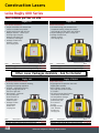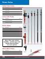
1
2014 Catalogue 877.252.0070 New Products senseFly eBee RTK Page 14 Leica GS14 - Powerful and compact GNSS receiver - Collects aerial imagery up to 1.6-6 sq. km per 45 minute flight - IP68 protection against the elements - Hand launched - Built for extreme temperatures - No piloting skills needed - Integrated TX/RX radio - Intuitive software Leica 810 Touch Disto Page 65 Leica Nova MS50 - First laser distance meter with touch screen - Combines every significant measuring technology in one device: - Precise 360 degree tilt sensor - Free Disto Sketch App available for both iOS and Android - Integrated camera now stores images with USB download capability - 3D Scanning - Precision TPS - Rechargeable battery Vivax VLoc Pro 2 Page 27 Page 67 - Exceptional sensitivity - Multiple frequencies for any application - Multiple transmitter options to suit your needs Page 28 - Digital Imagery - GNSS Connectivity - Long Range Reflectorless Rugby 800 Series Lasers Page 50 - Toughest laser on the market with the highest environmental standards for water and dust protection - Available in 4 different versions to suit any application - Unique solar power concept enable you to recharge your batteries anywhere, anytime - The best IP rating of any laser in the industry (IP68) 2 spatialtechnologies.ca | 877.252.0070 Table of Contents Welcome Locations Technical Support Training Terms and Conditions Service Scanning Solutions Airborne Solutions Leica Viva Leica Data Collectors and Software Leica GPS Solutions Scanning Total Station Robotic Total Stations Manual Total Stations Software Mapping Solutions Non-Leica Data Collectors and Software GPS Radios Network Solutions iCON Construction Solutions Construction Lasers Interior Lasers Pipe Lasers and Laser Accessories Laser Receivers Distance Measuring Instruments Line and Dot Lasers Levels Laser Distancemeters Locators Electronic Hand Tools Tripods Cables Batteries and Chargers Data Collector Accessories Tribrachs, Adapters, and Carriers Prisms Prism Poles and Accessories Instrument Accessories GPS Radio Accessories Level Rods Hand Levels Safety and Vests Flagging, Whiskers and Targets Paint Markers and Crayons Drafting and Paper Plumb Bobs and Accessories Nails and Spikes Lath Blades and Sledges Measuring Wheels and Tapes spatialtechnologies.ca | 877.252.0070 Page Page Page Page Page Page Page Page Page Page Page Page Page Page Page Page Page Page Page Page Page Page Page Page Page Page Page Page Page Page Page Page Page Page Page Page Page Page Page Page Page Page Page Page Page Page Page Page Page Page Page 4 5 6 7 8 9 10 14 22 24 26 28 29 31 34 36 38 40 42 43 48 54 55 56 59 60 61 64 66 69 70 72 73 74 75 76 78 80 82 84 85 86 88 90 91 92 94 95 96 97 98 3 Welcome Your First Choice In Top Quality Measurement Solutions Founded in 2002 and led by three former Leica Geosystems employees and staffed by trained and experienced professionals, including Professional Land Surveyors, Spatial Technologies is the exclusive sales and authorized warranty service centre for Leica’s high-end surveying solutions in Western Canada. Our head office is based in Calgary, Alberta with additional offices in Edmonton, AB and Richmond, BC. Spatial Technologies sells, services and rents a complete range of surveying equipment and supplies ranging from basic construction lasers to 3D laser scanners. Spatial Technologies is the most trusted supplier of quality measurement solutions to the Land Surveying, Engineering, construction, mining, and mapping industries. Spatial Technologies understands exactly what tools you need, whether it is to ensure millimeter accuracy for special construction or when “close enough” is enough. We’ll make sure you have the right product. At Spatial Technologies we know that you need accurate, reliable, cost effective solutions and supplies backed by a knowledgeable support and service staff. Our mission is to ensure your success. Spatial Technologies strives to be a partner and not just a supplier to our customers. Our goal is to establish a reputation of mutual respect, trust and integrity in all of our dealings with our customers and our suppliers. 4 spatialtechnologies.ca | 877.252.0070 Locations Locations With offices in Calgary, Edmonton and Richmond Spatial Technologies has you covered Calgary Office #2 -21 Highfield Circle SE Calgary, Alberta T2G 5N6 P - 403.252.0070 F - 403.259.3992 Edmonton Office 16304 - 111 Ave Edmonton, Alberta T5M 4G3 P - 780.486.2111 F - 780.486.2155 Richmond Office #10 - 3671 Viking Way Richmond, BC V6V 2J5 P - 604.214.9453 F - 604.214.3455 spatialtechnologies.ca | 877.252.0070 5 Technical Support To be able to fully support our customers, Spatial Technologies has dedicated individuals keeping you working hard by providing support and training. Only a call away! Call Toll Free 855.414.9453 These individuals have also worked hard at creating a wealth of knowledge available to users in the form of quickstart guides, tutorials and format files all available 24 hours a day on our website. Check it out today! www.spatialtechnologies.ca 6 spatialtechnologies.ca | 877.252.0070 Training Knowledge at your Fingertips Spatial Technologies offers flexible courses designed to suit your company’s needs and the professional development of your staff. Our instructors are experienced professionals that will provide you with first-rate, hands-on training in order to maximize your productivity in the field. Whether you use a simple distance measuring device or the most sophisticated integrated solution, Spatial Technologies provides a true partnership in helping to define your training requirements and deliver the highest level of service, support and collaboration. - On-site TPS, GPS and Software Training - Customized Company Training Programs - Remote PC Training - Basic Construction Product Training - Product Workshops spatialtechnologies.ca | 877.252.0070 7 Terms and Conditions Catalog Accuracy and Pricing Spatial Technologies makes every effort to ensure that the information presented in this catalog is accurate. Spatial Technologies cannot be held responsible for any errors. Spatial Technologies warrant the accuracy and reserves the right to make changes at any time without notice. Shipping As specified by the customer, or via the most economical route possible. We reserve the right to select method of transportation for prepaid shipments. All goods we sell are carefully selected and inspected before shipping. Carrier is Responsible for Damage and Loss. No merchandise can be returned without prior consent. Please contact us for product return number. All shipments are uninsured by Spatial Technologies and are the customers responsibility once goods leave the premises. Rentals Most products may be rented, leased or obtained on a rental/purchase plan. Please call for Rental Rates on survey equipment. All rentals start from the time the equipment leaves our shop until the time it is returned. All travel time is included in the rental period. Please inspect shipments immediately after receipt and report damages or shortages to your carrier at once. Spatial Technologies is not responsible for any damage or loss. Errors All claims of error in shipments must be made within 48 hours of receipt of product. Accounts Call the nearest Spatial Technologies Office for a Customer Account Application. DEALER INQUIRIES WELCOME 8 spatialtechnologies.ca | 877.252.0070 Service At Your Service... We offer a full service and repair center at our locations in Calgary, Edmonton and Richmond. Our Leica factory-certified technicians offer over 120 years of combined experience to provide you with the best service for your equipment. We provide free estimates and only begin work on your approval. All our repairs come with a 3 month guarantee backed up by a large rental pool giving you peace of mind. Spatial Technologies is now an Authorized Pacific Crest Repair Center For more information or to request service feel free to contact us at 877.252.0070 or visit us at www.spatialtechnologies.ca spatialtechnologies.ca | 877.252.0070 9 Scanning Solutions Leica P20 Scanner Industry´s Best Performing Ultra-High Speed Laser Scanner Leica ScanStation P20, an ultra-high speed rugged one-scanning solution, designed to operate in temperatures from -20°C to +50°C. Scanning 1 million points per second with a 120m range, it’s as fast as it is accurate. The Leica ScanStation P20 provides three world’s firsts in a compact terrestrial laser scanner: •Onboard Check & Adjust functionality •Sub-millimeter range noise at 120 m •Modern Waveform Digitizing (WFD) technology delivering 1 million points per second. Leica Geosystems are pioneers in the development of terrestrial laser scanners, and these years of experience is shown in the state-of-the-art technology used in the Leica ScanStation P20. The P20 uses an optimal combination of angular and range measurements to provide unrivaled 3D point quality and product reliability Check & Adjust 10 ü Quality Technology Prices are subject to change without notice. Scanning Solutions Leica P15 Scanner Scalable Laser Scanner The new Leica ScanStation P15 achieves an extremely fast million points per second scan rate and delivers the highest quality possible in 3D data for project scans with ranges of up to 40 m. In addition, it has best-in-class angular measurements and tilt compensation, making the Leica ScanStation P15 perfectly suited for quick and accurate as-built surveys of any scenes. Robustly built, the Leica ScanStation P15 can be used even under the most challenging conditions. With an environmental rating of IP54, the Leica ScanStation P15 operates at temperatures ranging from –20° C to +50° C and also enables 3D scanning in full sunlight or complete darkness. Leica C10 Scanner The All-in-One Laser Scanner for Any Application The versatile Leica ScanStation C10 includes a high-accuracy/long-range scanner, tilt sensor, battery, controller, data storage, auto-adjusting video camera and laser plummet all in one compact, portable instrument. The ScanStation C10 also features major productivity advances, including a Smart X-Mirror™ design that lets users conduct full-dome scans in literally a few minutes using a spinning mirror or conduct small area scans efficiently with Smart X-Mirror’s oscillating mode. spatialtechnologies.ca | 877.252.0070 11 Scanning Solutions Leica Cyclone 3D Point Cloud Processing Software The inherent completeness of 3D point clouds represents one of their major advantages over other sources of geometric information. Cyclone's unique Object Database Client/Server software architecture provides the highest performance environment for laser scanning projects. Cyclone software makes it easy for users to manage data efficiently in databases. Users can work concurrently on databases, thereby reducing the need to copy and/or transmit large point cloud project files. Cyclone-REGISTER Cyclone-REGISTER provides the complete set of tools for aligning point clouds captured from different scanning positions, quickly and accurately. Cyclone-REGISTER supports the use of Leica Geosystems HDS targets to geo-reference scan data, as well as the ability to align overlapping areas of point clouds – without the use of targets. This results in optimum registration, and provides significant time- and cost-savings by reducing the need to place and extract targets. Cyclone-MODEL This versatile, powerful module enables professionals to use point clouds directly, to process them into objects for robust export into CAD (and other applications), and to allow robust import of data from CAD (and other applications). Cyclone-MODEL has the industry's largest, most complete and automated set of tools for accurately modeling 3D point clouds as CAD geometry or as meshes for engineering, surveying, construction, architectural and related applications. Cyclone-SURVEY Cyclone-SURVEY lets surveyors quickly extract relevant feature and coordinate information from the point cloud data via the Cyclone Virtual Surveyor™ function. Powerful tools support complex topographic models, with intelligent mesh decimation that minimizes file size while retaining accurate geometry. Cyclone-SURVEY is a subset of the CycloneMODEL product and is an ideal module for surveyors. 12 Prices are subject to change without notice. Scanning Solutions Leica Cyclone 3D Point Cloud Processing Software Cyclone-IMPORTER Many organizations find the need to utilize scanners from other providers but would prefer to process this data with Leica's software solutions. Through direct agreements with many of the other scanner manufactures, Cyclone IMPORTER provides direct importing of the native point cloud formats from Faro, Riegl and Optech units. Cyclone-BASIC Cyclone-BASIC operates time-of-flight and phase-based Leica Geosystems scanners. Users can manage scan parameters; scan target acquisition; field QA; digital imaging; geo-referencing; and more depending on scanner capabilities. In the office, Cyclone BASIC provides viewing and navigating of point clouds and 3D models, as well as measurement and mark up/redlining. Cyclone BASIC is a versatile “back-office” data exchange module, supporting imports and exports of a wide range of formats.. Cyclone-SERVER Cyclone-SERVER enables individual members of workgroups to simultaneously access 3D point cloud data sets and/or models. This provides a powerful environment for collaborative design on large, complex projects, and can significantly reduce project execution time. Cyclone- SERVER supports the simultaneous connection of one through ten 'client' users to the same data server in a network environment. These clients can be licensees of Cyclone REGISTER, MODEL, SURVEY, VIEWER, or Cyclone CloudWorx for AutoCAD and for MicroStation. Leica TruView and Cyclone-PUBLISHER Leica Cyclone-PUBLISHER publishes point cloud data for web-based sharing and viewing allowing access from anywhere in the world. Using the FREE Leica TruView panoramic point cloud viewer, users can view, zoom in, or pan over point clouds naturally and intuitively spatialtechnologies.ca | 877.252.0070 13 Airborne Solutions senseFly eBee RTK Survey-Grade Aerial Mapping The eBee RTK by senseFly is a fully autonomous survey-grade mapping drone (or UAV/UAS). It features a built-in L1/L2 GNSS receiver and is capable of receiving corrections from most leading brands of base station via its supplied eMotion 2 flight control software and ground modem. This ensures the high positional accuracy of the drone’s images without the need for Ground Control Points (GCPs). The eBee RTK is sold as a standalone solution - comprising the drone itself, eMotion 2 flight planning & control software, and Postflight Terra 3D photogrammetry software (powered by Pix4D). No extra base station purchase is necessary and no additional logger or third-party software are required. 3 ways to work with the eBee RTK 1. Real Time Kinematic • Place your base station on a known position • Correction data is streamed to the drone via its eMotion flight control software and ground modem 2. Virtual base station • Configure the drone’s eMotion software to receive VRS/Ntrip correction data (internet connection & VRS/Ntrip subscription required) • Creates a virtual base station location • Correction data is streamed to the drone via its eMotion flight control software and ground modem 3. Post processing • Position your base station in a convenient on-site location 14 Prices are subject to change without notice. Airborne Solutions senseFly eBee RTK Survey-Grade Aerial Mapping • Survey-grade accuracy Absolute orthomosaic / Digital Elevation Model accuracy of down to 3 cm (1.2 in) without the need for GCPs – for less time spent in the field and high precision even in inaccessible areas. • Fully integrated workflow The eBee RTK’s flight planning and control software (eMotion 2) connects to the base station and broadcasts correction data to the rover (eBee RTK) - no additional logger or third-party software required. This software can also be used to apply corrections later via post-processing. • Base station compatible The eBee RTK is compatible with most leading brands of base station, working seamlessly alongside your existing portfolio of instruments. •Autonomous The eBee RTK flies, acquires images and lands itself. •Lightweight The eBee RTK weighs just 0.7 kg (1.5 lbs) – minimising its power usage (optimizing its flight time) and ensuring the safety of people and objects on the ground. spatialtechnologies.ca | 877.252.0070 15 Airborne Solutions senseFly eBee Professional Aerial Mapping The eBee takes off, flies and lands autonomously. The artificial intelligence incorporated in the senseFly autopilot continuously analyzes data from the Inertial Measurement Unit and the onboard GPS and takes care of all aspects of the flight mission. If the eBee's sensors detect a critical situation a warning will be emitted through the ground control software. The eBee will automatically initiate a safety procedure, such as returning to its landing point when low battery or strong wind is detected or start climbing if it detects the proximity of the ground The modular design, allows the wings to be disassembled and stored with the central body and all its accessories in a small case. The eBee is light enough to be launched by hand. After its preflight checks just shake it three times to start the engine and it is ready for take-off. It is as simple as that, the eBee does not need any external element to fly. - 96cm wingspan - Less than 0.7kg take-off weight - Launch by hand - No extra equipment required - 16MP camera, electronically integrated and controlled - Lithium polymer battery gives up to 45 minutes of flight time - 36-57km/h (10-16m/s) cruise speed - Up to 45km/h (12m/s) wind resistance - Up to 3km radio link - Covers up to 1.5-10km2 - Linear or circular landing - Image resolution of 3-30cm/pixel (depending on flight altitude) 16 Prices are subject to change without notice. Airborne Solutions eMotion 2 Professional Software for Flight Panning and Control eMotion 2 is senseFly's proprietary state-of-the-art ground control software. It lets you plan, simulate, monitor and control the drone’s trajectory both before and during flight. With simple drag&drop actions you can designate the area to be mapped, generate a flight plan. You can update your mission or return the drone to its starting location with a single mouse click. eMotion 2 can be installed on your desktop or notebook computer. Postflight Terra 3D Professional Software for Mapping Postflight Terra 3D-EB is a professional photogrammetry software that runs on your desktop computer or laptop. It processes aerial imagery to 2D maps and 3D models with centimeter accuracy with just a couple of clicks. It is also the perfect tool if you want to process drone imagery with traditional photogrammetric software, generally not able to process small drone imagery. Postflight Terra 3D-EB will provide you with camera calibration parameters and lists of matching features, enabling rapid processing through most classic photogrammetric software. spatialtechnologies.ca | 877.252.0070 17 Airborne Solutions senseFly eXom The inspection and close mapping drone Imagine being able to… · Inspect & map structures. Up close. In high resolution. eXom is acutely aware of its surroundings, allowing it to view structures and buildings close up, in high-resolution, with minimal risk of contact damage. This makes eXom particularly suitable for sensitive or dangerous sites, such as cliff faces, flare stacks, bridges and more. · Boost your efficiency eXom captures and geotags video, still and thermal imagery simultaneously. You get all the data you need, in the minimum number of flights, without ever having to change cameras. Plus all the software you need is included. · Focus on work, not on flying Are you mapping an entire pre-defined site? Fly a fully autonomous, GPS-guided mission. Or do you need to perform a live inspection? Choose interactive mode and click/tap the screen to re-centre eXom’s cameras as you work. Or flick between these operating modes as required. No piloting skills necessary. 18 Prices are subject to change without notice. Airborne Solutions senseFly eXom The inspection and close mapping drone eXom is designed from the ground up to permit the safe, close inspection of buildings and other vertical structures. Its onboard vision and proximity sensors feed cuttingedge computer vision algorithms. These in turn provide the situational awareness and object avoidance intelligence eXom needs to make every project a success. Need to perform a live inspection? · Take-off in interactive mode (or click into it during an autonomous flight) · ‘See what eXom sees’ via its multiple live video feeds · Click or tap the screen to: · Centre eXom’s cameras on a target · Vision-lock onto objects · Capture high-res still images on demand Already know the specific structure or site you want to map? · Specify the area or object of interest · eMotion flight planning software (supplied) creates a full flight plan · Initiate your flight · eXom takes off, captures imagery, and lands itself · Explore the detail captured by eXom’s multiple imaging sensors · View the live video stream during flight · Imagery stored on eXom’s SD card for post-flight analysis · Use Postflight Terra 3D photogrammetry software (supplied) to create highly accurate 2D orthomosaics & 3D models spatialtechnologies.ca | 877.252.0070 19 Airborne Solutions Aibotix Aibot X6 Focus on the Job, Not the Flying The newly developed Aibot X6 V2 enables a complete array of new and improved functions that make the copter easier to control and safer. Moreover the new hard- and software technology offers a broad spectrum of adjustment and expansion possibilities. Key features •Fully automatic take-off and landing Take-off and land by just using one switch. •Highly configurable flight-characteristics Customizable behavior to perfectly suit your needs. •Training mode / Geo-fence Virtual safety-zone or geo fence and minimal flight-altitude for maximum protection. The Aibot X6 cannot leave this zone to prevent damage to people and the environment. •Dynamic POI (point of interest) Set POI directly while flying. The Aibot X6 will automatically maintain the alignment towards the POI. •Enhanced safety features Different fail-safe modes: lost of RC-signal / low battery voltage. Start prevention system (low battery voltage / tilted position recognition). •Standardized interface for new sensors like RTK GNSS transmitter New modular design enables the integration of many kinds of sensors. 20 Prices are subject to change without notice. Airborne Solutions Aibot Sensors Countless Applications through Various Sensors Thermal Imager The areas of application of thermography range from surveillance and identification to maintenance. Issues in photovoltaic systems can be graphically represented with a thermal imaging camera as well. In the field of building thermography the Aibot can reveal defects in bridges and buildings using a thermal camera to detect energy loss. Thermal cameras can also be used to aid in search and recovery of missing people, victims or wreckage. Multispectral The equipment of the Aibots with multispectral cameras increased the scope is an important element. This now means that multi-spectral images of broad areas and motifs can be generated. This is an excellent addition to the detail shots of the digital SLR cameras. Digital SLR (georeferenced) With the help of digital SLR cameras we can take high-resolution images and video recordings. You can produce professional SLR images with excellent quality and spectacular detail, which make it ideal for analytical applications of any kind, such as the inspection of bridges or overhead power lines. spatialtechnologies.ca | 877.252.0070 21 Viva GNSS & TPS Viva TPS Viva GNSS Viva Controllers & Software Leica Viva — It does not get more versatile. Leica Viva — is a new-generation measurement system that combines the latest state-of-the-art technologies into an unrivalled portfolio of total stations, GNSS receivers, system controllers and onboard software. Encompassing innovative, feature-rich functionality with a new, modern and ergonomic design, Leica Viva is easier and more intuitive to use than any of its predecessors, yet it does not compromise on speed and precision. 22 Prices are subject to change without notice. Leica Viva Leica Viva System Welcome to Leica Viva – A Complete Surveying System Leica Viva provides a complete range of GNSS and TPS solutions. With the unique SmartStation and the versatile SmartPole, fewer setups are required, fewer control points are needed and your flexibility is maximized. Leica Viva GNSS & TPS Leica Viva TPS TS15i Nova SmartStation SmartPole Leica Viva GNSS Leica Viva Controllers & Software GS10 GS14 CS25 Zeno 10 CS15 SmartWorx Software GS15 GS25 GS08plus NetRover Zeno 15 CS10 spatialtechnologies.ca | 877.252.0070 23 Leica Data Collectors Leica Viva Controller CS10 & CS15 Built for the Field Leica Viva contains a unique portfolio of wirelessly connected field controllers. With a complete range of easy-to-use software your work can start immediately and be finished faster than ever before. FEATURES: • IP67 and -30 to 60°C (-22 to 140°C) operating temperature • Tactile, rubber keypad (numeric on CS10, alphanumeric QWERTY on CS15) • 2-megapixel camera • Color VGA touchscreen, illuminated • Flexible communication and data handling • Fully integrated wireless Intenna technology • Choice of 2 connector modules (Lemo/RS232) • Integrated 3.5G Modem for: - Easy data transfer between office and field - Remote tech-support capabilities - Receiving RTK data • Data storage using SD Card, CF Card, USB memory stick CS10 CS15 Leica SmartWorx Viva Simply Productive Field Software Simple to Use • Clear graphics, logical menu structures and wizards to help with more complex procedures • Non-technical terminology • Pick up, turn on and start working Packed With Features • Survey and code points, lines and areas • Stake points, lines and areas, simple and complex alignments, and DTMs • Easy to configure to your working style Additional Apps for Specific Survey and Staking Tasks • For both GPS and TPS instruments • COGO calculations, volume computations, building facade measuring and much more • Seismic stakeout • Road, rail and tunnel staking and checking 24 Prices are subject to change without notice. Onboard Software MicroSurvey FieldGenius The Most Powerful Survey Data Collection Software in the World Total Station and GPS Support Powerful Road Module All the staking tools you will ever need Total Station and GPS Support What sets FieldGenius apart from the competition? Code-Free Linework. Linework is created automatically without entering codes and is instantly displayed, eliminating the need for a separate sketch. No need to connect the dots back at the office. Advanced Display With High-Def Graphics and Intuitive Interface. FieldGenius is laid out with logical icons, customizable toolbars, smart objects and easy-to-use GPS and total station controls. Works on More Displays Than Ever. High-definition, standard- (or legacy-) definition, widescreen, portrait, tablet-style – you name it. Productivity Tasks: Customize your data collector by assigning commands to your keypad keys. Calculating Tools: Access the built-in RPN calculator from any edit field. Hardware Freedom of Choice. FieldGenius works with many GPS receivers, unlike our competition where proprietary software must be used with the receiver (or vice versa). FieldGenius also works on a multitude of handheld data collectors. We believe you shouldn’t have to buy all new equipment just to upgrade one component. Plus: advanced roading, surfacing, slope staking, smart points, DXF & LandXML import/export, and full robotic and GPS support. FieldGenius is the choice of organizations that value productivity. spatialtechnologies.ca | 877.252.0070 25 Leica GPS Solutions Leica Viva NetRover GS08plus The All-In-One GNSS Network Solution Leica Viva NetRover integrates the latest technology from Leica Geosystems, the world’s leading measurement solutions provider. All the components of Viva NetRover work seamlessly together, creating a lightweight and cable-free network rover. TURN-ON & MEASURE • Viva NetRover is always ready to measure • Full support of RTCM3.1 message • Positions are automatically supplied in local coordinates QUICK TO LEARN • SmartWorx Viva LT designed with simplicity in mind • Clear graphics, logical menus DESIGNED FOR NETWORKS • Best-in-class performance • Field controller with built-in 3.5G mobile broadband • Future proof TURN-ON SURVEY IT STAKE IT 26 Prices are subject to change without notice. Leica GPS Solutions Leica Viva GS10 and GS15 Unlimited You Can't Find a More Flexible System PROVEN GNSS TECHNOLOGY Built on years of knowledge and experience, the Leica GS10 and GS15 deliver the hallmarks of Leica GNSS – reliability and accuracy. • SmartCheck – RTK data processing to guarantee correct results • SmartTrack – advanced four-constellation tracking of all GNSS satellites including GPS, GLONASS, Galileo, BeiDou • SmartLink - bridges communication gaps • SmartRTK – delivers consistent results in all networks WORK AS YOU WANT TO The Leica GS10 and GS15 are designed to suit any surveying task. • Exchangeable communication devices for field base stations and RTK rovers • Fully scalable sensor allows you to buy only what you need today and upgrade with additional functionality as you need it • Integrated web server to configure the logging of Leica or RINEX raw data and measure with one button press in the field • Leica Viva GNSS Unlimited series utilises all useful GNSS signals today. Both technologies SmartTrack and SmartCheck have been extended to fully support the Chinese BeiDou GNSS. Leica Viva GS14 Unlimited Performance on a Budget The Leica GS14 is the most compact and powerful GNSS receiver. The integrated mobile communications and UHF modem means it is suited for any measuring task. With its convenient, integrated design, the Leica GS14 is easy to use. Together with the leading GNSS RTK the Leica GS14 meets the highest standards for measurement technology. Integrated RTK devices - The fully integrated communication devices increase ease-of-use whilst maintaining flexibility to choose between UHF and mobile phone technology. Lightweight -Extra convenience due to compact and lightweight design. Leica SmartTrack - Leica SmartTrack technology guarantees the most accurate signal tracking. Leica SmartTrack technology is future-proof and ensures compatibility with all GNSS systems today and tomorrow. All GNSS signals – the Leica Viva GNSS Unlimited series utilises all useful GNSS signals today. Both technologies SmartTrack and SmartCheck have been extended to fully support the Chinese BeiDou GNSS. GPS, Glonass, Galileo and BeiDou together provide maximum performance spatialtechnologies.ca | 877.252.0070 27 Scanning Total Station Leica NOVA MS50 The new dimension in measuring technology You only get a moment to make the right decision. So ultimate performance and absolute reliability are critical. This requires not only intuition, but also intelligent technology you can rely on. For the first time, the Leica Nova MS50 combines every significant measuring technology in one device and opens the doors to a fascinating new dimension of the geospatial world. With precise 1" accuracy and 2km reflectorless range, all functions, including precision 3D scanning, extensive and precise total station capabilities, digital imagery and GNSS connectivity are now brought together in the Leica Nova MultiStation. A revolutionary solution with advanced measuring technology that provides unchallenged accuracy and quality, yet is easy to use for an unprecedented range of applications. The capabilities of the Leica Nova Multistation are truly comprehensive and second to none. INTEGRATED SCANNING OF EVERY DETAIL The Leica Nova MS50 integrates 3D point cloud measurements into a regular survey workflow. This lets you collect and visualize your topographic survey data together with detailed high-precision scans. Save time by checking your data for integrity and relevance and avoid costly reworking or returns to the field. Benefit from better decisions with richer and more detailed data. PROVEN TECHNOLOGY FOR UNMATCHED VERSATILITY The Leica Nova MS50 provides proven total station functionality with superior sensor integration for highest precision, performance and full automation of measurement procedures. Together with the benefits of GNSS connectivity, the Leica Nova MS50 offers complete versatility by delivering reliable results wherever and whenever you need them. IMAGE ASSISTANCE FOR EVERY SITUATION The Leica Nova MS50 features an overview camera and a telescope camera with 30x magnification and autofocus. State-of-the art image processing technology delivers live fluid video streaming of highest image quality. The imaging capabilities of the Leica Nova MS50 open up new opportunities of operating the MultiStation in an almost infinite range of applications. 28 Prices are subject to change without notice. Robotic Total Stations Leica TS50 True precision, True perfection The Leica Nova TS50 redefines the meaning of precision with its optimum combination of angle and distance measuring. At the same time, it offers extraordinary acceleration and speed for highest efficiency. True perfection: discover the 0.5" Leica Nova TS50. -IMAGE ASSISTANCE FOR EVERY SITUATION The Leica Nova TS50 features an overview camera and a telescope camera with 30x magnification and autofocus. State-of-the art image processing technology delivers live fluid video streaming of highest image quality. -PROVEN TECHNOLOGY FOR UNMATCHED VERSATILITY The Leica Nova TS50 provides proven total station functionality with superior sensor integration for highest precision, performance and full automation of measurement procedures. Together with the benefits of GNSS connectivity, the Leica Nova TS50 offers complete versatility by delivering reliable results wherever and whenever you need them. -Leica Smartworx The Leica Nova TS50 is equipped with the latest Leica SmartWorx software to provide unparalleled ease-of-use and performance. No matter how complex the application, Leica SmartWorx has functionality to complete every task with ease. With identical operation for TPS and GNSS, changing between Leica TPS and GNSS instruments is smooth and simple. Leica TS15 Your Vision Leica Viva TS15 adds an advanced image sensor to the already-proven total station sensors. With unique capture–sketch–link functionality, total station images can be captured, enhanced with sketching and linked to any point of interest. With tap–turn–measure any remote point can be measured without returning to the total station. Every vision on every scale becomes reality with ease. Best-In-Class Imaging Option • Image Notes – Capture an image, screenshot or template, sketch on it, and link it to any object in the database • Image-Assisted Surveying – Simply tap on the display and the total station will turn and measure the desired target Best-In-Class One-Person Surveying • Search – the unique PowerSearch finds your prism within seconds • Lock – Viva TS15 stays locked onto your prism in the most demanding environments • Measure – PinPoint EDM seamlessly harmonizes with precise angle sensors to complete the measurement process • Available in 1", 2", 3" and 5" accuracies and up to 1km reflectorless range Leica Viva GNSS Add-On • Use SmartStation for TPS setup without the need of control points, traverses and resections • Use SmartPole to save time with setup "on-the-fly" and measure parallel with TPS and GNSS for double productivity spatialtechnologies.ca | 877.252.0070 29 Robotic Total Stations Leica TS12 Performance on a Budget Leica Viva TS12 Performance Robotic package sets a new standard. Everything you need is in one package to begin efficient surveying today. Leica Viva TS12 is packed with features, such as the unique PowerSearch sensor, which finds prisms regardless of their location in seconds, and the lightweight Leica CS10 or CS15 controller provides secure wireless connectivity to the total station. Together with the easy-to-use Leica SmartWorx Viva software, robotic surveying has never been so easy and productive. The TS12 is an amazing value and is available in 2", 3: and 5" models with 400m reflectorless capabilities and the proven Smartworx Classic software on board. BEST-IN-CLASS SEARCH–LOCK–MEASURE Leica Viva TS12 uses years of experience to optimally find, lock and measure to prisms with a single key press. With the unique PowerSearch sensor any prism type is found within seconds regardless of location. Your benefit – the fastest robotic total station in its class. BEST-IN-CLASS RADIO FIELD CONTROLLER The CS10 lightweight and CS15 full-keyboard field controllers with fully integrated Intenna technology offer long-range, secure and fast wireless connectivity to your TS12 total station. Your benefit – ergonomic field solution. BEST-IN-CLASS SIMPLICITY IN THE FIELD Smart Worx Survey directly from the instrument or from SmartWorx Viva on the controllers, allowing you the flexibility and power you expect from Leica instruments. Your benefit – be up to speed in a minimum of time. BEST-IN-CLASS LEICA ORIGINAL ACCESSORIES Original Accessories Original Leica Geosystems accessories guarantee seamless operation and maximum performance, as all accessories have been meticulously designed for the instrument. Your benefit – trusted results today and tomorrow. 30 Prices are subject to change without notice. Manual Total Stations Leica TS11 An Advanced Manual Total Station Leica Viva TS11, the most advanced manual total station, raises productivity to the next level with the inclusion of advanced imaging functionality and the easy-to-use Leica SmartWorx Viva onboard software. The unique capture–sketch–link functionality enables high-resolution total station images to be captured, enhanced with sketching and then linked to any point of interest. Costly revisits can be avoided to significantly improve productivity. Every vision on every scale becomes reality with ease. FEATURES: • Available in 1", 2”, 3” and 5” models • Reflectorless Range up to 1000 meters (3281 feet) • Full-featured data collector options • Optional onboard software application • Optional imaging capability • Fast, accurate and reliable measurements Rental Equipment Available • • • • Daily, Weekly, Monthly Data Collectors Total Stations Digital Levels • • • • Network Rovers Base/Rover GPS Robotic Total Stations Accessories Visit spatialtechnologies.ca to find a location near you! spatialtechnologies.ca | 877.252.0070 31 Manual Total Stations Leica FlexLine Plus Total Stations The New Generation of Total Stations Leica FlexLine TS02plus Leica FlexLine TS06plus Best-In-Class Tech Top Precision Meets High Efficiency The Leica FlexLine TS02plus Manual Total Station is ideal for standard measurement tasks. It comes with a simple keyboard and a complete standard set of application software that guides you through your daily work. Bluetooth is an option. The Leica FlexLine TS06plus Manual Total Station is ideal for mid-range applications. The full alpha-numerical keyboard, built-in Bluetooth, USB host and device board offer highest user friendliness. Leica FlexLine TS09plus Full Precision at High Performance A true performance-oriented total station that continually delivers. Designed especially for mid- to high-accuracy applications. By including all FlexLine features – removable USB memory, Bluetooth wireless technology, Emitting Guide Light and a complete range of application software – the TS09plus guarantees maximum performance. Color Touch Display and Leica FlexField plus Onboard Software • Fast navigation inside the software via touchscreen, tabs and icons • High resolution • Easy-to-understand graphics and icons Best-In-Class Electronic Distance Measurement (EDM) • 2 mm + 2 ppm to any surface in 1 second • 1000m range without a prism • Coaxial laser pointer and measurement beam Flexible Data Exchange • USB stick for easy and fast data transfer (GSI, DXF, ASCII, LandXML, CSV, user-defined) • Built-in wireless Bluetooth® Theft Protection by Leica Geosystems – mySecurity • If your instrument is ever stolen, a locking mechanism disables the device and it can no longer be used 32 Prices are subject to change without notice. Manual Total Stations Leica FlexLine Plus Total Stations Specifications Available Accuracy Enhanced measurement accuracy to prism Reflectorless measurement range Display with graphics and display illumination Full alpha-numerical keyboard with function keys Second Keyboard Keyboard illumination Electronic Guide Light USB Type A and mini B Bluetooth® Wireless Onboard software (package content) Survey with Coding Stake Out Station Setup Resection Orientation with Angle Orientation with Coordinates Height Transfer Reference Line/-Grid /-Segment Tie Distance 3D Area & DTM Volume Remote Height Offset (Standard & Cylindrical) Backsight Check Hidden Point COGO Calculations Road 2D Reference Arc Reference Plane Road 3D Traverse Mining TS02+ TS06+ TS09+ 2"/3"/5"/7" 1"/2"/3"/5"/7" 1"/2"/3"/5" 1.5 mm + 2 ppm 1.5 mm + 2 ppm 1.5 mm + 2 ppm No Reflectorless 500 m included 500 m included /500 m option / 1000 m option / 1000 m option Black & White Black & White Q-VGA Color & high resolution high resolution Touch O O O - - FlexField plus (full) O - O O FlexField plus (advanced) O O O O FlexField plus (standard) O O O O O spatialtechnologies.ca | 877.252.0070 33 Software Leica Geo Office One Integrated Office Software One Office Software for All Your Instruments • GNSS instrument support • TPS instrument support • Level instrument support Best-In-Class Processing Options • GNSS data processing using SmartCheck techniques • TPS processing – from simple station updates to complex traverses • Level processing • Combined network adjustments • COGO calculations, datum transformations and volume calculations All Components Integrated in One Software • Use GNSS processing to automatically update SmartStation setups • Combine GNSS and terrestrial data with an integrated Least Squares Adjustment • Benefit from volume calculations being instantly updated whenever coordinates change Leica Infinity TPS, GPS, Scans and More. New perspectives for your project Discover a new dimension in survey office software. Leica Infinity not only allows you to process complex structures with absolute precision, it is above all your key to simple access to the worlds of 3D data processing. The clearly laid-out user interface and intuitive handling of its 3D map view means that three-dimensional data sets recorded in the field - and even multiple scans - can now be displayed on your desktop, edited more rapidly than ever before and integrated with other survey results - for faster decisions in projects. Nothing beats another check Leica Infinity is designed to provide you with instant access to all aggregated raw data at all times and lets you combine and cross-check them against processed or archived data and survey results with only a couple of clicks. Your survey crews in the field are kept on the ball by data transfer when it comes to expanding or reducing the survey schedule, response times and decisions are made faster and bring new levels of project-efficiency. Report and archive your results No matter how complex your survey is, it is important to be aware for the state of the project. Leica Infinity offers you all the tools to document and report on individual steps and final results, no matter for how long your project lasts. All your data, processed results and deliverables are contained in your project and are accessible whenever you need. 34 Prices are subject to change without notice. Software Leica Exchange Transfer Your Data - Fast & Safe Transfer objects easily between the field and the office with Leica Exchange. The yearly Leica Exchange Service allows an unlimited number of exchanges to an unlimited number of users. Your Benefits: • Easy to Use • Instant notifications • No limits to worry about • Field and office solution • Integrated into the measurement process • No interruptions in your work - downloads in background ACTIVE ASSIST Leica Active Assist Expert Help Always by your Side Imagine being in the field and coming across a problem that prevents you from finishing the job. You call your local support engineer, but have trouble explaining your exact problem. By simply pressing a button in Leica SmartWorx Viva, you can activate Leica Active Assist, and your local support engineer can securely access your device and see exactly what you see. By pressing the buttons for you, your support engineer can guide you back to full productivity within minutes You can continue with confidence to complete the survey, and know if the problem ever arises again, you can solve it yourself after being guided step-by-step through a solution. Your Benefits: • Easy-to-use • Help is always by your side • Improve productivity • Available with all Leica SmartWorx Viva hardware Requires: • One-time license fee • Valid CCP maintenance contract spatialtechnologies.ca | 877.252.0070 Page A | Section Header 35 Mapping Solutions Leica GIS/Mapping Series Easy-to-Use Mobile Solutions Leica Zeno/Uno Easy-to-Use Mobile GIS The Leica GS05/06 GNSS top caps allow any user to convert the high performance CS10 and CS15 data collectors into the ultimate mapping tool. The high quality 14 channel L1 GPS/ SBAS receiver (with optional GLONASS) allow DGPS accuracy of <0.4m. The optional docking station ensures quick, direct and easy access to the data you have measured in the field. Software Options to Suit your Needs These unit have the option to run either the proven Smartworx software (For more information - please see Page 18) or Zeno field software allowing you to have the right software for your GIS/mapping needs. Zeno field is based an OEM version of ArcPad 10 with added functionality of GNSS raw data logging, easy handling of GNSS configurations (such as DGPS settings) and accuracy management. Leica Optim Flexible Solutions for Asset Management Optim Server Optim Server is our web-based deployment for integration of GIS and mobile solutions for field asset management. Mobile data collection solutions and project data can be downloaded to mobile devices, and can be uploaded, with just one click. Installation is automated and all projects can be monitored from one central configuration control panel. The system is integrated with Esri ArcGIS for Server. We offer two types of server solutions, which can be scaled based on cost and security needs. Optim Mobile Optim Mobile is the highest productivity, rapid deployment mobile platform for managing your real world assets, featuring ready-to-configure templates, documentation, and tools that seamlessly integrate with Esri ArcGIS. QuickCollect is easy to configure and cost effective for any sized project. QuickCollect QuickCollect is a comprehensive application for GIS, mobile and post-processing GPS data that delivers significant time savings for user efficiency and adoption. It fully supports Esri geodatabases, seamlessly integrates into the GIS environment and enables one-click transfer of collected data without ever leaving the Esri ArcGIS for Desktop environment. QuickCollect delivers significant improvements in efficiency from the office to the field. Optim Studio Build and configure easy-to-use, scalable mobile solutions for the field easily and quickly without any development skills. It is an easy-to-use, powerful suite of configuring data forms, showing how data is both collected and returned to the database. 36 Prices are subject to change without notice. NAVCOM GPS Navcom Land-Pak Rugged & Reliable Survey Solutions The LAND-PAK system includes full GNSS support, field, office & GNSS post processing software, all hardware & accessories, backed by Spatial’s service and support and comes with an industry leading three year manufacturer’s warranty. LAND-PAK also includes a lifetime license for our StarFire global satellite-based augmentation system providing subdecimeter horizontal accuracy worldwide and the freedom and flexibility that a DGPS solution offers. Ultra RTK provides RTK-level accuracy up to 40km away from a base station while NavCom’s patented RTK Extend allows for continuous RTK positioning during radio outages. - Integrated UHF and GSM support - Bluetooth® Cable free, all-on-the pole design - Multi-constellation support (GPS, GLONASS) - Ultra RTK (up to 40K baseline) - Network RTK with support for multiple message formats - Built-in StarFire™ receiver with lifetime license - StarFire™ 5cm standalone accuracy (worldwide) - RTK Extend™ - Coast through base station outages - Dual hot swappable batteries for continuous operation - SF-3040 GNSS receiver operates as a base or rover - Water proof and shock resistant - 3 year warranty spatialtechnologies.ca | 877.252.0070 37 Data Collectors MicroSurvey ALGIZ 7 Top Performance Starts With Great Power. The Algiz 7 features an impressive Intel Atom 1.6 GHz processor, with a massive 64 GB SSD and 2 GB of DDR2 RAM. It runs the state-of-the-art Windows 7 Ultimate operating system, the most powerful tool available for the field user. Meaning you’ll be able to work in all the top PC applications, in the office and out in the field. With 10 easy-to-use function buttons and an onscreen QWERTY soft keyboard, you can use the Algiz 7 efficiently in the office. But its heart is outdoors, where its versatility and built-in ruggedness make it stand out. It meets stringent MIL-STD-810G military standards for withstanding humidity, vibration, drops and extreme temperatures, and it keeps dust and water out as well. So use it in any kind of weather, let it rattle on the dashboard, rinse it off after a dirty day – the Algiz 7 is built for hard work. Juniper Systems Archer 2 Wherever the Job Takes You The Archer 2 incorporates all the best things about the Archer and adds to them. Featuring a new IllumiView™ high-visibility display, the Archer 2 remains extraordinarily bright under even the most glaring sunlight. You’ll love the responsiveness of its large, glove-friendly capacitive touchscreen and numeric keypad, allowing you to input data at unprecedented speeds. And for those work days that just seem to go on and on, you can trust that the Archer 2’s custom Overtime Technology™ battery will get you through, no problem. Add to this the signature ruggedness that Juniper Systems is known for, and you have one mean data-collecting machine that you can rely on, wherever your job takes you. 38 Prices are subject to change without notice. Software MicroSurvey STAR*NET Survey Network Adjustment Program MicroSurvey STAR*NET is an easy-to-use application that adjusts 1D/2D/3D survey networks. Collect your measurements & GPS vectors more efficiently & build confidence by ensuring your field data is both accurate & correct. FEATURES: • The easiest Least Squares Adjustment • Integrates data easily • Results are clear and reliable MicroSurvey CAD 2014 MicroSurvey embedded CAD 2013 The Complete Desktop Survey & Design Software Solution Powered by Autodesk Technology™ MicroSurvey CAD is a complete desktop survey and design program created for surveyors, contractors and engineers. MicroSurvey CAD is compatible with field data from all major total stations and data collectors and is fully compatible with AutoCAD. MicroSurvey embedded CAD, powered by Autodesk Technology™, is 100% compatible with AutoCAD® DWG® files. It’s a full-featured standalone surveying powerhouse using an industry-leading CAD engine. FEATURES: • Data extraction from point clouds • Enhanced point cloud visualization and manipulation • Integrated survey, design & CAD FEATURES: • 100% AutoCAD and 100% DWG compatibility • Integrated survey, design & CAD, and much more spatialtechnologies.ca | 877.252.0070 39 GPS Radios Satelline EASy Pro Dependable Data Transfer SATELLINE-EASy Pro is an IP67 (NEMA 6) classified UHF radio modem with a high power (up to 35 W) transmitter and wide 70MHz tuning range. It was designed for easy mobile use in demanding field conditions. According to the IP67 standard, the casing and connectors of the SATELLINE-EASy Pro are waterproof and secured against dust. In addition to the high output power and wide tuning range, the channel spacing is also selectable to be 12.5, 20 or 25 kHz. The SATELLINE-EASy Pro is equipped with a Liquid Crystal Display (LCD) and a keypad, used to indicate the current operating status (frequency, channel number, power level, voltage level, field strength), as well as for changing the operating channel and power level of the radio modem. Item Description 789636 Satel EASy Pro 35W Base Radio 40 Price $2730.00 Prices are subject to change without notice. GPS Radios Pacific Crest ADL Vantage Pro Advanced Data Link for the Field ADL Vantage Pro is an advanced, high speed, wireless data link built to survive the rigors of GNSS/RTK surveying and precise positioning. This sophisticated 35 Watt radio utilizes Pacific Crest’s latest generation Advanced Data Link (ADL) technology while remaining backward compatible with existing Pacific Crest, and other radios. ADL Vantage Pro’s fullfunction user interface streamlines field configuration and troubleshooting so you can maintain maximum productivity. Its 35 Watts of power and advanced radio protocols offer the maximum range and throughput. For the most rugged and reliable digital data link, go with the geomatics industry’s new standard in high-power wireless communications – ADL Vantage Pro. Item Description 75450-43 Pacific Crest Vantage Pro 35W Radio Price $2855.00 Pacific Crest ADL Vantage Compact and Easy to Use Tec Spati hno al l now ogies is Aut an h Pac orize Rep ific C d re air Cen st ter ADL Vantage is an advanced, high speed, wireless data link built to survive the rigors of GNSS/RTK surveying and precise positioning. This sophisticated 0.1-4.0 Watt radio modem utilizes Pacific Crest’s next generation Advanced Data Link (ADL) technology while remaining backward compatible with existing Pacific Crest, Trimble and other products. ADL Vantage’s full-function user interface streamlines field configuration and troubleshooting so you can maintain maximum productivity. For the most rugged and reliable digital data link, go with the Geomatics industry’s new standard in lightweight wireless communications – ADL Vantage Item K01111 Description Pacific Crest Vantage 4W Radio Price $2145.00 spatialtechnologies.ca | 877.252.0070 41 Network Solutions Pleiades Data Corporation Western Canadian Coverage Pleiades Data Corporation provides subscription-based GNSS Network RTK corrections throughout Western Canada. Pleiades provides high-precision, high-availability Network RTK corrections for any application, using any constellation, and is available to everyone. Quality Cost • Same accuracy as a local base station • Half the capital investment – no base station! • High-speed initialization for RTK solutions • Redundancy – multiple reference stations, • Eliminates paying an employee to guard not just one base station against theft Productivity • Reduces insurance costs – less risk • Perform cm-accuracy RTK surveys with • Subscribers can easily work in various one rover locations • Eliminates daily base station setup and • Provincial-, regional- and national-level potential errors subscriptions available • Reduces dependency on ground control monuments • Far exceeds range of conventional RTK systems • Convert your existing base station into a productive rover www.pleiadesdata.com 42 Prices are subject to change without notice. Construction Instruments Leica Geosystems intelligent CONstruction Leica intelligent CONstruction Custom-Built Solutions Building Construction Enhancing YourforPerformance Fully understanding construction needs has carried us beyond the ordinary. Leica iCON is more than a new product line and a software package – it enables you to enhance your performance and increase your profitability through perfecting your construction workflow. iCONstruct iCONtrol Tailor-made hardware and software solutions for positioning and measuring tasks on site. Providing you with perfect communication between construction personnel on site and our comprehensive portfolio of machine control solutions. Custom-built Straightforward Extendable Interchangeable Suitable for small to large sites Reliable and seamless sensor communication Streamlined workflow & data handling i nt e l l ig e nt C O ns t r uc t i o n iCONsult iCONnect An extensive support network, with clear guidance on intelligent CONstruction benefits to grow your business. Connect your system to a superior network. Wireless data transfer, easy, fast and secure. Worldwide network Personal service Professional consultancy Instant guidance and checks Realtime data guarantees accurate jobs High productivity No delays spatialtechnologies.ca | 877.252.0070 spatialtechnologies.ca | 877.252.0070 | PAGE 37 43 Designed for the Building Site — One Layout Software Sketching Applications Point Pilot for fast and intuitive input of plan dimensions Benefits Easily replicate digital blueprints Leica iCON CC60/61 Rugged, mobile tablet PC with enhanced connectivity and functionality. As-Built Applications Measure points, lines or arcs in one step with immediate graphical representation Benefits Reduce site visits by visually verifying the measurements in the field Leica iCON CC50 Lightweight, handy PDA for easy and efficient field work. Leica iCON gps 60 Versatile SmartAntenna for multipurpose positioning tasks. Prices are subject to change without notice. | PAGE 44 Cut & Fill Applications Check actual surface against design elevation Benefits Optimize material savings (e.g., asphalt) by checking subground elevation and tolerances Leica Builder Intuitive, powerful and scalable series of total stations for routine construction tasks on site. for GPS & Total Stations — Easy to Learn, Easy to Use! Volumes Applications Calculate volume of a stockpile or pit, compare between surfaces or to the elevation Benefits Accurate and flexible volume calculations, independent of size or shape Layout Points Height Transfer Benefits Choose points directly from the map, no need to enter point numbers or scroll through lists Benefits Mark and check elevations within one application Applications Simply select sketched or imported points directly from the map Customize and extend your iCONstruct toolbox. Leica iCON robot 50 One-person operation, increases productivity when carrying out layout tasks and as-built checks. iCON build is part of the unique iCONstruct toolbox, providing you with one solution for all your construction tasks across the entire job site. iCONstruct offers you the possibility to extend and customize applications according to your needs. spatialtechnologies.ca | 877.252.0070 | PAGE 45 Applications Transfer height to any location on site iCON Instruments The iCONstruct product portfolio enables you to select your individual solution. Invest in the solution you need today and have the flexibility to expand your product portfolio based on your future needs tomorrow. Intuitive, powerful and scalable series for routine Leica iCON robot 50 One-person operation, saving time and increasing productivity construction tasks on site. when carrying out layout tasks Leica Builder and as-built checks. Leica iCON CC60/61 Rugged, mobile tablet PC with enhanced connectivity and functionality. Leica iCONstruct field software Core central interface to all iCONstruct sensors and devices with unmatched simplicity but no compromises on functionality. Leica iCON CC50 Lightweight, handy PDA for easy and efficient field work. Leica iCONstruct office software Data preparation and verification of simple and complex project plans. Call us at 877.252.0070 to schedule your on-site demonstration today! 46 Leica iCON gps 60 Versatile Smart Antenna for multi-purpose positioning tasks. Prices are subject to change without notice. spatialtechnologies.ca | 877.252.0070 | PAGE 40 Construction Total Stations Leica Builder Series Because Leica Understands the Way Builders Build The Builder Series is designed to meet the requirements of construction experts for your daily work on site. FEATURES: • IP55 rating to withstand dust, water, and other construction site environmental conditions • Two operation modes: standalone via onboard powersite software to collect, store and download data, or external data collector • Multilingual function • Theft protection Builder Specifications Leica Builder 100 Leica Builder 200 Leica Builder 300 Leica Builder 400 Leica Builder 500 Full-Power Site Software Wireless Communication Prism Measurement Mode Full Alphanumeric Keyboard Volumes Calculation Data Import/Export to USB Stick PC/Handheld Interface Laser Distance Measure Control Line Setup 3 Languages Leveling Aid Dual-Axis Compensator Laser Plummet Li-Ion Batteries Internal Memory (Points) - - 15’000 50’000 50’000 9’’, 6’’ 9’’, 6’’ 9’’, 6’’ 9’’, 5’’ 9’’, 5’’, 3’’ Angular Accuracy Distance Without Reflector (90% Reflective) - 80 m 120 m 15 m 250 m 250 m 250 m 15 m 250 m Distance to Reflective Tape (60mm x 60mm) - Distance to Glass Prism - - - 500 (3500) m 500 (3500) m spatialtechnologies.ca | 877.252.0070 47 Construction Lasers Leica Rugby 600 Series Your reliable partner on site Rugby 610 Rugby 620 One Button Simplicity Simple and Reliable • Simple and reliable, one button laser • Concrete forming, pad placement and where no mistakes are possible framework levelling; setting foundations • Superb performance with all Leica and footings has never been more efficient Rod Eye receivers – extend your • Slope matching up to 8% in a single axis working range using the • Package includes laser, Rod Eye 140 Classic and detector, bracket the Rod Eye 160 Digital and carrying case • Package includes laser, detector, bracket and carrying case Item Description Price 6008612 Rugby 610 RE Basic Alkaline Package $ 830.00 6008610 Rugby 610 RE Basic Rechargeable Pkg$ 1030.00 Item Description Price 6008618 Rugby 620 RE Basic Alkaline Package $ 1070.00 6005984 Rugby 620 RE140 Rechargeable Pkg $ 1410.00 Other Laser Packages Available - Ask for Details! Rugby 640 Rugby 670/680 Versatility Inside and Outside Slopes Done Easy • Fit for any interior and exterior levelling, • A great general construction laser with aligning and squaring application digital grade capability • Scan 90 – make layout easier by • Dial-in grade in single or dual quickly moving the beam to axis, easy and fast at the touch the left or right side of a button • Plumb Down – automatic • The unique Smart Slope function and accurate plum continuously monitors time down direction for and temperature changes alignment over a to ensure accurate reference point performance over • Package includes the course of laser,detector, the day bracket and • Package includes carrying case laser, detector, bracket and carrying case Item Description Price 6008620 Rugby 640 RE Basic Alkaline Package $ 1420.00 6005988 Rugby 640 RE140 Rechargable Pkg. $ 1760.00 48 Item Description Price 6008622 Rugby 670 RE Basic Alkaline Package $ 1540.00 6008624 Rugby 680 RE Basic Rechargable Pkg $ 1780.00 Prices are subject to change without notice. Construction Lasers Leica Rugby 600 Series Your reliable partner on site Fit, fast, tough – Select the perfect team player for your site Leica Rugby lasers are the toughest rotating lasers suitable for all construction applications with IP67 environmental protection. Level, align and square much quicker than ever before, eliminating costly errors and downtime. Fea t ure Rug by 610 Rug by 620 Rug by 640 90° Plumb beam ݱ Vertical operation ݱ RF remote control ݱ Manual slope in single axis ݱ Manual slope in dual axis Rug by 670 Rug by 680 ݱ ݱ ݱ ݱ Single grade to ± 8% Dual grade to ± 8% ݱ Beam masking ݱ Beam Down ݱ Sleep Mode ݱ Bright, visible beam ݱ ݱ ݱ Large, intuitive, graphic display ݱ ݱ ݱ ݱ Operating Range (Diameter) RE-Basic 500m 600m 500m 600m 600m Operating Range (Diameter) RE140/16 600m 800m 600m 800m 800m Self-Leveling Accuracy +/- 1.5mm per 30m +/- 2.2mm per 30m Rotating Speeds 10 RPS -10° to +50° C Operating Temperature Battery Life (based at 20° C) 10 RPS 0, 2, 5, 10 RPS 10 RPS 10 RPS -20° to +50° C Up to 60 hours with alkaline/up to 40 hours with rechargeable 7 6 IP spatialtechnologies.ca | 877.252.0070 49 Construction Lasers Leica Rugby 800 Series The toughest construction lasers on site Rugby 810 Rugby 820 Levelling Made Easy Tough as Concrete • Rugged, reliable, accurate • Self-levelling Horizontal and manual slope up to 10% in • Always automatic – always self-leveling single or dual-axis • Out-of-level indication • Automatic slope in signal or dual-axis with • General construction laser • 800m Range (Diameter) RE180 RF Receiver • Package includes laser, • 800m Range (Diameter) detector, bracket • Package includes laser, and carrying case detector, bracket and carrying case Item Description Price 807270 Rugby 810 RE140 Alkaline Package $ 1420.00 807269 Rugby 810 RE140 Rechargeable Pkg $ 1660.00 Item Description Price 808476 Rugby 820 RE140 Alkaline Package $ 1660.00 805735 Rugby 820 RE180 Rechargeable Pkg $ 2050.00 Other Laser Packages Available - Ask for Details! Rugby 830 Rugby 840 The Long Range Solution The Laser that Tackles it All • Self-leveling Horizontal and manual slope up to 10% in single • Self-levelling Horizontal, Vertical, 90' and manual slope up or dual-axis to 10% in single or dual-axis • 1350m Range (Diameter) • Automatic slope in single or dual-axis with • Package includes laser, RE180 RF Receiver detector, bracket • 800m Range (Diameter) and carrying case • Package includes laser, remote, detector, bracket and carrying case Item Description Price 790393 Rugby 830 RE160 Alkaline Package $ 2150.00 790390 Rugby 830 RE160 Rechargable Pkg. $ 2390.00 50 Item Description 790397 Rugby 840 RE180 Alkaline Package 790396 Rugby 840 RE180 Rechargable Pkg Prices are subject to change without notice. Price $ 2350.00 $ 2590.00 Construction Lasers Leica Rugby 800 Series The toughest construction lasers on site The Leica Rugby 800 Series is the toughest laser in the market today and has the highest environmental standard for water and dust protection (IP68), meaning that it never breaks or has any down-time. Errors and rework are eliminated with the continuous monitoring of the laser plane. Intelligent accessory options, such as the unique solar power concept enable you to charge the batteries anywhere, anytime. The included PROTECT by Leica Geosystems warranty ensures that customers always have a durable and high-quality product through its entire lifetime. The Rugby 800 series gives customers peace of mind and will increase their productivity and efficiency on site. Fea t ure Rug by 810 Rug by 820 Rug by 830 Rug by 840 90° Plumb beam ݱ Vertical operation ݱ RF remote control ݱ Smart Targeting Functionality ݱ ݱ Smart Lock Functionality ݱ ݱ Maximum Temperature Stability Simple One-Button Control ݱ ݱ Manual Slope up to 10% in dual axis Bright, visible beam Operating Range (Diameter) ݱ ݱ ݱ ݱ ݱ ݱ ݱ 800m 800m 1350m 700m Self-Leveling Accuracy +/- 1.5mm per 30m Rotating Speeds 0, 2, 5, 10 RPS 10 RPS Operating Temperature Battery Life (based at 20° C) -20° to +50° C -20° to +50° C -20° to +60° C -20° to +50° C Up to 60 hours with alkaline/up to 45 hours with rechargeable 8 6 IP spatialtechnologies.ca | 877.252.0070 51 Construction Lasers Leica Rugby 200 Series Keeps you Working Mid-Range Grade Lasers Item Description Price 6003540 260SG Single-Grade Alkaline Package $ 2120.00 6003543 270SG Single-Grade Rech. Package $ 2730.00 6003551 280DG Dual-Grade Rech. Package $ 3560.00 • Provide features and functionalities for any application from simple “flatwork” to complex dual grades and vertical control • The Rugby 260SG is a rugged single-grade laser • The Rugby 270SG is a fully automatic, single-grade laser for general construction • The Rugby 280DG includes horizontal, vertical and dual grade capability for exterior or interior use • All packages include laser, detector, bracket and carrying case Other Laser Packages Available - Ask for Details! Fea t ure Rug by 260 S G Rug by 270 S G Rug by 280 DG 90° Plumb beam ݱ Vertical operation ݱ RF remote control ݱ Dual grade to ± 15% ݱ Single grade to ± 15% ݱ ݱ Fully automated grade control ݱ ݱ Single grade to ± 10% (semi-automatic) ݱ ݱ ݱ Beam masking ݱ ݱ ݱ Bright, visible beam ݱ ݱ ݱ Large, intuitive, graphic display ݱ ݱ ݱ Simple, five-button operation ݱ ݱ ݱ 600m 700m 700m Operating Range (Diameter) Self-Leveling Accuracy Rotating Speeds Operating Temperature Battery Life (based at 20° C) 52 +/- 1.5mm per 30m 10 RPS 5, 10 RPS 0, 2, 5, 10 RPS -20° to +50° C Up to 70 hours with alkaline/up to 40 hours with rechargeable Prices are subject to change without notice. Construction Lasers Leica Rugby 300/400 Series The Toughest Players on Big Fields Precision Grade Lasers • • • • • Building pads, parking lots and runways Precise depth control for sub-base and fine-grade excavation Agricultural usage such as land leveling or tiling Step slope applications All packages include laser, detector, bracket & carrying case Item Description 6003518 320SG Single-Grade Alkaline Package 6003524 410DG Dual-Grade Alkaline Package 6003532 420DG Dual-Grade Alkaline Package w/Remote Price $ 3700.00 $ 4890.00 $ 6320.00 Other Laser Packages Available - Ask for Details! Rug by S eries Fea t ures by M odel Leic a Rug by 320 S G Leic a Rug by 410 DG Leic a Rug by 420 DG Simple to use 5-Button Key-Pad ݱ ݱ ݱ Real-Time Grade Matching ݱ ݱ ݱ Superior Dual Battery Concept ݱ ݱ ݱ Scope Mount in Both Axes ݱ ݱ ݱ Laser Beam Visible (Red) ݱ ݱ Laser Beam Invisible (IR) Grade Capability X (or Y)-Axis ݱ -5 to +25 % ݱ ݱ ݱ Grade Capability in Both Axes -5 to +15 % ݱ ݱ Long Range Remote Control ݱ ݱ Axis Alignment ݱ ݱ Laser Plane Stabilization ݱ Enhanced Operating Range ݱ Operating Range (Diameter) Self -Leveling Accuracy Rotating Speeds Operating Temperature Battery Life (based at 20° C) 900m 800m 1100m +/- 1.6mm per 30m 5, 10, 15, 20 RPS -20° to +50° C Up to 130 hours with alkaline/up to 100 hours with rechargeable spatialtechnologies.ca | 877.252.0070 53 Interior Lasers Leica Roteo Lasers Versatile Rotating Lasers Roteo 35WMR The Leica Roteo 35 rotating laser impresses everyone with its powerful features and complete set of accessories for every application, especially for interior works. The wall mount bracket allows convenient motorized control of the laser beam height by the combined remote control/detector or by manual adjustment. ItemDescription 765752 Roteo 35 Laser Pkg. w/ Case Price $ 1070.00 Roteo 35G The Leica Roteo 35G rotating laser has all the characteristics of the Leica Roteo 35. In addition, it has a green laser beam for better visibility in very bright conditions and over very long distances. ItemDescription Price 798056 Roteo 35 Green Laser Pkg. w/ Case $ 1420.00 Roteo 20HV The Leica Roteo 20HV is the ideal rotating laser for basic users. Its easy-to-understand keypad is intuitive to operate. The package includes a complete set of accessories for interior works with remote control, wall mount bracket and target plate. ItemDescription 772789 Roteo 20HV Laser Pkg. w/ Case 54 Price $ 830.00 Prices are subject to change without notice.. Pipe Lasers & Accessories Leica Piper Powerful and Compact The Leica Piper Series pipe lasers are perfect for: storm and sanitary sewer construction, gravity flow pipe lining and anywhere grade and line are required with a single beam. Choose from the Piper 100 or the Piper 200 with Alignmaster. ItemDescription 748704 Piper 100 Laser Package 748710 Piper 200 Laser Package 748900 Piper Accessories Kit 746158 Trivet Assembly 745139 Trivet Handle Assembly Smallest pipe laser on the market! FITS IN A 4” PIPE Price $ 5390.00 $ 5860.00 $ 390.00 $ 470.00 $ 70.00 Laser Batteries ItemDescription 762773 NiCad Battery for Roteo 752049 NiCad Battery For Rugby 50/55 752048 Alkaline Battery Holder for Rugby 50/55 726746 NiCad Battery For Rugby 100/200 726747 Alkaline Battery Holder for Rugby 100/200 790416 Li-Ion Battery (7.2 Ah) For Rugby 600/800 790415 Li-Ion Battery (4.8 Ah) For Rugby 600/800 790419 Alkaline Battery Holder for Rugby 600/800 739855 NiCad Battery For Rugby 300/400 Price $ 70.00 $ 90.00 $ 20.00 $ 180.00 $ 60.00 $ 300.00 $ 200.00 $ 50.00 $ 110.00 726746 752049 Laser Chargers ItemDescription 762774 Charger for Roteo Series 727165 Charger for Rugby 50/55/100/200 790417 Charger for Rugby 600/800 807479 Solar Panel Kit for Rugby 600/800 741349 Charger for Rugby 300/400 Price $ 70.00 $ 70.00 $ 50.00 $ 350.00 $ 110.00 739855 807479 spatialtechnologies.ca | 877.252.0070 55 Laser Receivers Rod-Eye Receivers Rod-Eye 180 Rod-Eye 160 Rod-Eye 140 FEATURES: • Integrated radio remote • Digital readout • Half millimeter accuracy • Strobe rejection • LCD indication – 2 large graphic displays • Displays cut/fill in selectable units FEATURES: • Digital readout • Half millimeter accuracy • Strobe rejection • LCD indication – 2 large graphic displays • Displays cut/fill in selectable units FEATURES: • High application performance • 12 cm detection window you can easily detect the beam • LCD indication – 2 large graphic displays ItemDescription Price 789926 Rod-Eye 180 Digital$ 510.00 w/Bracket 789927 Bracket Only $ 50.00 ItemDescription Price 789924 Rod-Eye 160 Digital $ 420.00 w/Bracket 789927 Bracket Only $ 50.00 ItemDescription Price 789923 Rod-Eye 140 Classic $ 350.00 w/Bracket 789927 Bracket Only $ 50.00 Rod-Eye Basic FEATURES: • LCD indication – 2 clear displays • Working radius: 150m (500ft) ItemDescription 769811Rod-Eye Basic w/Bracket 762777Bracket Only 56 Price $ 210.00 $50.00 Prices are subject to change without notice. Machine Receivers MR240 240° Machine-Mounted Receiver The LMR240 receiver provides accurate grade information for all visual machine control applications, with 240° detection of any rotating laser. FEATURES: • Choice of three settings: 3 channels (indicators) in coarse mode; 3 or 5 channels in fine. • Magnetic mount allows quick mounting and easy movement from machine to machine • Automatic shutoff • Rugged, waterproof construction • Includes receiver, batteries, case Item Description 773569 Leica MR240 Price $ 710.00 LMR360R 360° Machine-Mounted Receiver The LMR360R offers accurate grade information for all visual machine control applications. Large 360° detection windows pick up any rotating laser, from any angle. FEATURES: • Accurate grade control • Built-in vertical indicator • Compatible with any laser • Includes Remote Cab Display • Waterproof • Rechargeable battery included Item Description Price 6009893Leica LMR360 w/ Mag & Clamps $ 2370.00 MC200 Machine Control Receiver with plumb indicator Leica Basic Digging System is an ideal tool for any kind of height control for Excavators. Simply turn the excavator dipper into an integrated measuring stick without having to leave the cabin. It is simple to set-up and can be used with any rotating laser. FEATURES: • Magnetic or bracket mounted • Compatible with any laser • Ultra-bright LED displays (front & back) • Waterproof • "Shake 2 wake" functionality • Rechargable Battery Included Item 742438 742440 742701 Description MC200 w/ Clamp MC200 w/ Magnets MC200 w/ Clamp & Magnets spatialtechnologies.ca | 877.252.0070 Price $ 2240.00 $ 2170.00 $ 2330.00 57 Machine Control Leica Machine Control Solutions Measuring the Real World Leica Geosystems offers a smart and integrated range of machine control solutions for the construction market. They are accurate, easy to use, upgradable and ruggedized, helping you get the job done on time and to budget. Contact your local Spatial Technologies representative for details. Trenching Any application where there is a buried utility or a need for controlled water flow (water and sewage, electricity, gas, communications. Leica iCON excavate 31 & iCON grade 32 offer flexible configurable solutions for these typical applications. iCONstruct The perfect support for the on-site machine control solution. The same design data is used for machine operations and for the iCONstruct field solution. This means preparing data only once by using Leica iCON office. Filling & Road Preparation For the applications of cutting to subgrade and the building (filling) process through different sublayers of material on a road construction process, the iCON grade solution offers significant time and cost savings. Finishing Layers Fine grading work for roads, parking lots, places, airport runways etc. is usually done with a grader. The Leica iCON grade 42 3D grading solution provides highest precision and flexibility for fast, high quality results. Bulk Earthworks In the process of shaping a landscape and preparing it for a road project, the efficiency in using heavy equipment like bulldozers, excavators and material is of key importance. Leica iCON grade 32/42 offer guided and automated solutions. 58 Prices are subject to change without notice. Jamar Technologies RAC Plus I & RAC Geo II Make Your Job a Little Bit Easier For 20 years, JAMAR has set the standard in vehicle installed Distance Measuring Instruments. These cost effective DMIs allow your field personnel to measure distance as they drive, accurate up to 1 foot per mile. Much safer and more cost effective than using the old 'Hand-Wheel'. Users of JAMAR DMIs have come to appreciate their accuracy and reliability across a wide range of applications. The large display can be read from any angle with four brightness levels to allow for ambient light conditions, whether it be bright sunlight, cloudy, or at dusk/night. Dual display windows simplify and separate distance data from vehicle speed, interval distance, status and menu information. All this in a small package (7.8" x 2.3" x 1.2") for mounting to the vehicle dashboard or, with optional bracket, to the windshield. The new Geo II uses a high-performance, on-board GPS receiver that allows you to do distance measuring without the need of any external sensor, saving you time and money. Contact your local Spatial Technologies Representative for details. spatialtechnologies.ca | 877.252.0070 Page A | Section Header 59 Line & Dot Lasers Leica Lino Series Measuring the Real World FEATURES: •Leveling of all types and all orders of accuracy •Precise leveling and settlement determinations on buildings •Routine heighting for the construction of roads, railways, pipelines, tunnels and more •Setting-out work and control measurements on the construction site •Accuracy of +/- 1.5mm at 5m Item Description 757225 Leica Lino L2 Cross-Line Laser 777067 Leica Lino P3 3-Point Laser 777068 Leica Lino P5 5-Point Laser 777069 Leica Lino L2P5 Cross-Line & 5-Point Laser 790509 Leica Lino L360 Line Laser 777070 Replacement Magnetic Wall Mount Function P3 P5 Plumbing up and down Vertical aligning 777069 L2 L2P5 L360 Vertical and horizontal aligning Aligning at any angle 60 777067 $ 520.00 $ 103.00 Setting out right angles Horizontal levelling Price $ 250.00 $ 240.00 $ 300.00 $ 450.00 757225 Prices are subject to change without notice. 790509 Digital Levels DNA03 & DNA10 Advantages that Move You Ahead FEATURES: • Large display, alphanumeric keyboard • Bidirectional horizontal drive • Camcorder batteries • Magnetically damped compensator • Onboard programs • Data storage to internal memory • Data backup to PCMCIA card or to CF card with adapter • Geo Office Tools Item 726540 723289 Description Price DNA10 0.9mm* Precision Digital $ 5000.00 Level, Magnetically Damped Compensator,w/User Manual and Container DNA03, 0.3mm* Precision Digital $ 7440.00 Level, Magnetically Damped Compensator, w/User Manual and Container Variety of Rods and Accessories Available! Leica Sprinter 50/150(M)/250M Leica Sprinter Electronic Levels FEATURES: • USB interface (150M and 250M only) • User-friendly menu • Automatic height calculation and delta height • The right leveling applications • Built-in memory (150M and 250M only) • Built-in tilt warning system • Onboard applications • Short measuring time • Protection against dust/water • Low power consumption with AA dry cells • RS232 port for easy interface (optional) Item Description 6002129 Sprinter 50 - 2.0mm Accuracy* 6002132 Sprinter 150 - 1.5mm Accuracy* 6002135 Sprinter 150M - 1.5mm Accuracy* 6002138 Sprinter 250M - 1.0mm/0.7mm Accuracy* 741882 4m Telescoping Staff 764452 Fiberglass Precision Rod (for 250M Only) Price $ 1180.00 $ 1420.00 $ 1780.00 $ 2260.00 $ 100.00 $ 260.00 *ACCURACY BASED PER 1KM DOUBLE RUN spatialtechnologies.ca | 877.252.0070 Page A | Section Header 61 Automatic Levels Leica NA2/NAK2 Precision Leveling FEATURES: •Leveling of all types and all orders of accuracy •Precise leveling and settlement determinations on buildings •Routine heighting for the construction of roads, railways, pipelines, tunnels and more •Setting-out work and control measurements on the construction site •High-accuracy area leveling: - 0.3mm w/ Optional Parallel plate micrometer* - 0.7mm w/ Invar staff* Item Description 352036 NA2 Universal Automatic Level 352038 NAK2 Universal Automatic Level with Horizontal Circle 360 Price $2730.00 $3560.00 Leica NA700 Series Superior Performance, Superior Value FEATURES: •Easy to use •Quick targeting •Ergonomic optics •Durable, tough, precise •Multipurpose configurable •May be mounted on flat- or dome-head tripod Item 641985 641984 641983 641982 Description NA730 Automatic Optical 1.2mm Accuracy* NA728 Automatic Optical 1.5mm Accuracy* NA724 Automatic Optical 2.0mm Accuracy* NA720 Automatic Optical 2.5mm Accuracy* Level Price $ 1180.00 Level $ 1070.00 Level $ 830.00 Level $ 590.00 *ACCURACY BASED PER 1KM DOUBLE RUN 62 Prices are subject to change without notice. Automatic Levels Leica Runners Tough, Accurate, Great Value Runner 20 Runner 24 FEATURES: • Choice of magnification: 20x or 24x • Superior performance at a great price • Easy set up • Designed to work hard on job sites • Accurate with clear, bright optics • Double-sided endless fine drive • Pentaprism for easy viewing of circular level • 360° division Item Description 727585 RUNNER20 Automatic Level 2.5mm Accuracy* 727586 RUNNER24 Automatic Level 2.0mm Accuracy* Price $ 360.00 $ 420.00 Leica Joggers Fit for Work FEATURES: • Choice of magnification: 20x – 32x • Automatic, air-damped compensator • Smooth, double-sided endless fine drive for easy and precise targeting • Horizontal circle with 360° division Item 762263 762264 783739 783740 Description Jogger 20 Automatic 2.5mm Accuracy* Jogger 24 Automatic 2.0mm Accuracy* Jogger 28 Automatic 2.0mm Accuracy* Jogger 32 Automatic 2.0mm Accuracy* Level Price $ 260.00 Level $ 300.00 Level $ 330.00 Level $ 360.00 *ACCURACY BASED PER 1KM DOUBLE RUN spatialtechnologies.ca | 877.252.0070 www.spatialtechnologies.ca | PAGE 40 63 Laser Distancemeters Leica 3D Disto Recreating the Real World The Leica 3D Disto uses a highly accurate combination of distance and angle measurements to determine the precise position of each point targeted with the integral camera and captured with the laser beam. It detects the location and the height of the target point. FEATURES: • Measure plan position, height and distance, on all three spatial axes • Intuitive user guidance from Assistants • Measure from one station – every visible point can be measured by targeting with the visible laser dot – without the need to walk to the target • Measure to difficult-to-reach points, such as roof edges • As-built records of ceiling, floor and roof surfaces, volumes, inclination, falls, height differences, angles • Plumbing of points, parallel axis offsetting, leveling, wall-to-wall level transfer – forget your spirit level and measuring tapes! • Realtime display of measurements as drawings on the screen • Positionally accurate representation of the measured points in the camera display • Pocket calculator • Recording information in the form of standard tables, photos, DXF files, text files at the press of a button • Remote control measurements • Data import and export on PC and USB stick Item Description 6007842 Leica 3D Disto Package PACKAGE INCLUDES: • 3D Disto • Windows Software Keycode (For PC Operation) • Control unit (CU) • RM100 remote control • USB stick • Self-adhesive target marks • Ruler (for offset points) • Power supply for 3D Disto & control unit • 2 USB cables • Power cable 3D Disto to CU • Data CD 64 Prices are subject to change without notice. Page A | Section Header Price $ 9370.00 Laser Distancemeters Leica DISTO Series Item 812806 788211 788472 822820 792320 799097 Description Leica DISTO E7100i Leica DISTO E7300 Leica DISTO E7400X Leica DISTO E7500 Leica DISTO E7500i Leica DISTO 810 Touch Price $ 160.00 $ 240.00 $ 330.00 $ 560.00 $ 710.00 $ 1010.00 Function Distance measurement (Range) min max E7100i E7300 E7400x 60 m 60 m 80 m Area Only • • • • • • • Minimum / maximum measurements Area / volume measurements Triangle / room angle function 7500 7500i D810 touch 150 m 200m 200m • • • • • • • • • • • • • 360° 360° 360° 360° • • • • • • • • • • • • • • • • • • • • • • • • • • • • • • Trapezium function Pythagoras functions Tilt measurement Smart Horizontal Mode™ Sloped object measurement Height tracking Height profile measurements + Subtraction / addition digital Pointfinder with 4x zoom • Camera function Measure with the picture sec Timer Personalised favourites Touch screen Compass ® A Bluetooth SMART Free App iOS/ Android spatialtechnologies.ca | 877.252.0070 Bluetooth® Bluetooth® SMART SMART iOS/ Android iOS/ Android 65 Disto Acc. & Locators Leica Disto Accessories Recreating the Real World 780117 799301 (Shown with 810 Touch) 757938 Item 780117 769459 757938 778359 6008193 799301 Description Laser Glasses D5/D8/7500/810 LSA360 Pole Adapter Leica Tripod TRI100 TA360 Tripod Adapter TRI170 Tripod w/ TA360 Adapter FTA360 Tripod Adapter Price $ 40.00 $ 110.00 $ 90.00 $ 180.00 $ 240.00 $ 240.00 Metrotech VM-810 Metrotech, one of the original names in Pipe & Cable locating, has been producing the well tried and tested 810 for over forty years. The instrument includes a distance sensitive left/right guidance system(pioneered by Metrotech) to provide accurate easy locating. The 810 are the locators of choice for many Customers around the world. LOCCLAMP5 ItemDescription Price LOCVM810 Metrotech VM-810 Locator $ 3780.00 (83.1kHz) with Depth Indicator Includes Hard Container & Direct Connect Cables LOCCLAMP4 Metrotech 4" Clamp $ 415.00 LOCCLAMP5 Metrotech 5" Clamp $ 500.00 LOCCLAMP18 Metrotech 18" Clamp $ 690.00 LOCVM810 66 Prices are subject to change without notice. Locators Vivax vLoc Pro 2 The vLocPro2 is intended for use by field technicians to locate and trace the position of buried utility pipes and cables. Designed by engineers experienced in the field of location and incorporating ideas and feedback from customers. LOCVLOCPRO2 LOCVLOC10TX LOCVLOC1TX • IP54 rating for all weather use • Color display • Multiple location modes with compass orientation • Multiple frequencies (over 70) • Push button and continuous depth/current (feet or meters) • Normal & modulated audio modes (separately selectable for Power, Radio & Active modes) • Signal direction to aid line identification • Rechargeable and alkaline battery packs • Optional Bluetooth and GPS ItemDescription Price LOCVLOCPRO2 Vivax vLocPro2 Receiver with $ 2530.00 Depth Indicator Includes Soft Bag & Direct Connect Cables LOCVLOC10TX Vivax 10w Transmitter $ 2060.00 LOCVLOC1TX Vivax 1w Tramsmitter $ 985.00 LOCVLOC10TX-BAGSweeping Bag for 10w TX $ 80.00 $ 600.00 LOCVLOC10TX-REC Rechargable Kit for 10w TX LOCVLOCPROHC Hard Case for vLoc and 10w TX $ 285.00 LOCCLAMP5 Vivax 5" Induction Clamp $ 500.00 LOCCLAMP18 Vivax 18" Induction Clamp $ 690.00 LOCVLOCCLAMP18 Vivax VM-560 With a choice of passive power locating and active 8kHz and 480kHz frequencies the VM-560 is designed to meet the requirements of those wishing to detect the presence of active power cables and also wishing to trace short ranges. It is particularly useful in helping to detect and trace short distance drop wires. LOCVM560 ItemDescription Price LOCVM560 Vivax VM-560 Locator (8Khz & $ 1490.00 480kHz)with Depth Indicator Includes Soft Bag & Direct Connect Cables spatialtechnologies.ca | 877.252.0070 67 Locators Sonarmite The SonarMite Echo Sounder is result of nearly two years research and development to further extend the boundaries of shallow water hydrographic surveying equipment. The SonarLite, the worlds first truly portable echo sounder system is the portable instrument of choice in many survey companies around the world Features: • 4 degree beam width • Rugged, field-proven survey grade echosounder • Bluetooth technology integrated with Windows Pocket PC devices • Proven 'Smart' transducer design with QA output • Easily integrated with other modern software & GPS technology ItemDescription SMBT Sonarmite BT Survey System HLTM Hydrolite Mounting Bracket SMBTCASE Hard Container for Sonarmite Price $ 7250.00 $ 1450.00 $ 550.00 Pin Finders Schonstedt ML-1 Item Description Price GA-52CX Schonstedt GA52CX $ 1145.00 Audio Indication 92 GA-72CD Schonstedt GA72CD $ 1395.00 Audio/Visual Indication GA-92XTD Schonstedt GA92XTD $ 1345.00 Colapsable w/ Audio/Visual Indication Subsurface ItemDescription Price ML-1 Subsurface ML-1 $ 995.00 GA-92XTD GA-52CX GA-72CD 68 Prices are subject to change without notice. Electronic Hand Tools TruPulse Range Finders It's almost an insult to even call these powerful measurement tools a "Laser Rangefinder" because thier capabilities go far beyond just measuring a range. You can instantly measure slope distance, i n c l i n a tion and azimuth* and calculate horizontal and vertical distance - all with a single push of a button. ItemDescription TP200 Truepulse 200 Laser Rangefinder TP200X Truepulse 200X Laser Rangefinder TP360 Truepulse 360 Laser Rangefinder TP360R Truepulse 360R Ruggedized Rangefinder TP200 Price $ 935.00 $ 2250.00 $ 1995.00 $ 2250.00 TP360R SmartTool Digital Level The 24" and 48" SmartTool Digital levels contain the SmartTool Builder's Angle Sensor inclinometer module permanently mounted into a durable aluminum frame. The level includes an indestructible horizontal spirit bubble vial and a plumb spirit bubble vial. Durable plastic endcaps protect the level when dropped. ItemDescription 92325 48" SmartTool Digital Level 92379 24" SmartTool Digital Level Price $ 265.00 $ 225.00 92379 Ziplevel Unlike a rotary laser, the Ziplevel lets you truly work alone to quickly and easily level and read elevations directly in unmistakably clear digits. Now you can measure over any distance or elevation on earth, from paper thickness to the height of a mountain without error-inducing tabulation or math. ItemDescription ZIPPRO2000 Ziplevel Pro 2000 Digital Level Price $ 1250.00 ZIPPRO2000 spatialtechnologies.ca | 877.252.0070 69 Tripods Leica Tripods Item 394752 667301 563630 726831 Description Price Tripod GST20-9, Telescopic with Accessories, without Pouch Tripod GST120-9, Telescopic Self-Closing, with Accessories, without Pouch GST05L Aluminum Tripod, Telescopic, with Accessories GST101 Wooden Tripod, Yellow Legs, Hinges, Feet, Black Dome, w/Shoulder Strap $ 420.00 667301 $ 420.00 $ 300.00 $ 150.00 563630 Leica Tripods Setting the Industry Standard, Worldwide! Crain Tri-Max Tripods Item Description 90553 Crain Tri-Max Tripod Tall Dual Clamps Crain Basic Elevator Tripod 90556 90558 Crain Delux Elevator Tripod 90558-050 Crain Extension for Deluxe Tripod Crain Tripod Dolly w/ Case 90555 Price $ 552.00 $ 789.00 $ 2245.00 $ 470.00 $ 1932.00 Dutch Hill Tripods Item Description GT-2000 Composite Head Tripod GT-2000A Aluminum Head Tripod GT-2000CF Carbon Fiber Leg Tripod Price $ 400.00 $ 445.00 $ 550.00 90553 Economical Tripods Item M1N M1D SB20 SQ25 70 Description Economy Aluminum Lightweight Tripod w/ Flat Head Economy Aluminum Lightweight Tripod w/Dome Head Economy Wood Tripod Economy Fiberlgass Tripod Price $ 115.00 $ 115.00 $ 145.00 $ 185.00 Prices are subject to change without notice. Page A | Section Header GT-2000 Tripods & Accessories Elevator Tripods Item Description 663100 Leica LAT265 Elev.. Tripod (104" Max) 663099 Leica LAT195 Elev. Tripod (77" Max) 90558 Crain Deluxe Elevator Tripod 90558-050 Crain Extension for Delux Tripod 5321-17 Seco Heavy Duty Elevating Tripod ELV-300Q Economy Elevator Tripod 90558 Price $ 680.00 $ 620.00 $ 2245.00 $ 470.00 $ 380.00 $ 185.00 5321-17 Tripod Accessories Item 332200 YR-TCR 8154-10 8160-30 332200 Description GST4 Tripod Floor Brace Tripod Chain Rest Seco Tripod Bag Seco Hard Container for Tripod Price $ 500.00 $ 19.00 $ 98.75 $ 445.00 Rental Equipment Available • • • • Daily, Weekly, Monthly Data Collectors Total Stations Digital Levels • • • • Network Rovers Base/Rover GPS Robotic Total Stations Accessories Visit spatialtechnologies.ca to find a location near you! spatialtechnologies.ca | 877.252.0070 71 Cables TPS Power/Interface Cables ItemDescription 563625 TPS to RS232 Cable 409678 GEV52 TPS Power Cable 734697 GEV186 TPS to TCPS Radio Cable 8201169 TPS to RS232 Coiled Cable Price $ 130.00 $ 180.00 $ 390.00 $ 145.00 GPS Power/Interface Cables ItemDescription 767899 GEV243 Viva to USB Cable 733280 GEV160 Comm. Port to RS232 Cable 733282 GEV162 RX Port to RS232 Cable 733283 GEV163 System 1200 Controller Cable 560130 GEV97 Power Cable to GPS 563625 Price $ 350.00 $ 180.00 $ 180.00 $ 230.00 $ 170.00 767899 Radio Antennas and Mounts can be found On Page 70 560130 Coax Antenna Cables ItemDescription 667200 Leica 1.2m Antenna Cable 724969 Leica 1.8m Antenna Cable 636959 Leica 2.8m Antenna Cable 667201 Leica 1.6m Antenna Extension Cable SPT-7-10 Spatial 10ft Antenna Cable SPT-7-23 Spatial 23ft Antenna Cable SPT-7-33 Spatial 33ft Antenna Cable SPT-7-50 Spatial 50ft Antenna Cable 772002 External Antenna Cable for GS05/06 Price $ 70.00 $ 110.00 $ 70.00 $ 80.00 $ 95.00 $ 120.00 $ 145.00 $ 170.00 $ 110.00 SPT-7-23 External Power Cables ItemDescription 749279 GEV208 AC Power Supply 439038 GEV71 Alligator Clip Power Cable w/ Integrated circuit protection Price $ 250.00 $ 280.00 439038 72 Prices are subject to change without notice. Batteries & Chargers Instrument Batteries 667318 667123 ItemDescription 439149 GEB77 Plug-In Battery 12v 667147 GEB187 Plug-In Battery 12v 667123 GEB121 Plug-In Cam. Battery 667318 GEB111 Plug-In Cam. Battery Small 772806 GEB212 Internal Battery Li-Ion 4.7v 793973 GEB222 Internal Battery Li-Ion 7.4v 793975 GEB242 Internal Battery Li-Ion 4.8amp 727367 GEB171 External Battery 12v/9amp Price $ 210.00 $ 230.00 $ 120.00 $ 100.00 $ 150.00 $ 260.00 $ 480.00 $ 470.00 Battery Fit Chart 772806 793973 439149 667147 Equipment CS10/CS15 GS 08/14/15 GS10 Zeno GX1200 RX1250 ATX1200 GHT56 SR500 TS30/MS50 TS11/12/15 TPS1200 TS02/06/09 TPS300/400/700/800 Builder (New Series) Builder (Old Series) Battery GEB212 GEB212 GEB222 GEB212 GEB222 GEB212 GEB212 GEB212 GEB111 GEB242 GEB222 GEB222 GEB212 GEB111 GEB212 GEB111 or GEB222 or GEB121 or or or or GEB222 GEB121 GEB222 GEB121 727367 Chargers/Charger Adapters 733271 734753 733323 ItemDescription 785703 GKL32 Battery Charger 115v 5-Pin 799185 GKL311 Battery Charger GEB211/221 734753 GLK112 Battery Charger GEB111/121 733271 GKL221 Professional Charger 733322 GDI222 Adapter for GEB111/121 733323 GDI221 Adapter for GEB212/222 734389 GDC221 DC Adapter for GKL221 Charger Price $ 180.00 $ 170.00 $ 100.00 $ 620.00 $ 70.00 $ 70.00 $ 200.00 733322 spatialtechnologies.ca | 877.252.0070 73 Data Collector Accessories Data Cards ItemDescription 795993 MMSD01 1GB Micro SD Card 733256 MCF32 32Mb Compact Flash Card 733257 MCF256 256Mb Compact Flash Card 767856 MSD1000 1GB SD Industrial Flash Card 789139 MSD08 8GB SD Industrial Flash Card 733258 MCFAD1 CF to PC Card Adapter 765199 MS1 1GB Industrial USB Memory Stick Price $ 140.00 $ 120.00 $ 260.00 $ 240.00 $ 600.00 $ 50.00 $ 300.00 733257 Leica Memory Cards Rated for Operation from -40 C to +85 C 767856 765199 795993 Controller Mounts/Straps ItemDescription 767879 GHT62 Holder for Viva CS10/15 767880 GHT63 Pole clamp for Controller Holder 733264 GHT39 Holder For RX1200 767877 GHT61 Hand strap for Viva CS10/15 GHT41 Hand strap for RX1200 733266 767906 Docking Station for CS10/15 Price $ 70.00 $ 120.00 $ 60.00 $ 60.00 $ 60.00 $ 300.00 767877 767880 767879 767906 Screen Protectors ItemDescription 799658 SPF03 Screen Protector foil for TS30/TPS1200/TS12 799660 SPF04 Screen Protector Foil for CS10/CS15/MS50/TS15/TS11/TS09+ Price $ 30.00 $ 30.00 799660 799658 74 Prices are subject to change without notice. Tribrachs & Carriers Tribrachs 777509 777508 748888 Item 777508 777509 748888 2152-04- BLK XFG1P Description Tribrach GDF321 PRO, Without Optical Plummet, Pale Green Tribrach GDF322 PRO, with Optical Plummet, Pale Green Tribrach GDF111-1 BASIC, w/o Optical Plummet, Seco Economy Tribrach with Optical Plummet Economical Basic Tribrach w/ OP Price $ 460.00 $ 590.00 $ 300.00 $ 245.00 $ 175.00 2152-04 Tribrach Adapters & Carriers 667316 667313 2010-00 667216 Item 667313 667216 770715 2010-00 2070-00 725566 428340 667316 Description GRT144 Carrier w/ Stub GRT146 Carrier With 5/8" Screw, GRT247 Short Carrier With 5/8" Screw for GS15 SmartAntenna Seco Fixed Tribrach Adapter Seco Rotatable Tribrach Adapter Carrier GZR103, with Plate Level and Optical Plummet, for Reflectors and GPS Antenna, Pale Green GZR3 Precision Carrier, with Plate Level and Optical Plummet SNLL121 Sensor, Zenith-Nadir Laser Plummet, Pale Green, w/User Manual Price $ 140.00 $ 130.00 $ 180.00 $ 54.75 $ 77.75 $ 450.00 $1010.00 $ 650.00 2070-00 722045 667718 Item 667718 722045 667244 Tribrach Accessories Description GHM007 Instruments Height Meter GHT196 Distance Holder for Height Meter GZS4 Height Hook Price $ 70.00 $ 20.00 $ 240.00 667243 spatialtechnologies.ca | 877.252.0070 Page A | Section Header 75 Prisms 360 Degree Prisms ItemDescription 639985 GRZ4 360° Reflector 754384 GRZ122 360° Reflector with 5/8" Thread Adapter for Mounting of GPS Antenna 644327 GRZ101 Mini 3600 Prism Price $ 1120.00 $ 1920.00 $ 730.00 639985 754384 644327 (Shown with Pole) Standard Prisms ItemDescription 753492 GPR113 Plastic Body Prism w/o Target 362820 GPH1 Single-Prism Holder 362830 GPR1 Circular Prism, in Black Housing 362823 Target Plate for GPH1/GPR113 641617 GPR121 Metal Body Prism - w/ Target 641618 GPR111 Plastic Body Prism - W/ Target 731346 CPR105 Flat Double-Sided Reflector 6402-10 Seco Standard Prism w/ Target (0,-30) 6422-20 Seco Locking Prism w/ Target (0,-30) Price $ 210.00 $ 80.00 $ 270.00 $ 60.00 $ 440.00 $ 220.00 $ 70.00 $ 233.00 $ 284.00 641618 641617 6402-10 Mini-Prisms ItemDescription 641615 GPM111 Basic Mini-Prism w/Pole (-17.5) 641662 GMP101 Mini-Prism w/Target Plate 641762 GMP104 Mini w/LBar 642534 GRZ111-0 "0-Constant" Mini-Prism 6200-10 Seco Mini-Prism w/ Mid Bubble (0,-30) 6200-11 Seco Mini-Prism W/ Side Bubble (0,-30) 5910-01 Seco Mini Prism w/ Pole (0,-30) 5910-02 Seco Mini Prism w/ Pole (-17.5) 5910-03 Seco Mini Prism w/ Pole (-34) 5910-06 Seco Sliding Tilting Prism w/ Pole (0 ) 6600-10 Seco Sliding Non-Tilting Prism (0) YR-8 Economy Mini-Prism Mid Bubble (-30) YR-8A Economy Mini-Prism Side Bubble (-30) Price $ 290.00 $ 250.00 $ 130.00 $ 280.00 $ 168.00 $ 168.00 $ 328.00 $ 328.00 $ 328.00 $ 362.00 $ 155.00 $ 95.00 $ 95.00 641762 641662 641615 76 Prices are subject to change without notice. Prisms & Accessories Reflector Tape ItemDescription 763532 GZM29 20x20mm Tape 763533 GZM30 40x40mm Tape 763534 GZM31 60x60mm Tape Price $ 60.00 $ 100.00 $ 140.00 763532 762533 762533 Monitoring Prisms 726296 ItemDescription 726295 GPR112 Monitoring Prism w/o Mount 726296 GHT112 Mounting Set for GPR112 727406 GDZ112 Rain Shelter for GPR112 Price $ 140.00 $ 50.00 $ 30.00 726295 727406 Prism Bags ItemDescription 8080-00-MBL-L Triple-Prism Bag 8130-00-MBL-L Extra-Tall Triple-Prism Bag 8082-00-MBL-L Super Jumbo Bag SB-4 Econo Single Prism Bag SB-5 Econo Prism/Tribrach Bag SB-6 Econo Large Bag 8080-00-MBL Price $ 52.75 $ 76.75 $ 84.75 $ 24.75 $ 34.75 $ 54.75 8082-00-MBL spatialtechnologies.ca | 877.252.0070 77 Prism Poles Leica Prism Poles ItemDescription 385500 GLS11 Telescopic Pole - 1.24-2.15m 754391 GLS12 2m Telescopic Aluminum Pole w/ Stub 766359 GLS31 2m Telescopic Carbon Fiber Pole w/ Stub 403427 GLS14 0.2m Mini Pole w/ Stub 642106 GLS115 Mini-Reflector Pole Price $ 220.00 $ 280.00 $ 510.00 $ 120.00 $ 100.00 Leica GPS Poles ItemDescription 752292 GLS30 2m Telescopic Carbon Fiber Pole with 5/8" Thread 768226 GLS13 2m Telescopic Aluminum Pole with 5/8" Thread Price $ 510.00 $ 250.00 5500-23 SECO Poles ItemDescription 5541-10Seco 2.6m Fiberglass Adjustable Tip Pole 5541-20Seco 3.6m Fiberglass Adjustable Tip Pole 5541-30Seco 4.6m Fiberglass Adjustable Tip Pole 5125-22Seco 2m Alum. Snap-loc Pole 5128-08Seco 2m Carbon Fiber 2-Section Pole 5500-11Seco 2.6m Alum. Twist-loc Pole 5500-21Seco 3.6m Alum. Twist-loc Pole 5500-30Seco 4.65m Alum. Twist-loc Pole 5125-06Seco 2m Alum 2-Section Pole Price $ 220.00 $ 297.00 $ 439.00 $ 188.00 $ 420.00 $ 220.00 $ 272.00 $ 323.00 $ 163.00 Many other pole options available - Contact your local Spatial Representative for more options 403427 5010-00 385500 754391 768226 752292 766359 SECO Mini Poles ItemDescription 5010-01Seco 0.12m Mini Pole w/ 5/8" Thread 5010-00Seco 0.39m Alum Pole w/ 5/8" Thread 5500-23Seco 0.82-1.55m Alum Adj. Tip Pole 78 Price $ 91.75 $ 103.00 $ 272.00 5010-01 Prices are subject to change without notice. 642106 Pole Accessories ItemDescription 22-MBS MIni Bipod for Leica MInipole (403427) 5217-04 Seco Alu. Thumb Rel. w/ Screw Clamp 5217-50 Seco Alu. Thumb Rel. w/ Quick Clamp 5219-03 Seco CF Thumb Rel. w/ Screw Clamp 5217-30 Seco Bipod Leg Clip 5217-15 Seco 12' Mini Bipod/Rod Rest 5218-15 Seco 12" Mini Tripod 5214-01 Seco Rodrest Retractable Kickstand 5214-00 Seco Alligator Clamp Prism Pole Tripod 5217-15 5217-04 Bipods Price $ 170.00 $ 217.00 $ 257.00 $ 374.00 $ 18.75 $ 67.75 $ 97.75 $ 250.00 $ 64.75 5217-15 Pole Adapters ItemDescription 2080-00 Alum. F. 5/8" to M. Leica Stub 2080-SS Stainless Steel F. 5/8" to M. Leica Stub 5187-00 Alumi.F. 5/8" to M. Leica Short Stub 5111-00 Alum. F. Stub to M. 5/8" Thread 5180-00 Alum. Double M. 5/8" 2090-14 Adjustable 5/8" Thread w/ Lockring Price $ 28.75 $ 32.75 $ 34.75 $ 77.75 $ 18.75 $ 38.75 5111-00 2080-SS 2090-14 Pole Points/Feet 5192-02 5192-00 ItemDescription Price 5192-02 Seco Point/Topo Foot Combo $ 74.75 $ 17.75 5191-00 Seco Narrow Topo Foot 5192-00 Seco Wide Topo Foot $ 32.75 91601 Seco Plastic Topo Boot (Req. 91605) $ 7.75 91605 Seco 2pc Steel Tip (For 91601) $ 27.75 5194-05 Seco 2pc Pole Point $ 13.75 5190-00 Seco 1pc Pole Point $ 13.75 5194-10 Seco Center Punch Point$104.00 5194-05 5194-10 5191-00 spatialtechnologies.ca | 877.252.0070 79 Instrument Accessories GPS Accessories ItemDescription 767790 GAD108 Antenna Arm for GS14/15 767791 GAD109 Lemo to TNC for GS14/15 667219 GAD33 15cm Antenna Arm 667220 GAD34 3cm Antenna Arm 667228 GAD32 Telescopic Pole for Backpack 770707 GVP647 Minipack for GPS 667217 GAD31 F Stub to M. 5/8" Adapter Price $ 280.00 $ 90.00 $ 100.00 $ 70.00 $ 70.00 $ 280.00 $ 160.00 767791 667220 667219 767790 Choose from a variety of accessories to help protect and keep your equipment working at its best! 770707 667217 667228 TPS Accessories ItemDescription 734514 GFZ3 Diagonal Eyepiece for TPS 743504 GVO13 Solar Filter for TPS 788853 RH16 Radio Handle for TPS 788855 CTR16 Communication Cap for CS15 Price $ 850.00 $ 340.00 $ 1860.00 $ 1070.00 788853 743504 80 Prices are subject to change without notice. 734514 Instrument Accessories 5198-152 5200-150 Seco Controler Mounts ItemDescription 5198-052 Seco QR Pole Clamp - Basic 5198-054 Seco QR Pole Clamp w/ 40' Vial 5198-055 Seco QR Pole Clamp w/ Compass 5198-152 Seco QR Pole Clamp for 1.5" Dia. Pole 5200-150 Seco QR Claw Pole Clamp - Basic 5198-086 Seco QR Cradle for CS (Requires Plate) 5200-050 Seco QR Claw Cradle - Ranger 300/500 5200-052 Seco QR Claw Cradle - Allegro 5200-057 Seco QR Claw Cradle - Archer 5200-059 Seco QR Claw Cradle - Nomad 5200-062 Seco QR Claw Cradle - Carlson Surveyor 5200-065 Seco QR Claw Cradle - Ranger (Ser 3) 5200-15 Seco Ram Asmb. Complete - Leica RX Price $ 94.75 $ 104.00 $ 104.00 $ 94.75 $ 94.75 $ 87.75 $ 104.00 $ 104.00 $ 110.00 $ 104.00 $ 104.00 $ 104.00 $ 252.00 5198-086 5200-15 Climate & Compass ItemDescription BRU F-OMNISIGHT Brunton Omnisight Compass BRU F-OMNISLOPEBrunton Omnislope Clinmeter BRU FBOSS60 Brunton 60m Basic Compass JSH5255 Duplex Pocket Thermometer K3500 Kestrel Pocket Barometer Price $ 150.00 $ 150.00 $ 60.00 $ 34.75 $ 285.00 BRU F-OMNISIGHT K3500 JSH5255 Magnetic Mounts 5114-050 ItemDescription 5114-051 Seco Single Magmount w/ Stub 5114-050 Seco Single Magmount w/ 5/8" Thread 5114-01 Seco Triple Magmount w/ Stub 5114-02 Seco Triple Magmount w/ 5/8" Thread Price $ 78.75 $ 78.75 $ 335.00 $ 258.00 5114-02 spatialtechnologies.ca | 877.252.0070 81 GPS Radio Accessories Antennas and Mounts ItemDescription 11581 Spatial Antenna Mount fits 5/8" Thread TNC to NMO-Type Connections C02548 Base Whip Antenna (0 dB) 430-450 MHz C02549 Base Whip Antenna (0 dB) 450-470 MHz C02551 Base Whip Antenna (5 dB) 430-450 MHz C02552 Base Whip Antenna (5 dB) 450-470 MHz 667243 Gainflex Rover Antenna 430-470 MHz Price $ 90.00 $ $ $ $ $ 145.00 145.00 185.00 185.00 60.00 11581 C02551 667243 C02548 Antenna Masts ItemDescription SPT-1 Spatial Tripod w/ Mast (2.3m) w/ Bag 5561-20 Seco Antenna Mast - Fits most Tripods 2133-05 Seco Ram Style Antenna Mast Mount 2133-06 Seco Tripod Radio Antenna Kit w/ Bag Price $ 593.00 $ 227.00 $ 129.00 $ 250.00 2133-05 SPT-1 2133-06 Bubble Calibration Tools ItemDescription Price 16TPL2000True Plumb Pole Adjusting Jig - For $ 230.00 Calibration of Pole Bubbles 5195-01 Seco Pole Adjusting Jug - For Calibration $ 64.75 of Pole Bubbles 2002-00 Seco Tribrach Adjuster - For Calibration $ 137.00 of Tribrach Bubbles and Plummets 2002-00 82 Prices are subject to change without notice. 5195-01 GPS Radio Accessories SPT-4 A00454 SPT-20 SPT-28 Power/Interface Cables ItemDescription Price SPT-4 Spatial Base Y-Cable for Viva System $ 575.00 Provides Power and Data to GPS and Radio (Requires SPT-20/28) SPT-27 Spatial Base H-Cable for System 1200 $ 725.00 Provides Power and Data to GPS and Radio (Requires SPT-20/28) SPT-17 Spatial Base Y-Cable for System 500 $ 575.00 Provides Power and Data to GPS and Radio (Requires SPT-20/28) SPT-37 Spatial Repeater Power Cable $ 400.00 (Requires SPT-20/28) SPT-20 Spatial Alligator Clip Cable for $ 140.00 SPT-4/17/27/37 SPT-28 Spatial Battery Box (Bulkhead) Cable for $ 130.00 SPT-4/17/27/37 A00454 Pacific Crest Power/Data Cable $ 315.00 A00854 Pacific Crest Repeater Power Cable HPB $ 150.00 A00910 Pacific Crest Repeater Power Cable LPB $ 150.00 A00393 Pacific Crest Ring Terminal to SAE Cable $ 45.00 $ 140.00 YCOP35A Satel Power to SAE Cable YCSWK-L1 Satel EPIC Pro 35W to Leica GPS Cable $ 295.00 A00854 Base Battery/Chargers SPT-ALU-S ItemDescription SPT-ALU-S Spatial Small Base Battery Box w/o Cables Or Battery SPT-ALU-L Spatial Large Base Battery Box w/o Cables or Battery YP33BB Soft Bag for Small Base Battery SPT-DCB-S Small Gel Cell Battery - Battery Only SPT-DCB-L Large Deep Cycle Battery - Battery Only A01509 Pacific Crest Base Battery Charger To SAE Type Connector Price $ 450.00 $ 475.00 $ $ $ $ 39.75 110.00 190.00 195.00 A01509 spatialtechnologies.ca | 877.252.0070 83 Level Rods SVR/LR Fiberglass Rods Imprinted scales for lifetime wear. Positive locking/button system and 5/8 x 11” female prism mounting adapter. Standard Series – 25’ telescoping heights, tenths. ItemDescription 90014 LR Level Rod 7.6m (Round) 98012 SVR Level Rod 7.6m - 0.5cm 98013 SVR Level Rod 7.6m - E-Face 98023 SVR Level Rod 5m - E-Face 98011 SVR Level Rod 25' - Inches 98010 SVR Level Rod 25' - 10ths LR Metric Rod SVR Metric Rod Price $ 350.00 $ 278.00 $ 278.00 $ 238.00 $ 278.00 $ 278.00 CR Imperial Rod Hultafors Rod CR Basic Fiberglass Rods (CR Series) incorporates versatility. Rectangular shape with rounded back corners provides compatibility with laser sensors and a large, easyto-read face. ItemDescription 92046 CR Level Rod - 5m - E-Face 92028 CR Level Rod - 4m - British E-Face 92026 CR Level Rod - 4m - E-Face 92022 CR Level Rod - 13' - Inches 92021 CR Level Rod - 13' - 10ths 92002 CR Level Rod - 8' - Inches 92001 CR Level Rod - 8' - 10ths Price $ 158.00 $ 132.00 $ 132.00 $ 105.00 $ 105.00 $ 69.75 $ 69.75 Hultafors Rods 4 Section solid wood core levelling rod. 35mm width with brass fittings. ItemDescription 704RG1RG6 Hultafors 4m Rod Metric/Tenths 704RG1N2 Hultafors 4m Rod Metric/MM Price $ 335.00 $ 310.00 Aluminum Rods ItemDescription ALS5-5EK 5m Econ. Alum. E-Face Rod ALS7-5EK 7m Econ. Alum. E Face Rod 84 Price $ 95.00 $ 145.00 Choose from our large selection of lengths and increments in Metric, Feet/ Tenths and Feet/Inches. Prices are subject to change without notice. Hand Levels Rod Accessories ItemDescription 5001-10Seco Rod Level 40 Min 5001-21Seco Heads-Up Rod Level, Handheld 5001-12Seco Snap-On Rod Level 7304-02Seco 1Kg Turning Point 5001-10 5001-21 Price $ 23.75 $ 117.00 $ 26.75 $ 17.75 5001-12 7304-02 Hand Levels ItemDescription 572-S Kuker Ranken 2x Hand Level 17-5502-1 David White Hand Level 4200-00 Seco Inclosed Hand Level 4040-60 Seco 1x Hand Level 572-S Price $ 115.00 $ 110.00 $ 135.00 $ 89.75 17-5502-1 4040-60 spatialtechnologies.ca | 877.252.0070 85 Safety Survey Signs ItemDescription 4022000 Survey Sign Stand 4026036-EV-HF Survey Crew - 36"x36" SAFETY-FLAG Econ. Safety Flag Price $ 155.00 $ 85.00 $ 35.00 Keep You and Your Job Site Safe! 402036-EV-HF with 4022000 Cones ItemDescription SAFETY-CONE-MDSafety Cone - MD Price $ 12.75 SAFETY-CONE-MD Caution Tape Item Description BT1200ECaution Tape - 1000' BT1201 Caution: Do Not Enter Tape - 1000' Price $ 14.75 $ 14.75 BT1200E 86 Prices are subject to change without notice. Safety Vests Survey Red 1115-1010 ItemDescription Red Cruiser Vest w/Stripes S 1115-1010-S 1115-1010-M Red Cruiser Vest w/Stripes M 1115-1010-L Red Cruiser Vest w/Stripes L Red Cruiser Vest w/Stripes XL 1115-1010-XL 1115-1010-XL2 Red Cruiser Vest w/Stripes XXL Red Cruiser Vest w/Stripes XXXL 1115-1010-XL3 Price $ 95.00 $ 95.00 $ 95.00 $ 95.00 $ 95.00 $ 95.00 Yellow 1116-7151 ItemDescription Yellow Cruiser Vest w/Stripes S 1116-7151-S 1116-7151-M Yellow Cruiser Vest w/Stripes M 1116-7151-L Yellow Cruiser Vest w/Stripes L Yellow Cruiser Vest w/Stripes XL 1116-7151-XL 1116-7151-XL2 Yellow Cruiser Vest w/Stripes XXL 1116-7151-XL3 Yellow Cruiser Vest w/Stripes XXXL Price $ 95.00 $ 95.00 $ 95.00 $ 95.00 $ 95.00 $ 95.00 Blue ItemDescription VESTSURVEYBLUE-S Blue Cruiser Vest w/Stripes S VESTSURVEYBLUE-M Blue Cruiser Vest w/Stripes M VESTSURVEYBLUE-L Blue Cruiser Vest w/Stripes L VESTSURVEYBLUE-XL Blue Cruiser Vest w/Stripes XL VESTSURVEYBLUE-XXL Blue Cruiser Vest w/Stripes XXL VESTSURVEYBLUE-XXXLBlue Cruiser Vest w/Stripes XXXL Price $ 95.00 $ 95.00 $ 95.00 $ 95.00 $ 95.00 $ 95.00 Mesh Survey Red ItemDescription VESTMESHRED-S Red Mesh Back Vest w/Stripes VESTMESHRED-M Red Mesh Back Vest w/Stripes VESTMESHRED-L Red Mesh Back Vest w/Stripes VESTMESHRED-XL Red Mesh Back Vest w/Stripes VESTMESHRED-XXL Red Mesh Back Vest w/Stripes S M L XL XXL Price $ 95.00 $ 95.00 $ 95.00 $ 95.00 $ 95.00 S M L XL XXL XXXL Price $ 95.00 $ 95.00 $ 95.00 $ 95.00 $ 95.00 $ 95.00 Blue VESTMESH BLUE ItemDescription VESTMESHBLUE-S Blue Mesh Back Vest w/Stripes VESTMESHBLUE-M Blue Mesh Back Vest w/Stripes VESTMESHBLUE-L Blue Mesh Back Vest w/Stripes VESTMESHBLUE-XL Blue Mesh Back Vest w/Stripes VESTMESHBLUE-XXL Blue Mesh Back Vest w/Stripes VESTMESHBLUE-XXXL Blue Mesh Back Vest w/Stripes Please refer to your local regulations on what colors are acceptable in your territory spatialtechnologies.ca | 877.252.0070 87 Flags & Whiskers Marking Flags Plastic Pin Flag 2-1/2" x 3 Flag (Per 1000) Item Description Price PINFLAG-PLASTICBLUE Plastic Shaft Flag Blue $ 125.00 PINFLAG-PLASTICORG Plastic Shaft Flag Orange $ 125.00 PINFLAG-PLASTICPINK Plastic Shaft Flag Pink $ 125.00 PINFLAG-PLASTICRED Plastic Shaft Flag Red $ 125.00 PINFLAG-PLASTICYEL Plastic Shaft Flag Yellow $ 125.00 PINFLAG-GREENSEISMIC Plastic Shaft Flag Green $ 135.00 w/ Black Seismic Text PINFLAG-REDSEISMIC Plastic Shaft Flag Red $ 135.00 w/ Black Seismic Text Metal Pin Flag 2-1/2" x 3" Flag (Per 1000) Item Description PINFLAG-METALBLUE Metal Shaft Pin Flag Blue Metal Shaft Pin Flag Green PINFLAG-METALGRN PINFLAG-METALOLV Metal Shaft Pin Flag Olive PINFLAG-METALORG Metal Shaft Pin Flag Org PINFLAG-METALPNK Metal Shaft Pin Flag Pink PINFLAG-METALPURP Metal Shaft Pin Flag Purple Metal Shaft Pin Flag Red PINFLAG-METALRED PINFLAG-METALWHITEMetal Shaft Pin Flag White PINFLAG-METALYEL Metal Shaft Pin Flag Yellow Price $ 125.00 $ 125.00 $ 125.00 $ 125.00 $ 125.00 $ 125.00 $ 125.00 $ 125.00 $ 125.00 Wire Marking Flags Stake Chasers/Whiskers Stake Chasers/Whiskers (25 per bundle) ItemDescription WHISKBLUE Stake Chaser Blue Bndl/25 WHISKGREEN Stake Chaser Green Bndl/25 WHISKORG Stake Chaser Orange Bndl/25 WHISKPINK Stake Chaser Pink Bndl/25 WHISKRED Stake Chaser Red Bndl/25 WHISKTURQ Stake Chaser Turquoise Bndl/25 WHISKWHITE Stake Chaser White Bndl/25 Stake Chaser Yellow Bndl/25 WHISKYEL Price $ 4.50 $ 4.50 $ 4.50 $ 4.50 $ 4.50 $ 4.50 $ 4.50 $ 4.50 Stake Chasers/Whiskers 88 Prices are subject to change without notice. Flagging & Targets Solid Arctic Flagging Item Description FLAGBLU Flo Blue FLAGGREENGreen FLAGORG Flo Orange FLAGPINK Flo Pink FLAG RED Red FLAGYEL Yellow Price Per Roll $ 1.45 $ 1.45 $ 1.45 $ 1.45 $ 1.45 $ 1.45 Stripped Arctic Flagging Item Description Price Per Roll FLAGORG/BLK Orange/Black Striped $ 1.95 FLAGPINK/BLK Pink/Black Striped $ 1.95 FLAGYEL/BLK Yellow/Black Striped $ 1.95 Solid Flagging Seismic Arctic Flagging Item Description FLAGGREENSIESMIC Green Seismic FLAGREDSEISMIC Red Seismic Striped Flagging Price Per Roll $ 1.95 $ 1.95 Aerial Flagging Item Description Price 9045-01 12" X 300' White Aerial $ 41.75 9045-02 18" X 300' White Aerial $ 72.75 9045-03 24" X 300' White Aerial $ 82.75 36" X 300' White Aerial $ 124.00 9045-04 Aerial Targets Item Description Price 15000-0-48 Aerial Target - 48"X48" - Iron Cross $ 19.75 15500-0-48 Aerial Target - 48"X48" - Bullseye $ 19.75 Aerial Flagging 15000-0-48 15500-0-48 Case Discounts Available Contact your Local Spatial Representative for Details spatialtechnologies.ca | 877.252.0070 89 Paint Supplies Marking Paint Item Description 200 Clear Paint- Clear Coat 201 Red Paint - Red 206 Black Paint - Black 207 White Paint - White 212 Purple Paint - Purple 220 FL Red Paint - Fl. Red 222 Fl Org Paint - Fl. Orange 224 Fl Green Paint - Fl. Green 226 Fl Yellow Paint - Fl. Yellow 227 Fl Blue Paint - Fl. Blue 229 Fl Pink Paint - Fl. Pink 230 Fl Red/Org Paint - Fl. Red/Orange Price (Can) $ 5.50 $ 5.50 $ 5.50 $ 5.50 $ 5.50 $ 5.50 $ 5.50 $ 5.50 $ 5.50 $ 5.50 $ 5.50 $ 5.50 Case Discounts Available Contact your Local Spatial Representative for Details Marking Paint Accessories ItemDescription Price PA14 Keson Marking Stick - Short $ 19.75 PA35 Keson Marking Stick - Long $ 24.75 244 Aervoe Marking Stick - Short $ 24.75 Aervoe Marking Stick - Long $ 29.75 245 Paint Pens ItemDescription Price 1221 Red Industrial Paint Pen - Red $ 3.75 1222 Yellow Industrial Paint Pen - Yellow $ 3.75 1226 Black Industrial Paint Pen - Black $ 3.75 1227 White Industrial Paint Pen - White $ 3.75 90 Prices are subject to change without notice. Aervoe Marking Paint PA35 PA14 1221 1226 1222 Markers and Crayons Dixon Markers ItemDescription 9060-14 Dixon Liquid Tip Marker -Black 9060-06 Dixon Liquid Tip Marker - Red Price $ 2.75 $ 2.75 9060-14 9060-06 Sharpie ItemDescription PRICE 15001 Sharpie King Size Marker $ 2.75 15001 Dixon Lumber Crayons 9062-00 9061-05 9061-04 9061-03 9061-02 9061-05 9061-06 Item Description Price 9061-14 Black Dixon Lumber Crayon $ 1.25 9061-03 Yellow Dixon Lumber Crayon $ 1.25 9061-05 Blue Dixon Lumber Crayon $ 1.25 White Dixon Lumber Crayon $ 1.25 9061-04 9061-02 Pink Dixon Lumber Crayon $ 1.25 9061-06 Red Dixon Lumber Crayon $ 1.25 9062-00 Dixon Lumber Crayon Holder $ 11.75 China Marker China Marker Item Description Price CMB China Marker - Blue $ 0.75 CMBK China Marker - Black $ 0.75 CMR China Marker - Red $ 0.75 CMW China Marker - White $ 0.75 CMY China Marker - Yellow $ 0.75 Carpenter Pencil Item Description Price CP26 Carpenter Pencil (6) w/ Sharpener $ 8.75 CP26 spatialtechnologies.ca | 877.252.0070 91 Drafting Pencils Item 526 50BK 780 BK 200HB-BK12 Description Price Staedtler Mars Plastic Eraser $ 2.75 Staedtler Lead Holder $ 12.75 Staedtler 2mm Leads - HB$ 21.75 526 50BK 780 BK Templates 200HB-BK12 Item Description Price 977 125 Staedtler Template - Architect $ 14.75 977 161 Staedtler Template - Surveyor $ 21.75 Scales Item Description Price 98718-4WP Staedtler Triangular Scale - Architect $ 12.75 98718-6WP Staedtler Triangular Scale - Surveyor $ 12.75 98718-4WP Pens Item Description Price JDL37 RITR Standard Clicker Pen - Black JDL97 RITR Tactical Clicker Pen - Black JDL97KIT RITR Tactical Clicker Pen - Black w/ Holster $ 13.75 $ 20.75 $ 23.75 JDL97 JDL37 92 Prices are subject to change without notice. Field Books & Paper Spatial Binder ItemDescription BINDER-BLUE-POLY Trimseal Poly Binder BINDER-BLUE-SP Trimseal Naugahyde Binder Price $ 9.75 $ 13.75 Spatial Bound Field Book ItemDescription Price S298360 Spatial Bound Field Book (White) $ 6.75 S298370 Spatial Bound Level Book (Yellow) $ 6.75 BINDER-BLUE-SP Loose Leaf S298360 Bound Book Rite in the Rain Paper ItemDescription Price JDL302 RITR 302 Loose Leaf - Transit (100pgs) $ 19.75 JDL312 RITR 312 Loose Leaf - Level (100pgs) $ 19.75 JDL352 RITR 352 Loose Leaf - Field (100pgs) $ 19.75 $ 19.75 JDL392 RITR 392 Loose Leaf - Journal (100pgs) JDL395 RITR 395 Loose Leaf - Blank (100pgs) $ 19.75 JDL300 RITR 300 Bound Book - Transit $ 23.75 JDL310 RITR 310 Bound Book - Level $ 23.75 $ 23.75 JDL300F RITR 300 Fabric Bound Book - Transit $ 23.75 JDL310F RITR 310 Fabric Bound Book - Level JDL350F RITR 350 Fabric Bound Book - Field $ 23.75 JDL301 RITR 301 Stapled Notebook - Transit $ 6.75 JDL311 RITR 311 Stapled Notebook - Level $ 6.75 JDL351 RITR 351 Stapled Notebook - Field $ 6.75 $ 9.75 JDL303 RITR 303 Spiral Bound Notebook - Transit JDL313 RITR 313 Spiral Bound Notebook - Level $ 9.75 JDL353 RITR 353 Spiral Bound Notebook - Field $ 9.75 JDL8511 RITR 8511 Copier Paper 8-1/2" X 11" $ 41.75 JDL8514 RITR 8514 Copier Paper 8-1/2" X 14" $ 53.75 $ 81.75 JDL8517 RITR 8517 Copier Paper 11" X 17" Duksbak Copier Paper Transit Spiral Bound Journal ItemDescription Price 7x4F Duksbak Loose Leaf - Field $ 17.75 7x4LL Duksbak Loose Leaf - Transit $ 17.75 WF-7 Duksbak Coil Bound Book - Field $ 19.75 WL-7 Duksbak Coil Bound Book - Transit $ 19.75 Field spatialtechnologies.ca | 877.252.0070 Level 93 Field Accessories Plumb Bobs ItemDescription 6000-012 12oz Plumb Bob 6000-014 14oz Plumb Bob 6000-016 16oz Plumb Bob 6000-024 24oz Plumb Bob 6000-032 32oz Plumb Bob Price $ 22.75 $ 23.75 $ 24.75 $ 33.75 $ 43.75 Points/Tips ItemDescription Price 6000-002 Tip for Plumb Bob $ 3.75 6000-001 End Cap for Plumb Bob $ 4.75 Sheaths 6000-012 6000-024 ItemDescription Price 6000-120 Sheath for 10 - 12oz Plumb Bob $ 12.75 6000-160 Sheath for 14 - 18oz Plumb Bob $ 13.75 6000-160 Gammon Reels and Strings ItemDescription Price 6001-06 6' Gammon Reel $ 17.75 6001-12 12' Gammon Reel $ 21.75 GRS-ORG Gammon Reel String - Orange $ 8.75 Gammon Reel String - Red $ 8.75 GRS-RED GRS-WHITE Gammon Reel String - White $ 8.75 Tally Counter 6001-12 ItemDescription Price TM100 Keson Tally Counter $13.75 TM100 94 Prices are subject to change without notice. 6000-014 Nails & Spikes Mag Nails, Spikes and Hubs Mag Nails (100 per box) ItemDescription 24750 Mag Nail 3/4" X 1/8" 241000 Mag Nail 1" X 5/32" 241250 Mag Nail 1-1/4" X 3/16" 241500 Mag Nail 1-1/2" X 1/4" 242000 Mag Nail 2" X 1/4" 242500 Mag Nail 2-1/2" 1/4" 241000 2545644 Price $ 8.75 $ 11.75 $ 15.75 $ 21.75 $ 25.75 $ 31.75 Stake Tacks ItemDescription 2545644 Stake Tacks - 5 Lbs. Price $ 45.00 Mag Spike (25 per box) ItemDescription 253MAGSPIKE 3/8" x 3" Mag Spike 256MAGSPIKE 3/8" x 6" Mag Spike 258MAGSPIKE 3/8" x 8" Mag Spike Price $ 39.75 $ 48.75 $ 54.75 Mag Hub 253MAGSPIKE 256MAGSPIKE 258MAGSPIKE 23MAGHUB4 23MAGHUB6 ItemDescription 23MAGHUB4 3/16" x 4" Mag Hub (Aprox 875) 23MAGHUB6 1/4" x 6" Mag Hub (Aprox 360) 23MAGHUB8 1/4" x 8" Mag Hub (Aprox 275) Price $ 84.75 $ 84.75 $ 84.75 23MAGHUB8 spatialtechnologies.ca | 877.252.0070 95 Lath & Accessories Lath 18" Lath ItemDescription LATH18O 18" Lath - Orange LATH18P 18" Lath - Pink LATH18B 18" Lath - Blue LATH18U 18" Lath - Unpainted Price $ 24.75 $ 24.75 $ 24.75 $ 23.75 36" ItemDescription LATH36O 36" Lath - Orange LATH36U 36" Lath - Unpainted Price $ 29.75 $ 28.75 48" ItemDescription LATH48O 48" Lath - Orange LATH48P 48" Lath - Pink 48" Lath - Blue LATH48B LATH48U 48" Lath - Unpainted Price $ 34.75 $ 34.75 $ 34.75 $ 33.75 Stake & Lath Bags ItemDescription Price 8090-20 18" Stake/Rebar Bag w/ Rhinotek Base $ 73.75 8103-20 24" Lath Bag w/ Rhinotek Base $ 62.75 36" Lath Bag w/ Rhinotek Base $ 62.75 8100-20 8101-20 48" Lath Bag w/ Rhinotek Base $ 67.75 48" Trough Style Lath Bag $104.00 8102-01 8102-01 8101-20 Shipping Tags ItemDescription SHIPTAG-BLUE Shipping Tag - Blue SHIPTAG-GREEN Shipping Tag - Green SHIPTAG-RED Shipping Tag - Red SHIPTAG-YELLOW Shipping Tag - Yellow Price $ 47.00 $ 47.00 $ 47.00 $ 47.00 Shipping Tags 96 Prices are subject to change without notice. Blades & Sledges Machetes Item Description 442P-MA22 22" Machete 44MA22SHEATH 22" Sheath for Machete 44MA22SHEATH Price $ 21.75 $ 24.75 Sledges/Picks 442P-MA22 Item Description Price 9070-02 Estwing Long Handle Rock Pick $ 53.75 9070-06 Estwing Short Drilling Hammer $ 44.75 9070-07 Estwing Rock Chisel $ 24.75 $ 41.75 9070-08 Estwing Engineer's Hammer 44OS8 Sledge Hammer - 8Lb - 36' Handle $ 39.75 9070-02 9070-06 44OS8 9070-07 9070-08 spatialtechnologies.ca | 877.252.0070 97 Measuring Wheels Measuring Wheels MP401E RRT12M Item Description MP401E Keson Electronic Wheel RRT6M Keson Metric Small Wheel w/ Brake RRT12M Keson Metric Large Wheel w/ Brake RRT12 Keson Ft/In Wheel w/ Brake RR10M Keson Metric Short Run Wheel 98 RRT6M Price $ 225.00 $ 99.75 $ 125.00 $ 125.00 $ 39.75 Prices are subject to change without notice. Measuring Tapes Steel Open Reel Tape ItemDescription NRS18M100 Keson 30m/100' Tape w/ 3X Rewind NRS50M Keson 50m Tape w/ 3X Rewind NRS18M200 Keson 60m/200' Tape w/ 3X Rewind NRS100M Keson 100m Tape w/ 3X Rewind 3006-09 Seco 15m Tape 3006-14 Seco 15m/50' Tape 3006-11 Seco 60m Tape 3006-18 Seco 60m/200' Tape 3006-20 Seco 100m Tape NRS18M200 Price $ 79.75 $ 89.75 $ 99.75 $ 149.75 $ 20.75 $ 20.75 $ 59.75 $ 59.75 $ 99.75 Fiberglass Open-Reel Tape ItemDescription Price OTRS18M100 Keson 30m/100ft Tape w/ 3X Rewind $ 29.75 OTRS18M200 Keson 60m/200ft Tape w/ 3X Rewind $ 39.75 OTRS10300H Keson 300' Tape w/ 3X Rewind $ 44.75 Closed-Reel Tape ItemDescription Price ST18M1003X Keson 30m/100' Tape w/ 3X Rewind $ 21.75 OTRS18M200 Hand Tapes ItemDescription Price PG18M25RG Keson Rubberized Hand Tape $ 14.75 7.5m/25ft - Steel Blade PG18M25AL Keson Auto-lock Hand Tape $ 14.75 7.5m/25ft - Steel Blade ST18M1003X PG18M25AL PG18M25RG spatialtechnologies.ca | 877.252.0070 99 spatialtechnologies.ca 877.252.0070 Volume 2014-3