1
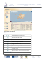
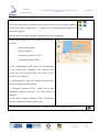
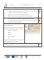
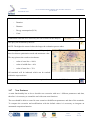
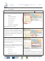
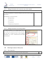
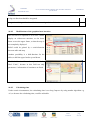
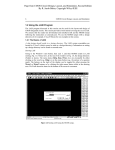
1CE055P2 - SoNorA
O.5.6.1 – Internet-based evaluation tool for nodes:
technical specification
Work
Package
WP 5 –Activating services along itineraries
Action
A5.6 – ICT development nodes
Author
PP 24 – Technical University of Applied Sciences Wildau
Version
2
Date
17.12.10
Status
Final
1CE055P2
South North Axis
O5.6.1 Internet-based evaluation tool for nodes: technical
specification
Confidential
Document Approval Chronology
Document
Revision / Approval
Version
Date
Status
Date
Status
1
23.06.2010
draft
8.10.2010
LP revised
2
17.12.2010
final
20.1.2011
LP approved
Final
17/12/10
page
2 / 32
1CE055P2
South North Axis
O5.6.1 Internet-based evaluation tool for nodes: technical
specification
Confidential
Index
1
2
3
4
5
6
7
8
9
9.1
9.2
9.3
10
10.1
10.2
11
12
13
14
14.1
14.2
14.3
14.4
14.4.1
14.4.2
14.5
14.6
14.7
14.7.1
14.7.2
14.7.3
14.7.4
14.7.5
14.7.6
14.8
Executive Summary .......................................................................................................................5
Introduction ....................................................................................................................................5
Context and objectives ...................................................................................................................5
Scope of output ..............................................................................................................................6
Importance to the SoNorA Network ..............................................................................................6
Methodology and approach – methodological approach ...............................................................6
Users of the new evaluation tool for nodes....................................................................................7
Aims and objectives of the developed system ...............................................................................7
Scope / constraints of the developed output ..................................................................................8
Scope............................................................................................................................................. 8
Conceptual constraints .................................................................................................................. 8
Geographical constraints............................................................................................................... 8
Requirements of the developed software tool................................................................................8
User interface requirements .......................................................................................................... 8
Security requirements ................................................................................................................... 9
Output specific analytical work .....................................................................................................9
Obstacles ........................................................................................................................................9
Identification of next steps ...........................................................................................................10
Results – software tool description and application ....................................................................10
Product Features ......................................................................................................................... 10
Operating Environment............................................................................................................... 10
Homepage of existing interim IT tool......................................................................................... 10
Calculation of a route – without fixed relations ......................................................................... 12
From terminal to terminal ........................................................................................................... 12
12
From free address to free address ............................................................................................... 16
Calculation of a route – with fixed relations............................................................................... 17
Analysis of accessibility ............................................................................................................. 19
New Features .............................................................................................................................. 20
Edit Terminals............................................................................................................................. 22
Add terminals .............................................................................................................................. 23
Delete a terminal ......................................................................................................................... 24
Disable a terminal ....................................................................................................................... 24
Editing of information of the connection routes of the terminals ............................................... 25
Editing of information of an existing terminal ........................................................................... 25
Other improvements of the system ............................................................................................. 25
Final
17/12/10
page
3 / 32
1CE055P2
South North Axis
14.8.1
14.8.2
14.8.3
14.9
14.9.1
14.9.2
14.9.3
14.10
15
16
17
O5.6.1 Internet-based evaluation tool for nodes: technical
specification
Confidential
Ease of operation ........................................................................................................................ 25
Modifications of the graphical user interface ............................................................................. 26
Calculating time .......................................................................................................................... 26
Automated comparison of changes ............................................................................................. 27
Transit ......................................................................................................................................... 28
Internal accessibility ................................................................................................................... 29
External accessibility .................................................................................................................. 30
Public scenarios .......................................................................................................................... 31
Added value and expected benefits .............................................................................................31
Evaluation criteria for successful implementation of output .......................................................31
Abbreviations / glossary ..............................................................................................................32
Final
17/12/10
page
4 / 32
1CE055P2
South North Axis
O5.6.1 Internet-based evaluation tool for nodes: technical
specification
Confidential
1 Executive Summary
One of the main objectives of this action is the further development of an existing IT-Tool, in order to
extend this tool with an edit-function to edit terminals and networks. These functions are necessary to
describe and to compare different scenarios with the default scenario and to publish the results.
Therefore it was necessary to elaborate the requirements and the necessary improvements to develop a
convincing specification requirement. As result of the elaboration, it turned out that two edit functions
are necessary; firstly, a terminal edit-tool and secondly, a network edit-tool. This specification
requirement handles the needs for the Terminal edit-function. With this function it is possible to edit
new terminals with the connection to the respective networks. To do this, it also has to be possible to
change parameters, information and other data of the terminals. To publish the results for other users a
publishing function is required.
2 Introduction
This document describes the functions of the Interim IT-Tool and provides an overview of the new
functions which have to be implemented.
3 Context and objectives
SoNorA addresses the need for improved multimodal accessibility in Central Europe in South-North
dimensions, its aim is to incisively bring forward the state of the art on the deployment of primary
transport infrastructure and services, through transnational collaboration to prioritise: transport network
development, removal of obstacles in the infrastructure realisation process, activation of services along
itineraries. For example, the project will result in the development of transnational tools and guidelines
from case studies and business case development for new logistics services.
The new evaluation tool for nodes supports the aim of work package 5 (activating of services along
itineraries) by providing the user a strategic information and evaluation tool for changes of nodes in the
intermodal network in the whole of Europe. The user creates scenarios (by changing of nodes of the
Final
17/12/10
page
5 / 32
1CE055P2
South North Axis
O5.6.1 Internet-based evaluation tool for nodes: technical
specification
Confidential
default), shares and discusses them with other users and compares the scenarios with the default
evaluating the changes.
The purpose of developing the technical specification is to describe the functionalities and the needed
functions of the IT tool for the respective developer and user of this tool. It contains a detailed
description of all functions, specific requirements, the project scope and improvements of this tool. The
effect of its utilization is to develop an IT tool which can be used to simulate and describe different
scenarios of logistics networks in Europe, to find new possibilities to improve the interaction between
the transport and logistics administrators, public authorities, network operators and logistic service
providers.
4 Scope of output
The document includes the requirement specification of this IT-Tool. The implementation of the new
functions and check of functionality is content of the core output “O5.6.4 ICT development nodes:
evaluation tool for nodes”.
5 Importance to the SoNorA Network
This technical specification is the basis for the new evaluation tool for nodes (O5.6.4) and describes the
functions to be included. The new evaluation tool for nodes itself is important for the SoNorA project as
all project partners can use this tool for, e. g. for the evaluation of the effects of their developed business
cases. Furthermore any (nodes) changes planned in the SoNorA network area can be evaluated by the
tool.
6 Methodology and approach – methodological approach
Basis for the technical specification are the functions and description of the already existing interim IT
tool that will be developed further. Details of the new functions for the new evaluation tool for nodes
Final
17/12/10
page
6 / 32
1CE055P2
South North Axis
O5.6.1 Internet-based evaluation tool for nodes: technical
specification
Confidential
were worked out and described. With a questionnaire all SoNorA project partners were asked to give
comments and ideas about the planned new functions. The answers were included in this technical
specification.
There is a strong interlinkage with “O5.6.4 ICT development: evaluation tool for nodes” as this
technical specification describes the new functions of the tool of output 5.6.4, it is the basis.
7 Users of the new evaluation tool for nodes
The following figure provides an overview of the main user groups:
-
Administrations and Agencies
-
National, regional and local level representatives
-
Network Operators
The following classification of Logistic Service Providers will be considered:
-
Providers of transport services on rail and inland waterways and short sea shipping
-
Providers of transhipment services
-
Intermodal terminal operators
-
Hub operators
-
Providers of additional logistics services
8 Aims and objectives of the developed system
The new evaluation tool for nodes consists of the already existing interim IT tool and additionally an
edit function to edit nodes to create, describe and compare different scenarios with the default and to
publish the results. With this function it is possible to add new nodes, delete existing nodes and edit the
parameters of the nodes. Furthermore, the creator of a scenario can upload files concerning the scenario
Final
17/12/10
page
7 / 32
1CE055P2
South North Axis
O5.6.1 Internet-based evaluation tool for nodes: technical
specification
Confidential
(description, idea, etc.) and publish all to other users for discussion. Additionally the created scenario
can be compared with the default to evaluate the changes.
9 Scope / constraints of the developed output
9.1
Scope
SoNorA exerts the development of an intermodal South-North-Transport passage from the Baltic Sea to
the Adriatic, as a base for the regional development in Central Europe.
The field of duties of the Technical University of Applied Sciences Wildau includes the creation of a
feasibility analysis about the logistic services related infrastructure and ICT applications in the SoNorAnetwork.
This document contains the description of a toolset which can be used to change the landscape of
logistics nodes at the South-North-Axis and in the whole of Europe and evaluate it with the default.
9.2
Conceptual constraints
It is assumed that routes which are included in the timetable of regular traffic and traffic on demand in
the context of intermodal transportation are deposited in the system. Special traffic or ad hoc traffic can
not be considered in the system. In general the availability of data may be another conceptual constraint.
9.3
Geographical constraints
The tool covers not only the SoNorA project area, but almost the whole of Europe.
10 Requirements of the developed software tool
10.1
User interface requirements
-
The tool should be developed with an English language user interface.
Final
17/12/10
page
8 / 32
1CE055P2
South North Axis
-
O5.6.1 Internet-based evaluation tool for nodes: technical
specification
Confidential
To avoid barriers concerning the usage of the tool no submission of installation files or
executable files to potential users are necessary.
-
The GIS data for the tool have to be interactive (i.e. linking selected elements in tables with
their display in maps and vice versa).
-
The buttons, icons and fields of the tool contain an explanation of the context (e.g. activated
when standing with the pointer for approx. 1 sec.). Most functions provided in the system are
self explanatory, so that the user manual could be kept to a minimum. Nevertheless, online
help should be offered for features that require some more explanations.
10.2
Security requirements
Security was taken as a very serious non-functional requirement so that the data and information of each
user is protected from visibility and possible alteration by other users. The admission to the toolset will
be given after filling in a registration form via the internet and its transmission to the administrator.
Information like company / department name, contact person, address and e-mail are compulsory to get
an account. It is intended to generate the password automatically which means that it will be transmitted
automatically to the prospective user after the approval of the administrator. The administrator has to be
informed via e-mail about a new request.
11 Output specific analytical work
No analytical work will be carried out to develop the new functions, all analytical work is already
included in the existing interim IT tool.
12 Obstacles
For the elaboration of the technical specification questionnaires were sent to the project partners to get
feedback, comments and ideas. Unfortunately only a few answers were received. Therefore only these
few comments could be integrated.
Final
17/12/10
page
9 / 32
1CE055P2
O5.6.1 Internet-based evaluation tool for nodes: technical
specification
South North Axis
Confidential
13 Identification of next steps
Based on this technical specification the next step is the development of the tool which is foreseen in
“O5.6.4 ICT development: evaluation tool for nodes” of SoNorA.
14 Results – software tool description and application
14.1
Product Features
The main purpose is the integration of an edit-function to add and change terminals (nodes) inside the
INTERIM-toolset.
14.2
Operating Environment
The Service Provider is the Technical University of Applied Sciences Wildau (TH Wildau), which is
operating the system. The TH Wildau is authorized to run analyses on data in the system in order to
optimize the provision and exchange of information.
14.3
Homepage of existing interim IT tool
The INTERIM IT tool can be used to evaluate logistic nodes and networks. Thereby the street-, rail-,
short sea shipping-, inland waterway-, and ferry-networks are considered. The provision of
comprehensive information of the terminals, such as number of handled units like gantry cranes or
reach stackers, opening hours, special goods, container storage etc. is a further feature of this IT tool.
Furthermore,
it
covers
all
European
countries.
The
INTERIM
IT
tool
is
hosted
on
www.viom.de/interim.To get access to the IT tool you have to register. User name and password are to
be asked to the administrator.
Following is the start page.
Final
17/12/10
page
10 / 32
1CE055P2
South North Axis
O5.6.1 Internet-based evaluation tool for nodes: technical
specification
Confidential
Figure 1 Starting page of Interim
Toolbar:
previous map view / next map view
Navigate to the map’s origin
Zoom in / Zoom out
Zoom out for quick orientation
Toggle pan mode on / off
Distance measuring on / off
Print map cut-out
Maximize applet / reinsert into browser window
3D-view
Final
17/12/10
page
11 / 32
1CE055P2
South North Axis
O5.6.1 Internet-based evaluation tool for nodes: technical
specification
Confidential
Show / hide navigable overview window
Zoom to selected local position
Calculation of a route – without fixed relations
14.4
14.4.1
From terminal to terminal
Selection of a given terminal from the terminal list
through one of the following options:
With
-
Filter by country-specific ISO code
-
Filter by city name
-
Filter by name
-
Filter by Zip code
-
Filter by street name
-
Filter by description
it can be skipped to the next page of the list or
to get to the end of the list
The user can sort the table by Name, Description,
Country, ZIP code, City name, Street name or Geo code
through clicking on the header of each column. The list
will be sorted in alphabetic order or vice versa.
By clicking on the blue “assign to start” button after the selection of a TSP the name
of the assigned terminal will be indicated. The red star in the map turns into the
“start icon”.
The user has to repeat the same procedure for the selection of the destination, by
clicking on the blue ”assign to destination” button the name of the assigned terminal
will be indicated. The red star in the map turns into the “destination icon”.
Final
17/12/10
page
12 / 32
1CE055P2
South North Axis
O5.6.1 Internet-based evaluation tool for nodes: technical
specification
Confidential
Optional:
The user can repeat the procedure for the selection of one or two via-points and has
to click on the blue ”assign to via1” / ”assign to via2” button (see more details at the
end of this chapter).
The user has to press the “Routing” button to get to the routing page
On the following page the user can specify the query by
selecting
-
“Optimization Mode”
-
“Allowed Modes”
-
“Transport Capacities (TEU)”
-
“Transport Quantity (TEU)”
1. The “Optimization Mode” allows the determination
of the fastest route (Duration), the cheapest route
(Costs), the most energy-saving route (ECO) or the
shortest route (Distance)
2. “Allowed Modes” allow the selection of one or more
modes of transport for the routing
3. “Transport Capacities (TEU)” enables one to state
maximum transport capacities for each mode of
transport
4. In the field “Transport Quantity (TEU)” the user can
enter the volume that shall be transported.
The user can press “Show routing points” in order to see in the map the area covered
Final
17/12/10
page
13 / 32
1CE055P2
South North Axis
O5.6.1 Internet-based evaluation tool for nodes: technical
specification
Confidential
-
If buttons are coloured grey, no changes can be made
-
If changes concerning the selection of the terminals have to be done, the button
“Terminals” can be used to get back to the terminal list
-
With the “Clear” button the terminal settings can be deleted
-
With the “Routing” button the user can get again to the routing page
-
The user has to press the “Start query” button to start the routing process
-
If a routing request has already been done, the last result can be displayed by
pressing the button “Show last result”
The next page shows the routing result based on the
chosen optimization mode.
The following information for the whole transport chain
as well as for individual routing segments is available:
-
Quantity to be transported
-
Duration
-
Distance
-
Energy consumption
-
Costs
A segment is a section from one TSP to another TSP
without changing the mode of transport
If changes e.g. concerning the selection of optimization mode, mode of transport or quantities
etc. have to be made, the user can use the blue button “Back” to get back to the routing page
Final
17/12/10
page
14 / 32
1CE055P2
South North Axis
O5.6.1 Internet-based evaluation tool for nodes: technical
specification
Confidential
Geographical details of the routing segments can be
displayed in the map through the selection of an
individual segment in table “Routing Segments”:
1. Click on routing segment
2. Map zooms to the segment
3. Chosen segment shows up in red
4. Segment details change (in the table “Segment
Details”)
Geographical details of the TSP of the chosen routing
segment can then be displayed through selection of a
terminal name in the table “Segment Details” on the
right side
Sequence of columns:
-
Name of Start TSP of a segment
-
Name of End TSP of a segment
-
Mode of transport within the segment
-
Transport volume / quantity in segment
-
Duration per segment
-
From TSP to TSP (segment 2)
-
Distance per segment
-
From TSP to TSP (segment 3)
-
Energy Consumption per segment
-
From TSP to End TSP (segment 4)
-
Costs per segment
Sequence of row entries:
-
From Start TSP to TSP (segment
1)
Sequence of columns:
-
Name of TSP of chosen segment
-
Related Logistics Service Provider (LSP)
-
Type of terminal
Final
17/12/10
page
15 / 32
1CE055P2
South North Axis
O5.6.1 Internet-based evaluation tool for nodes: technical
specification
Confidential
Sequence of row entries:
-
Start TSP of chosen segment
-
End TSP of chosen segment
If the field “Accumulated values” is checked, the transport costs for the total
number of TEU will be evaluated (according to the entry in the field
“Transport Quantity” on the routing page)
The link in the Column “Type” leads to detailed information about the selected TSP
14.4.2
From free address to free address
Beginning from the start page, the user has to click on the button ”Address search”
To search for an address there are several options.
After the selection of the country-specific ISO code
a.) Search by City name
b.) Search by Zip code
c.) Search by City name + Street name
Example: selection by City name + Street name
- Select e.g. “DE” and enter city name and street name.
The user has to press the “Start search” button to start the query
Final
17/12/10
page
16 / 32
1CE055P2
South North Axis
-
O5.6.1 Internet-based evaluation tool for nodes: technical
specification
Confidential
The user has to click on the respective
address line to choose as start. (With
the
user can skip to the next page of the list)
-
The map zooms to the selected starting
point and shows a red star at the local
position of the address
-
The user has to click on the blue ”assign to
start” button
-
The assigned address will be indicated. The red star in the map turns into the “start
icon”
The user can press the “Clear search” button in order to delete all filled in address fields
The user has to repeat the same procedure for the selection of the destination address and assign
to destination
NOTE: Free addresses can only be used as start or destination of a routing query. Therefore as
via-points only TSP from the terminal list can be selected.
The user has to press the “Routing” button to get to the routing page and continue as already
described in the previous chapter
14.5
Calculation of a route – with fixed relations
The INTERIM IT tool offers the possibility to include fixed relations in the routing process. Fixed
relations are relations where intermodal service offers already exist and which will be run by a transport
operator. The existing market offer will be taken into account and included as backbone. That means it
serves as main run for the complete and entire routing process.
Final
17/12/10
page
17 / 32
1CE055P2
O5.6.1 Internet-based evaluation tool for nodes: technical
specification
South North Axis
Confidential
The calculation of a route with fix relations can be realised after the determination of a start and
destination (either terminal and / or free address).
After the assignment of a start and a destination as described in the previous chapters, the user
has to press the button ”Fix relations”
The user has to press the red button “Search fix relations between Start and
Destination”
NOTE: The default setting of the search for fix relations is within a radius
of 300km from a Start or Destination. If no values were found the user shall
increase the radius.
Results at radius 300km:
NOTE: If no fix relation is suitable, the user shall
increase the radius again to get further options for fix
relations.
The user has to select from the list a fix relation by
clicking on the relation. (with
the user can skip to the
next page of the list).
The selected fix relation turns white.
The user has to press the arrow “Assign fix relations between Start and
Destination”
The fix relation is assigned when it turns red.
The name of the company (if available) which operates the chosen fix relation will be indicated
The links in the Column “Info” lead to detailed information about the fix relation
An assigned fix relation can be removed by pressing the button “Clear fix relations between
Start and Destination”
Final
17/12/10
page
18 / 32
1CE055P2
South North Axis
O5.6.1 Internet-based evaluation tool for nodes: technical
specification
Confidential
The user has to press the button “Routing” to get to the routing page and continue as already
described previously (individual settings)
The user has to press the “Start search” button to start the query
The chosen fix relation is considered in the further
routing process
14.6
Analysis of accessibility
The INTERIM IT tool offers the possibility to analyse the accessibility of transhipment points regarding
criteria such as duration, distance, costs and energy consumption.
The accessibility analysis can be realised after the determination of a start (TSP). The additional
selection of a destination is optional. After the assignment of a start (and optional of a
destination) as described previously, the user has to press the button ”Region”
By clicking the button “zoom to start” the user starts the accessibility analysis from start. By
clicking the button “zoom to destination” the user starts the accessibility analysis from
destination.
Final
17/12/10
page
19 / 32
1CE055P2
South North Axis
O5.6.1 Internet-based evaluation tool for nodes: technical
specification
Confidential
The user has to select an optimization mode:
-
Duration
-
Distance
-
Energy consumption (ECO)
-
Costs
A maximum value has to be entered by the user as basis for the analysis
The query can be started by the user.
NOTE: The higher the entered value, the longer the evaluation process takes.
The next page lists the results of the accessibility analysis
based on chosen optimization mode and maximum value.
The map pictures the results as isochrones:
-
value of outer line = 100%
-
value of middle line = 66%
-
value of inner line = 33%
All terminals will be indicated which can be reached
within the requested time
The user can press on the blue stars in the map in order to receive detailed TSP information
14.7
New Features
A main functionality has to be to describe new scenarios with new / different parameters and data,
therefore it is necessary to extend the tool with some new functions.
The user should be able to create his own scenario with different parameters and data of the terminals.
To compare the scenarios and modifications with the default values it is necessary to integrate an
automated comparison function.
Final
17/12/10
page
20 / 32
1CE055P2
South North Axis
O5.6.1 Internet-based evaluation tool for nodes: technical
specification
Confidential
One of these functions is a function to edit terminals, with all respective data and parameters.
-
Add terminal
-
Delete terminal
-
Disable terminal
-
Edit parameters
-
Automated comparison of the effects of the changes
Further there are some improvements of the handling and the graphical user interface necessary.
The function to edit terminals is necessary to describe and to compare different scenarios with the
default scenarios and to publish the results.
A scenario is a default interactive map including current terminals connected with the networks, e.g.
rail, street, inland waterway, short sea shipping and ferries. The special data (velocity, capacity, energy
consumption, distance) of these networks have preset values which can be modified.
Final
17/12/10
page
21 / 32
1CE055P2
South North Axis
14.7.1
O5.6.1 Internet-based evaluation tool for nodes: technical
specification
Confidential
Edit Terminals
The new edit-function should be integrated into the
INTERIM-tool.
Appearing about two Tabs on the left side.
-
Scenario: the new functions
-
Routing: the existing functions
To use the edit-function, it is necessary to assign every
potential user a specific role.
Specific roles are:
-
normal user without access to the edit function
-
advanced user with access to the edit function
-
test user with temporary access
After choosing the edit tab the user should see an option
window.
There the user can choose between two options:
-
Add / change terminals
-
Add / change networks
By choosing add / change terminal, there are the options:
-
Add terminal
-
Delete terminal
-
Disable terminal
-
Edit parameter
-
Automated comparison of changes
Final
17/12/10
page
22 / 32
1CE055P2
South North Axis
14.7.2
O5.6.1 Internet-based evaluation tool for nodes: technical
specification
Confidential
Add terminals
To add a new terminal, the user should choose the option “Add terminal”.
Input of the information about the new terminal:
-
address
-
company information
-
service information
-
supported modes
-
special goods
-
which units can be handled
Saving with the “Save” – button.
By using the address search-function or by
searching “by hand” the geographical position on
the map can be searched. By searching „by hand“
it is necessary to use the function „pick in map“ to
determine the terminal.
After the saving of the terminal, it has to be
connected with the current networks to which it is
really connected; therefore the user has to press
the button “load network”.
Now this map is loading the networks of the
environment of the terminal, thereby the networks
are shown in different colours:
-
road – red
-
rail – green
-
inland waterway – blue
A connecting point / node of the current network is
shown as a red point.
By clicking on the terminal point and the node,
which is the nearest to the terminal, it is possible to
Final
17/12/10
page
23 / 32
1CE055P2
South North Axis
O5.6.1 Internet-based evaluation tool for nodes: technical
specification
-
short sea shipping – dark-blue
-
ferry – blue / grey
Confidential
connect these points.
Saving all these changes with the “Save” – button.
The changing of information about the terminal
-
address information
should be possible.
-
contact person
-
capacity in TEU (twenty-foot equivalent
unit – 20’ Container)
14.7.3
-
connected networks
-
container
-
further information
Delete a terminal
To delete a terminal, the user has to choose the option “Delete terminal”.
After selecting the terminal from the list, the user has to press the delete-button.
Saving all these changes
14.7.4
Disable a terminal
To put a terminal out of action, the user has to activate the field “Disable
terminal”. Out of action means that the routing will do without that terminal.
After selecting the terminal from the list the user has to set a tick in the disable
field.
Saving all these changes.
Final
17/12/10
page
24 / 32
1CE055P2
South North Axis
14.7.5
O5.6.1 Internet-based evaluation tool for nodes: technical
specification
Confidential
Editing of information of the connection routes of the terminals
The information of the connections between the terminals and the networks has to be editable.
To change the parameters of a specific terminal the user has to select a terminal
from the list.
After that there is a drop-down menu:
14.7.6
-
Speed parameters
-
Cost parameters
-
ECO parameters
-
Transhipment point parameters
Editing of information of an existing terminal
To change information of an existing terminal, the user
has to choose the terminal from the list above, thereafter
the user has to choose the tab of the respective
information, e.g. “service”, and then the user can change
the information.
14.8
14.8.1
Other improvements of the system
Ease of operation
The handling of the site has to be improved, buttons and tabs larger.
Final
17/12/10
page
25 / 32
1CE055P2
South North Axis
O5.6.1 Internet-based evaluation tool for nodes: technical
specification
Confidential
A log-out-function should be integrated.
Integration of a log-in function with time measuring and time limitation.
14.8.2
Modifications of the graphical user interface
The site has to be adjusted so as to have a better
display on widescreen monitors, as the lower
frame covers the upper frame, so that the map is
not completely displayed.
Relief could be gained by a switch-function
between table and map.
Another possibility is a shift-function for the
table, to shift the upper border up and down.
The label “Container” has to be replaced with the
label “Units”, because in this field not only
parameters / information of containers are listed.
14.8.3
Calculating time
Under certain circumstances, the calculating time is too long. Improve by using another algorithm e.g.
A*, to decrease the calculating time, could be advisable.
Final
17/12/10
page
26 / 32
1CE055P2
South North Axis
14.9
O5.6.1 Internet-based evaluation tool for nodes: technical
specification
Confidential
Automated comparison of changes
It is necessary to compare the modifications with the starting values because every modification has an
effect on the scenario. The user is able to create his own scenario with different parameters and data of
the terminals and the networks.
The changes have to be compared automatically by choosing the tab “Automated comparison”.
After choosing this tab the user sees a window with three options:
-
Transit
-
Internal accessibility
-
External accessibility
On every comparison it is firstly necessary to determine an area where the respective terminals or
networks are situated, by a selection window. Therefore it is important to choose an area with a
minimum of four and a maximum of ten terminals. The selection window has to cover an area of 400
km2 at most. It should be possible to specify the query by selecting
-
“Optimization mode”
-
“Allowed modes”
-
“Transport capacities (TEU)”
-
“Transport quantity (TEU)”
1. The “Optimization mode” allows the determination of the fastest route (duration), the cheapest
route (costs), the most energy-saving route (ECO) or the shortest route (distance)
2. “Allowed modes” allows the selection of one or more modes of transport for the routing
3. “Transport capacities (TEU)” allows one to state maximum transport capacities for each mode
of transport
4. In the field “Transport quantity (TEU)” the user can enter the transport volume.
Final
17/12/10
page
27 / 32
1CE055P2
South North Axis
14.9.1
O5.6.1 Internet-based evaluation tool for nodes: technical
specification
Confidential
Transit
This will be a function to test the transit through
the area which was modified, to compare the
effects onto the different option modes:
-
fastest route (duration)
-
cheapest route (costs)
-
most energy-saving route (ECO)
-
the shortest route (distance)
Therefore it is necessary to route from the points
(1-8) on the edge of the map to other respective
points.
These points are reference points of the window,
while no reference on the same side and reference
of the same edge will be considered.
For example (coloured arrows):
1-4,1-5,1-6,
(1st routing)
2-4, 2-5, 2-6, 2-7, 2-8 (2nd routing)
3-6, 3-7, 3-8
(3rd routing)
4-6, 4-7, 4-8, 4-1, 4-2 (4th routing)
and so forth
5-8, 5-1, 5-2
(5th routing)
6-8, 6-1, 6-2, 6-3, 6-4 (6th routing)
7-2, 7-3, 7-4
(7th routing)
8-2, 8-3, 8-4, 8-5, 8-6 (8th routing)
Repeating with the default parameters and data to
compare with the new scenario.
Final
17/12/10
page
28 / 32
1CE055P2
South North Axis
O5.6.1 Internet-based evaluation tool for nodes: technical
specification
Confidential
The output of this function are tables of:
-
Default scenarios
-
Scenario scenarios
-
Difference scenarios
A second routing with the default values has to start
with the data of:
-
Duration
-
Costs
-
Time
-
ECO
14.9.2
also to generate the default table as a comparison
table.
Internal accessibility
To test the internal accessibility from the border
of the area the tool will route from the points (18) of the edge of the map to the centre terminal
calculated on the default and the scenario with
modifications after the changes to compare them.
Comparing the effects onto the different option
modes:
-
fastest route (duration)
-
cheapest route (costs)
-
most energy-saving route (ECO)
-
shortest route (distance)
Final
17/12/10
page
29 / 32
1CE055P2
South North Axis
O5.6.1 Internet-based evaluation tool for nodes: technical
specification
Confidential
The output of this function are tables of:
-
Default terminals
-
Scenario terminals
-
Difference terminals
with the data of:
-
Duration
-
Costs
-
Time
-
ECO
14.9.3
External accessibility
A function to test the external accessibility from
the centre of the area with modifications out to the
environment, after the changes.
Comparing the effects onto the different option
modes:
-
fastest route (duration)
-
cheapest route (costs)
-
most energy-saving route (ECO)
-
shortest route (distance)
Additional to the graphical output there is a table
with the terminals and the respective data of the
selected area.
Final
17/12/10
page
30 / 32
1CE055P2
South North Axis
O5.6.1 Internet-based evaluation tool for nodes: technical
specification
Confidential
14.10 Public scenarios
The user needs a function to publish the changed scenarios and the respective data and information on
the website, available for other users.
The function should start by pressing the “publish” button.
After pressing the button the user will come to a display window where a password can be set and other
important information entered like:
-
short description
-
which changes have been made
-
screenshots
-
tables
-
maps
-
upload of documents and pictures only in pdf or jpg format
-
secure the information with password is possible but not mandatory
15 Added value and expected benefits
The developing of multimodal infrastructure and services in the Central Europe area is the main
objective of the SoNorA project. In particular, work package 5 attends to the chance to activate services
along the Baltic-Adriatic axis by also analyzing innovative logistics solutions relevant for the network
area. The development of this IT tool will bring together public authorities and logistics service
providers with the aim to strengthen the logistics supply of the south – north axis.
16 Evaluation criteria for successful implementation of output
The tool offers the possibility to use new ways of transportation, furthermore, the scenario comparing
function offers the opportunity to improve environmental quality by ”greener” transportation and
logistic services. The output is successfully implemented when the functions are implemented in the IT
tool as described above.
Final
17/12/10
page
31 / 32
1CE055P2
South North Axis
O5.6.1 Internet-based evaluation tool for nodes: technical
specification
Confidential
17 Abbreviations / glossary
TSP
TransShipment Point
LSP
Logistics Service Provider
Scenario
A test situation with stated parameters and data of the terminals and networks, to
compare with the starting situation
Relation
Point of reference / a relation in mathematics is defined as an object that has its existence
as such within a definite context or setting.
Routing
Routing is the process of selecting paths in a network along which to send network
traffic. Routing is performed for many kinds of networks, including the telephone
network, electronic data networks and transportation networks.
Network
In graph theory a network is a digraph with weighted edges.
Segment
A segment is a section from one TSP to another TSP without changing the mode of
transport
Final
17/12/10
page
32 / 32