1
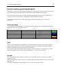
Eukalyptus
(Koala Environment Simulator)
User manual: Map blueprint
Thabo Beeler, University of Applied Sciences, Rapperswil (HSR)
2
User manual: Map blueprint
Revision History
Version
0.1
0.2
When
13.06.2004
23.06.2004
What
Initial version
First revision.
Who
Thabo Beeler
Thabo Beeler
User manual: Map blueprint
3
Table of contents
How to create a good map blueprint ............................................................................................ 4
Color encoding ........................................................................................................................ 4
Size ......................................................................................................................................... 4
Format..................................................................................................................................... 4
4
User manual: Map blueprint
How to create a good map blueprint
Eukalyptus is able to load and interpret image files. This provides an easy and convenient way
to generate maps for the simulator, as blueprints of most buildings are available.
One could simply load such a blueprint, but the resulting map may not be good. Especially
doors need to be color encoded, so Eukalyptus interprets them correctly.
The following instructions for blueprint pre-processing will enable you to create good
blueprints.
Color encoding
The following color encodings are recognized by Eukalyptus. Every element in the blueprint
should be colored in one of these colors.
Element
Door (open)
Door (closed)
Obstacle
Go-areas
No-Go-areas
Color
Green
Blue
Black
White
Red
Code-code (hex)
0x00FF00
0x0000FF
0x000000
0xFFFFFF
0xFF0000
Sample
Size
The size of the image file is important, as it determines the resolution of the map. One pixel
on the image is the base unit for the collision detection. The smallest object may have this
dimension. Smaller objects cannot possibly be detected.
If you want collision detection with an accuracy of 1 cm, you need to choose the size of the
image such that one pixel on the image corresponds to 1 cm2 in the real world.
Format
The best formats for the images are indexed ones, like GIF, because we have just a small
amount of colors.
When saving the file, make sure to use a palette with exactly the amount of colors used in the
map (max. 5).
Turn off any dithering or smoothing, because we don’t want blurry walls.